Embed Size (px)
Citation preview
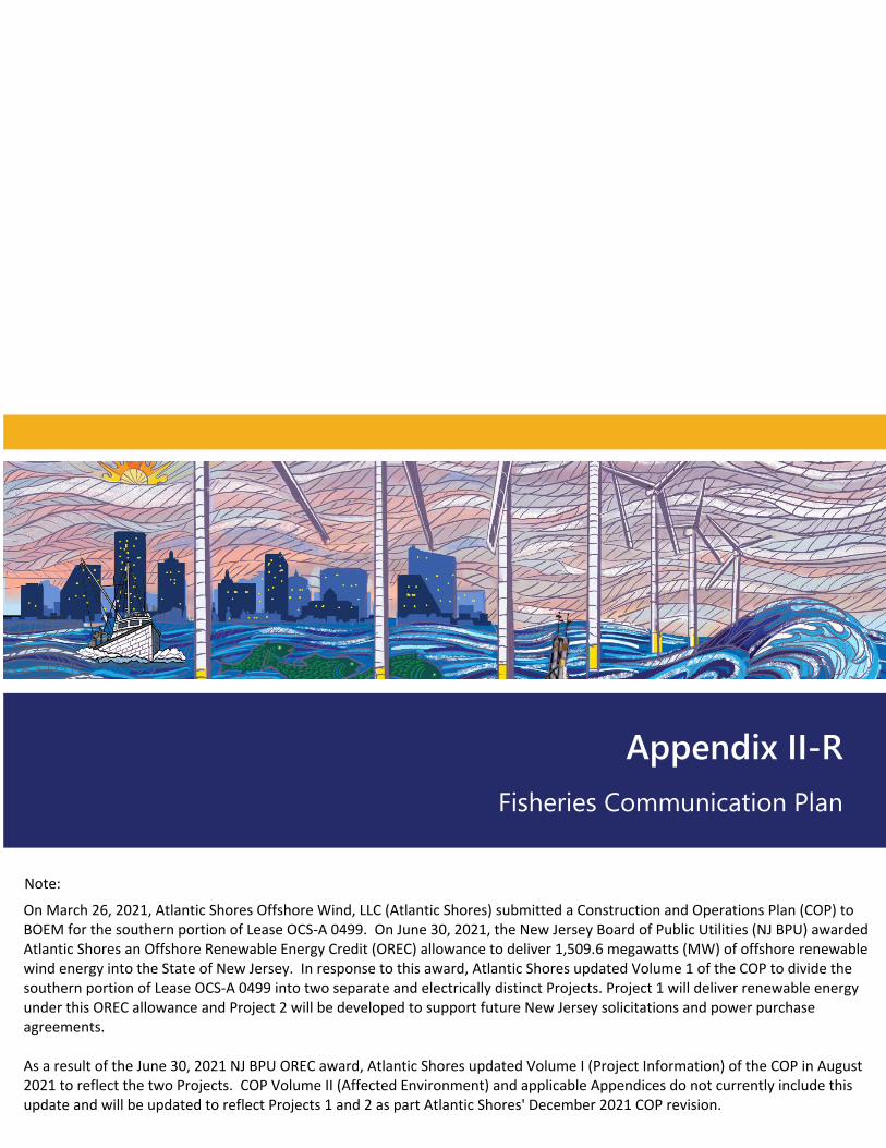
Appendix II-R Fisheries Communication Plan
Note:
On March 26, 2021, Atlantic Shores Offshore Wind, LLC (Atlantic Shores) submitted a Construction and Operations Plan (COP) to BOEM for the southern portion of Lease OCS-A 0499. On June 30, 2021, the New Jersey Board of Public Utilities (NJ BPU) awarded Atlantic Shores an Offshore Renewable Energy Credit (OREC) allowance to deliver 1,509.6 megawatts (MW) of offshore renewable wind energy into the State of New Jersey. In response to this award, Atlantic Shores updated Volume 1 of the COP to divide the southern portion of Lease OCS-A 0499 into two separate and electrically distinct Projects. Project 1 will deliver renewable energy under this OREC allowance and Project 2 will be developed to support future New Jersey solicitations and power purchase agreements.
As a result of the June 30, 2021 NJ BPU OREC award, Atlantic Shores updated Volume I (Project Information) of the COP in August 2021 to reflect the two Projects. COP Volume II (Affected Environment) and applicable Appendices do not currently include this update and will be updated to reflect Projects 1 and 2 as part Atlantic Shores' December 2021 COP revision.
Atlantic Shores Offshore Wind Fisheries Communication Plan
Lease Area (OCS-A 0499)
Prepared for:
Atlantic Shores Offshore Wind LLC
Prepared by:
Sea Risk Solutions LLC
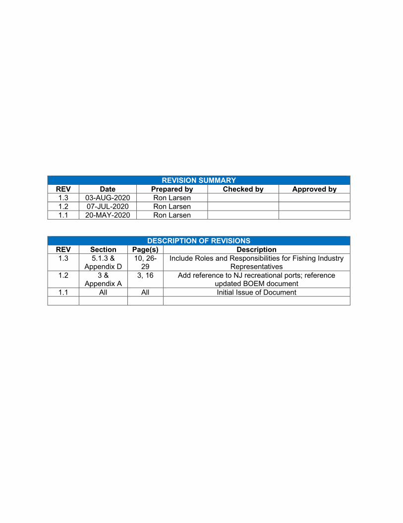
REVISION SUMMARY REV Date Prepared by Checked by Approved by 1.3 03-AUG-2020 Ron Larsen 1.2 07-JUL-2020 Ron Larsen 1.1 20-MAY-2020 Ron Larsen
DESCRIPTION OF REVISIONS REV Section Page(s) Description 1.3 5.1.3 &
Appendix D 10, 26-
29 Include Roles and Responsibilities for Fishing Industry
Representatives 1.2 3 &
Appendix A 3, 16 Add reference to NJ recreational ports; reference
updated BOEM document 1.1 All All Initial Issue of Document

This page intentionally left blank
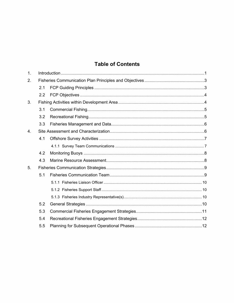
Table of Contents 1. Introduction ........................................................................................................................ 1
2. Fisheries Communication Plan Principles and Objectives .................................................. 3
2.1 FCP Guiding Principles ............................................................................................ 3
2.2 FCP Objectives ........................................................................................................ 4
3. Fishing Activities within Development Area ........................................................................ 4
3.1 Commercial Fishing.................................................................................................. 5
3.2 Recreational Fishing................................................................................................. 5
3.3 Fisheries Management and Data.............................................................................. 6
4. Site Assessment and Characterization ............................................................................... 6
4.1 Offshore Survey Activities ........................................................................................ 7
4.1.1 Survey Team Communications .................................................................................... 7
4.2 Monitoring Buoys ..................................................................................................... 8
4.3 Marine Resource Assessment .................................................................................. 8
5. Fisheries Communication Strategies .................................................................................. 9
5.1 Fisheries Communication Team ............................................................................... 9
5.1.1 Fisheries Liaison Officer ............................................................................................. 10
5.1.2 Fisheries Support Staff ............................................................................................... 10
5.1.3 Fisheries Industry Representative(s) .......................................................................... 10
5.2 General Strategies ................................................................................................. 10
5.3 Commercial Fisheries Engagement Strategies ....................................................... 11
5.4 Recreational Fisheries Engagement Strategies ...................................................... 12
5.5 Planning for Subsequent Operational Phases ........................................................ 12
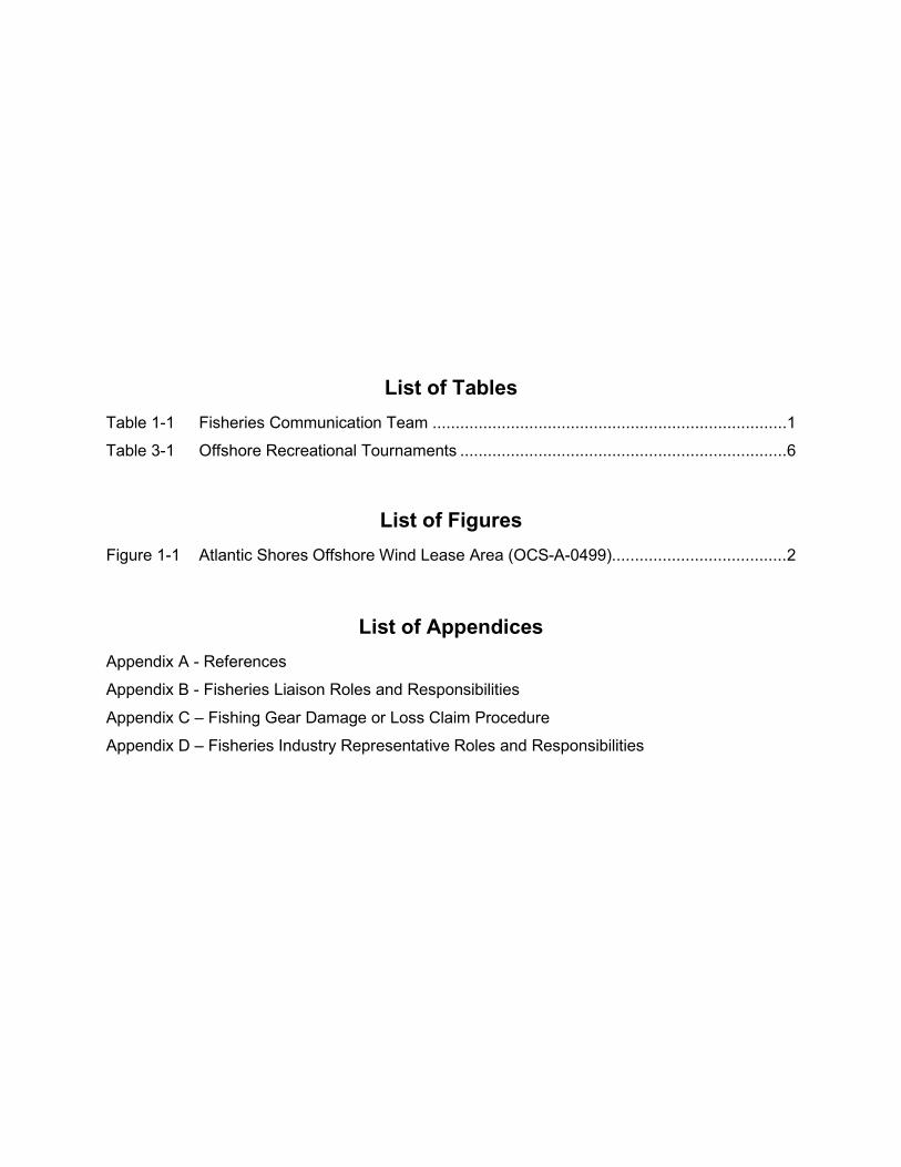
List of Tables Table 1-1 Fisheries Communication Team ............................................................................. 1
Table 3-1 Offshore Recreational Tournaments ....................................................................... 6
List of Figures Figure 1-1 Atlantic Shores Offshore Wind Lease Area (OCS-A-0499)...................................... 2
List of Appendices Appendix A - References
Appendix B - Fisheries Liaison Roles and Responsibilities
Appendix C – Fishing Gear Damage or Loss Claim Procedure
Appendix D – Fisheries Industry Representative Roles and Responsibilities
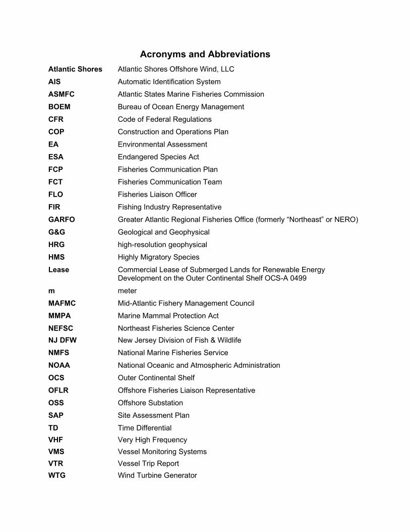
Acronyms and Abbreviations Atlantic Shores Atlantic Shores Offshore Wind, LLC AIS Automatic Identification System ASMFC Atlantic States Marine Fisheries Commission BOEM Bureau of Ocean Energy Management CFR Code of Federal Regulations COP Construction and Operations Plan EA Environmental Assessment ESA Endangered Species Act FCP Fisheries Communication Plan FCT Fisheries Communication Team FLO Fisheries Liaison Officer FIR Fishing Industry Representative GARFO Greater Atlantic Regional Fisheries Office (formerly “Northeast” or NERO) G&G Geological and Geophysical HRG high-resolution geophysical HMS Highly Migratory Species Lease Commercial Lease of Submerged Lands for Renewable Energy
Development on the Outer Continental Shelf OCS-A 0499 m meter MAFMC Mid-Atlantic Fishery Management Council MMPA Marine Mammal Protection Act NEFSC Northeast Fisheries Science Center NJ DFW New Jersey Division of Fish & Wildlife NMFS National Marine Fisheries Service NOAA National Oceanic and Atmospheric Administration OCS Outer Continental Shelf OFLR Offshore Fisheries Liaison Representative OSS Offshore Substation SAP Site Assessment Plan TD Time Differential VHF Very High Frequency VMS Vessel Monitoring Systems VTR Vessel Trip Report WTG Wind Turbine Generator

This page intentionally left blank
1. Introduction
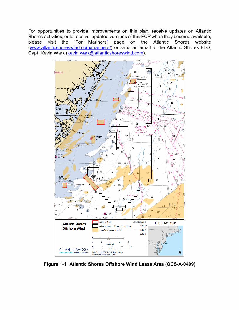
Atlantic Shores Offshore Wind, LLC (Atlantic Shores), a 50/50 joint venture between EDF-RE Offshore Development, LLC (a subsidiary of EDF Renewables, Inc.) and Shell New Energies US LLC, is the lease holder of Outer Continental Shelf (OCS) Lease Area OCS-A-0499 (Lease). As shown in Figure 1.1, the Lease is located approximately 8 to 20 miles off the New Jersey coast, between Barnegat Light and Sea Isle City, encompassing approximately 183,000 acres. The Lease was designated by the Bureau of Ocean Energy Management (BOEM), following a review of existing and targeted environmental studies as well as significant stakeholder engagement and input. The specific activities undertaken and considered when designating the location for Lease Area OCS-A-0499 can be reviewed on the BOEM website, BOEM New Jersey Activities (https://www.boem.gov/renewable-energy/state-activities/new-jersey-activities).
Atlantic Shores is committed to coexistence with all users of this shared ocean space, including commercial and recreational fisheries. Atlantic Shores has assembled and will maintain a Fisheries Communications Team (FCT) (Table 1-1), inclusive of a Fisheries Liaison Officer (FLO), throughout all phases of development (planning, construction, operation, and eventual decommissioning). This Fisheries Communication Plan (FCP) is central to the Atlantic Shores’ fisheries engagement strategy and will be the foundation of the company’s efforts to develop and implement best practices and build collaborative relationships with the fishing community.
The FCP establishes the principles that will guide Atlantic Shores in its outreach and engagement with the region’s marine fisheries communities. It is a “living document” that will evolve with regular feedback and guidance from fishermen, fishing organizations, and regulatory agencies.
Building relationships is key to coexistence with users of this area. Participation by fishermen and their representatives is important and will help to inform Atlantic Shores’ project-planning and design activities. Gathering fisheries information will be iterative and continuous. It should be understood and expected that credible information received from different sources may be contradictory. Atlantic Shores will endeavor to apply the available information to develop fair and equitable plans for shared use of the Lease Area.
Table 1-1 Fisheries Communication Team Position Contact Company Email Tel
Development Manager
Doug Copeland Atlantic Shores [email protected] +1 267 535-1366
Fisheries Liaison Officer Kevin Wark Atlantic Shores [email protected] +1 609 290-8577
Fisheries Support Ron Larsen Sea Risk Solutions, LLC. [email protected] +1 570 242-5023
Fishing Industry Representative(s) TBD TBD TBD TBD
For opportunities to provide improvements on this plan, receive updates on Atlantic Shores activities, or to receive updated versions of this FCP when they become available, please visit the “For Mariners” page on the Atlantic Shores website (www.atlanticshoreswind.com/mariners/) or send an email to the Atlantic Shores FLO, Capt. Kevin Wark ([email protected]).
Figure 1-1 Atlantic Shores Offshore Wind Lease Area (OCS-A-0499)
2. Fisheries Communication Plan Principles and Objectives
Timely communication and information dissemination are essential to identifying and avoiding potential problems during development of Atlantic Shores’ Lease Area. The sharing of information on fishing activities, planned infrastructure positions, submarine cable routes, vessel movements, safety zones, etc. can help to reduce and prevent the potential for conflict detrimental to fishing and the activities of Atlantic Shores.
The Atlantic Shores FCP has been developed in accordance with the BOEM guidelines and best practices guidance from other relevant resources (Appendix A). The objective of the FCP is to define outreach and engagement strategies for fisheries’ interests that may be affected during the planning, construction, operation, and eventual decommissioning within the Lease. These strategies will be enhanced with inputs received from the fishing community and updated as Atlantic Shores progresses with the development of the Lease Area.
Development of the Lease Area will occur in several stages. This version of the FCP specifically addresses the site assessment and site characterization activities that will be conducted both within the Lease Area and along the Export Cable Route(s). The “adaptive” nature of the FCP will allow it to be iterative over time as inputs and new information are received and through the different phases of project development and implementation.
Atlantic Shores will be developing a Construction and Operations Plan (COP) that will be subject to regulatory review, with additional opportunities for public input, as required by regulation, prior to construction. Fisheries information used to inform the COP are based on the best available and most credible data, science, and stakeholder-received information.
2.1 FCP Guiding Principles The fundamental principle of the Atlantic Shores FCP is facilitation of an open, ongoing dialogue among users of our natural resources on the shared OCS so that we may coexist in our responsible utilization of offshore resources for the benefit of all. This will be achieved by focusing the FCP around these set of principles:
• Facilitate timely, coordinated, efficient, accurate and transparent two-way communications to promote Atlantic Shores’ awareness and mariner safety.
• Seek out and utilize the diverse expertise and knowledge of the commercial and recreational fishing communities.
• Acknowledge and respect the very real concerns, issues and interests of the fishing community.
2.2 FCP Objectives Broadly stated, the objective of this FCP is to outline outreach and engagement strategies necessary to inform the fishing public in a timely manner about Atlantic Shores’ activities, while also building reliable and cooperative working relationships between Atlantic Shores and the fishing communities. These relationships are key to identifying, mitigating, to the extent possible, the inevitable challenges that come with coexistence. In order to work towards effective coexistence, Atlantic Shores has identified a sub-set of defined objectives, which include:
• Promote the safety of fishermen, offshore survey crews and construction crews transiting, working, and fishing in the area.
• Proactively seek fishing communities’ inputs to provide additional details, filling in any data gaps regarding the historic, existing, and potential fisheries opportunities in the Lease Area.
• Identify potential adverse impacts to fishermen and make informed decisions on how to avoid impacts where possible and/or mitigate the extent of any effects.
• Provide a pathway to quickly and fairly resolve fisheries related conflicts that may develop during the life for the Project.
• Build an authentic, trusting working relationship with fisheries users and communities to inform the responsible design, development, implementation, and operation of the Project.
• Demonstrate how industry relationships established via the FCP have informed the development of the Lease Area as well as the FCP.
3. Fishing Activities within Development Area
Fisheries are regional and dynamic; in addition to New Jersey’s fishermen, vessels from North Carolina to Massachusetts may fish or transit within the Lease Area or along the Export Cable Routes. There are five primary commercial fishing ports (including Belford, Point Pleasant, Barnegat Light, Atlantic City, and Cape May) on New Jersey’s Atlantic Ocean coastline and several smaller ports (e.g., Ocean City, Sea Isle City, etc.). The primary commercial landings and target species within the development area are surf clam / ocean quahog, Atlantic sea scallops, summer flounder, squid sp., monkfish and other finfish species. The primary gear types utilized are dredges, trawls, gillnets, pots/traps, purse seines, and hook/line.
The offshore recreational fishery consists of individual vessel owner/operators as well as a substantial “for hire” fleet. The top five (5) recreational fishing ports that support offshore activity are Manasquan Inlet (Point Pleasant), Cape May, Barnegat Light Inlet, Shark River Inlet, and Sandy Hook (Raritan Bay). Primary landings and target species for the offshore recreational fisheries are summer flounder, bluefish, black sea bass, striped bass, shark sp., tuna sp. and other pelagic species (e.g., mahi mahi).
In addition to vessels fishing within the development area, there may also be fishing vessels that transit through the Lease Area to get to/from the fishing grounds. Fisheries research, resource surveys and other oceanographic studies carried out by federal, state and academic organizations also take place in and around the Lease Area.
3.1 Commercial Fishing The primary commercial fishery conducted in and around the Lease Area is the harvesting of surf clams using hydraulic dredges. The fishery is conducted year-round and is well managed using a harvest quota; the vessels that work the Lease Area are typically from Atlantic City, New Jersey or Pt. Pleasant, New Jersey. Regional fishing databases (e.g., Mid-Atlantic Regional Council on the Ocean (MARCO)) indicate that the fishing effort associated with this fishery has recently been shifting north and into deeper waters due to effects of ocean warming.
Other commercial fishing gear types that fish the area on a limited basis include gillnets to target species of opportunity, depending on the season, which can be floating or fixed on the seabed. Pot/trap gear targeting sea bass, lobster and whelk/conch are also deployed seasonally and occur more in the southern third of the Lease Area. Otter trawling (dragging) and scallop dredging activities, on a very limited basis, have been noted in the northern portion of the Lease Area, likely consisting of day boat activity from local ports (e.g., Barnegat Light).
The Lease Area is also heavily transited by commercial fishing vessels. Automatic Identification System (AIS) data, although not used by all vessels, provides some indication of transit activity within the within the Lease Area. The Atlantic City, New Jersey clam dredge vessels will transit in generally east/west direction in order to reach offshore fishing grounds and return to port. Scallop vessels and trawl vessels are generally traveling in north/south directions when from Cape May, New Jersey and ports south or from Barnegat Light, New Jersey and ports north.
3.2 Recreational Fishing
The primary method of harvest is hook/line but there is also a small recreational pot/trap fishery. The New Jersey Recreational Fleet is mainly made up of private vessels, although there is a substantial “For Hire” fleet. The “For Hire” fleet consists of approximately 100 Party/Head Boats and over 300 Charter Boats.
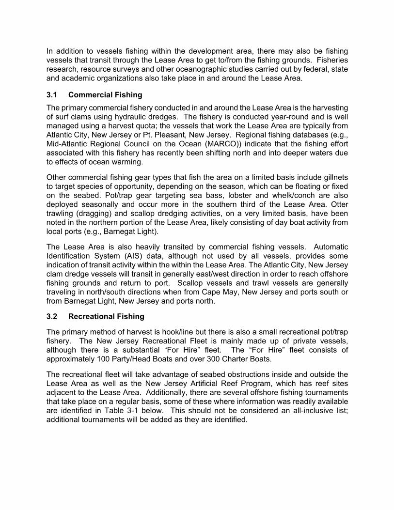
The recreational fleet will take advantage of seabed obstructions inside and outside the Lease Area as well as the New Jersey Artificial Reef Program, which has reef sites adjacent to the Lease Area. Additionally, there are several offshore fishing tournaments that take place on a regular basis, some of these where information was readily available are identified in Table 3-1 below. This should not be considered an all-inclusive list; additional tournaments will be added as they are identified.
Table 3-1 Offshore Recreational Tournaments Tournament Host
South Jersey Shark Tournament South Jersey Tournaments MidAtlantic Tuna Tournament South Jersey Tournaments MidAtlantic Cup – Blue Marlin Tournament South Jersey Tournaments South Jersey Yacht Sales Offshore Showdown South Jersey Tournaments Yacht Club of Stone Harbor Marlin Tournament South Jersey Tournaments Ocean City Marlin & Tuna Club Overnight Tournament South Jersey Tournaments
The MidAtlantic South Jersey Tournaments Tag One: Research Project South Jersey Tournaments Mako/Tuna Fever Tournament(s) Jersey Coast Anglers Beach Haven White Marlin Invitational Beach Haven Marlin & Tuna Club Bluefin Open Manasquan River Marlin & Tuna Club Tuna Mania Greater Point Pleasant Charter Boat Association Shark Challenge Triple Challenge Tournament Series
3.3 Fisheries Management and Data Fisheries operating within the Lease Area are subject to a variety of regulations and reporting protocols that result in multiple data sets. The regulatory programs and data collection often involve interjurisdictional management between National Marine Fisheries Service (NMFS), regional fisheries management councils (e.g., Mid-Atlantic Fisheries Management Council [MAFMC] and New England Fisheries Management Council [NEFMC]), the Atlantic States Marine Fisheries Commission (ASMFC) and coastal states.
Many of the fisheries conducted within the Lease Area are subject to tracking via a Vessel Monitoring System (VMS), which would create a spatial data record of their activities. Other vessels have permits for regulated species that require effort and landings to be reported via Vessel Trip Reporting (VTR). These fisheries dependent data have been used to assess the historical commercial fishing activity inside the Lease Area.
The FLO will consult with local fishermen to interpret and add context to these data to facilitate a mutually agreed and understandable characterization of the fisheries uses of the Lease Area.
4. Site Assessment and Characterization
The site assessment activities will include survey vessels working in the Lease Area and along proposed Export Cable Corridors gathering Geophysical and Geotechnical (G&G) data to support the understanding of seabed characteristics and sensitive resources/habitats as well as to inform site engineering. Data collection buoys will also be deployed to collect long term meteorological and oceanographic data. Biological and
ecological surveys of birds, other marine life and their associated habitats will also be conducted within the Lease Area and along the Export Cable Corridors.
4.1 Offshore Survey Activities The G&G surveys initiated in the Fall of 2019 will resume in the Spring of 2020 within the Lease Area and along the proposed Export Cable Corridor. These G&G surveys will be conducted by a suite of special purpose survey vessels which will be deployed at various times throughout the year. Large, dynamically positioned vessels will work the offshore areas while a smaller, shallow draft vessel will conduct surveys in the shallow reaches of the Export Cable Corridors.
The G&G survey activities will include the following activities:
• Depth sounding (multibeam echo sounder) to determine site bathymetry and bottom contours.
• Magnetic intensity measurements to identify ferrous objects like shipwrecks and unexploded ordnance.
• Seafloor imaging (side scan sonar) to identify seabed features, natural and/or manmade.
• Shallow and mid-range penetrating sub bottom profiler to map the near geological stratigraphy below the seabed.
• Sediment samples and digital imagery to support interpretation of geophysical data and characterize sediment conditions and benthic habitats
• Benthic grab sampling, • Deep soil boreholes including include downhole P-S logging (compressional and
shear wave velocity logging) or seismic cone penetration tests (CPTs) at selected borehole locations within the Lease Area to support the engineering design of future potential wind turbine generator (WTG) and offshore substation (OSS) foundations, and
• Vibracores along the Export Cable Corridors to round-truth geophysical interpretation and provide soil characteristics for cable engineering.
These vessels will often be towing survey equipment behind the vessel and a safety buffer around these vessels will be requested. The vessel specifications, operational details and timing will be shared once their schedules have been determined.
4.1.1 Survey Team Communications Prior to survey operations being conducted, the Fisheries Communication Team (FCT) and the FLO will develop and distribute Survey Awareness Flyers to the recreational and commercial fishing fleets. They will also brief the Survey Team during survey vessel mobilization to promote awareness of the local recreational and commercial fisheries.
During survey operations, survey vessels will monitor VHF 16 and 13 for bridge-to-bridge communications with fishing vessels operating in the Lease Area and along the Export Cable Corridors. The FCT will interact daily with the survey vessel(s) to provide fisheries updates and receive feedback from the survey team.
The FLO will provide the Survey Team with the following:
• A description of the commercial and recreational fisheries that may be encountered in the Lease Area.
• A schedule of the recreational fishing tournaments that may overlap the survey in space and time, including communications channels for the tournament fleets.
• Guidelines for avoidance and management of potential contacts with fishing. • A gear entanglement protocol and reporting form for the Client Representative on
the survey vessels. The FLO will be the primary point of contact and will work to resolve any fisheries issues or gear conflicts that may arise. Standardized procedures are in place inside Atlantic Shores to facilitate the filing of a claim for gear damage or loss that a fisherman may suspect was caused by survey activities. A draft of the claim procedure can be found in Appendix C.
4.2 Monitoring Buoys Atlantic Shores will deploy data collection buoys to collect meteorological and oceanographic conditions as part of the site assessment activities to help inform the development strategy for turbine layouts. These buoys will be moored in and around the Lease Area, planned buoy locations will be shared via notices to mariners and updates on the Project website.
These state-of-the-art metocean buoys will consist of instrumentation and supporting systems atop a floating moored buoy platform. Each floating platform consists of a modular hull, an instrument container, power system, light detection and ranging (LiDAR) system, mooring chain, and chain weight anchor. The platform float with fenders is made out of a combination of polyethylene, aluminum and stainless-steel, measuring 9.2 feet (2.8 meters) in diameter, with a vertical profile of approximately 11.5 feet (3.5 meters) from the sea surface to the top of the hull mast, and a weight of 3,748 pounds (1,700 kilograms [kg]). The submerged portion of the hull will measure approximately 8.5 feet (2.6 meters) below the sea surface from the water line to the bottom of the keel weight.
4.3 Marine Resource Assessment In addition to the deployment of offshore resources to collect site assessment data, Atlantic Shores will also conduct both habitat characterization and resource assessment studies throughout the Lease Area and Export Cable Corridors. A primary goal of Atlantic Shores is to avoid impacts to not only stakeholders but also the marine resources that exist within and surround our Lease Area and Export Cable Corridors.
The purpose of the habitat characterization and resource assessment studies is to understand the marine resources (both habitats and species) within the area of development and then assess how construction, operation and decommissioning activities may affect these resources. This data collection and assessment will not only support Atlantic Shores with its facility siting efforts, but it will also provide the information
necessary to work with regulators and stakeholders to avoid and minimize affects throughout each phase of development.
5. Fisheries Communication Strategies
The fishing communities that utilize the Lease Area consist of small, family businesses, complex multi-vessel companies, and individual fishermen. Vessels using the area may be resident in a local port, operate from a regional port outside of New Jersey and/or move seasonally between multiple ports. The fishing industry is complex in that regard.
Atlantic Shores acknowledges these complexities and the challenges they present when attempting to disseminate critical information to large numbers of fishermen in a reliable, timely manner. Engagement efforts must embrace differences in the needs of these fishing communities. The Fisheries Communication Team use specific methods to target both the commercial and recreational users, and sub-groups of the same, in addition to general outreach strategies designed to engage the entire fishing community. Identifying the best ways to communicate with fishermen will be an ongoing process that will evolve over time with the inputs from fishermen, which are encouraged.
The fishing industry itself will have a role to play in ensuring that effective communication and interaction takes place in a timely and constructive manner. Fishermen should be willing to engage, and be engaged, to discuss their concerns in an open and transparent way. These engagements will contribute to the assessment of fisheries in the area necessary to avoid and/or minimize negative impacts, develop solutions based on shared information and understanding, and reduce/eliminate conflicts to the greatest extent practicable. Ongoing communication during all phases of development will be important in resolving any issues or conflicts and informing fishermen of activities that could affect their operations.
5.1 Fisheries Communication Team Atlantic Shores has assembled a Fisheries Communication Team (Table 1-1) that is comprised of Atlantic Shores management, a FLO, Fisheries Support Staff and, as necessary, Fishing Industry Representatives (FIRs). In this structure, an active commercial fisherman is employed as the FLO with the support of land-based Fisheries Support Staff. This structure combines the experience, credibility and passion of an active commercial fishermen with support staff that is also knowledgeable of and experienced in the region’s fisheries.
The FLO in this structure also fulfills many of the same roles as that of a FIR. Where necessary, additional FIRs may be nominated to represent specific fisheries that are identified within the Lease Area or along the Export Cable Routes. This combination of experience and skills, together with the leadership and resources of Atlantic Shores Management, form the Fisheries Communication Team. As with the entire FCP, this team will not remain static and will evolve over time as development of the Atlantic Shores Lease Area progresses.
5.1.1 Fisheries Liaison Officer The FLO’s primary responsibility is to communicate the issues and concerns raised by the fishing community directly to Atlantic Shores. The FLO is also responsible for overall implementation of the communications plan, communicating project plans and activities that might impact the fishing industry during all phases of project development and implementation. The FLO will have a direct line of communication to the Project’s senior management, through which to make recommendations for improvement and address complaints, concerns, and share other input received from the fishing communities.
The primary roles and responsibilities of the FLO are detailed in Appendix B of this document.
5.1.2 Fisheries Support Staff The Fisheries Support Staff will assist the FLO with his/her day-to-day activities, including managing stakeholder databases, providing information support for meetings, preparing and reviewing informational flyers and other communications, etc. As needed, support staff will prepare materials for and/or attend industry management meetings, industry workshops and outreach events. The Fisheries Support Staff will report to the Atlantic Shores Development Manager and have direct lines of communication to Atlantic Shores’ senior management.
5.1.3 Fisheries Industry Representative(s) The Fishing Industry Representatives (FIRs) will serve as additional points of contact where necessary within the fishing community. If nominated, they would not work for or on behalf of Atlantic Shores, they would not be paid by Atlantic Shores but rather represent their respective fishing communities on the Atlantic Shores FCT. A FIR should have prior acceptance of the fishing industry they represent and provide unbiased representation of the same. The FIR is normally an individual who has worked extensively within the industry they represent but does not need to be an active fisherman.
The primary roles and responsibilities of the FIRs, commercial and/or recreational, are detailed in Appendix D of this document.
5.2 General Strategies The Atlantic Shores Fisheries Communication Team will use an array of general outreach strategies designed to engage the entire fishing community. These strategies will offer various opportunities to access and/or receive timely updates on project activities and stress the need for feedback from fishing communities. Feedback from the fishing community will be encouraged, methods and opportunities to provide that feedback will clearly identified and readily available.
General outreach strategies that will be employed include, but are not limited to, the following:
• Establish and maintain a dedicated webpage on the Atlantic Shores website specifically for the fishing community with the latest information, including relevant
contact information and opportunities to submit feedback (www.atlanticshoreswind.com/mariners/).
• Establish a comprehensive email distribution list to provide regular project updates and other important notices.
• Regularly distribute updated asset and operational awareness bulletins showing the development area, depicted on local nautical charts, with a description of the assets in the area, the activities taking place, timelines and relevant contact information.
• Schedule and hold regular meetings, open houses and webinars with activities designed to educate the public, share project information and solicit community feedback activities.
• Engage the existing offshore wind communications networks of the federal management agencies (e.g., BOEM, NMFS, etc.), the regional fisheries management councils (e.g., MAFMC, NEFMC, etc.) and state agencies (e.g., New Jersey Department of Environmental Protection [NJ DEP], etc.) and provide links to the same.
• Publish announcements and share updates with print and online industry publications and local news outlets.
• Establish a 24-hour phone line to address any real-time operational conflicts and/or safety issues.
• Establish specific methods for communicating with fishermen while they are at sea. • Issue Local Notice to Mariners (LNTM) ahead of any offshore activities, as
required.
5.3 Commercial Fisheries Engagement Strategies In all cases, early identification of the commercial fisheries conducted in the Lease Area and along the Export Cable Corridors and engagement with the specific users is paramount to the success of this FCP. Atlantic Shores has engaged with existing commercial fishermen’s organizations (e.g., Responsible Offshore Development Alliance [RODA]), local leaders that represent the various gear types used in the area and individual fishermen. Additional engagement strategies specific to commercial fisheries users of the Lease Area and proposed Export Cable Corridors include:
• Engage fixed gear fishermen to establish a set of guiding principles and procedures for 1) the identification and /or temporary relocation of fixed gear if/when needed, 2) the process for filing claims associated with lost or damaged gear, and 3) agreed methods to determine any required mitigations.
• Schedule meetings with local fishermen (e.g., port meetings, webinars, etc.) when offshore operational plans and dates are confirmed to discuss the activity and identify any potential conflicts.
• Establish and support regular “Port Hours” with an open-door policy in local ports to encourage regular, local engagement to help identify and characterize important local details regarding fisheries operations and practices
• As necessary, engage local fishermen to serve as Offshore Fisheries Liaison Representatives (OFLR) and secure local vessels to act as scout boats during offshore activities.
• Participate in commercial fishing conferences and trade shows, providing an additional point of engagement.
5.4 Recreational Fisheries Engagement Strategies Recreational fisheries users that may be impacted by operations in the Lease Area and long the Export Cable Corridors are also represented by national organizations (e.g., Recreational Fishing Alliance), local organizations (e.g., United Boatman of New Jersey, New Jersey Saltwater Fishermen, etc.), clubs (e.g., Beach Haven Marlin & Tuna Club, Atlantic City Saltwater Anglers, etc.) and individual fishermen. Additional engagement strategies specific recreational fisheries users of the Lease Area include:
• Engage the professional associations representing the “For Hire” fleet of party and charter boats; schedule meetings to share information and obtain feedback.
• Identify and engage local offshore fishing clubs, attend meetings, deliver educational presentations and solicit feedback.
• Identify offshore fishing tournaments and dates; engage with tournament organizers, share operational plans and contact information; identify and monitor VHF channel used by tournament.
• Participate in recreational fishing trade shows and have a presence during fishing tournaments.
5.5 Planning for Subsequent Operational Phases This FCP has been prepared for Atlantic Shores’ Site Assessment and Characterization Phase. As the development of the Lease Area progresses, the FCP will continue to be updated ahead of the remaining phases of the Project, including:
• Site Assessment and Characterization – This is the current phase of activity, which includes the marine G&G surveys, environmental surveys, as well the deployment one or more environmental monitoring buoys. The Fisheries Communication Team will work with the regional fisheries community to promote awareness of the site assessment and characterization activities; the FCP will likely be updated several times during this phase of development.
• Design and COP Preparation - The Fisheries Communication Team will use the survey data fisheries inputs received to date to inform the wind farm facility layout (e.g., WTG and OSS foundations, inter-array cable and export cable routes). Continued engagement with the industry to review the layout and, if necessary, adjust. The FCP will continue to be refined as needed.
• Construction and Installation – Ahead of construction and installation activities, the FCP will be further refined and reviewed with the industry facilitate ongoing communication and engagement.
• Operational Life – Following construction, the FCP will continue to be updated during the operational life of the Project in order to address the changing needs of the industry.
• Decommissioning – Prior to the decommissioning, the FCP will be updated to address this final phase of the Project.
As previously stated, the FCP will evolve over time based on the activities being executed. This evolution will be based on shared experiences of Atlantic Shores and the fishermen and requires the continued engagement and dedication of all parties to be effective.

This page intentionally left blank.
Appendix A - References
This FCP is based on best practice guidance and has improved with input from the fishing industry through feedback and consultation. Best practice guidance from other resources includes but is not limited to:
• Fishing Liaison with Offshore Wind and Wet Renewables Group (FLOWW) Best Practice Guidance for Offshore Renewables Developments: Recommendations for Fisheries Liaison, January 2014. Available online: http://www.thecrownestate.co.uk/media/5693/floww-best-practice-guidance-for-offshore-renewables-developments-recommendations-for-fisheries-liaison.pdf
• Offshore Wind Best Management Practices Workshop, Feb 5-6, 2014, Final Report, Mid-Atlantic Fishery Management Council.
• Ecology and Environment, Inc. 2014. Development of Mitigation Measures to Address Potential Use Conflicts between Commercial Wind Energy Lessees/Grantees and Commercial Fishermen on the Atlantic Outer Continental Shelf Report on Best Management Practices and Mitigation Measures. A final report for the U.S. Department of the Interior, Bureau of Ocean Energy Management, Office of Renewal Energy Programs, Herndon, VA. OCS Study BOEM 2014-654. 98 pp. Available at: http://www.boem.gov/OCS-Study-BOEM-2014-654.
• Guidelines for Providing Information on Fisheries Social and Economic Conditions for renewable Energy Development on the Atlantic Outer Continental Shelf Pursuant to 30 CFR Part 585, U.S. Department of The Interior, BOEM, Office of Renewable Energy Program, May 27, 2020.
• Guidelines for Information Requirements for a Renewable Energy Construction and Operations Plan, Attachment A – Version 3.0, BOEM April 2016
• Collaborative Fisheries Planning for Virginia’s Offshore Wind Energy Area. OCS Study BOEM 2016-040, prepared by Virginia Coastal Zone Program. Available at: http://www.deq.virginia.gov/Programs/CoastalZoneManagement/CZMIssuesInitiatives/OceanPlanning/FishingandVirginiaOffshoreWind.aspx
• A_Justin Kirkpatrick, et al., Socio-Economic Impact of Outer Continental Shelf Wind Energy Development on Fisheries in the U.S. Atlantic, OCS Study BOEM 2017-12.
• Guidelines for Providing Information on Fisheries for Renewable Energy Development on the Atlantic Outer Continental Shelf Pursuant to 30 CFR Part 585, U.S. Department of The Interior, Bureau of Ocean Energy Management, Office of Renewable Energy Programs, June 2019.
• Fishing and Submarine Cables Working Together – International Cable Protection Committee, February 2009, Second Edition

This page intentionally left blank.
Appendix B - Fisheries Liaison Roles and Responsibilities
The roles and responsibilities of the Fisheries Liaison Officer (FLO) include but are not limited to:
1) Act as Atlantic Shores public outreach representative and principle contact to the fishing communities.
2) Effective implementation of the FCP, with support of Fisheries Communication Team.
3) Identify and communicate with FIRs via email, in person meetings, and conference calls; provide regular updates to Atlantic Shores management regarding fisheries issues/concerns.
4) Ensure timely communications and dissemination of information to fishermen groups regarding all relevant project activities.
5) Support development of communication materials to ensure effective messaging.
6) Organize meetings, as necessary, to obtain fishermen’s views of project effects and communicate concerns to Atlantic Shores management.
7) Support development and maintenance of a comprehensive stakeholder database for all identified fisheries operating within the Lease Area and along the Export Cable Routes throughout all stages of development and implementation. Record relevant information and communications, including presentations and individual conversations, maintaining confidentiality as appropriate.
8) Share, present and discuss this FCP with industry and appropriate agencies; refine and enhance FCP based on real-time fishing industry feedback and ongoing outreach experience(s).
9) Maintain awareness and, where possible, participate in meetings with fisheries groups, regulators, non-government organizations, policy makers, contractors working on behalf of Atlantic Shores, and other offshore wind developers to foster positive working relationships.
10) Assess offshore activities and identify the need, if any, for an OFLR, static gear clearance and/or scout vessel; make recommendations for the same.
11) Develop, recommend and/or comment on potential mitigation measures being considered for use during design, implementation and operation of the Lease Area and Export Cable Routes.
12) Investigate and follow-up any known complaints or concerns regarding fisheries related issues, including any gear conflicts/interactions with Atlantic Shores operational vessels.
13) Be available to meet with fishermen representatives in person, via email or social media, phone, or radio outside of regular business hours and on weekends.

This page intentionally left blank.
Appendix C – Fishing Gear Damage or Loss Claim Procedure
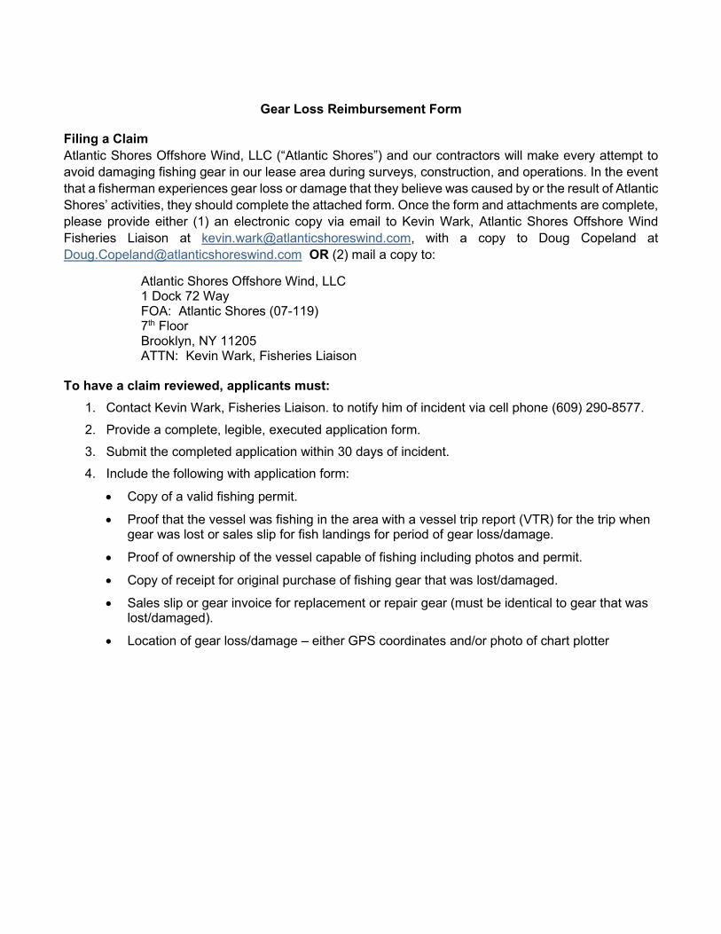
Gear Loss Reimbursement Form Filing a Claim Atlantic Shores Offshore Wind, LLC (“Atlantic Shores”) and our contractors will make every attempt to avoid damaging fishing gear in our lease area during surveys, construction, and operations. In the event that a fisherman experiences gear loss or damage that they believe was caused by or the result of Atlantic Shores’ activities, they should complete the attached form. Once the form and attachments are complete, please provide either (1) an electronic copy via email to Kevin Wark, Atlantic Shores Offshore Wind Fisheries Liaison at [email protected], with a copy to Doug Copeland at [email protected] OR (2) mail a copy to:
Atlantic Shores Offshore Wind, LLC 1 Dock 72 Way FOA: Atlantic Shores (07-119) 7th Floor Brooklyn, NY 11205 ATTN: Kevin Wark, Fisheries Liaison To have a claim reviewed, applicants must:
1. Contact Kevin Wark, Fisheries Liaison. to notify him of incident via cell phone (609) 290-8577. 2. Provide a complete, legible, executed application form. 3. Submit the completed application within 30 days of incident. 4. Include the following with application form:
• Copy of a valid fishing permit.
• Proof that the vessel was fishing in the area with a vessel trip report (VTR) for the trip when gear was lost or sales slip for fish landings for period of gear loss/damage.
• Proof of ownership of the vessel capable of fishing including photos and permit.
• Copy of receipt for original purchase of fishing gear that was lost/damaged.
• Sales slip or gear invoice for replacement or repair gear (must be identical to gear that was lost/damaged).
• Location of gear loss/damage – either GPS coordinates and/or photo of chart plotter
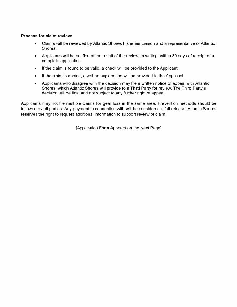
Process for claim review: • Claims will be reviewed by Atlantic Shores Fisheries Liaison and a representative of Atlantic
Shores.
• Applicants will be notified of the result of the review, in writing, within 30 days of receipt of a complete application.
• If the claim is found to be valid, a check will be provided to the Applicant.
• If the claim is denied, a written explanation will be provided to the Applicant.
• Applicants who disagree with the decision may file a written notice of appeal with Atlantic Shores, which Atlantic Shores will provide to a Third Party for review. The Third Party’s decision will be final and not subject to any further right of appeal.
Applicants may not file multiple claims for gear loss in the same area. Prevention methods should be followed by all parties. Any payment in connection with will be considered a full release. Atlantic Shores reserves the right to request additional information to support review of claim.
[Application Form Appears on the Next Page]
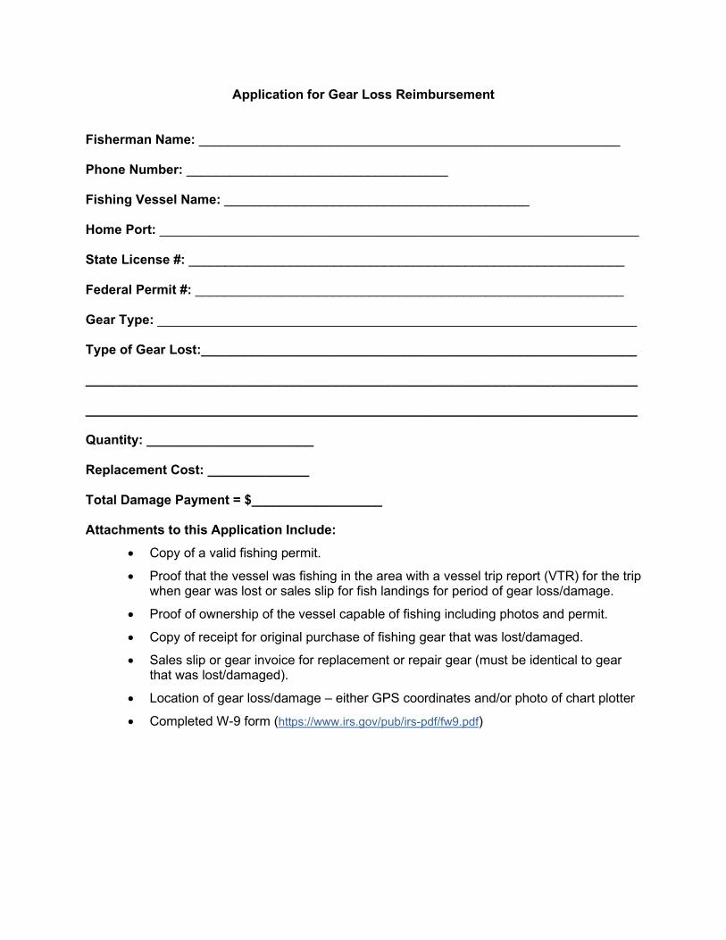
Application for Gear Loss Reimbursement Fisherman Name: __________________________________________________________ Phone Number: ____________________________________ Fishing Vessel Name: __________________________________________ Home Port: __________________________________________________________________ State License #: ____________________________________________________________ Federal Permit #: ___________________________________________________________ Gear Type: __________________________________________________________________ Type of Gear Lost:____________________________________________________________ ____________________________________________________________________________ ____________________________________________________________________________ Quantity: _______________________ Replacement Cost: ______________ Total Damage Payment = $__________________ Attachments to this Application Include:
• Copy of a valid fishing permit.
• Proof that the vessel was fishing in the area with a vessel trip report (VTR) for the trip when gear was lost or sales slip for fish landings for period of gear loss/damage.
• Proof of ownership of the vessel capable of fishing including photos and permit.
• Copy of receipt for original purchase of fishing gear that was lost/damaged.
• Sales slip or gear invoice for replacement or repair gear (must be identical to gear that was lost/damaged).
• Location of gear loss/damage – either GPS coordinates and/or photo of chart plotter
• Completed W-9 form (https://www.irs.gov/pub/irs-pdf/fw9.pdf)
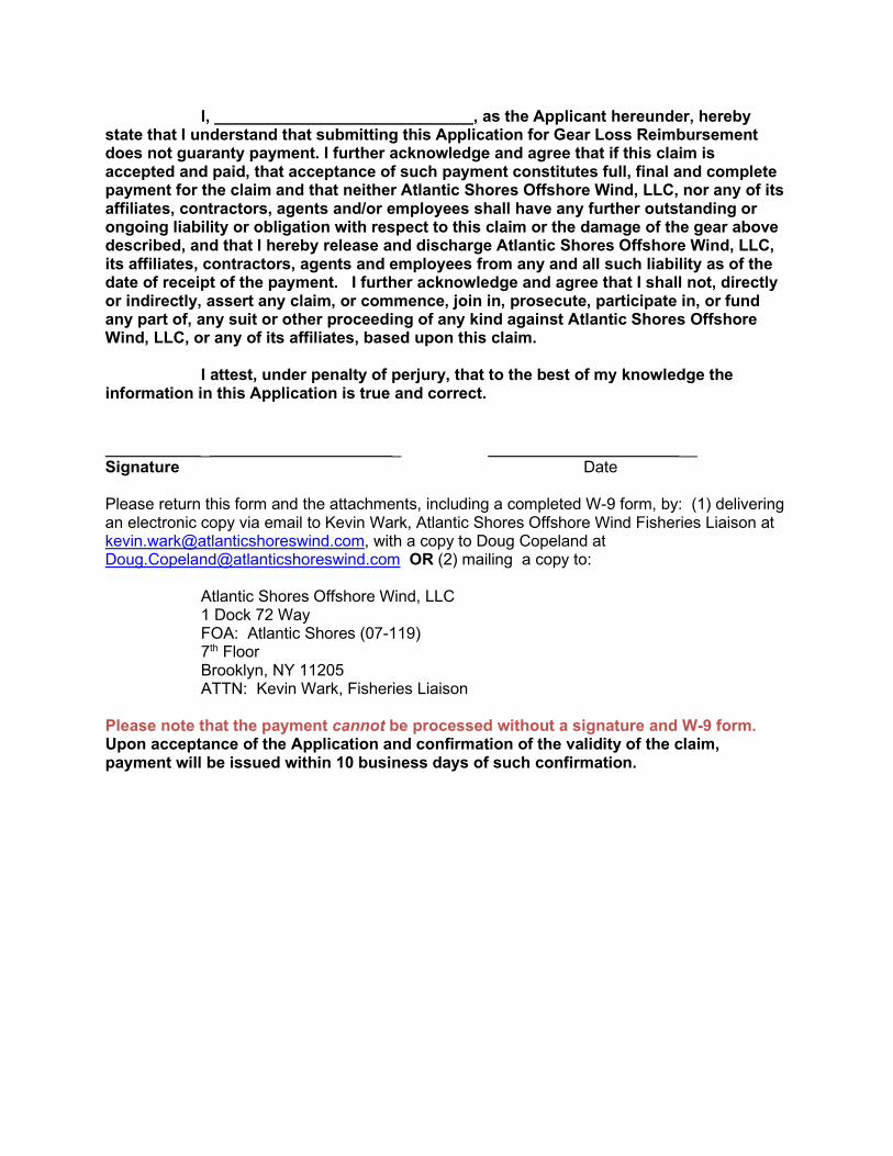
I, _____________________________, as the Applicant hereunder, hereby state that I understand that submitting this Application for Gear Loss Reimbursement does not guaranty payment. I further acknowledge and agree that if this claim is accepted and paid, that acceptance of such payment constitutes full, final and complete payment for the claim and that neither Atlantic Shores Offshore Wind, LLC, nor any of its affiliates, contractors, agents and/or employees shall have any further outstanding or ongoing liability or obligation with respect to this claim or the damage of the gear above described, and that I hereby release and discharge Atlantic Shores Offshore Wind, LLC, its affiliates, contractors, agents and employees from any and all such liability as of the date of receipt of the payment. I further acknowledge and agree that I shall not, directly or indirectly, assert any claim, or commence, join in, prosecute, participate in, or fund any part of, any suit or other proceeding of any kind against Atlantic Shores Offshore Wind, LLC, or any of its affiliates, based upon this claim. I attest, under penalty of perjury, that to the best of my knowledge the information in this Application is true and correct. _ _ __ Signature Date Please return this form and the attachments, including a completed W-9 form, by: (1) delivering an electronic copy via email to Kevin Wark, Atlantic Shores Offshore Wind Fisheries Liaison at [email protected], with a copy to Doug Copeland at [email protected] OR (2) mailing a copy to: Atlantic Shores Offshore Wind, LLC 1 Dock 72 Way FOA: Atlantic Shores (07-119) 7th Floor Brooklyn, NY 11205 ATTN: Kevin Wark, Fisheries Liaison Please note that the payment cannot be processed without a signature and W-9 form. Upon acceptance of the Application and confirmation of the validity of the claim, payment will be issued within 10 business days of such confirmation.

This page intentionally left blank.
Appendix D – Fisheries Industry Representative Roles and
Responsibilities
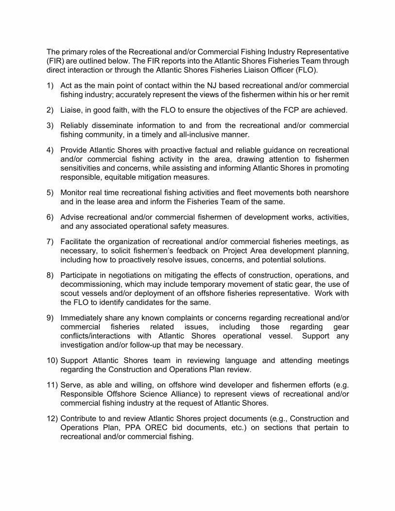
The primary roles of the Recreational and/or Commercial Fishing Industry Representative (FIR) are outlined below. The FIR reports into the Atlantic Shores Fisheries Team through direct interaction or through the Atlantic Shores Fisheries Liaison Officer (FLO).
1) Act as the main point of contact within the NJ based recreational and/or commercial fishing industry; accurately represent the views of the fishermen within his or her remit
2) Liaise, in good faith, with the FLO to ensure the objectives of the FCP are achieved.
3) Reliably disseminate information to and from the recreational and/or commercial fishing community, in a timely and all-inclusive manner.
4) Provide Atlantic Shores with proactive factual and reliable guidance on recreational and/or commercial fishing activity in the area, drawing attention to fishermen sensitivities and concerns, while assisting and informing Atlantic Shores in promoting responsible, equitable mitigation measures.
5) Monitor real time recreational fishing activities and fleet movements both nearshore and in the lease area and inform the Fisheries Team of the same.
6) Advise recreational and/or commercial fishermen of development works, activities, and any associated operational safety measures.
7) Facilitate the organization of recreational and/or commercial fisheries meetings, as necessary, to solicit fishermen’s feedback on Project Area development planning, including how to proactively resolve issues, concerns, and potential solutions.
8) Participate in negotiations on mitigating the effects of construction, operations, and decommissioning, which may include temporary movement of static gear, the use of scout vessels and/or deployment of an offshore fisheries representative. Work with the FLO to identify candidates for the same.
9) Immediately share any known complaints or concerns regarding recreational and/or commercial fisheries related issues, including those regarding gear conflicts/interactions with Atlantic Shores operational vessel. Support any investigation and/or follow-up that may be necessary.
10) Support Atlantic Shores team in reviewing language and attending meetings regarding the Construction and Operations Plan review.
11) Serve, as able and willing, on offshore wind developer and fishermen efforts (e.g. Responsible Offshore Science Alliance) to represent views of recreational and/or commercial fishing industry at the request of Atlantic Shores.
12) Contribute to and review Atlantic Shores project documents (e.g., Construction and Operations Plan, PPA OREC bid documents, etc.) on sections that pertain to recreational and/or commercial fishing.

13) Be available to meet with FLO and Fisheries Team in person, via phone and/or video conference on a regular basis.