Embed Size (px)
Citation preview

I-1 – September 2011
Appendix I Special-Status Species Table
This appendix provides a comprehensive list of special-status species with some potential
to occur in the project area (Table I-1). This list includes those species included on
preliminary lists developed by PacifiCorp and originally documented in:
Terrestrial Resources Final Technical Report. Klamath Hydroelectric Project
(FERC Project No. 2082). PacifiCorp, Portland, Oregon. February, 2004.
In addition, Table I-1 includes additional species listed by the Oregon Biodiversity
Information Center (ORBIC) and the California Natural Diversity Database (CNDDB).
The CNDDB search included the following U.S. Geologic Survey (USGS) 7.5-Minute
Quadrangles in California:
Secret Spring Mountain
Copco
Iron Gate Reservoir
Hornbrook
Hawkinsville
Badger Mountain
McKinley Mountain
Horse Creek
Hamburg
Seiad Valley
Slater Butte
Happy Camp
Clear Creak
Ukonom Mountain
Dillon Mountain
Bark Shanty Gulch
Somes Bar
Orleans Mountain
Orleans
Fish Lake
Weitchpec
French Camp Ridge

Klamath Facilities Removal EIS/EIR Public Draft
I-2 – September 2011
Johnsons
Holter Ridge
Ah Pah Ridge
Klamath Glen
Requa
Table I-1 includes 236 special-status species: 14 amphibians, 5 reptiles, 69 birds, 24
mammals, 112 plants, 3 bryophytes, and 9 lichens that have some potential to occur in the
project area.
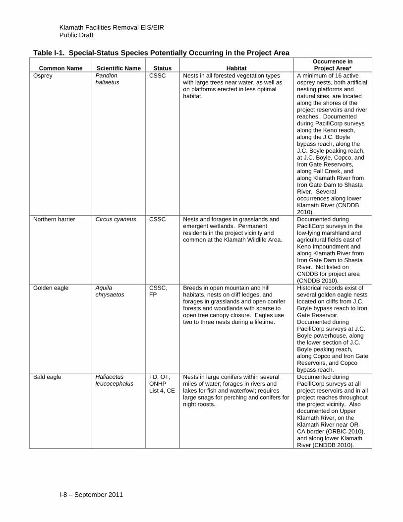
Table I-1. Special-Status Species Potentially Occurring in the Project Area
Common Name Scientific Name Status Habitat Occurrence in Project Area*
Amphibians
California tiger salamander
Ambystoma californiense
FC, CSSC
Breeds in pools (mostly temporary). Adults may occur in annual grasslands and lowland riparian forests. Only two isolated populations are known to exist in Oregon; one is located in Klamath Falls, but neither occurs in the study area. In California, the species is offered protected status; range is generally restricted to areas south of Butte County (central California).
Not documented during PacifiCorp surveys.
Clouded salamander Aneides ferreus SU, ONHP List 3
Inhabits forests, including burned, clearcut, second growth, and rocky areas. Closely associated with decaying logs and stumps, particularly Douglas-fir. Inhabits burns and clearcuts until the decay process proceeds to the point where the wood becomes too dry. This species’ range is restricted to the Coast Range and western Cascade Mountains of Oregon.
Not documented during PacifiCorp surveys.
Oregon slender salamander
Batrachoseps wrighti
FSC Moist Douglas fir, maple, and red cedar woodlands; to 914 m. Range is north and west of study area.
Not documented during PacifiCorp surveys.
Scott Bar salamander
Plethodon asupak
CT Rocky forested areas, especially thick moss-covered talus. Found in a very small area of the Siskiyou Mountains near the confluence of the Klamath and Scott Rivers, where the elevation is approximately 460 - 610 m.
Not documented during PacifiCorp surveys. Documented along tributaries of lower Klamath River (CNDDB 2010).
Del Norte salamander
Plethodon elongatus
FSC, S/M-D, SV, ONHP List 2, CSSC
Moist, rocky areas within forests. Can tolerate drier conditions and usually occurs in decaying logs and under litter on forest floor, especially in older conifer forests. Range is restricted to the coast range and barely extends into far western Siskiyou County.
Not documented during PacifiCorp surveys. Documented along tributaries of lower Klamath River (CNDDB 2010).

Appendix I – Special-Status Species Table
I-3 – September 2011
Table I-1. Special-Status Species Potentially Occurring in the Project Area
Common Name Scientific Name Status Habitat Occurrence in Project Area*
Siskiyou Mountains salamander
Plethodon stormi FSC, S/M-C, ONHP List 2, CT
Loose rock talus on north-facing slopes or in dense wooded areas. Also may be found under bark near talus. Range exists west of the study area but within the area of analysis.
Not documented during PacifiCorp surveys. Documented along tributaries of lower Klamath River (CNDDB 2010).
Southern torrent salamander
Rhyacotriton variegatus
FSC, SV, ONHP List 4, CSSC
Small streams and springs in Douglas-fir, mixed conifer, riparian, and upland deciduous forests. Range is west of, and including, the Coast Range Mountains from Mendocino County in California north through central Oregon, and barely extends into far western Siskiyou County.
Not documented during PacifiCorp surveys. Several occurrences along tributaries of lower Klamath River (CNDDB 2010).
Coastal (Pacific) tailed frog
Ascaphus truei FSC, BLM, SV, ONHP List 2, CSSC
Requires fast, small, permanent streams with clear, cold water, cobble or boulder substrate, and little silt lakes. Tadpoles are generally found attached to the undersides of moss-free rocks in rapidly moving water and require 2 to 3 years to metamorphose; adults can also occur under rocks during the day. At night adults can be seen along stream edges and in adjacent forest stands up to 25 m from water. This species is reported to be restricted to areas north and west of the study area, and at higher elevations.
Not documented during PacifiCorp surveys. Several occurrences on tributaries to Klamath River outside study area (CNDDB 2010).
Western toad Bufo boreas BLM, SV, ONHP List 4
Breeds from February to early May in ponds, the edges of shallow lakes, and in slow-moving streams. Adults are common near marshes and small lakes but may also be found in dry forests, shrubby areas, and meadows.
Documented during PacifiCorp surveys along J.C. Boyle peaking reach, along the north shore of Iron Gate Reservoir, and along Klamath River near RM 185 (between the confluence of Bogus and Cottonwood Creeks). One occurrence near Frain Ranch, Klamath River Canyon (ORBIC 2010).
Northern red-legged frog
Rana aurora aurora
FSC, SU, ONHP List 2, CSSC
Breeds in cool, well-shaded ponds and wetlands; along the edges of lakes; or in slow streams. Adults can be found in moist coniferous or deciduous forests up to 300 m away from water and in forested wetlands. Range lies west of the study area but within the area of analysis.
Not documented during PacifiCorp surveys. Not listed on CNDDB for project area (CNDDB 2010).

Klamath Facilities Removal EIS/EIR Public Draft
I-4 – September 2011
Table I-1. Special-Status Species Potentially Occurring in the Project Area
Common Name Scientific Name Status Habitat Occurrence in Project Area*
California red-legged frog
Rana aurora draytonii
FT, SC, ONHP List 1, CSSC
Found in dense, shrubby riparian vegetation associated with deep (0.7 m), still or slow-moving water. Vegetation that structurally seems to be most suitable is provided by arroyo willow; cattails and bulrushes also provide suitable habitat. Can occur in ephemeral or permanent streams or ponds, but populations probably cannot be maintained in ephemeral streams. Designated critical habitat is well south of the study area (50 CFR Part 17, March 13, 2001). Range lies west of the study area but within the area of analysis.
Not documented during PacifiCorp surveys. One occurrence near lower Klamath River (CNDDB 2010).
Foothill yellow-legged frog
Rana boylii FSC, BLM, SV, ONHP List 2, CSSC
Inhabits permanent slow-moving streams with rocky bottoms in a variety of habitats.
Not documented during PacifiCorp surveys. Known to occur along J.C. Boyle bypass reach near J.C. Boyle Dam. Historical record below J.C. Boyle Reservoir (ORBIC 2010) and more recently along lower Klamath River (CNDDB 2010).
Cascades frog Rana cascadae FSC, BLM, ONHP List 2, CSSC
Wet meadows, bogs, moist forests, pond and stream edges. Breeds in bogs or ponds with cold springs or snow melt. Lays eggs in water depths < 20 cm. Range extends as isolated, noncontiguous patches along the Cascade mountain corridor to the Sierra Nevada Mountains in California. Species not known to occur in the study area.
Not documented during PacifiCorp surveys. Not listed on CNDDB for project area (CNDDB 2010).
Oregon spotted frog Rana pretiosa FC, SC, ONHP List 1
Slow-moving and pond water in wetlands, ponds, and lake/river edges. Range occurs east of the study area, but is known to occur near Klamath Falls. Historically observed at the J.C. Boyle Reservoir. Current species’ range includes the northern portion of the study area.
Not documented during PacifiCorp surveys.

Appendix I – Special-Status Species Table
I-5 – September 2011
Table I-1. Special-Status Species Potentially Occurring in the Project Area
Common Name Scientific Name Status Habitat Occurrence in Project Area*
Reptiles
Northwestern pond turtle
Actinemys marmorata marmorata
FSC, BLM, SC, ONHP List 2, CSSC
Prefers quiet water in small lakes, marshes, and sluggish streams and rivers; requires basking sites.
Documented during PacifiCorp surveys at Keno, J.C. Boyle, Copco, and Iron Gate Reservoirs, along J.C. Boyle bypass reach, along J.C. Boyle peaking reach in California, and along Klamath River from Iron Gate Dam to Shasta River. Also documented at Iron Gate Reservoir and along Klamath River (ORBIC, CNDDB 2010).
Northern sagebrush lizard
Sceloporus graciosus graciosus
FSC, BLM, SV, ONHP List 4
Inhabits sagebrush, chaparral, juniper woodlands, and dry conifer forests.
Documented during PacifiCorp surveys in the rocky riparian shrub habitat of Keno reach, along J.C. Boyle peaking reach, near J.C. Boyle powerhouse intake canal, and near the edge of a forested wetland along Iron Gate Reservoir.
Sharptail snake Contia tenuis BLM Inhabits moist sites in chaparral, conifer forests, and deciduous forests, but primarily occurs in oaks and other deciduous tree woodlands, particularly in the forest edges.
Known to occur along upper J.C. Boyle peaking reach west of Frain Ranch in Douglas-fir habitat but not detected by PacifiCorp during its surveys.
California mountain kingsnake
Lampropeltis zonata
FSC, BLM, SV, ONHP List 4
Inhabits thick vegetation along watercourses, farmland, chaparral, deciduous, and mixed-coniferous forests; specifically associated with moist river valleys and dense riparian vegetation.
Documented during PacifiCorp surveys along Copco Road and in close proximity to J.C. Boyle powerhouse intake canal. Also known to occur along J.C. Boyle peaking reach. Documented in Klamath River Canyon and at J.C. Boyle Dam (ORBIC 2010).
Common kingsnake Lampropeltis getula
FSC, BLM, SV, ONHP List 4
Occurs in pine forests, oak woodlands, and chaparral in, under, or near rotting logs and usually near streams; associated with well-illuminated rocky riparian habitat with mixed deciduous and coniferous trees.
Documented during PacifiCorp surveys along J.C. Boyle peaking reach in oak/woodland and mixed conifer woodland and along Copco Road.
Birds
Common loon Gavia immer FSC, CSSC
May over-winter on project reservoirs or occur in aquatic habitat associated with large bodies of water like the project reservoirs while migrating from sub-arctic freshwater breeding grounds to coastal and near-shore pelagic marine habitat along the Pacific coast.
Documented during PacifiCorp surveys at Iron Gate Reservoir.

Klamath Facilities Removal EIS/EIR Public Draft
I-6 – September 2011
Table I-1. Special-Status Species Potentially Occurring in the Project Area
Common Name Scientific Name Status Habitat Occurrence in Project Area*
Horned grebe Podiceps auritus BLM, SP, ONHP List 2
Reservoirs, ponds, and emergent wetlands throughout the study area represent suitable habitat. Nests are anchored to emergent vegetation. Occurs at Upper Klamath Lake.
Not documented during PacifiCorp surveys.
Red-necked grebe Podiceps grisegena
SC, ONHP List 2
Reservoirs, ponds, and emergent wetlands throughout the study area represent suitable habitat. Nests in hardstem bulrush and forages in lakes, ponds and slow-moving rivers that are deeper than 5 feet. Known to breed on Upper Klamath Lake, Howard Prairie Reservoir, and Malheur National Wildlife Refuge. No breeding in California.
Not documented during PacifiCorp surveys.
American white pelican
Pelecanus erythrorhynchos
BLM, SV, ONHP List 2, CSSC
Nests at lakes and marshes and uses almost any lake outside of the breeding season; have a restricted range in southern Oregon and along the California border, where they are found to be associated with only a few large bodies of inland water.
Documented during PacifiCorp surveys on all project reservoirs, with the highest number occurring on Keno Impoundment, and along Link River, Keno reach, J.C. Boyle bypass reach, and on Klamath River between Iron Gate Dam and Shasta River.
Double-crested cormorant
Phalacrocorax auritus
Nesting colonies are afforded special protection by CDFG.
Colonial nester on coastal cliffs, offshore islands, and along lake margins.
Documented during PacifiCorp surveys at Keno and J.C. Boyle Dams. Documented nesting colonies near mouth of Klamath River (CNDDB 2010).
Western least bittern Ixobrychus exilis hesperis
FSC, BLM, SP, ONHP List 2, CSSC
Inhabits emergent wetlands. Suitable habitat occurs upstream of J.C. Boyle Dam, primarily along upper Klamath Lake. Only six reports in Oregon since 1981. Known to have historically occurred in Upper Klamath Lake and downstream into the northern portion of the study area. Range includes portions of eastern Siskiyou County, east of the study area.
Not documented during PacifiCorp surveys.
Black-crowned night heron
Nycticorax nycticorax
FSC Found in riparian habitats and in wetland sites.
Documented during PacifiCorp surveys primarily along Keno reach, but also along Link River, at Keno Impoundment, and along Klamath River from Iron Gate Dam to Shasta River. Communal roost used by night herons and other heron species located in a group of willow trees near the East Side powerhouse adjacent to Link River.

Appendix I – Special-Status Species Table
I-7 – September 2011
Table I-1. Special-Status Species Potentially Occurring in the Project Area
Common Name Scientific Name Status Habitat Occurrence in Project Area*
Snowy egret Egretta thula BLM, SV, ONHP List 2
Inhabits emergent wetlands associated with freshwater marshes and along the periphery of large water bodies. The northern limit of the species range includes southern Oregon.
Documented during PacifiCorp surveys near Link River Dam, at Keno Dam, and along Keno reach.
Great egret Casmerodius albius
BLM Nests in willows and other trees; forages in shallow water, wetlands, and fields. Range includes Klamath basin and eastern Siskiyou County. Known to occur in the study area.
Documented during PacifiCorps surveys at J.C. Boyle Reservoir and Keno Impoundment, Keno Canyon reach, J.C. Boyle bypass and peaking reaches, and Link River.
Great blue heron Ardea herodias Breeding colonies are afforded special-status protection by CDFG
Forages mostly in slow-moving or calm salt, fresh, or brackish water in a variety of habitats, including rocky shores, coastal lagoons, saltwater and freshwater marshes, mudflats, bays, estuaries, along the margins of rivers, lakes, and irrigation canals, and in flooded fields. Nesting colonies are typically found in groves of large trees, often in mixed colonies with other herons, egrets, and cormorants.
Documented during PacifiCorps surveys at all reservoirs and most study area reaches; rookery documented at Copco Reservoir. Several rookeries documented along the Klamath River (CNDDB 2010).
White-faced ibis Plegadis chihi FSC, BLM, ONHP List 4, CSSC
Breeds in freshwater marshes and lakes, and estuaries, and nests near the water on mats of vegetation and twigs; usually occurs in isolated con-specific flocks. Does not typically overwinter in Oregon but is a fairly common visitor in the Klamath Wildlife Area during the spring and summer.
Documented during PacifiCorp surveys along Link River and at Keno and J.C. Boyle Reservoirs.
Harlequin duck Histrionicus histrionicus
FSC, SU, ONHP List 2, CSSC
Nests along remote low-gradient mountain streams. May occur along Klamath River from J.C. Boyle Dam to Copco Reservoir.
Not documented during PacifiCorp surveys.
Bufflehead Bucephala albeola
BLM, SU, ONHP List 4
Typically breeds around isolated mountain lakes; nesting habitat includes mixed conifer forest and ponderosa pine forests with sparse to moderate tree canopy closure close to lakes and ponds. Nests in cavities, including artificial nest boxes. May be found in open water and riverine habitat throughout southern Oregon after the breeding season.
Documented during PacifiCorp surveys primarily from January until April along the Link River, at Keno, Copco, and Iron Gate Reservoirs.
Barrow's goldeneye Bucephala islandica
SU, ONHP List 4, CSSC
Tends to breed along high-elevation mountain lakes and winter in coastal areas. Potential nesting habitat includes forests with sparse to moderate tree canopy closure next to rivers and reservoirs.
Documented during PacifiCorp surveys along Keno Impoundment, in an inundated drainage ditch off of Copco Reservoir, and on Iron Gate Reservoir.
Klamath Facilities Removal EIS/EIR Public Draft
I-8 – September 2011
Table I-1. Special-Status Species Potentially Occurring in the Project Area
Common Name Scientific Name Status Habitat Occurrence in Project Area*
Osprey Pandion haliaetus
CSSC Nests in all forested vegetation types with large trees near water, as well as on platforms erected in less optimal habitat.
A minimum of 16 active osprey nests, both artificial nesting platforms and natural sites, are located along the shores of the project reservoirs and river reaches. Documented during PacifiCorp surveys along the Keno reach, along the J.C. Boyle bypass reach, along the J.C. Boyle peaking reach, at J.C. Boyle, Copco, and Iron Gate Reservoirs, along Fall Creek, and along Klamath River from Iron Gate Dam to Shasta River. Several occurrences along lower Klamath River (CNDDB 2010).
Northern harrier Circus cyaneus CSSC Nests and forages in grasslands and emergent wetlands. Permanent residents in the project vicinity and common at the Klamath Wildlife Area.
Documented during PacifiCorp surveys in the low-lying marshland and agricultural fields east of Keno Impoundment and along Klamath River from Iron Gate Dam to Shasta River. Not listed on CNDDB for project area (CNDDB 2010).
Golden eagle Aquila chrysaetos
CSSC, FP
Breeds in open mountain and hill habitats, nests on cliff ledges, and forages in grasslands and open conifer forests and woodlands with sparse to open tree canopy closure. Eagles use two to three nests during a lifetime.
Historical records exist of several golden eagle nests located on cliffs from J.C. Boyle bypass reach to Iron Gate Reservoir. Documented during PacifiCorp surveys at J.C. Boyle powerhouse, along the lower section of J.C. Boyle peaking reach, along Copco and Iron Gate Reservoirs, and Copco bypass reach.
Bald eagle Haliaeetus leucocephalus
FD, OT, ONHP List 4, CE
Nests in large conifers within several miles of water; forages in rivers and lakes for fish and waterfowl; requires large snags for perching and conifers for night roosts.
Documented during PacifiCorp surveys at all project reservoirs and in all project reaches throughout the project vicinity. Also documented on Upper Klamath River, on the Klamath River near OR-CA border (ORBIC 2010), and along lower Klamath River (CNDDB 2010).

Appendix I – Special-Status Species Table
I-9 – September 2011
Table I-1. Special-Status Species Potentially Occurring in the Project Area
Common Name Scientific Name Status Habitat Occurrence in Project Area*
Cooper's hawk Accipiter cooperii CSSC Inhabits riparian deciduous forest, montane hardwood oak woodland, montane hardwood oak-juniper, montane hardwood oak-conifer, juniper woodland, mixed conifer forest, ponderosa pine forest, and lodgepole pine with any level of tree canopy closure.
Documented during PacifiCorp surveys along J.C. Boyle bypass and peaking reaches, and along Klamath River from the Iron Gate Dam to Shasta River. Not listed on CNDDB for project area (CNDDB 2010).
Northern goshawk Accipiter gentilis FSC, BLM, CC, SC, ONHP List 4, CSSC
Inhabits forested communities with at least 60 percent canopy cover and trees greater than 6 inches in diameter, except oak woodland, oak-conifer woodland, and oak-juniper woodland; forages over large home ranges.
Documented during PacifiCorp surveys flying over J.C. Boyle peaking reach. Documented near tributaries of lower Klamath River (CNDDB 2010).
Sharp-skinned hawk Accipiter striatus CSSC Inhabits riparian deciduous forest, montane hardwood oak woodland, montane hardwood oak juniper, montane hardwood oak-conifer, juniper woodland, mixed conifer forest, ponderosa pine forest, and lodgepole pine with any level of tree canopy closure and tree diameters ranging from 6 to 24 inches.
Documented during PacifiCorp surveys in oak habitat along J.C. Boyle bypass and peaking reaches, and along Klamath River from Iron Gate Dam to Shasta River. Not listed on CNDDB for project area (CNDDB 2010).
Ferruginous hawk Buteo regalis FSC, BLM, SC, ONHP List 2, CSSC
Nests on cliffs, isolated trees, or riparian forests for nesting and forages in open habitats with sparse to open tree closure (<40 percent). Range includes eastern Siskiyou County.
Not documented during PacifiCorp surveys. Not listed on CNDDB for project area (CNDDB 2010).
Swainson's hawk Buteo swainsoni FSC, BLM, SV, ONHP List 4, , CT
Dwells in open country and typically inhabits sagebrush, annual grassland, juniper woodland, montane hardwood oak-juniper, and riparian deciduous forest with sparse to open tree canopy closure. The species’ range generally lies east of the project vicinity and includes the plains of the Great Basin in southeast Oregon and eastern northern California.
Documented during PacifiCorp surveys flying over agricultural fields southeast of Keno Impoundment. Not listed on CNDDB for project area (CNDDB 2010).
Merlin Falco columbarius
BLM, ONHP List 2, CSSC
Uses a variety of forested and open habitats. Ranges throughout North America and travels great distances during migration from breeding grounds in northern Canada and Alaska to wintering habitat through the contiguous United States south to Central America.
Documented during PacifiCorp surveys at J.C. Boyle Reservoir and along J.C. Boyle peaking reach. Not listed on CNDDB for project area (CNDDB 2010).
Klamath Facilities Removal EIS/EIR Public Draft
I-10 – September 2011
Table I-1. Special-Status Species Potentially Occurring in the Project Area
Common Name Scientific Name Status Habitat Occurrence in Project Area*
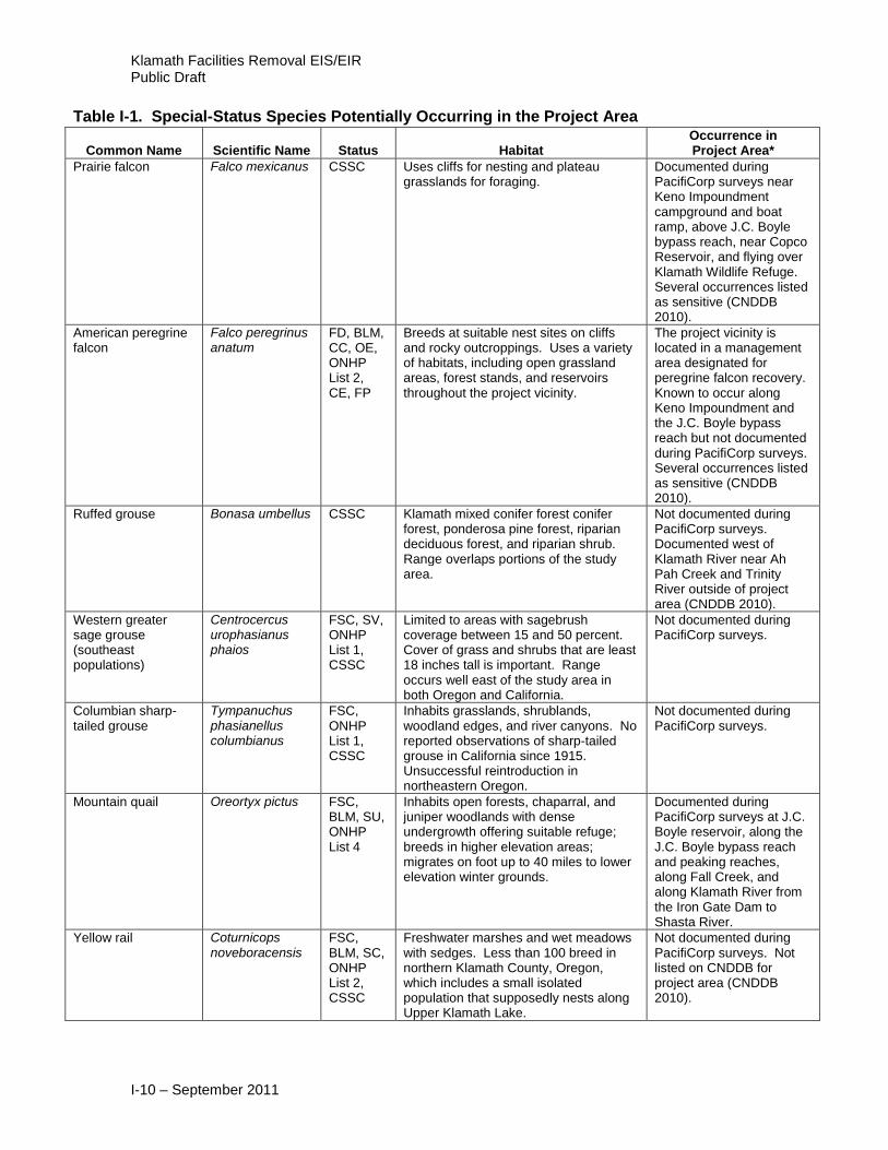
Prairie falcon Falco mexicanus CSSC Uses cliffs for nesting and plateau grasslands for foraging.
Documented during PacifiCorp surveys near Keno Impoundment campground and boat ramp, above J.C. Boyle bypass reach, near Copco Reservoir, and flying over Klamath Wildlife Refuge. Several occurrences listed as sensitive (CNDDB 2010).
American peregrine falcon
Falco peregrinus anatum
FD, BLM, CC, OE, ONHP List 2, CE, FP
Breeds at suitable nest sites on cliffs and rocky outcroppings. Uses a variety of habitats, including open grassland areas, forest stands, and reservoirs throughout the project vicinity.
The project vicinity is located in a management area designated for peregrine falcon recovery. Known to occur along Keno Impoundment and the J.C. Boyle bypass reach but not documented during PacifiCorp surveys. Several occurrences listed as sensitive (CNDDB 2010).
Ruffed grouse Bonasa umbellus CSSC Klamath mixed conifer forest conifer forest, ponderosa pine forest, riparian deciduous forest, and riparian shrub. Range overlaps portions of the study area.
Not documented during PacifiCorp surveys. Documented west of Klamath River near Ah Pah Creek and Trinity River outside of project area (CNDDB 2010).
Western greater sage grouse (southeast populations)
Centrocercus urophasianus phaios
FSC, SV, ONHP List 1, CSSC
Limited to areas with sagebrush coverage between 15 and 50 percent. Cover of grass and shrubs that are least 18 inches tall is important. Range occurs well east of the study area in both Oregon and California.
Not documented during PacifiCorp surveys.
Columbian sharp-tailed grouse
Tympanuchus phasianellus columbianus
FSC, ONHP List 1, CSSC
Inhabits grasslands, shrublands, woodland edges, and river canyons. No reported observations of sharp-tailed grouse in California since 1915. Unsuccessful reintroduction in northeastern Oregon.
Not documented during PacifiCorp surveys.
Mountain quail Oreortyx pictus FSC, BLM, SU, ONHP List 4
Inhabits open forests, chaparral, and juniper woodlands with dense undergrowth offering suitable refuge; breeds in higher elevation areas; migrates on foot up to 40 miles to lower elevation winter grounds.
Documented during PacifiCorp surveys at J.C. Boyle reservoir, along the J.C. Boyle bypass reach and peaking reaches, along Fall Creek, and along Klamath River from the Iron Gate Dam to Shasta River.
Yellow rail Coturnicops noveboracensis
FSC, BLM, SC, ONHP List 2, CSSC
Freshwater marshes and wet meadows with sedges. Less than 100 breed in northern Klamath County, Oregon, which includes a small isolated population that supposedly nests along Upper Klamath Lake.
Not documented during PacifiCorp surveys. Not listed on CNDDB for project area (CNDDB 2010).
Appendix I – Special-Status Species Table
I-11 – September 2011
Table I-1. Special-Status Species Potentially Occurring in the Project Area
Common Name Scientific Name Status Habitat Occurrence in Project Area*
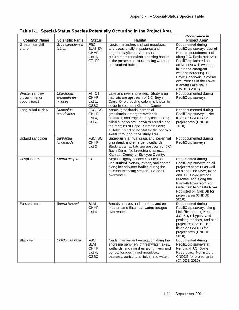
Greater sandhill crane
Grus canadensis tabida
FSC, BLM, SV, ONHP List 4, CT, FP
Nests in marshes and wet meadows, and occasionally in pastures and irrigated hayfields. A primary requirement for suitable nesting habitat is the presence of surrounding water or undisturbed habitat.
Documented during PacifiCorp surveys east of Keno Impoundment and along J.C. Boyle reservoir. PacifiCorp located an active nest with two eggs in it in the emergent wetland bordering J.C. Boyle Reservoir. Several occurrences in the Lower Klamath Lake NWR (CNDDB 2010).
Western snowy plover (Interior populations)
Charadrius alexandrines nivosus
FT, OT, ONHP List 1, CSSC
Lake and river shorelines. Study area habitats are upstream of J.C. Boyle Dam. One breeding colony is known to occur in southern Klamath County.
Not documented during PacifiCorp surveys.
Long-billed curlew Numenius americanus
FSC, CC, ONHP List 4, CSSC
Annual grasslands, perennial grasslands, emergent wetlands, pastures, and irrigated hayfields. Long-billed curlews are known to breed along the margins of Upper Klamath Lake; suitable breeding habitat for the species exists throughout the study area.
Not documented during PacifiCorp surveys. Not listed on CNDDB for project area (CNDDB 2010).
Upland sandpiper Bartramia longicauda
FSC, SC, ONHP List 2
Sagebrush, annual grassland, perennial grassland, and emergent wetlands. Study area habitats are upstream of J.C. Boyle Dam. No breeding sites occur in Klamath County or Siskiyou County.
Not documented during PacifiCorp surveys.
Caspian tern Sterna caspia CC Nests in tightly packed colonies on undisturbed islands, levees, and shores along inland water bodies during the summer breeding season. Forages over water.
Documented during PacifiCorp surveys on all project reservoirs as well as along Link River, Keno and J.C. Boyle bypass reaches, and along the Klamath River from Iron Gate Dam to Shasta River. Not listed on CNDDB for project area (CNDDB 2010).
Forster's tern Sterna forsteri BLM, ONHP List 4
Breeds at lakes and marshes and on mud or sand flats near water; forages over water.
Documented during PacifiCorp surveys along Link River, along Keno and J.C. Boyle bypass and peaking reaches, and at all project reservoirs. Not listed on CNDDB for project area (CNDDB 2010).
Black tern Chlidonias niger FSC, BLM, ONHP List 4, CSSC
Nests in emergent vegetation along the shoreline periphery of freshwater lakes, wetlands, and marshes along rivers and ponds; forages in wet meadows, pastures, agricultural fields, and water.
Documented during PacifiCorp surveys at Keno and J.C. Boyle Reservoirs. Not listed on CNDDB for project area (CNDDB 2010).
Klamath Facilities Removal EIS/EIR Public Draft
I-12 – September 2011
Table I-1. Special-Status Species Potentially Occurring in the Project Area
Common Name Scientific Name Status Habitat Occurrence in Project Area*
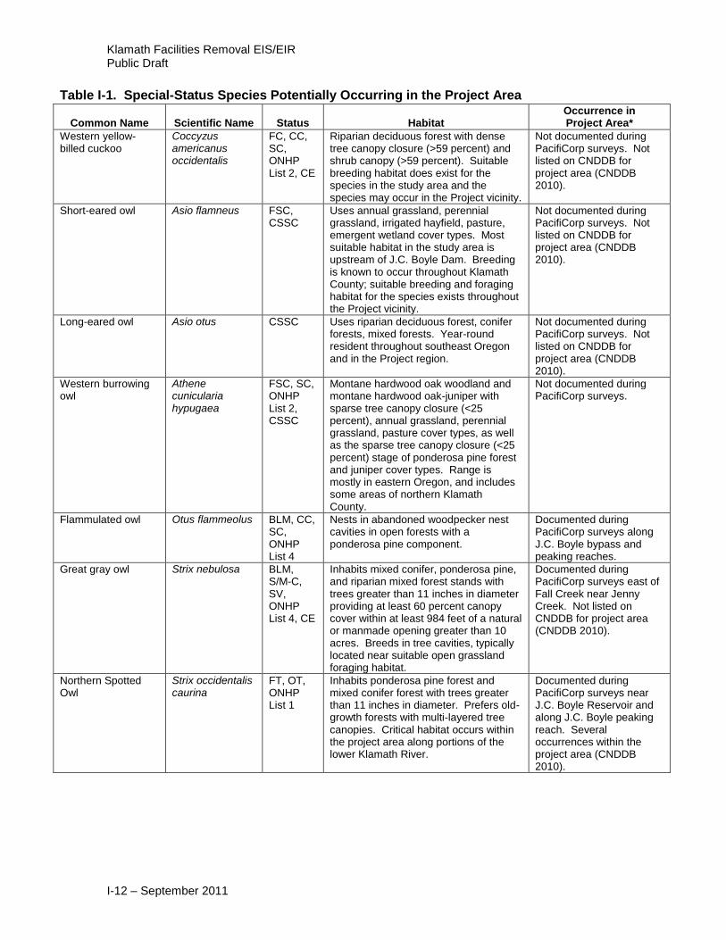
Western yellow-billed cuckoo
Coccyzus americanus occidentalis
FC, CC, SC, ONHP List 2, CE
Riparian deciduous forest with dense tree canopy closure (>59 percent) and shrub canopy (>59 percent). Suitable breeding habitat does exist for the species in the study area and the species may occur in the Project vicinity.
Not documented during PacifiCorp surveys. Not listed on CNDDB for project area (CNDDB 2010).
Short-eared owl Asio flamneus FSC, CSSC
Uses annual grassland, perennial grassland, irrigated hayfield, pasture, emergent wetland cover types. Most suitable habitat in the study area is upstream of J.C. Boyle Dam. Breeding is known to occur throughout Klamath County; suitable breeding and foraging habitat for the species exists throughout the Project vicinity.
Not documented during PacifiCorp surveys. Not listed on CNDDB for project area (CNDDB 2010).
Long-eared owl Asio otus CSSC Uses riparian deciduous forest, conifer forests, mixed forests. Year-round resident throughout southeast Oregon and in the Project region.
Not documented during PacifiCorp surveys. Not listed on CNDDB for project area (CNDDB 2010).
Western burrowing owl
Athene cunicularia hypugaea
FSC, SC, ONHP List 2, CSSC
Montane hardwood oak woodland and montane hardwood oak-juniper with sparse tree canopy closure (<25 percent), annual grassland, perennial grassland, pasture cover types, as well as the sparse tree canopy closure (<25 percent) stage of ponderosa pine forest and juniper cover types. Range is mostly in eastern Oregon, and includes some areas of northern Klamath County.
Not documented during PacifiCorp surveys.
Flammulated owl Otus flammeolus BLM, CC, SC, ONHP List 4
Nests in abandoned woodpecker nest cavities in open forests with a ponderosa pine component.
Documented during PacifiCorp surveys along J.C. Boyle bypass and peaking reaches.
Great gray owl Strix nebulosa BLM, S/M-C, SV, ONHP List 4, CE
Inhabits mixed conifer, ponderosa pine, and riparian mixed forest stands with trees greater than 11 inches in diameter providing at least 60 percent canopy cover within at least 984 feet of a natural or manmade opening greater than 10 acres. Breeds in tree cavities, typically located near suitable open grassland foraging habitat.
Documented during PacifiCorp surveys east of Fall Creek near Jenny Creek. Not listed on CNDDB for project area (CNDDB 2010).
Northern Spotted Owl
Strix occidentalis caurina
FT, OT, ONHP List 1
Inhabits ponderosa pine forest and mixed conifer forest with trees greater than 11 inches in diameter. Prefers old-growth forests with multi-layered tree canopies. Critical habitat occurs within the project area along portions of the lower Klamath River.
Documented during PacifiCorp surveys near J.C. Boyle Reservoir and along J.C. Boyle peaking reach. Several occurrences within the project area (CNDDB 2010).

Appendix I – Special-Status Species Table
I-13 – September 2011
Table I-1. Special-Status Species Potentially Occurring in the Project Area
Common Name Scientific Name Status Habitat Occurrence in Project Area*
Vaux's swift Chaetura vauxi CSSC Found in mixed conifer, ponderosa pine, lodgepole pine, riparian deciduous, montane hardwood oak woodland, montane hardwood oak-conifer, and montane hardwood oak-juniper forests with trees greater than 11 inches in diameter.
Documented during PacifiCorp surveys at J.C. Boyle, Copco, and Iron Gate Reservoirs, along the J.C. Boyle bypass and peaking reaches, along Fall Creek, and along Klamath River from Iron Gate Dam to Shasta River. Not listed on CNDDB for project area (CNDDB 2010).
Black swift Cypseloides niger
SP, ONHP List 2, CSSC
Suitable nesting habitat is limited to cliffs near water courses. Breeding sites are widely distributed in Oregon and California; none known in Klamath or northern Siskiyou Counties.
Not documented during PacifiCorp surveys. Documented along Klamath River near Orleans (CNDDB 2010).
Pilelated woodpecker
Drycopus pileatus
BLM, SV ONHP List 4
Occurs in all forest and woodland cover types with moderate to dense tree canopy closure. Requires large snags 25 inches or more in diameter for excavating suitable nest cavities.
Documented during PacifiCorp surveys along Keno reach, at J.C. Boyle Reservoir, along J.C. Boyle bypass and peaking reaches, and along Fall Creek.
Acorn woodpecker Melanerpes formicivorus
FSC, BLM, ONHP List 4
Nests in cavities located in snags of deciduous tree species, particularly oak snags at least 17 inches in diameter.
Several nesting colonies documented during PacifiCorp surveys in oak, oak-juniper, and oak/conifer habitats, primarily at Copco Reservoir. Also documented during PacifiCorp surveys at J.C. Boyle and Iron Gate Reservoirs, along J.C. Boyle peaking reach, along Copco bypass reach, along Fall Creek, and along Klamath River from Iron Gate Dam to Shasta River.
Lewis' woodpecker Melanerpes lewis FSC, BLM, CC, SC, ONHP List 2
Associated with oak woodlands and mixed oak conifer habitat, but also can be found in a variety of open forest stands including ponderosa pine and cottonwood-dominated riparian areas.
Documented during PacifiCorp surveys in upland habitats along J.C. Boyle peaking reach, in riparian habitats at Iron Gate Reservoir, and along Klamath River from Iron Gate Dam to Shasta River. Documented in Klamath River Canyon (ORBIC 2010).
White-headed woodpecker
Picoides albolarvatus
FSC, BLM, CC, SC, ONHP List 2
Nests in cavities typically located in ponderosa pine at least 18 inches in diameter. Occurs in lodgepole pine, ponderosa pine, and Klamath mixed conifer forests with trees greater than 11 inches in diameter.
Documented during PacifiCorp surveys along J.C. Boyle bypass reach. Not listed on CNDDB for project area (CNDDB 2010).

Klamath Facilities Removal EIS/EIR Public Draft
I-14 – September 2011
Table I-1. Special-Status Species Potentially Occurring in the Project Area
Common Name Scientific Name Status Habitat Occurrence in Project Area*
Black-backed woodpecker
Picoides arcticus BLM, SC, ONHP List 4
Lodgepole pine, ponderosa pine forest, and Klamath mixed conifer forest forests with trees greater than 11 inches dbh. Range is within the study area.
Not documented during PacifiCorp surveys.
Three-toed woodpecker
Picoides tridactylus
BLM, SC, ONHP List 4
Lodgepole pine, ponderosa pine forest, and Klamath mixed conifer forests upstream of Keno Dam. Elevation may be too low for this species to occur in the study area. Range occurs along Cascades, well north of the study area.
Not documented during PacifiCorp surveys.
Williamson's sapsucker
Sphyrapiicus thyroideus
BLM, SU Associated with higher-elevation coniferous forest types including ponderosa pine, lodgepole pine, and Douglas-fir.
Known to occur in the general project vicinity but not documented during PacifiCorp surveys.
Olive-sided flycatcher
Contopus cooperi FSC, BLM, CC, SV, ONHP List 4
Typically found in coniferous forests with tall trees providing suitable perch sites.
Documented during PacifiCorp surveys along Link River, at Keno, J.C. Boyle and Iron Gate Reservoirs, and along Keno and J.C. Boyle peaking reaches. Not listed on CNDDB for project area (CNDDB 2010).
Willow flycatcher Empidonax traillii FSC, BLM, CC, SV, ONHP List 4, CE
Associated with dense riparian willow thickets.
Documented during PacifiCorp surveys in some of the more dense willow patches along Link River, at J.C. Boyle, Copco, and Iron Gate Reservoirs, along the J.C. Boyle peaking reach, and along Klamath River from Iron Gate Dam to Shasta River. Also documented at Iron Gate Reservoir at Jenny Creek (CNDDB 2010).
Black phoebe Sayornis nigricans
BLM Nests on cliffs or rock outcrops near water. Forage in riparian areas with thick vegetation and some nearby vertical surface. The Klamath study area exists along the northern limit of the species range.
Documented during PacifiCorp surveys along the Iron Gate-Shasta reach.
Loggerhead shrike Lanius ludovicianus
ONHP List 4, CSSC
Riparian and wetland forests, as well as Klamath mixed conifer forest, ponderosa pine forest, montane hardwood oak woodland, montane hardwood oak-conifer, and montane hardwood oak-juniper that have sparse to moderate tree canopy closure (<60 percent). Range includes the Klamath basin.
Not documented during PacifiCorp surveys. Not listed on CNDDB for project area (CNDDB 2010).
Pinyon jay Gymnorhinus cyanocephalus
BLM Juniper and ponderosa pine woodlands. Range includes eastern Klamath and Siskiyou Counties east of the study area.
Not documented during PacifiCorp surveys.

Appendix I – Special-Status Species Table
I-15 – September 2011
Table I-1. Special-Status Species Potentially Occurring in the Project Area
Common Name Scientific Name Status Habitat Occurrence in Project Area*
Purple martin Progne subis FSC, BLM, SC, ONHP List 2, CSSC
Riparian and wetland forests, as well as Klamath mixed conifer forest, ponderosa pine forest, montane hardwood oak woodland, montane hardwood oak-conifer, and montane hardwood oak-juniper with sparse to moderate tree canopy closure (<60 percent). Range is patchy and may include portions of the study area.
Documented during PacifiCorp surveys above the upper falls at Fall Creek.
Bank swallow Riparia riparia FSC, BLM, SU, ONHP List 4, CT
Suitable habitat most often associated with roadcuts or riparian embankments. Range includes Klamath basin. No colonies are known to exist in the Project vicinity, but the species may occur in the study area during the breeding season and migration.
Not documented during PacifiCorp surveys. Not listed on CNDDB for project area (CNDDB 2010).
Black-capped chickadee
Parus atricapillus CSSC Nests in a variety of woodland habitats wherever suitable, small nest cavities can be found.
Documented during PacifiCorp surveys along Link River and at Copco and Iron Gate Reservoirs.
Pygmy nuthatch Sitta pygmea BLM, SV Typically found in ponderosa pine forests with less than 70 percent canopy closure.
Documented during PacifiCorp surveys at Keno and J.C. Boyle Reservoirs.
Blue-gray gnatcatcher
Polioptila caerulea
BLM Mixed chaparral, montane hardwood oak woodland, montane hardwood oak-juniper. Range overlaps the study area. The species is specifically known to breed in the chaparral of the Klamath basin.
Documented during PacifiCorp surveys at Iron Gate reservoir.
Western bluebird Sialia mexicana BLM, SV, ONHP List 4
Found in a variety of open habitats; may be limited by the availability of suitable nesting cavities. Nests in open clearings adjacent to woodlands or in human-made structures providing suitable nest sites.
Documented during PacifiCorp surveys along Copco bypass reach, along Fall Creek, and at Iron Gate Reservoir.
Yellow warbler Dendroica petechia
CSSC Found in riparian deciduous forest, riparian shrub, scrub-shrub wetland, and forested wetland. Breeds in riparian habitat throughout North America and winters south from Mexico through South America.
Documented during PacifiCorp surveys throughout the project vicinity at all project reservoirs and in all project reaches. Not listed on CNDDB for project area (CNDDB 2010).
Yellow-breasted chat
Icteria virens FSC, BLM, ONHP List 4, CSSC
Found in the brushy understory of deciduous and mixed woodlands; breeds in brushy vegetation, typically willow thickets, along rivers and streams.
Documented during PacifiCorp surveys primarily in wetland and riparian habitats along J.C. Boyle peaking reach, at Copco Reservoir, along Fall Creek, and along Klamath River from Iron Gate Dam to Shasta River. Not listed on CNDDB for project area (CNDDB 2010).

Klamath Facilities Removal EIS/EIR Public Draft
I-16 – September 2011
Table I-1. Special-Status Species Potentially Occurring in the Project Area
Common Name Scientific Name Status Habitat Occurrence in Project Area*
Tricolored blackbird Agelaius tricolor FSC, BLM, SP, ONHP List 2, CSSC
Scrub-shrub wetland, emergent wetland, and riparian shrubland. Documented in Keno pool area. Range includes Klamath basin.
Not documented during PacifiCorp surveys. Not listed on CNDDB for project area (CNDDB 2010).
Black-throated sparrow
Amphispiza bilineata
BLM, SP, ONHP List 2
Annual grassland, perennial grassland, and mixed chaparral with sparse shrub canopy closure (<25 percent). Range lies east of the Project region.
Not documented during PacifiCorp surveys.
Mammals
Preble's shrew Sorex preblei FSC, ONHP List 4
Streams; near permanent water or intermittent streams in arid to semi-arid shrub/grass associations and within high-elevation conifer forests; sagebrush thickets and willows. Range only extends into extreme eastern Klamath County.
Not documented during PacifiCorp surveys.
Pallid bat Antrozous pallidus pacificus
FSC, BLM, SV, ONHP List 2, CSSC
Most common in open habitats but occurs in a wide variety of cover types including forests. Range overlaps the study area.
Not documented during PacifiCorp surveys. Not listed on CNDDB for project area (CNDDB 2010).
Townsend's western big-eared bat
Corynorhinus townsendii townsendii
FSC, BLM, SC, ONHP List 2, CSSC
Generally found in open forests and a variety of habitats; the availability of suitable roost sites (rock crevices, cliff ledges, and human-made structures) limits distribution and occurrence.
Known from J.C. Boyle peaking reach but not documented during PacifiCorp surveys. One occurrence in project area listed as sensitive by ORBIC (2010). Not listed on CNDDB for project area (CNDDB 2010).
Silver-haired bat Lasionycteris noctivagans
FSC, BLM, SU, ONHP List 4
Montane hardwood forests, riparian forests, juniper, and all conifer forests with moderate to dense shrub canopy closure (>39 percent). Range overlaps the study area.
Not documented during PacifiCorp surveys. Documented outside the project area (CNDDB 2010).
Small-footed myotis bat
Myotis ciliolabrum
FSC, BLM, SU, ONHP List 4
Associated with cliffs and rocky canyons, ponderosa pine and mixed conifer forests.
Not documented during PacifiCorp surveys. Not listed on CNDDB for project area (CNDDB 2010).
Long-eared myotis bat
Myotis evotis FSC, BLM, SU
All forests, mixed chaparral, sagebrush, and forest edges. Range overlaps the study area.
Not documented during PacifiCorp surveys. Not listed on CNDDB for project area (CNDDB 2010).
Fringed myotis bat Myotis thysanodes
FSC, BLM, SV, ONHP List 2
All forests, particularly riparian forests. Range overlaps the study area.
Not documented during PacifiCorp surveys. Not listed on CNDDB for project area (CNDDB 2010).
Long-legged myotis bat
Myotis volans FSC, BLM, SV, ONHP List 4
All forests, including coniferous forests, oak woodlands, riparian forests. Range overlaps the study area.
Not documented during PacifiCorp surveys. Not listed on CNDDB for project area (CNDDB 2010).

Appendix I – Special-Status Species Table
I-17 – September 2011
Table I-1. Special-Status Species Potentially Occurring in the Project Area
Common Name Scientific Name Status Habitat Occurrence in Project Area*
Yuma myotis bat Myotis yumanensis
FSC, BLM, ONHP List 4
Generally found in open forests and a variety of habitats; the availability of suitable roost sites (rock crevices, cliff ledges, and human-made structures) limits distribution and occurrence.
Documented during PacifiCorp surveys roosting in J.C. Boyle forebay spillway house, in transformer bays at Copco No. 1 powerhouse, and in rafters at Iron Gate south gatehouse. Also known from J.C. Boyle peaking reach. One occurrence outside project area (CNDDB 2010).
Pygmy rabbit Brachylagus idahoensis
FSC, SV, ONHP List 2, CSSC
Associated with areas supporting tall, dense clumps of sagebrush. Also may occur in greasewood stands. Project region lies west of the known species’ range.
Not documented during PacifiCorp surveys. Not listed on CNDDB for project area (CNDDB 2010).
Sierra Nevada snowshoe hare
Lepus americanus tahoensis
FSC, CSSC
Riparian deciduous forest, riparian shrub, mixed chaparral, ponderosa pine forest, Klamath mixed conifer forest, montane hardwood oak woodland, montane hardwood oak-juniper, and montane hardwood oak-conifer with trees greater than 11 inches dbh. Restricted to California well south of the study area.
Not documented during PacifiCorp surveys.
White-tailed jackrabbit
Lepus townsendii BLM, SU, ONHP List 4
Sagebrush, mixed chaparral, perennial grassland, and montane hardwood oak-juniper, with sparse to open tree canopy closure (<40 percent). Range overlaps the study area.
Not documented during PacifiCorp surveys. Not listed on CNDDB for project area (CNDDB 2010).
Western gray squirrel
Sciurus griseus BLM, SU, ONHP List 4
Found in a variety of forested habitat types including mixed conifer forest, ponderosa pine forest, lodgepole pine, montane hardwood oak woodland, montane hardwood oak-conifer, and montane hardwood oak juniper with trees greater than 6 inches in diameter.
Documented during PacifiCorp surveys at J.C. Boyle and Copco Reservoirs, along J.C. Boyle peaking reach, and along Copco bypass reach.
White-footed vole Arborimus (=Phenacomys) albipes
FSC, SU, ONHP List 4, CSSC
Riparian deciduous forest (usually alder) areas surrounded by conifer forests. Range is restricted to the Coast and Cascade Ranges well north of the study area.
Not documented during PacifiCorp surveys. Not listed on CNDDB for project area (CNDDB 2010).
Oregon red tree vole Arborimus longicaudus
FSC, S/M-C, ONHP List 3
Dense moist coniferous forests. Range is restricted to the Coast and Cascade Ranges well north of the study area.
Not documented during PacifiCorp surveys. Not listed on CNDDB for project area (CNDDB 2010).
Sonoma tree vole Arborimus pomo CSSC North Coast fog belt from Oregon border to Sonoma County in Douglas Fir, redwood and montane hardwood-conifer forests.
Not documented during PacifiCorp surveys. Documented at north end of Williams Ridge, west of Weitchpec outside of project area (CNDDB 2010).

Klamath Facilities Removal EIS/EIR Public Draft
I-18 – September 2011
Table I-1. Special-Status Species Potentially Occurring in the Project Area
Common Name Scientific Name Status Habitat Occurrence in Project Area*
Sierra Nevada red fox
Vulpes vulpes necator
FSC, CT All habitats, especially forest, riparian, and chaparral habitat. Range occurs south of Siskiyou County.
Not documented during PacifiCorp surveys. Not listed on CNDDB for project area (CNDDB 2010).
Ringtail Bassariscus astutus
BLM, SU, ONHP List 4
Uses a mixture of forest and shrublands or other habitats that provide vertical structure near rocky or riparian areas. Range overlaps the study area. The species is known to occur in the study area.
Not documented during PacifiCorp surveys. Documented in Klamath River Canyon (ORBIC 2010). Not listed on CNDDB for project area (CNDDB 2010).
American (Humboldt) marten
Martes americana (humboldtensis)
FSC, BLM, SV, ONHP List 4
Klamath mixed conifer forest, ponderosa pine forest, lodgepole pine, montane hardwood oak-conifer with moderate to dense tree canopy closure (>39 percent) and trees greater than 11 inches dbh. Habitat without human disturbance is important. Range overlaps the study area.
Not documented during PacifiCorp surveys. Documented outside the project area (CNDDB 2010).
Fisher Martes pennanti FC, BLM, SC, ONHP List 2, CSSC
Mature, closed canopy forests with some deciduous trees; intermediate to large tree stages of conifer forests and riparian deciduous forests both with high tree canopy closure. Habitats in the study area include lodgepole pine, Klamath mixed conifer forest, ponderosa pine forest, riparian deciduous forest, montane hardwood oak-conifer with trees >11 inches dbh. Range overlaps the study area.
Not documented during PacifiCorp surveys. Documented along lower Klamath River (CNDDB 2010). Has been documented in the Upper Klamath Basin within the last two years (T. Collom, ODFW, personal communication, April 29, 2011).
American badger Taxidea taxus CSSC Drier open stages of most shrub, forest, and herbaceous habitats with friable soils.
Not documented during PacifiCorp surveys. One occurrence outside project area (CNDDB 2010).
California wolverine Gulo gulo luteus FSC, OT, ONHP List 2
Lodgepole pine, Klamath mixed conifer forest, mixed chaparral, riparian deciduous forest. Open forests at higher elevations. Range in Oregon is restricted to Cascades well north of the study area. In California, range includes portions of Siskiyou County, but not the study area.
Not documented during PacifiCorp surveys. Documented outside the project area (CNDDB 2010).
Canada lynx Lynx canadensis FT, ONHP List 2
Dense boreal forests, meadows, bogs. The last confirmed specimen in Oregon occurred in 1974. Range overlaps the study area in Oregon. Not in found in California.
Not documented during PacifiCorp surveys.
Gray wolf Canis lupus FT, OT, ONHP List 2-ex
Wide variety of habitats. Not known to occur in vicinity.
Not documented during PacifiCorp surveys.
Appendix I – Special-Status Species Table
I-19 – September 2011
Table I-1. Special-Status Species Potentially Occurring in the Project Area
Common Name Scientific Name Status Habitat Occurrence in Project Area*
Plants
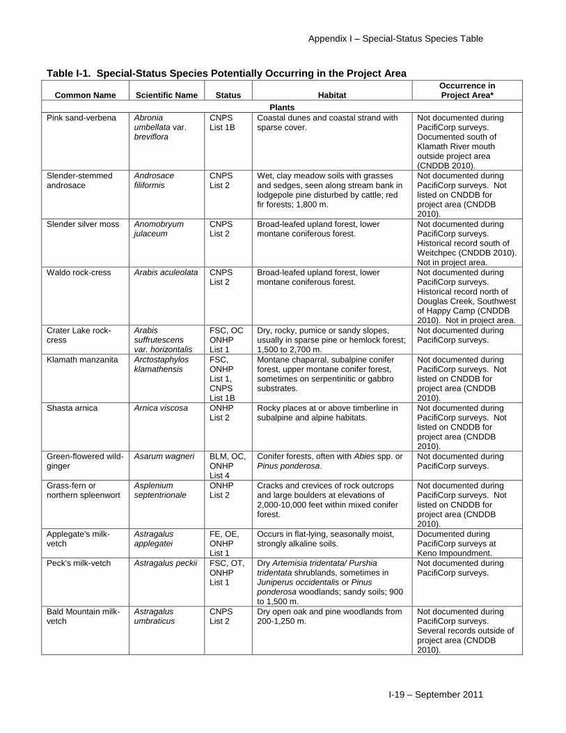
Pink sand-verbena Abronia umbellata var. breviflora
CNPS List 1B
Coastal dunes and coastal strand with sparse cover.
Not documented during PacifiCorp surveys. Documented south of Klamath River mouth outside project area (CNDDB 2010).
Slender-stemmed androsace
Androsace filiformis
CNPS List 2
Wet, clay meadow soils with grasses and sedges, seen along stream bank in lodgepole pine disturbed by cattle; red fir forests; 1,800 m.
Not documented during PacifiCorp surveys. Not listed on CNDDB for project area (CNDDB 2010).
Slender silver moss Anomobryum julaceum
CNPS List 2
Broad-leafed upland forest, lower montane coniferous forest.
Not documented during PacifiCorp surveys. Historical record south of Weitchpec (CNDDB 2010). Not in project area.
Waldo rock-cress Arabis aculeolata CNPS List 2
Broad-leafed upland forest, lower montane coniferous forest.
Not documented during PacifiCorp surveys. Historical record north of Douglas Creek, Southwest of Happy Camp (CNDDB 2010). Not in project area.
Crater Lake rock-cress
Arabis suffrutescens var. horizontalis
FSC, OC ONHP List 1
Dry, rocky, pumice or sandy slopes, usually in sparse pine or hemlock forest; 1,500 to 2,700 m.
Not documented during PacifiCorp surveys.
Klamath manzanita Arctostaphylos klamathensis
FSC, ONHP List 1, CNPS List 1B
Montane chaparral, subalpine conifer forest, upper montane conifer forest, sometimes on serpentinitic or gabbro substrates.
Not documented during PacifiCorp surveys. Not listed on CNDDB for project area (CNDDB 2010).
Shasta arnica Arnica viscosa ONHP List 2
Rocky places at or above timberline in subalpine and alpine habitats.
Not documented during PacifiCorp surveys. Not listed on CNDDB for project area (CNDDB 2010).
Green-flowered wild-ginger
Asarum wagneri BLM, OC, ONHP List 4
Conifer forests, often with Abies spp. or Pinus ponderosa.
Not documented during PacifiCorp surveys.
Grass-fern or northern spleenwort
Asplenium septentrionale
ONHP List 2
Cracks and crevices of rock outcrops and large boulders at elevations of 2,000-10,000 feet within mixed conifer forest.
Not documented during PacifiCorp surveys. Not listed on CNDDB for project area (CNDDB 2010).
Applegate's milk-vetch
Astragalus applegatei
FE, OE, ONHP List 1
Occurs in flat-lying, seasonally moist, strongly alkaline soils.
Documented during PacifiCorp surveys at Keno Impoundment.
Peck's milk-vetch Astragalus peckii FSC, OT, ONHP List 1
Dry Artemisia tridentata/ Purshia tridentata shrublands, sometimes in Juniperus occidentalis or Pinus ponderosa woodlands; sandy soils; 900 to 1,500 m.
Not documented during PacifiCorp surveys.
Bald Mountain milk-vetch
Astragalus umbraticus
CNPS List 2
Dry open oak and pine woodlands from 200-1,250 m.
Not documented during PacifiCorp surveys. Several records outside of project area (CNDDB 2010).

Klamath Facilities Removal EIS/EIR Public Draft
I-20 – September 2011
Table I-1. Special-Status Species Potentially Occurring in the Project Area
Common Name Scientific Name Status Habitat Occurrence in Project Area*
Woolly balsamroot Balsamorhiza hookeri var. lanata
BLM, ONHP List 1, CNPS List 1B
Open woods and grassy slopes; 800 to 1,000 m.
Not documented during PacifiCorp surveys. Not listed on CNDDB for project area (CNDDB 2010).
Bensoniella Bensoniella oregano
S/M- C, ONHP List 1, CNPS List 1B
Edges of meadows near seeps and small streams in Abies zones, often with Senecio triangularis, Mitella ovalis, Viola glabella, Asarum caudatum; 900 to 1,400 m.
Not documented during PacifiCorp surveys. Not listed on CNDDB for project area (CNDDB 2010).
Resin birch Betula pumila var. glandulifera
CNPS List 2
Edges of bogs, meadows and springs in lower montane to subalpine conifer forests; 1,300 to 2,200 m. (= B. glandulosa v. glandulifera).
Not documented during PacifiCorp surveys. Not listed on CNDDB for project area (CNDDB 2010).
Small groundcone Boschniakia hookeri
CNPS List 2
North Coast coniferous forest in open woods, shrubby places from 90-885 m.
Not documented during PacifiCorp surveys. Documented near tributaries outside of project area (CNDDB 2010).
Lance-leaved grape fern
Botrychium lanceolatum ssp. Lanceolatum
ONHP List 2
Mesic to wet rocky slopes, meadows and woods in the montane to subalpine zones.
Not documented during PacifiCorp surveys.
Mingan moonwort Botrychium minganense
S/M, ONHP List 2, CNPS List 2
Moist conifer forests, especially riparian Thuja plicata wetlands (but not wet enough to support Lysichiton) on duff; occasionally in subalpine meadows, ski slopes and mossy boulder fields under Acer macrophyllum or in open shrubland.
Not documented during PacifiCorp surveys. Not listed on CNDDB for project area (CNDDB 2010).
Mountain grapefern Botrychium montanum
S/M, ONHP List 2, CNPS List 2
Shady Thuja plicata and Picea engelmannii forests with sparse understory, near swamps and streams, also in drier Pseudotsuga menziesii forest; 950-1800 m.
Not documented during PacifiCorp surveys. Not listed on CNDDB for project area (CNDDB 2010).
Pumice grape fern Botrychium pumicola
FSC, OT, ONHP List 1
Fine pumice gravel lacking humus and on grassy slopes above 5,000 feet.
Not documented during PacifiCorp surveys.
Greene's mariposa-lily
Calochortus greenei
FSC, BLM, OC, ONHP List 1, CNPS List 1B
Occurs primarily in annual grassland, wedgeleaf ceanothus chaparral, and oak and oak-juniper woodlands.
Documented during PacifiCorp surveys at Iron Gate Reservoir. Yellow starthistle, medusahead, and annual bromes form the dominant herb layer cover at nearly all of the sites where Greene’s mariposa lily was observed. Also known to occur at Copco Reservoir and along J.C. Boyle peaking reach. Several occurrences on CNDDB along Klamath River (2010).

Appendix I – Special-Status Species Table
I-21 – September 2011
Table I-1. Special-Status Species Potentially Occurring in the Project Area
Common Name Scientific Name Status Habitat Occurrence in Project Area*
Long-haired startulip Calochortus longebarbatus var. longebarbatus
FSC, BLM, ONHP List 1, CNPS List 1B
Seasonally wet meadows within pine forests or sagebrush communities; open, grassy meadows, clay soil; 1,000 to 1,500 m.
Not documented during PacifiCorp surveys. Not listed on CNDDB for project area (CNDDB 2010).
Single-flowered mariposa-lily
Calochortus monanthus
FSC, CNPS List 1A
Meadows and seeps in riparian scrub, at +/- 740 m.
Not documented during PacifiCorp surveys. Documented in a meadow along the Shasta River near Yreka, outside the project area (CNDDB 2010).
Siskiyou mariposa-lily
Calochortus persistens
FSC, ONHP List 1, CNPS List 1B
Lower montane conifer forest, North Coast conifer forest, open, rocky areas; 1,000 to 1,500 m.
Not documented during PacifiCorp surveys. Documented on CNDDB (2010) outside of the project area.
Abrupt-beaked sedge
Carex abrupta ONHP List 2
Moist meadows and open forest between 4,600 and 11,000 feet.
Not documented during PacifiCorp surveys.
Capitate sedge Carex capitata ONHP List 2
Found on marshy meadows with acidic, coarse textured, loamy sandy soils between 5,000 and 12,800 feet.
Not documented during PacifiCorp surveys.
Bristly sedge Carex comosa ONHP List 2
Marshes, lake shores, and wet meadows.
Not documented during PacifiCorp surveys. Documented along east shore of J.C. Boyle Reservoir (ORBIC 2010).
Oregon sedge Carex halliana CNPS List 2
Pinyon-juniper woodland, meadows. Not documented during PacifiCorps surveys. Documented outside of project area (CNDDB 2010).
Smooth-beaked sedge
Carex integra ONHP List 2
Seasonally moist soil between 3,000 and 11,000 feet.
Not documented during PacifiCorp surveys.
Slender sedge Carex lasiocarpa var. americana
OHNP List 2
Meadows and lake and pond shores between 5,000 and 7,000 feet. Generally found in standing water.
Not documented during PacifiCorp surveys.
Meadow sedge Carex praticola ONHP List 2, CNPS List 2
Moist to wet meadows below 10,500 feet in elevation.
Not documented during PacifiCorps surveys. Documented outside of project area (CNDDB 2010).
Brown fox sedge Carex vulpinoidea
CNPS List 2
Near water on moist open ground in swamps, prairie swales, lowland forests, wet ditches, ravines, and along the edges of marshes, springs, lakes, and ponds.
Not documented during PacifiCorp surveys. Documented on north shore of Iron Gate Reservoir, 0.1 mile downstream from mouth of Fall Creek (CNDDB 2010).
Oregon coast paintbrush
Castilleja affinis ssp. litoralis
CNPS List 2
Coastal bluff scrub, coastal dunes, coastal scrub.
Not documented during PacifiCorp surveys. Documented outside of project area (CNDDB 2010).

Klamath Facilities Removal EIS/EIR Public Draft
I-22 – September 2011
Table I-1. Special-Status Species Potentially Occurring in the Project Area
Common Name Scientific Name Status Habitat Occurrence in Project Area*
Green-tinged paintbrush
Castilleja chlorotica
FSC, BLM, ONHP List 1
Open areas in ponderosa pine or mixed conifer forests; loose, sandy soils with Penstemon davidsonii, Artemisia tridentata, Heuchera cylindrica; hemiparasitic several shrubs most notably mountain big sagebrush; 1,900 to 2,500 m.
Not documented during PacifiCorp surveys.
Bulb-bearing water hemlock
Cicuta bulbifera BLM, ONHP List 2ex
Marshes, bogs, wet meadows, shallow ponds; 70 to 1,150 m.
Not documented during PacifiCorp surveys.
Ashland thistle Cirsium ciliolatum BLM, ONHP List 1, CE, CNPS List 2
Dry, rocky, grassland; open woodland on south aspects; 800 to 1,400 m.
Not documented during PacifiCorp surveys. Not listed on CNDDB for project area (CNDDB 2010).
Mt. Mazama collomia
Collomia mazama
FSC, BLM, ONHP List 1
Alpine meadows and slopes; dry rocky places conifer forests; 900 to 1,850 m.
Not documented during PacifiCorp surveys.
Oregon goldthread Coptis laciniata CNPS List 2
North coast coniferous forest, meadows and seeps.
Not documented during PacifiCorp surveys. Not listed on CNDDB for project area (CNDDB 2010).
Pallid bird’s-beak Cordylanthus tenuis ssp. pallescens
FSC, CNPS List 1B
Lightly disturbed openings in ponderosa pine, Jeffrey pine, and mixed conifer forests; gravelly alluvium, volcanic or ultramafic soils; 1,100 to 1,700 m.
Not documented during PacifiCorp surveys. Documented on tributaries outside of the project area (CNDDB 2010).
Clustered lady's slipper
Cordylanthus tenuis ssp. pallescens
FSC, BLM, S/M- C, ONHP List 1, CNPS List 4
Dry, open conifer forests, sometime in moist riparian habitats, many soil types; 350 to 950 m (to 1,800 m in California).
Not documented during PacifiCorp surveys. Not listed on CNDDB for project area (CNDDB 2010).
Mountain lady's slipper
Cypripedium montanum
BLM, S/M, ONHP List 4, CNPS List 4
Occurs in dry, open conifer forests, but more often in moist riparian habitats.
Documented during PacifiCorp surveys on a shaded and mesic, forested slope above Frain Creek, a small tributary to the Klamath River at Frain Ranch along J.C. Boyle peaking reach. Not listed on CNDDB for project area (CNDDB 2010).
Naked flag moss Discelium nudum CNPS List 2
Coastal bluff scrub. Not documented during PacifiCorp surveys. Documented outside of the project area (CNDDB 2010).
Oregon fireweed Epilobium oreganum
FSC, ONHP List 1, CNPS List 1B
Wet, gently sloping stream banks, meadows, and bogs, sometimes generally on ultramafic soil; 50 to 2,500 m.
Not documented during PacifiCorp surveys. Documented outside the project area (CNDDB 2010).

Appendix I – Special-Status Species Table
I-23 – September 2011
Table I-1. Special-Status Species Potentially Occurring in the Project Area
Common Name Scientific Name Status Habitat Occurrence in Project Area*
Klamath Mountain buckwheat
Eriogonum hirtellum
CNPS List 1B
Lower montane and upper montane coniferous forest on rocky outcrops and ridges.
Not documented during PacifiCorp surveys. Documented outside of the project area (CNDDB 2010).
Del Norte buckwheat Eriogonum nudum var. paralinum
CNPS List 2
Coastal bluff scrub, coastal prairie. Not documented during PacifiCorp surveys. Documented on sand bar at mouth of Klamath River (CNDDB 2010).
Prostrate buckwheat Eriogonum prociduum
FSC, ONHP List 1, CNPS List 1B
Basalt flows in pine woodlands, occasionally on barren volcanic tuff; with Artemisia spp. and Juniperus; 1,300 to
2,705 m.
Not documented during PacifiCorp surveys. Not listed on CNDDB for project area (CNDDB 2010).
Blushing wild buckwheat
Eriogonum ursinum var. erubescens
CNPS List 1B
Rocky openings on open ridgelines in the Klamath Range from 5,300 to 6,200 feet.
Not documented during PacifiCorp surveys. Documented outside the project area (CNDDB 2010).
Henderson's fawn lily
Erythronium hendersonii
CNPS List 2
Lower montane yellow pine forest. 300 to 1,600 m.
Not documented during PacifiCorp surveys. One occurrence listed as sensitive on CNDDB (2010).
Giant fawn lily Erythronium oregonum
CNPS List 2
Cismontane woodlands, meadows and seeps.
Not documented during PacifiCorp surveys. Documented outside the project area (CNDDB 2010).
Coast fawn lily Erythronium revolutum
CNPS List 2
Bogs and fens, broad-leaved upland forest, north coast coniferous forest.
Not documented during PacifiCorp surveys. Documented outside the project area (CNDDB 2010).
Gentner's fritillary Fritillaria gentneri FE, OE, CNPS List 1B
Variety of habitats including shaded riparian areas, open grasslands, and chaparral, but generally prefers the ecotone between meadow and oak woodland.
Not documented during PacifiCorp surveys. Documented outside the project area (CNDDB 2010).
Newberry's gentian Gentiana newberryi var. newberryi
BLM, ONHP List 2
Meadows and seeps. Moist conditions in meadows and along streambanks; 1,200 to 2,200 m.
Not documented during PacifiCorp surveys.
Klamath gentian Gentiana plurisetosa
FSC, ONHP List 4, CNPS List 1B
Lower and upper montane conifer forest, meadows and seeps, mesic; 1,000 to 3,000 m.
Not documented during PacifiCorp surveys. Documented outside the project area (CNDDB 2010).

Klamath Facilities Removal EIS/EIR Public Draft
I-24 – September 2011
Table I-1. Special-Status Species Potentially Occurring in the Project Area
Common Name Scientific Name Status Habitat Occurrence in Project Area*
Bolander's sunflower Helianthus bolanderi
BLM, ONHP List 3
Occurs in yellow pine forest, foothill oak woodland, chaparral, and occasionally in serpentine substrates or wet habitats.
Documented during PacifiCorp surveys in highly disturbed and degraded sites filled with annual bromes and starthistle along the lower reach of Hayden Creek, a tributary to the Klamath River along J.C. Boyle peaking reach, and south of Iron Gate Reservoir.
Salt heliotrope Heliotropium curvasassavicum
BLM, ONHP List 2
Occurs in seasonally flooded, low-lying, non-porous areas on the east side of the Cascades.
Documented during PacifiCorp surveys at the upper end of Keno Impoundment.
Vanilla grass Hierochloe odorata
BLM, ONHP List 3, CNPS List 2
Meadows, seeps; 1,500 to 1,830 m. Not documented during PacifiCorp surveys. Not listed on CNDDB for project area (CNDDB 2010).
Baker's globe mallow
Iliamna bakeri BLM, ONHP List 1
Chaparral with manzanita, mountain mahogany, open ponderosa pine forest and juniper woodland. Open canopies, dry sandy soils and upper slopes, often in burned areas (Oregon) and/or volcanic lava fields (California); 1,500 to 2,000m (2,300m in California).
Not documented during PacifiCorp surveys.
California globe mallow
Iliamna latibracteata
CNPS List 1B
North Coast coniferous forest. Not documented during PacifiCorp surveys. Documented outside project area (CNDDB 2010).
Pickering’s ivesia Ivesia pickeringii FSC, CNPS List 1B
Lower montane conifer forest, meadows and seeps; mesic, clay, generally serpentinitic clay soils; 800 to 1,500m.
Not documented during PacifiCorp surveys. Not listed on CNDDB for project area (CNDDB 2010).
Dudley's rush Juncus dudleyi CNPS List 2
Lower montane coniferous forest. Not documented during PacifiCorp surveys. Documented outside project area (CNDDB 2010).
Heckner’s lewisia Lewisia cotyledon var. heckneri
FSC, ONHP List 4, CNPS List 1B
Open to partially shaded rocky slopes; +/- 1,500 to 1,600 m.
Not documented during PacifiCorp surveys. Two occurrences listed as sensitive (CNDDB 2010).
Howell’s lewisia Lewisia cotyledon var. howellii
FSC, ONHP List 4, CNPS List 3
Oak woodlands, in rock crevices, gravel, shallow loam or duff; 150 to 400 m.
Not documented during PacifiCorp surveys. Not listed on CNDDB for project area (CNDDB 2010).
Kellog's lily Lilium kelloggii FSC Dry slopes with wet winters and some summer moisture.
Not documented during PacifiCorp surveys or listed by CNDDB (2010) for project area.

Appendix I – Special-Status Species Table
I-25 – September 2011
Table I-1. Special-Status Species Potentially Occurring in the Project Area
Common Name Scientific Name Status Habitat Occurrence in Project Area*
Bellinger's meadow-foam
Limnanthes floccosa ssp. bellingerana
FSC, BLM, OC, ONHP List 1, CNPS List 1B
Occurs in rocky, seasonally wet meadows, or along the margins of damp rocky meadows often partially shaded by adjacent trees and shrubs.
Not documented during PacifiCorp surveys. Known to occur along J.C. Boyle peaking reach. Not listed on CNDDB for project area (CNDDB 2010).
Coast Range lomatium
Lomatium martindalei
CNPS List 2
Bogs and seeps in lower montane coniferous forest, coast bluff scrub, meadows.
Not documented during PacifiCorp surveys. Documented outside project area (CNDDB 2010).
Peck's lomatium Lomatium peckianum
CNPS List 2
Rocky slopes and flats or grassy slopes in ponderosa pine and black oak woodland on volcanic soils and pinyon-juniper woodland; 700 to 1,800 m.
Not documented during PacifiCorp surveys. Documented outside project area (CNDDB 2010).
Bog club-moss Lycopodiella inundata
ONHP List 2
Wet organic soils in peat bogs, muddy depressions, and pond margins.
Not documented during PacifiCorp surveys or listed by CNDDB (2010) for project area.
Broad-nerved hump moss
Meesia uliginosa CNPS List 2
Fens, peaty soil banks, seeps, meadows, and rock fissures upon exposed, damp organic soil within upper montane to subalpine coniferous forest.
Not documented during PacifiCorp surveys. Documented outside the project area (CNDDB 2010).
Detling's silverpuffs Microseris laciniata ssp. detlingii
CNPS List 2
Chaparral and grassy openings among Oregon white oak trees.
Not documented during PacifiCorp surveys. Documented west of Iron Gate Reservoir, 1.2 miles north of Klamath River bridge at Iron Gate Dam (CNDDB 2010).
Elongate copper moss
Mielichhoferia elongata
CNPS List 2
Cismontane woodlands. Not documented during PacifiCorp surveys. Documented outside project area (CNDDB 2010).
Disappearing monkeyflower
Mimulus evanescens
FSC, OC, ONHP List 1, CNPS List 1B
Within sagebrush-juniper dominated vegetation zones and rock fragments and alongside small boulders.
Not documented during PacifiCorp surveys. Not listed on CNDDB for project area (CNDDB 2010).
Jepson’s monkeyflower
Mimulus jepsonii ONHP List 4, CNPS List 4
Bare gravelly, sandy, pumice soils in conifer forests; more than 1,000 m.
Not documented during PacifiCorp surveys. Not listed on CNDDB for project area (CNDDB 2010).

Klamath Facilities Removal EIS/EIR Public Draft
I-26 – September 2011
Table I-1. Special-Status Species Potentially Occurring in the Project Area
Common Name Scientific Name Status Habitat Occurrence in Project Area*
Egg Lake monkeyflower
Mimulus pygmaeus
FSC, CNPS List 4
Occurs in damp areas or vernally moist conditions in meadows and open woods.
Documented during PacifiCorp surveys on the southwest end of J.C. Boyle Reservoir in damp mudflats adjacent to shallow and narrow tributaries to the Reservoir and under the transmission line just southwest of J.C. Boyle Dam. Not listed on CNDDB for project area (CNDDB 2010).
Three-colored monkeyflower
Mimulus tricolor ONHP List 2
Moist flats, wet clay soils and vernal pools. Plants bloom in the receding muds of ephemeral creeks, and stock ponds when sufficient snowpack provides spring water.
Not documented during PacifiCorp surveys.
Ghost-pipe Monotropa uniflora
CNPS List 2
Broad-leaved upland forest, north coast coniferous forest.
Not documented during PacifiCorp surveys. Documented outside project area (CNDDB 2010).
Howell's montia Montia howellii CNPS List 2
Meadows, North coast coniferous forest, vernal pools.
Not documented during PacifiCorp surveys. Documented outside project area (CNDDB 2010).
Wolf's evening-primrose
Oenothera wolfii CNPS List 1B
Coastal bluff scrub, coastal dunes, coastal prairie, lower montane coniferous forest.
Not documented during PacifiCorp surveys. Documented along lower Klamath River (CNDDB 2010).
Northern adder’s tongue
Ophioglossum pusillium
FSC, CNPS List 1A
Freshwater wetlands or moist areas in forests, wetland edges. Low pastures and grassy roadside ditches; 1,000 to 2,000 m.
Not documented during PacifiCorp surveys. Not listed on CNDDB for project area (CNDDB 2010).
Slender orcutt grass Orcuttia tenuis FT, CE, CNPS List 1B
Vernal pools; 200 to 1,100 m. Not documented during PacifiCorp surveys. Not listed on CNDDB for project area (CNDDB 2010).
Thread-leaved beardtongue
Penstemon filiformis
CNPS List 1B
Cismontane woodland, lower montane coniferous forest, meadows and seeps.
Not documented during PacifiCorp surveys. Documented outside project area (CNDDB 2010).
Blue-leaved penstemon
Penstemon glaucinus
FSC, BLM, ONHP List 1
Dry, fine, ashy soils or weathered tuff in forest openings and sometimes in high intensity burn sites, ponderosa pine and lodgepole pine forest; 1,900 to 2,650 m.
Not documented during PacifiCorp surveys.
Red-root yampah Perideridia erythrorhiza
FSC, BLM, OC, ONHP List 1
Occurs in moist prairies, pastureland, seasonally wet meadows, and oak or pine woodlands, often in dark wetland soils and clay depressions.
Not documented during PacifiCorp surveys. Known to occur along Keno reach, at J.C. Boyle Reservoir, and along J.C. Boyle peaking reach.

Appendix I – Special-Status Species Table
I-27 – September 2011
Table I-1. Special-Status Species Potentially Occurring in the Project Area
Common Name Scientific Name Status Habitat Occurrence in Project Area*
Howell’s false caraway
Perideridia howellii
BLM, ONHP List 4
Moist meadows, stream banks; 300 to 1,500 m.
Not documented during PacifiCorp surveys.
Cooke’s phacelia Phacelia cookei FSC, CNPS List 1B
Great Basin scrub, lower montane conifer forest; sandy volcanic soil; 1,400 to 1,700 m.
Not documented during PacifiCorp surveys. Not listed on CNDDB for project area (CNDDB 2010).
Playa phacelia Phacelia inundata
FSC, ONHP List 1, CNPS List 1B
Great Basin scrub, lower montane conifer forest, playas; alkaline soils; 1,300 to 1,800 m.
Not documented during PacifiCorp surveys. Not listed on CNDDB for project area (CNDDB 2010).
Moss phlox Phlox muscoides CNPS List 2
Alpine fell fields to subalpine conifer to great basin scrub in low sagebrush with narrow leaf mountain mahogany; 1,200 to 2,700 m.
Not documented during PacifiCorp surveys. Not listed on CNDDB for project area (CNDDB 2010).
American pillwort Pilularia americana
BLM, ONHP List 2
Shallow pools, vernal pools; 0 to 1,600 m.
Not documented during PacifiCorp surveys.
White-flowered rein orchid
Piperia candida CNPS List 1B
North coast coniferous forest, lower montane coniferous forest, broad-leafed upland forest.
Not documented during PacifiCorp surveys. Documented outside project area (CNDDB 2010).
Desert allocarya Plagiobothrys salsus
FSC, ONHP List 2, CNPS List 2
Moist, alkaline mud flats within the Mohave desert of California and Nevada.
Not documented during PacifiCorp surveys. Not listed on CNDDB for project area (CNDDB 2010).
Profuse-flowered mesa mint
Pogogyne floribunda
FSC, BLM, ONHP List 1, CNPS List 1B
Vernal pools and seasonal lakes sometimes dominated by Artemisia cana, Poa secunda and Navarretia sp.;
1,000 to 1,500 m.
Not documented during PacifiCorp surveys. Not listed on CNDDB for project area (CNDDB 2010).
Oregon polemonium Polemonium carneum
CNPS List 2
Woody thickets, open and moist forests, prairie edges, roadsides, and fence lines.
Not documented during PacifiCorp surveys. Documented outside project area (CNDDB 2010).
Rafinesque's pondweed
Potamogeton diversifolius
ONHP List 2
Found in ponds, lakes, rivers and streams up to 8,200 feet.
Not documented during PacifiCorp surveys.
Newberry’s cinquefoil
Potentilla newberryi
CNPS List 2
Marshes and swamps, receding shorelines, drying marsh margins, sandy volcanic soils; 1,290 to 2,200 m.
Not documented during PacifiCorp surveys. Not listed on CNDDB for project area (CNDDB 2010).
Western black currant
Ribes hudsonianum var. petiolare
CNPS List 1
Riparian scrub; 1,500 to 2,200 m. Not documented during PacifiCorp surveys. Not listed on CNDDB for project area (CNDDB 2010).

Klamath Facilities Removal EIS/EIR Public Draft
I-28 – September 2011
Table I-1. Special-Status Species Potentially Occurring in the Project Area
Common Name Scientific Name Status Habitat Occurrence in Project Area*
Columbia yellow cress
Rorippa columbiae
FSC, BLM, OC, ONHP List 1, CNPS List 1B
Occurs in cobbly, gravelly silt associated with seasonal creek drainages in ponderosa pine/juniper woodland, on the shores of alkalne lakes, along roadside ditches, in meadows, and seeps.
Documented during PacifiCorp surveys at Keno Impoundment. One occurrence at Klamath River near Orleans (CNDDB 2010).
Fleshy sage Salvia dorrii var. incana
CNPS List 3
Occurs in silty to rocky soils in great basin scrub, pinyon, and juniper woodland.
Documented during PacifiCorp surveys on weathered bedrock outcrops overlain with thin, loose, and rocky substrate at Iron Gate Reservoir and along Klamath River from Iron Gate Dam to Shasta River. Not listed on CNDDB for project area (CNDDB 2010).
Tracy’s sanicle Sanicula tracyi FSC, CNPS List 4
Mixed conifer or oak forests; 100 to 1,000 m.
Not documented during PacifiCorp surveys. Documented outside the project area (CNDDB 2010).
Scheuchzeria or pod grass
Scheuchzeria palustris var. americana
BLM, ONHP List 2, CNPS List 2
Freshwater wetlands, bogs, fens, lake margins; 1,400 to 2,000 m.
Not documented during PacifiCorp surveys. Not listed on CNDDB for project area (CNDDB 2010).
Slender bulrush Scirpus heterochaetus
BLM, ONHP List 3, CNPS List 1B
Marshes, muddy shores of lakes at lower elevations, tolerant of alkali (like S. acutus); 500 m.
Not documented during PacifiCorp surveys. Not listed on CNDDB for project area (CNDDB 2010).
Pendulous bulrush Scirpus pendulus BLM, ONHP List 2, CNPS List 2
Occurs along streambanks and in wet meadows.
Documented during PacifiCorp surveys along Fall Creek and J.C. Boyle peaking reach. Documented outside project area (CNDDB 2010).
Water bulrush Scirpus subterminalis
ONHP List 2, CNPS List 2
Marshes and swales, montane lake margins.
Not documented during PacifiCorp surveys. Not listed on CNDDB for project area (CNDDB 2010).
Pale yellow stonecrop
Sedum laxum ssp. flavidum
CNPS List 4
Broad-leaved upland forest, chaparral, cismontane woodland, lower montane coniferous forest.
Not documented during PacifiCorp surveys. Documented outside of project area (CNDDB 2010).
Coast sidalcea Sidalcea oregana ssp. eximia
CNPS List 1B
Meadows and seeps, north coast coniferous forest, lower montane coniferous forest.
Not documented during PacifiCorps surveys. Documented outside of project area (CNDDB 2010).
Lemmon’s silene Silene lemmonii ONHP List 3
Open pine woodlands; 600 to 2,850 m. Not documented during PacifiCorp surveys.
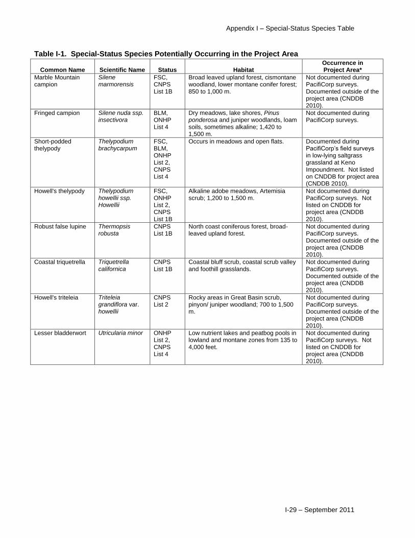
Appendix I – Special-Status Species Table
I-29 – September 2011
Table I-1. Special-Status Species Potentially Occurring in the Project Area
Common Name Scientific Name Status Habitat Occurrence in Project Area*
Marble Mountain campion
Silene marmorensis
FSC, CNPS List 1B
Broad leaved upland forest, cismontane woodland, lower montane conifer forest; 850 to 1,000 m.
Not documented during PacifiCorp surveys. Documented outside of the project area (CNDDB 2010).
Fringed campion Silene nuda ssp. insectivora
BLM, ONHP List 4
Dry meadows, lake shores, Pinus ponderosa and juniper woodlands, loam soils, sometimes alkaline; 1,420 to 1,500 m.
Not documented during PacifiCorp surveys.
Short-podded thelypody
Thelypodium brachycarpum
FSC, BLM, ONHP List 2, CNPS List 4
Occurs in meadows and open flats. Documented during PacifiCorp’s field surveys in low-lying saltgrass grassland at Keno Impoundment. Not listed on CNDDB for project area (CNDDB 2010).
Howell's thelypody Thelypodium howellii ssp. Howellii
FSC, ONHP List 2, CNPS List 1B
Alkaline adobe meadows, Artemisia scrub; 1,200 to 1,500 m.
Not documented during PacifiCorp surveys. Not listed on CNDDB for project area (CNDDB 2010).
Robust false lupine Thermopsis robusta
CNPS List 1B
North coast coniferous forest, broad-leaved upland forest.
Not documented during PacifiCorp surveys. Documented outside of the project area (CNDDB 2010).
Coastal triquetrella Triquetrella californica
CNPS List 1B
Coastal bluff scrub, coastal scrub valley and foothill grasslands.
Not documented during PacifiCorp surveys. Documented outside of the project area (CNDDB 2010).
Howell's triteleia Triteleia grandiflora var. howellii
CNPS List 2
Rocky areas in Great Basin scrub, pinyon/ juniper woodland; 700 to 1,500 m.
Not documented during PacifiCorp surveys. Documented outside of the project area (CNDDB 2010).
Lesser bladderwort Utricularia minor ONHP List 2, CNPS List 4
Low nutrient lakes and peatbog pools in lowland and montane zones from 135 to 4,000 feet.
Not documented during PacifiCorp surveys. Not listed on CNDDB for project area (CNDDB 2010).
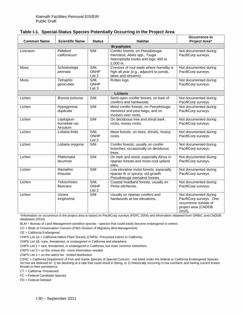
Klamath Facilities Removal EIS/EIR Public Draft
I-30 – September 2011
Table I-1. Special-Status Species Potentially Occurring in the Project Area
Common Name Scientific Name Status Habitat Occurrence in Project Area*
Bryophytes
Liverwort Ptilidium californicum
S/M Conifer forests, on Pseudotsuga menziesii, Abies spp., Tsuga heterophylla trunks and logs; 450 to 2,000 m.
Not documented during PacifiCorp surveys.
Moss Schistostega pennata
S/M, ONHP List 2
Crevices of root wads where humidity is high all year (e.g., adjacent to ponds, lakes and streams).
Not documented during PacifiCorp surveys.
Moss Tetraphis geniculata
S/M, ONHP List 3
Rotten logs. Not documented during PacifiCorp surveys.
Lichens
Lichen Bryoria tortuosa S/M Semi-open conifer forests, on bark of conifers and hardwoods.
Not documented during PacifiCorp surveys.
Lichen Hypogymnia duplicata
S/M Moist conifer forests, on Pseudotsuga menziesii and pine twigs, and on mosses over rocks.
Not documented during PacifiCorp surveys.
Lichen Leptogium burnetiae var. hirsutum
S/M On deciduous tree and shrub bark, rocks, mossy rocks.
Not documented during PacifiCorp surveys.
Lichen Lobaria linita S/M, ONHP List 2
Moist forests, on trees, shrubs, mossy rocks.
Not documented during PacifiCorp surveys.
Lichen Lobaria oregona S/M Conifer forests; usually on conifer branches, occasionally on deciduous trees.
Not documented during PacifiCorp surveys.
Lichen Platismatia lacunose
S/M On bark and wood, especially Alnus in riparian forests and moist cool upland sites.
Not documented during PacifiCorp surveys.
Lichen Ramalina thrausta
S/M Low elevation moist forests, especially riparian fir or spruce; old-growth Pseudotsuga menziesii forests.
Not documented during PacifiCorp surveys.
Lichen Teloschistes flavicans
S/M, ONHP List 2
Coastal headland forests, usually on Picea sitchensis.
Not documented during PacifiCorp surveys.
Lichen Usnea longissima
S/M Usually on riparian conifers and hardwoods at low elevations.
Not documented during PacifiCorp surveys. One occurrence outside of project area (CNDDB 2010).
*Information on occurrence in the project area is based on PacifiCorp surveys (FERC 2004) and information obtained from ORBIC and CNDDB databases (2010).
BLM = Bureau of Land Management sensitive species - species that could easily become endangered or extinct.
CC = Birds of Conservation Concern (FWS Division of Migratory Bird Management)
CE = California Endangered
CNPS List 1A = California Native Plant Society (CNPS)- Presumed extinct in California.
CNPS List 1B =rare, threatened, or endangered in California and elsewhere.
CNPS List 2 = rare, threatened, or endangered in California, but more common elsewhere.
CNPS List 3 = on the review list - more information needed
CNPS List 4 = on the watch list - limited distribution
CSSC = California Department of Fish and Game Species of Special Concern - not listed under the federal or California Endangered Species Act but are believed to: 1) be declining at a rate that could result in listing, or 2) historically occurring in low numbers and having current known threats to their persistence
CT = California Threatened
FC = Federal Candidate Species
FD = Federal Delisted

Appendix I – Special-Status Species Table
I-31 – September 2011
Table I-1. Special-Status Species Potentially Occurring in the Project Area
Common Name Scientific Name Status Habitat Occurrence in Project Area*
FE = Federal Endangered
FP: Fully protected under the California Fish and Game Code
FSC = Federal Species of Concern
FT = Federal Threatened
OC = Candidate listing by Oregon Department of Agriculture (ODA) or Oregon Department of Fish and Wildlife (ODFW)
OE = Listed as endangered by ODA or ODFW
ONHP List 1 = Oregon Natural Heritage Program (ONHP) threatened with extinction or presumed to be extinct throughout their entire range
ONHP List 2 = threatened with extirpation or presumed to be extirpated from the state of Oregon
ONHP List 3 = more information is needed before status can be determined, but may be threatened or endangered in Oregon or throughout their range
OHNP List 4 = of conservation concern but not currently threatened or endangered
OT = Listed as threatened by ODA or ODFW
SC = Sensitive Critical - listed by ODFW as threatened or endangered is pending, or listing as threatened or endangered may be appropriate if immediate conservation actions are not taken.
SP = Sensitive Peripheral or Naturally Rare - listed by ODFW with populations on the edge of the range or historically low because of naturally occurring limiting factors
SU = Sensitive Undetermined Status - listed by ODFW for which status is unclear
SV = Sensitive Vulnerable - listed by ODFW as threatened or endangered is not imminent and can be avoided through continued or expanded use of adequate protective measures and monitoring. In some cases the populations are sustainable and protective measures
S/M-C = Survey and Manage Species, as designated in the Northwest Forest Plan; category C - Uncommon, pre-disturbance surveys practical
S/M-D = Survey and Manage Species, as designated in the Northwest Forest Plan; category D - Uncommon, pre-disturbance surveys not practical or necessary
I.2 References
PacifiCorp. 2004. Terrestrial Resources Final Technical Report. Klamath Hydroelectric
Project (FERC Project No. 2082). Portland, Oregon.

This page intentionally left blank