Embed Size (px)
Citation preview
Chapter 3 – Affected Environment/Environmental Consequences 3.13 Cultural and Historic Resources
3.13-1 – September 2011
3.13 Cultural and Historic Resources
This section discusses the Proposed Action and alternatives‟ potential effects on cultural
resources, historic properties, and historical resources. United States Department of the
Interior (DOI) elected to utilize the National Environmental Policy Act (NEPA) process
to meet the requirements of Section 106 of the National Historic Preservation Act
(NHPA) as allowed under 36 CFR Section 800.8(c). DOI defines the undertaking, for
purposes of Section 106 of the NHPA, as the removal of the four PacifiCorp dams which
may be a result of the Secretarial Determination. The proposed undertaking has the
potential to affect historic properties triggering compliance with Section 106 of the
NHPA. The analysis and consultations concerning any effects of the Proposed Action
and alternatives on historic properties will be integrated into the NEPA review and
documentation pursuant to the criteria identified in 36 CFR Section 800.8(c)(1)-(4). The
following section also incorporates the compliance requirements of the California
Environmental Quality Act (CEQA).
3.13.1 Area of Analysis
The area of analysis for cultural and historic resources includes the area of potential
effects (APE) for the Proposed Action (removal of the four dams and facilities) as this
represents the largest APE of all alternatives and is inclusive of all APEs for each of the
other alternatives. The APE is defined as the entire 263 mile length of the Klamath River
from Upper Klamath Lake to the Pacific Ocean and a 0.5-mile-wide corridor surrounding
the river, all four dams and associated facilities, and each of the four reservoirs.
3.13.2 Regulatory Framework
The following definitions are common terms used to discuss the regulatory requirements
and treatment of cultural resources:
Cultural Landscape is a geographic area, including both cultural and
natural resources, associated with an historic event, activity, or person or
exhibiting other cultural or aesthetic values. (Birnbaum 1994). An
ethnographic landscape, one type of cultural landscape, is described as a
landscape containing a variety of natural and cultural resources that
associated people define as heritage resources. (Birnbaum 1994). Cultural
landscapes may be evaluated for eligibility following the criteria 36 CFR
Section 60.4.
Cultural resource is a term used to describe several different types of
properties, both made/modified by people and natural: prehistoric and
historical archaeological sites; architectural properties such as buildings,
bridges, and infrastructure; and resources of traditional or historic
importance to Indian tribes and other cultural groups.
Klamath Facilities Removal EIS/EIR Public Draft
3.13-2 – September 2011
Historic properties is a term defined in 36 CFR Section 800, the
implementing regulations for Section 106 of the NHPA, as any prehistoric
or historic district, site, building, structure, or object included in, or
eligible for inclusion on, the National Register of Historic Places (National
Register), including artifacts, records, and material remains related to such
a property. The term includes properties of traditional religious and
cultural importance (Traditional Cultural Properties or Cultural
Landscapes) to an Indian tribe or other cultural group that also meet the
National Register criteria for listing found at 36 CFR Section 60.4.
Historical resource is a CEQA term that includes buildings, sites,
structures, objects, or districts, each of which may have historical,
prehistoric, architectural, archaeological, cultural, or scientific importance,
and is eligible for listing or is listed in the California Register of Historical
Resources (California Register).
Historic District is a significant concentration, linkage, or continuity of
sites, buildings, or structures united historically or aesthetically by plan or
physical development. A Historic District derives its importance from
being a unified entity, even though it is often composed of a wide variety
of resources. The identity of a District results from the interrelationship of
its resources, which can convey a visual sense of the overall historic
environment or be an arrangement of historically or functionally related
properties. A District can include sites, structures, and features that, on
their own, lack individual distinction, but are significant as a group. A
District will have an identified theme and time period of significance.
Programmatic Agreements are negotiated agreements between federal
agencies, the Advisory Council on Historic Preservation (ACHP), and
State Historical Preservation Officers (SHPOs), in consultation with other
interested parties, that govern the implementation of a particular program
or the resolution of adverse effects from certain complex project situations
or multiple undertakings, as defined in 36 CFR Section 800.14.
Programmatic Agreements may be used when effects on properties are
similar and repetitive or are multi-state; when effects on historic properties
cannot be fully determined prior to approval of an undertaking; when
nonfederal parties are delegated major decision making responsibilities;
and for dealing with the potential adverse effects of complex projects or
multiple undertakings.
Traditional Cultural Property (TCP) is defined as a property eligible
for inclusion in the National Register “because of its association with
cultural practices or beliefs of a living community that (a) are noted in that
community‟s history, and (b) are important in maintaining the continuity
of the community (Parker and King 1998).”
Chapter 3 – Affected Environment/Environmental Consequences 3.13 Cultural and Historic Resources
3.13-3 – September 2011
3.13.2.1 National Historic Preservation Act of 1966, as amended in 1992
The NHPA is the primary federal legislation governing preservation of cultural and
historical resources in the United States. The NHPA established a national historic
preservation program which encourages the identification and protection of cultural
resources. Section 106 of the NHPA requires federal agencies to take into account the
effects of their undertakings on historic properties listed in or eligible for the National
Register of Historic Places and afford the ACHP a reasonable opportunity to comment on
such undertakings (16 USC Section 470f). The ACHP promulgated the Section 106
implementing regulations, found at 36 CFR Part 800, which sets forth the Section 106
process, including consultation requirements.
Compliance with Section 106 of the NHPA As allowed under the Section 106
regulations, DOI has elected to integrate compliance with Section 106 through the NEPA
process pursuant to 36 CFR Section 800.8(c)(1)-(4). This integrated approach satisfies
the regulatory steps of the Section 106 process by using the NEPA process and the
documentation required for the preparation of an Environmental Impact Statement (EIS)/
Record of Decision (ROD) to evaluate and resolve an undertaking‟s potential adverse
effects on historic properties. The regulations identify specific requirements that the
federal agency must meet through the NEPA process and documentation in lieu of the
Section 106 process set forth in 36 CFR Sections 800.3 through 800.6. These standards,
and a description of how DOI will meet those standards, are described below.
Initiation of the Section 106 Process: The definition of the federal undertaking is an
important step in the initiation of the Section 106 process. In this case, the proposed
undertaking is the potential removal of the four lower PacifiCorp dams. The proposed
undertaking and the alternatives being analyzed in this EIS/ Environmental Impact
Report (EIR) are limited to only the selection of an approach involving partial or full dam
removal and the installation of fish passages. The specific details of how the proposed
undertaking or the alternatives might be implemented are not fully known at this time and
cannot be fully analyzed in this EIS/EIR, nor will a decision through the EIS/EIR
authorize the removal of dams without additional compliance with NEPA and other
federal environmental laws, including Section 106 of the NHPA. Future decisions will
evaluate how to implement the Proposed Action or other selected alternative.
Use of the NEPA Process In Lieu of the Section 106 Procedures Set Forth in 36 CFR
Sections 800.3 through 800.6: The regulations for Section 106 permit federal agencies
to integrate Section 106 compliance with the NEPA process (36 CFR Section 800.8).
Due to the scope and scale of this undertaking, DOI has chosen to utilize this provision in
order to reduce redundancies when complying with both laws; provide the broadest
possible opportunities and greatest convenience for the public to review and consult on
DOI‟s proposed actions; and ensure that concerns pertaining to historic properties are
fully integrated into the EIS and the ROD.
The Section 106 regulations clearly state that integrating the Section 106 compliance
process with NEPA does not waive federal agency obligations under either law. While
the regulations do permit the DOI to take advantage of the NEPA process, the Agency
Klamath Facilities Removal EIS/EIR Public Draft
3.13-4 – September 2011
must still adhere to the fundamental direction for compliance with Section 106. The
following summarizes the DOI‟s actions to comply with these provisions (36 CFR
Sections 800.8(c)(1) through 800.8(c)(4)).
Notifications: A federal agency must disclose its intent to integrate the Section 106
process with the NEPA process to the appropriate SHPOs and the ACHP prior to the
review. DOI notified the ACHP and the California SHPO and Oregon SHPO, of its
intent to implement the Section 106 regulations through the NEPA process by letter dated
June 24, 2011.
Identifying consulting parties pursuant to 36 CFR Section 800.3(f): The public
involvement process for NEPA has been extensive and sustained. It has included
outreach and invitations to consult to other federal agencies, state and local governments,
nongovernmental organizations, and the public. In addition, DOI has separately notified
the ACHP, California SHPO, Oregon SHPO, six federally recognized Indian tribes, two
Indian organizations, and other interested parties.
Identify Historic Properties and Assess the Effects: For purposes of the proposed action
to remove the four lower PacifiCorps dams (and for the evaluation of alternatives), DOI
established as the APE the entire 263 miles of the Klamath River and a 0.5 mile corridor
around it. The effort to identify and assess effects reflects DOI‟s consideration of the
project alternatives and is commensurate with the assessment of other environmental
factors. The identification of and potential effect on some historic properties cannot be
fully determined prior to approval of either the proposed undertaking or an alternative
evaluated in this EIS/EIR. Future decisions regarding implementation of the selected
alternative will further develop the APE and identify cultural and historic properties that
may be affected by future actions such as road construction or improvements and
reservoir drawdown.
DOI identified known historic properties listed or eligible for the National Register, such
as the Klamath Hydroelectric Facilities, and also the types of historic properties likely to
occur within this area through records searches at the North Central Information Center at
California State University, Chico; the North Coastal Information Center, Klamath,
California; the Oregon Office of Historic Preservation; the Klamath National Forest; a
sacred lands search conducted by the California Native American Heritage Commission;
and a review of archaeological, ethnographic, and historic information. DOI also sought
information from the SHPOs, Indian tribes, Indian organizations, and the public
regarding information about historic resources through the scoping process for the
EIS/EIR and the initiation of consultations under Section 106 of the NHPA. This data is
presented in Section 3.13.3. The potential effects of the proposed undertaking and the
alternatives are discussed in Section 3.13.4.
Consult Regarding the Effects of the Undertaking with Tribes that May Attach Religious
and Cultural Significance to Affected Historic Properties: Tribal consultation for Section
106 was initiated via letter dated October 19, 2010. Tribal consultation is ongoing.
Chapter 3 – Affected Environment/Environmental Consequences 3.13 Cultural and Historic Resources
3.13-5 – September 2011
Involve the Public in accordance with the Agency’s Published NEPA Procedures: The
public has been involved in the scoping process for this EIS/EIR and will be provided an
opportunity to review and comment on this EIS/EIR during the public review period.
Develop, in Consultation with Consulting Parties, Alternatives and Proposed Measures that Might Avoid, Minimize, or Mitigate Any Adverse Effects of the Undertaking on
Historic Properties: Selection of one of the proposed alternatives, other than the No
Action Alternative, would be the first part of a multi-tiered decision-making process.
The Proposed Action and the alternatives being evaluated in this EIS/EIR will require
additional environmental compliance prior to initiation of ground disturbing activities.
Section 106 consultation was initiated with ACHP, SHPOs, and other consulting parties,
and will be ongoing through a final decision and any future agency decisions. DOI
identified known historic properties and methods to further identify and evaluate historic
properties. DOI has also sought information from Indian tribes regarding the
identification of areas with religious or cultural importance, and this section discusses the
potential effect to such resources. Measures to avoid, minimize or mitigate adverse
effects are also evaluated in this section. These measures would be offered as binding
commitments for future decisions, and will help to coordinate future development
through those decisions. The mitigation measures also serve as a program of action to
avoid, minimize, or mitigate the effects on historic properties associated with the selected
alternative.
Review of Environmental Documents: DOI will submit the Draft EIS/EIR for review and
comments to the SHPOs, Tribal Historical Preservation Officers (THPOs), ACHP, Indian
tribes, Indian organizations, and other parties identified as interested parties.
Approval of the Undertaking: The measures to avoid, minimize, or mitigate potential
adverse effects associated with the Proposed Action or the selected alternative will be
incorporated into the Record of Decision and represent a binding commitment as the
selected alternative is carried out.
3.13.2.2 Native American Graves Protection and Repatriation Act (NAGPRA)
Section 3 of NAGPRA applies to Indian human remains and other cultural items found
on federal lands and tribal lands, and addresses the treatment and disposition of those
remains and items in consultation with relevant tribe(s) (see Appendix D of NAGPRA).
Any Indian human remains or other cultural items found on federal land or tribal land
affected by the Proposed Action and alternatives would be subject to the procedures
under NAGPRA.
3.13.2.3 California Environmental Quality Act
For the purpose of this Klamath Facilities Removal EIS/EIR, California public agencies
must consider the effects of their actions on both “historical resources” and “unique
archaeological resources.” Pursuant to Public Resources Code (PRC) Section 21084.1, a
“project that may cause a substantial adverse change in the significance of an historical
resource is a project that may have a significant effect on the environment.” Section
Klamath Facilities Removal EIS/EIR Public Draft
3.13-6 – September 2011
21083.2 requires agencies to determine whether proposed projects would have effects on
“unique archaeological resources.”
“Historical resource” is a term with a defined statutory meaning (PRC, Section 21084.1
and State CEQA Guidelines, Section 15064.5 [a], [b]). The term embraces any resource
listed in or determined to be eligible for listing in the California Register. The California
Register includes resources listed in or formally determined to be eligible for listing in
the National Register, as well as some California State Landmarks and Points of
Historical Interest.
Properties of local significance that have been designated under a local preservation
ordinance (local landmarks or landmark districts) or that have been identified in a local
historical resources inventory may be eligible for listing in the California Register and are
presumed to be historically or culturally significant for purposes of CEQA unless a
preponderance of evidence indicates otherwise (PRC, Section 21084.1 and California
Code of Regulations, Title 14, Section 4850).
In addition to assessing whether historical resources potentially affected by a proposed
project are listed in the California Register or have been identified as historically or
culturally significant in a survey process, lead agencies have a responsibility to evaluate
them against the California Register criteria prior to making a finding as to a proposed
project‟s impacts on historical resources (PRC, Section 21084.1 and California Code of
Regulations, Section 15064.5 [a][3]). Under California Code of Regulations (CCR), Title
14, Chapter 3, Section 15064.5 (a)(3) a historical resource is defined as any object,
building, structure, site, area, place, record, or manuscript that meets the following
criteria:
a) Is historically or archeologically significant, or is significant in the
architectural, engineering, scientific, economic, agricultural,
educational, social, political or cultural annals of California.
b) Meets any of the following criteria:
(A) Is associated with events that have made a significant
contribution to the broad patterns of California‟s history and
cultural heritage.
(B) Is associated with the lives of persons important in our past.
(C) Embodies the distinctive characteristics of a type, period,
region, or method of construction, or represents the work of an
important creative individual, or possesses high artistic values.
(D) Has yielded, or may be likely to yield, information important
in prehistory or history.
Archaeological resources may also qualify as “historical resources” and PRC 5024
requires consultation with the Office of Historic Preservation when a project may affect
historical resources located on state-owned land.
For historic structures, CEQA Guidelines Section 15064.5, subdivision (b)(3), indicates
that a project that follows the Secretary of the Interior‟s Standards for the Treatment of
Chapter 3 – Affected Environment/Environmental Consequences 3.13 Cultural and Historic Resources
3.13-7 – September 2011
Historic Properties with Guidelines for Preserving, Rehabilitating, Restoring, and
Reconstructing Historic Buildings, or the Secretary of the Interior‟s Standards for
Rehabilitation and Guidelines for Rehabilitating Historic Buildings (1995) shall be
considered as mitigating impacts to a less-than-significant level.
CEQA addresses impacts, potentially significant and significant impacts, to historical
resources. Historical resources are properties that are either listed on or determined
eligible for inclusion on the California Register and significant impacts are defined at
CCR Section 15382 as: “…a substantial, or potentially substantial, adverse change in any
of the physical conditions within the area affected by the project including land, air,
water, minerals, flora, fauna, ambient noise, and objects of historic and aesthetic
significance. An economic or social change by itself shall not be considered a significant
effect on the environment. A social or economic change related to a physical change may
be considered in determining whether the physical change is significant.”
As noted above, CEQA also requires lead agencies to consider whether projects will
affect “unique archaeological resources.” PRC Section 21083.2, subdivision (g), states
that “„unique archaeological resources‟ means an archaeological artifact, object, or site
about which it can be clearly demonstrated that, without merely adding to the current
body of knowledge, there is a high probability that it meets any of the following criteria:
1) Contains information needed to answer important scientific
research questions and that there is a demonstrable public interest
in that information.
2) Has a special and particular quality such as being the oldest of its
type or the best available example of its type.
3) Is directly associated with a scientifically recognized, important
prehistoric or historic event or person.”
Treatment options under PRC Section 21083.2 include activities that preserve such
resources in place in an undisturbed state. Other acceptable methods of mitigation under
PRC Section 21083.2 include excavation and curation or study in place without
excavation and curation (if the study finds that the artifacts would not meet one or more
of the criteria for defining a “unique archaeological resource”).
In addition, California law protects Indian human remains and associated cultural items
regardless of their antiquity and provides for the sensitive treatment and disposition of
those remains. Section 7050.5(b) of the California Health and Safety Code specifies
protocol when human remains are discovered. The code states:
In the event of discovery or recognition of any human remains in any
location other than a dedicated cemetery, there shall be no further
excavation or disturbance of the site or any nearby area reasonably
suspected to overlie adjacent remains until the coroner of the county in
which the human remains are discovered has determined, in accordance
with Chapter 10 (commencing with Section 27460) of Part 3 of
Division 2 of Title 3 of the Government Code, that the remains are not
subject to the provisions of Section 27492 of the Government Code or
Klamath Facilities Removal EIS/EIR Public Draft
3.13-8 – September 2011
any other related provisions of law concerning investigation of the
circumstances, manner and cause of death, and the recommendations
concerning treatment and disposition of the human remains have been
made to the person responsible for the excavation, or to his or her
authorized representative, in the manner provided in Section 5097.98 of
the Public Resources Code.
California Health and Safety Code at Sections 8010-8011 established the California
NAGPRA 2001. The state repatriation policy is consistent with and facilitates
implementation of the federal NAGPRA. The California act strives to ensure that all
California Indian human remains and cultural items are treated with dignity and respect
by encouraging voluntary disclosure and return of remains and cultural items by publicly
funded agencies and museums in California. The act also provides a mechanism for
aiding California Indian tribes, including non-federally recognized tribes, in filing
repatriation claims and obtaining responses to those claims.
CCR Section 15064.5, subdivision (e), requires that excavation activities be stopped
whenever human remains are uncovered and that the county coroner be called in to assess
the remains. If the county coroner determines that the remains are those of Indian tribes,
the Native American Heritage Commission must be contacted within 24 hours. At that
time, the lead agency must consult with the appropriate Indian tribes, if any, as identified
by the Native American Heritage Commission. CCR Section 15064.5 directs the lead
agency, under certain circumstances, to develop an agreement with the Indian tribes for
the treatment and disposition of the remains.
In addition to the mitigation provisions pertaining to the accidental discovery of human
remains, the State CEQA Guidelines also require that a lead agency make provisions for
the accidental discovery of historical or archaeological resources, generally. Pursuant to
CCR Section 15064.5, subdivision (f), these provisions should include “an immediate
evaluation of the find by a qualified archaeologist. If the find is determined to be an
historical or unique archaeological resource, contingency funding and a time allotment
sufficient to allow for implementation of avoidance measures or appropriate mitigation
should be available. Work could continue on other parts of the building site while
historical or unique archaeological resource mitigation takes place.”
Burials would be subject to federal NAGPRA on federal land and Indian land, California
state burial laws in California, and Oregon state burial laws in Oregon.
3.13.3 Existing Conditions/ Affected Environment
The presence of historic properties (or historical resources under CEQA) within the APE
for each alternative was identified by conducting background and archival research and
consulting with parties with knowledge of the area to identify known resources. In
addition, through archival and background research, consultations, and knowledge of
known resources, the types of historic properties likely present in inaccessible areas
(primarily areas currently inundated by the reservoirs) were identified.
Chapter 3 – Affected Environment/Environmental Consequences 3.13 Cultural and Historic Resources
3.13-9 – September 2011
Due to the nature of the action being proposed, potential effects on all historic properties
cannot be fully determined prior to approval of either the Proposed Action or an
alternative evaluated in this EIS/EIR. The identification and evaluation of certain
resources, and the potential effects to those resources, can only be understood and
addressed as particular details of how to carry out the selected alternative are developed.
One particular example is historic properties and cultural resources that are thought to be
currently under water that could be exposed during reservoir draw down, as a direct result
of dam removal. Another example is the construction or modifications to related
facilities, roads, or temporary systems that may be necessary to implement the selected
alternative, which will only be know when DOI develops particular details for
accomplishing the proposed alternative. As specific details are developed through
designs and plans to implement the selected alternative, the designated federal officials
will conduct additional steps to identify and evaluate historic properties and alternatives
to avoid, minimize, or mitigate adverse effects, in consultation with the consulting
parties, in accordance with 36 CFR Part 800 and the stipulations identified in this
EIS/EIR.
3.13.3.1 Regional Prehistory and Ethnography
The cultural resources area of analysis includes four culture areas; the Columbia Plateau,
Great Basin, California, and Northwest Coast. These culture areas have unique histories
and are occupied by different Indian tribes that exhibit diverse traits and ecological
adaptations. The cultural resources analysis will focus on The Klamath Tribes, Shasta,
Karuk, Hoopa, and Yurok that occupy the territory along and adjacent to the Klamath
River. These tribes have a long history of occupation of the area and tribal beliefs
identify that the groups have occupied the area for time immemorial.
Columbia Plateau and Great Basin Culture Areas
Prehistory
The upper Klamath River and Klamath Lakes area exhibit a blend of cultural traits from
the Columbia Plateau and Great Basin culture areas. The chronology of the area may be
organized into the Paleoarchaic, Early Archaic, Middle Archaic, Late Archaic, and Late
Prehistoric periods.
Paleoarchaic (14,000 to 7,000 Before Present [BP])
During the Paleoarchaic period, the Klamath Basin was occupied by hunter-gatherers that
tended to focus on hunting large game animals, but also supplemented their diet with fish,
birds, and plant resources. These groups were seasonally mobile and generally small in
size (Ames et al. 1998). Two of the oldest sites in the region are Paisley Cave, which is
dated at 14,200 BP (Balter 2008) and Fort Rock Cave, which is dated between 13,200
and 10,200 BP (Aikens and Jenkins 1994). The oldest site in the upper Klamath River
area is the Klamath Shoal midden site, 35KL21, which yielded a date of 7,700 BP.
Early Archaic (7,000 to 4,500 BP)
Most of the archaeological evidence for early human occupation in the Klamath River
Canyon dates to the beginning of the Early Archaic period (Mack 1983 and 1991). Semi-
subterranean house pits first appear in the Plateau region during this period suggesting
Klamath Facilities Removal EIS/EIR Public Draft
3.13-10 – September 2011
that some people were adopting a less mobile lifestyle. Typical artifacts associated with
the Early Archaic include large stemmed, lanceolate, or leaf-shaped projectile points,
knives, gravers, scrapers, and some cobble and ground stone tools (e.g., abraders or
grinding slabs, mortars, mullers, and stone bowls).
Middle Archaic (4,500 to 2,500 BP)
The Middle Archaic period is characterized by an increase in the exploitation of riverine
and marsh environments and food resources such as salmon and various plant
roots/tubers. There was also an increase in the use of milling stones and pestles at sites
during this period. Typical Middle Archaic artifacts include broad-necked, corner-
notched, and side-notched projectile points, many types of ground stone tools, bone and
antler tools (e.g., chisels and wedges), and specialized fishing gear (e.g., bone harpoon
barbs and net sinkers).
Late Archaic/Late Prehistoric (2,500 to 200 BP)
Several major cultural changes occurred during the Late Period, including: the
widespread appearance of pit houses; a shift to a heavy reliance on fishing; the use of
storage pits for salmon; camas exploitation; the development of seasonal land use
patterns (i.e., use of “winter villages”); the appearance of the bow as evidenced by the
presence of small corner- and side-notched projectile points at sites; and the appearance
of Olivella shell beads. Extensive trade networks became important across the region by
as early as 1,500 years ago, as suggested by tools made from obsidian sources 110 to 120
miles away and the presence of beads made from marine shells.
Ethnography
The Klamath Tribes were constituted as a result of the Klamath Treaty of 1864, and
includes the Klamath, Modoc, and Yahooskin Band of Snake Indians. Prior to their
placement on a shared reservation, these groups utilized overlapping resource areas in the
Klamath Basin, but were necessarily friendly with one another. When these groups were
forcefully placed on the same reservation, they began to become more integrated. The
Klamath and Modoc people occupy the entire upper Klamath Basin and adjacent interior
drainages to the east, living in close association with the marsh and riverine resources of
this area. The Klamath and Modoc tribes were the only populations residing in the Upper
Klamath Basin prior to Euro-American contact, but they participated in salmon fishing
and social gatherings along the Klamath River at least as far downstream as Seiad Valley
in California. The Yahooskin principally occupy lands east of the Klamath Basin, but did
participate in resource harvests, including salmon harvests, with Klamath and Modoc on
the Sprague River and other Klamath River tributaries. The discussion of The Klamath
Tribes will focus on the Klamath and Modoc because of their close proximity to the APE.
Stern (1998) summarizes ethnographic information regarding the Klamath Tribe
collected by Barrett (1910), Spier (1930), and Berreman (1937). Deur (2011) also
presents a summary of the ethnography of the Klamath Tribes and their relationship to
the Klamath River. The Klamath and Modoc are members of the Plateau Penutian
language family and they speak dialects of a single language (Stern 1998). Klamath
ancestral territory stretches from the southern boundary of the Deschutes River watershed
Chapter 3 – Affected Environment/Environmental Consequences 3.13 Cultural and Historic Resources
3.13-11 – September 2011
in the north to Shovel Creek, which is along the Klamath River south of the Oregon and
California border and from the Cascade Mountains in the west to the escarpment of
Winter Rim in the east (Stern 1998). This area encompasses the Sprague River and
Sycan Rivers, Sycan Marsh, Klamath Lake, and Klamath Marsh (Spier 1930; Berreman
1937). Modoc ancestral territory extends from Mount Shasta in the south to an area near
the current California and Oregon border in the north and from the eastern slope of the
Cascade Range near Mount Shasta to the area around Goose Lake in the east (Ray 1963).
This area encompassed Lower Klamath Lake and Tule Lake.
Klamath and Modoc were both organized in villages that collectively owned productive
fishing or other resource (e.g., seed or other plants) gathering areas. Influential heads of
households, supported by extended families, assumed leadership roles in the villages
(Stern 1998). Villages included various types of structures including semi-subterranean
winter lodges for families and extended families. The Klamath and Modoc rebuilt their
winter lodges in the fall. Spier (1930) identified five geographic subdivisions of winter
villages:
Klamath Marsh-Williamson River group on the southern margin
of Klamath Marsh and the Lower Williamson and Sprague rivers
(about 34 villages, plus four to five villages on the upper Sprague
and Sycan rivers).
Agency Lake group on Agency Lake and the northern arm of
Klamath Lake (one village and one hamlet).
Lower Williamson River group close to the mouth of Williamson
River (about seven villages).
Pelican Bay group that includes the Pelican Bay district on the
west side of Klamath Lake, Four Mile Creek, and the marsh
north of the lake (about eight villages).
Klamath Falls group: along Klamath Lake south of Modoc Point
(about 14 villages).
The permanent winter villages were never totally abandoned during the year. Each group
of villages maintained one or more places for cremation of the dead. The ashes of
cremated individuals were covered with soil and rocks. Individuals dying away from
home might be interred under piles of rocks or cremated and returned to the cremation
ground. Particular sweat houses, said to have been built by the legendary Kemu’kumps,
and a hot spring were used to cleanse mourners.
Fish is the primary resource for the Klamath and Modoc; consequently settlements
clustered near rivers and streams. Runs of fish began in the early spring and lasted into
the fall (Spier 1930). Men, with some assistance from women, fished throughout the year
from the banks of rivers or streams or from canoes using long-handled dip nets, spears,
harpoons, and hook-and-line. During parts of the year, fish drives were also used to
harvest fish. Members of the tribe would drive fish toward individuals dragging
triangular nets on A-frames or purse nets through the water either on foot or from a
canoe. Gill nets drawn between canoes and traps were also used to acquire fish. In
Klamath Facilities Removal EIS/EIR Public Draft
3.13-12 – September 2011
addition, stone barriers were constructed on some streams to restrict fish passage and
facilitate fishing.
Klamath and Modoc typically left their winter villages in early spring to begin a seasonal
round of harvest activities. Spring activities began with harvesting fish from the run of
large suckers that took place in Upper Klamath Lake in March. Fish were dried on the
branches of pine saplings and sometimes pounded into a meal and bagged for storage. As
the spring sucker run subsided, Klamath and Modoc women turned their attention to
digging ipos (Carum oregonum) roots, gathering waterfowl eggs, and scraping the
cambium layers of young ponderosa pines for food. By late spring, women dug camas
bulbs in wet meadows, baking them in earth ovens and sun-drying them for storage while
men hunted waterfowl and other animals.
Summer was the season when women harvested wocas, the nutritious seeds of the yellow
pond lily, at Klamath Marsh, Sycan Marsh, Tule Lake, Lower Klamath Lake, and other
water bodies. Wocas were an important food resources and shaman conducted a
ceremony at the beginning of the harvest. The seeds were processed for soup and flour.
Women also collected cattail roots for drying and grinding into meal. During the summer
months men hunted waterfowl and a variety of small mammals.
In fall, Klamath and Modoc gathered chokecherries, serviceberries, Klamath plums, pine
nuts, blackberries, and gooseberries. Klamath and Modoc eventually moved into the high
country of the western Cascades to harvest huckleberries. Women dried the berries
before fires, while men hunted deer and elk and trapped furbearing mammals. Deer
hunting methods included stalking and driving the animals into the lakes, rivers, or
confined spaces where they could be clubbed by women in canoes or shot with bows and
arrows. Whitefish were also harvested in the fall primarily by the use of dip-nets.
Klamath and Modoc sought power by visiting places where they believed that sacred
beings resided and sought to gain their power through ritualized activities. Klamath and
Modoc parents sent boys and girls on a power quest when they reached puberty. Fathers
and mourning kinsmen sometimes sought power at the birth of a child or death of a wife
or child (Stern 1998). Seekers of power often sought specific competence such as luck in
hunting or fishing, war, love-making, gambling, foot-racing, or curing. Seekers of power
went alone into the mountains for 5 days to fast, pile rocks, wrestle with trees, run,
perhaps take sweat baths, and climb hills. Power might come in the form of a dream or a
visit by a spirit, which would be followed by the seeker waking with blood in his mouth
or nose and a personalized spirit song in his ears.
Shamans, mourners, and gamblers also sought power by swimming in deep river eddies.
During the day, the seeker sweated and fasted, waiting in the brush until nightfall. At
that time the power seeker went to the river and dove to the bottom in search of a spirit.
The seeker did not appear to be frightened even if he saw something moving under the
water. Similar to other power seeking events, it is reported that sometimes a seeker
surfaced from the bottom of the river unconscious, with blood flowing from his mouth
and/or nose (Spier 1930).
Chapter 3 – Affected Environment/Environmental Consequences 3.13 Cultural and Historic Resources
3.13-13 – September 2011
Shamans performed important ceremonies in midwinter gatherings, first-fruit rites for
wocas gathering, and other occasions. They also cured illnesses and provided spiritual
and practical support during warfare. Novice shamans received their initiation as a group
at midwinter ceremonies. Helpers worked with shamans over a 5-day period during the
ceremonies to call spirits, interpret spirit messages, and lead the audience in singing
sacred songs.
Euroamerican expansion into Klamath and Modoc territory had a dramatic effect on their
traditional cultural practices. Regardless, The Klamath Tribes exhibited considerable and
well-documented persistence in their ceremonial and social traditions, particularly as they
related to site-specific and resource-specific traditions. However, in 1954 Congress
terminated the reservation and its trust relationship with The Klamath Tribes. The
Klamath Tribes retained some rights to resources, but a majority of the tribal members
withdrew from the tribe and received a portion of the tribal holdings. The trust account
created for the rest of the members was later liquidated. In addition, in 1974 the federal
government condemned thousands of forest acres that had been part of the Klamath
Reservation so that the forest land could be added to the Winema National Forest
(Klamath Tribes 2003).
The Klamath Tribes accomplished restoration of federal recognition in 1986 and began to
rebuild their tribal government, economy, and community. Currently, the tribal Culture
and Heritage Department is working to protect, preserve, and enhance traditional cultural
values (Klamath Tribes 2003). The Klamath Tribes are also pursuing a variety of
economic enterprises through their Economic Self-Sufficiency Plan.
Northern Interior California Culture Area
Prehistory
Previous archaeological investigations near the area of analysis were conducted in
response to hydroelectric developments and highway construction projects beginning in
the 1940s. The more recent investigations of Basgall and Hildebrandt (1989) and Cleland
(1997a, 1997b) are the most relevant to this analysis because it is likely that the
subsistence and settlement patterns they identify are similar to the patterns along the
Klamath River in California.
Basgall and Hildebrandt (1989) propose a three-phase cultural chronology for the
northern Sacramento River Canyon that includes the Pollard Flat Phase (2,700–5,300
BP), the Vollmers Phase (1,700–4,500 BP), and the Mosquito Creek Phase (1,900 BP to
contact). The Pollard Phase appears to represent a forager population that occupied
residential base camps for extended periods of time, and is characterized by relatively
large projectile points, ground stone tools, anvils, mauls, and net weights. The Vollmers
Phase represents populations that were more mobile than those of the previous phase,
while still maintaining residential camps, and are characterized by medium size projectile
points, ground stone tools, anvils, mauls, and net weights. The Mosquito Creek Phase
populations consisted of small groups that practiced a pattern of seasonal transhumance,
and are characterized by small projectile points, ground stone tools, and the absence of
hand stones, milling stones, hammer stones, anvils, mauls, and net weights.
Klamath Facilities Removal EIS/EIR Public Draft
3.13-14 – September 2011
Cleland‟s (1997a, 1997b) chronology for the Lake Britton area is divided into six periods
spanning 7,000 years. The six periods include: Paleo-Indian (prior to 7,500 BP; Early
Archaic-A (5,000–7,500 BP); Early Archaic-B (3,900–5,000 BP); Middle Archaic-A
(3,000–3,900 BP); Middle Archaic-B (2,000–3,000 BP); Late Archaic (1,000–2,000 BP);
and Emergent (150–1,000 BP).
The Paleo-Indian Period is poorly represented and indicates sporadic use of the area. The
Early Archaic-A Period reflects an intensification of use of the area. Sites associated
with this period are usually on mid-slope terraces and tend to be situated some distance
from the Pit River. The Early Archaic-B Period reflects increased occupation of the area.
Sites still tend to be situated on terraces and benches above the Pit River, but freshwater
mussel shells appear at sites suggesting the exploitation of riverine resources.
The Middle Archaic-A Period is highlighted by a continued increase in the intensity of
use of the area and a diversification of the overall settlement pattern. Occupation of the
higher terraces above the Pit River continues, but habitation sites also occur closer to the
river. The diversified settlement pattern of the Middle Archaic-A Period continues
during the Middle Archaic-B Period, but there is increased occupation of sites near the
Pit River. The Late Archaic-A Period is characterized by an increase of more riverine
sites. This pattern continues into the Emergent-A Period during which occupation of
riverine sites intensifies.
Ethnography
Silver (1978) summarizes ethnographic information regarding Shasta collected by Dixon
(1907), Voegelin (1942), and Holt (1946). Shasta territory extended north to a point
about 20 miles north of Ashland, Oregon, including the Rogue River; south to Mt.
Shasta; west to Seiad Valley on the Klamath River, southwest to New River; and east to
Beswick (Silver 1978). Shasta groups are members of the Hokan language family.
There are several groups of Shasta that exhibit different cultural traits. Information
presented here focuses on the Klamath River Shasta, called the Wiruhikwaiiruka or
Kammatwa (Daniels 2003). Shasta were organized into autonomous tribelets consisting
of extended family groups that occupied a group of villages. The family was the basic
social unit of the Shasta, with the village being the political and economic unit. Each
village had a chief, whose position was usually hereditary, to provide leadership and
organize important social, political, and economic events (Silver 1978). Shamans
conducted a variety of ceremonies in villages, and Shasta considered Mount Shasta to be
sacred ground that was used for healing, blessing, and ceremonies. Mount Shasta is a
significant part of Shasta traditions and ceremonialism.
Shasta along the Klamath River tended to build their winter villages near the river.
Villages had recognized territories with areas for each family, including fishing places
with fish weirs along the Klamath. Hunting territories also were held privately over the
long term, in contrast to tobacco-growing plots and acorn-gathering trees, which were
claimed only for brief periods. Typical villages consisted of brush shelters, bark houses,
sweathouses, assembly houses, and winter houses (Silver 1978).
Chapter 3 – Affected Environment/Environmental Consequences 3.13 Cultural and Historic Resources
3.13-15 – September 2011
During the spring and summer, Shasta established temporary hunting and gathering
camps in the foothills and mountains to exploit seasonally available resources in those
ecological zones. Shasta relied on a subsistence pattern emphasizing gathering, hunting,
and fishing, and exploited a variety of plant and animal resources as they became
seasonally available. For example, resources used by the Shasta included deer, brown
bear, rabbit, a variety of small mammals, fish, birds, insects, acorns, buckeye, pine nuts,
manzanita berries, and a variety of other plants. Acorns were a staple of the Shasta diet.
Regardless of the variety of resources available to the Shasta, the primary components of
their diet were deer, Chinook salmon, and acorns (Dixon 1907; Silver 1978).
Individual hunters and communal hunting parties hunted deer using bows and arrows,
snares, dogs, and drives (e.g., driving deer over cliffs). Waterfowl and quail were taken
using nets, snares, and traps (Moratto 1984). Spring and fall salmon runs were important
fishing times for the Shasta. Fishing techniques included using set, dip, and long flat
seine nets, basket traps, weirs, hook and line, and spears. In the spring Klamath River
Shasta waited to catch salmon until a member of another Shasta group called the
Kammatwa caught the first fish and performed a ritual. Klamath River Shasta could then
catch and process the fish for storage but could not eat them until the Karuk performed
the White Deerskin Dance ceremony. Salmon and trout were sun dried and stored in
baskets for winter consumption (Silver 1978). Women and children also dove for
mussels in the Klamath River during the spring.
Shasta traded pine nuts, obsidian blades, and juniper beads with their neighbors for
obsidian from the Achumawi; pine nut necklaces from the Wintu; canoes from Karuk and
Yurok; acorns, baskets, dentalia shells, haliotis shells, and other shells from the Karuk,
Hoopa, and Yurok; and beads from Wintu (Silver 1978). Shasta also acted as a
middleman for the Achumawi, who acquired dentalia shells from groups in the Columbia
River area. In addition, Shasta occasionally attended Karuk, Hoopa, and Yurok dances.
Euroamerican settlement of the study area accelerated as a result of the Gold Rush.
Conflicts between Indian tribes and Euroamericans resulted in the Rogue River Indian
Wars of 1850-1857 that pushed Shasta from their traditional fishing, hunting, and village
sites. A treaty in 1851 established a reservation in Scott Valley for Shasta, but conflict
between Euroamericans and Shasta persisted. Consequently, in the 1870s Shasta
welcomed cultural revivalist movements such as the Ghost Dance. From the 1870s
through the 1940s most Shasta in the APE lived at the Frain Ranch or Bogus Tom
Smith‟s Rancheria (Daniels 2003) and continued to practice their traditional subsistence
activities. Currently, Shasta are attempting to preserve, protect, and maintain traditional
cultural practices, including sites associated with those practices.
Northwest California Culture Area
Prehistory
Fredrickson (1973) identified six patterns or modes of adaptation (i.e., Post, Borax Lake,
Berkeley, Mendocino, Gunther, and Augustine Patterns) for northwest California and the
North Coast Ranges and assigned them to six time periods: Paleo-Indian (10,000–6,000
B.C.); Lower, Middle, and Upper Archaic (6,000 B.C.–A.D. 500); and Upper and Lower
Klamath Facilities Removal EIS/EIR Public Draft
3.13-16 – September 2011
Emergent (A.D. 500–1800) periods. The patterns applicable to northwest California are
the Post, Borax Lake, Mendocino, and Gunther.
The Post Pattern (12,000–8,000 BP) represents the earliest occupation of the area and is
characterized by fluted, concave-base projectile points and crescents. Regardless,
archaeological sites with well-defined assemblage of typical Post Pattern artifacts are not
well represented in northwest California.
The Borax Lake Pattern (8,000–2,500 BP) represents a generalized hunting and gathering
subsistence pattern. It is characterized by heavy, wide-stemmed points with indented
bases, serrated bifaces, ovoid tools, hand stones, and milling slabs (Hildebrandt 2007).
The Borax Lake Pattern is identified at sites across a wide variety of environments in
Humboldt and Trinity Counties. For example, sites CA-HUM-567 and CA-HUM-367
are along Pilot Ridge and South Fork Mountain and site CA-TRI-1008 is along a river
terrace adjacent to the Trinity River. Site CA-HUM-567 includes a house floor and post
holes dated at 6,000 BP.
The Mendocino Pattern (5,000 BP–AD 500) appears to represent a hunting and gathering
subsistence pattern that is well adapted to local environments and typically exploits
seasonally available resources across different ecological zones. It is characterized by
side-notched, corner-notched, and concave base dart points, hand stones, milling slabs,
and in some cases small numbers of cobble mortar and pestles. The Mendocino Pattern is
not clearly defined in northwestern California, but it has been identified at sites such as
CA-DNO-11 at Point St. George, CA-DNO-1 and CA-DNO-26 along the Smith River,
CA-HUM-351 in Humboldt Bay, and CA-HUM-538, -588, and -595 in the northern
mountains of Humboldt County (Hildebrandt 2007).
The Gunther Pattern (Post A.D. 500) appears to be associated with the exploitation of
marine and riverine resources. It is characterized by Gunther barbed projectile points,
concave based points used for composite harpoons, spears, hooks ground and polished
stone artifacts, flanged pestles, notched net sinkers, and steatite bowls. Sites representing
the Gunther Pattern in Del Norte and Humboldt Counties that are associated with
exploitation of marine mammals and fish include sites CA-DNO-11, CA-HUM-129, -
118, and -67 (Hildebrandt 2007). The Gunther Pattern appears to represent the earliest
evidence of subsistence patterns associated with the exploitation of marine mammals and
fish that is typical of the Yurok, Hoopa, and Karuk that currently inhabit northwest
California and the Klamath Basin.
Ethnography
Karuk
Bright (1978) summarizes ethnographic information regarding Karuk primarily from
information presented by Gifford (1939a, 1939b, and 1940) and Kroeber and Barrett
(1960). Karuk occupy territory west of the Shasta, which stretches along the middle part
of the Klamath River near the western boundary of Siskiyou County from Seiad to Bluff
Creek just west of Orleans (Bright 1978). Karuk are members of the Hokan language
Chapter 3 – Affected Environment/Environmental Consequences 3.13 Cultural and Historic Resources
3.13-17 – September 2011
family (Bright 1978). Karuk share similar cultural traits with the Yurok and Hoopa and
regularly interact with each other.
Karuk were organized in villages with a relatively loose political structure. The
acquisition of wealth is an important part of Karuk culture, and wealthy men assumed
leadership roles because of their prestige. Villages varied in size and consisted of
rectangular cedar plank houses and sweat houses. Karuk focused on the exploitation of
fish and aquatic resources, but other terrestrial resources were also important supplements
to their diet. Karuk also harvested acorns and hunted in upland areas around the Klamath
River for deer, elk, birds, and fur bearing mammals. The hides of mammals were used
for a variety of clothing and bird feathers and pelts were used for ceremonial regalia.
Plentiful fish resources facilitated the occupation of numerous villages along the Klamath
and Salmon Rivers (i.e., Salter [2003] reports that 100 villages existed along the two
rivers). The villages were in advantageous locations on bends of the Klamath River and
bluffs above it, such as near the mouths of Camp Creek (Tishaniik), the Salmon River
(Mashuashav), and Clear Creek (Inam).
Karuk tools reflect their emphasis on the acquisition of fish and other aquatic resources
and include harpoons, nets, and hooks. Facilities constructed to harvest fish include
weirs, dams, and fishing platforms. Karuk also constructed canoes from hollowed out
logs for fishing and transportation along the Klamath River and its tributaries.
Transportation along the river and streams was essential to Karuk ceremonial activity.
Indeed, Karuk traditions state that the Klamath River was created to facilitate their
interaction with Yurok and Hoopa and with salmon.
The political and social organization and material cultural of the Karuk are important
topics, but their religious and ceremonial practices highlight their relationship to the
Klamath River and its associated resources. Of particular importance are world renewal
ceremonies and ceremonies for bountiful harvests of fish and other resources (Bright
1978). World renewal ceremonies include the White Deerskin and Jump ceremonies at
which the earth and the creator are honored for providing food and facilitating the
prosperity of the tribes. These ceremonies were and continue to be conducted at sites
along the Klamath River such as Panaminik (Drucker 1936). Ceremonies to insure
harvests of fish include the First Fish, First Salmon, and Fish Dam ceremonies. Other
ceremonies related to world renewal and curing are the Boat Dance and the Brush Dance.
Karuk, Hoopa, and Yurok regularly attend each other‟s ceremonies and the ceremonies
are conducted for the benefit of all the groups.
The White Deerskin and Jump ceremonies honor the earth and the creator for providing
food resources and maintaining the tribes. The White Deerskin ceremony is held from
late August into September, depending on the river and its waters. The Jump ceremony
is conducted after the conclusion of the White Deerskin ceremony and is also held for the
“good” of the world. Both the White Deerskin and the Jump ceremonies depend on a
healthy Klamath River system for fish, basket materials, and bathing. The First Fish
ceremony is conducted in spring and the Fish Dam ceremony is conducted to in mid-
Klamath Facilities Removal EIS/EIR Public Draft
3.13-18 – September 2011
summer to celebrate the harvesting of fish and to pray for continuing prosperity and
access to subsistence resources, primarily fish resources. The Boat ceremony forms part
of the White Deerskin ceremony, celebrating the flows and health of the rivers. The
Brush Dance is held to cure the sick, particularly children.
As noted above, Euroamerican settlement in the area of analysis accelerated as a result of
the Gold Rush. Conflicts between Indian tribes and Euroamericans were commonplace
across Karuk territory. Consequently, Karuk welcomed cultural revivalist movements in
the 1870s such as the Ghost Dance, but traditional cultural practices and numbers of
Karuk continued to decline. Regardless, the Karuk persisted even though they do not
have a reservation, and contemporary Karuk continue to practice their traditional
activities and are actively engaged in programs related to improving the health of the
Klamath River and its fishery.
Yurok
Pilling (1978) summarizes ethnographic information regarding Yurok collected by
Waterman (1920), Waterman and Kroeber (1934), and others. Sloan (2004, 2011) also
presents a summary of the ethnography of the Yurok and the relationship to the tribe to
the Klamath River. Yurok are members of the Algonquian language family. Yurok
ancestral territory extends along the Pacific coast of California from Crescent City in the
north to Trinidad in the south and along the Klamath River from the coast to a point near
the confluence of the Klamath and Trinity Rivers and the town of Weitchpec (Pilling
1978). The Yurok life, language, ceremonies, society, and economy are linked with the
Klamath River. There are Yurok stories that reinforce the Yurok belief that the River was
created in a distinct way in order to provide Yurok people with the best of worlds (Sloan
2004, 2011). Yurok refer to the river as HeL kik a wroi or “watercourse coming from way
back in the mountains”. Contemporary Yurok often refer to the Klamath River as the
”Yurok Highway” emphasizing its comparison to a blood vessel that provides the main
flow of sustenance. Indeed, Karuk, Yurok, and Hoopa share similar cultural traits and
traditional stories state that the Klamath River was created to facilitate their interaction
with each other and with salmon.
Yurok were organized into villages and districts with a relatively loose political structure
(Pilling 1978). The acquisition of wealth is an important part of Karuk culture, and
wealthy men assumed leadership roles in the village, district, and family. Villages varied
in size and consisted of rectangular cedar or redwood plank houses and sweat houses.
Pilling (1978) cites 44 villages, 97 fishing spots, 82 significant cultural places (e.g.,
places used for ceremonies, gathering, and hunting), and 41 rocks of cultural significance
along the Klamath River.
Yurok focused on the exploitation of fish and aquatic resources, but other terrestrial
resources were also important supplements to their diet. Yurok harvested acorns and
hunted in upland areas around the Klamath and Trinity River for deer, elk, birds, and fur
bearing mammals. The hides of mammals were used for a variety of clothing and bird
feathers and pelts were used for ceremonial regalia.
Chapter 3 – Affected Environment/Environmental Consequences 3.13 Cultural and Historic Resources
3.13-19 – September 2011
Yurok tools reflect their emphasis on the acquisition of fish and other aquatic resources
and include harpoons, nets, and hooks. Facilities constructed to harvest fish include
weirs, dams, and fishing platforms. Yurok also constructed canoes for fishing and
transportation along the Klamath and Trinity Rivers and their tributaries. Transportation
along the rivers and streams was essential to Yurok ceremonial activity.
One of the most important aspects of Yurok technology was the river- and ocean-going
canoe or yoch, which were carved from selected redwood trees (Sloan 2004, 2011). The
Yurok ocean-going canoe was from 30 to 40 feet in length, 6 to 8 feet in width and 3 feet
deep. It could haul up to five tons of cargo (e.g., seal carcasses) and was customarily
paddled by 5 to 20 paddlers and an oarsman who steered the boat from the back. There
are historic accounts of expeditions traveling 180 miles along the coast (Sloan 2004,
2011). A typical river canoe measured 16 to 20 feet in length and 3 to 4 feet in width.
River canoes were customarily paddled and/or pushed with a long pole. Yurok
technology and facilities do not only serve utilitarian functions, but also include
ceremonial aspects of Yurok culture. For example, facilities, such as fish weirs, were
created specifically to signify the time of sacred ceremonies (e.g., the Deerskin and Jump
ceremonies).
Fishing places along the Klamath River were owned by individuals, families, or groups
of individuals. Fishing places were borrowed, leased, inherited, or bought and sold (Sloan
2004, 2011). Some ownership rights at fishing places depended on species of fish caught
at the site, while others depended on the water level (i.e., individuals owned the right to
fish at a place if the river was below or above a certain level). Yurok still recognize this
traditional form of resource management and use of the river. Families and individuals
continue to use and own rights to fishing places on the Klamath River.
Like the Karuk, the religious and ceremonial practices highlight the Yurok‟s relationship
to the Klamath River and its associated resources. Of particular importance were the
Jump, Deerskin, Boat, and Brush ceremonies. The Jump and Deerskin ceremonies were
held in late fall to give thanks for food resources abundance collected during the year and
to insure a continued abundance of food resources for the next year (Sloan 2004, 2011).
Affluent individuals and religious leaders conducted most ceremonies, and wealthy
individuals were expected to feed salmon to everyone attending the ceremonies. The
Boat Ceremony was part of the Deerskin Ceremony. In this ceremony, several boats
filled with participants traveled down the Klamath River. The participants thanked the
river for continuing to flow and provide resources. The Brush Ceremony unfolded over a
four-day period and highlighted the importance of Klamath River resources to Yurok.
For example, baskets made of plant materials collected at the water‟s edge were used to
hold food and ceremonial medicine; acorns were cooked in the baskets using hot rocks
gathered at specific river bars; ceremonial regalia was made from various plant and
animals that live along the river; ceremonial bathing was performed; and participants
listened to the sounds made by the Klamath River.
Klamath Facilities Removal EIS/EIR Public Draft
3.13-20 – September 2011
The social and ceremonial significance of the Klamath River is evident in and reinforced
by Yurok traditions. For example, there are at least 77 Yurok stories that make direct
reference to the Klamath River (Sloan 2004, 2011). These Yurok stories reinforce the
belief that the Klamath River was created to provide Yurok with a very good place to
live.
Spanish explorers and vessels traveling from the Philippines may have interacted with
Yurok along the coast in the late 1700s. Other explorers such as Peter Skene Odgen and
Jedediah Smith certainly encountered Yurok along the Klamath River in the early 1800s.
Regardless, Euroamerican settlement and use of Yurok territory did not begin until after
the discovery of gold in California. As a result of the discovery of gold in the Trinity
River, gold prospectors inundated the region affecting Yurok traditional culture (Pilling
1978).
In 1851 a “Treaty of Peace and Friendship” was signed between the United States
Government and the Klamath River Indians, but the United States Congress did not ratify
this treaty. Subsequently, on November 16, 1855, the Klamath River Reserve, also
known as the Klamath Indian Reservation, was established by Executive Order. The
Order designated the reservation lands from the mouth of the Klamath River, one mile on
each side extending approximately 20 miles upriver to Tectah Creek (Sloan 2004, 2011).
Escalating conflict between Yurok and Euroamericans during the 1860s and 1870s over
encroachment onto the Klamath Indian Reserve resulted in the gradual displacement of
Lower Klamath Indians further upriver (Sloan 2004, 2011). Euroamericans on the
reserve resisted attempts to remove them, including eviction in 1879 by the United States
Army (Sloan 2004, 2011). After decades of struggle to regain their traditional
homelands, the Yurok Tribe was re-organized and was granted its own reservation in
1988. As a result of the 1988 Hoopa-Yurok Settlement Act (PL-100-580), the Yurok
Indian Reservation was established.
The Yurok Tribe is the largest tribe in California, with over 4,500 enrolled tribal
members and over 200 tribal government employees. The Yurok Tribe is actively
pursuing economic development and resource management both on the reservation and
Yurok ancestral lands, including a fisheries program.
Hoopa
Wallace (1978) summarizes ethnographic information regarding Hoopa primarily
collected by Goddard (1903). Hoopa are members of the Athabascan language family.
Hoopa ancestral territory is centered in Hoopa Valley and the area surrounding the
Trinity River near its confluence with the Klamath River. Hoopa, Karuk, and Yurok
share similar cultural traits and regularly interact with each other.
Hoopa were organized in villages with a relatively loose political structure. Villages
typically consisted of family groups (Wallace 1978). Villages varied in size and
consisted of rectangular cedar plank houses. Hoopa focused on the exploitation of fish
and aquatic resources, but other terrestrial resources were also important supplements to
Chapter 3 – Affected Environment/Environmental Consequences 3.13 Cultural and Historic Resources
3.13-21 – September 2011
their diet. Hoopa also harvested acorns and hunted in upland areas around the Trinity and
Klamath River for deer, elk, birds, and fur bearing mammals. The hides of mammals
were used for a variety of clothing and bird feathers and pelts were used for ceremonial
regalia.
Hoopa tools reflect their emphasis on the acquisition of fish and other aquatic resources
and include harpoons, nets, and hooks. Facilities constructed to harvest fish include
weirs and dams. Hoopa used canoes for fishing and transportation along the Trinity and
Klamath Rivers, but obtained their canoes from the Yurok. Transportation along the
river and streams was essential to Hoopa ceremonial activity. Indeed, Hoopa believe that
the Klamath River was created to facilitate their interaction with Yurok and Hoopa and
with salmon.
Like the Karuk and the Yurok, the Hoopa‟s religious and ceremonial practices highlight
their relationship to the Klamath and Trinity Rivers and their associated resources. Of
particular importance are world renewal ceremonies and ceremonies for bountiful
harvests of fish and other resources (Wallace 1978). World renewal ceremonies include
the White Deerskin and Jump ceremonies at which the earth and the creator are honored
for providing food and facilitating the prosperity of the tribes. Ceremonies to ensure
harvests of fish and acorns include the First Salmon ceremony and Acorn Feast (Wallace
1978). Hoopa, Karuk, and Yurok regularly attend each other‟s ceremonies and the
ceremonies are conducted for the benefit of all the groups.
Euroamerican settlement of the APE accelerated as a result of the Gold Rush, resulting in
the establishment of the Hoopa Valley Reservation in 1864. President Harrison expanded
the existing Hoopa Valley Indian Reservation in 1891 to include lands within one mile on
either side of the Klamath River from the Pacific Ocean to the Hoopa Valley (Salter
2003). This area included the Klamath Indian Reserve. The 1988 Hoopa-Yurok
Settlement Act (PL-100-580) established the Yurok Indian Reservation (Salter 2003).
The culture of Karuk, Hoopa, and Yurok is closely related to the Klamath and Trinity
Rivers. These tribes subsist wholly or in large part on the resources acquired from the
river, most of their sacred sites are located along it, and their cultural traditions are
related to it (Bright 1978; Pilling 1978; and Wallace 1978). Contemporary Hoopa
practice their traditional activities and are actively engaged in programs related to
improving the health of the Klamath River and its fishery.
3.13.3.2 Historic Context
Before the influx of Euroamericans that began in the 1840s, the APE was settled
primarily by Indian tribes (as described in Section 3.13.3.1). Euroamerican exploration
of the Klamath Basin began in the early 19th century. Jedediah Strong Smith and Peter
Skene Ogden explored current Siskiyou and Klamath County in 1826 and 1827 for
beaver, and in 1829 a party of Hudson Bay Company trappers and explorers, led by
Alexander Roderick McLeod, also passed through the area (Klamath Hydroelectric
Project [KHP] 2004). The fur trade ended in the mid-1840s. Largely, the area remained
Klamath Facilities Removal EIS/EIR Public Draft
3.13-22 – September 2011
sparsely occupied by Euroamericans until the late 1800s, when mining and logging
attracted settlers to the area.
The discovery of gold at Sutter‟s Mill in Coloma in 1848 was the catalyst that caused a
dramatic alteration of both Indian tribes and Euroamerican cultural patterns in California.
A flood of Euroamericans entered the region once news of the discovery of gold spread.
Initially, the Euroamerican population grew slowly, but soon exploded as the presence of
large deposits of gold was confirmed. The population of California quickly swelled from
an estimated 4,000 Euroamericans in 1848 to 500,000 in 1850 (Bancroft 1888). The
discovery of gold and the large influx of Euroamerican immigrants had a positive effect
on the growth and economic development of California, but a negative effect on Indian
cultures. The discovery of gold in California marked the beginning of a relatively rapid
decline of both Indian populations and culture. Euroamericans displaced Indian tribes
from their traditional territory, discouraged the use of traditional languages and the
practice of religious ceremonies, and Euroamerican economic pursuits (e.g., gold mining,
logging, ranching, and farming) limited the practice of traditional Indian subsistence
activities.
Gold was discovered by Abraham Thompson and his party just north of the present-day
location of Yreka in 1851 (Hoover et al. 2002). Known as “Thompson‟s Dry Diggins”,
the population quickly exploded to 2,000 miners, and the town of Shasta Plains was
established (Hoover et al. 2002). The town primarily included tents and brush shanties,
but also included a saloon built out of shakes and canvas by Sam Lockhart. The first
permanent house in the town was built by D. H. Lowry and his wife, who is credited with
being the first white woman in Siskiyou County.
Euroamerican settlement in the Klamath River watershed continued to grow through the
1850s due to the completion of roads such as the Southern Emigrant Road, also known as
the Applegate Trail, in 1846 (KHP 2004). These roads brought prospectors to the region
and helped to establish communities such as Henley (Cottonwood), Gottville, Happy
Camp, and Somes Bar. Fertile soil and plentiful water sources provided opportunities for
homesteading and the private development of agriculture and ranching by unsuccessful
prospectors, particularly in the area around current Upper Klamath Lake. The expansion
of agricultural activities in southeastern Oregon resulted in execution of treaties with The
Klamath Tribes and the relocation of groups of Indians in the area (KHP 2004).
Logging began in the Klamath Basin in the 1860s and sustained logging enterprises
appeared in the 1880s (KHP 2004). Early companies were generally small, family-run
operations managed by ranching families trying to supplement their income. In 1867,
President Ulysses S. Grant signed legislation to create a land-grant subsidy for the
construction of the Oregon & California Railroad (O&C) (KHP 2004). The grant
allowed the O&C Railroad Company to select off-numbered sections from the public
domain for the construction of the railroad. In 1887, the O&C Railroad Company
claimed “lieu” lands on the Pekegama Plateau as compensation for other lands that had
already been claimed by homesteader or military and wagon road companies. Title to
these lieu lands were immediately (and illegally) transferred to the Pokegama Sugar Pine
Chapter 3 – Affected Environment/Environmental Consequences 3.13 Cultural and Historic Resources
3.13-23 – September 2011
Lumber Company (PSPLC). To move the logs from the Pokegama Plateau, the PSPLC
built a log chute on the rim of the Klamath River Canyon and the first railroad in
Klamath County (Gavin 2003). During this period, larger scale logging companies such
as Pokegama Sugar Pine Lumber Company and Klamath River Lumber and
Improvement Company were established on the north rim of the Klamath River Canyon.
The end of the nineteenth and beginning of the twentieth century witnessed an ongoing
and growing immigration of Euroamericans into the area, which was facilitated by the
construction of the of the railroad through the region. The railroad provided a reliable
means of transportation in the area and stimulated regional cultural and economic
development. In addition to improving transportation, a railroad grade constructed at the
northern end of Lower Klamath Lake functioned as a dike that facilitated drainage of
wetlands for agriculture and control of the flow of water from the Klamath River.
The Oregon & California Railroad constructed in 1877 was the first railway through the
region (KHP 2004). It extended from Siskiyou County, California, to Jackson County,
Oregon, and facilitated travel and the transport of goods between Sacramento and
Portland. Subsequently, the Southern Pacific Railroad Company acquired the Oregon &
California Railroad, and by 1909 agricultural and lumber products of the Klamath Basin
could be distributed to a nationwide market.
The first hydroelectric development in the Klamath Basin was established in 1891 in the
Shasta River Canyon below Yreka Creek to provide electricity to Yreka (KHP 2004).
Four years later, in 1895, the Klamath Falls Light & Water Company built a power plant
along the banks of the Link River and soon thereafter began power generation for the
town of Klamath Falls (KHP 2004). The first decade of the 20th century brought a
number of mergers and reorganizations of power companies in the APE. The California-
Oregon Power Company (Copco) was one of the companies that emerged from this
period of reorganization (KHP 2004). The Bureau of Reclamation‟s Klamath Project was
developed by the DOI to supply farmers with irrigation water and farmland in the
Klamath Basin.
Copco proposed to develop hydroelectric power facilities along the Klamath River.
Residents in the Klamath Falls area were divided over Copco‟s proposal to dam and
generate power on the river. Farmers feared the depletion of precious irrigation water
while other businesses saw Copco operations as an addition to the local economy.
Regardless, with the increasing power needs of both irrigation and lumber mills and a
huge influx of military personnel stationed at Medford and Klamath Falls, it was only a
matter of time before additional power generation facilities were needed in the area.
Envisioned in 1911, the Klamath Hydroelectric Project was built in phases through 1962
(see Kramer [2003a, 2003b] for a detailed history of the Klamath Hydroelectric Project).
Klamath Hydroelectric Project facilities were constructed by Copco beginning with
Copco 1 (1918), followed by Copco 2 (1925), and reconstruction of the old East Side
facility in 1924. After World War II, regional population growth prompted a new round
of hydroelectric power expansion highlighted by Copco‟s Big Bend project in 1958 and
the construction of the Iron Gate facilities in 1962. While the Iron Gate facilities were
Klamath Facilities Removal EIS/EIR Public Draft
3.13-24 – September 2011
still under construction, Copco merged with Pacific Power & Light, currently PacifiCorp.
PacifiCorp currently owns and operates the Klamath Hydroelectric Project.
The development of the Klamath Hydroelectric Project played a significant role in the
area‟s economic development, both as part of a regionally significant, locally owned and
operated private utility and through the role that increased electrical capacity played in
the expansion of the timber, agriculture, and recreation industries during the first six
decades of the 20th century. The Klamath Hydroelectric Project dams and associated
facilities are recommended as eligible for inclusion on the National Register as the
Klamath Hydroelectric Historic District (KHHD) under criterion a for its association with
the industrial and economic development of southern Oregon and northern California
from 1903-1962 (see Table 3.13.1 below) (Kramer 2003a, 2003b; Cardno Entrix 2010).
3.13.3.3 Known Cultural and Historic Resources in the APE
Record searches and archival research were conducted for the vicinity of the APE.
Previously, 191 cultural resources surveys were conducted covering 30,746 acres
(approximately 36 percent of the APE) and 681 sites were identified (Cardno Entrix
2010). Most of the surveys were conducted around Upper and Lower Klamath Lakes and
on Yurok lands. The majority of the sites within the APE are prehistoric sites associated
with Indian occupation and use of the area. These sites include small lithic scatters,
traditional fishing sites, ceremonial sites, and large village sites. The historic sites within
the APE are mostly related to the development of agriculture and hydroelectric power.
Sixty-eight sites in the APE are recommended eligible for inclusion on the National
Register. The Klamath Hydroelectric Project dams and other associated facilities also are
recommended eligible for inclusion on the National Register as a historic district (Kramer
2003a, 2003b and Cardno Entrix 2010). Table 13.13-1 identifies key features of the
hydroelectric system and their eligibility recommendation.
The review of ethnographic information for the study area identified TCPs and other
culturally sensitive sites along and near the Klamath River. The TCPs and other sites
include villages at traditional salmon fishing sites, villages associated with secondary
resource procurement areas, ceremonial sites, and burial sites (cf., Daniels 2003; Deur
2004, 2011; Kreober and Barrett 1960; Sloan 2004, 2011; and Waterman 1920). Deur
(2004, 2011) identified 11 TCPs along the Klamath River and Theodoratus et al. (1990)
identified 3 sites along the river between J.C. Boyle Dam and Scott River that have
“cultural value” to The Klamath Tribes. Daniels (2003) identified 47 ethnographic sites
(e.g., habitation, hunting, fishing, gathering, and spiritual/ceremonial sites) along the
Klamath River and at least 5 village sites submerged by the formation of Copco 1
Reservoir that have cultural value to the Shasta. Theodoratus et al. (1990) also identified
24 sites along the Klamath River between J.C. Boyle Dam and Scott River that have
“cultural value” to Shasta. Additionally, the Bureau of Land Management (BLM) has
previously identified a culturally significant area along the Upper Klamath River for a
proposed National Register District.
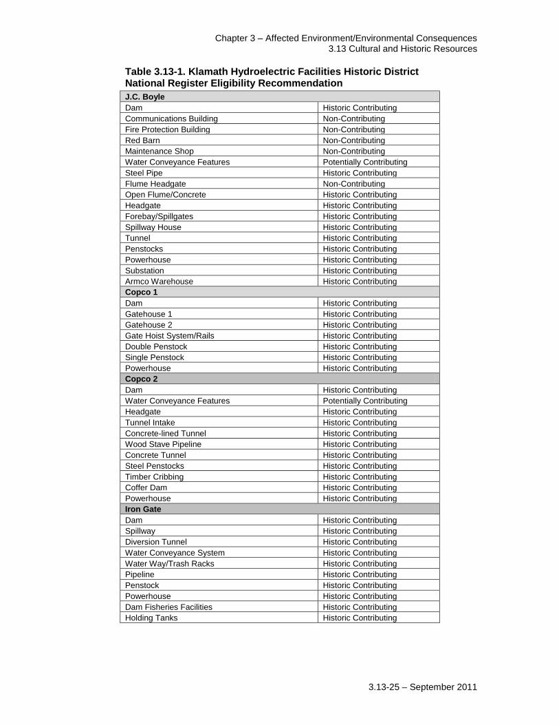
Chapter 3 – Affected Environment/Environmental Consequences 3.13 Cultural and Historic Resources
3.13-25 – September 2011
Table 3.13-1. Klamath Hydroelectric Facilities Historic District National Register Eligibility Recommendation
J.C. Boyle
Dam Historic Contributing
Communications Building Non-Contributing
Fire Protection Building Non-Contributing
Red Barn Non-Contributing
Maintenance Shop Non-Contributing
Water Conveyance Features Potentially Contributing
Steel Pipe Historic Contributing
Flume Headgate Non-Contributing
Open Flume/Concrete Historic Contributing
Headgate Historic Contributing
Forebay/Spillgates Historic Contributing
Spillway House Historic Contributing
Tunnel Historic Contributing
Penstocks Historic Contributing
Powerhouse Historic Contributing
Substation Historic Contributing
Armco Warehouse Historic Contributing
Copco 1
Dam Historic Contributing
Gatehouse 1 Historic Contributing
Gatehouse 2 Historic Contributing
Gate Hoist System/Rails Historic Contributing
Double Penstock Historic Contributing
Single Penstock Historic Contributing
Powerhouse Historic Contributing
Copco 2
Dam Historic Contributing
Water Conveyance Features Potentially Contributing
Headgate Historic Contributing
Tunnel Intake Historic Contributing
Concrete-lined Tunnel Historic Contributing
Wood Stave Pipeline Historic Contributing
Concrete Tunnel Historic Contributing
Steel Penstocks Historic Contributing
Timber Cribbing Historic Contributing
Coffer Dam Historic Contributing
Powerhouse Historic Contributing
Iron Gate
Dam Historic Contributing
Spillway Historic Contributing
Diversion Tunnel Historic Contributing
Water Conveyance System Historic Contributing
Water Way/Trash Racks Historic Contributing
Pipeline Historic Contributing
Penstock Historic Contributing
Powerhouse Historic Contributing
Dam Fisheries Facilities Historic Contributing
Holding Tanks Historic Contributing
Klamath Facilities Removal EIS/EIR Public Draft
3.13-26 – September 2011
Gates (2003) and King (2004) identify the entire length of the Klamath River as a
“riverscape,” which they identify as a type of cultural or ethnographic landscape, because
of the relationship between the Klamath Tribes, Shasta, Karuk, Hoopa, and Yurok and
the river and its resources. Gates (2003) and King (2004) recommended the Klamath
River as eligible for inclusion on the National Register as a riverscape and/or
ethnographic landscape. The Klamath River is certainly sensitive to the Klamath Tribes,
Shasta, Karuk, Hoopa, and Yurok and is an integral part of their traditional cultural
practices, but its eligibility for inclusion on the National Register as a riverscape and/or
ethnographic landscape requires formal review and concurrence by the Oregon and
California SHPOs. The riverscape and/or ethnographic landscape reports and eligibility
determination have not been submitted to the Oregon and California SHPOs for review
and concurrence regarding their eligibility determination.
At least one site is known to have human remains exposed from erosion in the Upper
Klamath River area. Actions by a federal agency resulted in the reburial of the exposed
remains and temporary stabilization of the river bank. Previous studies, surveys, and
federal actions, combined with ethnographic studies, indicates that there is a high
probability for the presence of additional sites in unsurveyed areas, as well as, in
currently submerged settings.
Based on the previously identified sites and ethnographic literature reviews, sites
identified at each reservoir include primarily the historic dams and associated facilities
and structures and prehistoric/ethnohistoric villages, fishing locations, and ceremonial
sites. At the JC Boyle Reservoir, ten prehistoric sites have been identified along the
shoreline. At the Copco Reservoir, eleven prehistoric sites and five ethnographic village
sites have been identified along the shoreline and within the reservoir. At Iron Gate
Reservoir, twelve prehistoric sites and five ethnographic village sites have been identified
along the shoreline and within the reservoir. Additional sites may be inundated and/or
covered with sediment. Depending on the selected alternative for this EIS/EIR, further
identification efforts would need to be taken to identify these sites.
3.13.4 Environmental Consequences
3.13.4.1 Effects/Impacts Determination Methods
Cultural resources investigations (e.g., records searches and reviews of archaeological,
ethnographic, and historic information) resulted in the identification of 681 sites, one
historic district, several TCPs, and one potential ethnographic landscape within the APE.
Identified sites will be treated as potentially eligible for the National Register and
California Registers for the analyses of potential effects/impacts for this EIS/EIR. In
addition, certain site types likely to be identified in previously unsurveyed areas,
including inundated areas, will be considered potentially eligible for potential
effects/impacts analyses.
The cultural resources section of this document considers potential effects/impacts from
implementation of the Proposed Action and alternatives on these sites, which include
prehistoric and historic sites, buildings/structures, cultural (ethnographic) landscapes, and
Chapter 3 – Affected Environment/Environmental Consequences 3.13 Cultural and Historic Resources
3.13-27 – September 2011
TCPs. The findings of effects/impacts to cultural resources within the APE are based on
criteria presented in 36 CFR Section 800.5 and in CEQA, as described in 3.13.2
Regulatory Framework. Through consultation (see Chapter 7), DOI has developed
measures to avoid, minimize or mitigate adverse effects to historic properties and
historical resources, including known effects and those effects for which DOI cannot
fully understand at this time. Many of these measures would be offered as binding
commitments in the ROD, and will help to coordinate future development through these
decisions.
Additionally, due to the nature of the action being proposed, potential effects on all
historic properties or historical resources cannot be fully determined prior to approval of
either the Proposed Action or an alternative evaluated in this EIS/EIR. The identification
and evaluation of certain resources, and the potential effects to those resources, can only
be understood and addressed as particular details of how to carry out the selected
alternative are developed. To address this uncertainty, DOI through consultation (see
Chapter 7), is proposing measures that the designated federal officials must follow as
specific details are evaluated through future decisions that are required before the
selected alternative in this EIS/EIR can be implemented. These measures, which are
identified below, will be incorporated as binding stipulations in the ROD for this
EIS/EIR. Further, DOI will also seek to develop additional measures through
consultation with the ACHP, the SHPOs, THPOs, Indian tribes, and other interested
parties as part of the continuing NEPA process.
Under CEQA, potentially significant or significant impacts to historical resources may be
mitigated to a less than significant level. If impacts cannot be mitigated or if
implementation of mitigation would not reduce an impact to a less than significant level,
the impacts are identified as significant and unavoidable.
3.13.4.2 Significance Criteria
The significance criteria used to assess effects/impacts to cultural resources (e.g., historic
properties and historical resources) as a result of implementing the Proposed Action and
alternatives include both federal and California state criteria.
Cultural resource effects/impacts would be adverse and/or significant if implementation
of the Proposed Action and alternatives result in any of the following:
Under NHPA Section 106, “an adverse effect is found when an undertaking may
alter, directly or indirectly, any of the characteristics of a historic property that
qualify the property for inclusion in the National Register in a manner that would
diminish the integrity of the property's location, design, setting, materials,
workmanship, feeling, or association (36 CFR Section800.5(a)(1)).”
Under CEQA, a substantial adverse change in the significance of an
archaeological resource or an historical resource is defined as physical
demolition, destruction, relocation, or alteration of the resource or its immediate
surroundings such that the significance of an historical resource is materially
impaired, as defined in PRC Section 21083.2 and CCR 15064.5; or
Klamath Facilities Removal EIS/EIR Public Draft
3.13-28 – September 2011
Disturbance of any human remains, including those interred outside of formal
cemeteries.
3.13.4.3 Effects Determinations
Alternative 1: No Action/No Project Alternative
Under the No Action/No Project Alternative, none of the actions under consideration
would be implemented. The Klamath Hydroelectric Project would continue operations
under the terms of an annual license until a long term license is finalized. Annual
licenses would not include the actions associated with the Klamath Hydroelectric
Settlement Agreement (KHSA) and Klamath Basin Restoration Agreement (KBRA).
Under the No Action/No Project Alternative current effects/impacts on historic
properties/ historical resources, other cultural resources, and human remains will
continue to occur. Under the No Action/No Project Alternative, the Klamath
Hydroelectric Project on the Klamath River would continue to operate. The Klamath
Hydroelectric Project introduced artificial water fluctuations that have resulted in erosion
along the lower terraces. Over the life of the Klamath Hydroelectric Project, cultural
resources have been impacted by these changing water levels. Known impacts include
exposing cultural materials to the public, sometimes leading to looting and illegal
excavation of these sites. These circumstances are known to have exposed human
remains at least one site. Actions by a federal agency resulted in the reburial of the
exposed remains and temporary stabilization of the river bank. Concerns regarding
artificial fluctuating water levels and exposing cultural remains in the APE continue to be
a concern of federal agencies and Indian tribes.
There are known ongoing effects/impacts on cultural resources due to operation of the
Klamath Hydroelectric Project. Therefore, the No Action Alternative would result in
no change from existing conditions and effects/impacts on historic properties and/or
historical resources in the APE.
Alternative 2: Full Facilities Removal of Four Dams Alternative (the Proposed Action)
Under the Proposed Action, four dams and their associated hydroelectric facilities along
the Klamath River would be removed. Keno Dam would be transferred to the DOI, the
KBRA would be implemented, and the Yreka water supply pipeline would be installed.
The Proposed Action would result in direct effects/impacts to J.C. Boyle Dam, Copco 1
Dam, Copco 2 Dam, and Iron Gate Dam, their associated hydroelectric facilities, and on
the KHHD, which is considered eligible for inclusion on the National Register and
California Register. The Proposed Action would include removal of four dams, their
associated hydroelectric facilities, and other facilities along the Klamath River. These
facilities contribute to the KHHD, which is considered eligible for inclusion on the
National Register and the California Register due to its role in early development of
electricity and economy of the southern Oregon and northern California regions.
Removal of the four dams and all associated facilities under the Proposed Action would
adversely affect each dam‟s eligibility for inclusion on the National Register and the

Chapter 3 – Affected Environment/Environmental Consequences 3.13 Cultural and Historic Resources
3.13-29 – September 2011
California Register and the overall integrity of the KHHD because a large portion of this
district would be removed.
Under this action adverse effects, as described in Section 106, to the dams and the
KHHD cannot be avoided and will need to be mitigated. Mitigation will likely
include thorough documentation of the four dams and their associated facilities to
Historic American Building Survey (HABS)/Historic American Engineering Record
(HAER)/Historic American Landscape Survey (HALS) levels or the equivalent.
Removal of the dams and facilities may also impact as yet unidentified buried cultural
resources, particularly ethnographic villages. Additional efforts to identify and evaluate
historic properties/historical resources would be conducted. Possible avoidance and/or
minimization of effects/impacts to other currently unidentified historic
properties/historical resources would be identified through consultations as appropriate.
Under CEQA, for the purpose of this EIS/EIR, mitigation measures that include
HABS/HAER documentation could be implemented for the removal of dams under the
Proposed Action, but implementation of mitigation measures would not reduce impacts to
historical resources to a less than significant level. For the purpose of this EIS/EIR,
under CEQA, the Proposed Action would be a significant and unavoidable impact
to historical resources.
Under NEPA/CEQA, for the purpose of this EIS/EIR, Mitigation Measures CHR-1,
CHR-2, CHR-3, and CHR-4 would be implemented. Impacts to the KHHD would
remain significant and unavoidable.
Reservoir drawdown associated with the Proposed Action could affect/impact
archaeological and historic sites, TCPs, and cultural landscapes that are eligible for
inclusion on the National Register and/or California Register and possibly Indian human
remains. The Proposed Action includes a drawdown of the reservoirs at the Four
Facilities. The dam removal and reservoir drawdown would result in a reduction of water
levels in the existing reservoirs; temporarily increase flows along the Klamath River; and
expand the limits of the 100 year floodplain by 1 percent (see Section 3.6, Flood
Hydrology, for specific data related to stream flow and flooding data). Ethnographic
records identify village sites, including burials, located along the previous riverbanks
prior to dam construction and subsequent inundation. The dam removal and reservoir
drawdown could affect 32 known sites located along the current shores of the reservoirs,
ten ethnographic village sites, an unknown number of sites that may be submerged in the
reservoirs and human remains that may be isolated or associated with those sites.
Ethnographic records identify village sites, including burials, located along the previous
riverbanks prior to dam construction and subsequent inundation. Also, several hundred
sites along and near the Klamath River downstream from the dams and reservoirs may be
exposed or damaged from temporary increase in flows during reservoir drawdowns.
The riverscape, a potentially eligible or significant cultural landscape, includes villages,
hunting, gathering, fishing, and spiritual locations on terraces and benches along the
river, as well as the river itself and its natural resources. The overall riverscape/cultural
Klamath Facilities Removal EIS/EIR Public Draft
3.13-30 – September 2011
landscape would likely benefit from dam removal by restoring the river more closely to
its original setting and facilitating the practice of important Indian traditional customs,
ceremonies, and economic activities. However, sites associated with it could be adversely
affected through erosion, exposure, and vandalism. Increased flows along the Klamath
River could undercut, erode, or flood sites along or near the banks of the river, affecting
elements of the potentially significant cultural landscape.
Under this action adverse effects, as described in Section 106, could occur to historic
properties as a result of reservoir drawdowns. These effects will need to be
mitigated. Drawdown of the reservoirs and the flushing of sediment will likely expose
submerged sites around and under the reservoirs. Additional cultural resources surveys
and monitoring of the drawdown zone would be conducted as land is exposed.
Avoidance, minimization, and mitigation measures would be identified through
consultations as appropriate. A cultural resources management plan is likely to be
developed, through consultations, to manage and protect endangered and exposed cultural
resources.
Under CEQA, for the purpose of this EIS/EIR implementation of Mitigation
Measures CHR-1, CHR-2, CHR-3, and CHR-4 would reduce impacts to any
historical resources to less than significant.
Installation of the Yreka Water Supply Pipeline could affect/impact archaeological and
historic sites that are eligible for inclusion on the National Register or California
Register. The existing water supply pipeline for the City of Yreka passes under the Iron
Gate Reservoir and will have to be relocated prior to the decommissioning of the
reservoir to prevent damage from deconstruction activities or increased water velocities
once the reservoir has been drawn down. The pipeline will either be suspended from a
pipe bridge across the river near its current location, or rerouted along the underside of
the Lakeview Bridge just downstream of Iron Gate Dam. The pipeline itself may be a
historic property or historical resource and would need to be evaluated for eligibility.
Ground disturbance required for either method of relocating the pipeline could result in
the discovery of historic and/or archaeologically significant sites. The construction of
footing to support the pipe bridge and the trenching and rerouting of the pipeline to reach
Lakeview Bridge could uncover previously unknown sites. Under this action adverse
effects, as described in Section 106, could occur to historic properties as a result of
installation of the Yreka water supply pipeline. These effects will need to be
mitigated. Measures to identify historic properties/historical resources and to avoid,
minimize, or mitigate and resolve adverse effects would be identified through
consultations, as appropriate.
Under CEQA, for the purpose of this EIS/EIR implementation of Mitigation
Measures CHR-1, CHR-2, CHR-3, and CHR-4 would reduce impacts to any
historical resources to less than significant.
Construction activities including use of haul roads and disposal sites for demolition
debris under the Proposed Action could affect/impact archaeological and historic sites,
Chapter 3 – Affected Environment/Environmental Consequences 3.13 Cultural and Historic Resources
3.13-31 – September 2011
TCPs, and cultural landscapes that are eligible for inclusion on the National Register or
California Register. Ground disturbing activities associated with construction activities
will likely have both direct and indirect effects/impacts on historic properties/historical
resources. The debris from the demolition of the dams and facilities would be hauled to
disposal sites. Modifications of the proposed haul roads and use of disposal sites could
affect/impact sites (including 17 sites previously identified during earlier survey coverage
of the roads and the KHHD) that are located along the haul roads and/or at the disposal
sites. Under this action adverse effects, as described in Section 106, could occur to
historic properties as a result of construction of haul roads and disposal sites. These
effects will need to be mitigated. As future plans are developed for construction
activities, modifications to haul roads, and identification of actual locations of disposal
sites and associated staging/construction, additional identification and evaluation of
historic properties/historical resources would be conducted. Measures to avoid,
minimize, or mitigate and resolve adverse effects would be identified through
consultations, as appropriate.
Under CEQA, for the purpose of this EIS/EIR implementation of Mitigation
Measures CHR-1, CHR-2, CHR-3, and CHR-4 would reduce impacts to any
historical resources to less than significant.
Removal of the recreational facilities after reservoir drawdown may affect
archaeological or historic sites that could be eligible for inclusion on the National
Register or California Register or human remains. Recreation facilities, such as
campgrounds and boat ramps, currently located along the reservoir banks will need to be
relocated down slope to be near the new river bed once the reservoir is removed. These
facilities are not eligible for the National Register or California Register, and were not
known to impact archaeological sites when they were built. Additional ground
disturbance from removal of these facilities may affect/impact previously unidentified
historic properties/historical resources. Under this action adverse effects, as described
in Section 106, could occur to historic properties as a result of removal and
relocation of recreational facilities. These effects will need to be mitigated. Further
identification and evaluation of historic properties/historical resources would be
conducted. Measures to avoid, minimize, or mitigate and resolve adverse effects would
be identified through consultations, as appropriate.
Under CEQA, for the purpose of this EIS/EIR implementation of Mitigation
Measures CHR-1, CHR-2, CHR-3, and CHR-4 would reduce impacts to any
historical resources to less than significant.
Keno Transfer
The Transfer of Keno Dam to the DOI could have adverse effects to historic properties or
historic resources. The KHSA calls for transferring ownership and operation of Keno
Dam from PacifiCorp to DOI. Upon transfer of privately owned facilities into federal
ownership, cultural resources and historic properties are then subject to federal historic
and cultural resources management laws. Under Section 106 and CEQA, this action
would not cause an effect/impact to historic properties or historical resources. The
Klamath Facilities Removal EIS/EIR Public Draft
3.13-32 – September 2011
transfer would likely be a beneficial effect because the facilities would be subject to
federal regulation.
East and West Side Facilities
The decommissioning of the East and West Side Facilities could have adverse effects on
historic resources or historic properties. Decommissioning of the East and West Side
canals and hydropower facilities of the Link River Dam by PacifiCorp as a part of the
KHSA will redirect water flows currently diverted at Link River Dam into the two canals,
back in to Link River. Following decommissioning of the facilities there will be no
change in outflow from Upper Klamath Lake or inflow into Lake Ewauna.
Decommissioning does not typically involve deconstruction of the facilities. Instead,
buildings and equipment that are too large to easily remove or are fixed in place are
usually fenced to prevent entry. Any deconstruction and removal of facilities would be
analyzed in future environmental analyses. The decommissioning of the East and West
Side Facility will have less than significant effects on historical resources or historic
properties. KBRA
The KBRA has several programs that could result in impacts/effects to cultural and
historic resources that are eligible for inclusion on the National Register and/or California
Register. These resources include archaeological and historic sites, TCPs, cultural
landscapes, and possibly Indian human remains. Specific KBRA programs potentially
affecting cultural and historic resources include:
Phases 1 and 2 Fisheries Restoration Plans
Fisheries Reintroduction and Management Plan
Wood River Wetland Restoration Project
On-Project Plan
Water Use Retirement Program
Fish Entrainment Reduction
Klamath Tribes Interim Fishing Site
Mazama Forest Project
Implementation of the Phase 1 and 2 Fisheries Restoration Plans, the Fisheries
Reintroduction and Management Plan, the Wood River Wetland Restoration Project, the
On-Project Plan, the Water Use Retirement Program, and the Fish Entrainment
Reduction progam, could result in impacts/effects to archaeological and historic sites,
TCPs, and cultural landscapes that are eligible for inclusion on the National Register
and/or California Register and possibly Indian human remains. Actions associated with
the Fisheries Restoration Plans in the floodplain and river channel include: floodplain
rehabilitation, large woody debris replacement, fish passage correction, cattle exclusion
(fencing), riparian vegetation planting, mechanical thinning of upland areas to mimic
natural forest conditions, fire treatment to mimic natural forest conditions, purchase of
conservation easements/land, road decommissioning, gravel augmentation, and treatment
of fine sediment sources. The fisheries restoration actions are designed to improve
Chapter 3 – Affected Environment/Environmental Consequences 3.13 Cultural and Historic Resources
3.13-33 – September 2011
aquatic and riparian habitat and potential changes in river hydraulics are intended to
improve the habitats‟ ability to support river fisheries. These restoration actions would
not occur at the same locations as construction activities for the hydroelectric facility
removal. KBRA construction activities would not contribute to potential cultural and
historic resource effects of facility removal actions. Implementation of the KBRA
programs listed above include ground disturbing activities that are likely to have a
significant impact on cultural and historic resources that are eligible for inclusion
on the National Register and/or California Register. Studies will be conducted to
identify cultural resources and measures to reduce significant impacts to those
resources. Implementation of specific plans and projects associated with Phase 1
and 2 Fisheries Restoration will require future environmental compliance as
appropriate.
Under CEQA/NEPA, for the purpose of this EIS/EIR, Mitigation Measures CHR-1,
CHR-2, CHR-3, and CHR-4 would be implemented, but the impact would remain
significant and unavoidable.
Establishment of the Klamath Tribes Interim Fishing Site could result in impacts/effects
to archaeological and historic sites, TCPs, and cultural landscapes that are eligible for
inclusion on the National Register and possibly Indian human remains. Actions
associated with the Klamath Tribes Interim Fishing Site include establishment of an
interim fishing site for Klamath Tribal members between Iron Gate Dam and Interstate -
5. The location and timing of this project reduces the potential for any negative cultural
and historic resource impacts generated by establishment of the Klamath Tribes Interim
Fishing Site from contributing to the effects of the hydroelectric facility removal actions.
Although negative short-term effects could occur, implementation of construction-related
best management practices (BMPs) would occur. Establishment of the Klamath Tribes
Interim Fishing Site is likely to include ground disturbing activities that could have
a significant impact on cultural and historic resources that are eligible for inclusion
on the National Register. Studies will be conducted to identify cultural resources
and measures to reduce significant impacts to those resources. Implementation of
specific plans associated with the establishment of the Klamath Tribes Interim
Fishing Site will require future environmental compliance as appropriate.
Under CEQA/NEPA, for the purpose of this EIS/EIR, Mitigation Measures CHR-1,
CHR-2, CHR-3, and CHR-4 would be implemented and would reduce any impact of
the Klamath Tribes Interim Fishing Site to a less than significant level.
Implementation of the Mazama Forest Project could result in impacts/effects to
archaeological and historic sites, TCPs, and cultural landscapes that are eligible for
inclusion on the National Register and possibly Indian human remains. Actions
associated with the Mazama Forest Project include the purchase and management of
90,000 acres of timberland on former reservation land owned by the Klamath Tribe. The
90,000 acres identified in the Mazama Forest Project are likely to include cultural and
historic resources that are eligible for inclusion on the National Register. Forest
management actions at the Mazama Forest would not be in the same location as the
Klamath Facilities Removal EIS/EIR Public Draft
3.13-34 – September 2011
hydroelectric facility removal actions and there would be no negative cultural and historic
resource impacts generated by these restoration actions that would contribute to the
effects of facility removal actions. While the Klamath Tribes Forest Management
Plan has been developed, the specific location of management actions within the
Mazama Forest have not been identified. It is assumed however that implementation
of this plan is likely to have a significant impact on cultural and historic resources
that are eligible for inclusion on the National Register and/or California Register.
Studies will be conducted to identify cultural resources and reduce significant
impacts to these resources. Implementation of specific plans and projects associated
with the Mazama Forest Project will require future environmental compliance as
appropriate.
Under CEQA/NEPA, for the purpose of this EIS/EIR, Mitigation Measures CHR-1,
CHR-2, CHR-3, and CHR-4 would be implemented and would reduce any impact of
the Mazama Forest Project to a less than significant level.
Finding of Effects Under NHPA Section 106
Under the Proposed Action for NHPA, adverse effects to known historic properties
(including the KHHD) cannot be avoided. In addition, adverse effects to as yet
unidentified or unevaluated historic properties expected to be identified during future
identification efforts may result from this alternative. The adverse effects will need to be
minimized or mitigated. Additional consultations and identification and evaluation
efforts will be conducted under consultations with ACHP, SHPOs, THPOs, Indian
Tribes, and other interested parties, per 36 CFR Part 800. Measures to avoid, minimize,
or mitigate and resolve adverse effects, identified through consultations, will likely result
in agreement documents per 36 CFR Part 800 for implementation of this alternative.
Under NHPA Section 106, the Proposed Action will have an adverse effect to
historic properties.
Alternative 3: Partial Facilities Removal of Four Dams Alternative
Under the Partial Facilities Removal of Four Dams Alternative, four dams and their
associated hydroelectric facilities would be partially removed to provide for volitional
fish passage. Keno Dam would be transferred to the DOI, the KBRA would be
implemented, and the Yreka water supply pipeline would be installed
The Partial Facilities Removal of Four Dams Alternative would result in direct
effects/impacts to J.C. Boyle Dam, Copco 1Dam, Copco 2 Dam, and Iron Gate Dam and
on the KHHD considered eligible for inclusion on the National Register and California
Register. The Partial Facilities Removal of Four Dams Alternative would include
removal of portions of the four dams, their associated hydroelectric facilities, and f other
facilities along the Klamath River. These facilities contribute to the KHHD, which is
presumed eligible for inclusion on the National Register and the California Register due
to its role in early development of electricity and economy of the southern Oregon and
northern California regions. Partial removal of the four dams would adversely affect
each dam‟s eligibility and possibly the overall integrity of the KHHD.
Chapter 3 – Affected Environment/Environmental Consequences 3.13 Cultural and Historic Resources
3.13-35 – September 2011
Potential effects/impacts to cultural and historic resources under the Partial Facilities
Removal of Four Dams Alternative, including draw downs of reservoirs; the Keno
Transfer; the East and West Side Facility decommissioning; relocation of the Yreka
Water Supply Line; construction activities; removal of recreational facilities; and transfer
of Keno Dam would be the same as those identified for the Proposed Action/Full
Facilities Removal of Four Dams Alternative.
KBRA
The KBRA has several programs that could result in impacts/effects to cultural and
historic resources that are eligible for inclusion on the National Register and/or California
Register. These resources include archaeological and historic sites, TCPs, cultural
landscapes, and possibly Indian human remains. Specific KBRA programs potentially
affecting cultural and historic resources include:
Phases 1 and 2 Fisheries Restoration Plans
Mazama Forest Project
Klamath Tribes Interim Fishing Site
Fisheries Reintroduction and Management Plan – Phases I and II – Oregon
Wood River Wetland Restoration Project
On-Project Plan
Water Use Retirement Program
Fish Entrainment Reduction
Potential effects/impacts to cultural and historic resources associated with the Partial
Facilities Removal of Four Dams Alternative are the same as identified for the Proposed
Action.
Finding of Effects Under NHPA Section 106
Under the Partial Removal of Four Dams Alternative for NHPA, adverse effects to
known historic properties (including the KHHD) cannot be avoided. Under this
alternative effects would be the same as those identified for the Proposed Action/Full
Facilities Removal of Four Dams Alternative.
Alternative 4: Fish Passage at Four Dams Alternative
Under the Fish Passage at Four Dams Alternative operation of the existing dams and
hydroelectric facilities would continue along the Klamath River and fish passage
facilities would be constructed at the four dams. Keno Dam would not be transferred to
DOI and the KBRA would not be implemented.
The Fish Passage at Four Dams Alternative could affect/impact the four dams and the
KHHD, other historic properties/historical resources, TCPs, cultural landscapes, or
human burials. The Fish Passage at Four Dams Alternative would continue operation of
the existing dams and hydroelectric facilities along the Klamath River and could continue
to affect historic properties/ historical resources. Construction of fish passages could
require modifications to the four dams and/or their associated facilities, resulting in
Klamath Facilities Removal EIS/EIR Public Draft
3.13-36 – September 2011
effects/impacts to the KHHD. Construction activities required for the fish passages may
affect/impact as yet unidentified historic properties/historical resources. Under this
action adverse effects, as described in Section 106, to the dams and the KHHD
would occur and will need to be mitigated. Further identification and evaluation of
historic properties/historical resources would be conducted. Measures to avoid,
minimize, or mitigate and resolve adverse effects would be identified through
consultations, as appropriate.
Under CEQA/NEPA, for the purpose of this EIS/EIR this would be a significant
impact to historical resources. Implementation of Mitigation Measures CHR-1,
CHR-2, CHR-3, and CHR-4 would reduce impacts to any historical resources to
less than significant.
Finding of Effects Under NHPA Section 106
Under the Fish Passage at Four Dams Alternative for NHPA, adverse effects to known
historic properties (including the KHHD) would likely occur. In addition, adverse
effects to as yet unidentified or unevaluated properties may result from this alternative.
The adverse effects will need to be minimized or mitigated. Additional consultations and
identification and evaluation efforts will be conducted under consultations with ACHP,
SHPOs, THPOs, Indian Tribes, and other interested parties, per 36 CFR Part 800.
Measures to avoid, minimize, or mitigate and resolve adverse effects, identified through
consultations, will likely result in agreement documents per 36 CFR Part 800 for
implementation of this alternative. Under NHPA Section 106, the Fish Passages at
Four Dams will have an adverse effect to historic properties.
Alternative 5: Fish Passage at Two Dams, Remove Copco 1 and Iron Gate Alternative
Under the Fish Passage at Two Dams, Remove Copco 1 and Iron Gate Alternative, two
dams, their associated hydroelectric facilities, and fish hatchery facilities along the
Klamath River would be removed and fish passage facilities would be constructed at two
dams. Under this alternative, Keno Dam would not be transferred to the DOI and the
KBRA would not be implemented.
The Fish Passage at Two Dams, Remove Copco 1 and Iron Gate Alternative would result
in direct effects/impacts to Copco 1Dam and Iron Gate Dam and on the KHHD
considered eligible for inclusion on the National Register and California Register. The
Fish Passage at Two Dams, Remove Copco 1 and Iron Gate Alternative would include
removal of two dams, their associated hydroelectric facilities, and other facilities along
the Klamath River. Installation of fish passages at JC Boyle Dam and Copco 2 Dam may
affect/impact those dams and their associated facilities. These facilities contribute to the
KHHD, which is presumed eligible for inclusion on the National Register and the
California Register due to its role in early development of electricity and economy of the
southern Oregon and northern California regions. The removal of two dams and facilities
would adversely affect each dam‟s eligibility and possibly the overall integrity of the
KHHD.
Chapter 3 – Affected Environment/Environmental Consequences 3.13 Cultural and Historic Resources
3.13-37 – September 2011
Under this action adverse effects, as described in Section 106, to the dams and the
KHHD cannot be avoided and will need to be mitigated. Mitigation will likely
include thorough documentation of the four dams and their associated facilities to
HABS/HAER/HALS levels or similar. Removal of the dams and facilities and
construction of fish passages may also impact as yet unidentified buried cultural
resources, particularly ethnographic villages. Additional efforts to identify and evaluate
historic properties/historical resources would be conducted. Possible avoidance,
minimization, and mitigation measures to other currently unidentified historic
properties/historical resources would be identified through consultations as appropriate.
Under CEQA, for the purpose of this EIS/EIR, mitigation measures that include
HABS/HAER documentation could be implemented, but implementation of mitigation
measures would not reduce impacts to historical resources to a less than significant level.
For the purpose of this EIS/EIR, under CEQA/NEPA, the Fish Passage at Two
Dams, Remove Copco 1 and Iron Gate Alternative would be a significant and
unavoidable impact to historical resources.
Reservoir drawdown associated with the Fish Passage at Two Dams, Remove Copco 1
and Iron Gate Alternative could affect/impact archaeological and historic sites, TCPs,
and cultural landscapes that are eligible for inclusion on the National Register and/or
California Register and possibly Indian human remains. The Fish Passage at Two Dams,
Remove Copco 1 and Iron Gate Alternative includes a drawdown of the reservoirs behind
Copco 1 and Iron Gate dams. The dam removal and reservoir drawdown would result in
a reduction of water levels in the existing reservoirs and temporarily increase flows along
the Klamath River. Ethnographic records identify village sites, including burials, located
along the previous riverbanks prior to dam construction and subsequent inundation. The
dam removal and reservoir drawdown could affect 23 known sites located along the
current shores of the reservoirs, ten ethnographic village sites, an unknown number of
sites that may be submerged in the reservoirs and human remains that may be isolated or
associated with those sites. Ethnographic records identify village sites, including burials,
located along the previous riverbanks prior to dam construction and subsequent
inundation. Also, several hundred sites along and near the Klamath River downstream
from the dams and reservoirs may be exposed or damaged from temporary increase in
flows during reservoir drawdowns.
The riverscape, a potentially eligible or significant cultural landscape, includes villages,
hunting, gathering, fishing, and spiritual locations on terraces and benches along the
river, as well as the river itself and its natural resources. The overall riverscape/cultural
landscape would likely benefit from dam removal by restoring the river more closely to
its original setting and facilitating the practice of important Indian traditional customs,
ceremonies, and economic activities. However, sites associated with it could be adversely
affected through erosion, exposure, and vandalism. Increased flows along the Klamath
River could undercut, erode, or flood sites along or near the banks of the river, affecting
elements of the potentially significant cultural landscape.
Klamath Facilities Removal EIS/EIR Public Draft
3.13-38 – September 2011
Under this action adverse effects, as described in Section 106, could occur to historic
properties as a result of reservoir drawdowns. These effects will need to be
mitigated. Drawdown of the reservoirs and the flushing of sediment will likely expose
submerged sites around and under the reservoirs. Additional cultural resources surveys
and monitoring of the drawdown zone would be conducted as land is exposed.
Avoidance, minimization, and mitigation measures would be identified through
consultations as appropriate. A cultural resources management plan is likely to be
developed, through consultations, to manage and protect endangered and exposed cultural
resources.
Under CEQA/NEPA, for the purpose of this EIS/EIR implementation of Mitigation
Measures CHR-1, CHR-2, CHR-3, and CHR-4 would reduce impacts to any
historical resources to less than significant.
Potential effects/impacts to cultural and historic resources under the Fish Passage at Two
Dams, Remove Copco 1 and Iron Gate Alternative, including draw downs of reservoirs;
construction activities; and removal of recreational facilities would be the same as those
identified for the Proposed Action/Full Facilities Removal of Four Dams Alternative.
Finding of Effects Under NHPA Section 106
Under the Fish Passage at Two Dams, Remove Copco 1 and Iron Gate Alternative for
NHPA, adverse effects to known historic properties (including the KHHD) cannot be
avoided. In addition, adverse effects to as yet unidentified or unevaluated properties may
result from this alternative. The adverse effects will need to be minimized or mitigated.
Additional consultations and identification and evaluation efforts will be conducted under
consultations with ACHP, SHPOs, THPOs, Indian Tribes, and other interested parties,
per 36 CFR Part 800. Measures to avoid, minimize, or mitigate and resolve adverse
effects, identified through consultations, will likely result in agreement documents per 36
CFR Part 800 for implementation of this alternative. Under NHPA Section 106, the
Fish Passage at Two Dams, Remove Copco 1 and Iron Gate Alternative will have an
adverse effect to historic properties.
3.13.4.4 Mitigation Measures
Mitigation Measure by Consequences Summary
Implementation of the Proposed Action and alternatives will each have an adverse effect
on historic properties under Section 106 of the NHPA. Mitigation measures CHR-1 to
CHR-4 identify actions to avoid, minimize or mitigate adverse effects following the
process in 36 CFR Section 800.8(c)(1)(v).
Under CEQA, most of the impacts to historical resources could be mitigated to a less than
significant impact for the purpose of this EIS/EIR by implementing all four mitigation
measures. However, impacts to the four dams and the KHHD cannot be mitigated to less
than a significant and unavoidable impact for the purpose of this EIS/EIR.
Chapter 3 – Affected Environment/Environmental Consequences 3.13 Cultural and Historic Resources
3.13-39 – September 2011
Mitigation Measure CHR-1: Update the Klamath Hydroelectric Project Request for
Determination of Eligibility (Kramer 2003) to include Iron Gate as a historic property
and to identify contributing elements to the KHHD; and
Continue consultations under Section 106 of the NHPA with ACHP, SHPOs,
THPOs, and other interested parties to reach a consensus on the eligibility
determination; and
Enter into an agreement document (Memorandum of Agreement or Programmatic
Agreement) under Section 106 of the NHPA with ACHP, SHPOs, THPOs, and
other consulting parties for the resolution of adverse effects; and
Document the four dams to HABS/HAER/HALS standards or equivalent; and
Identify additional mitigation measures in the agreement document, including a
public outreach or education component.
Mitigation Measure CHR-2: Continue consultations under Section 106 of the NHPA with
ACHP, SHPOs, THPOs, Indian tribes, and other interested parties to identify and
evaluate cultural resources for eligibility for listing on the National Register and/or
California Register; and
Continue identification and evaluation of historic properties/historical resources
for unevaluated cultural resources, unsurveyed areas, and inundated zones; and
Continue consultations under Section 106 of the NHPA with ACHP, SHPOs,
THPOs, Indian tribes and other interested parties to identify alternatives to avoid,
minimize, or mitigate adverse effects to historic properties; and
Enter into an agreement document (Memorandum of Agreement or Programmatic
Agreement) under Section 106 of the NHPA with ACHP, SHPOs, THPOs, and
other consulting parties for the avoidance, minimization, and mitigation of
adverse effects, and the resolution of adverse effects (including excavation as
appropriate and a public outreach component); and
Prepare a Monitoring Plan to identify historic properties/historical resources
exposed during implementation of the selected alternative; and
Prepare and implement an Inadvertent Discovery Plan for unanticipated
discoveries of historic properties/historical resources and Indian human remains;
and
Prepare and implement a Cultural Resources Management Plan to address the
management and protection of historic properties/historical resources and
significant cultural resources; and
Respect and maintain the confidentiality of sensitive information following 36
CFR Section 800.11(c) and the Archaeological Resources Protection Act of 1979
(16 USC 470hh).
Mitigation Measure CHR-3: Continue consultations under Section 106 of the NHPA with
ACHP, SHPOs, THPOs, Indian tribes and other interested parties to identify and evaluate
TCPs and cultural landscapes for eligibility for listing on the National Register and/or
California Register; and
Follow the steps in CHR-2 for identification and evaluation, alternatives to avoid,
minimize, or mitigate, and resolution of adverse effects; and
Klamath Facilities Removal EIS/EIR Public Draft
3.13-40 – September 2011
Respect and maintain the confidentiality of sensitive information following 36
CFR Section 800.11(c) and the Archaeological Resources Protection Act of 1979
(16 USC Section 470hh).
Mitigation Measure CHR-4:
Consult with Indian Tribes and other Indian organizations on identification,
treatment, disposition, and management of Indian human remains exposed and/or
impacted by the selected alternative;
Prepare and implement a Plan of Action to manage and treat Indian human
remains, following NAGPRA on federal and Indian tribal lands and California
and Oregon state burial laws on appropriate state lands;
Prepare and implement an Inadvertent Discovery Plan for unanticipated
discoveries of historic properties/historical resources and Indian human remains;
Consult on discoveries of historic properties/historical resources in association
with Indian human remains as identified in Mitigation Measure CHR-2. Effectiveness of Mitigation in Reducing Effects/Impacts
Under NHPA Section 106, Mitigation Measures CHR-1, CHR-2, CHR-3, and CHR-4
would be effective at addressing adverse effects to historic properties as a result of
implementing the Proposed Action or other alternatives. Under CEQA, Mitigation
Measures CHR-1, CHR-2, CHR-3, and CHR-4 would be effective at reducing most
impacts to historical resources as a result of implementing the Proposed Action or other
alternatives to less than significant. However, the mitigation measures would not be
effective at reducing impacts on the four dams and the KHHD that is recommended
eligible for inclusion on the California Register. The Proposed Action and other
alternatives would have a significant and unavoidable impact on the Klamath River dams
and KHHD. Mitigation measures could be implemented for the removal of dams under
the Proposed Action, but implementation of the measures would not reduce impacts to
these historical resources to less than significant.
Agency Responsible for Mitigation Implementation
The Dam Removal Entity or Hydropower Licensee, and state agencies would be
responsible for implementing Mitigation Measures CHR-1, CHR-2, CHR-3, and CHR-4.
It is anticipated that a mix of federal and state agencies would be responsible for
implementing the mitigation measures because implementation of the Proposed Action
and alternatives requires the involvement of various federal and state permitting,
licensing, and funding agencies.
Remaining Significant Impacts
Under CEQA, Mitigation Measures CHR-1, CHR-2, CHR-3, and CHR-4 would address
most impacts on historical resources associated with the Proposed Action and
alternatives. However, the mitigation measures presented in this EIR/EIS would not
reduce impacts on the four Klamath River dams and the KHHD that is recommended
eligible for inclusion on the California Register to less than significant. Under the
Proposed Action and other alternatives impacts to the four Klamath River dams and the
KHHD would be significant and unavoidable.
Chapter 3 – Affected Environment/Environmental Consequences 3.13 Cultural and Historic Resources
3.13-41 – September 2011
Mitigation Measures Associated with Other Resource Areas
Several other resources areas include mitigation measures to address construction related
effects/impacts associated with implementation of the Proposed Action or other
alternatives. These mitigation measures include Rec-1 (relocation of recreational
facilities at reservoirs); H-2 (flood-proof structures); GW-1 (deepen or replace affected
wells); WRWS-1 (modify or screen affected water intakes); PHS-4 (repair damaged
roads); PHS-5 (construct water storage tanks for firefighting); TR-6 (assess and improve
roads to carry construction loads); and TR-7 (assess and improve bridges to carry
construction loads). These mitigation measures could affect/impact historic
properties/historical resources, other cultural resources, and Indian human remains.
Under NHPA Section 106 actions associated with implementing mitigation measures
associated with other resource areas could cause adverse effects to historic
properties. Adverse effects to historic properties that are a result of these mitigation
measures can be resolved through implementation of Mitigation Measures CHR-1,
CHR-2, CHR-3, and CHR-4. Under CEQA, actions associated with implementing
mitigation measures associated with other resource areas could result in significant
impacts to historical resources. Implementation of Mitigation Measures CHR-1,
CHR-2, CHR-3, and CHR-4 would reduce impacts to historical resources as a result
of these mitigation measures to less than significant.
3.13.5 References
Aikens, C.M. and D.L. Jenkins (editors). 1994. “Archaeological Researches in the
Northern Great Basin: Fort Rock Archaeology Since Cressman.” University of Oregon
Anthropological Papers 50. Eugene, Oregon.
Ames, K.M., D.E. Dumond, J.R. Galm, and R. Minor. 1998. “Prehistory of the Southern
Plateau.” Handbook of North American Indians, Volume 12: Plateau. Edited by Deward
E. Walker, Jr., pp. 103-119. W.C. Sturtevant, general editor. Smithsonian Institution,
Washington, D.C.
Balter, Michael. 2008. DNA From Fossil Feces Breaks Clovis Barrier. Science 320:37.
Bancroft, Hubert Howe. 1888. Annals of the California Gold Era.
Barrett, S.A. 1910. The Material Culture of the Klamath Lake and Modoc Indians of
Northeastern California and Southern Oregon. University of California Publications in
Archaeology and Ethnology, Volume 5, Number 4, pp. 239-292.
Basgall, M.E. and W. R. Hildebrand. 1989. Prehistory of the Sacramento River Canyon,
Shasta County, California. Center for Archaeological Research at Davis Publication
Number 9. University of California, Davis, California.
Berreman, J.V. 1937. “Tribal Distribution in Oregon.” Memoirs of the American
Anthropological Association No. 47. American Anthropological Association, Menasha,
WI.
Klamath Facilities Removal EIS/EIR Public Draft
3.13-42 – September 2011
Birnbaum, C. 1994. Protecting Cultural Landscapes: Planning, Treatment and
Management of Historic Landscapes. Preservation Briefs Number 36. U.S. Department
of the Interior, National Park Service, Washington D.C.
Bright, W. 1978. “Karok.” In the Handbook of North American Indians, Volume 8:
California. Edited by R.F. Heizer, pp. 180-189. General editor, W. C. Sturtevant.
Smithsonian Institution, Washington, D.C.
Cardno Entrix. 2010. Draft Klamath Secretarial Determination Cultural Resources
Report. Prepared for the Bureau of Reclamation, Mid-Pacific Region, Sacramento,
California.
Cleland, J.H. (editor). 1997a. Prehistory of the Middle Pit River, Northeastern,
California. KEA Environmental, Inc., San Diego and Dames and Moore, Inc., Chico,
California. Submitted to Pacific Gas and Electric Company, San Francisco, California.
Cleland, J.H. (editor). 1997b. Cultural Chronology. Chapter 5 in Prehistory of the
Middle Pit River, Northeastern, California, edited by J. H. Cleland, pp. 69-79. KEA
Environmental, Inc., San Diego and Dames and Moore, Inc., Chico. Submitted to Pacific
Gas and Electric Company, San Francisco, California.
Daniels, Brian I. 2003. Preliminary Shasta TCP Study. A draft report prepared for
PacifiCorp, Portland, Oregon, by Brian Isaac Daniels from San Bruno, California.
Department of Interior‟s (DOI), National Park Service (NPS).1995. The Secretary of
Interior‟s Standards for Rehabilitation and Guidelines for Rehabilitating Historic
Buildings. Washington, D.C.
Deur, D. 2004. Traditional Cultural Properties and Sensitive Resource Study, Klamath
Tribes, Klamath Hydroelectric Project FERC Relicensing Documentation. Report
prepared for The Klamath Tribes.
Deur, D. 2011. The Klamath Tribes An Ethnographic Assessment of Cultural Resource
Impacts. Report prepared for the Klamath Tribes.
Dixon, R.B. 1907. The Shasta. Bulletin of the American Museum of Natural History
17(5):381-498.
Drucker, P. 1936. A World Renewal Ceremony at Panaminik. Varia Anthropologica,
University of California Publications in American Archaeology and Ethnology Volume
35, Number 3, pp 23-28.
Fredrickson, D.A. 1973. Early Cultures of the North Coast Ranges, California.
Unpublished Ph.D. dissertation, Department of Anthropology, University of California,
Davis, California.
Fredrickson, D.A. 1984. The North Coastal Region. In California Archaeology. Edited
by Michael J. Moratto, pp. 471-527. Academic Press, Orlando.
Chapter 3 – Affected Environment/Environmental Consequences 3.13 Cultural and Historic Resources
3.13-43 – September 2011
Gates, T. 2003. Ethnographic Riverscape: Regulatory Analysis. Draft report prepared for
PacifiCorp Hydroelectric Inc., by Yurok Tribe Heritage Preservation Office under
contract #P13342 in conjunction with FERC Project No. 2082.
Gavin, Scott. 2003. A Tale of four Pokegamas or Klamath county‟s First Railroad. Document
on file at the US Department of the Interior, Bureau of Land Management, Klamath Falls
Resource Area office, Klamath Falls, Oregon.
Gifford. 1939a. "Karok Field Notes". Bancroft Library, University of California,
Berkeley; CU 23.1 item 174.
Gifford. 1939b. "Karok Narratives,". Bancroft Library, University of California,
Berkeley. Contents: I. Myths and Tales -- II. Formulae -- III. Confessions -- IV. Games.
Gifford. 1940 "Karok Field Notes". Bancroft Library, University of California, Berkeley;
CU 23.1 item 175.
Goddard, Pliny Earle. 1903. Life and Culture of the Hupa. University of California
Publications in Archaeology and Ethnology, Volume 1, Number 1.
Gunther, E. 1926. “An Analysis of the First Salmon Ceremony.” American
Anthropologist.
Hildebrandt, W.R., 2007. Northwest California: Ancient Lifeways among Forested
Mountains, Flowing Rivers, and Rocky Shores. In California Prehistory pp. 83-98 edited
by Terry L. Jones and Kathryn A. Klar. Alta Mira Press, Lanham, Maryland.
Holt, C. 1946. “Shasta Ethnography.” University of California Anthropological Records
3(3). Berkley.
Hoover, M., H. Rensch, E. Rensch, and W. Abeloe. 2002. Historic Spots in California.
Fifth Edition, revised by Douglas E. Kyle. Stanford University Press. Stanford,
California.
King, T.F., 2004. First Salmon: The Klamath Cultural Riverscape and The Klamath River
Hydroelectric Project. Report prepared for the Klamath River Intertribal Fish and Water
Commission.
Klamath Hydroelectric Project, 2004. Exhibit E Cultural Resources, FERC License
Application.
Klamath Tribes. 2003. “Klamath Tribes History.” Electronic document,
http://www.klamathtribes.org/history.html
Kramer, George. 2003a. Historic Context Statement: Klamath Hydroelectric Project,
FERC No. 2082. Prepared for PacifiCorp in Portland, Oregon. June 2003.
Klamath Facilities Removal EIS/EIR Public Draft
3.13-44 – September 2011
Kramer, George. 2003b. Request for Determination of Eligibility: Klamath Hydroelectric
Project, FERC No. 2082. Prepared for PacifiCorp in Portland, Oregon. October 2003.
Kroeber, A.L. 1925. Handbook of the Indians of California. Bureau of American
Ethnology Bulletin 78. Washington, D.C. Reprinted in 1976 by Dover Publications,
Inc., New York, New York.
Kroeber, A.L. and Samuel A. Barrett. 1960 Fishing Among the Indians of Northwestern
California. In: University of California Publications, Anthropological Records Vol. 21,
No.1. Berkeley, CA.
Mack, J.M. 1983. “Archaeological Investigations in the Salt Cave Locality: Subsistence
Uniformity and Cultural Diversity on the Klamath River, Oregon.” University of Oregon
Anthropological Papers 29. Eugene.
Mack, J.M. 1991. “Klamath River Canyon Prehistory.” Klamath Canyon Prehistory and
Ethnology. Edited by Richard Hanes. USDI BLM, Oregon State Office, Cultural
Resource Series No. 8. Portland, Oregon.
Moratto, M. J. 1984. California Archaeology. Academic Press, New York, New York.
National Park Service. 1995. The Secretary of the Interior's Standards for the Treatment
of Historic Properties with Guidelines for Preserving, Rehabilitating, Restoring, and
Reconstructing Historic Buildings. U.S. Department of the Interior, Washington D.C.
National Park Service. 1996. The Secretary of the Interior‟s Standards for the Treatment
of Historic Properties with Guidelines for the Treatment of Cultural Landscape. U.S.
Department of the Interior, Washington D.C.
National Park Service. 2002. National Register Bulletin 15 How to Apply the National
Register Criteria for Evaluation. U.S. Department of the Interior, Washington, D.C.
Parker, P.J. and T.F. King. 1998. Guidelines for Evaluating and Documenting Traditional
Cultural Properties. Preservation Briefs Number 38. U.S. Department of the Interior,
National Park Service, Washington D.C.
Pilling, A.R. 1978. “Yurok.” In the Handbook of North American Indians, Volume 8:
California. Edited by R.F. Heizer, pp. 137-154. General editor, W. C. Sturtevant.
Smithsonian Institution, Washington, D.C.
Ray, V.F. 1963. Primitive Pragmatists: The Modoc Indians of Northern California.
Seattle: University of Washington Press.
Salter, J.F. 2003. A Context Statement Concerning the Effect of the Klamath
Hydroelectric Project on Traditional Resources Uses and Cultural Patterns of the Karuk
People Within the Klamath River Corridor. Report prepared for PacifiCorp.
Chapter 3 – Affected Environment/Environmental Consequences 3.13 Cultural and Historic Resources
3.13-45 – September 2011
Silver, S. 1978. Shasta. In Handbook of North American Indians Volume 8. William C.
Sturtevant, general editor. Smithsonian Institution, Washington D.C.
Sloan, K. 2004. Ethnographic Riverscape: Klamath River Yurok Tribe Ethnographic
Inventory. Report prepared for the Klamath Hydroelectric Project FERC 2082.
Sloan, K. 2011. Yurok and the Klamath River: Yurok Historical Context and Data for
Assessing Current Conditions and the Effects of the proposed Klamath Restoration
Project on Yurok Tribal Trust Assets and Yurok Resources of Cultural and Religious
Significance. Prepared for the Department of the Interior, Bureau of Indian Affairs.
Spier, L. 1930. Klamath Ethnography. University of California Publications in American
Archaeology and Ethnology Volume 30.
Stern, T. 1998. “Klamath and Modoc.” In Handbook of North American Indians. W. C.
Sturtevant, gen. ed. Vol. 12: Plateau. D. E. Walker, Jr., ed. Washington, DC: Smithsonian
Institution.
Swezey, S.L. and R. F. Heizer. 1977. “Ritual Management of Salmonid Fish Resources in
California.” Journal of California Anthropology 4(1).
Theodoratus, D., M.M. Ashman, H. McCarthy, and D.L. Genetti. 1990. Klamath River
Canyon Ethnology Study prepared for the U.S. Bureau of Land Management, Lakeview
Oregon.
Voegelin, Erminie. 1942. “Culture Element Distributions, XX: Northeast California.”
University of California Anthropological Records 7(2):47-252.
Wallace, W.J. 1978. “Hupa, Chilula, and Whilkut.” In the Handbook of North American
Indians, Volume 8: California. Edited by R.F. Heizer, pp. 164-179. General editor, W. C.
Sturtevant. Smithsonian Institution, Washington, D.C.
Waterman, T.T. 1920. Yurok Geography. University of California Publications in
American Archaeology and Ethnography Volume 16, Number 5, pp. 177-314.
Waterman, T.T. and A. L. Kroeber. 1934. Yurok Marriages. University of California
Publications in American Archaeology and Ethnology 35(1): 1-14. Berkeley.
Klamath Facilities Removal EIS/EIR Public Draft
3.13-46 – September 2011
This page intentionally left blank.