Embed Size (px)
Citation preview
Nolans Bore Mine Notice of Intent
Appendix G
Low 2007 Flora and Fauna Survey Report

ARAFURA RESOURCES NL
Landscape Flora and Fauna Surveys of the Proposed Rare Earths Mine at Nolans Bore near Aileron, N.T.
Prepared for
Arafura Resources NL
By
Tom Newsome, Tom Reilly, Dennis Matthews, and Dr Bill Low
LOW ECOLOGICAL SERVICES
PO Box 3130, Alice Springs, N.T. 0870 Phone: (08) 89 555 222
Fax: (08) 89 555 722 Email: [email protected]
September 2007
Cover Plate: Nolans Bore mine site area from the ENE. Branch of Kerosene Camp Creek crosses mine site. West is at right top, north to the lower right.

Landscape, Flora and Fauna Surveys of the Proposed Rare Earths Mine at Nolans Bore near Aileron NT
Low Ecological Services P/L
September 2007 ii
Table of Contents
1 EXECUTIVE SUMMARY ..........................................................................................1 2 INTRODUCTION.......................................................................................................4 3 SCOPE......................................................................................................................4
3.1 Landscape........................................................................................................4 3.2 Ecology ............................................................................................................5
4 BACKGROUND INFORMATION..............................................................................5 4.1 Site and Survey Location ...............................................................................5 4.2 Land use at Nolans Bore ................................................................................6 4.3 Climate .............................................................................................................6 4.4 Land Systems and Geology ...........................................................................8 4.5 Soil Types ......................................................................................................15 4.6 Flora................................................................................................................15 4.7 Fauna..............................................................................................................16
5 SURVEY METHODS ..............................................................................................22 5.1 Survey Sites...................................................................................................22 5.2 Flora................................................................................................................26 5.3 Fauna..............................................................................................................26 5.4 Criteria used in Identifying Species of Conservation Significance..........27
6 RESULTS ...............................................................................................................27 6.1 Landscape......................................................................................................27 6.2 Land Unit Descriptions (Surveys one and two)..........................................27
6.2.1 Site 1: Riparian..................................................................................................................... 28 6.2.2 Site 2: Rocky Granite Hills ................................................................................................... 28 6.2.3 Site 3: Shallow Sand Plain ................................................................................................... 29 6.2.4 Site 4: Rocky Undulating Plain ............................................................................................ 29 6.2.5 Site 5: Western Creek Diversion........................................................................................... 29
6.3 Flora Summary ..............................................................................................30 6.4 Fauna..............................................................................................................30
6.4.1 Mammals .............................................................................................................................. 31 6.4.2 Reptiles ................................................................................................................................. 32 6.4.3 Birds ..................................................................................................................................... 32
6.5 Other surveys areas / observations ............................................................33 6.5.1 Haul road options................................................................................................................. 33

Landscape, Flora and Fauna Surveys of the Proposed Rare Earths Mine at Nolans Bore near Aileron NT
Low Ecological Services P/L
September 2007 iii
7 CONSERVATION OF THE NOLANS BORE MINE SITE AREA - REGIONAL CONTEXT, SUMMARY AND IMPACTS ........................................................................41
7.1 Habitat ............................................................................................................41 7.2 Flora................................................................................................................42 7.3 Fauna..............................................................................................................42 7.4 Creek Diversion Area ....................................................................................42 7.5 Proposed Haul Road Options.......................................................................43 7.6 Criteria for Identifying Critical Habitats ......................................................47
8 ACKNOWLEDGEMENTS.......................................................................................48 9 REFERENCES........................................................................................................49 10 PLATES ..................................................................................................................50 11 APPENDICES.........................................................................................................57
11.1 Summary of landsystems in, or intersecting, the Burt Plain Bioregion (Modified after Neave et al. 2006). ...........................................................................57 11.2 Summary of Geological soil derivation Classes within the Burt Plains Bioregion. ..................................................................................................................58 11.3 Plant taxa records from Neave et al. (2006) within the Burt Plains Bioregion showing status within the NT.................................................................59 11.4 Matters of Environmental Significance. ......................................................75 11.5 Vegetation Records for the Nolans Bore Mine Site and near surrounding area determined from current survey and . ............................................................76 11.6 Significant plant taxa occurring in the Burt Plains Bioregion (Modified after Neave et al. 2006). ............................................................................................83 11.7 Threatened plant taxa occurring in the Burt Plains Bioregion (Modified after Neave et al. 2006). ............................................................................................87 11.8 Near Threatened plant taxa occurring in the Burt Plains Bioregion (Modified after Neave et al. 2006). ...........................................................................88 11.9 Mammals Presently or Potentially Inhabiting the Nolans Bore Mine Site Area 89 11.10 Reptiles Presently or Potentially inhabiting the Nolans Bore Mine Site Area 90 11.11 Birds presently or potentially inhabiting the Nolans Bore Mine Site Area 92 11.12 Vertebrate Fauna Records from the Burt Plains Bioregion...................97
Landscape, Flora and Fauna Surveys of the Proposed Rare Earths Mine at Nolans Bore near Aileron NT
Low Ecological Services P/L
September 2007 iv
11.13 Threatened and data deficient vertebrate fauna recorded within the Burt Plains Bioregion (Modified after Neave et al. 2006).....................................103 11.14 Near Threatened vertebrate fauna recorded within the Burt Plains Bioregion (Modified after Neave et al. 2006).........................................................104 11.15 Ground Dwelling Fauna and Bats Recorded at Nolans Bore mine site by Low Ecological Services (May and November 2006)......................................105 11.16 Birds Recorded at Nolans Bore mine site by Low Ecological Services (May and November 2006)......................................................................................107
Figures FIGURE 4.1: LOCATION MAP SHOWING THE NOLANS BORE MINE SITE WHICH IS APPROXIMATELY 135 KM
NORTH-WEST OF ALICE SPRINGS. NOTE THAT THE MINE SITE AREA IS NOT TO SCALE............................. 7 FIGURE 4.2: MEAN MONTHLY RAINFALL (MM) AND MEAN DAILY MAXIMUM AND MINIMUM TEMPERATURES
(ºC) FOR BARROW CREEK (NORTHERN TERRITORY) FROM 1874 TO 2004 (BUREAU OF METEOROLOGY
2004)...................................................................................................................................................... 8 FIGURE 4.3: LAND SYSTEM (LS) MAP OF THE REGION SURROUNDING THE NOLANS BORE MINE SITE. WHERE:
AI IS AILERON LS; BU IS BUSHY PARK LS, NA IS NAPPERBY LS; SA IS SANDOVER LS,THE YELLOW AREA
AT RIGHT IS SN OR SINGLETON LS, BROWN AREA IS HARTS LS AND BLUE AREA IS RY OR RYANS LS
(MODIFIED AFTER PERRY ET AL. 1962). ................................................................................................ 10 FIGURE 4.4: SATELLITE IMAGE, WATERCOURSE AREAS AND CONTOURS OF THE REGION SURROUNDING THE
NOLANS BORE MINE SITE. THE STUART HWY RUNS UP THE RIGHT SIDE OF THE IMAGE WITH NT GAS
LINE DIAGONAL FROMBOTTOM LEFT TO CROSS HWY HALF WAY UP RIGHT SIDE OF IMAGE AND
CONTINUE NNE.................................................................................................................................... 11 FIGURE 4.5: PHYSIOGRAPHY CLASSES OF THE REGION SURROUNDING THE NOLANS BORE MINE SITE
(MODIFIED AFTER NEAVE ET AL. 2006 FROM PERRY ET AL., 1962). CLASS DESCRIPTIONS OF THE BURT
PLAINS BIOREGION ARE PROVIDED IN APPENDIX 1............................................................................... 12 FIGURE 4.6: AERIAL RADIOMETRICS / SLOPE (ARAD – SLOPE) CLASSES OF THE REGION SURROUNDING THE
NOLANS BORE MINE SITE DERIVED FROM THE NORTHERN TERRITORY GEOLOGICAL SURVEY, AERIAL
RADIOMETRICS COVERAGE AND DIGITAL TERRAIN MODEL (MODIFIED AFTER NEAVE ET AL. 2006)
WERE JUDGED TO BE . ........................................................................................................................... 13 FIGURE 4.7: GENERALISED GEOLOGY CLASSES OF SOIL TYPES OF THE REGION SURROUNDING THE NOLANS
BORE MINE SITE FROM 1:250,000 GEOLOGICAL MAP SHEETS (MODIFIED AFTER NEAVE ET AL. 2006).
THE MAPPING HAS MINIMISED THE GRANITIC SKELETAL SOILS OF THE MOUNTAIN RANGE BETWEEN THE
HIGHWAY AND NOLAN’S BORE. ........................................................................................................... 14

Landscape, Flora and Fauna Surveys of the Proposed Rare Earths Mine at Nolans Bore near Aileron NT
Low Ecological Services P/L
September 2007 v
FIGURE 4.8: VEGETATION CLASSES OF THE REGION SURROUNDING THE NOLANS BORE MINE SITE DERIVED
FROM THE 1:1,000,000 VEGETATION MAP OF WILSON ET AL. (1990). MODIFIED AFTER NEAVE ET AL.
(2006). ................................................................................................................................................. 20 FIGURE 4.9: SIGHTINGS OF FAUNA LISTED UNDER THE ENVIRONMENT PROTECTION AND BIODIVERSITY ACT
(1999) (EPBC ACT 1999) OR THE TERRITORY PARKS AND WILDLIFE CONSERVATION ACT (2000) (TPWC
ACT 2000)) BASED ON RECORDS FROM THE NORTHERN TERRITORY NATIONAL PARKS AND WILDLIFE
FAUNA ATLAS AS OF DECEMBER 2006 WITHIN 100 KM OF THE NOLANS BORE MINE SITE.................... 21 FIGURE 5.1: LAND SYSTEMS / PROMINENT VEGETATION TYPES (ROCKY GRANITE HILLS, RIPARIAN AND
PLAINS) AND AREAS SURVEYED DURING THE ENVIRONMENTAL ASSESSMENT AT NOLANS BORE ((1)
RIPARIAN (2) ROCKY GRANITE HILLS, (3) SHALLOW SAND PLAIN (4) ROCKY UNDULATING PLAIN (5)
CREEK DIVERSION. NOTE THAT THE WATERCOURSE AREAS ARE A REPRESENTATION ONLY AND NOT TO
SCALE. .................................................................................................................................................. 23 FIGURE 5.2: CREEK DIVERSION OPTIONS AROUND THE NOLANS BORE MINE SITE. NOTE THAT THE
WATERCOURSE AREAS ARE A REPRESENTATION ONLY AND NOT TO SCALE. .......................................... 24 FIGURE 6.1: TOTAL NUMBER OF SPECIES RECORDED AT EACH SITE WITHIN THE NOLANS BORE MINE SITE
AREA. WHERE: SITE 1 = RIPARIAN, SITE 2 = ROCKY GRANITE HILLS, SITE 3 = SHALLOW SAND PLAIN,
SITE 4 = ROCKY UNDULATING PLAIN AND SITE 5 = CREEK DIVERSION AREA. FOR LOCATIONS SEE
FIGURE 5.1. .......................................................................................................................................... 30 FIGURE 7.1: ‘HOTSPOTS’ FOR FLORA IN THE REGION OF THE NOLANS BORE MINE SITE AREA. INCLUDES
RECORDS FOR EXTANT TAXA THAT ARE VULNERABLE (VU), DATA DEFICIENT (DD), OR LOWER RISK-
NEAR THREATENED (NT) UNDER THE TERRITORY PARKS AND WILDLIFE CONSERVATION AMENDMENT ACT
2000 (MODIFIED AFTER NEAVE ET AL. 2006)........................................................................................ 44 FIGURE 7.2: ‘HOTSPOTS’ FOR VERTEBRATE FAUNA IN THE GREATER REGION AROUND NOLANS BORE MINE
SITE AREA. INCLUDES RECORDS FOR EXTANT SPECIES THAT ARE CRITICALLY ENDANGERED (CR),
ENDANGERED (EN), VULNERABLE (VU), DATA DEFICIENT (DD), OR LOWER RISK-NEAR THREATENED
(NT) UNDER THE TERRITORY PARKS AND WILDLIFE CONSERVATION AMENDMENT ACT 2000. ................. 45 FIGURE 7.3: SIGNIFICANT BIRD, MAMMAL, REPTILE AND FROG RECORDS IN THE GREATER REGION AROUND
NOLANS BORE MINE SITE AREA. ........................................................................................................... 46
Tables TABLE 1: SUMMARY OF VEGETATION AND ROAD CONDITIONS ON THE VEHICLE TRACKS WITHIN THE
NORTHERN PROPOSED HAUL ROAD THAT FOLLOWS AN EXISTING TRACK FROM NOLANS BORE TO THE
STUART HIGHWAY. NOTE: VEGETATION IS A SUMMARY ONLY, AND INCLUDES DOMINANT SPECIES
ADJACENT TO THE VEHICLE TRACKS. .................................................................................................... 34 TABLE 2: SUMMARY OF VEGETATION AND ROAD CONDITIONS ON THE VEHICLE TRACKS WITHIN THE
SOUTHERN PROPOSED HAUL ROAD THAT FOLLOWS AN EXISTING TRACK FROM NOLANS BORE TO THE

Landscape, Flora and Fauna Surveys of the Proposed Rare Earths Mine at Nolans Bore near Aileron NT
Low Ecological Services P/L
September 2007 vi
GAS PIPELINE THEN TO THE STUART HIGHWAY. NOTE: VEGETATION IS A SUMMARY ONLY, AND
INCLUDES DOMINANT SPECIES ADJACENT TO THE VEHICLE TRACKS. .................................................... 38

Landscape, Flora and Fauna Surveys of the Proposed Rare Earths Mine at Nolans Bore near Aileron NT
Low Ecological Services P/L
September 2007 1
1 Executive Summary
Introduction
Arafura Resources Limited requires information on the landscape, flora and fauna of the
proposed Nolans Bore mine to ensure that mining operations comply with environmental
regulations of the Northern Territory and minimise impact on the environment. Low Ecological
Services was commissioned to carry out two ecological surveys in the lease area (ML (A)
23868) to determine the presence of species or habitats of conservation significance. Flora
and fauna surveys were conducted during winter and summer to account for seasonal
changes in species distribution and abundance. The surveys were aimed at determining the
range of habitats available and species that inhabit or could inhabit the. The first survey took
place between the 4th and 7th of May 2006 and the second survey took place between the 21st
and 24th November 2006. This report summarises the findings of both surveys.
The Nolans Bore mine area is located on an operational pastoral property near Nolans Bore
livestock watering point. The Nolans Bore area and the mine site lie within the Napperby land
system, and the project area extends into the Aileron and Singleton Land Systems. Dominant
vegetation communities for the region have been described and mapped by Perry et al.
(1962) and Neave et al. (2006). The closest previous survey in the area was at Anna’s
reservoir conservation reserve approximately 20 km west of Aileron (Millington et al., 1981)
an area made up of several plant communities dominated by tussock grassland with sparse
upper storey on the rocky hills and rolling slopes. Nolans Bore mine area lies within the valley
bottom dominated by patchy distribution of plant communities. Communities in the proposed
pit and surrounding areas include short grass and forbs (mainly Copperburrs (Sclerolaena
spp)) community with no overstorey on the mine pit area, and open woodland, dominated by
bloodwoods (Corymbia opaca) and mulga (Acacia aneura), with a sparse under story that
included several introduced and native grass complexes in the surrounding areas.
Surveys
During survey one, four land units were identified within the Nolans Bore mine site area
(approximate area of 4 km-2) based on landform and vegetation characteristics. These were,
(1) Riparian (2) Rocky Granite Hills (3) Shallow Sand Plain and (4) Rocky Undulating Plain.
Survey sites were chosen throughout these land units in order to represent the different
habitat types and to give an indication of species diversity where most mining activities will
occur as well a control site where mining will not occur. Proposed access tracks, haul road
options and areas where creeks may be diverted were also driven or walked and assessed
for vegetation and landscape issues. Some of these sites were located outside the Nolans
Bore mine site area making the total survey area approximately 15 km-2. A protected matters

Landscape, Flora and Fauna Surveys of the Proposed Rare Earths Mine at Nolans Bore near Aileron NT
Low Ecological Services P/L
September 2007 2
report was generated from the Department of Environment and Heritage website (DEH – now
Department of Environment and Water Resources - DEWR) based on flora species listed
under the Environment Protection and Biodiversity Act (1999) (EPBC Act 1999); and the
Territory Parks and Wildlife Conservation Act (2000) (TPWC Act 2000). A search of the
Northern Territory Parks and Wildlife Fauna Atlas (formerly Biological Records Scheme) was
used to identify locations of species of significance and to identify species previously recorded
in the area. Flora and fauna data collated by Neave et al. (2006) within the surrounding Burt
Plains Bioregion from Neave et al. (2006) were also incorporated for a regional analysis and
comparison.
Results
No flora species of environmental or conservation significance listed under the Environment
Protection and Biodiversity Act (1999) (EPBC Act 1999) or the Territory Parks and Wildlife
Conservation Act (2000) (TPWC Act 2000) are known to occur within a 15 km radius of the
Nolans Bore Mine Site (22º 34’ S, 133º 14 E) based on the protected matters report from the
DEWR. Neave et al. (2006) did not find any records of any flora of conservation significance
within the proposed Nolans Bore mine site area, but recognise a number of flora hotspots
within a 15 km radius. In general, species recorded during the two surveys in May and
November 2006 and their associated vegetation communities were common in the region with
the exception of a few species.
Fauna identified around the Nolans Bore mine site area is also typical of the Mountainous
Land Systems found through a wide part of central Australia. The two surveys conducted in
May and November 2006 recorded a relatively small proportion of animal species that could
potentially inhabi the area and did not identify any fauna species of conservation significance.
The length and timing of surveys were sufficient to identify key species and/or key habitat
areas within the proposed mining area, given that data was supplemented by previous
surveys (Anna’s Reservoir), records from the DEWR, Northern Territory Parks and Wildlife
Fauna Atlas and bioregional summaries by Neave et al. (2006).
The DEWR protected matters report lists several species of environmental or conservation
significance (EPBC Act 1999 and TPWC Act 2000) as occurring or possibly occurring within a
15 km radius of the Nolans Bore Mine Site, although the majority of these species have not
been recorded in the area for many years. The Northern Territory Parks and Wildlife Fauna
Atlas and previous surveys conducted at Anna’s Reservoir did not identify any species of
conservation significance that are likely to still occur in the area. Neave et al. (2006) did not
identify any flora of conservation significance within the region of the proposed Nolans Bore
mine site area, but recognise a number of fauna hotspots within a 15 km radius.

Landscape, Flora and Fauna Surveys of the Proposed Rare Earths Mine at Nolans Bore near Aileron NT
Low Ecological Services P/L
September 2007 3
Impacts of the proposal and management consideration
Clearing of vegetation for the proposed haul roads and mining operation at Nolans Bore will
result in localised habitat loss for flora and fauna, and mining will also indirectly impact on the
local fauna through increased noise, vibration, dust, lights, roads, human activity and possible
impact on water resources. However, the species occurring or likely to occur in the mine area
are common and widespread throughout their range and their status is unlikely to be affected.
Further, on a regional scale the vegetation and landscape of the area are not considered to
be threatened or significant, and the vegetation is well represented within protected areas in
the region. Neave et al. (2006) identify a number of criteria for identifying important habitats
within the Burt plains Bioregion and based on the information gathered within this report the
Nolans Bore mine site does not fully meet any of the criteria. The rocky foothills (which
contained the highest plant diversity) and riparian areas (which provide important ecosystem
services) should be managed to minimize impact given their higher conservation interest.
The survey of the area where the creek could be diverted did not identify any species of
environmental or conservation significance. However, the proposed western creek diversions
ran through undulating areas which would require significant earth works to allow for water
flow. The proposed creek diversion to the east of the mine site which runs through a more
open flat plain would minimise the amount of disturbance to the area but may impinge on
Aboriginal sites as well as access to the proposed pit.
The proposed southern haul road which follows the cleared gas pipeline to the Stuart
Highway is preferred from an environmental perspective as the area is already well cleared.
The area is susceptible to erosion, but a sealed road with appropriate run-off control
structures would minimise erosion. An alternative northern route north of Mt Boothby passes
through hilly, erodable country and significant areas of Bean Trees, (Erythrina vespertilio)
which should be avoided.

Landscape, Flora and Fauna Surveys of the Proposed Rare Earths Mine at Nolans Bore near Aileron NT
Low Ecological Services P/L
September 2007 4
2 Introduction
Arafura Resources NL www.arafuraresources.com.au has undertaken exploration in
the Nolans Bore area in the eastern Reynolds Range with the intent to develop a rare
earth mining operation within mineral lease application (ML(A) 23868). The company
has been conducting a drilling program to determine the resource base at Nolans
Bore, and the production of phosphoric acid (H3PO4) is likely, with the most
commonly trading product as merchant grade (52%) phosphoric acid, along with rare
earths and small amounts of uranium. In addition to an open cut mine and associated
waste rock dumps and ore treatment sites, there is a need for a haul road to be built
to the nearest main road or transport system and for an existing ephemeral creek line
to be diverted around the mining area.
Arafura Resources NL commissioned Low Ecological Services PTY LTD to conduct two
environmental surveys focusing on the landscape, flora and fauna within Nolans Bore mine
site and other impacted areas. The surveys aimed to identify:
Flora and fauna species of conservation significance
Land systems and soil types
Any potential or detrimental environmental impacts
3 Scope
Prior to the commencement of construction and drilling programs Arafura Resources NL
require baseline data to assess potential threats to flora and fauna species of conservation
significance and to threatened ecological communities within or immediately adjacent to the
project area. They also require information on the land systems and soil types located within
the project area, with particular attention to potential mining areas or areas where disturbance
will occur. The following subsections (Sections 3.1 and 3.2) define the scope of this report:
3.1 Landscape
Baseline Data
Provide maps showing the regional geology and geomorphology of the site and peripheral
areas.
Discuss the soil types and land units of the site and peripheral areas.

Landscape, Flora and Fauna Surveys of the Proposed Rare Earths Mine at Nolans Bore near Aileron NT
Low Ecological Services P/L
September 2007 5
3.2 Ecology
Baseline Data
Provide details of any flora or fauna surveys previously conducted in the area to indicate
the types of species likely to occur in the region;
Survey fauna and flora species (including migratory species) and biological communities
to determine range of species and communities present;
Consider species seasonality, species rarity, potential for occurrence of significant
species and sensitivity of species to disturbance;
Identify rare, threatened and endangered species against Northern Territory (NT) and
Commonwealth legislation, and species with indigenous conservation values.
Special consideration should be given to the following
o ecologically outstanding areas;
o vegetation that is the habitat of rare, threatened or endangered species or
has outstanding diversity;
o communities that are exceptional examples of their type; and
o vegetation outside its normal distribution or of other biogeographical
significance.
Provide maps showing landform units, vegetation communities and locations of flora
species or vegetation communities of conservation significance
Provide maps showing locations where fauna species of conservation significance were
recorded and habitats considered most likely to support populations of fauna species of
conservation significance.
4 Background Information
4.1 Site and Survey Location
Nolans Bore (22º 34’ S, 133º 14 E) is located at the eastern end of the Reynolds Range
approximately 135 km north east of Alice Springs (Figure 4.1). The nearest occupied area is
Aileron Roadhouse and the adjacent Aileron Station homestead and Alyuen Aboriginal
community which are located on the Stuart Highway, 13 km east south east of the project
area. The site straddles Kerosene Camp Creek and extends from west to the north east of
Nolans Bore. For the purposes of this report the Nolans Bore mine site area is approximately
4 km2 and this is where the majority of surveys were conducted. Additional surveys were

Landscape, Flora and Fauna Surveys of the Proposed Rare Earths Mine at Nolans Bore near Aileron NT
Low Ecological Services P/L
September 2007 6
conducted outside this area making the entire survey area approximately 15 km2. Bioregional
desktop searches were conducted within a 15 km and 100 km radius of the Nolans Bore mine
site.
4.2 Land use at Nolans Bore
Nolans bore area is located within Aileron Pastoral Station and the proximity of the potential
open cut pit to the sacrifice zone around the water point has at times resulted in heavy
grazing pressure on the study area. The recent dry conditions have exacerbated the grazing
impact. However, despite the grazing use, there are some areas with relatively rich and
mature vegetation, such as along the creek lines and in the rocky granite hills.
4.3 Climate
Barrow Creek, located 100 km north-north east of Nolans Bore, is the nearest location that
has long-term weather records dating back to 1874 (Bureau of Meteorology 2006). In general,
the area experiences marked seasonal fluctuations in both rainfall and temperature (Figure
4.2). Average monthly rainfall ranges between 5.7 and 66 mm with an annual average of 316
mm. Rainfall amount and frequency increases dramatically between November and March,
however, the number of wet days is low and varies from about five per month in mid summer
and to less than one in late winter. Mean daily maximum air temperatures range from 22.2 –
36.7 ºC and mean daily minimum temperatures range from 8.2 – 24.1 ºC, although
temperatures have been frequently recorded below 0 ºC between June and August. The
distinct seasonality in rainfall and temperature greatly affects the regions flora and fauna and
causes significant temporal and spatial fluctuation in species richness and abundance.

Landscape, Flora and Fauna Surveys of the Proposed Rare Earths Mine at Nolans Bore near Aileron NT
Low Ecological Services P/L
September 2007 7
Figure 4.1: Location map showing the Nolans Bore mine site which is approximately 135 km north-west of Alice Springs. Note that the mine site area is not to scale.

Landscape, Flora and Fauna Surveys of the Proposed Rare Earths Mine at Nolans Bore near Aileron NT
Low Ecological Services P/L
September 2007 8
Figure 4.2: Mean monthly rainfall (mm) and mean daily maximum and minimum temperatures (ºC) for Barrow Creek (Northern Territory) from 1874 to 2004 (Bureau of Meteorology 2004).
4.4 Land Systems and Geology
The site is in the eastern end of the Reynolds Range, a granitic range including areas of
gneissic granite, mica/schist/quartzite and pellitic gneiss. The proposed mine site is focused
on a subcrop of mylonite and magnetic pellitic gneiss north of Nolans Bore.
The geology, geomorphology and land systems of the Nolans Bore area have been mapped
and described by Perry et al. (1962) (Figure 4.3). The Nolans Bore mine site is situated within
the Napperby land system, and the project area (which includes areas adjacent to the mine
site and areas where hauls roads may be built) includes portions of the Aileron and Singleton
land system to the east (Figure 4.3 but see also Figure 4.4 for topographic comparison).
The Napperby land system is described as an erosional weathered land surface consisting of
granite hills, gneiss ridges and some schist. The granite hills extend up to 150 m high and
encompass bare rock summits and rectilinear boulder-covered hill slopes with minor gullies
and short colluvial aprons. The gneiss ridges are closely set and extend up to 15 m high with
quartz reefs, short rocky slopes and narrow intervening valleys. Interfluves occur up to 6 m in
height with flattish/convex crests, and erosional plains, drainage floors, alluvial fans, drainage
heads and channels occur in the lower lying areas (Perry et al. 1962). The proposed mine site
area is within a large erosional intermont plain with drainage channels (i.e. Kerosene Camp
Creek), alluvial fans, levee banks and sand plains.
The Aileron land system is described as an erosional weathered land surface, consisting of
granite hills and plains which are partially masked by alluvium and sandy plains. In the hills (at
110 m), tors and domes occur with steep boulder strewn slopes, small slope gullies and short

Landscape, Flora and Fauna Surveys of the Proposed Rare Earths Mine at Nolans Bore near Aileron NT
Low Ecological Services P/L
September 2007 9
colluvial aprons. In lower lying areas, alluvial fans stretch up to 1.6 km long, erosional
intermont plains occur with minor channel drainage, and sand plains occur with no surface
drainage. Short erosional slopes with some rocky outcrops also occur at the foot of the hills
(Perry et al. 1962).
Singleton land system includes dune fields and sand plains and consists of quaternary
Aeolian sand overlying metamorphic, igneous and sedimentary rock of Proterozoic to
Quaternary age. The depositional sand plains are flat or gently undulating with little or no
surface drainage. Swales with flat floors can be up to 95 m wide, and sand rises up to 1.5 m
in height are continuous for many miles following the prevalent southerly and easterly winds.
Small alluvial flats with linear drainage floors also extend up to one mile (Perry et al. 1962).
In Neave et al.’s (2006) study within the Burt Plains Bioregion, physiography classes were
derived by merging Perry et al. (1962) landsystem classes into four broad classes based on
physical geography (Appendix One). These were, depositional Plains (DP), Drainage Lines
(DL), Hills and Ranges (HR) and Weathered Landsurfaces (WL). The Nolans Bore mine site
falls under the HR category being heavily dominated by massive granite, gneiss and some
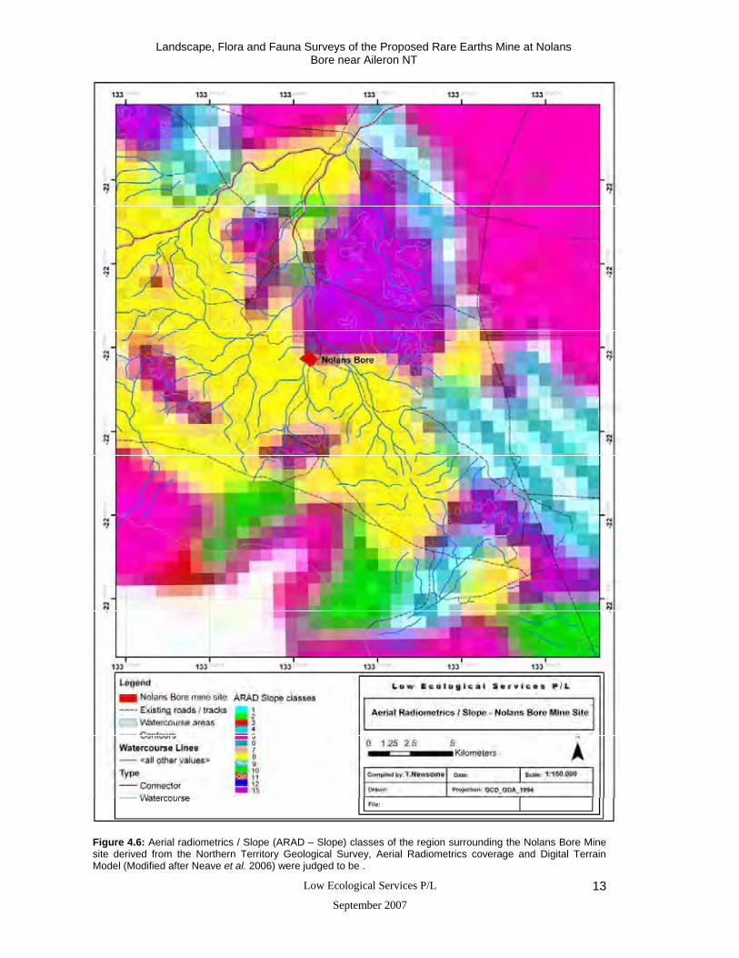
schist (Figure 4.5). Neave et al. (2006) also provide aerial radiometric / slope (ARAD –Slope)
classes for the Burt Plains Bioregion by combining radiometric bands (K, Th, and U) with
slope from a digital terrain model. The resulting classes for the Nolans Bore Mine Site area
are provided in Figure 4.6. Generalised geology classes derived from 1:250,000 geological
map sheets are also provided in Figure 4.7. A summary of the attributes of each geological
class is provided in Appendix 2.
Neave et al. 2006 tested their pilot stratification scheme in the field on Hamilton Downs
Pastoral Lease during June 2004. For stratification purposes, the 1:1,000,000 Vegetation Map
of Wilson et al. (1990) was not reliable enough to use in conjunction with the relatively high
resolution Aerial Radiometrics coverage (i.e. 100 metre resolution). For example, expected
changes in vegetation in relation to the other stratification variables, particularly ARAD-Slope,
were often not evident in the field. As a result, the available 1:250,000 Geology was
considered a more appropriate coverage to use in the final stratification of the Burt Plain
Bioregion for survey design purposes.
The various stratifications of Neave et al., (2006) for the Nolans Bore area are presented here
as indicators of variability of the area, which generally is relatively low in the proposed mine
site area.

Landscape, Flora and Fauna Surveys of the Proposed Rare Earths Mine at Nolans Bore near Aileron NT
Low Ecological Services P/L
September 2007 10
Figure 4.3: Land System (LS) map of the region surrounding the Nolans Bore Mine site. Where: Ai is Aileron LS; Bu is Bushy Park LS, Na is Napperby LS; Sa is Sandover LS,the yellow area at right is Sn or Singleton LS, brown area is Harts LS and blue area is Ry or Ryans LS (Modified after Perry et al. 1962).

Landscape, Flora and Fauna Surveys of the Proposed Rare Earths Mine at Nolans Bore near Aileron NT
Low Ecological Services P/L
September 2007 11
Figure 4.4: Satellite image, watercourse areas and contours of the region surrounding the Nolans Bore Mine site. The Stuart Hwy runs up the right side of the image with NT Gas Line diagonal frombottom left to cross Hwy half way up right side of image and continue NNE.

Landscape, Flora and Fauna Surveys of the Proposed Rare Earths Mine at Nolans Bore near Aileron NT
Low Ecological Services P/L
September 2007 12
Figure 4.5: Physiography classes of the region surrounding the Nolans Bore Mine site (Modified after Neave et al. 2006 from Perry et al., 1962). Class descriptions of the Burt Plains Bioregion are provided in Appendix 1.
Landscape, Flora and Fauna Surveys of the Proposed Rare Earths Mine at Nolans Bore near Aileron NT
Low Ecological Services P/L
September 2007 13
Figure 4.6: Aerial radiometrics / Slope (ARAD – Slope) classes of the region surrounding the Nolans Bore Mine site derived from the Northern Territory Geological Survey, Aerial Radiometrics coverage and Digital Terrain Model (Modified after Neave et al. 2006) were judged to be .
Landscape, Flora and Fauna Surveys of the Proposed Rare Earths Mine at Nolans Bore near Aileron NT
Low Ecological Services P/L
September 2007 14
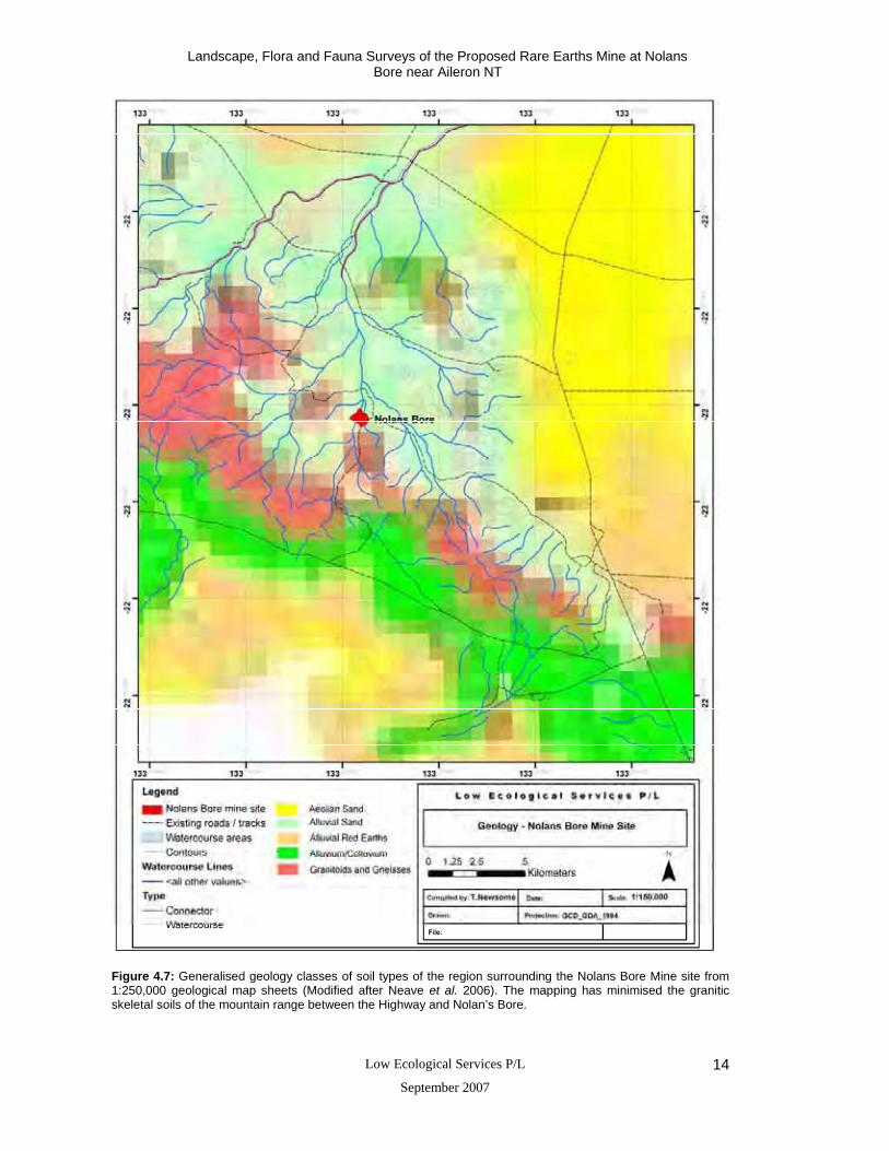
Figure 4.7: Generalised geology classes of soil types of the region surrounding the Nolans Bore Mine site from 1:250,000 geological map sheets (Modified after Neave et al. 2006). The mapping has minimised the granitic skeletal soils of the mountain range between the Highway and Nolan’s Bore.

Landscape, Flora and Fauna Surveys of the Proposed Rare Earths Mine at Nolans Bore near Aileron NT
Low Ecological Services P/L
September 2007 15
4.5 Soil Types
In the Napperby land system the granite hills, gneiss ridges and quartz reefs contain pockets
of shallow gritty or stony soils (Fig 4.7). The interfluves and erosional plains contain mainly
shallow to moderate gritty sandy red earths, red clayey sands, texture contrast soils and stony
solids near the hills. The drainage floors contain mainly textured contrast soils, alluvial soils
and red earths. The alluvial fans contain brown sands and red clayey sands. The drainage
heads and channels contain red earths and bed loads of course grit respectively (Perry et al.
1962, Neave et al. 2006).
In the Aileron land system the hills contain outcrops and pockets of shallow stony soils. In the
lower lying areas the alluvial fans contain brown sands and red clayey sands, the erosional
intermont plains contain red earths with minor alluvial variants and the sand plains contain red
clayey sands. The erosional slopes at the foot of hills contain mainly gritty red clayey sands,
stony soils and texture contrast soils (Perry et al. 1962).
In the Singleton land system the sand plains and swales contain red clayey sands which are
generally coarse-grained. The sand rises and alluvial flats contain red sands and red earths
respectively.
4.6 Flora
There have been no detailed flora surveys of the project area or mine site. However, an
environmental survey of Anna’s reservoir conservation reserve (approx 20 km west of Aileron)
was completed by Millington et al. (1980 And pastoral surveys have been conducted by
DPIFM predecessors to determine range condition and species of pastoral value. Millington
identified several plant communities, all of which were dominated by tussock grassland, which
had a sparse upper storey over the rocky hills and rolling slopes. The alluvial foothill fans
comprised a significant part of the reserve were dominated by bloodwoods forming an open
woodland. Stream-channel woodland and, tall and low shrubland communities were also
present. The greatest number of species recorded in that survey belonged to the Poaceae
family (grasses) followed by Mimosaceae, Malvaceae, Asteraceae and Chenopodiaceae.
Only one introduced plant species was recorded, Alternanthera pungens (khaki weed), and
no rare or endangered species were recorded.
Perry et al. (1962) also provided a general description of plant communities in the area. The
granite hills were described as containing sparse shrubs and low trees over sparse forbs and
grasses, mainly spinifex (Triodia spicata and T. basedowii). The alluvial fans commonly
contained sparse low trees over short grasses and forbs, including kerosene grasses (Aristida

Landscape, Flora and Fauna Surveys of the Proposed Rare Earths Mine at Nolans Bore near Aileron NT
Low Ecological Services P/L
September 2007 16
sp). Dense groves/areas of mulga (Acacia aneura) followed the rounded drainage areas
(clayey red earths) and contained a short grass and forb understorey. Drainage channels
contained river red gum (Eucalyptus camaldulensis), bean trees (Erythrina vespertilio) and
ironwoods (Acacia estrophiolata) over curly windmill grass (Enteropogon acicularis). Drainage
floors also contained a range of Eremophila species and sparsely distributed corkwood
(Hakea lorea) over short grasses and forbs. A range of Senna shrubs are also found in the
interfluves and erosional plains. Wilson et al. (1990) provide general structure classes for the
NT and Nolans Bore mine site area falls within the Acacia sparse-open shrubland category
(Figure 4.8)
Neave et al. (2006) provide an overview of flora within the Burt Plains Region, and at the time
of the survey there were 8264 records for 1141 plant taxa of which 3 are listed as vulnerable
under the Territory Parks and Wildlife Conservation Act (2000) (TPWC Act 2000), 62 are
listed as data deficient and 41 are listed near threatened in the Northern Territory (see
Appendix 3 and Neave et al. 2006). Frequency of plant records for 15” (minute) cells are also
provided within this report and there are 269 plant records in the cell containing the Nolans
Bore Mine Site. In general, the flora within the Burt Plains region has many taxa in common
with neighbouring bioregions, however there have been very few extensive flora surveys
across southern Northern Territory which limits (from a conservation planning perspective)
comparisons of species richness between bioregions (Neave et al. 2006).
A protected matters report generated from the Department of Environment and Water
Resources based on flora species listed under the Environment Protection and Biodiversity
Act (1999) (EPBC Act 1999); and the Territory Parks and Wildlife Conservation Act (2000)
(TPWC Act 2000) did not identify any species of environmental or conservation significance
within a 15 km radius of the Nolans Bore mine site (Appendix 4). However, a full list of
species likely to occur in the area, including those identified by Millington et al. (1980) and
Perry et al. (1962) is listed in Appendix 5. Summaries of significant plant taxa occurring in the
Burt Plains Bioregions are also provided in Appendices 6, 7, and 8 for reference.
4.7 Fauna
The environmental survey undertaken by Millington et al. (1980) at Anna’s reservoir
conservation reserve 26 years before the current surveys listed 41 reptiles, 20 mammals, and
41 bird species, confirmed or expected to occur in the area. Records from the Northern
Territory National Parks and Wildlife Fauna Atlas also identified a further 13 reptiles, one
mammal, and 48 bird species within a 100 km radius of the mine site. Millington et al. (1980)
described the area as similar to large areas of Harts Land Systems found throughout central
Australia and concluded that from a geographical and habitat distribution point of view the
area should contain a fairly extensive checklist of species. At the time of the Millington et al.

Landscape, Flora and Fauna Surveys of the Proposed Rare Earths Mine at Nolans Bore near Aileron NT
Low Ecological Services P/L
September 2007 17
(1980) survey no unusual species were found in the area, although they did note that rock
wallabies were common back in the 1930s. All species likely to occur in the area, including
those identified by Millington et al. (1980), Perry et al. (1962) and Northern Territory National
Parks and Wildlife Fauna Atlas are listed in Appendices 9, 10 and 11.
Neave et al. (2006) provide an overview of fauna within the Burt Plains Region, and at the
time of the survey there were 19,500 records for 366 vertebrate species, the majority of which
are birds (Appendix 12). Frequency of fauna records for 15” (minute) cells area also provided
within this report and there are 287 bird records, 6 mammal records, 41 reptile records and 1
frog record in the cell containing the Nolans Bore Mine Site. In general, the fauna within the
Burt Plains region has many taxa in common with neighbouring bioregions, however there
have been very few extensive fauna surveys across southern Northern Territory which limits
(from a conservation planning perspective) comparisons of species richness between
bioregions (Neave et al. 2006). Summaries of significant fauna occurring in the Burt Plains
Bioregions are provided in Appendices 13, and 14.
Three mammal, 7 bird and 1 reptile species of environmental or conservation significance
(EPBC Act 1999 and TPWC Act 2000) are recorded as occurring or possibly occurring within
a 15 km radius of the Nolans Bore mine site (Appendix 4). However, the Nolans Bore mine
site area does not provide key habitat areas crucial to the survival of these species (see
below). The recent book by Woinarski et al. 2007 provides a good pictorial summary of
threatened species in the NT and assessment of threatening processes for plant, invertebrate
and vertebrate species currently assessed as threatened. Conclusions presented below are
essentially the same information provided in the book.
There is limited data on the population dynamics and threatening processes for the southern
marsupial mole (Notoryctes typhlops) due to their fossorial behaviour (Benshemesh and
Johnson 2003). They are most often recorded in sandy dune habitats supporting various
acacias and other shrubs, and often, but not always, in association with spinifex
(Benshemesh 2004). Such habitat is not present at the Nolans Bore site but is widespread in
and typical of the sandy deserts including areas of Singleton LS to the south and east of the
Nolans Bore site. The Northern Territory Parks and Wildlife Fauna Atlas indicate that this
species has only been recorded at one location (back in late 1970s and early 80s) within a
100 km radius of the proposed mine site (approximately 80 km to the west of Nolans Bore)
(Figure 4.9).
Mulgaras (Dasycercus cristicauda) are listed as vulnerable under the EPBC Act (1999) and
TPWC Act (2000). They were once widespread and common throughout the central deserts
and are now principally found in mature mixed with immature hummock grasslands (spinifex)
and in palaeo-drainage systems or drainage lines in sandplain or sand dune habitats

Landscape, Flora and Fauna Surveys of the Proposed Rare Earths Mine at Nolans Bore near Aileron NT
Low Ecological Services P/L
September 2007 18
(Maxwell et al. 1996, Masters, 1984). Key threats to this species include habitat loss,
competition with introduced herbivores and predation by foxes and cats. There is potential for
Mulgaras to occur within the Nolans Bore mine site area, although the Northern Territory
Parks and Wildlife Fauna Atlas indicate that this species has only been recorded at two
locations (back in the 1960s) within a 100 km radius of the mine site in sand plains
(approximately 71 km and 92 km to the south west of Nolans Bore) (Figure 4.9).
Black-footed rock-wallabies (Petrogale lateralis) are listed as vulnerable under the EPBC Act
(1999) and as near threatened under the TPWC Act (2000). They are patchily distributed
throughout the ranges of central Australia and are usually found in close proximity to cliffs,
rock piles, talus or escarpments that provide a source of refuge (DEH 2006) in proximity to
surface water. They have also been known to occur on granite outcrops and sandstone cliffs
(Maxwell et al. 1996). Key threats to this species include habitat loss and predation by foxes
and cats. There is potential for rock wallabies to occur in the hills surrounding the Nolans
Bore mine site area, particularly within the rocky granite hills, although the nearest record
within the Northern Territory Parks and Wildlife Fauna Atlas is 30 km to the south east (Figure
4.9).
Birds that are listed under the EPBC Act (1999) and / or TPWC Act (2000) include the
princess parrot (Polytelis alexandrae) and six migratory species (oriental plover, (Charadrius
veredus) oriental pratincole, (Glareola maldivarum), fork-tailed Swift (Apus pacificus), great
egret / white egret (Ardea alba), cattle egret (Ardea ibis), and rainbow bee-eater (Merops
ornatus). Only two of these species (princess parrot and rainbow bee eater) have been
recorded within a 100 km radius of Nolans Bore (Northern Territory Parks and Wildlife Fauna
Atlas) (Figure 4.9).
The princess parrot is listed as vulnerable under the EPBC Act (1999) and TPWC Act (2000).
They are known to occur in the southern sections of the Tanami desert, south to Angas
Downs and Yulara and east to Alice Springs. It usually occupies swales between sand dunes
and is occasionally seen on slopes and crests of dunes. Their habitat consists mostly of
shrubs such as Eremophila, Grevillea, and Hakea and scattered trees. Breeding takes place
in hollows in large eucalypts, particularly river red gums (Eucalyptus camaldulensis) and also
in desert oaks (Allocasuarina decaisneana) (Northern Territory Parks and Wildlife 2002).
There is potential for the princess parrot to occur within the Nolans Bore Mine site area
although they have not been recorded since the late 1960s within a 100 km radius of Nolans
Bore (Northern Territory Parks and Wildlife Fauna Atlas).
The rainbow bee-eater is a listed migratory species under the EPBC Act (1999) and is
protected under the Japan – Australia Migratory Bird Agreement (JAMBA). They are found
seasonally throughout Australia, although they prefer open woodlands with sandy or loamy

Landscape, Flora and Fauna Surveys of the Proposed Rare Earths Mine at Nolans Bore near Aileron NT
Low Ecological Services P/L
September 2007 19
soils and are often seen around disturbed areas such as quarries, road cuttings and mines
where exposed bare soil provides suitable breeding sites (Higgins 1999). There is potential
for the rainbow bee-eater to occur within the Nolans Bore Mine site area and there have been
a large number of sightings of this species within a 100 km radius (Figure 4.9). However, the
distribution and occurrence of sightings in the area suggest that the Nolans Bore mine site is
not critical habitat used regularly by this migratory species (Figure 4.9).
The great desert skink (Egernia kintorei) is the only reptile listed under the EPBC Act (1999)
and TPWC Act (2000) that may occur in the area and it is unlikely to occur at Nolans Bore
because of inappropriate habitat. Little is known of the precise distribution of this species;
however there are large areas of potentially suitable habitat throughout the western deserts of
central Australia. They generally occur in hummock grass sandplains and some adjacent
dunefield swales. They have also been located in areas of spinifex and woollybutt grass
(Eragrostis spp.) with scattered mulga. There is little potential for this species to occur within
the Nolans Bore mine site due to habitat limitations, and there are no records of this species
within the Northern Territory Parks and Wildlife Fauna Atlas within 100 km of Nolans Bore.

Landscape, Flora and Fauna Surveys of the Proposed Rare Earths Mine at Nolans Bore near Aileron NT
Low Ecological Services P/L
September 2007 20
Figure 4.8: Vegetation classes of the region surrounding the Nolans Bore Mine site derived from the 1:1,000,000 vegetation map of Wilson et al. (1990). Modified after Neave et al. (2006).

Landscape, Flora and Fauna Surveys of the Proposed Rare Earths Mine at Nolans Bore near Aileron NT
Low Ecological Services P/L
September 2007 21
Figure 4.9: Sightings of fauna listed under the Environment Protection and Biodiversity Act (1999) (EPBC Act 1999) or the Territory Parks and Wildlife Conservation Act (2000) (TPWC Act 2000)) based on records from the Northern Territory National Parks and Wildlife Fauna Atlas as of December 2006 within 100 km of the Nolans Bore mine site.

Landscape, Flora and Fauna Surveys of the Proposed Rare Earths Mine at Nolans Bore near Aileron NT
Low Ecological Services P/L
September 2007 22
5 Survey Methods
Two environmental surveys were conducted by Low Ecological Services between the 4th and
7th of May 2006 and 21st and 24th of November 2006. Personnel included Dr Bill Low, Tom
Reilly, Cassie Wright, Tom Newsome, Erin Moon, Clare Ghee and Dave Gregory from Low
Ecological Services, Dennis Matthews (private consultant specialising in bat survey and GIS).
Steve Mackowski from Arafura Resources (Operations Manager) and Peter Bannister from
the Northern Territory Government also visited and took part in short periods of the survey.
5.1 Survey Sites
The Nolans Bore mine site lies within the Napperby Land System (Perry et al. 1962) (see
section 4.4). Within the mine site area and habitat directly adjacent, two prominent land units
(rocky hills and plains) were identified and are shown in Figure 5.1. Watercourse areas
(Riparian) were also identified as a separate habitat. Four survey sites were chosen
throughout the land units in order to represent the different habitat types and to give an
indication of species diversity where most mining activities will occur (Figure 5.1). The habitat
types included:
(1) Riparian,
(2) Rocky granite hills,
(3) Shallow sand plain, and
(4) Rocky undulating plain.
A fifth survey site was chosen during the second environmental survey to aid in assessing
flora and fauna within the creek diversion area (Figure 5.2). This provided an intensive survey
area of approximately 4 km-2. At each site, flora and fauna surveys were conducted, and
included a combination of Elliott trapping, pitfall trapping, landscape assessment and
vegetation identification. Proposed access tracks, possible haul road routes and the
suggested creek diversion around the future open cut pit were also driven or walked and
assessed for susceptible vegetation and landscape features (Figure 5.2 and 5.3). This
extended the total survey area to approximately 15 km-2. Tracks and waypoints were recorded
using a Garmin GPS 76C Mapper and were mapped in ArcMap (version 8.3). GPS data were
set to WGS 84 and Projection Grid set to UTM (location 53 K).
Landscape, Flora and Fauna Surveys of the Proposed Rare Earths Mine at Nolans Bore near Aileron NT
Low Ecological Services P/L
September 2007 23
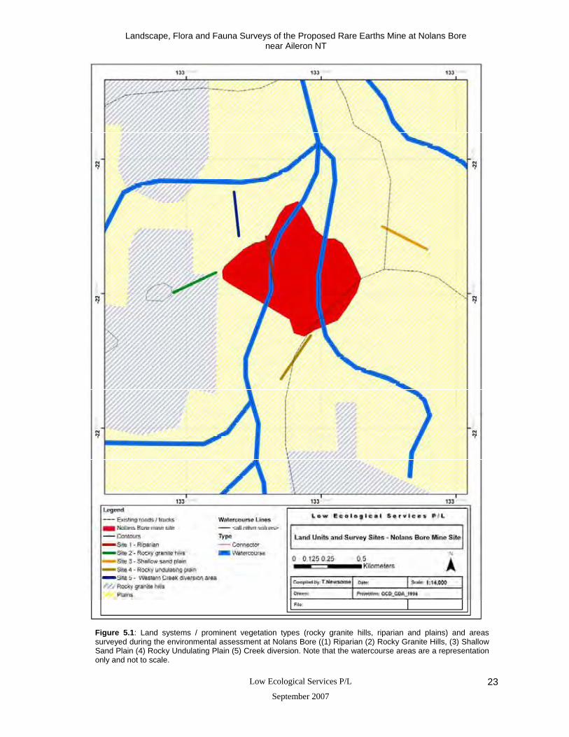
Figure 5.1: Land systems / prominent vegetation types (rocky granite hills, riparian and plains) and areas surveyed during the environmental assessment at Nolans Bore ((1) Riparian (2) Rocky Granite Hills, (3) Shallow Sand Plain (4) Rocky Undulating Plain (5) Creek diversion. Note that the watercourse areas are a representation only and not to scale.

Landscape, Flora and Fauna Surveys of the Proposed Rare Earths Mine at Nolans Bore near Aileron NT
Low Ecological Services P/L
September 2007 24
Figure 5.2: Creek diversion options around the Nolans Bore mine site. Note that the watercourse areas are a representation only and not to scale.

Landscape, Flora and Fauna Surveys of the Proposed Rare Earths Mine at Nolans Bore near Aileron NT
Low Ecological Services P/L
September 2007 25
Figure 5.3: Haul road options from the Nolans Bore mine site. Note that the watercourse areas are a representation only and not to scale.

Landscape, Flora and Fauna Surveys of the Proposed Rare Earths Mine at Nolans Bore near Aileron NT
Low Ecological Services P/L
September 2007 26
5.2 Flora
During surveys one and two, vegetation characteristics were recorded at each site to indicate
the species composition, dominance and vegetation structure. The survey consisted of two
personnel identifying or collecting flora specimens and estimating dominance and percent
cover of total and dominant vegetation along (250 m transect) and adjacent (30 m either side)
to the Elliott trap line. Photographs were taken at all sites to show the different habitat zones
in the area. Voucher specimens were collected when identification was uncertain, and were
identified by David Maynard and Des Nelson (local botanists) with reference to the Northern
Territory Herbarium. Percentage cover of dominant species was also estimated at each site
and vegetation was categorised into four structural layers:
(1) Emergent tree layer;
(2) Upper shrub layer;
(3) Lower shrub layer; and,
(4) Ground layer.
5.3 Fauna
Elliott and Pitfall Traps
During surveys one and two, twenty-five Elliott traps (type A, 33 x 10 x 10 cm) were
positioned, 10 – 15 metres apart, through each of the sites. Each trap was baited with a
mixture of oats and peanut butter, and provided with cotton wool or litter for bedding. Two
pitfall traps, each consisting of a 25 L bucket with a 10 m drift fence were also installed in
each of the land units during each survey. All traps were checked each morning and evening
for three consecutive days, except for Site 5 which was only set for two nights in the second
survey. Trapped fauna were identified and then released at the site of capture, except House
Mice which were euthanased.
Indirect / opportunistic observations
During surveys one and two, sightings and evidence (e.g. tracks, scats and traces) of fauna
were opportunistically recorded for each land unit whilst checking trap lines each day and
whenever observers were present in particular land units. Bird presence and abundance was
recorded at each of the trapping sites for approximately 15 minutes at each site in the
morning and afternoon and/or opportunistically across the area, by observation or call. The
bird survey consisted of walking slowly through each of the land units and recording birds that
are seen or heard within 50 – 100m of the Elliott trap line (250 m).

Landscape, Flora and Fauna Surveys of the Proposed Rare Earths Mine at Nolans Bore near Aileron NT
Low Ecological Services P/L
September 2007 27
Bats were recorded for approximately 12 hours at each survey site using the bat detector unit
ANABAT Systems - version 6, during survey 1 and 2. The unit records high frequency bat
calls that are specific to each bat species. The detector was set-up for at least one night at
each site. Calls were identified by Dennis Matthews, private consultant. The ANABAT System
(version 6) used this way can not provide abundance data of species recorded, because one
bat can pass the detector many times and may be the only bat of that species in the area.
Therefore, only a check list of species has been provided. However, the record does give an
indication of the relative activity of different species at a particular location. Some species
were not separated from other species due to constraints of this technique; these species are
listed at the end of Appendix 15.
5.4 Criteria used in Identifying Species of Conservation Significance
This report draws attention to species of conservation significance inhabiting or potentially
inhabiting the Nolans Bore mine site area (as of December 2006). The Commonwealth EPBC
Act (amended 2004) and species listed in the TPWC Act (2000) have been used to identify
species of conservation significance (Appendix 4). Neave et al. (2006) also list a number of
criteria for identifying areas of conservation significance within the Burt Plains Bioregion and
each of these is discussed in Section 7. Woinarski et al. 2007 provides a current pictorial
summary of threatened species in the NT and assessment of threatening processes for plant,
invertebrate and vertebrate species currently assessed as threatened.
6 Results
6.1 Landscape
The land forms within the Nolans Bore mine site area are dominated by the intermont subcrop
plain dissected by drainage channels and associated alluvial fans, sand plains, and
undulating rocky plains. Surrounding the site are rocky granitic hills which extend to the east
and west of the project area. Soils are predominantly alluvial red earths mixed with quartz and
sandstone. The vegetation is mainly dominated by a sparse woodland with a mixture of
bloodwood and mulga trees. The Nolans Bore mine site is located within a pastoral property
and is heavily grazed around the bore area. The area has not been burnt for a number of
years.
6.2 Land Unit Descriptions (Surveys one and two)
Land Units present are presented here with full lists of plant species identified in each land
unit during surveys one and two are provided in Appendix 5.
Landscape, Flora and Fauna Surveys of the Proposed Rare Earths Mine at Nolans Bore near Aileron NT
Low Ecological Services P/L
September 2007 28
6.2.1 Site 1: Riparian
The site is a drainage channel tributary flowing north east to Kerosene Camp Creek, with
banks approximately 12 m wide and 1.5 m high (Figure 5.1) (Plates 1, 2 and 3). Alluvial
deposits are scattered along the creek, which has a sandy soil base to a depth of around 40
cm and generally sits on a rock subcrop. Rocky outcrops (quartzite) were only apparent at
several rock bars along or adjacent to the creek and 80% of the ground in the creek bed was
bare.
Trees along the drainage channel and the emergent tree layer are dominated by mulga trees,
bean trees and river red gums. The upper shrub layer was dominated by conkerberry
(Carissa lanceolata), senna shrubs (Senna artemisioides), emu bush (Eremophila longifolia)
and sida species (Sida cunninghamii). The ground layer was dominated by curly windmill
grass although in survey two there was also high percentage of Sclerolaena bicornis. Other
grasses and sedges present during surveys one and two included silky browntop (Eulalia
aurea), golden beard grass (Chrysopogon fallax), erect kerosene grass (Aristida holathera),
caustic bush/desert spurge (Euphorbia tannensis) and the introduced species buffel grass
(Cenchrus ciliaris). The density of bean trees along the stream lines in numerous locations is
very high and reflects favourable temperatures and rainfall for this species.
6.2.2 Site 2: Rocky Granite Hills
This site comprised rocky slopes, flanks and foothills in the west of the project area (Figure
5.1) (Plates 4, 5 and 6). The site contained red sandy alluvial loam mixed with quartz
sandstone and rocky granite outcrops in the hills. In the rocky hills, the vegetation covered
approximately 50% of the area, and the emergent tree layer was dominated by mulga trees.
Other trees included whitewoods (Atalaya hemiglauca), conkerberries, ironwoods, and ghost
gums (Corymbia aparrerinja, formerly Eucalyptus papuana). The sparse shrub layer was
predominantly Senna glutinosa and the ground layer was dominated by spinifex (Triodia
spicata).
The flanks contained a slightly higher vegetation cover (65%) in comparison to the rocky
slopes and foothills. The emergent tree layer was dominated by mulga trees and the upper
and lower shrub layers were dominated by blue mallee (Eucalyptus gamophylla), witchetty
bush (Acacia kempeana), and senna shrubs (Senna glutinosa and S. oligophylla). Spinifex
(Triodia spicata) provided the bulk of ground cover.
In the foothills the vegetation covered approximately 60% of the area, with mulga, long-leafed
corkwood trees and bloodwoods (Corymbia opaca) dominating the emergent tree layer. Small
mulga trees also dominated the upper shrub layer and the lower shrub layer was dominated

Landscape, Flora and Fauna Surveys of the Proposed Rare Earths Mine at Nolans Bore near Aileron NT
Low Ecological Services P/L
September 2007 29
by senna shrubs (Senna oligophylla), eremophila species (Eremophila longifolia, E. latrobei ).
There was less spinifex on the ground layer of the foothills which was dominated by copper
burr (Sclerolaena costata) and Fimbristylis species.
6.2.3 Site 3: Shallow Sand Plain
This site comprised a relatively large flat red earth plain with an open woodland in the east of
the project area (Figure 5.1) (Plates 7 and 8). There were very few rocky outcrops on the site
and approximately 30 – 40% of the ground was bare. Clay soils underlay the red earth sands
at a depth of around 20 cm and the area is underlain by a rock basement at relatively shallow
depth. Leaf litter was relatively common on the surface. The site contained termite mounds
and there was mulga and bloodwood log litter throughout. The emergent tree layer was
dominated by mulga and bloodwood trees which had grown to around 4 – 6 m. The upper
shrub layer was also dominated by smaller mulga trees and to a lesser extent witchetty bush.
The lower shrub layer was dominated by senna shrubs (Senna sturtii and S. artemesiodes
ssp. oligophylla) and Sida platycalyx. The ground layer was dominated by copper burrs
including Sclerolaena costata and birchii.
6.2.4 Site 4: Rocky Undulating Plain
This land unit was situated directly south west of Nolans Bore, in an undulating area that
included an old levee bank with open shrubs growing on it, and an area of rocky undulating
plains (Figure 5.1) (Plate 9 and 10). The area is heavily grazed and utilised by stock. The site
contained red alluvial soils with scattered outcrops of pebbles and gravel and some areas
were affected by erosion. The sparse emergent tree layer was dominated by bloodwoods and
beefwoods. Mulga trees, supplejacks (Ventilago viminalis) and white woods were also
patchily distributed in the emergent tree layer. The upper shrub and lower shrub layer were
respectively dominated by mimosa bush (Acacia farnesiana) and senna shrubs (which
accounted for >70% of each stratum). There was a high proportion of introduced species in
the ground layer, particularly buffel grass and couch grass (Cynodon dactylon) during survey
one, although in survey two (after a period of little rain) the ground layer was relatively bare
and dominated by Sclerolaena bicornis (compare Plates 9 and 10).
6.2.5 Site 5: Western Creek Diversion
Vegetation in the area where the proposed western creek diversion option 1 may occur (see
Figure 5.2) was assessed during survey one. In survey two, vegetation in the area where the
trap line was installed (see Figure 5.1) was assessed in more detail and a general landscape
assessment of the proposed western creek diversion 2 took place. In general, the area where
the western creek diversions may occur has similar vegetation and landform characteristics
throughout. Soils are mainly red earths with alluvial rocks scattered throughout (likely washed

Landscape, Flora and Fauna Surveys of the Proposed Rare Earths Mine at Nolans Bore near Aileron NT
Low Ecological Services P/L
September 2007 30
down from the hills). Vegetation is dominated by mulga trees, bloodwoods and whitewoods.
Other trees identified included beefwoods (Grevillea striata) Hakea sp. and witchetty bush.
There is also a variety of shrub species in the area, including sennas, annual saltbush
(Atriplex elachophylla), native fuchsia (Eremophila latrobei), and witchetty bush. The ground
layer is dominated by Fimbristylis, Sclerolaena and Aristida species and buffel grass.
6.3 Flora Summary
A total of 185 species were identified across the five survey sites and the creek diversion area
during surveys one and two with considerable between site repetition (see below) (Appendix
5). Site 2 (Rocky Granite Hills) contained the highest number of species (80) and all others
contained between 37 and 51 plant species (Figure 6.1). None of these species or species
identified by other surveys in the area were listed under the EPBC Act (1999) or TPWC Act
(2000) legislation for conservation significance (Appendices 1 and 2). Species recorded
during the two surveys and their associated vegetation communities are common in the
region with the exception of a few species. General descriptions of species and vegetation
communities are provided in Section 6.1 and 6.2 and a full list of species identified in the
survey along with others likely to occur in the region is provided in Appendix 5.
0
20
40
60
80
100
Site 1 Site 2 Site 3 Site 4 Site 5
Figure 6.1: Total number of species recorded at each site within the Nolans Bore mine site area. Where: Site 1 = Riparian, Site 2 = Rocky Granite Hills, Site 3 = Shallow Sand Plain, Site 4 = Rocky Undulating Plain and Site 5 = Creek diversion area. For locations see Figure 5.1.
6.4 Fauna
Fauna species identified by Low Ecological Services during surveys one and two are listed in
Appendices 9, 10 and 11. A total of 78 species were identified across the five sites during
survey, including 51 birds, 18 mammals, eight reptiles, and one snail. There was no
significant difference between the number of species of native fauna identified in surveys one
and two (19 and 18 respectively). None of these species were listed under the EPBC Act
(1999) or TPWC Act (2000) legislation for conservation significance (Appendix 4). Species
Landscape, Flora and Fauna Surveys of the Proposed Rare Earths Mine at Nolans Bore near Aileron NT
Low Ecological Services P/L
September 2007 31
recorded during the two surveys are generally common and widespread throughout the
region.
6.4.1 Mammals
Mammalian species recorded during the survey are listed in Appendix 15 and a list of species
likely to occur in the area is provided in Appendix 9. In total, 22 native and three introduced
mammalian species were identified in the project area during surveys one and two (Appendix
15). None of these species were listed as vulnerable or endangered under the EPBC Act
(1999) or TPWC Act (2000) legislation for conservation significance (Appendix 4).
Stripe-faced dunnarts (Sminthopsis macroura) were captured during surveys one and two in
Sites 2 and 5 (Plate 11). This species is common in the area and their distribution is scattered
throughout much of the arid zone. They are found mostly on sandy substrates but also on
cracking clay and stony plains (Menkhorst and Knight 2004). It is likely that this species is
present in most areas with hummock or tussock grasses and shrubs across the site.
Introduced house mice (Mus musculus) provided the majority of captures in surveys one and
two, and most occurred at Site 4. This species is well adapted to arid country and populations
fluctuate enormously in response to climate and food availability.
Two macropod species were observed during the survey. Red kangaroos (Macropus rufus)
were observed throughout Sites 2 and 3. They are widespread and common across semiarid
and arid Australia, and are likely to be found throughout the project area, particularly following
rain, where there is green herbage. One euro (M. robustus) was observed on the granite hills
of Site 2 during survey 1 (Plate 12). Euros are also widespread throughout the region and are
likely to be common over the rocky areas of the project site. Short-beaked echidna
(Tachyglossus aculeatus) scats were also found in Site 2 (Plate 13) during survey 1.
Feral cats (Felis catus) were observed indirectly (tracks) in the area surrounding Site 1 during
survey one. Three juvenile dingoes (Canis lupus dingo) were also observed regularly at Site
4, and their den site was situated next to the cattle yards at Nolans Bore.
The ANABAT system (bat detector) was set-up for at least one night at each site for surveys
one and two. The system showed that there were at least eight species present. No
megachiropteran bats (fruit and blossom bats) were observed during the survey period;
however this is to be expected as these bats do not occur in Central Australia except in
extreme conditions. The southern freetail bat (Mormopterus planiceps) (long penis form) is a
good sighting but they are widespread. Hill’s sheathtail bat (Taphozous hilli) is a cliff/cave
dwelling species and was identified from a few calls on two nights, and it is likely that there

Landscape, Flora and Fauna Surveys of the Proposed Rare Earths Mine at Nolans Bore near Aileron NT
Low Ecological Services P/L
September 2007 32
are more individuals in the area. The inland forest bat (Vespadelus baverstocki) is a tree
dwelling species and was identified from a number of calls and the probability of its
occurrence is high enough to list as a definite record, although it is unlikely to occur on all of
the sites (Matthews pers. comm.). The white-striped freetail bat (Tadarida australis), inland
broad-nosed bat (Scotorepens balstoni), Gould’s wattled bat (Chalinolobus gouldii), and
lesser long-eared bat (Nyctophilus geoffroyi) are all widespread and common throughout the
region. The last bat was identified as being either the inland cave bat (Vespadelus finlaysoni)
or the chocolate wattled bat (Chalinolobus morio). It is most likely the latter, as this species is
known to occur in the region (Menkhorst and Knight 2004).
6.4.2 Reptiles
Reptile species recorded during the survey are listed in Appendix 15 and a list of species
likely to occur in the area is provided in Appendix 10. Overall, trap captures were low and
there was no significant difference in trap captures between surveys one and two (four and
five respectively). Long-nosed water dragons (Lophognathus longirostris) (Plate 14) were
observed during both surveys in Sites 1 and 2. One central netted dragon (Ctenophorus
nuchalis) was caught in Site 1 during survey two (Plate 15) and burrows were not uncommon,
particularly in winrows at the edge of roads. A single Leonhardi's ctenotus (Ctenotus
leonhardii) (Plate 16) was captured in a pitfall trap at Site 3, and other unidentified ctenotus
sp. were observed in Site 3 during survey one. Two broad banded swimmers (Eremiascincus
richardsonii) were captured in site 4 during survey 2 (Plate 17) along with a legless lizard
(Lerista bipes), two sand plain geckos (Diplodactylus stenodactylus) in sites 2 and 3
respectively (Plate 18 and 19). An incidental sighting of a perentie (Varanus giganteus) (Plate
20) also occurred during survey one. Overall, all species seen or captured are common to the
region and are likely to be found throughout the survey area. None of these species recorded
are listed as vulnerable or endangered under the EPBC Act (1999) or TPWC Act (2000)
legislation for conservation significance (Appendix 4).
6.4.3 Birds
Bird species recorded during the survey are listed in Appendix 16 and a list of species likely to
occur in the area is provided in Appendix 11. In total 51 bird species were recorded during
surveys one and two. None of these species were listed as vulnerable or endangered under
the EPBC Act (1999) or TPWC Act (2000) legislation for conservation significance (Appendix
4).

Landscape, Flora and Fauna Surveys of the Proposed Rare Earths Mine at Nolans Bore near Aileron NT
Low Ecological Services P/L
September 2007 33
6.5 Other surveys areas / observations
6.5.1 Haul road options
Two proposed haul road routes (to the north and to the south from Nolans Bore - see figure
5.3) were driven and assessed for susceptible vegetation and landscape features. The
proposed northern haul road follows an existing track from Nolans Bore to the Stuart Highway
(Figure 5.3). A summary of the information collected from the survey along this track is
presented in Table 1. The proposed southern haul road follows an existing track from Nolans
Bore to the gas pipeline which crosses to the Stuart Highway (Figure 5.3). A summary of the
information collected from the survey along this track is presented in Table 2.

Landscape, Flora and Fauna Surveys of the Proposed Rare Earths Mine at Nolans Bore near Aileron NT
Low Ecological Services P/L
September 2007 34
Table 1: Summary of vegetation and road conditions on the vehicle tracks within the northern proposed haul road that follows an existing track from Nolans Bore to the Stuart Highway. Note: Vegetation is a summary only, and includes dominant species adjacent to the vehicle tracks.
Location Road Condition General Vegetation in Area Recommendations Distance along track : 0 – 1 km
General Description: Flat plain, well cleared track, area generally open. Soil Types: Red earths Environmental Processes
Vegetation sp : 60 - 80 % Cover adjacent to track Upper stratum (trees) Acacia aneura (mulga) Corymbia opaca(bloodwood) Hakea divaricata (corkwood) Middle stratum (shrubs) Acacia kempeana (witchetty bush) Hakea leucoptera (needlewood) Lower stratum (grasses, sedges and forbs) Sclerolaena sp.
Environmental issues for track construction / road use: Avoid large stands of mulga. Road should follow existing track, some areas will need widening.
Distance along track : 1 - 2 km
General Description: Flat plain, fairly open well cleared track Soil Types: Red earths Environmental Processes
Vegetation sp : 50 - 60 % Cover adjacent to track Upper stratum (trees) Acacia aneura (mulga) Eucalyptus camaldulensis (river red gum) Corymbia opaca(bloodwood) Erythrina vespertilio (bean tree) Hakea divaricata Middle stratum (shrubs) Acacia kempeana (witchetty bush) Acacia victoriae (victory wattle) Aristida contorta Aristida holathera Hakea leucoptera (needlewood) Lower stratum (grasses, sedges and forbs) Sclerolaena sp. Eulailia aurea
Environmental issues for track construction / road use: Avoid large stands of mulga. Road should follow existing track, some areas may need widening.
Distance along track : 2 – 3 km
General Description: Flat plain, fairly open well cleared track Soil Types: Red earths
Vegetation sp : 40 - 50 % Cover adjacent to track Upper stratum (trees) Acacia aneura (mulga) Corymbia opaca(bloodwood) Middle stratum (shrubs) Senna artemisioides ssp. oligophylla
Environmental issues for track construction / road use: Road should follow existing track, some areas may need widening.
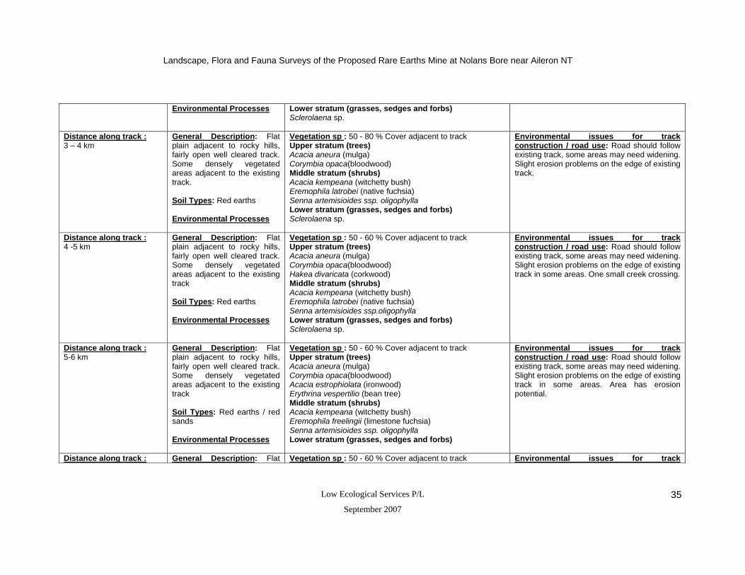
Landscape, Flora and Fauna Surveys of the Proposed Rare Earths Mine at Nolans Bore near Aileron NT
Low Ecological Services P/L
September 2007 35
Environmental Processes Lower stratum (grasses, sedges and forbs) Sclerolaena sp.
Distance along track : 3 – 4 km
General Description: Flat plain adjacent to rocky hills, fairly open well cleared track. Some densely vegetated areas adjacent to the existing track. Soil Types: Red earths Environmental Processes
Vegetation sp : 50 - 80 % Cover adjacent to track Upper stratum (trees) Acacia aneura (mulga) Corymbia opaca(bloodwood) Middle stratum (shrubs) Acacia kempeana (witchetty bush) Eremophila latrobei (native fuchsia) Senna artemisioides ssp. oligophylla Lower stratum (grasses, sedges and forbs) Sclerolaena sp.
Environmental issues for track construction / road use: Road should follow existing track, some areas may need widening. Slight erosion problems on the edge of existing track.
Distance along track : 4 -5 km
General Description: Flat plain adjacent to rocky hills, fairly open well cleared track. Some densely vegetated areas adjacent to the existing track Soil Types: Red earths Environmental Processes
Vegetation sp : 50 - 60 % Cover adjacent to track Upper stratum (trees) Acacia aneura (mulga) Corymbia opaca(bloodwood) Hakea divaricata (corkwood) Middle stratum (shrubs) Acacia kempeana (witchetty bush) Eremophila latrobei (native fuchsia) Senna artemisioides ssp.oligophylla Lower stratum (grasses, sedges and forbs) Sclerolaena sp.
Environmental issues for track construction / road use: Road should follow existing track, some areas may need widening. Slight erosion problems on the edge of existing track in some areas. One small creek crossing.
Distance along track : 5-6 km
General Description: Flat plain adjacent to rocky hills, fairly open well cleared track. Some densely vegetated areas adjacent to the existing track Soil Types: Red earths / red sands Environmental Processes
Vegetation sp : 50 - 60 % Cover adjacent to track Upper stratum (trees) Acacia aneura (mulga) Corymbia opaca(bloodwood) Acacia estrophiolata (ironwood) Erythrina vespertilio (bean tree) Middle stratum (shrubs) Acacia kempeana (witchetty bush) Eremophila freelingii (limestone fuchsia) Senna artemisioides ssp. oligophylla Lower stratum (grasses, sedges and forbs)
Environmental issues for track construction / road use: Road should follow existing track, some areas may need widening. Slight erosion problems on the edge of existing track in some areas. Area has erosion potential.
Distance along track : General Description: Flat Vegetation sp : 50 - 60 % Cover adjacent to track Environmental issues for track

Landscape, Flora and Fauna Surveys of the Proposed Rare Earths Mine at Nolans Bore near Aileron NT
Low Ecological Services P/L
September 2007 36
6 - 7 km plain adjacent to rocky hills, fairly open well cleared track. Some densely vegetated areas adjacent to the existing track Soil Types: Red earths / red sands Environmental Processes
Upper stratum (trees) Corymbia opaca(bloodwood) Carissa lanceolata (conkerberry) Middle stratum (shrubs) Acacia kempeana (witchetty bush) Eremophila latrobei (native fuchsia) Eremophila freelingii (limestone fuchsia) Senna artemisioides ssp. oligophylla Lower stratum (grasses, sedges and forbs)
construction / road use: Road should follow existing track, some areas may need widening. Area has erosion potential. One small creek crossing.
Distance along track : 7 - 8 km
General Description: Flat plain adjacent to rocky hills, fairly open well cleared track. Some densely vegetated areas adjacent to the existing track Soil Types: Red earths / red sands Environmental Processes
Vegetation sp : 50 - 60 % Cover adjacent to track Upper stratum (trees) Acacia aneura (mulga) Acacia estrophiolata (ironwood) Atalaya hemiglauca (whitewood) Corymbia opaca(bloodwood) Hakea divaricata (corkwood) Middle stratum (shrubs) Acacia kempeana (witchetty bush) Eremophila latrobei (native fuchsia) Eremophila freelingii (limestone fuchsia) Senna artemisioides ssp. artemisioides Lower stratum (grasses, sedges and forbs)
Environmental issues for track construction / road use: Road should follow existing track, some areas may need widening, still relatively cleared though. Area has erosion potential.
Distance along track : 8 - 9 km
General Description: Flat plain adjacent to rocky hills, fairly open well cleared track. Some densely vegetated areas adjacent to the existing track Soil Types: Red earths / red sands Environmental Processes
Vegetation sp : 50 - 60 % Cover adjacent to track Upper stratum (trees) Acacia estrophiolata (ironwood) Atalaya hemiglauca (whitewood) Erythrina vespertilio (bean tree) Hakea divaricata (corkwood) Middle stratum (shrubs) Acacia victoriae (acacia bush) Acacia murrayana (colony wattle) Eremophila latrobei (native fuchsia) Senna artemisioides ssp. Artemisioides Senna artemisioides subsp. filifolia Pittosporum angustifolium (native apricot) Lower stratum (grasses, sedges and forbs)
Environmental issues for track construction / road use: Road should follow existing track, some areas may need widening. Area has erosion potential.

Landscape, Flora and Fauna Surveys of the Proposed Rare Earths Mine at Nolans Bore near Aileron NT
Low Ecological Services P/L
September 2007 37
Distance along track : 9 - 10 km
General Description: Flat plain adjacent to rocky hills, fairly open well cleared track. Some densely vegetated areas adjacent to the existing track Soil Types: Red earths / red sands Environmental Processes
Vegetation sp : 50 - 60 % Cover adjacent to track Upper stratum (trees) Acacia aneura (mulga) Acacia estrophiolata (ironwood) Corymbia opaca(bloodwood) Grevillea striata (beefwood) Middle stratum (shrubs) Acacia strongylophylla (round leafed wattle) Acacia holosericea (silver wattle) Senna artemisioides ssp. artemisioides Lower stratum (grasses, sedges and forbs)
Environmental issues for track construction / road use: Road should follow existing track, some areas may need widening. Area has erosion potential.
Distance along track : 10 -11 km
General Description: Flat plain adjacent to rocky hills, fairly open well cleared track. Some densely vegetated areas adjacent to the existing track Soil Types: Red earths / red sands Environmental Processes
Vegetation sp : 50 - 60 % Cover adjacent to track Upper stratum (trees) Acacia aneura (mulga) Acacia estrophiolata (ironwood) Grevillea striata (beefwood) Middle stratum (shrubs) Acacia murrayana (colony wattle) Acacia strongylophylla (round leafed wattle) Senna artemisioides ssp. artemisioides Lower stratum (grasses, sedges and forbs) Triodia sp. (spinifex)
Environmental issues for track construction / road use: Road should follow existing track, some area may need widening. Area has erosion potential.
Distance along track : 11 - 12 km
General Description: Flat plain adjacent to rocky hills, fairly open well cleared track. Some densely vegetated areas adjacent to the existing track Soil Types: Red earths / red sands Environmental Processes
Vegetation sp : 60 – 70% Cover adjacent to track Upper stratum (trees) Acacia aneura (mulga) Acacia estrophiolata (ironwood) Corymbia opaca(bloodwood) Grevillea striata (beefwood) Middle stratum (shrubs) Acacia murrayana (colony wattle) Acacia strongylophylla (round leafed wattle) Lower stratum (grasses, sedges and forbs)
Environmental issues for track construction / road use: Road should follow existing track, some area may need widening. Area has erosion potential.

Landscape, Flora and Fauna Surveys of the Proposed Rare Earths Mine at Nolans Bore near Aileron NT
Low Ecological Services P/L
September 2007 38
Table 2: Summary of vegetation and road conditions on the vehicle tracks within the southern proposed haul road that follows an existing track from Nolans Bore to the gas pipeline then to the Stuart Highway. Note: Vegetation is a summary only, and includes dominant species adjacent to the vehicle tracks.
Location Road Condition General Vegetation in Area Recommendations Distance along track : 0 – 1 km
General Description: Flat plain, well cleared track, area generally open. Soil Types: Red earths Environmental Processes
Vegetation sp : 40 % Cover adjacent to track Upper stratum (trees) Acacia aneura (mulga) Hakea divaricata (corkwood) Middle stratum (shrubs) Senna artemisioides ssp. oligophylla Lower stratum (grasses, sedges and forbs) Sclerolaena sp.
Environmental issues for track construction / road use: Avoid large stands of mulga. Road should follow existing track, some areas may need widening.
Distance along track : 1 – 2 km
General Description: Flat plain, well cleared track, area generally open. Soil Types: Red earths Environmental Processes
Vegetation sp : 60 % Cover adjacent to track Upper stratum (trees) Acacia aneura (mulga) Middle stratum (shrubs) Lower stratum (grasses, sedges and forbs)
Environmental issues for track construction / road use: Avoid large stands of mulga. Road should follow existing track, some areas may need widening.
Distance along track : 2 – 3 km
General Description: Flat plain, well cleared track, area generally open. Soil Types: Red earths Environmental Processes
Vegetation sp : 60 % Cover adjacent to track Upper stratum (trees) Acacia aneura (mulga) Middle stratum (shrubs) Senna artemisioides ssp. oligophylla Acacia kempeana (witchetty bush) Lower stratum (grasses, sedges and forbs)
Environmental issues for track construction / road use: Avoid large stands of mulga. Road should follow existing track, some rocky areas. .
Distance along track : 3 – 4 km
General Description: Flat plain, well cleared track, area generally open. Soil Types: Red earths Environmental Processes
Vegetation sp : 20 % Cover adjacent to track Upper stratum (trees) Acacia aneura (mulga) Corymbia opaca(bloodwood) Eucalyptus aparrerinja (ghost gum) Eucalyptus camaldulensis (river red gum) Middle stratum (shrubs) Senna artemisioides ssp. oligophylla Acacia kempeana (witchetty bush) Lower stratum (grasses, sedges and forbs)
Environmental issues for track construction / road use: Road should follow existing track, Large trees should be retained within the creek crossing.

Landscape, Flora and Fauna Surveys of the Proposed Rare Earths Mine at Nolans Bore near Aileron NT
Low Ecological Services P/L
September 2007 39
Distance along track : 4 – 5 km
General Description: Flat plain, well cleared track, area generally open. Soil Types: Red earths Environmental Processes
Vegetation sp : 40 % Cover adjacent to track Upper stratum (trees) Acacia aneura (mulga) Eucalyptus camaldulensis (river red gum) Erythrina vespertilio (bean tree) Middle stratum (shrubs) Eremophila latrobei (native fuchsia) Lower stratum (grasses, sedges and forbs)
Environmental issues for track construction / road use: Road should follow existing track.
Distance along track : 5 – 6 km
General Description: Flat plain, well cleared track, area generally open. Soil Types: Red earths Environmental Processes
Vegetation sp : 40 % Cover adjacent to track Upper stratum (trees) Acacia aneura (mulga) Corymbia opaca(bloodwood) Hakea divaricata (corkwood) Middle stratum (shrubs) Eremophila latrobei (native fuchsia) Lower stratum (grasses, sedges and forbs)
Environmental issues for track construction / road use: Road should follow existing track. Some areas may need widening
Distance along track : 6 – 7 km (Gas Pipeline Road)
General Description: Flat plain, well cleared track. Soil Types: Red earths Environmental Processes: Erosion present adjacent to existing track.
Vegetation sp : 80 % Cover adjacent to track Upper stratum (trees) Acacia aneura (mulga) Atalaya hemiglauca (whitewood) Corymbia opaca(bloodwood) Hakea divaricata (corkwood) Middle stratum (shrubs) Lower stratum (grasses, sedges and forbs)
Environmental issues for track construction / road use: Road should follow existing track. Area prone to erosion. Water runoff would need to be managed.
Distance along track : 7 – 8 km (Gas Pipeline Road)
General Description: Flat plain, well cleared track. Soil Types: Red earths Environmental Processes: Erosion present adjacent to existing track.
Vegetation sp : 80 % Cover adjacent to track Upper stratum (trees) Acacia aneura (mulga) Atalaya hemiglauca (whitewood) Corymbia opaca(bloodwood) Hakea divaricata (corkwood) Middle stratum (shrubs) Lower stratum (grasses, sedges and forbs)
Environmental issues for track construction / road use: Road should follow existing track. Area prone to erosion. Water runoff would need to be managed.
Distance along track : 8 – 9 km (Gas Pipeline
General Description: Flat plain, well cleared track
Vegetation sp : 80 % Cover adjacent to track Upper stratum (trees)
Environmental issues for track construction / road use: Road should follow

Landscape, Flora and Fauna Surveys of the Proposed Rare Earths Mine at Nolans Bore near Aileron NT
Low Ecological Services P/L
September 2007 40
Road)
Soil Types: Red earths Environmental Processes: Erosion present adjacent to existing track.
Acacia aneura (mulga) Middle stratum (shrubs) Acacia kempeana (witchetty bush) Eremophila latrobei (native fuchsia) Lower stratum (grasses, sedges and forbs)
existing track. Water runoff would need to be managed.
Distance along track : 9 – 10 km (Gas Pipeline Road)
General Description: Flat plain, well cleared track Soil Types: Red earths Environmental Processes: Erosion present adjacent to existing track.
Vegetation sp : 40 - 60% Cover adjacent to track Upper stratum (trees) Acacia aneura (mulga) Middle stratum (shrubs) Acacia kempeana (witchetty bush) Acacia murrayana (colony wattle) Lower stratum (grasses, sedges and forbs)
Environmental issues for track construction / road use: Road should follow existing track. Water runoff would need to be managed.
Distance along track : 10 – 11 km (Gas Pipeline Road)
General Description: Flat plain, well cleared track Soil Types: Red earths Environmental Processes:
Vegetation sp : 40% Cover adjacent to track Upper stratum (trees) Acacia aneura (mulga) Corymbia opaca(bloodwood) Hakea divaricata (corkwood) Middle stratum (shrubs) Acacia murrayana (colony wattle) Lower stratum (grasses, sedges and forbs) Aristida contorta (kerosene grass)
Environmental issues for track construction / road use: Road should follow existing track. Water runoff would need to be managed.
Distance along track : 11 - 12 km (Gas Pipeline Road)
General Description: Flat plain, well cleared track Soil Types: Red earths Environmental Processes:
Vegetation sp : 40% Cover adjacent to track Upper stratum (trees) Acacia melleodora Hakea divaricata (corkwood) Middle stratum (shrubs) Lower stratum (grasses, sedges and forbs) Aristida contorta (kerosene grass) Triodia sp. (Spinifex)
Environmental issues for track construction / road use: Road should follow existing track. Water runoff would need to be managed.

Landscape, Flora and Fauna Surveys of the Proposed Rare Earths Mine at Nolans Bore near Aileron NT
Low Ecological Services P/L
September 2007 41
7 Conservation of the Nolans Bore Mine Site Area - Regional Context, Summary and Impacts
7.1 Habitat
The vegetation at Nolans Bore includes several plant communities encompassing flat alluvial
plains with drainage channels and creek lines which are surrounded by a series of rocky hills
and alluvial foothill fans. The vegetation is patchily distributed, forming an scattered to open
woodland, dominated by bloodwoods and mulga trees with a sparse under story which includes
several introduced and native grass complexes. There is a relatively rich number of species in
the area and diversity appears to be highest around the rocky slopes and granite hills, although
plant species were well represented across the project area. Neave et al. (2006) provides an
overview of important habitats within the surrounding Burt Plains Bioregion. Nolans Bore mine
site does not fall within significant wetlands or mesic areas, or areas identified as containing
sites of botanical or national significance. Hence, on a regional scale the vegetation and
landscape of the area is not considered to be threatened or significant, and the vegetation is
represented widely within protected areas in the region, particularly within the Davenport Range
National Park which is located south-east of Tennant Creek and east of Aileron. However, there
was an uncommonly high density of bean trees in the north eastern corner of the project area
and along the creek lines (particularly Kerosene Camp Creek), and the area contained several
diverse plant communities with a high number of young seedlings.
The rocky foothills and riparian areas (particularly those with bean trees) should be given
higher priority for avoidance and conservation in the area. Species diversity was highest around
the rocky slopes and granite hills and it therefore represents a key area to conserve. The
Nolans Bore mine site also contains a network of stream channels and creek lines that are
quick draining but waterholes occur in periods of higher rainfall. Riparian vegetation is a key
component of river systems and it provides a number of important ecosystem services including
protecting water quality and maintaining bank stability. In addition, riparian communities are
often associated with having high productivity and high species diversity and can act as wildlife
corridors for terrestrial and in-stream fauna (O’Grady et al. 2003). There is a potential for mining
to have a significant impact on the riparian vegetation through the alteration of catchment areas
and increased erosion and management should aim to minimize this impact.
Overall, the Nolans Bore mine will result in localised loss of habitat and alteration of the
landscape (particularly if the creek is diverted and new haul roads are built). This is likely to be
insignificant in a regional context, but the effects of ongoing disturbance (e.g. increased
erosion) have the potential to be significant on a local scale. Neave et al. (2006) lists a number
of potential threats from the mining industry within the Burt Plains Bioregion and those relevant
to the proposed operations at Nolans Bore include:

Landscape, Flora and Fauna Surveys of the Proposed Rare Earths Mine at Nolans Bore near Aileron NT
Low Ecological Services P/L
September 2007 42
Local disturbance which may be difficult to rehabilitate
Tailing dams attract birds and some bird deaths have occurred as a result of
toxic chemicals in dam water.
Aquatic ecosystems may be contaminated by acid mine drainage, tailings or
petroleum spills, the effects of which can be widespread in central Australia
due to the scarcity of water.
7.2 Flora
The flora surveys at Nolans Bore conducted in May and November 2006 did not identify any
species of environmental or conservation significance (Appendix 5). However, Neave et al.
(2006) recognise a number of flora species of conservation significance within the Burt Plains
Bioregion and there are a number of flora hotspots within 10 km of the Nolans Bore Mine Site
(Figure 71.)
7.3 Fauna
The fauna surveys at Nolans Bore conducted in May and November 2006 did not identify any
species of environmental or conservation significance (Appendices 9, 10 and 11). There were
very few mammals and reptiles observed or captured during the two surveys, and it is unlikely
that further surveys will reveal a higher level of diversity or any new species of conservation
significance. However, Neave et al. (2006) recognise a number of fauna species of
conservation significance within the Burt Plains Bioregion and there are a number of flora
hotspots within 10 km of the Nolans Bore Mine Site (Figure 7.2. and 7.3)
Vegetation clearing and alteration of the landscape for mining activities at Nolans Bore will
result in habitat loss for the local fauna, particularly those in the areas adjacent to the proposed
pit, creek diversion and haul road (see below for discussion of these areas). Mining will also
have an indirect impact on the local fauna through increased noise, vibration, dust, lights,
roads, increased human activity and possible alteration of the natural drainage patterns.
Although these disturbances will reduce populations in localised parts of the project area, most
species are widespread throughout their range and their status is unlikely to be affected. Few
species of conservation significance (that occur or could possibly occur) may be adversely
affected by the mining operation (Appendix 4 but see section 4.7 for discussion).
7.4 Creek Diversion Area
Landscape, Flora and Fauna Surveys of the Proposed Rare Earths Mine at Nolans Bore near Aileron NT
Low Ecological Services P/L
September 2007 43
The survey of the area which is the current preferred creek realignment did not identify any
plant species of environmental or conservation significance (Appendix 4). However, there are a
number of issues concerning the western creek diversion areas as the undulating areas would
require significant earthworks to allow water flow. Western Creek diversion option one diverts
from Kerosene Camp Creek to the southwest of Nolans Bore and runs around and in between
the rocky granite hills to the north connecting back to the existing creek line approximately 2 km
north of Nolans Bore (Figure 5.2). The area to the northwest of Nolans Bore gently rises from
east to west towards the rocky granite hills and in this area substantial modifications to the
slope of the area would be needed to allow for water flow. This is also the case for the
proposed creek diversion 2 which runs along the eastern side the mine site area (Figure 5.2).
This option would also have the disadvantage of interfering with traffic between the pit and
waste dump and haul road to the south. The third proposed creek diversion to the west of the
hill west of the mine site area would require more extensive earthworks even theough the
country is less undulating and would be easier to modify in order to allow for a concentrated
water flow. To minimise disturbance the new creek line should:
Divert around large stands of mature trees,
Utilise any existing low lying areas
Have broad gently sloping banks to minimise erosion
Comply with any management plan, which should include the use of planting or armoring to
increase the stability of the area
Utilise top soil from riparian areas which are going to be disturbed as a result of the mining
operation to encourage appropriate flora growth.
7.5 Proposed Haul Road Options
No species of environmental or conservation significance were identified during the vegetation
and landscape assessment of the north or south haul roads. The actual route used will depend
on the where the mining material is likely to be delivered. However, from an environmental
perspective the southern route presents a far more viable option. This track follows the existing
road from Nolans Bore south south west to the gas pipeline which runs eastwards towards the
Stuart Highway. The pipeline area is already well cleared and runs though mulga country and
open woodland (dominated by bloodwoods, whitewoods, conkerberries and buffel grass). The
northern haul road follows an existing track, although it is not as well cleared in comparison to
the southern option, and it is narrow in some section. Further, there are several creek crossings
with a number of well established significant trees (Bean trees). Hence, the use of the southern
option would minimise any further vegetation loss. Given that the mine has a potential life span
of over 20 years, it would be optimal to build a sealed haul road and well designed control
structures to minimize run-off and erosion .

Landscape, Flora and Fauna Surveys of the Proposed Rare Earths Mine at Nolans Bore near Aileron NT
Low Ecological Services P/L
September 2007 44
Figure 7.1: ‘Hotspots’ for flora in the region of the Nolans Bore mine site area. Includes records for extant taxa that are vulnerable (VU), data deficient (DD), or lower risk-near threatened (NT) under the Territory Parks and Wildlife Conservation Amendment Act 2000 (Modified after Neave et al. 2006).
Landscape, Flora and Fauna Surveys of the Proposed Rare Earths Mine at Nolans Bore near Aileron NT
Low Ecological Services P/L
September 2007 45
Figure 7.2: ‘Hotspots’ for vertebrate fauna in the greater region around Nolans Bore mine site area. Includes records for extant species that are critically endangered (CR), endangered (EN), vulnerable (VU), data deficient (DD), or lower risk-near threatened (NT) under the Territory Parks and Wildlife Conservation Amendment Act 2000.

Landscape, Flora and Fauna Surveys of the Proposed Rare Earths Mine at Nolans Bore near Aileron NT
Low Ecological Services P/L
September 2007 46
Figure 7.3: Significant bird, mammal, reptile and frog records in the greater region around Nolans Bore mine site
area.

Landscape, Flora and Fauna Surveys of the Proposed Rare Earths Mine at Nolans Bore near Aileron NT
Low Ecological Services P/L
September 2007 47
7.6 Criteria for Identifying Critical Habitats
Neave et al. (2006) identify a number of criteria for identifying important habitats within the Burt
plains Bioregion and each of these is discussed with reference to the current and previous
surveys conducted within the Nolans Bore mine site and surrounding bioregion.
Criteria for identifying important habitats within the Burt Plains Bioregion include:
1. Habitat with high species richness, that supports a high abundance of native species, and/or is
topographically or geologically complex.
Assessment:
The Nolans Bore mine site does not meet this criterion. The Nolans Bore mine site is situated on
a grazing property and is located near a watering point for cattle, thereby exposing it to years of
localised grazing pressure. There is a high number of flora species in the area, but diversity
appears to be highest around the rocky slopes and granite hills.
2. Habitat supporting species of high conservation value (e.g. threatened species, endemic
species, poorly reserved species and/or rare species).
Assessment:
The Nolans Bore mine site does not meet this criterion. The flora and fauna surveys at Nolans
Bore conducted in May and November 2006 did not identify any species of environmental or
conservation significance. However, Neave et al. (2006) recognise a number of flora and fauna
species of conservation significance within the Burt Plains Bioregion and there are a number of
flora and fauna hotspots within 10 km of the Nolans Bore Mine Site (Figure 7.2.)
3. Habitat that is of good quality (i.e. its compositional and structural integrity and ecological
processes have not been undermined) with a high level of integrity.
Assessment:
The Nolans Bore mine site does not meet this criterion. The Nolans bore mine site has been
subject to years of localised grazing pressure which has altered the compositional and structural
integrity (and in turn the ecological integrity) of the flora in areas preferred by cattle. The site has

Landscape, Flora and Fauna Surveys of the Proposed Rare Earths Mine at Nolans Bore near Aileron NT
Low Ecological Services P/L
September 2007 48
also been subject to altered fire regimes, is in close proximity to infrastructure and introduced
predators were recorded (albeit at low numbers).
4. Habitat that is poorly reserved elsewhere (Neave et al. 2006).
The Nolans Bore mine site does not meet this criterion. Habitat found within the Nolans Bore
mine site is similar to that within the Davenport Range National Park which is located south-
east of Tennant Creek and east of Aileron. Flora and fauna species recorded in the area are
also common and widespread throughout southern Northern Territory. However, there was a
relatively high density of bean trees in the north eastern corner of the project area and along
the creek lines (particularly Kerosene Camp Creek) which is uncommon, and the area
contained several diverse plant communities with a high number of young seedlings.
8 Acknowledgements
Thanks to Dennis Matthews for his help in the field, and for comments on the manuscript.
Thanks also to Jeff Cole for providing data from the Northern Territory Parks and Wildlife Fauna
Atlas and to Des Nelson and David Maynard for their plant identifications. Thanks also to other
members of the field crew from Low Ecological Services. Kelvin Hussey and Steve Mackowski
of Arafura Resources assisted with coordinating the field work and back ground information.

Landscape, Flora and Fauna Surveys of the Proposed Rare Earths Mine at Nolans Bore near Aileron NT
Low Ecological Services P/L
September 2007 49
9 References
Albrecht, D., Duguid, A.W., Latz, P.K., Coulson, H. and Barritt, M.J. (1997) Vascular Plant Checklist for the Southern Bioregions of the Northern Territory: Nomenclature, Distribution and Conservation Status. Parks and Wildlife Service of the Northern Territory, Alice Springs. Benshemesh, J. (2004) Draft recovery plan for Marsupial Moles Notoryctes typhlops and N. caurinus. 2005-2010. Northern Territory. Department of Infrastructure, Planning and Environment, Alice Springs Benshemesh, J., and K. Johnson. (2003). Biology and conservation of marsupial moles (Notoryctes). Pages 464-474 in M. Jones, C. R. Dickman, and M. Archer, editors. Predators with Pouches: the biology of carnivorous marsupials. CSIRO Publishing, Melbourne. Bureau of Meteorology (2006) Commonwealth of Australia. www.bom.gov.au. Department of the Environment and Heritage (DEH) (2006) Petrogale lateralis Species Profile and Threats Database. Department of the Environment and Heritage, Canberra. http://www.deh.gov.au/sprat. (new website www.environment.gov.au) Higgins, P. J., Ed. (1999) Handbook of Australian, New Zealand and Antarctic Birds, Vol 4. Parrots to Dollarbird. Oxford University Press, Melbourne McAlpin, S. (2001) The recovery plan for the Great Desert Skink (Egernia kintorei) 2001-2011. Arid Lands Environment Centre. Maxwell, S., Burbidge, A., and Morris, K. (1996) The 1996 Action Plan for Australian Marsupials and Monotremes. Menkhorst, P., and Knight, F. (2004) A Field Guide to the Mammals of Australia. Second edition. Oxford University Press. Millington, R.W., Kalotis, A.C., Lawrie, S.E., Low, W.A., and O’Byrne, D.L. (1980) A rapid resource appraisal of Anna’s reservoir conservation reserve 28th, 29th and 30th August 1980. Services Enterprises P/L. Neave, H., Sparrow, B., and Clifford, M. (2006). Preliminary Report: Towards a resource assessment towards of the Burt Plain Bioregion for Conservation Planning. Biodiversity Conservation Department of Natural Resources, Environment and the Arts. Northern Territory Parks and Wildlife (2002) Threatened species of the northern territory: Princess Parrot (Polytelis alexandrae). www.nt.gov.au/nreta/wildlife/threatened/pdf/princess_parrot_vu.pdf -
O'Grady, A., Eamus, D., Cook, P., Lamontagne, S., Kelly, G., and Hutley, L. (2003) Tree water use and sources of transpired water in riparian vegetation along the daly river, Northern Territory. Department of the Environment and Heritage, Canberra.
Perry, R.A., Mabbutt, J.A., Litchfield, W.H. and Quinlan, T. (1962) Lands of the Alice Springs Area, Northern Territory, Australia. CSIRO, Canberra. Wilson , B.A., Brocklehurst, P.S., Clark, M.J., and Dickinson, K.J.M. (1991) Vegetation survey of the Northern Territory Australia – southern sheet. Conservation Commission of the Northern Territory.
Woinarski, J.C.Z., Pavey, C., Kerrigan, R., Cowie, I., and Ward, S.. (2007) Lost from our
landscape; Threatened species of the Northern Territory. NT Dept NRETA. NT Gov Printer, Darwin.

Landscape, Flora and Fauna Surveys of the Proposed Rare Earths Mine at Nolans Bore near Aileron NT
Low Ecological Services P/L
September 2007 50
10 Plates
Plate 1: Section of the creek line in Site 1 (Riparian) during survey one in May 2006
Plate 2: Section of the riparian vegetation directly adjacent to the creek line in Site 1 (Riparian) during survey one in May 2006
Plate 3: Northern end of the creek line (dominated by river red gums (Eucalyptus camaldulensis)) in Site 1 (Riparian) during survey two in November 2006
Landscape, Flora and Fauna Surveys of the Proposed Rare Earths Mine at Nolans Bore near Aileron NT
Low Ecological Services P/L
September 2007 51
Plate 4: Section of the Open Woodland vegetation (dominated by mulga (Acacia aneura), bloodwoods (Corymbia opaca)), Senna shrubs and Eremophila species) in the foothills of Site 2 (Rocky Granite Hills) during survey one in May 2006
Plate 5: View of the vegetation and landscape leading to the rocky hills of Site 2 (Rocky Granite Hills) during survey two in November 2006.
Plate 6: Section of the vegetation (dominated by spinifex (Triodia spicata) and mulga (Acacia aneura)) in the rocky hills in Site 2 (Rocky Granite Hills) during survey two in November 2006
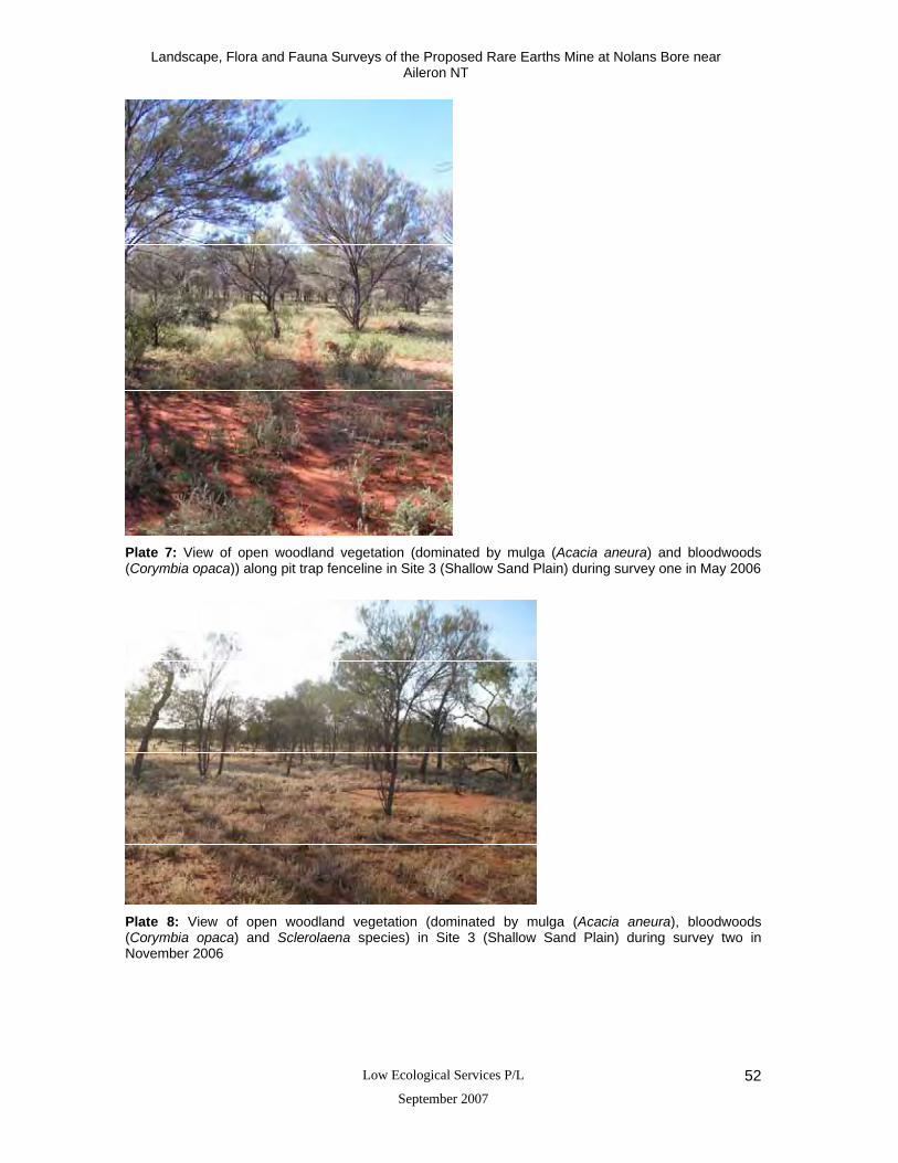
Landscape, Flora and Fauna Surveys of the Proposed Rare Earths Mine at Nolans Bore near Aileron NT
Low Ecological Services P/L
September 2007 52
Plate 7: View of open woodland vegetation (dominated by mulga (Acacia aneura) and bloodwoods (Corymbia opaca)) along pit trap fenceline in Site 3 (Shallow Sand Plain) during survey one in May 2006
Plate 8: View of open woodland vegetation (dominated by mulga (Acacia aneura), bloodwoods (Corymbia opaca) and Sclerolaena species) in Site 3 (Shallow Sand Plain) during survey two in November 2006

Landscape, Flora and Fauna Surveys of the Proposed Rare Earths Mine at Nolans Bore near Aileron NT
Low Ecological Services P/L
September 2007 53
Plate 9: View of scattered woodland vegetation (dominated by buffel grass (Cenchrus ciliaris), couch grass (Cynodon dactylon), bloodwoods (Corymbia opaca) and corkwoods (Hakea lorea)) in Site 4 (Rocky Undulating Plain) during survey one in May 2006
Plate 10: View of vegetation (dominated by buffel grass (Cenchrus ciliaris), Sclerolaena species, bloodwoods (Corymbia opaca) and corkwoods (Hakea lorea)) in Site 4 (Rocky Undulating Plain) during survey two in November 2006
Plate 11: Stripe-faced Dunnart (Sminthopsis macroura) captured in Site 2: Rocky Granite Hills

Landscape, Flora and Fauna Surveys of the Proposed Rare Earths Mine at Nolans Bore near Aileron NT
Low Ecological Services P/L
September 2007 54
Plate 12: Euro (Macropus robustus) observed on the granite hills of Site 2: Rocky Granite Hills
Plate 13: Short-beaked echidna (Tachyglossus aculeatus) scats found in Site 2: Rocky Granite Hills
Plate 14: Long-nosed water dragon (Lophognathus longirostris) seen in Site 1: Riparian

Landscape, Flora and Fauna Surveys of the Proposed Rare Earths Mine at Nolans Bore near Aileron NT
Low Ecological Services P/L
September 2007 55
Plate 15: Central netted dragon (Ctenophorus nuchalis) caught in Site 1 during survey two
Plate 16: Leonhardi's ctenotus (Ctenotus leonhardii) captured in Site 3 during survey one
Plate 17: Broad banded swimmer (Eremiascincus richardsonii) captured in Site 4 during survey 2
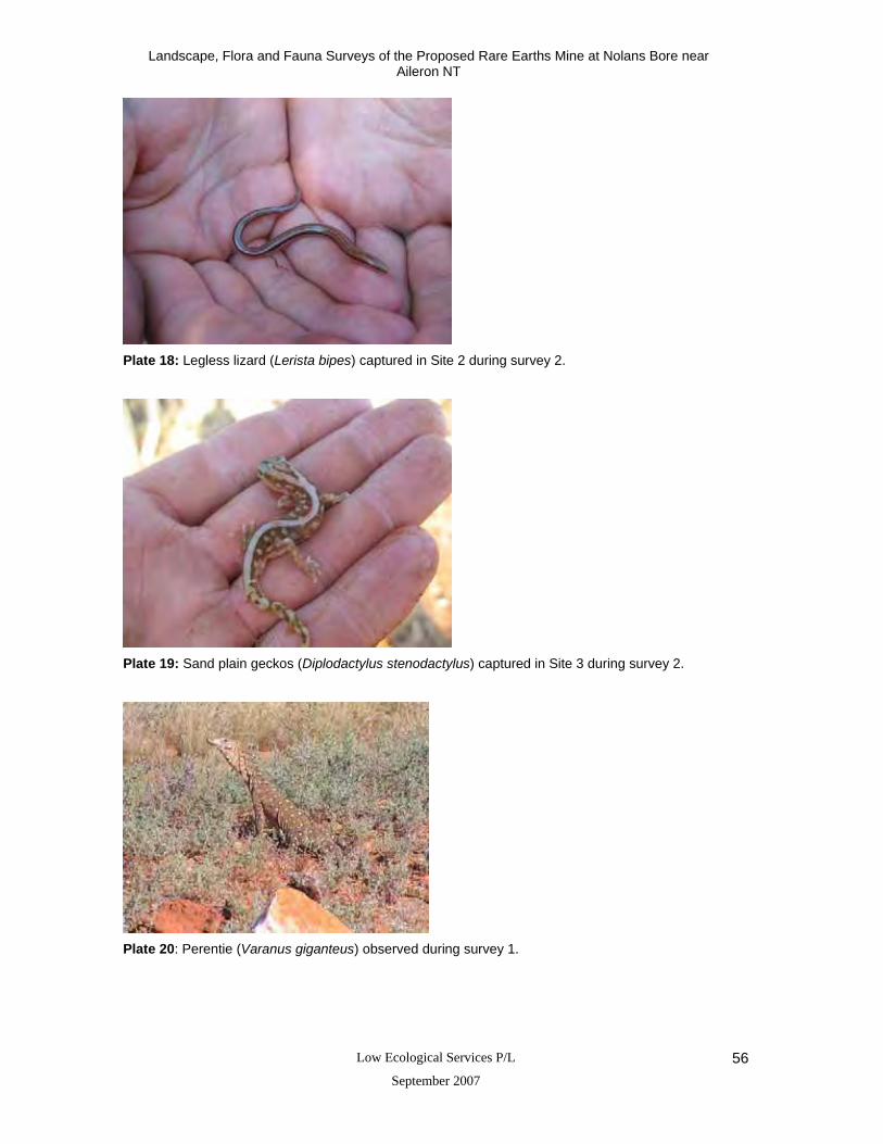
Landscape, Flora and Fauna Surveys of the Proposed Rare Earths Mine at Nolans Bore near Aileron NT
Low Ecological Services P/L
September 2007 56
Plate 18: Legless lizard (Lerista bipes) captured in Site 2 during survey 2.
Plate 19: Sand plain geckos (Diplodactylus stenodactylus) captured in Site 3 during survey 2.
Plate 20: Perentie (Varanus giganteus) observed during survey 1.

Landscape, Flora and Fauna Surveys of the Proposed Rare Earths Mine at Nolans Bore near Aileron NT
Low Ecological Services P/L
September 2007 57
11 Appendices
11.1 Summary of landsystems in, or intersecting, the Burt Plain Bioregion (Modified after
Neave et al. 2006).
Where % BRT is the percentage of each landsystem occurring in the Burt Plain Bioregion. Class in Fig 7.4 refers to figures from Neave et al. (2006).
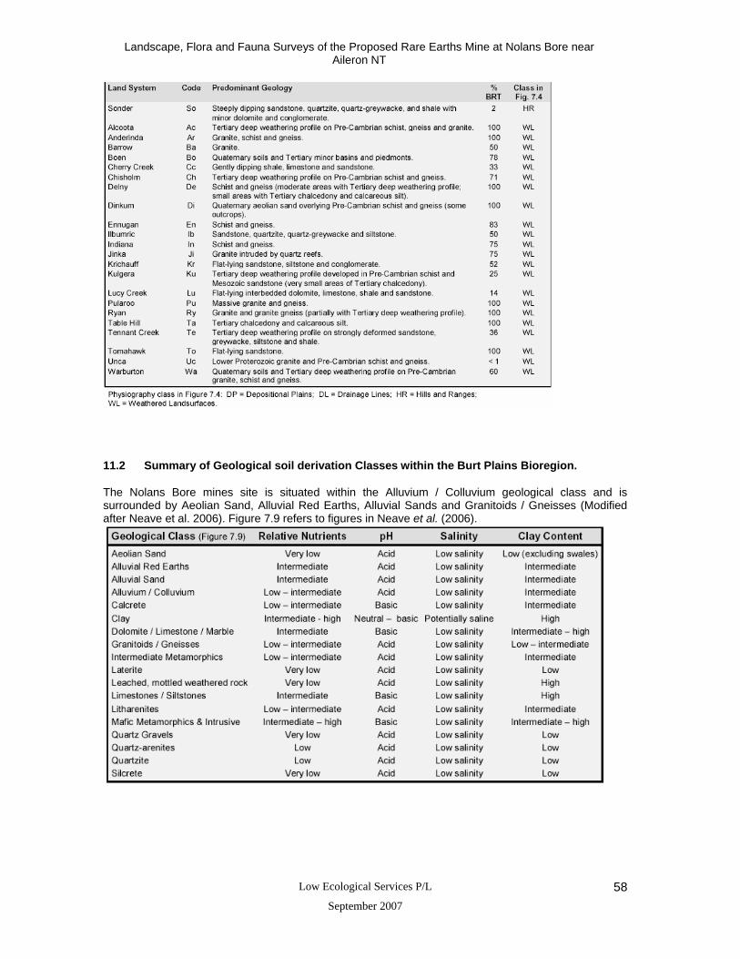
Landscape, Flora and Fauna Surveys of the Proposed Rare Earths Mine at Nolans Bore near Aileron NT
Low Ecological Services P/L
September 2007 58
11.2 Summary of Geological soil derivation Classes within the Burt Plains Bioregion.
The Nolans Bore mines site is situated within the Alluvium / Colluvium geological class and is surrounded by Aeolian Sand, Alluvial Red Earths, Alluvial Sands and Granitoids / Gneisses (Modified after Neave et al. 2006). Figure 7.9 refers to figures in Neave et al. (2006).

Landscape, Flora and Fauna Surveys of the Proposed Rare Earths Mine at Nolans Bore near Aileron NT
Low Ecological Services P/L
September 2007 59
11.3 Plant taxa records from Neave et al. (2006) within the Burt Plains Bioregion showing
status within the NT.
‘NT Status’ refers to listing in the schedules of the Territory Parks and Wildlife Conservation Amendment Act 2000 (native taxa) or Weeds Management Act 2001; ‘Res_cnt’ is the number of reserves in the southern region of the Northern Territory from which the taxon has been recorded; ‘Res_rec’ is the number of records from reserves in the southern region of the Northern Territory; ‘BRT_rec’ is the number of existing records from the Herbarium Holtze Database and other sources for the Burt Plain Bioregion; ‘Total NT_rec’ is the total number of records for the Northern Territory; ‘% BRT’ is the percentage of all Northern Territory records from the Burt Plain Bioregion.

Landscape, Flora and Fauna Surveys of the Proposed Rare Earths Mine at Nolans Bore near Aileron NT
Low Ecological Services P/L
September 2007 60

Landscape, Flora and Fauna Surveys of the Proposed Rare Earths Mine at Nolans Bore near Aileron NT
Low Ecological Services P/L
September 2007 61

Landscape, Flora and Fauna Surveys of the Proposed Rare Earths Mine at Nolans Bore near Aileron NT
Low Ecological Services P/L
September 2007 62
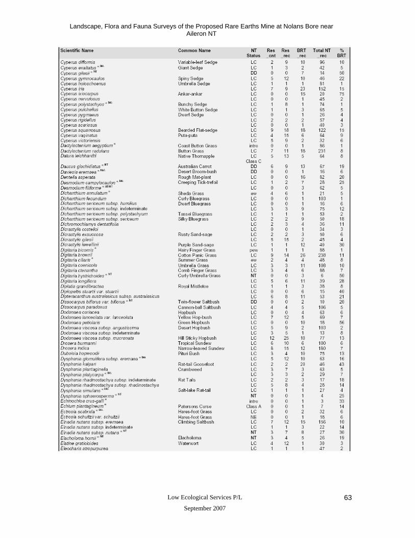
Landscape, Flora and Fauna Surveys of the Proposed Rare Earths Mine at Nolans Bore near Aileron NT
Low Ecological Services P/L
September 2007 63

Landscape, Flora and Fauna Surveys of the Proposed Rare Earths Mine at Nolans Bore near Aileron NT
Low Ecological Services P/L
September 2007 64
Landscape, Flora and Fauna Surveys of the Proposed Rare Earths Mine at Nolans Bore near Aileron NT
Low Ecological Services P/L
September 2007 65

Landscape, Flora and Fauna Surveys of the Proposed Rare Earths Mine at Nolans Bore near Aileron NT
Low Ecological Services P/L
September 2007 66

Landscape, Flora and Fauna Surveys of the Proposed Rare Earths Mine at Nolans Bore near Aileron NT
Low Ecological Services P/L
September 2007 67

Landscape, Flora and Fauna Surveys of the Proposed Rare Earths Mine at Nolans Bore near Aileron NT
Low Ecological Services P/L
September 2007 68

Landscape, Flora and Fauna Surveys of the Proposed Rare Earths Mine at Nolans Bore near Aileron NT
Low Ecological Services P/L
September 2007 69

Landscape, Flora and Fauna Surveys of the Proposed Rare Earths Mine at Nolans Bore near Aileron NT
Low Ecological Services P/L
September 2007 70

Landscape, Flora and Fauna Surveys of the Proposed Rare Earths Mine at Nolans Bore near Aileron NT
Low Ecological Services P/L
September 2007 71
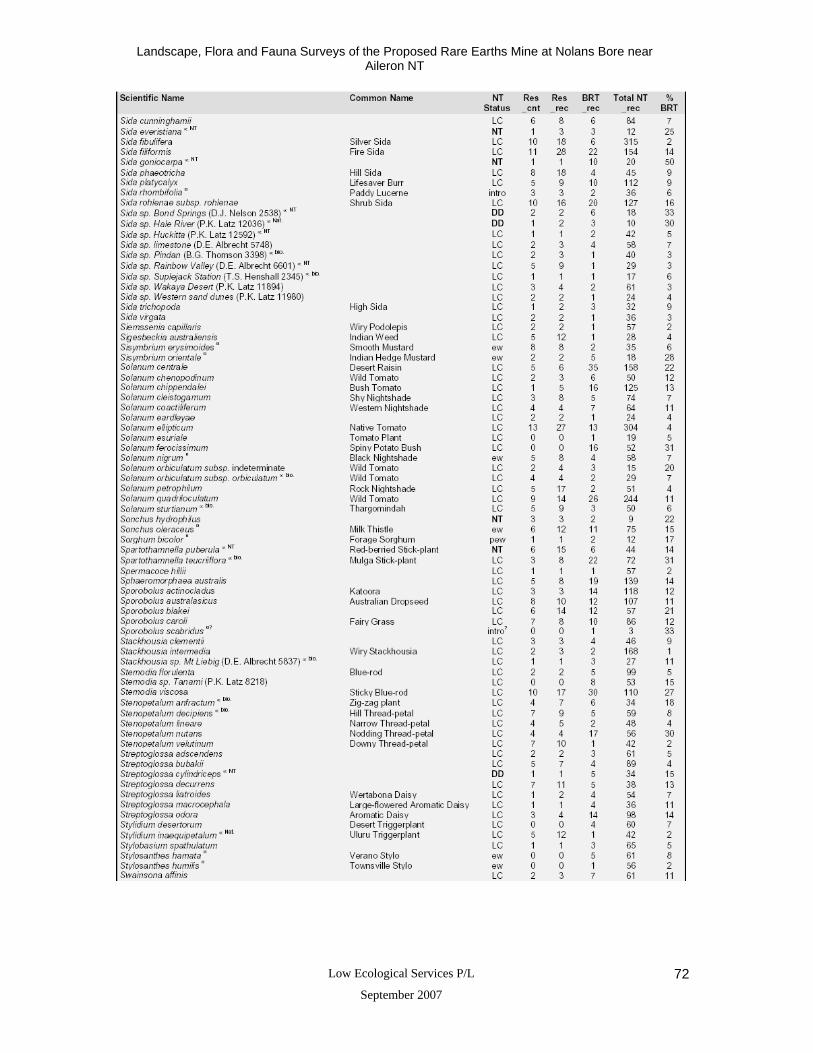
Landscape, Flora and Fauna Surveys of the Proposed Rare Earths Mine at Nolans Bore near Aileron NT
Low Ecological Services P/L
September 2007 72

Landscape, Flora and Fauna Surveys of the Proposed Rare Earths Mine at Nolans Bore near Aileron NT
Low Ecological Services P/L
September 2007 73

Landscape, Flora and Fauna Surveys of the Proposed Rare Earths Mine at Nolans Bore near Aileron NT
Low Ecological Services P/L
September 2007 74

Landscape, Flora and Fauna Surveys of the Proposed Rare Earths Mine at Nolans Bore near Aileron NT
Low Ecological Services P/L
September 2007 75
11.4 Matters of Environmental Significance.
Species of Conservation Significance Listed under the Environmental Protection and Biodiversity Conservation Act (1999), (EPBC Act 1999) and Territory Parks and Wildlife Conservation Act (2000) (TPWC Act 2000), that occur or could possibly occur within the Nolans Bore mine site area. Search consisted of a point search type (220 34”S, 1340 14”E) with a buffer of 15km. Species Name and Status Common Name Level of Status Present during the
survey Preferred habitat
ENDANGERED Mammals Notoryctes typhlops Southern Marsupial Mole EPBC Act (1999)
TPWC Act (2000) - (Vulnerable)
Not Recorded sand-dunes, interdunal flats, and river flats; not present on site
VULNERABLE Birds Polytelis alexandrae Princess Parrot,
Alexandra's Parrot EPBC Act (1999) TPWC Act (2000)
Not Recorded Inland deserts and watercourses
Mammals Dasycercus cristicauda Mulgara EPBC Act (1999)
TPWC Act (2000) Not Recorded Arid and semi arid sandy regions
particularly mature hummock grasslands Petrogale lateralis Black-footed Rock-wallaby EPBC Act (1999)
TPWC Act (2000) - (near threatened)
Not Recorded Rock piles, steep cliffs, and granite outcrops, typically where there is some cover in the form of open vegetation
Reptiles Egernia kintorei Great Desert Skink EPBC Act (1999)
TPWC Act (2000) Not Recorded hummock grass, sand plains and dune
field swales; not present on site MIGRATORY – Species or species habitat may occur within the area Birds Charadrius veredus Oriental Plover EPBC Act (1999) Not Recorded Timbered Habitats Glareola maldivarum Oriental Pratincole EPBC Act (1999) Not Recorded Creeklines Apus pacificus Fork-tailed Swift EPBC Act (1999) Not Recorded boreal and temperate forests Ardea alba Great Egret, White Egret EPBC Act (1999) Not Recorded wet areas and damp grasslands Ardea ibis Cattle Egret EPBC Act (1999) Not Recorded grasslands, woodlands and wetlands Merops ornatus Rainbow Bee-eater EPBC Act (1999) Not Recorded open forests, woodlands and shrublands,
and cleared areas, usually near water.

Landscape, Flora and Fauna Surveys of the Proposed Rare Earths Mine at Nolans Bore near Aileron NT
Low Ecological Services P/L
September 2007 76
11.5 Vegetation Records for the Nolans Bore Mine Site and near surrounding area determined from current survey and .
A ’1’ denotes the presence of a species at a particular site (Sites 1-5) or that is has been identified in the region (other). Sites 1-5 were surveyed by Low Ecological Services (May and November 2006). ‘Other’ refers to previous surveys conducted by Services Enterprises P/L at Anna’s reservoir (approx 20km west of the project area) in the early 1980’s and by Perry et al. (1962). Nomenclature follows Albrecht et al. (1997) or Australian Plant Name Index (www.anbg.gov.au); * indicates introduced to southern region of Northern Territory (Albrecht et al. 1997). Scientific Name Common Name Site 1 Site 2 Site 3 Site 4 Site 5 Other
Riparian Rocky
Foothills Flank
Rocky Slopes Crest
Shallow Sand Plain
Rocky Undulating
Plain Western
Creek Divert Recorded Abutilon cryptopetalum desert lantern 1 Abutilon fraseri desert lantern 1 1 1 1 Acacia aneura mulga 1 1 1 1 1 1 Acacia bivenosa 1 Acacia coriacea Now A. sericophylla 1 Acacia cuthbertsonii 1 1 Acacia estrophiolata ironwood 1 1 1 1 Acacia farnesiana Now Vachellia farnesiana mimosa bush 1 1 Acacia kempeana witchetty bush 1 1 1 1 1 Acacia melleodora 1 1 1 Acacia monticola 1 Acacia pruinocarpa 1 1 Acacia spondylophyla 1 Acacia tenuissima 1 1 1 1 Acacia tetragonophylla dead finish 1 1 1 1 Acacia victoriae victory wattle 1 1 Achyranthes aspera 1 Alternanthera nana 1 Alternanthera pungens 1 1 Amyema sanguinea mistletoe 1 Amyema maidenii mistletoe 1 1 1
Aristida holathera erect kerosene grass 1 1 1

Landscape, Flora and Fauna Surveys of the Proposed Rare Earths Mine at Nolans Bore near Aileron NT
Low Ecological Services P/L
September 2007 77
Aristida inaequiglumis kerosene grass 1 1 Aristida nitidula flat-awn three awn 1 Aristida strigosa rough three awn 1 Atalaya hemiglauca white wood 1 1 1 1 Atriplex elachophylla 1 1 1 Atriplex aff. semibaccata sp? 1 Boerhavia coccinea 1 1 Calocephalus platycephalus billy buttons 1 1 Calotis hispidula bogan flea 1 Calotis latiuscula 1 1 Cammelina ensifolia 1 Canthium latifolium Now Psydrax latifolia wild current 1 Capparis mitchellii wild orange 1 Capparis spinosa wild passionfruit 1 Carissa lanceolata conkerberry 1 1 1 1 1 1 1 Senna artemisioides silver cassia 1 Senns desolata now a ssp of S artemisiodes 1 Senna glutinosa 1 1 Senna helmsii now a ssp of S artemisiodes 1 Senna oligophylla now a ssp of S. artemisiodes 1 Senna pruinosa now a ssp of S glutinosa 1 Cassytha sp. 1 Cenchrus ciliaris* buffel grass 1 1 1 1 Centipeda minima sneezeweed 1 Cheilanthes lasiophylla woolly cloak fern 1 Cheilanthes sieberi mulga fern 1 1 Cheilanthes tenufolia rock fern 1 Chenopodium cristatum crested goosefoot 1 Chenopodium melanocarpum black crumbweed 1

Landscape, Flora and Fauna Surveys of the Proposed Rare Earths Mine at Nolans Bore near Aileron NT
Low Ecological Services P/L
September 2007 78
Chloris scariosa now Oxychloris scariosa already in list below winged chloris 1 1 Chrysopogon fallax 1 Citrullus colocynthus* paddymelon 1 Cleomi viscosa tick weed 1 1 1 1 Codonocarpus cotinifolius desert poplar 1 Convolvulus erubescens now C elementii bindweed 1 Corymbia aparrerinja (formerly papuana) ghost gum 1 1 1 Corymbia opaca central bloodwood 1 1 1 1 Cullen australasicum 1 Cymbopogon obtectus silky heads 1 1 1 Cyperus sp. 1 Digitaria brownii cotton panic grass 1 Dipteracanthus australasicus 1 1 Dipteracanthus coryonthecus same as D australicus 1 Dodonaea lanceolata hop bush 1 Einadia nutans ssp.eremaea Einadia nutans ssp. nutans 1 Enchylaena tomentosa 1 Enneapogon avenaceus 1
Enneapogon oblongus purple-headed nineawn 1
Enneapogon polyphyllus 1 1 1 1 1 1 Enteropogon acicularis curly windmill grass 1 1 Eragrostis dielsii leafy nineawn 1 Eragrostis elongata clustered lovegrass 1 Eragrostis eriopoda woolly butt 1 1 Eragrostis falcata sickle lovegrass 1 1 1 Eremophila duttonii love grass 1 1

Landscape, Flora and Fauna Surveys of the Proposed Rare Earths Mine at Nolans Bore near Aileron NT
Low Ecological Services P/L
September 2007 79
Eremophila freelingii limestone fuchsia 1 1 1 1 Eremophila latrobei native fuchsia 1 1 1 1 1
Eremophila longifolia long leaved emu bush 1 1 1 1
Eriachne helmsii mountain wanderrie 1 1 Eriachne mucronata native fuchsia 1 1 1
Erythrina vespertilio weeping emu bush / bean tree 1 1 1 1
Out of order Eulalia aurea 1 1 1 1 Eucalyptus camaldulensis river red gum 1 1 1 1 Eucalyptus gamophylla blue malle 1 1 Eucalyptus papuana now Corymbia aparrerinja in your list above ghost gum 1 1 Corymbia opacanow Corymbia opaca in your list above bloodwood 1 1 Eulalia fulva now E.aurea silky browntop 1 Euphorbia drummondii caustic weed 1 Euphorbia tannensis caustic bush 1 1 1 Evolvulus alsinoides tropical speedwell 1 Exocarpos sparteus 1 Ficus Platypoda now F brachypoda wild fig 1 Fimbristylis sp. 1 1 1 Glycine canescens 1 Goodenia fascicularis broom bush 1 1 1 Goodenia larapinta 1 Goodenia vilmoriniae 1 Gossypium australe 1 Gossypium sturtianum Sturt’s desert rose 1 Grevillea striata beefwood 1 1 1 1 1 1 Grevillea wickhamii 1 1 Hakea chordophylla corkwood 1 Hakea divaricata 1 1

Landscape, Flora and Fauna Surveys of the Proposed Rare Earths Mine at Nolans Bore near Aileron NT
Low Ecological Services P/L
September 2007 80
Hakea leucoptera 1 Hakea lorea corkwood 1 1 1 1 Hakea macrocarpa 1 Hakea suberea now H lorea 1 Helipterum saxatile now Anemocarpa saxatilis yellow paper daisy 1 Helipterum stipitatum now Leucochrysum stipitatum paper daisy 1 Hibiscus solanifolius 1 Indigofera brevidens now I psammophila indigo bush 1 Indigofera georgei indigo bush 1 Indigofera linifolia 1 1 Isotoma petraea rock isotome 1 Jasminum lineare now J didymum desert jasmine 1 Leichhardtia australis now Marsdeni australis in your list below silky pear 1 Lepidium meulleri-ferdinandi 1 Lysiana spathulata 1 1 1 Macgregoria racemigera desert snow 1 Malvastrum americanum 1 Marsdenia australis silky pear 1 1 Marsilea drummondii nardoo 1 1 1 Melaleuca glomerata ti tree 1 Melhainia oblongifolia velvet hibiscus 1 1 1 Oxychloris scariosa 1 1 1 Pandorea doratoxylon spearbush 1 Pluchea rubelliflora 1 1 1 Pluchea tetranthera 1 Portulaca filifolia 1 Portulaca oleracea 1 Prostanthera striatiflora mint bush 1

Landscape, Flora and Fauna Surveys of the Proposed Rare Earths Mine at Nolans Bore near Aileron NT
Low Ecological Services P/L
September 2007 81
Ptilotus atriplicifolius same as P sessilifolius in list below Lamb’s tail 1 Ptilotus incanus Lamb’s tail 1 1 Ptilotus obovatus hillside pussytail 1 1 Ptilotus schwartzii 1 1 1 Ptilotus sessilifolius 1 1 Rhagodia eremaea 1 1 Rhagodia nutans now Einadia nutans in your list above climbing saltbush 1 Rhagodia spinescens thorny saltbush 1 1 1 Rhodanthe floribunda 1 Rostellularia pogonanthera now R adscendens bearded anthem 1 Salsola tragus 1 1 1 1 Santalum lanceolatum native plum 1 Sarcostemma australe now S. viminale
snake vine ?caustic vine 1
Sclerolaena bicornis 1 1 1 Sclerolaena birchii burr 1 Sclerolaena convexula burr 1 1 1 1 1 Sclerolaena cornishiana 1 1 Sclerolaena costata 1 Sclerolaena cuneata 1 1 1 1 Senecio magnificus cartwheel burr 1 1 1 1 Senna artemisioides ssp. artemisioides 1 1 1 1 1 Senna artemisioides ssp. filifolia 1 1 1 Senna artemisioides ssp. helmsii camel weed 1 1 Senna artemisioides ssp. oligophylla cassia 1 1 1 1 1 Senna artemisioides ssp. sturtii cassia 1 1 Sida cryphiopetala now S 1

Landscape, Flora and Fauna Surveys of the Proposed Rare Earths Mine at Nolans Bore near Aileron NT
Low Ecological Services P/L
September 2007 82
phaeotricha
Sida cunninghamii 1 Sida fibulifera 1 Sida filiformis 1 1 Sida platycalyx 1 Senna glutinosa out of order cassia 1 1 1 1 1 Sida arenicola out of order cassia 1 1 Sida platycalyx already in list above cassia 1 1 1 1 1 1 Sida sp. 1 1 1 Solanum quadriloculatum wild tomato 1 1 1 1 1
Sporobolus australasicus Australian dropseed 1
Stemodia viscosa blue rod 1 1 1 1 1 Swainsona flavicarinata 1 Themeda australis now T triandra kangaroo grass 1 1 Themeda triandra 1 1 Trachymene glaucifolia wild parsnip 1 Tribulus terrestris caltrop 1 Tribulus sp. 1 1 Triodia basedowii 1 1 Triodia hubbardii soft spinifex 1 Triodia spicata hard spinifex 1 1 1 1 Tripogon loliiformis 1 Urochloa piligera 1 Ventilago viminalis supplejack 1 1 1 1 Wahlenbergia sp. Australian bluebells 1 1 1 Wedelia asperrima daisy 1 1 Total 185 listings 51 24 26 30 45 37 51 118

Landscape, Flora and Fauna Surveys of the Proposed Rare Earths Mine at Nolans Bore near Aileron NT
Low Ecological Services P/L
September 2007 83
11.6 Significant plant taxa occurring in the Burt Plains Bioregion (Modified after Neave et al. 2006).
NT status refers to listing in the schedules of the Territory Parks and Wildlife Conservation Amendment Act 2000.

Landscape, Flora and Fauna Surveys of the Proposed Rare Earths Mine at Nolans Bore near Aileron NT
Low Ecological Services P/L
September 2007 84

Landscape, Flora and Fauna Surveys of the Proposed Rare Earths Mine at Nolans Bore near Aileron NT
Low Ecological Services P/L
September 2007 85

Landscape, Flora and Fauna Surveys of the Proposed Rare Earths Mine at Nolans Bore near Aileron NT
Low Ecological Services P/L
September 2007 86

Landscape, Flora and Fauna Surveys of the Proposed Rare Earths Mine at Nolans Bore near Aileron NT
Low Ecological Services P/L
September 2007 87
11.7 Threatened plant taxa occurring in the Burt Plains Bioregion (Modified after Neave et al. 2006).
‘NT status’ refers to listing in the schedules of the Territory Parks and Wildlife Conservation Amendment Act 2000. ‘Aus status’ refers to listing in the schedules of the Environment Protection and Biodiversity Conservation Act 1999; ‘Res_cnt’ is the number of reserves in the southern region of the Northern Territory for which the taxon has been recorded. ‘% BRT’ is the percentage of all Northern Territory records from the Burt Plain Bioregion.

Landscape, Flora and Fauna Surveys of the Proposed Rare Earths Mine at Nolans Bore near Aileron NT
Low Ecological Services P/L
September 2007 88
11.8 Near Threatened plant taxa occurring in the Burt Plains Bioregion (Modified after Neave et al. 2006).
Res_cnt’ is the number of reserves in the southern region of the Northern Territory for which the taxon has been recorded. ‘% BRT’ is the percentage of all Northern Territory records from the Burt Plain Bioregion.

Landscape, Flora and Fauna Surveys of the Proposed Rare Earths Mine at Nolans Bore near Aileron NT
Low Ecological Services P/L
September 2007 89
11.9 Mammals Presently or Potentially Inhabiting the Nolans Bore Mine Site Area
This table includes species recorded during the environmental survey of the Nolans Bore mine site area by Low Ecological Services in May and November 2006 (highlighted in bold), and species from other surveys in the area and Northern Territory Parks and Wildlife Fauna Atlas. Note: status is a generalisation only. References 1 Nolans Bore mine site area (Source: Low Ecological Services Survey One – May 2006) 2 Nolans Bore mine site area (Source: Low Ecological Services Survey Two – November 2006) 3 Anna’s Reservoir (Source: Millington et al. 1980) 4 Nolans Bore mine site area (Source: Northern Territory Parks and Wildlife Fauna Atlas) Species name Common name Status Antechinus macdonnellensis 3 now Pseudantechinus Red Eared Antechinus Uncommon Antechinomys spenceri 3 now A laniger Western Antechinus Uncommon Bos taurus 1, 2, 3 Cow Common Canis lupis dingo 1, 2, 3 Dingo Common Chalinilobus gouldii 1, 2, 3 Goulds wattled bat Common Equus caballus 3 Horse Common Felis catus 1, 2, 3 Cat Pest Macropus robustus 1, 2, 3 Euro Common Macropus rufus 1, 2, 3 Red Kangaroo Common Mormopterus planiceps (long penis form) 2 Southern Freetail Bat Uncommon Mus musculus 1, 2 House Mouse Pest Notomys alexis 3 Brown Hopping Mouse Common Nyctophilus geoffroyi 1, 2, 3 Lesser Long Eared Bat Common Oryctolagus cuniculus 3 European Rabbit Pest Pseudomys hermannsburgensis 3 Sandy Inland Mouse Common Scotorepens balstoni 1, 2 Inland Broad-nosed Bat Common Sminthopsis crassicaudata 3 Fat Tailed Sminthopsis Common Sminthopsis macroura 1, 2, 3, 4 Stripe-faced Dunnart Common Tachyglossus aculeatus 1, 3 Short-beaked Echidna Common Tadarida australis 1, 2 White-striped Freetail Bat Common Taphozous hilli 1, 2 Hills Sheathtail Bat Common Vespadelus baverstocki 1, 2 Inland Forest Bat Common Vespadelus finlaysoni / Chalinolobus morio 1, 2
Inland Cave Bat / Chocolate Wattled Bat Common

Landscape, Flora and Fauna Surveys of the Proposed Rare Earths Mine at Nolans Bore near Aileron NT
Low Ecological Services P/L
September 2007 90
11.10 Reptiles Presently or Potentially inhabiting the Nolans Bore Mine Site Area
This table includes species recorded during the environmental survey of the Nolans Bore mine site area by Low Ecological Services in May and November 2006 (highlighted in bold), species from other surveys in the area and Northern Territory Parks and Wildlife Fauna Atlas. Note: status is a generalisation only References 1 Nolans Bore mine site area (Source: Low Ecological Services Survey One – May 2006) 2 Nolans Bore mine site area (Source: Low Ecological Services Survey Two – November 2006) 3 Anna’s Reservoir (Source: Millington et al. 1980) 4 Nolans Bore mine site area (Source: Northern Territory Parks and Wildlife Fauna Atlas) Species name Common name Status Acanthophis pyrrhus 4 Desert Death Addder C Amphibolurus caudicinctus 3 (now Ctenophorus) Ring tailed dragon C Amphibolurus longirostis 1, 2 now Lophognathus - in list below Long-nosed Water Dragon C Amphibolurus vitticeps 3 now Pogona Bearded Dragon C Carlia munda 4 Striped Rainbow Skink C Carlia triacantha 3, 4 Three-Spined Rainbow Skink C Ctenophorus caudicinctus 4 Ring-tailed Dragon C Ctenophorus isolepis 4 Military Dragon C Ctenophorus nuchalis 1,4 Central Netted Dragon C Ctenotus alacer 3 Striped Skink Lively Ctenotus? C Ctenotus leonhardii 1, 3.4 Leonhardi's Ctenotus C Ctenotus saxatilis 3 Striped Skink Rock Ctenotus? C Ctenotus schomburgkii 4 Schomburk's Ctenotus C Cyclodomorphus melanops 4 Slender Blue-tongued Lizard C Cryptoblepharus sp. 3 Tree Skink C Delma borea 3 Legless Lizard C Delma tincta 3, 4 Black-necked Snake-lizard C Demansia psammophis 3, 4 Yellow-faced Whip Snake C Diplodactylus ciliaris 3 Spiny -Tailed Gecko C Diplodactylus conspicillatus 3 Fat-Tailed Gecko C Diplodactylus stenodactylus 2 Sand Plain Gecko C Diporiphora lalliae 4 Round-Head Dragon C Egernia striata 4 Striated Egernia C Eremiascincus richardsonii 2 Broad-banded Sand Swimmer C Furina diadema 3 now F ornata Red-Naped Snake C Gehrya variegata 3, 4 Tree Dtella C Heteronotia binoei 3, 4 Bynoe's Gecko C Lerista bipes 1,2,3 Burrowing Skink C Liasis childreni 3 Children’s Python C Lophognathus longirostris 1,3 Central Water Dragon C Lucasium damaeum 3 Beaded Gecko C Menetia greyii 3, 4 Grey's Menetia C Morethia ruficauda 3 Fire-tailed Skink C

Landscape, Flora and Fauna Surveys of the Proposed Rare Earths Mine at Nolans Bore near Aileron NT
Low Ecological Services P/L
September 2007 91
Nephrurus levis 3 Common Barking Gecko C Oedura marmorata 3 Velvet Gecko C Omolepida branchialis 3 C Pogona minor 4 Dwarf Bearded Dragon C Pseudechis australis 3 King Brown Snake C Pseudechis nuchalis 3 now Pseudonaja Western Brown Snake C Rhynchoedura ornata 3, 4 Beaked Gecko C Simoselaps semifiatus 3 Half-girdled Snake C Strophurus ciliaris 4 Spiny-tailed Gecko C Suta punctata 4 Little Spotted Snake C Suta suta 3 Curl Snake C Tiliqua multifasciata 4 Centralian Blue-Tongued Lizard C Tympanocryptis cephalus 3 C Tympanocryptis lineata 3 Earless Sand Dragon C Typhlina sp. 3 now Ramphotyphlops Blind Snake C Varanus acanthurus 3 Spiny-Tailed Pygmy Goanna C Varanus giganteus 1 Perentie C Varanus gouldii 4 Sand Goanna C Varanus tristis 3 Black-tailed goanna or monitor C Vermicella annulata 3 Bandy Bandy C

Landscape, Flora and Fauna Surveys of the Proposed Rare Earths Mine at Nolans Bore near Aileron NT
Low Ecological Services P/L
September 2007 92
11.11 Birds presently or potentially inhabiting the Nolans Bore Mine Site Area
This table includes species recorded during the environmental survey of the Nolans Bore mine site area by Low Ecological Services in May and November 2006 (highlighted in bold), species from other surveys in the area and Northern Territory Parks and Wildlife Fauna Atlas. Note: status is a generalisation only References 1 Nolans Bore mine site area (Source: Low Ecological Services Survey One – May 2006) 2 Nolans Bore mine site area (Source: Low Ecological Services Survey Two – November 2006) 3 Anna’s Reservoir (Source: Millington et al. 1980) 4 Nolans Bore mine site region (Source: Northern Territory Parks and Wildlife Fauna Atlas)
Species name Common name Status Range Reference
Acanthagenys rufogularis Spiny-cheeked Honeyeater Common Australia wide except far north 1, 2, 4
Acanthiza apicalis Inland Thornbill Common Inland Australia 4
Acanthiza chrysorrhoa Yellow-rumped thornbill Common, sedentary Australia wide except far north 1, 2, 4
Acanthiza uropygialis Chestnut-rumped Thornbill Common, sedentary Australia wide except far north 1, 2, 4
Accipiter fasciatus Brown Goshawk Common, sedentary or vagrant Australia wide 3
Accipiter cirhrocephalus Collared Sparrowhawk Common Australia wide 3
Aegotheles cristatus Australian Owlet-nightjar Common Australia wide 4
Anas gracilis Grey Teal Locally common nomad Australia wide 3, 4
Anthus novaeseelandiae Richard's Pipit Common resident or nomad Australia wide 1, 3, 4
Aphelocephala leucopsis Southern Whiteface Patchily common Central and southern Australia 1, 2
Aquila audax Wedge-tailed Eagle Uncommon Australia wide 3, 4
Artamus leucorhynchus White-breasted Wood Swallow Moderately common Australia wide 3
Out of order Ardea pacifica White-necked Heron Uncommon Australia wide except eastern interior 3
Artamus cinereus Black-faced Woodswallow Common nomad Australia wide 1, 2, 4
Artamus personatus Masked Woodswallow Common resident Australia wide 1, 2, 3, 4
Artamus superciliosus White-browed Wood Swallow Common resident Australia wide 3
Barnardius zonarius Australian Ringneck Common, sedentary Western and central Australia 1, 2, 4
Burhinus grallarius Bush Stone-curlew Uncommon / vulnerable Australia wide except southern interior 1, 2
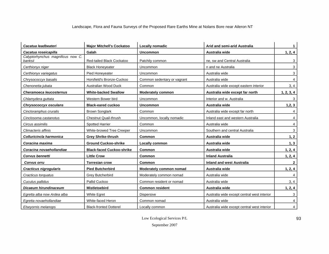
Landscape, Flora and Fauna Surveys of the Proposed Rare Earths Mine at Nolans Bore near Aileron NT
Low Ecological Services P/L
September 2007 93
Cacatua leadbeateri Major Mitchell's Cockatoo Locally nomadic Arid and semi-arid Australia 1
Cacatua roseicapilla Galah Uncommon Australia wide 1, 2, 4Calyptorhynchus magnificus now C. banksii Red-tailed Black Cockatoo Patchily common ne, sw and Central Australia 3
Certhionyx niger Black Honeyeater Uncommon n and ne Australia 3
Certhionyx variegatus Pied Honeyeater Uncommon Australia wide 3
Chrysococcyx basalis Horsfield's Bronze-Cuckoo Common sedentary or vagrant Australia wide 4
Chenonetta jubata Australian Wood Duck Common Australia wide except eastern interior 3, 4
Cheramoeca leucosternus White-backed Swallow Moderately common Australia wide except far north 1, 2, 3, 4
Chlamydera guttata Western Bower bird Uncommon Interior and w. Australia 3
Chrysococcyx osculans Black-eared cuckoo Uncommon Australia wide 1,2, 3
Cincloramphus cruralis Brown Songlark Common Australia wide except far north 4
Cinclosoma castanotus Chestnut Quail-thrush Uncommon, locally nomadic Inland east and western Australia 4
Circus assimilis Spotted Harrier Common Australia wide 4
Climacteris affinis White-browed Tree Creeper Uncommon Southern and central Australia 3
Colluricincla harmonica Grey Shrike-thrush Common Australia wide 1, 2
Coracina maxima Ground Cuckoo-shrike Locally common Australia wide 1, 3
Coracina novaehollandiae Black-faced Cuckoo-shrike Common Australia wide 1, 2, 4
Corvus bennetti Little Crow Common Inland Australia 1, 2, 4
Corvus orru Torresian crow Common Inland and west Australia 2
Cracticus nigrogularis Pied Butcherbird Moderately common nomad Australia wide 1, 2, 4
Cracticus torquatus Grey Butcherbird Moderately common nomad Australia wide 4
Cuculus pallidus Pallid Cuckoo Common resident or nomad Australia wide 3, 4
Dicaeum hirundinaceum Mistletoebird Common resident Australia wide 1, 2, 4
Egretta alba now Ardea alba White Egret Dispersive Australia wide except central west interior 3
Egretta novaehollandiae White-faced Heron Common nomad Australia wide 4
Elseyornis melanops Black-fronted Dotterel Locally common Australia wide except central west interior 4

Landscape, Flora and Fauna Surveys of the Proposed Rare Earths Mine at Nolans Bore near Aileron NT
Low Ecological Services P/L
September 2007 94
Emblema picta Painted Finch Patchily common Inland Australia 4
Epthianura tricolor Crimson Chat Common Australia wide except far east and north 4
Erythrogonys cinctus Red-kneed Dotterel Common resident or nomad Inland Australia 3, 4
Eupodtis australis now Ardeotis Bustard Common nomad, vulnerable in NT Arid and Northern Australia 3
Eurostopodus quttatus now E argus Spotted Nightjar Moderately common Inland Australia 3
Falco berigora Brown Falcon Common Australia wide 1, 2, 4
Falco cenchroides Australian Kestrel Uncommon to rare Australia wide 1, 2, 4
Falco hypoleucos Grey falcon Vagrant Inland Australia 3
Falco longipennis Little Falcon Uncommmon Australia wide 2, 3
Falco peregrinus Peregrine Falcon Uncommon to rare nomad Australia wide 3
Falco subniger Black Falcon Common Australia wide 3
Gallinula ventralis Black-tailed Native-hen Common Australia wide except inland west 4
Geopelia cuneata Diamond Dove Uncommon resident or nomad Arid and semi-arid Australia 4
Gerygone fusca Brown Warbler Common Central, east and western Australia 3, 4
Grallina cyanoleuca Magpie-lark Common nomad or resident Australia wide 1, 2, 4
Gymnorhina tibicen Australian Magpie Common Australia wide 1, 2, 3Haliaetus morphnoides now Hieraatus Little Eagle Uncommon Australia wide 3
Haliastur sphenurus Whistling Kite Uncommon resident Australia wide 4Halycon sancta now Todiramphus sanctus Sacred Kingfisher Moderately common migrant
Australia wide except central east Australia 3
Hamirostra melanosternon Black-breasted Buzzard Common nomad Northern interior 1
Himantopus himantopus Black-winged Stilt Common resident or nomad Australia wide 3
Lalage sueurii White-winged Triller Relatively common resident Australia wide 3, 4
Lichenostomus keartlandi Grey-headed Honeyeater Common or nomad Inland Australia 1, 2
Lichenostomus penicillatus White-plumed Honeyeater Common Inland, east and south east Australia 1, 2, 4
Lichenostomus virescens Singing Honeyeater Common nomad or resident Australia wide 1, 2, 4

Landscape, Flora and Fauna Surveys of the Proposed Rare Earths Mine at Nolans Bore near Aileron NT
Low Ecological Services P/L
September 2007 95
Lichmera indistincta Brown Honeyeater Common resident Australia wide 4Lophophaps plumifera now Geophaps Plumed Pigeon (Spinifex) Common, sedentary Inland and w. Australia 3
Malacorhynchus membranaceus Pink-eared Duck Common vagrant Australia wide 3, 4
Malurus lamberti Varigated Fairy Wren Common Australia wide 2 Malurus leucopterus Fairywren (female) Common nomad Inland and w. Australia 1 Malurus splendens Splendid Fairy-wren Common South east Australia 2, 4
Manorina flavigula Yellow-throated Miner Common Australia wide 1, 2, 4
Melanodryas cucullata Hooded Robin Common, but scattered Australia wide 1, 2Meliphaga plumula now Lichenostomus plumulus Yellow-fronted Honey Eater Patchily common Inland and west Australia 3
Melopsittacus undulatus Budgerigar Common Inland Australia 1, 4
Merops ornatus Rainbow Bee-eater Common nomad Australia wide 2, 4
Microeca fascinans Jackie Winter Common nomad north, east, and south Australia 1
Milvus migrans Black Kite Common Australia wide 4
Neopsephotus bourkii Bourke's Parrot Patchily common Interior and w. Australia 3, 4
Ninox novaeseelandiae Boobook Owl Common Australia wide 3
Nycticorax caledonicus Nankeen Night Heron Patchily common Inland, east and west Australia 3
Nymphicus hollandicus Cockatiel Common nomad Australia wide 4
Ocyphaps lophotes Crested Pigeon Common Inland Australia 1, 2, 4
Oreoica gutturalis Crested Bellbird Common sedentary Australia wide except south west 1, 2, 4
Pachycephala rufiventris Rufous Whistler Common Australia wide 1, 2, 4
Out of order Podargus strigoides Tawny Frogmouth Common Australia wide 1, 2, 3
Paradalotus substriatus Striated Pardalote Common, sedentary Australia wide 3
Pardalotus rubricatus Red-browed Pardalote Patchily common Inland and north Australia 3
Petrochelidon ariel now Hirundo Fairy Martin Uncommon nomad Australia wide 3
Petrochelidon nigricans now Hirundo Tree Martin Common resident Australia wide 3
Petroica goodenovii Red-capped Robin Common, but scattered Australia wide 1, 3, 4

Landscape, Flora and Fauna Surveys of the Proposed Rare Earths Mine at Nolans Bore near Aileron NT
Low Ecological Services P/L
September 2007 96
Phalacrocorax sulcirostris Little Black Cormorant Common nomad Australis wide except west interior 3
Phaps chalcoptera Bronzewing Common Australia wide except Cape York 3
Phylidonyris albifrons White-fronted Honeyeater Locally common Inland and south Australia 3
Platalea flavipes Yellow-billed Spoonbill Locally common Australia wide except west interior 3, 4
Platalea regia Royal Spoonbill Common Australia wide except west interior 3
Plegadis falcinellus Glossy Ibis Common resident Northern Australia 4Podiceps poliocephalus now Poliocephalus poliocephalus Hoary-headed Grebe Common, vagrant Australia wide except south west interior 3, 4
Pomatostomus superciliousus White-browed Babbler Common, sedentary Southern and central Australia 1, 2, 3
Pomatostomus temporalis Grey-crowned Babbler Widespread nomad Northern, central and south east Australia 1, 2, 4
Psephotus varius Mulga Parrot Patchily common Southern and central Australia 1, 2, 3, 4
Psophodes occidentalis Chiming Wedgebill Locally common Interior and west Australia 3
Pyrrholaemus brunneus Redthroat Uncommon sedentary Inland Australia 1
Recurvirostra novaehollandiae Red-necked Avocet Common nomad Inland and south Australia 3
Rhipidura fuliginosa Grey Fantail Patchily common Australia wide ex central east Australia 1, 2, 3
Rhipidura leucophrys Willie Wagtail Common resident Australia wide 1, 2, 4
Smicrornis brevirostris Weebill Common Australia wide 2, 3
Stipiturus ruficeps Rufous-crowned Emu Wren Uncommon Inland Australia 3
Tachybaptus novaehollandiae Australasian Grebe Common, vagrant Australia wide 4
Taeniopygia guttata Zebra Finch Common summer migrant Australia wide 1, 2, 4
Threskiornis molucca White Ibis Common, sedentary Coastal and Inland Australia 3
Threskiornis spinnicollis Straw-necked Ibis Locally common Australia wide except west interior 3
Todiramphus pyrrhopygia Red-backed Kingfisher Common resident Inland Australia 2, 4
Turnix velox Little Button-quail Common Australia wide 4
Tyto alba Barn Owl Common summer migrant Australia wide 3
Vanellus tricolor Banded Plover Common, sedentary Australia wide except far north 3
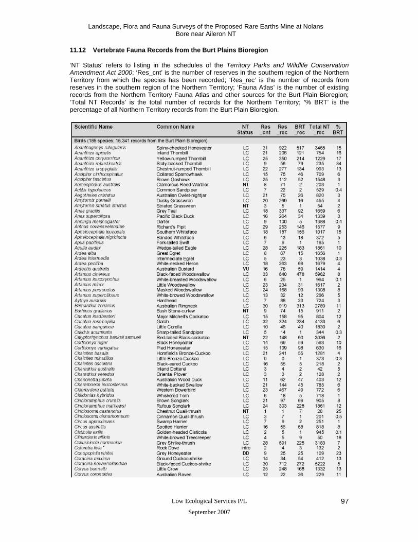
Landscape, Flora and Fauna Surveys of the Proposed Rare Earths Mine at Nolans Bore near Aileron NT
Low Ecological Services P/L
September 2007 97
11.12 Vertebrate Fauna Records from the Burt Plains Bioregion
‘NT Status’ refers to listing in the schedules of the Territory Parks and Wildlife Conservation Amendment Act 2000; ‘Res_cnt’ is the number of reserves in the southern region of the Northern Territory from which the species has been recorded; ‘Res_rec’ is the number of records from reserves in the southern region of the Northern Territory; ‘Fauna Atlas’ is the number of existing records from the Northern Territory Fauna Atlas and other sources for the Burt Plain Bioregion; ‘Total NT Records’ is the total number of records for the Northern Territory; ‘% BRT’ is the percentage of all Northern Territory records from the Burt Plain Bioregion.

Landscape, Flora and Fauna Surveys of the Proposed Rare Earths Mine at Nolans Bore near Aileron NT
Low Ecological Services P/L
September 2007 98
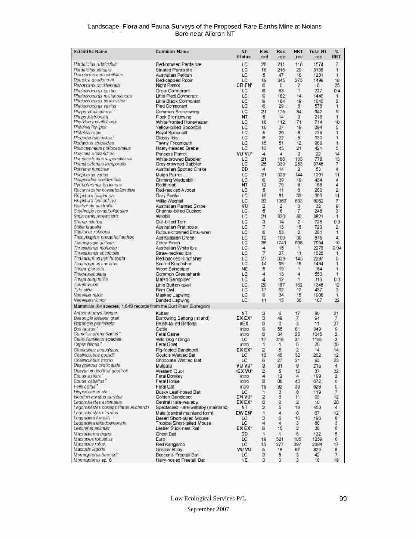
Landscape, Flora and Fauna Surveys of the Proposed Rare Earths Mine at Nolans Bore near Aileron NT
Low Ecological Services P/L
September 2007 99

Landscape, Flora and Fauna Surveys of the Proposed Rare Earths Mine at Nolans Bore near Aileron NT
Low Ecological Services P/L
September 2007 100

Landscape, Flora and Fauna Surveys of the Proposed Rare Earths Mine at Nolans Bore near Aileron NT
Low Ecological Services P/L
September 2007 101

Landscape, Flora and Fauna Surveys of the Proposed Rare Earths Mine at Nolans Bore near Aileron NT
Low Ecological Services P/L
September 2007 102

Landscape, Flora and Fauna Surveys of the Proposed Rare Earths Mine at Nolans Bore near Aileron NT
Low Ecological Services P/L
September 2007 103
11.13 Threatened and data deficient vertebrate fauna recorded within the Burt Plains
Bioregion (Modified after Neave et al. 2006)
‘NT Status’ refers to listing in the schedules of the Territory Parks and Wildlife Conservation Amendment Act 2000; ‘AUS Status’ refers to listing in the schedules of the Environment Protection and Biodiversity Conservation Act 1999; ‘Res_cnt’ is the number of reserves in the southern region of the Northern Territory from which the species has been recorded; ‘% BRT’ is the percentage of all Northern Territory records from the Burt Plain Bioregion.
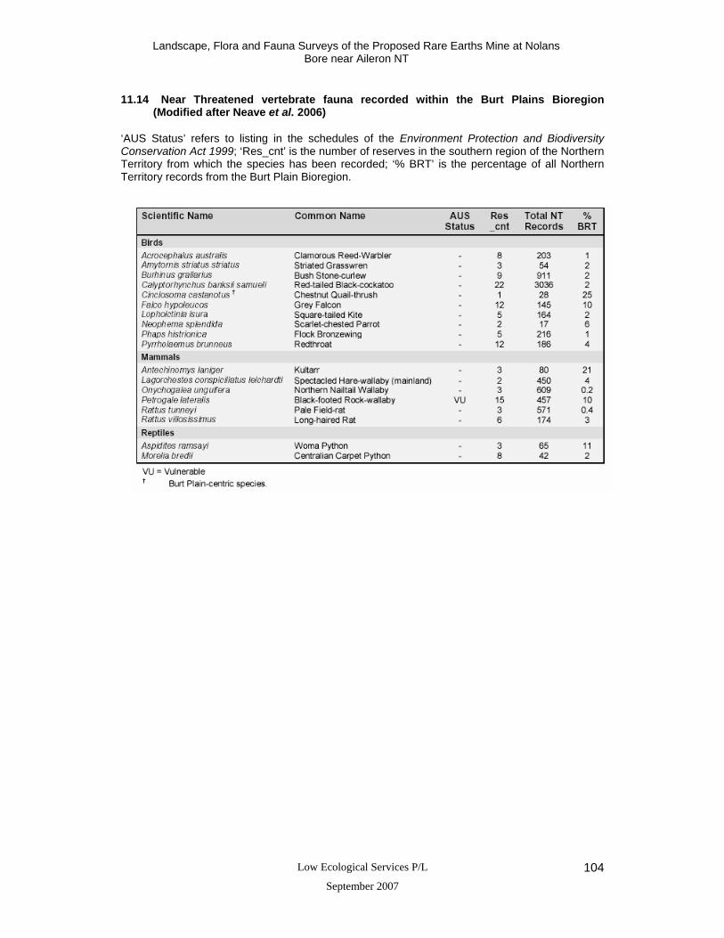
Landscape, Flora and Fauna Surveys of the Proposed Rare Earths Mine at Nolans Bore near Aileron NT
Low Ecological Services P/L
September 2007 104
11.14 Near Threatened vertebrate fauna recorded within the Burt Plains Bioregion
(Modified after Neave et al. 2006)
‘AUS Status’ refers to listing in the schedules of the Environment Protection and Biodiversity Conservation Act 1999; ‘Res_cnt’ is the number of reserves in the southern region of the Northern Territory from which the species has been recorded; ‘% BRT’ is the percentage of all Northern Territory records from the Burt Plain Bioregion.

Landscape, Flora and Fauna Surveys of the Proposed Rare Earths Mine at Nolans Bore near Aileron NT
Low Ecological Services P/L
September 2007 105
11.15 Ground Dwelling Fauna and Bats Recorded at Nolans Bore mine site by Low Ecological Services (May and November 2006)
References 1 Nolans Bore mine site area (Source: Low Ecological Services Survey One – May 2006) 2 Nolans Bore mine site area (Source: Low Ecological Services Survey Two – November 2006) Where * = introduced species, numbers indicate the number of animals observed or captured, C = common, P = Pest, and X = present in the area
Scientific Name Common Name Status Site 1 Site 2 Site 3 Site 4 Site 5 Evidence
Riparian
Granite / Rocky Hills
Flat plain
Levee bank
Western Creek Divert
SNAILS Sinumelon expositum 1 Snail C Dry snail shells REPTILES Dragons
Lophognathus longirostis 1, 2 Long-nosed Water Dragon
C 8 2
Observation
Ctenophorus nuchalis 2 Central Netted Dragon
C 1
Pit trap
Skinks Ctenotus leonhardii 1 Leonhardi's Ctenotus C 1 Pit trap Ctenotus sp. 1 C 3 Observation
Eremiascincus richardsonii 2 Broad-banded Sand Swimmer
C 2
Pit trap
Legless Lizards Lersita bipes 2 C 1 Pit trap Gecko Diplodactylus stenodactylus 2 Sand Plain Gecko
C 2
Pit trap
Monitor Varanus giganteus 1 Perentie C Incidental MAMMALS

Landscape, Flora and Fauna Surveys of the Proposed Rare Earths Mine at Nolans Bore near Aileron NT
Low Ecological Services P/L
September 2007 106
Carnivorous Marsupials Sminthopsis macroura 1, 2 Stripe-faced Dunnart C 1 1 Elliott trap Rodents Mus musculus 1, 2 House Mouse* C 2 1 11 Elliott trap Kangaroos and Wallabies Macropus rufus 1, 2 Red Kangaroo C 1 10 Observations Macropus robustus 1 Euro C 1 Observations Introduced Carnivores Felis catus 1 Feral Cat* P 1 Tracks
Canis lupus dingo 1, 2 Dingo C
1 3 Observations,
tracks, howling Introduced Herbivores Bos taurus 1, 2 Cattle* C 20 1 Observations Monotreme
Tachyglossus aculeatus 1 Short-beaked Echidna
C 1
Tracks, scats
Bats
Tadarida australis 1, 2 White-striped freetail bat
C X
ANABAT recording
Taphozous hilli 2 Hills sheathtail bat C X X ANABAT recording
Scotorepens balstoni 1, 2 Inland broad-nosed bat
C X X X X
X ANABAT recording
Chalinolobus gouldii 1, 2 Gould’s wattled bat C X X X X X ANABAT recording Mormopterus planuceps (long penis form) 2 Southern freetail bat
C X X X X X ANABAT recording
Nyctophilus geoffroyi 1, 2 Lesser long-eared bat
C X X X X X ANABAT recording
Vespadelus baverstocki 1, 2 Inland forest bat C X ANABAT recording
Vespadelus finlaysoni / Chalinolobus morio 1, 2
Inland cave bat / Chocolate wattled bat
C X X
ANABAT recording

Landscape, Flora and Fauna Surveys of the Proposed Rare Earths Mine at Nolans Bore near Aileron NT
Low Ecological Services P/L
September 2007 107
11.16 Birds Recorded at Nolans Bore mine site by Low Ecological Services (May and November 2006)
Where X = present in the area, C = common, and UC = uncommon Common Names Status Reference Site 1 Site 2 Site 3 Site 4 Site 5
Australian Kestrel Uncommon 1, 2 X X
Australian Magpie Common 1, 2 X X X X X
Australian Ringneck Common, sedentary 1, 2 X X X
Black-breasted Buzzard Common nomad 1 X
Black-eared cuckoo Uncommon 1,2 X
Black-faced Cuckoo-shrike Common 1, 2 X X
Black-faced Woodswallow Common nomad 1, 2 X X X X
Brown Falcon Common 1, 2 X X X
Budgerigar Common 1 X
Bush Stone-curlew Uncommon / vulnerable 1, 2 X X
Chestnut-rumped Thornbill Common, sedentary 1, 2 X X
Crested Bellbird Common sedentary 1, 2 X X X
Crested Pigeon Common 1, 2 X X X
Fairywren (female) Common nomad 1 X X
Galah Uncommon 1, 2 X X
Grey Fantail Patchily common 1, 2 X
Grey Shrike-thrush Common 1, 2 X X
Grey-crowned Babbler Widepsread nomad 1, 2 X X
Grey-headed Honeyeater Common or nomad 1, 2 X
Ground Cuckoo-shrike Locally common 1 X
Hooded Robin Common, but scattered 1, 2 X
Jackie Winter Common nomad 1 X X

Landscape, Flora and Fauna Surveys of the Proposed Rare Earths Mine at Nolans Bore near Aileron NT
Low Ecological Services P/L
September 2007 108
Little Crow Common 1, 2 X X X
Little Falcon Uncommmon 2 X
Magpie-lark Common nomad or resident 1, 2 X X X
Major Mitchell's Cockatoo Locally nomadic 1 X
Masked Woodswallow Common resident 1, 2, X X
Mistletoebird Common resident 1, 2 X X
Mulga Parrot Patchily common 1, 2 X X
Pied Butcherbird Moderately common nomad 1, 2 X X X X
Rainbow Bee-eater Common nomad 2 X X X X
Red-backed Kingfisher Common resident 2 X
Red-capped Robin Common, but scattered 1 X
Redthroat Uncommon sedentary 1 X
Richard's Pipit Common resident or nomad 1 X
Rufous Whistler Common 1, 2 X X X X X
Singing Honeyeater Common nomad or resident 1, 2 X X X X X
Southern Whiteface Patchily common 1, 2 X X X X
Spiny-cheeked Honeyeater Common 1, 2 X X X X X
Splendid Fairy-wren Common 2 X X
Tawny Frogmouth Common 1, 2 X
Torresian Crow Common 2 X
Variegated Fairy Wren Common 2 X
Weebill Common 2 X
White-backed Swallow Moderately common 1, 2 X
White-browed Babbler Common, sedentary 1, 2 X X
White-plumed Honeyeater Common 1, 2 X X X
Willie Wagtail Common resident 1, 2 X X X X
Landscape, Flora and Fauna Surveys of the Proposed Rare Earths Mine at Nolans Bore near Aileron NT
Low Ecological Services P/L
September 2007 109
Yellow-rumped Thornbill Common sedentary 1, 2 X X X X
Yellow-throated Miner Common 1, 2 X X
Zebra Finch Common summer migrant 1, 2 X X X X