Embed Size (px)
Citation preview
US 150 SCOPING STUDY - FINAL REPORT
Appendix E - TRAFFIC FORECAST REPORT
0
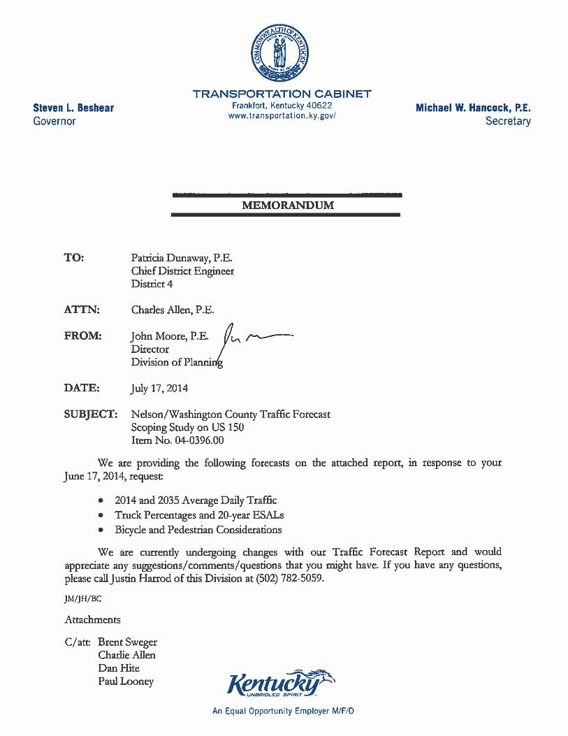
Traffic Forecast Report and Bike/Ped Accommodation Assessment for
Nelson/Washington County Scoping Study on US 150
Item No. 04-0396.00
Prepared for:
Prepared by: Justin Harrod
Division of Planning Kentucky Transportation Cabinet
July 16, 2014
Executive Summary
Traffic Forecast Technical Report
Nelson/Washington County: Scoping Study on US 150
Item No. 04-0396.00
KYTC Division of Planning Page 1
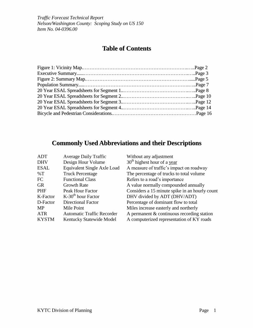
TTaabbllee ooff CCoonntteennttss
FFiigguurree 11:: VViicciinniittyy MMaapp..………………………………………………………………………………………………………………..……....PPaaggee 22
EExxeeccuuttiivvee SSuummmmaarryy............………………………………………………………………………………………………………………..……....PPaaggee 33
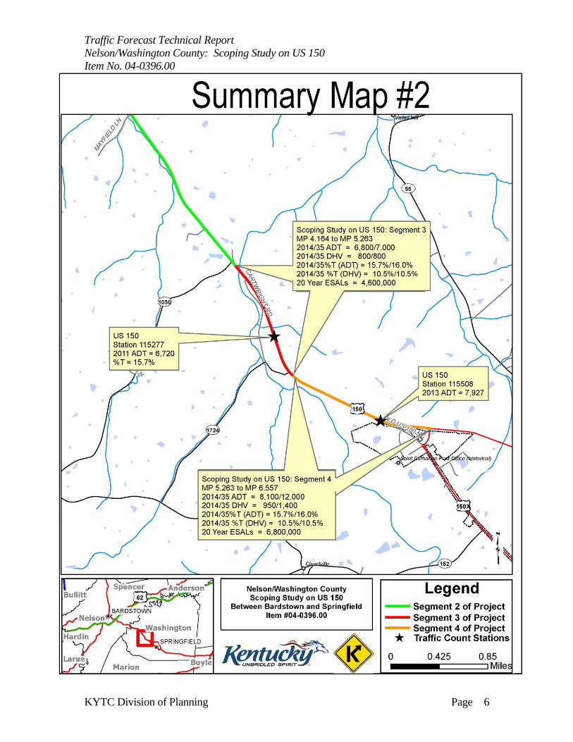
FFiigguurree 22:: SSuummmmaarryy MMaapp..………………………………………………………………………………………………………………..........PPaaggee 55
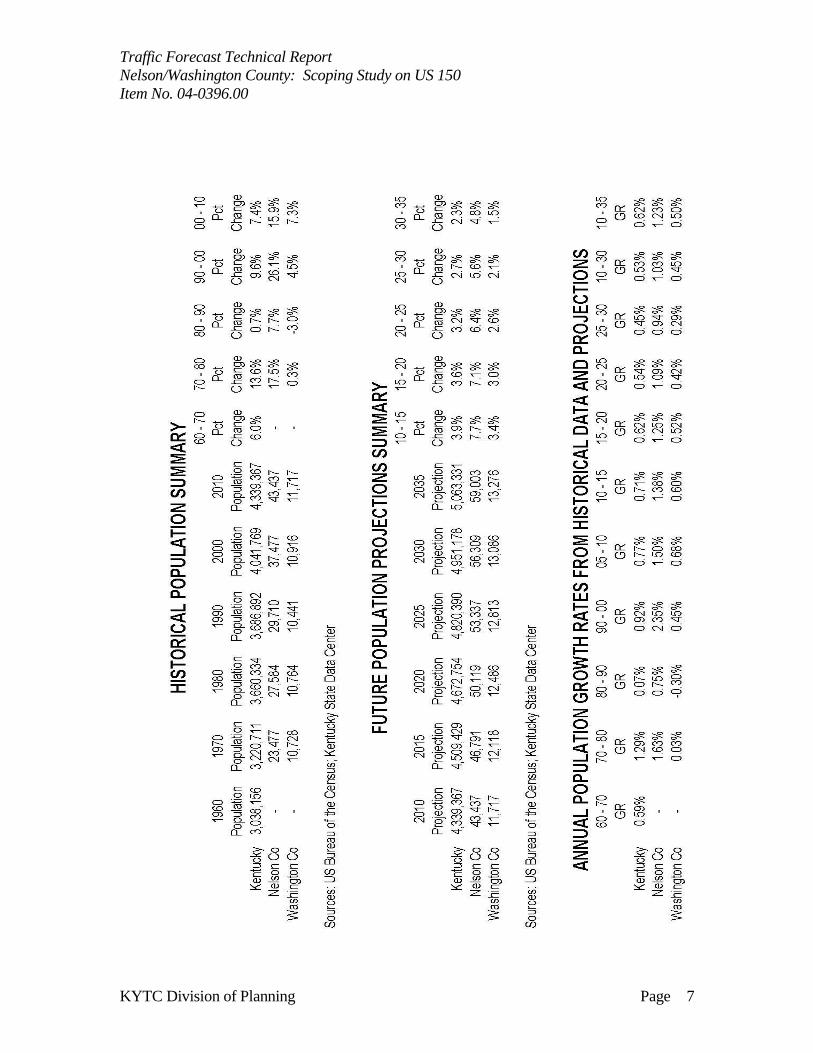
PPooppuullaattiioonn SSuummmmaarryy..........………………………………………………………………………………………………………………..……....PPaaggee 77
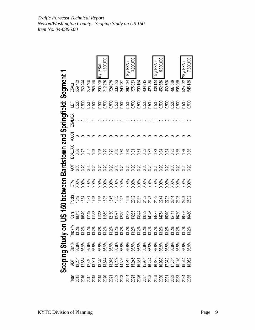
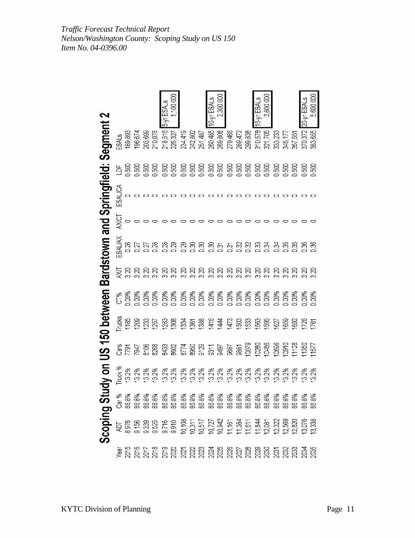
2200 YYeeaarr EESSAALL SSpprreeaaddsshheeeettss ffoorr SSeeggmmeenntt 11....……………………………………………………………………..……....PPaaggee 88
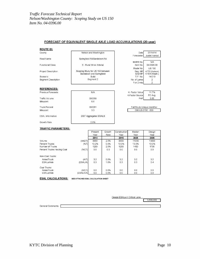
2200 YYeeaarr EESSAALL SSpprreeaaddsshheeeettss ffoorr SSeeggmmeenntt 22....……………………………………………………………………..……....PPaaggee 1100
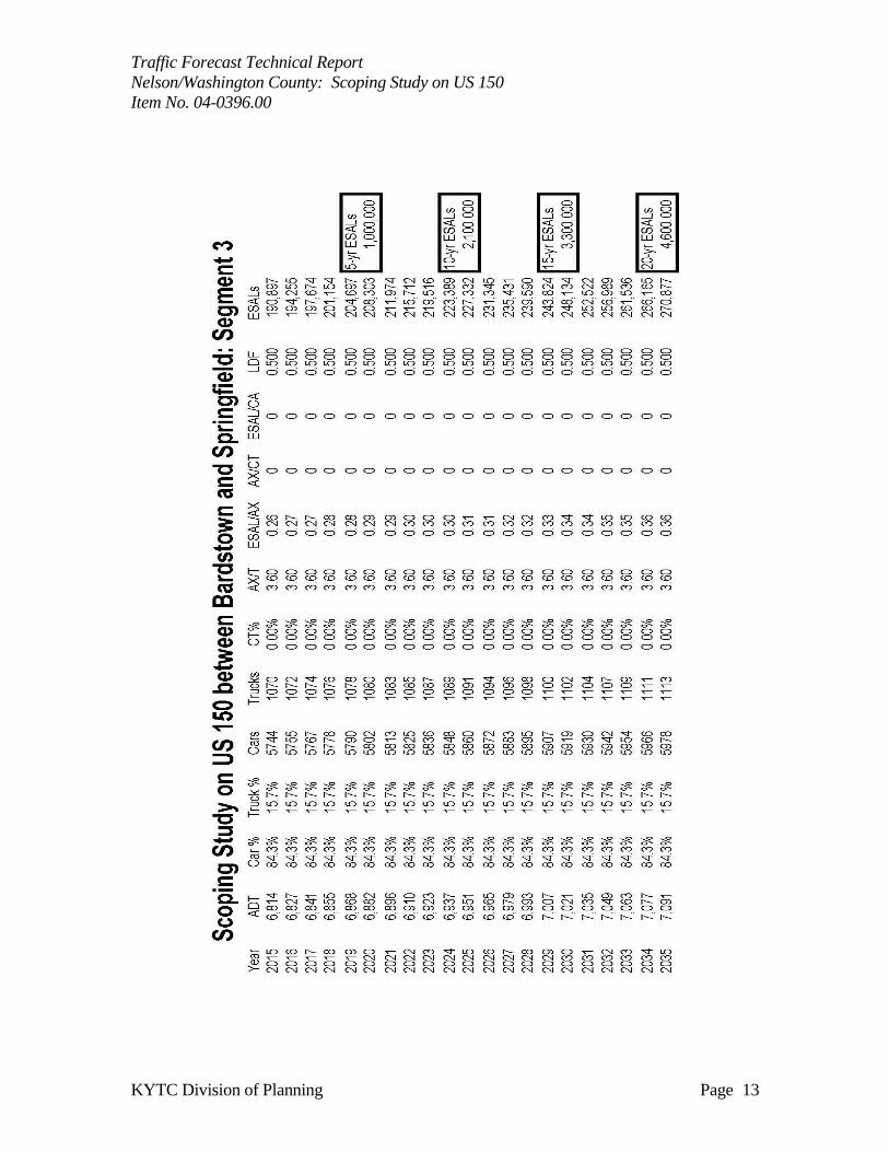
2200 YYeeaarr EESSAALL SSpprreeaaddsshheeeettss ffoorr SSeeggmmeenntt 33....……………………………………………………………………..……....PPaaggee 1122
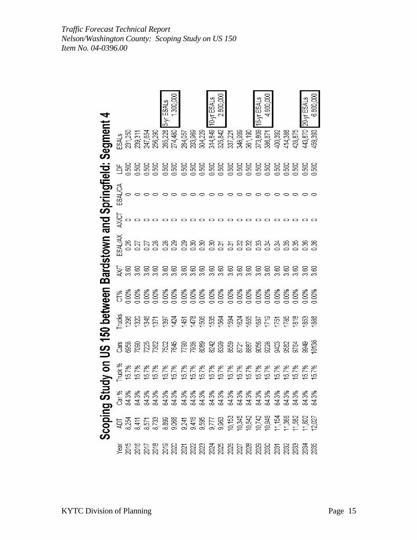
2200 YYeeaarr EESSAALL SSpprreeaaddsshheeeettss ffoorr SSeeggmmeenntt 44....……………………………………………………………………..……....PPaaggee 1144
BBiiccyyccllee aanndd PPeeddeessttrriiaann CCoonnssiiddeerraattiioonnss..…………………………………………………………………………………………PPaaggee 1166
CCoommmmoonnllyy UUsseedd AAbbbbrreevviiaattiioonnss aanndd tthheeiirr DDeessccrriippttiioonnss
ADT Average Daily Traffic Without any adjustment
DHV Design Hour Volume 30th highest hour of a year
ESAL Equivalent Single Axle Load A measure of traffic’s impact on roadway
%T Truck Percentage The percentage of trucks to total volume
FC Functional Class Refers to a road’s importance
GR Growth Rate A value normally compounded annually
PHF Peak Hour Factor Considers a 15 minute spike in an hourly count
K-Factor K-30th hour Factor DHV divided by ADT (DHV/ADT)
D-Factor Directional Factor Percentage of dominant flow to total
MP Mile Point Miles increase easterly and northerly
ATR Automatic Traffic Recorder A permanent & continuous recording station
KYSTM Kentucky Statewide Model A computerized representation of KY roads

Traffic Forecast Technical Report
Nelson/Washington County: Scoping Study on US 150
Item No. 04-0396.00
KYTC Division of Planning Page 2
Traffic Forecast Technical Report
Nelson/Washington County: Scoping Study on US 150
Item No. 04-0396.00
KYTC Division of Planning Page 3
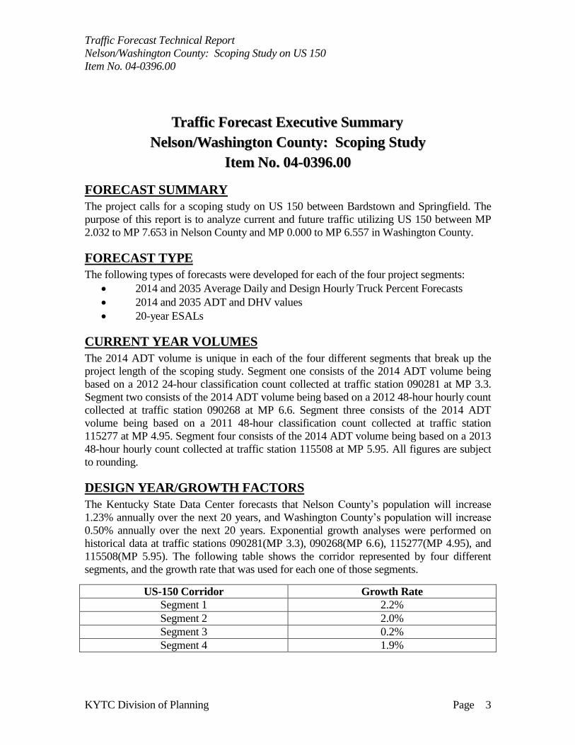
TTrraaffffiicc FFoorreeccaasstt EExxeeccuuttiivvee SSuummmmaarryy
NNeellssoonn//WWaasshhiinnggttoonn CCoouunnttyy:: SSccooppiinngg SSttuuddyy
IItteemm NNoo.. 0044--00339966..0000
FORECAST SUMMARY
The project calls for a scoping study on US 150 between Bardstown and Springfield. The
purpose of this report is to analyze current and future traffic utilizing US 150 between MP
2.032 to MP 7.653 in Nelson County and MP 0.000 to MP 6.557 in Washington County.
FORECAST TYPE
The following types of forecasts were developed for each of the four project segments:
2014 and 2035 Average Daily and Design Hourly Truck Percent Forecasts
2014 and 2035 ADT and DHV values
20-year ESALs
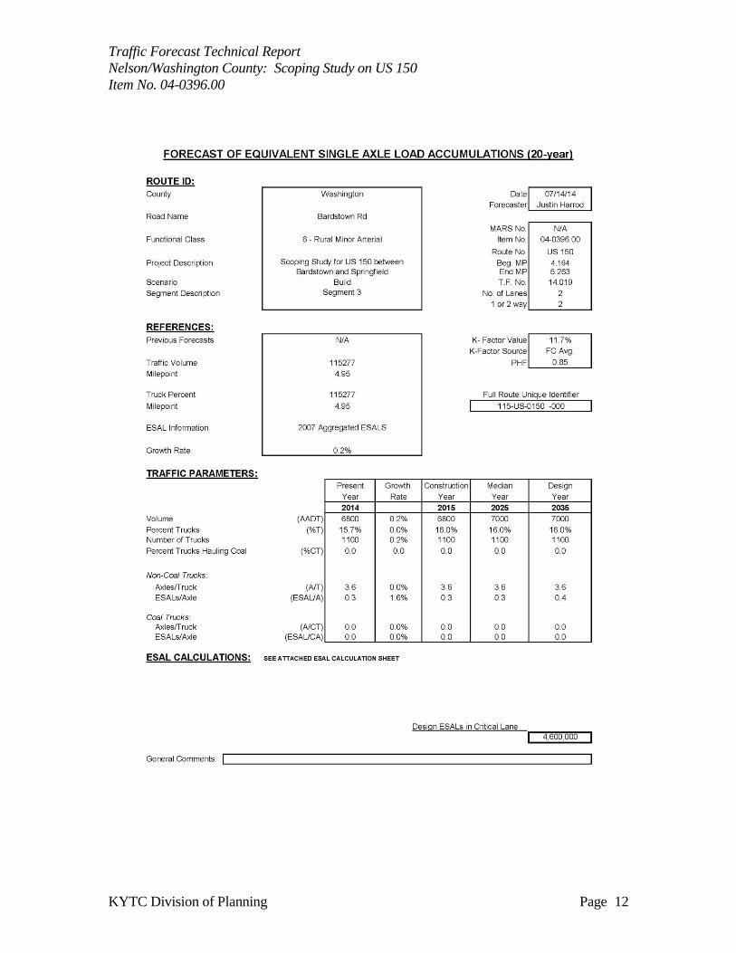
CURRENT YEAR VOLUMES
The 2014 ADT volume is unique in each of the four different segments that break up the
project length of the scoping study. Segment one consists of the 2014 ADT volume being
based on a 2012 24-hour classification count collected at traffic station 090281 at MP 3.3.
Segment two consists of the 2014 ADT volume being based on a 2012 48-hour hourly count
collected at traffic station 090268 at MP 6.6. Segment three consists of the 2014 ADT
volume being based on a 2011 48-hour classification count collected at traffic station
115277 at MP 4.95. Segment four consists of the 2014 ADT volume being based on a 2013
48-hour hourly count collected at traffic station 115508 at MP 5.95. All figures are subject
to rounding.
DESIGN YEAR/GROWTH FACTORS
The Kentucky State Data Center forecasts that Nelson County’s population will increase
1.23% annually over the next 20 years, and Washington County’s population will increase
0.50% annually over the next 20 years. Exponential growth analyses were performed on
historical data at traffic stations 090281(MP 3.3), 090268(MP 6.6), 115277(MP 4.95), and
115508(MP 5.95). The following table shows the corridor represented by four different
segments, and the growth rate that was used for each one of those segments.
US-150 Corridor Growth Rate
Segment 1 2.2%
Segment 2 2.0%
Segment 3 0.2%
Segment 4 1.9%
Traffic Forecast Technical Report
Nelson/Washington County: Scoping Study on US 150
Item No. 04-0396.00
KYTC Division of Planning Page 4
DESIGN HOUR FACTORS
DHVs were estimated by analyzing each traffic count along each one of the four segments
collected at station 090281, 090268, 115277, and 115508. The peak AM and PM volumes
were derived by dividing the highest hourly volumes from these counts by the daily total.
Functional class design hour factors based on the day and month of these counts were then
applied. Finally, the calculated K-factors were used in combination with the ADT forecast to
produce DHVs for 2014 and 2035.
TRUCK PERCENTAGE
The truck percentage for segment one and two were calculated using a 2012 24-hour class
count at traffic station 090281 at MP 3.3. A truck percentage of 13.2% and a truck growth
rate of 0.0% were used to estimate future truck volumes. The truck percentage for segment
three and four were calculated using a 2011 48-hour classification count at traffic station
115277 at MP 4.95. A truck percentage of 15.7% and a truck growth rate of 0.0% were used
to estimate future truck volumes.
ESALs
Functional class averages and the 2035 ADT projections were used to estimate 20-year
ESALs on the project road segment. The 2007 aggregated ESAL report, generated by the
Kentucky Transportation Center in collaboration with the Kentucky Transportation Cabinet,
was used to grow the important ESAL calculation variables. For more information, please
see the attached ESAL calculation sheets.

Traffic Forecast Technical Report
Nelson/Washington County: Scoping Study on US 150
Item No. 04-0396.00
KYTC Division of Planning Page 5
Traffic Forecast Technical Report
Nelson/Washington County: Scoping Study on US 150
Item No. 04-0396.00
KYTC Division of Planning Page 6
Traffic Forecast Technical Report
Nelson/Washington County: Scoping Study on US 150
Item No. 04-0396.00
KYTC Division of Planning Page 7

Traffic Forecast Technical Report
Nelson/Washington County: Scoping Study on US 150
Item No. 04-0396.00
KYTC Division of Planning Page 8
Traffic Forecast Technical Report
Nelson/Washington County: Scoping Study on US 150
Item No. 04-0396.00
KYTC Division of Planning Page 9
Traffic Forecast Technical Report
Nelson/Washington County: Scoping Study on US 150
Item No. 04-0396.00
KYTC Division of Planning Page 10
Traffic Forecast Technical Report
Nelson/Washington County: Scoping Study on US 150
Item No. 04-0396.00
KYTC Division of Planning Page 11
Traffic Forecast Technical Report
Nelson/Washington County: Scoping Study on US 150
Item No. 04-0396.00
KYTC Division of Planning Page 12
Traffic Forecast Technical Report
Nelson/Washington County: Scoping Study on US 150
Item No. 04-0396.00
KYTC Division of Planning Page 13

Traffic Forecast Technical Report
Nelson/Washington County: Scoping Study on US 150
Item No. 04-0396.00
KYTC Division of Planning Page 14
Traffic Forecast Technical Report
Nelson/Washington County: Scoping Study on US 150
Item No. 04-0396.00
KYTC Division of Planning Page 15
Traffic Forecast Technical Report
Nelson/Washington County: Scoping Study on US 150
Item No. 04-0396.00
KYTC Division of Planning Page 16
Bicycle and Pedestrian Review for Project #04-0396.00
Project Overview:
Design study to determine improvements needed for US 150 between Springfield and
Bardstown (MP 2.032-7.653 in Nelson County & MP 0.000-6.557 in Washington
County)
Local Governments/Regional Bicycle and Pedestrian Plan:
City of Bardstown Bicycle and Pedestrian master Plan (http://transportation.ky.gov/Bike-
Walk/Documents/Nelson%20Bike%20Transportation%20Plan.pdf)
a. Updated plan has specific plans for shared use paths along US-150 to KY-605 (MP
.44-1.67 / Phase 1) & (MP 1.67-3.82 / Phase 2)
US Bike Route 76 (Trans America) route / http://transportation.ky.gov/Bike-
Walk/Pages/transamerica-bike-tour.aspx
Existing Conditions:
ADT range (11370-6720)
b. MP 3.3 (Nelson County) =
11370 (2012)
c. MP 6.6 (Nelson County) = 8546
(2012)
d. MP 4.95 (Washington County)
= 6720 (2011)
e. MP 5.95 (Washington County)
= 7927 (2013)
Posted Speed Limit is 45-55 mph
2 Lane / rural cross section design
No shoulder space for cyclists (less
than 6 feet)
Current Bicyclists Comfort Index
(BCI) rating is an E (the lowest
Rating)
The KYTC Bicycle and Pedestrian program team recommendations are: Reference to D-4 DNA Study (http://transportation.ky.gov/Planning/Pages/Project-
Details.aspx?Project=US%20150%20DNA%20-%20Data%20Needs%20Assessment
US-150 provides a vital connection between the Cities of Bardstown and Springfield. The project to
widen US-150 from MP-2.032 (Nelson) – 7.653 (Washington) will need to address several
structurally deficient bridges and major widening. With such extensive work being done; this would
be the best time to pursue the inclusion on a multiuse path along this roadway corridor. Further study
needs to be done to decide the specific location (Northern or southern side).
Best: Multiuse path along the entire roadway project corridor
a. Northern side of US-150 seems to provide better connection to similar planned
facilities in the area
b. 10 foot minimum design
c. Usage and maintenance agreements need to be created with both local governments
d. The BCI would be an A+ (the best rating)
Better: Using the 8-12 foot planned shoulders for marked bike lanes
a. Provide a stripped buffered space between motor vehicle traffic and the bike lane
(http://www.fhwa.dot.gov/environment/bicycle_pedestrian/guidance/design_guidanc
e/design_flexibility.cfm)
b. Bike lanes would be on both side of the roadway (4foot lane width minimum)
Traffic Forecast Technical Report
Nelson/Washington County: Scoping Study on US 150
Item No. 04-0396.00
KYTC Division of Planning Page 17
c. Special consideration for milled rumble strip pattern
used(http://safety.fhwa.dot.gov/roadway_dept/pavement/rumble_strips/t504039/)
d. Usage and maintenance agreements need to be created with both local governments
e. The BCI would be an A
Good: provide an 8-12 foot shoulder space for pedestrians and bicyclists to use for
general travel purposes
a. Special consideration for milled rumble strip pattern used
(http://safety.fhwa.dot.gov/roadway_dept/pavement/rumble_strips/t504039/)
b. Allow for future additions of bike lanes with future resurfacing projects as the local
governments update their bicycle and pedestrian master plans
c. The BCI would be an C
Prepared by:
Troy Hearn, Bicycle & Pedestrian Program Coordinator
Division of Planning, www.transportation.ky.gov/Bike-Walk
Kentucky Transportation Cabinet
June 25th, 2014