Embed Size (px)
Citation preview
APPENDIX D
Biological Resources Technical Report
Palomar Community College District
South Education Center Project
BIOLOGICAL RESOURCES
GENERAL SURVEY REPORT
March 2016
Land Development Review Division, City of San Diego, California
Assessor’s Parcel Number 6782001900
Escondido, California USGS 7.5-minute Topographic Quadrangle
Unsectioned, Township 13 South, Range 2 West
Prepared for:
Palomar Community College District
San Marcos Campus
1140 West Mission Road
San Marcos, California 92069
Prepared by:
3570 Carmel Mountain Road, Suite 300
San Diego, California 92130
858.874.1810 Atkins #100028572
TABLE OF CONTENTS
PCCD South Education Center Project
Biological Resources General Survey Report
Page i
March 2016
Table of Contents
1.0 Executive Summary ................................................................................................................ 1
2.0 Introduction .......................................................................................................................... 2
2.1 Project Location .................................................................................................................... 2
2.2 Project Description ............................................................................................................... 2
3.0 Methodology ......................................................................................................................... 6
3.1 Pre-Survey Investigation ....................................................................................................... 6
3.2 General Biological Surveys ................................................................................................... 6
4.0 Results ................................................................................................................................... 8
4.1 Weather Conditions ............................................................................................................. 8
4.2 General Land Uses ................................................................................................................ 8
4.3 Disturbance .......................................................................................................................... 8
4.4 Topography and Soils ........................................................................................................... 8
4.5 Vegetation Communities ...................................................................................................... 9
4.6 General Wildlife .................................................................................................................. 18
5.0 Sensitive Biological Resources .............................................................................................. 19
5.1 Special-Status Species ........................................................................................................ 19
5.2 Sensitive Natural Communities .......................................................................................... 25
5.3 Jurisdictional Waters and Wetlands ................................................................................... 25
5.4 Wildlife Corridors and Linkages .......................................................................................... 26
6.0 Project Impact Analysis ........................................................................................................ 27
6.1 Issue 1: Special-Status Species ........................................................................................... 27
6.2 Issue 2: Sensitive Natural Communities ............................................................................. 28
6.3 Issue 3: Wetlands ............................................................................................................... 29
6.4 Issue 4: Wildlife Corridors .................................................................................................. 29
6.5 Issue 5: Habitat Conservation Plans ................................................................................... 30
6.6 Issue 6: Land Use Adjacency ............................................................................................... 30
6.7 Issue 7: Local Policies and Ordinances ............................................................................... 30
6.8 Issue 8: Invasive Species ..................................................................................................... 30
7.0 Mitigation, Monitoring, and Reporting ................................................................................. 31
8.0 Certification and Acknowledgements ................................................................................... 32
9.0 References ........................................................................................................................... 33
APPENDICES
A Special-Status Plant and Animal Species Tables
B Plant and Animal Species Observed
TABLE OF CONTENTS
PCCD South Education Center Project
Biological Resources General Survey Report
Page ii
March 2016
TABLES
Table 1 Vegetation Communities within the Property Boundary and Project Area .............................. 9
Table 2 Special-Status Plant Species Documented within 1 mile of the Survey Area ......................... 20
Table 3 Special-Status Animals Documented or Known to Occur within 1 mile of the Survey Area .. 23
FIGURES
Figure 1 Regional Location ..................................................................................................................... 3
Figure 2 Proposed PCCD South Education Center Project Area ............................................................. 4
Figure 3 Project Area – USGS Topo Quad ............................................................................................... 5
Figure 4 Site Plan .................................................................................................................................. 10
Figure 5 USDA Soils ............................................................................................................................... 11
Figure 6 Vegetation Communities ........................................................................................................ 13
Figure 7 Existing Biological Data ........................................................................................................... 21

1.0 EXECUTIVE SUMMARY
PCCD South Education Center Project
Biological Resources General Survey Report
Page 1
March 2016
1.0 Executive Summary
Atkins completed a general biological survey and report for the Palomar Community College District
(PCCD) South Education Center Project (project). PCCD proposes to establish the South Education Center
on the 27-acre property located at 11111 Rancho Bernardo Road in the city of San Diego, San Diego
County, California. The proposed project would convert the existing four-story, 110,000-square foot
building into a comprehensive community college education center; construct a looped road; implement
drainage improvements; and install walkways, hardscape areas, and landscaping.
This Biological Resources General Survey Report provides an inventory of existing biological conditions on
and in the immediate vicinity of the proposed project site, and analyzes potential project-related impacts
to sensitive biological resources with respect to local, state, and federal policy.
Atkins biologist Melissa Tu conducted a biological survey on May 14, 2015, following a project re-design
that reduced the size of the project area. The survey focused on the revised project area, which is outside
the Multi-Habitat Planning Area (MHPA) of the City of San Diego Multiple Species Conservation Program
(MSCP). Vegetation communities within the revised project area include 5.47 acres of non-native
grassland and 0.36 acre of landscaped areas. Therefore, the proposed project could result in impacts of
up to 5.83 acres of previously disturbed areas.
Loss of foraging and nesting habitat for special-status animal species and bird species protected under the
Federal Migratory Bird Treaty Act and California Fish and Game Code (CFG Code) may occur as a result of
construction activities. However, impacts would be mitigated through breeding season (March 15 through
August 30) and nest avoidance. In addition, the loss of foraging habitat is not expected to be significant
and would be mitigated by landscaping with native species. No special-status plant species are anticipated
to be directly adversely affected by the proposed project.
The standard best management practices (BMPs) will be implemented during project construction,
including installation of construction fencing and maintenance of equipment and materials, to ensure that
direct impacts to adjacent habitats do not occur and potential indirect impacts are avoided or minimized.
2.0 INTRODUCTION
PCCD South Education Center Project
Biological Resources General Survey Report
Page 2
March 2016
2.0 Introduction
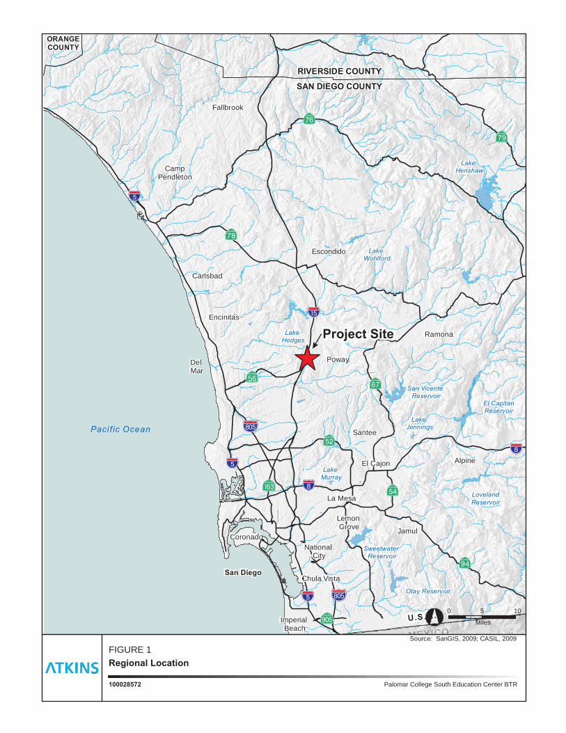
At the request of PCCD, Atkins prepared this Biological Resources General Survey Report for the PCCD
South Education Center Project (project). PCCD proposes to establish the South Education Center on the
27-acre property located at 11111 Rancho Bernardo Road in the city of San Diego, San Diego County,
California (Figure 1). The proposed project would convert the existing four-story, 110,000-square foot
building into a comprehensive community college education center as well as provide updated access and
security features on the property (Figure 2). This report provides the documentation necessary for project
review under the California Environmental Quality Act (CEQA) to allow for the construction, operation,
and maintenance of the proposed road and facilities.
2.1 Project Location
The area proposed for the project is located in the Rancho Bernardo Community planning area in the
northern portions of the city of San Diego, San Diego County, California. Specifically, the project site is
located at 11111 Rancho Bernardo Road. The site is depicted on the Escondido, California U.S. Geological
Survey (USGS) 7.5-minute topographic quadrangle map within an unsectioned portion of Township 13
South and Range 2 West (Figure 3).
The project site is not located within or directly adjacent to the boundaries of the MHPA of the City of San
Diego MSCP. It is, however, situated about 1.50 miles south of the Lake Hodges Segment of the MSCP
Subarea Plan area. Additionally, the project site is approximately 0.25 mile east of an area designated as
MSCP Preserve Land. The project site is separated from the preserve land by Rancho Bernardo Road.
2.2 Project Description
The proposed project would establish the PCCD South Education Center by converting the existing four-
story, 110,000-square-foot building into a comprehensive community college education center. The
project would also make improvements to the existing parking structure; construct a looped access road;
implement drainage improvements; and install walkways, hardscape areas, and landscaping.
The new looped access road would be approximately 1,238 feet long and follows the outer boundary of
the existing graded pad from the northern boundary of the existing parking lot to the existing parking
structure. The proposed alignment of the loop road would follow the edge of existing non-native
grassland.
Construction of the proposed project is anticipated to begin in July 2016 and be completed by January of
2018, lasting approximately 18 months.
Source: SanGIS, 2009; CASIL, 2009
Palomar College South Education Center BTR100028572
Regional Location
FIGURE 1
Pacif ic Ocean
MEXICO
U.S.A.
RIVERSIDE COUNTY
SAN DIEGO COUNTY
ORANGECOUNTY
San Diego
Poway
Coronado
Chula Vista
Santee
El Cajon
Encinitas
Ramona
La Mesa
Jamul
National City
Imperial Beach
Lemon Grove
Del Mar
Fallbrook
CampPendleton
Carlsbad
Escondido
Alpine
San Vicente Reservoir
Otay Reservoir
Sweetwater Reservoir
Lake Hodges
Lake Jennings
Lake Murray
Lake Henshaw
El CapitanReservoir
LovelandReservoir
Lake Wohlford
!"̂$
!"̂$
%&s(
!"_$
AÛ
%&s(
Aù
?z
!"_$
?À
!"̂$
!"a$
?j
?h
?̈
?ª
?©
?k[56
° Miles
1050
Project SiteProject Site
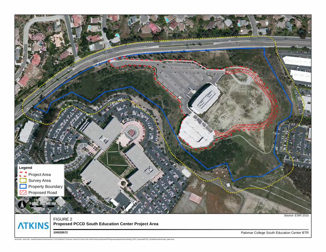
FIGURE 2Proposed PCCD South Education Center Project Area
Palomar College South Education Center BTR100028572
Legend
Project AreaSurvey AreaProperty BoundaryProposed Road
Source: ESRI 2015
9/24/2015 bela7036 \\sdofs01\data\Clients\Palomar CCD\100028572 Palomar South Ed Center ENV EIR\Technical Reports\BTR\Figures\support\GIS\mxd\Fig2_BTR_ProposedPCCD_SouthEducationCenter_letter.mxd
° 0 50 100 150 20025
Feet
1 inch = 250 feet
FIGURE 3Project Area - USGS Topo QUAD
Palomar College South Education Center BTR100028572
Legend
Project AreaProperty Boundary
Source: Escondido and Rancho Santa Fe USGS 7.5 Minute Quads, 2015
9/24/2015 bela7036 \\sdofs01\data\Clients\Palomar CCD\100028572 Palomar South Ed Center ENV EIR\Technical Reports\BTR\Figures\support\GIS\mxd\Fig3_ProposedPCCD_USGS_Topo_letter.mxd
° 0 250 500 750 1,000125
Feet
1 inch = 1,000 feet
3.0 METHODOLOGY
PCCD South Education Center Project
Biological Resources General Survey Report
Page 6
March 2016
3.0 Methodology
3.1 Pre-Survey Investigation
Prior to conducting field surveys, a thorough review of available relevant maps, databases, and literature
pertaining to biological resources known to occur in the project site was performed. Aerial imagery
(Google Earth 2015), topographic maps (USGS 2015), soils maps (U.S. Department of Agriculture [USDA]
2015), vegetation maps (City of San Diego 1997; SanGIS 2015), national wetland inventory (U.S. Fish and
Wildlife Service [USFWS] 2015a) and other maps of the project site and vicinity were acquired and
reviewed to obtain updated information on the natural environmental setting. In addition, a query of
sensitive species and habitat databases was conducted, including the California Natural Diversity Database
(CNDDB; California Department of Fish and Wildlife [CDFW] 2015a), the California Native Plant Society
(CNPS) Electronic Inventory (CNPS 2015), San Diego Natural History Museum (SDNHM) Plant Atlas
(SDNHM 2015), and the Consortium of California Herbarium (Consortium 2015) applications, as well as a
review of regional lists produced by the USFWS (2015b) and CDFW (2015a, 2015b, and 2015c).
The pre-survey investigation also included a verification of whether or not the project site falls in areas
designated as final or proposed USFWS Critical Habitat for federally threatened or endangered species
(USFWS 2015c), as well as areas designated as MHPA for the MSCP Subarea Plan (SanGIS 2015). Lastly,
the pre-survey investigation included a review of MSCP documents (City of San Diego 1997) and the City
of San Diego Land Development Code, Land Development Manual and Biology Guidelines, and
Environmentally Sensitive Lands regulations, and amendments (City of San Diego 2012).
The complete list of sensitive species and habitats that have been previously recorded in the vicinity of
the proposed project was compiled, and all recorded locations of species and other resources were
mapped and overlayed onto aerial imagery using Geographic Information Systems (GIS). The list of
sensitive species and habitats represents database results for areas within approximately two miles of the
project site, as well as selected results from the Escondido, California USGS 7.5 minute topographic
quadrangle (Appendix A).
3.2 General Biological Surveys
An initial general biological survey of the project site and approximately 100 feet beyond the site,
hereinafter referred to as the survey area, was conducted by Atkins in June 2012. The survey was
conducted on-foot and included 100 percent visual coverage of the survey area. The survey included a
general inventory of existing conditions and focused primarily on mapping vegetation communities or
habitat types, assessing suitability for sensitive plant and wildlife species, and identifying potential
wetlands and other sensitive resources. Physical parameters assessed included vegetation and soil
conditions, presence of indicator plant and wildlife species, slope, aspect and hydrology. A follow-up
general biological survey was performed by Atkins in October 2012, which focused on the coastal sage
scrub habitat located in the northeastern and eastern portions of the survey area.
The project was re-designed and the project area revised subsequent to the survey in October 2012. On
May 14, 2015, Melissa Tu, an Atkins’ qualified biologist, conducted a general biological survey of the
updated project area including the loop access road. All plant and wildlife species observed in 2012 and
2015 are listed in Appendix B.
3.0 METHODOLOGY
PCCD South Education Center Project
Biological Resources General Survey Report
Page 7
March 2016
Vegetation communities were mapped in the field using aerial imagery and 7.5-minute USGS topographic
base maps. The vegetation communities were classified according to Oberbauer et al. (2008). The names
of plant species discussed in this report generally follow the nomenclature suggested by the CNPS and in
Jepson (Baldwin et al. 2012) and Munz (1974). The names of wildlife generally follow the nomenclature
suggested by CDFW (CDFG 2008).
Data was collected in the field using a Garmin GPSMAP 60CSx hand-held Global Positioning System unit
and recorded on recent aerial imagery at a 1 inch = 200 feet scale. Other materials used in the field
included field binoculars, digital camera, and a Kestrel hand-held air temperature and wind speed
recording device.
4.0 RESULTS
PCCD South Education Center Project
Biological Resources General Survey Report
Page 8
March 2016
4.0 Results
4.1 Weather Conditions
The May 14, 2015, survey was conducted between the hours of 8:30 and 10:30 a.m. Weather conditions
encountered included mostly cloudy skies and light drizzle with temperatures ranging from 59 to 61
degrees Fahrenheit, and winds ranging from 0 to 4 miles per hour out of the west.
Prior to 2015, the June 21, 2012, survey was conducted between the hours of 7:00 a.m. and 1:00 p.m.
Weather conditions encountered included partly cloudy skies, with temperatures ranging from 62 to 68
degrees Fahrenheit, and winds ranging from 1 to 3 miles per hour out of the west. The October 3, 2012,
survey was conducted between the hours of 7:30 a.m. and 12:30 p.m. Weather conditions encountered
included clear skies, with temperatures ranging from 68 to 70 degrees Fahrenheit, and winds ranging from
0 to 1 mile per hour out of the west.
4.2 General Land Uses
General land use in the survey area is limited to existing commercial developments, ornamental plantings,
non-native grassland, and native and non-native open space. General land use surrounding the survey
area includes disturbed and undisturbed open space and residential developments to the north, and
existing commercial developments to the east, south, and west. The project site is also located
approximately 0.25 mile east of an area designated as MSCP Preserve Land (SanGIS 2015).
4.3 Disturbance
The survey area contains anthropogenic related disturbances. An existing 110,000 square-foot, 4-story
building is located at the center of the property. Also, within the project site is a paved parking lot situated
northwest of the building and a graded area to the east. The 2015 project area is within a previous graded
area. Other disturbances include those resulting from the operation of, and proximity to, adjacent existing
commercial and residential developments. Lighting, noise, runoff, and encroachment resulting from
building and parking lot operations present direct and indirect disturbances to wildlife and habitat.
Further, much of the native habitat in the survey area has been subject to the spread of ornamental
landscape, as evident by a relatively high number of non-native and exotic ornamental plant species.
4.4 Topography and Soils
The majority of the survey area occurs on a northeast-facing slope with an approximate 2:1 gradient.
Elevations range from approximately 740 to 645 feet above mean sea level. Above the slope and in the
western portions of the survey area, the topography is relatively flat as a result of parking lot
developments for the commercial property. Below the slope and in the north and northwestern portions
of the survey area, the topography is defined by a shallow gradient that gently slopes into open space and
a drainage feature at the base of the supporting canyon.
4.0 RESULTS
PCCD South Education Center Project
Biological Resources General Survey Report
Page 9
March 2016
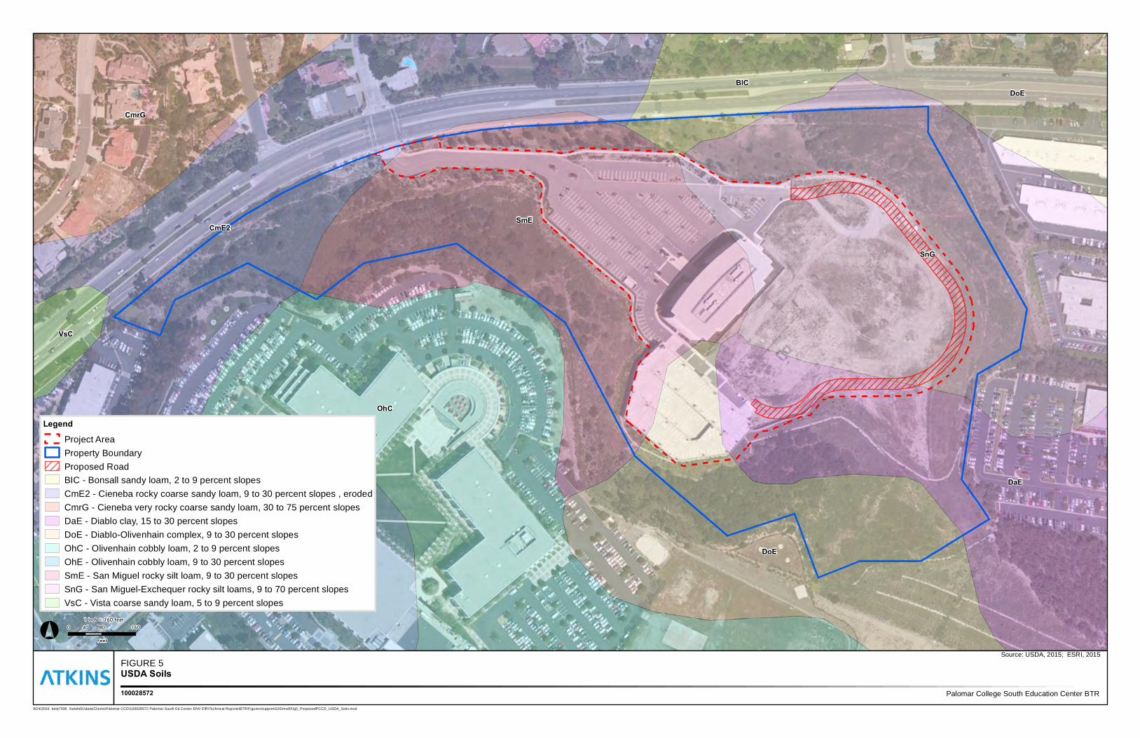
As depicted in Figure 4, the soils in the survey area are mapped as: Bonsall sandy loam (2 to 9 percent
slopes), Cieneba rocky coarse sandy loam (9 to 30 percent slopes eroded), Diablo clay (15 to 30 percent
slopes), Diablo-Olivenhain complex (9 to 30 percent slopes), Olivenhain cobbly loam (9 to 30 percent
slopes), San Miguel rocky silt loam (9 to 30 percent slopes), and San Miguel-Exchequer rocky silt loams
(9 to 70 percent slopes) (USDA 2015). These soils are generally well-drained and typical of marine terraces
with gravelly alluvium parent material derived from various sources. The lower profiles of these soils are
reported to contain a very cobbly clay and clay loam content. The soils in the eastern portions of the
survey area are highly disturbed and compacted as a result of existing developments. The observed soils
on the slope and in the canyon bottom have been disturbed by erosion damage associated with the
surrounding land use.
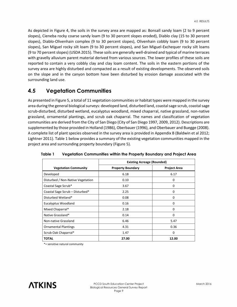
4.5 Vegetation Communities
As presented in Figure 5, a total of 11 vegetation communities or habitat types were mapped in the survey
area during the general biological surveys: developed land, disturbed land, coastal sage scrub, coastal sage
scrub-disturbed, disturbed wetland, eucalyptus woodland, mixed chaparral, native grassland, non-native
grassland, ornamental plantings, and scrub oak chaparral. The names and classification of vegetation
communities are derived from the City of San Diego (City of San Diego 1997, 2009, 2012). Descriptions are
supplemented by those provided in Holland (1986), Oberbauer (1996), and Oberbauer and Buegge (2008).
A complete list of plant species observed in the survey area is provided in Appendix B (Baldwin et al 2012;
Lightner 2011). Table 1 below provides a summary of the existing vegetation communities mapped in the
project area and surrounding property boundary (Figure 5).
Table 1 Vegetation Communities within the Property Boundary and Project Area
Vegetation Community
Existing Acreage (Rounded)
Property Boundary Project Area
Developed 6.18 6.17
Disturbed / Non-Native Vegetation 0.10 0
Coastal Sage Scrub* 3.67 0
Coastal Sage Scrub – Disturbed* 2.25 0
Disturbed Wetland* 0.08 0
Eucalyptus Woodland 0.16 0
Mixed Chaparral* 2.18 0
Native Grassland* 0.14 0
Non-native Grassland 6.46 5.47
Ornamental Plantings 4.31 0.36
Scrub Oak Chaparral* 1.47 0
TOTAL 27.00 12.00
*= sensitive natural community
Source: LPA 2014
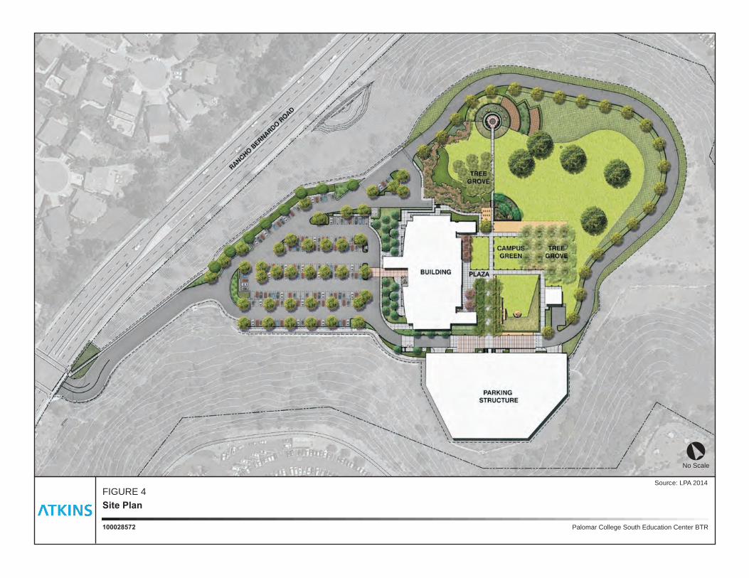
Palomar College South Education Center BTR100028572
Site Plan
FIGURE 4
No Scale°
OhC
SnG
SmECmE2
DoE
DaE
OhE
CmrG
DoEBlC
VsC
FIGURE 5USDA Soils
Palomar College South Education Center BTR100028572
Legend
Project AreaProperty BoundaryProposed RoadBIC - Bonsall sandy loam, 2 to 9 percent slopesCmE2 - Cieneba rocky coarse sandy loam, 9 to 30 percent slopes , erodedCmrG - Cieneba very rocky coarse sandy loam, 30 to 75 percent slopesDaE - Diablo clay, 15 to 30 percent slopesDoE - Diablo-Olivenhain complex, 9 to 30 percent slopesOhC - Olivenhain cobbly loam, 2 to 9 percent slopesOhE - Olivenhain cobbly loam, 9 to 30 percent slopesSmE - San Miguel rocky silt loam, 9 to 30 percent slopesSnG - San Miguel-Exchequer rocky silt loams, 9 to 70 percent slopesVsC - Vista coarse sandy loam, 5 to 9 percent slopes
Source: USDA, 2015; ESRI, 2015
9/24/2015 bela7036 \\sdofs01\data\Clients\Palomar CCD\100028572 Palomar South Ed Center ENV EIR\Technical Reports\BTR\Figures\support\GIS\mxd\Fig5_ProposedPCCD_USDA_Soils.mxd
° 0 80 16040
Feet
1 inch = 160 feet
4.0 RESULTS
PCCD South Education Center Project
Biological Resources General Survey Report
Page 12
March 2016
Vegetation Communities within the Project Area
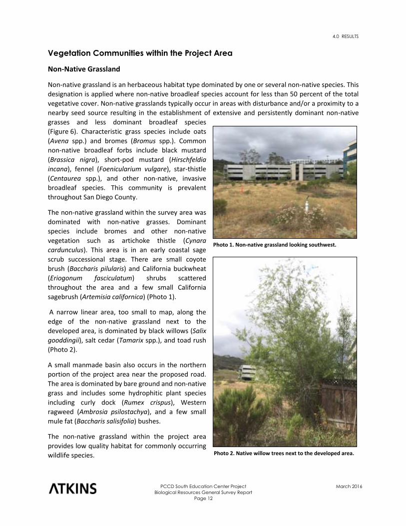
Non-Native Grassland
Non-native grassland is an herbaceous habitat type dominated by one or several non-native species. This
designation is applied where non-native broadleaf species account for less than 50 percent of the total
vegetative cover. Non-native grasslands typically occur in areas with disturbance and/or a proximity to a
nearby seed source resulting in the establishment of extensive and persistently dominant non-native
grasses and less dominant broadleaf species
(Figure 6). Characteristic grass species include oats
(Avena spp.) and bromes (Bromus spp.). Common
non-native broadleaf forbs include black mustard
(Brassica nigra), short-pod mustard (Hirschfeldia
incana), fennel (Foenicularium vulgare), star-thistle
(Centaurea spp.), and other non-native, invasive
broadleaf species. This community is prevalent
throughout San Diego County.
The non-native grassland within the survey area was
dominated with non-native grasses. Dominant
species include bromes and other non-native
vegetation such as artichoke thistle (Cynara
cardunculus). This area is in an early coastal sage
scrub successional stage. There are small coyote
brush (Baccharis pilularis) and California buckwheat
(Eriogonum fasciculatum) shrubs scattered
throughout the area and a few small California
sagebrush (Artemisia californica) (Photo 1).
A narrow linear area, too small to map, along the
edge of the non-native grassland next to the
developed area, is dominated by black willows (Salix
gooddingii), salt cedar (Tamarix spp.), and toad rush
(Photo 2).
A small manmade basin also occurs in the northern
portion of the project area near the proposed road.
The area is dominated by bare ground and non-native
grass and includes some hydrophitic plant species
including curly dock (Rumex crispus), Western
ragweed (Ambrosia psilostachya), and a few small
mule fat (Baccharis salisifolia) bushes.
The non-native grassland within the project area
provides low quality habitat for commonly occurring
wildlife species.
Photo 1. Non-native grassland looking southwest.
Photo 2. Native willow trees next to the developed area.
DEV
NNG
DEV
OP
OP
MC
DEV
SOC
OP
DEV
CSS
DEV
CSS
CSS-d
CSS
CSS
CSS
CSSSOC
CSS-d
MC
NNG
CSS
CSS-d
EUC
CSS-d
MC
NNG
NNG
CSS-d
DEVEUC
EUC
CSS
MC
OP
CSS-dDL
EUC
MC
CSS-d
OP
NG
EUC
CSS-d
CSS
DW
OP
CSS-d
OP
CSS
OP
EUC
OP
DL
EUC
OP
OP
CSS-d
CSS
OP CSS-d
CSS
CSS-d
CSS-d
CSS
CSS-d
NNG
NNG
CSS-d
DW
MC
CSS-d
NNG
CSS
EUC
NG
NG
DEV
EUC
OP
OP
CSS-d
CSS-d
NNG
EUCCSS-d
CSS-d
CSS-d
CSS-d
OPNNG
NNG
DL
OP
NNG
MC
CSS
EUC
NNG
DW
DEV DEV
EUC
CSS-d
CSS-d
CSS-d
CSS
DEV
EUC
CSS
DEVDEV
CSS-d
OP
FIGURE 6Vegetation Communities
Palomar College South Education Center BTR100028572
LegendProposed RoadProject AreaSurvey AreaProperty BoundaryCSS, Coastal Sage ScrubCSS-d, Coastal Sage Scrub - DisturbedDEV, DevelopedDL, Disturbed LandDW, Disturbed WetlandEUC, Eucalyptus WoodlandMC, Mixed ChaparralNG, Native GrasslandNNG, Non-Native GrasslandOP, Ornamental PlantingsSOC, Scrub Oak Chaparral
Source: SANDAG, 2015; ESRI, 2015
9/24/2015 bela7036 \\sdofs01\data\Clients\Palomar CCD\100028572 Palomar South Ed Center ENV EIR\Technical Reports\BTR\Figures\support\GIS\mxd\Fig6_ProposedPCCD_VegetationCommunities.mxd
° 0 80 16040
Feet
1 inch = 160 feet
4.0 RESULTS
PCCD South Education Center Project
Biological Resources General Survey Report
Page 14
March 2016
Ornamental Plantings
Non-native ornamental plantings describe areas in which there is evidence of previous removal of natural
habitat and planting of non-native ornamental species. Invasive non-native plant species typical in
southern California include: ornamental trees such as palm (Washingtonia spp., Phoenix spp.), and gum;
shrubs such as wattle (Acacia spp.) and oleander (Nerium oleander); and, groundcover such as turf grass
and hottentot-fig (Carpobrotus edulis), among others. This community is widespread throughout San
Diego County.
The ornamental plantings within the project area are associated with the landscaping for the existing
commercial building in the project area. The landscaped area adjacent to the commercial building is
irrigated and consists primarily of turf grass, pines (Pinus spp.), and French lavender (Lavandula dentata).
The ornamental plantings surrounding the disturbed non-native grassland consists primarily of small open
canopy gum trees and non-native grasses.
Developed
Developed land generally includes areas that have been permanently altered due to the construction of
aboveground structures such as buildings, roads, and golf courses. Developed land is characterized by a
high percentage of non-vegetated bare earth or asphalt, concrete, and other permanent surfaces.
Developed land is the second most prevalent community in the survey area. This community type occurs
as existing commercial development in the central portion of the survey area, including an asphalt parking
lot, buildings, and ornamental landscaping (primarily mature pine trees and ornamental lavender). Areas
characterized by developed land provide limited biological function and value.
Vegetation Communities within the Property Boundary outside the Survey Area
Disturbed/Non-Native Vegetation
Disturbed/non-native vegetation includes areas in which there is sparse vegetative cover and where there
is evidence of soil surface disturbance and compaction from previous human activity and/or the presence
of building foundations and debris. For the purposes of this assessment, areas described as
disturbed/non-native vegetation include elements of “disturbed land” bordered by “ornamental
plantings.” Vegetation in disturbed habitat (if present) will have a high predominance of non-native plant
species. This includes exotic species recruited to the area from adjacent ornamental landscaped areas
and/or ruderal (weedy) annual species that are indicators of disturbance, such as Russian thistle (Salsola
tragus), telegraph weed (Heterotheca grandiflora), horehound (Marrubium vulgare), and sow-thistle
(Sonchus oleraceus), among others.
A small patch of disturbed/non-native vegetation is mapped in the northern portion of the property
adjacent to Rancho Bernardo Road. This area is comprised of disturbed open patches of non-native herbs
and other groundcover between the canopy of adjacent scrub and chaparral. Dominant plant species
observed included hottentot-fig (Carpobrotus edulis), ripgut (Bromus diandrus), and black mustard
(Brassica nigra). Other notable species included red brome (Bromus madritensis ssp. rubens), slender wild
oats (Avena barbata), artichoke thistle, Mexican fan palm (Washingtonia robusta), and pine (Pinus spp.).
The disturbed/non-native vegetation in the area hosts several non-native and/or invasive plant species
and provides limited biological function and value.
4.0 RESULTS
PCCD South Education Center Project
Biological Resources General Survey Report
Page 15
March 2016
Coastal Sage Scrub and Coastal Sage Scrub – Disturbed
Coastal sage scrub is a native scrub-type community that is widespread throughout the lower elevations
of southern California. Vegetation typically consists of low-growing, drought-deciduous, perennial and
evergreen shrubs adapted to xeric sites supported by steep and gentle sloping topography with severely
drained soils or clays that release stored soil moisture slowly. Coastal sage scrub most often occurs as a
dense scrub-type community of scattered shrubs, sub-shrubs, and herbs generally less than 3 feet tall
developing considerable cover. Typical stands are dominated by the native shrub, California sagebrush,
with a sub-dominance of one or more native shrubs, such as California buckwheat and black sage (Salvia
mellifera). The understory typically consists of native and non-native grasses, and annual forbs. Diagnostic
species generally include California sagebrush, California buckwheat, black sage, white sage (Salvia
apiana), laurel sumac (Malosma laurina), sticky monkey flower (Mimulus auranticus), chaparral yucca
(Yucca whipplei), and California aster (Corethrogyne filaginifolia), among others. This community is fire-
adapted, with many constituent plant species being able to sprout new stems from remnant crowns after
a burn. In southern California, this community intergrades with coastal dunes scrub and foredune habitats
along the coast, and with grassland, chaparral, and oak woodland habitats at inland locales. Coastal sage
scrub is the primary habitat for the federally threatened coastal California gnatcatcher (Polioptila
californica californica), among other sensitive species.
Coastal sage scrub and disturbed coastal sage scrub occur in patches around the boundary of the project
area. Stands in the eastern, western, and southern portions of the survey area are considered to be
relatively low in habitat quality due to very low species richness, predominance of non-native plant
species, and proximity to existing developments. The stand in the northeastern portion of the survey area,
next to the area where the new access road is proposed, is highly disturbed by ornamental plantings. In
terms of composition, these patches are fairly homogenous and support a low diversity of plant species.
In general, dominant shrub species observed in the survey area include California sagebrush, coyote
brush, and buckwheat. Other shrub species observed in much lower percent cover include sticky monkey
flower, black sage, deerweed (Acmispon glaber), and lemonade berry (Rhus integrifolia). The northern
stand also contains a relatively high percent cover of non-native grasses and ruderal forbs, including red
brome, ripgut, and black mustard. Relative to other coastal sage scrub habitat in the local area (e.g., Lake
Hodges Cornerstone MSCP area), the coastal sage scrub in the survey area is highly disturbed and provides
limited biological function and value. Furthermore, due to its steepness of slopes, vegetation composition,
proximity to existing developments, and overall disturbance, the coastal sage scrub in the survey area is
generally unsuitable and does not support the constituent elements required by the coastal California
gnatcatcher (USFWS 2010).
Disturbed Wetland
Disturbed wetlands include areas permanently or periodically inundated by water, which have been
significantly modified by human activity. Site factors associated with disturbed wetlands include obvious
artificial structures such as concrete lining, barricades, rip-rap, piers, or gates. Examples of disturbed
wetlands may include lined channels, Arizona crossings, detention basins, culverts, and ditches.
Characteristic species of disturbed wetlands include giant reed (Arundo donax), salt cedar, gum tree, fan
palm (Washingtonia spp.), pampass grass (Cortaderia spp.), and Bermuda grass (Cynodon dactylon). This
habitat may also contain willows (Salix spp.), cattails (Typha sp.), and a variety of other wetland plants.
Disturbed wetlands occur throughout San Diego County.
4.0 RESULTS
PCCD South Education Center Project
Biological Resources General Survey Report
Page 16
March 2016
Disturbed wetland occurs within the northern and southern portions of the survey area. This habitat is
found in association with an existing concrete-lined ditch and in areas that channel seasonal flows
supported by ambient runoff. Dominant plant species observed include toad rush (Juncus bufonius), curly
dock, and Italian ryegrass (Festuca multiflorum). Overall, the disturbed wetland within the survey area
provides low quality habitat and limited biological function and value.
Eucalyptus Woodland
Eucalyptus woodland habitats vary from single-species thickets with little or no shrubby understory, to
scattered trees over a well-developed herbaceous and shrubby understory. In most cases, eucalyptus
forms a dense stand with a closed canopy. Eucalyptus species produce a large amount of leaf and bark
litter, of which, the chemical and physical characteristics limit the ability of other species to grow in the
understory, decreasing floristic diversity. Overstory composition is typically limited to one species of the
genus, but can be mixed stands composed of several species. Few native overstory species are present
within eucalyptus planted areas, except in small cleared pockets. Characteristic vegetation is the gum tree
(Eucalyptus spp.) with the most common species consisting of blue gum (Eucalyptus globulus) and red
gum (Eucalyptus camaldulensis). In San Diego County, this introduced habitat ranges from coastal to
foothill locales that have access to water sources.
Eucalyptus woodland occurs in small patches along the eastern, western, and southern boundaries of the
survey area. The woodland stand is relatively dense and comprised of similar-age blue gum trees that
have evidently occurred in the area for decades (Google Earth 2015). Understory growth is limited to non-
native grasses, namely ripgut. Due to disturbance factors, the eucalyptus woodland within the survey area
provides relatively low quality habitat and limited biological function and value.
Mixed Chaparral
Mixed chaparral is a broad classification for native chaparral-type communities that are widespread
throughout the lower and mid elevations of southern California. It c of broad-leaved, sclerophyllous
shrubs that grow to about 10 feet in height. Mixed chaparral shrubs are typically associated with north-
and east-facing slopes and found at higher elevations than coastal sage scrub. For the purposes of this
assessment, the City of San Diego classification term “mixed chaparral” is used synonymously with the
more specific term, “southern mixed chaparral.” Southern mixed chaparral is perhaps the most
widespread upland habitat type in the southern California coastal region. Depending on the type of
chaparral, dominant species may include mission manzanita (Xylococcus bicolor), California scrub oak
(Quercus berberidifolia), redberry (Rhamnus crocea), toyon (Heteromeles arbutifolia), horryleaf ceanothus
(Ceanothus crassifolius), and Ramona lilac (Ceanothus tomentosus), among many others.
Mixed chaparral occurs in two distinct patches in the western portion of the survey area. Similar to coastal
sage scrub found in the survey area, the mixed chaparral is considered to be relatively low in habitat
quality, primarily due to very low species richness and proximity to existing developments. The mixed
chaparral that occurs in the survey area is strongly dominated by lemonade berry. Other species observed
in much lower densities include scrub oak, laurel sumac, and black sage. The mixed chaparral in the survey
area provides limited biological function and value.
4.0 RESULTS
PCCD South Education Center Project
Biological Resources General Survey Report
Page 17
March 2016
Native Grassland
Native grassland habitats in San Diego County are dominated by native perennial grasses. Typically, these
will include dense tussocks of purple needlegrass (Stipa pulchra). Native and introduced annuals occur
between the perennials, often exceeding the bunchgrasses in percentage of cover. Native perennial herbs
such as checkerblooms (Sidalcea spp.), blue-eyed grass (Sisirynchium bellum), poppies (Eschscholzia spp.),
or golden fields (Lasthenia spp.) are also apparent in this habitat when it occurs within San Diego County.
The percentage cover of native species at any one time may be quite low, but an area is considered native
grassland if 20 percent aerial cover of native species is present.
Native grassland occurs in isolated patches in the western portion of the survey area. The dominant native
species is purple needlegrass (Stipa pulchra), but the area also includes many introduced annual grasses,
such as slender wild oat, red brome, and ripgut. Due to the lack of species diversity and general
disturbance from surrounding development, native grassland provides limited biological function and
value within the survey area.
Non-Native Grassland
Non-native grassland occurs in the southern portion of the survey area. This habitat occurs as isolated
patches within the survey area and is not directly connected to any larger, more expansive grassland
blocks. Overall, the grassland within the survey area contains a slight dominance of non-native grasses
over broadleaf species. Dominant species include ripgut, soft chess, and wild oat. Sub-dominant species
include native and non-native annuals, such as filaree (Erodium botrys), dove weed (Croton setiger),
fiddleneck (Amsinckia menziesii), Spanish lotus (Lotus purshianus), short-pod mustard, prickly lettuce
(Lactuca serriola), and yellow star thistle (Centaurea solstitialis), among others. The non-native grassland
within the survey area provides low quality habitat and limited biological function and value for commonly
occurring wildlife species.
Ornamental Plantings
Approximately 4.31 acres of ornamental plantings are mapped encircling the non-native grassland and
developed portions of the project area. This habitat is characterized by several non-native sub-tree and
shrub species defining an open canopy, with scattered non-native annual herbaceous species in the
understory. A few isolative native shrub species also occur amongst the non-native understory. Overall,
the non-native ornamental plantings habitat within the survey area provides limited biological function
and value.
Developed
Non-native vegetation/ornamental plantings describe areas in which there is evidence of previous
removal of natural habitat and planting or recruitment of non-native ornamental plant species, are typical
of landscaped areas and are usually in close proximity to existing developments. Non-native plant species
typical of this habitat include ornamental trees such as pine, pepper (Schinus spp.), palm (Washingtonia
spp., Phoenix spp.), and gum; shrubs such as wattle and oleander (Nerium oleander); and groundcover
such as turf grass, common ice plant (Mesembryanthemum crystallinum), and hottentot-fig, among
others. This community is widespread throughout San Diego County.
4.0 RESULTS
PCCD South Education Center Project
Biological Resources General Survey Report
Page 18
March 2016
Ornamental plantings are mapped encircling the disturbed and developed portions of the survey area.
This habitat is characterized by several non-native sub-tree and shrub species defining an open canopy,
with scattered non-native annual herbaceous species in the understory. A few isolated native shrub
species also occur amongst the non-native understory. Overall, the non-native vegetation/ornamental
plantings habitat within the survey area provides limited biological function and value.
Scrub Oak Chaparral
Scrub oak chaparral generally consists of dense, evergreen chaparral with vegetation height measuring
up to 20 feet tall. This habitat is dominated by scrub oaks with considerable California mountain mahogany
(Cercocarpus betuloides). In San Diego County, California scrub oak is often the dominant species (more
than 50% cover) and usually occurs in small patches within a variety of other vegetation communities.
Scrub oak chaparral typically occurs in somewhat mesic areas at elevations up to 5,000 feet, often on
north-facing slopes.
Scrub oak chaparral occurs in the southern portion of the survey area. The area is characteristically
dominated by scrub oak and occurs as an isolated stand among surrounding developed and disturbed
areas. The scrub oak chaparral within the survey area provides moderate quality habitat, but limited
biological function and value for commonly occurring wildlife species.
4.6 General Wildlife
The project area was previously disturbed by commercial development and does not provide extensive
high quality habitat for wildlife species. Overall, wildlife activity during the general surveys was low. A
single reptile, 16 birds, and 5 mammal species were observed or otherwise detected by call or sign in the
survey area during the general biological surveys (Appendix B). Common species observed or otherwise
detected (e.g., call, feathers, scat, tracks) in or flying over the survey area included common reptiles such
as side-blotched lizard (Uta stansburiana); common songbirds such as black phoebe (Sayornis nigricans),
northern mockingbird (Mimus polyglottos), house finch (Carpodacus mexicanus), lesser goldfinch (Spinus
psaltria), song sparrow (Melospiza melodia), Bullock’s oriole (Icterus bullockii), Anna’s hummingbird
(Calypte anna), American crow (Corvus brachyrhynchos), and mourning dove (Zenaida macroura); and
common mammals including desert cottontail (Sylvilagus audubonii), California ground squirrel
(Otospermorphilus beecheyi), and domestic dog (Canis familiaris). In addition, an inactive woodrat
(Neotoma spp.) nest was observed in the northwestern portion of the survey area (outside of the project
area). It is unknown whether or not the woodrat nest was associated with the San Diego desert woodrat
(Neotoma lepida intermedia), a sensitive species. With the exception of the unconfirmed San Diego desert
woodrat nest, no rare, threatened, or endangered species were observed or otherwise detected in the
survey area. Appendix B provides a complete list of wildlife species observed or otherwise detected in the
survey area, including the habitat types where each species was observed (CDFG 2008).
5.0 SENSITIVE BIOLOGICAL RESOURCES
PCCD South Education Center Project
Biological Resources General Survey Report
Page 19
March 2016
5.0 Sensitive Biological Resources
Sensitive biological resources generally include the following: (1) vegetation communities or habitat types
that are unique, of relatively limited distribution, or of particular values to wildlife; and (2) species and
other resources that have been given special recognition by federal or state agencies, and/or are included
in the MSCP due to limited, declining, or threatened populations or extent.
Sensitive biological resources determined to occur or have a potential to occur in the survey area are
described below in terms of special-status species, sensitive natural communities, jurisdictional waters
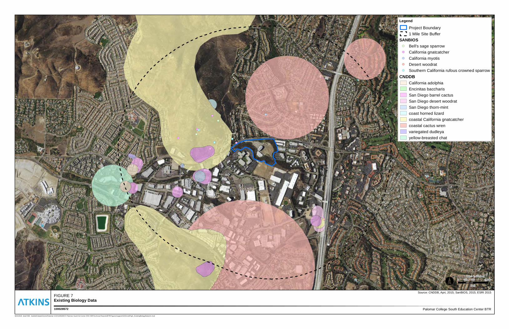
and wetlands, and wildlife corridors and linkages. Figure 7 presents CDFW CNDDB special-status species
observations, including historical observations, and SanGIS special-status species data within one mile of
the survey area (CDFW 2015; SanGIS 2015).
5.1 Special-Status Species
Special-status Plant Species
Special-status plant species are those that: are federally listed as threatened or endangered by the USFWS
(2015b); are state listed as threatened or endangered or considered sensitive by the CDFW (2015b,
2015c); are CNPS List 1A, 1B, or 2 species recognized in the CNPS’s Inventory of Rare and Endangered
Vascular Plants of California (CNPS 2015), as consistent with CEQA guidelines; are covered species under
the City of San Diego MSCP Subarea Plan; and/or are narrow endemic (plant) species identified in the City
of San Diego MSCP Subarea Plan and regulations.
Based on a list compiled through the CNDDB (CDFW 2015a), SanGIS (SanGIS 2015), and other sources
(SDNHM 2015; CNPS 2015; Consortium 2015; and Calflora 2015), six special-status plant species
historically occurred within one mile of the project area (Table 2), including two state and federally listed
species, and three CNPS rare species. Nuttall’s scrub oak (Quercus dumosa) and San Diego barrel cactus
(Ferocactus viridescens) were reported within the area prior to the original development in 1996, but
these species have not been seen during subsequent surveys. Approximately 20 individual variegated
dudleya (Dudleya ariegate) plants were documented on the slope in the southernmost portion of the site
during 2001. In 2003, the population was confirmed on site, but was reduced to only three individuals
(2004 AMEC).
Twelve special-status plant species have been documented between one to two miles from the survey
area (Table A-1 in Appendix A). Most of the special-status plant species have not been reported as
occupying habitat in the survey area. No special-status plant species are likely to occur in the project area
for the reasons described below.
No special-status plant species were observed in the survey area during the general biological surveys
conducted on June 21, 2012, October 3, 2012, and May 14, 2015, which included 100 percent visual
coverage and a complete botanical inventory of the survey area during the “spring blooming period” for
the region. Given the dates of the May and June surveys (during a time of the year when most plant
species, including spring-blooming annuals, are readily detectable) and methods employed (100 percent
visual coverage and a complete botanical inventory), special-status plant species would have likely been
observed had any special-status plant species been present.
5.0 SENSITIVE BIOLOGICAL RESOURCES
PCCD South Education Center Project
Biological Resources General Survey Report
Page 20
March 2016
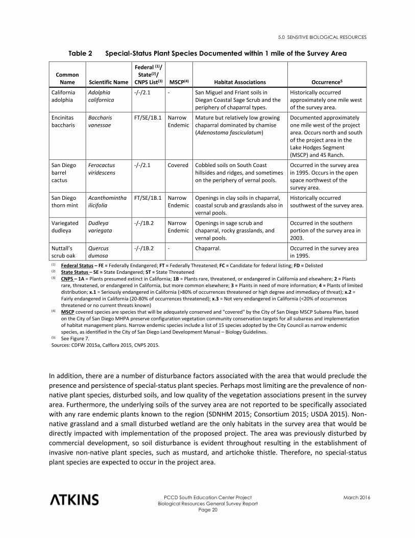
Table 2 Special-Status Plant Species Documented within 1 mile of the Survey Area
Common Name Scientific Name
Federal (1)/ State(2)/
CNPS List(3) MSCP(4) Habitat Associations Occurrence5
California adolphia
Adolphia californica
-/-/2.1 - San Miguel and Friant soils in Diegan Coastal Sage Scrub and the periphery of chaparral types.
Historically occurred approximately one mile west of the survey area.
Encinitas baccharis
Baccharis vanessae
FT/SE/1B.1 Narrow Endemic
Mature but relatively low growing chaparral dominated by chamise (Adenostoma fasciculatum)
Documented approximately one mile west of the project area. Occurs north and south of the project area in the Lake Hodges Segment (MSCP) and 4S Ranch.
San Diego barrel cactus
Ferocactus viridescens
-/-/2.1 Covered Cobbled soils on South Coast hillsides and ridges, and sometimes on the periphery of vernal pools.
Occurred in the survey area in 1995. Occurs in the open space northwest of the survey area.
San Diego thorn mint
Acanthomintha ilicifolia
FT/SE/1B.1 Narrow Endemic
Openings in clay soils in chaparral, coastal scrub and grasslands also in vernal pools.
Historically occurred southwest of the survey area.
Variegated dudleya
Dudleya variegata
-/-/1B.2 Narrow Endemic
Openings in sage scrub and chaparral, rocky grasslands, and vernal pools.
Occurred in the southern portion of the survey area in 2003.
Nuttall’s scrub oak
Quercus dumosa
-/-/1B.2 - Chaparral. Occurred in the survey area in 1995.
(1) Federal Status – FE = Federally Endangered; FT = Federally Threatened; FC = Candidate for federal listing; FD = Delisted (2) State Status – SE = State Endangered; ST = State Threatened (3) CNPS – 1A = Plants presumed extinct in California; 1B = Plants rare, threatened, or endangered in California and elsewhere; 2 = Plants
rare, threatened, or endangered in California, but more common elsewhere; 3 = Plants in need of more information; 4 = Plants of limited distribution; x.1 = Seriously endangered in California (>80% of occurrences threatened or high degree and immediacy of threat); x.2 = Fairly endangered in California (20-80% of occurrences threatened); x.3 = Not very endangered in California (<20% of occurrences threatened or no current threats known)
(4) MSCP covered species are species that will be adequately conserved and "covered" by the City of San Diego MSCP Subarea Plan, based on the City of San Diego MHPA preserve configuration vegetation community conservation targets for all subareas and implementation of habitat management plans. Narrow endemic species include a list of 15 species adopted by the City Council as narrow endemic species, as identified in the City of San Diego Land Development Manual – Biology Guidelines.
(5) See Figure 7. Sources: CDFW 2015a, Calflora 2015, CNPS 2015.
In addition, there are a number of disturbance factors associated with the area that would preclude the
presence and persistence of special-status plant species. Perhaps most limiting are the prevalence of non-
native plant species, disturbed soils, and low quality of the vegetation associations present in the survey
area. Furthermore, the underlying soils of the survey area are not reported to be specifically associated
with any rare endemic plants known to the region (SDNHM 2015; Consortium 2015; USDA 2015). Non-
native grassland and a small disturbed wetland are the only habitats in the survey area that would be
directly impacted with implementation of the proposed project. The area was previously disturbed by
commercial development, so soil disturbance is evident throughout resulting in the establishment of
invasive non-native plant species, such as mustard, and artichoke thistle. Therefore, no special-status
plant species are expected to occur in the project area.
!(!(
!(
!(
!(
!(
!(
!(
!(
!(
!(
!(
FIGURE 7Existing Biology Data
Palomar College South Education Center BTR100028572
Legend
Project Boundary1 Mile Site Buffer
SANBIOS!( Bell's sage sparrow!( California gnatcatcher!( California myotis!( Desert woodrat!( Southern California rufous crowned sparrow
CNDDBCalifornia adolphiaEncinitas baccharisSan Diego barrel cactusSan Diego desert woodratSan Diego thorn-mintcoast horned lizardcoastal California gnatcatchercoastal cactus wrenvariegated dudleyayellow-breasted chat
Source: CNDDB, Apri, 2015; SanBIOS, 2015; ESRI 2015
9/24/2015 bela7036 \\sdofs01\data\Clients\Palomar CCD\100028572 Palomar South Ed Center ENV EIR\Technical Reports\BTR\Figures\support\GIS\mxd\FigX_ExistingBologyData1mi.mxd
° 0 700 1,400350
Feet
1 inch = 1,400 feet
5.0 SENSITIVE BIOLOGICAL RESOURCES
PCCD South Education Center Project
Biological Resources General Survey Report
Page 22
March 2016
Sensitive vegetation communities in the survey area also have limited potential to support special-status
plant species. The mixed and scrub oak chaparral are dense, homogenous, and provide little canopy or
understory opportunity for rare endemic plants to become established. The understory of the mixed
chaparral consists entirely of non-native herbs, and none of the shrub species observed in the canopy are
considered to be sensitive. The native grassland occurs in isolated patches and includes many introduced
annual grasses. Similarly, the areas mapped as disturbed/non-native vegetation, including eucalyptus
woodland, ornamental plantings, and non-native grassland, are entirely occupied by non-native plants,
most notably, freeway ice plant, gum tree, pine tree, and Mexican fan palm. Therefore, no special-status
plant species would be expected to occur in the surveyed habitats outside the project area.
Special-status Animal Species
Special-status animal species are those listed as threatened or endangered, proposed for listing, or
candidates for listing by the USFWS (2015b) or CDFW (2015c) or animals of special concern listed by CDFW
(2015c) and/or covered species under the City’s MSCP Subarea Plan.
Based on a list compiled through the CNDDB and SANDAG San Diego MSCP data (CDFW 2015a, SANGIS
2015), 13 special-status animal species have been documented within approximately one mile of the
survey area (Table 3) and an additional 14 species have been documented between one and two miles
from the survey area (Table A-2 in Appendix A).
Special-status bird, mammal, and reptile species reported within one mile of the survey area are listed in
Table 3. Species highlighted in bold print in Table 3 have the greatest potential to occur in the native
habitat in the survey area. One special-status reptile species the Blainville’s horned lizard (Phrynosoma
blainvillii) has the potential to occur in the survey area. Blainville’s horned lizard occurs in coastal sage
scrub and chaparral habitat and has been documented northwest of the project area in the MSCP Preserve
Land. No special-status amphibian species are likely to occur within two miles of the survey area.
Bird species with the greatest potential to transit through or forage in the survey area include southern
California rufous-crowned sparrow (Aimophila ruficeps canescens), Bell’s sage sparrow (Amphispiza belli
belli), Cooper’s hawk (Accipiter cooperii), and white-tailed kite (Elanus leucurus) (Table 3).
In 1995 prior to original site development, southern California rufous-crowned sparrow, Cooper’s hawk,
white-tailed kite, and coastal California gnatcatcher were recorded in the coastal sage scrub in the survey
area (2004 AMEC). However, subsequent grading activities have reduced the potential of the area to
support these special-status species and none of these four species were recorded during subsequent
surveys in 2001, 2003, 2012, and 2015. Protocol surveys for coastal California gnatcatcher were also
performed in 2001, but no gnatcatchers were observed and the species was deemed to be absent from
the site (AMEC 2004, Atkins 2012). Southern California rufous-crowned sparrow, Bell’s sage sparrow,
Cooper’s hawk, and white-tailed kite have moderate potential to forage or fly through the coastal sage
scrub and chaparral habitat currently occurring in the survey area adjacent to the project area. These birds
are not expected to nest in these habitats due to the small patch sizes and proximity to development.
However, southern California rufous-crowned sparrow and Bell’s sage sparrow breed in the chaparral and
coastal sage scrub habitat in the MSCP Preserve Land northwest of the project area (Figure 7).
5.0 SENSITIVE BIOLOGICAL RESOURCES
PCCD South Education Center Project
Biological Resources General Survey Report
Page 23
March 2016
Table 3 Special-Status Animals Documented or Known to Occur within
1 mile of the Survey Area
Common Name Scientific Name
Federal Status(1)
State Status(2) MSCP(3) Habitat Associations
Occurrence in Survey Area
Reptiles
Blainville’s horned lizard
Phrynosoma blainvillii
- SSC Covered Inhabits coastal sage scrub and chaparral.
Moderate potential to occur in the survey area
Birds
American peregrine falcon
Falco peregrinus anatum
FD SE Covered Wetlands, lakes, rivers, or other water or on cliffs, banks, dunes, or mounds.
Not likely to occur.
Bell's sage sparrow
Amphispiza belli - WL - Nests in chaparral dominated by fairly dense stands of chamise.
Occurred in the survey area in 1995. Moderate potential to occur in the survey area.
Burrowing owl Athene cunicularia
- SSC Covered Open, dry annual, or perennial grasslands, deserts and scrublands characterized by low-growing vegetation.
Not likely to occur.
Coastal cactus wren
Campylorhynchus brunneicapillus sandiegensis
- SSC Covered Coastal sage scrub with tall Opuntia cactus for nesting and roosting.
Not likely to occur; cactus is not present on site. Historically occurred within a mile prior to housing developments in the area.
Coastal California gnatcatcher
Polioptila californica
FT SSC Covered Low, coastal sage scrub in arid washes, on mesas, and on slopes.
Low potential to occur in the survey area based small patchy habitat and previous surveys.
Cooper's hawk Accipiter cooperii - WL Covered Open, interrupted, or marginal type woodland. Nest sites mainly found in riparian growths of deciduous trees in canyon bottoms on river flood-plains.
Occurred in the survey area in 1995. Likely to fly over the survey area. Not likely to nest in the survey area.
Southern California rufous-crowned sparrow
Aimophila ruficeps canescens
- WL Covered Coastal sage scrub and sparse mixed chaparral.
Occurred within the study area in 1995. Moderate potential to occur in the survey area.
Yellow-breasted chat
Icteria virens - SSC - Summer resident that inhabits riparian thickets of willow and other brushy tangles near watercourses.
Not likely to occur.
White-tailed kite
Elanus leucurus - SFP - Rolling foothills and valley margins with scattered oaks and river bottomlands or marshes next to deciduous woodland. Open grasslands, meadows, or marshes for foraging.
Occurred in the survey area in 1995. Moderate potential to fly over the survey area. Not likely to nest in the survey area.
5.0 SENSITIVE BIOLOGICAL RESOURCES
PCCD South Education Center Project
Biological Resources General Survey Report
Page 24
March 2016
Table 3 Special-Status Animals Documented or Known to Occur within
1 mile of the Survey Area
Common Name Scientific Name
Federal Status(1)
State Status(2) MSCP(3) Habitat Associations
Occurrence in Survey Area
Mammals
San Diego black-tailed jackrabbit
Lepus californicus bennettii
- SSC - Coastal sage scrub and chaparral.
Moderate potential to occur in the survey area.
San Diego desert woodrat
Neotoma lepida intermedia
- SSC - Rock outcrops and slopes with moderate to dense canopies.
Likely to occur in the survey area.
Southern mule deer
Odocoileus hemionus
- - Covered Variety of habitats over a broad range.
Likely to forage and transit through the survey area.
(1) Federal Status – FE = Federally Endangered; FT = Federally Threatened; FC = Candidate for federal listing; FD = Delisted (2) State Status – SE = State Endangered; ST = State Threatened (3) MSCP covered species are species that will be adequately conserved and "covered" by the City of San Diego MSCP Subarea Plan, based
on the City of San Diego MHPA preserve configuration vegetation community conservation targets for all subareas and implementation of habitat management plans. Narrow endemic species include a list of 15 species adopted by the City Council as narrow endemic species, as identified in the City of San Diego Land Development Manual – Biology Guidelines.
References: CDFW 2015a, Calflora 2015, CNPS 2015.
Three special-status mammals have the potential to occur in the survey area. Southern mule deer
(Odocoileus hemionus) is likely to forage in and transit the study area and has potential to occur in the
project area. San Diego black-tailed jackrabbit (Lepus californicus bennettii) and San Diego desert woodrat
has the potential to occur in the survey area. The project area is likely to open and sparsely vegetated to
support the jackrabbit or woodrat.
During a general biological survey in 2012, a single woodrat nest was observed in the coastal sage scrub
habitat in the northwestern portions of the survey area. It could not be determined as to whether or not
the nest belonged to the San Diego desert woodrat, which is not federal or state threatened or
endangered, and is not an MSCP covered species. However, this woodrat is designated as a species of
special concern by the CDFW. The observed woodrat nest was old, collapsed, and did not appear to be
active; however, given the scope of the survey, it could not be positively confirmed or denied that the
nest belonged to the San Diego desert woodrat. All of the resources required by this species can be found
on or in the immediate vicinity of the survey area. Given the uncertainty, this species is determined to
have a high potential to occur in the survey area. With the exception of the San Diego desert woodrat, no
other special-status wildlife species were observed or otherwise detected in the survey area during the
general biological surveys conducted on March 31, 2012 and May 14, 2015, including any of the other 27
special-status animal species in documented within two miles of the project (CDFW 2015a).
There is a number of disturbance factors associated with the survey area and vicinity that would preclude
most special-status animal species from occurring within the habitat. Perhaps most limiting are: (1) the
proximity to existing developments and disturbances, including regular lighting, noise, vehicle, and
pedestrian activity; and (2) the overall low quality of the habitat present in the survey area with respect
to providing nesting, foraging, dispersal, refuge or other elements preferred by special-status animals
known to occur in the region.
5.0 SENSITIVE BIOLOGICAL RESOURCES
PCCD South Education Center Project
Biological Resources General Survey Report
Page 25
March 2016
The adjacent commercial developments and undeveloped areas are regularly used by vehicles and/or
pedestrians, which may result in adverse direct and indirect effects to the habitat and special-status
animal species attempting to use the habitat. The survey area is subject to adverse direct effects resulting
from encroachment into the habitat by pedestrians, of which, was evident in the survey area from existing
foot trails, trash, and debris. Pedestrian activity, trash, and debris reduce the quality of the habitat and
reduce the likelihood for most special-status animal species to occur. The survey area is also subject to
adverse indirect effects from noise and night lighting, the effects of which could also deter special-status
animal species from using the area.
Furthermore, the habitat in the survey area and immediate vicinity is constrained in all directions by
existing developments and roads, thereby reducing the likelihood for special-status animal species to
occur. What little habitat remains has been reduced to small, fragmented, and low quality stands. The
existing developments and Rancho Bernardo Road make it difficult for small mammals and reptiles to
disperse into the area. These species tend to depend on habitat connectivity without substantial
development barriers as they move throughout their range. Also, the small size and low quality of the
existing habitat do not offer the space and resources required by most of the special-status animal species
known to be associated with the habitat types present in the survey area.
In conclusion, existing development, roads, disturbances, and vegetation composition, limit the number
of special-status species that can use the habitat in the survey area. However, a few species, southern
mule deer, San Diego jackrabbit, San Diego desert woodrat, and Blainville’s horned lizard (refer to Table
3) could occur within or adjacent to the project area. No federally or state listed animal species are likely
to occur within or in the immediate vicinity of the project area.
5.2 Sensitive Natural Communities
As discussed in Section 4.0, the survey area supports the following sensitive natural communities: 0.14
acre of native grassland, 1.47 acres of scrub oak chaparral, 3.67 acres of coastal sage scrub, 2.25 acres of
coastal sage scrub-disturbed, 2.18 acres of mixed chaparral, and 0.07 acre of disturbed wetland (Table 1;
Figure 6). The terrestrial communities are considered sensitive by CDFW (CDFG 2010). No sensitive natural
communities occur within the project area. Southern cottonwood willow riparian forest, an additional
sensitive natural community, occurs approximately 1.5 miles north of the survey area (CDFW 2015a).
However, there is no obvious connectivity to the survey area.
5.3 Jurisdictional Waters and Wetlands
In the context of this assessment, jurisdictional waters and wetlands generally include those resources
regulated by: the U.S. Army Corps of Engineers (USACE) pursuant to Section 404 of the Federal Clean
Water Act (CWA), the Regional Water Quality Control Board (RWQCB) pursuant to Section 401 of the CWA
and State Porter-Cologne Water Quality Control Act, and the CDFW pursuant to Sections 1600 et. seq. of
the CFG Code.
A narrow, concrete-lined drainage ditch transects areas in the north and south portions of the survey area.
This unnamed drainage feature supports disturbed wetland habitat but does not exhibit an ordinary high
water mark (OHWM). Although not confirmed, downstream flows presumably continue to the north
beneath Rancho Bernardo Road and discharge to underground municipal stormwater facilities. Due to the
lack of an OHWM and connectivity to a jurisdictional waterway, the unnamed drainage feature and
5.0 SENSITIVE BIOLOGICAL RESOURCES
PCCD South Education Center Project
Biological Resources General Survey Report
Page 26
March 2016
associated wetlands would likely not fall under the regulatory jurisdiction of the USACE, RWQCB, and
CDFW.
5.4 Wildlife Corridors and Linkages
Development in the region has reduced the total available open space for wildlife populations, and in
some instances, created isolated "islands" of habitat. In general, wildlife corridors and linkages are smaller
constrained areas of habitat that connect larger areas of habitat that are otherwise separated by rugged
terrain, changes in vegetation, or urban development. This allows for interactions between otherwise
isolated populations and an exchange of genetic material, which increases the viability and overall health
of the population. Wildlife corridors are especially important for species with large habitat ranges or
seasonal migrations. A corridor is a specific route that is used for the movement and migration of species,
and may be different from a linkage in that it represents a smaller or narrower avenue for movement. A
linkage is an area of land that supports or contributes to the long-term movement of wildlife and genetic
exchange by providing live-in habitat that connects to other habitat areas. Many linkages occur as
stepping-stone linkages that are comprised of fragmented archipelago arrangement of habitat over a
linear distance. Corridors and linkages consist of land features that accommodate the movement of all
sizes of wildlife, including large animals on a regional scale. These areas support adequate vegetation
cover and provide visual continuity and long lines of sight, so as to encourage the use of the corridor by
all types of wildlife. In San Diego County, important corridors and linkages have been identified on the
local and regional scale, particularly in establishing a connection between the northern and southern
regional populations of the federally threatened coastal California gnatcatcher.
No known wildlife corridors or linkages occur within the survey area (City of San Diego 1997; SanGIS 2015).
The survey area is constrained and surrounded by existing developments and roads, and does not support
habitat that would contribute substantially to the assembly and function of any local or regional wildlife
corridors or linkages. What little habitat remains on site has been reduced to small, fragmented, and low
quality stands, which are disconnected from better quality habitat in the local and regional area. Animal
species that require direct or less-constrained habitat connectivity along their travel routes would be
challenged to find access to habitat in the survey area and immediate vicinity. Although local habitat in
the immediate vicinity of the survey area could be used as potential stepping-stone habitat for certain
migratory and resident birds, habitat in the survey area itself is disturbed and lacks adequate cover or
resources and is unlikely to attract or sustain dense populations of local wildlife. Therefore, the survey
area does not support habitat that would contribute substantially to the assembly and function of any
local or regional wildlife corridors or linkages.
The Lake Hodges Segment of the MSCP Subarea Plan preserve area is situated approximately 1.5 miles to
the northwest of the project site. The preserve area protects a portion of the Hodges Reservoir/San
Pasqual Valley core resource area identified in the final MSCP and provides vital regional linkage
northwest to the Carlsbad/La Costa region. This area represents a primary connection between the two
regions for the coastal California gnatcatcher (City of San Diego 1997). The proposed improvements would
not impact habitat within the preserve area, nor would the proposed project affect the preserve area’s
ability to serve as a wildlife corridor.
6.0 PROJECT IMPACT ANALYSIS
PCCD South Education Center Project
Biological Resources General Survey Report
Page 27
March 2016
6.0 Project Impact Analysis
This section provides a project-level biological resources impact analysis for the proposed project in
support of environmental review. The issues addressed in this section are derived from the City of San
Diego Initial Study Checklist, as presented in the Development Services Department CEQA Significance
Determination Thresholds (City of San Diego 2011) and Appendix G of the CEQA Guidelines. Mitigation,
monitoring, and reporting requirements to eliminate or reduce project impacts to a less than significant
level are provided in Section 7.0.
6.1 Issue 1: Special-Status Species
Would the project result in a substantial adverse impact, either directly or through habitat modifications,
on any species identified as a candidate, sensitive, or special-status species in the MSCP or other local or
regional plans, policies or regulations, or by the CDFW or USFWS?
Special-Status Plant Species
As discussed in Section 5.0, no special-status plant species were determined to have moderate to high
potential to occur in the survey area (Table 2). Additionally, no special-status plant species were observed
in the survey area during the general biological surveys in June and October 2012 and May 2015. The
project would result in direct impacts to existing habitat that is highly disturbed and generally unsuitable
for special-status plant species. Given the relatively small area proposed to be impacted, marginal quality
of the habitat, and the fact that no special-status plant species were observed during surveys in June or
October 2012 or May 2015, no special-status plant species would be expected to occur in the proposed
permanent impact areas. Therefore, the proposed project is not anticipated to result in any significant
impacts to special-status plant species and no mitigation is required.
Special-Status Animal Species
Also discussed in Section 5.0, a few relatively common local species were determined to have a high
potential to occur in the project area (Table 3). A possible San Diego desert woodrat nest observed in the
northwestern portion of the survey area had been abandoned for some time and occurred outside of the
proposed permanent and temporary impact areas. No other sign of woodrat was observed within the
survey area during the June and October 2012 or May 2015 surveys and no sign of woodrat was ever
observed in the areas proposed to be directly or indirectly impacted by the project. Therefore, no direct
impacts to woodrats, including the CDFW species of special concern San Diego desert woodrat, are
anticipated to occur as a result of the proposed project and no mitigation is required.
Furthermore, the project would result in direct impacts to existing habitat that is highly disturbed and
generally unsuitable for occurrence of most special-status animal species. Much of the existing habitat in
the proposed impact areas occurs in land that has been previously disturbed, developed, and/or planted
with ornamental species. The relatively limited amount of habitat that occurs in the proposed impact
areas is also not connected to the nearby preservation area; they are separated by about 0.25 mile of
development and Rancho Bernardo Road. Adjacent habitats within the survey area are disturbed,
surrounded by existing developments, relatively small in size, and would not be expected to support any
permanent populations of special-status animal species. Therefore, no special-status animal species
would be expected to permanently reside in the proposed permanent impact areas. The special-status
6.0 PROJECT IMPACT ANALYSIS
PCCD South Education Center Project
Biological Resources General Survey Report
Page 28
March 2016
species that are likely to use the project area to forage to transit are likely to also use the larger
surrounding habitat. Consequently, the proposed project is not anticipated to result in any significant
impacts to special-status animal species and no mitigation is required.
Nesting Birds
The Federal Migratory Bird Treaty Act (MBTA) protects all common wild birds found in the United States
except the house sparrow (Passer domesticus), European starling (Sturnus vulgaris), feral pigeon (Columba
livia), and resident game birds such as pheasant (Phasianus colchicus), grouse (Dendragapus sp.), quail
(Callipepla sp.), and wild turkey (Meleagris gallopavo). Resident game birds are managed separately by
each state. The MBTA makes it unlawful for anyone to kill, capture, collect, possess, buy, sell, trade, ship,
import, or export any migratory bird, including feathers, parts, nests, or eggs.
Section 3503 of the CFG Code makes it illegal to destroy any birds’ nest or any birds’ eggs that are
protected under the MBTA. Section 3503.5 further protects all birds in the orders Falconiformes and
Strigiformes (birds of prey), such as hawks and owls, and their eggs and nests from any form of take.
Although no special-status animal species would be expected to occur, the survey area and immediate
vicinity contain trees, shrubs, and man-made structures (e.g., buildings) that provide suitable nesting
habitat for common (non-sensitive) birds, including common raptors protected under the MBTA and CFG
Code. Construction of the proposed project could result in the removal or trimming of trees and shrubs
during the general bird nesting season (March 15 through September 15), and therefore, could result in
impacts to nesting birds in violation of the MBTA and CFG Code. Direct impacts could occur as a result of
removal of vegetation supporting an active nest. Indirect impacts could occur as a result of construction
noise and vibration in the immediate vicinity of an active nest, such that the disturbance results in nest
failure. These impacts would be considered significant and in violation of the MBTA and CFG Code.
Mitigation Measure Bio-1 in Section 7.0 would require that the PCCD retain a qualified biologist approved
by the City of San Diego to perform pre-construction surveys and implement avoidance measures to
prevent construction-related impacts to nesting birds in violation of the MBTA and CFG Code.
6.2 Issue 2: Sensitive Natural Communities
Would the project result in a substantial adverse impact on any sensitive natural community identified in
local or regional plans, policies, regulations, or by the CDFW or USFWS?
All sensitive natural communities discussed in Section 5.2 will be avoided with the exception of disturbed
wetland, which is considered in Section 6.3 below. The proposed project would result in temporary and
permanent impacts to approximately 5.47 acres of non-native grassland (discussed in Section 6.3) and
maintenance of 0.36 acre of ornamental planting.
Project construction would occur adjacent to sensitive natural communities and habitats (i.e., coastal sage
scrub and chaparral). Adverse indirect impacts to sensitive natural communities and habitats located
immediately adjacent to the project site would be considered significant. No indirect impacts resulting
from storm water runoff from the construction site are expected. However, construction activities could
result in adverse indirect impacts to adjacent sensitive natural communities and habitats pertaining to
water quality should fluid leaks from construction vehicles, concrete spoils and other hazardous
6.0 PROJECT IMPACT ANALYSIS
PCCD South Education Center Project
Biological Resources General Survey Report
Page 29
March 2016
construction materials occur at the project site and upstream of other sensitive natural communities and
habitats.
Mitigation Measures Bio-2 and Bio-3 in Section 7.0 would require that the PCCD implement BMPs during
construction to ensure avoidance of adjacent sensitive natural communities and reduce potential indirect
impacts to less than significant.
6.3 Issue 3: Wetlands
Would the project result in a substantial adverse impact on wetlands (including, but not limited to, marsh,
vernal pool, riparian, etc.) through direct removal, filling, hydrological interruption, or other means?
The proposed project is not likely to result indirect impacts to disturbed wetlands. As proposed, there
would be about a 150 foot buffer between the disturbed wetland and the nearest project-related
construction activity. No direct impacts would occur to the disturbed wetlands, which are depicted in
Figure 6. No potential jurisdictional waters and wetlands, including federally protected wetlands as
defined by Section 404 of the CWA, were determined to occur within the proposed project impact area.
Mitigation Measures Bio-2 and Bio-3 in Section 7.0 provide protection measures to reduce the significance
of potential indirect impact to the disturbed wetland within the survey area, as this could be considered
a sensitive natural community by the City of San Diego as described in Section 5.3. Because no other
waters or wetlands occur within the survey area, the proposed project would not have a substantial
adverse effect on federally protected wetlands as defined by Section 404 of the CWA (including, but not
limited to, marsh, vernal pool, coastal, etc.) through direct removal, filling, hydrological interruption, or
other means. Therefore, no further mitigation would be required.
6.4 Issue 4: Wildlife Corridors
Would the project interfere substantially with the movement of any native resident or migratory fish or
wildlife species or with established native resident or migratory wildlife corridors, including linkages
identified in the MSCP Plan, or impede the use of native wildlife nursery sites?
No known wildlife corridors or linkages occur within the survey area (City of San Diego 1997; SanGIS 2015).
Furthermore, the survey area is constrained by existing developments and does not support habitat that
would contribute substantially to the assembly and function of any local or regional wildlife corridors or
linkages. Construction of the project would not affect the nearby MSCP preserve land. Therefore, the
project would not interfere substantially with the movement of any native resident or migratory fish or
wildlife species or with established native resident or migratory wildlife corridors, including linkages
identified in the MSCP Plan, or impede the use of native wildlife nursery sites. Consequently, no mitigation
is required.
6.0 PROJECT IMPACT ANALYSIS
PCCD South Education Center Project
Biological Resources General Survey Report
Page 30
March 2016
6.5 Issue 5: Habitat Conservation Plans
Would the project conflict with the provisions of an adopted Habitat Conservation Plan, Natural
Conservation Community Plan, or other approved local, regional, or state habitat conservation plan, either
in the MSCP plan area or in the surrounding region?
The proposed project does not occur in the boundaries of the MSCP Subarea Plan. The project is not
expected to result in any significant impacts to special-status species, including MSCP covered species and
narrow endemic species. The project would not result in impacts to any wildlife corridors or linkages,
including lands identified in the MSCP Subarea Plan as important habitat linkages or other areas of local
or regional wildlife movement importance. The project would also not prevent the City of San Diego from
attaining the conservation goals and objectives of the MSCP Subarea Plan area. Therefore, no mitigation
is required.
6.6 Issue 6: Land Use Adjacency
Would the project introduce land use in an area adjacent to the MHPA that would result in adverse edge
effects?
The proposed project would occur in an area that is already predominantly developed and on habitats
that are largely disturbed. The project would not introduce any new land uses to the area compared to
the pre-project, current land uses. Furthermore, an adverse edge effect likely already exists in the area
based on the project site’s proximity to developments. The project does not propose any activity or new
structure that would exacerbate the existing adverse edge effect. Therefore, the project would not result
in any adverse edge effects (direct or indirect) near the MHPA and no mitigation is required.
6.7 Issue 7: Local Policies and Ordinances
Would the project conflict with any local policies or ordinances protecting biological resources?
Mitigation Measures Bio-1 through Bio-3 in Section 7.0 would require that avoidance and protection
measures, including BMPs, be implemented during construction. Sensitive habitats would be fenced and
avoided, thereby reducing direct impacts to less than significant levels. With the implementation of
Mitigation Measures Bio-1 through Bio-3, the proposed project would not conflict with any local policies
or ordinances protecting biological resources. Therefore, no further mitigation is required.
6.8 Issue 8: Invasive Species
Would the project result in an introduction of invasive species of plants into a natural open space area?
No natural open space areas with be directly impacted by the proposed project. Indirect impacts to open
space will be mitigation through implementation of measures Bio-2 and Bio-3 in Section 7.0. Therefore,
the project would not result in the introduction or spread of invasive species into a natural open space
and no further mitigation is required.
7.0 MITIGATION, MONITORING, AND REPORTING
PCCD South Education Center Project
Biological Resources General Survey Report
Page 31
March 2016
7.0 Mitigation, Monitoring, and Reporting
Development of the proposed project has the potential to directly or indirectly affect biological resources.
The following mitigation measures would reduce impacts to biological resources to a less than significant
level.
Implementation of Mitigation Measure Bio-1 would reduce impacts to nesting birds and would allow the
project to be in accordance with the MBTA and CFG Code.
Bio-1 Pre-Construction Nesting Bird Surveys. Vegetation should not be removed from the project site
between March 15 and September 15 to avoid impacts to nesting birds. If project construction
cannot be avoided during the period of March 15 through September 15, the PCCD shall have a
qualified biologist approved by the survey all potential nesting vegetation on and within 300 feet
of the project site (where access is available) for nesting birds, prior to commencing project
activities (including construction and/or site preparation). Surveys shall be conducted once a day
for two days at the appropriate time of day during the breeding season, and surveys shall be
performed no more than three days prior to vegetation removal and/or disturbance. If no nesting
birds are observed, project activities may begin without further mitigation. If an active bird nest
is located, the nest site shall be fenced with an exclusion zone of a minimum of 200 feet (500 feet
for raptors) in all directions (as feasible considering site boundaries) and this area shall not be
disturbed until after September 15 or until the nest becomes inactive.
Implementation of Mitigation Measure Bio-2 would prevent direct impacts to habitat located adjacent to
the construction site and would also reduce potential indirect impacts pertaining to the spread of silt and
general disturbance from the construction zone to a less than significant level.
Bio-2 Construction Fencing and BMPs. Prior to vegetation clearing, grading, and/or construction
activities, the PCCD will retain a qualified biologist to oversee installation of appropriate
fencing to delineate the limits of construction and the approved construction staging areas.
Temporary fencing (with silt barriers) will be installed at the limits of project impacts
(including construction staging areas and access routes, as feasible) to prevent sensitive
habitat impacts outside the project area and to prevent the spread of silt from the
construction zone into adjacent habitats. Fencing will be installed in a manner that does not
impact habitats to be avoided. The temporary construction fencing will be removed by the
PCCD upon project completion.
Also, standard construction BMPs shall be implemented on site, including but not limited to:
observation of a reduced 20-mile per hour speed limit in all project areas, limiting
construction activities to day-time only (no additional lighting required), placing trash in
closed containers, prohibiting firearms on site; prohibiting pets on site, and ensuring
construction noise shall not significantly exceed the existing ambient noise level.
Implementation of Mitigation Measure Bio-3 would reduce potential indirect impacts pertaining to the
spill of contaminants in the construction zone to a less than significant level.
Bio-3 Construction Staging and Equipment Maintenance. The PCCD shall ensure fueling of
equipment occurs solely in designated fueling zones or off site. All equipment used in the
approved construction limits will be maintained to minimize and control fluid and grease
8.0 CERTIFICATION AND ACKNOWLEDGEMENTS
PCCD South Education Center Project
Biological Resources General Survey Report
Page 32
March 2016
leaks. Provisions to contain and clean up unintentional leaks/spills of construction materials
(e.g., concrete), fuel, oil, fluid and grease shall be in place prior to construction.
Finally, with implementation of Mitigation Measures Bio-1 through Bio-3, the proposed project would
have minimal impacts to native vegetation or wildlife within and adjacent to the project area. Therefore,
the proposed project is not expected to result in a significant cumulative impact for biological resources
with implementation of the mitigation measures outlined in this section.
8.0 Certification and Acknowledgements
I hereby certify that the statements furnished above and in the attached exhibits present data and
information required for this biological evaluation and that the facts, statements, and information
presented are true and correct to the best of my knowledge and belief.
Signed: Date: March 24, 2016
Melissa Tu, Senior Biologist
Atkins
9.0 REFERENCES
PCCD South Education Center Project
Biological Resources General Survey Report
Page 33
March 2016
9.0 References
AMEC Earth and Environmental, Inc. 2004. Biological Resources Technical Report, Bernardo Industrial
Park North, Lot 11, Project 1096. Prepared for Granum Partners. August.
Atkins. 2012. PCCD South Education Center Biological Resources General Survey Report.
Baldwin B.G, D.H. Goldman, D.J Keil, R. Patterson, T.J Rosatti, and D.H. Wilken. 2012. The Jepson
Manual: Higher Plants of California. University of California Press. Berkeley, California.
Calflora. 2015. Calflora Plant Observation Library. Data provided by the participants of Calflora. Accessed
June 16, 2015 at http://www.calflora.org/cgi-bin/occform.cgi
California Department of Fish and Game (CDFG). 2008. Complete List of Amphibian, Reptile, Bird and
Mammal Species in California. September. Accessed April 27, 2015 at
https://www.dfg.ca.gov/biogeodata/cwhr/pdfs/species_list.pdf
California Department of Fish and Game (CDFG). 2010. List of California Terrestrial Natural Communities
Recognized by the California Natural Diversity Database. September. California Department of
Fish and Game, California Natural Diversity Database. Sacramento, California. Accessed April 30,
2015 at http://www.dfg.ca.gov/biogeodata/vegcamp/pdfs/natcomlist.pdf
California Department of Fish and Wildlife (CDFW). 2015a. Biogeographic Data Branch, California Natural
Diversity Database (CNDDB), RareFind. May 2015 data.
California Department of Fish and Wildlife (CDFW). 2015b. Special Vascular Plants, Bryophytes, and
Lichens List. California Natural Diversity Database. Sacramento, California. Accessed April 27,
2015 at http://www.dfg.ca.gov/biogeodata/cnddb/pdfs/SPPlants.pdf
California Department of Fish and Wildlife (CDFW). 2015c. Special Animals. California Department of
Fish and Wildlife, California Natural Diversity Database. Sacramento, California. March. Accessed
April 27, 2015 at http://www.dfg.ca.gov/biogeodata/cnddb/pdfs/SPAnimals.pdf
California Native Plant Society (CNPS). 2015. California Native Plant Society Electronic Inventory.
Accessed June16, 2015 at http://cnps.site.aplus.net/cgi-bin/inv/inventory.cgi
City of San Diego. 1997. Final City of San Diego MSCP Subarea Plan. March 1997. Available at
http://www.sandiego.gov/planning/programs/mscp/pdf/subareafullversion.pdf
City of San Diego. 2009. San Diego Municipal Code. Land Development Code. Biology Guidelines.
(Amended) August 2009. Available at
http://www.sandiego.gov/planning/community/pdf/cpc/agendas/attachments/ldcbiologyguide
draft.pdf
City of San Diego. 2011. Significance Determination Guidelines under CEQA. January. Available at
http://www.sandiego.gov/development-services/news/pdf/sdtceqa.pdf
City of San Diego. 2012. San Diego Municipal Code. Land Development Code. Regulations, Amendments,
and Related Documents (Amended) April 2012. Accessed April 30, 2015 at
http://www.sandiego.gov/development-services/industry/landdevcode/#code
9.0 REFERENCES
PCCD South Education Center Project
Biological Resources General Survey Report
Page 34
March 2016
Consortium of California Herbaria (Consortium). 2015. Data provided by the participants of the
Consortium of California Herbaria. Accessed April 28, 2015 at
http://ucjeps.berkeley.edu/consortium/
Google Earth. 2015. Google Earth 5.0. Available at http://earth.google.com/.
Holland, R.F. 1986. Preliminary Descriptions of the Terrestrial Natural Communities of California. Non-
game Heritage Program. California Department of Fish and Game. Sacramento, California.
Jepson Flora Project (eds.) 2013. Jepson eFlora. Accessed June 18, 2015 at
http://ucjeps.berkeley.edu/IJM.html
Lightner, J. 2011. San Diego County Native Plants. San Diego, California: San Diego Flora.
Munz, P.A. 1974. A Flora of Southern California. University of California Press. Berkeley, California.
Oberbauer, T. 1996. Terrestrial Vegetation Communities in San Diego County Based on Holland’s
descriptions, 6p.
Oberbauer, T. M., M. Kelly, and J. Buegge. 2008. Draft Vegetation Communities of San Diego County.
Based on “Preliminary Descriptions of the Terrestrial Natural Communities of California”
prepared by Robert F. Holland, Ph.D., October 1986). March 2008. Accessed April 30, 2015 at
http://www.sandiegocounty.gov/content/dam/sdc/pds/ceqa/Soitec-Documents/Final-EIR-
Files/references/rtcref/ch9.0/rtcrefaletters/O14%202014-12-19_OberbauerTM2008.pdf
San Diego Natural History Museum (SDNHM). 2015. San Diego County Plant Atlas Project. Available at
http://www.sdplantatlas.org/(S(gn2sqn45kw1fmc45trphjz55))/index.aspx
SanGIS. 2015. SanGIS Interactive Map. Information provided by the participants of San GIS. Accessed in
May 2015 at http://sdgis.sandag.org/
U.S. Department of Agriculture (USDA). 2015. Soil Survey Staff, Natural Resources Conservation Service,
Web Soil Survey. Access in May 2015 at http://websoilsurvey.nrcs.usda.gov/app/HomePage.htm
U.S. Fish and Wildlife Service (USFWS). 2010. Coastal California Gnatcatcher 5-year Review.
U.S. Fish and Wildlife Service (USFWS). 2015a. National Wetlands Inventory. Accessed May 2015 at
http://www.fws.gov/wetlands
U.S. Fish and Wildlife Service (USFWS). 2015b. Species Reports. Accessed May 2015 at
http://ecos.fws.gov/tess_public
U.S. Fish and Wildlife Service (USFWS). 2015c. Critical Habitat Portal. Accessed May 2015 at
http://criticalhabitat.fws.gov
U.S. Geological Survey (USGS). 2015. Escondido and Rancho Santa Fe, California 7.5 Minute Series
(Topographic) Map. Available at http://store.usgs.gov/b2c_usgs/usgs/maplocator
Appendix A
Special-Status Plant and
Animal Species List
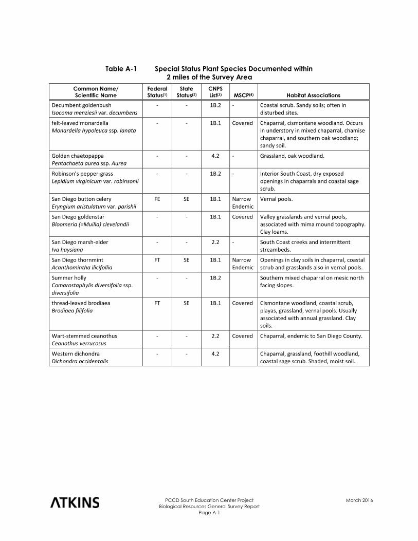
PCCD South Education Center Project
Biological Resources General Survey Report
Page A-1
March 2016
Table A-1 Special Status Plant Species Documented within
2 miles of the Survey Area
Common Name/
Scientific Name
Federal
Status(1)
State
Status(2)
CNPS
List(3) MSCP(4) Habitat Associations
Decumbent goldenbush Isocoma menziesii var. decumbens
- - 1B.2 - Coastal scrub. Sandy soils; often in disturbed sites.
felt-leaved monardella Monardella hypoleuca ssp. lanata
- - 1B.1 Covered Chaparral, cismontane woodland. Occurs in understory in mixed chaparral, chamise chaparral, and southern oak woodland; sandy soil.
Golden chaetopappa Pentachaeta aurea ssp. Aurea
- - 4.2 - Grassland, oak woodland.
Robinson’s pepper-grass
Lepidium virginicum var. robinsonii - - 1B.2 - Interior South Coast, dry exposed
openings in chaparrals and coastal sage scrub.
San Diego button celery
Eryngium aristulatum var. parishii FE SE 1B.1 Narrow
Endemic Vernal pools.
San Diego goldenstar
Bloomeria (=Muilla) clevelandii - - 1B.1 Covered Valley grasslands and vernal pools,
associated with mima mound topography. Clay loams.
San Diego marsh-elder
Iva haysiana - - 2.2 - South Coast creeks and intermittent
streambeds.
San Diego thornmint
Acanthomintha ilicifollia FT SE 1B.1 Narrow
Endemic Openings in clay soils in chaparral, coastal scrub and grasslands also in vernal pools.
Summer holly
Comarostaphylis diversifolia ssp. diversifolia
- - 1B.2 Southern mixed chaparral on mesic north facing slopes.
thread-leaved brodiaea
Brodiaea filifolia FT SE 1B.1 Covered Cismontane woodland, coastal scrub,
playas, grassland, vernal pools. Usually associated with annual grassland. Clay soils.
Wart-stemmed ceanothus Ceanothus verrucosus
- - 2.2 Covered Chaparral, endemic to San Diego County.
Western dichondra Dichondra occidentalis
- - 4.2 Chaparral, grassland, foothill woodland, coastal sage scrub. Shaded, moist soil.
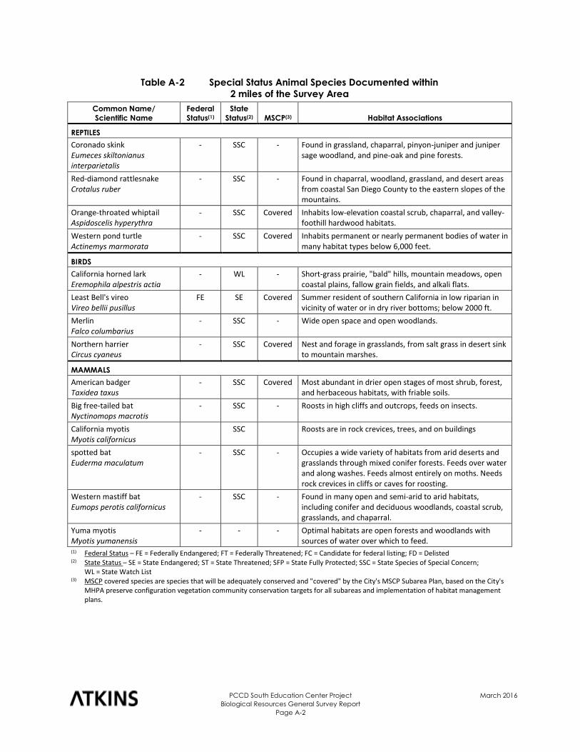
PCCD South Education Center Project
Biological Resources General Survey Report
Page A-2
March 2016
Table A-2 Special Status Animal Species Documented within
2 miles of the Survey Area
Common Name/
Scientific Name
Federal
Status(1)
State
Status(2) MSCP(3) Habitat Associations
REPTILES
Coronado skink Eumeces skiltonianus interparietalis
- SSC - Found in grassland, chaparral, pinyon-juniper and juniper sage woodland, and pine-oak and pine forests.
Red-diamond rattlesnake Crotalus ruber
- SSC - Found in chaparral, woodland, grassland, and desert areas from coastal San Diego County to the eastern slopes of the mountains.
Orange-throated whiptail Aspidoscelis hyperythra
- SSC Covered Inhabits low-elevation coastal scrub, chaparral, and valley-foothill hardwood habitats.
Western pond turtle Actinemys marmorata
- SSC Covered Inhabits permanent or nearly permanent bodies of water in many habitat types below 6,000 feet.
BIRDS
California horned lark Eremophila alpestris actia
- WL - Short-grass prairie, "bald" hills, mountain meadows, open coastal plains, fallow grain fields, and alkali flats.
Least Bell's vireo Vireo bellii pusillus
FE SE Covered Summer resident of southern California in low riparian in vicinity of water or in dry river bottoms; below 2000 ft.
Merlin Falco columbarius
- SSC - Wide open space and open woodlands.
Northern harrier Circus cyaneus
- SSC Covered Nest and forage in grasslands, from salt grass in desert sink to mountain marshes.
MAMMALS
American badger Taxidea taxus
- SSC Covered Most abundant in drier open stages of most shrub, forest, and herbaceous habitats, with friable soils.
Big free-tailed bat Nyctinomops macrotis
- SSC - Roosts in high cliffs and outcrops, feeds on insects.
California myotis Myotis californicus
SSC Roosts are in rock crevices, trees, and on buildings
spotted bat Euderma maculatum
- SSC - Occupies a wide variety of habitats from arid deserts and grasslands through mixed conifer forests. Feeds over water and along washes. Feeds almost entirely on moths. Needs rock crevices in cliffs or caves for roosting.
Western mastiff bat Eumops perotis californicus
- SSC - Found in many open and semi-arid to arid habitats, including conifer and deciduous woodlands, coastal scrub, grasslands, and chaparral.
Yuma myotis Myotis yumanensis
- - - Optimal habitats are open forests and woodlands with sources of water over which to feed.
(1) Federal Status – FE = Federally Endangered; FT = Federally Threatened; FC = Candidate for federal listing; FD = Delisted (2) State Status – SE = State Endangered; ST = State Threatened; SFP = State Fully Protected; SSC = State Species of Special Concern;
WL = State Watch List (3) MSCP covered species are species that will be adequately conserved and "covered" by the City's MSCP Subarea Plan, based on the City's
MHPA preserve configuration vegetation community conservation targets for all subareas and implementation of habitat management plans.
Appendix B
Plant and Animal Species Observed
PCCD South Education Center Project
Biological Resources General Survey Report
Page B-1
March 2016
Table B-1 Plant Status Observed
Scientific Name Common Name
2015 Project
Area(1)
Study Area
Surrounding
Project Area(1)
Apiaceae Carrot Family
Foeniculum vulgare sweet fennel NNG
Aizoaceae Fig-Marigold Family
Carpobrotus edulis* hoten tot fig NNG
Mesembryanthemum crystallinum* Common Ice plant NNG
Anacardiaceae Sumac or Cashew Family
Malosma laurina laurel sumac NNG CSS
Rhus integrifolia lemonade berry - MC
Arecaceae Palm Family
Washingtonia robusta* Mexican fan palm NNG
Asteraceae Sunflower Family
Ambrosia psilostachya Western ragweed DIS-wet
Artemisia californica California sage brush NNG CSS
Baccharis pilularis coyote brush NNG CSS, MC, MFS
Baccharis salicifolia mule fat NNG MFS
Centaurea solstitialis* yellow star-thistle NNG CSS
Conyza canadensis* horseweed NNG CSS
Cynara cardunculus* artichoke thistle NNG
Deinandra fasciculata slender tarweed NNG
Gnaphalium californicum California everlasting NNG CSS
Gnaphalium canescens felty everlasting NNG CSS
Hazardia squarrosa saw-toothed goldenbush - MC
Heterotheca grandiflora telegraph weed NNG
Isocoma menziesii goldenbush NNG
Helminthotheca echioides* bristly ox-tongue NNG MFS
Sonchus sp.* sow thistle NNG
Boraginaceae Forget-me-not Family
Heliotropium curassavicum salt heliotrope NNG
Brassicaceae Mustard Family
Brassica nigra* black mustard NNG CSS, MC
Cactaceae Casctus Family
Opuntia littoralis Western prickly pear NNG CSS
Cucurbitaceae Gourd Family
Marah macrocarpus wild cucumber CSS, MC, MFS
Cyperaceae Sedge Family
Eleocharis macrostachya Common spikerush NNG
Scirpus californicus California bullrush MFS
Chenopodiaceae Goosefoot Family
Salsola tragus Russian thistle NNG
PCCD South Education Center Project
Biological Resources General Survey Report
Page B-2
March 2016
Table B-1 Plant Status Observed
Scientific Name Common Name
2015 Project
Area(1)
Study Area
Surrounding
Project Area(1)
Fabaceae Legume Family
Acacia retinodes* ever blooming acacia NNG
Acmispon glaber Common deerweed NNG CSS
Melilotus alba* white sweet clover NNG MFS
Fagaceae Oak Family
Quercus berberidifolia scrub oak MC
Geraniaceae Geranium Family
Erodium botys Filaree, stork’s bill NNG
Lamiaceae Mint Family
Lavandula dentata* French lavender NNG
Salvia mellifera black sage CSS, MC
Myrsinaceae Myrsine Family
Anagallis arvensis* pimpernel NNG
Myrtaceae Myrtle Family
Eucalyptus sp.* gum tree ORN ORN
Pinaceae Pine Family
Pinus spp.* pine ORN, DEV ORN, DEV
Poaceae Grass Family
Avena fatua* slender wild oat CSS
Bromus madritensis ssp. rubens* red brome NNG CSS
Bromus diandrus* ripgut NNG CSS
Cortaderia selloana* pampas Grass NNG
Stipa pulchra Purple needlegrass NG
Polemoniaceae Phlox Family
Navarretia squarrosa Skunkweed NNG
Polygonaceae Buckwheat Family
Eriogonum fasciculatum California buckwheat NNG CSS
Rumex Curly dock NNG
Salicaceae Willow Family
Salix gooddingii black willow NNG
Scrophulariaceae Figwort Family
Mimulus aurantiacus sticky monkeyflower CSS, MC
Solanaceae Nightshade Family
Nicotiana glauca* tree tobacco MFS
Typhaceae Cattail Family
Typha latifolia broad-leaved cattail MFS
Tamaricaceae Tamarisk Family
Tamarix sp.* Salt cedar NNG (1) Habitat codes: DEV = Developed, DIS = Disturbed/non-native vegetation, DIS WET = Disturbed wetland, CSS = Coastal sage scrub, MC = Mixed chaparral, MFS = Mule fat scrub (or coastal sage scrub-disturbed), NNG = Non-native grassland *Non-native species
PCCD South Education Center Project
Biological Resources General Survey Report
Page B-3
March 2016
Table B-2 Animal Status Observed
Scientific Name Common Name Project Area(1)
Study Area
Surrounding
Project Area(1)
REPTILES
Iguanidae Iguanids
Uta stansburiana side-blotched lizard DIS
BIRDS
Aegithalidae Bushtits
Psaltriparus minimus bushtit MC
Columbidae Pigeons and Doves
Zenaida macroura mourning dove NNG DEV
Corvidae Jays and Crows
Corvus brachyrhynchos American crow NNG DIS
Emberizidae Emberizids
Pipilo crissalis California towhee NNG MC
Pipilo maculatus Spotted towhee CSS
Icteridae Blackbirds and Orioles
Icterus bullockii Bullock’s oriole DEV
Fringillidae Finches
Carpodacus mexicanus house finch NNG DEV, DIS
Carduelis psaltria lesser goldfinch NNG DIS, MC, MFS
Mimidae Mockingbirds and Thrashers
Mimus polyglottos northern mockingbird DEV, DIS
Sturnidae Starlings
Sturnus vulgaris European starling DEV
Timaliidae Babblers
Chamaea fasciata wrentit MC
Trochilidae Hummingbirds
Calypte anna Anna’s hummingbird NNG CSS, DIS, MC, MFS
Troglodytidae Wrens
Thryomanes bewickii Bewick’s wren MC, MFS
Tyrannidae Tyrant Flycatchers
Sayornis nigricans black phoebe DIS, MFS
Sayornis saya Say’s phoebe NNG
Tyrannus vociferans Cassin’s kingbird NNG
MAMMALS
Canidae Wolves and Foxes
Canis familiaris domestic dog DIS
Geomyidae Pocket Gophers
Thomomys bottae Botta’s pocket gopher NNG CSS
PCCD South Education Center Project
Biological Resources General Survey Report
Page B-4
March 2016
Table B-2 Animal Status Observed
Scientific Name Common Name Project Area(1)
Study Area
Surrounding
Project Area(1)
Leporidae Hares and Rabbits
Sylvilagus audubonii desert cottontail NNG CSS, DIS, MC
Muridae Mice and Rats
Neotoma sp. woodrat CSS
Sciuridae Squirrels
Otospermophilus beecheyi California ground squirrel DEV CSS, DIS
(1) Habitat codes: DEV = Developed, DIS = Disturbed/non-native vegetation, DIS WET = Disturbed wetland, CSS = Coastal sage scrub, MC = Mixed chaparral, MFS = Mule fat scrub (or coastal sage scrub-disturbed), NNG = Non-native grassland *Non-native species


![I11111 111ll111111 IIIII 11111 11111 1111111ll1 …...I11111 111ll111111 IIIII 11111 11111 1111111ll1 Ill11 11111 11111 11ll11111111111111 United States Patent 1191 USOO539398OA [11]](https://img.pdfslide.us/doc/110x75/5f03956a7e708231d409c50c/i11111-111ll111111-iiiii-11111-11111-1111111ll1-i11111-111ll111111-iiiii-11111.jpg)