Embed Size (px)
Citation preview
3.7 Biological Resources
Environmental Setting
PHYSICAL SETTING
Vegetation Communities
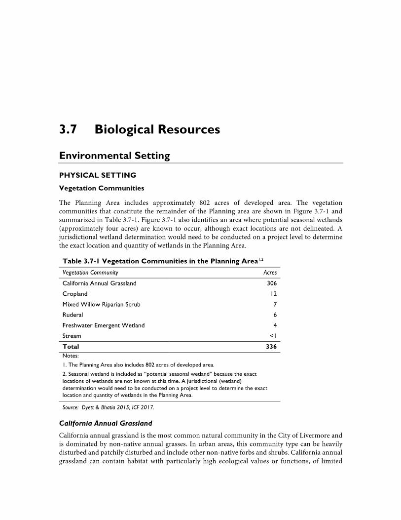
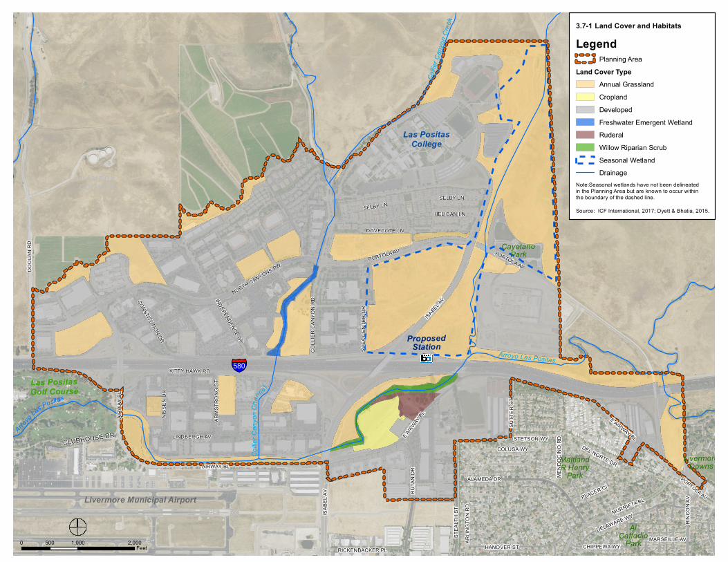
The Planning Area includes approximately 802 acres of developed area. The vegetation communities that constitute the remainder of the Planning area are shown in Figure 3.7-1 and summarized in Table 3.7-1. Figure 3.7-1 also identifies an area where potential seasonal wetlands (approximately four acres) are known to occur, although exact locations are not delineated. A jurisdictional wetland determination would need to be conducted on a project level to determine the exact location and quantity of wetlands in the Planning Area.
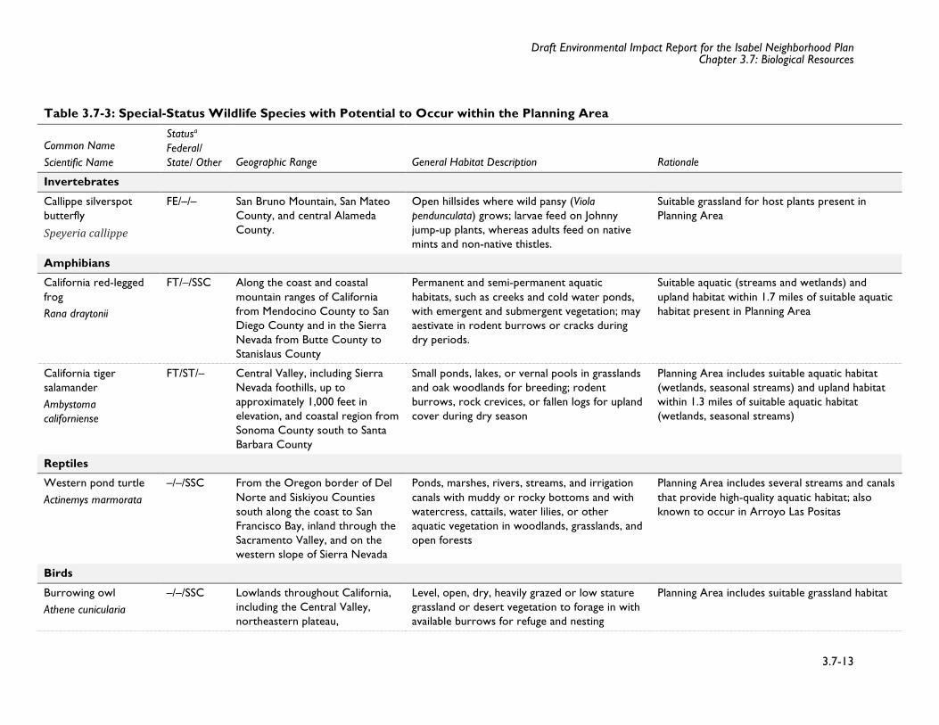
Table 3.7-1 Vegetation Communities in the Planning Area1,2
Vegetation Community Acres
California Annual Grassland 306
Cropland 12
Mixed Willow Riparian Scrub 7
Ruderal 6
Freshwater Emergent Wetland 4
Stream <1
Total 336 Notes:
1. The Planning Area also includes 802 acres of developed area.
2. Seasonal wetland is included as “potential seasonal wetland” because the exact locations of wetlands are not known at this time. A jurisdictional (wetland) determination would need to be conducted on a project level to determine the exact location and quantity of wetlands in the Planning Area.
Source: Dyett & Bhatia 2015; ICF 2017.
California Annual Grassland
California annual grassland is the most common natural community in the City of Livermore and is dominated by non-native annual grasses. In urban areas, this community type can be heavily disturbed and patchily disturbed and include other non-native forbs and shrubs. California annual grassland can contain habitat with particularly high ecological values or functions, of limited
Draft Environmental Impact Report for the Isabel Neighborhood Plan Chapter 3.7: Biological Resources
3.7-2
distribution, or otherwise of concern to federal, State, and/or local resource agencies. As shown in Figure 3.7-1, Land Cover and Habitats, California annual grassland is located in undeveloped areas throughout the Planning Area, but is more abundant north of I-580. The largest continuous areas of California annual grassland in the Planning Area surround both the east and west sides of Isabel Avenue and the east side of Campus Hill Drive.
California annual grassland dominant species are wild oats (Avena barbata, A. fatua), ripgut grass (Bromus diandrus), soft chess (Bromus hordeaceus), rye grass (Festuca perennis), and wall barley (Hordeum murinum). Herbaceous cover includes native and nonnative forbs such as bristly ox-tongue (Helminthotheca echioides), bull thistle (Cirsium vulgare), Italian thistle (Carduus pycnocephalus subsp. pycnocephalus), lupine (Lupinus sp.), prickly lettuce (Lactuca serriola), shortpod mustard (Hirschfeldia incana), stinkwort (Dittrichia graveolens), and yellow star-thistle (Centaurea solstitialis). Congdon’s tarplant (Centromadia parryi congdonii) or big-scale balsamroot (Balsamorhiza macrolepis) occur within California annual grasslands and have the potential to occur within the Planning Area.
Grasslands support insects, amphibians, reptiles, small birds, and mammals that are prey for carnivorous wildlife such as red-tailed hawk (Buteo jamaicensis), red-shouldered hawk (Buteo lineatus), northern harrier (Circus cyaneus), American kestrel (Falco sparverius), burrowing owl (Athene cunicularia), turkey vulture (Cathartes aura), coyote (Canis latrans), and American badger (Taxidea taxus). Grasslands near open water and woodland are used by more species than those that lack such features because they provide places for resting, breeding, and escape cover for species that breed in these adjacent habitats. Other common wildlife species occurring in grasslands include black-tailed jackrabbit (Lepus californicus), desert cottontail (Sylvilagus audubonii), California ground squirrel (Spermophilus beecheyi), striped skunk (Mephitis mephitis), western fence lizard (Sceloporus occidentalis), common garter snake (Thamnophis sirtalis), gopher snake (Pituophis catenifer), ring-necked pheasant (Phasianus colchicus), western kingbird (Tyrannus verticalis), loggerhead shrike (Lanius ludovicianus), horned lark (Eremophila alpestris), savannah sparrow (Passerculus sandwichensis), and western meadowlark (Sturnella neglecta).
Cropland
Cropland is found in the Planning Area along Arroyo Las Positas on the south side of I-580. Cropland occurs on tilled land supporting agriculture crops other than orchards and vineyards. In the Planning Area, the cropland consists of corn planted in rows.
Although cropland is an artificial habitat type, it provides higher value habitat for many wildlife species than the surrounding developed areas. Many species of birds and small mammals have adapted to croplands, such as California ground squirrel (Otospermophilus beecheyi) or red-winged blackbird (Agelaius phoeniceus), which breed or forage within this habitat type. Raptors, doves, and ring-necked pheasants often forage on crops before they are harvested. Croplands flooded for weeding control or irrigation can serve as freshwater wetland for a variety of associated wetland wildlife, including shorebirds, wading birds, and gulls (Zeiner et al., 1990).
Mixed Willow Riparian Scrub
Mixed willow riparian scrub is found in the Planning Area in sparse patches along Arroyo Las Positas and Collier Canyon Creek/channel. Typically, mixed willow riparian scrub consists of
Draft Environmental Impact Report for the Isabel Neighborhood Plan Chapter 3.7: Biological Resources
3.7-3
willow stands that may or may not be dominated by a single species and occur in environmental conditions similar to alder (Alnus spp.), cottonwood (Populus spp.), and other willow series (Holland, 1986). Within the Planning Area, the mixed willow riparian scrub community typically consists of scattered willows and fast-growing shrubs and vines.
Riparian vegetation is diverse and comprises multiple vegetative strata, which provide high-value habitat for many wildlife species. Dense, multilayered riparian communities provide escape cover, forage, and nesting opportunities for wildlife. Riparian woodlands support many of the same species occurring in other woodland communities discussed in this section, as well as several riparian-specific species, such as Pacific-slope flycatcher (Empidonax difficilis), warbling vireo (Vireo gilvus), Wilson's warbler (Cardellina pusilla), and black-headed grosbeak (Pheucticus melanocephalus). Riparian corridors also function as wildlife corridors since they provide cover and foraging habitat in otherwise suboptimal wildlife habitat (e.g., tree-lined streams in Central Valley cropland). Riparian canopy cover that overhangs streams and creeks provides shaded riverine aquatic (SRA) cover that benefits fish by reducing water temperature, providing in-water cover, and increasing aquatic productivity by vegetation input (leaves, branches) into the channel.
Ruderal
Ruderal vegetation occurs throughout the Planning Area in locations where natural vegetation has been removed or significantly degraded by past or current human activity. Ruderal vegetation is often associated with the sides of railroad tracks, vacant lots, roadsides, and other highly disturbed areas. Ruderal vegetation is typified by the dominance of nonnative forbs that thrive in disturbed conditions, and includes bristly ox-tongue, bull thistle, Italian thistle, prickly lettuce, shortpod mustard, stinkwort, yellow star-thistle, English plantain (Plantago lanceolata), jimson weed (Datura sp.), and Russian thistle (Salsola sp.). Because of the highly variable nature of ruderal habitats, this type was not classified according to Sawyer et al. (2009) or Holland (1986). Ruderal areas may be similar to California annual grassland but are characterized by a greater level of disturbance.
Wildlife species occurring in ruderal vegetation are primarily determined by the characteristics of nearby natural, less disturbed habitat, although the dense cover provided by weeds often attracts large flocks of foraging songbirds that are otherwise absent from adjacent developed, grassland, woodland, or wetland areas. Species within this category include white-crowned sparrow (Zonotrichia leucophrys), American goldfinch (Spinus tristis), dark-eyed junco (Junco hyemalis), and song sparrow. Such cover also provides habitat for common reptiles such as western fence lizard, gopher snake, and common garter snake.
Wetlands
Wetlands are considered sensitive natural communities by several resource agencies and should be given special consideration in the Planning Area because they provide a variety of important ecological functions and essential habitat for wildlife resources. As a result of land management practices and development activities, natural wetland habitats are steadily declining compared to their historical distribution. The U.S. Army Corps of Engineers (USACE), California Department of Fish and Wildlife (CDFW), and the U.S. Fish and Wildlife Service (USFWS) have policies and regulations that protect wetland habitats. As described below, seasonal wetland and freshwater emergent wetland occur within the Planning Area.
Draft Environmental Impact Report for the Isabel Neighborhood Plan Chapter 3.7: Biological Resources
3.7-4
Seasonal Wetland
Seasonal wetlands (indicated above as “potential seasonal wetlands”) in the Planning Area are freshwater wetlands that support inundation or saturated soil conditions typically during the wet season, as these features are often inundated by direct rainfall and runoff of adjacent uplands. In the Planning Area, seasonal wetlands occur north of I-580 and east of Isabel Avenue and Campus Hill Drive. Seasonal wetlands inundate for varying periods determined by local micro-topography, soil composition, and depth to a water restricting layer. For the purposes of this document, seasonal wetlands are inclusive of vernal pools, which typically exhibit longer hydroperiods that can support vernal pool branchiopods (e.g., fairy shrimp). Floristic species typical of seasonal wetlands include smooth-rayed goldfields (Lasthenia glaberrima), common spikerush (Eleocharis macrostachya), Fitch’s spikeweed (Centromadia fitchii), peppergrass (Lepidium nitidum), cowbag clover (Trifolium depauperatum), and vernal pool popcornflower (Plagiobothrys stipitatus).
Freshwater Emergent Wetland
Freshwater marsh occurs along the margin of Collier Canyon Creek/channel in the Planning Area north of I-580. Characteristic vegetation within freshwater marsh includes cattails (Typha spp.), bulrushes (Schoenoplectus spp.), and sedges (Carex sp.).
Wildlife species frequently observed within freshwater emergent wetland in the Planning Area include mallard (Anas platyrhynchos), black phoebe (Saynoris nigricans), great egret (Ardea alba), black-necked stilt (Himantopus mexicanus), song sparrow (Melospiza melodia), red-winged blackbird, and American coot (Fulica americana), and mosquito fish (Gambusia affinis). Freshwater emergent wetlands provide drinking water for numerous species of wildlife and also attract prey for larger predators when water sources are limited. As such, freshwater wetlands typically support many wildlife species in addition to those that use such areas exclusively.
Aquatic Habitat
Drainages
Originating from Altamont Range and the Coast Range into the Tri-Valley, perennial intermittent, and ephemeral drainages occur in the Planning Area. These drainages are typically associated with riparian habitat described above and may support areas of freshwater marsh, however the portion below the ordinary high water mark1 is generally unvegetated. Primary drainages within the Planning Area include Arroyo Las Positas, Collier Canyon Creek/channel, and Cayetano Creek. Smaller drainages within the Planning Area include several seasonal drainages including a drainage east of the proposed BART station location that provides seasonal aquatic habitat. Most of these areas are regulated under the jurisdiction of the USACE and the Regional Water Quality Control Board (RWQCB).
Drainages can provide both aquatic and breeding habitat for amphibians such as California red-legged frog (Rana draytonii) and California tiger salamander (Ambystoma californiense) depending on their depth and seasonality of inundation. Reptile species that utilize aquatic habitats include common garter snake and western pond turtle (Actinemys marmorata). Native fish
1 The level reached by the sea at high tide, or by a lake or river at its highest stand.
Draft Environmental Impact Report for the Isabel Neighborhood Plan Chapter 3.7: Biological Resources
3.7-5
species present in Arroyo Las Positas include hardhead (Mylopharodon conocephalus), rainbow trout (Oncorhynchus mykiss), and Sacramento pikeminnow (Ptychocheilus grandis) (California Fish Website, 2017). Introduced species that utilize aquatic habitats include American bullfrogs (Rana catesbeiana), red-eared sliders (Trachemys scripta), and non-native fish such as catfish (Ameiurus spp.), green and redear sunfish (Lepomis spp.), largemouth bass (Micropterus salmoides), and western mosquitofish (Gambusia affinis) (California Fish Website, 2017).
Special-Status Species
Special-status species are plants and animals that are legally protected under State and federal Endangered Species Acts, and species that are considered sufficiently rare by the scientific community to qualify for such listing. The State CEQA Guidelines define rare, threatened, or endangered species as those listed under the California Endangered Species Act (CESA) and ESA, as well as any other species that meets the criteria of the resource agencies or local agencies (e.g., the CDFW-designated “species of special concern” and California Native Plant Society (CNPS)-listed species). The effects of a proposed project on these resources are important in determining whether the project has significant environmental impacts under CEQA. Special-status plants and animals are species in the following categories:
• Species listed or proposed for listing as threatened or endangered under the federal Endangered Species Act (50 CFR 17.12 [listed plants], 50 CFR 17.11 [listed animals], and various notices in the Federal Register [proposed species]);
• Species that are candidates for possible future listing as threatened or endangered under the federal Endangered Species Act (73 FR 75176, December 10, 2008);
• Species listed or proposed for listing by the State of California as threatened or endangered under the California Endangered Species Act (14 CCR 670.5);
• Species that meet the definitions of rare or endangered under California Environmental Quality Act (CEQA) (State CEQA Guidelines, Section 15380);
• Plants listed as rare under the California Native Plant Protection Act (California Fish and Game Code, Section 1900 et seq.);
• Plants considered by the CNPS to be "rare, threatened, or endangered in California" (Lists 1B and 2 in California Native Plant Society, 2017);
• Plants listed by CNPS as plants about which more information is needed to determine their status and plants of limited distribution (List 3 in CNPS list, 2017), for which information is identified indicating that these plants are indeed rare;
• Animal species of special concern to the California Department of Fish and Wildlife (California Department of Fish and Wildlife, 2017); and
• Animals fully protected in California (California Fish and Game Code, Section 3511 [birds], 4700 [mammals], and 5050 [amphibians and reptiles]).
Special-Status Plant Species
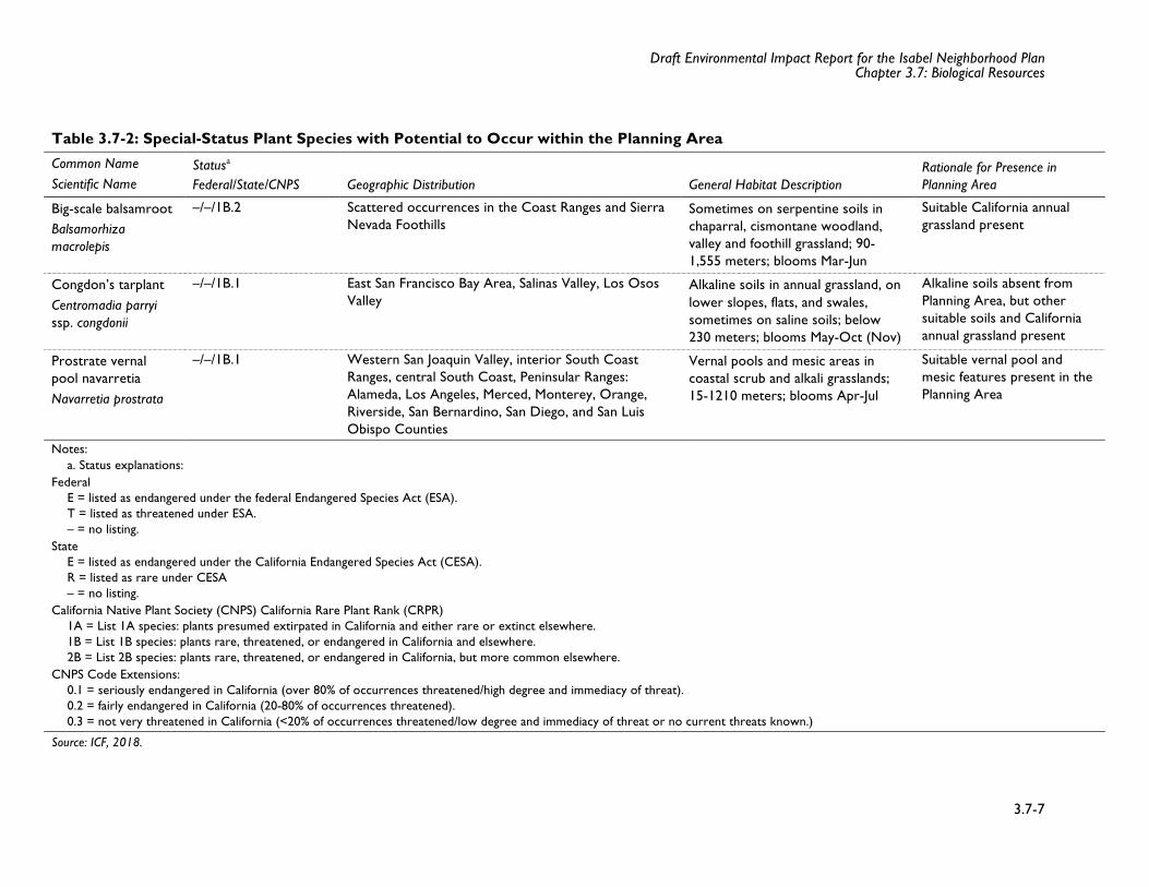
Table 3.7-2 provides a current list of special-status plant species that have potential to occur in or near the Planning Area, based on a review of CNPS, California Natural Diversity Database
Draft Environmental Impact Report for the Isabel Neighborhood Plan Chapter 3.7: Biological Resources
3.7-6
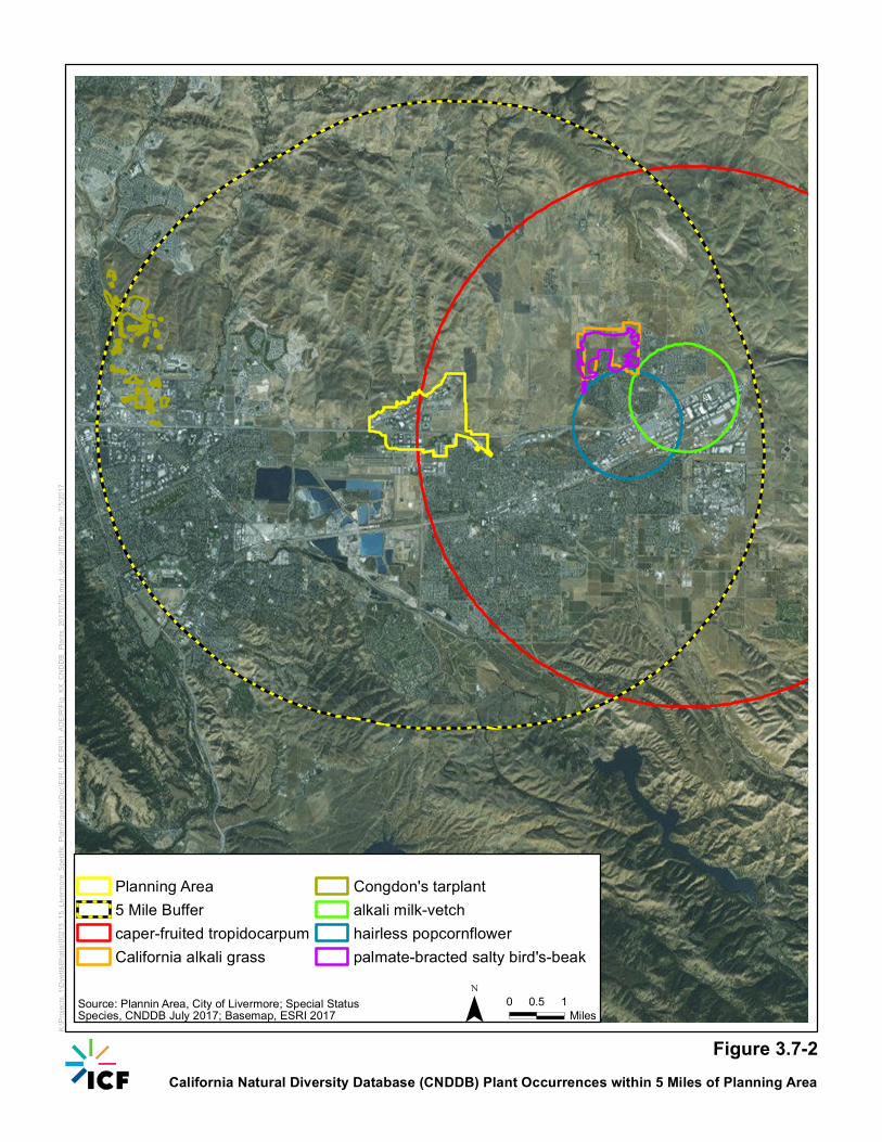
(CNDDB), and USFWS sources. A table providing a list of all special-status plants that occur within a one-mile radius of the Planning Area is provided in Appendix D. Figure 3.7-2 shows the location of CNDDB occurrence locations within the Planning Area and within a five-mile buffer of the Planning Area.
Big-Scale Balsamroot (Balsamorhiza macrolepis) – California Rare Plant Rank (CRPR) 1B.2
Big-scale balsamroot is a perennial herb in the sunflower family (Asteraceae) found in chaparral, cismontane woodland, and California annual grassland from 90 to 1,555 meters in elevation. This species can be associated with serpentine soils and blooms from March through June. Big-scale balsamroot is known to occur in the Coast Ranges and Sierra Nevada foothills. While potential habitat within the Planning Area includes California annual grasslands, there are no recorded CNDDB occurrences of Big-scale balsamroot documented within 5 miles of the Planning Area.
Congdon’s Tarplant (Centromadia parryi ssp. congdonii) – CRPR 1B.1
Congdon’s tarplant is an annual herb in the sunflower family known from East San Francisco Bay Area, Salinas Valley, and Los Osos Valley. Congdon’s tarplant blooms from May through October and occurs in annual grassland on lower slopes, flats, and swales below 230 meters in elevation. Potential habitat within the Planning Area includes annual grasslands with clay soils. There is one recorded CNDDB occurrence of Congdon’s tarplant documented within 5 miles of the Planning Area in an area known to possess alkali soils.
Prostrate vernal pool navarretia (Navarretia prostrata) – CRPR 1B.1
Prostrate vernal pool navarretia, an annual herb in the phlox family (Polemoniaceae), is found in vernal pools, coastal scrub, and alkali grasslands between elevations of 15 to 1,210 meters. This species blooms from April through July, and occurs in western San Joaquin Valley, interior South Coast Ranges, central South Coast, Peninsular Ranges and Alameda, Los Angeles, Merced, Monterey, Orange, Riverside, San Bernardino, San Diego, and San Luis Obispo counties. While potential habitat within the Planning Area includes seasonal wetlands, there are no recorded CNDDB occurrences of Prostrate vernal pool navarretia documented within 5 miles of the Planning Area.
Draft Environmental Impact Report for the Isabel Neighborhood Plan Chapter 3.7: Biological Resources
3.7-7
Table 3.7-2: Special-Status Plant Species with Potential to Occur within the Planning Area
Common Name Scientific Name
Statusa Federal/State/CNPS Geographic Distribution General Habitat Description
Rationale for Presence in Planning Area
Big-scale balsamroot Balsamorhiza macrolepis
–/–/1B.2 Scattered occurrences in the Coast Ranges and Sierra Nevada Foothills
Sometimes on serpentine soils in chaparral, cismontane woodland, valley and foothill grassland; 90-1,555 meters; blooms Mar-Jun
Suitable California annual grassland present
Congdon’s tarplant Centromadia parryi ssp. congdonii
–/–/1B.1 East San Francisco Bay Area, Salinas Valley, Los Osos Valley
Alkaline soils in annual grassland, on lower slopes, flats, and swales, sometimes on saline soils; below 230 meters; blooms May-Oct (Nov)
Alkaline soils absent from Planning Area, but other suitable soils and California annual grassland present
Prostrate vernal pool navarretia Navarretia prostrata
–/–/1B.1 Western San Joaquin Valley, interior South Coast Ranges, central South Coast, Peninsular Ranges: Alameda, Los Angeles, Merced, Monterey, Orange, Riverside, San Bernardino, San Diego, and San Luis Obispo Counties
Vernal pools and mesic areas in coastal scrub and alkali grasslands; 15-1210 meters; blooms Apr-Jul
Suitable vernal pool and mesic features present in the Planning Area
Notes: a. Status explanations:
Federal E = listed as endangered under the federal Endangered Species Act (ESA). T = listed as threatened under ESA. – = no listing.
State E = listed as endangered under the California Endangered Species Act (CESA). R = listed as rare under CESA – = no listing.
California Native Plant Society (CNPS) California Rare Plant Rank (CRPR) 1A = List 1A species: plants presumed extirpated in California and either rare or extinct elsewhere. 1B = List 1B species: plants rare, threatened, or endangered in California and elsewhere. 2B = List 2B species: plants rare, threatened, or endangered in California, but more common elsewhere.
CNPS Code Extensions: 0.1 = seriously endangered in California (over 80% of occurrences threatened/high degree and immediacy of threat). 0.2 = fairly endangered in California (20-80% of occurrences threatened). 0.3 = not very threatened in California (<20% of occurrences threatened/low degree and immediacy of threat or no current threats known.)
Source: ICF, 2018.

Draft Environmental Impact Report for the Isabel Neighborhood Plan Chapter 3.7: Biological Resources
3.7-8
Special-Status Wildlife and Fish Species
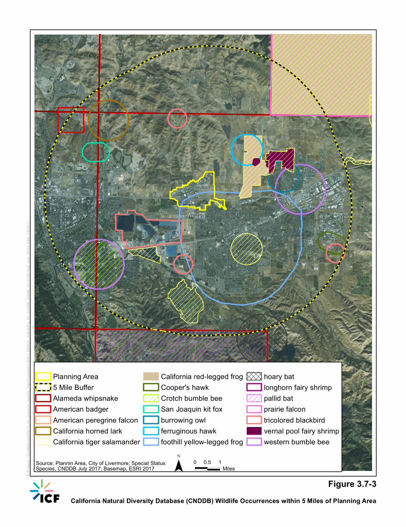
Table 3.7-3 provides a current list of special-status wildlife species that are known to occur or have a potential to occur within the Planning Area. This list was identified by a review of the CNDDB and a list obtained from the USFWS. No special-status fish species have potential to occur within the Planning Area and therefore are not included in Table 3.7-3. Figure 3.7-3 shows the location of CNDDB occurrence locations within the Planning Area and within a 5-mile buffer of the Planning Area. A table providing a list of all special-status wildlife and fish species that occur within a five-mile radius of the Planning Area is provided in Appendix E.
Invertebrates
Callippe Silverspot Butterfly (Speyeria callippe callippe) Callippe silverspot butterfly is a yellow, orange, and black butterfly found in grasslands within San Mateo, Sonoma, and Alameda Counties, as well as the hills between Cordelia and Vallejo. Johnny jump-up (Viola pedunculata) is the species’ sole larval food source; however, adults use a variety of other nectar plants. This species has potential to occur within grasslands that support johnny jump-up within the Planning Area. There are no CNDDB records of this species within 5 miles of the Planning Area.
Vernal Pool Fairy Shrimp (Branchinecta lynchi) Vernal pool fairy shrimp is a small invertebrate that inhabits vernal pools formed by hardpan, claypan, and sandstone rock outcrops. This species ranges across California’s Central Valley and south into the Coast Ranges in Santa Barbara County, with some isolated populations in Riverside County. This species has potential to occur within the seasonal wetlands and vernal pools in the Planning Area. One CNDDB record of this species is located approximately 1.6 miles northeast of the outermost edge of the Planning Area (California Department of Fish and Wildlife, 2017).
Amphibians
California Red-legged Frog (Rana draytonii) California red-legged frog inhabits ponds, streams, other aquatic habitats, and adjacent upland land cover. This species has potential to occur within stock ponds, streams, and riparian habitat; as well as migrate through all undeveloped types of land cover within 1.7 miles of suitable aquatic habitat. The presence of bullfrogs and mosquito fish in aquatic habitat seriously reduce but do not preclude the potential for California red-legged frog to occur at such locations. There are 11 CNDDB records of this species within 5 miles of the Planning Area, with the nearest occurrence located approximately 1.2 miles east of the Planning Area (California Department of Fish and Wildlife, 2017). This species has potential to occur in all of the drainages and wetlands in the Planning Area, and in undeveloped uplands within 1.7 miles of aquatic habitat.
Foothill Yellow-legged Frog (Rana boylii) Foothill yellow-legged frog inhabits relatively swift (i.e., not still), rock- and/or gravel–bottomed perennial streams within woodland, forest, mixed chaparral, and wet meadows in the Klamath, Cascade, north Coast, south Coast, Transverse, and Sierra Nevada Ranges up to approximately 6,000 feet above mean sea level. The current range of the species in Alameda County is located in south central to southeast portions (near the Sunol and Ohlone Regional Wilderness areas) of the
Draft Environmental Impact Report for the Isabel Neighborhood Plan Chapter 3.7: Biological Resources
3.7-9
county, extending as far north approximately 4.5 miles south of Livermore. Suitable habitat for the species is absent as the Planning Area is located outside of species’ current range. One CNDDB record of this species from an observation made in 1973 occurs within 5 miles of the Planning Area, but it was located south of Interstate 580, and was likely an individual that washed into Arroyo Mocho from suitable streams approximately 4.5 miles south of Livermore. Therefore, this species is not expected to occur within the Planning Area and would not be affected by future projects within the Planning Area.
California Tiger Salamander (Ambystoma californiense) California tiger salamander ranges from Yolo County to Tulare County and San Luis Obispo County in the respective Central Valley and Coast Range [both considered the Central Valley Distinct Population Segment (DPS)]. Two other DPS of the species also occur in Sonoma and Santa Barbara Counties. California tiger salamander spends most of the year underground within Botta’s pocket gopher (Thomomys bottae) or California ground squirrel (Otospermophilus beecheyi) burrows, typically in grasslands. During the late fall to winter, adults migrate to vernal pools and ephemeral stock ponds to breed. As the pools and ponds begin to dry, adults and metamorphs migrate back to the rodent burrows in the surrounding uplands. There are eight CNDDB records of this species within 5 miles of the Planning Area, two of which are extirpated (i.e., no longer exist), with the nearest occurrence located approximately 1.2 miles east of the Planning Area (California Department of Fish and Wildlife, 2017). Proximity to aquatic habitat is generally the limiting habitat factor; therefore, the species has potential to occur within seasonal and freshwater emergent wetlands in the Planning Area and California annual grassland that supports rodent burrows within 1.3 miles of wetlands.
Reptiles
Western Pond Turtle (Actinemys marmorata) Western pond turtle is an olive-drab turtle that inhabits a wide variety of water bodies, including ponds, marshes, rivers, streams, and irrigation canals. This species can tolerate full-strength seawater for a short period of time, but is normally found in freshwater. Western pond turtle females migrate away from their water bodies into surrounding uplands, where they construct underground nests and lay eggs from April to August. This species has potential to occur within wetlands, stock ponds, ditches, and other aquatic habitat types including adjacent undeveloped upland habitat within 1,150 feet (0.22-mile) of all of the drainages and wetlands (Pilliod et al., 2013) in the Planning Area. No CNDDB records of this species occur within 5 miles of the Planning Area.
Birds
Burrowing Owl (Athene cunicularia) Burrowing owl is a small owl that lives in burrows created by ground squirrels and pocket gophers. This species forages over grassland and open salt marsh vegetation for small mammals, insects, and lizards and is most active at dawn and dusk. This species ranges throughout lowland portions of California, but is absent from the southern coastal areas of the state. Grassland, pastures, freshwater marsh, and wetlands with populations of California ground squirrels or Botta’s pocket gophers provide suitable foraging and nesting habitat in the Planning Area. There is one record of a burrowing owl occurrence within 5 miles of the Planning Area, located approximately 2.2 miles east of the Planning Area (California Department of Fish and Wildlife, 2017).
Draft Environmental Impact Report for the Isabel Neighborhood Plan Chapter 3.7: Biological Resources
3.7-10
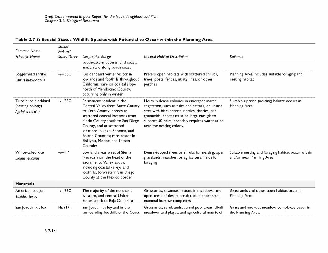
Loggerhead Shrike (Lanius ludovicianus) Loggerhead shrikes occur in open habitats with scattered trees, shrubs, posts, fences, utility lines, or other types of perches. Nests are built in trees or shrubs with dense foliage and are usually hidden well. Loggerhead shrikes search for prey from perches and frequently impale their prey on thorns, sharp twigs, or barbed-wire. The nesting period for loggerhead shrikes is March through June (Zeiner et al., 1990a:546).
While there are no CNDDB records of loggerhead shrike within 5 miles of the Planning Area (California Department of Fish and Wildlife, 2017), this species is known to occur in the greater Livermore area. Open habitat, such as freshwater marsh, wetlands, grassland, and agricultural fields provide suitable foraging habitat for loggerhead shrike, and trees and shrubs near foraging habitat provide suitable nesting substrate for the species in the Planning Area.
Tricolored Blackbird (Agelaius tricolor) Tricolored blackbird is a permanent resident of the Central Valley but breeds in a couple scattered coastal locations from Marin County to San Diego. This species nests colonially, with a minimum size of 50 pairs, in dense marsh vegetation such as cattails (Typha spp.) and bulrush (Schoenoplectus spp.). Tricolored blackbird has potential to nest within dense marsh vegetation and blackberry (Rubus spp.) associated with streams, rivers, stock ponds, and other aquatic features. There are four CNDDB records of the species within 5 miles of the Planning Area, located approximately 0.5 mile south of the Planning Area (California Department of Fish and Wildlife, 2017). This species has potential to occur within riparian, wetland, and along aquatic vegetation communities in the Planning Area.
White-Tailed Kite (Elanus leucurus) White-tailed kite is a small raptor that forages primarily for small mammals over open habitats, including grassland, tidal salt marsh, and agricultural fields. The range of this species includes lowland areas west of the Sierra Nevada from the northern extent of the Sacramento Valley south, including coastal foothills to western San Diego County. This species nests within trees suitable of supporting its nest that offer at least partial shade within the canopy. Grasslands, marshes, pastures, wetlands, and agricultural fields provide suitable foraging habitat for this species throughout the Planning Area. No CNDDB records of white-tailed kite occur within 5 miles of the Planning Area (California Department of Fish and Wildlife, 2017), but this species is known to occur in the greater Livermore area.
Mammals
American Badger (Taxidea taxus) American badgers occur in a wide variety of open, arid habitats but are most commonly associated with grasslands, savannas, mountain meadows, and open areas of desert scrub (Stephenson and Calcarone, 1999). In California, American badgers occur throughout the state except in humid coastal forests of northwestern California in Del Norte and Humboldt Counties (Williams, 1986). The primary factor that determines whether habitat is suitable for American badger is the presence of a sufficient prey base, typically consisting of California ground squirrel and/or pocket gopher. American badger has potential to occur within the open areas of grassland habitat throughout the
Draft Environmental Impact Report for the Isabel Neighborhood Plan Chapter 3.7: Biological Resources
3.7-11
Planning Area. There is one CNDDB record of this species within 5 miles of the Planning Area, approximately 4.2 miles to the northwest (California Department of Fish and Wildlife, 2017).
San Joaquin Kit Fox (Vupes macrotis mutica) San Joaquin kit fox occur in a wide variety of grassland and altered habitats, but generally occur in areas with gentler slopes and are excluded from steeper areas. Optimal slopes for kit fox are less than five percent, while habitat with slopes of five to 15 percent are suitable, and greater than 15 percent are unsuitable. The majority of San Joaquin kit fox occur on the west side of the San Joaquin Valley, although they also occur in the foothills of the Coast Ranges, Sierra Nevada, and Tehachapi Mountains. Of all the CNDDB occurrences, 75 percent have been identified in the San Joaquin Valley, and 1.5 percent have been recorded in Alameda County (U.S. Fish and Wildlife Service, 2010). San Joaquin kit fox has potential to occur within the open areas of grassland habitat within the Planning Area. There is one CNDDB record of this species within 5 miles of the Planning Area, approximately three miles to the northwest (California Department of Fish and Wildlife, 2017)
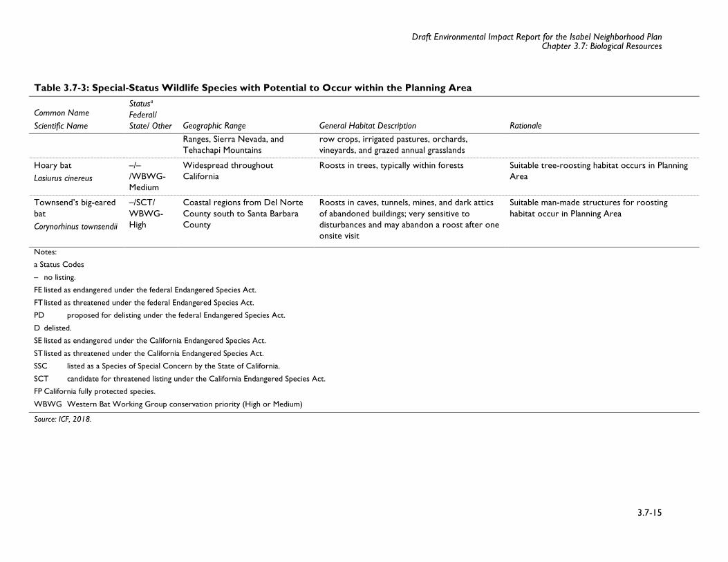
Hoary Bat (Lasiurus cinereus) Hoary bat’s range covers all of California and is listed as a species with moderate regional priority by Western Bat Working Group (Western Bat Working Group, 2017). This species roosts in trees that are typically within forests or various types of woodlands. Hoary bat has potential to occur within the mixed willow riparian scrub in the Planning study area. There is one CNDDB record within 5 miles of the Planning Area, located approximately 4.4 miles south (California Department of Fish and Wildlife, 2017).
Townsend’s Big-Eared Bat (Corynorhinus townsendii) Townsend’s big-eared bat occurs throughout California in a wide variety of habitats ranging from sea level to 10,800 feet above mean sea level from Del Norte County to Santa Barbara County. This species is typically associated with coniferous forests, mixed meso-phytic forests, deserts, native prairies, riparian communities, active agricultural areas, and coastal habitat types. Species distribution is also strongly correlated with availability of caves or cave-like roosting habitat. Townsend’s big-eared bats have been observed utilizing buildings, bridges, rock crevices, and hollow trees as roost sites (Western Bat Working Group, 2017). Townsend’s big-eared bats are highly sensitive to disturbance and therefore are highly unlikely to roost within suitable habitat along highly developed portions of the Planning Area. There are no CNDDB records of this species within 5 miles of the Planning Area (California Department of Fish and Wildlife, 2017). This species could occur within mixed willow riparian scrub and anthropogenic structures with stable thermal regimes in the Planning Area.
Fish
Central California Coast Steelhead Central California coast steelhead (Oncorhynchus mykiss) is a federally listed threatened fish species. The Central California Coast steelhead distinct population segment has been listed as threatened under the ESA (62 FR 159, August 18, 1997). Central California coast steelhead includes populations from the Russian River south to Aptos Creek in Santa Cruz County, including streams that are tributaries to San Francisco and San Pablo Bays. Adults migrate upstream to freshwater
Draft Environmental Impact Report for the Isabel Neighborhood Plan Chapter 3.7: Biological Resources
3.7-12
from December to March, and juveniles migrate downstream to the Bay in late winter and spring (Center for Biological Diversity, no date).
Currently there is no suitable habitat in Arroyo Las Positas for steelhead due to the ephemeral nature of the stream in the Planning Area and sparse willow riparian vegetation along the banks. There are also downstream barriers on Alameda Creek. However, barriers downstream are being removed in the hopes of restoring Central California Coast steelhead populations to upstream tributaries of Alameda Creek, which includes Arroyo Las Positas. In 2003, Zone 7 Water Agency installed a fish ladder and restored habitat at the confluence of Arroyo Mocho and Arroyo Las Positas (downstream of the Planning Area) to allow for steelhead passage when all the barriers in Alameda Creek are removed (Alameda Creek Alliance no date). Arroyo Las Positas would also have to be restored in the Planning Area if steelhead are expected to use this section of the stream. The BART weir (lowest barrier in the Alameda Creek watershed) will have a fish ladder and the fish ladder is expected to be constructed in 2019 (Alameda County Water District n.d.), which will help to allow steelhead to access the upper Alameda Creek watershed.
Draft Environmental Impact Report for the Isabel Neighborhood Plan Chapter 3.7: Biological Resources
3.7-13
Table 3.7-3: Special-Status Wildlife Species with Potential to Occur within the Planning Area
Common Name Scientific Name
Statusa Federal/ State/ Other Geographic Range General Habitat Description Rationale
Invertebrates
Callippe silverspot butterfly Speyeriacallippe
FE/–/– San Bruno Mountain, San Mateo County, and central Alameda County.
Open hillsides where wild pansy (Viola pendunculata) grows; larvae feed on Johnny jump-up plants, whereas adults feed on native mints and non-native thistles.
Suitable grassland for host plants present in Planning Area
Amphibians
California red-legged frog Rana draytonii
FT/–/SSC Along the coast and coastal mountain ranges of California from Mendocino County to San Diego County and in the Sierra Nevada from Butte County to Stanislaus County
Permanent and semi-permanent aquatic habitats, such as creeks and cold water ponds, with emergent and submergent vegetation; may aestivate in rodent burrows or cracks during dry periods.
Suitable aquatic (streams and wetlands) and upland habitat within 1.7 miles of suitable aquatic habitat present in Planning Area
California tiger salamander Ambystoma californiense
FT/ST/– Central Valley, including Sierra Nevada foothills, up to approximately 1,000 feet in elevation, and coastal region from Sonoma County south to Santa Barbara County
Small ponds, lakes, or vernal pools in grasslands and oak woodlands for breeding; rodent burrows, rock crevices, or fallen logs for upland cover during dry season
Planning Area includes suitable aquatic habitat (wetlands, seasonal streams) and upland habitat within 1.3 miles of suitable aquatic habitat (wetlands, seasonal streams)
Reptiles
Western pond turtle Actinemys marmorata
–/–/SSC From the Oregon border of Del Norte and Siskiyou Counties south along the coast to San Francisco Bay, inland through the Sacramento Valley, and on the western slope of Sierra Nevada
Ponds, marshes, rivers, streams, and irrigation canals with muddy or rocky bottoms and with watercress, cattails, water lilies, or other aquatic vegetation in woodlands, grasslands, and open forests
Planning Area includes several streams and canals that provide high-quality aquatic habitat; also known to occur in Arroyo Las Positas
Birds
Burrowing owl Athene cunicularia
–/–/SSC Lowlands throughout California, including the Central Valley, northeastern plateau,
Level, open, dry, heavily grazed or low stature grassland or desert vegetation to forage in with available burrows for refuge and nesting
Planning Area includes suitable grassland habitat
Draft Environmental Impact Report for the Isabel Neighborhood Plan Chapter 3.7: Biological Resources
3.7-14
Table 3.7-3: Special-Status Wildlife Species with Potential to Occur within the Planning Area
Common Name Scientific Name
Statusa Federal/ State/ Other Geographic Range General Habitat Description Rationale
southeastern deserts, and coastal areas; rare along south coast
Loggerhead shrike Lanius ludovicianus
–/–/SSC Resident and winter visitor in lowlands and foothills throughout California; rare on coastal slope north of Mendocino County, occurring only in winter
Prefers open habitats with scattered shrubs, trees, posts, fences, utility lines, or other perches
Planning Area includes suitable foraging and nesting habitat
Tricolored blackbird (nesting colony) Agelaius tricolor
–/–/SSC Permanent resident in the Central Valley from Butte County to Kern County; breeds at scattered coastal locations from Marin County south to San Diego County, and at scattered locations in Lake, Sonoma, and Solano Counties; rare nester in Siskiyou, Modoc, and Lassen Counties
Nests in dense colonies in emergent marsh vegetation, such as tules and cattails, or upland sites with blackberries, nettles, thistles, and grainfields; habitat must be large enough to support 50 pairs; probably requires water at or near the nesting colony.
Suitable riparian (nesting) habitat occurs in Planning Area
White-tailed kite Elanus leucurus
–/–/FP Lowland areas west of Sierra Nevada from the head of the Sacramento Valley south, including coastal valleys and foothills, to western San Diego County at the Mexico border
Dense-topped trees or shrubs for nesting, open grasslands, marshes, or agricultural fields for foraging
Suitable nesting and foraging habitat occur within and/or near Planning Area
Mammals American badger Taxidea taxus
–/–/SSC The majority of the northern, western, and central United States south to Baja California
Grasslands, savannas, mountain meadows, and open areas of desert scrub that support small mammal burrow complexes
Grasslands and other open habitat occur in Planning Area
San Joaquin kit fox FE/ST/- San Joaquin valley and in the surrounding foothills of the Coast
Grasslands, scrublands, vernal pool areas, alkali meadows and playas, and agricultural matrix of
Grassland and wet meadow complexes occur in the Planning Area.
Draft Environmental Impact Report for the Isabel Neighborhood Plan Chapter 3.7: Biological Resources
3.7-15
Table 3.7-3: Special-Status Wildlife Species with Potential to Occur within the Planning Area
Common Name Scientific Name
Statusa Federal/ State/ Other Geographic Range General Habitat Description Rationale
Ranges, Sierra Nevada, and Tehachapi Mountains
row crops, irrigated pastures, orchards, vineyards, and grazed annual grasslands
Hoary bat Lasiurus cinereus
–/–/WBWG-Medium
Widespread throughout California
Roosts in trees, typically within forests Suitable tree-roosting habitat occurs in Planning Area
Townsend’s big-eared bat Corynorhinus townsendii
–/SCT/ WBWG-High
Coastal regions from Del Norte County south to Santa Barbara County
Roosts in caves, tunnels, mines, and dark attics of abandoned buildings; very sensitive to disturbances and may abandon a roost after one onsite visit
Suitable man-made structures for roosting habitat occur in Planning Area
Notes:
a Status Codes
– no listing.
FE listed as endangered under the federal Endangered Species Act.
FT listed as threatened under the federal Endangered Species Act.
PD proposed for delisting under the federal Endangered Species Act.
D delisted.
SE listed as endangered under the California Endangered Species Act.
ST listed as threatened under the California Endangered Species Act.
SSC listed as a Species of Special Concern by the State of California.
SCT candidate for threatened listing under the California Endangered Species Act.
FP California fully protected species.
WBWG Western Bat Working Group conservation priority (High or Medium)
Source: ICF, 2018.
Service Layer Credits: Esri, USDA FarmService Agency
ISABE
L AV
E AIRWAY BL
AIRWAY BL
PORTOLA AV
NORTH CANYONS PW
KITTY HAWK RD
CONSTITUTION DR
HELIGAN LN
STEA
LTH
ST
LINDBERGH AV
RUTA
N DR
ALAMEDA DR
COLL
IER
CANY
ON R
D
DOOL
AN R
D
ARLIN
GTON
RD
DELAWARE WYSU
TTER
ST
DOVECOTE LN
CLUBHOUSE DR
HANOVER ST
COLUSA WY DEL NORTE DR
NISS
EN D
R
SELBY LN
HILLVIEW DR
CHIPPEWA WY
PLACER CI
MARSEILLE AV
SHEA
CEN
TER
DR
MEND
OCIN
O RD
RICKENBACKER PL
SELBY LN
PORTOLA AV
INDEPENDENCE DR
ISABEL AV
PORTOLA AV
RINC
ON AV
MURRIETA BL
STETSON WY
ARMS
TRON
G ST
E AIRWAY BLAIR
WAY
BL
§̈¦580
MaitlandR Henry
Park
AlCaffodio
Park
LivermoreDowns
Livermore Municipal Airport
Las PositasCollege
Las PositasGolf Course
ALAMEDA CO UNTY
CayetanoPark
ProposedStation
Arroyo Las Positas
Collie
r Can
yon C
reek
Collie
rCan
yonC
hanne l
Arro
yo
Las Positas
3.7-1 Land Cover and Habitats
0 1,000 2,000500Feet
Planning AreaLand Cover Type
Annual GrasslandCroplandDevelopedFreshwater Emergent WetlandRuderalWillow Riparian ScrubSeasonal WetlandDrainage
Source: ICF International, 2017; Dyett & Bhatia, 2015.
Legend
Note:Seasonal wetlands have not been delineatedin the Planning Area but are known to occur withinthe boundary of the dashed line.
K:\Pr
ojects
_1\D
yett&
Bhati
a\002
15_1
5_Liv
ermore
_Spe
cific_
Plan\F
igures
\Doc
\EIR\
1_DE
IR\01
_ADE
IR\Fi
g_XX
_CND
DB_P
lants_
2017
0705
.mxd
; Use
r: 387
05; D
ate: 7
/5/20
17
0 10.5Miles
Source: Plannin Area, City of Livermore; Special StatusSpecies, CNDDB July 2017; Basemap, ESRI 2017 ¯
Planning Area5 Mile Buffercaper-fruited tropidocarpumCalifornia alkali grass
Congdon's tarplantalkali milk-vetchhairless popcornflowerpalmate-bracted salty bird's-beak
Figure 3.7-2California Natural Diversity Database (CNDDB) Plant Occurrences within 5 Miles of Planning Area
K:\Pr
ojects
_1\D
yett&
Bhati
a\002
15_1
5_Liv
ermore
_Spe
cific_
Plan\F
igures
\Doc
\EIR\
1_DE
IR\01
_ADE
IR\Fi
g_XX
_CND
DB_W
ildlife
_201
7070
5.mxd
; Use
r: 387
05; D
ate: 7
/5/20
17
0 10.5Miles
Source: Plannin Area, City of Livermore; Special StatusSpecies, CNDDB July 2017; Basemap, ESRI 2017 ¯
Planning Area5 Mile BufferAlameda whipsnakeAmerican badgerAmerican peregrine falconCalifornia horned larkCalifornia tiger salamander
California red-legged frogCooper's hawkCrotch bumble beeSan Joaquin kit foxburrowing owlferruginous hawkfoothill yellow-legged frog
hoary batlonghorn fairy shrimppallid batprairie falcontricolored blackbirdvernal pool fairy shrimpwestern bumble bee
Figure 3.7-3California Natural Diversity Database (CNDDB) Wildlife Occurrences within 5 Miles of Planning Area
Draft Environmental Impact Report for the Isabel Neighborhood Plan Chapter 3.7: Biological Resources
3.7-19
REGULATORY SETTING
Federal Regulations
Federal Endangered Species Act
The Federal Endangered Species Act (ESA) protects fish and wildlife species and their habitats that have been identified by the USFWS as endangered or threatened. Endangered refers to species, subspecies, or distinct population segments that are in danger of extinction through all or a significant portion of their range. Threatened refers to species, subspecies, or distinct population segments that are likely to become endangered in the near future.
The ESA is administered by the USFWS. Provisions of ESA Sections 7, 9, and 10 are relevant to the proposed Plan and are summarized below.
Endangered Species Act Authorization Process for Federal Actions (Section 7)
Section 7 of the ESA provides a means for authorizing take of threatened and endangered species by federal agencies. “Take,” as defined by ESA, means “to harass, harm, pursue, hunt, shoot, wound, kill, trap, capture, or collect, or to attempt to engage in any such conduct.” “Harm” is defined as “any act that kills or injures the species, including significant habitat modification.” Under Section 7, the federal agency conducting, funding, or permitting an action (the lead federal agency, such as the U.S. Army Corps of Engineers [USACE]) must consult with USFWS to ensure that the proposed action will not jeopardize endangered or threatened species or destroy or adversely modify designated critical habitat. If a proposed project “may affect” a listed species or designated critical habitat, the lead agency is required to prepare a biological assessment evaluating the nature and severity of the expected effect. In response, USFWS issues a biological opinion, with a determination that the proposed action either:
• May jeopardize the continued existence of one or more listed species (jeopardy finding) or result in the destruction or adverse modification of critical habitat (adverse modification finding), or
• Will not jeopardize the continued existence of any listed species (no jeopardy finding) or result in adverse modification of critical habitat (no adverse modification finding).
The biological opinion issued by the USFWS may stipulate discretionary “reasonable and prudent” conservation measures. If a project would not jeopardize a listed species, the USFWS issues an incidental take statement to authorize the proposed activity.
Endangered Species Act Prohibitions (Section 9)
Section 9 of the ESA prohibits the take of any fish or wildlife species listed under the ESA as endangered. Take of threatened species also is prohibited under Section 9, unless otherwise authorized by federal regulations. In some cases, exceptions may be made for threatened species under ESA Section 4[d]; in such cases, the USFWS issues a “4[d] rule” describing protections for the threatened species and specifying the circumstances under which take is allowed. In addition, Section 9 prohibits removing, digging up, cutting, and maliciously damaging or destroying federally listed plants on sites under federal jurisdiction.
Draft Environmental Impact Report for the Isabel Neighborhood Plan Chapter 3.7: Biological Resources
3.7-20
Endangered Species Act Section 10 (Habitat Conservation Plans)
In cases where a nonfederal entity is undertaking an action that does not require federal authorization, the take of listed species must be permitted by USFWS and/or National Marine Fisheries Service (NMFS) through the Section 10 process. If a proposed project would result in the incidental take of a listed species, the project proponent must first obtain a Section 10(a)(1)(B) incidental take permit (ITP). Incidental take is defined under Section 10 as the take of federally listed fish and wildlife species “that is incidental to, but not the purposes of, otherwise lawful activities.”
To receive an ITP, the nonfederal entity is required to prepare a Habitat Conservation Plan (HCP). The HCP must include conservation measures that avoid, minimize, and mitigate the project’s impact on listed species and their habitat. In the event that the Section 10 consultation process is used for this Plan, then the City of Livermore would work with USFWS or NMFS as necessary to meet the Section 10 process requirements.
Clean Water Act
The federal Clean Water Act (CWA) was enacted as an amendment to the federal Water Pollution Control Act of 1972, which outlined the basic structure for regulating discharges of pollutants to waters of the United States. The CWA serves as the primary federal law protecting the quality of the nation’s surface waters, including lakes, rivers, and coastal wetlands. For further information about the Clean Water Act as it relates to hydrology and water quality, please see Section 3.9 of this EIR, “Hydrology and Water Quality.”
Permits for Fill Placement in Waters and Wetlands (Section 404)
CWA 404 regulates the discharge of dredged and fill materials into waters of the United States. Waters of the United States refers to oceans, bays, rivers, streams, lakes, ponds, and wetlands, including:
• Areas within ordinary high-water mark (OHWM) of a stream, including nonperennial streams with a defined bed and bank and any stream channel that conveys natural runoff, even if it has been realigned; and
• Seasonal and perennial wetlands, including coastal wetlands.
Applicants must obtain an individual or general permit from the USACE for all discharges of dredged or fill material into waters of the United States, including adjacent wetlands, before proceeding with a proposed activity. General permits are preauthorized and are issued to cover multiple instances of similar activities expected to cause only minimal adverse environmental effects. Nationwide permits (NWPs) are a type of general permit issued to cover particular fill activities. Potential waters of the United States in the project area would be under the jurisdiction of the Sacramento District of the USACE.
The USACE cannot issue an individual permit or verify the use of a general permit until the requirements of the National Environmental Policy Act (NEPA), ESA, and NHPA have been met. In addition, the USACE cannot issue or verify any permit until a water quality certification or a waiver of certification has been issued pursuant to CWA 401.
Draft Environmental Impact Report for the Isabel Neighborhood Plan Chapter 3.7: Biological Resources
3.7-21
Permits for Stormwater Discharge (Section 402)
CWA 402 regulates construction-related stormwater discharges to surface waters through the National Pollutant Discharge Elimination System (NPDES) program, administered by the EPA. In California, the State Water Resources Control Board is authorized by the EPA to oversee the NPDES program through the Regional Water Quality Control Boards (RWQCBs) (see the related discussion under Porter-Cologne Water Quality Control Act below). Portions of the Planning Area and vicinity are under the jurisdiction of the Central Valley RWQCB.
NPDES permits are required for projects that disturb more than one acre of land. The NPDES permitting process requires the applicant to file a public notice of intent (NOI) to discharge stormwater and prepare and implement a stormwater pollution prevention plan (SWPPP). The SWPPP includes a site map and a description of proposed construction activities. In addition, it describes the best management practices (BMPs) that will be implemented to prevent soil erosion and discharge of other construction-related pollutants (e.g., petroleum products, solvents, paints, and cement) that could contaminate nearby water resources. Permittees are required to conduct annual monitoring and reporting to ensure that BMPs are correctly implemented and effective in controlling the discharge of stormwater-related pollutants. Projects disturbing less than an acre of ground surface during construction would not be required to prepare a SWPPP, but would be required to implement the construction site control BMPs required by the Alameda County Municipal NPDES permit.
Water Quality Certification (Section 401)
Under CWA 401, applicants for a federal license or permit to conduct activities that may result in the discharge of a pollutant into waters of the United States must obtain certification from the state in which the discharge would originate or, if appropriate, from the interstate water pollution control agency with jurisdiction over affected waters at the point where the discharge would originate. Therefore, all projects that have a federal component and may affect state water quality (including projects that require federal agency approval, such as issuance of a CWA 404 permit) also must comply with CWA Section 401.
Executive Order 13186 (Federal Migratory Bird Treaty Act)
The Migratory Bird Treaty Act (MBTA) (16 U.S. Government Code 703–711) prohibits the take of any migratory bird or any part, nest, or eggs of any such bird. Under the act, take is defined as the action of or attempt to “pursue, hunt, shoot, capture, collect, or kill”. This act applies to all persons and agencies in the United States, including federal agencies.
Executive Order 13186 for conservation of migratory birds (January 11, 2001) requires any project with federal involvement to address the impacts of federal actions on migratory birds. The order is designed to assist federal agencies in their efforts to comply with the MBTA and does not constitute any legal authorization to take migratory birds. The order also requires federal agencies to work with the USFWS to develop a memorandum of understanding (MOU). Protocols developed under the MOU must promote the conservation of migratory bird populations through:
• avoiding and minimizing, to the extent practicable, adverse impacts on migratory bird resources when conducting agency actions;
Draft Environmental Impact Report for the Isabel Neighborhood Plan Chapter 3.7: Biological Resources
3.7-22
• restoring and enhancing the habitat of migratory birds, as practicable; and • preventing or abating the pollution or detrimental alteration of the environment for the
benefit of migratory birds, as practicable.
Executive Order 11990: Protection of Wetlands
Executive Order (EO) 11990, signed May 24, 1977, directs all Federal agencies to refrain from assisting in or giving financial support to projects that encroach on publicly or privately owned wetlands. It further requires that Federal agencies support a policy to minimize the destruction, loss, or degradation of wetlands.
Executive Order 13112: Invasive Species
EO 13112, signed February 3, 1999, directs all Federal agencies to prevent and control the introduction of invasive species in a cost-effective and environmentally sound manner. The EO requires consideration of invasive species in NEPA analyses, including their identification and distribution, their potential effects, and measures to prevent or eradicate them.
State Regulations
California Environmental Quality Act
CEQA is the regulatory framework by which California public agencies identify and mitigate significant environmental impacts. A project normally is considered to result in a significant environmental impact on biological resources if it substantially affects a rare or endangered species or the habitat of that species, substantially interferes with the movement of resident or migratory fish or wildlife, or substantially diminishes habitat for fish, wildlife, or plants.
California Endangered Species Act
California implemented CESA in 1984. The act prohibits the take of endangered and threatened species; however, habitat destruction is not included in the State’s definition of take. Under CESA, take is defined as an activity that would directly or indirectly kill an individual of a species, but the definition does not include harm or harassment. Section 2090 of CESA requires State agencies to comply with endangered-species protection and recovery and promote conservation of these species. The CDFW administers the act and authorizes take through Section 2081 agreements (except for species designated as fully protected). Regarding rare plant species, CESA defers to the California Native Plant Protection Act of 1977, which prohibits importing rare and endangered plants into California, taking rare and endangered plants, and selling rare and endangered plants. State-listed plants are protected mainly in cases where State agencies are involved in projects under CEQA. In these cases, plants listed as rare under the California Native Plant Protection Act are not protected under CESA but can be protected under CEQA.
Porter-Cologne Water Quality Control Act
Water Code Section 13260 requires “any person discharging waste, or proposing to discharge waste, in any region that could affect the waters of the state to file a report of discharge (an application for waste discharge requirements)”. Under the Porter-Cologne definition, the term waters of the state is defined as “any surface water or groundwater, including saline waters, within the boundaries of the state”. The SWANCC ruling and Rapanos decision, described above, have no bearing on the
Draft Environmental Impact Report for the Isabel Neighborhood Plan Chapter 3.7: Biological Resources
3.7-23
Porter-Cologne definition. Although all waters of the United States that are within the borders of California are also waters of the state, the converse is not true (i.e., in California, waters of the United States represent a subset of waters of the state). Thus, California retains authority to regulate discharges of waste into any waters of the state, regardless of whether the USACE has concurrent jurisdiction under CWA 404.
If the USACE determines a wetland is not subject to regulation under CWA 404, CWA 401 water quality certification is not required. However, the RWQCB may impose waste discharge requirements (WDRs) if fill material is placed into waters of the state.
California Fish and Game Code
Section 1602
Under Section 1602 of the California Fish and Game Code, public agencies are required to notify the CDFW before undertaking any project that would divert, obstruct, or change the natural flow, bed, channel, or bank of any river, stream, or lake. Preliminary notification and project review occur generally during the environmental process. When an existing fish or wildlife resource may be substantially adversely affected, the CDFW is required to propose reasonable project changes to protect the resources. These modifications are formalized in a streambed-alteration agreement that becomes part of the plans, specifications, and bid documents for the project.
Sections 3503 and 3503.5
Section 3503 of the California Fish and Game Code prohibits the destruction of bird nests. Section 3503.5 prohibits the killing of raptor species and the destruction of raptor nests.
Section 3511 (Fully Protected Birds)
The California Fish and Game Code provides protection from take for a variety of species, referred to as fully protected species. Section 3511 lists fully protected birds and prohibits take of these species. The California Fish and Game Code defines take as “hunt, pursue, catch, capture, or kill, or attempt to hunt, pursue, catch, capture, or kill”. Except for take related to scientific research, all take of fully protected species is prohibited.
Local Regulations
East Alameda County Conservation Strategy
In July 2011, the City Council accepted the East Alameda County Conservation Strategy (EACCS) as guidance for environmental permitting and regional conservation for endangered species in Eastern Alameda County. The EACCS is designed to convey the project-level permitting and environmental compliance requirements of ESA, CESA, CEQA, NEPA, and other applicable laws for all projects within the designated study area with impacts on biological resources. Second, it is intended to create a vision for how biological resources in the study area should be conserved through the project permitting process and through non- regulatory conservation actions. The goals and objectives of the Conservation Strategy are: (ICF International, 2010)
• Coordinate the protection of remaining natural communities where they occur to allow them and the species that depend on them to persist.
Draft Environmental Impact Report for the Isabel Neighborhood Plan Chapter 3.7: Biological Resources
3.7-24
• Avoid and minimize project-level impacts on species and their habitats through avoidance and minimization measures that are consistently applied.
• Preserve major local and regional connections between key habitat areas and among existing protected areas.
• Restore natural communities that have been degraded or lost over time where possible.
The Planning Area falls within Conservation Zone 2. Projects implemented within the Conservation Strategy study area have the choice of participating in the EACCS, but it is not mandatory. Because the EACCS provides a baseline of mitigation ratios for impacts to covered species’ habitats, this EIR will propose consistent mitigation, as needed.
City of Livermore General Plan
The City of Livermore’s General Plan Open Space and Conservation Element discusses conserving Livermore’s biodiversity and protecting biological resources of concern (City of Livermore, 2004). The element includes a goal to conserve the value and function of Livermore’s open spaces as a biological resource, with objectives and accompanying policies that support biodiversity with an emphasis on sensitive species; minimize impacts to sensitive habitats such as alkali sinks, riparian vegetation, wetlands, and woodland forest; conserve native trees and vegetation; and protect surface and groundwater.
City of Livermore Municipal Code- Street Trees and Tree Preservation
Livermore Municipal Code Chapter 12.20 discusses street trees and tree preservation. Street trees are City property and it is unlawful for any person to plant, remove, prune, injure, or destroy any street tree. To cut, prune branches or roots, remove or otherwise impair the natural growth of any street tree, an application must be submitted to the Public Works Department for approval. The Livermore tree preservation ordinance protects most trees within the city limits and classifies trees as ancestral, native, and protected. No trees can be removed or encroached upon into the protection zone (dripline of the tree) without a permit issued by the City of Livermore.
The City of Livermore’s Street Tree and Tree Preservation Ordinance Chapter 12.20 defines regulated trees as follows.
• Trees in Livermore with single trunk, 60-inch or more circumference at breast height (CBH), multi-trunk, or in a stand of trees that depend on each other for survival located on private property occupied by single-family residential development.
• California native trees having a circumference of 24 inches or more (California native trees include white alder, bay, buckeye, madrone, big-leaf maps, oaks, gray pine, sycamore, California black walnut).
• Trees located on private property occupied by commercial, industrial, institutional, mixed-use, or multi-family residential with a CBH of 24 inches or more.
• Trees on undeveloped property with a CBH of 18 inches or more. • Trees located in an open space, riparian, or habitat area with a CBH or 18 inches or more.
Draft Environmental Impact Report for the Isabel Neighborhood Plan Chapter 3.7: Biological Resources
3.7-25
• Trees approved as part of a site plant approval or as a condition of approval for a development project, or mitigation trees required to be planted.
• Street trees and trees designated as “ancestral trees” by the Livermore beautification com-mittee.
Impact Analysis
SIGNIFICANCE CRITERIA
Implementation of the Proposed Plan would have a potentially significant adverse impact if it would:
Criterion 1: Have a substantial adverse effect, either directly or through habitat modifications, on any species identified as a candidate, sensitive, or special-status species in local or regional plans, policies, or regulations, or by the Department of Fish and Wildlife or U.S. Fish and Wildlife Service.
Criterion 2: Have a substantial adverse effect on any riparian habitat or other sensitive natural community identified in local or regional plans, policies, regulations, or by the Department of Fish and Wildlife or U.S. Fish and Wildlife Service.
Criterion 3: Interfere substantially with the movement of any native resident or migratory fish or wildlife species or with established native resident or migratory wildlife corridors, or impede the use of native wildlife nursery sites.
Criterion 4: Have a substantial adverse effect on federally protected wetlands as defined by Section 404 of the Clean Water Act (including, but not limited to, marsh, vernal pool, coastal, etc.) through direct removal, filling, hydrological interruption, or other means.
Criterion 5: Conflict with the provisions of any adopted habitat conservation plan, natural community conservation plan, or other approved local, regional, or State habitat conservation plan.
Criterion 6: Conflict with any local policies or ordinances protecting biological resources, such as a tree preservation policy or ordinance.
METHODOLOGY AND ASSUMPTIONS
Potential impacts resulting from implementation of the proposed Plan were evaluated based on a review of the following data sources:
• Existing resource information and aerial photographs of the Planning Area.
Draft Environmental Impact Report for the Isabel Neighborhood Plan Chapter 3.7: Biological Resources
3.7-26
• Data presented in the CNDDB, CNPS Electronic Inventory of Rare and Endangered Vascular Plants of California, and USFWS species list (2017) for the Livermore USGS 7.5-minute topographic quadrangle, which include the Planning Area and vicinity.
• Available literature regarding the natural resources of the area.
No new field studies or other research were conducted for the preparation of this EIR. Rather potential impacts are assessed based on a review of relevant maps and biological resources documentation for the City of Livermore and for the Planning Area. It is assumed that future projects proposed within the Planning Area will conduct project-specific assessments of the potential for impacts to biological resources to occur. Such specific projects would be expected to adopt the mitigation measures proposed herein, as needed, and/or proposed project-specific mitigation to avoid or reduce impacts to biological resources.
Impacts on fish are not discussed due to the ephemeral nature and sparse riparian vegetation along the streams and creeks in the Planning Area.
IMPACTS
Impact 3.7-1 Implementation of the proposed Plan would have a substantial adverse ef-fect, either directly or through habitat modifications, on special-status species. (Less than Significant with Mitigation)
Construction
As described above, existing habitat within the Planning Area includes California annual grassland, mixed willow riparian scrub, ruderal (e.g., vacant fields), seasonal wetlands, freshwater emergent wetlands, and aquatic riverine and drainage features, which represent suitable habitat for special-status species. Construction associated with future development in the Planning Area could affect special-status plant and wildlife species such as big-scale balsamroot, Congdon’s tarplant, prostrate vernal pool navarretia, Callippe silverspot butterfly, vernal pool fairy shrimp, California red-legged frog, California tiger salamander, western pond turtle, burrowing owl, loggerhead shrike, tricolored blackbird, white-tailed kite, American badger, hoary bat, and Townsend’s big-eared bat. These habitat areas and the species that rely upon them could be directly impacted by construction activities associated with future projects to be implemented under the proposed Plan, including:
• Vegetation clearing (including tree removal), grading, excavating/trenching, and demolition.
• Temporary stockpiling, soil movement, construction material, and construction waste storage.
• Excavation and placement of fill. • Soil compaction, dust, air pollution, and water runoff from the construction site. • Increased vehicle traffic. • Short-term construction-related noise (from equipment) and visual disturbance.
Draft Environmental Impact Report for the Isabel Neighborhood Plan Chapter 3.7: Biological Resources
3.7-27
• Degradation of water quality in aquatic habitat features from construction runoff containing petroleum or concrete products.
Indirect effects on wildlife could also occur as a result of increased light and noise levels, alteration of hydrology or aquatic thermal regime, introduction of invasive (nonnative) species, and introduction of invasive plants. The introduction of invasive plants during construction could also result in indirect impacts on special status plants.
All of these activities would disturb approximately 340 acres of existing suitable habitat for special-status species or the species themselves, if present in the Planning Area during construction activities. Such an effect would be considered a significant impact. However, implementation of the proposed Plan policies, and mitigation measures below would avoid or minimize construction impacts on wildlife to a less-than-significant level.
Operation
Projects implemented under the proposed Plan would result in operational impacts to wildlife within the Planning Area. Birds that prey on terrestrial and aquatic wildlife (e.g., burrowing owl, California tiger salamander, California red-legged frog, and western pond turtle hatchlings) frequently use elevated structures above wetlands, streams, and other aquatic habitat as predator perches. The presence of buildings and other elevated structures contributes to increased predation on some special-status terrestrial and aquatic wildlife. However, new buildings and other structures are not expected to significantly increase predation on such species above current predation levels given the already developed nature of the Planning Area and the associated presence of existing structures and trees throughout.
Increased noise, light, and human activity associated with the densification of the Planning Area could also affect special-status wildlife. However, these effects are expected to be similar in magnitude to existing conditions in the Planning Area, due to the residential and urban nature of the project area and the existing degree of fragmentation by roads and I-580. Operational impacts from the proposed Plan on special-status wildlife would be less than significant with proposed Plan policies.
Proposed Plan Policies that Would Reduce the Impact
Parks, Public Facilities, and Infrastructure Chapter
P-PF-42: Require new development to incorporate low impact landscape design, such as natural drainage systems and groundwater recharge features, consistent with stormwater per-mit requirements.
Urban Design Chapter
DS-32: New developments built adjacent to creeks (arroyos) will be responsible for making any necessary flood control improvements, upgrading the vegetation along the riparian corridor to enhance biological and aesthetic value, and adding amenities such as path-ways and benches. Work within the creek channel should be avoided, unless required for environmental mitigation (See Chapter 11 of the City’s Design Standards and Guidelines for additional guidelines related to Arroyos and Floodplains).
Draft Environmental Impact Report for the Isabel Neighborhood Plan Chapter 3.7: Biological Resources
3.7-28
DS-33: Development adjacent to creeks or other open space areas (see Land Use Diagram) shall be designed to provide access to natural areas, while incorporating appropriate buffers or design treatments to protect sensitive habitat.
DS-80: Design outdoor lighting adjacent to creeks to illuminate pathways but not shine di-rectly onto or cause any glare for wildlife habitat. • A photometric plan shall document that light levels fall to 0 foot-candles at the
edge of identified habitat area.
Environmental Resources Chapter
G-ENV-3: Protect and improve the quality of biological resources and habitat areas.
P-ENV-18: Establish a minimum 100-foot buffer from all creek edges and restrict new development within the buffer. • Expand the buffer edge in areas where the City determines there is high biological
value. • Where feasible, allow public access in the form of open space or a pedestrian and
bicycle trail within the creek edge buffer, and incorporate interpretive signage for educational purposes in public access areas along creeks.
P-ENV-19: Promote the healthy growth of trees and minimize the removal of trees within the Isa-bel Neighborhood through the City’s Tree Protection Ordinance (Section 12.20 of the Livermore Municipal Code).
P-ENV-20: Design pedestrian and vehicle bridges over creeks to span the bed and bank of the creek and to avoid placing bridge piers or footings within the creek, within bridge safety limits.
P-ENV-21: Require that new development inventory sensitive resources and develop adequate measures to avoid or mitigate impacts for any parcel that may include special-status species habitat with a moderate or greater potential to exist in the Isabel Neighborhood. The inventory must be conducted by an independent, qualified biologist, and follow guidelines established for federally-listed species. If special-status species are identified, an avoidance strategy must be pursued where feasible.
P-ENV-22: Require that project proponents avoid or minimize the introduction or spread of inva-sive plant species through measures such as the following: • Cleaning construction equipment and vehicles in a designated wash area prior to
entering and exiting the construction site. • Treating small, isolated infestations with eradication methods that have been
approved by or developed in conjunction with CDFW and USFWS to prevent or destroy viable plant parts or seeds.
• Minimizing surface disturbance to the greatest extent feasible to complete the work.
Draft Environmental Impact Report for the Isabel Neighborhood Plan Chapter 3.7: Biological Resources
3.7-29
• Using native, non-invasive species or non-persistent hybrids in erosion-control plantings to stabilize site conditions and prevent invasive plant species from colonizing.
• Using weed-free imported erosion-control materials (or rice straw) in upland areas.
P-ENV-23: Require project proponents to comply with the East Alameda County Conservation Strategy (EACCS). Development activities will either obtain compensatory habitat mitigation through the EACCS, or use the mitigation prescribed in EACCS as a basis for near-term and longer-term mitigation and obtain coverage under separate applicable State and federal permits from CDFW and USFWS. The project proponent will be responsible for acquiring, funding, monitoring, restoring, enhancing, reporting, and implementing compensatory habitat mitigation and contingency actions per the applicable State and federal permits. In accordance with the EACCS, the project proponent will implement compensatory mitigation for impacts on habitat for the following species under or consistent with EACCS at the corresponding average mitigation ratios. • Vernal pool fairy shrimp—10:1 ratio (mitigation area to impact area) • Callippe silverspot butterfly—5:1 • California tiger salamander and California red-legged frog—3:1 • Burrowing owl—3:1
• Temporary effects to State and federally listed species—1.1:1
P-ENV-24: Where a biologist has identified areas supporting or potentially supporting sensitive biological resources, require project proponents to prepare and implement a worker environmental awareness training program prior to equipment staging, grading, or vegetation removal. The training program should be provided to all construction personnel (contractors and subcontractors) and include the following information: • The need to avoid effects on sensitive biological resources and the importance of
protecting habitat; • Penalties for not complying with applicable State and federal laws and permit re-
quirements; • General restrictions and guidelines to be followed by all construction personnel to
reduce or avoid effects on sensitive biological resources during construction; • The life history and habitat requirements of special-status species potentially oc-
curring in or adjacent to the improvements footprint; and
Draft Environmental Impact Report for the Isabel Neighborhood Plan Chapter 3.7: Biological Resources
3.7-30
• The terms and conditions of the Biological Opinions and other applicable permits. In addition, the training program should educate construction supervisors and managers about invasive plant identification and the importance of controlling and preventing the spread of invasive plant infestations.
P-ENV-25: If any work remains to be completed after the start of the rainy season (October 15 to June 1), require project proponents or their contractors to install exclusion fencing and erosion control measures prior to any ground disturbance within 50 feet of wetlands and vernal pools to be avoided by construction (where feasible) under the guidance of a City-approved biologist. The fencing should be installed around the perimeter of vernal pools and other seasonal wetlands and be erected and maintained under the supervision of the biologist.
P-ENV-26: Require that construction within 300 feet of freshwater marsh or streambank habitat take place during the non-breeding season for tricolored blackbirds (September 1 through January 31) to the extent feasible.
P-ENV-27: Require that construction and structure demolition/modification activities be con-ducted outside of the bird nesting season (February 1 to August 31) to the extent fea-sible.
Mitigation Measures
MM-BIO-1: Prepare and implement a salvage, relocation, or propagation and monitoring plan for special-status plant species.
If a protocol-level botanical survey reveals the presence of special-status plant species in the Planning Area, all directly affected areas of special-status plants will be documented by a qualified botanist or ecologist retained by project proponents prior to issuance of grading permits. Documentation will include density and percent cover; key habitat characteristics, including soil type, associated species, hydrology, and topography; and photographs of preconstruction conditions. The project proponent will notify USFWS and/or CDFW and a qualified botanist or restoration ecologist will prepare a salvage, relocation, or propagation and monitoring plan in coordination with USFWS and/or CDFW prior to construction to address affected special-status plant species. The plan will include provisions that address the techniques, location, and procedures required for the successful establishment of the plant populations. The plan will include provisions for performance that address survivability requirements, maintenance, monitoring, implementation, and the annual reporting requirements.
Monitoring and success criteria applicable to special-status plant salvage, relocation, or propagation will require the following.
• At least two surveys by a qualified botanist or ecologist per monitoring year. • At least 80 percent of the planted area must support vegetation composition and density
consistent with reference population conditions. • At least 80 percent of the planted area must support target species amounts similar to
reference feature conditions.
• A minimum of five consecutive years of monitoring to ensure success criteria are met.
Draft Environmental Impact Report for the Isabel Neighborhood Plan Chapter 3.7: Biological Resources
3.7-31
• Remedial actions to restore intended ecological function of planted areas that fail to meet the success criteria for three consecutive years.
MM-BIO-2: Avoid nesting birds where feasible.
Proponents (or their contractors) of specific projects under the proposed Plan shall conduct con-struction activities outside the bird nesting season (February 1 to August 31) to the extent feasible. If construction initiation is unavoidable during this time, the project proponent or its contractor will retain a qualified wildlife biologist with demonstrated nest-searching experience to conduct preconstruction surveys for nesting birds (including raptors, but excluding burrowing owl) within 300 feet and including the near-term or longer-term improvements environmental footprints. Ad-jacent lands outside the development footprints will be scanned with binoculars from the limit of ground-disturbance and publicly accessible areas. Preconstruction surveys will occur no more than three days prior to the onset of ground-disturbing activities (including clearing, grubbing, and stag-ing) at each development area. If active nests are found in the development footprints, the biologist will establish a no-disturbance buffer around the nest and mark the buffer perimeter with high-visibility fencing, flagging, or pin flags. The size of the buffer will be based on the species' sensitivity to disturbance and planned work activities in the vicinity; typical buffer sizes are 250 feet for raptors and 50 feet for other birds. The buffer will remain in place until the nest is no longer active, as determined by the biologist. Buffers for any nests found outside but within 300 feet of the develop-ment sites will be established based on the biologist’s best professional judgment whether the work would result in nest abandonment. If a lapse in construction activities of 15 days or longer at a previously surveyed environmental footprint occurs, another preconstruction survey will be con-ducted.
If structure demolition activities cannot occur outside of the nesting season, the project proponent or its contractor will remove inactive nests from the structure to be demolished and install nest exclusion measures (e.g., fine mesh netting, panels, or metal projectors) outside of the nesting sea-son. All exclusionary devices will be monitored and maintained throughout the breeding season to ensure that they are successful in preventing the birds from accessing the cavities or nest sites. No more than three days prior to structure demolition activities, a qualified biologist will conduct a preconstruction survey of all potential nesting habitat on the structures to be demolished/modified and the surrounding areas for the presence of active nests. If active nests are found on the structures or in the affected area, then demolition/modification activities will not proceed until the biologist verifies that all nests on the structures are inactive.
After all surveys and/or nest deterrence activities are completed at each development footprint, the biologist will complete a memorandum detailing the survey effort and results and submit the mem-orandum to the project proponent within seven days of survey completion.
MM-BIO-3: Avoid burrowing owl nesting where feasible.
Prior to any construction activity planned during the fall and winter non-nesting season (Septem-ber 1 through January 31) or at any time during the construction process, proponents of projects proposed within the Planning Area will retain a qualified wildlife biologist to conduct a precon-struction survey for burrowing owls. Surveys will be conducted at each area of suitable habitat that will be disturbed no more than seven days prior to ground-disturbing activities and will cover all
Draft Environmental Impact Report for the Isabel Neighborhood Plan Chapter 3.7: Biological Resources
3.7-32
suitable burrowing owl habitat subject to disturbance pursuant to CDFW’s Staff Report on Bur-rowing Owl Mitigation (California Department of Fish and Game, 2012). If any burrowing owls are found within the disturbance area, the project proponent will notify CDFW and will proceed under CDFW direction.
If construction is planned to occur during the nesting season (February 1 through August 31), the project proponent will retain a qualified wildlife biologist to conduct a breeding season burrowing owl survey in the year prior to construction. The survey will be conducted to determine if there is a breeding pair within approximately 500 feet of each development footprint, unless the biologist determines that a smaller survey buffer around the construction footprint is warranted based on preexisting background disturbance and conditions. Survey visits will be timed in accordance with CDFW guidelines (California Department of Fish and Game, 2012). This will provide the project team advance notice of nesting owls in the development area and allow ample time to discuss ap-propriate avoidance measures with CDFW. In addition, preconstruction surveys will be conducted no more than seven days prior to ground disturbance in all areas of the development footprint supporting burrowing owl habitat. If the biologist identifies the presence of a burrowing owl nest in an area scheduled to be disturbed by construction, a 660-foot no-activity buffer will be estab-lished and maintained around the nest while it is active. Surveys and buffer establishment will be performed by qualified wildlife biologists, and buffers will be coordinated with CDFW by contact-ing the appropriate CDFW personnel, and will be subject to CDFW review and oversight.
MM-BIO-4: Avoid tricolored blackbird breeding habitat where feasible.
If construction activities in or within 300 feet of freshwater emergent wetland habitat occur during the breeding season (February 1 through August 31), the project proponent will retain a qualified biologist to conduct surveys for the presence of a tricolored blackbird nesting colony or nests. If an active nest colony or nest is observed by the qualified biologist, then a no-disturbance buffer of 250 feet will be established until the end of the breeding season or until the nesting colony or nest is determined inactive by the biologist. Nest buffers may be reduced if site-specific conditions reduce the possibility of near-term or longer-term improvements disturbance, as determined by the qual-ified biologist in coordination with CDFW.
MM-BIO-5: Avoid western pond turtle where feasible.
Prior to the start of construction within western pond turtle habitat (i.e., any undeveloped areas within 400 feet of riverine aquatic habitat, freshwater emergent wetlands, vernal pools, or seasonal wetlands), proponents of proposed projects within the Planning Area shall retain a biologist ap-proved by the CDFW to survey for western pond turtles. Surveys will be conducted at each habitat area no more than seven days prior to the initiation of ground disturbance at that location. If pre-construction surveys identify active nests, the biologist will establish 50-foot no-disturbance buffer zones around each nest using temporary orange construction fencing with a four-inch-tall gap be-low the fence. The fencing will be permeable to young turtles and allow them to move away from the nest following hatching. The buffer zones and fencing will remain in place until the biologist has confirmed that the young have left the nest. If non-nesting pond turtles are found in the foot-print, the biologist will remove and relocate them to suitable habitat outside the environmental footprint. Relocation sites will be subject to CDFW approval.
Draft Environmental Impact Report for the Isabel Neighborhood Plan Chapter 3.7: Biological Resources
3.7-33
MM-BIO-6: Avoid San Joaquin kit fox and American badger where feasible.
Within one year but no less than three months prior initiating construction, proponents of specific projects within the Planning Area will retain qualified biologists to identify potential kit fox and badger dens in the development footprint and surrounding 200 feet. The biologist will prepare a report summarizing the survey observations and results, including maps depicting the locations of potential badger dens and, if possible, occupancy. The report will be submitted to the project pro-ponent and CDFW.
Prior to construction, the project proponent will retain qualified biologists to implement precon-struction surveys of previously identified potential kit fox and badger dens to determine if they are natal kit fox or American badger dens no less than 14 days and no more than 30 days before the initiation of construction at each development footprint (e.g., one week ahead of the construction crew for linear components). Construction activities will not occur within 100 feet of a potential den during the natal period (February 1 to September 30). If a known den or natal den is present within the permanent construction footprint or within 200 feet of the construction footprint during the natal period (100-foot buffer during the nonnatal period), the kit fox or badger will be excluded outside of the natal period (from November 1 to January 31). A summary report will be prepared by the biologists and submit to the project proponent and CDFW following completion of all kit fox or badger avoidance and exclusion activities.
MM-BIO-7: Avoid California tiger salamander and California red-legged frog where feasible.
Proponents of specific projects within the Planning Area shall retain a USFWS and/or CDFW-approved biologist (as appropriate) to identify and flag (pin flags or 4-foot lath) all suitable aquatic habitat for California tiger salamander and California red-legged frog outside of but adjacent to development footprints and ground-disturbance areas prior to staging, vegetation clearing, grad-ing, or other construction activities. The project proponent or its contractor will protect habitat areas by installing orange exclusion and erosion control fencing at the maximum practicable dis-tance from the work site or, if feasible, at least 500 feet from the aquatic habitat edge, wet or dry, to make it easily visible by construction crews.
A qualified biologist will conduct a preconstruction survey each morning before construction ac-tivities begin and continue to monitor ground-disturbing construction activities where suitable habitat occurs during all phases of construction to remove any California tiger salamander and California red-legged frogs found in the development footprint. Individual salamanders and frogs will be moved immediately to a relocation site that is a minimum of 330 feet from the construction boundary. The relocation site will be determined in coordination with USFWS and/or CDFW prior to the commencement of construction activities.
Construction activities near drainages and wetland complexes identified as potential movement corridors shall take place between July 1 and October 1, when the California tiger salamander and California red-legged frog are least likely to be present in the development area.
To discourage California tiger salamander and California red-legged frogs from entering the im-provements areas via ditches, the ditches will be equipped with lightweight, one-way flow gates. These will be designed so that water can easily pass from the construction site to the ditches, but
Draft Environmental Impact Report for the Isabel Neighborhood Plan Chapter 3.7: Biological Resources
3.7-34
small vertebrates such as the salamander or frog cannot move upstream from ditches to the devel-opment area.
MM-BIO-8: Avoid Callippe silverspot butterfly where feasible.
Prior to construction, proponents of specific projects within the Planning Area will retain a quali-fied botanist or biologist with experience in identifying Viola pedunculata, the host plant for Cal-lippe silverspot butterfly, to identify and flag (with pin flags or 4-foot lath) any Viola pedunculata individuals during its blooming season (February to April) when the species is readily identifiable in and within 50 feet of the near-term and longer-term improvements that will affect California annual grassland. The locations of Viola pedunculata outside of the ground disturbance area of the near-term or longer-term improvements will be included on grading plans and avoided by con-struction personnel.
The biologist will document the number and density of host plants that are unavoidable in devel-opment footprints. This information shall be compiled in a report and submit to USFWS prior to initiation of ground disturbance.
The project proponent or its contractor will adhere to the following host plant avoidance measures.
• No herbicide application will occur within 100 feet of host plant populations. Spot appli-cation to cut stumps, frilled stems, or injection into stems is acceptable. No broadcast herb-icide applications will be used.
• Cut trees that are removed in the vicinity of host plants will be hand carried rather than dragged to disposal areas.
• Avoid or minimize the removal of host plant, Viola pedunculata.
• Avoid work in suitable habitat during the flight and mating season (mid-May to mid-July) to the extent feasible.
MM-BIO-9: Avoid roosting bats where feasible. If tree removal and trimming cannot be conducted between September 15 and October 30, propo-nents of projects implemented under the proposed Plan will retain a qualified biologist to examine trees to be removed or trimmed for suitable bat roosting habitat no more than 2 weeks before re-moval and trimming. High-quality habitat features (large tree cavities, basal hollows, loose or peel-ing bark, larger snags, palm trees with intact thatch, etc.) will be identified and the area around these features searched for bats and bat signs (e.g., guano, culled insect parts, urine staining, etc.). Mixed willow riparian scrub and stands of mature broadleaf trees should be considered potential habitat for solitary foliage-roosting bat species. Passive monitoring using full spectrum bat detec-tors may be needed if identification of bat species is required. Survey methods will be discussed with CDFW prior to the start of surveys.
Measures to avoid and minimize impacts on sensitive bats species will be determined in coordina-tion with CDFW and may include the following.
Draft Environmental Impact Report for the Isabel Neighborhood Plan Chapter 3.7: Biological Resources
3.7-35
• Tree removal will be avoided between April 1 and September 15 (the maternity period) to avoid effects on pregnant females and active maternity roosts (whether colonial or solitary).
• All tree removal will be conducted between September 15 and October 30, which corre-sponds to a time period when bats have not yet entered torpor or would be caring for non-volant (non-flying) young.
• Each tree will be removed in pieces rather than felling the entire tree. • If a maternity roost is located, whether solitary or colonial, that roost will remain undis-
turbed until September 15 or a qualified biologist has determined the roost is no longer active.
• If avoidance of nonmaternity roost trees is not possible, and tree removal or trimming must occur between October 30 and September 15, qualified biologists will monitor tree trim-ming and removal. If possible, tree trimming and removal should occur in the late after-noon or evening when it is closer to the time that bats would normally arouse. Prior to removal and trimming, each tree will be shaken gently and several minutes should pass before felling trees or limbs to allow bats time to arouse and leave the tree. The biologists will search downed vegetation for dead and injured bats. The presence of dead or injured bats that are species of special concern will be reported to CDFW. The biologist will prepare biological monitoring report, which will be provided to the project proponent and CDFW.
Impact 3.7-2 Implementation of the proposed Plan would not adversely affect riparian habitat and/or other sensitive natural communities in the Planning Area. (Less than Significant with Mitigation)
As described above, approximately 7 acres of mixed willow riparian vegetation occurs in scattered patches within the Planning Area. Riparian vegetation may be subject to USACE jurisdiction and falls under the purview of CDFW. New development within the Planning Area could affect up to 1 acre of riparian vegetation, both during construction and operations.
Construction activities associated with implementation of projects under the proposed Plan that would occur along streams or creeks in the Planning Area could directly remove willow riparian vegetation. In addition, construction activities that occur adjacent to willow riparian vegetation could indirectly impact riparian vegetation from contaminated runoff, or cause erosion or siltation, such that the riparian habitat is degraded. Impacts to riparian vegetation would be most severe if large-scale grading is proposed along a stream channel containing willow riparian vegetation. Im-pacts to riparian vegetation could occur during operations under the proposed Plan, as increased development within the Planning Area could increase the extent of permeable surfaces and/or alter the direction of overland flows.
These changes resulting from future development under the proposed Plan would result in a po-tentially significant impact on riparian vegetation. However, with implementation of the proposed Plan policies, and mitigation measures listed below, this impact would be reduced to a less-than-significant level.
Draft Environmental Impact Report for the Isabel Neighborhood Plan Chapter 3.7: Biological Resources
3.7-36
Proposed Plan Policies that Would Reduce the Impact
Goal G-ENV-3, Policies P-PF-42, and P-ENV-18 through P-ENV-21, and Design Standards DS-32 and DS-33, as listed under Impact 3.7-1.
Mitigation Measures
MM-BIO-10: Avoid and protect riparian habitat during construction. Proponents of specific projects under the proposed Plan will ensure that a qualified resource specialist (i.e., biologist, botanist, or ecologist) will clearly identify riparian habitat to be preserved abutting the development area and outside of the direct construction area with high-visibility construction fencing or markers (e.g., lathe or pin flags) before site preparation. Construction will not encroach upon sensitive natural communities identified by the resource specialist. The resource specialist will use the project’s verified wetland delineation, soils data, and land cover data to confirm the location of riparian habitat boundaries based on existing conditions at the time of the avoidance marking. Exclusion fencing or markers will be installed before construction activities are initiated, and the fencing will be maintained throughout the construction period. No construction activity, traffic, equipment, or materials will be permitted in fenced sensitive natural community areas. Exclusion fencing and markers will be removed following completion of construction activities.
All conditions imposed by State and federal permits for individual improvements will be clearly identified in the construction plans and specifications and monitored during and after construction to ensure compliance.
MM-BIO-11: Compensate for loss of riparian habitat.
For direct effects on woody riparian trees that cannot be avoided, proponents of specific projects under the proposed Plan will compensate for the loss of riparian habitat to ensure no net loss of habitat functions and values. Compensation ratios will be based on site-specific information and determined through coordination with the appropriate State and federal agencies during the permitting process. At a minimum, the compensation ratio will be 2:1 (e.g., two acres restored/created/enhanced or credits purchased for every 1 acre removed) for permanent impacts and 1:1 for temporary impacts (where riparian habitat will regenerate to pre-activity character within one year). Compensation may be a combination of offsite restoration or mitigation credits. The project proponent or its contractor will develop a restoration and monitoring plan that describes how riparian habitat will be enhanced or recreated and monitored over at least 5 years, or as determined by the appropriate State and federal agencies.
If the project proponent identifies suitable onsite areas (adjacent to the permanent construction footprint) that are outside the development footprint and chooses to compensate onsite or in the project’s vicinity, a revegetation plan will be prepared. The revegetation plan will be developed prior to the removal of existing riparian vegetation and will be conducted onsite or in the near-term or longer-term improvements vicinity to the extent feasible; however, mitigation site selection will avoid areas where future development or maintenance are likely. The revegetation plan will be prepared by a qualified botanist or restoration specialist with experience in riparian restoration and reviewed by the appropriate agencies. The revegetation plan will specify the planting stock appropriate for each riparian land cover type and each mitigation site, ensuring the use of genetic
Draft Environmental Impact Report for the Isabel Neighborhood Plan Chapter 3.7: Biological Resources
3.7-37
stock from the corresponding development area by project. The plan will employ the most successful techniques available at the time of planting. Success criteria will be established as part of the plan and will include a minimum of 70 percent revegetation success after three years, 80 percent revegetation success at the end of five years, and 75 percent vegetative coverage after five years.
The project proponent or its contractor will retain a qualified botanist, restoration ecologist, or biologist with experience in riparian restoration to monitor the plantings as necessary for five years. The project proponent or its contractor will be responsible for maintaining the plantings, including managing invasive plants (as defined by the California Invasive Plant Council) and other weeds, and implementing irrigation and plant protection if necessary. The project proponent or its contractor will submit annual monitoring reports to the regulatory agencies issuing permits related to habitat effects, including CDFW, USACE, and USFWS. Replanting will be necessary if success criteria are not met, and replacement plants subsequently will be monitored and maintained to meet the success criteria. The riparian habitat mitigation will be considered successful when the sapling trees established meet the success criteria, the habitat no longer requires substantial active management, and vegetation is arranged in groups that, when mature, replicate the area, natural structure, stratification, and species composition of similar riparian habitats in the region.
Impact 3.7-3 Implementation of the proposed Plan would not adversely affect federally protected wetlands and other waters regulated under Section 404 of the Clean Wa-ter Act. (Less than Significant with Mitigation)
As described above, seasonal wetlands, freshwater emergent wetlands and drainages occur within the Planning Area. These features are expected to be subject to USACE jurisdiction. Additionally, riparian habitat may be subject to USACE jurisdiction and falls under the purview of CDFW. New development within the Planning Area could affect such protected features, both during construc-tion and operation.
Construction activities associated with implementation of the proposed Plan, such as site clearing, grading and excavation, site contouring, installation of improvements and structural development, and site clean-up, could temporarily alter the ground surface and drainage patterns, which could result in flooding or increases in runoff that would affect wetlands or other waters. Impacts to wet-lands or other waters would also occur if fill is proposed as part of specific development projects. Impacts to wetlands and other waters also could occur during operation under the proposed Plan, as increased development within the Planning Area could increase the extent of permeable surfaces and/or alter the direction of overland flows.
These changes resulting from future development under the proposed Plan would result in a po-tentially significant impact on wetlands and other waters. However, with implementation of the proposed Plan policies and mitigation measures listed below, which would require avoidance or/or protections of wetlands and other waters, this impact would be reduced to a less-than-significant level.
Proposed Plan Policies that Would Reduce the Impact
Policy P-PF-42 and Design Standards DS-32, DS-33, as listed under Impact 3.7-1 above.
Draft Environmental Impact Report for the Isabel Neighborhood Plan Chapter 3.7: Biological Resources
3.7-38
Mitigation Measures
MM-BIO-12: Avoid and protect wetlands during construction. Proponents of specific projects under the proposed Plan will ensure that a qualified resource specialist (i.e., wetland biologist, ecologist, or soil scientist) will clearly identify wetland areas to be preserved abutting the development area and wetland areas outside of the direct construction area with high-visibility construction fencing or markers (e.g., lathe or pin flags) before site preparation. Construction will not encroach upon jurisdictional wetlands identified by the resource specialist. The resource specialist will use the development footprint and verified wetland delineation to confirm the location of wetland boundaries based on existing conditions at the time of the avoidance marking. Exclusion fencing or markers will be installed before construction activities are initiated, and the fencing will be maintained throughout the construction period. No construction activity, traffic, equipment, or materials will be permitted in fenced wetland areas. Exclusion fencing and markers will be removed following the completion of construction activities.
All conditions imposed by the projects’ State and federal permits will be implemented as part of the construction, with ultimate enforcement oversight by applicable State and federal agencies. The conditions will be clearly identified in the construction plans and specifications and monitored during and after construction to ensure compliance.
MM-BIO-13: Compensate for impacts on jurisdictional wetlands and non-wetland waters of the United States (aquatic resources) prior to near-term and longer-term improvements impacts during construction.
If projects impact jurisdictional wetlands and non-wetland waters, proponents of these specific projects under the proposed Plan will develop an aquatic resource (wetlands and non-wetland waters of the United States) mitigation plan, subject to approval by the USACE, which will ensure no net loss of wetlands from development impacts. The plan will detail the amount and type of wetlands (based on the projects’ verified wetland delineation) that will be compensated for (through preservation, creation, or restoration) for impacts on existing wetlands and non-wetland waters of the United States (aquatic resources), and outline the monitoring and success criteria for the compensation wetlands and non-wetland waters of the United States. Additional enhancement options include fish barrier removal, riparian restoration, floodplain restoration, and streambank layback to improve overall ecologic function and connectivity of wetland and non-wetland waters. Enhancement sites will be located as near the impact location as possible but, in the event that local enhancement opportunities are not available, such activities will occur within the same stream system or watershed to provide improved ecologic function and connectivity of wetlands and non-wetland waters affected by development activities
Monitoring and success criteria applicable to created or restored wetlands will require the following.
• At least two surveys by a qualified wetland biologist, botanist, or ecologist per monitoring year.
• At least 80 percent of the created or restored features support vegetation consistent with reference feature conditions.
Draft Environmental Impact Report for the Isabel Neighborhood Plan Chapter 3.7: Biological Resources
3.7-39
• At least 80 percent of the created or restored features support hydrologic regimes similar to reference feature conditions.
• A minimum of five consecutive years of monitoring to ensure success criteria are met. • Remedial actions to restore intended ecological function of created or restored features that
fail to meet the success criteria for three consecutive years.
Once the plan is approved, the project proponent will implement the aquatic resource compensation measures prior to the initiation of development construction. The project proponent will be responsible for funding compensatory mitigation, monitoring of the created or restored features per the mitigation plan, and any remedial actions necessary. All conditions that are attached to the State and federal permits will be implemented as part of the development project, with ultimate enforcement oversight by applicable State and federal agencies. The conditions will be clearly identified in the construction plans and specifications and monitored during and after construction to ensure compliance.
Impact 3.7-4 Implementation of the proposed Plan would not interfere with the move-ment of wildlife species. (Less than Significant)
The Planning Area comprises a mixture of developed and undeveloped parcels, as well as associated roads. Although the drainages in the Planning Area serve as wildlife corridors, the presence of hu-man activity and noise are existing deterrents to wildlife species that may occur in or near the Plan-ning Area. Collier Canyon Creek is fragmented by multiple road crossings. I-580 runs east-west and residential and commercial buildings are located throughout the Planning Area, along with associated streets providing access to these areas. Given the surrounding network of existing devel-oped parcels and roads, existing human activity and visitation, and existing human and vehicle noise, the current Planning Area does not likely serve as a habitat corridor; thus, further develop-ment projects within the Planning Area are not anticipated to significantly block or interfere with wildlife species movement. Therefore, this impact would be less than significant.
Mitigation Measures
None required.
Impact 3.7-5 Implementation of the proposed Plan would not conflict with the provisions of an adopted conservation plan. (No Impact)
The Planning Area is located within the EACCS coverage area; however, EACCS is a voluntary conservation strategy, not a conservation plan. Projects within the Planning Area would be required to be consistent with EACCS, per P-ENV-23. The Planning Area is not located within an adopted conservation plan (e.g., HCPs or NCCPs) area. Therefore, projects within the Planning Area would not conflict with an adopted conservation plan, and there would be no impact.
Mitigation Measures
None required.
Draft Environmental Impact Report for the Isabel Neighborhood Plan Chapter 3.7: Biological Resources
3.7-40
Impact 3.7-6 Implementation of the proposed Plan would not have the potential to con-flict with local policies or ordinances protecting biological resources. (Less than Sig-nificant with Mitigation)
Implementation of future projects within the Planning Area may result in the removal of trees subject to the City of Livermore’s jurisdiction. The City of Livermore Department of Public Works and/or the Community Development Department ultimately determines the replacement ratio during the permitting process.
The removal of regulated trees without a permit or appropriate compensation would result in a significant impact. The implementation of the conservation policy below would reduce this impact to a less-than-significant level.
Goals and Policies that Would Reduce the Impact
P-ENV-28: Require project proponents to compensate for tree removal during construction. Prior to the removal of any trees, proponents of projects within the Planning Area shall obtain a tree removal permit, and if necessary, develop a tree avoidance, minimization, and replacement plan in consultation with a certified arborist, the City of Livermore’s Department of Public Works and/or the Community Development Department, and is consistent with the City of Livermore’s Street Tree and Tree Preservation Ordinance Chapter 12.20. Replacement plantings should be native species where practicable. Invasive species (as defined by the California Invasive Plant Council) should not be planted.