Embed Size (px)
Citation preview
Northern Berkshire District Forest Resource Management Plan 1
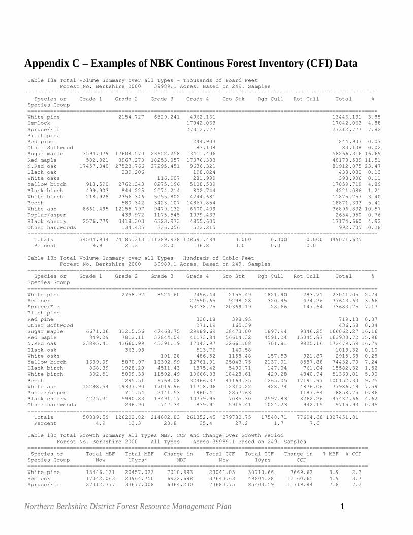
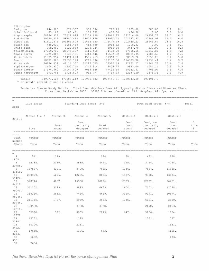
Appendix C – Examples of NBK Continous Forest Inventory (CFI) Data Table 13a Total Volume Summary over all Types - Thousands of Board Feet Forest No. Berkshire 2000 39989.1 Acres. Based on 249. Samples ============================================================================================================ Species or Grade 1 Grade 2 Grade 3 Grade 4 Gro Stk Rgh Cull Rot Cull Total % Species Group ============================================================================================================ White pine 2154.727 6329.241 4962.161 13446.131 3.85 Hemlock 17042.063 17042.063 4.88 Spruce/Fir 27312.777 27312.777 7.82 Pitch pine Red pine 244.903 244.903 0.07 Other Softwood 83.108 83.108 0.02 Sugar maple 3594.079 17608.570 23652.258 13411.406 58266.316 16.69 Red maple 582.821 3967.273 18253.057 17376.383 40179.539 11.51 N.Red oak 17457.340 27523.766 27295.451 9636.321 81912.875 23.47 Black oak 239.206 198.824 438.030 0.13 White oaks 116.907 281.999 398.906 0.11 Yellow birch 913.590 2762.343 8275.196 5108.589 17059.719 4.89 Black birch 499.903 844.225 2074.214 802.744 4221.086 1.21 White birch 218.928 2356.346 5055.802 4244.681 11875.757 3.40 Beech 580.342 3423.107 14867.854 18871.303 5.41 White ash 8661.495 12155.797 9479.132 6600.409 36896.832 10.57 Poplar/aspen 439.972 1175.545 1039.433 2654.950 0.76 Black cherry 2576.779 3418.303 6323.973 4855.605 17174.660 4.92 Other hardwoods 134.435 336.056 522.215 992.705 0.28 ============================================================================================================ Totals 34504.934 74185.313 111789.938 128591.484 0.000 0.000 0.000 349071.625 Percent 9.9 21.3 32.0 36.8 0.0 0.0 0.0 Table 13b Total Volume Summary over all Types - Hundreds of Cubic Feet Forest No. Berkshire 2000 39989.1 Acres. Based on 249. Samples ============================================================================================================ Species or Grade 1 Grade 2 Grade 3 Grade 4 Gro Stk Rgh Cull Rot Cull Total % Species Group ============================================================================================================ White pine 2758.92 8524.60 7496.44 2155.49 1821.90 283.71 23041.05 2.24 Hemlock 27550.65 9298.28 320.45 474.26 37643.63 3.66 Spruce/Fir 53138.25 20369.19 28.66 147.64 73683.75 7.17 Pitch pine Red pine 320.18 398.95 719.13 0.07 Other Softwood 271.19 165.39 436.58 0.04 Sugar maple 6671.06 32215.56 47468.75 29989.69 38473.00 1897.94 9346.25 166062.27 16.16 Red maple 849.29 7812.11 37844.04 41173.84 56614.32 4591.24 15045.87 163930.72 15.96 N.Red oak 23895.41 42660.99 45391.19 17343.97 32661.08 701.81 9825.16 172479.59 16.79 Black oak 363.98 513.76 140.58 1018.32 0.10 White oaks 191.28 486.52 1158.48 157.53 921.87 2915.68 0.28 Yellow birch 1639.09 5870.97 18392.99 12761.01 25043.75 2137.01 8587.88 74432.70 7.24 Black birch 868.39 1928.29 4511.43 1875.42 5490.71 147.04 761.04 15582.32 1.52 White birch 392.51 5009.33 11592.49 10666.83 18428.61 429.28 4840.94 51360.01 5.00 Beech 1295.51 6769.08 32466.37 41164.35 1265.05 17191.97 100152.30 9.75 White ash 12298.54 19337.90 17016.96 11718.06 12310.22 428.74 4876.06 77986.49 7.59 Poplar/aspen 711.54 2141.53 1960.41 2857.63 1187.64 8858.75 0.86 Black cherry 4225.31 5990.83 13491.17 10779.95 7085.30 2597.83 3262.26 47432.66 4.62 Other hardwoods 246.90 747.34 839.91 5915.41 1024.23 942.15 9715.93 0.95 ============================================================================================================ Totals 50839.59 126202.82 214082.83 261352.45 279730.75 17548.71 77694.68 1027451.81 Percent 4.9 12.3 20.8 25.4 27.2 1.7 7.6 Table 13c Total Growth Summary All Types MBF, CCF and Change Over Growth Period Forest No. Berkshire 2000 All Types Acres 39989.1 Based on 249. Samples ========================================================================================================= Species or Total MBF Total MBF Change in Total CCF Total CCF Change in % MBF % CCF Species Group Now 10yrs* MBF Now 10yrs CCF ========================================================================================================= White pine 13446.131 20457.023 7010.893 23041.05 30710.66 7669.62 3.9 2.2 Hemlock 17042.063 23964.750 6922.688 37643.63 49804.28 12160.65 4.9 3.7 Spruce/Fir 27312.777 33677.008 6364.230 73683.75 85403.59 11719.84 7.8 7.2
Northern Berkshire District Forest Resource Management Plan 2
Pitch pine Red pine 244.903 577.997 333.094 719.13 1105.02 385.89 0.1 0.1 Other Softwood 83.108 183.461 100.352 436.58 436.58 0.00 0.0 0.0 Sugar maple 58266.316 73521.016 15254.699 166062.27 192314.00 26251.73 16.7 16.2 Red maple 40179.539 58787.418 18607.879 163930.72 201577.63 37646.91 11.5 16.0 N.Red oak 81912.875 103609.805 21696.930 172479.59 202445.23 29965.64 23.5 16.8 Black oak 438.030 1051.438 613.409 1018.32 1018.32 0.00 0.1 0.1 White oaks 398.906 1629.850 1230.944 2915.68 3447.70 532.03 0.1 0.3 Yellow birch 17059.719 25175.137 8115.418 74432.70 87995.55 13562.86 4.9 7.2 Black birch 4221.086 5640.731 1419.646 15582.32 18571.95 2989.63 1.2 1.5 White birch 11875.757 16471.020 4595.263 51360.01 60019.20 8659.20 3.4 5.0 Beech 18871.303 26638.199 7766.896 100152.30 116389.70 16237.41 5.4 9.7 White ash 36896.832 48114.332 11217.500 77986.49 92231.27 14244.78 10.6 7.6 Poplar/aspen 2654.950 4395.764 1740.814 8858.75 9943.00 1084.26 0.8 0.9 Black cherry 17174.660 24187.809 7013.148 47432.66 55342.61 7909.94 4.9 4.6 Other hardwoods 992.705 1925.503 932.797 9715.93 12187.29 2471.36 0.3 0.9 ========================================================================================================= Totals 349071.625 470008.219 120936.602 1027451.81 1220943.50 193491.70 * or growth period if not 10 years Table 14a Coarse Woody Debris - Total Oven-dry Tons Over All Types by Status Class and Diameter Class Forest No. Berkshire 2000 39989.1 Acres. Based on 249. Samples. All Species ================================================================================================================== Live Trees Standing Dead Trees 3-5 Down Dead Trees 6-8 Total Dead -------------------------------------------------------------------------------------------------------------------- Status 1 & 2 Status 3 Status 4 Status 5 Status 6 Status 7 Status 8 Status Dead Dead Dead,down Dead 3 Dead partially Dead down partially down thru live Sound decayed decayed Sound decayed decayed 8 -------------------------------------------------------------------------------------------------------------------- Diam Number Number Number Number Number Number Number Number Class Tons Tons Tons Tons Tons Tons Tons Tons ================================================================================================================== 4 511. 119. 188. 38. 462. 998. 1805. 6 94335. 2160. 3835. 4424. 325. 3754. 6258. 20755. 8 187557. 4391. 8700. 7625. 1246. 7584. 11915. 41461. 10 280329. 5295. 12255. 8804. 1527. 9708. 13834. 51424. 12 328744. 4207. 14350. 10024. 2333. 12737. 20461. 64111. 14 341252. 3199. 9893. 4639. 1604. 7152. 12598. 39085. 16 285210. 2512. 7626. 4629. 3315. 9391. 10574. 38046. 18 211165. 1727. 5969. 3683. 1245. 5121. 2900. 20645. 20 128588. 4150. 3328. 2670. 2163. 12311. 22 85990. 592. 3035. 2279. 647. 5266. 1054. 12872. 24 65752. 1185. 1352. 797. 3334. 26 50300. 2261. 1161. 3422. 28 17648. 1126. 933. 1155. 3214. 30 6682. 433. 433. 32 7654.

Northern Berkshire District Forest Resource Management Plan 3
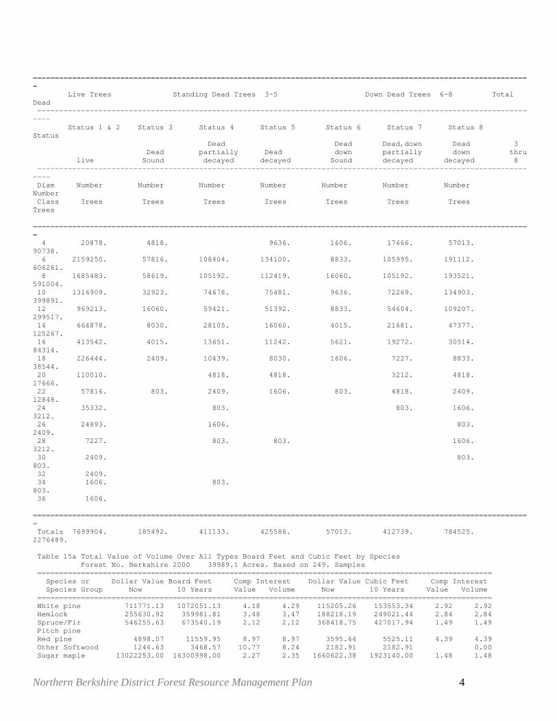
34 6109. 2351. 2351. 36 6740. ================================================================================================================== Totals 2104566. 24200. 76738. 50555. 12279. 65198. 86299. 315269. Table 14b Coarse Woody Debris - Total Hundreds of Cubic Feet over All Types by Status Class and Diameter Class Forst No. Berkshire 2000 39989.1 Acres. Based on 249. Samples. ALL Species ================================================================================================================== Live Trees Standing Dead Trees 3-5 Down Dead Trees 6-8 Total Dead -------------------------------------------------------------------------------------------------------------------- Status 1 & 2 Status 3 Status 4 Status 5 Status 6 Status 7 Status 8 Status Dead Dead Dead,down Dead 3 Dead partially Dead down partially down thru live Sound decayed decayed Sound decayed decayed 8 -------------------------------------------------------------------------------------------------------------------- Diam Number Number Number Number Number Number Number Number Class CCF CCF CCF CCF CCF CCF CCF CCF ================================================================================================================== 4 273.95 44.93 94.16 19.87 241.35 512.60 912.90 6 48612.08 1240.79 2156.93 2489.54 180.07 2107.94 3395.11 11570.39 8 97772.53 2721.42 5085.82 4565.43 763.59 4461.90 7189.24 24787.41 10 141648.45 3219.73 7088.27 5387.91 965.96 5857.10 8696.89 31215.86 12 164786.73 2637.63 8426.08 6166.19 1354.15 7736.55 13043.55 39364.15 14 166130.97 1894.87 6005.13 2819.23 928.94 4244.34 8182.24 24074.76 16 137317.03 1376.11 4396.28 2769.49 1945.81 5570.15 6695.70 22753.54 18 98160.84 1034.76 3872.85 2279.16 691.18 2980.18 1983.86 12841.98 20 60662.80 2367.97 2070.06 1595.39 1421.83 7455.25 22 38790.49 452.25 1663.31 1139.43 407.25 3109.22 746.91 7518.36 24 29398.16 797.44 755.29 598.43 2151.15 26 23039.41 1335.87 649.47 1985.34 28 7820.52 693.73 625.61 832.54 2151.88 30 3370.65 309.88 309.88 32 3557.26 34 2887.98 1322.14 1322.14 36 3222.02 ================================================================================================================== Totals 1027451.81 14622.48 45211.83 30406.22 7256.81 38659.40 54258.26 190415.05 Table 14c Coarse Woody Debris - Total Trees Over All Types by Status Class and Diameter Class Forest No. Berkshire 2000 39989.1 Acres. Based on 249. Samples. All Species
Northern Berkshire District Forest Resource Management Plan 4
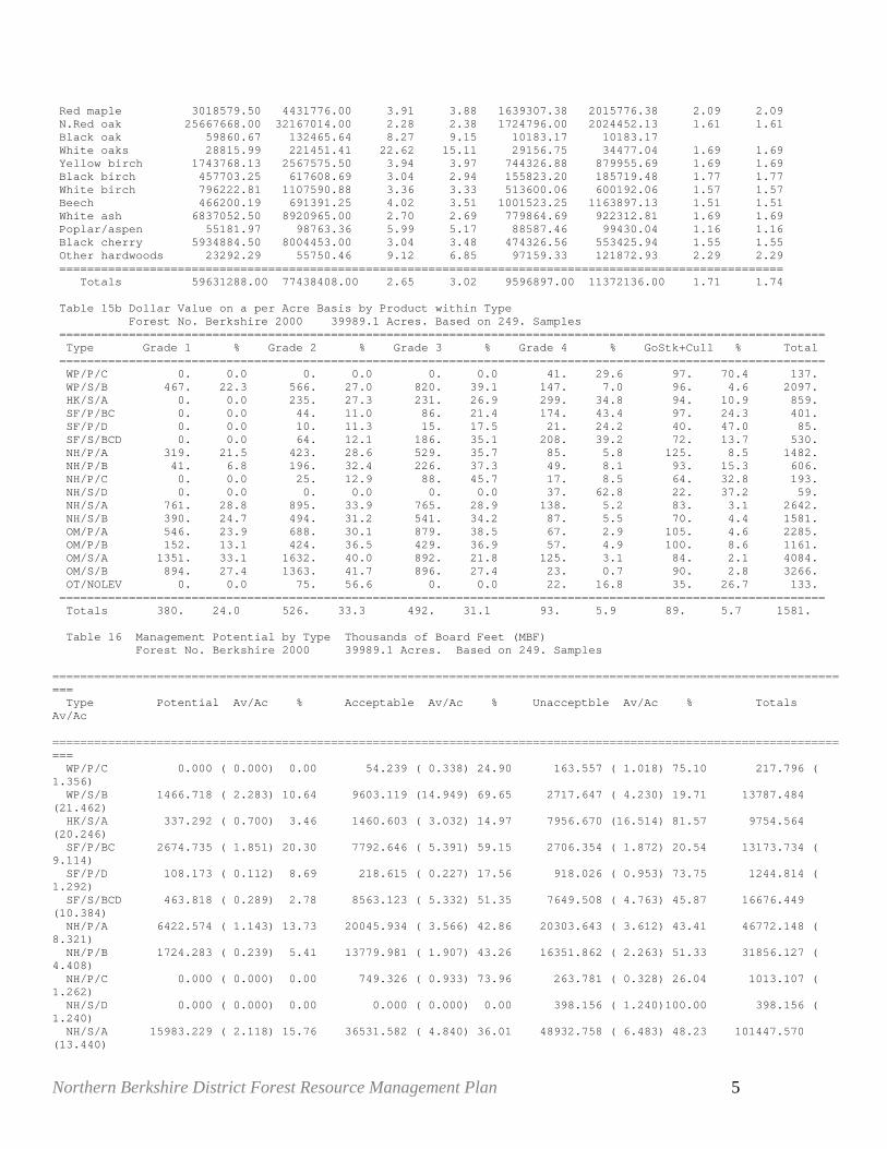
================================================================================================================== Live Trees Standing Dead Trees 3-5 Down Dead Trees 6-8 Total Dead -------------------------------------------------------------------------------------------------------------------- Status 1 & 2 Status 3 Status 4 Status 5 Status 6 Status 7 Status 8 Status Dead Dead Dead,down Dead 3 Dead partially Dead down partially down thru live Sound decayed decayed Sound decayed decayed 8 -------------------------------------------------------------------------------------------------------------------- Diam Number Number Number Number Number Number Number Number Class Trees Trees Trees Trees Trees Trees Trees Trees ================================================================================================================== 4 20878. 4818. 9636. 1606. 17666. 57013. 90738. 6 2159250. 57816. 108404. 134100. 8833. 105995. 191112. 606261. 8 1685483. 58619. 105192. 112419. 16060. 105192. 193521. 591004. 10 1316909. 32923. 74678. 75481. 9636. 72269. 134903. 399891. 12 969213. 16060. 59421. 51392. 8833. 54604. 109207. 299517. 14 664878. 8030. 28105. 16060. 4015. 21681. 47377. 125267. 16 413542. 4015. 13651. 11242. 5621. 19272. 30514. 84314. 18 226444. 2409. 10439. 8030. 1606. 7227. 8833. 38544. 20 110010. 4818. 4818. 3212. 4818. 17666. 22 57816. 803. 2409. 1606. 803. 4818. 2409. 12848. 24 35332. 803. 803. 1606. 3212. 26 24893. 1606. 803. 2409. 28 7227. 803. 803. 1606. 3212. 30 2409. 803. 803. 32 2409. 34 1606. 803. 803. 36 1606. ================================================================================================================== Totals 7699904. 185492. 411133. 425586. 57013. 412739. 784525. 2276489. Table 15a Total Value of Volume Over All Types Board Feet and Cubic Feet by Species Forest No. Berkshire 2000 39989.1 Acres. Based on 249. Samples ======================================================================================================== Species or Dollar Value Board Feet Comp Interest Dollar Value Cubic Feet Comp Interest Species Group Now 10 Years Value Volume Now 10 Years Value Volume ======================================================================================================== White pine 711771.13 1072051.13 4.18 4.29 115205.26 153553.34 2.92 2.92 Hemlock 255630.92 359981.81 3.48 3.47 188218.19 249021.44 2.84 2.84 Spruce/Fir 546255.63 673540.19 2.12 2.12 368418.75 427017.94 1.49 1.49 Pitch pine Red pine 4898.07 11559.95 8.97 8.97 3595.64 5525.11 4.39 4.39 Other Softwood 1246.63 3468.57 10.77 8.24 2182.91 2182.91 0.00 Sugar maple 13022253.00 16300998.00 2.27 2.35 1660622.38 1923140.00 1.48 1.48
Northern Berkshire District Forest Resource Management Plan 5
Red maple 3018579.50 4431776.00 3.91 3.88 1639307.38 2015776.38 2.09 2.09 N.Red oak 25667668.00 32167014.00 2.28 2.38 1724796.00 2024452.13 1.61 1.61 Black oak 59860.67 132465.64 8.27 9.15 10183.17 10183.17 White oaks 28815.99 221451.41 22.62 15.11 29156.75 34477.04 1.69 1.69 Yellow birch 1743768.13 2567575.50 3.94 3.97 744326.88 879955.69 1.69 1.69 Black birch 457703.25 617608.69 3.04 2.94 155823.20 185719.48 1.77 1.77 White birch 796222.81 1107590.88 3.36 3.33 513600.06 600192.06 1.57 1.57 Beech 466200.19 691391.25 4.02 3.51 1001523.25 1163897.13 1.51 1.51 White ash 6837052.50 8920965.00 2.70 2.69 779864.69 922312.81 1.69 1.69 Poplar/aspen 55181.97 98763.36 5.99 5.17 88587.46 99430.04 1.16 1.16 Black cherry 5934884.50 8004453.00 3.04 3.48 474326.56 553425.94 1.55 1.55 Other hardwoods 23292.29 55750.46 9.12 6.85 97159.33 121872.93 2.29 2.29 ======================================================================================================== Totals 59631288.00 77438408.00 2.65 3.02 9596897.00 11372136.00 1.71 1.74 Table 15b Dollar Value on a per Acre Basis by Product within Type Forest No. Berkshire 2000 39989.1 Acres. Based on 249. Samples ============================================================================================================== Type Grade 1 % Grade 2 % Grade 3 % Grade 4 % GoStk+Cull % Total ============================================================================================================== WP/P/C 0. 0.0 0. 0.0 0. 0.0 41. 29.6 97. 70.4 137. WP/S/B 467. 22.3 566. 27.0 820. 39.1 147. 7.0 96. 4.6 2097. HK/S/A 0. 0.0 235. 27.3 231. 26.9 299. 34.8 94. 10.9 859. SF/P/BC 0. 0.0 44. 11.0 86. 21.4 174. 43.4 97. 24.3 401. SF/P/D 0. 0.0 10. 11.3 15. 17.5 21. 24.2 40. 47.0 85. SF/S/BCD 0. 0.0 64. 12.1 186. 35.1 208. 39.2 72. 13.7 530. NH/P/A 319. 21.5 423. 28.6 529. 35.7 85. 5.8 125. 8.5 1482. NH/P/B 41. 6.8 196. 32.4 226. 37.3 49. 8.1 93. 15.3 606. NH/P/C 0. 0.0 25. 12.9 88. 45.7 17. 8.5 64. 32.8 193. NH/S/D 0. 0.0 0. 0.0 0. 0.0 37. 62.8 22. 37.2 59. NH/S/A 761. 28.8 895. 33.9 765. 28.9 138. 5.2 83. 3.1 2642. NH/S/B 390. 24.7 494. 31.2 541. 34.2 87. 5.5 70. 4.4 1581. OM/P/A 546. 23.9 688. 30.1 879. 38.5 67. 2.9 105. 4.6 2285. OM/P/B 152. 13.1 424. 36.5 429. 36.9 57. 4.9 100. 8.6 1161. OM/S/A 1351. 33.1 1632. 40.0 892. 21.8 125. 3.1 84. 2.1 4084. OM/S/B 894. 27.4 1363. 41.7 896. 27.4 23. 0.7 90. 2.8 3266. OT/NOLEV 0. 0.0 75. 56.6 0. 0.0 22. 16.8 35. 26.7 133. ============================================================================================================== Totals 380. 24.0 526. 33.3 492. 31.1 93. 5.9 89. 5.7 1581. Table 16 Management Potential by Type Thousands of Board Feet (MBF) Forest No. Berkshire 2000 39989.1 Acres. Based on 249. Samples ==================================================================================================================== Type Potential Av/Ac % Acceptable Av/Ac % Unacceptble Av/Ac % Totals Av/Ac ==================================================================================================================== WP/P/C 0.000 ( 0.000) 0.00 54.239 ( 0.338) 24.90 163.557 ( 1.018) 75.10 217.796 ( 1.356) WP/S/B 1466.718 ( 2.283) 10.64 9603.119 (14.949) 69.65 2717.647 ( 4.230) 19.71 13787.484 (21.462) HK/S/A 337.292 ( 0.700) 3.46 1460.603 ( 3.032) 14.97 7956.670 (16.514) 81.57 9754.564 (20.246) SF/P/BC 2674.735 ( 1.851) 20.30 7792.646 ( 5.391) 59.15 2706.354 ( 1.872) 20.54 13173.734 ( 9.114) SF/P/D 108.173 ( 0.112) 8.69 218.615 ( 0.227) 17.56 918.026 ( 0.953) 73.75 1244.814 ( 1.292) SF/S/BCD 463.818 ( 0.289) 2.78 8563.123 ( 5.332) 51.35 7649.508 ( 4.763) 45.87 16676.449 (10.384) NH/P/A 6422.574 ( 1.143) 13.73 20045.934 ( 3.566) 42.86 20303.643 ( 3.612) 43.41 46772.148 ( 8.321) NH/P/B 1724.283 ( 0.239) 5.41 13779.981 ( 1.907) 43.26 16351.862 ( 2.263) 51.33 31856.127 ( 4.408) NH/P/C 0.000 ( 0.000) 0.00 749.326 ( 0.933) 73.96 263.781 ( 0.328) 26.04 1013.107 ( 1.262) NH/S/D 0.000 ( 0.000) 0.00 0.000 ( 0.000) 0.00 398.156 ( 1.240)100.00 398.156 ( 1.240) NH/S/A 15983.229 ( 2.118) 15.76 36531.582 ( 4.840) 36.01 48932.758 ( 6.483) 48.23 101447.570 (13.440)
Northern Berkshire District Forest Resource Management Plan 6
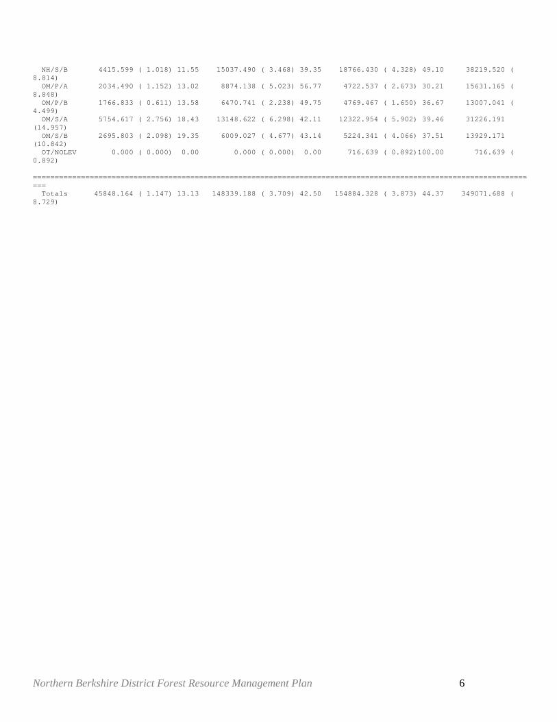
NH/S/B 4415.599 ( 1.018) 11.55 15037.490 ( 3.468) 39.35 18766.430 ( 4.328) 49.10 38219.520 ( 8.814) OM/P/A 2034.490 ( 1.152) 13.02 8874.138 ( 5.023) 56.77 4722.537 ( 2.673) 30.21 15631.165 ( 8.848) OM/P/B 1766.833 ( 0.611) 13.58 6470.741 ( 2.238) 49.75 4769.467 ( 1.650) 36.67 13007.041 ( 4.499) OM/S/A 5754.617 ( 2.756) 18.43 13148.622 ( 6.298) 42.11 12322.954 ( 5.902) 39.46 31226.191 (14.957) OM/S/B 2695.803 ( 2.098) 19.35 6009.027 ( 4.677) 43.14 5224.341 ( 4.066) 37.51 13929.171 (10.842) OT/NOLEV 0.000 ( 0.000) 0.00 0.000 ( 0.000) 0.00 716.639 ( 0.892)100.00 716.639 ( 0.892) ==================================================================================================================== Totals 45848.164 ( 1.147) 13.13 148339.188 ( 3.709) 42.50 154884.328 ( 3.873) 44.37 349071.688 ( 8.729)
Northern Berkshire District Forest Resource Management Plan 7
Appendix D – High Conservation Value Forest
Defining HCVFs on DCR & DFW Lands in Massachusetts
A report to The Bureau of Forestry
Department of Conservation and Recreation And
The Forestry Project Division of Fisheries and Wildlife
Prepared by
Patricia Swain, Ph.D. Natural Heritage & Endangered Species Program
Division of Fisheries & Wildlife
Final January 2008
Defining High Conservation Value Forests on DCR & DFW Lands in Massachusetts
Abstract:
Northern Berkshire District Forest Resource Management Plan 8
Defining and identifying High Conservation Value Forests (HCVF) is a condition of Forest Stewardship Council (FSC) ‘Green Certification’ of sustainable forestry for Massachusetts’ state lands. HCVFs are forest areas that need to be appropriately managed in order to maintain or enhance identified High Conservation Values (HCVs). The definition of HCVs encompasses exceptional or critical ecological attributes, ecosystem services, and social functions. Under certification, areas identified as HCVFs may be harvested, but management activities must maintain or enhance the HCVs present.
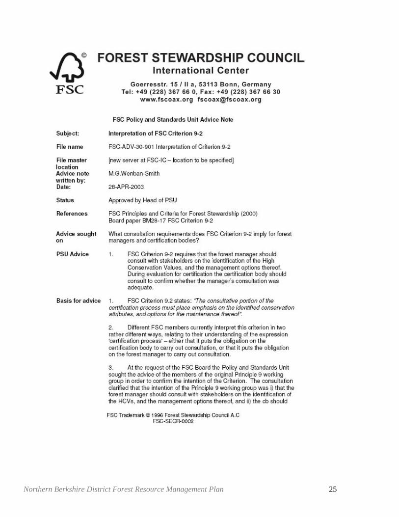
The FSC Northeastern Region Standards provide guidance on identifying HCVs, and many HCVs are already identified and mitigated under existing Massachusetts regulations and procedures. In addition, when public land managers in Massachusetts held natural resource expert meetings to establish criteria for identifying Forest Reserves in 2004, many of the criteria chosen represented HCVs. However, FSC has issued an Interpretation FSC Criterion 9-2 (attached as Appendix D2) that “requires that the forest manager consult with stakeholders on the identification of the High Conservation Values and the management options thereof.” This was accomplished by posting the HCVF draft document on the state forestry websites, alerting experts to its existence and need for review, and presenting the document at public meetings on forest planning on January 31 and February 1, 2007.
Rare Species: FSC principles and criteria state that general forest management should conserve biological diversity and its associated values. In addition to this guidance, FSC identifies “significant concentrations” of rare species as an HCV. In Massachusetts, forest cutting plans for areas in known rare species habitats (Priority Habitats) already undergo review by the Natural Heritage and Endangered Species Program (NHESP); therefore identifying all forested sites on state lands within NHESP Priority Habitats as HCVFs would put no additional burden on forestry operations and would meet and exceed the rare species protection intentions of the Green Certification document.
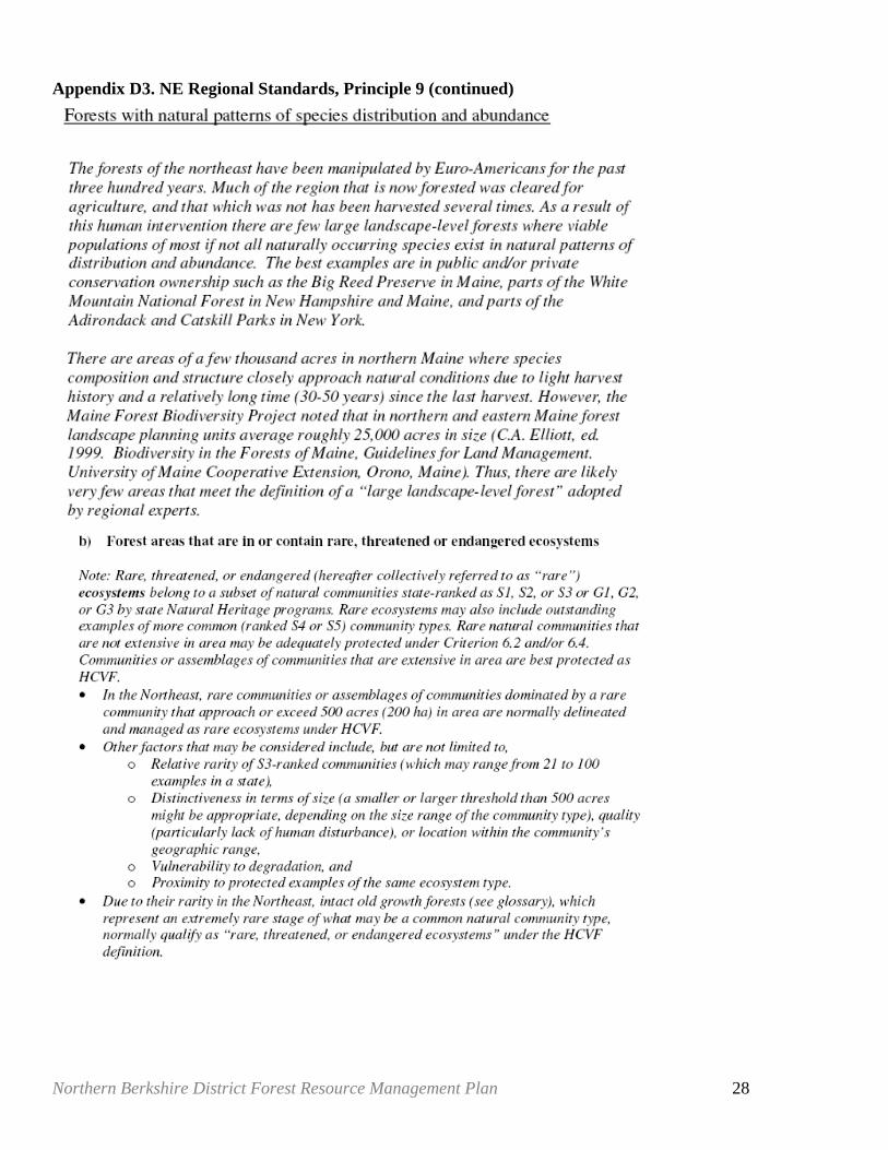
Rare Ecosystems: HCVFs are intended to include forest areas that are in or contain rare, threatened or endangered ecosystems. The FSC Northeast US region report on HCVF standards recommends using natural communities with abundance ranks of S1, S2 or S3 by the state’s Natural Heritage Program as the rare ecosystems. In Massachusetts, most S1-S3 community types are disturbance sensitive, and were included in the areas NHESP recommended as being in Forest Reserves. When sufficient numbers of a type occur on state land, it may make sense to keep only the best as reserves, and identify others as HCVs. Those S1-S3 types that were not recommended for Forest Reserves need some conditioned, occasional management, and thus may be appropriate for designation as HCVF since management that maintains or enhances HCVs is allowed. The Northeast working group suggests that S1-S3 natural communities that are around 500 acres would be a target for HCVF, with smaller occurrences being protected through Principle 6.2 (conservation zones and protection areas) and/or 6.4 (representative areas). Very few of the rare types of natural communities in Massachusetts have occurrences that would approach or exceed 500 acres (although some occurrences of pitch pine scrub oak communities do). Despite their small size, designation of S1 and S2, and good quality examples S3 types outside Forest Reserves as HCVF is warranted for conservation of these unique communities. NHESP has not focused on identifying priority natural communities on existing conservation lands, therefore further inventory on state lands and reporting of natural communities would improve NHESP’s information about the occurrences of the different types, their condition, and their protection status. Further analysis of protection status of known natural community occurrences would allow identification of the most sensitive for reserve status.
Landscape Level Ecosystems: An additional biodiversity HCV is “large landscape level forests contained within or containing the management unit, where viable populations of most if not all naturally occurring species exist in natural patterns of distribution and abundance.” DCR and DFW have already determined that existing Old Growth will be within Forest Reserves. Massachusetts has three sources of information on such large forests.
Northern Berkshire District Forest Resource Management Plan 9
An important landscape level ecosystem HCV in Massachusetts would be Interior Forest. Interior Forest is areas of extensive, unfragmented forest land buffered from roads and development that provide important habitat for certain native wildlife species that benefit from unbroken forest patches. Interior Forest patches in Massachusetts have been identified using GIS modeling (MassWildlife unpuplished data). They include many of the common forest types for their respective ecoregions which could cover at least part of the need for representatives of the large forest types. Because Interior Forest provides important habitat for disturbance sensitive and wide ranging species, it should be a designated HCV itself..
Massachusetts has a second source of information to identify important forest areas: areas that were forested in the 1830s (as shown on old maps) and are currently forested may have been continuously forested since pre-settlement times (commonly referred to as “1830s forest,” although such designation needs to be shown by on-the-ground evaluation of the soils). These areas typically support greater biodiversity than areas that have been tilled. These forest areas should be identified as HCVFs with special forest management considerations.
The third source of information of good examples of common forest types is the NHESP database which contains ‘A’ ranked (excellent) examples of the more common types of natural communities. Including those excellent examples that occur on state land as HCVFs would provide recognition and appropriate management to maintain these communities.
High Quality Cold Water Fisheries Resources: DFW is identifying a sub-set of all streams and rivers in Massachusetts that support cold water fish species where the entire fishery is composed of native species. Forests on state lands that buffer and support habitat associated with these unique stream reaches are of high conservation value. Appropriate filter widths on state lands should be designated, when the research by the DFW Fisheries Section is complete and reviewed by DCR.
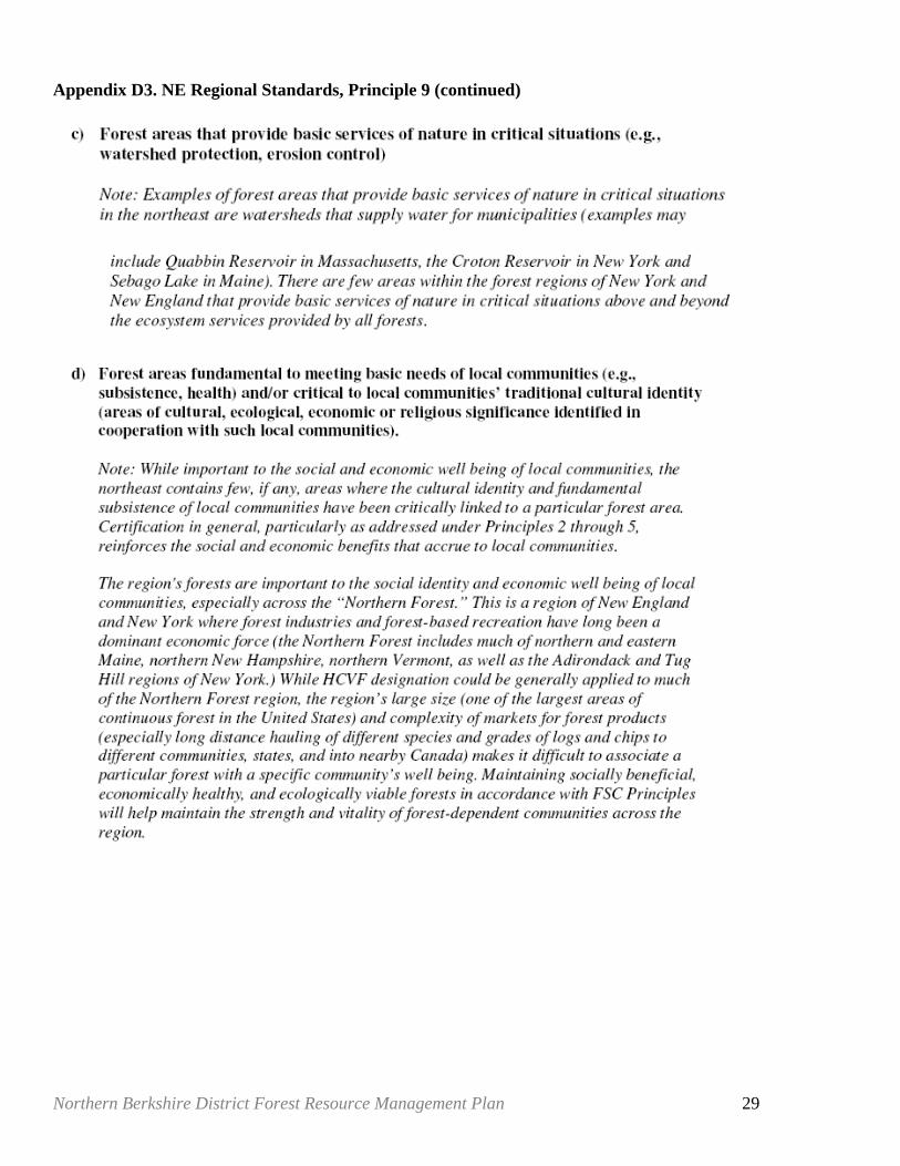
Watershed Protection Forest: Forest areas that provide basic services of nature in critical situations, such as watershed protection or erosion control are an additional HCV. Watersheds that contribute to drinking water supplies are a particular HCV that are being addressed by DCR’s Division of Watershed Protection on the Quabbin, Ware River, and Wachusett watersheds. There are other (primarily municipal) water supply areas on DCR lands, and perhaps on DFW lands, that should be identified as HCVFs, with the management of these areas focused on water supply protection, according to regulation and BMPs.
Forest Areas Critical for Subsistence of Local Communities: These are intended to be key hunting or foraging areas for endemic communities for which there is no alternative food sources, and are unlikely to occur in Massachusetts. FSC comments that they do not occur in the United Kingdom, since it is a highly developed area where most of the population has alternative sources of food. The Northeast working group suggests that is true for the northeast US as well.
Forest Areas of Special Cultural or Religious Significance: DCR and DFW need to identify and interact with any local groups, particularly with any indigenous peoples, that have identified culturally sensitive areas on state lands (Appendix D5 includes some information from the SE Bioreserve report on protecting cultural resources). Areas of potential harvest are already submitted to the Massachusetts Historical Commission (MHC) for review under their regulations and policies concerning historic and archeological sites, for review and comment. In addition, the state archeologist maintains a list of known archeological sites and has modeled areas likely used by Native Americans before European settlement. If those areas are not included as Forest Reserves, they should be included as HCVF until their actual status is determined from studies. Massachusetts forest cutting procedures already cover much for the intent of protecting cultural resources.
Public Review: This HCVF report was made available for public and expert review as part of the Forest Resource Management Planning public involvement process.
Northern Berkshire District Forest Resource Management Plan 10
Introduction: Defining and identifying High Conservation Value Forests (HCVF) is a condition of Green Certification for Massachusetts’ state lands. Fortunately for land managers, many of the suggested High Conservation Values (HCVs) are already identified and dealt with in existing Massachusetts regulations and procedures. Under Forest Stewardship Council (FSC) certification, areas identified as HCVFs may be harvested, but management activities must maintain or enhance the HCVs present. Background: When the Massachusetts state lands were “Green certified” by Scientific Certification Systems (SCS) for the FSC in 2004, a condition of certification was that the agencies develop local definitions of High Conservation Values and apply that to management (Condition 2002.7 for DEM and DFW, 2002.9 for MDC) (SCS, 2004). Forest Stewardship Council, Northeast (USA) Region Standards - definition of HCVF: In Principle 9 of the FSC certification standard, forest managers are required to identify HCVs, to manage the forests for HCVs, and to monitor the success of this management. The definition of HCVs encompasses exceptional or critical ecological attributes, ecosystem services, and social functions. High Conservation Value Forests are forests that contain key HCVs. The designation relies solely on the presence of one of more HCVs. While all forests provide environmental and social values, HCVFs encompass exceptional or critical ecological attributes, ecosystem services and social functions. HCVFs are simply the forests where these values are found, or, more precisely, the forest area that needs to be appropriately managed in order to maintain or enhance the identified values (language from Jennings, 2004. ProForest ToolKit: HCVF for Conservation Practitioners. page 1). Other protections: FSC principles and criteria include general forest management requirements. The FSC discussions recommend using protected lands, such as Forest Reserves, and zoning to assure protection of the most sensitive forest attributes. Several of these forest attributes are explicitly discussed in Principle 9, the HCVF section. As noted in the recommendation discussion of this document (p.12), existing Massachusetts’ statutes, regulations, and policies protect pre- and post-settlement historic sites, rare species habitat, water supplies, and Old Growth forest. Principle 6, Environmental Impact, states that forest management should conserve biological diversity and its associated values. The discussion of HCVFs in the Northeast Regional standards refers back to various parts of Principle 6 (6.2, safeguards for rare and endangered species and habitats through zoning and protected areas and/or 6.4, protection of representative samples of existing ecosystems) and suggests that HCVFs need to be designated only where zoning and existing protected areas (Wildlands/Nature Preserves or Forest Reserves in Massachusetts) don’t suffice. Although Forest Reserves may contain HCVs, HCVFs do not need to be designated as protected areas if management does not compromise the HCVs.
Northern Berkshire District Forest Resource Management Plan 11
Principle 9 Biodiversity Values: Given the state of knowledge of ‘significant concentrations of biodiversity,’ there are generally two approaches to conserving it: fine filter and coarse filter. The Fine filter approach relies on identifying rare species (usually state and/or federally listed plants or animals) and protecting them and their habitats. The Coarse filter approach uses natural communities, where natural communities are stand-ins for total biodiversity. Natural communities are generally defined as recurring assemblages of plant and animal species, usually found in particular environmental conditions. In this approach, the types of natural communities in a state (or other region) are ranked for abundance throughout the state (S5 types are most abundant, and S1 least, details are given in Appendix D4). The occurrences are then ranked for quality, with the best of the most common types (and all their constituent species) identified for conserving, and as many as possible of the least common (and their constituent species) protected. There is a sliding scale between the best of the abundant types and accepting all that remains of the least common. Fine Filter - Rare Species: One of the HCVs is “significant concentrations” of rare species. However in Massachusetts, known occurrences of rare species listed in the Massachusetts Endangered Species Act (MESA) have a regulatory impact on forestry – forest cutting plans for areas in known rare species habitats already undergo review. Mitigation for the protection of the rare species is provided: therefore the requirements in Principle 9 of maintaining or enhancing the HCV (rare species in this case) is already being met when the recommendations from review of the forest cutting plan are followed (304 CMR 11.00 11(6) and 321 CMR 10.02 (14)). This means that identifying all areas in NHESP Priority Habitats as HCVFs would put no additional burden on forestry operations and would meet and exceed the rare species protection intentions of the Green Certification document. Coarse Filter - Natural Communities (part 1) An additional biodiversity HCV is “large landscape level forests contained within or containing the management unit, where viable populations of most if not all naturally occurring species exist in natural patterns of distribution and abundance” (FSC, 2004, glossary). This definition is very close to the definitions Natural Heritage Programs use for A (the best, on a scale of A-D) ranked occurrences of each type of natural community. Including A ranked occurrences of the more common types (abundance ranked S5 (demonstrably secure ) and S4 (apparently secure) of natural communities from the NHESP database as HCVFs would be a way to meet this part of the broad definition of HCVFs. In Massachusetts, Old Growth occurrences are A ranked for whatever type of natural community they represent. Most Old Growth studied to date are examples of relatively common types of natural communities, typically Spruce-Fir-Northern Hardwoods Forest, Northern Hardwoods-Hemlock-White Pine Forest or High Elevation Spruce Fir Forest, with an example of Oak-Hemlock-White Pine Forest. DCR and DFW have already determined that Old Growth will be in Forest Reserves, although DFW has not detected any Old Growth forest on its lands. There are a few non-Old Growth A and B ranked occurrences of common types in the NHESP database, which could be dealt with on an individual basis, by zoning or by calling the A ranked occurrences HCVs. NHESP has records of thirteen occurrences of eight types of common (S5 and S4) upland forest-types on ten DCR properties, with five occurrences of two types of common forested wetlands on five properties. On DFW land there are 28 occurrences of ten types of upland forests on eighteen properties, and one type of forested wetland on one property. As the NE Working Group points out in the notes for the Northeast Regional Standards (p. 32 in Vers. 8.1), there really are not many landscape level (large forests with 25,000 contiguous acres where viable populations of most, if not all, naturally occurring species exist in natural patterns of distribution and abundance)
Northern Berkshire District Forest Resource Management Plan 12
undisturbed forests in the northeast. No such very large unfragmented forests would be expected in Massachusetts, although state forest managers plan to maintain the larger tracts that do occur on public land, with encouragement to private landowners to apply certification standards to large private holdings as well. As part of the Forest Reserve planning process, interior forest areas (intact forest buffered from roads and developed and open land) on state land were identified on GIS. Interior Forest is considered to be unbroken blocks of unfragmented forest. Natural features such as wetlands and open water are included in this dataset and were not interpreted as fragmenting forest patches. Roads were buffered at different distances depending on the type and the effects on wildlife. The resulting maps of the blocks of interior forest were made available for planning (unpublished DFW Metadata, copy in Appendix D4). Interior forest provides important habitat: for example, songbird nesting success is greater for some species further from forest edge and the disturbances associated with human dominated areas, which have more opportunistic predators such as raccoons, as well as cats and dogs. They also provide habitat to wide ranging species that do not interact well with humans (such as bears and coyotes) or that might be harmed by aspects of development, including by vehicles on highways. Interior Forest should be a designated as a HCV itself. Interior forests include many of the common forest types for their respective ecoregions which provides good representatives of those forest types. In addition, a minimum, meaningful, size for interior forest should be established by checking the literature on wildlife habitat needs, particularly that of disturbance sensitive birds. This would allow the most viable areas of interior forest to receive the necessary management attention. It may be that interior forest patches of a few dozen acres do not provide substantial benefit for wildlife, but patches of a few hundred acres may provide substantial benefits for wildlife. Interior Forest blocks are, by definition, buffered by forest lands that are closer to roads and development. Some of the buffering lands are state (or other) conservation land and so contribute in perpetuity to maintaining the interior forest and its special conditions. In other cases the buffering lands are not designated for conservation, and their long term use as buffers for maintaining the interior forest on the state land is not predictable. Identification of ownerships in the buffers and identification of lands worth protecting for any of the biodiversity values, including as buffers to interior forest, should be undertaken. Areas larger than the minimum patch size would receive particular focus for identifying ownerships of the buffering lands and for conservation acquisition. The conservation action here should be to identify public lands in the buffers that are not focused on conservation (not under Article 97 of the Massachusetts Constitution), and when possible move them to such protections. Identification of private lands in the buffers would enable discussions of conservation for those lands, including encouragement of sustainable management and forest certification. Massachusetts has an additional unique data source on forested lands that should be identified as HCVFs. In the 1830s the state mandated that towns make maps showing land use. Most of the forested areas, called ‘1830s forest’ or possible Primary Forest, were untilled woodlots and wooded pastures. These are not Old Growth, they have been harvested and pastured. Although those lands may well have undergone different uses in the time since the maps were made, some areas that were forested in the 1830s won’t ever have been tilled. Surveys of the soil structure in the individual sites are necessary to determine whether those sites are actual Primary Forest. Such lands that remain forested have greater biodiversity than areas that have been tilled. 1830s forest areas are shown in a GIS layer (Harvard Forest, 2002) derived from these town wide maps made in the 1830s (not all of the town
Northern Berkshire District Forest Resource Management Plan 13
maps are still available, see the Harvard Forest provisos on their website http://harvardforest.fas.harvard.edu/data/p01/hf014/1830readme.html ). 1830s forest areas should be considered for HCVF status because they include areas that have never been tilled which have higher biodiversity than tilled lands. However, it should be noted that 1830s forests were identified from old maps, and even restricted to currently forested areas, those are only two points of data in several hundred years - any given parcel may not have been continuously forested since European settlement. Of the areas that were continuously forested, most were woodlots and thinned repeatedly. They can continue to be managed in ways that maintain undisturbed soils and shaded understory layers and minimize soil compaction, displacement, and erosion. In these older forests, the soil structure with its associated biodiversity is a main attribute to protect: a goal of management should be to avoid the need to mitigate the effects of any harvest when it is done. Actual current vegetation present can provide indications of undisturbed soil, but examination of the soil structure of each area is necessary to determine actual land use history. Until individual areas are checked, the maps of 1830s/currently forested areas are the best available models of the biodiversity values found in the soils and understories of untilled forests. Each of the above forest areas supports concentrations of native biodiversity not as widespread in more disturbed parts of the state. Combining these two data sets, areas forested in the 1830s and interior forest, is expected to identify forest lands of particular importance for maintaining native species and ecosystem functioning. Some of the areas that are 1830s forest and interior forest and on state land, are included in Forest Reserves. These 1830s/interior forests areas could be considered HCVs, and part of HCVFs. Keeping in mind that some town maps did not report woodland or forest areas on the 1830s maps, and some town maps have been lost or were not made (Harvard Forest 2002; Hall et al. 2002), there are 58,534 acres of interior, 1830s forest on DCR land, out of 2,583,322 acres (about 2% - acres are “GIS acres”, calculated on landuse data in MassGIS). In addition, the planned Forest Reserves already include many of the common forest types for their ecoregions which could cover at least part of the need for representatives of the large types. If the forest types in the Forest Reserves were identified, any types not included in Forest Reserves that do occur in the 1830s/interior areas might be considered for HCVF status. For towns without 1830s forest, interior forest alone might be used. These interior, older forest areas were also identified in the BioMap report (NHESP 2001), although not to forest type. Preliminary inventory, at a fairly coarse level, can be done through aerial interpretation of forest cover and use of the existing forest inventory data. Final determination of the forest type requires on the ground surveys. Locations for surveys focused on particular forest types can be modeled from the broader existing information, geology, topography, and site knowledge of the local managers and foresters. DFW has undertaken many of these steps to locate one type of uncommon natural community, Rich Mesic Forest, resulting in many additional acres being identified on state lands. Management of the forest types designated as HCVs should be to encourage the desired conditions, and to minimize disturbance (except focused for regeneration), erosion, and displacement. Coarse Filter: Natural Communities (part 2) Principle 9 continues discussing HCVFs to include forest areas that are in or contain rare, threatened or endangered ecosystems. The Northeast region report on HCVF standards recommends using natural communities with abundance ranks of S1, S2 or S3 by the state’s Natural Heritage Program as the rare ecosystems. Massachusetts NHESP considers all types of natural communities ranked S1, S2 or S3 to be Priority Natural Communities. In Massachusetts, most S1-S3 community types are disturbance sensitive, and many were included in the areas NHESP recommended as being in Forest Reserves or patch reserves. Some of the community types
Northern Berkshire District Forest Resource Management Plan 14
included in the forest reserves may need occasional conditioned management to maintain them. Maps of locations of the NHESP natural community occurrences could be provided directly to DCR and most are available on MassGIS. It would be straightforward for maps of those locations on DCR land to be made available to the foresters and property managers. Some S1-S3 communities that were excluded from the Forest Reserves may need more conditioned, usually occasional management (for example Atlantic White Cedar Swamps might be strip clear-cut (regeneration harvest)on a very long rotation and Pitch Pine/Scrub Oak communities usually need to be managed to maintain the community attributes and the rare species that depend on the community). HCVF guidelines allow management of the forests with HCVs as long as the HCV is maintained or enhanced. The guidelines encourage using management to maintain successional natural communities. The Northeast working group suggests that S1-S3 natural communities that are around 500 acres would be a target for HCVF, with smaller occurrences being protected through Principle 6.2 (conservation zones and protection areas) and/or 6.4 (representative areas). Very few of the rare types of natural communities in Massachusetts have occurrences that would approach or exceed 500 acres (although some occurrences of pitch pine scrub oak communities do). Despite their small size, designation as HCVs is warranted for protection of all Massachusetts S1 and S2, and the better occurrences of S3 natural community types. Of the 12 upland forested Natural Community types, out of 29 priority terrestrial natural community types, seven are known from DSPR lands. Of the 17 forested wetland community types, out of 32 palustrine priority types, 9 are known from DSPR lands. For DFW lands, the numbers are: 7 upland types and 20 wetland types. The one type of priority forested natural community that occurs in intertidal estuarine conditions (of 8 priority intertidal types) is not currently documented on state land. It should be noted that in general, state lands have not been targets of natural community surveys. A few focused surveys on DFW land have resulted in increased numbers of records of priority natural communities. In addition, DFW has targeted some properties for acquisition that had known occurrences of priority natural communities, increasing the known occurrences on DFW land. The complete list of NHESP Priority Natural Community types with explanations of the S ranks is in Appendix D4. Tables 1, 2, and 3 in Appendix D4 have the names, state ranks, and acreages on state lands of forested NHESP Priority Natural Community types. Other HCVs: High Quality Cold Water Fisheries Resources: DFW is identifying a sub-set of all streams and rivers in Massachusetts that support cold water fish species where the entire fishery is composed of native species, primarily brook trout. Forests on state lands that buffer and support habitat associated with these unique stream reaches are of high conservation value . Appropriate filter widths on state lands should be designated, when the research by the DFW Fisheries Section is complete and reviewed by DCR.
Watershed protection: Forest areas that provide basic services of nature in critical situations, such as watershed protection or erosion control are an additional HCV. Watersheds that contribute to drinking water supplies are a particular HCV that has been addressed by DCR’s Division of Watershed Protection (the watershed portion of the former MDC). There are other water supply areas on DCR lands that should be identified as HCVFs, with the management of them aimed at protecting the water supplies, according to regulation and BMPs. Forest Areas critical for subsistence of local communities: these are unlikely to occur in Massachusetts. These are intended to be key hunting or foraging areas for endemic communities for which there is no alternative food sources. FSC comments that they do not occur in the United Kingdom, since it is a highly developed area where
Northern Berkshire District Forest Resource Management Plan 15
most of the population has alternative sources of food. The Northeast working group suggests that is true for the northeast US as well. Forest areas of special cultural or religious significance: Principle 3, Indigenous People’s Rights: Of the concerns for protecting rights of indigenous people, 3.3 appears to have the most relevance to Massachusetts. 3.3 states that “Sites of special cultural, ecological, economic or religious significance to indigenous peoples shall be clearly identified in cooperation with such peoples, and recognized and protected by forest managers.” Page 3, FSC Principles, 2004. The NorthEast Working Group noted that “Certification in general, particularly as addressed under Principles 2 through 5, reinforces the social and economic benefits that accrue to local communities.” Principle #4: Community relations and worker's rights: part 4.4.d. Significant archeological sites and sites of cultural, historical, or community significance, as identified through consultation with state archeological offices, tribes, universities, and local experts, are designated as special management zones or otherwise protected during harvest operations. (Appendix D6 has the FSC and NE Standards language on 3.3 and 4.4) Meetings should be held with any local groups, particularly with any indigenous peoples, that have identified culturally sensitive areas on state lands. This has been done in the area of the SE Bioreserve, and maps of sensitive areas, similar to NHESP Priority Habitat maps were produced. To protect them, the actual sensitive areas are seldom publicized. It is likely that the communications and contact methods used in the Bioreserve could be used as a model for working statewide, Appendix D5 includes some information from the Bioreserve report on protecting cultural resources. Appendix D6 includes FSC Principles 3.3 and 4.4 and the comments on them from the Northeast (US) Regional Standards. Any projects that require funding, licenses, or permits from any state agency must be reviewed by MHC [Massachusetts Historical Commission] in compliance with Massachusetts General Laws Chapter 9, sections 26-27C. This law creates the MHC, the office of the State Archaeologist, and the State Register of Historic Places among other historic preservation programs. It provides for MHC review of state projects, State Archaeologist’s Permits, the protection of archaeological sites on public land from unauthorized digging, and the protection of unmarked burials. Cultural resources are protected from state and federally funded or approved activities under several laws including, but not limited to (modified from Fleming et al. 2005):
M.G.L. Ch. 9 s. 26-27c (to 32) as amended (Massachusetts Historical Commission enabling legislation) http://www.mass.gov/legis/laws/mgl/9-26.htm; http://www.mass.gov/legis/laws/mgl/9-27.htm
http://www.sec.state.ma.us/mhc/mhcidx.htm M.G.L. Ch. 38 s. 6 (Massachusetts Unmarked Burial law) http://www.mass.gov/legis/laws/mgl/38-6.htm M.G.L. Ch. 30 s 61-62h. Massachusetts Environmental Policy Act (MEPA) http://www.mass.gov/legis/laws/mgl/30-61.htm and 301 CMR 11.00
http://www.mass.gov/envir/mepa/thirdlevelpages/meparegulations/meparegulations.htm http://www.mass.gov/envir/mepa/secondlevelpages/aboutmepa.htm Section 106 of the National Preservation Act of 1966
Northern Berkshire District Forest Resource Management Plan 16
To comply with these laws, DCR must consult with the State Historic Preservation Office (SHPO) whenever a state action has the potential to impact historic or archaeological resources. In Massachusetts the SHPO is the Massachusetts Historical Commission (MHC). Cultural Resource Management staff members are available to coordinate the consultation process. In planning projects and activities that are subject to MHC review, schedules must allow for a 30 day review process. Under these regulations and DCR and DFW policies about consultation with the Massachusetts Historical Commission which is responsible for historic and archeological sites, cultural sites including archeological sites, graveyards, cellar holes, stone walls, are reviewed. In addition, the state archeologist maintains a list of known archeological sites and has provided DCR with maps of areas that meet particular modeling criteria for likely use by Native Americans before European settlement. If those areas are not included as Forest Reserves, they should be included as HCVs until their actual status is determined from studies. Recommendations for HCVF designations: In the NE Regional Standard, their Appendix C (and attached in Appendix D3 here) is a guide to the designation of HCVFs. These separate the steps of determining whether various attributes ought to be designated as HCVs or dealt with through other means. Because Massachusetts has existing regulations protecting rare species and cultural areas that DCR and DFW are already complying with and managing for, it would make practical sense to designate these as HCVs. The same would apply to public water supply areas that are on state land where the management already is for maintaining the water quality, and secondarily for timber harvest as such. Expert meetings are encouraged to determine HCVs (especially if there are no local standards, which do exist for the Northeastern United States). Natural resource expert meetings were held to establish biodiversity value criteria for making Forest Reserves. Most of the recommendations are basically HCVs –acreage of old growth and acreage of valley bottom land, and concentrations of 1830s forest, viable rare communities, BioMap Ambystomid habitat, riparian and wetland forest, forest interior, and Living Waters CSW (Critical Supporting Watershed). Together with the Northeast standards, HCVs for biodiversity have been well defined for Massachusetts forests. However, FSC has issued an Interpretation FSC Criterion 9-2 (attached as Appendix D2) that “requires that the forest manager consult with stakeholders on the identification of the High Conservation Values and the management options thereof.” Posting this document on the state’s forestry web sites for review, calling it to the attention of forestry experts and asking for review, and addressing the HCVF ideas at the various public meetings on the forest management plans where the participants are focused on forests and represent a wide spectrum of interest in forests and forestry should provide important review and feedback on HCVF issues. Meetings should be held throughout the state to determine areas with cultural or spiritual values to local communities. This information would supplement information from MHC and the state archeologist. Some of those areas have been established as Forest Reserves, some might be managed as HCVFs. Recommended HCVs and likely effects on forestry operations: Rare Species: NHESP Priority Habitats should be designated as HCVs: forest cutting plans for such areas are already being reviewed and responses provided that maintain or enhance the species and their habitats, which meets HCV criteria. These Priority Habitats are in regulation and information exists on maps in the Natural Heritage Atlas and as public GIS datalayers.
Northern Berkshire District Forest Resource Management Plan 17
Effects on state lands management: Using existing regulations and policies would result in no additional constraints on forestry operations. Rare ecosystems: All Priority natural communities in NHESP’s database should be HCVs under the North East Standards. This includes all occurrences of types ranked S1 and S2, and good quality examples S3 types that are in the NHESP database as tracked Priority Natural Community occurrences. These can be provided to DCR and DFW as a GIS datalayer. NHESP has not focused on existing conservation lands for inventory, therefore further inventory on state lands and reporting of natural communities on them would improve NHESP’s information about the occurrences of the different types, their condition, and their protection status. For example, DFW Forestry Project has focused on identifying Rich Mesic Forest that occurs on DFW lands, that has so far resulted in more than doubling the known acreage of Rich Mesic Forest on DFW lands. Those areas will be designated as HCVFs. Locating and identifying Priority types of forested natural communities is time consuming. Because they are not randomly located in the landscape, it is possible to do some preliminary focusing. Models that incorporate information on habitat conditions provide some possibilities of locations for specific community types, but need to be checked on the ground. Interpreting aerial photographs again tends to provide broader possibilities than most of the specific natural communities occur in (for example, most oak forests types look about the same from aerials, but the specific types generally need to be determined on-site). Existing information, such as CSI plot information should also be reviewed for indications of presence of the uncommon types or to assist in planning site visits. Effects on state lands management: Consultation before harvesting. For example, expectations would include protections for soil integrity (such as requiring use of forwarders wherever feasible, limiting or excluding skidding of logs, seasonal restrictions on mechanized equipment operation, and careful location of landing areas outside of the HCVF area), procedures to avoid introducing invasives, and possibly restrictions on canopy openings to maintain shade on the forest floor. Since the forest trees are part of the natural community, and affect all the other species present, it might be important to retain particular proportions of tree species. Or, as in the case of early successional communities, opening the canopy might be encouraged. Creation of Conservation Management Practices (CMP’s) by NHESP and the DCR and DFW Forestry Programs for different types of forested priority communities would likely be useful (An individual CMP may be applicable to multiple priority communities). Landscape level ecosystems: DCR has placed known Old Growth in Forest Reserves. and much of the likely Primary Forest (also called 1830s Forest after the date of maps made throughout the state, as discussed on p. 8 of this document), that occurs on state land was placed in Forest Reserves. Interior Forest (unfragmented forest blocks, also discussed on p. 8 of this document) were also considered in setting up the Forest Reserves. Any remaining large areas that are both Primary Forest and Interior Forest that are not in Forest Reserves should be designated as HCVF. As mentioned earlier, records of 1830s woodlands are missing from some towns, in which case interior forest alone may need to be used until/unless other determinations of undisturbed soil can be made. Exemplary (A – ranked) occurrences of common types of communities from NHESP GIS should be included as HCVFs. There has not been a systematic inventory for these types of occurrences. Large Forest Reserves likely include examples of most the common types of natural communities in an area, but this needs to be verified by inventory. Such an inventory can be approached through existing information, such
Northern Berkshire District Forest Resource Management Plan 18
as CFI plots, and landcover maps made from interpretation of aerial photographs . These methods tend to provide guidance on where to look, rather than affirming the presence of particular types of natural communities. Effects on state lands management: Consultation before harvesting. For example, expectations would include protections for soil integrity (such as requiring use of forwarders where feasible, limiting or excluding skidding of logs, seasonal restrictions on mechanized equipment operation, and careful location of landing areas outside of the HCVF area), and procedures to avoid introducing invasives. Management foresters should make every effort possible to avoid the need for mitigating the effects of the harvest equipment at the end of a job. The goal is to minimize the impact. With widespread forest types, including interior forests, small openings would be normal, and areas of harvest that otherwise would not fragment the forest would be compatible. Forestry operations might be used to improve degraded examples of primary or widespread forest types. Creation of Conservation Management Plans for groups different types of widespread forested communities would likely be useful. Ecosystem Services - Critical Watersheds for drinking water supplies: Drinking water supply areas are known to management foresters and are on maps from DEP, and available from MassGIS. DCR GIS has them mapped. Effects on forestry operations: Using existing regulations and policies would result in no additional constraints on forestry operations. High Quality Cold Water Fisheries Resources: In an analysis of all streams and rivers in Massachusetts, a subset that support cold water fish species where the entire fishery is composed of native species is being identified. Forests associated with these unique stream reaches are of high conservation value, and appropriate widths on state lands should be designated as HCVF when sites are known. Effects on state lands management: Consultation before harvesting. Appropriate width enhanced buffers on state land, with no or reduced harvest will need to be identified on the ground from maps when the streams have been identified and protocols developed. Cultural areas: MHC and State Archeologist have maps, models, and site review. Meetings should be held during the regional or property specific planning with any local groups, particularly with any indigenous peoples, that have identified culturally or spiritually sensitive areas on state lands. Efforts to involve Massachusetts based tribes need to be actively pursued. If there is a state-wide intertribal council, it would provide good initial contacts for identifying appropriate local leaders. DCR planners have experience, for example in the SE Bioreserve, with identifying and contacting individual local groups that have interests in the state lands. Effects on forestry operations: Using existing regulations and policies would likely result in no additional constraints on forestry operations. Public Review: This draft HCVF report was made available for public review as part of the Forest Resource Management Planning public involvement process. It was posted on the DCR web pages, with a link from the MassWildlife forestry pages, and was made available in written copy upon request to the DCR Bureau of Forestry. Possible expert reviewers were notified of the existence and location of the document, with requests for review. In addition, HCVF ideas and the draft document were introduced at public meetings on ecoregional planning and DCR Management District and DFW Forest Management Zone plans on January 31 and February 1, 2007. Meetings in the forest management planning series were well attended by a wide spectrum of private and

Northern Berkshire District Forest Resource Management Plan 19
public sector stakeholders who are keenly interested in forests and forestry in Massachusetts, and who provided good input to the planning process.
Northern Berkshire District Forest Resource Management Plan 20
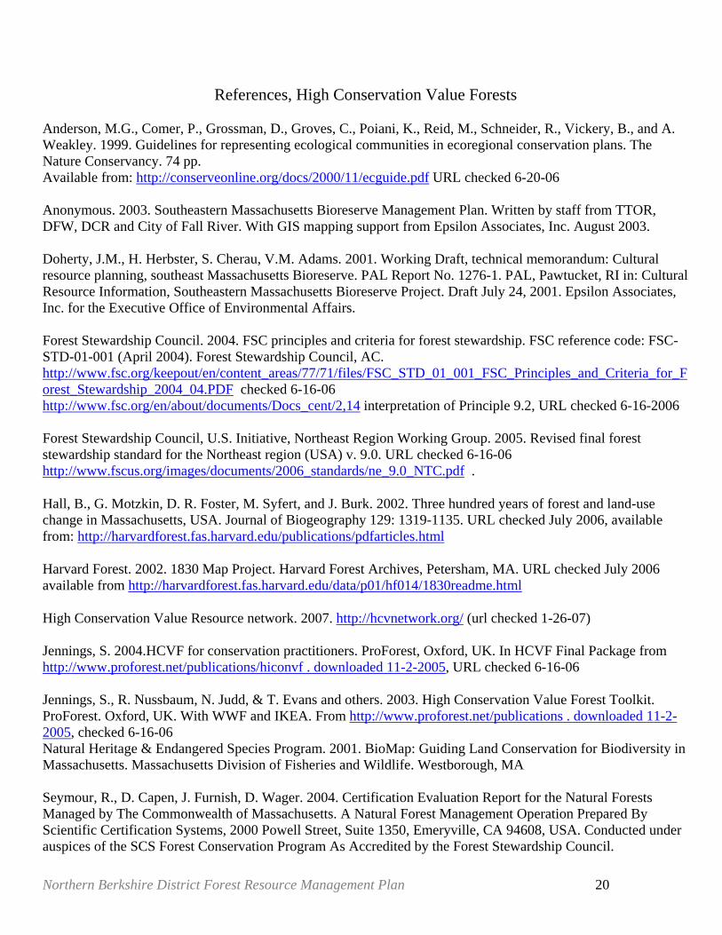
References, High Conservation Value Forests Anderson, M.G., Comer, P., Grossman, D., Groves, C., Poiani, K., Reid, M., Schneider, R., Vickery, B., and A. Weakley. 1999. Guidelines for representing ecological communities in ecoregional conservation plans. The Nature Conservancy. 74 pp. Available from: http://conserveonline.org/docs/2000/11/ecguide.pdf URL checked 6-20-06 Anonymous. 2003. Southeastern Massachusetts Bioreserve Management Plan. Written by staff from TTOR, DFW, DCR and City of Fall River. With GIS mapping support from Epsilon Associates, Inc. August 2003. Doherty, J.M., H. Herbster, S. Cherau, V.M. Adams. 2001. Working Draft, technical memorandum: Cultural resource planning, southeast Massachusetts Bioreserve. PAL Report No. 1276-1. PAL, Pawtucket, RI in: Cultural Resource Information, Southeastern Massachusetts Bioreserve Project. Draft July 24, 2001. Epsilon Associates, Inc. for the Executive Office of Environmental Affairs. Forest Stewardship Council. 2004. FSC principles and criteria for forest stewardship. FSC reference code: FSC-STD-01-001 (April 2004). Forest Stewardship Council, AC. http://www.fsc.org/keepout/en/content_areas/77/71/files/FSC_STD_01_001_FSC_Principles_and_Criteria_for_Forest_Stewardship_2004_04.PDF checked 6-16-06 http://www.fsc.org/en/about/documents/Docs_cent/2,14 interpretation of Principle 9.2, URL checked 6-16-2006 Forest Stewardship Council, U.S. Initiative, Northeast Region Working Group. 2005. Revised final forest stewardship standard for the Northeast region (USA) v. 9.0. URL checked 6-16-06 http://www.fscus.org/images/documents/2006_standards/ne_9.0_NTC.pdf .
Hall, B., G. Motzkin, D. R. Foster, M. Syfert, and J. Burk. 2002. Three hundred years of forest and land-use change in Massachusetts, USA. Journal of Biogeography 129: 1319-1135. URL checked July 2006, available from: http://harvardforest.fas.harvard.edu/publications/pdfarticles.html
Harvard Forest. 2002. 1830 Map Project. Harvard Forest Archives, Petersham, MA. URL checked July 2006 available from http://harvardforest.fas.harvard.edu/data/p01/hf014/1830readme.html
High Conservation Value Resource network. 2007. http://hcvnetwork.org/ (url checked 1-26-07) Jennings, S. 2004.HCVF for conservation practitioners. ProForest, Oxford, UK. In HCVF Final Package from http://www.proforest.net/publications/hiconvf . downloaded 11-2-2005, URL checked 6-16-06 Jennings, S., R. Nussbaum, N. Judd, & T. Evans and others. 2003. High Conservation Value Forest Toolkit. ProForest. Oxford, UK. With WWF and IKEA. From http://www.proforest.net/publications . downloaded 11-2-2005, checked 6-16-06 Natural Heritage & Endangered Species Program. 2001. BioMap: Guiding Land Conservation for Biodiversity in Massachusetts. Massachusetts Division of Fisheries and Wildlife. Westborough, MA Seymour, R., D. Capen, J. Furnish, D. Wager. 2004. Certification Evaluation Report for the Natural Forests Managed by The Commonwealth of Massachusetts. A Natural Forest Management Operation Prepared By Scientific Certification Systems, 2000 Powell Street, Suite 1350, Emeryville, CA 94608, USA. Conducted under auspices of the SCS Forest Conservation Program As Accredited by the Forest Stewardship Council.

Northern Berkshire District Forest Resource Management Plan 21
Certification Registration Number SCS-FM/COC-00048N. Available at: http://www.scscertified.com/PDFS/forest_mass.pdf . URL checked 6-20-06 WWF. No date. High conservation value forests. http://www.panda.org/downloads/forests/hcvffinal.pdf . a pamphlet about HCVFs, URL checked 6-20-06.
Northern Berkshire District Forest Resource Management Plan 22
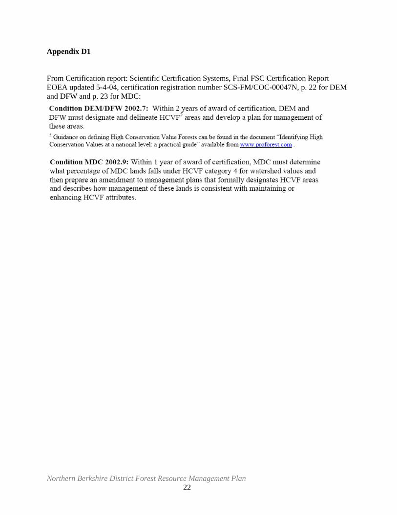
Appendix D1 From Certification report: Scientific Certification Systems, Final FSC Certification Report EOEA updated 5-4-04, certification registration number SCS-FM/COC-00047N, p. 22 for DEM and DFW and p. 23 for MDC:
Northern Berkshire District Forest Resource Management Plan 23
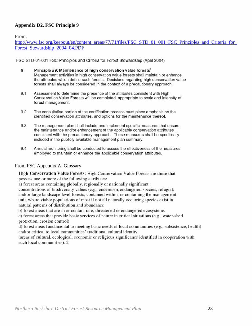
Appendix D2. FSC Principle 9 From: http://www.fsc.org/keepout/en/content_areas/77/71/files/FSC_STD_01_001_FSC_Principles_and_Criteria_for_Forest_Stewardship_2004_04.PDF
From FSC Appendix A, Glossary
Northern Berkshire District Forest Resource Management Plan 24
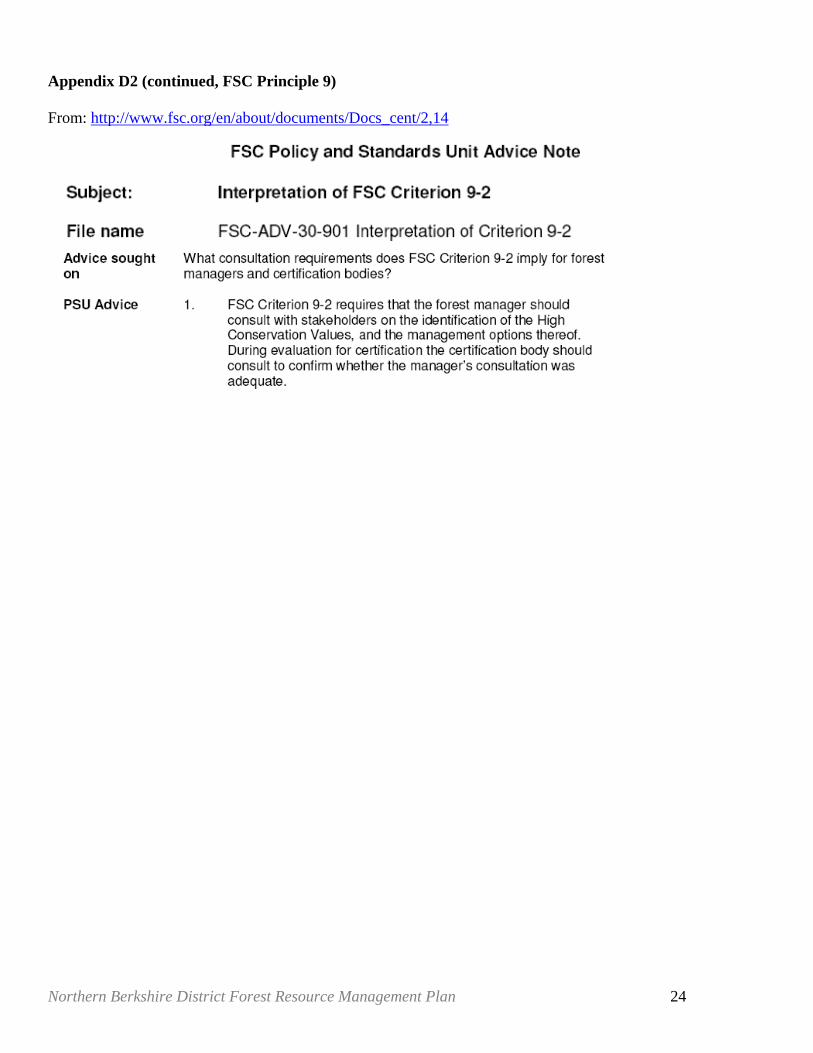
Appendix D2 (continued, FSC Principle 9) From: http://www.fsc.org/en/about/documents/Docs_cent/2,14
Northern Berkshire District Forest Resource Management Plan 25

Northern Berkshire District Forest Resource Management Plan 26
Northern Berkshire District Forest Resource Management Plan 27
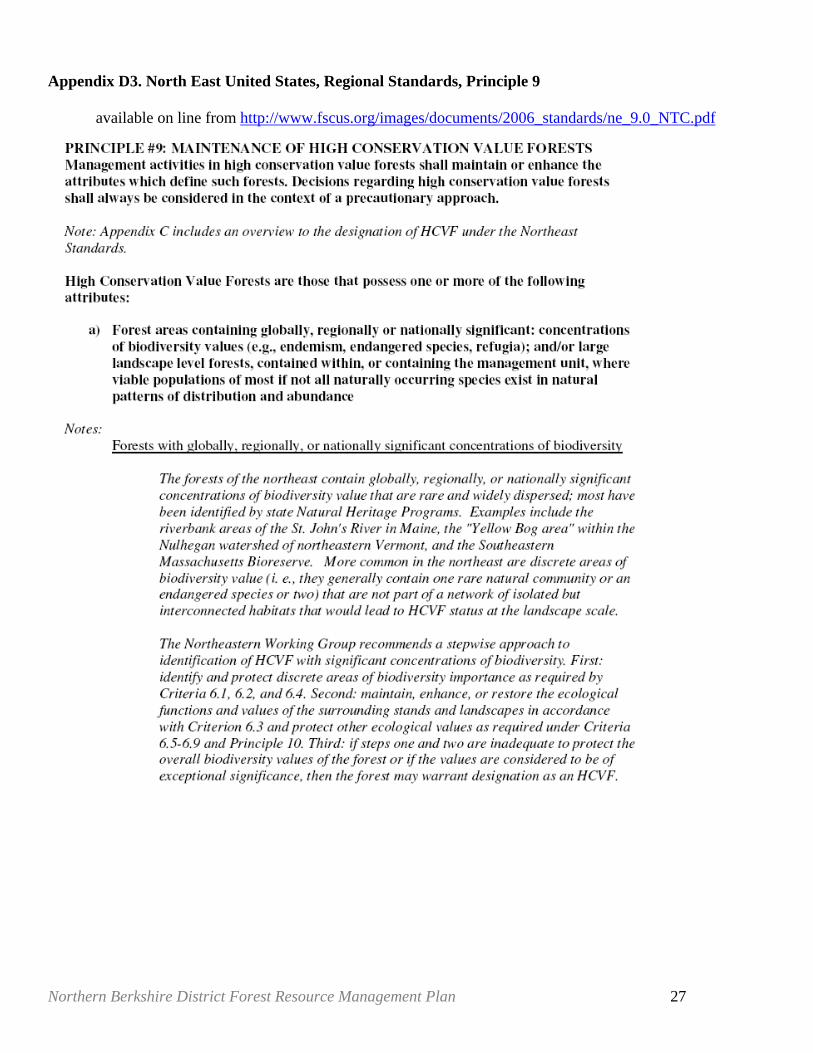
Appendix D3. North East United States, Regional Standards, Principle 9
available on line from http://www.fscus.org/images/documents/2006_standards/ne_9.0_NTC.pdf
Northern Berkshire District Forest Resource Management Plan 28
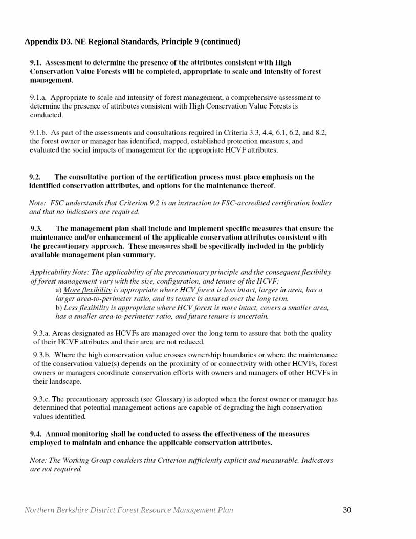
Appendix D3. NE Regional Standards, Principle 9 (continued)
Northern Berkshire District Forest Resource Management Plan 29
Appendix D3. NE Regional Standards, Principle 9 (continued)
Northern Berkshire District Forest Resource Management Plan 30
Appendix D3. NE Regional Standards, Principle 9 (continued)
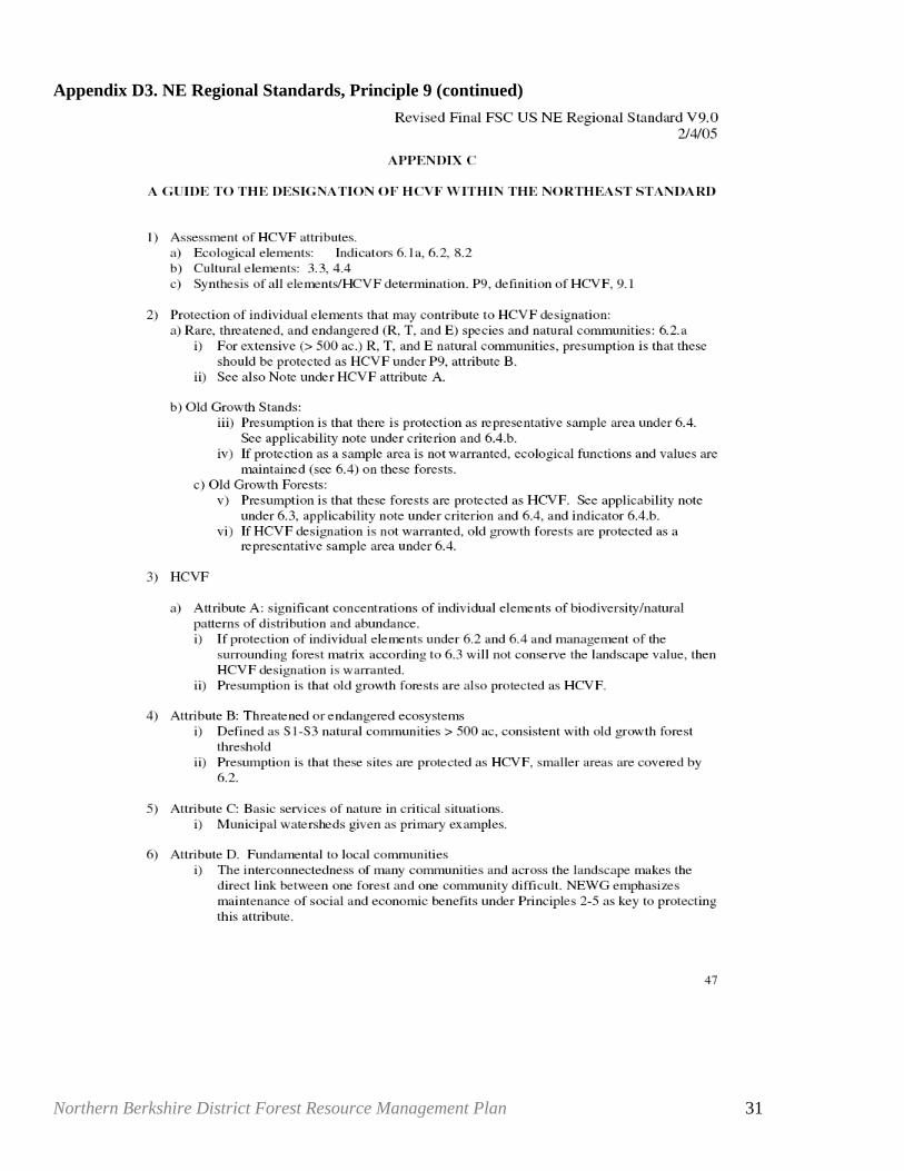
Northern Berkshire District Forest Resource Management Plan 31
Appendix D3. NE Regional Standards, Principle 9 (continued)
Northern Berkshire District Forest Resource Management Plan 32
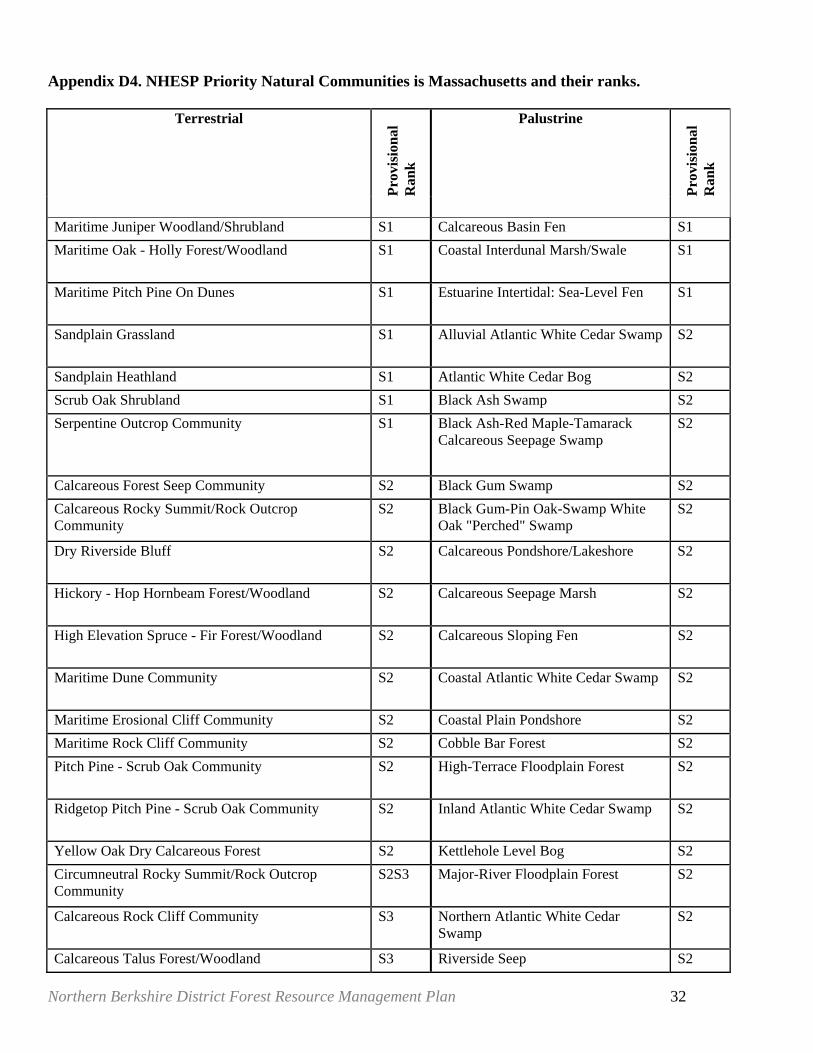
Appendix D4. NHESP Priority Natural Communities is Massachusetts and their ranks.
Terrestrial
Prov
isio
nal
Ran
k
Palustrine
Prov
isio
nal
Ran
k
Maritime Juniper Woodland/Shrubland S1 Calcareous Basin Fen S1 Maritime Oak - Holly Forest/Woodland S1 Coastal Interdunal Marsh/Swale S1
Maritime Pitch Pine On Dunes S1 Estuarine Intertidal: Sea-Level Fen S1
Sandplain Grassland S1 Alluvial Atlantic White Cedar Swamp S2
Sandplain Heathland S1 Atlantic White Cedar Bog S2 Scrub Oak Shrubland S1 Black Ash Swamp S2 Serpentine Outcrop Community S1 Black Ash-Red Maple-Tamarack
Calcareous Seepage Swamp S2
Calcareous Forest Seep Community S2 Black Gum Swamp S2 Calcareous Rocky Summit/Rock Outcrop Community
S2 Black Gum-Pin Oak-Swamp White Oak "Perched" Swamp
S2
Dry Riverside Bluff S2 Calcareous Pondshore/Lakeshore S2
Hickory - Hop Hornbeam Forest/Woodland S2 Calcareous Seepage Marsh S2
High Elevation Spruce - Fir Forest/Woodland S2 Calcareous Sloping Fen S2
Maritime Dune Community S2 Coastal Atlantic White Cedar Swamp S2
Maritime Erosional Cliff Community S2 Coastal Plain Pondshore S2 Maritime Rock Cliff Community S2 Cobble Bar Forest S2 Pitch Pine - Scrub Oak Community S2 High-Terrace Floodplain Forest S2
Ridgetop Pitch Pine - Scrub Oak Community S2 Inland Atlantic White Cedar Swamp S2
Yellow Oak Dry Calcareous Forest S2 Kettlehole Level Bog S2 Circumneutral Rocky Summit/Rock Outcrop Community
S2S3 Major-River Floodplain Forest S2
Calcareous Rock Cliff Community S3 Northern Atlantic White Cedar Swamp
S2
Calcareous Talus Forest/Woodland S3 Riverside Seep S2
Northern Berkshire District Forest Resource Management Plan 33
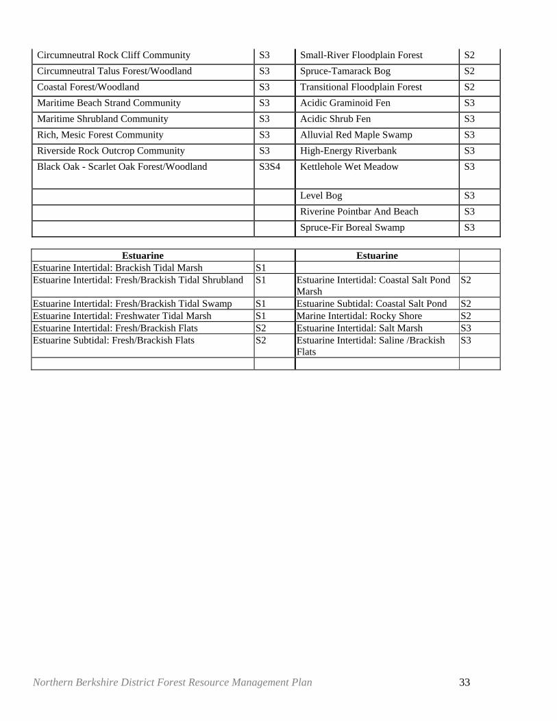
Circumneutral Rock Cliff Community S3 Small-River Floodplain Forest S2 Circumneutral Talus Forest/Woodland S3 Spruce-Tamarack Bog S2 Coastal Forest/Woodland S3 Transitional Floodplain Forest S2 Maritime Beach Strand Community S3 Acidic Graminoid Fen S3 Maritime Shrubland Community S3 Acidic Shrub Fen S3 Rich, Mesic Forest Community S3 Alluvial Red Maple Swamp S3 Riverside Rock Outcrop Community S3 High-Energy Riverbank S3 Black Oak - Scarlet Oak Forest/Woodland S3S4 Kettlehole Wet Meadow S3
Level Bog S3 Riverine Pointbar And Beach S3 Spruce-Fir Boreal Swamp S3
Estuarine Estuarine
Estuarine Intertidal: Brackish Tidal Marsh S1 Estuarine Intertidal: Fresh/Brackish Tidal Shrubland S1 Estuarine Intertidal: Coastal Salt Pond
Marsh S2
Estuarine Intertidal: Fresh/Brackish Tidal Swamp S1 Estuarine Subtidal: Coastal Salt Pond S2 Estuarine Intertidal: Freshwater Tidal Marsh S1 Marine Intertidal: Rocky Shore S2 Estuarine Intertidal: Fresh/Brackish Flats S2 Estuarine Intertidal: Salt Marsh S3 Estuarine Subtidal: Fresh/Brackish Flats S2 Estuarine Intertidal: Saline /Brackish
Flats S3
Northern Berkshire District Forest Resource Management Plan 34
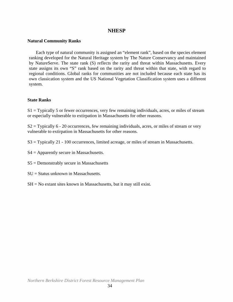
NHESP
Natural Community Ranks
Each type of natural community is assigned an “element rank”, based on the species element ranking developed for the Natural Heritage system by The Nature Conservancy and maintained by NatureServe. The state rank (S) reflects the rarity and threat within Massachusetts. Every state assigns its own “S” rank based on the rarity and threat within that state, with regard to regional conditions. Global ranks for communities are not included because each state has its own classication system and the US National Vegetation Classification system uses a different system.
State Ranks S1 = Typically 5 or fewer occurrences, very few remaining individuals, acres, or miles of stream or especially vulnerable to extirpation in Massachusetts for other reasons. S2 = Typically 6 - 20 occurrences, few remaining individuals, acres, or miles of stream or very vulnerable to extirpation in Massachusetts for other reasons. S3 = Typically 21 - 100 occurrences, limited acreage, or miles of stream in Massachusetts. S4 = Apparently secure in Massachusetts. S5 = Demonstrably secure in Massachusetts SU = Status unknown in Massachusetts. SH = No extant sites known in Massachusetts, but it may still exist.
Northern Berkshire District Forest Resource Management Plan 35
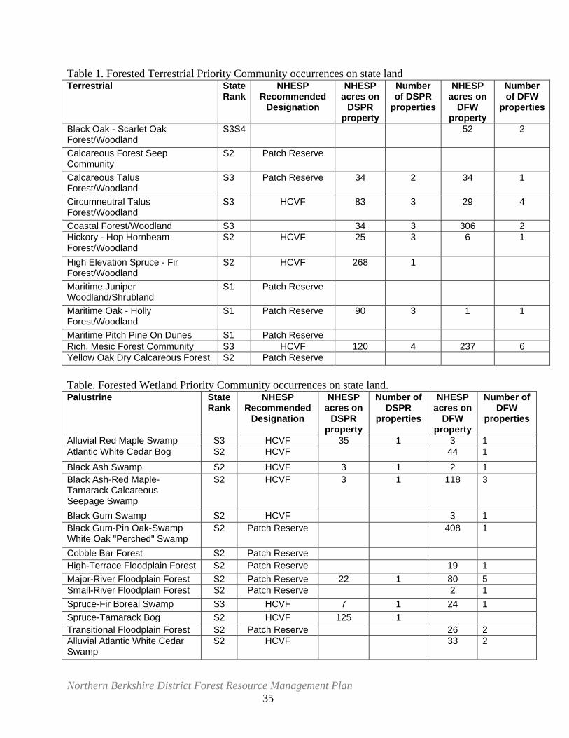
Table 1. Forested Terrestrial Priority Community occurrences on state land Terrestrial State
RankNHESP
Recommended Designation
NHESP acres on
DSPR property
Number of DSPR
properties
NHESP acres on
DFW property
Number of DFW
properties
Black Oak - Scarlet Oak Forest/Woodland
S3S4 52 2
Calcareous Forest Seep Community
S2 Patch Reserve
Calcareous Talus Forest/Woodland
S3 Patch Reserve 34 2 34 1
Circumneutral Talus Forest/Woodland
S3 HCVF 83 3 29 4
Coastal Forest/Woodland S3 34 3 306 2 Hickory - Hop Hornbeam Forest/Woodland
S2 HCVF 25 3 6 1
High Elevation Spruce - Fir Forest/Woodland
S2 HCVF 268 1
Maritime Juniper Woodland/Shrubland
S1 Patch Reserve
Maritime Oak - Holly Forest/Woodland
S1 Patch Reserve 90 3 1 1
Maritime Pitch Pine On Dunes S1 Patch Reserve Rich, Mesic Forest Community S3 HCVF 120 4 237 6 Yellow Oak Dry Calcareous Forest S2 Patch Reserve Table. Forested Wetland Priority Community occurrences on state land. Palustrine State
Rank NHESP
Recommended Designation
NHESP acres on
DSPR property
Number of DSPR
properties
NHESP acres on
DFW property
Number of DFW
properties
Alluvial Red Maple Swamp S3 HCVF 35 1 3 1 Atlantic White Cedar Bog S2 HCVF 44 1 Black Ash Swamp S2 HCVF 3 1 2 1 Black Ash-Red Maple-Tamarack Calcareous Seepage Swamp
S2 HCVF 3 1 118 3
Black Gum Swamp S2 HCVF 3 1 Black Gum-Pin Oak-Swamp White Oak "Perched" Swamp
S2 Patch Reserve 408 1
Cobble Bar Forest S2 Patch Reserve High-Terrace Floodplain Forest S2 Patch Reserve 19 1 Major-River Floodplain Forest S2 Patch Reserve 22 1 80 5 Small-River Floodplain Forest S2 Patch Reserve 2 1 Spruce-Fir Boreal Swamp S3 HCVF 7 1 24 1 Spruce-Tamarack Bog S2 HCVF 125 1 Transitional Floodplain Forest S2 Patch Reserve 26 2 Alluvial Atlantic White Cedar Swamp
S2 HCVF 33 2
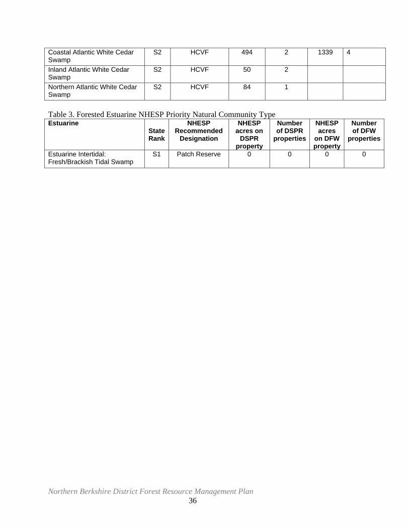
Northern Berkshire District Forest Resource Management Plan 36
Coastal Atlantic White Cedar Swamp
S2 HCVF 494 2 1339 4
Inland Atlantic White Cedar Swamp
S2 HCVF 50 2
Northern Atlantic White Cedar Swamp
S2 HCVF 84 1
Table 3. Forested Estuarine NHESP Priority Natural Community Type Estuarine
State Rank
NHESP Recommended
Designation
NHESP acres on
DSPR property
Number of DSPR
properties
NHESP acres
on DFW property
Number of DFW
properties
Estuarine Intertidal: Fresh/Brackish Tidal Swamp
S1 Patch Reserve 0 0 0 0
Northern Berkshire District Forest Resource Management Plan 37
Appendix D5. From Interior Forest Metadata: (unpublished, MA Division of Fisheries & Wildlife) Massachusetts Division of Fisheries and Wildlife, Forestry Program June, 2004 Interior Forest Land of Massachusetts Based on Land Use Data interior_forest describes unbroken blocks of unfragmented forest within forested areas of the Commonwealth of Massachusetts. Other natural features such as wetlands and open water are included in this dataset.</abstract> There are no legal constraints to accessing these data, however credit to the Massachusetts Division of Fisheries and Wildlife Forestry Program should be given purpose>The dataset was developed to facilitate the selection of forest reserves in Massachusetts as part of Green Certification by the Forest Stewardship Council on lands owned by Massachusetts state agencies. supplinf>Fragmenting buffer widths were based partially on done by The Nature Conservancy, Boston Office according to work by: Forman, R.T.T., and R.D. Deblinger. 2000. The Ecological Road-Effect Zone of a Massachusetts (U.S.A.) Suburban Highway. Conservation Biology 14:36-46. Source datasets were obtained from MassGIS, http://www.mass.gov/mgis/massgis.htm Jeremy Bell GIS Specialist/Habitat Analyst Massachusetts Audubon Society under contract to MassWildlife Forestry Program, 2004 1 Rabbit Hill Road Westborough, MA 01581 http://www.mass.gov/dfwele/dfw/ Users should bear in mind that these data represent land use current as of 1999, and the data could soon become obsolete. interior_forest was created using the Massachusetts Highway Department Roads data (2003), MassGIS Land Use data (1999), and Boston Transportation Planning Organization's Trains data (2004). Land use classes considered natural features from the Land Use 1999 lu21_code were extracted and converted to a new coverage. Codes 3 (forest), 4(wetland), and 20(open water) were included. Although wetlands and open water are not considered interior forest, in most cases they were considered non-fragmenting natural features in a landscape context and were left in for the initial analysis. Roads were separated into three classes: class 1 roads were buffered at 1000m, classes 2,3,4,7 were buffered at 300 m, and classes 5 and 6 were buffered at 100 m. Trains were buffered at 300 m. All land use categories considered fragmenting (all but 3,4, and 20) were extracted and converted to a new coverage. These features were buffered at 300m. The road, trains, and fragmenting land use buffers were then merged into the non-fragmenting natural features. Once complete, the buffers were extracted and deleted from the coverage, leaving polygons considered to be "interior natural features." Clean and build functions were then run to eliminate sliver polygons and artificial boundaries, such as town lines, that split areas of interior natural areas. Wetland and open water polygons were left in the dataset to keep data analysis flexibility for conservation uses. The coverage was then converted to shapefile format for distribution. interior_forest was created using the Massachusetts Highway Department Roads data (2003), MassGIS Land Use data (1999), and Boston Transportation Planning Organization's Trains data (2004). Land use classes considered natural features from the Land Use 1999 lu21_code were extracted and converted to a new coverage. Codes 3 (forest), 4(wetland), and 20(open water) were included. Although wetlands and open water are not considered interior forest, in most cases they were considered non-fragmenting natural features in a landscape context and were left in for the initial analysis. Roads were separated into three classes: class 1 roads were buffered at 1000m, classes 2,3,4,7 were buffered at 300 m, and classes 5 and 6 were buffered at 100 m. Trains were buffered at 300 m. All land use categories considered fragmenting (all but 3,4, and 20) were extracted and converted to a new coverage. These features were buffered at 300m. The road, trains, and fragmenting land use buffers were then merged into the non-fragmenting natural features. Once complete, the buffers were extracted and deleted from the coverage, leaving polygons considered to be "interior natural features." Clean and build functions were then run to eliminate sliver polygons and artificial boundaries, such as town lines, that split areas of interior natural areas. Wetland and open
Northern Berkshire District Forest Resource Management Plan 38
water polygons were left in the dataset to keep data analysis flexibility for conservation uses. The coverage was then converted to shapefile format for distribution. Appendix D6. Cultural Values
5.2.3 Historical and Archeological Resources MHC is the State Historic Preservation Office and is responsible for administering State Register properties and other historic and archaeological assets. The MHC is also the office of the State Archaeologist, whose duties are to compile and maintain an inventory of archaeological sites, to issue permits for archaeological investigations on lands in which the Commonwealth has an interest, and, in accordance with Massachusetts General Laws, Chapter 38, Section 6, notify the Commission on Indian Affairs if a possible Native American burial site has been identified.
5.2.3.3 Issues and Recommendations Management of the resources within the Bioreserve should incorporate the appropriate protection procedures to insure that the cultural resource base is not adversely affected by daily operations and visitor use. The cultural resources including archaeological remains and historic buildings and remnants are finite resources. They represent unique records of past events and behavior that are part of our communal heritage. Typically, prehistoric sites resulted from short-term sporadic occupation. There is seldom much material left, and under the best of circumstances sites are difficult to excavate and interpret properly. They are extremely fragile and easily damaged. Archaeological sites cannot be repaired or fixed, and their loss is analogous to the extinction of a plant or animal species. Once these resources are gone, they are gone forever.
The preservation of cultural resources within the Bioreserve can easily be accomplished through continued cooperation and teamwork. Good planning and early communication about proposed projects will insure smooth project implementation. Beyond the dictates of legal compliance and resource protection, the cultural history of the Bioreserve should be explored, developed and offered to the public. In general, good management of the cultural resources will include:
• Planning of projects, both capital and normal operations, that takes into account the potential effects on historic and archaeological resources
• Partners should (state agencies must) notify the MHC of any project that has the potential for impacting the historical, architectural, archaeological or cultural qualities of a property. Should partners undertake a project under federal funding or requiring federal oversight and/or permits, Section 106 of the National Historic Preservation Act of 1966 as amended (16 USC 470 et seq.) also requires consultation with the MHC.
• For projects planned at the Bioreserve on state lands, staff should consult with DPR’s archaeologist and preservation planners in the Planning, Design and Development of Historic Resources.
Northern Berkshire District Forest Resource Management Plan 39
• For most projects, the DCR Project Planning, Design and Development staff will require a project description, a site plan and photographs for review. No physical work can occur until one of the following outcomes has been achieved:
• Determination by DCR Project Planning, Design and Development staff that the project constitutes a categorical exemption and is consistent with DEM preservation standards
• Determination of “no effect” or “no adverse effect” from the MHC
• Successful completion of any mitigation outlined in the Memorandum of Agreement (MOA) between DCR and MHC (in cases of determination of “adverse effect”). If Project Planning, Design and Development or the MHC determines that the project will result in an “adverse impact” to cultural and/or archaeological properties, the project proponent will work with OHR and the MHC to avoid, minimize or mitigate the impact. The Office of Project Planning, Design and Development will initiate and manage those activities that will minimize or mitigate adverse impacts to cultural and archaeological resources on the state properties.
• Reporting of discoveries of artifacts or soil anomalies, observing the effects of active recreation to sensitive areas, and monitoring for looting of known archaeological sites (as identified by appropriate staff)
• Prohibition of the use of metal detectors on Commonwealth lands
• Maintenance of confidentiality regarding the specific locations of prehistoric sites (the Freedom of Information Act does not apply)
• Improvements to National Register listed or eligible properties in accordance with the Secretary of the Interior’s Standards for the Treatment of Historic Properties
• Continued recognition of significant historic buildings, objects and landscapes through their nomination to the National Register of Historic Properties
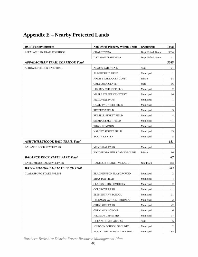
Northern Berkshire District Forest Resource Management Plan 40
Appendix E – Nearby Protected Lands
DSPR Facility Buffered Non-DSPR Property Within 1 Mile Ownership Total
APPALACHIAN TRAIL CORRIDOR CHALET WMA Dept. Fish & Game 3034
DAY MOUNTAIN WMA Dept. Fish & Game 11
APPALACHIAN TRAIL CORRIDOR Total 3045
ASHUWILLTICOOK RAIL TRAIL ADAMS RAIL TRAIL State 21
ALBERT REID FIELD Municipal 1
FOREST PARK GOLF CLUB Private 54
GREYLOCK CENTER State 56
LIBERTY STREET FIELD Municipal 2
MAPLE STREET CEMETERY Municipal 16
MEMORIAL PARK Municipal 1
QUALITY STREET FIELD Municipal 1
RENFREW FIELD Municipal 5
RUSSELL STREET FIELD Municipal 4
SIERRA STREET FIELD Municipal < 1
TOWN COMMON Municipal 1
VALLEY STREET FIELD Municipal 13
YOUTH CENTER Municipal 5
ASHUWILLTICOOK RAIL TRAIL Total 181
BALANCE ROCK STATE PARK MEMORIAL PARK Municipal 1
PONDEROSA PINES CAMPGROUND Private 66
BALANCE ROCK STATE PARK Total 67
BATES MEMORIAL STATE PARK HANCOCK SHAKER VILLAGE Non Profit 283
BATES MEMORIAL STATE PARK Total 283
CLARKSBURG STATE FOREST BLACKINGTON PLAYGROUND Municipal 2
BRAYTON FIELD Municipal 4
CLARKSBURG CEMETERY Municipal 2
COLGROVE PARK Municipal < 1
ELEMENTARY SCHOOL Municipal 31
FREEMAN SCHOOL GROUNDS Municipal 2
GREYLOCK PARK Municipal 42
GREYLOCK SCHOOL Municipal 6
HILLSIDE CEMETERY Municipal 17
HOOSAC RIVER ACCESS State 5
JOHNSON SCHOOL GROUNDS Municipal 2
MOUNT WILLIAMS WATERSHED Municipal 85
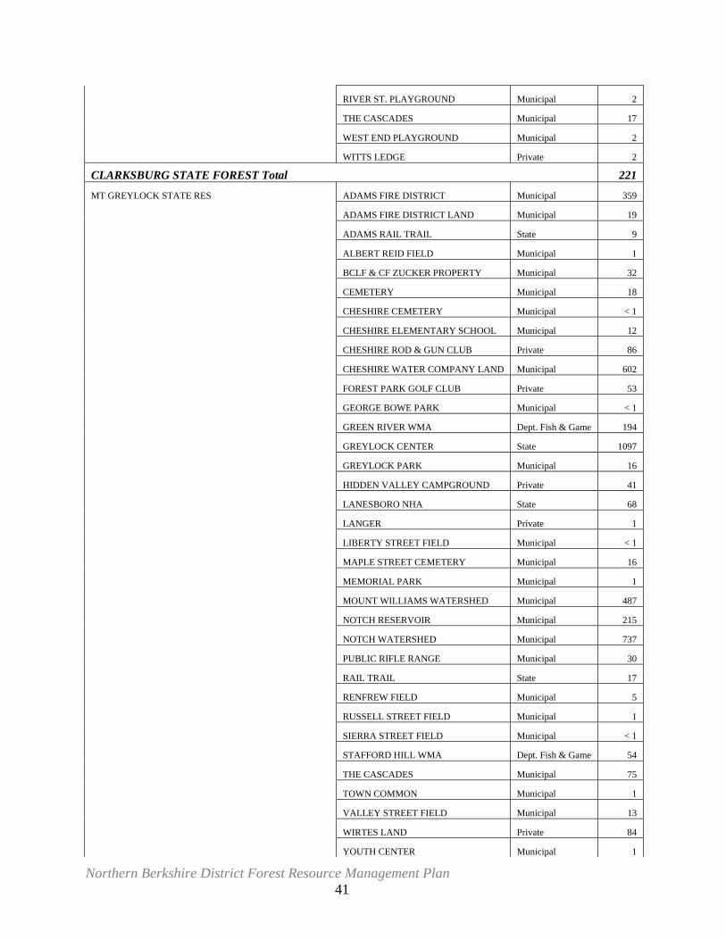
Northern Berkshire District Forest Resource Management Plan 41
RIVER ST. PLAYGROUND Municipal 2
THE CASCADES Municipal 17
WEST END PLAYGROUND Municipal 2
WITTS LEDGE Private 2
CLARKSBURG STATE FOREST Total 221
MT GREYLOCK STATE RES ADAMS FIRE DISTRICT Municipal 359
ADAMS FIRE DISTRICT LAND Municipal 19
ADAMS RAIL TRAIL State 9
ALBERT REID FIELD Municipal 1
BCLF & CF ZUCKER PROPERTY Municipal 32
CEMETERY Municipal 18
CHESHIRE CEMETERY Municipal < 1
CHESHIRE ELEMENTARY SCHOOL Municipal 12
CHESHIRE ROD & GUN CLUB Private 86
CHESHIRE WATER COMPANY LAND Municipal 602
FOREST PARK GOLF CLUB Private 53
GEORGE BOWE PARK Municipal < 1
GREEN RIVER WMA Dept. Fish & Game 194
GREYLOCK CENTER State 1097
GREYLOCK PARK Municipal 16
HIDDEN VALLEY CAMPGROUND Private 41
LANESBORO NHA State 68
LANGER Private 1
LIBERTY STREET FIELD Municipal < 1
MAPLE STREET CEMETERY Municipal 16
MEMORIAL PARK Municipal 1
MOUNT WILLIAMS WATERSHED Municipal 487
NOTCH RESERVOIR Municipal 215
NOTCH WATERSHED Municipal 737
PUBLIC RIFLE RANGE Municipal 30
RAIL TRAIL State 17
RENFREW FIELD Municipal 5
RUSSELL STREET FIELD Municipal 1
SIERRA STREET FIELD Municipal < 1
STAFFORD HILL WMA Dept. Fish & Game 54
THE CASCADES Municipal 75
TOWN COMMON Municipal 1
VALLEY STREET FIELD Municipal 13
WIRTES LAND Private 84
YOUTH CENTER Municipal 1
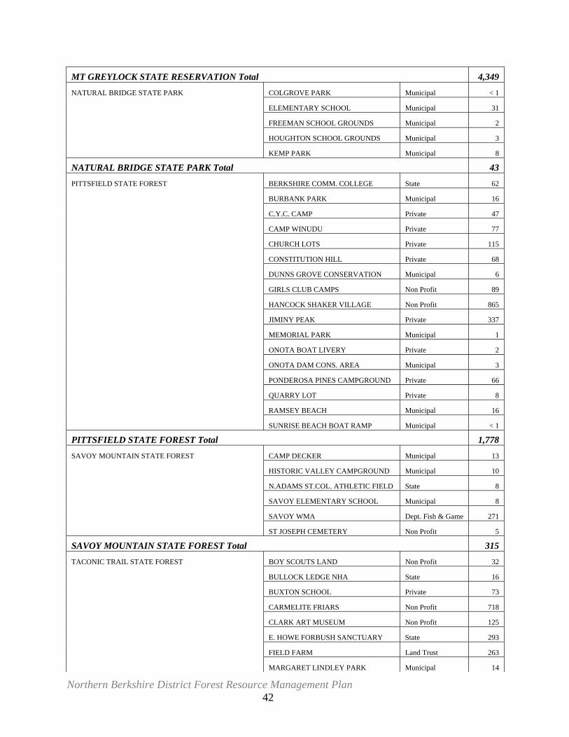
Northern Berkshire District Forest Resource Management Plan 42
MT GREYLOCK STATE RESERVATION Total 4,349
NATURAL BRIDGE STATE PARK COLGROVE PARK Municipal < 1
ELEMENTARY SCHOOL Municipal 31
FREEMAN SCHOOL GROUNDS Municipal 2
HOUGHTON SCHOOL GROUNDS Municipal 3
KEMP PARK Municipal 8
NATURAL BRIDGE STATE PARK Total 43
PITTSFIELD STATE FOREST BERKSHIRE COMM. COLLEGE State 62
BURBANK PARK Municipal 16
C.Y.C. CAMP Private 47
CAMP WINUDU Private 77
CHURCH LOTS Private 115
CONSTITUTION HILL Private 68
DUNNS GROVE CONSERVATION Municipal 6
GIRLS CLUB CAMPS Non Profit 89
HANCOCK SHAKER VILLAGE Non Profit 865
JIMINY PEAK Private 337
MEMORIAL PARK Municipal 1
ONOTA BOAT LIVERY Private 2
ONOTA DAM CONS. AREA Municipal 3
PONDEROSA PINES CAMPGROUND Private 66
QUARRY LOT Private 8
RAMSEY BEACH Municipal 16
SUNRISE BEACH BOAT RAMP Municipal < 1
PITTSFIELD STATE FOREST Total 1,778
SAVOY MOUNTAIN STATE FOREST CAMP DECKER Municipal 13
HISTORIC VALLEY CAMPGROUND Municipal 10
N.ADAMS ST.COL. ATHLETIC FIELD State 8
SAVOY ELEMENTARY SCHOOL Municipal 8
SAVOY WMA Dept. Fish & Game 271
ST JOSEPH CEMETERY Non Profit 5
SAVOY MOUNTAIN STATE FOREST Total 315
TACONIC TRAIL STATE FOREST BOY SCOUTS LAND Non Profit 32
BULLOCK LEDGE NHA State 16
BUXTON SCHOOL Private 73
CARMELITE FRIARS Non Profit 718
CLARK ART MUSEUM Non Profit 125
E. HOWE FORBUSH SANCTUARY State 293
FIELD FARM Land Trust 263
MARGARET LINDLEY PARK Municipal 14
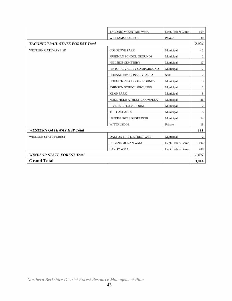
Northern Berkshire District Forest Resource Management Plan 43
TACONIC MOUNTAIN WMA Dept. Fish & Game 159
WILLIAMS COLLEGE Private 330
TACONIC TRAIL STATE FOREST Total 2,024
WESTERN GATEWAY HSP COLGROVE PARK Municipal < 1
FREEMAN SCHOOL GROUNDS Municipal 2
HILLSIDE CEMETERY Municipal 17
HISTORIC VALLEY CAMPGROUND Municipal 7
HOOSAC RIV. CONSERV. AREA State 7
HOUGHTON SCHOOL GROUNDS Municipal 3
JOHNSON SCHOOL GROUNDS Municipal 2
KEMP PARK Municipal 8
NOEL FIELD ATHLETIC COMPLEX Municipal 26
RIVER ST. PLAYGROUND Municipal 2
THE CASCADES Municipal 5
UPPER/LOWER RESERVOIR Municipal 14
WITTS LEDGE Private 18
WESTERN GATEWAY HSP Total 111
WINDSOR STATE FOREST DALTON FIRE DISTRICT WCE Municipal 2
EUGENE MORAN WMA Dept. Fish & Game 1094
SAVOY WMA Dept. Fish & Game 400
WINDSOR STATE FOREST Total 1,497 Grand Total 13,914
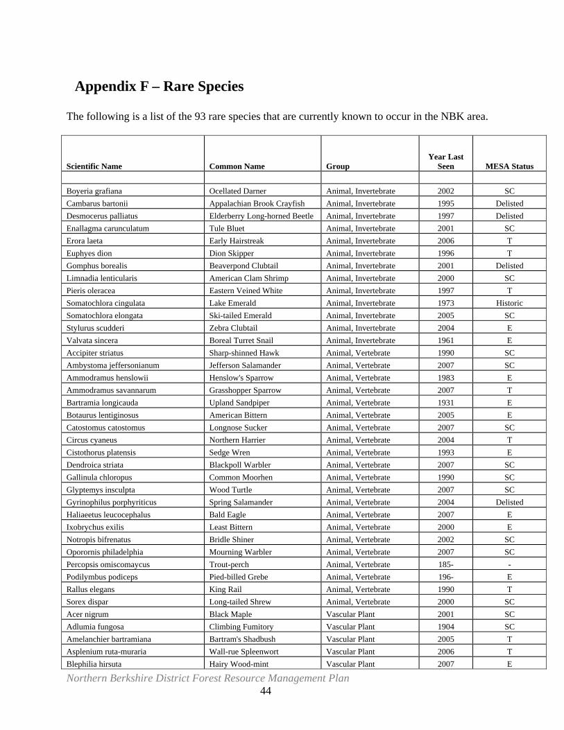
Northern Berkshire District Forest Resource Management Plan 44
Appendix F – Rare Species The following is a list of the 93 rare species that are currently known to occur in the NBK area.
Scientific Name Common Name Group Year Last
Seen MESA Status Boyeria grafiana Ocellated Darner Animal, Invertebrate 2002 SC Cambarus bartonii Appalachian Brook Crayfish Animal, Invertebrate 1995 Delisted Desmocerus palliatus Elderberry Long-horned Beetle Animal, Invertebrate 1997 Delisted Enallagma carunculatum Tule Bluet Animal, Invertebrate 2001 SC Erora laeta Early Hairstreak Animal, Invertebrate 2006 T Euphyes dion Dion Skipper Animal, Invertebrate 1996 T Gomphus borealis Beaverpond Clubtail Animal, Invertebrate 2001 Delisted Limnadia lenticularis American Clam Shrimp Animal, Invertebrate 2000 SC Pieris oleracea Eastern Veined White Animal, Invertebrate 1997 T Somatochlora cingulata Lake Emerald Animal, Invertebrate 1973 Historic Somatochlora elongata Ski-tailed Emerald Animal, Invertebrate 2005 SC Stylurus scudderi Zebra Clubtail Animal, Invertebrate 2004 E Valvata sincera Boreal Turret Snail Animal, Invertebrate 1961 E Accipiter striatus Sharp-shinned Hawk Animal, Vertebrate 1990 SC Ambystoma jeffersonianum Jefferson Salamander Animal, Vertebrate 2007 SC Ammodramus henslowii Henslow's Sparrow Animal, Vertebrate 1983 E Ammodramus savannarum Grasshopper Sparrow Animal, Vertebrate 2007 T Bartramia longicauda Upland Sandpiper Animal, Vertebrate 1931 E Botaurus lentiginosus American Bittern Animal, Vertebrate 2005 E Catostomus catostomus Longnose Sucker Animal, Vertebrate 2007 SC Circus cyaneus Northern Harrier Animal, Vertebrate 2004 T Cistothorus platensis Sedge Wren Animal, Vertebrate 1993 E Dendroica striata Blackpoll Warbler Animal, Vertebrate 2007 SC Gallinula chloropus Common Moorhen Animal, Vertebrate 1990 SC Glyptemys insculpta Wood Turtle Animal, Vertebrate 2007 SC Gyrinophilus porphyriticus Spring Salamander Animal, Vertebrate 2004 Delisted Haliaeetus leucocephalus Bald Eagle Animal, Vertebrate 2007 E Ixobrychus exilis Least Bittern Animal, Vertebrate 2000 E Notropis bifrenatus Bridle Shiner Animal, Vertebrate 2002 SC Oporornis philadelphia Mourning Warbler Animal, Vertebrate 2007 SC Percopsis omiscomaycus Trout-perch Animal, Vertebrate 185- - Podilymbus podiceps Pied-billed Grebe Animal, Vertebrate 196- E Rallus elegans King Rail Animal, Vertebrate 1990 T Sorex dispar Long-tailed Shrew Animal, Vertebrate 2000 SC Acer nigrum Black Maple Vascular Plant 2001 SC Adlumia fungosa Climbing Fumitory Vascular Plant 1904 SC Amelanchier bartramiana Bartram's Shadbush Vascular Plant 2005 T Asplenium ruta-muraria Wall-rue Spleenwort Vascular Plant 2006 T Blephilia hirsuta Hairy Wood-mint Vascular Plant 2007 E
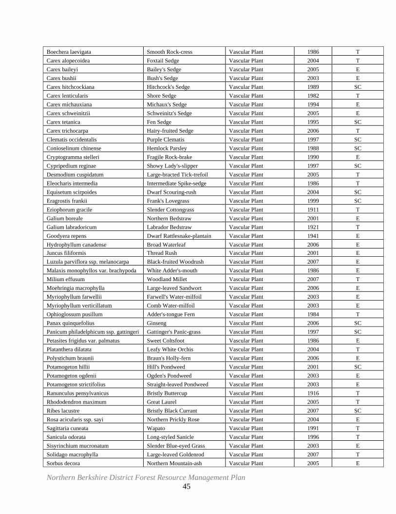
Northern Berkshire District Forest Resource Management Plan 45
Boechera laevigata Smooth Rock-cress Vascular Plant 1986 T Carex alopecoidea Foxtail Sedge Vascular Plant 2004 T Carex baileyi Bailey's Sedge Vascular Plant 2005 E Carex bushii Bush's Sedge Vascular Plant 2003 E Carex hitchcockiana Hitchcock's Sedge Vascular Plant 1989 SC Carex lenticularis Shore Sedge Vascular Plant 1982 T Carex michauxiana Michaux's Sedge Vascular Plant 1994 E Carex schweinitzii Schweinitz's Sedge Vascular Plant 2005 E Carex tetanica Fen Sedge Vascular Plant 1995 SC Carex trichocarpa Hairy-fruited Sedge Vascular Plant 2006 T Clematis occidentalis Purple Clematis Vascular Plant 1997 SC Conioselinum chinense Hemlock Parsley Vascular Plant 1988 SC Cryptogramma stelleri Fragile Rock-brake Vascular Plant 1990 E Cypripedium reginae Showy Lady's-slipper Vascular Plant 1997 SC Desmodium cuspidatum Large-bracted Tick-trefoil Vascular Plant 2005 T Eleocharis intermedia Intermediate Spike-sedge Vascular Plant 1986 T Equisetum scirpoides Dwarf Scouring-rush Vascular Plant 2004 SC Eragrostis frankii Frank's Lovegrass Vascular Plant 1999 SC Eriophorum gracile Slender Cottongrass Vascular Plant 1911 T Galium boreale Northern Bedstraw Vascular Plant 2001 E Galium labradoricum Labrador Bedstraw Vascular Plant 1921 T Goodyera repens Dwarf Rattlesnake-plantain Vascular Plant 1941 E Hydrophyllum canadense Broad Waterleaf Vascular Plant 2006 E Juncus filiformis Thread Rush Vascular Plant 2001 E Luzula parviflora ssp. melanocarpa Black-fruited Woodrush Vascular Plant 2007 E Malaxis monophyllos var. brachypoda White Adder's-mouth Vascular Plant 1986 E Milium effusum Woodland Millet Vascular Plant 2007 T Moehringia macrophylla Large-leaved Sandwort Vascular Plant 2006 E Myriophyllum farwellii Farwell's Water-milfoil Vascular Plant 2003 E Myriophyllum verticillatum Comb Water-milfoil Vascular Plant 2003 E Ophioglossum pusillum Adder's-tongue Fern Vascular Plant 1984 T Panax quinquefolius Ginseng Vascular Plant 2006 SC Panicum philadelphicum ssp. gattingeri Gattinger's Panic-grass Vascular Plant 1997 SC Petasites frigidus var. palmatus Sweet Coltsfoot Vascular Plant 1986 E Platanthera dilatata Leafy White Orchis Vascular Plant 2004 T Polystichum braunii Braun's Holly-fern Vascular Plant 2006 E Potamogeton hillii Hill's Pondweed Vascular Plant 2001 SC Potamogeton ogdenii Ogden's Pondweed Vascular Plant 2003 E Potamogeton strictifolius Straight-leaved Pondweed Vascular Plant 2003 E Ranunculus pensylvanicus Bristly Buttercup Vascular Plant 1916 T Rhododendron maximum Great Laurel Vascular Plant 2005 T Ribes lacustre Bristly Black Currant Vascular Plant 2007 SC Rosa acicularis ssp. sayi Northern Prickly Rose Vascular Plant 2004 E Sagittaria cuneata Wapato Vascular Plant 1991 T Sanicula odorata Long-styled Sanicle Vascular Plant 1996 T Sisyrinchium mucronatum Slender Blue-eyed Grass Vascular Plant 2003 E Solidago macrophylla Large-leaved Goldenrod Vascular Plant 2007 T Sorbus decora Northern Mountain-ash Vascular Plant 2005 E
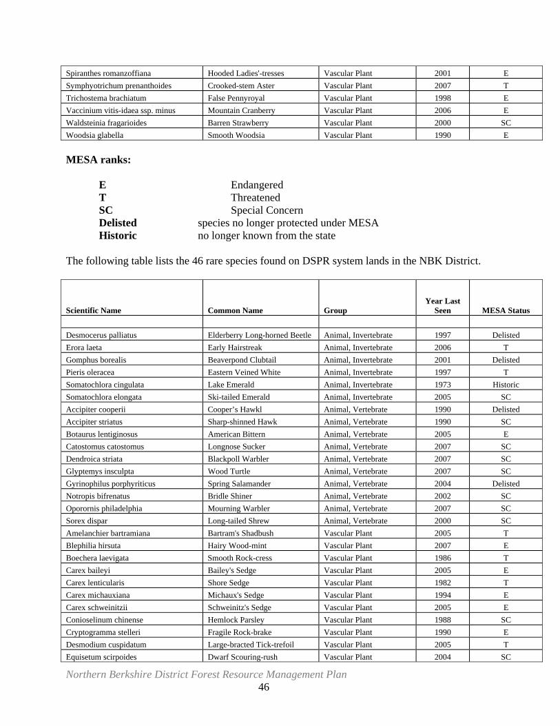
Northern Berkshire District Forest Resource Management Plan 46
Spiranthes romanzoffiana Hooded Ladies'-tresses Vascular Plant 2001 E Symphyotrichum prenanthoides Crooked-stem Aster Vascular Plant 2007 T Trichostema brachiatum False Pennyroyal Vascular Plant 1998 E Vaccinium vitis-idaea ssp. minus Mountain Cranberry Vascular Plant 2006 E Waldsteinia fragarioides Barren Strawberry Vascular Plant 2000 SC Woodsia glabella Smooth Woodsia Vascular Plant 1990 E MESA ranks: E Endangered T Threatened SC Special Concern Delisted species no longer protected under MESA Historic no longer known from the state The following table lists the 46 rare species found on DSPR system lands in the NBK District.
Scientific Name Common Name Group Year Last
Seen MESA Status Desmocerus palliatus Elderberry Long-horned Beetle Animal, Invertebrate 1997 Delisted Erora laeta Early Hairstreak Animal, Invertebrate 2006 T Gomphus borealis Beaverpond Clubtail Animal, Invertebrate 2001 Delisted Pieris oleracea Eastern Veined White Animal, Invertebrate 1997 T Somatochlora cingulata Lake Emerald Animal, Invertebrate 1973 Historic Somatochlora elongata Ski-tailed Emerald Animal, Invertebrate 2005 SC Accipiter cooperii Cooper’s Hawkl Animal, Vertebrate 1990 Delisted Accipiter striatus Sharp-shinned Hawk Animal, Vertebrate 1990 SC Botaurus lentiginosus American Bittern Animal, Vertebrate 2005 E Catostomus catostomus Longnose Sucker Animal, Vertebrate 2007 SC Dendroica striata Blackpoll Warbler Animal, Vertebrate 2007 SC Glyptemys insculpta Wood Turtle Animal, Vertebrate 2007 SC Gyrinophilus porphyriticus Spring Salamander Animal, Vertebrate 2004 Delisted Notropis bifrenatus Bridle Shiner Animal, Vertebrate 2002 SC Oporornis philadelphia Mourning Warbler Animal, Vertebrate 2007 SC Sorex dispar Long-tailed Shrew Animal, Vertebrate 2000 SC Amelanchier bartramiana Bartram's Shadbush Vascular Plant 2005 T Blephilia hirsuta Hairy Wood-mint Vascular Plant 2007 E Boechera laevigata Smooth Rock-cress Vascular Plant 1986 T Carex baileyi Bailey's Sedge Vascular Plant 2005 E Carex lenticularis Shore Sedge Vascular Plant 1982 T Carex michauxiana Michaux's Sedge Vascular Plant 1994 E Carex schweinitzii Schweinitz's Sedge Vascular Plant 2005 E Conioselinum chinense Hemlock Parsley Vascular Plant 1988 SC Cryptogramma stelleri Fragile Rock-brake Vascular Plant 1990 E Desmodium cuspidatum Large-bracted Tick-trefoil Vascular Plant 2005 T Equisetum scirpoides Dwarf Scouring-rush Vascular Plant 2004 SC
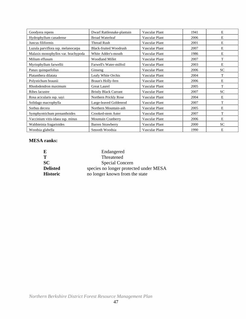
Northern Berkshire District Forest Resource Management Plan 47
Goodyera repens Dwarf Rattlesnake-plantain Vascular Plant 1941 E Hydrophyllum canadense Broad Waterleaf Vascular Plant 2006 E Juncus filiformis Thread Rush Vascular Plant 2001 E Luzula parviflora ssp. melanocarpa Black-fruited Woodrush Vascular Plant 2007 E Malaxis monophyllos var. brachypoda White Adder's-mouth Vascular Plant 1986 E Milium effusum Woodland Millet Vascular Plant 2007 T Myriophyllum farwellii Farwell's Water-milfoil Vascular Plant 2003 E Panax quinquefolius Ginseng Vascular Plant 2006 SC Platanthera dilatata Leafy White Orchis Vascular Plant 2004 T Polystichum braunii Braun's Holly-fern Vascular Plant 2006 E Rhododendron maximum Great Laurel Vascular Plant 2005 T Ribes lacustre Bristly Black Currant Vascular Plant 2007 SC Rosa acicularis ssp. sayi Northern Prickly Rose Vascular Plant 2004 E Solidago macrophylla Large-leaved Goldenrod Vascular Plant 2007 T Sorbus decora Northern Mountain-ash Vascular Plant 2005 E Symphyotrichum prenanthoides Crooked-stem Aster Vascular Plant 2007 T Vaccinium vitis-idaea ssp. minus Mountain Cranberry Vascular Plant 2006 E Waldsteinia fragarioides Barren Strawberry Vascular Plant 2000 SC Woodsia glabella Smooth Woodsia Vascular Plant 1990 E MESA ranks: E Endangered T Threatened SC Special Concern Delisted species no longer protected under MESA Historic no longer known from the state
Northern Berkshire District Forest Resource Management Plan 48
Appendix G – Cultural Resource Protection The Commonwealth of Massachusetts is heir to a rich legacy of cultural resources; its historic buildings, structures, archaeological sites and landscapes are reminders of the important role that the State has played since long before the Pilgrims landed at Plymouth. These resources are milestones in the course of history and teach us about how people lived during prehistoric, pre-and post-Colonial times. They inform us about the industrial and technological changes of the 19th and 20th centuries and even give us a glimpse of life during the Great Depression and two World Wars. Combined, these diverse historic resources document the human experience in Massachusetts. Scattered across the landscape, this ensemble of buildings, structures and sites tell the story of our common heritage – our Commonwealth – and their protection and preservation has become a vital component of DSPR’s mission and policy for resource stewardship. At the time of writing, DSPR’s Office of Historic Resource’s staff has had the opportunity to make only a cursory inspection of the archaeological record of the fifteen Parks and Forests that comprise the Northern Berkshire District. It was known from the outset that the DSPR’s Site Inventory that was performed in 1985 was in need of updating. It was also known that western Massachusetts is the only part of the State that was not studied as part of the Massachusetts Historical Commission’s (MHC) Statewide Survey, which culminated in 1984 with the completion of the Connecticut River Valley. Therefore, it was known from the beginning that the information available for developing cultural resource preservation strategies was incomplete and only preliminary in nature. The following section is offered with these shortcomings in mind. The western portion of Massachusetts consists of rough, hilly terrain and low river valleys. Although archaeological information on Native American activities in the Berkshires is limited, it is likely that the region was occupied throughout prehistory i.e., from Paleo Indian times 12,000 years ago to early historic times only 450 years ago. While it is doubtful that Native American populations in the hills of the Berkshires ever approached the numbers of those in the eastern part of the state, particularly in the coastal and estuarine zones, or the nearby Connecticut River Valley, the existing archaeological record must be considered artificially low. This bias has been induced by a number of factors and, as suggested below, actually creates great promise and opportunity for resource preservation and protection. A principal cause of bias, other than the lack of comprehensive research, is the relative lack of amateur collecting activities due to limited development and farming which the region has experienced. A site inventory based on the archaeological site files of the MHC reveals that only four prehistoric archaeological sites exist within the Northern Berkshire District. Three of these sites are located in the Mohawk Trail State Forest adjacent to the Deerfield River. A single archaeological site has been identified in Pittsfield SF. There is no information regarding when these sites were occupied or what activities occurred at them. The Northern Berkshire District includes a diverse landscape that contains some very important ecological differences throughout. However, these differences cannot explain the presence of Native American occupation in one area and the lack of occupation in another. To the contrary, some of the ecological characteristics of the areas where there are no sites are very favorable, even if within limited areas. One must surmise from this that archaeological sites exist but they simply haven’t been found. Over the years, archaeologists have developed a model for identifying locations where sites are likely to occur. By evaluating Site Location Criteria, which takes into account several geographical and ecological characteristics, areas of high archaeological sensitivity
Northern Berkshire District Forest Resource Management Plan 49
can be identified. By employing this model we can make reasonable predictions about the presence or absence of sites within the Western Connecticut Valley District and this will become an invaluable tool in the in-house evaluation of impacts to archaeological resources from the implementation of the Bureau’s silviculture program.
A. Prehistoric Overview & Archaeological Resources Existing archaeological data combined with historic records and oral tradition indicates that the Native inhabitants of western Massachusetts, particularly the Berkshires, but also including the middle Connecticut River Valley, had strong ties and cultural affinities to the peoples of the Hudson Valley, more so than to their eastern relatives. It also appears that these ties extend far back into antiquity, and did not just develop in late prehistoric or early historic times. Presumably the first humans to occupy this region would have been Paleo Indian hunters and gatherers (ca. 12,000 – 9,000 B.P.) While no Paleo sites are known specifically in the Western Connecticut Valley District, a number have been identified a short distance west on the Hudson River, to the north in Vermont, New Hampshire and Maine, in Connecticut, and several in central, eastern, and southern Massachusetts. Significantly, the Deerfield Economic Development and Industrial Corporation site in Deerfield, which is between 9,000 to 12,000 years old, is located a short distance east of Goshen and northeast of Williamsburg. From approximately 12,000 years ago to the present, warming climatic trends have resulted in marked landscape changes i.e., forests evolved from tundra-like conditions to Spruce Woodland, to Mixed Spruce and Hardwood Forests, and finally to the Eastern Deciduous Forest of today. These changes included a broad spectrum of commensurate adjustments in associated flora and fauna as well -- with each presenting its own challenges and opportunities to the local human populations. Indeed, although the current archaeological record is uninformative regarding temporal associations of the Northern Berkshire District one would predict that it was occupied through the ensuing Early, Middle, and Late Archaic periods (ca. 9,000 – 3,000 B.P.), as well as Early Middle and Late Woodland periods (ca. 3,000 – 500 B.P.) In order to place the Northern Berkshire District within a broader temporal and spatial context, a model of settlement in the Western Highlands of the Commonwealth has tentatively been formulated based on research in New York (Funk and Ritchie 1973) and Connecticut (Wadleigh 1983). When applied to the Northern Berkshire this model predicts that sites located within the highland and upland portions of the region would often be special purpose sites such as quarries, kill sites, and rock shelters. Such sites would tend to be small in area because they were occupied only briefly during the seasonal rounds of small foraging groups or nuclear families. In this model, the Berkshire highlands or uplands are viewed as marginal hinterlands, only used seasonally by peoples who otherwise spent most of the year elsewhere, presumably at lower elevations adjacent to rivers and streams, lakes, ponds and wetlands. Conversely, the alluvial plains associated with the region’s many major rivers such as the Housatonic, Deerfield, Westfield rivers. The three sites on the Deerfield River clearly attests to this pattern. Sites adjacent to these larger rivers would generally be expected to contain large sites because they would have been occupied by more people for longer periods of time than those of the upland/highland regime. Similarly, elevated well-drained locations around naturally occurring lakes, ponds, and wetlands may also tend to be larger because they attracted diverse animal and plant species, which in turn were capable of supporting larger and more diverse human populations. Two important changes that occurred in New England may also have important implications for Native American occupation of the Berkshires in general from at least 8,000 to 2,500 years ago: one of these was natural and the other was cultural. First, approximately 8,000 years ago, scientists believe that the spawning
Northern Berkshire District Forest Resource Management Plan 50
behavior of anadromous fish became reestablished after having been disrupted by the Wisconsin Glacial (Dincauze 1975). From that time on, throughout New England, locations situated adjacent to falls and rapids along the region’s major rivers became important for the seasonal harvest of this fishery. Indeed, this fishing activity may have become critical to group survival throughout the rest of prehistory. Therefore, those rivers which retain, or at least before historic damming, had outlets to the sea (Long Island Sound) may be expected to yield higher site densities than those that did not. Secondly, by at least 2,500 years ago, alluvial terraces became particularly attractive to local horticulturalists who had just learned to domesticate corn, beans and squash. Thus, it is predicted that riparian zones in general, and particularly those with well developed floodplains, will contain late archaeological sites (i.e., Early, Middle, and Late Woodlands sites ca. 3,000 to 500 years ago).
B. Historic Overview & Archaeological Resources Town histories written in the 19th century provide reasonably good documentation of Native American activities and sites throughout the Berkshires, although by the time they were written they were already second hand accounts. Perhaps the most obvious remnant of the Early Historic Period is a system of trails, which are believed to be derived from trails created during prehistoric times. The Mohawk Trail, which roughly corresponds to portions of present Route 2, was a major east-west corridor between the Hudson and Connecticut valleys. From Deerfield, this important trail went over King Arthur’s Seat and crossed the uplands to Shelburne Falls and then it proceeded along the north bank of the Deerfield from the North River Ford in Colrain through Charlemont and over the Hoosac Range. Another important east-west trail connected the Connecticut and Housatonic rivers via the Mill River from Northampton through Williamsburg and up into the Goshen uplands. From there it continued west paralleling the Swift River gorge through Cummington, toward Plainfield Pond and eventually to Pittsfield (MHC 1984). The most southerly of the major east-west trails followed the north bank of the Westfield from the Connecticut River to the Woronoc ford in Westfield and along Munn Brook to the Berkshire foothills. From here the trail climbed over Westfield Mountain to Russell Pond, where it looped across the Blandford highlands to Big Pond in Otis and continued west to the Housatonic Valley (MHC 1984). It isn’t easy, or perhaps even not possible, to make broad generalizations about the history of an area as diverse and large as the Berkshires, as almost by definition the diversity precludes generalizations. Nevertheless, in the interest of brevity, certain salient or underlying characteristics do standout that make the Berkshire’s history distinct, if not unique, within the state. Due largely to its rugged topography characterized by high elevations dissected by a maze of steep stream and river valleys; much of the land within the Berkshires was not settled until the mid 18th century. Ecological conditions created a formidable barrier to Colonial settlement, which first focused on the broad river basins of the Connecticut and Hudson rivers. Only after these areas were filled in did settler’s attentions turn to the highlands and here too, the bottomlands surrounding the larger rivers tended to be settled first. National and inter-colonial friction also hampered settlement of this frontier region. The disruption of traditional Native American cultural systems brought about by the fur trade and being drawn into colonial wars, resulted in unrest and antagonism between the indigenous people and the aspiring settlers. Further complicating matters was the fact that New York, Connecticut and Massachusetts each held claim to the land between the Hudson and the Connecticut rivers. Slowly, as population pressures increased even the highlands began to fill-in as “hill towns” increasingly took root in the most advantageous locations. In these early years, the Native American trail system proved vital to the colonial development of the Berkshires because of its dependency on available transportation routes. The Greenfield, Westfield and Hoosac rivers played an important role in the establishment of early European
Northern Berkshire District Forest Resource Management Plan 51
settlements. This role was enhanced as the Industrial Revolution found its way to the Berkshires and small family owned and operated industrial and commercial businesses were transformed into large highly competitive corporate entities such as the woolen mills in North Adams. While farming was a primary activity in the early years of historic settlement throughout most of the region, in the highlands this provided a marginal subsistence at best and its occupants often supplemented their livelihood by undertaking a wide range of endeavors. Sawmills and gristmills sprang up along the riverbanks in many communities in the early years of each community’s settlement. Railroad construction was to have a profound impact to the landscape of the western region, when in 1876 a major engineering feat was completed; the construction of the Hoosac Tunnel. Besides its impact on industry, the development of rail lines throughout Berkshire County opened up the region for a new industry – tourism. Writers and artists began to flock to the Berkshire hills for summer respite, and the late 1800s saw development of tourist related industries such as grand hotels, sumptuous inns, and summit houses. In the early 19th century, wilderness and the natural beauty of the new United States was a romantic ideal. Outdoor recreation became a popular tourist activity, and the ridges and mountaintops of Berkshire County enjoyed increasing visitation. This was also the era of the “rustic cabin” or lodge which were becoming popular with the wealthy from the northeast’s urban centers. This helped New York’s Catskills and Adirondack Mountains, and the forests of Maine become the center of the summer’s social circuit. In the Berkshires, this era is represented by the former mountain retreat of Alfred C. Douglas (BashBish Falls) and the grand Whitney Estate (October Mountain). Thus, as an accident of the development of the Commonwealth’s Forest and Parks system, virtually every type of historic archaeological site imaginable has been preserved in one form or another within the Western Connecticut Valley District. Over the years, as park and forest lands were acquired, the buildings and structures that formerly occupied those lands were often removed, creating a series of historic archaeological sites scattered across the landscape. In some cases these sites are isolated occurrences, such as the remains of a small self-sufficient farmstead. While in other cases, a cluster of sites such as several mills along a stream may represent a former mill village, each individual site of which is related to the other in time and space. In addition, the loss of population and the abandonment of entire “hill towns” have resulted in the creation of a series of related historic archaeological sites that were once churches and meetinghouses, schools, stores, banks, hotels, cemeteries and homesteads. The existing historic site inventory for the Northern Berkshire District is outlined below: Domestic sites: Remains of farmhouses together with their associated barns, chicken coops, ice and milk houses, granaries and fenced in fields and pastures may be informative regarding regional land-use and farming practices. The stone foundations and cellar holes of this class of historic sites are found in virtually every property within the Berkshires. Within the Northern Berkshire District the remains of several farmsteads are within Savoy and Natural Bridge SP, and along the Mohawk Trail, as well as on the Appalachian Trail and Taconic Trail, 3 in Florida SF, Clarksburg, Windsor and Bates Memorial each has the archaeological remains of a single farmstead. Industrial sites: Among the industrial sites recorded within the Northern Berkshire District are the remains of a mill dam in Bates Memorial SP, saw mills are recorded in Savoy Mountain SF, Windsor SF and Florida SF and on the Mohawk Trail. The Mohawk Trail also has the remains of a blacksmith shop, while the so-called “iron mill” in
Northern Berkshire District Forest Resource Management Plan 52
Windsor also probably represented a blacksmith. Ice house remains are noted in Mt. Greylock SR and Clarksburg SF, a gristmill is reported in Savoy Mountain SF, and a rifle manufacturer is recorded in Florida SF. The remains of several buildings associated with a marble-works exist at Natural Bridge SP Civic sites: Because of the manner in which the Forest and Park system was created, often with land takings, sometimes abandoned land, but other times viable and operational land, it is not surprising that the remains of many civic sites have survived in the archaeological record. Recorded civic sites in the Northern Berkshire District include a school in Savoy Mountain SF. Cemeteries exist in Bates Memorial, 16 cemeteries are recorded within Savoy alone, and several on the Mohawk Trail. It should be noted that many of these cemeteries are simple family plots, with only a few interments, whereas one with 212 stones is recorded in Savoy Mountain, and 300 graves are reported on Bow Wow Road on the Appalachian Trail. The most ubiquitous civic sites are old roads, which, like homesteads, exist within most of the State Forests and Parks in the Northern Berkshire District. The Civilian Conservation Corps (CCC) sites: Since many of the early parks were cutover forest or isolated natural features, the citizens of the Commonwealth had limited access to outdoor recreation. It was not until the 1930s that the parks of the Berkshire County region were transformed into premier recreational facilities under the direction of the Civilian Conservation Corps (CCC). From 1933 through 1938, the CCC worked in over one dozen forests and reservations in Berkshire County, expanding roads, trails, campgrounds, swimming areas and scenic areas in the state forests. Many of these improvements remain the cornerstones of the DCR facilities within the Berkshire region. The remains of CCC headquarters can be found in Savoy Mountain, Windsor, Mohawk Trail, Mount Greylock and Florida SF. CCC camp grounds, day use areas, and overlooks exist at Savoy, Windsor, Florida and Mohawk Trail. The complex on top of Mt. Greylock was built by the CCC. Other Archaeological Sites: The Northern Berkshire District contains the remains of other structures that do not fall within any of the broad categories noted above i.e., the foundation of an observatory in Savoy , a R.R. Trestle Abutment on the Mohawk Trail, concrete footings for a tower in Bates Memorial SP, and sections of the Mohawk Trail itself. HISTORIC BUILDINGS, STRUCTURES & LANDSCAPES
National Register of Historic Places Resources The National Register of Historic Places is the nation’s list of significant buildings, districts and sites which are worthy of preservation. Serving as the State Historic Preservation Office (SHPO), the Massachusetts Historical Commission administers the National Register program for the state and maintains the State Register of Historic Places. The State Register includes National Register properties and properties included in local historic districts, local landmarks and properties protected by preservation easements. The Northern Berkshire District contains the Western Gateway Freight Yard Historic District which is on the National Register. The Mohawk Trail in Florida SF and Savoy Mountain SF is also listed on the National Register of Historic Places. The building complex on the summit of Mt Greylock State Reservation is also listed on the National Register of Historic Places.
Northern Berkshire District Forest Resource Management Plan 53
The many CCC related buildings structures and landscape features have been determined eligible for listing on the National Register of Historic Places:
CCC resources (individual buildings, thematic resources) This designation means that these resources are to be treated and managed as if they were in fact listed and the repair, rehabilitation and stabilization of National Register properties should be consistent with The Secretary of the Interior’s Standards for the Treatment of Historic Properties. Historic Landscapes A number of specific areas within Western Massachusetts were identified in the Massachusetts Landscape Inventory (DEM 1982). The WCVD largely comprises the Berkshire Hills Unit and to a lesser extent the Taconic Unit. The Berkshire Hills contains the Deerfield Valley Unit (USGS Colrain, Ashfield, Shelbourne Falls, Greenfield, Williamsburg) and the Cummington Unit (USGS Worthington, Goshen). The Deerfield Valley Unit is described as including “probably the finest hill country scenery in the Berkshires with many small working farms, fine vistas and a pleasing mix of agricultural land and woodland.” The Cummington Unit contains the Chesterfield Gorge “one of the most dramatic in the state” and the many hillside farms, historic structures and small villages in Worthington and Cummington. Abandoned hills towns create a remarkable ensemble of archaeological remains and attest the difficulties that many 18th, 19th and 20th century farmers faced in trying to eek out a living in the rugged Berkshire and Taconic hills. These remains - stonewalls that partitioned off land for pasture and tillage, the archaeological vestiges of many former farms and mills, together with those still in operation - create significant vernacular landscapes for the Berkshire Ecoregions and to the Commonwealth in general. Likewise, the combination of these vernacular landscapes and the varied topography create a collection of significant Scenic Landscapes that are critical to preserve. SUMMARY The relatively low archaeological visibility of the Northern Berkshire Distrct has extremely important implications for property managers, foresters and students of archaeology and history alike. The existing archaeological record of the NBD is largely a result of sample error as opposed to systematic survey. Because of limited modern population and development pressures, less open and tilled land and fewer artifact collectors, there is potential that relatively intact archaeological sites remain to be discovered here. Thus, sites with good integrity, -- that is, sites with limited disturbance and which have a high degree of scientific research value -- are likely to exist in the Berkshires. These potential conditions make the preservation of archaeological sites within Northern Berkshire District of paramount importance and places an additional burden on the property manager and forester.
Northern Berkshire District Forest Resource Management Plan 54
Appendix H - Statutory Policy and Guiding Principles
PART I. ADMINISTRATION OF THE GOVERNMENT
TITLE XIX. AGRICULTURE AND CONSERVATION CHAPTER 132A. STATE RECREATION AREAS OUTSIDE OF THE METROPOLITAN PARKS DISTRICT Chapter 132A: Section 1F. Duties of bureau of forestry
Section 1F. The bureau of forestry shall, under the supervision of the director, with the approval of the commissioner perform such duties as respects forest management practices, reforestation, development of forest or wooded areas under the control of the department, making them in perpetuity income producing and improving such wooded areas. It shall be responsible for such other duties as are now vested in the division of forestry by the general laws or any special laws and shall be responsible for shade tree management, arboricultural service and insect suppression of public nuisances as defined in section eleven of chapter one hundred and thirty-two, subject to the approval of the director and, notwithstanding the provisions of any general or special law to the contrary, the bureau may require all tree spraying or other treatment performed by other departments, agencies or political subdivisions to be carried out under its direction. The bureau may promulgate rules and regulations to carry out its duties and powers. It shall assume the responsibilities of section one A of chapter one hundred and thirty-two and shall be responsible for such other duties as are not otherwise vested in the division of forestry; provided, however, that all personnel of the forest, fire, shade tree and pest control units in their respective collective bargaining units at the time of this consolidation to the bureau of forestry shall remain in their respective collective bargaining units.
MGL 132A Sec 1D enacted 2003 c. 26 Sec 393 effective July 1, 2003
Chapter 132, Section 40, provides a framework within which the Bureau of Forestry operates and defines its mission.
It is hereby declared that the public welfare requires the rehabilitation, maintenance, and protection of forest lands for the purpose of conserving water, preventing floods and soil erosion, improving the conditions for wildlife and recreation, protecting and improving air and water quality, and providing a continuing and increasing supply of forest products for public consumption, farm use and for the wood-using industries of the commonwealth,
Therefore, it is hereby declared to be the policy of the Commonwealth that all lands devoted to forest growth shall be kept in such condition as shall not jeopardize the public interests, and that the policy of the Commonwealth shall further be one of cooperation with the landowners and other agencies interested in forestry practices for the proper and profitable management of all forest lands in the interest of the owner, the public and the users of forest products.
GUIDING PRINCIPLES (Sustainable Forest Management) Ecosystem Management: The principles of Ecosystem Management (EM) guide the Bureau of Forestry in carrying out its mission. In contrast with traditional, production-oriented resource management, ecosystem
Northern Berkshire District Forest Resource Management Plan 55
management is “…a philosophical concept for dealing with larger spatial scales; longer time frames; and in which management decisions must be socially acceptable, economically feasible and ecologically sustainable”. Rather than setting commodity-based targets, EM defines desired conditions and develops strategies that lead to achieving them. Although some have put forth more complex definitions, EM can be considered to have three main elements: biodiversity, a social component and adaptive management. Conserving Biodiversity: Biodiversity is the variety of life and its processes; and includes the variety of living organisms, the genetic differences among them, and the communities and ecosystems in which they occur. Biodiversity may be sought on any scale: an entire landscape, an urban neighborhood or an aggregation of microscopic organisms. Generally speaking, the more diverse an ecosystem is, the more stable and resilient it is in the face of disturbance. In EM, three types of diversity are considered. Structural diversity can occur within a small group of trees (stands) where multiple age and/or size classes may be present. The term can also relate to a landscape with an aggregation of even-aged stands or a mixture of forest and other types of open space such as farmland and water. Compositional diversity relates to a mix of organisms, across a variety of scales, from the landscape to the stand level. Functional diversity relates to the genetic diversity within a population and also to the ability of an ecosystem to support processes necessary for its functioning and perpetuation.
Social Component: EM considers humans to be an integral component of the ecosystem, with the ability to meet many of their needs through the thoughtful application of EM principles. EM is collaborative and public participation is a part of the decision-making process. Like all democratic processes, effective EM requires that participants be well-informed and willing to compromise to achieve consensus. When ownerships are complex, some issues can only be brought to resolution by involving all of the stakeholders and creating partnerships through which desired conditions can be achieved. Adaptive Management: Learning by this process occurs from the results of past actions. It is circular in nature and its components are: plan, act, monitor and evaluate. If the desired results of an action have not been achieved, the actions are modified when the process begins anew. Monitoring and evaluation are accomplished through: resource inventories and their analyses and deliberate and efficient record keeping. The Role of Working Forests: To achieve its mission of balancing social needs with ecosystem health, the Bureau uses silviculture and other management tools to create a desired condition. Because the removal of trees is an extremely labor-intensive activity, current markets for wood products have a significant impact on the cost-effectiveness of creating desired conditions; some objectives will generate revenue and others will require an investment of revenue. Action through Programs: The Bureau carries out its mission by managing the state forest and park system and by providing education, technical assistance, technology transfer, resource assessment, monitoring, regulatory oversight and outreach. It organizes and conducts this business through five program areas: Service Forestry (private lands), Management Forestry (state lands), Urban Forestry, Forest Health, and Marketing & Utilization. In the delivery of these programs, it cooperates with federal and other state agencies, municipalities, the business community, non-governmental organizations, academia and individual landowners.
Northern Berkshire District Forest Resource Management Plan 56
Appendix I – Green Certification Information On May 11th 2004, the State of Massachusetts (MA) received Forest Stewardship Council (FSC) endorsed forest certification for the State lands managed by the principal agencies of the Massachusetts Executive Office of Energy and Environmental Affairs (EOEEA): • DCR, Division of State Parks and Recreation (DSPR) – 285,000 acres • Department of Fish and Game (DFG) – 110,000 acres • DCR, Division of Water Supply Protection (DWSP) – 45,000 acres • Re-Certification of the Quabbin Reservoir (DCR–DWSP) – 59,000 acres 1. What is Forest Certification? Under the sponsorship of the FSC, Scientific Certification Systems (SCS) promotes responsible forest management by certifying environmentally appropriate, socially beneficial, and economically viable forest management. Consumers purchasing products bearing the FSC and SCS labels can be assured that their wood products come from forests that have been responsibly managed to FSC standards. 2. Why is this significant? FSC Green Certification evolved from the certified organic grown agricultural programs and has expanded to millions of acres of the best-managed forests in the world. The certification being awarded to EOEEA agencies is one of less than a dozen such certifications awarded to states and is the first comprehensive award because it involves all of the managed forestland under environmental agencies in Massachusetts. Other state designations were for only a subset of state lands (for example, only forest department and not fish and wildlife land or only a portion of the state). This award builds on the certification award received in 1998 by the DCR for the Quabbin Reservoir holding – the first FSC Green Certified public forestland award in the U.S. 3. What were EOEEA’s goals in undergoing Green Certification and are they being met? a) Improve forest management practices on state forestlands – the requirements for management improvements for EOEEA agencies over the first 5 year period of Green Certification are literally a “blueprint” to further improving our forest management program. b) Identify opportunities for coordination of forest management among the three state forest management agencies – in undergoing Green Certification the agencies have already begun significant coordination efforts on areas such as designation of “forest reserves”, rare and endangered species and archaeological site policy, forest road inventories, and forest type mapping. The agencies have also begun coordinating management of nearby properties to enhance landscape-scale natural resource and ecosystem management. c) Encourage improvements in private forestland practices, by providing examples and building toward market incentives for verified sustainable management practices – since EOEEA began undergoing Green Certification, a landowner cooperative of more than 25 owners, a large mill’s forestland and two saw mills have undergone and received Green Certification. Green Certification at Quabbin has helped in the ability of DCR to sell its forest products at good prices – DCR has averaged $1 million in timber sale revenues over the past few years. DCR also set aside about 20% of the forests at Quabbin in reserves where no commercial forestry occurs.
Northern Berkshire District Forest Resource Management Plan 57
d) Improve public understanding and confidence of active forest management practices on state forestlands, by providing an independent, FSC-accredited audit of those practices – in beginning to implement requirements of Green Certification, EOEEA received positive feedback on initial management plan documents from several environmental organizations and the general public. e) Increase timber revenues through increasing sustainable forestry and access to Green Certification markets - Green Certification has helped put the DWSP on a sustainable forestry program that averages $1M per year. Once management plans and other requirements are in place – DSPR and DFG will also increase the sustainable timber revenues to proportionate levels while setting aside significant areas in forest reserves where commercial forestry will not be permitted. 4. Who determines the Standard for Certification? The Forest Stewardship Council is an international organization that evaluates, accredits, and monitors independent forest product certifiers. Scientific Certification Systems (SCS) is accredited as a certifier by the Forest Stewardship Council and uses an accredited set of standards based on the FSC principals and criteria in its evaluation activities. 5. What are the steps required in the SCS Certification Evaluation Process? A full evaluation of the land under consideration is conducted following the steps below: a) Assemble evaluation team of natural resource professionals b) Publicize upcoming evaluation and standards to be used c) Determine evaluation scope, collect and analyze data d) Consult with stakeholders e) Score the operations performance relative to the standard f) Specify pre-conditions, conditions, and recommendations g) Write report and have results peer reviewed 6. What are the Evaluation Criteria used by SCS? a) The generic certification criteria of the SCS Forest Conservation Program, accredited by the Forest Stewardship Council (FSC). The criteria are organized into three program elements: Timber Resource Sustainability, Ecosystem Maintenance, and Financial, Socio-Economic, and Legal Considerations. The generic criteria are contained in the SCS Forest Conservation Program Operations Manual, available upon request from SCS. b) The FSC Principles & Criteria, specifically the Northeast Regional Standard, to which the SCS generic criteria have been harmonized. These criteria are available at www.fscoax.org. 7. What is Timber Resource Sustainability?
Northern Berkshire District Forest Resource Management Plan 58
The timber resource sustainability program element is concerned with the manner in which the timber inventories of an ownership are managed for continuous production over the long run. The evaluation considers the degree to which: a) Forest stands are maintained or restored to fully stocked, vigorous growing condition, occupied by high-valued tree species b) Steady, significant progress is made, over time, in "regulating" the age and/or size class distribution of stands (even-aged management) or trees or groups of trees (uneven-aged management) c) Standing timber inventory is built up to levels associated with optimal stocking d) Temporal harvest patterns at the ownership level (or the working circle level, for larger ownerships) generally exhibit stability and absence of wide fluctuations e) Management is oriented towards yielding high-valued timber products 8. What is Forest Ecosystem Maintenance? This program element is concerned with the extent to which the natural forest ecosystems indigenous to the ownership are adversely impacted during the process of managing, harvesting, and extracting timber products. The evaluation considers: a) Forest community structure and composition b) Long-Term ecological productivity c) Wildlife management actions, strategies, and programs d) Watercourse management policies and programs e) Pesticide use – practices and policies f) Ecosystem reserve policies 9. What are the Financial, Socio-Economic, and Legal Considerations? This program element is concerned with three non-biophysical issues. First, it addresses the financial viability of the ownership structure and management program. Second, this program element addresses the socio-economic dimension of sustainable forest management – the human dimension of forestland use and the goods and services yielded from the forest. Special emphasis is placed upon sustaining the historical patterns of benefit, particularly to local and regional populations (including employees, contractors, neighbors, and local communities). Lastly, this program element addresses the legal and regulatory context in which forest management operations are conducted. The evaluation considers: a) Financial stability b) Community and public involvement c) Public use management
Northern Berkshire District Forest Resource Management Plan 59
d) Investment of capital and personnel e) Employee and contractor relations f) Compliance with relevant laws, regulations, treaties and conventions 10. Where can I obtain additional information? More information about FSC and SCS can be obtained at www.fscoax.org and www.scs1.com. Information about State of Massachusetts forestlands can be found on the EOEEA website at www.state.ma.us/envir/. SCS Contact Person: Dave Wager, Director of Forest Management Certification Mailing Address: SCS, 1939 Harrison Street, Suite 400, Oakland, CA 94612 Phone: (510) 236-9099 E-mail: [email protected]
Northern Berkshire District Forest Resource Management Plan 60
Appendix J – Natural Resource Protection as a Climate Strategy Massachusetts is extraordinarily rich in coastal and inland natural resources, and a number of economic sectors – including tourism, farming, fishing, and forestry – rely on their continued health. Climate change threatens these resources directly, and the state can take actions to protect and enhance them against future potential impacts of climate change. Furthermore these resources – particularly forests and farmland – can be key components in an overall strategy to reduce our net statewide carbon emissions and conserve our carbon resource. GOAL Scientific research has shown that climate change poses a significant risk to our already stressed natural resources. Climate change can be significantly lessened by reducing greenhouse gas emissions through changes in agricultural and forestry management. Natural resource managers and land conservation advocates need to integrate these latest scientific findings into their planning processes and day-to-day management techniques. The state will nurture awareness of the connection between climate change, greenhouse gas pollution, and our forests, oceans, fisheries, and farms. The state will actively foster new ways to protect these resources while conserving carbon and reducing greenhouse gas emissions. ACTIONS HOST WORKSHOPS ON THE POTENTIAL IMPACTS OF CLIMATE CHANGE ON NATURAL RESOURCES AND LAND MANAGEMENT In March 2004, the state convened an interdisciplinary workshop to disseminate scientific information on the potential impacts of climate change on the natural resources of Massachusetts and the New England region, and the implications for resource management. The workshop drew upon the talents of traditional conservation organizations, land managers, universities and colleges, science centers and museums, oceanographers, natural resource-based industries, recreation industries, other non-governmental organizations and interested citizens. Follow-up workshops will continue to connect sound science with public and private managers and practitioners, to shape feasible, cost-effective solutions. PROMOTE COASTAL PLANNING PROGRAMS THAT RESPOND TO CLIMATE CHANGE AND HELP PRESERVE WETLANDS The Massachusetts Coastal Zone Management Office (CZM) will integrate climate change considerations into their policy-making and their planning and management of state-owned coastal areas. They will encourage coastal municipalities to institute adaptation measures to reduce climate impacts, assist state open space preservation programs in the identification of coastal lands in need of protection, and encourage coastal municipalities to consider development strategies that include protection measures such as bulkheads, dikes, and seawalls in critical areas. PROMOTE A NEW FOREST VISION THAT INTEGRATES CARBON RESOURCE MANAGEMENT WITH OTHER NATURAL RESOURCE GOALS The state will continue its efforts to maintain existing forests, increase land conservation areas, and give incentives for native (non-invasive) reforestation of previously forested area. The amount of carbon stored or
Northern Berkshire District Forest Resource Management Plan 61
sequestered by these activities will be measured and monitored over time to ensure that real carbon benefits accrue, and to better understand the long-term benefits of such programs. The state will focus on measures including: Tree selection that will both increase carbon storage and shepherd adaptation to climate change over time. Continued support for urban tree planting programs. Additional shade in certain urban areas mitigates the “heat island effect,” and an urban tree-planting program can help lower energy demand by diminishing the need for air-conditioning. Reducing the size of the heat island has the additional benefit of reducing the formation of ground-level ozone smog in our cities. Including carbon resource management as one criterion in the management plan of state forests and other public lands. The state will encourage similar practices on private lands affected by conservation restrictions. Renewed research on the role of controlled and uncontrolled forest fires in returning carbon to the soil rather than emitting it into the atmosphere. The state will encourage land and building development practices that preserve existing trees during construction, encourage the planting of native replacement trees, and emphasize reforestation of cleared land in and around developments. The state will meet its obligation to replace trees affected by state projects PROTECTING OUR FORESTS: A NATURAL DEFENSE AGAINST CLIMATE CHANGE Massachusetts is the third most densely populated state yet it has the eighth highest percentage of forest cover. Massachusetts has long recognized that the state’s extensive forests furnish a broad array of benefits that support our quality of life. The state’s forest ecosystems provide habitat for wildlife, a resource base for timber production, a wide range of opportunities for recreation, a natural filter to purify the air and water, and a vital source of aesthetic pleasure. As development rates have outpaced population growth over the past four decades, the state has sought ways to ensure that forest resources are used in a sustainable manner. Today, however, an important ecosystem function waits to be fully integrated into this planning process – the beneficial role forests play in sequestering, storing, and emitting carbon dioxide. Carbon is a key component of soil, the atmosphere, the ocean, plants, and animals, and constantly moves among and between these reservoirs through natural and human-caused processes. This network of flows is called the global carbon cycle. For example, when forests grow, or wood decays, or soils are tilled, carbon is exchanged between land and the atmosphere. Before the industrial revolution, levels of carbon dioxide and other greenhouse gases in the atmosphere were fairly constant: about the same amount of carbon was released to the atmosphere from the land or ocean as was returned to the land and ocean by other processes. However, human activities, including large-scale fossil fuel use and deforestation, have since perturbed this balance, causing carbon to accumulate in the atmosphere faster that it can be removed. A process that causes a net transfer of carbon to the atmosphere, such as burning coal, is called a carbon source. A process that causes a net removal of carbon from the atmosphere, such as when forests grow, is called a sink. Carbon resource conservation strives to encourage activities that remove or keep more carbon out of the atmosphere and discourage activities that release carbon into the atmosphere. Massachusetts is studying the role of forests in climate change. Specifically, the state is promoting strategies to conserve and maintain working forests and their safe storage of carbon. Massachusetts will also seek to use forest carbon markets to encourage the retention of higher value-added products in the local timber industry, which currently exports much unfinished product out of state. Other strategies include the use of sustainably harvested biofuels to offset fossil fuel consumption, planting trees in urban areas to reduce the heating and cooling load of buildings, and the use of wood products instead of more emission intensive materials like

Northern Berkshire District Forest Resource Management Plan 62
concrete, plastics, and steel. The state’s goal is to fully incorporate net greenhouse gas emissions impacts when making forest management and land use decisions.
Northern Berkshire District Forest Resource Management Plan 63
Appendix K – Public Comments
Responses To Public Comments
The Draft Northern Berkshire District Forest Management Plan was presented to the public on January 31, 2007 at the Western Gateway Heritage State Park in North Adams, MA. Eight public participants attended the meeting, which was designed to present the key finding and results of the proposed forest management plan and solicit comments. Notices were posted in the Environmental Monitor and the DCR Forestry Program web pages encouraging the public to comment on the draft plan. It should be noted that the general feedback by the public at the September 29th meeting and personal contact by others is one of general agreement with the proposed plan. The Bureau of Forestry received comments from 71 ATV/ORV supporters concerned about forest reserves, the Massachusetts Forest Landowner Association, The Nature Conservancy, the Sierra Club, Susan Benoit and Alexandra Dawson of Massachusetts Audubon, Environment Massachusetts and the Appalachian Mountain Club. A “content analysis” was conducted to identify areas of support, concerns, and suggestions. Each respondent’s specific comments were coded and combined where there was commonality. The results of the “content analysis” were further sorted by Forest Management Plan topics. All comments were assessed for change and incorporation into the plan. The following are the support, suggestions, concerns of the public and their disposition. The following comments were received during the public comment period (January-February 2007) concerning the Draft Southern and Northern Berkshire and Western Connecticut Valley Districts Forest Resource Management Plans.
A. Forest Reserves:
1. Amount of Forest Reserves Issues: Public comments were received concerning the amount of forest reserves (large and small-scale) proposed in the draft plans. Public comments ranged from support for the proposed amount; complete opposition to delineating any forest reserves; a call to reduce the amount; and, conversely, support for increasing the amount of forest reserves. It should be noted that this public issue is a continuation of comments received during the Forest Reserve and Berkshire Ecoregional development comment period and it is expected that over time the issue will continue to persist.
Bureaus Response to Amount of Forest Reserve Issues: Approximately 27% of the State Forest and Park system lands have been delineated as forest reserves for the multiple purposes of providing late successional habitat, interior forests, biological, genetic and ecological diversity, and back-country recreation values. The Bureaus, in cooperation and coordination with internal and external partners, devoted much time and effort identifying the proposed location and amount of forest reserves. The Bureaus assessment of public comments has resulted in the conclusion that the proposed forest reserve system meets the scientific and publicly developed criteria and purpose of forest reserves. It should also be noted that the Bureaus, together with the University of Massachusetts, DCR Division of Water Supply and Protection, and the MA Department of Fish and Wildlife, Division of Fisheries and Wildlife has initiated a Long-term Monitoring system that will address many of the public issues related to forest reserve and actively managed forests.
Northern Berkshire District Forest Resource Management Plan 64
2. Tolland State Forest Reserve Issues: A large number of public comments suggested that the Tolland State Forest forest reserve should be removed from the forest reserve design because it is a long-term special and unique place (this issue also relates to the public comment on special places) for ATV-ORV use. The public suggested that ATV-ORV use be allowed in forest reserves. Some public specifically commented that the Tolland State Forest forest reserve was correctly identified and support the delineation of the forest reserve. Bureaus Response to Tolland State Forest Reserve Issues: The Bureaus recognize that the Tolland State Forest forest reserve has existing trails that have had long-term ATV-ORV use. These trails are very important to the sector of the public who recreates using ATVs-ORVs. The trails and associated use has become a very special and unique place over time for generations of users. New information related to forest ecology, watershed management, and biodiversity, and the need and desire that forests, including recreation, be managed for long-term sustainability Through GIS analysis, applying the small-scale forest reserve criteria and combining with local knowledge of the forest ecology of the area, a portion of Tolland State Forest was identified as a proposed small scale forest reserve.
In response to public comment, Bureaus and DCR staff conducted a field review of the Tolland State Forest small-scale forest reserve. As a result of the field review, it was determined that the forest reserve meets the criteria, purpose, and need for forest reserves. The Tolland State Forest forest reserve will remain as a forest reserve. Furthermore, it was determined that ATV-ORV use is not consistent with the criteria, purpose, and need of forest reserves. Therefore, ATV-ORV use and activity will not be included in this forest reserve areas as well as other reserve areas. In summary, the environmental impact observed during this field trip (and where the use is occurring elsewhere) is considerable and beyond the threshold established for forest reserves. Field observation concerning the use of the ATV-ORV trail included:
• The trail is located in close proximity to the Farmington River • The trail has considerable damage and is causing erosion and degradation of water
quality • The trail and use has adverse impacts to ecological functions and biodiversity (important
species and habitats) • The trail leaves the Farmington River riparian zone and ascends a steep hillside which is
approximately 30% in slope or greater • Substantial erosion is occurring on this steep trail (a portion has been abandoned and
relocated) • As the relocated trail erodes, the users are widening the trail (in some cases wider than
20 feet) causing additional erosion and site degradation.
The Bureaus and DCR understand the importance of ATV-ORV use and activity by the public who enjoy this type of outdoor recreation. Until the Tolland State Forest is evaluated for ATV-ORV use using DCR’s (spell out official name of policy) ATV-ORV criteria, the use may continue. As soon as the Tolland State Forest ATV-ORV evaluation has been completed, the ATV-ORV trail will be closed to the use.Pedestrian use may occur, however, some portions of the trail will be relocated away from the river. Depending on the outcome of the evaluation, a new ATV-ORV trail may be established (relocated), consistent with ATV-ORV trail guidelines that are publicly safe, environmentally sound, and maintained over time.
Northern Berkshire District Forest Resource Management Plan 65
3. Expansion of Forest Reserves Issues: Public comments were received concerning the expansion of large-scale forest reserves including increasing the size to a minimum 15,000 acres. It was also suggested that forest reserves in general may be expanded through fee acquisition, conservation restrictions and/or private landowner agreements who intend to manage their forest lands as forest reserves.
Bureaus Response to the Expansion of Forest Reserve Issues: The issue of expanding forest reserves and, in particular, expending large-scale forest reserves to a minimum size of 15,000 acres is partially related to the public issue concerning the amount of forest reserve. The large-scale forest reserve design is consistent with the September, 2006 Secretary of the Executive Office of Energy and Environment Affairs Large-Scale Forest Reserve Announcement and the 4 years of forest reserve study and field review in the context of the existing inventory of State Forest and Park system lands. The Bureaus recognize that, over time, additional lands may be added to the State Forest and Park system and fully support the increase of forest reserve areas where the evaluation criteria, purpose, and need of forest reserves are met. The Bureaus also support private landowner’s choice to manage their lands as forest reserves consistent with the standards and conditions that pertain to the management of State Forest and Parks forest reserves.
4. Management of Forest Reserves Issues: Public comments were made that support the management
guidelines as written and also to limit the management of forest reserves to ecological restoration and enhancement. A specific comment was made supporting the continued management of open fields within the forest reserve.
Bureaus Response to the Management of Forest Reserve Issues: The Bureaus do not intend to alter the proposed management standards and guidelines for the forest reserves. It should be noted that all forest reserves are intended to have as little forest management as possible with a few exceptions. These are: ecological restoration and enhancement where non-native and unnatural conditions (such as off-site and non native plantations) are included in the design. Also included are significant emergency situations that threaten the public interests, such as a highly destructive invasive species forest pest or extreme fuels build-up.
Open fields can and should be maintained primarily through prescribed fire. The prescribed fire prescription should contain the optimum timing of the use of fire to improve habitat and minimize adverse impacts such as disrupt nesting season, wildfire risks, recreation, air quality, etc. Use of mechanized equipment may occur if prescribed fire opportunities are not available.
5. Miscellaneous Forest Reserve Issues: The public commented that forest reserve references should
be cited and that the full suite of criteria used to select small scale forest reserves should be disclosed including the identification of the natural community types or rare species occurrences used in the selection process.
Bureaus Response to the Miscellaneous Forest Reserve Issues: The Bureaus have added the citing of references concerning the identification and delineation of forest reserves consistent with the Division of Fish and Wildlife. The small-scale forest reserve evaluation criteria, which are consistent with the large-scale forest reserve evaluation, are included in the Forest Resource Management Plans. The forest reserve evaluation criteria analysis is presented on individual State Forest resources maps and in methodologies found in the appendix of the Forest Resource Management Plans. Maps include the general rare species and natural community vegetation types used to identify and delineate forest reserves.
Northern Berkshire District Forest Resource Management Plan 66
3. Forest Stewardship Council (FSC) Sustainable Forest Certification Program:
FSC Certification Program Issues: A public comment was made in support of the FSC sustainable and well-managed forest certification program and the Bureaus efforts to meet the conditions of this “green certification” program.
Bureaus Response to the FSC Certification Program Issues: The Bureau will continue to meet FSC conditions to the highest level possible in consideration of available resources.
B. Forest Resource Management Planning:
1. New Definitions Suggestions: A public comment was made seeking to clarify and define the
purpose of sustainable forest management, commercial forest management, ecological forest management and forest health forest management on state forests, parks, and reservations, including the suggestion that DCR should decouple the management of forests from the parks.
Bureaus Response to the New Definitions Suggestions: Definitions of commercial forest management, ecological forest management, and forest health forest management have been included in the Forest Resource Management Plans.
Sustainable forest management has been defined as management that considers environmental (ecological), social and economic variables. Sustainable forest management is a long-term planning process and philosophy that carefully balances the environmental, social and economic needs with a comprehensive strategy that provides for native forests, biodiversity; high quality water, air, and climate standards; cultural resources; aesthetics, activities, and uses; renewable forest products and by-products; and the economics associated with employment, revenue, taxes, etc. DCR system lands are managed by sustainable forest management principles, which are annually audited by the Forest Stewardship Council: Northeast Conditions.
Commercial forest management has been defined as management that is intensive and designed primarily to focus on the long-term optimization of forest products and revenue within the environmental and harvesting laws and regulations of Massachusetts. It should be noted that private tree farms, industrial forest lands, etc. may be examples of lands managed under commercial forest management. DCR system lands are not managed by commercial forest management principles.
Ecological forest management has been defined as management that is based on ecological principles such as working within site condition constraints and managing for native and natural species and communities, natural disturbance patterns, and forest composition, structure, and function. Included in ecological forest management is ecological restoration and maintenance, resulting in a forest where non-native species may occur but will be managed for native species or habitats such as early successional or exemplarily vegetation communities. Although DCR does not manage the forest solely by forest ecological principles, DCR supports the principles of ecosystem management (ecological, social, and economic considerations) which includes many of the principles of ecological forest management.
Forest health forest management has been defined as management that is the result of managing the forest based on species composition, age, structure, growth, vigor, and mortality. Although DCR does not manage the forest solely by forest health forest management, DCR supports the principles of managing the forest in consideration of forest health considerations.
Northern Berkshire District Forest Resource Management Plan 67
Legislatively there is no difference in the definitions of State Forests, Parks, and Reservations. Over time, Massachusetts acquired properties and arbitrarily named them either as a State Forest, Park, or Reservation. DCR recognizes that the public perceives that each name (Forest, Park, or Reservation) means that a different purpose, activity, or use occurs. DCR has a long history and knowledge of each property and their associated activities, uses, and issues. We seek public input and comments on their future management. Regardless of the property name, DCR manages according to the larger landscape characteristics, site and environmental factors, appropriate uses and activities, and natural resources needs with a high level of sensitivity. In summary, high use areas (known as intensive use) are managed for public safety, use and activity in the context of environment laws and regulations, and in partial consideration of biodiversity and forest health (as defined by DCR).
The suggestion of decoupling forest and parks is a consideration worthy of exploration but beyond the scope of this analysis. The issue of first defining state forests and parks as separate entities, establishing evaluation criteria to identify potential forest and parks by the “new definition”, applying the evaluation criteria, and assessing the analysis will be forwarded to DCR leadership for consideration.
2. New Planning Zone Issues: A public comment was made to develop a new zone that splits Zone 2.
This new zone would emphasize dispersed recreation with no “commercial” timber harvesting (note: reference White Mountain NF and Maine Bureau of Parks and Lands).
Bureaus Response to the New Zone Issues: The forest reserve system was established primarily to incorporate “unfragmented landscapes”, backcountry areas, and larger landscape level forest blocks that serve well as dispersed recreation areas. Further analysis (appendix maps) indicate that the Bureaus identified and proposed forest reserve areas that either meet or partially meet the suggestion of emphasizing dispersed recreation where forest management, unless for the purpose of ecological restoration and maintenance, should not occur. It should also be noted that Massachusetts DCR system lands are proportionally similar to the White Mountain National Forest and Maine Bureau of Parks and Lands; small in parcel size, dispersed within the landscape, and much more developed by roads, housing, other structures, and facilities such as utility lines. The feasibility of delineation DCR system lands (property sizes ranging from 100 acres to 12,000 acres) into multiple zones like National Forest System Lands (property sizes ranging from 700,000 to millions of acres) might be cumbersome, difficult to administer, and pose unnecessary complexities to the public users.
3. Forest and Natural Resource Management Unit Planning Issues: Public comments were made
supporting the development of unit plans and to stop all cutting until the unit plans are completed. Other comments were made in support of the Southern and Northern Berkshire and Western Connecticut Valley Districts Forest Resource Management Plans. These comments included the support for the plan’s hierarchical approach emphasizing biodiversity conservation, rare species habitat, maintaining native ecosystems, maintaining forest health, long term planning and adaptive management.
Bureaus Response to the Forest and Natural Resource Management Unit Plan Issues: DCR supports the development of unit plans that include natural and cultural resources, activities and uses, infrastructure guidance and direction, and operational and monitoring procedures. The Southern and Northern Berkshire and Western Connecticut Valley District Forest Resource Management Plans contain many of the attributes and site specific information that can be readily used in the development of unit plans (see appendix maps). DCR’s Resource Management Planning process will be developing unit plans across the state as staffing allows. The plans will
Northern Berkshire District Forest Resource Management Plan 68
incorporate information from the District Forest Resource Management Plans and then serve as the guiding planning document for the park, forest, reservation, or pathway. DCR does not agree that all harvesting (cutting) should not occur until unit plans are completed. DCR system lands have been managed over time with minimal written guidance in the form of any management plans. An example is Mount Greylock Reservation which has been under the supervision and management of professional foresters since 1904 when the office of State Forester was established. The Southern and Northern Berkshire and Western Connecticut Valley Districts Forest Resource Management Plans contain a wealth of the most current information, the short and long-term desired condition of the forest (up to 105 years from now), clear guidance for the prioritization and management of the natural resources, information on where forest management activities may take place, resource needs to implement the plan, and monitoring strategies. DCR also complies with all environmental and harvesting laws and regulations and is annually audited by a third party under Forest Stewardship Council Northeast standards and conditions for sustainable and well-managed forests.
4. Forest Resource Management Plan Criteria and Limitations Issues: Some public comments
suggested that the Forest Resource Management Plans have clear criteria and limitations for the type and location of forestry operations (defining where and when management practices will occur) pending completion of property level resource management plans. Other public comments supported the Bureaus’ efforts to do good forest management in the context of the Forest Resource Management Plans.
Bureaus Response to Forest Resource Management Plan Criteria and Limitations Issues: As stated above, the Forest Resource Management Plans have clear criteria and limitations for the type and location of forestry operations. The plans should be carefully examined to understand the management philosophy, direction, emphasis and priorities, and conditions upon which management may occur, as well as maps of each unit visually depicting the forest resource management process, philosophy, and outcome.
5. Habitat and Rotation Issues: Some public comments suggested that the 105 year rotation is an
economic rotation and that extended rotations will not provide for late sucessional habitat. Other public comments supported early successional habitat on state land. Another public comment encouraged maximizing uneven age management located adjacent to forest reserves and described the frequency and intensity of harvesting in extended rotation management including, if possible, mapping uneven age management to show how they complement forest reserve areas.
Bureaus Response to Habitat and Rotation Issues: The 105 year rotation was selected based on forest health, forest biological, aesthetics, activities and use conditions and considerations. The biological basis for selecting the 105 year rotation is that this is the “normally accepted” culmination point where the mean and average annual incremental (growth) cross and depart. The economic rotation is generally based on two concepts 1) maximizing the financial returns from an “operating” or “commercial” forest and 2) maximizing the rate of return. Clearly, an economic rotation or financial orientation to the management of DCR lands was not a consideration since DCR does not manage their forest land within this framework.
Two rotation ages (105 and 150 years) for even aged forest management system were selected because of all the biological, cultural, social, and economic values associated with DCR system lands. It should be noted that where forest management occurs, additional site specific measures such as the retention of wildlife trees, legacy or standard trees and down and coarse woody debris
Northern Berkshire District Forest Resource Management Plan 69
are planned to enhance and simulate natural processes, biological considerations, and social expectations at the expense of revenue (this is the same as revenue) and value. A 150 year even age forest management rotation system was selected to complement the forest reserve systems, increase forest ecological value and biodiversity, and address public aesthetic concerns near and adjacent to special places, activities, and high use areas. It is DCR’s thinking that a 150 year rotation may provide components of late successional habitat as stands develop over time. The intent of the 150 year rotation is to provide late successional habitat which is one of the major goals of the forest reserve system. The providing of modest amounts of early successional habitat, according to the ecological conditions of the Berkshire Ecoregion Ecological Assessment, is an important part of the District Forest Resource Management Plans strategy to provide for biodiversity and habitat for a large number of species. It should also be noted and recognized that many small games species that are traditionally hunted rely primarily on early successional habitat. In addition, these areas also are especially important to non-game wildlife and plant species. Where possible, extended rotation and uneven age forest management systems will be identified through preliminary GIS analysis and mapped adjacent to forest reserves as will important aesthetic, activity, and use areas. It should be noted that the GIS data is an approximation and field verification and adjustment over time will be necessary. The District Forest Resource Management Plans provide further description of the frequency and intensity of harvesting in extended and uneven age rotation forest management.
6. Rare Species Issues: Some public comments suggested the need to improve resource inventories
(including rare species inventory); a question about how biodiversity goals were set given the lack of detailed information about rare species and the need to specifically include spotted turtle habitat on state land an how it should be managed in accordance with the spotted turtle conservation management practices. Other comments complimented and supported the DCR biodiversity strategy including rare species conservation management, the removal of non-native plantations, age class diversity (including late successional stages), and uneven age structural features.
Bureaus Response to Rare Species Issues: The District Forest Resource Management Plans were
developed with the best available scientific information. The Core Forest Resource Planning Team included a scientist from the MA Natural Heritage and Endangered Species Program who served two primary functions: 1) direct input and participation in all aspects of the planning process and 2) coordinated the input and review by NHESP specialists throughout all phases of the preparation of the plans. NHESP and DCR have considerable information on rare species and their habitat as well as an understanding that the data set may never be completed. It should be noted that an extraordinary effort has been made to prioritize and complete formal, publicly reviewed rare species Conservation Management Practices. The spotted turtle, although not presently considered a rare species at this time, Conservation Management Practices has been included as a requirement in the District Forest Management Plans. DCR’s biodiversity strategy was predicated on establishing: 1.) a goal that all DCR system lands should be managed for native species, 2.) delineation of forest reserves to serve as late successional habitat, 3.) rare species and vegetative community conservation, and 4.) diversity in species composition and structure.
Northern Berkshire District Forest Resource Management Plan 70
7. Forest Health Issues: Some public comments suggested that there should be a complete list of major forest health issues; there was objection that the sole management of hemlock woolly adelgid is removing affected trees; that the population of invasive species along skid trails and soil disturbance associated with forestry should be addressed; and that plan should differentiate between natural mortality and unnatural mortality associated with introduced pests and diseases and air and water pollution.
Bureaus Response to Forest Health Issues: The revised plans have incorporated the entire list of presently known major forest health issues. The hemlock woolly adelgid section includes a number of measures that address the management of eastern hemlock trees and forests.
Invasive species, which are recognized as a major threat to native Massachusetts species, are dealt with through a number of measures. The plan included direction on the prevention of introducing invasive species while conducting harvest operation by requiring clean logging equipment. The measure is designed to reduce potential seed dissemination from equipment. It is fully recognized that skid trails and exposed soils present potential opportunities for the establishment of invasive species. Past experience has indicated that rapid regeneration of vegetative native species, in most cases, has resulted in the establishment of predominately native vegetation. Project level monitoring that includes identification and treatment of newly established herbaceous invasive species is included in the plans monitoring strategy.
Differentiating between natural mortality and unnatural mortality associated with introduced pests and diseases and air and water pollution may occur through a number ways recognizing there will be a number of limitation and uncertainties concerning specific and accurate assessment of the exact causes and relationships of introduced pests and diseases, water pollution and other factors such as natural disasters, vegetative successional processes, climate change, etc. Landscape inventories such as the US Forest Service’s Forest Inventory and Analysis, the Bureau’s Continuous Forest Inventory, and efforts such as a cooperative University of Massachusetts Long-term Ecological Monitoring Program should provide important information on broad changes and trends in vegetation that could be further analyzed for cause and effect relationships with their change agents. The Bureaus routinely seek and cooperate on scientific studies which will include the emerging issues of changes in vegetation including mortality. It should be noted that Massachusetts forests, in general, are becoming mature and in many cases overstocked. It is widely known that this situation increases the basic competitive stresses for sunlight, water, and nutrients (basic components of survival needs) and as environmental stress increase and become limiting factors, forests become more susceptible to damaging agents and catastrophic changes. The Bureau’s staff and scientists (primarily the US Forest Service Forest Health Specialist) are dispatched to assess forests where wide-spread mortality has occurred and prepare formal reports on the cause of the mortality, damaging agents, and integrated approaches to managing the affected forest and forest that may be affected in the future.
8. Forest Economic Issues: Some public comments supported the balanced economic benefits through the production of forest products with other ecological and social benefits, the plans create new sources of funding to deal with infrastructure maintenance and invasive species, and increased harvesting on state land will increase forest trust fund payments to towns. Other public comments suggested that the Forest Resource Management Plans should be economically sustainable. Bureaus Response Forest Economic to Issues: The plan was carefully and thoughtfully (with all of the public’s input considered) developed in a manner that balances the ecological, social, and
Northern Berkshire District Forest Resource Management Plan 71
economic considerations over time (105 years). A plan, which equally considers and is predicated on ecological, social, and economic sustainability (Forest Stewardship Council definition of a well-managed forest), stands the chance of being accepted by the public and implemented over the long-run. The public acceptance and long-term resilience of State Forest, Park, and Reservation system lands is one of the Bureau’s primary goals. Constantly changing forest resource management plan strategies, where there are wide imbalances in the ecological, social, and economic factors, have not withstood the challenges of time, failed, and resulted in mismanaged forests.
The plan, will provide a number of ecological, social, and economic benefits because of its design. Some public comments recognized that environmental, administrative, and recreational improvements will occur, such as improved roads and trails, public access with reduced erosion and improved water quality; identification and treatment of known invasive species; closing of unauthorized ATV and ORV trails; picking up of trash and abandoned junk; increased forest trust fund payments to towns; etc. The plan is not economically sustainable from a stand alone “business” or “commercial” sense nor was there a goal to manage the State Forest, Parks, and Reservation in a manner where the costs and revenues balance. The enabling legislative mandate for our forests includes a multiple resource and use mission, including providing forest products and revenue. Society has placed high values on forests landscape values such as: water quality, rare species, cultural resources, aesthetics, recreational activities, uses, and lands where no forest management occurs (forest reserves). It should be noted that these values were addressed first during the forest resource management process. To be economically sustainable, a higher percentage of forestlands suitable for forest management would need to be allocated in the Active Management Area than currently proposed and the levels of harvesting would need to be increased from the presently planned modest level (that addresses the entire suite of ecological, social, and economic considerations) to one that focuses more on an “industrial’ or “commercial” approach.
9. Important and Sensitive Natural Resource Issues: Some public comments were concerned that increased harvesting may unintentionally harm undocumented but important resources or undermine public support for the Green Certification process. DCR should avoid cutting in areas likely to be of high sensitivity, unless and until a site specific management plan clearly identifies overriding justifications for such work. Comments also questioned whether the aesthetics of “special places” for people who have long used the forest for special recreation may be unacceptably altered.
Bureaus Response to Important and Sensitive Natural Resource Issues: The plan portion of the rare species and communities and High Conservation Value Forests was developed by the Division of Fisheries and Wildlife, Natural Heritage and Endangered Species Program (NHESP) staff based on the best information available. These plans will be amended or revised when and if new information becomes available and are predicated on “adaptive management” principles. Forest Resource Management Plans during the implementation are required to meet the Forest Cutting Practices Act and associated Massachusetts environmental legislation such as Endangered Species Act, Wetlands Protection Act, etc. The Bureau’s Service Forestry and NHESP staff review and approve all proposed harvesting plans, again with the best information available. The Bureau has also began, as necessary by priority and with available funding, to initiate rare species and vegetative community searches to further ensure the identification of important and sensitive natural resources. The Bureau’s staff routinely attend professional training on rare species, plant identification, wetlands delineation, vernal pool management, visual management and conduct frequent field trips to review management forestry staff’s work and “lessons” learned.
Northern Berkshire District Forest Resource Management Plan 72
Over time, there is a possibility that rare species are being disturbed. However, due to the plan’s modest forest management strategy and commitment to silvicultural systems, impact to species and alterations of habitat should be slight or even beneficial over the long-run. A site specific management plan (unless 100% of the area is completely inventoried by resource specialists with 100% accuracy) might be expected to have similar risks as the District Forest Resource Management plans. The plans identify sensitive resource sites as well as the process of identifying “special places” and call for forest management consistent with their associated values. Avoiding these sites over the long-term avoids and defers present and future public safety, biodiversity, forest health, and aesthetic issues. Often “special places” are associated with holding onto the present “snap-shot” of what the forest looks and feels like today. Forests are biologically-based entities and change, sometimes rapidly and abruptly over time. Forest management is considered and scheduled for the purpose of maintaining forests, partially to provide to the public recreational opportunities that are safe, healthy and biologically diverse. The costs of deferring forest management to the point where widespread forest mortality has occurred is astronomical economically, it can potentially change the aesthetics in a more dramatic manner than forest management, and is ecologically far more intrusive than the modest approach currently planned. The Bureau recognizes that the desired level of public satisfaction for State Lands Forest Management will be achieved through providing for a wide range of values. Forest management that is planned and implemented with the balance of Commonwealth interests through public participation and input and according to the principles of sustainable ecological, social, and economic forest management will in the long run result in the public support and appreciation of how state public lands are managed. In summary, all expected adverse impacts to important sensitive and natural resources are expected to be short term in means of intensity, impact, and duration.
10. Plan Omissions: The following omissions were reported by the public:
a. The Forest Resource Management Plans do not include maps according to FSC standards and property maps are excellent, should include non DCR protected land.
b. The list of intensive use areas needs to be completed. c. NBK: On page 51, 24% of the forest is over 90 years of age, however, in the description
of current conditions, it is reported that we have 15% over 114 years old, this needs to be reconciled.
d. Confirm page 18 NBK listing that 49.87% of protected OS has unknown ownership. e. Develop a chart breaking down the management areas, recreation corridors,
stream/wetland corridors, extended rotation forests and early succession forests, including a breakdown by town.
Bureaus Response to Plan Omission Issues:
a. Maps meet the FSC standards, as the list of maps included in the Northeast Certification
Standards are “recommended” vs. required. The revised final plan included a map with non DCR protected land.
b. The revised final plan included a current completed list of intensive use areas c. Page 51 has been reviewed and revised to reconcile conflicting and different percentages
of forest in the 90 and above and 114 year old age classes.
Northern Berkshire District Forest Resource Management Plan 73
d. This comment is in error, this percentage refers to all Chapter 61 lands, not “unknown ownership.”
e. The revised plan has a new chart breaking down the management areas, recreation corridors, stream/wetland corridors, extended rotation forests and early succession forests, including a breakdown by town.
11. Active Forest Management Issues: Some public comments were concerned that salvage logging, if
improperly applied, may excessively remove downed woody debris and future nutrients. They suggest that salvage logging be limited to prevent further damage to the forest on non-threatened forest regeneration. Other public comments supported the DCR Active Forest Management Program emphasizing native biodiversity as the underlying silvicultural and vegetation management goal on all state forest and park lands including restoration of native forest conditions maintaining a diversity of native forest types and age classes, removing nonnative plantations and emphasizing ecosystem function. Bureaus Response to Active Forest Management Issues: All forest plan standards and guidelines apply to salvage operations, therefore it is highly unlikely that salvage would be improperly applied resulting in excessive removal of downed woody debris and loss of future nutrients. The plan calls for all treatment areas to provide for horizontal and vertical structure as a means of providing coarse woody debris for the purposes of habitat and nutrient recycling. Forest salvage operations are scheduled in consideration of all resources and forest plan goals. In Forest Reserve areas, there are no plans to conduct salvage operations unless they meet the strict exception criteria established in the plan. The support for the plan’s Active Forest Management Program emphasizing native biodiversity as the underlying silvicultural and vegetation management goal on all state forest and park lands including restoration of native forest conditions, maintaining a diversity of native forest types and age classes, removing nonnative plantations, and emphasizing ecosystem function is appreciated. Providing for a diversity of biological conditions (biodiversity) is one of our principle and underlying forest management goals. Implementation, over time, will prove invaluable from an ecological, social and economic standpoint especially if global climate change and catastrophic damage to our forest occurs as expected. Providing for biodiversity and advancing a pro-active forest management philosophy is our insurance and assurance that forests will support a high level of species and habitats over time. The alternative is low biodiversity because of very similar, non-diverse habitats.
12. Global Climate Change Issues: Some public comments were concerned about an over-emphasis on early successional forest management and not providing carbon sequestration benefits. Other comments supported the anticipation of global climate change and the management for biodiversity.
Bureaus Response to Global Climate Change Issues: Global climate change, including effects of carbon sequestration in relationship to forest management, is an important emerging area of concern and consideration. The plan does not rely heavily of the creation of early successional habitat as a strategy to increase the rates of carbon sequestration. The plan focuses the following forest management techniques that can help to sequester carbon: a.) reduce forest densities by thinning to keep trees healthy as a way to minimize forest health problems (dead, decaying trees and wildland fires emit carbon at high rates), b.) encourage the rapid reforestation that is relatively free to grow after natural disasters or forest management regeneration practices, and 3.) utilization of wood products and energy generated from wood (sustainably and locally grown) in lieu of the production
Northern Berkshire District Forest Resource Management Plan 74
of fossil fuel-intensive products such as steel and concrete, energy from fossil fuels, and all products transported from afar.
D. Public Input Issues: Some public comments suggested that the public input for planning and timber
sales should be improved and that the state should engage the public in a process to understand what the residents in MA value in their state forest and park system.
Bureaus Response to Public Input Issues: DCR has had 9 public meetings and 4 open public comment periods associated with the development of the plans. The public has had multiple opportunities to provide their input into the Ecoregional Ecological Assessment; Forest Reserve systems, and Forest Resource Management Planning in the Berkshire area. DCR has developed a number of measures to inform the public of future planned vegetation management projects and has developed a more expansive public notice policy.
E. High Conservation Value Forest Issues: A public comment suggested that DCR forest interior areas > 500 acres be designated as High Conservation Value forest.
Bureaus Response to High Conservation Value Forest Issues: The Bureau has conducted a GIS analysis of interior forest areas > 500 acres both within and outside of the Forest Reserve systems. Interior forests > 500 acres in size and not in the Forest Reserve systems will be designated as High Conservation Value Forests and managed according to extended rotation (150 years) and uneven age (150 year) silvicultural systems.
F. Forest Monitoring Issues: Some public comments supported the development of the long- term
ecological monitoring program and suggested that the monitoring report contain progress concerning the implementation of the plan.
Bureaus Response to Forest Monitoring Issues: The Long-term Ecological Monitoring Program is designed to provide agency and public answers concerning forest reserve and active management over long periods of time. This is one of the most important aspects of the plan and is the first priority for funding within the Bureaus. The plan monitoring report includes a summary comparison of what was planned, implemented, and their effectiveness.
Northern Berkshire District Forest Resource Management Plan 75
Appendix L – Glossary Acceptable Growing Stock (AGS) - See Management Potential.
Aesthetics - forest value, rooted in beauty and visual appreciation, affording inspiration, contributing to the arts, and providing a special quality of life.
Allowable Harvest - the calculation of the amount of forest products that may be harvested, annually or periodically, from a specified area over a stated period, in accordance with the objectives of management.
Aspect - the orientation of a slope with respect to the compass; the direction toward which a slope faces; north facing slopes are generally cooler than south facing slopes.
Basal area - a measurement of the cross-sectional area of a tree trunk, in square feet, at breast height. Basal area (BA) of a forest stand is the sum of the basal areas of the individual trees, and is reported as BA per acre.
Biological diversity - the variety of plants and animals, the communities they form, and the ecological functions they perform at the genetic, stand, landscape, and regional levels.
Biological legacy - an organism, a reproductive portion of an organism, or a biologically derived structure or pattern inherited from a previous ecosystem—Note: biological legacies often include large trees, snags, and down logs left after harvesting to provide refuge and to structurally enrich the new stand.
Biological maturity - the point in the life cycle of a tree at which there is no net biomass accumulation; the stage before decline when annual growth is offset by breakage and decay. See Financial Maturity
Biomass - the total weight of all organisms in a particular population, sample, or area; biomass production may be used as an expression of site quality.
BMP - Abbrev. Best Management Practices.
Board foot - See Volume, tree
Bole - the main trunk of a tree.
Broad-based dip - an erosion control structure similar to and having the same purpose as a waterbar. Structurally, broad-based dips differ in that they are generally longer, less abrupt, often are paved with stone and are more appropriately used on truck roads. See Waterbar. Browse - portions of woody plants including twigs, shoots, and leaves used as food by such animals as deer. Buffer Strip - a forest area of light cutting where 50% or less of the basal area is removed at any one time (Ch. 132 regs.).
Canopy - the upper level of a forest, consisting of branches and leaves of taller trees. A canopy is complete (or has 100 percent cover) if the ground is completely hidden when viewed from above the trees.
Catastrophic Risk - high health and safety risk factors to people, high damage to human structures, or high destruction of forest conditions.
CCF - Hundreds of cubic feet. See Volume, tree.
CFI - Abbrev. Continuous Forest Inventory; a sampling method using permanent plots that are visited periodically to inventory large forest properties. Its purpose is to ascertain the condition of the forest as regards health, growth, and other ecosystem dynamics. With this information, long-term forest management policy is formulated to serve the needs of its owners. Cleaning - See Intermediate Cuttings.
Northern Berkshire District Forest Resource Management Plan 76
Coarse Woody Debris (CWD) - Dead and down woody material that is generally greater than 3” in diameter. See Biological Legacy Cord - See Volume, tree. Compartment - a subdivision of a forest property for administrative convenience and record keeping purposes
Community - a collection of living organisms in a defined area that function together in an organized system through which energy, nutrients, and water cycle.
Conservation - the wise use and management of natural resources.
Coppice Cutting - See Regeneration Cutting.
Corridor - a strip of wildlife habitat, unique from the landscape on either side of it, that links one isolated ecosystem “island” (e.g., forest fragment) to another. Corridors allow certain species access to isolated habitat areas, which consequently contributes to the genetic health of the populations involved.
Critical habitat - Uncommon habitat of great value to wildlife such as abandoned fields, orchards, aspen stands, blueberry barrens, cliffs, talus, caves, etc.
Crop tree - a term traditionally reserved to describe a tree of a commercially desirable species, with the potential to grow straight, tall, and vigorously. However, a crop tree can be one selected for non-timber purposes (varying with landowner objectives), such as mast production or den tree potential. See Management Potential
Crown class - an evaluation of an individual tree’s crown in relation to its position in the canopy and the amount of full sunlight it receives. The four recognized categories are: dominant (D), codominant (C), intermediate (I), and overtopped or suppressed (S).
Cull Tree - a live tree of commercial species that contains less than 50% usable material. Rough cull: a tree whose primary cause of cull is crook, sweep, etc. Rotten cull: a tree whose primary cause of cull is rot.
Danger tree - A standing tree that presents a hazard to employees due to conditions such as, but not limited to, deterioration or physical damage to the root system, trunk, stems or limbs, and the direction and lean of the tree. OSHA 1910.266, Logging Operations Daylight - verb; to cut vegetation adjacent to a road or other open area to increase solar insulation to its surface. DBH - abbrev. diameter at breast height; the diameter at breast height of a standing tree measured at 4.5' above the ground. Den Tree-living hollow trees that are used for shelter by mammals or birds. Syn.; cavity tree.
Diameter-limit cut - a timber harvesting treatment in which all trees over a specified diameter may be cut. See High Grading.
Disturbance - a natural or human-induced environmental change that alters one or more of the floral, faunal, and microbial communities within an ecosystem. Timber harvesting is the most common human disturbance. Windstorms and fire are examples of natural disturbance.
Ecology - the study of interactions between living organisms and their environment.
Economic Maturity - See Financial Maturity
Ecosystem - a natural unit comprised of living organisms and their interactions with their environment, including the circulation, transformation, and accumulation of energy and matter.
Ecosystem management - Forest management that is applied with emphases on 1.) maintaining biodiversity, 2.) addressing societal or social needs, and 3.) being adaptive. See Forest Management.
Northern Berkshire District Forest Resource Management Plan 77
Ecotype - a genetic subdivision of a species resulting from the selective action of a particular environment and showing adaptation to that environment. Ecotypes may be geographic, climatic, elevational, or soil-related.
Edge - the boundary between open land and woodland or between any two distinct ecological communities. This transition area between environments provides valuable wildlife habitat for some species, but can be problematic for some species, due to increased predation and parasitism. Syn.: ecotone
Endangered species - See Rare Species
Even-aged stand - See Stand Structure.
Featured Resource - the resource that is the primary focus of management activities.
Financial maturity - the point in the life cycle of a tree or stand when harvesting can be most profitable, i.e., when the rate of value increase of an individual tree or stand falls below a desired alternative rate of return. Syn.: Economic Maturity
Forest land - Land that is at least 10% stocked with trees.
Forest interior dependent species - animal species that depend upon extensive areas of continuous, unbroken forest habitat to live and reproduce, and are susceptible to higher rates of predation and population decline when interior forest habitat is fragmented or disturbed. See Fragmentation.
Forest management - the practical application of biological, physical, quantitative, managerial, economic, social and policy principles to the regeneration, management, utilization and conservation of forests to meet specified goals and objectives while maintaining the productivity of the forest.
Forest Road - A road owned by and under the jurisdiction of the Department of Conservation and Recreation, Division of Parks and Recreation.
Forest type - aggregations of tree species that commonly occur because of similar ecological requirements. Four major forest types in Massachusetts are northern hardwoods, oak/hickory, white pine and oak/pine. Syn. forest association.
Filter Strip - an area of forest land, adjoining the bank of a water body, where no more than 50% of the basal area is harvested at any one time (Ch. 132 regs.).
Fragmentation, forest - the segmentation of a large tract or contiguous tracts of forest to smaller patches, often isolated from each other by non-forest habitat. Results from the collective impact of residential and commercial development, highway and utility construction, and other piecemeal land use changes.
Ford - a stream crossing using a stable stream bottom as the roadbed.
Fuel management - the act or practice of controlling flammability and resistance to control of wildland fuels through mechanical, chemical, biological or manual means, or by fire in support of land management objectives.
Girdling - a method of killing unwanted trees by cutting through the living tissues around the bole. Can be used instead of cutting to prevent felling damage to nearby trees. Girdled trees can provide cavities and dead wood for wildlife and insects.
GIS - Geographic Information System. A computer-based system for collecting, storing, updating, manipulating, displaying and analyzing geographically referenced data. GPS - Global Positioning System. A satellite-based navigation system. Grade - the angle of an inclined surface as expressed in terms of percent slope: vertical rise per 100' of horizontal run. Grade, tree - A classification system for standing trees that is based on their potential for yielding high value lumber. Growing Stock - For inventory purposes, all live trees that are between 5.0” dbh to 10.9” dbh and are greater than 50% sound. See Management Potential
Northern Berkshire District Forest Resource Management Plan 78
Growth, net - The average annual net increase in the volume of trees expressed either as a per acre value or total value for a given unit of land. Mathematically it is expressed as follows: {[growth of the existing trees at the beginning of the period]+ [ingrowth the volume of trees that have reached merchantability during the period]} – {(the volume of trees that have died during the period) + (the volume of trees that have become cull during the period.
Habitat - the geographically defined area where environmental conditions (e.g., climate, topography, etc.) meet the life needs (e.g.,. food, shelter, etc.) of an organism, population, or community.
High-grading - a type of timber harvesting in which larger trees of commercially valuable species are removed with little regard for the quality, quantity, or distribution of trees and regeneration left on the site; often results when a diameter limit harvest is imposed. See Diameter Limit Cutting.
Herbaceous - A class of vegetation dominated by non-woody plants known as herbs; [graminoids (grass), forbs and ferns]. Incidental taking - the taking of a rare species that is incidental to, and not the purpose of, the carrying out of an otherwise lawful activity. Intermediate Cuttings - Operations conducted in a stand during its development from regeneration stage to maturity. These are carried out to improve the quality of the existing stand, increase its growth and provide for earlier financial returns, without any effort directed at regeneration.
Cleaning: a cutting made in a stand, not past the sapling stage, to free the best trees from undesirable individuals of the same age that overtop them or are likely to do so. See weeding. Thinning: a cutting whose purpose is to control the growth of stands by adjusting stand density. Salvage Cutting: a harvest whose primary purpose is to remove trees that have been or are in imminent danger of being killed or damaged by injurious agencies. Weeding: a cutting made in a stand not past the sapling stage that eliminates or suppresses undesirable vegetation regardless of crown position. See Cleaning.
Landing - any place where round timber is assembled for further transport, commonly with a change in method. Generally, a cleared area where log trucks are loaded. Legacy tree - a tree, usually mature or old-growth, that is retained on a site after harvesting or naturally disturbance to provide a biological legacy. . See Biological Legacy
Management plan - a document prepared by natural resource professionals to guide and direct the use and management of a forest property. It consists of inventory data and prescribed activities designed to meet ownership objectives.
Management potential - For forest inventory purposes, a classification method in which a tree is rated based on the likelihood that it will develop into a tree that will be structurally sound, vigorous and yield products of high value. The three classes are as follows:
Preferred Crop Tree: the highest class; a tree with a dominant crown and no or minimal sweep or crook and no or few limbs in the butt 16’ log. Acceptable Growing Stock: a tree of codominant or greater crown class with moderate sweep or crook and a moderate number of limbs in the butt 16’ log. Unacceptable Growing Stock: Any tree not meeting the above criteria.
Also, see Growing stock Mast - Seed produced by woody-stemmed, perennial plants, generally referring to soft (fruit) or hard (nut) mast. Matrix, forest - The most extensive and connected landscape element that plays the dominant role in landscape functioning. MBF - Abbrev. Thousands of board feet. See Tree Volume Merchantable - of trees, crops or stands, of a size, quality and condition suitable for marketing under given economic conditions even if so situated as not to be immediately accessible for logging. See Operable.
Multiple use and value - a conceptual basis for managing a forest area to yield more than one use or value simultaneously. Common uses and values include aesthetics, water, wildlife, recreation, and timber.
Northern Berkshire District Forest Resource Management Plan 79
Niche - the physical and functional location of an organism within an ecosystem; where a living thing is found and what it does there.
Old growth stand - A stand that has been formally designated as an old growth stand. These areas must meet a preponderance of the following four criteria: 1.) Be of a size that is large enough to be self sustaining. 2.) Show no evidence of significant post-European disturbance. 3.) Should have a component of trees that are greater than 50% of the maximum longevity for that species. 4.) Shall be a makeup that is self-perpetuating. Old growth attributes - attributes often associated with old growth forests such as large amounts of coarse woody debris, large trees, etc. that are achieved through deliberate actions in a managed forest. See Biological legacy Operable - trees, crops or stands that are both merchantable and accessible for harvesting. See Merchantable.
Patch - a small area of a particular ecological community surrounded by distinctly different ecological communities, such as a forest stand surrounded by agricultural lands or a small opening surrounded by forestland.
Poletimber - See Size Class.
Population - a group of individuals of one plant or animal taxon (species, subspecies, or variety).
Preservation - a management philosophy or goal which seeks to protect indigenous ecosystem structure, function, and integrity from human impacts. Management activities are generally excluded from “preserved” forests.
Raptor - A bird of prey.
Rare species - A collective term used to describe species listed under the MA Endangered Species Act as endangered, threatened, or of special concern.
Endangered: native species which are in danger of extinction throughout all or part of their range, or which are in danger of extirpation from Massachusetts, as documented by biological research and inventory.
Threatened: native species which are likely to become endangered in the foreseeable future, or which are declining or rare as determined by biological research and inventory.
Special concern: native species which have been documented by biological research or inventory to have suffered a decline that could threaten the species if allowed to continue unchecked, or which occur in such small numbers or with such restricted distribution or specialized habitat requirements that they could easily become threatened within Massachusetts.
Recreation, outdoor - Outdoor recreation is generally considered to be of two types. Extensive recreation is that which occurs throughout a large area and is not confined to a specific place or developed facility e.g., hunting, fishing, hiking, horseback riding, snowmobiling, cross-country skiing, etc. Syn, dispersed. Intensive recreation includes high density recreational activities that take place at a developed facility e.g., camp and picnic grounds and swimming beaches. Regeneration - the renewal of a tree crop, whether by natural or artificial means - may be broken down into those treatments that produce stands originating from seed (high forest) or from vegetative regeneration (coppice or sprouts) and create even-aged or uneven-aged stands. Syn. reproduction. Regeneration Cutting - Any removal of trees intended to assist regeneration already present or to make regeneration possible. The operation creates either an even-aged stand or an uneven-aged stand. See Even-aged stand and Uneven-aged stand
Clearcutting; (even-aged) removal of the entire stand in one cutting with reproduction obtained artificially or by natural seeding from adjacent stands or from trees cut in the clearing operation. Seed-tree: (even-aged) removal of the old stand in one cutting, except for a small number of seed trees left singly or in groups. Shelterwood: (even-aged) removal of the old stand in a series of cuttings, which extend over a relatively short portion of the rotation, by means of which the establishment of essentially even-aged reproduction under the partial shelter of seed trees is encouraged. Selection: (uneven-aged) removal of trees, throughout all size classes, either as single scattered individuals or in small groups at relatively short intervals, repeated indefinitely, by means of which the continuous establishment of reproduction is encouraged and an uneven-aged stand is maintained. Coppice: (even-aged or uneven-aged) any type of cutting in which dependence is placed mainly on vegetative reproduction.
Regeneration interference - an impediment to regeneration due to competing vegetation, or soil/site limitations.
Northern Berkshire District Forest Resource Management Plan 80
Release - removal of overtopping trees to allow understory or overtopped trees to grow in response to increased light.
Reproduction - Syn; Regeneration.
Reserve tree - a tree, pole-sized or larger, retained in either a dispersed or aggregated manner after the regeneration period under the clearcutting, seed tree, shelterwood, group selection or coppice methods. Syn. Standard, legacy tree
Residual stand - trees remaining following any silvicultural operation.
Riparian Area - an area in close proximity to a watercourse, lake, swamp or spring. Rotation - the planned number of years between the formation or regeneration of a crop or stand and its final harvest at a specified stage of maturity. Rotation, extended - a rotation longer than necessary to grown timber crops to financial maturity or size and generally used to provide habitat or nontimber values. Salvage Cutting - See Intermediate cutting Sapling - See Size Class Sawtimber - See Size Class. Seed Tree Cutting - See Regeneration Cutting. Seedling - See Size Class.
Seep (Seepage) - Groundwater (as opposed to surface flow) escaping through or emerging from the ground along an extensive line or surface, as contrasted with a spring where water emerges from a localized spot..
Selection cutting - See Regeneration Cutting.
Selective cutting - a cutting that removes only a portion of trees in a stand. Note: selective cutting is a loose term that should not be confused with cutting done in accordance with the selection method, is not a recognized silvicultural system and is often synonymous with or associated with High Grading. Shelterwood Cutting - See Regeneration Cutting. Silviculture - the theory and practice of controlling forest establishment, composition, structure and growth. Silvicultural prescription - a detailed, quantitative plan, at the stand level of resolution, for conducting a silvicultural operation. Silvicultural System - a program for the treatment of a stand throughout a rotation. An even-aged system deals with stands in which the trees have no or relatively little difference in age. An uneven-aged system deals with stands in which the trees differ markedly in age.
Site - the combination of biotic, climatic, topographic, and soil conditions of an area; the environment at a location.
Site index – See Site Quality.
Site preparation - Hand or mechanized manipulation of a site designed to enhance the success of regeneration.
Site quality - the inherent productive capacity of a specific location (site) in the forest affected by available growth factors (light, heat, water, nutrients, anchorage); often expressed as site index – the height of the average tree in an even-aged stand at a given age. In New England 50 years is generally used as the base age.
Northern Berkshire District Forest Resource Management Plan 81
Size Class: Seedling; a young tree, less than sapling size of seed origin. Sapling: a tree greater than 1" dbh and less than 4.9" dbh. Poletimber: a tree greater than 4.9" dbh and less than sawtimber size. Sawtimber: a tree greater than 11.0" dbh having at least 8' of usable length and less than 50% cull.
Slash - tops, branches, slabs, sawdust or debris resulting from logging or land clearing operations. Slope, steep - An area where the average, sustained slope is greater than 50%. See Grade. Snag - a standing dead tree, greater than 20' tall, which has decayed to the point where most of its limbs have fallen; if less than 20' tall it is referred to as a stub. A hard snag is composed primarily of sound wood, generally merchantable and a soft snag is composed primarily of wood in advanced stages of decay and deterioration. See Biological legacy.
Special concern, Species of - see Rare species
Species - a subordinate classification to a genus; reproductively isolated organisms that have common characteristics, such as eastern white pine or white-tailed deer.
Stand - a community of trees possessing sufficient uniformity as regards composition, constitution, age, spatial arrangement or condition to be distinguishable from adjacent communities, so forming a silvicultural or management entity. Standard - a tree (or trees), which remain after the harvest in the coppice with standards regeneration method to attain goals other than regeneration. See Reserve trees.
Stand Condition - Stand condition is based on species age, size, quality, and stocking of the trees making up the main stand.
Non-stocked: Those stands less than 10% stocked with commercial tree species. High Risk: Those stands which will not survive the next ten years, or in which, due to decay, insects, disease, mortality or other factors will have a net volume loss in the next ten years. Sparse: Those stands that are not high risk, but which have less than 40 sq. ft. of basal area/acre. Low Quality: Stands which are not sparse or high risk, but have less than 40 sq. ft. of basal area/acre in poletimber or sawlog trees that are classified as either acceptable or preferred growing stock.. Mature: An even-aged stand within 5 years of rotation age or beyond rotation age which does not fit into any of the above categories or an uneven-aged stand that exceeds the stocking and size criteria for that type. Immature: Any stand more than 5 years from rotation age which does not fit into any of the above categories. In Process of Regeneration: A stand in which work has been done to establish regeneration; site preparation, planting, seeding, shelterwood cutting, etc.
Stand Structure - A description of the distribution and representation of tree age and size classes within a stand.
Even-aged, single-storied: Theoretically, stands in which all trees are one age. In actual practice, these stands are marked by an even canopy of uniform height characterized by intimate competition between trees of approximately the same size. The greatest number of stems are in a diameter class represented by the average of the stand. The ages of the trees usually do not differ by more than 20 years. Even-aged, two-storied: Stands composed of two distinct canopy layers, such as, an overstory and understory sapling layer possibly from seed tree and shelterwood operations. This may also be true in older plantations where tolerant hardwoods may become established as management intensity decreases (burning and other means of understory control). Two relatively even canopy levels can be recognized in the stand. Both canopy levels tend to be uniformly distributed across the stand. The average age of each level differs significantly from the other. Uneven-aged (sized): Theoretically, these stands contain trees of every age on a continuum from seedlings to mature canopy trees. In practice, uneven-aged stands are characterized by a broken or uneven canopy layer. The largest number of trees is in the smaller diameter classes. As trees increase in diameter, their numbers diminish throughout the stand. Generally, a stand with 3 or more structural layers may be considered as uneven-aged.
Northern Berkshire District Forest Resource Management Plan 82
Mosaic: At least two distinct size classes are represented and these are not uniformly distributed, but are grouped in small repeating aggregations, or occur as stringers less than 120 feet wide, throughout the stand. Each size class aggregation is too small to be recognized and mapped as an individual stand. The aggregations may or may not be even-aged.
Stewardship - the wise management and use of forest resources to ensure their health and productivity for the future with regard for generations to come.
Stocking - the degree of occupancy of an area by trees. In even-aged stands, stocking levels are expressed as different levels (A, B and C) based upon stocking guides that use tree diameter, basal area and number of trees per acre. The A level represents the density of undisturbed even-aged stands. The B level represents the minimum density for maximum basal area and cubic foot growth. The C level represents both the minimum stocking of acceptable growing stock to make a stand suitable for management for timber products and represents 10 years growth below the B level. Overstocked: stands above the “A” level of stocking for their forest type, tree density and size class.
Fully stocked: stands between the “A” and “C” levels of stocking for their forest type, tree density and size class. Understocked: stands below the “C” level of stocking for their forest type, tree density and size class.
In uneven-aged stands, stocking is based on residual basal area, maximum tree size and a ratio known as “Q” which is a mathematical expression of the desired diameter distribution.
Structure, horizontal - the spatial arrangement of plant communities; a complex horizontal structure is characterized by diverse plant communities within a given geographic unit.
Structure, vertical - the arrangement of plants in a given community from the ground (herbaceous and woody shrubs) into the main forest canopy; a complex vertical structure is characterized by lush undergrowth and successive layers of woody vegetation extending into the crowns of dominant and co-dominant trees. (See crown class.)
Stumpage value - the commercial value of standing trees.
Succession - the natural series of replacements of one plant community (and the associated fauna) by another over time and in the absence of disturbance.
Sustained yield - historically, a timber management concept in which the volume of wood removed is equal to growth within the total forest. The concept is applicable to nontimber forest values as well.
Thinning - See Intermediate cuttings.
Threatened species - See Rare species.
Tolerance - a characteristic of trees that describes the relative ability to thrive with respect to the growth factors (light, heat, water nutrients, anchorage). Usually used to describe shade tolerance: the ability of a species to thrive at low light levels.
T.S.I. - timber stand improvement; a loose term comprising all intermediate cuttings made to improve the composition, constitution, condition and increment of a timber stand. The practice may be commercial; yielding net revenues or precommercial or noncommercial; where the cost of accomplishing the work exceeds the value of the products removed. Unacceptable Growing Stock (UGS) - See Management Potential.
Understory - the smaller vegetation (shrubs, seedlings, saplings, small trees) within a forest stand, occupying the vertical area between the overstory and the herbaceous plants of the forest floor.
Uneven-aged stand - See Stand Structure
Vernal or autumnal ponds - a class of wetland characterized by small, shallow, temporary pools of fresh water present in spring and fall, which typically do not support fish but are very important breeding grounds for many species of amphibians. Some species are totally dependent upon such ponds; examples are spring peepers and mole salamanders.
Volume, tree - the contents of the merchantable portion of a tree, expressed either as 1.) Board foot volume, where a board foot is equivalent to a piece of wood 12” x 12” x 1” thick, excluding the waste inherent in processing; 2.) Cubic foot volume with no waste attributed to processing: 3.) Cord volume, where 80 cubic feet of solid wood are equivalent to one cord. One cord of wood contains 128 cubic feet of air, bark and wood or 4.) Tons of oven-dry wood.

Northern Berkshire District Forest Resource Management Plan 83
Water Bar - a shallow depression, 12" to 36" wide, cut across a dirt road or skid trail at approximately a 30 degree angle to its alignment, for the purpose of diverting the overland flow of water from the surface of the road. See Broad-based dip. Wetland - an area meeting the criteria for a wetland under Massachusetts General Laws, Chapter 131, the Wetlands Protection Act. Wildlife tree - a live or dead tree designated for wildlife habitat or retained to become future wildlife habitat.
Northern Berkshire District Forest Resource Management Plan 84
Appendix M – References
1. A Management Guide for Oak in New England, Conn. Coop. Extension Publication #83-12
2. A Method of Applying Group Selection in Central Appalachian Hardwoods, USFS RP-NE-696
3. A Silvicultural Guide for Spruce-Fir in the Northeast, USFS GTR-NE-6
4. A Silvicultural Guide for White Pine in the Northeast, USFS GTR-NE-41
5. An Ecological Assessment and Forest Management Framework for the Lower Worcester Plateau Ecoregion in Massachusetts. 2nd Draft. 23 December 2003. Commonwealth of Massachusetts, Executive Office of Environmental Affairs.
6. Berlik, M.M., D.B. Kittredge, D.R. Foster. 2002. The Illusion of Preservation: A Global Environmental Argument for the Local Production of Natural Resources. Harvard Forest Paper No. 26. Harvard Forest, Harvard University, Petersham, MA.
7. BioMap, Guiding Land Conservation for Biodiversity in Massachusetts. 2001. Natural Heritage and Endangered Species Program, Massachusetts Division of Fisheries and Wildlife.
8. Burns, Russell M., Silvicultural Systems for the Major Forest Tvues of the U.S., U.S.D.A. Forest Service Ag. Handbook No. 445.
9. Bums, Russell M., and Barbara Honkala. Silvics of North America., U.S.D.A. Forest Service. Ag. Handbook 654.
10. DeGraaf, R.M., M. Yamasaki, W.B. Leak, J.W.Lanier. 1992. New England Wildlife: Management of Forested Habitats. USDA Forest Service General Technical Report NE-144. Northeast Forest Experiment Station, Radnor, PA. 271 pp.
11. Distribution of Cut Guides for Thinning in Alleghany Hardwoods: a Review, USFS RN-NE-362
12. Even-aged Silviculture for Upland Central Hardwoods, USFS, Agriculture Handbook 355
13. Foster, D.L., D.H. Knight and J.R. Franklin. 1998a. Landscape patterns and
legacies resulting from large, infrequent forest disturbances. Ecosystems (1998)1:497-510.
Northern Berkshire District Forest Resource Management Plan 85
14. Frank, Robert M. and John Bjorkbom. ‘A Silvicultural Guide for Spruce-Fir in the
Northeast.” U.S. Dept.of Ag., Forest Service General Technical Report NE-6, 1973.
15. Guide to Wildlife Tree Management in New England Northern Hardwoods, USFS GTR-NE-118
16. Hall, B., G. Motzkin, D. R. Foster, M. Syfert, and J. Burk. 2002. Three hundred years of forest and land-use change in Massachusetts, USA. Journal of Biogeography 129: 1319-1135.
17. Helms, John; Ed., 1998, The Dictionary of Forestry, Society of American Foresters, Bethesda, MD.
18. Hibbs, David and William Bentley, “A Management Guide for Oak in New England”. University of Connecticut, Cooperative Extension Service.
19. Hunter, M. 1990. Wildlife, Forests and ForestryPrinciples of Managing Forests for Biological Diversity.Prentice Hall Career and Technology, Englewood Cliffs, N.J.
20. Hunter, M.L. Jr. 1996. Fundamentals of conservation biology. Blackwell Science, Cambridge, MA.482pp
21. Kittredge, D. and Parker, M. 1996 Massachusetts Forestry Best Management Practices Manual Cooperative Extension - Univ. of Mass. Amherst., MA
22. Lancaster, Kenneth. “Managing Eastern Hemlock, A Preliminary Guide. U.S.D.A. Forest Service, NA-FR-30, 1985.
23. Lancaster, Kenneth, “White Pine Management, A Quick Review” U.S. Dept. of Ag., Forest Service, NA fr-27. 1984.
24. Lancaster, Kenneth and William D. Leak, “A Silvicultural Guide for White Pine in the Northeast, U.S. Forest Service General Technical Report NE-4 1, 1978
25. Lancaster, Kenneth, et. al., “A Silvicultural Guide for Developing a Sugarbush”. USDA Forest Service. Research Paper, NE-286, 1974.
26. Leak, William and Staley Filip, “Uneven-Aged Management of Northern Hardwoods in New England. U.S. Dept. of Ag., Forest Service Research Paper NE-332, 1975.
Northern Berkshire District Forest Resource Management Plan 86
27. Leak, William, Dale Solomon and Stanley Filip, “A Silvicultural Guide for Northern Hardwoods in the Northeast”. U.S. Dept. Ag., Forest Service, Research Paper NE-143, 1969.
28. Living Waters, Guiding the Protection of Freshwater Biodiversity in Massachusetts. 2003. Natural Heritage and Endangered Species Program, Massachusetts Division of Fisheries and Wildlife.
29. Managing Eastern Hemlock - A Preliminary Guide, USFS NA-FR-30
30. Marquis, D., Ernst, R. and Stout, S. 1990 Prescribing Silvicultural Treatments in Hardwood Stands of the Alleghanies (revised) Gen. Tech. Rep. NE-96 USDA-Forest Service
31. Massachusetts Department of Environmental Management., 1998. Manual for Continuous Forest Inventory Field Procedures. Massachusetts Dept. of Env. Mgmt., Div. of Forests and Parks, Bureau of Forestry. Amherst, MA.
32. Mawson, J.C., W.H. Rivers. A Forest Land Classification System for Massachusetts. July 1994. Department of Forestry and Wildlife Management, University of Massachusetts, Amherst MA.
33. NED/SIPS User's Manual, Version 1.0, USFS GTR-NE-205 34. Norton, D. 1999.Forest Reserves. Pp 525-555 in M.L. Hunter, Jr., ed. Maintaining
biodiversity in forest ecosystems. Cambridge Univ. Press. New York, NY. 667p
35. Number of Residual Trees: A Guide for Selection Cutting, USFS GTR-NE-80 36. Oregon Forest Resources Institute, Forests, Carbon and Climate Change, 2007
37. Office of Geographic and Environmental Information (Mass GIS),
Commonwealth of Massachusetts Executive Office of Environmental Affairs – All map data comes from this source unless otherwise noted.
38. Prescribing Silvicultural Treatments in Hardwood Stands of the Alleghenies (revised), USFS GTR-NE-96
39. Quantitative Silviculture for Hardwood Forests of the Alleghenies, USFS GTR-
NE-183
40. Roach, Benjamin and Samuel Gingrick, “Even-Aged Silviculture for Upland Central Hardwoods”. US Dept. Ag., Forest Service, Agriculture Handbook 355, 1968.
Northern Berkshire District Forest Resource Management Plan 87
41. Sampson, T.L., J. P. Barrett, and W.B. Leak, “A Stocking Chart for Northern Red Oak in New England”. New Hampshire Agricultural Experiment Station, University of New Hampshire.
42. Silvicultural Guide for Northern Hardwood Forest Types (revised), USFS RP-NE-603
43. Silvicultural Guide for Paper Birch in the Northeast, USFS RP-NE-535
44. Smith, David M., 1986, The Practice of Silviculture, Eighth Edition, John Wiley and Sons, Inc., N.Y.
45. The Practice of Silviculture: Applied Forest Ecology, ninth edition, 1997. 46. Walters, C.J. and C.S. Holling. 1990. Large-scale management experiments and
learning by doing. Ecology, 7(16):2060-2068