Embed Size (px)
Citation preview
Appendix 10C Unexploded Ordnance Reports
Note: These reports relate to the Overton and Monk Fryston substation sites only.
6 Alpha Project Number: 8973
Landmark Order Number: 278803566_1
Client Reference: 100102545 SS03
www.envirocheck.co.uk - +44 (0) 844 844 9952
Landmark Information Group Ltd
Imperium, Imperial Way
Reading, Berkshire
RG2 0TD,
United Kingdom
T: +44 (0) 844 844 9952
W: www.envirocheck.co.uk
6 ALPHA PROJECT NUMBER 8973 ORIGINATOR M. Stott
LANDMARK ORDER NUMBER 278803566_1 REVIEWED BY L. Gregory (19th May 2021)
CLIENT REFERENCE 100102545 SS03 RELEASED BY L. Gregory (19th May 2021)
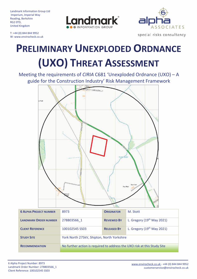
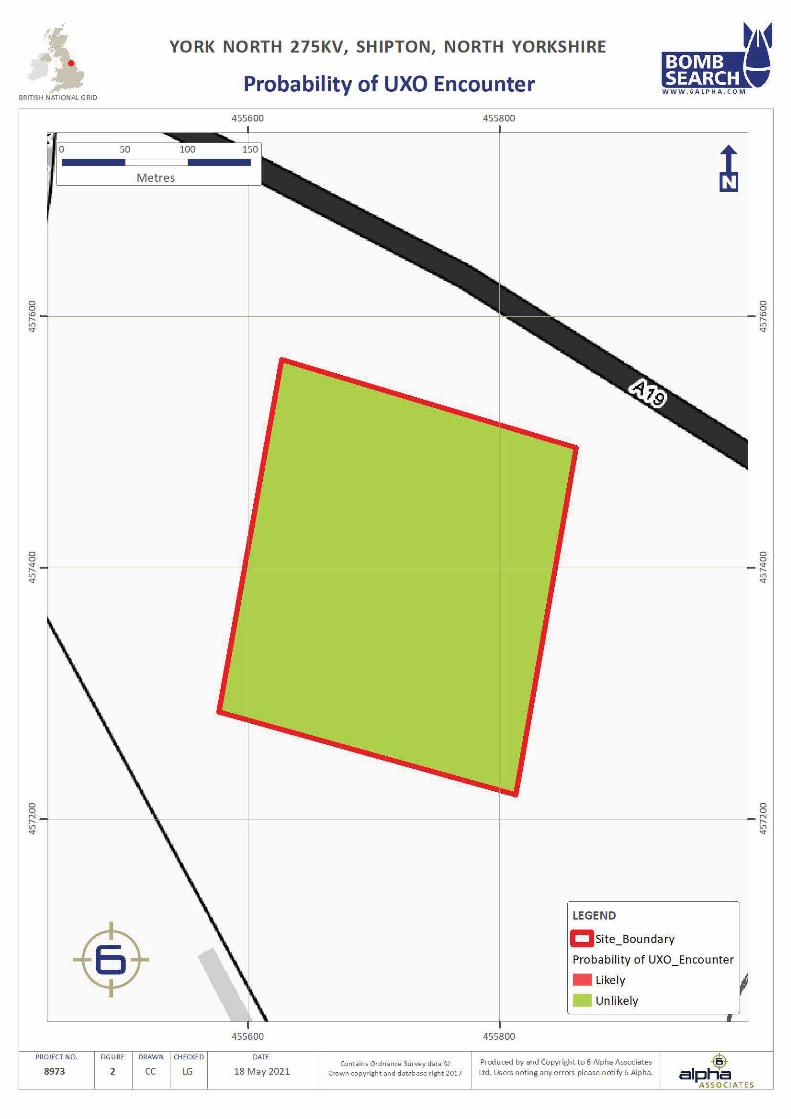
STUDY SITE York North 275kV, Shipton, North Yorkshire
RECOMMENDATION No further action is required to address the UXO risk at this Study Site
PRELIMINARY UNEXPLODED ORDNANCE
(UXO) THREAT ASSESSMENT Meeting the requirements of CIRIA C681 ‘Unexploded Ordnance (UXO) – A
guide for the Construction Industry’ Risk Management Framework
16 Alpha Project Number: 8973
Landmark Order Number: 278803566_1
Client Reference: 100102545 SS03
www.envirocheck.co.uk - +44 (0) 844 844 9952
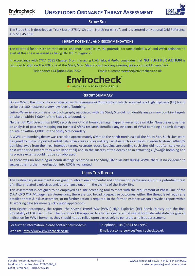
STUDY SITE
The Study Site is described as “York North 275kV, Shipton, North Yorkshire”, and it is centred on National Grid Reference
455720, 457390.
THREAT POTENTIAL AND RECOMMENDATIONS
The potential for a UXO hazard to occur, and more specifically, the potential for unexploded WWI and WWII ordnance to
exist at this site is assessed as being UNLIKELY (Figure 2).
In accordance with CIRIA C681 Chapter 5 on managing UXO risks, 6 Alpha concludes that NO FURTHER ACTION is
required to address the UXO risk at this Study Site. Should you have any queries, please contact Envirocheck.
Telephone: +44 (0)844 844 9952 Email: [email protected]
REPORT SUMMARY
During WWII, the Study Site was situated within Easingwold Rural District, which recorded one High Explosive (HE) bomb
strike per 100 hectares; a very low level of bombing.
Luftwaffe aerial reconnaissance photography associated with the Study Site did not identify any primary bombing targets
on-site or within 1,000m of the Study Site boundary.
Neither Air Raid Precaution (ARP) records nor official bomb damage mapping were not available. Nonetheless, neither
an analysis of post-war mapping nor further 6 Alpha research identified any evidence of WWII bombing or bomb damage
on-site or within 1,000m of the Study Site boundary.
A WWII-era bombing decoy was recorded approximately 695m to the north-north-east of the Study Site. Such sites were
designed to mimic important industrial/urban areas and or military facilities such as airfields in order to draw Luftwaffe
bombing away from their real intended target. Accurate record keeping surrounding such sites did not often survive the
post-war period (where they were kept at all) and so the success of the decoy site in attracting Luftwaffe bombing and
its precise extents could not be corroborated.
As there was no bombing or bomb damage recorded in the Study Site’s vicinity during WWII, there is no evidence to
suggest that further investigation into UXO is warranted.
USING THIS REPORT
This Preliminary Assessment is designed to inform environmental and construction professionals of the potential threat
of military related explosives and/or ordnance on, or in, the vicinity of the Study Site.
This assessment is designed to be employed as a site-screening tool to meet with the requirement of Phase One of the
CIRIA UXO Risk Management Framework; there are two broad prospective outcomes; either the threat level requires a
detailed threat & risk assessment; or no further action is required. In the former instance we can provide a report within
10 working days (or more quickly upon application).
Two figures accompany the report, the Second World War (WWII) High Explosive (HE) Bomb Density and the final
Probability of UXO Encounter. The purpose of this approach is to demonstrate that whilst bomb density statistics give an
indication for WWII bombing, they should not be relied upon exclusively to generate a holistic assessment.
For further information, please contact Envirocheck:
Website: http://www.envirocheck.co.uk
Telephone: +44 (0)844 844 9952
Email: [email protected]
UNEXPLODED ORDNANCE THREAT ASSESSMENT
26 Alpha Project Number: 8973
Landmark Order Number: 278803566_1
Client Reference: 100102545 SS03
www.envirocheck.co.uk - +44 (0) 844 844 9952
DATA FINDINGS
Threat Source
(within 1,000m)
Detail
Identified Comments
Airfields/Military Facilities X0IP Shipton was potentially used as a grass airfield during WWI
(1,100m north-west).
Ordnance
Manufacture/Storage None recorded within 1,000m.
WWII Decoy Bombing Sites A decoy site was located 695m north-north-east.
WWII Defensive Features None recorded within 1,000m.
WWII Luftwaffe Designated
Bombing Targets Luftwaffe aerial photography did not identify any primary bombing
targets on-site or within 1,000m of the Study Site boundary.
WWII Bomb Strikes
Within Study Site Boundary ARP records were not available.
WWII Bomb Strikes
Near Study Site Boundary ARP records were not available.
WWII Bomb Damage Official bomb damage mapping was not available.
Abandoned Bomb Register The official abandoned bomb list did not identify any abandoned
bombs located on-site or within 1,000m of the Study Site boundary.
Potential Threat Sources Further research has not uncovered any potential UXO threat
sources associated with the Study Site.
WWII Bombing Density Per
100 Hectares The Study Site was located within Easingwold Rural District, which
recorded one HE bomb strike per 100 hectares.
IMPORTANT NOTES
1. The term ‘Preliminary UXO Threat Assessment’ has been used to describe this report, to fall in line with the CIRIA
C681 guidelines. Whilst the term ‘Risk’ can be justifiably used at this stage, the reader should note that the
‘Consequence’ function of ‘Risk’ is not considered. Should it be required, this would be addressed in the ‘Detailed
UXO Threat & Risk Assessment’ (Stages 2 and 3).
2. This report is accurate and up to date at the time of writing.
3. The assessment levels have been generated from historical data and third-party sources. Where possible 6 Alpha
have sought to verify the accuracy of such data, but cannot be held accountable for inherent errors that may be
in third party data sets (e.g. National Archives or library sources).
4. 6 Alpha have exercised all reasonable care, skill and due diligence in producing this service.
5. Whilst every effort has been used to identify all potential UXO/explosive threats, there were a number of private
facilities, which may not have released privately recorded information concerning UXO/explosive threats into the
public domain. It is therefore possible that some of the aforementioned sites may not be included within the
database.
UNEXPLODED ORDNANCE THREAT ASSESSMENT

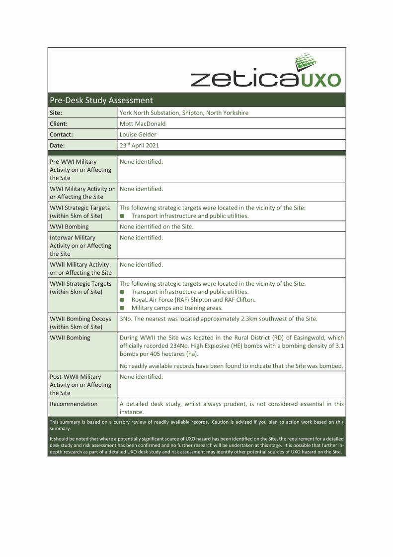
Pre-Desk Study Assessment
Site: York North Substation, Shipton, North Yorkshire
Client: Mott MacDonald
Contact: Louise Gelder
Date: 23rd April 2021
Pre-WWI Military
Activity on or Affecting
the Site
None identified.
WWI Military Activity on
or Affecting the Site
None identified.
WWI Strategic Targets
(within 5km of Site)
The following strategic targets were located in the vicinity of the Site:
Transport infrastructure and public utilities.
WWI Bombing None identified on the Site.
Interwar Military
Activity on or Affecting
the Site
None identified.
WWII Military Activity
on or Affecting the Site
None identified.
WWII Strategic Targets
(within 5km of Site)
The following strategic targets were located in the vicinity of the Site:
Transport infrastructure and public utilities.
RoyaL Air Force (RAF) Shipton and RAF Clifton.
Military camps and training areas.
WWII Bombing Decoys
(within 5km of Site)
3No. The nearest was located approximately 2.3km southwest of the Site.
WWII Bombing During WWII the Site was located in the Rural District (RD) of Easingwold, which
officially recorded 234No. High Explosive (HE) bombs with a bombing density of 3.1
bombs per 405 hectares (ha).
No readily available records have been found to indicate that the Site was bombed.
Post-WWII Military
Activity on or Affecting
the Site
None identified.
Recommendation A detailed desk study, whilst always prudent, is not considered essential in this
instance.
This summary is based on a cursory review of readily available records. Caution is advised if you plan to action work based on this
summary.
It should be noted that where a potentially significant source of UXO hazard has been identified on the Site, the requirement for a detailed
desk study and risk assessment has been confirmed and no further research will be undertaken at this stage. It is possible that further in-
depth research as part of a detailed UXO desk study and risk assessment may identify other potential sources of UXO hazard on the Site.
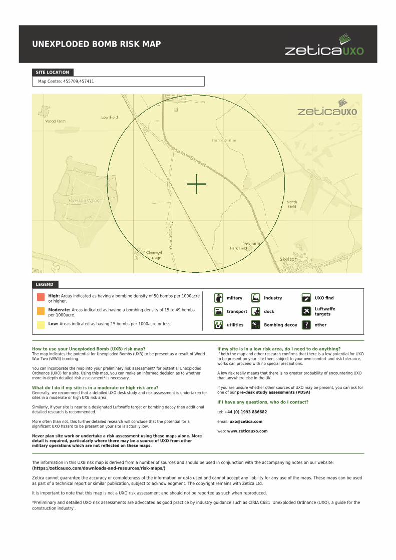
UNEXPLODED BOMB RISK MAP
SITE LOCATION
Map Centre: 455709,457411
LEGEND
High: Areas indicated as having a bombing density of 50 bombs per 1000acreor higher.
Moderate: Areas indicated as having a bombing density of 15 to 49 bombsper 1000acre.
Low: Areas indicated as having 15 bombs per 1000acre or less.
miltary industry UXO find
transport dockLuftwaffetargets
utilities Bombing decoy other
How to use your Unexploded Bomb (UXB) risk map?The map indicates the potential for Unexploded Bombs (UXB) to be present as a result of WorldWar Two (WWII) bombing.
You can incorporate the map into your preliminary risk assessment* for potential UnexplodedOrdnance (UXO) for a site. Using this map, you can make an informed decision as to whethermore in-depth detailed risk assessment* is necessary.
What do I do if my site is in a moderate or high risk area?Generally, we recommend that a detailed UXO desk study and risk assessment is undertaken forsites in a moderate or high UXB risk area.
Similarly, if your site is near to a designated Luftwaffe target or bombing decoy then additionaldetailed research is recommended.
More often than not, this further detailed research will conclude that the potential for asignificant UXO hazard to be present on your site is actually low.
Never plan site work or undertake a risk assessment using these maps alone. Moredetail is required, particularly where there may be a source of UXO from othermilitary operations which are not reflected on these maps.
If my site is in a low risk area, do I need to do anything?If both the map and other research confirms that there is a low potential for UXOto be present on your site then, subject to your own comfort and risk tolerance,works can proceed with no special precautions.
A low risk really means that there is no greater probability of encountering UXOthan anywhere else in the UK.
If you are unsure whether other sources of UXO may be present, you can ask forone of our pre-desk study assessments (PDSA)
If I have any questions, who do I contact?
tel: +44 (0) 1993 886682
email: [email protected]
web: www.zeticauxo.com
The information in this UXB risk map is derived from a number of sources and should be used in conjunction with the accompanying notes on our website:
(https://zeticauxo.com/downloads-and-resources/risk-maps/)
Zetica cannot guarantee the accuracy or completeness of the information or data used and cannot accept any liability for any use of the maps. These maps can be used
as part of a technical report or similar publication, subject to acknowledgment. The copyright remains with Zetica Ltd.
It is important to note that this map is not a UXO risk assessment and should not be reported as such when reproduced.
*Preliminary and detailed UXO risk assessments are advocated as good practice by industry guidance such as CIRIA C681 'Unexploded Ordnance (UXO), a guide for the
construction industry'.
6 Alpha Project Number: 8972
Landmark Order Number: 278802908_1
Client Reference: 100102545 SS03
www.envirocheck.co.uk - +44 (0) 844 844 9952
Landmark Information Group Ltd
Imperium, Imperial Way
Reading, Berkshire
RG2 0TD,
United Kingdom
T: +44 (0) 844 844 9952
W: www.envirocheck.co.uk
6 ALPHA PROJECT NUMBER 8972 ORIGINATOR D. Barrett
LANDMARK ORDER NUMBER 278802908_1 REVIEWED BY L. Gregory (18th May 2021)
CLIENT REFERENCE 100102545 SS03 RELEASED BY L. Gregory (19th May 2021)
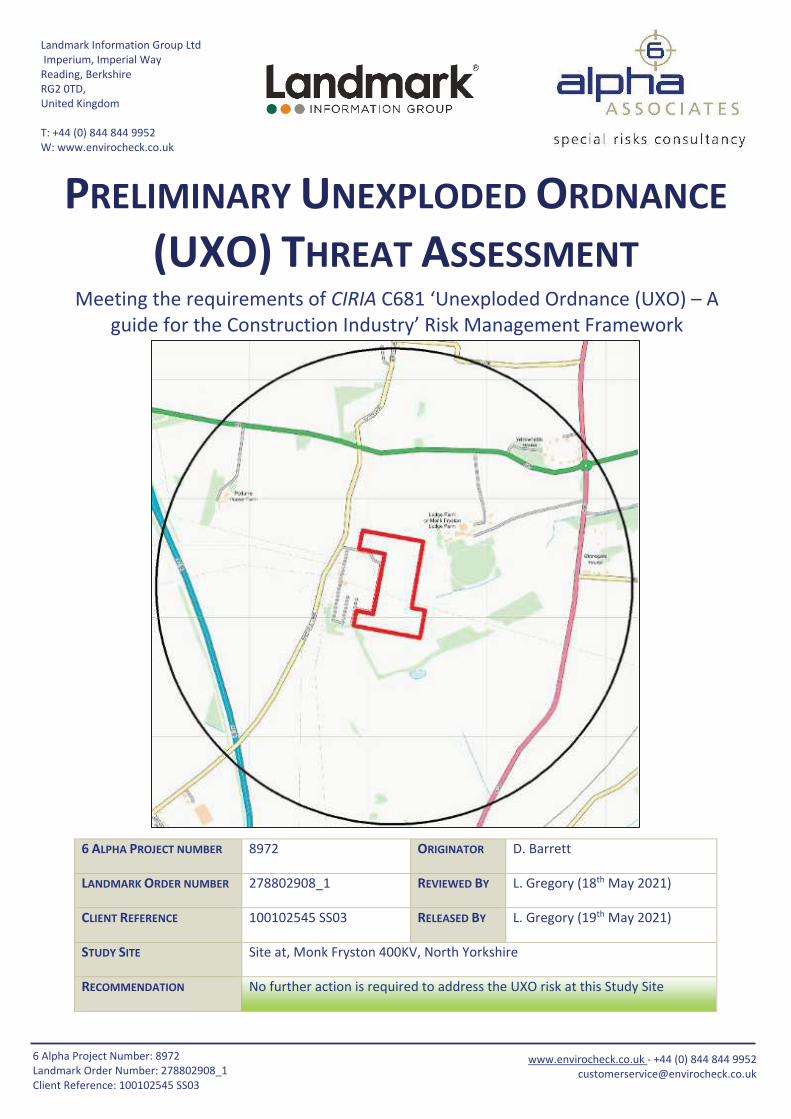
STUDY SITE Site at, Monk Fryston 400KV, North Yorkshire
RECOMMENDATION No further action is required to address the UXO risk at this Study Site
PRELIMINARY UNEXPLODED ORDNANCE
(UXO) THREAT ASSESSMENT Meeting the requirements of CIRIA C681 ‘Unexploded Ordnance (UXO) – A
guide for the Construction Industry’ Risk Management Framework
16 Alpha Project Number: 8972
Landmark Order Number: 278802908_1
Client Reference: 100102545 SS03
www.envirocheck.co.uk - +44 (0) 844 844 9952
STUDY SITE
The Study Site is described as “Site at, Monk Fryston 400KV, North Yorkshire”, and it is centred on National Grid Reference
448610, 429130.
THREAT POTENTIAL AND RECOMMENDATIONS
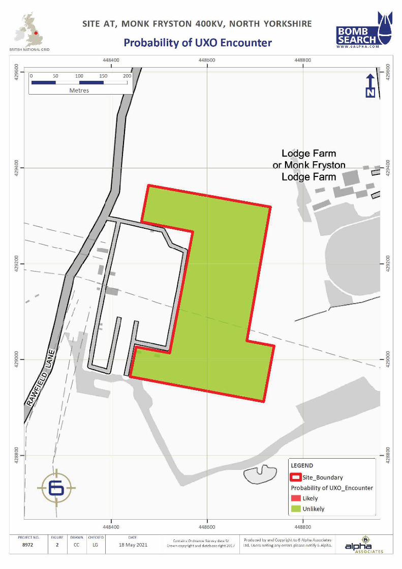
The potential for a UXO hazard to occur, and more specifically, the potential for unexploded WWI and WWII ordnance to
exist at this site is assessed as being UNLIKELY (Figure 2).
In accordance with CIRIA C681 Chapter 5 on managing UXO risks, 6 Alpha concludes that NO FURTHER ACTION is
required to address the UXO risk at this Study Site. Should you have any queries, please contact Envirocheck.
Telephone: +44 (0)844 844 9952 Email: [email protected]
REPORT SUMMARY
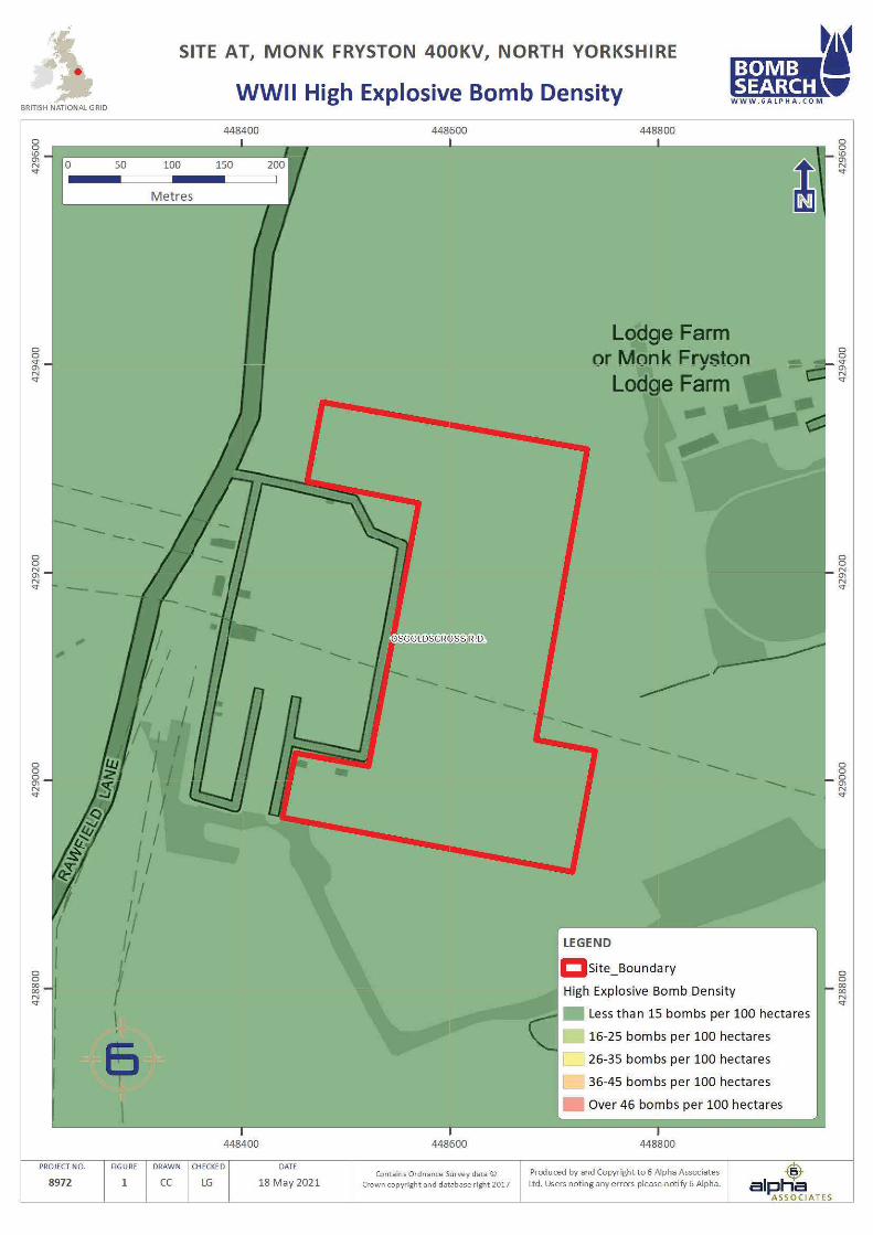
During WWII, the Study Site was situated within Osgoldscross Rural District, which recorded less than one High Explosive
(HE) bomb strike per 100 hectares; a very low level of bombing.
Luftwaffe aerial reconnaissance photography associated with the Study Site did not identify any primary bombing targets
on-site, or within 1,000m of the Study Site boundary.
Neither Air Raid Precaution (ARP) records nor official bomb damage were available. Nonetheless further research of
historical records identified incendiary bombs (IBs) impacting at Lumby (approximately 810m north) during WWI.
Nonetheless, neither further research of historical records nor an analysis of post-war mapping identified any bomb
strikes or potential bomb damage on-site or in the immediate vicinity.
Although WWI bomb strikes were recorded in the wider area, as there was no bombing or bomb damage recorded in the
Study Site’s vicinity during WWII, there is no evidence to suggest that further investigation into UXO is warranted.
USING THIS REPORT
This Preliminary Assessment is designed to inform environmental and construction professionals of the potential threat
of military related explosives and/or ordnance on, or in, the vicinity of the Study Site.
This assessment is designed to be employed as a site-screening tool to meet with the requirement of Phase One of the
CIRIA UXO Risk Management Framework; there are two broad prospective outcomes; either the threat level requires a
detailed threat & risk assessment; or no further action is required. In the former instance we can provide a report within
10 working days (or more quickly upon application).
Two figures accompany the report, the Second World War (WWII) High Explosive (HE) Bomb Density and the final
Probability of UXO Encounter. The purpose of this approach is to demonstrate that whilst bomb density statistics give an
indication for WWII bombing, they should not be relied upon exclusively to generate a holistic assessment.
For further information, please contact Envirocheck:
Website: http://www.envirocheck.co.uk
Telephone: +44 (0)844 844 9952
Email: [email protected]
UNEXPLODED ORDNANCE THREAT ASSESSMENT
26 Alpha Project Number: 8972
Landmark Order Number: 278802908_1
Client Reference: 100102545 SS03
www.envirocheck.co.uk - +44 (0) 844 844 9952
DATA FINDINGS
Threat Source
(within 1,000m)
Detail
Identified Comments
Airfields/Military Facilities None recorded within 1,000m.
Ordnance
Manufacture/Storage None recorded within 1,000m.
WWII Decoy Bombing Sites None recorded within 1,000m.
WWII Defensive Features None recorded within 1,000m.
WWII Luftwaffe Designated
Bombing Targets Luftwaffe aerial photography did not identify any primary bombing
targets on-site or within 1,000m of the Study Site boundary.
WWII Bomb Strikes
(Study Site Boundary) ARP records were not available.
WWI/WWII Bomb Strikes
(Wider Area)
Further research identified WWI-era IBs impacting approximately
810m north.
WWII Bomb Damage Official bomb damage mapping was not available.
Abandoned Bomb Register The official abandoned bomb list did not identify any abandoned
bombs on-site or within 1,000m of the Study Site boundary.
Potential Threat Sources Further research has not uncovered any potential UXO threat
sources associated with the Study Site.
WWII Bombing Density Per
100 Hectares The Study Site was located within Osgoldscross Rural District, which
recorded less than one HE bomb strike per 100 hectares.
IMPORTANT NOTES
1. The term ‘Preliminary UXO Threat Assessment’ has been used to describe this report, to fall in line with the CIRIA
C681 guidelines. Whilst the term ‘Risk’ can be justifiably used at this stage, the reader should note that the
‘Consequence’ function of ‘Risk’ is not considered. Should it be required, this would be addressed in the ‘Detailed
UXO Threat & Risk Assessment’ (Stages 2 and 3).
2. This report is accurate and up to date at the time of writing.
3. The assessment levels have been generated from historical data and third-party sources. Where possible 6 Alpha
have sought to verify the accuracy of such data, but cannot be held accountable for inherent errors that may be
in third party data sets (e.g. National Archives or library sources).
4. 6 Alpha have exercised all reasonable care, skill and due diligence in producing this service.
5. Whilst every effort has been used to identify all potential UXO/explosive threats, there were a number of private
facilities, which may not have released privately recorded information concerning UXO/explosive threats into the
public domain. It is therefore possible that some of the aforementioned sites may not be included within the
database.
UNEXPLODED ORDNANCE THREAT ASSESSMENT
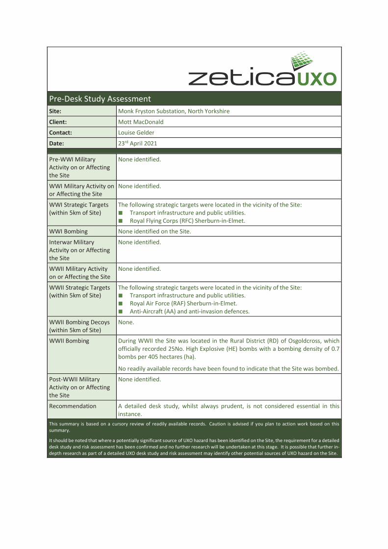
Pre-Desk Study Assessment
Site: Monk Fryston Substation, North Yorkshire
Client: Mott MacDonald
Contact: Louise Gelder
Date: 23rd April 2021
Pre-WWI Military
Activity on or Affecting
the Site
None identified.
WWI Military Activity on
or Affecting the Site
None identified.
WWI Strategic Targets
(within 5km of Site)
The following strategic targets were located in the vicinity of the Site:
Transport infrastructure and public utilities.
Royal Flying Corps (RFC) Sherburn-in-Elmet.
WWI Bombing None identified on the Site.
Interwar Military
Activity on or Affecting
the Site
None identified.
WWII Military Activity
on or Affecting the Site
None identified.
WWII Strategic Targets
(within 5km of Site)
The following strategic targets were located in the vicinity of the Site:
Transport infrastructure and public utilities.
Royal Air Force (RAF) Sherburn-in-Elmet.
Anti-Aircraft (AA) and anti-invasion defences.
WWII Bombing Decoys
(within 5km of Site)
None.
WWII Bombing During WWII the Site was located in the Rural District (RD) of Osgoldcross, which
officially recorded 25No. High Explosive (HE) bombs with a bombing density of 0.7
bombs per 405 hectares (ha).
No readily available records have been found to indicate that the Site was bombed.
Post-WWII Military
Activity on or Affecting
the Site
None identified.
Recommendation A detailed desk study, whilst always prudent, is not considered essential in this
instance.
This summary is based on a cursory review of readily available records. Caution is advised if you plan to action work based on this
summary.
It should be noted that where a potentially significant source of UXO hazard has been identified on the Site, the requirement for a detailed
desk study and risk assessment has been confirmed and no further research will be undertaken at this stage. It is possible that further in-
depth research as part of a detailed UXO desk study and risk assessment may identify other potential sources of UXO hazard on the Site.
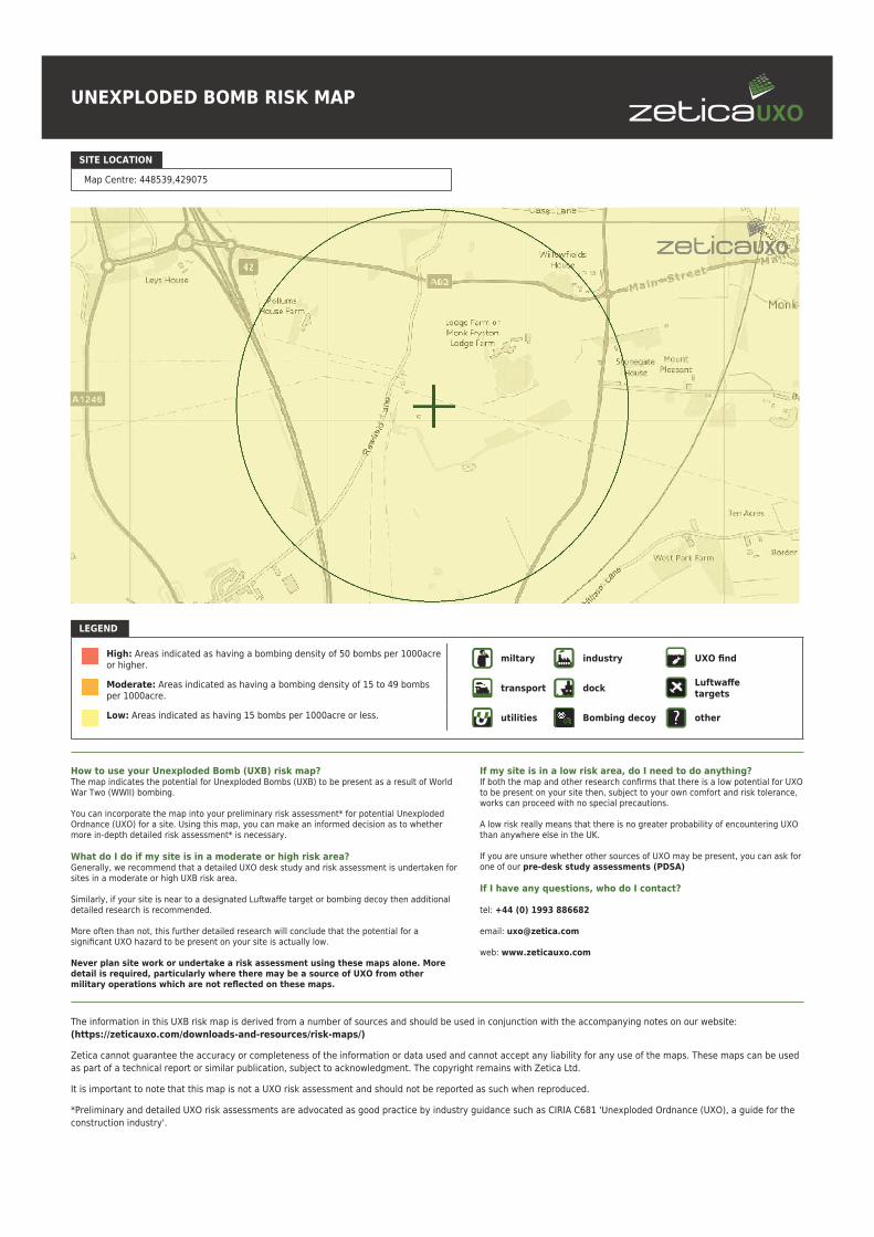
UNEXPLODED BOMB RISK MAP
SITE LOCATION
Map Centre: 448539,429075
LEGEND
High: Areas indicated as having a bombing density of 50 bombs per 1000acreor higher.
Moderate: Areas indicated as having a bombing density of 15 to 49 bombsper 1000acre.
Low: Areas indicated as having 15 bombs per 1000acre or less.
miltary industry UXO find
transport dockLuftwaffetargets
utilities Bombing decoy other
How to use your Unexploded Bomb (UXB) risk map?The map indicates the potential for Unexploded Bombs (UXB) to be present as a result of WorldWar Two (WWII) bombing.
You can incorporate the map into your preliminary risk assessment* for potential UnexplodedOrdnance (UXO) for a site. Using this map, you can make an informed decision as to whethermore in-depth detailed risk assessment* is necessary.
What do I do if my site is in a moderate or high risk area?Generally, we recommend that a detailed UXO desk study and risk assessment is undertaken forsites in a moderate or high UXB risk area.
Similarly, if your site is near to a designated Luftwaffe target or bombing decoy then additionaldetailed research is recommended.
More often than not, this further detailed research will conclude that the potential for asignificant UXO hazard to be present on your site is actually low.
Never plan site work or undertake a risk assessment using these maps alone. Moredetail is required, particularly where there may be a source of UXO from othermilitary operations which are not reflected on these maps.
If my site is in a low risk area, do I need to do anything?If both the map and other research confirms that there is a low potential for UXOto be present on your site then, subject to your own comfort and risk tolerance,works can proceed with no special precautions.
A low risk really means that there is no greater probability of encountering UXOthan anywhere else in the UK.
If you are unsure whether other sources of UXO may be present, you can ask forone of our pre-desk study assessments (PDSA)
If I have any questions, who do I contact?
tel: +44 (0) 1993 886682
email: [email protected]
web: www.zeticauxo.com
The information in this UXB risk map is derived from a number of sources and should be used in conjunction with the accompanying notes on our website:
(https://zeticauxo.com/downloads-and-resources/risk-maps/)
Zetica cannot guarantee the accuracy or completeness of the information or data used and cannot accept any liability for any use of the maps. These maps can be used
as part of a technical report or similar publication, subject to acknowledgment. The copyright remains with Zetica Ltd.
It is important to note that this map is not a UXO risk assessment and should not be reported as such when reproduced.
*Preliminary and detailed UXO risk assessments are advocated as good practice by industry guidance such as CIRIA C681 'Unexploded Ordnance (UXO), a guide for the
construction industry'.