Embed Size (px)
Citation preview
APPEAL AGAINST NON-DETERMINATION: STANCE REPORT
APPLICATION NO: P2012/0638
DATE: 29/08/2012
PROPOSAL: Erection of 5 no. Wind turbines with a max. height to tip
of 100m and associated works, access tracks, substation
and ancillary equipment. (Amended application site
boundary, Supplemental Environmental Information
including additional information in relation to transport,
mining, ecology, location of borrow pits and access
tracks)
LOCATION: Land at Mynydd Brombil, Brombil Farm, Margam, Port
Talbot
APPLICANT: REG Windpower
TYPE: Full Plans
WARD: Margam
Background:
Members are advised that an appeal has been lodged by the applicant against
non-determination of the application, which is to be heard at a Public Inquiry
scheduled to commence on Tuesday 12th May 2015.
The report which follows seeks members authorisation for the stance the
Council would have taken had it been in a position to determine the
application.
Planning History:
P2011/0798 Request for scoping opinion under the EIA regulations for the
erection of 5 wind turbines Determined 18/10/2011
Publicity and Responses:
Prior to the submission of the application, the applicants undertook a
community consultation as part of the development of the project and which is
fully detailed in the Report of Consultation presented as part of the planning
application, in accordance with the requirements of the Authority’s
Supplementary Planning Guidance for Wind Farms.
The Applicant
The applicant has indicated that two public exhibitions were organised for the
local communities of Margam and Taibach. A bilingual information flyer was
sent to all properties in the electoral wards of Margam and Taibach as well as
other stakeholders informing them about the event. The applicant sent out
3700 flyers, erected 50 posters and advertised in the press The exhibitions took
place on Friday the 11th November at Taibach Community Education Centre
and Saturday 12th
November at Taibach Community Centre.
The Authority
The proposal has been advertised by means of a press notice and the posting of
20 site notices. A hard copy of the application and Environmental Impact
Assessment was deposited in Port Talbot Civic Centre and The Quays.
Following the submission of additional information on 18th March 2013 in
relation to Ecology, Ornithology, landscape and visual impact assessment,
archaeology and cultural heritage, noise, air quality, transport and access,
geology, hydrology and hydrogeology, aviation telecommunications, shadow
flicker, socio economics, tourism and recreation. Additional information on
14th
November 2013 in relation to mining issues, Ecology and Ornithology,
Transport and additional information on the 13th
of January 2014 in relation to
ecology and transport.l Additional SEI was also received in July 2014
(including an amended red line site boundary) to provide updates including on
LVIA, ecology, noise, heritage and minerals. Further consultation was
undertaken by means of a press notice and site notices.
20 individual letters have been received objecting to the proposal for the
following summarised reasons:
- Negative effect on tourism
- Devalue houses
- Loss of birds
- Noise
- Damage to cycle ways
- Detrimental to visual amenity
- Traffic, congestion and highway safety
- Impact on land stability
- Limited economic benefit for the local community
- Saturation of windfarms and power generating facilities within the area
- Lead to industrialisation of the upland areas overlooking Port Talbot
- Impact on scheduled ancient monuments/sites
- Impact on wildlife
- Contrary to local and national planning policies
- Devaluation of property
- Disruption during construction
- The proposal can not be supported due to the wind strength being to low
- Shadow Flicker
- Overbearing and dominant
- Outside TAN 8
- Overshadow the town and the M4
- Concrete bases will remain long after the turbines have been removed.
A petition (183 signatures) has been received objecting to the application on
the following grounds:
- The proposal is in an area where wind farm development is not suitable
as the landscape is classified as highly sensitive.
- The access route through Bryn is not capable of accommodating HGV’s;
- Disruption.
- The submitted noise data is incomplete and the current predicted noise
levels for Goytre and Margam are already unacceptable.
- Impact on scheduled ancients.
- Shadow flicker.
- Impact on birds and protected species.
- Driver distraction.
A letter of objection has been received from Suzy Davies AM objecting to the
proposal on the grounds of impact on the landscape, distraction for users of the
M4, saturation of wind farms in the area, impact on footpaths, impact on
historic features, need for renewable energy and consideration as to whether
the submitted EIA is accurate and independent.
In addition 55 letters of support have been received for the following reasons:
- Positive contribution to tackling climate change
- Conforms with Welsh Government Policy
- Assist in meeting national energy targets
- Provision of a community fund of £40,000 PA
- Visually more acceptable than the existing steel works
One letter has been received on behalf of TATA Steel (UK) Ltd which is
summarised as follows:
The site falls within an area for which a Conditional Underground
Mining License has been granted by the Coal Authority for what is
known as the ‘Margam Prospect’ area which contains good quality
coking coal.
Extensive geological testing has been undertaken and commercial
feasibility studies to assess the long term demand for steel.
Approximately 380 million tonnes of coal could potentially be available
for use.
As the production of steel currently relies on imported coal, the use of
this locally sourced coal could provide security of supply and reduced
costs, as well as reducing extensive worldwide transportation
movements associated with the current importation of coal.
Significant economic benefits through job creation.
An application for 12 boreholes is to be submitted in early 2013
followed by further detailed drilling activities.
Creation of 400 to 500 jobs over a 20 year period.
Insufficient technical detail has been provided for the Local Planning
Authority to determine the application and to ensure that the proposal
does not sterilise the long term viability of deep coal mining in Margam.
Concerned about the impact of the weight of the turbines (between
2,195 and 2,445 tonnes) on any future deep mining operations at
Margam Prospect Area.
The Coal Authority response to the planning application does not
address future coal mining activities and recommends that an
assessment should be made of the potential sterilising effect of this
proposal.
ES requires updating.
National and local planning policies require full consideration of any
potential impact on future coal extraction.
Additional comments have been received following the submission of
Supplementary Environmental Information which are summarised as follows:
Tata has rights to all coal seams 100m below the surface to 5m below
the lowest coal seam. Tata’s seams are very shallow.
The wind farm is some 3km away from the nearest legacy borehole, and
as a consequence the application site has not been previously explored
by Tata.
The prevailing geology in the region is complex with significant
gradient changes and faulting which does not allow the depth of the
seams to be identified.
Tata do not accept or agree responsibility for the appropriate level of
protection for the wind farm.
Ancient Monuments Society : No reply, therefore no observations to make
Atkins Windfarm Support: No objection
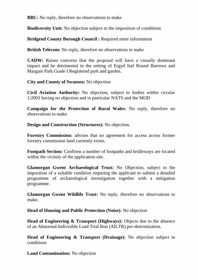
BBC: No reply, therefore no observations to make
Biodiversity Unit: No objection subject to the imposition of conditions
Bridgend County Borough Council : Required more information
British Telecom: No reply, therefore no observations to make
CADW: Raises concerns that the proposal will have a visually dominant
impact and be detrimental to the setting of Ergyd Isaf Round Barrows and
Margam Park Grade I Registered park and garden.
City and County of Swansea: No objection
Civil Aviation Authority: No objection, subject to bodies within circular
1/2003 having no objection and in particular NATS and the MOD
Campaign for the Protection of Rural Wales: No reply, therefore no
observations to make.
Design and Construction (Structures): No objection.
Forestry Commission: advises that no agreement for access across former
forestry commission land currently exists.
Footpath Section: Confirms a number of footpaths and bridleways are located
within the vicinity of the application site.
Glamorgan Gwent Archaeological Trust: No Objection, subject to the
imposition of a suitable condition requiring the applicant to submit a detailed
programme of archaeological investigation together with a mitigation
programme.
Glamorgan Gwent Wildlife Trust: No reply, therefore no observations to
make.
Head of Housing and Public Protection (Noise): No objection
Head of Engineering & Transport (Highways): Objects due to the absence
of an Abnormal Indivisible Load Trial Run (AILTR) pre-determination.
Head of Engineering & Transport (Drainage): No objection subject to
conditions
Land Contamination: No objection
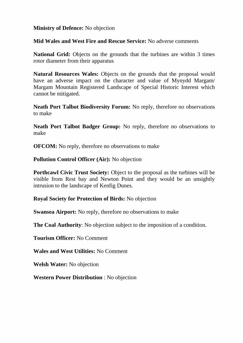
Ministry of Defence: No objection
Mid Wales and West Fire and Rescue Service: No adverse comments
National Grid: Objects on the grounds that the turbines are within 3 times
rotor diameter from their apparatus
Natural Resources Wales: Objects on the grounds that the proposal would
have an adverse impact on the character and value of Mynydd Margam/
Margam Mountain Registered Landscape of Special Historic Interest which
cannot be mitigated.
Neath Port Talbot Biodiversity Forum: No reply, therefore no observations
to make
Neath Port Talbot Badger Group: No reply, therefore no observations to
make
OFCOM: No reply, therefore no observations to make
Pollution Control Officer (Air): No objection
Porthcawl Civic Trust Society: Object to the proposal as the turbines will be
visible from Rest bay and Newton Point and they would be an unsightly
intrusion to the landscape of Kenfig Dunes.
Royal Society for Protection of Birds: No objection
Swansea Airport: No reply, therefore no observations to make
The Coal Authority: No objection subject to the imposition of a condition.
Tourism Officer: No Comment
Wales and West Utilities: No Comment
Welsh Water: No objection
Western Power Distribution : No objection
Description of Site and its Surroundings
The application site is located on Mynydd Brombil. To the west of the site is
the M4 Motorway which runs in North Westerly to South Easterly direction.
The settlements of Taibach and Margam lie adjacent to this section of
motorway nearest to the application site. Goytre is the closest settlement which
is located approximately 1km to the north. Margam Forest is located to the
East of the site.
The landscape is open, exposed and consists of grazing land. The site is in a
prominent elevated location above the settlements of Margam, Taibach and
Goytre with wider views across Port Talbot and Swansea Bay (approximately
200-270m AOD) elevated at between approximately 450m-556m. Immediately
adjacent to the site is a Scheduled Monument (tumuli) and Margam Country
Park a Registered Park and Garden lies 3km to the south-east. The site is
situated within the Mynydd Margam Landscape of Special Historic Interest.
There are several public rights of way that are located around the site. The
wider landscape consists of upland grazing and forestry upon higher ground
with infrastructure at lower levels which includes major road networks, the
Tata steel works and other industry as well as residential areas.
Whilst part of the access road to the site and the borrow pit are located within
Strategic Search Area (SSA) F, as set out in Technical Advice Note 8 (TAN
8), all of the wind turbines are located outside of this area with the nearest
wind turbine being approximately 340 metres away from the SSA boundary.
The application site has an area of 20.7 ha of which 1.08 hectares forms part of
the access track falling within the administrative boundary of Bridgend County
Borough Council.
Brief description of proposal
This is a proposal comprising 5 wind turbines with a maximum tip height of
100m, a hub height of 60m and a rotor diameter of 80m at the following
locations (subject to micro siting tolerances);
Easting Northing
T1 279039 188991
T2 279369 188698
T3 278755 188772
T4 278858 188496
T5 279129 188272
The applicant has indicated that the windfarm would have a maximum
generating capacity of 12.5 MW and an operational life of 25 years.
The development proposal also includes for the on-site access tracks, crane
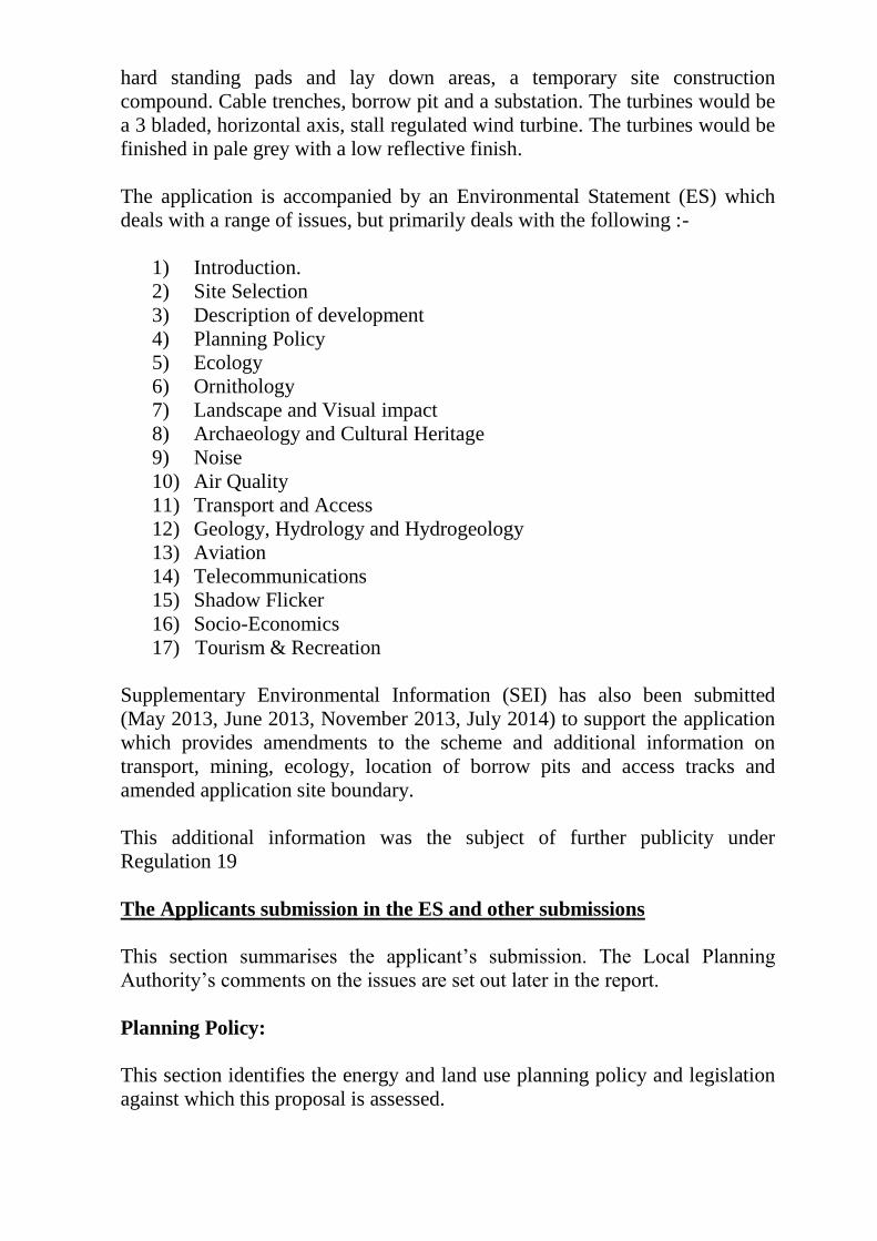
hard standing pads and lay down areas, a temporary site construction
compound. Cable trenches, borrow pit and a substation. The turbines would be
a 3 bladed, horizontal axis, stall regulated wind turbine. The turbines would be
finished in pale grey with a low reflective finish.
The application is accompanied by an Environmental Statement (ES) which
deals with a range of issues, but primarily deals with the following :-
1) Introduction.
2) Site Selection
3) Description of development
4) Planning Policy
5) Ecology
6) Ornithology
7) Landscape and Visual impact
8) Archaeology and Cultural Heritage
9) Noise
10) Air Quality
11) Transport and Access
12) Geology, Hydrology and Hydrogeology
13) Aviation
14) Telecommunications
15) Shadow Flicker
16) Socio-Economics
17) Tourism & Recreation
Supplementary Environmental Information (SEI) has also been submitted
(May 2013, June 2013, November 2013, July 2014) to support the application
which provides amendments to the scheme and additional information on
transport, mining, ecology, location of borrow pits and access tracks and
amended application site boundary.
This additional information was the subject of further publicity under
Regulation 19
The Applicants submission in the ES and other submissions
This section summarises the applicant’s submission. The Local Planning
Authority’s comments on the issues are set out later in the report.
Planning Policy:
This section identifies the energy and land use planning policy and legislation
against which this proposal is assessed.
The conclusions in the ES are that policy at a national level fully supports the
development of large scale renewable energy projects through TAN8 whilst
ensuring that any detrimental environmental effects on local communities are
minimised. The proposal falls adjacent to Strategic Search Area F and the 5km
buffer area as defined in TAN 8.
Ecology /Ornithology:
The assessment provides baseline information, identifies potential impacts of
the proposal on the ecology of the area, assesses the significance of those
impacts, describes mitigation measures to avoid, reduce, remedy or
compensate for those impacts, assesses the significance of the residual effects
based on the magnitude of the impact and the sensitivity of the receptor. This
section also discusses ongoing management, monitoring and mitigation
measures that may be required.
The Assessment includes :
Phase 1 Habitat Survey
Wintering bird surveys
Breeding bird surveys
Vantage point surveys bat survey
Breeding Raptor surveys
Nightjar surveys
Badger survey
Otter survey
Water Vole survey
Great Crested Newt survey
Other species of interest such as reptiles and invertebrates were recorded
during walkover surveys.
Mitigation of possible impacts includes the following:
- Timing of works i.e outside the breeding bird season
- Appropriate environmental site supervision and protection to be
provided during construction
- Buffer zones around important habitat
- Reasonable Avoidance Measures (RAMs)
- Post construction monitoring would be undertaken of badgers
Impact on Habitat
The E.S and SEI identifies that no rare or scarce plants, or plant species noted
as priority species in the Neath Port Talbot or UK Biodiversity Action Plans,
were recorded on the surveyed area. The proposal will involve the loss of 3.27
ha of improved pasture, overall the construction phase will result in the loss of
approximately 3.75 ha of low ecological value habitat but there will be a net
gain of 21 ha of high value habitats, of which 16ha comprise LBAP habitat.
In respect of the external access route no ground vegetation will require
removal as part of the construction works but the route will involve the
trimming of 68m length of the tree line. The broadleaved trees may fall under
the LBAP habitat for broad leaved woodland, therefore a precautionary
approach is required. Due to recent clear felling within the plantation the track
leading from the borrow pit to site is heavily disturbed and wide enough to
accommodate all construction vehicles. The ES states that no habitat loss along
the route is anticipated.
The E.S. concludes the development does not involve significant land take
and, with habitat management, no significant effects on habitats are predicted
and there should be a net conservation gain from increased areas of heath.
Impacts on bats
Seven species of bats were observed within a 500m radius of the proposed
turbines. There are no known bat roosts identified within a 250 metre radius of
the site although the coniferous plantation to the edge of this area is identified
as having low bat roost potential.
The E.S. concludes that it is unlikely that bats will be significantly affected by
the proposed development.
Impacts on Mammals, Reptiles and Amphibians
The ES indicates that whilst the survey showed signs of badger presence
within the application site no setts were identified. Invertebrates and
amphibians were recorded but as the development will not effect these
locations the E.S. concludes that the proposed development will have a minor
negative impact on reptiles, mammals and Amphibians.
Impacts on birds
There are three key potential impacts on birds from wind farm construction
and operation. These are disturbance, loss of habitat and death or injury from
collision with turbines, especially turning blades.
The conclusion in the ES is that as the proposed development will only have a
negligible effect on the total habitat available in the area, the impact on the
local bird populations from habitat loss is therefore negligible. It is also
considered that there will be no significant disturbance from the development
during the construction and decommissioning phases.
However, there remains a collision risk to all species during the operational
phase. The ES indicates that whilst a model exists to calculate collision risk the
low number of birds recorded at the site was too low to make a meaningful
calculation. The ES therefore concluded that the development would have a
negligible impact on the local bird populations.
Landscape and Visual Impact Assessment:
This section presents the findings of a landscape and visual assessment that has
considered the potential effects of the proposed wind farm and associated
works on the landscape character and visual amenity of locations at a
considerable distance beyond the site boundary. The study area for the
Landscape Visual Impact Assessment was based on a 35 km radius from the
ownership boundary extending from Brecon Beacons in the north, Gower and
Llanelli in the west, Merthyr Tydfil and the Rhondda valleys in the east and
extending southwards to the edge of Barry.
The baseline conditions include 35 wind farm sites that are either operational,
under construction, consented or in planning and are also located within the
landscape of the study area.
The assessment has taken account of the potential cumulative or additional
effects on landscape and visual amenity arising from the proposal, in
conjunction with the known baseline of operational and/or consented wind
farms and in conjunction with this baseline all of the submitted stage wind
farms as identified above. In addition, the assessment considers the entire
period of the development which includes the site preparation and
commissioning phases, the operation of the wind farm, final decommissioning
and reinstatement of the site.
The landscape assessment identified 16 landscape character type/areas within
the study area and assessed the impact of the proposal on those areas. A
summary of the effects is set out below.
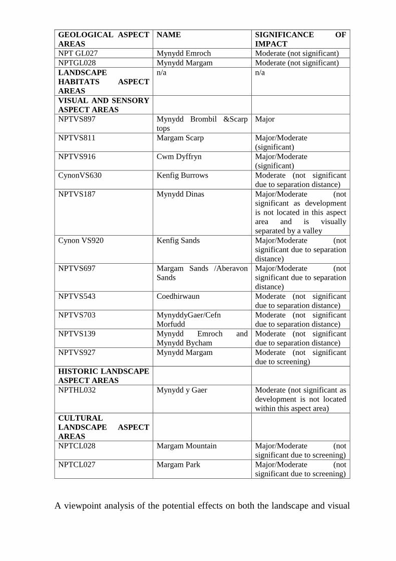
GEOLOGICAL ASPECT
AREAS
NAME SIGNIFICANCE OF
IMPACT
NPT GL027 Mynydd Emroch Moderate (not significant)
NPTGL028 Mynydd Margam Moderate (not significant)
LANDSCAPE
HABITATS ASPECT
AREAS
n/a n/a
VISUAL AND SENSORY
ASPECT AREAS
NPTVS897 Mynydd Brombil &Scarp
tops
Major
NPTVS811 Margam Scarp Major/Moderate
(significant)
NPTVS916 Cwm Dyffryn Major/Moderate
(significant)
CynonVS630 Kenfig Burrows Moderate (not significant
due to separation distance)
NPTVS187 Mynydd Dinas Major/Moderate (not
significant as development
is not located in this aspect
area and is visually
separated by a valley
Cynon VS920 Kenfig Sands Major/Moderate (not
significant due to separation
distance)
NPTVS697 Margam Sands /Aberavon
Sands
Major/Moderate (not
significant due to separation
distance)
NPTVS543 Coedhirwaun Moderate (not significant
due to separation distance)
NPTVS703 MynyddyGaer/Cefn
Morfudd
Moderate (not significant
due to separation distance)
NPTVS139 Mynydd Emroch and
Mynydd Bycham
Moderate (not significant
due to separation distance)
NPTVS927 Mynydd Margam Moderate (not significant
due to screening)
HISTORIC LANDSCAPE
ASPECT AREAS
NPTHL032 Mynydd y Gaer Moderate (not significant as
development is not located
within this aspect area)
CULTURAL
LANDSCAPE ASPECT
AREAS
NPTCL028 Margam Mountain Major/Moderate (not
significant due to screening)
NPTCL027 Margam Park Major/Moderate (not
significant due to screening)
A viewpoint analysis of the potential effects on both the landscape and visual
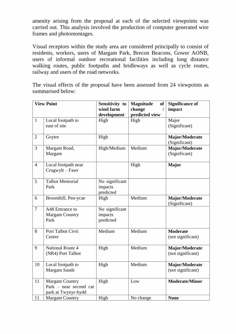
amenity arising from the proposal at each of the selected viewpoints was
carried out. This analysis involved the production of computer generated wire
frames and photomontages.
Visual receptors within the study area are considered principally to consist of
residents, workers, users of Margam Park, Brecon Beacons, Gower AONB,
users of informal outdoor recreational facilities including long distance
walking routes, public footpaths and bridleways as well as cycle routes,
railway and users of the road networks.
The visual effects of the proposal have been assessed from 24 viewpoints as
summarised below:
View Point Sensitivity to
wind farm
development
Magnitude of
change /
predicted view
Significance of
impact
1 Local footpath to
east of site
High High Major
(Significant)
2 Goytre
High Major/Moderate
(Significant)
3 Margam Road,
Margam
High/Medium Medium Major/Moderate
(Significant)
4 Local footpath near
Crugwylt – Fawr
High Major
5 Talbot Memorial
Park
No significant
impacts
predicted
6 Broomhill, Pen-ycae
High Medium Major/Moderate
(Significant)
7 A48 Entrance to
Margam Country
Park
No significant
impacts
predicted
8 Port Talbot Civic
Centre
Medium Medium Moderate
(not significant)
9 National Route 4
(NR4) Port Talbot
High Medium Major/Moderate
(not significant)
10 Local footpath to
Margam Sands
High Medium Major/Moderate
(not significant)
11 Margam Country
Park – near second car
park at Twynyr-hydd
High Low Moderate/Minor
11 Margam Country High No change None
A Park – approach to
Margam Castle
12 Aberavon Sands,
Port Talbot
High Medium Major/Moderate
(Significant)
14 M4 (overbridge)
northbound at
North Cornelly
between Junction 37 &
38
Low Low Minor/Moderate
15 Kenfig National
Nature Reserve –
visitor centre & car park
High Low Moderate/Minor
16 Porthcawl
High Low Moderate/Minor
17 Mumbles Head –
Gower AONB
High Low Moderate/Minor
18 M4 (overbridge)
southbound
between junction
45 & 46
No significant
impacts
predicted
19 Swansea Beach
Figure 7.38
High Low Moderate/Minor
20 Beacons way – an
Brycheinoig
No significant
impacts
predicted
21 St. Illtyd’s Walk
(Margam Country
Park
No views of
the proposed
development
22 Oxwich point,
Oxwich, Gower
No significant
impacts
predicted
23 Harbour Way,
Margam
Low High Moderate/Minor
Landscape effect
The assessment concluded that none of the designated areas would be
significantly affected with only Margam Mountain Historic Landscape
identified as Major/Moderate.
Visual effect
Fifteen settlements are identified within 10km of the nearest turbine.
Significant effects were identified in 2 settlements; Margam and Goytre.
Mynydd Margam forms an important feature in many views from Margam,
especially along the A48. The Zone of Theoretical Visibility (ZTV) indicates
that there are up to 4 turbines at blade tip height which are potentially visible
in the western part between the hospital and the railway line and in the
southern area delineated by playing fields, the railway line and the golf course.
The ES concludes that the overall magnitude of change is judged to be high
due to the close proximity to the site and scale of the turbines.
The ZTV indicates that the majority of the settlement of Goytre is covered by
theoretical visibility of two turbines (T1 and T3) at blade tip height and
Turbine 1 at hub height. Turbines would appear on top of the plateau and
visible at an acute angle, although they would occupy the majority of the view.
The magnitude of the change is considered to be medium.
Route corridor assessment indicates that, due to landform variation and
features, the fragmented pattern of visibility and the shielding effects of
vegetation and buildings, the effects on route corridors will not be significant,
with the exception of A48, Coed Morgannwyg Way and Ogwr Ridgeway
Walk.
Of the 24 viewpoints assessed the ES considered that there would be
significant effects upon 6 viewpoints as identified earlier in this report.
Viewpoint locations in the Gower Peninsula AONB and the Brecon Beacons
National Park would not experience significant effects.
The ES concludes that the scheme responds positively as far as possible and
practicably to the Authority’s Supplementary Guidance in that the turbines and
ancillary developments are positioned away from the break of the plateau; the
closest residential development is over 500 metres away; the turbines respect
the scale of the landscape and do not dwarf hills and slopes and the height of
the turbines is appropriate given the vast and exposed upland and coastal
landscape.
Cumulative effect
The updated assessment of cumulative effects in the SEI indicates that the
proposed wind farm would result in a limited number of cumulative effects
given the high concentration of wind farms located within the 35 km study
area. The SEI states that this is primarily due to the separation distances
between the application site and the operational wind farms of Ffynon Oer
located 10.4 km to the north; Pant y Wal (16.2 km), Fforch Nest (16.6km) and
Taff Ely (18.7km) to the east and the consented wind farms of Pen y cymoedd
9 km to the north and Llynfi Afan 9.78km to the north east extends the visual
influence towards the proposed development.
Whilst the ZTV mapping indicates widespread intervisibility between wind
farms, the screening effects provided by commercial forestry within the upland
areas foreshortens these connections. The ES acknowledges that the proposal
on the elevated Mynydd Brombil plateau would extend the visual envelope of
wind farms to the south of the Strategic Search Area F towards the Mynydd
Brombil carp near the coastline.
Cumulative effects on the Mynydd Margam Historic Landscape Area (HLA)
are not considered to be significant due to the visual enclosure provided by
commercial forestry at Margam Woods and the existing visual influence of
operational windfarms at Ffynon Oer and Pen-y-Cymoedd and the large scale
industrial areas within Port Talbot.
Significant cumulative effects have been identified on LANDMAP Visual and
Sensory aspect areas within 10km including NPTVS187 Mynydd Dinas,
NPTVS703 Mynydd y Gaer/Cefn Morffud, NPTVS139 Mynydd Emroch and
Mynydd Bycham and NPTVS 927 Mynydd Margam. This is by virtue of the
elevated upland locations with greater visibility over the study area towards
Mynydd Brombil. However, the majority of the lowland LANDMAP Visual
and Sensory aspect areas would not experience significant cumulative effects
due to the visual enclosure provided by the incised valleys and forestry.
Significant cumulative effects have been identified on transport routes
including the B4283 Road at closed proximity to Newlands Farm, Stormy
Down, Newton Down and Kenfig Industrial Estate with the proposed
development. Other transport routes including the railway network are not
considered by the ES to experience significant cumulative effects due to visual
containment provided by the steeply rising Mynydd Brombil scarp and built
development within the steelworks.
Significant cumulative effects have been identified on elevated upland
viewpoints including the public footpath to the east of the application site (VP
1) and the Cairn at Foel Fynyaddau (VP13). The cumulative effects are
associated with the proposed development in addition to Ffynon Oer, Pen y
cymoedd and Llynfi Afan.
The SEI concludes that the proposed development will be located on an
elevated plateau on Mynydd Brombil directly to the south west of the
boundary of Strategic Search Area F. Although the proposal will inevitably
extend the visual envelope of wind farms to the south of the wind farm clusters
at Ffynnon Oer, Pen y cymoedd, Llynfi Afan, Hirfynydd and Mynydd
Marchywel also located on similar elevated plateau within upland areas. The
proposed development is visually separated from these wind farms by distance
and extensive commercial forestry at Margam Woods reducing the potential
cumulative effects. The location of the site on the elevated landform is
considered to form part of a co-ordinated framework of wind farms within the
study area whilst being visually contained by extensive commercial forestry at
Mynydd Margam.
Cultural Heritage and Archaeology:
The ES notes that there are 0 cultural heritage sites within the application site.
A single Scheduled Ancient Monument Ergyd Isaf Round Barrow is situated
70 metres to the east of Turbine 2, no further SAMs lie within the study area.
No Grade I Listed Buildings or Grade I or II* Registered parks or Gardens are
situated within the site or within the study area. Two Grade II* listed
buildings, a War Memorial (LB36) and Beulah Calvanistic Methodist Chapel
(LB48) lie within the study area. Seven Grade I or Grade II* Listed Buildings
and 11 SAMs are situated within the 5 km buffer zone outside the Historic
Landscape Character Areas (HLCAs) which define the Mynydd Margam and
Merthyr Mawr, Kenfig and Margam Burrows Landscapes of Special Historic
Interest. Thirty two SAMs, Twenty five grade I and II* Listed buildings, one
Grade I and one Grade II* Registered Parks lie within the Myndd Margam and
Merthyr Mawr, Kenfig and Margam Burrows landscapes of Special Historic
Interest.
A total of 12 Grade II Listed buildings, one Grade II Registered Park (Talbot
Memorial Park) lie within the study area, a further 36 Grade II Listed
buildings are situated within the wider 5km buffer zone.
The cumulative effects of the proposed development have been assessed, the
change to the setting on one Scheduled Ancient Monument, comprising a pair
of Bronze Age round barrows, was considered to be Moderate adverse. No
other designated assets were considered to be subject to a level of harm greater
than Slight Adverse. The Update to the cumulative assessment considers
whether the impacts from any of the now 49 developments, of these 41 lay
more than 10 km away from the proposed wind farm at Mynydd Brombil will
yield a level of harm greater than the identified effects. Two turbines are
proposed to the south at Kenfig Industrial Park and Newlands Farm within
5km of Mynydd Margam Registered Landscape. A further three turbines at
Cefn Parc, Baiden Farm and Gelli Las Farm are proposed to the south-east
some 8-10km from the Registered Landscape. An additional assessment has
been undertaken to consider the potential impact upon Merthyr Mawr, Kenfig
and Margam Burrows Registered Landscape. The assessment concluded that
the impact upon the landscape would be slight adverse.
There are 57 Listed Buildings within the 5km Mynydd Brombil study area,
which lie outside the Registered Landscapes. The majority of these Listed
Buildings are located adjacent to the main routes of communication and
settlements at Margam, Port Talbot and Cwmafan. The SEI concludes that the
significance of these effects for 25 of these Listed Buildings is neutral (no
effect) and the proposed development will not result in a cumulative effect
with any other development. One group of buildings at Ty’n y Cellar is located
close to Newlands farm and Kenfig Industrial Estate, the SEI concludes that
there will be no adverse effect resulting from these schemes.
A total of 7 SAMs outside the Registered landscapes were considered as part
of the Mynydd Brombil Environmental Statement. The effects were considered
to be Slight Adverse or Neutral upon all of these assets. As no cumulative
turbines are proposed within 7km of these, the SEI concludes that that there
would be no cumulative effect upon the monuments or additional harm caused
to designated heritage assets.
Noise Assessment:
An assessment of the operational noise impact of the development has been
carried out. Baseline noise levels were measured at 5 locations representative
of the nearest residential locations. These are:
- 16 Glan-y-mor Avenue
- 18 Pellau Road
- Tyla Farm
- Llety Piod
- Goytre Farm
- a non-residential forest location to the east of the turbines and 100m from the
forest tracks.
The assessment has been carried out by comparing the predicted noise levels
with noise limits described in ETSU –R-97. The night time operational
assessment shows that the predicted typical downwind turbine noise levels, at
the nearest residential locations at the site, are below the night time noise
limits under all wind speed conditions. The day time assessment reveals that
typical downwind turbine noise levels, at the nearest residential locations to
the site, are below the day time noise limits under all wind speed conditions.
The ES concludes that the wind farm can meet the noise limits therefore no
further mitigation in respect of the operation of the wind farm is considered
necessary.
Noise during the construction period will arise from the construction of the
turbines, the erection of the turbines, the excavation of trenches for cables, the
construction of associated hardstandings, new access tracks, construction
compound and noise from vehicles on local roads and access tracks due to the
delivery of the turbine components and construction materials. Noise will also
arise during decommissioning from the removal of the turbines and breaking
of the exposed part of the concrete bases.
The ES concludes that there may be a temporary increase above the 65 dB(A)
criteria noise level due to track work, it is anticipated that this will be
controlled by restricting working hours.
Air Quality:
The ES identifies that the site is situated approximately 750m to the east of the
Air Quality Management Area (AQMA). The main pollutants (dust and
PM10s) primarily relate to the construction activities.
The ES concludes that the construction works have the potential to create dust,
however, the impacts are not expected to affect any residential properties, nor
affect the AQMA and as such are considered to be negligible. It acknowledges
that there would be short term increases in traffic levels during the
construction period, although the route would be outside the AQMA. The
increases in traffic along the route are considered to be negligible. Similarly,
no significant operational impacts are predicted.
Transport and Access:
The ES states that the delivery of the turbine components will involve a
number of abnormal indivisible loads (AILs) which will arrive by sea and will
be transported from the port via the M4. The preferred route for the turbine
components is from J41 of the M4 via the B4286 Cwmavon Road, London
Row and Ynysgwas Hill in Cwmafan the A4107 and the B4282 via Bryn and
towards Maesteg. All other materials, plant and labour associated with the
development may arrive/depart either eastwards or westwards along the B4282
and might therefore travel via the A4063 from J36 on the M4 and Maesteg.
The delivery of the turbines is expected to give rise to 35 abnormal load
deliveries plus 5 standard deliveries. The vehicles are reduced in size for the
return journey. Delivery of the turbine components will avoid peak times. A
maximum of 6 HGV movements per day are expected to occur at the start of
the construction period when plant and materials are delivered. This will last
for no more than 3 weeks and for some of this time there would be only one
delivery per day. The period of maximum HGV activity will occur during the
construction of the foundations and will amount to 46 HGV movements two-
way per day for a period of up to 10 days.
The ES concludes that there is likely to be a moderate adverse effect on driver
delay, pedestrian amenity and communities including Ynysygwas and Bryn
whilst AILs and construction vehicles are passing. However, this effect would
be temporary and short term and no significant traffic and transport effects are
expected during both the operational and decommissioning phases.
The Transport Statement which forms part of the Supplementary
Environmental Information confirms that the route assessed in the ES is
appropriate and the overall conclusions of the ES are unchanged.
Geology, Hydrology and Hydrogeology:
The ES describes the baseline conditions and assesses the development in
relation to water and geological environment, encompassing surface water,
groundwater quality, flooding issues, water supply and mining.
All the likely significant environmental impacts from the land and soils
conditions at the site have been considered for the construction, operational
and decommissioning phases of the development. A number of impacts
identified will be avoided by standard design measures and no other mitigation
measures will be required over and above these.
The SEI states that it may be that local treatment of workings and other coal
related features may be required and such works will need to be agreed with
The Coal Authority. Alternatively after risk assessment measures such as soil
or road reinforcement may be sufficient mitigation.
Aviation:
The ES assesses the likely significant effects of the proposed development on
civil and military aviation. No impacts on aviation requiring mitigation have
been identified.
Telecommunications:
The ES considers the effects on telecommunications and television reception.
No impacts on telecommunications requiring mitigation have been found.
Effects on television reception are not predicted to be significant. However, to
ensure that TV reception quality is not degraded by the proposal, the developer
has indicated that this can be addressed by a planning condition attached to
any consent requiring that any effects on TV reception attributable to the
development are identified and any mitigation measures put in place to restore
reception quality.
Shadow flicker:
A shadow flicker assessment has been undertaken for five residential
properties which include 32 Morlais Road, 74 Pellau Road, Lletypiod, 42
Goytre Road and Goytre Farm all of which are located within 800 metres of
the proposed turbine locations. The assessment reveals that in the worst case
conditions, the maximum occurrence of shadow flicker amounts to 19.9 hours
per year experienced at Goytre Farm. A maximum of 13.9 and 11.6 hours per
year is predicted to occur respectively at Lletypiod and 42 Goytre Road. No
residual shadow flicker effect will occur during operation of the development
at 32 Morlais Road and 74 Pellau Road as there were no potential shadow
flicker effects experienced at these properties.
The ES concludes that if shadow flicker is found to cause a nuisance,
mitigation measures can be implemented.
Socio- Economics:
In terms of economic benefits, the ES does not quantify the number of people
to be employed on site at any one time during the construction period. During
operation of the wind farm the potential for direct employment is fairly low
with a minimum of 2 permanent jobs.
Tourism and Recreation:
The ES identifies that the recreational offer in the immediate vicinity is
relatively limited and the design of the windfarm mitigates against any
potential disruption to existing public footpaths and cycleways. Consequently
the proposal will therefore have an overall negligible effect.
Assessment:
Having regard to the aims and objectives of The adopted Unitary development
Plan and National Planning Policy guidance, it is considered that the main
issues in the determination of this application concern the landscape and visual
impact of the proposed turbines on the character and appearance of the area;
and the effect of the proposal on heritage assets and the cultural heritage of the
area. In addition, matters relating to ecology, mineral resources, residential
amenity, noise and traffic / highway safety implications. And finally, whether
any harm identified in relation to all or any of these matters is outweighed by
the benefits of the scheme in terms of its contribution to renewable energy
production.
Policy Context:
UK Energy Policy
The National Renewable Energy Action Plan (2010) and UK Renewable
Energy Road Map (July 2011) both recognise the central role of the planning
system in delivering the infrastructure required to reduce carbon emission, yet
also equally recognise the vital role of the planning system in “safeguarding
our landscape and natural heritage and allowing communities and individuals
the opportunity to shape where they live and work.”
Section 4.5 of the UK National Infrastructure Plan EN-3 (July 2011)
recognises the need for large scale renewable energy projects to deliver the
ambitious 15% renewable energy targets but caveats this with the need for
infrastructure projects to be “sensitive to place” and, whilst accepting that
there are limitations in the appearance of some infrastructure, applicants ought
to demonstrate “good design in terms of siting relative to existing landscape
character, landform and vegetation”.
Planning Policy Wales (Edition 7, July 2014)
Planning Policy Wales (PPW7) sets out the land use planning policies of the
Welsh Government (WG), and is supplemented by a series of Technical
Advice Notes (TANs). PPW7 emphasises (para 1.2.1) that “the planning
system manages the development and use of land in the public interest
contributing to the achievement of sustainable development. It should
reconcile the needs of development and conservation, securing economy,
efficiency and amenity in the use of land, and protecting natural resources and
the historic environment”.
PPW7 also advises (1.4.4) that the planning system will play an important role
in tackling climate change and reducing greenhouse gas emissions, with
Chapter 4 dealing with the need to tackle Climate Change, which is identified
as one of a number of principles underpinning WG’s approach to its planning
policy for sustainable development.
Chapter 5 sets out WGs position in seeking to conserve and improve natural
heritage and the coast, including the need to avoid, wherever possible, adverse
effects on the environment (5.5.2), with Chapter 6 - Conserving the historic
environment - including advice at para 6.1.1 that “It is important that the
historic environment – encompassing archaeology and ancient monuments,
listed buildings, conservation areas and historic parks, gardens and
landscapes – is protected”.
WGs position in respect of Infrastructure and Services is set out in Chapter 12,
with section 12.8 dealing specifically with Renewable & Low Carbon Energy.
This Section is the most relevant in the consideration of this application, with
para 12.8.1 noting that the UK is subject to the requirements of the EU
Renewable Energy Directive, which include a UK target of 15% of energy
from renewables by 2020. The UK Renewable Energy Roadmap sets the path
for the delivery of these targets, promoting renewable energy to reduce global
warming and to secure future energy supplies. The WG is committed to
playing its part by delivering an energy programme which contributes to
reducing carbon emissions as part of our approach to tackling climate change
whilst enhancing the economic, social and environmental wellbeing of the
people and communities of Wales in order to achieve a better quality of life for
our own and future generations. This is outlined in the WG’s Energy Policy
Statement Energy Wales: A Low Carbon Transition (2012).
Para. 12.8.2 then emphasises that “Planning policy at all levels should
facilitate delivery of both the ambition set out in Energy Wales: A Low
Carbon Transition and UK and European targets on renewable energy”
(12.8.2), and that the “Welsh Government’s aim is to secure an appropriate
mix of energy provision for Wales which maximises benefits to our economy
and communities, whilst minimising potential environmental and social
impacts” (12.8.6).
Para. 12.8.9 states that “Local planning authorities should facilitate the
development of all forms of renewable and low carbon energy to move
towards a low carbon economy to help to tackle the causes of climate change.
Specifically they should make positive provision by…..considering the
contribution that their area can make towards developing and facilitating
renewable and low carbon energy, and ensuring the development plan policies
enable this contribution to be delivered……ensuring that development
management decisions are consistent with national and international climate
change obligations, including contributions to renewable energy targets and
aspirations”.
Para 12.8.12: “In the short to medium term, wind energy continues to offer the
greatest potential (for activities within the control of the planning system in
Wales) for delivering renewable energy. Wales has an abundant wind resource
and power generation using this resource remains the most commercially
viable form of renewable energy. The Welsh Government accepts that the
introduction of new, often very large structures for onshore wind needs careful
consideration to avoid and where possible minimise their impact. However, the
need for wind energy is a key part of meeting the Welsh Government’s vision
for future renewable electricity production as set out in the Energy Policy
Statement (2010) and should be taken into account by decision makers when
determining such applications”.
Section 12.10 Sets out WGs position in respect of Development Management
and Renewable and Low Carbon Energy, with paragraph 12.10.1 stating that
“In determining applications for renewable and low carbon energy
development and associated infrastructure local planning authorities should
take account:
the contribution a proposal will play in meeting identified national, Uk
and European targets and potential for renewable energy, including the
contribution to cutting greenhouse gas emissions;
the wider environmental, social and economic benefits and opportunities
from renewable and low carbon energy development;
the impact on the natural heritage, the coast and the historic
environment;
the need to minimise impacts on local communities to safeguard quality
of life for existing and future generations;
ways to avoid, mitigate or compensate identified adverse impacts;
the impacts of climate change on the location, design, build and
operation of renewable and low carbon energy development. In doing so
consider whether measures to adapt to climate change impacts give rise
to additional impacts;
grid connection issues where renewable (electricity) energy
developments are proposed; and
the capacity of and effects on the transportation network relating to the
construction and operation of the proposal”
12.10.3: Developers for renewable and low carbon energy developments
should seek to avoid or where possible minimise adverse impacts through
careful consideration of location, scale, design and other measures.
Technical Advice Note 8: Planning for Renewable Energy – July 2005.
PPW7 advises that “The most appropriate scale at which to identify areas for
large scale onshore wind energy development is at an all-Wales level. TAN8
(2005) identifies areas in Wales which, on the basis of substantial empirical
research, are considered to be the most appropriate locations for large scale
wind farm development; these areas are referred to as Strategic Search Areas
(SSAs)“ (12.8.13).
TAN 8 covers the land use planning considerations of all aspects of renewable
energy (not just wind). The TAN is written in 2 parts comprising the main
report and a series of 6 annexes.
The principal advice contained within the main body of the report can be
summarised as follows:
The provision of energy from renewable sources is an important
component of the UK Government energy policy. The target is to
produce 10% of electricity from renewable energy sources by 2010.
The Welsh Government has a target of 4TWh of electricity per year to
be produced by renewable energy by 2010 and 7TWh by 2020.
on-shore wind offers the greatest potential to meet these targets in the
short to medium term. To meet this requirement the WG have concluded
that large scale (over 25MW) on shore wind farms should be
concentrated into ‘Strategic Search Areas’ (SSA’s).
The TAN acknowledges that not all land within a SSA is going to be
suitable but WG is satisfied that sufficient land has been allocated
within these areas to meet their targets.
The TAN advises that Councils should refine the SSA to guide
developers to the most appropriate locations within the SSA but does
not preclude land outside of, but close to, the SSA from being
considered.
There are 7 SSA’s designated within Wales (with the current site falling within
SSA ‘F’ (Coed Morgannwg)), which have been chosen to meet the following
characteristics:
large areas with a good wind resource,
upland areas which contain a predominantly flat plateau,
generally sparsely populated,
dominated by conifer plantation or impoverished moor land, has little
nature conservation or historic landscape features,
can accommodate over 25MW and achieve 70MW of installed capacity,
and,
largely unaffected by broadcast transmission or military applications.
The TAN does not rule out on-shore wind projects in other areas outside of the
SSA’s and advises that some previously developed (brownfield) sites may be
suitable for up to 25MW which should be encouraged.
With regard to the ‘refinement exercise’ for the SSAs, Annex D states that the
purposes of undertaking a refinement exercise is to achieve a finer grain of
development allocation within it taking into account landscape, visual and
cumulative impacts. It is anticipated that refinements/adjustments can be made
to the SSA boundaries when they are translated into local planning documents.
This will facilitate the inclusion of development on the margins of the SSA’s
where local conditions recommend.
TAN 8 has considered cumulative landscape and visual interests at an all-
Wales level. The strategy adopted is a means of concentrating the impact of
wind turbines in a relatively small proportion of the country in areas that are,
on balance technically, practically and environmentally better able to
accommodate such impacts than other parts of Wales.
Other National Guidance
In addition to TAN8 it is considered that the following TANs are of relevance
in the determination of this proposal.
Technical Advice Note 5: Nature Conservation and Planning (2009) provides supplementary advice to the policies set out in PPW in respect of
nature conservation issues. It sets out the criteria against which a development
will be judged having regard to the relative significance of international,
national and local nature conservation designations. Paragraph 6.2.1 advises
that the presence of protected species is a material consideration when a local
planning authority is considering a development proposal that, if carried out,
would be likely to result in disturbance or harm to the species or its habitats.
Technical Advice Note 6: Planning for Sustainable Rural Communities
(July 2010) provides practical guidance on the role of the planning system in
supporting delivery of sustainable rural communities in particular to local
authorities in rural economies and agriculture. Paragraph 2.1.1 acknowledges
that the planning system must respond to the challenges posed by climate
change, for example by accommodating the need for renewable energy
generation.
Paragraph 2.2.1 states that ‘new development can help to generate wealth to
support local services ensuring that communities are sustainable in the long
term’. A key question for local authorities when determining applications is
whether the proposed development enhances or decreases the sustainability of
communities.
Paragraph 3.1.2 confirms that planning authorities should support
diversification of the rural economy as a way to provide local employment
opportunities. Paragraph 3.7.2 recognises that many economic activities can be
sustainably located on farms.
Technical Advice Note 11: Noise (1997) identifies the need to ensure that
noise generating developments (such as wind farms) do not cause unacceptable
levels of disturbance. In relation to wind farms, TAN 11 refers to the more
detailed guidance set out in TAN 8 and the need to comply with ETSU
guidance on noise.
Technical Advice Note 12: Design (2009) calls for a holistic approach to
design in order to contribute to the objectives of sustainable development. In
doing so, good design should balance the protection of the environment with
prudent use of resources and economic growth. It calls for an interactive
approach involving a proactive planning system with consideration given to
such issues as landscape setting, layout, density, scale and appearance.
Technical Advice Note 15: Development and Flood Risk (2004) sets out the
responsibilities and requirements of the various parties in the development
process and seeks to ensure that flood risk, surface water and foul water
drainage arrangements are properly considered during the planning process.
Technical Advice Note: Transport (March 2007)
Technical Advice Note 19: Telecommunications (2002) explains that there
can be two types of radio interference from the proposed development;
electrical interference and physical interference that:
‘Large prominent structures such as tower blocks, cranes, warehouses or wind
farms, can cause widespread disruption to television and other
telecommunications services due to the physical obstruction or reflection of
the wanted signals. Digital television signals are far more robust than analogue
and, as viewers change to digital over time; offer the prospect of the
elimination of such problems as interference caused by reflections from
structures. Local planning authorities will need to satisfy themselves that the
potential for interference has been fully taken into account in the siting and
design of such developments, since it will be more difficult, costly and
sometimes impossible to correct after the event.’
Technical Advice Note 23: Economic Development (2014): provides
guidance on planning economic development at a strategic level; working with
neighbouring authorities and relevant stakeholders; identifying and assessing
economic benefits of development proposals and establishing an evidence base
to help prepare economic development policies for LDPs.
Other relevant Policy guidance includes:
Energy Wales: A Low Carbon Transition (March 2012)
One Wales:One Planet (The Sustainable Development Scheme of the
Welsh Government) (May 2009)
A Low Carbon Revolution Wales’ Energy Policy Statement (WAG)
(March 2010)
Climate Change Strategy for Wales (WG) (October 2010)
Practice Guidance – Planning Implications of Renewable and Low
Carbon Energy Development (WG) (2010)
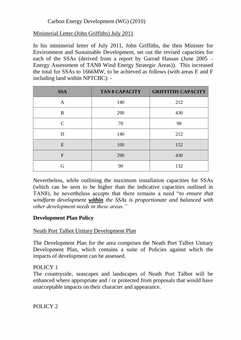
Ministerial Letter (John Griffiths) July 2011
In his ministerial letter of July 2011, John Griffiths, the then Minister for
Environment and Sustainable Development, set out the revised capacities for
each of the SSAs (derived from a report by Garrad Hassan (June 2005 –
Energy Assessment of TAN8 Wind Energy Strategic Areas)). This increased
the total for SSAs to 1666MW, to be achieved as follows (with areas E and F
including land within NPTCBC): -
SSA TAN 8 CAPACITY GRIFFITHS CAPACITY
A 140 212
B 290 430
C 70 98
D 140 212
E 100 152
F 290 430
G 90 132
Nevertheless, while outlining the maximum installation capacities for SSAs
(which can be seen to be higher than the indicative capacities outlined in
TAN8), he nevertheless accepts that there remains a need “to ensure that
windfarm development within the SSAs is proportionate and balanced with
other development needs in these areas.”
Development Plan Policy
Neath Port Talbot Unitary Development Plan
The Development Plan for the area comprises the Neath Port Talbot Unitary
Development Plan, which contains a suite of Policies against which the
impacts of development can be assessed.
POLICY 1
The countryside, seascapes and landscapes of Neath Port Talbot will be
enhanced where appropriate and / or protected from proposals that would have
unacceptable impacts on their character and appearance.
POLICY 2
Wildlife and habitats, including those within urban areas, will be enhanced
where appropriate and protected from proposals that would cause unacceptable
impacts. Particular emphasis will be placed on species and habitat areas that
are designated as being of international or national importance.
POLICY 3
The area’s minerals and other natural resources, both finite and renewable will
be conserved and safeguarded, and when exploited the most prudent use of
them will be sought.
POLICY 4
The creation of pollution or risks to health and amenities that would have
unacceptable impacts upon the environment, communities or individuals will
be resisted.
POLICY 6
The County Borough's historic environment including archaeology, ancient
monuments, listed buildings, conservation areas and historic parks, gardens
and landscapes will be protected and proposals that would aid its preservation
and enhancement will be supported.
POLICY 11
Social needs and aspirations of communities and groups within communities
will be taken fully into account when planning applications are considered.
POLICY 14
Proposals will be resisted which would be likely to cause unacceptable adverse
impact in terms of: -
a) traffic generation and highway safety;
b) poor accessibility by public transport, cycling and walking including
people with disabilities and
c) preventing the use or re-use of docks, harbours, wharfs or routes of railway
lines.
POLICY 18
The plan will encourage the best and most efficient use of infrastructure and
resources, but proposals which would place unacceptable demands on existing
and programmed resources and facilities will be resisted.
POLICY 19
Opportunities to create energy from renewable resources will be encouraged
provided that unacceptable impacts are not created.
POLICY 21
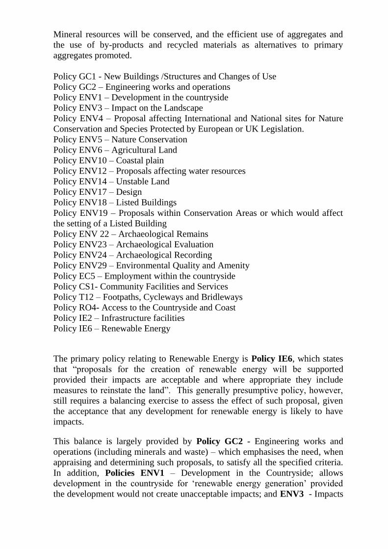
Mineral resources will be conserved, and the efficient use of aggregates and
the use of by-products and recycled materials as alternatives to primary
aggregates promoted.
Policy GC1 - New Buildings /Structures and Changes of Use
Policy GC2 – Engineering works and operations
Policy ENV1 – Development in the countryside
Policy ENV3 – Impact on the Landscape
Policy ENV4 – Proposal affecting International and National sites for Nature
Conservation and Species Protected by European or UK Legislation.
Policy ENV5 – Nature Conservation
Policy ENV6 – Agricultural Land
Policy ENV10 – Coastal plain
Policy ENV12 – Proposals affecting water resources
Policy ENV14 – Unstable Land
Policy ENV17 – Design
Policy ENV18 – Listed Buildings
Policy ENV19 – Proposals within Conservation Areas or which would affect
the setting of a Listed Building
Policy ENV 22 – Archaeological Remains
Policy ENV23 – Archaeological Evaluation
Policy ENV24 – Archaeological Recording
Policy ENV29 – Environmental Quality and Amenity
Policy EC5 – Employment within the countryside
Policy CS1- Community Facilities and Services
Policy T12 – Footpaths, Cycleways and Bridleways
Policy RO4- Access to the Countryside and Coast
Policy IE2 – Infrastructure facilities
Policy IE6 – Renewable Energy
The primary policy relating to Renewable Energy is Policy IE6, which states
that “proposals for the creation of renewable energy will be supported
provided their impacts are acceptable and where appropriate they include
measures to reinstate the land”. This generally presumptive policy, however,
still requires a balancing exercise to assess the effect of such proposal, given
the acceptance that any development for renewable energy is likely to have
impacts.
This balance is largely provided by Policy GC2 - Engineering works and
operations (including minerals and waste) – which emphasises the need, when
appraising and determining such proposals, to satisfy all the specified criteria.
In addition, Policies ENV1 – Development in the Countryside; allows
development in the countryside for ‘renewable energy generation’ provided
the development would not create unacceptable impacts; and ENV3 - Impacts
on the Landscape, seeks to protect against proposals that would create
unacceptable impacts on the landscape, with particular emphasis placed on
protecting (inter alia) …significant skylines, views and panoramas; and
features which are important in terms of contributing to the character of the
local landscape.
Relevant Supplementary Planning Guidance include ‘Landscape’ and
‘Biodiversity’, with Interim Planning Guidance (approved as SPG) : Wind
Turbine Development (2008) being of primary relevance and addressed below.
Supplementary Planning Guidance: Interim Planning Guidance – Wind
Turbine Development (IPG)
Whilst it is recognised that TAN 8 identifies the most appropriate location for
large scale wind farm development to be within the defined Strategic Search
Areas, TAN 8 confirms that the identification of SSAs is a consequence of a
“broad brush” approach and the location of a development within a SSA does
not convey its acceptability.
Following the publication of TAN 8, NPTCBC (as part of a five Authority
consortium) commissioned consultants (ARUP) to undertake a refinement
process to refine Strategic Search Areas, having regard to the need to identify
the best locations within the SSAs when taking into account landscape,
environmental and technical issues (TAN 8 Annex D Study of Strategic Search
Areas E and F: South Wales [Final Report] ARUP (December 2006)).
The study was primarily a landscape and visual assessment exercise which
also used a range of other technical and environmental data to inform the
work. The study identified 'preferred areas' for large scale wind farms broadly
within the boundaries of the SSAs in TAN 8.
This work resulted in the approval of Supplementary Planning Guidance in the
form of the ‘Interim Planning Guidance – Wind Turbine Development’ (July
2008), which incorporates the refined SSA boundaries to be taken forward by
the Authority (Appendix A of the IPG).
The identified refined areas (according to the IPG) “would deliver WAG’s
target and are considered by the Authority to represent the maximum that
could be reasonably accommodated without causing unacceptable impacts on
communities, visitors and the landscape”.
As part of recent appeals, it has been accepted that the weight to be attached to
the IPG – insofar as it relates to the extent of the refined SSAs – has
diminished as a result of the publication of the July 2011 Ministers letter (see
above) which seeks greater capacities within SSAs than were relevant at the
time of preparation of the IPG. The IPG is, nevertheless, approved guidance
and is therefore a material consideration, with the main thrust of the advice
remaining of direct relevance, insofar as it relates to the assessment of impacts
of such development on the landscape and wider locality. Moreover, in the
case of SSA F (and notwithstanding the Inspector’s comments in the Mynnyd
Y Geli / Llynfi Afan appeal), it is notable that the delivery of the July 2011
Griffiths maximum capacities is largely being achieved (see ‘need’ section
later in report), with the majority within the SSA refined boundaries, such that
the weight to be attributed to the refined boundaries of SSA F is considered to
be greater than, for example, SSA E where it is accepted that the much refined
SSA focussed around the Maesgwyn Wind Farm at the top of the Neath Valley
(in addition to the refined SSA within Carmarthenshire/Swansea) would be
highly unlikely to meet the 152MW maximum identified capacity for SSA E.
Notwithstanding the above, it is also considered that the ARUP Study remains
robust in its assessment of the SSA and as a refinement exercise and, in this
respect it is noted that in his decision on the Fforch Nest Appeal (ref.
APP/11/2147835), the Inspector referred to the ARUP report as “useful advice
relating to refinement of the “broad brush” scale of the boundaries of SSA’s as
shown in TAN8 maps”. The IPG therefore remains a material consideration,
not least insofar as it has informed the emerging LDP as discussed below.
Emerging Local Development Plan Policy
The Council is presently in the process of preparing its Local Development
Plan, which is at an advanced stage with LDP having been submitted to the
Welsh Government for Examination in October 2014, with the Hearings
programmed to commence on 11th March 2015. Consequently, there is
limited weight that can be attached to the policies contained within the LDP.
However, emerging Policies SP1 (Climate Change) and SP18 (Renewable and
Low Carbon Energy) are generally supportive of renewable energy, while the
background evidence for the emerging LDP includes not only the ARUP
Annex D Study referred to above, but also a ‘Renewable & Low Carbon
Energy Topic Paper’ which has informed both the policy development and
boundaries of the refined SSA within the emerging LDP, and has had due
regard to the increased maximum capacities identified by the Minister.
It is also notable that, while the emerging LDP seeks to amend the refined
boundary of SSA E to increase its size from that in the IPG, the LDP does not
propose to change the refined boundary for SSA F, which remains in the size
and location as recommended and evidenced by the ARUP Annex D study.
In the face of WG scrutiny of LDP’s to ensure the SSA installed capacity
targets are capable of being met and that there is consistency across
administrative boundaries, it is of note that to date a significant proportion of
the ‘refined’ SSA (in the LDP) has been developed and overall SSA F is
extremely well advanced in delivering the maximum capacity as set out by the
WG. Ultimately, however, the soundness of the Plan remains to be subject of
Examination.
It is noted that the application (appeal) site is not located within either the
TAN 8 SSA boundary or the refined SSA identified on the proposals map of
the emerging LDP, although it is located in the 5km buffer zone.
Landscape and Visual Effects:
Within and immediately adjacent to SSAs the implicit objective is to accept
landscape change i.e. a significant change in landscape character from wind
turbine development. Nonetheless, TAN 8 (paragraph 2.4) also recognises that
not all of the land within these areas may be technically, economically and/or
environmentally suitable for major wind power proposals. As stated in
‘Designing Wind Farms in Wales’, good landscape design principles need to
be followed to ensure that the development is appropriate for the scale and
character of the landscape, and there may be a limit on the number or extent of
wind farms which can reasonably be accommodated.
Wind farms have to be located on high ground to maximise wind conditions,
design efficiency dictates that they have to be of such stature. It is impossible
therefore to completely screen such developments as they will always be
visible from surrounding areas at varying distances. In respect of Mynydd
Brombil this is located within the Mynydd Margam Registered Landscape of
Special Historic Interest at the gateway to Port Talbot. The wind farm will be
visible from a number of surrounding settlements and the coastal plain.
Government policy accepts that there will be significant change in the
landscape adjoining SSAs, however planning policies also dictate that all
schemes will need to demonstrate that they would not cause any unacceptable
impacts on local residents, communities, visitors, landscape, ecology or users
of the highway.
Any judgement about the acceptability of the current proposal must be
influenced by an assessment of its impact upon the landscape character and the
area’s visual amenity. The key to assessment is to consider whether the impact
will unacceptably dominate a particular landscape and the degree to which
people would be affected by that impact. The Supplementary Planning
Guidance differentiates between the level of effects – prominent, dominant and
overwhelming. Prominent means something that can be seen and identified in
the landscape without the need for closer examination. The word ‘dominant’
may describe the situation where that object draws the observer’s eye to the
extent that little else is seen, even in an attractive landscape. ‘Overwhelming’
might describe a situation where the wind energy development is so close and
of such a size as to be likely to make the observer feel uncomfortable and want
to move away. The latter two impacts are likely to result in a proposal being
refused.
It is considered therefore that the fact that wind farms will be visible from
such areas is not a reason for refusal in itself, but careful assessment has to be
made relating to the degree of visual impact each site would have. A key factor
is considered to be whether turbines would dominate the landscape and the
degree to which people would be affected by that impact. In this respect, it is
considered that dominant can be defined as when the eye is drawn to the extent
that little else is seen even in an attractive landscape.
The visual impact of the development has overlapping influence in relation to
a number of factors. The development has the potential to affect people within
the vicinity of the proposal, whether living, working, travelling through or
undertaking leisure activities.
The wind farm is considered to be of a medium scale in terms of extent,
number of turbines and size of turbines and as such the main landscape and
visual effects are considered to be caused by the turbines with ancillary
infrastructure such as tracks, hardstandings and other structures being less
prominent.
White Consultants have been commissioned to assist in the assessment of the
landscape and visual impacts of the development and their comments are
incorporated below, along with the views of NRW which largely endorse the
consuktants views.
Landscape Impact
There are a number of landscape assessment studies which had been carried
out within the county Borough including this site. These include LANDMAP
2004, Landscape Assessment based on LANDMAP (2004) and TAN 8 SSA F
refinement study.
In respect of the LANDMAP visual and sensory aspect, the site lies within
Mynydd Brombil and scarp tops aspect area and adjacent to the Margam scarp
and Cwm Dyffryn aspect areas. The submitted LVIA correctly indicates that
there are significant adverse effects on these areas.
In respect of the LANDMAP historic landscape aspect, the site lies within the
Mynydd Brombil aspect area which is of outstanding value. This is not
assessed within the LVIA, although the effect is expected to be significant
adverse. The Landscape Character Assessment (2004) identifies the site as
falling within the Mynydd Brombil, Mynydd Dinas Character Area 6.
The key characteristics of this area are:
Steep slopes with rounded plateau tops.
Unenclosed slopes are dominant by bracken cover.
Plateau tops comprise of sheep grazed pasture, enclosed by bracken
down walls and post and wire fences.
Provides a solid backcloth and prominent landform adjacent to the
coastal plain.
Upland character contrasts with settlements and industry of the coastal
plain.
Wide views and a sense of exposure from higher elevations.
A wealth of multi period activity, evident from the sites present –Bronze
Age Cairns, Pillow mounds.
The area untrammelled by industrial exploitation.
White Consultants considers that… ‘the proposal would diminish the apparent
scale of the scarp slope with three of the turbines located close to the plateau
edge. It would introduce highly prominent large structures into the area
currently unaffected by such development, with pylons to the south east at a
significantly smaller scale. Consequently, the character of the site would no
longer contrast positively with the settlement and industry of the coastal plain.
The proposal would also detract from the setting and context of the historical
features within the area in a commanding location. Due to the change in
several key characteristics the effect is considered to be significant and
adverse.’
The TAN 8 refinement study identified the area as Zone F4 Ergyd Isaf
(Mynydd Margam West). Its conclusion was that the area had a high
sensitivity to strategic scale windfarms. Its summary stated:
‘The area has the sensitivity above because it is a prominent edge to upland
coalfield plateau behind scarp slope which falls to the coastal plain. The land
rises to 257mAOD, 240m above the plain and has a smooth rounded profile
but with some pillow mounds. The land cover is upland pasture.’
As such the area was excluded from the refined SSA area. Whilst strategic
scale development assumed turbines of around 125m, the site was of such
sensitivity that 100m turbines were not recommended in the area either.
White Consultants considers the scarp slope and plateau edge at Mynydd
Brombil to be dramatic and distinctive example of an edge landscape where
the coalfield plateau meets the flat coastal plain with the whole sweep of
Swansea Bay beyond. It is perceived as a positive backcloth with only minor
detractors and its importance is emphasised by its juxtaposition with Margam
Park and the plantations to the south east. However, the plateau top and site
itself is not visible from below, the turbines themselves would be highly
prominent and as such would cause demonstrable harm to Mynydd Brombil’s
distinctive qualities.
NRW agree with the statement under section 6.46 of the ES Planning
Statement that there would be ‘significant change to the landscape character
and visual amenity on site and within close vicinity during construction phase’
and note that this would be for 25 years, which is assessed as ‘temporary’ in
the ES. However the operational impacts on the landscape, which includes the
historic and visual and amenity aspects cannot be dismissed taking place as
they would for a minimum of 25 years contrary to Policy 1 of the UDP which
states:
‘The countryside, seascapes and landscapes of Neath Port Talbot will be
enhanced where appropriate and/or protected from proposals that would have
unacceptable impacts on their character and appearance’.
The key policy of relevance in the Unitary Development Plan is ENV 3
(Impacts on the Landscape). This states that unacceptable impacts on the
landscape will be resisted and that there will be particular concern to protect:
significant skylines, views and panoramas;
features which are important in terms of contributing to the character of
the local landscape; and
landscapes, parks and gardens which are of special historic interest.
The Supplementary Planning Guidance (SPG) entitled ‘Landscape’ adopted by
the Authority in 2008, sets out guidelines for the protection and enhancement
of the landscapes of Neath Port Talbot. This Landscape Character Assessment
(LCA) uses LANDMAP as its basis. The general landscape guidelines for the
scarp slopes below the proposed development (see LCA 6 specifically) state
that developments should be of a form and scale that reflects the character of
the surrounding area and should be considered in terms of impacts upon the
wider landscape.
NRW have confirmed that The Landscape and Visual Impact Assessment
(LVIA) is broadly consistent with current best practice and national guidelines
and the quality of the visualisations is good. The extent of the study area is
consistent with Scottish Natural Heritage guidelines of 35km for the proposed
height of the wind turbines. However, NRW have raised concerns that the
proposal would introduce an adverse and significant change to the landscape
character of the landscape within which the site is situated. The upland area,
like the open access land which lies on the scarp slopes below, forms a
valuable amenity with a good footpath network. Its current character is that of
a tranquil space with a sense of remoteness with panoramic views over
Swansea Bay and a bird’s eye view of the industrial sites below. Consequently,
the proposed development would have significant adverse landscape effect
upon the visual and sensory aspect area in which the turbines would be
situated by reason of their scale, layout and movement, creating entirely new
and incongruous landscape elements.
Historic Landscape Character
Notably, the site also lies within the Mynydd Margam Landscape of Special
Historic Interest. The LVIA addresses this briefly (table 9), indicating that
there is a major/moderate significance of impact. White Consultants state that
“Normally this would be expected to be significant but the LVIA indicates that
because of the limited direct effects on features which are not particularly
apparent in the landscape it is not significant. On the basis of the recent
decision at Bedlinog wind farm with its impact on the adjacent Gelligaer
landscape of special historic interest, this logic does not seem entirely
credible”.
They add that the turbines are located close to a number of these features but
the importance of the designation as a whole is the not only the number and
type of features but also their setting, context and relationship. It is likely that
features were located here in order to benefit from the commanding location
with panoramic views. The turbines would significantly adversely affect the
perception of this.
The Assessment of the Significance of Impacts of Development on Historic
Landscape’s (ASIDOHL2) overall analysis of the significance of impact of the
development on the historic landscape rates it as ‘moderate’ in five landscape
areas and ranges between ‘slight’ to ‘moderate’ for the remainder. However,
NRW advise that the proposed development would unacceptably harm the
historic character of this nationally important landscape area, and would be
contrary to the principles underpinning the identification of historic landscape
areas on the Register. In addition, they further advise that the location and size
of this proposal will lead to it having a more than local impact on this
registered landscape, contrary to the guidance endorsed by Welsh Government
‘Guide to Good Practice on the Use of the Register in the Planning and
Development Processes in Wales and Policy ENV3 of the Unitary
Development Plan and the Supplementary Planning Guidance: Landscape.
The turbines would also be located within the Historic Landscape Character
Area (HLCA004) Mynydd Brombil and Ergyd Isaf while the site boundary
extends into HLCA003 Cwm Brombil and Graig Fawr both of which character
areas are recognised as having considerable value. The ASIDOHL2 scores
recognise that there would be a considerable and moderate visual impact
respectively on these HLCAs (stage 3b). However, NRW is of the opinion that
some criteria in the subsequent 4b stages are underscored leading to an
underscoring of the overall significance of impact.
NRW also emphasise that the part played by the high ground of Mynydd
Brombil and the undeveloped landform which slopes up to it behind the
industrialised coastal plain as a neutral buffer zone remains undervalued in the
applicant’s assessment. The turbines, they add “by virtue of their height and
movement would appear as incongruous features on top of the hilly backdrop.
The scarp slope, above which the turbines would be located, forms a
characteristic hinterland landform forming a distant backdrop to the coast
whose land cover is that of rural uses such as pasture”.
Landscape Impact Conclusions
Having regard to the impacts identified above, it is concluded that the turbines
would be highly prominent and as such would cause demonstrable harm to
Mynydd Brombil’s distinctive qualities, diminishing the apparent scale of the
scarp slope and introducing highly prominent large structures into the area
currently unaffected by such development. As a consequence, the character of
the site would no longer contrast positively with the settlement and industry of
the coastal plain, while the proposal would also detract from the setting and
context of the historical features within the area in a commanding location, and
have an unacceptable impact on the character and value of the Mynydd
margam / margam mountain registered landscape of special historic interest.
Accordingly it would have a significant adverse impact on landscape
character, contrary to Policies 1, 6, 19, GC1, GC2, ENV1 and ENV3 of the
Neath Port Talbot Unitary Development Plan.
Visual Impact
The LVIA acknowledges that there is a major significance of impact on the
settlement of Margam and a major/ moderate significance of effect on Goytre.
It is agreed that the effects on the settlements are significant. It is also
considered that the significant adverse effects also extends to parts of Port
Talbot.
In respect of Margam, the turbines will appear as very large structures
appearing above the skyline which is relatively unspoilt providing a positive
backcloth to the settlement. Up to four turbines at blade tip height are
potentially visible in the western and southern part. Views in respect of these
two areas will be different in terms of direction of view and where the turbines
are located in relation to landscape. When viewed from the western side of
Margam Turbine 3 would be located within the saddle between two distinctive
landforms and would be the only one with its entire tower being visible.
Turbine T1 would appear behind Turbine T3 with its hub appearing just above
the horizon. Turbine T4 would appear to the right partially screened and
Turbine T5 would only appear intermittently with its blade theoretically
visible. When viewed from the south, only the tower of Turbine T5 would be
visible and the hub of Turbine T4 above the horizon. Turbines T2 and T3
would be viewed intermittently. As a consequence, the overall magnitude of
change is judged to be high due to close proximity to the site and the scale of
turbines in relation to the landform.
In respect of Goytre, the Zone of Theoretical Visibility shows that the tip
height of two turbines (T1 and T3) and one turbine at hub height (T1) would
be visible. Turbines would appear on top of the plateau, with the majority of
the view being from the lower parts of Goytre as represented by Viewpoint 2,
the magnitude of change is considered to be medium.
White Consultants conclude that : “…In Goytre, fewer turbines will be visible
but the effects will be similar to Margam in terms of scale and proximity. In
Port Talbot, the turbines will be more distant but they would be more
noticeable due to the unspoilt skyline, extending the built form onto the upland
behind the town. The LVIA acknowledges a significant effect from Aberavon
beach, from where the turbines would be highly visible on the upland
backcloth.”
White Consultants further advise that users of the M4 travelling towards Port
Talbot would initially have direct views from the east and west becoming more
oblique the closer you get. The effect would be adverse as currently road users
experience the dramatic contrast between the unspoilt upland plateau and scarp
slope and the developed coastal plain. Effects on users of public footpaths both
on the uplands and on the coastal plain would be adversely affected by the
development.
In respect of the other nearby settlements of Taibach, Pen-y-cae, Port Talbot,
Bryn, Eglwys Nunydd, Coed Hirwaun and Pontrhydyfen the magnitude of
change is considered to be negligible to low.
In addition to the Council’s consultants assessment of visual impacts identified
above, Natural Resources Wales has stated that there would be a major and
adverse change to the undeveloped open skyline above the industrial and built
up transport corridor that characterises the coastal plain between Margam and
Port Talbot with the introduction of incongruous dominating and moving
elements.
At present industrial development in the neighbourhood is restricted to the
lowland, coastal plain below the Mynydd Margam ridge. This is very apparent
from Viewpoint 15/Figure 7.34 of the Environmental Statement (ES) where
the background (Mynydd Margam) is a long ridge of undeveloped grass and
woodland. The perception of this backdrop would be completely changed were
the turbines to be visible, as they would be on the skyline replicating industrial
development, incorporating the movement of the turbine blades at a higher
level above the coast. The scale of this development related to the current
height of the valley slope is illustrated here and in further view points from the
coastal plain e.g. from View Point 10 Margam Sands and View Point 12
Aberavon Sands.
Three of the turbines (T3, T4 and T5) are located very close to the edge of the
plateau adding to their visual prominence when viewed from the west.
Additionally the undeveloped slope immediately below the plateau on which
the turbines would be situated is classified as open access land which, as well
as forming a definite visual separation from the industrial and built up coastal
plain, is of great amenity value to the communities of Margam and Port
Talbot.
Impact on Registered Park & Garden
The proposal lies some 1.8km to the north west of a grade I (one) registered
park and garden and associated listed buildings. Section 66 of the Planning
(Listed Buildings and Conservation Areas) Act 1990 requires that special
regard to the desirability of preserving the building or its setting or any
features of special architectural or historic interest which it possess is paid
when deciding whether planning permission should be given.
Paragraph 6.5.25 of PPW states:
“Planning authorities should protect parks and gardens and their settings
included in the first part of the ‘Register of Landscapes, Parks and Gardens of
Special Historic Interest in Wales’. Cadw should be consulted on planning
applications affecting grade 1 and II* sites and the Garden History Society
should be consulted on all parks and gardens on the Register. Information on
the historic landscapes in the second part of the Register should be taken into
account by local planning authorities in considering the implications of
developments which are of such a scale that they would have a more than local
impact on an area on the Register (see para 6.4.9). The effect of proposed
development on a park or garden contained in the Register of Landscapes,
Parks and Gardens of Special Historic Interest in Wales, or on the setting of
such a park or garden, may be a material consideration in the determination
of a planning application.”
CADW have advised that the elevated areas of the registered park at Margam
give panoramic views across the parkland and surrounding landscape beyond.
The proposed turbines will interrupt the skyline in views to the northwest by
introducing a substantial, moving, vertical element to the landscape in which
Margam Park is currently experienced. This visual impact is increased in
views where both turbine hub and blades are visible. For these reasons CADW
advise that the proposed development will have a detrimental impact on the
Grade 1 registered park and garden.
Notwithstanding the significant adverse visual impacts identified above, the
presence of the Grade I registered park and garden at Margam and the impacts
thereon identified by Cadw is, given the need to have special regard to the
desirability of preserving the building or its setting, considered on its own to
amount to an unacceptable impact. Taken cumulatively with the other
landscape impacts described above, however, it is considered to provide
further weighty justification for the stance that the proposal would cause
unacceptable landscape impacts.
Cumulative Landscape and Visual Effects
With regards to the cumulative assessment within the Supplementary
Environmental Information (SEI) (dated July 2014) to the Environmental
Statement, the proposed development would extend the visual envelope of
wind farms to the south and west of the wind farm clusters at Ffynnon Oer (9),
Pen-y-Cymoedd (13) and Llynfi Afan (12) (all approved or operational),
Hirfynydd (14) and Mynydd Marchywel (49) (in planning). These wind farms
are/would be located in an inland upland setting10km or more from the coast.
The proposal combined with approved, operational and in planning wind
turbines at Newlands Farm (1), Kenfig Industrial Estate (2), Cefn Parc (3),
Stormy Down (6), Newton Down (8), Queen’s Dock (10) and Swansea Waste
Water Treatment Works (11) are/would be located approximately 5km or less
from the coastline around Swansea Bay. The cumulative effect of these
proposals would be a noticeable increase in the impact of wind turbines around
the coast of Swansea Bay and extending inland, whereas currently the effects
on the coastal landscape and seascape are considered to be minor. The
Mynydd Brombil proposal is the largest of these coastal schemes and due to its
location above a steep scarp slope and breaking the skyline, would add
significantly to this cumulative effect and representing a stark contrast to the
existing industrial development around the bay and concentrated in the low-
lying coastal strip, rather than the mountains forming the backcloth.
The updated cumulative assessment states that the adverse cumulative effects
would be significant on the LANDMAP aspect areas of Mynydd Dinas,
Mynydd y Gaer/Cefn Morfudd, Mynydd Emroch & Bycham and Mynydd
Margam, on the B4283 and on viewpoints 1 (local footpath), 13 (Cairn at Foel
Fynyddau) and 15 (Kenfig NNR visitor centre). NRW advises that they concur
with this assessment and also consider that significant adverse cumulative
effects would result at Viewpoint 12 (Aberavon Sands). The proposal would
extend industrial infrastructure onto the relatively unspoilt upland skyline that
forms the backdrop to Aberavon/Port Talbot.
Visual Impact Conclusions
Having regard to the impacts identified above and the relationship of the
application site to a number of settlements, it is considered that the turbines
will be highly visible from nearby settlements, from the registered historic
park and from the M4 corridor, and would be prominently located on and
dominate the skyline, having a significant adverse impact on the relatively
unspoilt upland backdrop to the industrial and suburban development to the
south of the M4 and on the setting of the Grade I Registered Historic Park and
Garden. Accordingly it would have an unacceptable impact on the visual
amenity of the surrounding area, contrary to Policies 1, 6, 19, GC1, GC2,
ENV1 and ENV3 of the Neath Port Talbot Unitary Development Plan.
Archaeology and Cultural Heritage:
In addition to the objections on historic landscape character, it is also notable
that the proposed site is located approximately 20 metres from a Scheduled
Ancient Monument (SAM) a pair of Bronze Age Round Barrows.
Planning Policy Wales (Edition 7, July 2014, paragraph 6.5.1) states that
‘the desirability of preserving an ancient monument and its setting is a
material consideration in determining a planning application, whether that
monument is scheduled or unscheduled. Where nationally important
archaeological remains, whether scheduled or not, and their settings are likely
to be affected by proposed development, there should be a presumption in
favour of their physical preservation in situ.’
Welsh Office Circular 60/96 Planning and the Historic Environment:
Archaeology also explains that there is a presumption against proposals which
would involve significant alteration or cause damage, or which would have a
significant impact on the setting of visible remains.
Cadw advises that the setting of a monument is the surroundings in which a
heritage asset is experienced and can be described as being the way in which
the monument is seen, understood and appreciated. It is often primarily visual,
but can also include other features like tranquillity or remoteness. Its extent is
not fixed and may change as the asset and its surroundings evolve. Setting
includes views from, of and across a monument.
Cadw have confirmed that Ergyd Isaf Round Barrows (Cadw reference:
GM160) are a scheduled Bronze Age funerary monument (c. 2300 - 800 BC)
of national importance and is likely to have been originally located to take
advantage of the upland location, from which it could be viewed from afar,
command extensive views and be inter-visible with other barrows and cairns
situated within the landscape.
Cadw have acknowledged that the scheduled monument is not physically
impacted upon by the proposal but it could potentially be damaged if turbine
No.2 were to collapse.
Photomontages of views from Ergyd Isaf Round Barrow (Viewpoint 11
northwest and viewpoint 12 southeast) depict the proposed turbines but not
other infrastructure elements such as the trackways, substation and
construction compound. From Viewpoint 11 the industrial sites at Baglan Bay
are visible to the left of centre and Swansea further to the left, however, they
are at a low level and the open landscape is the prominent feature of the view.
There are also clear views across Mynnydd Emroch to Mynydd Dinas and
Mynydd y Gaer with the only discordant man-made features being two large
electricity pylons.
On the summit of Mynydd Dinas is the round barrow of Twyn Disgwylfa. This
monument is not scheduled, due to previous archaeological interventions, but
is a ritual burial site that may be contemporary with the Ergyd Isaf Round
Barrows. The Buarth y Gaer Round Barrow is located on the summit of
Mynydd y Gaer and this, like Twyn Disgwylfa, is a ritual burial site that may
be contemporary with the Ergyd Isaf Round Barrows. Buarth y Gaer Round
Barrow is, however, also a scheduled ancient monument.
Cadw advise that the location of round barrows were located in prominent
positions to be clearly visible and the visual relationships between the round
barrows located on Mynydd Brombil, Mynydd Dinas and Mynydd y Gaer are
therefore important when considering the impact of a proposed development
on their settings. The photomontage for Viewpoint 11 shows that three
turbines will be introduced into this view. Turbine No.2 will be located in
close proximity to Ergyd Isaf Round Barrows. Most of Turbine No.1 and No.3
will be clearly visible further away.
Although it has been suggested by the applicant’s archaeologists that the
development will be visually permeable it is Cadws view that the locations of
turbines No.1 and No.2 in this view form a significant barrier to views towards
Mynydd Dinas and the Twyn Disgwylfa round barrow. Viewpoint 12 looks
towards the southwest and Swansea Bay with the steelworks at Port Talbot
visible in the middle distance. The landscape is more enclosed than from
viewpoint 11 with hedges, fences and a ruined modern barn visible along with
a modern conifer plantation and electricity pylon. The photomontage shows
that most of turbines No.4 and No.5 will be visible in this view with turbine
No.5 and the electricity pylon being seen close together.
Cadw conclude that Turbine No.2 will dominate views to and from Ergyd Isaf
Round Barrows due to its location. It will add the presence of a high structure
alongside the monument and unlike the existing pylons will add rotational
movement and as such will therefore have a significantly damaging impact on
the setting of the monument and reduce the overall significance of the
monument.
Turbine No.2 and Turbine No.1 will also form a barrier to views towards
Mynydd Dinas and the Twyn Disgwylfa round barrow that will have a
significant impact on understanding the inter-visibility between the two
monuments and therefore reduces the significance of the scheduled monument.
Whilst the view towards the southeast is more enclosed, near views of the
monument show that it is located in open countryside which, apart from the
row of pylons, has few modern elements, although clearly longer views do
show the modern conurbations. However, the introduction of the turbines and
the associated infrastructure will add a considerable number of modern
elements into the vicinity of the Ergyd Isaf Round Barrows and considerably
alter the surrounding landscape.
As identified in the visual impacts section of this report, Cadw have also
objected on the grounds that the proposed development will have a detrimental
impact on the Grade 1 Registered Park and Garden.
Glamorgan Gwent Archaeological Trust advise that in order to mitigate
archaeologically the proposals, all ground disturbing work should be
undertaken under archaeological supervision so that features can be identified
and recorded. The submitted Archaeological Assessment provides sufficient
information to allow informed mitigation to be made and as a consequence
GGAT recommends that a condition is imposed to any consent requiring the
submission of a detailed programme of investigation for the archaeological.
Having regard to the objections from Cadw, it is concluded that the proposed
development, by virtue of its scale and siting, would represent a very
substantial visual addition which would have a visually dominant impact that
would have a significant harmful effect on the setting of the Scheduled
Ancient Monument Ergyd Isaf Round Barrows (GM160) (and how it is viewed
within the wider historic landscape), both in itself and in adding weight to the
views expressed earlier in this report that the impacts on the historic landscape
would be unacceptable. Accordingly the proposal would be contrary to
Planning Policy Wales (2014), TAN8 and Policies 6, GC1, GC2, ENV3 and
IE6 of the Neath Port Talbot Unitary Development Plan.
Residential Visual Amenity
It is widely accepted that the ‘Lavender Test’ conceived by the Inspector in the
appeal decision at Burnthouse Farm (Cambridgeshire) and adopted in a large
number of Inspector’s decisions since is the appropriate test to apply when
considering the physical impact of turbines on the amenity of nearby
properties.
This represents a “transparent and objective approach to assessing visual
impact”, with Mr. Lavender, in determining the effect of a windfarm on
receptors in the Enifer Downs appeal, considering that “when turbines are
present in such number, size and proximity that they represent an
overwhelming and unavoidable presence in main views from a house or
garden, there is every likelihood that the property concerned would come to be
widely regarded as an unattractive and thus unsatisfactory (but not necessarily
uninhabitable) place in which to live”.
The ES Residential Visual Amenity Study concludes that there would be
residential properties on a total of 79 roads and 7 individual properties to the
north within 1.5 km of the proposed development, of these a total of 24 roads
contained properties that would likely to experience a significant effect from
some part of the residential property or its associated curtilage, with 55 roads
likely to experience a moderate, moderate/minor, minor/moderate, minor or no
visual effect that would be significant in nature.
The survey concludes that, having undertaken a thorough and objective
assessment of the relationship between the proposed development and the
residential properties in the locality of the turbines, “that the likely visual
effects will not be against the public interest or result in an overbearing or
overwhelming effect concerning residential amenity that might be so
unpleasant as to make the residential property an unattractive place to live”.
Whilst it is acknowledged that the number of turbines which would be visible
will vary depending on the location within the aforementioned settlements –
and the visual impacts as a whole on many areas / properties / settlements
would be significantly adverse – it is considered that the impacts on individual
properties, while significant, would nevertheless not result in any specific
property which would fail the ‘Lavender Test’ in terms of it becoming an
“unsatisfactory (but not necessarily uninhabitable) place in which to live”.
Noise:
Noise issues relating to the potential impact of this wind farm scheme have
been assessed in the Environmental Statement and the methodology is
described earlier in this report.
The Head of Public Protection and Housing (Noise) has confirmed that the
operational levels fall within the guidance levels specified in the DTI
document ETSU-R-97 – The Assessment and Rating of Noise from Wind
Farms and ISo9613-2 methodologies.
The background noise survey demonstrates a noise environment that is
dominated by traffic noise from the M4 and the night time and quiet daytime
noise limits derived from the background measurements using ETSU-R-97
methodology reflect this. The predicted turbine noise levels are lower than all
calculated noise limits, often by a considerable margin.
It is therefore considered that due to the separation distances to the nearest
residential properties, the proposed development will not have an adverse
effect by virtue of noise either during construction or operation of the wind
farm.
Air Quality:
The construction works have the potential to create dust, however the impacts
are not anticipated to affect any residential properties or the Air Quality
Management Areas (AQMA). There would be short-term increases in traffic
levels during the construction period, although these would fall outside the
AQMA similarly Air Quality Objectives for N02 and PM10 along the B4282
would not be breached as a consequence of construction traffic. Consequently,
the Pollution Control Officer (Air) has raised no objection to the proposal
subject to the imposition of a condition requiring the submission of a
Construction Method Statement.
Transport and Access:
The baseline conditions in relation to traffic movement along the preferred
construction traffic route have been identified earlier in this report. The ES sets
out the transportation requirement for each phase of development.
In consultation with South Wales Police, who will be responsible for escorting
the Abnormal loads, the Head of Engineering and Transport (Highways) has
indicated that insufficient information has been submitted to assess the
suitability of the Abnormal Indivisible Loads (AILs) route and the impact on
highway safety and requested that a Trial Run is undertaken prior to the
determination of the application. This is a requirement of the turbine
manufacturers, the Police and the Highway Authority and is a means of
making a final assessment of the route.
In response, the Applicant has submitted as part of the Supplementary
Environmental Information a Transport Statement which confirms that the
route assessed in the Environmental Statement (ES) and the accompanying
planning application documents is appropriate and the overall conclusions of
the ES remain the same. The Applicant also makes reference to an Agreed
Statement on the Delivery Process for Abnormal Indivisible Loads
demonstrating that the management and delivery of AILs can be undertaken in
an effective and co ordinated manner. A draft Traffic Management Plan which
establishes both the protocol to be adopted for the delivery of the AILs and
identifies any areas where temporary or permanent improvements will be
required.
The traffic implications relating to the proposal have been further considered
by The Head of Engineering and Transport (Highways) who have maintained
their objection on the grounds that any traffic management plan should be
based on documented trial runs that mimic the movement of the longest,
widest and highest anticipated loads and the submitted information does not
alleviate their original concerns in relation to a potential conflict with a
highway wall and road structure.
Notwithstanding the above, as part of the appeal process the Head of
Engineering and Transport (Highways) has agreed that, in this case, the
requirement for a trial run can be satisfactorily addressed by the imposition of
a suitably worded Grampian condition which requires that an Abnormal
Indivisible Load Test Run is carried out, and the results approved by the local
planning authority, before any development is commenced. This approach was
considered to be reasonable by the Inspector at the recent Bryn Llewelyn
Public Inquiry. The applicant (appellant) has also accepted the imposition of
such a condition, and accepts that if the AILTR is unable to satisfactorily
demonstrate that the chosen route can accommodate the AILs, that the
development could not be implemented as approved.
In view of the above, it is considered that provided an appropriate Traffic
Management Scheme is conditioned and implemented, along with other
appropriate conditions, that the impacts of the proposal during the construction
phase of the wind farm would not result in any unacceptable impact upon
highway and pedestrian safety. The proposal accords with Policy T1 of the
Neath Port Talbot Unitary Development Plan
Ecology and Ornithology:
Technical Advice Note 5: Nature Conservation and Planning states that;
Biodiversity conservation and enhancement is an integral part of planning for
sustainable development. The planning system has an important part to play in
nature conservation. The use and development of land can pose threats to the
conservation of natural features and wildlife. Past changes have contributed to
the loss of integrity of habitat networks through land-take, fragmentation,
severance, disturbance, hydrological changes and other adverse impacts.
But development can also present significant opportunities to enhance wildlife
habitats and the enjoyment and understanding of the natural heritage. The
planning system needs to be watchful of the cumulative effects of a series of
small, perhaps occasional, apparently insignificant losses from the natural
world, which can combine to seriously deplete the natural heritage, including
essential hydrological and ecological systems; small scale opportunities for
habitat creation and enhancement can be significant and can build into major
contributions over time.
In addition it states; the development control process is a critical stage in
delivering the protection and enhancement of nature conservation required by
PPW. The following can help to achieve these objectives:
adopting the five-point approach to decision-making - information,
avoidance, mitigation, compensation and new benefits;
ensuring that planning applications are submitted with adequate
information, using early negotiation, checklists, requiring ecological
surveys and appropriate consultation
securing necessary measures to protect, enhance, mitigate and
compensate through planning conditions and obligations;
carrying out effective planning enforcement;
identifying ways to build nature conservation into the design of new
development.
TAN 5 confirms that through the use of conditions, the delivery of a number of
positive benefits to biodiversity beyond those of simply avoiding adverse
effects are possible, including;
The submission and agreement of a landscape scheme so that
greater attention can be given to issues such as species
composition;
The maintenance of landscape planting for a five-year period, or
longer, where the need for this can be justified;
Habitat enhancement;

The restoration and aftercare of a site where a positive approach
to restoration and after-use required by conditions can produce
significant biodiversity benefits in terms of habitat creation and
enhancement.
Originally the Authority’s Biodiversity Unit advised that the ecology chapter
of the ES required further clarification in respect of the baseline information
and evaluation of ecological receptors, construction impact assessment,
operational impact assessment, monitoring and landscape. Following the
submission of the ES Addendum further comments have been received which
advises that the ecological information presented is satisfactory. Whilst there
remain areas of concern, the baseline ecological information is adequate and
appropriate condition can be imposed to ensure that mitigation measures are
provided to address the potential loss of habitat as a result of the development/
The suggested condition is in respect of a Habitat Enhancement and
Management Plan (HEMP), while in addition a S106 agreement is also
recommended to secure the provision of off site heathland/ Nightjar habitat
creation. This recommendation is supported by NRW.
In conclusion, it is considered that the original ES and the subsequent SEI
demonstrates that the proposal will not have a significant impact on ecological
interests to warrant an objection to this proposal. Therefore, subject to the
imposition of the suggested condition and the signing of a Section 106
Agreement appropriate mitigation measures and positive habitat management
will outweigh any negative ecological effects of the proposal. The
development is therefore considered to accord with Policy ENV5 of the
Unitary Development Plan.
Hydrology and Hydrogeology:
The wind farm has the potential to alter the hydrology and hydrogeology
regime within the site. Impacts are possible as a result of tree removal and the
construction of tracks, hardstandings, buildings and turbine foundations,
including possible increased run off and sedimentation. The potential impacts
will be managed through measures which would be fully detailed in a
Construction Method Statement (which can be conditioned). The ES concludes
that it is not considered that the proposed wind farm development will pose a
significantly increased flood risk. As a consequence, NRW have raised no
objection to the development on these grounds, however to prevent
groundwater pollution of the environment a number of conditions are
recommended.
Geology, Mining and Mineral Resources:
The proposed wind farm site lies within an area defined Development High
Risk Area; therefore within the application site and surrounding area there are
coal mining features and hazards which need to be considered. The Coal
Authority originally acknowledged that the submitted ES affords due
consideration to coal mining legacy and resulting ground conditions and that
shallow mine workings pose a potential risk to the development and meets the
requirements of Planning Policy Wales in demonstrating that the application
site is or can be made safe and stable. As a consequence they suggested that
prior to the commencement of development intrusive site investigation works
are undertaken to ensure that appropriate remedial measures can be identified
where necessary.
As the proposal falls within an area for which a Conditional Licence for
underground coal mining has been granted to Tata Steel for the Margam
Prospect it was recommended by The Coal Authority that an assessment is
made of the potential sterilising effect of this proposal on future mining
activities. The target Gellideg coal seam is located to the north east of the Steel
Works and outside the application site. In response the applicant has submitted
a revised Review of Mining Constraints Report (April 2014) which provides
advice on risks from future deep mine workings and potential sterilisation
effects on coal reserves. This Report identified that there is already sensitive
surface development above this licence area namely Margam Abbey and
associated ancient monuments, Margam Village and the M4 corridor and the
report concludes that the proposed windfarm is within this corridor of sensitive
development and could be included within this development restriction
(exclusion) zone. No deep level longwall workings are present historically but
there is some potential for effects due to future working of seams. The Report
considers that there is little risk of any turbine locations being affected by
ground subsidence related to underlying past deep mining activities which
have occurred at depths ranging from 160m to 220m below the surface.
The Coal Authority advise that should there be any potential conflict between
the deep coal mining and surface development a precautionary approach
should be adopted with regard to the taking of financial security against any
potential subsidence damage in case of default of the licensee as this could
affect the viability of future coal mining in this part of the licensed area.
Members will recall that there is a current appeal in respect of this very issue,
relating to the proposed siting of the Hirfynydd Windfarm above the
Aberpergwm Mine. That appeal is being fought on the grounds that, due to the
risk of damage to the wind turbines caused by mine-induced subsidence, it is
likely that the proposal would adversely impact on future operations planned at
Aberpergwm Mine, which would have the effect of sterilising a significant
proportion of coal in the Aberpergwm Mine which could otherwise be worked.
In that case, the winning of the coal at Aberpergwm Mine is established and
ongoing, and there are detailed proposals to mine coal beneath the appeal site
in the near future (ref. Planning application P2014/0729).
National advice in Minerals Technical Advice Note 2 (Jan 2009) notes (para
227) that “Mining is also a material consideration when considering the
granting for surface development in mining areas. The MPA will need to
consider the human, environmental and economic costs of subsidence. The
effects must not be unduly deleterious, and may be a reason for refusal.”
Para 228 then deals with matters relating to subsidence and its impacts on
surface development, which is precisely the critical issue in the current appeal,
stating that “it is material to consider whether a development will be affected
by subsidence and to consider the acceptability of proposed mitigation
measures.”
The Coal Authority asserts that “Although it is argued that consent for wind
farm turbine schemes is usually considered to be for a temporary period (often
25 years, as indicated in this case), this is a significant period of time.” In
terms of wind farms being considered development of a ‘temporary’ nature.
Minerals Technical Advice (Wales) 2 Coal (MTAN2) identifies at paragraph
39 (in the context of safeguarding) that development of a temporary nature
which can be completed and the site restored to a condition that does not
inhibit extraction within a reasonable timescale includes wind farms.
Regarding the potential effects of proposed wind farms on mineral resources,
the Interim Planning Guidance – Wind Turbine Development paragraph 7.28
states that “Where a proposed wind farm would be located on significant coal
or other mineral resources (particularly those that might be worked by
opencast quarry methods), the extent and scale of the reserves that would be
sterilised or constrained should be identified. The authority will have to assess
the relative benefits of allowing a wind farm to proceed against its duty of
protecting coal and mineral resources. However, in some cases it may be
feasible to consider extracting coal or other minerals before development of
the wind farm.”
The compatibility of wind farm development with coal mining operations has
been considered within the locality as recently as May 2012, where the
Secretary of State (SoS) considered the application at Pen y Cymoedd for a
substantial Wind Farm. In considering the approach to potential sterilisation of
resources, the decision of the SoS in that case accepted that due regard should
be taken of the extent to which surface development would affect the ability to
extract Minerals which represent a national asset; that the potential effects on
the possibility of future coal extraction represents a material consideration of
importance to the objectives of national energy policy; and that decision-
makers must take a precautionary approach in considering whether surface
development may impact on future coal extraction.
Nevertheless, the SoS concluded in that case that any decision…should not
preclude or pre-empt the potential exploitation of the coal reserves at Unity
Mine. In this regard he explained that if it were accepted that the Unity Mine
reserves would be extracted during the operational life of the Development
(which the Secretary of State ultimately accepted could be a realistic prospect,
albeit only toward the end of the Wind Farm’s operational life) then “it would
be important to ensure that suitable mitigation would be incorporated at the
outset rather than rely on remediation should subsidence or underground
vibration occur in such a way as to affect the Development.” He went on to
state that “any decision to grant consent for the Development should be
conditional upon suitable mitigation measures being incorporated into the
project to safeguard the physical integrity of the turbine structures and the
economic potential of the sub-surface minerals.” (emphasis added).
In the context of that appeal the Secretary of State was satisfied, on the basis of
evidence before him that the foundation details could be designed to deal with
potential subsidence risks and suitable compensatory arrangements could be
arrived at to secure remediation of tile should this occur.
Mineral Planning Policy (2000) sets out the requirement to safeguard the
minerals which society may need. Areas to be safeguarded should be identified
on proposals maps. Additionally, the policy states that “to identify areas of
safeguarding, it is necessary that the location and quality of the minerals is
known and the environmental constraints associated with extraction have been
considered.”
In this case, while there have been objections raised by TATA in respect of
such matters, it is notable that there have been no planning applications lodged
with the Authority for the extraction of coal beneath the application (appeal)
site, nor are there any ongoing discussions in that regard. In addition there are
no known technical, economic or environmental feasibility studies to
demonstrate that the coal resources within the application area are capable of
economic and sustainable exploitation.
Accordingly, while the need to protect coal reserves is in the public interest
and is a material consideration of weight, it is considered that the recovery of
such minerals would not in this case be unacceptably prejudiced or the
resource be unacceptably sterilised such that it would warrant refusal of the
application on such grounds. An appropriate condition could, however, be
imposed to cover any need for mitigation measures to be incorporated into the
project to safeguard the physical integrity of the turbine structures and the
economic potential of the sub-surface minerals.
It is also considered that that the applicant has satisfactorily demonstrated that
the proposed layout of the development has been drawn up, with areas of
known danger both for construction and operation of the wind farm having
been avoided. Whilst it is emphasised that this is primarily a matter for the
developer in conjunction with other agencies, there is no evidence to suggest
that the erection of the turbines would cause ground instability.
As the wind farm is a temporary proposal and in the absence of a planning
permission to extract coal within the area of the application site it is considered
that there will be no unacceptable sterilisation of the mineral resource to
warrant a refusal on these grounds.
Telecommunications:
As part of the iterative design process the applicant has taken into account
effects on aviation and electromagnetic interference. No Objection has been
received from CAA and no comments have been received from OFCOM and
Swansea Airport.
It is therefore considered that the proposed development will not have a
detrimental effect on Electromagnetic Interference and Aviation.
Shadow Flicker:
In terms of shadow flicker, the Environmental Statement provides an
assessment of possible effect.
Shadow flicker occurs when the alignment of the sun, wind turbine and
sensitive receptor’s occurring during certain climatic conditions. Shadow
flicker does not generally create disturbance outdoors as light is reflected from
all directions. Therefore animals and sensitive receptors outside are unlikely to
experience shadow flicker.
The ES analyses the potential for shadow flicker at five properties within
800m of the proposed development. The results indicated that shadow flicker
could be experienced at four properties for between 11.6 hours and 19.9 hours
per annum.
Whilst it is accepted that there are a number of coinciding factors that must
occur to result in shadow flicker, the evidence available indicates that when
those factors occur four properties will experience shadow flicker which is
likely to have an effect on residential amenity.
However, mitigating measures can be set in place to switch off turbines during
conditions when shadow flicker may occur, thus protecting residential
amenity.
It is therefore considered that subject to a suitably worded condition to prevent
shadow flicker the development will not have an adverse effect on the occupier
of nearby properties as a result of shadow flicker.
Tourism and Socio-economics:
In respect of tourism, in addition to many Studies relating to Scotland, the
Welsh Government Study into the Potential economic Impact of Wind Farms
and associated Grid Infrastructure on the Welsh Tourism Sector (Regeneris
2014) found no evidence of significant impacts either locally or in areas where
there are established wind farms or nationally. Indeed existing studies and
research on the effects of wind farms on tourism suggest that the presence of a
wind farm does not generally deter visitors or impact on the decisions to revisit
and that wind farms can be tourist attractions in their own right.
In addition, whilst the scale of the proposal means that it is likely to impact
upon the visual experience of walker close to the site there is no evidence to
suggest that wind farms in areas of high scenic value have experienced
reductions in tourism demand.
It is therefore considered that the development would have no unacceptable
impacts on tourism.
Assessment having regard to the benefits of renewable energy (“the
planning balance”)
The earlier parts of this assessment have concluded that there would be
significant landscape and visual impacts, and impacts on cultural heritage.
These impacts are assessed below having regard to the benefits of renewable
energy, and in the context of Policy IE6 which requires that any such impacts
are ‘acceptable’.
As emphasised earlier in this report, National policy supports the increased use
of renewable energy both to address the concerns about climate change and to
deliver national diversity of energy supplies, thus ensuring the UK is not
dependent on any one type of fuel or power source.
Nationally, the UK has committed to sourcing 15% of its total energy from
renewable sources by 2020 (UK Renewable Energy Strategy (2009)) and
projections suggest that by 2020 about 30% or more of electricity generation
could come from renewable sources. The UK Renewable Energy Roadmap
Update (2013) also emphasises that the UK Government remains committed to
the delivery of further renewable energy, noting that the UK has made “very
good progress” against the 15% target introduced in the 2009 EU Renewable
Energy Directive. In 2012, 4.1% of UK energy consumption came from
renewable sources, up from 3.8% in 2011.
As set out earlier in this report, PPW Edition 7 (2014) clearly supports the
policy aims set out in the Energy Policy Statement (2010) to facilitate the
delivery of renewable energy targets, with paragraph 12.8.12 of PPW 7
emphasising the role wind energy can play when it states that “… the need for
wind energy is a key part of meeting the Welsh Government’s vision for future
renewable electricity production …and should be taken into account by
decision makers when determining such applications.”
The Welsh Government has also stated that its aim is to have 4.5 KWh/d/p of
installed onshore wind generation capacity ‘in the main’ by 2015/2017…..by
optimising the use of existing Strategic Search Areas as set out in TAN 8 on
Planning for Renewable Energy keeping the TAN under review in the light of
progress towards these targets.”
Within this context, the proposal would contribute up to 12.5 MW towards the
UK target of 15% of energy to be derived from renewable sources by 2020 and
the WG’s aim of having 4.5KWh/d/p of installed onshore wind capacity in the
main by 2015/2017. The need for this development having regard to such
targets is addressed later in this report.
Neath Port Talbot Council has, over the years, demonstrated considerable
support for the Welsh Government’s policies and targets for renewable energy,
and has approved and hosts a number of major renewable energy schemes
including a significant number of on-shore wind, biomass and solar schemes.
The Council’s support and commitment towards such schemes has, however,
been dependent upon the appropriateness of such development having regard
not only to national policy imperatives, but also to local and site-specific
circumstances. In considering each case on its respective planning merits,
therefore, it is necessary to consider local or wider impacts arising from any
development proposals and to balance these against the benefits of generating
electricity from renewable onshore wind.
The approach of the Council in this regard is consistent with national policy
which, whilst recognising the important role wind energy has in achieving
energy security and meeting established targets for energy generation from
renewables, does not give an open invitation to site wind farms without regard
to their impacts, even within Strategic Search Areas.
In particular, the drive towards renewable energy by onshore wind is balanced
in PPW 7 and TAN8 both of which emphasise the need for proposals to
comply with adopted Development Plan policy and for decision-makers to
have regard to local circumstances and other planning considerations.
PPW 7 notes that “infrastructure which is…badly located can exacerbate
problems rather than solving them” (para 12.1). Para 12.8.14 reinforces the
need for a site-specific assessment of impacts by stating that “Developers will
need to be sensitive to local circumstances, including siting in relation to local
landform, proximity to dwellings and other planning considerations” and, at
para. 12.10.3, explaining that “Developers for renewable and low carbon
energy developments should seek to avoid or where possible minimise adverse
impacts through careful consideration of location, scale, design and other
measures”.
TAN 8, whilst recognising that in the short term onshore wind provides the
greatest potential to increase renewable energy in Wales and that, in general,
onshore wind farms should be concentrated within Strategic Search Areas
(SSAs), nevertheless goes on to state that “Not all of the land within SSAs
may be technically, economically and/or environmentally suitable for major
wind power proposals (para 2.4)”(my emphasis). This guidance remains
pertinent whether or not the capacity for each SSA has been met.
The proposition that the acceptability of windfarm development, even in SSAs,
is to be considered on a site-specific basis is also supported by the letter from
John Griffiths, AC/AM, Minister for Environment and Sustainable
Development (July 2011) which, while outlining the maximum installation
capacities for SSAs which were higher than the indicative capacities outlined
in TAN8, nevertheless accepted that there remains a need “to ensure that
windfarm development within the SSAs is proportionate and balanced with
other development needs in these areas.”
Nevertheless, while TAN 8 explains that within (and immediately adjacent) to
SSAs, “the implicit objective is to accept landscape change i.e. a significant
change in landscape character from wind turbine development.” this does not
automatically mean that all wind farms even within SSAs are appropriate or
acceptable, either in themselves or when considering the need to adopt such a
balanced approach.
This view was endorsed by the appeal Inspector at Hirwaun (PINS ref.
APP/L6940/A/07/2058755) who, whilst noting that “the imperative of
delivering on-shore wind energy production is clear” and accepting that “the
TAN makes it clear that there is a need to balance the conflicting objectives of
increasing production against landscape protection”, nevertheless noted that
“this need - even within an SSA - does not justify a ‘development at all costs’
approach” (emphasis added).
In this case, the site is located outside of the TAN 8 SSA boundary and outside
of the refined SSA identified in the IPG, albeit wholly within the 5km buffer.
TAN 8 indicates (at para 2.4) the ‘broad brush’ nature of the SSA boundaries
and emphasises that “it is a matter for local planning authorities to undertake
local refinement within each of the SSAs in order to guide and optimise
development within each of the areas”.
In considering such refinement, para 2.4 also states that “if there is robust
evidence that land outside (but close to) the SSA is suitably unconstrained
local planning authorities might wish to consider the possibility of
development of wind farms in these areas as well”. The refinement exercise
undertaken by ARUP (and the weight to be attached to it) is referred to
elsewhere in this report, but it is noted here that the inference within TAN 8 is
clearly that where a site falls just outside the SSAs (as this site does), ‘robust
evidence’ will be needed to demonstrate that the land is ‘suitably
unconstrained’.
Irrespective of the above, however, for the reasons expanded upon in this
report it is considered that the proposal is unacceptable on the basis of its site-
specific impacts.
Having regard to this, the question is the degree that landscape change is
acceptable, given that national guidance states that damage should be
minimised.
National policy is clear. Whilst in principle there is a significant degree of
support for onshore wind, it does not amount to a ‘carte blanche’ for proposed
wind farms, even those located within SSAs. In each case the decision-maker
must have regard to local and site-specific planning considerations. In some
cases, such as this, such considerations will outweigh the policy imperatives in
favour of wind energy.
The balance struck by national planning policy is reflected in local planning
policy, primarily through Policy IE6 – Renewable Energy – which supports
the need for renewable energy in locations where development does not have
unacceptable impacts. Such a presumptive policy, however, still requires a
balancing exercise to assess the effect of such proposal, given the acceptance
that any development for renewable energy is likely to have impacts.
This balance is largely provided by Policy GC2 - Engineering works and
operations (including minerals and waste) – which emphasises the need, when
appraising and determining such proposals, to satisfy all the specified criteria
which include the need to respect the landscape, seascape and/or townscape
including its local topography, character, features, and archaeological remains
(criterion (a))
In recognising the competing demands of renewable and mineral energy
policy, the Council’s Interim Planning Guidance – Wind Turbine
Development (2008) (see above) provides guidance on consideration of the
potential impact.
Onshore Wind - Current Need / Provision
Whilst the demonstrable need for more onshore wind energy, both at national
and local level, is acknowledged, to which particular weight should be given, it
is considered that this is tempered to some degree by the fact that good
progress is being made at both a national and local level in achieving
renewable energy targets.
At a UK level, of particular relevance is the published information from the
UK Renewable Energy Roadmap Update (November 2013) which represents
one of the most recent measures of national performance against renewable
energy objectives. Here the Government expresses its confidence that the
current pipeline will fulfill the targets set in the 2011 Roadmap for onshore
wind capacity by 2020 and states:
“Since the publication of the last Update in 2012, the UK has made very good
progress towards our challenging 2020 renewable target, to deliver the 15%
of our energy demand from renewable sources. We are fully committed to
achieving this target and have seen a significant amount of deployment to
date, particularly in the renewable electricity sector. This was demonstrated in
2012 when more than 4% of the UK’s energy came from renewable sources-
above our interim target. We will continue to monitor our progress towards
the target, ensuring that we have measures in place to reach our goal.” (page
4)
The Roadmap Update (2013) indicates that, as at June 2013, 13.5 GW onshore
wind was already built, under construction or consented, with a further 6GW
comprising planning applications yet to be determined.
Later RESTATS figures (DECC - Data Sheet Electricity) at June 2014 confirm
that the position has further improved, with some 14.5 GW on shore wind
capacity already operational, under construction or awaiting construction, and
a further 6.42 GW ‘pre-consent’ in planning and S36 applications awaiting
determination.
In Wales, the Ministerial letter of July 2011 provided clarity on the issue of
maximum installation capacities for onshore wind within the Strategic Search
Areas (SSAs) identified in TAN 8 in 2005. These indicate identified maximum
capacities of a total of 1666 megawatts of onshore wind across all our SSAs
(the remaining 300+MW to come from smaller schemes, micro-generation
etc).
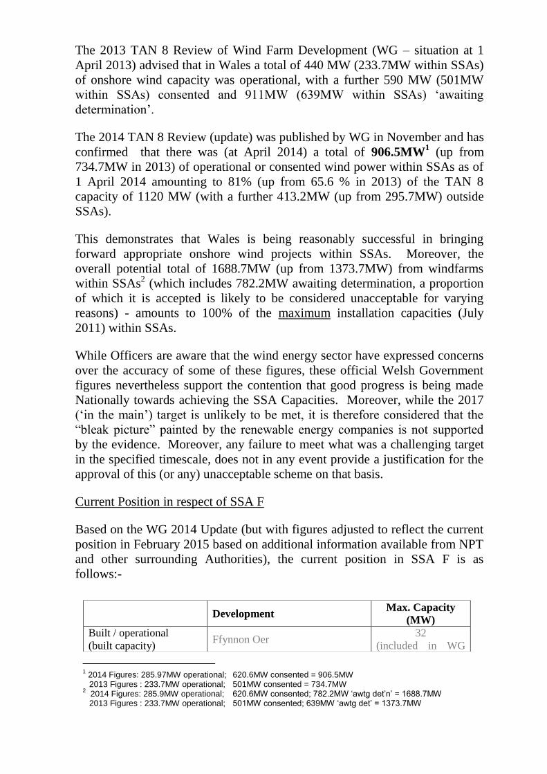
The 2013 TAN 8 Review of Wind Farm Development (WG – situation at 1
April 2013) advised that in Wales a total of 440 MW (233.7MW within SSAs)
of onshore wind capacity was operational, with a further 590 MW (501MW
within SSAs) consented and 911MW (639MW within SSAs) ‘awaiting
determination’.
The 2014 TAN 8 Review (update) was published by WG in November and has
confirmed that there was (at April 2014) a total of 906.5MW1 (up from
734.7MW in 2013) of operational or consented wind power within SSAs as of
1 April 2014 amounting to 81% (up from 65.6 % in 2013) of the TAN 8
capacity of 1120 MW (with a further 413.2MW (up from 295.7MW) outside
SSAs).
This demonstrates that Wales is being reasonably successful in bringing
forward appropriate onshore wind projects within SSAs. Moreover, the
overall potential total of 1688.7MW (up from 1373.7MW) from windfarms
within SSAs2 (which includes 782.2MW awaiting determination, a proportion
of which it is accepted is likely to be considered unacceptable for varying
reasons) - amounts to 100% of the maximum installation capacities (July
2011) within SSAs.
While Officers are aware that the wind energy sector have expressed concerns
over the accuracy of some of these figures, these official Welsh Government
figures nevertheless support the contention that good progress is being made
Nationally towards achieving the SSA Capacities. Moreover, while the 2017
(‘in the main’) target is unlikely to be met, it is therefore considered that the
“bleak picture” painted by the renewable energy companies is not supported
by the evidence. Moreover, any failure to meet what was a challenging target
in the specified timescale, does not in any event provide a justification for the
approval of this (or any) unacceptable scheme on that basis.
Current Position in respect of SSA F
Based on the WG 2014 Update (but with figures adjusted to reflect the current
position in February 2015 based on additional information available from NPT
and other surrounding Authorities), the current position in SSA F is as
follows:-
Development Max. Capacity
(MW)
Built / operational
(built capacity) Ffynnon Oer
32
(included in WG
1 2014 Figures: 285.97MW operational; 620.6MW consented = 906.5MW
2013 Figures : 233.7MW operational; 501MW consented = 734.7MW 2 2014 Figures: 285.9MW operational; 620.6MW consented; 782.2MW ‘awtg det’n’ = 1688.7MW
2013 Figures : 233.7MW operational; 501MW consented; 639MW ‘awtg det’ = 1373.7MW
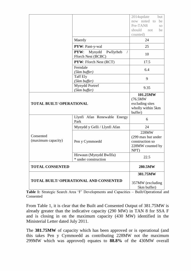
Table 1: Strategic Search Area ‘F’ Developments and Capacities – Built/Operational and
Consented
From Table 1, it is clear that the Built and Consented Output of 381.75MW is
already greater than the indicative capacity (290 MW) in TAN 8 for SSA F
and is closing in on the maximum capacity (430 MW) identified in the
Ministerial Letter dated July 2011.
The 381.75MW of capacity which has been approved or is operational (and
this takes Pen y Cymmoedd as contributing 228MW not the maximum
299MW which was approved) equates to 88.8% of the 430MW overall
2014update but
now noted to be
Pre-TAN8 so
should not be
counted)
Maerdy 24
PYW: Pant-y-wal 25
PYW: Mynydd Pwllyrheb /
Fforch Nest (BCBC) 10
PYW: Fforch Nest (RCT) 17.5
Ferndale
(5km buffer) 6.4
Taff Ely
(5km buffer) 9
Mynydd Portref
(5km buffer) 9.35
TOTAL BUILT/ OPERATIONAL
101.25MW
(76.5MW
excluding sites
wholly within 5km
buffer)
Consented
(maximum capacity)
Llynfi Afan Renewable Energy
Park 6
Mynydd y Gelli / Llynfi Afan 24
Pen y Cymmoedd
228MW
(299 max but under
construction so
228MW counted by
NPT)
Hirwaun (Mynydd Bwllfa)
* under construction 22.5
TOTAL CONSENTED 280.5MW
TOTAL BUILT/ OPERATIONAL AND CONSENTED
381.75MW
357MW (excluding
5km buffer)
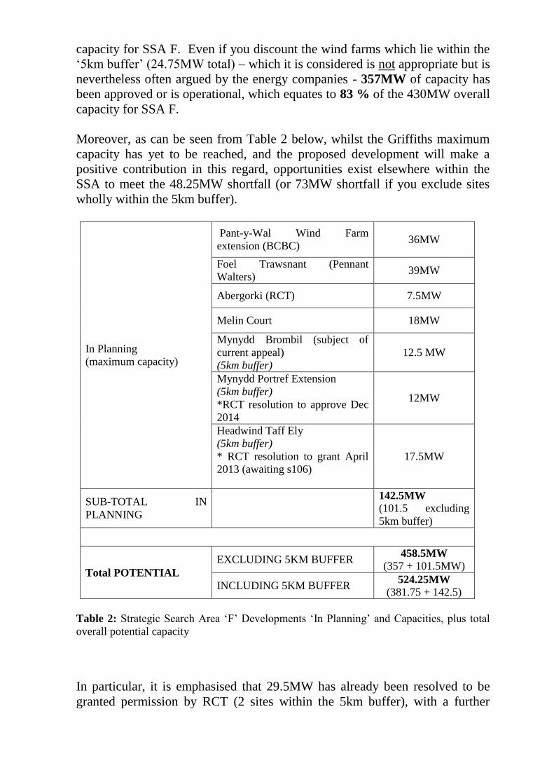
capacity for SSA F. Even if you discount the wind farms which lie within the
‘5km buffer’ (24.75MW total) – which it is considered is not appropriate but is
nevertheless often argued by the energy companies - 357MW of capacity has
been approved or is operational, which equates to 83 % of the 430MW overall
capacity for SSA F.
Moreover, as can be seen from Table 2 below, whilst the Griffiths maximum
capacity has yet to be reached, and the proposed development will make a
positive contribution in this regard, opportunities exist elsewhere within the
SSA to meet the 48.25MW shortfall (or 73MW shortfall if you exclude sites
wholly within the 5km buffer).
In Planning
(maximum capacity)
Pant-y-Wal Wind Farm
extension (BCBC) 36MW
Foel Trawsnant (Pennant
Walters) 39MW
Abergorki (RCT) 7.5MW
Melin Court 18MW
Mynydd Brombil (subject of
current appeal)
(5km buffer)
12.5 MW
Mynydd Portref Extension
(5km buffer)
*RCT resolution to approve Dec
2014
12MW
Headwind Taff Ely
(5km buffer)
* RCT resolution to grant April
2013 (awaiting s106)
17.5MW
SUB-TOTAL IN
PLANNING
142.5MW
(101.5 excluding
5km buffer)
Total POTENTIAL
EXCLUDING 5KM BUFFER 458.5MW
(357 + 101.5MW)
INCLUDING 5KM BUFFER 524.25MW
(381.75 + 142.5)
Table 2: Strategic Search Area ‘F’ Developments ‘In Planning’ and Capacities, plus total
overall potential capacity
In particular, it is emphasised that 29.5MW has already been resolved to be
granted permission by RCT (2 sites within the 5km buffer), with a further
113MW ‘in planning’ (including the appeal proposal). These developments
which are in the ‘pipeline’ demonstrate that there is future potential to meet the
targets and these have been acknowledged in the 2014 TAN 8 Update.
In concluding on need, whilst substantial weight should be given to the
potential contribution of the proposals to securing electricity from renewable
sources, it is nevertheless considered that the rapidly accelerating performance
of on-shore wind capacity provision within the UK, Wales and NPT, as
evidenced above, is an important factor to be weighed in the planning balance.
In light of the current and proposed capacities in SSA F identified above, it is
considered that excellent progress is being made in SSA F, such that there is
every expectation that the maximum capacity of 430MW for SSA F will be
reached by schemes which are currently ‘in planning’ and which lie wholly or
partially within the SSA F boundaries (as envisaged by TAN8 and by the
refined IPG boundaries). Indeed, the combined total of schemes above is such
that weight must be placed on the possibility of the maximum capacities being
exceeded.
In the context of this need and the unacceptable levels of harm identified in
this report it is thus concluded that there are no justifiable grounds to conclude
that the benefits in terms of renewable energy generation outweigh the impacts
of the development.
Having regard to the above policy imperative, it is thus also considered that the
national renewable energy targets will not be materially prejudiced by the
dismissal of this scheme because there remains a strong push towards meeting
the renewables – and particularly onshore wind – at local and national level.
It is therefore concluded that there is no overriding need for this development,
and in any respect the benefits in terms of additional energy generation would
not outweigh the clear harm identified earlier in this report on landscape /
historic character grounds. For this reason, the proposal not only fails to
accord with Policies ENV3, GC1 and GC2 but also Policy IE6 – Renewable
Energy – given that the impacts of the development would be unacceptable, in
themselves and within the wider context of the generally permissive policy
approach towards renewables.
Others (including objections):
In respect of the objections raised by local residents and Suzy Davies AM it is
considered that the concerns relating to planning policy, visual amenity, noise
and disturbance, stability, ecology, traffic implications, highway safety,
shadow flicker, cumulative impact, impact on tourism and socio economic,
impact on , historic features and energy production have been addressed in the
report.
In respect of other matters raised:
There is no justifiable evidence that the wind farm would devalue
property;
During construction and decommissioning, healthy and safety
requirements will make it necessary to manage paths PRoW and other
permissive routes where these trails come close to infrastructure. The
applicant may request temporary closure orders in consultation with
local authorities and providing temporary alternative routes where
possible. Notices would be posted in publicly available documents and
the routes will be demarcated with warning signs to discourage persons
from entering the construction area. During the operation of the wind
farm, no restrictions would be placed on the movement of walkers,
cyclists and horseback riders using the existing rights of way across the
whole site;
Government Policy considers wind energy to have the greatest potential
in the short/medium terms to provide renewable energy;
At the expiry of the consent or the end of the wind farm’s useful life, it
is proposed that the turbines, transformers and on site substation would
be removed. Therefore, in the event that planning permission was
granted, a condition could be imposed requiring the submission of a
decommissioning statement requiring the land to be re-instated once the
turbines have been de-commissioned;
The comments raised by TATA have been addressed earlier in this report.
Community Benefit
Developers in consultation with local planning authorities should take an
active role in engaging with the local community on renewable energy
proposals. Experience has shown that there are opportunities to achieve
community benefits through major wind farm development. Local Planning
Authorities, where reasonably practical, should facilitate and encourage such
proposals. However, such contributions should not enable permission to be
given to a proposal that otherwise would be unacceptable in planning terms.
TAN 8 Renewable Energy (2005) considers “Community Involvement and
Benefits” and recognises the opportunities that large developments provide in
making contribution that benefit the community. These include where
developers offer benefits not directly related to the planning process. However,
such contributions should not impact on the decision making process, and as
stated above should not enable permission to be given to a proposal that
otherwise would be unacceptable in planning terms.
The Authority within its supplementary planning guidance believes that it is
more appropriate for these “community contributions” to be dealt with as part
of the planning process in order that they may better reflect the needs and
aspirations of the area as identified through the Community Plan and UDP/
Local Development Plan (LDP) process, although they should not impact on
the decision making process.
The applicant has indicated in Section 16 of the ES that a community benefit
package/scheme will be offered through which an annual payment per
megawatt installed will be paid and applied directly within the local
community. Such matters will be discussed as part of the ongoing appeal, but
it should be noted however, that the community benefit is not put forward as
mitigation and must not be taken into consideration in the determination of the
planning application.
Conclusion:
All environmental information submitted within the ES and the Supplementary
Environmental information along with the comments of statutory consultees
on the information supplied, and the comments, observations and
representations provided by members of the public have been taken into
consideration in this recommendation. In addition, all the relevant European
directives, legislation and regulations have been taken into account.
The submitted scheme demonstrates that there are no unacceptable detrimental
effects in relation to Ecology, Archaeology, Hydrology and Hydrogeology,
Geology, Mining and Mineral Resources, Noise, Traffic, Transportation and
Access, Electromagnetic Interference and Aviation. In relation to Socio-
Economic effects there are limited short term benefits in relation to
employment.
TAN 8 makes it clear that “within (and immediately adjacent) to the SSAs, the
implicit objective is to accept landscape change” however, the TAN together
with Local and National policy makes it clear that each site must be assessed
on it merits as local environmental conditions may dictate that the level of
harm associated with the development out weighs the need to provide
additional forms of renewable energy. Given the existing landscape quality
and the scale of the proposal within the landform it is considered that the
impact of the proposal on landscape in isolation or cumulatively with other
built or consented schemes out weighs the need to provide a renewable form of
energy to meet national targets.
Having regard to the landscape and visual impacts identified earlier in this
report and the relationship of the application site to a number of settlements, it
is considered that the prominent siting of the turbines would unacceptably
dominate the skyline of the landform upon which they are proposed to be
located and the backcloth to the adjacent settlements would result in the
introduction of visually incongruous structures which would have a significant
adverse effect, and detract from the character and value of the Mynydd
margam / margam mountain registered landscape of special historic interest. It
is further considered that by virtue of their overall size, the substantial vertical
impact of their moving blades that the proposed development will have a
visually dominant impact that is significantly damaging to the setting of the
Scheduled Ancient Monuments Ergyd Isaf Round Barrows and the Grade I
Registered Park and Garden. The proposal would not safeguard or enhance the
character or appearance of the site or its surroundings and would have a
significant detrimental impact which could not be satisfactorily mitigated.
Given the prominence and impacts identified within the submitted ES and the
high sensitivity to change in the settlements of Margam and Goytre, it is
concluded that views from these settlements would substantially change, and
the quality of life and experience of residents and visitors would alter to an
unacceptable degree. As a consequence, the visual impacts of the proposal
would be unacceptably dominant on persons living in and moving through
these areas.
While the benefits of the proposal in meeting the acknowledged need for
further onshore wind energy is acknowledged, this does not justify a
‘development at all costs’ approach. In this respect, the site is located outside
of the SSA F boundary as defined by TAN8 and the refined boundary within
the Councils approved Interim Planning Guidance. Moreover, SSA F is well
advanced towards meeting the capacities set out by the Minister in July 2011,
with significant future potential ‘in the pipeline’ which are likely to be less
harmful than the development subject of this proposal. Having regard to this,
it is considered that the proposal would cause a degree of harm that would not
be justified by the benefit of the scheme towards energy generation.
Accordingly, the proposal is considered to be contrary to Planning Policy
Wales 2014, TAN8: Renewable Energy, Policies 1 and 6, Policies GC1, GC2,
ENV1, ENV3 and IE6 of the Neath Port Talbot Adopted Unitary Development
Plan, and the Council’s approved Interim Planning Guidance : Wind Turbine
Development(2008).
Recommendation : That, had the Council been in a position to determine the
application, planning permission would have been REFUSED on the following
grounds: -
1. The proposed development would result in the introduction of
incongrous, dominating, and visually prominent structures which
would : -
(a) Have an unacceptable impact on the character and value of the
Mynydd margam / margam mountain registered landscape of
special historic interest
(b) Have a visually dominant impact that would have a significant
harmful effect on the setting of the Scheduled Ancient Monument
Ergyd Isaf Round Barrows (GM160); and
(c) Have unacceptable adverse landscape and visual impacts, primarily
on the settlements of Margan and Goytre, and on the setting of the
Grade I Registered Park and Garden at Margam;
Having regard to the location of the site outside of the boundary of the
Strategic Search Area F, both as defined by TAN 8 and by the refined
boundary within the Council’s approved Interim Planning Guidance :
Wind Turbine Development (2008), and the unacceptable landscape and
visual impacts, and impacts on historic assets, it is considered that the
proposal would cause a degree of harm that would not be outweighed by
the benefits of the scheme in terms of wind energy generation. As a
consequence the development would be contrary to Planning Policy
Wales (2014), TAN8 : Planning for Renewable Energy (2005), Policies
1, 5, 6, 19, GC1, GC2, ENV1, ENV3 and IE6 of the Neath Port Talbot
Unitary Development Plan, and the Neath Port Talbot Interim Planning
Guidance : Wind Turbine Development (2008).