Embed Size (px)
Citation preview
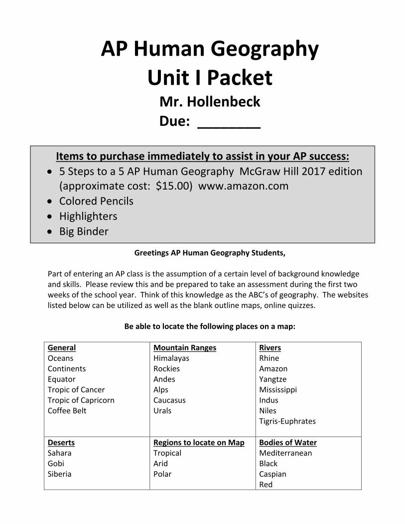
AP Human Geography Unit I Packet Mr. Hollenbeck Due: ________
Greetings AP Human Geography Students,
Part of entering an AP class is the assumption of a certain level of background knowledge and skills. Please review this and be prepared to take an assessment during the first two weeks of the school year. Think of this knowledge as the ABC’s of geography. The websites listed below can be utilized as well as the blank outline maps, online quizzes.
Be able to locate the following places on a map:
General Oceans Continents Equator Tropic of Cancer Tropic of Capricorn Coffee Belt
Mountain RangesHimalayas Rockies Andes Alps Caucasus Urals
RiversRhine Amazon Yangtze Mississippi Indus Niles Tigris‐Euphrates
Deserts Sahara Gobi Siberia
Regions to locate on MapTropical Arid Polar
Bodies of Water Mediterranean Black Caspian Red
Items to purchase immediately to assist in your AP success:
5 Steps to a 5 AP Human Geography McGraw Hill 2017 edition (approximate cost: $15.00) www.amazon.com
Colored Pencils Highlighters Big Binder
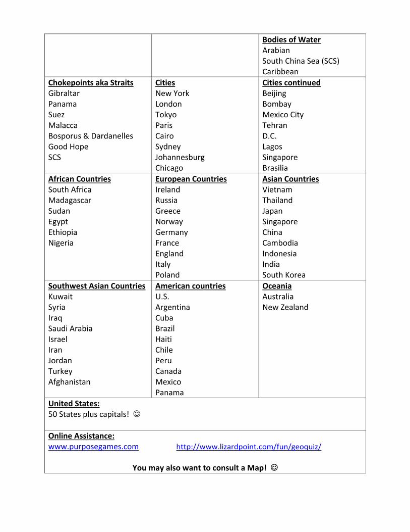
Bodies of Water Arabian South China Sea (SCS) Caribbean
Chokepoints aka Straits Gibraltar Panama Suez Malacca Bosporus & Dardanelles Good Hope SCS
CitiesNew York London Tokyo Paris Cairo Sydney Johannesburg Chicago
Cities continued Beijing Bombay Mexico City Tehran D.C. Lagos Singapore Brasilia
African Countries South Africa Madagascar Sudan Egypt Ethiopia Nigeria
European CountriesIreland Russia Greece Norway Germany France England Italy Poland
Asian Countries Vietnam Thailand Japan Singapore China Cambodia Indonesia India South Korea
Southwest Asian Countries Kuwait Syria Iraq Saudi Arabia Israel Iran Jordan Turkey Afghanistan
American countriesU.S. Argentina Cuba Brazil Haiti Chile Peru Canada Mexico Panama
Oceania Australia New Zealand
United States: 50 States plus capitals!
Online Assistance: www.purposegames.com http://www.lizardpoint.com/fun/geoquiz/
You may also want to consult a Map!

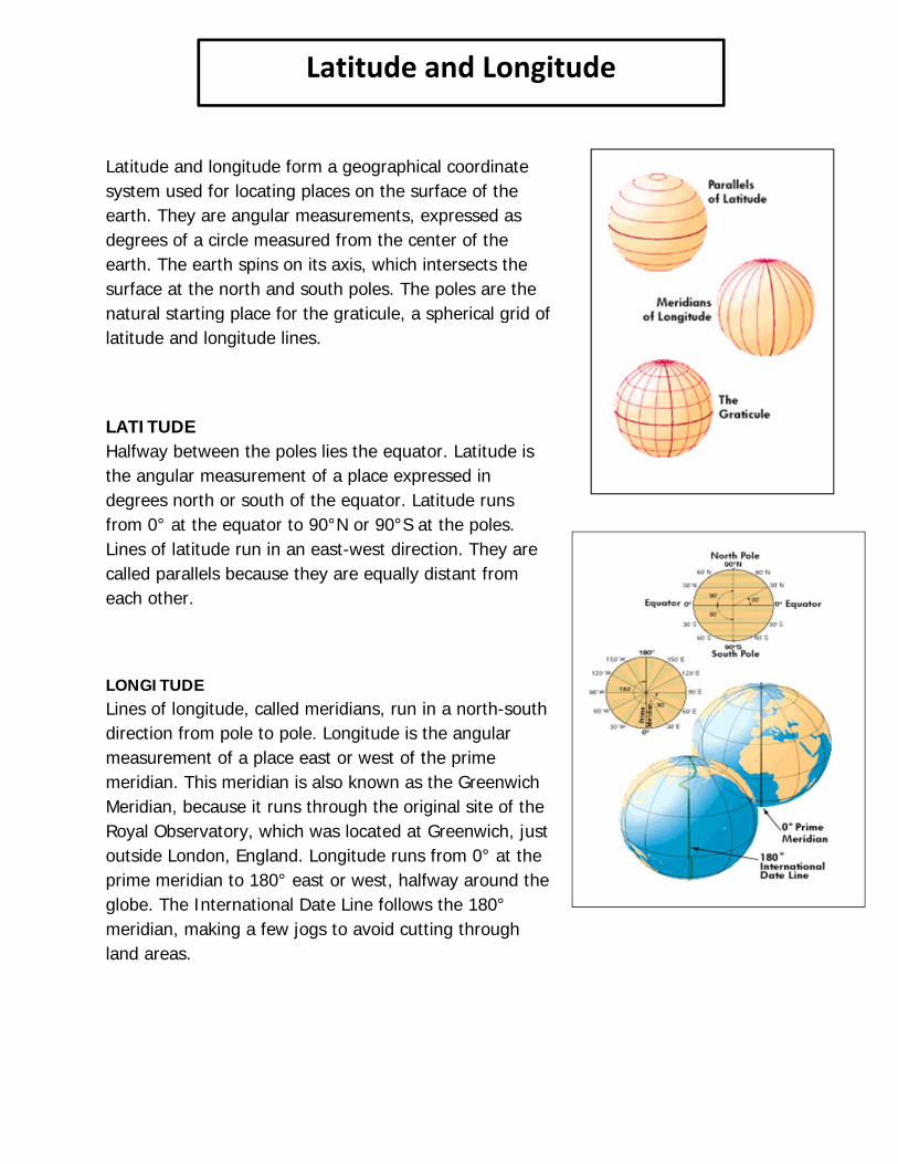
Latitude and longitude form a geographical coordinate system used for locating places on the surface of the earth. They are angular measurements, expressed as degrees of a circle measured from the center of the earth. The earth spins on its axis, which intersects the surface at the north and south poles. The poles are the natural starting place for the graticule, a spherical grid of latitude and longitude lines.
LATITUDE Halfway between the poles lies the equator. Latitude is the angular measurement of a place expressed in degrees north or south of the equator. Latitude runs from 0° at the equator to 90°N or 90°S at the poles. Lines of latitude run in an east-west direction. They are called parallels because they are equally distant from each other.
LONGITUDE Lines of longitude, called meridians, run in a north-south direction from pole to pole. Longitude is the angular measurement of a place east or west of the prime meridian. This meridian is also known as the Greenwich Meridian, because it runs through the original site of the Royal Observatory, which was located at Greenwich, just outside London, England. Longitude runs from 0° at the prime meridian to 180° east or west, halfway around the globe. The International Date Line follows the 180° meridian, making a few jogs to avoid cutting through land areas.
Latitude and Longitude
1) What is the purpose for having a latitude and longitude coordinate system? 2) Tell what direction latitude lines run (in other words, use the words: north ,south, east, or west). 3) What is another name for latitude lines? 4) Latitude lines go from 0 degrees to ____ degrees.
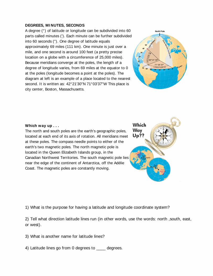
DEGREES, MINUTES, SECONDS A degree (°) of latitude or longitude can be subdivided into 60 parts called minutes ('). Each minute can be further subdivided into 60 seconds ("). One degree of latitude equals approximately 69 miles (111 km). One minute is just over a mile, and one second is around 100 feet (a pretty precise location on a globe with a circumference of 25,000 miles). Because meridians converge at the poles, the length of a degree of longitude varies, from 69 miles at the equator to 0 at the poles (longitude becomes a point at the poles). The diagram at left is an example of a place located to the nearest second. It is written as: 42°21'30"N 71°03'37"W This place is city center, Boston, Massachusetts.
Which way up . . . The north and south poles are the earth's geographic poles, located at each end of its axis of rotation. All meridians meet at these poles. The compass needle points to either of the earth's two magnetic poles. The north magnetic pole is located in the Queen Elizabeth Islands group, in the Canadian Northwest Territories. The south magnetic pole lies near the edge of the continent of Antarctica, off the Adélie Coast. The magnetic poles are constantly moving.

5) Tell what direction longitude lines run. 6) What is another name for longitude lines? 7) What is the name of the 0 degree longitude line? 8) What is the highest degree a longitude line can be?
Latitude and Longitude Mapping Exercise
1. Draw a red line along the equator (0 degrees latitude).
2. Draw a purple line along the Prime Meridian (0 degrees longitude).
3. In which ocean is the location 10 degrees S latitude, 75 degrees E longitude located? Mark it on the map with a blue "X" and write the name of the ocean.
4. In which ocean is the location 30 degrees N latitude, 60 degrees W longitude located? Mark it on the map with a blue "Y" and write the name of the ocean.
5. Mark the following cities on the map:
B. Beijing: 40°N, 116°E C. Cairo: 30°N, 31°E CT. Cape Town: 34°S, 18°E H. Hong Kong: 22°N, 114°E J. Jakarta: 6°S, 106°E LA. Los Angeles: 34°N, 118°W LI. Lima: 12°S, 77°W LO. London: 51°N, 0°W
List the city found at these coordinates here and place them on your map
19°N, 99°W - 55°N, 37°E -
19°N, 72°E - 1°S, 37°E -
30°N, 90°W - 40°N, 74°W -
23°S, 43°W - 47°N, 122°W -

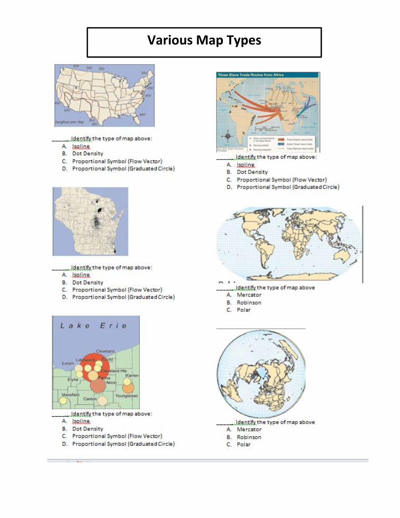
Various Map Types