Embed Size (px)
Citation preview
Nile Equatorial Lakes Subsidiary Action Program
FEASIBILITY STUDY AND PREPARATION OF AN INTEGRATED
WATERSHED MANAGEMENT PROGRAM AND INVESTMENT
PROPOSAL FOR SIO-MALABA-MALAKISI SUB BASIN
Final Report
Annex 1 - Catchment Rehabilitation and Management Project
Revised final version - August 2012
in association with
Document quality information
General information
Auteur(s) Jean-Marc ROUSSEL, Team Leader
Project title Feasibility Study and Preparation of an Integrated Watershed Management Program and Investment Proposal for the Sio-Malaba-Malakisi Sub-Basin
Document title Final Report – Annex 1 - Catchment Rehabilitation and Management Project
Date August 2012
Reference GED 10412 X
Addressee(s)
Sent to :
Name Organization Sent on:
Mohammed BADAZA Project Manager, Sio-Malaba-Malakisi River Basin Management Project, Kakamega, Kenya
28/08/2012
Copy to:
Name Organization Sent on:
History of modifications
Version Date Written by: Review by:
Version 0 04/06/2012 Jean-Marc ROUSSEL, Team
Leader Emmanuel DAVAL, Project Director
Version 1 14/08/2012 Jean-Marc ROUSSEL, Team
Leader Emmanuel DAVAL, Project Director
The contents of the present report are the sole responsibility of the Consultant, and should not be taken as reflecting the views of the Nile Basin Authority or the Nile Equatorial Lakes Subsidiary Action Programme.
SIO-MALABA-MALAKISI WATERSHED MANAGEMENT STUDY
Annex 1 - Catchment Rehabilitation and Management Project i
TABLE OF CONTENTS
CHAPTER 1. CRMP GENERAL PRESENTATION......................................................................... 1
1.1 Introduction.................................................................................................................................... 1 1.2 Justification of CRMP .................................................................................................................... 3 1.3 CRMP Objectives and key outputs ................................................................................................ 5 1.4 Provisional Project benefits ........................................................................................................... 6 1.5 Location of intervention areas........................................................................................................ 6 1.6 Project description ......................................................................................................................... 8
CHAPTER 2. AFFORESTATION .................................................................................................... 9
2.1 Sub-Project justification ................................................................................................................. 9 2.2 Sub-Project specific objectives and key outputs ............................................................................ 9 2.3 Provisional benefits...................................................................................................................... 10 2.4 Location of intervention areas...................................................................................................... 12 2.5 Sub-project description ................................................................................................................ 12 2.6 Implementation framework .......................................................................................................... 14 2.7 Monitoring.................................................................................................................................... 14 2.8 Cost breakdown and benefits ...................................................................................................... 16
CHAPTER 3. SOIL AND WATER CONSERVATION / AGROFORESTRY .................................. 18 3.1 Sub-project justification................................................................................................................ 18 3.2 Sub-project objectives and key outputs ....................................................................................... 21 3.3 Provisional benefits...................................................................................................................... 22 3.4 Location of intervention areas...................................................................................................... 23 3.5 Sub-Project Description ............................................................................................................... 24 3.6 Implementation framework .......................................................................................................... 26 3.7 Implementation monitoring .......................................................................................................... 29 3.8 Cost breakdown........................................................................................................................... 31
CHAPTER 4. CONSERVATION AGRICULTURE......................................................................... 33
4.1 Sub-project justification................................................................................................................ 33 4.2 Sub-project specific objectives/key outputs ................................................................................. 35 4.3 Provisional benefits...................................................................................................................... 36 4.4 Location of intervention areas...................................................................................................... 37 4.5 Sub-project activities.................................................................................................................... 37 4.6 Implementation framework .......................................................................................................... 40 4.7 Monitoring.................................................................................................................................... 41 4.8 Costs and benefits breakdown..................................................................................................... 42
CHAPTER 5. RIVERBANK PROTECTION ................................................................................... 45 5.1 Sub-project justification................................................................................................................ 45 5.2 Sub-project objectives/key outputs .............................................................................................. 45 5.3 Provisional benefits...................................................................................................................... 46 5.4 Location of intervention areas...................................................................................................... 46 5.5 Project description ....................................................................................................................... 47 5.6 Implementation framework .......................................................................................................... 48 5.7 Monitoring.................................................................................................................................... 48
SIO-MALABA-MALAKISI WATERSHED MANAGEMENT STUDY
Annex 1 - Catchment Rehabilitation and Management Project ii
5.8 Costs and benefits breakdown..................................................................................................... 49
CHAPTER 6. PROMOTION OF SUSTAINABLE PRACTICES FOR SAND ABSTRACTION ...... 50 6.1 Sub-project justification................................................................................................................ 50 6.2 Project objectives and key outputs .............................................................................................. 50 6.3 Provisional benefits...................................................................................................................... 51 6.4 Location of intervention areas...................................................................................................... 52 6.5 Sub-project description ................................................................................................................ 52 6.6 Implementation framework .......................................................................................................... 53 6.7 Monitoring.................................................................................................................................... 53 6.8 Costs breakdown ......................................................................................................................... 54
LIST OF TABLES
Table 1: Targeted areas for CRMP..................................................................................................... 7
Table 2: Performance indicators for Afforestation ............................................................................ 15
Table 3: Example of soil conservation and erosion control practices............................................... 19
Table 4: Performance indicators for sub-project ............................................................................... 29
Table 5: Performance indicators for sub-project 1C ......................................................................... 41
Table 6: Performance indicators for sub-project ............................................................................... 49
Table 7: Performance indicators for sub-project ............................................................................... 54
LIST OF FIGURES
Figure 1: Priority areas for catchment rehabilitation ........................................................................... 8
SIO-MALABA-MALAKISI WATERSHED MANAGEMENT STUDY
Annex 1 - Catchment Rehabilitation and Management Project iii
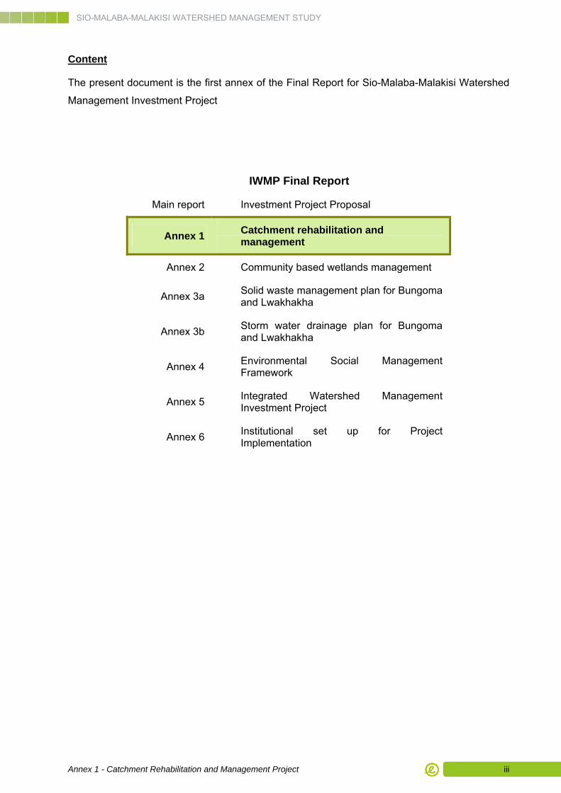
Content
The present document is the first annex of the Final Report for Sio-Malaba-Malakisi Watershed
Management Investment Project
IWMP Final Report
Main report Investment Project Proposal
Annex 1 Catchment rehabilitation and management
Annex 2 Community based wetlands management
Annex 3a Solid waste management plan for Bungoma and Lwakhakha
Annex 3b Storm water drainage plan for Bungoma and Lwakhakha
Annex 4 Environmental Social Management Framework
Annex 5 Integrated Watershed Management Investment Project
Annex 6 Institutional set up for Project Implementation
SIO-MALABA-MALAKISI WATERSHED MANAGEMENT STUDY
Annex 1 - Catchment Rehabilitation and Management Project 1
CHAPTER 1. CRMP General Presentation
1.1 Introduction
1.1.1 General Context
The Catchment Rehabilitation and Management Project (CRMP) is one of the core sector
projects of the Sio-Malaba-Malakisi Integrated Watershed Management Plan (IWMP). It has
direct relevance for the three Project Components, since it aims at developing watershed
conservation, ensuring income generation and promoting better watershed management.
The IWMP has been formulated within the framework of the consultancy services for the Sio-
Malaba-Malakisi (SMM) River Basin Management Project, one of the three transboundary
integrated water resources management and development projects being implemented within
the framework of the Nile Equatorial Lakes Subsidiary Action Program (NELSAP), an
investment program of the Nile Basin Initiative.
The SMM basin consists of the Malaba-Malakisi catchment, which originates from the southern
slope of Mount Elgon and drains towards Lake Kyoga, and the Sio catchment, which originates
south of Mount Elgon and drains into Lake Victoria. The SMM catchments have experienced
significant land use changes over the past years due to population pressure; as people continue
to clear forests and drain wetlands to create new agricultural land and establish new
settlements.
The SMM River Basin Management Project targets economic growth opportunities through co-
operative management of the shared water resources amongst Nile Equatorial Lakes (NEL)
countries, to alleviate poverty, enhance economic growth and reverse environmental
degradation. It also contributes towards the wider Nile Basin Initiative (NBI) goal of achieving
sustainable socio-economic development through equitable utilization of, and benefit from, the
common Nile Basin water resources.
The present report on CRMP needs to be read in conjunction with the IWMP Main Report.
1.1.2 Background
The high population pressure in the SMM basin has led to excessive land fragmentation and
has pushed farming activities into marginal areas that are vulnerable to soil erosion and nutrient
loss, and increased encroachment of ecologically fragile areas such as wetlands, riverbanks
and protected forests for farming purposes.
SIO-MALABA-MALAKISI WATERSHED MANAGEMENT STUDY
Annex 1 - Catchment Rehabilitation and Management Project 2
The SMM basin is also experiencing water resources quantity and quality challenges as a result
of poor land use management practices, encroachment on river riparian lands and wetlands,
flash floods, increased sediment loads in the water courses and water storage facilities.
Further, poorly controlled effluent discharges mainly from urban sewage outflows, and the
excessive nutrient and agro-chemical pollution from non-point sources have negatively
impacted surface water and groundwater quality.
In most of the lower SMM catchments, natural forests have been cleared since the turn of the
last century for agricultural land and livestock grazing. Most forests in the Malaba and
Mpologoma river catchment have been degraded; in the Tororo and Busia districts, trees have
recently been cut down for lime burning and charcoal making, and for brick kilns.
There is particularly heavy dependence on forest resources in the areas near Mt. Elgon, i.e. the
Mt. Elgon and Bungoma districts in Kenya, and Bunduda and Manafwa in Uganda. These
forests are utilized by the communities for firewood, ropes, pole wood, vegetables, bamboo
shoots, fruits, medicines, and livestock grazing. Because of their importance for rural
communities, forested lands have been encroached upon by new human settlements, while
gazetting of national parks and forest reserves has created significant resentment and social
unrest.
Expansion of farmland to the riverbanks, coupled with depletion of riverine vegetation has made
riverbank erosion more severe. There is evidence of erosion in most all banks within the basin,
as well as undercutting on outer meander curves where flow velocity is highest.
Within the SMM basin, degradation in upper watershed areas has led to an increase in
sediment load and intensity of flash floods. Coarse fractions have caused siltation of incised
riverbeds. This in its turn has increased flooding intensity and hence riverbank erosion, which
has further contributed to siltation of beds. Uncontrolled sand collection from riverbeds and
banks in some areas has also led to an increase in erosion.
Soil erosion causes water pollution leading to deterioration of aquatic habitats, increases water
treatment costs and clogging of water distribution systems. The washing of nutrients and
organic matter from the rich top soil into streams and rivers is a major cause of eutrophication.
Furthermore, excessive deposition of sediments in rivers, lakes and wetlands has caused
destruction of fish spawning areas and contributed to decrease of wetland extension.
The average annual soil loss over the entire basin is estimated at 3.78 tons/ha; and 0.62
tons/ha for the Sio basin only. The uncontrolled runoff of excessive rainwater causes sheet
erosion and leads to gullies and landslides with increased sediment transport and siltation of
rivers, lakes and valley reservoirs.
Soil degradation in the SMM basin is linked to soil fertility depletion and soil erosion, long-term
cultivation with diminishing fallow periods, limited crop rotation practices and low fertilizer inputs.
SIO-MALABA-MALAKISI WATERSHED MANAGEMENT STUDY
Annex 1 - Catchment Rehabilitation and Management Project 3
This causes low soil stability and particles are easily transported during rain. Although farmers
are aware of reduced soil fertility and its effects, their capacity to address the issues is limited
leading to poor yields.
1.2 Justification of CRMP
The CRMP will build on prevailing baseline conditions.
Kenya has experienced a period of strong emphasis on soil and water conservation through
long term SIDA support. In Uganda, soil conservation has captured far less attention over the
last decades. At present, soil conservation and afforestation activities are being carried out in
SMM catchment in both countries but:
■ Implementation is scattered and implementation rates are modest.
■ Implementation is demand-driven; it does not follow a plan with priority ranking of degraded or threatened areas.
■ Sensitization is taking place within the framework of the NALEP/NAADS extension program, with support from other line agencies (NEMA, District water offices, WRMA, KFS/FSSD/NFA). The operational capacity of these line agencies (staff, means of transport, equipment, budgets) is limited, especially at grassroots levels.
Agroforestry can play an important role in catchment rehabilitation. Despite the fact that
agroforestry technologies are known and agroforestry services are actually well appreciated,
government support in terms of resource allocation and agroforestry adoption is low. Contrarily,
a potential network of qualified institutions exist which could provide assistance in knowledge
transfer (ICRAF, ICIPE, MUIENR, KEFRI, NaFORRI, KFS/FSSD/NFA) and in promotion and
implementation of agroforestry activities (Sweden- based VI project).
Conservation Agriculture is in its infancy, especially in terms of adoption but its potential is
advocated by many. Several measures are being applied with varying success (contour “trash
lines”, composting). Basic knowledge is available in the area and promoted e.g. by Agricultural
Development Training Centres in Western Province, Kenya or ACT. Several pilot projects on
conservation agriculture have been implemented in Bungoma, with promising results
In summary, the proposed Catchment Rehabilitation and Management Project is expected to
address:
■ Conservation of natural resources and environmental assets;
■ Improvement of livelihoods for communities maintaining and benefitting from natural resources improvements, and
■ Improvement of natural resources management through institutional strengthening.

SIO-MALABA-MALAKISI WATERSHED MANAGEMENT STUDY
Annex 1 - Catchment Rehabilitation and Management Project 4
Catchment management for the SMM area will seek to make the best use of soil, water and
vegetation within the constraints of watershed’s agroclimatic and topographic conditions to
strengthen the natural resource base (soil, vegetation cover) and to increase agriculture
productivity, thereby improving peoples’ livelihoods.
The focus of the CRMP will be on activities that will benefit the farmers through provision of
alternative livelihood activities and improvement of incomes and, at the same time are likely to
have maximum impact on watershed conservation as well.
The proposed project will involve activities on improving human welfare encompassing poverty
alleviation, increasing cash income within the confines of the farmlands, and thereby easing
pressure off natural ecosystems and improving food and nutritional security. Reversing
environmental degradation activities will involve soil improvement (replenishment of soil fertility,
conservation of soil, conservation agriculture), enhanced biological diversity on farm and off
farm and increased carbon storage. The proposed project ensures land use activities will avoid
environmental degradation without compromising the ability for economic activity.
The development of CRMP has involved considerable input from the community and key
stakeholders; and while the proposed projects will not address all the environmental issues,
they will be designed to encompass the range of key focus areas identified by the stakeholders
and implement the larger scale actions required to address the more significant threats to the
SMM Catchment.
Implementation strategy
Catchment rehabilitation should start with the introduction of a few attractive measures or
technologies that are easily adopted based on their productivity aspects. Around these measures,
the environmental context (the environmental protection aspects) will be explained in a simple way.
Based on the adoption of the first measures and the understanding of its context, other measures
are gradually added and the broader environmental context will be taught. In this way, the people’s
understanding will increase with advanced participation. A possible initial measure could for
example be: 1) the production of seedlings in private nurseries. Following steps would be 2) how
and where to collect seeds, 3) which trees to plant where in a catchment, 4) how to combine trees
with other crops, 5) how to make an integrated plan for a small focal area or micro-catchment.
This approach implies that a longer support, but with gradually decreasing intensity, will be
required than the one-year attention devoted by the former national Soil and Water
Conservation Program in Kenya. In this way, it is aimed at a higher commitment of communities
to prolonged catchment conservation, based on better understanding. Possible implementation
partners are already following similar strategy. For example, the Swedish NGO named VI
Agroforestry works close to the farmers through a strong extension service system. When
sustainable results have been reached (normally after 2–3 years of intensive and 2–3 years of
extensive support) the program moves on to another site.
SIO-MALABA-MALAKISI WATERSHED MANAGEMENT STUDY
Annex 1 - Catchment Rehabilitation and Management Project 5
Communities that have not formerly been included in decision-making about the uses of land and
natural resources will not initially trust the new participatory processes. The implementing teams
will need to learn participatory processes and adapt their own attitudes to facilitate community
members to take on the active roles required by a truly participatory planning process. This means
that the teams need to give the communities time (through regular meaningful contact) and some
of their own power (over ownership of maps, reports, information about their own village and about
laws and policies). It requires attention to detail e.g. the stepwise development of new situations.
At least some field activities with tangible outputs for communities should start as soon as
possible after the plan becoming operational, even parallel to other preparatory activities (training,
planning, development of monitoring system), in order not to lose interest among communities.
It is important that farmers adopt improved land husbandry models in anticipation for long-term
profitability, rather than because of short-term gains in the form of payments. Participating
communities will not be paid but undertake activities from a sense of ownership. The more
these improved models are established through farmers’ own inputs, the more a sense of
ownership is created. The implementation strategy will be to undertake rather intensive
sensitization and demonstration during initial contacts with farmer communities, in strategic
locations. Once a few persons or one or a few groups have adopted and are practicing new
models or technologies, it will be easier to get others interested. Gradually, the sensitization
effort will decrease and a situation will develop where farmers or communities take the initiative
to contact extension officers, line agencies, or cooperating partners and requesting them for
assistance. In this way, the “message” will be spread at an increasing speed. Similarly, the effort
of demonstration will be intensive in the beginning but will gradually be taken over by
communities themselves showing others how to improve livelihoods.
The Catchment Rehabilitation Team will not replace but strengthen existing line agencies in
their operational capacities. When the project comes to implementation, an exit strategy should
be developed for all supporting structures at a relatively early stage, as to avoid dependency on
these short term structures.
1.3 CRMP Objectives and key outputs
The global objectives of the CRMP are:
■ Rehabilitate forest cover on steep slopes and strategic zones like Mont Elgon to conserve forests biodiversity, functions and ecological services (timber and non timber products, soil cover, water retention…), and mitigate the process of soil erosion in fields and along rivers;
■ Improve income from agricultural activities through development of adequate practices in the watershed to enhance productivity;
SIO-MALABA-MALAKISI WATERSHED MANAGEMENT STUDY
Annex 1 - Catchment Rehabilitation and Management Project 6
■ Support the strengthening of different institutions, and particularly the groups of farmers under their different names, through capacity building and organizational development, to ensure a smooth and sustainable implementation of the activities.
Main anticipated project global outputs are:
1. Biomass/biodiversity losses in upper catchments are compensated by reforestation
activities;
2. Sediment loads in streams originating from erosion on slopes, along riverbanks and
along road-sides, have significantly reduced by implementation of soil conservation,
agro-forestry and conservation agriculture measures.
3. Pollution from agriculture as non-point pollution source has significantly reduced by
introduction and implementation of conservation agriculture measures.
4. Farmers’ incomes have increased and food and nutritional security have improved in
the watershed.
5. Communities and farmers’ groups are taking responsibility in developing and
applying updated techniques to reduce soil erosion and enhance incomes.
1.4 Provisional Project benefits
The benefits of CRMP are described in the sections dedicated to each of the sub-projects.
1.5 Location of intervention areas
Initial priorities have been for location of intervention areas have been defined by a succession
of GIS-based actions described in the Main Report and including in particular:
A categorization of soils with their characteristics, capabilities and sensitivity to erosion;
A review of natural slopes and physiography;
A search for visual proof of active soil erosion process;
Establishment of soil erosion hazard.
This process, reflected in Map 1 below, has been further refined with indications from different
stakeholders, and particularly district officers from Environment, Water Resources and
Agriculture, of specific spots requiring urgent attention and action.
SIO-MALABA-MALAKISI WATERSHED MANAGEMENT STUDY
Annex 1 - Catchment Rehabilitation and Management Project 7
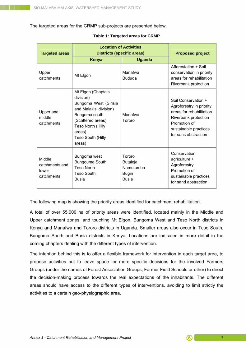
The targeted areas for the CRMP sub-projects are presented below.
Table 1: Targeted areas for CRMP
Location of Activities
Districts (specific areas) Targeted areas
Kenya Uganda
Proposed project
Upper catchments
Mt Elgon Manafwa Bududa
Afforestation + Soil conservation in priority areas for rehabilitation Riverbank protection
Upper and middle catchments
Mt Elgon (Chaptais division) Bungoma West (Sirisia and Malakisi division) Bungoma south (Scattered areas) Teso North (Hilly areas) Teso South (Hilly areas)
Manafwa Tororo
Soil Conservation + Agroforestry in priority areas for rehabilitation Riverbank protection Promotion of sustainable practices for sans abstraction
Middle catchments and lower catchments
Bungoma west Bungouma South Teso North Teso South Busia
Tororo Butaleja Namutumba Bugiri Busia
Conservation agriculture + Agroforestry Promotion of sustainable practices for sand abstraction
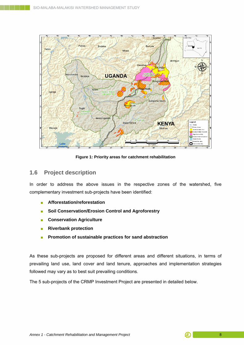
The following map is showing the priority areas identified for catchment rehabilitation.
A total of over 55,000 ha of priority areas were identified, located mainly in the Middle and
Upper catchment zones, and touching Mt Elgon, Bungoma West and Teso North districts in
Kenya and Manafwa and Tororo districts in Uganda. Smaller areas also occur in Teso South,
Bungoma South and Busia districts in Kenya. Locations are indicated in more detail in the
coming chapters dealing with the different types of intervention.
The intention behind this is to offer a flexible framework for intervention in each target area, to
propose activities but to leave space for more specific decisions for the involved Farmers
Groups (under the names of Forest Association Groups, Farmer Field Schools or other) to direct
the decision-making process towards the real expectations of the inhabitants. The different
areas should have access to the different types of interventions, avoiding to limit strictly the
activities to a certain geo-physiographic area.
SIO-MALABA-MALAKISI WATERSHED MANAGEMENT STUDY
Annex 1 - Catchment Rehabilitation and Management Project 8
Figure 1: Priority areas for catchment rehabilitation
1.6 Project description
In order to address the above issues in the respective zones of the watershed, five
complementary investment sub-projects have been identified:
■ Afforestation/reforestation
■ Soil Conservation/Erosion Control and Agroforestry
■ Conservation Agriculture
■ Riverbank protection
■ Promotion of sustainable practices for sand abstraction
As these sub-projects are proposed for different areas and different situations, in terms of
prevailing land use, land cover and land tenure, approaches and implementation strategies
followed may vary as to best suit prevailing conditions.
The 5 sub-projects of the CRMP Investment Project are presented in detailed below.
SIO-MALABA-MALAKISI WATERSHED MANAGEMENT STUDY
Annex 1 - Catchment Rehabilitation and Management Project 9
CHAPTER 2. Afforestation
2.1 Sub-Project justification
Trees and forest are critical resources for people’s livelihoods, environmental conservation and
economic development. Majority of the population depends directly on wood for their energy
needs (firewood and charcoal), materials for furniture and construction (timber and poles) as
well as food and other non-timber forest products (including fruits, nuts, medicinal plants,
fodder, etc.).
Many factors are directly influencing the loss of forest cover and the decline in the forest
resource base. These include forest clearance for agriculture, wood fuels or charcoal
production, the over-harvesting (poor planting and weak regulation, non sustainable harvesting
of forest products) and degradation of forests, the encroachment of government reserves and
the degazetting of forest reserves for alternatives purposes, mainly cultivation of agricultural
crops as a result of population pressure.
Consequently, it has become vital to identify appropriate land–use approaches for the
production of multipurpose outputs, and to ensure the sustainability of the production base.
2.2 Sub-Project specific objectives and key outputs
2.2.1 Specific Objectives
The specific objectives of the sub-project are the followings:
■ Mechanisms for community management and sustainable valorization (timber and non timber products) of forests and woodlots are settled and operational;
■ Farmers professional environment is operational: farmers are organized and have access to technical advices, techniques, tools and seedlings;
■ Farmers professional network is operational: farmers are included in the decision making process for woodlands and forests management;
■ Awareness towards usefulness of sustainable forests management is improved;
■ Protected forests are restored in the watershed.
■ Alternatives to fuel wood and energy saving technologies are introduced and used in the watershed;
SIO-MALABA-MALAKISI WATERSHED MANAGEMENT STUDY
Annex 1 - Catchment Rehabilitation and Management Project 10
2.2.2 Key Outputs
The sub-project key outputs are the followings:
A. Intervention areas to be rehabilitated are identified and characterized, reforestation plans are
produced, management mechanisms are proposed and this basic information is disclosed and
discussed with communities.
B. Community associations (CFAs, CFUGs…) are identified and members are trained;
extension staff are equipped and trained to organize, facilitate and provide on-going support to
community associations; Research institutes are identified and involved in specific supportive
tasks.
C. Nurseries are operational and seedlings available for reforestation operations.
D. Knowledge networks for exchanging experiences are established at local and transboundary
levels
E. Farmers are undertaking reforestation operations on private plots and community areas
F. Reforestation operations are carried out in governmental forests
G. Possible alternatives to fuel wood or energy saving technologies are selected and promoted
in the watershed (development of hydropower, wind or solar energy as alternative sources;
improved cook stove, improved charcoal oven, solar cook stove, biomass cook stove, improved
fish smoker…)
H. Equipment and tools are available: local manufacturers and retail sector are able to supply
improved stoves / ovens
2.3 Provisional benefits
The benefits of the afforestation sub-project are described under the three project Components
of Watershed Conservation, Income Generation and Watershed Management.
2.3.1 Watershed conservation
Ecological integration of reforested areas. The afforestation sub-project aims to restore the
governmental forests in the most degraded or deforested areas. The project will contribute to
improve the tree species currently used by promoting the use of indigenous tree species well
acclimated to the local conditions. This diversification of tree species will initiate the future forest
cover and ensure an ecological integration of the restored areas in the overall forest cover and
provide habitats for wildlife.
SIO-MALABA-MALAKISI WATERSHED MANAGEMENT STUDY
Annex 1 - Catchment Rehabilitation and Management Project 11
Few years after intervention, the biodiversity should naturally increase and ecological corridors
should be restored between this restored areas and the other parts of the forests.
Additionally, agroforestry can act as a buffer between protected forests and surrounding
agricultural land and minimize edge effects in natural forests. Well-developed agroforestry
systems provide habitat for wild fauna and contribute to biodiversity.
Environmental services. Afforestation (and agroforestry) is associated with positive
environmental outcomes because of the role trees play in larger ecosystem functions. Trees can
improve soil quality in various ways: root systems prevent soil erosion, leguminous species fix
nitrogen and improve nutrient recycling, and detritus from trees increases the organic content of
soil. Forest lands are habitats to wild fauna produce wood for multipurpose, fruits and various
other non timber products and participate to ground water table and spring protection
Other indirect conservation benefits may include benefits for future generation, stream bank
stabilization and decreasing siltation in the water streams and water storage, water tower
conservation, recreation and ecotourism development, spiritual and aesthetic values of
plantation of native species.
Climate risk adaptation/mitigation: Since CO2 is the most important cause of global warning,
the function of trees as a carbon sink is an important positive externality. In that carbon is not a
traded product in the individual farm level; the benefit is a share global rather than a national or
local one.
However it seems to be appropriate to include notice a benefit for carbon sequestration in view
of potential for valorisation of the project as a CDM or REDD+ project.
Hence Afforestation sub-project will affect the global climate by storing carbon and will
potentially offsets deforestation by providing an alternative source of wood products.
2.3.2 Income generation
Different sources of income are provided by afforestation sub-project:
■ Sustainable supply of timber for future generations
■ Ecotourism development around Mont Elgon and wide forests
■ Establishment of nurseries
■ Increasing pasture outputs
■ Developing small business relying on non-timber products such as honey, medicinal plants, wild fruit, handicraft…
SIO-MALABA-MALAKISI WATERSHED MANAGEMENT STUDY
Annex 1 - Catchment Rehabilitation and Management Project 12
2.3.3 Watershed management
Struggle for the right to use the forest resources has been an important element in the social
disturbances experienced in the forest areas in past years. Strengthening of users groups
(CFA/CFUG) giving legitimacy together with awareness and knowledge for forestry
management is expected to reinforce the recent progress in social harmony in those areas.
More general awareness to environmental issues and understanding the links between actions
within a river basin or a small watershed may also be part of improving social safety.
The focus to be put on diversification of income sources based on non-timber products is
expected to develop a higher level of protagonist role for women, for the women leading
households as well as for housewives in general.
2.4 Location of intervention areas
The targeted areas are mostly located in the upper catchment of Malaba and Malakisi rivers
near the Mount Elgon forest reserve and its surrounding areas, and also in degraded hills in the
upper and middle catchment.
The proposed areas are
■ In Manafwa district, Soono parish (18,000 persons) is a priority, and also Bunamunyi, Bunambale and Namisindwa. Afforestation should be combined with ecotourism (caves, mountain scenery), soil and water conservation structures and conservation agriculture. Total beneficiary population is estimated at 70,000 persons;
■ In Mt Elgon district, Cheptais, Chepyuk and Chwele areas, afforestation and agroforestry, with agricultural practices to reduce soil erosion and coffee development;
■ Nangoma and Lwanya in Busia district, Samia and Bunyala in Central district: reforestation of hilltops.
The potential for reforestation has been evaluated to 4884 ha in Kenya and 5572 ha in Uganda.
2.5 Sub-project description
2.5.1 Sub-project activities
Activity 1: Community awareness and capacity building for reforestation project and
forest management
■ Identification of CFAs/CFUGs, training sessions, workshops and visits and production and dissemination of technical and communication support. The capacity building will target institutional and community capacities and information on: improved forest rehabilitation and management practices, tree nursery establishment and management, forest governance.
SIO-MALABA-MALAKISI WATERSHED MANAGEMENT STUDY
Annex 1 - Catchment Rehabilitation and Management Project 13
Activity 2: Development of village nurseries to support forestry
■ Preliminary selection, collection and propagation of tree species for regeneration and reforestation purposes; including native seeds form indigenous forests and procurement of high quality seed for planted forests and enrichment planting;
■ Technical and financial support to the development of community-level nurseries (village nurseries) for forest species production and the use of appropriate technological methods for the production of seedlings
Activity 3: Governmental natural forests and hills rehabilitation interventions
■ Forest rehabilitation plans will be produced and will include preliminary erosion control and run-off water management techniques,
■ Implementation of reforestation programmes and management plan in natural governmental forests.
Activity 4: Community support for reforestation and sustainable management in
forestlands
■ Provide assistance to farmer groups to apply forestry/agroforestry practices within their land: technical advice, improvement of organizational capacities (for farmers and government extension agencies) and seeds/seedling supply, according to the specific needs and the promotion of government-community partnerships in forest management. This component will provide assistance to farmer groups to apply forestry/ agroforestry practices within their land but focusing on landscape scale rather than individual farmers.
■ The project will finance campaigns for communities to plant forest trees but also multi–purpose and nitrogen fixing trees in communal and private woodlots, schools and along roadsides. The aim is also to undertake reforestation of severely damaged areas already identified, on hilltops and other areas where viable agricultural practices are or have become more or less impossible. Community participation will be crucial in achieving this. The envisaged assistance will comprise technical advice, improvement of organizational capacities (for farmers and government extension agencies), supply of seeds/seedling and other inputs needed for reforestation, according to the specific needs and the promotion of government-community partnerships in forest management.
2.5.2 Means
The Afforestation sub-project will be concerned with afforestation activities on gazetted forest
land and community or private woodlands. Afforestation would be organized and coordinated by
forestry district officers (KFS) in Kenya and MWE-FSSD Officers in Uganda. In Uganda,
intervention on governmental forests only will be driven by NFA officers.
Labour for land preparation and plantation will be recruited from local communities.
The project will fund settlement and equipment of community or private nurseries to allow an
easy access to seedlings for afforestation operations.
The project will fund seedlings and inputs fro plantation on private and community woodplots
SIO-MALABA-MALAKISI WATERSHED MANAGEMENT STUDY
Annex 1 - Catchment Rehabilitation and Management Project 14
2.5.3 Quantities
The Objective is to restore around 5 000 ha in Kenya and 5 000 ha in Uganda
With a density around 1 500 seedlings/ha, the corresponding total of seedling to be produced
along the 5 years is: 15 000 000 plants; note that this account for loss ratio of 1 in 3 from
seedlings to grown trees from 1 500 to 1 000 per ha approximately.
This production may be reached by 100 nurseries (30 000 seedlings/year during 5 years)
established in and around the targeted areas.
A total of 50 CFA or CFUG will be involved in the project implementation.
2.6 Implementation framework
For the Afforestation/Reforestation sub-project, activities, intervention will be implemented
directly with already existing or newly created Community Forest Associations (CFAs) or
Community Forest Users Groups (CFUGs).
The implementing agency will be MFW-KFS in Kenya and MWE-FSSD in Uganda;
Second governmental agencies involved are NEMA in Kenya and NFA and District local
governments (FS) and LKWMZ in Uganda
Scientific research institutes, namely KEFRI in Kenya and NaFORRI in Uganda, will be involved
in part of the activities, to support innovative techniques and species identification, seed
collection and treatment/conservation.
Project-employed project facilitators (3 per district) will work with 1 assigned forest officer per
district or sub-county.
2.7 Monitoring
2.7.1 Indicators
Performance indicators have been proposed to reflect the progress of the sub-project
implementation and impacts of activities undertaken under the different components of the sub-
project.
The Performance indicators for sub-project progress and outcomes are the following table.
SIO-MALABA-MALAKISI WATERSHED MANAGEMENT STUDY
Annex 1 - Catchment Rehabilitation and Management Project 15
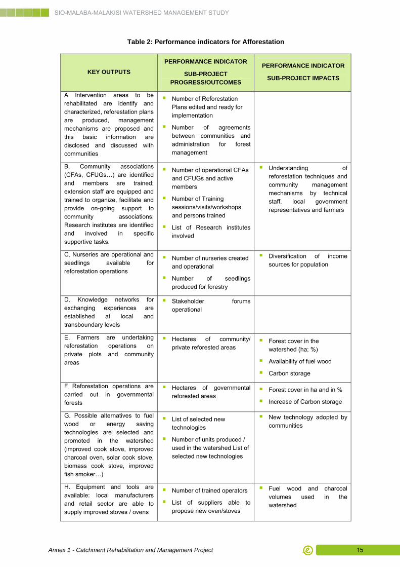
Table 2: Performance indicators for Afforestation
KEY OUTPUTS
PERFORMANCE INDICATOR
SUB-PROJECT PROGRESS/OUTCOMES
PERFORMANCE INDICATOR
SUB-PROJECT IMPACTS
A Intervention areas to be rehabilitated are identify and characterized, reforestation plans are produced, management mechanisms are proposed and this basic information are disclosed and discussed with communities
Number of Reforestation Plans edited and ready for implementation
Number of agreements between communities and administration for forest management
B. Community associations (CFAs, CFUGs…) are identified and members are trained; extension staff are equipped and trained to organize, facilitate and provide on-going support to community associations; Research institutes are identified and involved in specific supportive tasks.
Number of operational CFAs and CFUGs and active members
Number of Training sessions/visits/workshops and persons trained
List of Research institutes involved
Understanding of reforestation techniques and community management mechanisms by technical staff, local government representatives and farmers
C. Nurseries are operational and seedlings available for reforestation operations
Number of nurseries created and operational
Number of seedlings produced for forestry
Diversification of income sources for population
D. Knowledge networks for exchanging experiences are established at local and transboundary levels
Stakeholder forums operational
E. Farmers are undertaking reforestation operations on private plots and community areas
Hectares of community/ private reforested areas
Forest cover in the watershed (ha; %)
Availability of fuel wood
Carbon storage
F Reforestation operations are carried out in governmental forests
Hectares of governmental reforested areas
Forest cover in ha and in %
Increase of Carbon storage
G. Possible alternatives to fuel wood or energy saving technologies are selected and promoted in the watershed (improved cook stove, improved charcoal oven, solar cook stove, biomass cook stove, improved fish smoker…)
List of selected new technologies
Number of units produced / used in the watershed List of selected new technologies
New technology adopted by communities
H. Equipment and tools are available: local manufacturers and retail sector are able to supply improved stoves / ovens
Number of trained operators
List of suppliers able to propose new oven/stoves
Fuel wood and charcoal volumes used in the watershed
SIO-MALABA-MALAKISI WATERSHED MANAGEMENT STUDY
Annex 1 - Catchment Rehabilitation and Management Project 16
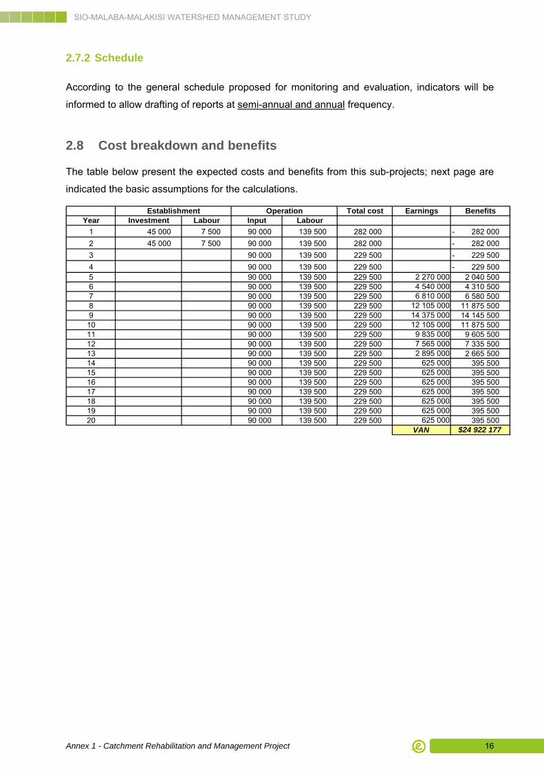
2.7.2 Schedule
According to the general schedule proposed for monitoring and evaluation, indicators will be
informed to allow drafting of reports at semi-annual and annual frequency.
2.8 Cost breakdown and benefits
The table below present the expected costs and benefits from this sub-projects; next page are
indicated the basic assumptions for the calculations.
Total cost Earnings BenefitsYear Investment Labour Input Labour
1 45 000 7 500 90 000 139 500 282 000 282 000 -
2 45 000 7 500 90 000 139 500 282 000 282 000 -
3 90 000 139 500 229 500 229 500 -
4 90 000 139 500 229 500 229 500 - 5 90 000 139 500 229 500 2 270 000 2 040 500 6 90 000 139 500 229 500 4 540 000 4 310 500 7 90 000 139 500 229 500 6 810 000 6 580 500 8 90 000 139 500 229 500 12 105 000 11 875 500 9 90 000 139 500 229 500 14 375 000 14 145 500 10 90 000 139 500 229 500 12 105 000 11 875 500 11 90 000 139 500 229 500 9 835 000 9 605 500 12 90 000 139 500 229 500 7 565 000 7 335 500 13 90 000 139 500 229 500 2 895 000 2 665 500 14 90 000 139 500 229 500 625 000 395 500 15 90 000 139 500 229 500 625 000 395 500 16 90 000 139 500 229 500 625 000 395 500 17 90 000 139 500 229 500 625 000 395 500 18 90 000 139 500 229 500 625 000 395 500 19 90 000 139 500 229 500 625 000 395 500 20 90 000 139 500 229 500 625 000 395 500
VAN $24 922 177
Establishment Operation
SIO-MALABA-MALAKISI WATERSHED MANAGEMENT STUDY
Annex 1 - Catchment Rehabilitation and Management Project 17
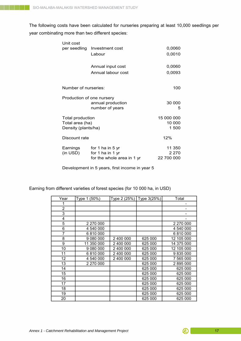
The following costs have been calculated for nurseries preparing at least 10,000 seedlings per
year combinating more than two different species:
Unit costper seedling Investment cost 0,0060
Labour 0,0010
Annual input cost 0,0060
Annual labour cost 0,0093
Number of nurseries: 100
Production of one nurseryannual production 30 000 number of years 5
Total production 15 000 000 Total area (ha) 10 000 Density (plants/ha) 1 500
Discount rate 12%
Earnings for 1 ha in 5 yr 11 350 (in USD) for 1 ha in 1 yr 2 270
for the whole area in 1 yr 22 700 000
Development in 5 years, first income in year 5
Earning from different varieties of forest species (for 10 000 ha, in USD)
Year Type 1 (50%) Type 2 (25%) Type 3(25%) Total1 - 2 - 3 - 4 - 5 2 270 000 2 270 000 6 4 540 000 4 540 000 7 6 810 000 6 810 000 8 9 080 000 2 400 000 625 000 12 105 000 9 11 350 000 2 400 000 625 000 14 375 000 10 9 080 000 2 400 000 625 000 12 105 000 11 6 810 000 2 400 000 625 000 9 835 000 12 4 540 000 2 400 000 625 000 7 565 000 13 2 270 000 625 000 2 895 000 14 625 000 625 000 15 625 000 625 000 16 625 000 625 000 17 625 000 625 000 18 625 000 625 000 19 625 000 625 000 20 625 000 625 000
SIO-MALABA-MALAKISI WATERSHED MANAGEMENT STUDY
Annex 1 - Catchment Rehabilitation and Management Project 18
CHAPTER 3. Soil and Water Conservation / Agroforestry
3.1 Sub-project justification
The sub-project will aim at conservation-based improvement of livelihoods of local communities
practicing farming on private lands. It is therefore the rationale of this sub-project that local
communities will be the principal implementing institution.
Communities will be taught and guided by division/district technical and extension staff, and
KFS/NFA staff, to produce planting material in private or community nurseries and use these for
mainly vegetative erosion control measures (biological techniques to fight against erosion) soil
conservation measures (agro-forestry-type measures, conservation agriculture measures and
others) on their own lands.
The innovative character of the Soil Conservation Project will consist of the strong emphasis on
biological soil conservation and erosion control measures, ensuring simultaneous intensification
of land husbandry.
Measures to be promoted will include live fences, grass strips, alley cropping, under
cropping/under seeding, contour cropping, zero tillage, nitrogen-fixing trees and shrubs,
selection of multi-purpose shrubs and trees (timber, fodder, fruits, and medicinal products).
Potential Agro-forestry models include:
■ Fruit tree planting or cash crop planting (coffee, banana) with under cropping (grass, fodder or other cover crops,
■ Multi–purpose and nitrogen fixing trees in communal woodlots, degraded lands, along roadsides and watersides, and in dwelling areas, planting of fertilizer trees such as Tithonia,
■ Integration of high value trees such as Oil palm, Mulberry (for silk worms), coffee and fruit trees/orchards onto farmland.
Conservation Agriculture measures include:
■ selection of perennial crops instead of annual crops, good cover crops instead of “open” crops,
■ integration of contour strips of perennial fodder crops,
■ zero-tillage, seed drilling,
■ on-site composting, crop residue trash lines.
SIO-MALABA-MALAKISI WATERSHED MANAGEMENT STUDY
Annex 1 - Catchment Rehabilitation and Management Project 19
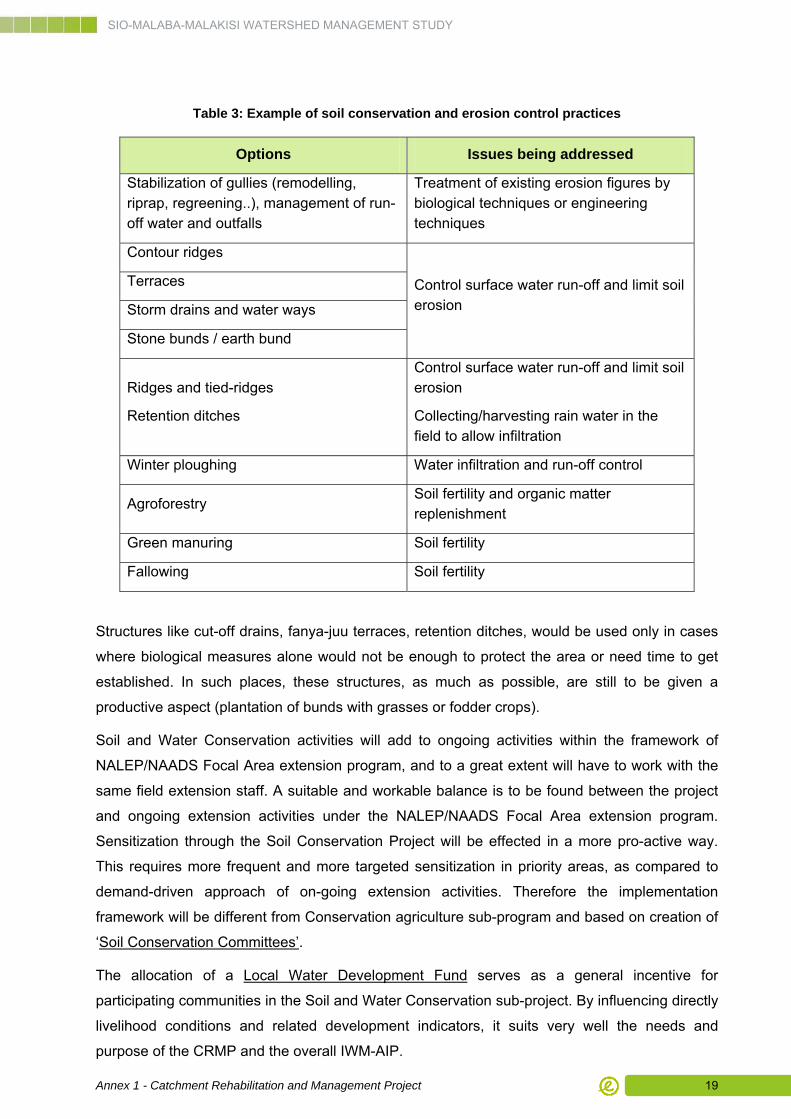
Table 3: Example of soil conservation and erosion control practices
Options Issues being addressed
Stabilization of gullies (remodelling, riprap, regreening..), management of run-off water and outfalls
Treatment of existing erosion figures by biological techniques or engineering techniques
Contour ridges
Terraces
Storm drains and water ways
Stone bunds / earth bund
Control surface water run-off and limit soil erosion
Ridges and tied-ridges
Retention ditches
Control surface water run-off and limit soil erosion
Collecting/harvesting rain water in the field to allow infiltration
Winter ploughing Water infiltration and run-off control
Agroforestry Soil fertility and organic matter replenishment
Green manuring Soil fertility
Fallowing Soil fertility
Structures like cut-off drains, fanya-juu terraces, retention ditches, would be used only in cases
where biological measures alone would not be enough to protect the area or need time to get
established. In such places, these structures, as much as possible, are still to be given a
productive aspect (plantation of bunds with grasses or fodder crops).
Soil and Water Conservation activities will add to ongoing activities within the framework of
NALEP/NAADS Focal Area extension program, and to a great extent will have to work with the
same field extension staff. A suitable and workable balance is to be found between the project
and ongoing extension activities under the NALEP/NAADS Focal Area extension program.
Sensitization through the Soil Conservation Project will be effected in a more pro-active way.
This requires more frequent and more targeted sensitization in priority areas, as compared to
demand-driven approach of on-going extension activities. Therefore the implementation
framework will be different from Conservation agriculture sub-program and based on creation of
‘Soil Conservation Committees’.
The allocation of a Local Water Development Fund serves as a general incentive for
participating communities in the Soil and Water Conservation sub-project. By influencing directly
livelihood conditions and related development indicators, it suits very well the needs and
purpose of the CRMP and the overall IWM-AIP.
SIO-MALABA-MALAKISI WATERSHED MANAGEMENT STUDY
Annex 1 - Catchment Rehabilitation and Management Project 20
Elements of local water development could include spring development, installation of pit
latrines, rehabilitation of small dams, and installation of fish ponds. These would be included in
Micro-Catchment Action Plans supported by WRMA - LVNC in Kenya, and soon by the WMZ
Lake Kyoga in Uganda. Also included could be small-scale water harvesting from field roads,
micro-catchment protection around water points, and construction of pit latrines. Although the
impact per intervention site of a local water development program will not be as spectacular as
other measures, the effects on livelihoods as well as on flow regimes in small streams will be
spread over a large area.
In Kenya, fish ponds (outside existing wetlands) are already promoted by the Ministry of
Fisheries in Bungoma and Teso. They are fed by local springs. Because of reduced productivity
of springs due to watershed deterioration, some of these new fish ponds face difficulties of
adequate water supply.
Potential of small dam rehabilitation and spring development is somewhat limited since the
water points are spread over considerable areas. About 30 dams were counted on topographic
maps dating from 1967, most of these (26) in Kenya. It is not known if and how many were
additionally built after that date. Small dam rehabilitation could provide multi-purpose water
sources for fishery, gardening, small-scale irrigation, cattle drinking, cattle dips, tree production.
If the reservoir area of the dam is well protected (fenced) and basic conditions are well
controlled (regular monitoring, provision for intermediate storage), these could also be used for
human water consumption, or alternatively as source of grey water e.g. for washing clothes.
The number of springs has not been quantified, and more in-depth inventories should be carried
out in cooperation with local communities. Springs play a crucial role in local water supply and
clean water availability is one of the most important socio-economic factors. Water fetching are
also greatly affects daily work load of women. Spring development is not very costly and it will
have an enormous impact on improvement of water supply and basic living conditions,
responding directly to the overall objective of the study. Spring development followed by actions
of piped water supply does not undermine economic viability of the former. Variation in water
sources increases water supply security, decreases distances to the next water point, and
allows separate consumption by human beings and animals which has positive impact on
hygienic conditions. Spring protection (as one of the elements of spring development) is gaining
importance under conditions of environmental degradation and, possible, climate change when
groundwater resources will diminish.
Funding for local water development activities would be requested by individual farmers,
farmers collectives, villages, or WRUAs. Because of its relevance for IWMP, it is recommended
to create a SMM Local Water Development Fund, to be managed by the CRMP project
management office.
SIO-MALABA-MALAKISI WATERSHED MANAGEMENT STUDY
Annex 1 - Catchment Rehabilitation and Management Project 21
3.2 Sub-project objectives and key outputs
3.2.1 Specific Sub-project objectives
The specific objectives of the sub-project are the followings:
■ Erosion process is stabilized in the intervention areas
■ Farmer’s professional environment is operational: farmers have access to technical advices, suitable tools, service hiring, inputs supply and revolving funds for their investments and access to market for their products trading
■ Soil and water conservation (SC) practices are adopted by farmers; livelihood productivity is increased and better secured
■ Farmer’s income are diversified and increased and food security is improved
■ Existing infrastructures for water harvesting and small irrigation abnd other purpose are restored and operational
■ Farmer’s professional network is operational and farmers are included in the decision making process
3.2.2 Sub-project key outputs
The key outputs of the sub-project are the followings:
A. Identification of SC intervention areas and mapping; project design for stabilization and
production of stabilization plans for each SC areas
B. Major erosion figures (lavakas, major gullies and landslides) are treated in the
intervention areas; Maintenance of works is organized
C. SC Committees are identified, FFS are created and members are trained; Extension
staff are trained to organize, able to facilitate and provide on-going support to
committees; Research institutes are identify and involved in specific tasks
D. Equipment and tools are available (Owners of draught animal power (DAP) and tractors
are able to offer hire-services to other farmers + Local manufacturers and retail sector
are able to supply tools and equipment suitable for conservation agriculture practices to
farmers).
E. Revolving funds/micro-credit mechanism is established and accessible to farmers.
Farmers adopt and apply practices for soil erosion control and agroforestry;
F. Farmers adopt and apply practices for soil erosion control and agroforestry; Rational use
of fertilizers and other agricultural inputs has improved; Non point pollution in the river
bodies has decreased.
SIO-MALABA-MALAKISI WATERSHED MANAGEMENT STUDY
Annex 1 - Catchment Rehabilitation and Management Project 22
G. Farmers have access to market for their cash crop production and other products.
H. Local water fund is established and operational; Targeted infrastructures are identified,
works are planned and implemented, operation and maintenance framework is
established.
I. Knowledge networks for exchanging experiences are established at local and
transboundary levels
3.3 Provisional benefits
The benefits of this sub-project are described under the three basic lines of watershed
conservation, income generation and watershed management.
3.3.1 Watershed conservation
Erosion control. The biological and engineering techniques applied at the level of a SC unit will
stop regressive erosion processes and loss of arable lands; therefore contributing to
improvement of water quality and decrease of silting water bodies and water storage.
Ecological functions. Agroforestry is associated with positive environmental outcomes
because of the role trees play in larger ecosystem functions. Trees can improve soil quality in
various ways: root systems prevent soil erosion, leguminous species fix nitrogen and improve
nutrient recycling, and detritus from trees increases the organic content of soil. Well-developed
agroforestry systems provide habitat for wild fauna and contribute to biodiversity. Agroforestry
affects climate change by storing carbon and offsets deforestation by providing an alternative
source of wood products. Finally, agroforestry can act as a buffer between protected forests and
surrounding agricultural land and minimize edge effects in natural forests.
Climate risk adaptation/mitigation: Since CO2 is the most important cause of global warning,
the function of trees as a carbon sink is an important positive externality. In that carbon is not a
traded product in the individual farm level; the benefit is a share global rather than a national or
local one.
However it seems to be appropriate to include notice a benefit for carbon sequestration in view
of potential for valorisation of the project as a CDM or REDD+ project.
Hence Soil and Water Conservation -Agroforestry sub-project will affect the global climate by
storing carbon and will potentially offsets deforestation by providing an alternative source of
wood products.
SIO-MALABA-MALAKISI WATERSHED MANAGEMENT STUDY
Annex 1 - Catchment Rehabilitation and Management Project 23
3.3.2 Income generation
Diversification of products and source of income. The sub-project, while increasing yields
will also contribute to introducing of new products and cash crops. Enlargement of the
production will contribute to secure income and livelihoods and income.
Market access. Agroforestry’s contribution to poverty reduction is dependent on people’s
access to product markets. Market access can be improved through construction of roads,
development of farmer organizations to increase the bargaining power of producers, or
negotiation of contracts between farmers and larger forestry companies.
3.3.3 Watershed management
Poverty reduction. Agroforestry projects can reduce poverty directly by providing timber,
fuelwood, fruit and nuts, and livestock fodder, all of which can be sold to generate income or
fulfill basic family needs. The sale of timber is particularly important to poverty reduction, as
returns are long term. Indirectly, agroforestry can increase crop production and incomes through
conservation of soil and soil moisture.
Reducing vulnerability. Agroforestry has long been a traditional coping mechanism to reduce
production-related risks, particularly during times of drought or crop failure. Trees store biomass
during good production seasons and, when annual crops fail, can be harvested to provide
income to purchase food and other needs.
3.4 Location of intervention areas
Agroforestry is required in many areas as part of the activities, because of its potential rapid
impact on income generation, in upper slopes, medium areas and in wetlands in the lower
areas. Similarly, activities about soil and water conservation can be undertaken in most parts of
the basin, independently of the prevailing slope. Based on the selection process for
implementing locations, the areas in which this type of activity will be the most important one
include in priority:
■ In Butaleja district, Budumba sub-county: Buwesa, Budembe, Bubade, Nawetaka, Budusu and Dumbu villages
■ In Busia district, Matayos and Lumino villages
■ Teso North district, Aremit, Apegei and Akoret locations
SIO-MALABA-MALAKISI WATERSHED MANAGEMENT STUDY
Annex 1 - Catchment Rehabilitation and Management Project 24
3.5 Sub-Project Description
3.5.1 Sub-project activities
Activity 1: Community awareness and capacity building for Soil conservation project
■ Creation of Soil Conservation Committees, integration in stakeholders forum, training sessions, workshops and visits, and production and dissemination of technical and communication support
Activity 2: Development of village nurseries to support agro-forestry and biological
erosion control techniques
■ Preliminary selection, collection and propagation of species for agroforestry purposes (nitrogen fixing trees etc…) and erosion control biological structures
■ Technical and financial support to the development of community-level nurseries (village nurseries)
Activity 3: Community support for soil conservation techniques and practices
■ Provide assistance to committees to apply agroforestry practices and biological techniques within their own land: technical advice, improvement of organizational capacities (for farmers and government extension agencies) and access to revolving funds for farmer’s investments
■ The project will finance rehabilitation and erosion control interventions on community degraded sites
Activity 4: Local Water Development Fund
■ Identification of targeted areas and infrastructures for example for Rehabilitation of small dams
■ Assessment of current national/regional schemes already on going to ensure complementarity
■ Rehabilitation plans and budgets, management plan for operation and maintenance
■ Implementation of works
SIO-MALABA-MALAKISI WATERSHED MANAGEMENT STUDY
Annex 1 - Catchment Rehabilitation and Management Project 25
3.5.2 Means
Activities will be undertaken within Soil Conservation (SC) units including both private lands and
communal lands and through the creation of SC committees.
The project will fund directly:
■ Preliminary investigations and consultancies needed to produce the land stabilization
plans (for each SC unit);
■ Civil works, tools and equipment and inputs needed for stabilization of major erosion figures;
Committees will provide labour for stabilization biological techniques;
Applying of agroforestry and other agricultural practices promoted will be implemented by individuals farmers on their own plots.
Farmers will have access to revolving funs for their investment (tools, seeds, service hiring…)
Funding for local water development activities would be requested by individual farmers, farmer
collectives, villages, or WRUAs. Because of its relevance for IWMP, it is recommended to
create a SMM Local Water Development Fund, to be managed by the Project Management Unit
office (Financial Manager).
3.5.3 Quantities
The Soil and water Conservation Project is supposed to start with a first phase with a duration of
5 years. This is considered as a minimum period where tangible outputs can be expected, given
the gradual take off of implementation and the innovative character of suggested measures.
Since programs of this kind are generally having an impact growing substantially only after
longer period, a donor should preferably be prepared to a longer term commitment.
A tentative estimation can be made of extents of areas rehabilitated. Community Mobilizations
Officers (CMOs) and District Technical Officers (DTOs) would be deployed in 8 districts; the
number of CMO and DTOs will be double in Bungoma West. A realistic and modest
implementation rate would imply mobilization of communities and implementation starting at
about 5 sites per District Technical Officer in year 1, each adding about 10 new sites per year in
following years.
One site may imply one advanced farmer, a group of farmers or an entire village community, but
an average of 10 households is assumed per site, each implementing in an area of about 0.5 ha
(half the size of their farm holding). Two division extension staff would each add 3 sites in year
2; 5 sites in year 3-5.
SIO-MALABA-MALAKISI WATERSHED MANAGEMENT STUDY
Annex 1 - Catchment Rehabilitation and Management Project 26
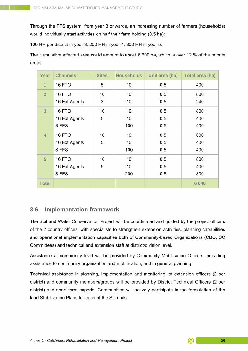
Through the FFS system, from year 3 onwards, an increasing number of farmers (households)
would individually start activities on half their farm holding (0.5 ha):
100 HH per district in year 3; 200 HH in year 4; 300 HH in year 5.
The cumulative affected area could amount to about 6,600 ha, which is over 12 % of the priority
areas:
Year Channels Sites Households Unit area (ha) Total area (ha)
1 16 FTO 5 10 0.5 400
2 16 FTO
16 Ext Agents
10
3
10
10
0.5
0.5
800
240
3 16 FTO
16 Ext Agents
8 FFS
10
5
10
10
100
0.5
0.5
0.5
800
400
400
4 16 FTO
16 Ext Agents
8 FFS
10
5
10
10
100
0.5
0.5
0.5
800
400
400
5 16 FTO
16 Ext Agents
8 FFS
10
5
10
10
200
0.5
0.5
0.5
800
400
800
Total 6 640
3.6 Implementation framework
The Soil and Water Conservation Project will be coordinated and guided by the project officers
of the 2 country offices, with specialists to strengthen extension activities, planning capabilities
and operational implementation capacities both of Community-based Organizations (CBO, SC
Committees) and technical and extension staff at district/division level.
Assistance at community level will be provided by Community Mobilisation Officers, providing
assistance to community organization and mobilization, and in general planning.
Technical assistance in planning, implementation and monitoring, to extension officers (2 per
district) and community members/groups will be provided by District Technical Officers (2 per
district) and short term experts. Communities will actively participate in the formulation of the
land Stabilization Plans for each of the SC units.
SIO-MALABA-MALAKISI WATERSHED MANAGEMENT STUDY
Annex 1 - Catchment Rehabilitation and Management Project 27
The use of Farmer Field Schools (FFS) has proven to be an effective extension mechanism for
simple agricultural improvements, which could be further upgraded by inclusion of more
integrated approaches towards cropping, specifically including erosion control. In similar areas,
large-scale up scaling of sustainable agricultural production is feasible, requiring only minimal
support for FFSs for the development of a FFS curriculum and training of trainers. FFSs should
cover a range of potentially suitable techniques (including agricultural modernization and
diversification options), which farmers can test and adjust to their farming environments.
The system of FFS would reach individual farmers. The Soil Conservation project will use this
system for promotion of technical measures but, in the same time, needs a set up wherein local
communities as a whole are contacted, sensitized and organized, as to plan interventions for a
larger contiguous area (village area, micro-catchments SC unit…).
Commitment of communities is to be raised on the basis of livelihood models providing
increased productivity as well as environmental protection. Wherever possible, productive
biological measures (contour hedges, agro-forestry measures) would be given preference
instead of mechanical measures. This would gradually entail a transition from a mono-cropping
model to a multi cropping agro-forestry model.
For the Soil and Water Conservation Sub-project, the IWMP will cooperate with the district and
division level MOA/MAAIF offices and with NEMA and KFS/FSSD and NFA staff at that level.
The Community Mobilization Officers will make the first contacts with communities in priority
areas, after introduction by the responsible Frontline Extension Officer to the area. They will
undertake sensitization activities and assist in community mobilization/ organization. They will
identify and contact existing CBOs in the area to this regard.
The Technical officers would join in at an early stage, for technical aspects, to familiarize with
the community and community-based approach. Their main task will be to guide field
implementation activities. Technical Officers will as much as possible work in close cooperation
with the Extension Officers, although the latter also have their parallel program with
NALEP/NAADS in the remaining area.
In case of new technologies, representatives of partner organizations will be responsible for
training/demonstration during initial implementation in the field, after which this will be taken
over by the Technical Field Officers.
Close cooperation will also be sought with WRUAs or sub-WRUAs when these are created in
the areas concerned, because of considerable overlap in interest and target groups. In existing
Catchment Management plans (example of Khalaba Catchment), responsibility for soil
conservation activities is normally ascribed to MOA/MAAIF staff.
Conditions of cooperation with partner organizations in catchment rehabilitation activities will be
stipulated in a Memorandum of understanding.
SIO-MALABA-MALAKISI WATERSHED MANAGEMENT STUDY
Annex 1 - Catchment Rehabilitation and Management Project 28
Institutional networking
Institutional networking will take place at two levels, notably at the level of community-based
institutions, and at the level of supporting institutions.
At the level of the community, when a group of community members decides to embark on
catchment rehabilitation, they will create an institution for this purpose or choose an existing
CBO through which they have undertaken community activities before. Focus will be on existing
Farmer Self Help groups, Forestry Resource User Group, Land Committees, Environment
Committees and others CBOs engaging in natural resource management, and Farmer Field
Schools who are already practicing improved and profitable land husbandry models.
Representative(s) of such groups could be contracted as “model farmers” or “demonstration
farmers” to assist in sensitization/extension. Networking between these CBOs will be promoted
by organizing exchange visits and local level stakeholder meetings.
At the level of supporting institutions, emphasis will be put on institutional networking, as:
■ To make use of all knowledge, experience and capacity available in the area on the subjects concerned, and
■ To mobilize multiple resources and encourage a stronger focus for implementation in the priority intervention areas.
It is aimed at having the intervention area covered by a network of intervention partners. Special
management workshops will be organized with candidate partners to harmonize activities by
various institutions, to ensure complementarities and avoid duplication or contradictory
approaches, and to formulate specific tasks of each institution in the CRSP.
Arrangements for cooperation will, among others, be made with:
■ NALEP and NAADS, the principle partners for extension services;
■ KFS and FSSD &NFA, for knowledge transfer regarding the establishment of private nurseries, production and tending of fruit trees, marketing of agroforestry produce; production of specialized planting material
■ Other line agencies concerned with environmental protection (NEMA, District Water Offices);
■ Newly created WRUAs and equivalent future organizations for sub-WMZ in Uganda, for integration of catchment rehabilitation activities into the wider perspective of integrated watershed management. WRUAs can also request for funding from a special Trust Fund created for watershed management;
■ NGOs, both working on technical aspects (for example VI) and aspects of community support (case of World Vision);
■ National and international institutes responsible for research and knowledge transfer (ICRAF)
SIO-MALABA-MALAKISI WATERSHED MANAGEMENT STUDY
Annex 1 - Catchment Rehabilitation and Management Project 29
■ Ongoing projects in the area like MERECP, SHOMAP;
■ Existing information exchange networks: Agroforestry Network, Forest Action Network…
■ Individuals and institutions already promoting conservation agriculture, such as the ADTCs in Western province of Kenya;
■ the Kasi kwa Vijana” (work for youth program).
Transboundary aspects
■ The PMU and country coordination team would see to an equitable attention to interests on either side of the border.
■ All general planning efforts will be carried out as a joint effort of representatives from relevant line agencies in both partner countries.
■ Implementation will be effectuated by Community Mobilisation Officers and Technical Field Officers in cooperation with line agency staff on either side of the border.
■ Agreements with implementation partners will be conform a format agreed upon by both partner countries.
■ Agreements regarding local environmental regulations and commitments will be formulated through mutually agreed upon bylaws being in compliance with legislation in both partner countries. It is important that locally formulated bylaws are approved at the district level. In Uganda where bylaws are approved by the district (Ugandan equivalent of LG5), the communities prove to be more confident in enforcing them.
3.7 Implementation monitoring
3.7.1 Indicators
Performance indicators have been proposed to reflect the progress of the sub-project
implementation and impacts of activities undertaken under the different components.
The Performance indicators for sub-project progress and outcomes are the following table.
Table 4: Performance indicators for sub-project
KEY OUTPUTS INDICATOR FOR SUB-PROJECT
PROGRESS/OUTCOMES INDICATOR FOR
SUB-PROJECT IMPACTS
A. Identification of SC intervention areas and mapping; project design for stabilization and production of stabilization plans for each SC areas
Number of stabilization plans edited, disclosed and agreed by SC committees members
B. Major erosion figures (Lavakas, major gullies and landslides) are treated in the intervention areas;
Maintenance of works is organized
Hectares treated for erosion control in the targeted areas
Number of maintenance agreements signed
Stabilization of the treated areas
Sediment loads in the water bodies
SIO-MALABA-MALAKISI WATERSHED MANAGEMENT STUDY
Annex 1 - Catchment Rehabilitation and Management Project 30
KEY OUTPUTS INDICATOR FOR SUB-PROJECT
PROGRESS/OUTCOMES INDICATOR FOR
SUB-PROJECT IMPACTS
C. SC Committees are identified, FFS are created and members are trained;
Extension staff are trained to organize, able to facilitate and provide on-going support to committees;
Research institutes are identify and involved in specific tasks
Number of committees and FFS established and operational
Number of training sessions/visits/workshops and persons trained
Terms of reference for research institutes involvement
Extension staff and farmers familiar with FFS methodology
Understanding of SC practices
D. Equipment and tools are available (Owners of draught animal power (DAP) and tractors are able to offer hire-services to other farmers + Local manufacturers and retail sector are able to supply tools and equipment suitable for conservation agriculture practices to farmers)
Trained operators and animals available for each farmer group
Access to SC equipment and maintenance for each farmer group
Sustainability of SC practices
E. Revolving funds/micro-credit mechanisms is established and accessible to farmers
Number of beneficiaries
Financial capacities of farmers for investments
Farmers income
F. Farmers adopt and apply practices for soil erosion control and agroforestry;
Rational use of fertilizers and other agricultural inputs has improved;
Non point pollution in the river bodies has decreased.
Number of individual farmers applying SC practices
Hectares/linear treated with new SC techniques
Quantity of fertilizers and other inputs used by farmers members of the SC Committees
Soil fertility
Level of pression on marginal lands and forest for croplands settlement
Water quality (sediment load, organic matter, nutriments and pollutants) of the water bodies
G. Farmers have access to market for their cash crop production and other products
Agricultural yields are increasing
Increasing of annual volumes of cash crops and other products
Identification of marketing channels for new products
Farmer’s income and food security
H. Local water funds is established and operational
Targeted infrastructures are identified, works are planned and implemented, operation and maintenance framework is established
Number of sites restored and operational
Number of operation and maintenance agreements
Capacity of water harvesting
I. Knowledge networks for exchanging experiences are established at local and transboundary levels
Stakeholders forums are operational
Progress in transboundary exchanges and land management
Level of farmer solidarity and decision power
SIO-MALABA-MALAKISI WATERSHED MANAGEMENT STUDY
Annex 1 - Catchment Rehabilitation and Management Project 31
3.7.2 Schedule
According to the general schedule proposed for monitoring and evaluation, indicators will be
informed to allow drafting of reports semi-annual and annual rapports.
3.8 Cost breakdown
The table below shows the costs and benefits for this sub-project expressed in USD for a 1 ha
unit.
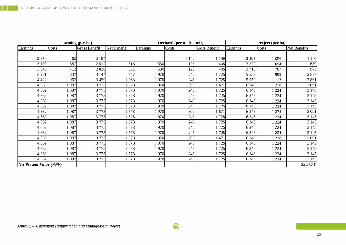
SIO-MALABA-MALAKISI WATERSHED MANAGEMENT STUDY
Annex 1 – Catchment Rehabilitation and Management Project 32
Earnings Costs Gross Benefit Net Benefit Earnings Costs Gross Benefit Earnings Costs Net Benefits
2 659 462 2 197 - - 1 140 - 1 140 2 393 1 556 - 1 140 3 100 587 2 512 316 530 126 405 3 320 654 689 3 540 712 2 828 631 530 126 405 3 716 767 973 3 981 837 3 144 947 1 970 246 1 725 5 553 999 2 577 4 422 962 3 459 1 263 1 970 246 1 725 5 950 1 112 2 861 4 862 1 087 3 775 1 578 1 970 300 1 671 6 346 1 278 3 091 4 862 1 087 3 775 1 578 1 970 246 1 725 6 346 1 224 3 145 4 862 1 087 3 775 1 578 1 970 246 1 725 6 346 1 224 3 145 4 862 1 087 3 775 1 578 1 970 246 1 725 6 346 1 224 3 145 4 862 1 087 3 775 1 578 1 970 246 1 725 6 346 1 224 3 145 4 862 1 087 3 775 1 578 1 970 300 1 671 6 346 1 278 3 091 4 862 1 087 3 775 1 578 1 970 246 1 725 6 346 1 224 3 145 4 862 1 087 3 775 1 578 1 970 246 1 725 6 346 1 224 3 145 4 862 1 087 3 775 1 578 1 970 246 1 725 6 346 1 224 3 145 4 862 1 087 3 775 1 578 1 970 246 1 725 6 346 1 224 3 145 4 862 1 087 3 775 1 578 1 970 300 1 671 6 346 1 278 3 091 4 862 1 087 3 775 1 578 1 970 246 1 725 6 346 1 224 3 145 4 862 1 087 3 775 1 578 1 970 246 1 725 6 346 1 224 3 145 4 862 1 087 3 775 1 578 1 970 246 1 725 6 346 1 224 3 145 4 862 1 087 3 775 1 578 1 970 246 1 725 6 346 1 224 3 145
Net Present Value (NPV) 52 975 €
Farming (per ha) Orchard (per 0.1 ha unit) Project (per ha)
SIO-MALABA-MALAKISI WATERSHED MANAGEMENT STUDY
Annex 1 - Catchment Rehabilitation and Management Project 33
CHAPTER 4. Conservation Agriculture
4.1 Sub-project justification
LVNCMS sees a high potential for increased agricultural productivity, on the basis of
introduction of modern agricultural practices, use of high yielding and disease resistant varieties,
development of irrigation infrastructure, reduction of post harvest losses, agro-processing
facilities, and marketing of agricultural products. This package sounds interesting as an overall
long term goal. It is being promoted by many already for a long time, without in-depth analysis of
its not being adopted by small-scale subsistence farmers.
What is needed more urgently from the watershed management perspective, are
farming/forestry practices geared to the integrated goal of increased production and improved
environmental protection (prevention of erosion). The introduction of such approaches is most
urgent in areas with highest erosion hazards or evidence. The combined production-protection-
oriented approach implies a much stronger emphasis on agro-forestry components and
conservation farming. These are highly productive techniques providing a more continuous
vegetative ground cover and a much better alternative for clean weeding land preparation
before the onset of rainy seasons. Also, a well established farming system along these lines
would require less input of labour intensive terracing works.
Introduction of conservation agriculture practices aims at achieving better and more permanent
soil cover in connection with improving soil fertility, providing protection from erosion and
preventing outwash of agricultural chemicals. Conservation agriculture (CA) is seen as a more
sustainable land-use practice that incorporates the essential elements of land preparation and
planting, but eliminates the need to disturb the soil regularly. Besides reducing the cost of crop
production, CA increases soil moisture and fertility significantly, leading to higher yields. These
advantages indicate that for arable land, CA is a viable alternative to conventional soil
conservation programmes and traditional land preparation.
Conservation agriculture in the form of zero tillage, together with crop rotations and permanent
cover, is more crucial in a landscape where animal or tractor power, repetitive tillage and
downslope tillage and monocultures are prevalent. Where the traditional farming practices
include perennial and annual species that already provide a good soil cover, improvements
could focus on integrated soil fertility, water and biodiversity management for pest and disease
control and added productivity and value (e.g., niche markets, eco-labelling).
A basic competence in conservation farming has built up in the region. Some technical officers
have received training in conservation farming.
SIO-MALABA-MALAKISI WATERSHED MANAGEMENT STUDY
Annex 1 - Catchment Rehabilitation and Management Project 34
In Kenya, one of the two Agricultural Development Training Centres is specially promoting
conservation farming. Elements of conservation farming (grass strips, trash lines, zero tillage)
are being promoted by MoA in several districts.
Conservation Agriculture was initiated in the larger Bungoma District through the FAO initiated
CA-SARD Project (Conservation Agriculture for Sustainable Agriculture & Rural Development)
and further upscaled through GTZ supported Sustainet.
In Uganda, conservation agriculture methodologies were, among others, propagated through
the NARO implemented INSPIRE project (Integrated Soil Productivity Initiative through
Research and Education, 2002–2005), covering Tororo and Busia districts.
In both countries, CA extension has been effectuated through the Farmer Field School (FFS)
approach. Farmer field schools aim to make farmers experts in their own fields. They do this
through a systematic training process of weekly discovery-based learning sessions during the
crop cycle. Small groups of farmers observe the growing crop, analyze their findings, make
recommendations, and share with the rest of the farmer field school members. This process
allows farmers to learn, use their previous experience, and innovate alternative ways of dealing
with their own problems, so improving their ability to make decisions.
A farmer-centred integrated curriculum guides the process. This helps farmers define the study
agenda and later subtopics they are interested in. Farmers take the lead in the learning process.
The curriculum is based on a participatory training needs assessment between the farmers and
a facilitator. It takes into account constraints and opportunities identified through baseline
surveys.
Promoting land and water management through farmer field schools has a bright future. The
Kenyan government’s Strategy for Revitalizing Agriculture emphasizes the role of natural
resource management in agricultural development. The farmer field school approach improves
the delivery of extension and advisory services, ensures access to financial services and farm
inputs, and creates networks to act as centres for value addition and marketing of agricultural
produce.
In Uganda, pilot projects using farmer field schools to promote improved land and water
management have yielded commendable achievements. They have shown that land
degradation and food insecurity can be reduced and livelihoods improved through farmer field
schools. Concerted efforts from all stakeholders – government, donors, civil society, the private
sector, development partners and communities – are needed to invest in farmer field schools
and scale up the successes created by recent pilot activities.
SIO-MALABA-MALAKISI WATERSHED MANAGEMENT STUDY
Annex 1 - Catchment Rehabilitation and Management Project 35
4.2 Sub-project specific objectives/key outputs
4.2.1 Specific Sub-Project objectives
The specific objectives of the sub-project are the followings:
■ Target intervention areas are identified and techniques to be promoted are selected and disseminated
■ Farmer’s professional environment is operational: farmers have access to technical advices, suitable tools, service hiring, inputs supply and revolving funds for their investments and access to market for their products trading
■ CA-techniques practices, treatments and cash-crops are adopted by farmers in the watershed; Livelihood productivity is increased and better secured
■ Farmer’s income and food security are improved
■ Farmer’s professional network is operational and Farmers are including in the decision making process
4.2.2 Sub-project outputs
The sub-project key outputs are the followings:
A. Target intervention areas and techniques to be promoted are identified
B. Extension staff are equipped and trained to organize, facilitate and provide on-going support
to operational CA-FFS and apply participatory extension approach for CA development
C. CA equipment and tools are available (Owners of draught animal power (DAP) and tractors
are able to offer hire-services in CA practices to other farmers + Local manufacturers and retail
sector are able to supply tools and equipment suitable for conservation agriculture practices to
farmers)
D. Revolving funds / micro-credit mechanisms is established and accessible to farmers
E. Farmers adopt and apply conservation agriculture practices;. Rational use of fertilizers and
other agricultural inputs has improved
F. Farmers have access to market for their cash crop production
G. Knowledge networks for exchanging experiences are established at local and transboundary
levels
SIO-MALABA-MALAKISI WATERSHED MANAGEMENT STUDY
Annex 1 - Catchment Rehabilitation and Management Project 36
4.3 Provisional benefits
The benefits of the Conservation Agriculture sub-project are described under the 3 basic lines:
4.3.1 Watershed conservation
■ Decrease of erosion and loss of arable lands
■ Increase of soil fertility
■ Decrease of use of fertilizers and other chemicals (pesticides…) polluting rivers and water storage
Climate risk adaptation/mitigation
Global climate models forecast changes in rainfall pattern and temperature leading to shorter
rains of higher intensity, with drought spells of similar duration or frequency with the current
ones, but more intense. Under such conditions, the recommendations brought by the project
tending to a more varied set of income sources for each household based on diversification of
crops will act positively.
With this increase in varieties, selection of plants should be guided for improved soil cover
leading to a decrease in soil erosion.
4.3.2 Income generation
Diversification of products and source of income. The sub-project, while increasing yields
will also contribute to introducing of new products and cash crops. Enlargement of the
production will contribute to secure income and livelihoods and income.
Market access. Agroforestry’s contribution to poverty reduction is dependent on people’s
access to product markets. Market access can be improved through construction of roads,
development of farmer organizations to increase the bargaining power of producers, or with
direct support establishing contact between producers and traders
4.3.3 Watershed management
Poverty reduction. Conservation Agriculture projects can reduce poverty directly by providing
higher yields for most products, in a highly significant level, with progressive efficacy.
Development of non-agricultural activities such as beekeeping or production of aromatic and
medicinal plants will also act in favour of poverty reduction. These activities, moreover, can be
handled mostly by women.
SIO-MALABA-MALAKISI WATERSHED MANAGEMENT STUDY
Annex 1 - Catchment Rehabilitation and Management Project 37
Reducing vulnerability. Conservation agriculture is a strong argument towards reducing the
vulnerability through improvement of soil moisture during longer periods. Increased crop
diversity is also a resource against climate change.
Access to technical advice and professional network. The double capacity building process
intended for the SMM programme is expected to give good results in term of professional
advice: first at community level group through the Farmer Field School process, and then at
coordination level promoting exchanges among the different groups.
Access to micro credit for new investments and development of complementary income
generating activities will also participate in facilitating initiatives from persons or groups currently
less favoured.
4.4 Location of intervention areas
Conservation Agriculture is required in most parts of the SMM catchment, including seasonal
wetlands, as part of the solution to increase productivity to face demographic pressure; yet in
some areas it comes a secondary activity, while in other ones it is the central concern.
The CA subproject would potentially cover all districts included in the CRMP, i.e. Tororo and
Manafwa in Uganda and Bungoma and Teso districts in Kenya, and include also those parts of
Busia Kenya and Busia Uganda districts that are not fully dominated by the sugarcane sector.
Priority areas will include:
In Manafwa district: Buwabwala, Bupoto, Bumbo, Bumbwoni, Bubutu and Butiru villages;
In Teso North: Aremit and Apegei locations;
Villages located around the city of Tororo;
Villages immediately west of the city of Bungoma.
4.5 Sub-project activities
Activity 1: Community awareness and capacity building for Conservation Agriculture
project
■ Identification or creation of FFS, integration of stakeholders forums; training sessions, workshops and visits, and production and dissemination of technical and communication support
Activity 2: Community support for implementation of Conservation agriculture improved
techniques and practices
■ Provide assistance to FFS to apply conservative agriculture practices within their member’s land: technical advice, improvement of organisational capacities (for farmers and government extension agencies)
SIO-MALABA-MALAKISI WATERSHED MANAGEMENT STUDY
Annex 1 - Catchment Rehabilitation and Management Project 38
■ Support access to marketing of products
■ Revolving funds for farmer’s investment/operation
Activity 3: Support of suppliers, providers of local hire services and manufacturers of
tools and machinery
■ Identification of target suppliers and providers; building networks; introduction of new tools
■ Revolving funds for suppliers or providers
4.5.1 Means
The project will promote further introduction of Conservation Agriculture as a relatively new
agricultural technology to smallholder farming systems in SMM districts of Kenya and Uganda
with the aim of raising agricultural productivity and using scarce natural resources in a more
sustainable and efficient way.
The project will build on the momentum in CA development created by previous projects in
Bungoma in Kenya and in Tororo and Busia in Uganda.
Where necessary, it will revitalize and consolidate the network of knowledgeable persons in this
field, at the level of
■ district government line agencies,
■ research and training institutions (NARO, KARI),
■ Agricultural Development Training Centers,
■ Farmer Field Schools and local communities (trained farmers from previous projects),
■ Members of the African Conservation Tillage (ACT) Network, FAO/GTZ SARD program.
A workshop will be organized in each participating country to discuss previous experiences and
lessons learnt, with regard to technologies propagated and to procedures of contacting
communities, creating new farmer field schools (FFS), and methods of upscaling. “Long lists” of
technologies will be compiled that appear most relevant to the CRMP project and prevailing
agro-climatic conditions.
Main elements of project design are:
■ Promotion of Conservation Agriculture with the three key principles: i) minimum soil disturbance, ii) soil cover (with mulch, or cover crops, preferably legumes) and iii) crop rotation or association.
■ Support to farmer groups via Farmer Field Schools (FFS).
■ Encouragement and support of service providers such as local hire services for no-till farming operations and national manufacturers of machinery (sub-soilers, rippers, and direct seeders).
SIO-MALABA-MALAKISI WATERSHED MANAGEMENT STUDY
Annex 1 - Catchment Rehabilitation and Management Project 39
A project CA Officer, trained by the project’s CA specialist, will be appointed in each district (10
in total), to assist in the work of trained farmers from previous projects (CA Facilitators) and
government extension staff or project staff (2 per district). Trained farmers (CA facilitators) and
extension staff will receive follow up training by the project’s CA specialist, in cooperation with
the African Conservation Tillage Network and national research institutes (NARO and KARI). A
well designed training curriculum exists for this purpose, formulated by the previous projects,
and comprehensive and well designed training material is available.
The CA facilitators and extension staff will promote, and assist in creation of, new FFS for
conservation agriculture. Trained farmers act as CA facilitators to new FFS. Exchange visits to
existing FFS will add to the acceptance on new sites.
4.5.2 Quantities
FFS are operated by farmer groups. Main elements of the FFS concept will be:
■ Farmer groups (up to 25 members of women and men) are guided by extension workers in experimentation and learning of Conservation agriculture until they graduate as CA-farmers (earliest after 1, latest after 3 years).
■ Each farmer group conducts a field trial, in which various CA measures (subsoiling, legume cover etc.) are compared with the traditional farming method with respect to plant development, yield etc. Farmer groups use an experimental lay-out and receive a modest subsidy for an input package (fertilizer, herbicides and seed and shared machinery for the experiment),
■ The field implementation is supported by national extension services under guidance and supervision of national agricultural research institutions (KARI and NARO).
■ Farmer groups are supported to exchange experiences between each other and to join local CA networks for continued cooperation.
Focus will be put on farmer-led FFS, as opposed to extension staff-led FFS, to reduce costs and
increase the number. Extension staff should backstop farmer field school groups technically,
and not be the main facilitators. They pay regular visits (in monthly intervals during the growing
season) to the farmer groups until they are graduated.
A project revolving fund should be created to finance operation of FFS. Previous experience has
shown that FFS can be operated at a cost of about 10 US$ per farmer. That translates into a
grant of a few hundred dollars per group. Other stakeholders could be invited to participate in
joint funding of farmer field schools.
Relationships will be established with local (private or government) credit facilitators to enable
farmers to invest in inputs required to apply what they have learned.
Contacts will be renewed with local manufacturers in Kenya and Uganda producing small CA
implements. Batch orders could be placed through the project or by ministries of agriculture and
other institutions.
SIO-MALABA-MALAKISI WATERSHED MANAGEMENT STUDY
Annex 1 - Catchment Rehabilitation and Management Project 40
The project will be allocated a subsidy budget fund to buy a number of small implements for
demonstration purposes, and to hire larger implements for one-time initial land preparation
where needed.
A project period of five years would be required to obtain substantial outputs. Since programs of
this kind are generally having an impact growing substantially only after longer period, a donor
should preferably be prepared to a longer term commitment.
Based on experience in previous projects in the region, the following implementation rates can
be anticipated. If three extension staff are allocated per district to work with the project, and
sufficient CA facilitators can be found to join them, the number of new FFS for conservation
agriculture can amount to
In Year 1: 10 (districts) x 1 CA officer x 2 CA facilitators) x 5 new FFS = 150 FFS
In Year 2: 10 (districts) x 1 CA officer x 2 CA facilitators) x 10 new FFS = 300 FFS
In Year 3: 10 (districts) x1 CA officer x 2 CA facilitators) x 10 new FFS = 300 FFS
In Year 4: 10 (districts) x 1 CA officer x 2 CA facilitators) x 10 new FFS = 300 FFS
In Year 5: 10 (districts) x 1 CA officer x 2 CA facilitators) x 10 new FFS = 300 FFS
Total 1350 FFS
It can also be anticipated (through experience in previous projects) that
■ one FFS is run by a group of 20 farmers,
■ implementation will develop over a 5-year period for each FFS
■ farmers will implement conservation agriculture on about 50 % of their own farm.
The project would progressively achieve introduction of conservation agriculture on
■ 1,350 (FFS) x 20 (farmers per FFS) x 0.5 ha = 13,500 ha (complete by year 9)
4.6 Implementation framework
The sub-project will be coordinated by the project’s CA coordinator based in Bungoma for
Kenya and the liaison officer based in Tororo coordination office for Uganda.
For training/extension matters, the project will be supported by a Training/Extension specialist.
If availability of governmental district staff is too low, NGOs in the area will be contracted to
provide staff to perform as CA project facilitators (2 per district), who will be stationed in the
respective districts, and will work from there with CA district officers (1 per district). They will
receive regular visits from the project’s CA specialist (from IWMP office in Bungoma and/or its
liaison officer from IWMP office in Tororo)).
SIO-MALABA-MALAKISI WATERSHED MANAGEMENT STUDY
Annex 1 - Catchment Rehabilitation and Management Project 41
The sub-project will strongly build on good cooperation with network partners: national research
organizations, local Agricultural Development Training Centers, government line agencies at
different levels, the ACT, FAO CA-SARD program, donors like GTZ, credit facilitators, local
manufacturers. Cooperation will be formalized in the form of Cooperation Agreements.
As the central CRMP project office is located in Bungoma in Kenya, a liaison officer (for
accounts and logistics) for the entire CRMP will be stationed half time in one of the main project
districts in Uganda.
4.7 Monitoring
4.7.1 Indicators
Performance indicators have been proposed to reflect the progress of the sub-project
implementation and impacts of activities undertaken under the different components of the sub-
project.
The Performance indicators for sub-project progress and outcomes are the following table.
Table 5: Performance indicators for sub-project 1C
KEY OUTPUTS
PERFORMANCE INDICATOR
SUB-PROJECT PROGRESS/OUTCOMES
PERFORMANCE INDICATOR
SUB-PROJECT IMPACTS
A. Target intervention areas and techniques to be promoted are identified
Guidelines for CA implementation is produced
Knowledge on CA is disseminated
B. Extension staff are equipped and trained to organize, facilitate and provide on-going support to operational CA-FFS and apply participatory extension approach for CA development
Number of training, visits and workshops
Extension staff and farmers familiar with FFS methodology
Understanding of CA practices
C. CA equipment and tools are available (Owners of draught animal power (DAP) and tractors are able to offer hire-services in CA practices to other farmers + Local manufacturers and retail sector are able to supply tools and equipment suitable for conservation agriculture practices to farmers)
Trained operators and animals available for each farmer group
Access to CA equipment and maintenance for each farmer group
D. Revolving funds / micro-credit mechanisms is established and accessible to farmers
Number of beneficiaries
Financial capacities of farmers for investment in new technologies are improved
SIO-MALABA-MALAKISI WATERSHED MANAGEMENT STUDY
Annex 1 - Catchment Rehabilitation and Management Project 42
KEY OUTPUTS
PERFORMANCE INDICATOR
SUB-PROJECT PROGRESS/OUTCOMES
PERFORMANCE INDICATOR
SUB-PROJECT IMPACTS
E. Farmers adopt and apply conservation agriculture practices
Rational use of fertilizers and other agricultural inputs has improved
Number of CA-FFS established and operational
Number of individual farmers applying CA-practices
Surfaces dedicated to CA practices
Quantity of fertilizers and other inputs used by farmers members of the SC Committees
Livelihood productivity
Level of pressure on marginal lands and forest fro cropland settlement
Soil fertility
F. Farmers have access to market for their cash crop production
Volume of cash crops trade on local markets
Farmers income
G. Knowledge networks for exchanging experiences are established at local and transboundary levels
Stakeholders forums are operational
Level of Farmers solidarity and decision power
4.7.2 Schedule
According to the general schedule proposed for monitoring and evaluation, indicators will be
informed to allow drafting of reports semi-annual and annual rapports.
4.8 Costs and benefits breakdown
Typical costs and benefits have been established for different parts of the catchment, in USD
per ha. Areas have been taken tentatively as equal in the three areas: upper, medium and lower
catchment. Conditions are expected to vary progressively from Without-Project to With-project
conditions; these are supposed to be reached at the fifth year from the end of the investment
phase, i.e. by year 9 of implementation. Net Present Value is calculated at a 12% discount rate.
SIO-MALABA-MALAKISI WATERSHED MANAGEMENT STUDY
Annex 1 - Catchment Rehabilitation and Management Project 43
Earnings Costs Gross benefit Net Benefit Area (ha) Earnings Costs Net Benefits
1 2 659 462 2 197 - 100 - - - 2 3 071 531 2 539 343 400 164 617 27 583 137 034 3 3 482 600 2 882 685 900 740 777 124 124 616 653 4 3 894 669 3 224 1 028 1 600 1 975 405 330 997 1 644 408 5 4 305 738 3 567 1 370 2 500 4 115 426 689 577 3 425 849 6 4 717 807 3 909 1 713 3 300 6 790 454 1 137 802 5 652 651 7 4 717 807 3 909 1 713 3 900 8 025 081 1 344 675 6 680 406 8 4 717 807 3 909 1 713 4 300 8 848 167 1 482 591 7 365 576 9 4 717 807 3 909 1 713 4 500 9 259 709 1 551 549 7 708 161 10 4 717 807 3 909 1 713 4 500 9 259 709 1 551 549 7 708 161 11 4 717 807 3 909 1 713 4 500 9 259 709 1 551 549 7 708 161 12 4 717 807 3 909 1 713 4 500 9 259 709 1 551 549 7 708 161 13 4 717 807 3 909 1 713 4 500 9 259 709 1 551 549 7 708 161 14 4 717 807 3 909 1 713 4 500 9 259 709 1 551 549 7 708 161 15 4 717 807 3 909 1 713 4 500 9 259 709 1 551 549 7 708 161 16 4 717 807 3 909 1 713 4 500 9 259 709 1 551 549 7 708 161 17 4 717 807 3 909 1 713 4 500 9 259 709 1 551 549 7 708 161 18 4 717 807 3 909 1 713 4 500 9 259 709 1 551 549 7 708 161 19 4 717 807 3 909 1 713 4 500 9 259 709 1 551 549 7 708 161 20 4 717 807 3 909 1 713 4 500 9 259 709 1 551 549 7 708 161 NPV Net Present Value (NPV) 31 681 958
Upper catchment
ProjectFarming (per ha)Year
Earnings Costs Gross benefit Net Benefit Area (ha) Earnings Costs Net Benefits
1 2 659 462 2 197 - 100 - - - 2 3 100 587 2 512 316 400 176 274 49 996 126 278 3 3 540 712 2 828 631 900 793 234 224 984 568 251 4 3 981 837 3 144 947 1 600 2 115 291 599 957 1 515 335 5 4 422 962 3 459 1 263 2 500 4 406 857 1 249 910 3 156 948 6 4 862 1 087 3 775 1 578 3 300 7 271 315 2 062 351 5 208 964 7 4 862 1 087 3 775 1 578 3 900 8 593 372 2 437 324 6 156 048 8 4 862 1 087 3 775 1 578 4 300 9 474 743 2 687 306 6 787 437 9 4 862 1 087 3 775 1 578 4 500 9 915 429 2 812 297 7 103 132
10 4 862 1 087 3 775 1 578 4 500 9 915 429 2 812 297 7 103 132 11 4 862 1 087 3 775 1 578 4 500 9 915 429 2 812 297 7 103 132 12 4 862 1 087 3 775 1 578 4 500 9 915 429 2 812 297 7 103 132 13 4 862 1 087 3 775 1 578 4 500 9 915 429 2 812 297 7 103 132 14 4 862 1 087 3 775 1 578 4 500 9 915 429 2 812 297 7 103 132 15 4 862 1 087 3 775 1 578 4 500 9 915 429 2 812 297 7 103 132 16 4 862 1 087 3 775 1 578 4 500 9 915 429 2 812 297 7 103 132 17 4 862 1 087 3 775 1 578 4 500 9 915 429 2 812 297 7 103 132 18 4 862 1 087 3 775 1 578 4 500 9 915 429 2 812 297 7 103 132 19 4 862 1 087 3 775 1 578 4 500 9 915 429 2 812 297 7 103 132 20 4 862 1 087 3 775 1 578 4 500 9 915 429 2 812 297 7 103 132
NPV Net Present Value (NPV) 29 195 179
Middle Catchment
ProjectFarming (per ha)Year
SIO-MALABA-MALAKISI WATERSHED MANAGEMENT STUDY
Annex 1 - Catchment Rehabilitation and Management Project 44
Earnings Costs Gross benefit Net Benefit Area (ha) Earnings Costs Net Benefits
1 2 259 472 1 787 - 100 - - - 2 2 703 545 2 158 371 400 177 419 29 004 148 414 3 3 146 617 2 529 742 900 798 385 130 520 667 865 4 3 590 690 2 900 1 113 1 600 2 129 026 348 052 1 780 973 5 4 033 762 3 271 1 484 2 500 4 435 470 725 108 3 710 361 6 4 477 835 3 642 1 855 3 300 7 318 525 1 196 429 6 122 096 7 4 477 835 3 642 1 855 3 900 8 649 166 1 413 961 7 235 205 8 4 477 835 3 642 1 855 4 300 9 536 260 1 558 983 7 977 277 9 4 477 835 3 642 1 855 4 500 9 979 807 1 631 494 8 348 313
10 4 477 835 3 642 1 855 4 500 9 979 807 1 631 494 8 348 313 11 4 477 835 3 642 1 855 4 500 9 979 807 1 631 494 8 348 313 12 4 477 835 3 642 1 855 4 500 9 979 807 1 631 494 8 348 313 13 4 477 835 3 642 1 855 4 500 9 979 807 1 631 494 8 348 313 14 4 477 835 3 642 1 855 4 500 9 979 807 1 631 494 8 348 313 15 4 477 835 3 642 1 855 4 500 9 979 807 1 631 494 8 348 313 16 4 477 835 3 642 1 855 4 500 9 979 807 1 631 494 8 348 313 17 4 477 835 3 642 1 855 4 500 9 979 807 1 631 494 8 348 313 18 4 477 835 3 642 1 855 4 500 9 979 807 1 631 494 8 348 313 19 4 477 835 3 642 1 855 4 500 9 979 807 1 631 494 8 348 313 20 4 477 835 3 642 1 855 4 500 9 979 807 1 631 494 8 348 313
NPV 34 313 102
Lower CatchmentProjectFarming (per ha)
Year
SIO-MALABA-MALAKISI WATERSHED MANAGEMENT STUDY
Annex 1 - Catchment Rehabilitation and Management Project 45
CHAPTER 5. Riverbank protection
5.1 Sub-project justification
The main cause of riverbank erosion is encroachment (including clearance) of former seasonal
wetlands, in a search for additional cropland. The logical solution is therefore to restore some
kind of more permanent vegetation in a buffer zone along the streams. Both Kenya and Uganda
have addressed this issue with variable but unsatisfactory success.
Regulations exist to protect riparian zones. However, both countries have not been able to settle
this issue through laws and regulations to safeguard riparian zones as those are not adequately
enforced. Within the framework of NALEP/NAADS extension activities, riparian zones have
been pegged in a number of places in a cooperative effort of line agencies (NEMA, MoA/MAAIF,
and NFA/KFS) and farmers. This has gone together with the extension message that beyond
these boundary farmers should refrain from cropping, and allow restoration of natural vegetation
or establish a perennial cover crop. At present, too little capacity exists to provide farmers with
technical assistance and related necessary inputs to establish these new improved systems.
5.2 Sub-project objectives/key outputs
5.2.1 Sub-project specific objectives
The specific objectives of the sub-project 1C are the followings:
A. Awareness and capacities of communities and technical officers towards riverbank protection
and restoration have increased
B. Representatives pilot areas are restored for sensitization and promotion of good practices
purpose
5.2.2 Sub-project key outputs
The sub-project key outputs are the following:
■ Guidelines for riverbank protection and restoration are produced, printed and disseminated
■ Community awareness, knowledge of laws and capacities towards riverbank protection and restoration are increased
■ Pilot areas representatives of different type of degradation are identified and mapped, restoration operation are implemented with promoted techniques on pilot areas
SIO-MALABA-MALAKISI WATERSHED MANAGEMENT STUDY
Annex 1 - Catchment Rehabilitation and Management Project 46
5.3 Provisional benefits
The benefits of the Riverbank protection sub-project are described under the 3 basic lines:
5.3.1 Environmental conservation
Decrease of erosion and loss of arable lands
Decrease of flooding events
Decreasing of sediments load in rivers and silting of river beds, and river storage
Adaptation to forecast increase of extreme events and flooding
5.3.2 Income generation
Increase of yields and diversification of crop production including cash crops
Access to market and trades for the products
5.3.3 Watershed management
Increasing awareness of consequences of riverbank degradation and usefulness of river
bank and river beds protection and related laws and regulation
Increasing knowledge regarding possible restoration techniques
Access to micro credit for new investments and development of complementary income
generating activities
5.4 Location of intervention areas
The riverbank protection component in principle would have to be implemented in banks of most
of the main streams in the SMM basin, some of which extend beyond the proposed CRMP
intervention area. This would necessitate a project with too large an intervention zone to be
effective. Highest priorities have been identified for:
Walatsi village in Nambale district
Tingolo village in Butula district
Bunyala village in Central district
SIO-MALABA-MALAKISI WATERSHED MANAGEMENT STUDY
Annex 1 - Catchment Rehabilitation and Management Project 47
In areas touched by the Wetland Management project, riverbank protection will automatically be
part and parcel of wetland management activities.
Other priority sites or priority riverbank sections will be indicated by stakeholder technical
agencies already active in this field, and by local communities. Other sites will be added as a
result of riverbank reconnaissance.
5.5 Project description
Activity 1: Community awareness and capacity building for Riverbank protection
■ Identification of individual owners or concerned communities
■ Promotion of existing laws and regulations (buffer zones 10 m K & 30 m U)
■ Training sessions, workshops and visits, and production and dissemination of technical and communication support
Activity 2: Implementation of Pilot intervention
■ Rehabilitation plans and budgets, management plan for operation and maintenance
■ Implementation of works
5.5.1 Means
Preliminary surveys will be implemented by consultancy services provided by riverbank
protection experts. They will monitor then supervise the implementation process all along the 5-
years of the project. Implementation of field will be managed by 6 technical field officers with an
agroforestry or forestry background, 1 per districts targeted for riverbank protection activities:
■ Manafwa and Tororo in Uganda,
■ Bungoma West and South, Teso North and South, in Kenya.
Activities will begin in the priority areas named in section 5.4 above. In those areas, a stage of
mobilization and awareness of population will seek to reach community support of the project
and to ensure that land owners or users in the areas will actively respect and contribute to
protect the rehabilitation areas.
SIO-MALABA-MALAKISI WATERSHED MANAGEMENT STUDY
Annex 1 - Catchment Rehabilitation and Management Project 48
5.5.2 Quantities
The Riverbank Protection Project is supposed to start with a first phase with duration of 5 years.
This is considered as a minimum period where tangible outputs can be expected, given the
gradual take off of implementation and the innovative character of suggested measures. Since
programs of this kind are generally having an impact growing substantially only after longer
period, a donor should preferably be prepared to a longer term commitment.
A tentative estimation of progress in river bank protection over a five years period, shows that a
total of over 25 km of river length including several different type of degradation addressed, can
be protected on the basis of 2 000 to 6 000 meters each year
One Agroforestry Field Officers would be deployed in 6 districts, to manage the pilot
rehabilitation works.
5.6 Implementation framework
The sub-project will be coordinated by the project’s CA coordinator based in Bungoma for
Kenya and the liaison officer based in Tororo coordination office for Uganda.
Surveys and supervision of rehabilitation work will be implemented by one or a team of
specialized consultants.
1 Agroforestry Field Officers would be deployed in each of the 6 districts, to manage the pilot
rehabilitation works.
The rehabilitation works will be implemented on river length from 2 000 meter to 6 000 meters
each year during 5 years.
Workshops, meetings and field visits, dissemination of technical material, organized by technical
officers will be the support of riverbank promotion and public awareness.
5.7 Monitoring
5.7.1 Indicators
Performance indicators have been proposed to reflect the progress of the sub-project
implementation and impacts of activities undertaken under the different components of the sub-
project.
The Performance indicators for sub-project progress and outcomes are the following table.
SIO-MALABA-MALAKISI WATERSHED MANAGEMENT STUDY
Annex 1 - Catchment Rehabilitation and Management Project 49
Table 6: Performance indicators for sub-project
KEY OUTPUTS
PERFORMANCE INDICATOR
SUB-PROJECT PROGRESS/OUTCOMES
PERFORMANCE INDICATOR
SUB-PROJECT IMPACTS
A. Guidelines for riverbank protection and restoration are produced, printed and disseminate
Number of printed and disseminated guidelines for riverbank protection and restoration
Level of awareness regarding riverbank restoration usefulness and techniques
B. Community awareness, knowledge of laws and capacities towards riverbank protection are increased
Number of private owner involved in pilot actions
Number of training sessions/workshops and visits organized
Public awareness level
C. Identification and mapping of pilots areas
Implementation of promoted techniques on pilot areas
Number of treated pilot areas.
Linear of stabilized and vegetated river banks
PMU GIS database
Sediment loads in the rivers
Carbon storage
Public awareness level
5.7.2 Schedule
According to the general schedule proposed for monitoring and evaluation, indicators will be
informed to allow drafting of reports semi-annual and annual rapports.
5.8 Costs and benefits breakdown
Benefits from this activity are not considered as quantifiable. Cost is estimated at USD
2,139,600 including a provision for Environmental and Social Monitoring. Details are provided in
the Annex on Investment Proposal.
SIO-MALABA-MALAKISI WATERSHED MANAGEMENT STUDY
Annex 1 - Catchment Rehabilitation and Management Project 50
CHAPTER 6. Promotion of sustainable practices for sand
abstraction
6.1 Sub-project justification
Uncontrolled sand collection from riverbeds and banks in some areas has led to considerable
increase in erosion (on slopes and in river banks). Where it is done by hand scooping within the
middle sections of the rivers, it needs not be a problem and may even contribute to desilting of
riverbeds. The problem lies in damaging the riverbank to provide access and, in extreme cases
(Teso hills), deliberate promotion of erosion as to assure « sand supply » at the base of the
slope. The issue is being discussed at several levels, and is recognized to constitute negative
impacts on sediment loads, but reliable assessment of the accumulative severity of the problem
is lacking. The National Guidelines for Sand Harvesting (NEMA, 2007) provide for a system of
permits for sand collection to mitigate uncontrolled operations, but this is disregarded in many
places.
More intensive sensitization and enforcement of regulations should go together with inputs for
riverbank reinforcement and alternative income generation in locations far too sensitive for sand
abstraction.
A pilot activity is recommended to find models of sustainable sand harvesting, whilst respecting
riverbanks and curbing erosion on adjacent slopes. This pilot activity is suggested to build on
positive experiences gained elsewhere, for example by the Poverty Eradication Network (PEN)
in Machakos.
6.2 Project objectives and key outputs
6.2.1 Sub-project specific objective
The specific objective for the sub-project is the following:
■ River sand abstraction activity is regulated and allowed on identified sites carefully identified at the scale of the river basin by sustainable practices
SIO-MALABA-MALAKISI WATERSHED MANAGEMENT STUDY
Annex 1 - Catchment Rehabilitation and Management Project 51
6.2.2 Sub-project key outputs
The sub-project key outputs are the followings:
A. Knowledge on sand abstraction occurrence and current practices and consequences has
increased
B. Proposition are made for improvement of countries regulations, based on a preliminary
review of sand abstraction legal framework in each country
C. Community awareness and capacities of communities and technical officers towards river
basin functioning, sand abstraction practices impacts and sustainable practices; knowledge of
laws and capacities towards riverbank protection are increased
6.3 Provisional benefits
The benefits of the Promotion of sustainable practices for sand abstraction sub-project are
described under the 3 basic lines:
6.3.1 Watershed conservation
Decrease of erosion and loss of arable lands along the rivers
Decrease of flooding events
Decreasing of sediments load in rivers and silting of river beds, and river storage
Adaptation to forecast increase of extreme events and flooding
6.3.2 Income generation
No direct income from this subproject
6.3.3 Institutional strengthening
Increasing awareness of consequences of riverbank and river bed degradation and
usefulness of river bank and river beds protection and related laws and regulation
Increasing knowledge regarding possible alternative practices
SIO-MALABA-MALAKISI WATERSHED MANAGEMENT STUDY
Annex 1 - Catchment Rehabilitation and Management Project 52
6.4 Location of intervention areas
This activity is basically directed towards promotion of good practices and support to the
elaboration of new regulations. As such, it does not need to apply on any priority or pilot area.
Locations of sand abstraction are numerous and occur along main streams throughout the area.
Stakeholders have indicated a few locations of high priority and information from the district
authorities, for example in Teso District, will be a sufficient indication to start the activities
6.5 Sub-project description
6.5.1 Sub-project activities
Activity1: Review of sand extraction legal framework
■ Search for the reasons for the non enforcement of guidelines in Kenya
■ Comparison with actual regulation on Uganda
■ Prepare a proposal for harmonized legal framework for both countries
Activity 2: Community awareness for sustainable sand abstraction practices
■ Sensitizing sessions and visits showing upstream/downstream impacts of sand mining activities, and production and dissemination of technical and communication support
6.5.2 Means
A team of 2 specialists will be recruited for an assignment of 2 months (4 person months in
total). The team will include
■ a lawyer/institutional development specialist.
■ an erosion control specialist or hydraulic engineer,
It is recommended to first make a proper assessment of the severity of the problem, current
occurrence and practices of sand abstraction. The survey will include the consultation of
relevant stakeholders in the districts mostly concerned: Manafwa, Tororo, Bungoma West and
South, Teso North and South. These include district staff of NEMA, MOA/MAAIF, District Water
Offices, but also institutions distributing sand abstraction permits (district/municipal councils).
Representatives of these institutions will be invited for meetings/workshops to collectively
forward locations of importance (including cartographic reference), and discuss possible
measures to be taken.
The team will visit sites of importance together with above stakeholders. Interviews will be
organized with on-site stakeholders (labourers and/or entrepreneurs, and respective land-
owners), to analyze the issue in more detail: awareness of negative impacts, usefulness and
SIO-MALABA-MALAKISI WATERSHED MANAGEMENT STUDY
Annex 1 - Catchment Rehabilitation and Management Project 53
acceptance of regulations, options and required inputs to work more environmentally friendly,
appreciation and recommendations for alternative income generation.
The team will make recommendations for measures to be taken. These will cover:
■ technical aspects: feasibility of reinforcement of riverbanks, installation of reinforced sand collection sites, erosion control measures on slopes,
■ legislative/institutional aspects: responsibilities, suitability of regulations and system of permits, possibility of enforcement, options of bylaws tailored to specific local conditions, possibility of translocation of sand abstraction to sites with lower erosion risks,
■ socio-economic aspects: suitable options for alternative incomes.
■ financial aspects: costs of inputs to improve the situation.
The team will document the findings and recommendations and organize a workshop to discuss
these with stakeholders.
6.5.3 Quantities
A lump-sum consultancy service
6.6 Implementation framework
The sub-project will be coordinated by the project’s CA coordinator based in Bungoma for
Kenya and the liaison officer based in Tororo coordination office for Uganda.
Surveys will be implemented by a team of specialized consultants.
6.7 Monitoring
6.7.1 Indicators
Performance indicators have been proposed to reflect the progress of the sub-project
implementation and impacts of activities undertaken under the different components of the sub-
project.
The Performance indicators for sub-project progress and outcomes are the following table.
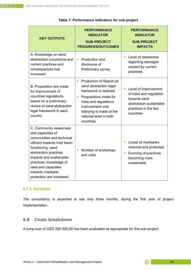
SIO-MALABA-MALAKISI WATERSHED MANAGEMENT STUDY
Annex 1 - Catchment Rehabilitation and Management Project 54
Table 7: Performance indicators for sub-project
KEY OUTPUTS
PERFORMANCE INDICATOR
SUB-PROJECT PROGRESS/OUTCOMES
PERFORMANCE INDICATOR
SUB-PROJECT IMPACTS
A. Knowledge on sand abstraction occurrence and current practices and consequences has increased
Production and disclosure of Preliminary survey
Level of awareness regarding damages caused by current practises
B. Proposition are made for improvement of countries regulations, based on a preliminary review of sand abstraction legal framework in each country
Production of Report on sand abstraction legal framework is realized
Propositions made for rules and regulations improvement and lobbying is made at the national level in both countries
Level of improvement of rules and regulation towards sand abstraction sustainable practices in the two countries
C. Community awareness and capacities of communities and technical officers towards river basin functioning, sand abstraction practices impacts and sustainable practices; knowledge of laws and capacities towards riverbank protection are increased
Number of workshops and visits
Linear of riverbanks restored and protected
Evolving of practices becoming more sustainable
6.7.2 Schedule
The consultancy is expected to last only three months, during the first year of project
implementation.
6.8 Costs breakdown
A lump sum of USD 200 000,00 has been evaluated as appropriate for this sub-project.