Embed Size (px)
Citation preview
Donald Campbell Project Manager
287 Maspeth Avenue, Brooklyn, NY 11211 T: 718. 963.5453 ■ F: 718. 963.5611 ■ [email protected] ■ www.nationalgrid.com
June 15, 2011
Mr. Henry Willems New York State Department of Environmental Conservation Division of Environmental Remediation 625 Broadway, 12th Floor Albany, New York 12233-7013
Subject: Revised Remedial Investigation Work Plan Addendum (No. 3)
Lowes Parking Lot Boring/Well Installation Metropolitan Former Manufactured Gas Plant (MGP) Site, Brooklyn, NY NYSDEC Site No.: 224046, Order on Consent Index #: A2-0552-0606
Dear Mr. Willems:
National Grid is submitting the following revised Remedial Investigation (RI) Work Plan Addendum for the Metropolitan former manufactured gas plant (MPG) site (the Site), located at 124 - 136 2nd Avenue in Brooklyn, New York. This addendum describes work to be performed in the Lowes parking lot on FC Gowanus property located at 118 2nd Avenue and includes the two additional soil borings requested in your May 19, 2011 conditional approval letter for the original submittal.
The former Metropolitan MGP was operated by The Brooklyn Union Gas Company (BUG), a predecessor company to National Grid, from at least the late 1880s until approximately 1938. As you are aware, the Remedial Investigation of the Site is being conducted by National Grid pursuant to a Multi-site Order on Consent and Administrative Settlement with the NYSDEC, Index # A2-0552-0606, executed on February 22, 2007 and modified on August 10, 2007, and in accordance with applicable guidelines of the NYSDEC and the New York State Department of Health (NYSDOH). Specifics of the RI scope of work are presented in the NYSDEC-approved work plan (Remedial Investigation Work Plan, Metropolitan Former MGP Works) produced by AECOM in May 2009 and in two previous Remedial Investigation Work Plan Addendums. Addendum No. 1, for off-site property located at 381/539 Smith Street, was submitted to NYSDEC in June 2010, and Addendum No. 2, for installation of two deep wells adjacent to the canal, on property owned by Hamilton Plaza Associates was submitted to NYSDEC in February 2011.
The scope of work presented in this letter supplements the May 2009 NYSDEC-approved Remedial Investigation Work Plan (the RIWP). The purpose of the work described in this RIWP Addendum (No. 3) is to advance at least five soil borings in the Lowes parking lot area for the delineation of potential MGP residuals. Monitoring wells will be installed at select locations as outlined later in this submittal. At each boring location, a deep soil boring (minimum of 90 feet deep and 10 feet into visually clean soils) will be advanced and continuously logged to delineate zones of deep soil impacts (MGP residuals) identified in various investigation and geotechnical borings installed at the Site. Specifically, the primary objective for this work is to delineate NAPL and MGP residuals observed beneath the Lowes parking lot, in borings installed near the Gowanus Canal and the 11th Street Basin, and in recovery well borings located between the Hamilton Plaza Associates and Lowes buildings. Non-Aqueous Phase Liquid (NAPL) and MGP residuals were observed during the investigation and remediation of the FC Gowanus property at 118 2nd Avenue.
Mr. Hank Willems June 15, 2011 Page 2
287 Maspeth Avenue, Brooklyn, NY 11211 T: 718. 963.5453 ■ F: 718. 963.5611 ■ [email protected] ■ www.nationalgrid.com
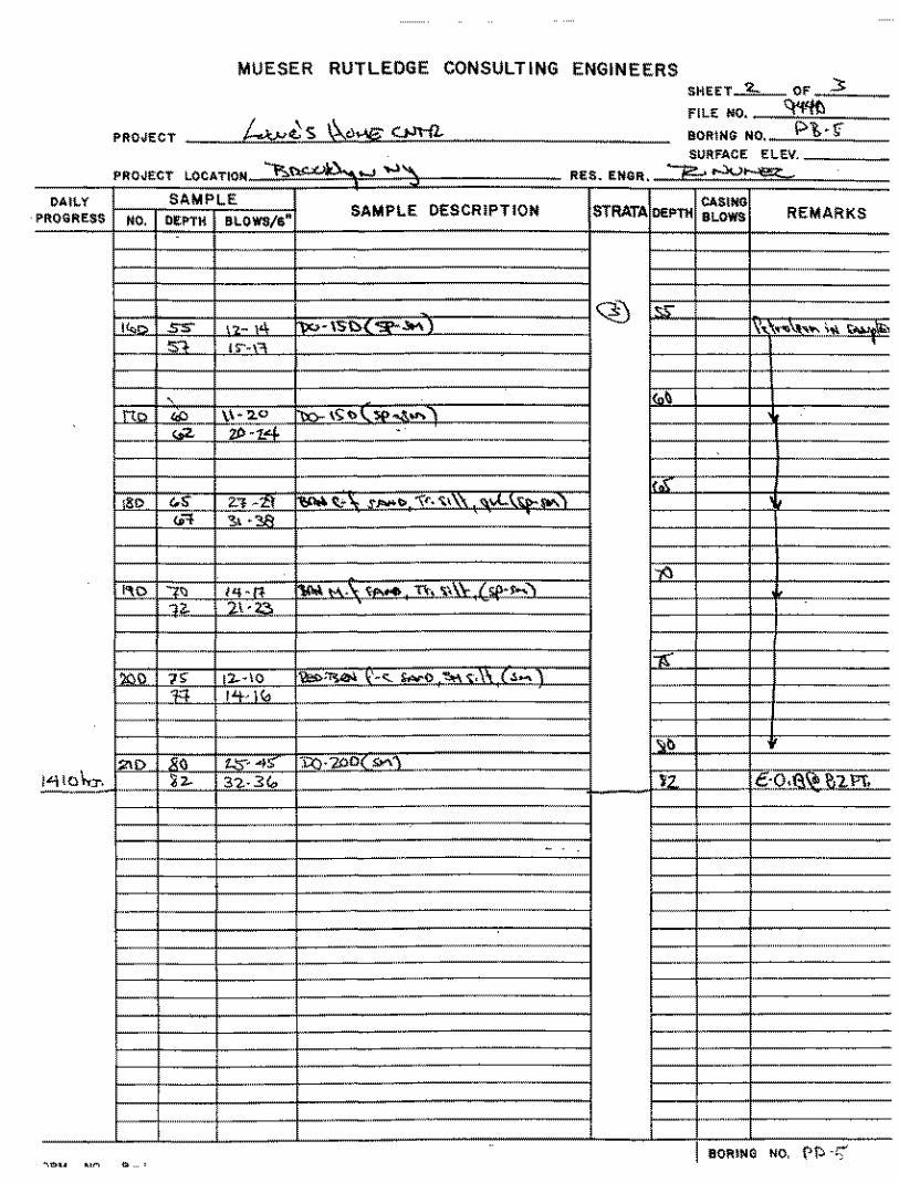
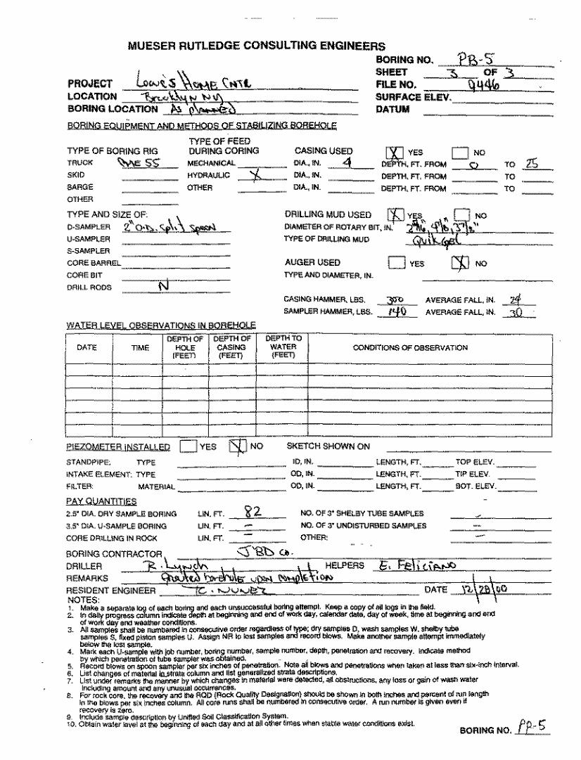
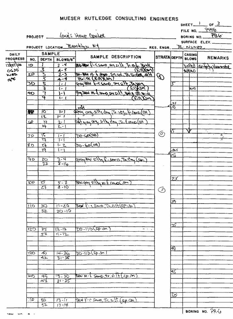
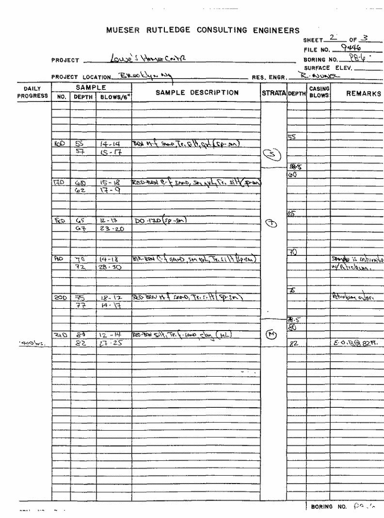
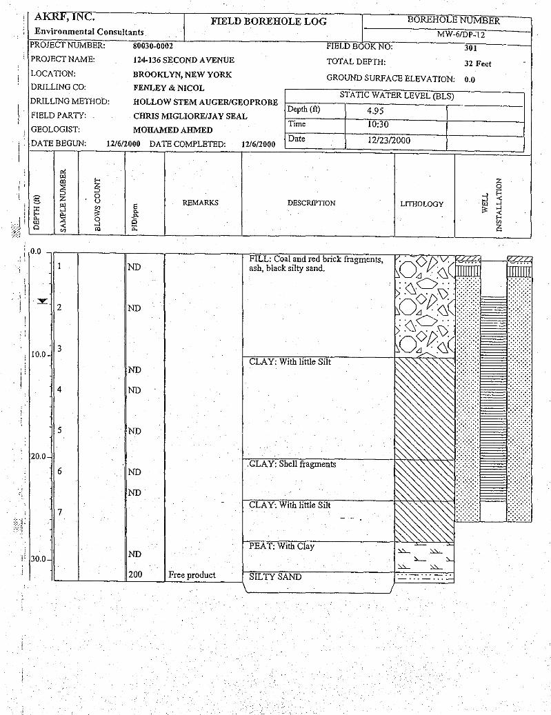
A summary of previously observed subsurface conditions in the proposed investigation area is provided in attached cross-sections A-A’ and B-B’ (Figures 1 through 3). As shown on Figure 2, suspected MGP impacts were observed in geotechnical boring PB-5 at depths of approximately 50 to 80 feet bgs. Along cross-section B-B’ (Figure 3), MGP residuals were detected at depth in two historical borings, MW-6/DP-12 and PB-5, near the 11th Street Basin, with shallower impacts also observed at MW-6/DP-12. No residuals were detected in historical borings C-3S/D and PB-7 southeast of MW-6/DP-12 towards the former gas holders. Copies of historical soil boring and geotechnical logs are included in Attachment A.
NYSDEC has indicated that borings installed by others (e.g., FC Gowanus and USEPA) may be used for delineation of NAPL and MGP residuals if they: 1) employed continuous sampling, 2) have associated real-time organic vapor monitoring, and 3) have associated laboratory soil sample analyses. Because several of the borings used to develop cross-sections A-A’ and B-B’ do not meet these three criteria, additional investigation work is required. The data from the proposed borings and wells will provide additional soil and groundwater information at the Metropolitan former MGP site and will be compiled with data previously collected by others at the Lowes property. Additional step-back borings may be required to fully delineate the extent of potential impacts. If required, the location of these borings will be discussed with the NYSDEC prior to borehole advancement. Potential step back locations will be cleared using geophysical techniques during the initial pre-clearing activities to allow access to these locations during the same mobilization.
RIWP Addendum Scope of Work
Borehole Advancement and Monitoring Well Installation
Each boring (SB/MW-21, SB/MW-22, SB/MW-23, SB-24, and SB-25) will be advanced to a minimum of 90 feet bgs, and 10 feet into visually un-impacted materials, to reach depths encountered in earlier geotechnical work and to provide the anticipated full vertical extent information. Proposed boring/well locations are shown on Figure 4. Prior to advancement, each boring location will be cleared for utilities following National Grid pre-clear protocols and low energy excavation techniques. Geophysical clearance may also be performed to identify any subsurface utilities in the proposed investigation areas. Once cleared, soil borings will be advanced by sonic drilling techniques, which allows for greater drilling efficiencies and well installation options. The actual drilling locations and screen intervals will be determined based upon field conditions encountered and subsurface utility clearance activities. Soils will be logged continuously and screened with a photoionization detector (PID) from ground surface to the terminus of the borehole. Soil borings SB-21, SB-22, and SB-23 will be converted to monitoring wells. An intermediate well is proposed at one location (SB-22) to provide additional data to support ongoing RI work at the adjacent Pathmark parcel. Soil borings SB-24 and SB-25 may be converted into monitoring wells based on field observations and discussions between National Grid and NYSDEC. Targeted screen depth intervals and rationale for MW-21, MW-22, and MW-23 are provided in Table 1. Screen depth intervals for monitoring wells at locations SB-24 and SB-25, if installed, will be agreed upon in the field with NYSDEC. Each deep monitoring well will be constructed with 2-inch-diameter riser and 0.20-inch slot well screen. Well components will be constructed of PVC, except where Dense Non-Aqueous Phase Liquid (DNAPL) is present in the soil column, at which interval(s) well materials may be constructed of stainless steel.
The annular space between the well screen and borehole wall for each monitoring well will be backfilled with chemically inert No.0-sized, or equivalent, sand. A bentonite clay seal will be constructed using bentonite chips placed above the sand pack. The bentonite clay seal will be a minimum of 2-feet thick. The remaining annular space will be filled to grade with a cement/bentonite grout that is tremied from the top of the bentonite clay seal to the surface. Each monitoring well will be fitted with a lockable cap and finished with a flush-mounted curb box secured with a cement pad.
Mr. Hank Willems June 15, 2011 Page 3
287 Maspeth Avenue, Brooklyn, NY 11211 T: 718. 963.5453 ■ F: 718. 963.5611 ■ [email protected] ■ www.nationalgrid.com
Drilling equipment (e.g. drilling rods and casing,) will be decontaminated using a non-phosphate soap wash and/or steam cleaning between each sample location. Non-disposable soil sampling devices (split-spoon samplers, core samplers, etc.) will be decontaminated using a non-phosphate soap wash, methanol, dilute nitric acid rinse, and distilled/deionized water final rinse between each use. Soil cuttings, decontamination fluids, and other investigation derived wastes (IDW) will be contained within United States Department of Transportation (USDOT) 55-gallon drums and disposed of at an approved off-site disposal facility.
The newly installed monitoring wells will be developed no sooner than 24 hours following installation. Each monitoring well will be developed using alternative surging and pumping methods as outlined in the existing RI Work Plan.
Soil Sampling
Soil sampling will be performed during soil boring advancement at each borehole. In summary, soil samples may be collected at the following depth intervals based on field observations:
• At the depth interval exhibiting the highest PID readings or visual evidence of impacts. If no impacts are noted, this sample will not be collected; and
• At the first clean interval or the base of the borehole.
Actual soil sampling depths may be adjusted based on field conditions or in consultation with NYSDEC field oversight personnel. Soil samples will be analyzed for:
• Volatile organic compounds (VOCs) by EPA Method 8260B • Semi-volatile organic compounds (SVOCs) by EPA Method 8270C • Resource Conservation Recovery Act (RCRA) 8 Metals, and • Free Cyanide
If DNAPL is encountered in any borehole, a forensic sample of the material will be collected for comparison to dense non-aqueous phase liquid (DNAPL) collected at other areas of the site. The samples will be analyzed for:
• PAH and Biomarkers by EPA 8270 and Total Extractable Hydrocarbons by EPA 8015
Groundwater Gauging and Sampling
The newly installed monitoring wells will be gauged and sampled following EPA’s low-flow groundwater sampling procedures in accordance with the RI Work Plan. Prior to sampling, groundwater levels will be collected at high and low tides levels based upon Gowanus Canal tidal elevations. Each monitoring well will be gauged with an oil-water interface probe to detect the presence of NAPL. While not expected based on available data collected at the site, if NAPL is present, a groundwater sample will not be collected.
Field measurements will be collected during the sampling of each monitoring well. The following parameters will be monitored: salinity, pH, specific conductance, dissolved oxygen (DO), oxidation reduction potential (ORP), temperature, and turbidity.
Groundwater samples will be collected from the newly installed monitoring wells at least two weeks after well development and may be coordinated with sampling at nearby sites managed by National Grid.
Mr. Hank Willems June 15, 2011 Page 4
287 Maspeth Avenue, Brooklyn, NY 11211 T: 718. 963.5453 ■ F: 718. 963.5611 ■ [email protected] ■ www.nationalgrid.com
Groundwater samples will be collected using low flow groundwater sampling procedures. Groundwater samples will be analyzed for:
• VOCs by EPA Method 8260B • SVOCs by EPA Method 8270C • RCRA 8 Metals, and • Total cyanide by EPA Method 9012B.
Quality Assurance and Quality Control Quality assurance and quality control (QA/QC) samples of soil and groundwater will be collected and submitted in accordance with the RIWP.
Community Air Monitoring Plan
A Community Air Monitoring Plan (CAMP) has been developed for this project that will be followed during all invasive fieldwork (soil borings, borings for well installations, and test pitting). The CAMP will monitor concentrations of VOCs and particulate matter less than 10 microns in size (PM-10) in accordance with NYSDEC and NYSDOH guidance. The CAMP will monitor these parameters upwind and downwind of the work area. Included in the CAMP is a description of methods that may be used to control odors during the RI if needed. The CAMP is included in the approved RI Work Plan for the site.
Surveying
A survey of the investigation sampling points will be conducted at the end of the fieldwork by a licensed NY-State surveying contractor. All horizontal locations will be reported in the New York State Plane Coordinate System, Long Island Zone (NAD83) in feet. All vertical measurements will be reported in NAVD88 in feet, to the nearest 0.1 ft. and 0.01 ft. for soil borings and monitoring wells respectively.
Schedule
Field work can commence following the approval of this Work Plan. AECOM and their drilling subcontractor are ready to initiate field activities as early as June 2011 pending site access. Ideally National Grid would like to coordinate the execution of the work described above with the execution of RIWP Addendum No. 1, assuming access to both properties can be obtained at approximately the same time. On completion of RIWP Addendums No. 1 and No. 3 field work, data derived from the original May 2009 RIWP and RIWP Addendums No. 1 through 3 will be presented in a single, all-inclusive RI Report.
Yours sincerely, Donald Campbell Cc: T. Bell (National Grid) A. Hecht (National Grid) J. Giordano (National Grid)
C. Doroski (NYSDOH) P. Cox (AECOM)

287 Maspeth Avenue, Brooklyn, NY 11211 T: 718. 963.5453 ■ F: 718. 963.5611 ■ [email protected] ■ www.nationalgrid.com
Tables
Table 1Proposed RI Addendum at 118 2nd Avenue, Sample Location, Rationale, and Analytical Sample Summary
Metropolitan Former MGP, 124-136 Second Avenue, Brooklyn, New YorkLocation ID Sample
ID Completion Depth* Sample Depth No. of Samples Analyses Rationale
SB-21SB-21 (depth) Est. 90 feet min
Zone of worst-case impacts, and first clean or bottom
2VOCs, SVOCs, RCRA 8 metals, and free CN
Evaluate impacts noted at RW-7 and lack of impacts noted at PB-7. Determine if MGP impacts are present north of former gas holder No. 1.
SB-22
SB-22 (depth) Est. 90 feet min
Zone of worst-case impacts, and first clean or bottom
2
VOCs, SVOCs, RCRA 8 metals, and free CN
Evaluate soils northeast of former relief holder No. 4 and north of gas holder No. 1. Evaluate petroleum impacts noted in boring PB-6 from 70-72 feet bgs. Provide western extent of any impacts migrating from former gas holder No. 1 area towards the Gowanus Canal.
SB-23
SB-23 (depth) Est. 90 feet min
Zone of worst-case impacts, and first clean or bottom
2
VOCs, SVOCs, RCRA 8 metals, and free CN
Evaluate soil northeast of the SB/MW-9 MGP operations area and further evaluate lack of impacts noted in existing borings PB-3 and GCMW-46. Provide data to test conceptual model: impacts to the south originating in the SB/MW-9 MGP operations area of the Metropolitan MGP and impacts to the north as originating from the Citizens MGP site .
SB-24
SB-24 (depth) Est. 90 feet min
Zone of worst-case impacts, and first clean or bottom
2
VOCs, SVOCs, RCRA 8 metals, and free CN
Evaluate soil north/northeast of the former MGP operations area. Further evaluate lack of impacts noted in existing historical borings in the area.
SB-25
SB-25 (depth) Est. 90 feet min
Zone of worst-case impacts, and first clean or bottom
2
VOCs, SVOCs, RCRA 8 metals, and free CN
Evaluate soil south/southeast of existing geotechnical boring PB-1. Provide data to test conceptual model: impacts observed at PB-1, CGMW-47, and CGMW-45 as originating from the Citizens MGP site to the north.
MW-21MW-21D D est 70 ft D ~ 60-70 ft 1
VOCs, SVOCs, RCRA 8 metals, and total CN
Evaluate the presence of MGP residuals in groundwater (dissolved and possible free phase) north of former gas holder No. 1. Combine deep aquifer d t ith h ll d t il bl t i ti ll RW 7 d C3S/D
Surface Soil/Subsurface Soil
Groundwater
(date) D est. 70 ft D 60 70 ft. 1 data with shallower data available at existing wells RW-7 and C3S/D.
MW-22
MW-22I/D (date) I-est. 35 ft, D est. 70 ft I ~ 25-35f ft., D ~ 60-
70 ft. 2
VOCs, SVOCs, RCRA 8 metals, and total CN
Evaluate the presence of MGP residuals in groundwater (dissolved and possible free phase) northeast of former relief holder No. 4 and north of gas holder No. 1. Combine with existing data from SB/MW-8S/I on the opposite side of the Pathmark building.
MW-23
MW- 23D (date) D est. 70 ft D ~ 60-70 ft. 1
VOCs, SVOCs, RCRA 8 metals, and total CN
Evaluate the presence of MGP residuals in groundwater (dissolved and possible free phase) northeast of former MGP operations area at SB/MW-9. Combine intermediate aquifer data at existing well GCMW-46.
Notes1. No. - number2. ID - identification3. SB - Soil Boring (Subsurface Soil)4. MW - Monitoring Well (Groundwater Sample)
J:\Rem_Eng\Project Files\National Grid\1765-075 Metropolitan Former MGP\RI Addendum Work Plan\Metro Sample Rational Table 1_Lowes borings_Rev4
Page 1 of 1

287 Maspeth Avenue, Brooklyn, NY 11211 T: 718. 963.5453 ■ F: 718. 963.5611 ■ [email protected] ■ www.nationalgrid.com
Figures
#
#
#
#
#
#
#
#
#
D
! A! A
! A
! A! A
! A! A
! A
! A
! A
! A! A
!H
!H
!H
!H
##
#
#
#
! A
! A
! A ! A! A
! A
! A
! A
Coal Storage
No 5Gas Holder
No 2Gas Holder
No 3Gas Holder
No 1Gas Holder
No 1PurifierHouse
Generator House
Gowanus Canal
12th STREET
2nd AVENUE
10th STREET
13th STREET
§̈¦278
Tank Pits
514k
146k
220k
No 2PurifierHouse
Oxide Shed
No 4Relief Holder
BoilerHouse
Coal Shed Pump
HouseTar ExtractorsCondenser
ShavingScrubbers
Valve ExhaustHouse
Settling TanksTar TankHousing
Valve House Drip OilTank
Valve House
Broo
klyn A
lcatra
zAs
phalt
Co
Oil T
anks
Separator
Brooklyn AlcatrazAsphalt Co
A A'
B'
B
SB-17
SB-12
SB-13
SB-14
SB-15
SB-16
SB-10
SB-11
SB-18
CANALSURFACE
GAUGE
MW-1I/MW-1D
MW-1S
MW-2D
MW-3I/MW-3S
MW-4I/MW-4S
MW-5I/MW-5D
MW-5S
MW-6I/MW-6S
MW-7I/MW-7S
MW-8I/MW-8S
MW-9I/MW-9D
MW-9S
SV-1
SV-3
SV-4
SV-2
C-3S/D
GCMW-44 GCMW-45GCMW-46
GCMW-47
RW-7
MW-6/DP-12
PB-1PB-3
PB-7
PB-6
PB-5C-4S/D
TP-1
TP-2
Former MGP Structure (1915)Former MGP Boundary
D Gauge! A Monitoring Well# Soil Boring!H Soil Vapor Sample- Test Pit
µ
0 75 15037.5 Feet
1:1200 1 Inch = 100 ft
NATIONAL GRIDMETROPOLITAN FORMER MGP SITE Geologic Locations
Cross Sections B-B', and ,D-D'Figure 1
A A'
NATIONAL GRIDMETROPLOITAN FORMER MGP SITE
60137361-200
GEOLOGIC CROSS SECTION A-A'
FIGURE 2
,---.... _j
(f]
2
z 0
~ w _j
w
50
45
40
35
30
25
20
15
10
5
0
- 5
-10
-15
- 20
- 25
- 30
- 35
- 40
- 45
- 50
- 55
- 50
- 55
- 70
- 75
-80
LIM ITS OF
STREET BAS IN) . . . CANAL (lirH ~
· a
· a
0 · a
· a a
0 25
LEGE ND
't <o D 't 't
""" I I
(f) Ul 3 l"l 3 'f l :::;, I :::>' 1 m u ill u un:. 0 (L (') ... • .... •
' 0 · a
50 75 100 125 150 175 200 225 250
HORIZONTAL DISTANCE IN (FEET)
TAR SATU RATED
BLEBS, GLOBS, LENSES, GRAIN COATIN G, SHEENS
VERTI CAL EXAGGERATI ON 2 : 1
IL-.__•. ·~a ~, Fl LL
L..._[ ::..c...:...c::..c...:...c::..c.._:_:::...Jl ORGANIC SILT
"' r---~ ~ I I
3 3~ :::>' ::e:l u urn (') (') Q_ • ..
275 300 325 350 375 400
SAND/S ILT
SAND/GRAVEL
~ ~------------------------------------------------------------------------------------------------------------------------------------~D_M_E_: ~D5~/-1~2~/_1_1 ____ ._DR_w_N_:_RC~W--------~--------------~------------------------~~--------------~
B B'
NATIONAL GRIDMETROPLOITAN FORMER MGP SITE
60137361-200
GEOLOGIC CROSS SECTION B-B'
FIGURE 3
50
4 5
40
3 5
3 0 0
2 5 " " "---if)
20 I I "' m ~ I
(L u
15 .... .. .. 10
,...-... 5 _j
(f)
2 0
1-- - 5 w w -1 0 LL ...._.,-
-1 5
z - 20 0 1-- - 25 :;
- 30 w _j
w - 35
-40
- 4 5
- 5 0
- 5 5
- 50
- 55
-70
-75
- 80 0 25 50 75 1 DO 125
LEGEND
TAR SATURATED
BLEBS, GLOBS, GRAIN COATIN G,
0 · a
"' I m o_
RELIEF HOLDER f--'-'-· APPRO X. 180' ·~ .. I SOUTHWEST • I
o .
150 175 200 225 250 2 75
HOR IZO NTAL DISTANCE (FEET) VERTICAL EXAGG ERATION 2:1
t
· a
J FILL
LENSES,
I= l ORGANIC SHEEN S
3 00
SILT
<'J
I o_ 0
0 "---"' "---I if) co ~
7 I I ro ::;, 0 o_ .. .. ....
3 25 3 50 375 4 00
l I ., ·, SAND/S ILT
• .. ·.···
SAND/GRAVEL
~ i-----------------------------------------------------------------------------------------------------------------------------------------------------------~•D•M•E•: ~0~5~/.1~2/~1•1----~-D-RW•N•:•R•C~W~--------~----------------~------------------------------~------------------~
Coal Storage
No 5Gas Holder
No 2Gas Holder
No 3Gas Holder
No 1Gas Holder
No 1PurifierHouse
Generator House
Gowanus Canal
12th STREET
2nd AVENUE
10th STREET
13th STREET
278
Tank Pits
514k
146k
220k
No 2PurifierHouse
Oxide Shed
No 4Relief Holder
BoilerHouse
Coal Shed Pump
HouseTar ExtractorsCondenser
ShavingScrubbers
Valve ExhaustHouse
Settling TanksTar TankHousing
Valve House Drip OilTank
Valve House
Broo
klyn A
lcatra
zAs
phalt
Co
Oil T
anks
Separator
Brooklyn AlcatrazAsphalt Co
A'
B'
B
ASB-10
SB-11
SB-12
SB-13
SB-14
SB-15
SB-16
SB-17
SB-18
CANALSURFACEGAUGE
MW-1I/MW-1D
MW-1S
MW-2D
MW-3I/MW-3S
MW-4I/MW-4S
MW-5I/MW-5D
MW-5S
MW-6I/MW-6S
MW-7I/MW-7S
MW-8I/MW-8S
MW-9I/MW-9D
MW-9S
SV-1
SV-3
SV-4
SV-2
PB-1PB-3
PB-7
PB-6
PB-5
C-4S/D
C-3S/D
GCMW-44 GCMW-45
GCMW-46
GCMW-47
RW-7
MW-6/DP-12
SB/MW-21
SB/MW-22
SB/MW-23
SB-24
SB-25
TP-1
TP-2
Former MGP Structure (1915)Former MGP BoundaryGaugeMonitoring WellSoil BoringSoil Vapor SampleTest PitProposed Soil Boring / Monitoring Well
0 75 15037.5 Feet
1:1200 1 Inch = 100 ft
NATIONAL GRIDMETROPOLITAN FORMER MGP SITE Proposed Remedial Investigation
Addendum Investigation LocationsFigure 4
287 Maspeth Avenue, Brooklyn, NY 11211 T: 718. 963.5453 ■ F: 718. 963.5611 ■ [email protected] ■ www.nationalgrid.com
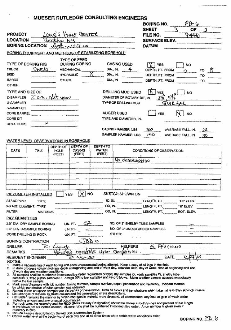
Attachment A Historical Subsurface Boring Logs and Geotechnical Logs
PROJECT
MUESER RUTLEDGE CONSULTING ENGINEERS SHEET • Of _):
fiLE NO. ~ BORING NO. J€.r SURfACE ElEV.
RES. ENGR. :-t-· f'.\\}N~
:ss
MUESER RUTLEDGE CONSULTING ENGINEERS
SAMPLE DESCRIPTION
SliE!:T
Fll.E 110.
80R!IIG 110.
SURf ... CE ELEV. , EIIGR. ']?....· Nt.>"'§!Z,..,
REMARKS
80R!t!G t!O.

l.lQBJ.!iG EQUIPMENT AND METHQl)S.
TYPE OF BORING R!G ""0 .. ?3:_ SKID
BARGE OT>lER
TYPE OF FEED DURING CORING
MECHANICAL
HYOAAUUC x:_ ~"
CASINGUSEO DIA.,Itt 4 PIA,. IN. OiA.,IN.
TYPE ANO SIZE OF: \ D·SAMI'LER 2"QI"::,. '\.~\\ ':';.~ U·SAMPLER
DRIWNG MUD USED ttl YES,, • 0 NO
~:.:;:;;,urr.IN. ~·~~~·~;ea,.~=Jt:= .... ====== S-SAMI'LER
CORE BARREL
CORE SIT
DRILl RODS
DATE
INTAKE ElEMENT: TYPE
AUGER USED D Y€S TYPEANOOIAM~. IN.
AVERAGE FAll, IN.
AVERIIGE FAU .. IN.
CONDITIONS Of oest'.'flVATION
SKETCH SHOWN ON
....... - 00, IN. LENGTH, FT. TIP !:UV _
AlTER: :========== IO,IN. ---·- lE-.. GTH, FT. TOP EI.£V_
MATEfUAl OO.IN. _____ lENGTH, FT --··BOT- EI.£V_
PAY QUANTITIES
3-5' DlA_ U·SAMPlE 9001NG
COf\E Of11UlNG IN ROCK
' DRILLER REMARKS
LIN. FT.
LIN. FT.
tJN. FT.
NO. OF 3' SHElBY TUBE SAMPI..ES
NO. Of 3' UNDISTURBED SAMPLES
OTHl'ift
-fl···
OAILY PROGRESS
"'""' o:t~sl..~ ~ . ._..,
""'' ~\ """
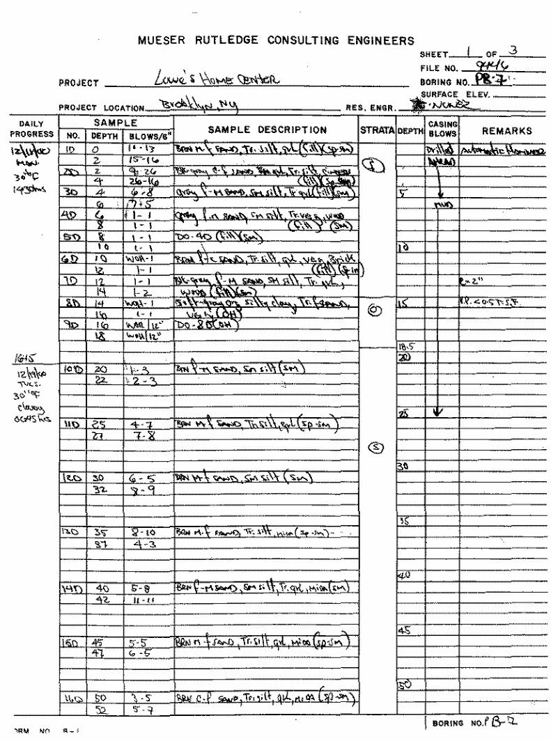
MUESER RUTLEDGE CONSULTING ENGINEERS
PROJECT
Si'!EET
fiLE NO.
BORING NO.
BORING NO. p (?: • 3
MUESER RUTLEDGE CONSULTING ENGINEERS
SAMPLE DESCRIPTION REMARKS
BORING NO.
MUESER RUTLEDGE CONSULTING ENGINEERS
<l.QBJ~\J.l.eMI',;NI AND Mlill:J.QQ.a.Q£ STAB!LIZlNG BQflEHOI,J;;
TYPE OF BORING RIG
MSS' TflVCK
SKID
MAG~
On<f.R
TYPE OF FEED DURING COfiiNG MECHANfCAL_
HYDRAVWC ~ OTHER
CASING USED ~A., IN.
OIA .• IN.
OIA., IN.
BORING NO. SHEET
FILE NO. SURFACE DATUM
TYPE AND SIZE OF:
lJ..SAMPLS'l 2''i ·'b s¢..\ V·SAMPL~R
S·SAMPLER
DRILLING MUD USED !$] .;;wlo. ~j NO
~:~:::7:::oarr, IN. ~~~~~-~'C"/0~="===== CORE BARREt
CORE !liT
DRILL l'lOOS
't:li\T!;R LEVEl.~YAI!QNSJtulQf!EHOI.E
AUGER USED D YES C$J NO
TYPEANO DIAMETER, IN. ---- ............................................................... .
CASING HAMMER, UlS. 3"'0 SAMP!.ER HAMMER, LBS. /4£
AVERAGE FALL, IN . ....ltl_ AVERAGE FALL, IN .. ~ ....
DEf'TH OF "'b~wr 1_ .... -- -] i DAl'~ I DEPTH OF TIME ~' CASlNG CONDITtoNs OF OOSERVATlON
L ...... - (FE~--' I . --
I I
--
' ' .-L .... _ C.
.. .. C:::::::.Jves ~ EIEZQMEIEFJ .. iN.iiT~
STANDPIPE TYMee>,eeMc =======:·: .... : ...... ,_, INTAKE Et.EM~NT: TYPE
f'lEI'l.
PAY OUANTI[teS_
2.5" D•A- DRY SAMPL~ !lORING
3 5" O>A. !!.sAMPLE BORING
_,,
"""
-
SKETCH SHOWN ON
NO. OF 3"' Sl-I~LBY TUBE SM!PI.ES
NO. OF 3"' UNOISTURSEO SAMPLES
-
_,, """""""
I -····- """""""'_'"_
-~ """"""""""-"'
""""'
""""""""'""'"
-
BORING NO. ?lY .:?: ..
'~""") "-2o~~
,,"t'~1;s(·
MUESER RUTLEDGE CONSULTING ENGINEERS
' Ei..EV.
&OR!NG
MUESER RUTLEDGE CONSULTING ENGINEERS
SAMPLE DESCRIPTION
""" .. ~ ..
SHEET 'L
fiLE ItO.
BORING NO.
SIJRfA.CE ELEV.
REMARKS
I BORING NO, f'f-l-
MUESER RUTLEDGE CONSULTING ENGINEERS
PROJECT _ _k_w~' ~~ .. \~">\~~·~· C~·~e~t~~~~~= LOCATION ~<J;;,.qt! ~~ SORING LOCATION ~ ~\l~S . 6.QRING EQUIP~Q..METJ:!QQS Of SIAB!l!ZJNG BQB€Ha!f
TYPE OF BORING RIG TRUCK ~ $$
OTHER
TYPE AND SIZE Qf_
TYPE OF FEED DURING CORING
M!<CHA.ffiCAL --:::J"-, KVORAUUC -f:>--
CASING USED 01A,. lN. ~~4-DIA.,fN.
01A., IN_
BORING NO . ....... ..J:B · '5 SHEET :1).... OF 3 Fll.E NO. ~44\, SURFACE ElEV. DATUM
~.y:r~ ffiOM D NO
DEPTH, FT. ffiOM
DePTH. Ff_ FROM
O·SAMPLER ,Z,~.Q:k.Sf\~ li·SAM!'l!OR
S-SAMFLER
DRILLING MUD USED [7=J y~" ~ l~ NO
01AMETI'i.R OF ROTAf!Y SfT,IN. ;n,~:l\'1\;Ei~'i'CI~~--~"==== TYPE OF DRIWNO MUD _ <f" t'hi;fi
CORE BARREL
COOEBIT
DRill RODS
DATE
E!;ZQMETER jNSTAI \ED
STANDPWE.
INTAKE EI.EMENT_ TYPE
AUGER USED 0 YES [$1 NO
-----------CASINO HAMMER, laS. ~- AVERAGE FAll., INSAMPLER 1-!AMMEA,lSS- _ _rf_ll._ AV!ERAGE FALL. lN.
CONPITfONS OF OSSERVATLON
MATER!AL _ .. _ ..
EAY..QVANiliiES 2.5" DIA_ ORY SAMPLE BOAlNG
H' DlA \!·SAMPLE BORING
COflE DR•t.LlNG IN ROCK
' • " ' "
liN. FT. J~.- NO.Of$'SHElBYn.ISESAMP\.ES
UN. FT. - NO. OF 3' UNOISTURIIEO SAMPLES
UN. FT. OTHER: --
l<l<liC/IIII mori>Dd
!af«m a! loss 1l'lalt Sl~·inch lnloN•I .
Po 5 SORING NO. _l__L .......... ..
OAlLY
MUESER RUTLEDGE CONSULTING ENGINEERS
I I
REMARKS
BORING NO.
MUESER RUTLEDGE CONSULTING ENGINEERS SKEET
f!lE NO.
PROJECT OOIUN\l NO.-~~;\g
SAMPLE OESCRlPT!ON REMARKS
BOI'IIN\l NO.
MUESER RUTLEDGE CONSULTING ENGINEERS
PROJECT m ~ 5. \j<.\11> <);t;,tt;t, . LOCATION ----,s:~'tr- t-13, BORING LOCATION""'~~;,., /J·g -
BORING NO. SHm AI.E NO. SURFACE ELEV. DATUM
PU-<e OF '
'l'i'l!o~~c-:
BORING EQUIPMENT AND METHODS OE..5.IA6.!UZJf:i!l.aQflEHOl E
TYPE OF BORING RIG
TRUCK ~ S~lt>
BARGE
OTHER
TYPE AND SIZE OF:
TYPE OF FEED DURING CORING
-~~ KYDAAUUC
o•~
D·SAMPlER T.' 0•'1:>, \p\\\' ~ 1.1-SJ\MPli'.'R
S·SAMI'l!?.R
CORE BARR~I.
CORE !liT
DRU.. ROD$
PIEZOMETEfl.JNfiJAII FD ']No
STANDP,PE: TYPE ========: INTME ELEMEN't, TYPE
FILTER: MAT~RIAL
PAY QUANTITIES
2 S' DIA. DRY SAMPLE BQf11NG
'l.S' OIA U·SAMP!.E BORING
CORE DRilLING IN ROCK
liN. FT. _____s'2:: LIN. FT.
UN. FT.--·
CASINGUSEO ~YES D '0 DIA., IN. __1 ___ fT_ FROM DIA.,IN. DEP'fH. FT. FWJM OIA., fN. OEi>ll-1, fT_ FROM ------
DRIWNG MUD USED
AUGER USED 0 YES
TYP!?. AN0 DIAM8ER, IN.
CASING KAMMER, LBS. AV€RAGE FALL IN_
SJ\MPI..ER KAMidER, LBS. _____t'!Q__ AVI'.'f\1\GE FAU., IN.
CONI.llTIO~ OF Oll$ERVATION
SKETCH SHOWN ON
ID,IN. OO,JN. __
lENGTH, fT_ TOf' ELEV.
LENGTH, FT. TlP ELEV
•o 15: •o ...... __ "
. .... :&_
"'
OD,IN. - .... , __ LENGTH, FT. BOT. ELEV. __ _
NO. Of 3' SHEUlY TUeE SAMI'LES
NO. Of 3' UNOtSTURtiED SAMf'lES
OTHER:
BORING NO. n.: .. k_
DAllY PROGRESS
MUESER RUTLEDGE CONSULTING ENGINEERS SHEtT OF 3
FilE MO. ~(, !lORING NO. M'.
REMARKS
80R!HG
PROJECT: LOCATION:
DAILY
PFCGR83S NO.
Cont'd
12-19-00
Tuesday .. Cloudy
30°F
170
180
190
200
210
220 11:35
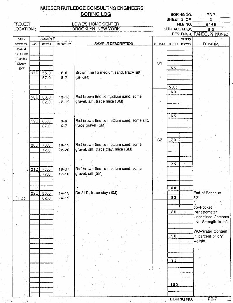
MUESER RUTLEDGE CONSULTING ENGINEERS BORING LOG
LOWE'S HOME CENTER BROOKLYN NEW YORK
SAMPLE DEPTH BLOWS/6" SAMPLE DESCRIPTION
.
.
55.0 6-6 Brown fine to medium sand, trace silt 57.0 8-7 (SP-SM)
60.0 13-13 Red brown fine to medium sand, some
62.0 12-10 gravel, silt, trace mica (SM)
65.0 9-8 Red brown fine to medium sand, some silt, 67.0 6-7 trace gravel (SM)
~
70.0 18-15 Red brown fine to medium sand, some 72.0 22-20 gravel, silt, trace clay, mica (SM)
75.0 18-37 Red brown fine to medium sand, some
77.0 17-1 6 gravel, silt·(SM)
80.0 14-15 Do 21 D, trace clay (SM) 82.0 24-19
I
.
- ..
BORING NO. PB-7 SHEET 2 OF 3
FI.LE NO. 9446 SURFACE ELEV. 8. 9
RES ENGR RANDOLPH NUNEZ CASING
STRATA DEPTH BLOWS REMARKS
51 55
58.5 60
65
52 70
.75
·.
80 End of Boring at
82 82'.
pp=Pocket 85 . Penetrometer
Unconfined Compres-sive Strength in tsf.
WC=Water Content 90 in percent of dry
weight.
95
100 '
BORING NO. PB-7
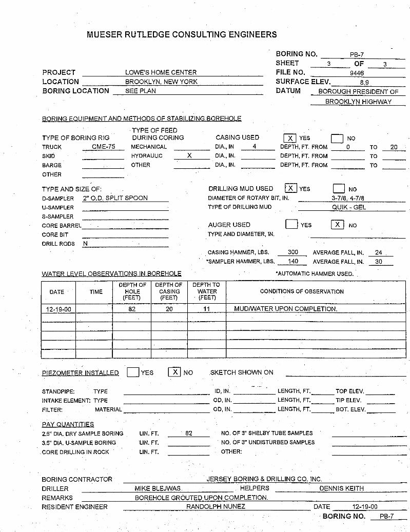
MUESER RUTLEDGE CONSULTING ENGINEERS
BORING NO. ---'-PB~-:c_7 ___ _
SHEET -----"3~- OF __ 3"----PROJECT LOWE'S HOME CENTER FILE NO. 9446
LOCATION ----~B~R'"O~O:o;K~Lc!.YNC'.•c!N:'..'E=.!W.!-'..Y~O~R~K---'----- SURFACE ELEV. 8.9
BORING LOCATION _....;S:ooE=.=E:..!P_,lA"-"-'N __________ _ DATUM BOROUGH PRESIDENT OF
BROOKLYN HIGHWAY
BORING EQUIPMENT AND METHODS OF STABILIZING BOREHOLE
TYPE OF FEED TYPE OF BORING RIG DURING CORING CASING USED [KJ YES D NO TRUCK
SKID
BARGE
OTHER
CME-75
TYPE AND SIZE OF:
MECHANICAL
HYDRAULIC
OTHER
D-SAMPLER 2" O.D. SPLIT SPOON
U-SAMPLER
S-SAMPLER
COREBARREL_~--------
CORE BIT DRILL RODS .:_N,__ _______ _
WATER LEVEL OBSERVATIONS IN BOREHOLE
X DIA., IN
DIA.,IN.
DIA., IN.
4
DRILLING MUD USED
DEPTH, FT. FROM 0
DEPTH, FT. FROM ---
DEPTH, FT. FROM --'----
[K] YES D NO DIAMETER OF ROTARY BIT, IN. 3-7/8, 4-7/8
TYPE OF DRILLING MUD QUIK- GEL
AUGER USED DYES [K) NO
TYPE AND DIAMETER, IN.
. CASING HAMMER, lBS. 300 AVERAGE FALL, IN.
•sAMPLER HAMMER, LBS. 140 AVERAGE FALL, IN.
•AUTOMATIC HAMMER USED
DEPTH OF DEPTH OF DEPTH TO DATE TIME HOLE CASING
(FEET) (FEET)
12-19-00
PIEZOMETER INSTALLED
STANDPIPE: TYPE
INTAKE ELEMENT: TYPE
FILTER: MATERIAL
eAY QUANIITIES
2.5" DIA. DRY SAMPLE BORING
3.5" DIA. U-SAMPLE BORING
CORE DRILLING IN ROCK
BORING CONTRACTOR
DRILLER
82 20
DYES [K]No
LIN. FT. 82
LIN. FT.
LIN. FT.
MIKE BLEJWAS
WATER CONDITIONS OF OBSERVATION · (FEET)
11 MUD/WATER UPON COMPLETION. .
.SKETCH SHOWN ON
ID, IN. LENGTH, FT. TOP ELEV.
OD,IN. LENGTH, FT. TIP ELEV.
OD,IN. LENGTH, FT. BOT. ELEV.
NO. OF 3" SHELBY TUBE SAMPLES
NO. OF 3" UNDISTURBED SAMPLES
OTHER:
JERSEY BORING & DRILLING CO. INC.
HELPERS DENNIS KEITH
REMARKS BOREHOLE GROUTED UPON COMPLETION.
TO
TO
TO
24
30
RESIDENT ENGINEER --------'R-"-A"'-N,_,Dc::O::.:Le..P-'-'H'-'-N'-'U"'-N_,_,E,Z:.._ ______ DATE 12-19-00
20
BORING NO. PB-7
Project No: SERAS-059
Project: Gowanus Canal Superfund Site
Client: EPA/ERT
Location: 118 2nd Ave., Brooklyn, NY
Logged By: J. Bolduc
.c -a. Q)
0
SUBSURFACE PROFILE
0 .0 E >.
(/)
Description
Gravel With Sand (SW-GW) Fill Dark grayish brown to dark gray, fine to coarse angular gravel, some fine to coarse-grained sand, little silt, copper nails, wood, g.lass, clay pot fragments, spotty petroleum hydrocarbon sheens, no odor.
Silty Clay (CL) Dark gray, low plasticity, soft, plant remains and shell fragments throughout, micaceous, wet, no stain, no odor.
Drill Method: A300 Rotary Sonic
Start Date: 1300 6/8/1 0
Hole Size: 8 inches
GCMW-44S Northing (ft): 184458.534 Log of Well: GCMW-4 GCMW-44S Easting (ft): 985077.566
GCMW-441 Northing (ft): 184458.434
GCMW-441 Easting (ft): 985077.808
GCMW-44S Elevation (ft AMSL): 4. 72 GCMW-441 Elevation (ft AMSL): 4. 73
SAMPLE
!S ...... ~ Q) Q)
.0 > :> Q) 0
PID Readings ppmv
Well Completion Details
E a. () Q) :J >. Q) 0 20 40 60 80 100 w z 1- 0::
0.0 • 0.0
0.0 • 0.0
0.0 • 0.0 •
0.0 • 0.0
0.0
0.0
0.0 • 0.0 • 0.0
Lockheed Martin/SERAS 2890 Woodbridge Avenue Building 209 Annex Edison, NJ 08837
Drill Company: Boart Longyear
End Date: 1630 6/8/1 0
Sheet: 1 of 2
Project No: SERAS-059
Project: Gowanus Canal Superfund Site
Client: EPA/ERT
Location: 118 2nd Ave., Brooklyn, NY
Logged By: J. Bolduc
..c: a. Q)
0
SUBSURFACE PROFILE
0 .0 E >. (/)
Description
Clayey Sand (SC) Dark gray, fine to medium grained, some clay, little silt, shell fragments,
no stain, no odor.
Silty Clay (CL) Dark gray, trace fino to mediumgrained sand, low plasticity, soft, micaceous, moist, no stain, no odor.
Silt(ML) Very dark grayish brown, clayey, trace fine-grained sand, occasional plant and shell fragments, micaceous, slightly moist, no stain, no odor.
Sand(SW) Light brownish gray, fino to coarse grained, trace silt, micaceous, wet, no stain, no odor.
No Recovery No recovery between 43 and 45 feet.
Drill Method: A300 Rotary Sonic
Start Date: 1300 6/8/10
Hole Size: 8 inches
GCMW-44S Northing (ft): 184458.534 Log of Well: GCMW-4 GCMW-44S Easting (ft): 985077.566
GCMW-441 Northing (ft): 184458.434
GCMW-441 Easting (ft): 985077.808
GCMW-44S Elevation (ft AMSL): 4. 72
GCMW-441 Elevation (ft AMSL): 4. 73
SAMPLE
L.. Q) .0
Q)
c:-Q)
> PID Readings 0 ppmv
Well Completion Details
E ::I z
a. >.
u 0 Q) 20 40 60 80 100
-31.00
f- a::: 1:1.0
0.6
0.6
0.0 • 0.0 • 0.0 • 0.0 • 0.0 • 0.0 • 0.0 • 0.0
0.0 • 0.0 • 0.0
0.0 • 0.0 • 0.0
0.0 • 0.0 .
Lockheed Martin/SERAS 2890 Woodbridge Avenue Building 209 Annex Edison, NJ 08837
Drill Company: Boart Longyear
End Date: 1630 6/8/1 0
Sheet: 2 of 2
Project No: SERAS-059
Project: Gowanus Canal Superfund Site
Client: EPNERT
Location: Lowes, Brooklyn, NY
Logged By: J. Bolduc
SUBSURFACE PROFILE
0 .0 E >. (/)
Description
Sand With Gravel (SW-GP) Fill Dark gray, fine to coarse grained, little silt, some fine gravel, coal, brick, and wood fragments throughout, wet, no stain, no odor.
Brown, trace clay, fibrous, wet, no stain, no odor.
Silty Clay (CL) Dark gray, trace fine sand, low plasticity, soft, plant and shell fragments, no plant fragments below 17 feet1 wet, no stain, no odor.
Several fine sand stringers from 1 to 3 inches thick from 24 to 26 feet.
Drill Method: A300 Rotary Sonic
Start Date: 0813 6/8/10
Hole Size: 8 inches
GCMW-45S Northing (ft): 184648.833 Log of Well: GCMW-4 GCMW-45S Easting (ft): 985200.254
GCMW-451 Northing (ft): 184648.804
GCMW-451 Easting (ft): 985199.988
GCMW-45S Elevation (ft AMSL): 4.49
GCMW-451 Elevation (ft AMSL): 4.50
SAMPLE
.... ~ Q) > PID Readings
ppmv
Well Completion Details Q) .0 E :::J z
8 Q) 0 20 40 60 80 100
0:::
0.0
0.0 • 0.0
13.0
0.0
0.0 • 1.0
0.0 • 0.0 • 0.0 • 0.0 . 0.0
0.0 • 0.0 . 0.0 • 0.0
Lockheed Martin/SERAS 2890 Woodbridge Avenue Building 209 Annex Edison, NJ 08837
Drill Company: Boart Longyear
End Date: 1025 6/8/10
Sheet: 1 of 2
Project No: SERAS-059
Project: Gowanus Canal Superfund Site
Client: EPA/ERT
Location: Lowes, Brooklyn, NY
Logged By: J. Bolduc
..c -0. Q)
0
SUBSURFACE PROFILE
0 .0 E >. (/)
Description
Clayey Sand (SC) Dark gray, fine to medium grained, shell fragments, wet, petroleum hydrocarbon sheen and low viscosity petroleum hydrocarbon saturated throughout, faint petroleum
odor.
Silty Clay (CL) Dark gray, little fine-grained sand, occasional plant fragments,
GCMW-45S Northing (ft): 184648.833 Log of Well: GCMW-4 GCMW-45S Easting (ft): 985200.254
GCMW-451 Northing (ft): 184648.804
GCMW-451 Easting (ft): 985199.988
GCMW-45S Elevation (ft AMSL): 4.49
GCMW-451 Elevation (ft AMSL): 4.50
SAMPLE
......... c-¢::! ..... Q) ........ .0
Q) PID Readings > > Q)
UJ E ::J z
Q) 0.
~
0 <.> Q) 0 0::: ~.0
0.0 • 0.0
9.0
ppmv
20 40 60 80
25.0
25.0 •
40.0 •
30.0
Well Completion Details
100
no odor. -33.00 8.0
Clayey Sand (SC) Dark gray to black, fine to coarse grained, thin clay stringers from 33 to 37 feet, wet, low viscosity petroleum hydrocarbon saturated, dark brown petroleum hydrocarbon staining, faint petroleum hydrocarbon odor.
Sand With Silt (SP-SM) Dark gray, fine to medium grained, little silt, clay stringer at 37 feet, low viscosity petroleum hydrocarbon saturated, spotty PHC sheens throughout, moderate petroleum hydrocarbon
Drill Method: A300 Rotary Sonic
Start Date: 0813 6/8/10
Hole Size: 8 inches
-37.00
·50.00
0.0
13.0
25.0 •
50.0
Lockheed Martin/SERAS 2890 Woodbridge Avenue Building 209 Annex Edison, NJ 08837
•
Drill Company: Boart Longyear
End Date: 1025 6/8/10
Sheet: 2 of 2
Project No: SERAS-059
Project: Gowanus Canal Superfund Site
Client: EPA/ERT
Location: 118 2nd Ave., Brooklyn, NY
Logged By: C. Sklaney
.s::::. 0.. Q)
0
SUBSURFACE PROFILE
0 ..a E >
(/)
Description
Not Logged Air knifed to clear borehole of underground utilities to 7 feet. Subsurface materials not logged during air knifing.
Gravel With Sand (GP-SP) Fill Dark grayish brown, fine gravel, some medium to coarse-grained sand, little fines, gravel consists of fly ash, slag, and construction debris (concrete and brick), shell fragments.
GCMW-461 Northing (ft): 184593.888 Log of Well: GCMW-4 GCMW-461 Easting (ft): 985167.173
GCMW-461 Elevation (ft AMSL): 4. 76
SAMPLE
..... Q) ..a E :::J z
Q) a. ~
i::' Q)
~ u Q) 0
0::::
0.0 •
PID Readings ppmv
20 40 60 80 100
Well Completion Details
0.0 ~~--~~------------~~~~~~-.-1--~ ·
Clay(CL) Very dark grayish brown, moderate plasticity, soft, little woody material (twigs, mulch, and chips), moist ..
Drill Method: A300 Rotary Sonic
Start Date: 1415 6/15/10
Hole Size: 8 inches
0.0 1--------lo-.... ..1----1 •
0.0 •
0.0 •
0.0 •
0.0 i'=::-==-t--1--1----1 • f=:::!:..!=t--1--1-----i 0.0
• 0.0
1---.,-1-...f-=:----i •
0.0 •
Lockheed Martin/SERAS 2890 Woodbridge Avenue Building 209 Annex Edison, NJ 08837
Drill Company: Boart Longyear
End Date: 1620 6/15/1 0
Sheet: 1 of 2
Project No: SERAS-059
Project: Gowanus Canal Superfund Site
Client: EPAIERT
Location: 118 2nd Ave., Brooklyn, NY
Logged By: C. Sklaney
.c -0.. Q)
0
SUBSURFACE PROFILE
0 .0 E ;;;
Description
Clay (CL) As Above
Clayey Sand (SC) Gray, fine to medium grained, clayey,
silt, wet.
Sand(SP) Very dark gray, medium grained, trace fines, wet.
Sand(ML) Very dark gray, very fine grained, trace alit, wet
Sand(SP) Very dark gray, medium grained, subrounded to rounded, trace fines, wet.
Sand becomes well rounded between 47 and 54 feet.
Sand With Gravel (SP-GP) Very dark gray, coarse grained, and fine subrounded to rounded gravel,
wet
Drill Method: A300 Rotary Sonic
Start Date: 1415 6/15/10
Hole Size: 8 inches
GCMW-461 Northing (ft): 184593.888 Log of Well: GCMW-4 GCMW-461 Easting (ft): 985167.173
GCMW-461 Elevation (ft AMSL): 4. 76
SAMPLE
L.. Q) .0 E Q)
~ Q) > 0
PID Readings ppmv
Well Completion Details
::) 0.. 0
0 ~
Q) 20 40 60 80 100 z
-42.00
0:::
o.o •
0.0 . 0.0 •
0.0 •
0.0 •
0.0
0.0
0.0
1.0
1.0
1.0
1.0
1.0
1.0 •
Lockheed Martin/SEf~AS 2890 Woodbridge Avenue Building 209 Annex Edison, NJ 08837
Drill Company: Boart Longyear
End Date: 1620 6/15/10
Sheet: 2 of 2
Project No: SERAS-059
Project: Gowanus Canal Superfund Site
Client: EPA/ERT
Location: 118 2nd Ave., Brooklyn, NY
Logged By: C. Sklaney
..c ...... a. Q)
0
SUBSURFACE PROFILE
0 ..0 E >(/)
Description
Not Logged Air knifed to clear underground utilities to 7 feet. Subsurface materials not logged during air knifing.
Sand With Silt and Gravel (SW-SM) Fill Very dark grayish brown, fine to coarse grained, some gravel, some cobbles, some silt, shell fragments, wet.
Silty Clay (CL) Fill Very dark grayish brown, silty, medium stiff, some roots, plant
faint sulfur-like odor.
Silty Clay (CL) Very dark grayish brown, medium stiff, some roots, plant remains, peat, faint sulfur-like odor.
Sand With Silt (SP-SM) Very dark gray, fino to medium grained, little fines, petroleum hydrocarbon staining, sheen and saturation present, strong petroleum hydrocarbon odor.
Sandy Silt (ML) Very dark grayish brown, sandy, little peat, petroleum hydrocarbon staining and sheen
Drill Method: A300 Rotary Sonic
Start Date: 0935 6/28/10
Hole Size: 8 inches
GCMW-47S Northing (ft): 184690.704 Log of Well: GCMW-4 GCMW-47S Easting (ft): 985209.243
GCMW-471 Northing (ft): 184690.893
GCMW-471 Easting (ft): 985209.050
GCMW-47S Elevation (ft AMSL): 4.53
GCMW-471 Elevation (ft AMSL): 4.62
SAMPLE
'-Q)
..0 E
PID Readings ppmv
W ell Completion Details
:::l z
20 40 60 80 100
0.0
0.0 • 0.0 • 0.0 • 0.0 • 0.0 • 0.0
0.0 • 0.0
i-='-==t--11---t----i 0.0 r-~~ •
-23.00
0.0
0.0
0.0 •
0.0 •
7.0 •
7.0 . 25.0
10.0 •
15.0 •
•
40.0 •
Lockheed Martin/SERAS 2890 Woodbridge Avenue Building 209 Annex Edison, NJ 08837
Drill Company: Boart Longyear
End Date: 1430 6/28/10
Sheet: 1 of 2
Project No: SERAS-059
Project: Gowanus Canal Superfund Site
Client: EPA/ERT
Location: 118 2nd Ave. , Brooklyn, NY
Logged By: C. Sklaney
.c 0. (l)
0
SUBSURFACE PROFILE
0 ..a E >. (/)
Description
5and(5P) Very darl< grayish brown, medium grained, petroleum hydrocarbon stain,
and odor present.
5and(5P) Very darl< grayish brown, medium to coarse grained, loose, petroleum hydrocarbon staining, sheen, high saturation from 34 to 37 feet, and odor present
Spotty petroleum hydrocarbon saturation between 37 and 43.5 feet.
No visible or olfactory evidence of petroleum hydrocarbon presence between 43.5 and 47 feet.
Drill Method: A300 Rotary Sonic
Start Date: 0935 6/28/10
Hole Size: 8 inches
GCMW-475 Northing (ft): 184690.704 Log of Well: GCMW-4 GCMW-475 Easting (ft): 985209.243
GCMW-471 Northing (ft): 184690.893
GCMW-471 Easting (ft): 985209.050
GCMW-475 Elevation (ft AM5L): 4.53
GCMW-471 Elevation (ft AM5!_): 4.62
SAMPLE
......._ ~ ~
..._ (l) PID Readings (l) ........ ..a >
> E (l) :::J iii z
-34.00
(l) 0 ppmv a. u >. (l) 0 1- 0:::
20
10.0
40
40.0
40.0 •
Lockheed Martin/SERAS 2890 Woodbridge Avenue Building 209 Annex Edison, NJ 08837
60 80
Well Completion Details
100
0> c ·;;; ., (.)
Q; .. ii5 U) U)
~ ,!;
c .s "' (/)
~ g (/)
:Q .. a. (/) ~
0 Q 0 .<: Q; C)
~ c (/) ~
(!; (")
"' a. ~ Q
£ c ~
Drill Company: Boart Longyear
End Date: 1430 6/28/10
Sheet: 2 of 2
~
! A , INC. F1ELD BOREHOLE LOG BOREHOLE NUMBER ' Environmental Consultants MW-6/DP~-12
PROJECT NUMBER: 80030~0002 FIELD BOOK NO: 301 PROJECT NAME: 124-136 SECOND A VENUE TOTAL DEPTH: 32 Feet -
. LOCATION: BROOKLYN, NEW YORK GROUND SURF ACE ELEVATION: 0.0 DRILLING CO: FENLEY & NICOL
STATIC WATER LEVEL (BLS) DRILLING METHOD: HOLLOW STEM AUGER/GEOPROBE
Depth (ft) 4.95 FIELD PARTY: CHRIS MIGLIORE/JAY SEAL
GEOLOGIST: MOHAMED AHMED Time 10:30
DATE BEGUN: 12/6/2000 DATE COMPLETED: 12/6/2000 Date I2/23/2000
i '" "' f-< z Ol
5 ~ ' ~ _, 0 _, <( g ;z: u REMARKs DESCRIPTION LITHOLOGY Ul ...J
l "' ?i E
"' _, :z: _,
0. <( f-< "" <?- f-< ' "" ::E 0 "' ' "' _, 8 2: <( Cl
"' Ol ""
, I 0.0
ash, black silty sand.
': ~
2
. \ '' I
4
5
6
7
200 Free