Embed Size (px)
Citation preview

© m
mca
rtog
raph
ics
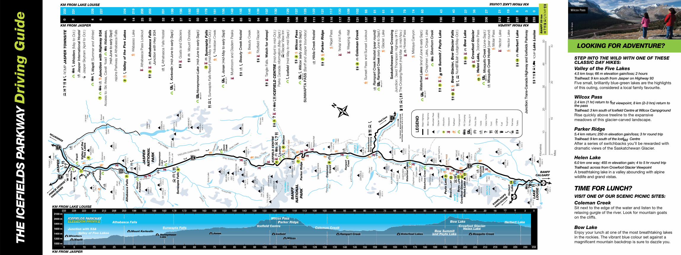
ICEFIELDSPARKWAY
SUMMER ON THE
YOUR PARKS PASS The Icefields Parkway was built by Parks Canada as a scenic drive to showcase the powerful natural landscape of Jasper and Banff national parks. A valid national parks pass is required to drive the Icefields Parkway. Revenues from pass sales support maintenance, plowing, sanding and avalanche control. If you’re a frequent visitor to Canada’s national parks and historic sites, consider purchasing a Discovery Pass for unlimited access to many of Canada’s extraordinary treasures. Details and fees are listed at: pc.gc.ca/jasperfees.
Également offert en français
© Her Majesty the Queen in Right of Canada Catalogue No: R64-442/2015E ISBN: 978-1-100-25779-2
YOU ARE WELCOME TO TAKE THIS BROCHURE HOME AS A SOUVENIR BUT IF YOU ARE FINISHED WITH IT, PLEASE DROP IT OFF AT ANY PARK INFORMATION CENTRE WHERE IT CAN BE USED AGAIN.
MORE INFORMATION JASPER INFORMATION CENTRE: 780-852-6176
LAKE LOUISE VISITOR CENTRE: 403-522-3833
BANFF VISITOR CENTRE: 403-762-1550
pc.gc.ca/jasper
pc.gc.ca/banff
CHECK THE ROAD CONDITIONS AND THE WEATHER
FORECAST BEFORE YOU LEAVE TOWN:
ROAD CONDITIONS: Call 511 • alberta511.ca
WEATHER FORECAST
Banff 403-762-2088 • Jasper 780-852-3185
weather.gc.ca • Visit an information centre
BACKCOUNTRY INFORMATION
Research and plan overnight trips, including potential trail restrictions and closures, avalanche conditions and mandatory backcountry permits. pc.gc.ca/jasperbackcountry
pc.gc.ca/ banff-backcountry
TRAIL REPORTS
pc.gc.ca/jaspertrails
pc.gc.ca/banfftrails
and Banff National Parks
0 1 2 3 4 5 Km
Grizzly Bear Wilcox Pass Athabasca Falls Coyote Peyto Lake Bighorn Sheep
Phot
o: M
. Bra
dley
Phot
o: A
. Zie
rVog
el
Phot
o: A
. Zie
rVog
el
Phot
o: R
. Gru
ys
Phot
o: R
. Gru
ys
Phot
o: P
. Ziz
ka
With a total area of 200 km2, the Columbia Icefi eld
is the largest mass of glacial ice in the Canadian
Rockies. It feeds several large glaciers, including the
Athabasca, the Columbia and the Saskatchewan.
WHAT’S A GLACIER? Glaciers form where more snow falls in winter than melts each summer. As the snow gets thicker and heavier, it compacts into dense glacial ice that slowly flows downhill, like a river of taffy.
GLACIERS AND RIVERS Water flows to three different oceans from this area, known as a hydrological apex. On the British Columbia side, meltwater flows into the Columbia River and the Pacific Ocean. On the Alberta side, the North Saskatchewan and Athabasca rivers feed into the Atlantic and Arctic Oceans, respectively. These rivers provide fresh drinking water for millions of people, and are crucial to agriculture and countless ecosystems. That’s why their source is protected in a national park.
TRY ONE OF THESE SHORT STROLLS:
ABOUT THE ICEFIELD
Athabasca Falls Feel the spray of the Athabasca River as it thunders into the canyon below. Stay behind railings and on designated trails. The rock beyond is slippery and dangerous.
Sunwapta Falls A torrent of plunging water not far from the highway, Sunwapta Falls are just one of the many waterfalls in Jasper created by hanging valleys.
Bow Summit and Peyto Lake A short uphill walk from the parking area leads to a view of the glacial-fed, brilliantly turquoise Peyto Lake.
Bow Lake and Bow Glacier The source of the Bow River, Bow Lake is one of the more scenic and accessible lakes for fishing.
CHECK OUT THESE ROADSIDE ATTRACTIONS:
Athabasca Glacier A magical area that can be seen from the road, explored with a commercial guide or visited on a special bus tour. Do not walk on the glacier; crevasses and other hazards can be deadly.
Crowfoot Glacier When this glacier was named a century ago, it looked like a three-toed crowsfoot. Since then, one toe has melted, and the middle toe is slowly disappearing.
Herbert Lake A photographer’s favourite. The still waters of Herbert Lake provide a perfect panoramic reflection of the stunning Main Range peaks, including Mount Temple. The picnic area provides an ideal place for a picnic stop.
EXPLORE! Winding 232 glorious kilometres through the heart of Jasper and Banff national parks, the Icefields Parkway has been called one of the world’s most scenic drives. Around every corner, the route offers fresh wonders – from waterfalls, pristine lakes and broad sweeping valleys to ancient glaciers flowing down from the rugged mountains. Take your time to experience the many scenic stops, picnic spots and hiking trails along the way.
WILDLIFE Wildlife sightings are one of many reasons the Icefields Parkway is known as the best drive in the world. Bears, sheep, wolves and even elusive caribou are often spotted on the roadsides—keep your eyes open and drive slowly, especially early morning and evening.
NEVER APPROACH OR FEED WILDLIFE.Mountain Goat
NEED TO STRETCH YOUR LEGS?LOOKING FOR A VIEW FROM THE EDGE?
C
J
A
L
y
er
er
tt
Ta
TT n
gle
C reek
Bow River
Sunwapta River
NNoort
hS
ask
ak
ta
chewanRive
r
Athabasc
a R
ive r
Athabasca River
M os
uitot
Cre
ek
horn rh
i lve
S
ya R
iver
Noyo e
s Cr
Howse R
ive
r
Arc
t c o
myys C
ree
k
Ra m
part
Cree k
Riv
er
Creek
Nigelgel
Bea u tyy C
rCC eek
Ast
ori a
R
i v r
Po P r
tal
C re
ek
M
aligne
Rive
r
T
Ger
Riv
er
Whirlp
ool
Cha
ba River
Maligne R
iver
Pobokta
n
Cre
ek
Cre
e
Jonas Creek
ENDLESS CHAIN RIDGE
AtAA habasca Rive
r
R
Ale
xand
rand
1
EDMONTONOO Red D
eer
188
VANCOUVER
KAMPLOOPS PRIN
CE GEORGE
NCE
VANCOUVE
R
COU
THE
ICE
FIE
LDS P
AR
KW
AY
Dri
ving G
uid
e
PY
RA
MID
2762
m Pyra
mid
La
Lake
ke
JJJAS
PE
RS
PEE
R16
16
2100 m
KM FROM LAKE LOUISE
KM FROM JASPER
02
33
22
31
RC
MP
JA
SP
ER
TO
WN
SIT
E
Wh
istl
errrs
Whi
stle
rs (M
ay to
Oct
.)W
HIS
TLE
RS
WH
WH
WH
T
2469
2469 m
WWW
ap
iti
Jasp
er In
tern
atio
nalH
ost
el
1
Valley
of
the
y Fiv
eLake
s Jasp
er
Skytr
am
(((A
pril
to O
ct.)
Jacq
ues
Lake
2
TE
KA
RR
A2693
m
AQ
UIL
A
2880
m
Wap
iti(S
umm
er a
ndWWW
inte
r)4
22
9
veW
ab
asso
KM FROM LAKE LOUISE
2000 m ICEFIELDS PPPARKW YAYWW Wilcox PassWilcox Pass on the cliffs.
1200 m
1000 m
1400 m
1600 m
1800 m ELEVATVV ION PROFILTT E
Junction with 93A
Whistlers WWapitiapitiWWWW
Valley of Five LakesVV Mount Kerkeslin
Athabasca Falls
HoHoneymoonLake
Sunwapta Falls
sJonas
WilcoxWW
Icefield CentreIcefield Centre
Icefield
Parker Ridge
Ramppart Creek
Coleman CreekColeman
Waterfowl LakesWW Mosqquito Creek Bow Summit
and Peyto Lakeand Peyto Lake
Bow Lake Crowfoot GlacieCrowfoot Glacierr
Helen Lake
Herbert LakeHerbe
Bow Lake Enjoy your lunch at one of the most breathtaking lakes in the rockies. The vibrant blue colour set against a magnificent mountain backdrop is sure to dazzle you.
0 55 100 155 2020 2525 3030 3535 4040 4545 5050 5555 6060 6565 7070 7575 8080 8585 9090 9595 1000 1050 1101 1151 1202 1252 1303 1353 1404 1454 1505 1555 1606 1656 1707 1757 1808 1858 1909 1959 2000 2050 2101 2151 2202 2252 230 233
KM FROM JASPER
1 9 7 5 3 1 0 8233 2282 2232 218 2131 2080 2030 198 1939 1888 1838 178 1737 1686 1636 158 1535 1484 1434 138 1333 1282 1232 118 1131 1080 103 98 93 83 8 88 3 73 88 733 68 68 3 53 8 58 33 48 48 3 33 8 38 3 23 8 28 33
Jun
ctio
n w
ith
Hig
hw
ay
93A
6
22
7B
eave
r W
ab
asso
Lake
Lake
Med
icinin
e
Access t
o: S
ki A
rea, C
avell
Road
WWW
abas
so,
Lake
(((mid
-Jun
e to
ear
ly S
epttt)
ED
ITH
CAAA
VE
LL
CU
RAAATO
R
3367
m
2624
m
Moab
rejo
ins P
ark
way a
t A
thab
asca F
alls
Lake
93
Ath
ab
asc
a F
alls
A
HA
RD
ISTY
2
VVVa
lley
of
the
FFFiv
eLake
s 9
22
4
3
aldin
e La
kes Kerk
eslin
2715
m
Wab
asso
WW
Lake
14
2
19
ii M
ou
nt
KE
RK
ES
LIN
2955
m
Ath
ab
asca P
ass L
ookout
25
20
8
JAP
EJA
SP
ER
Malig
nig
nlig
nlig
ne
NAAT
Lakeeee
TIO
NA
L3
A
thabasc
a F
alls
30
20
3
FRRR
YA
YA
YAAAAAAAATT
336
336
336
360
m
PPPPPAR
KA
RK
AR
KA
RK
PPPJu
nctio
n w
ith H
wy
93A
H
on
eym
oo
n
CH
RIS
TIEE
B
RU
SS
ELS
3102
m
Lake
kk
SA
MS
ON
3076
m
32
2
01
Ath
ab
asca F
alls
Hoste
l 3160
m
Osp
rey L
ake
BuckkLa
ke
UUN
WIN
K
erke
slin
(((mid
-Jun
e to
ear
ly S
ept.)
3
41
99
Su
nw
nw
nnww
ap
ta F
alls
aaa
4
3300
m
CH
AR
LLLTOOOO
CH
A
NM
AX 2
5 FT
326000
mm0
m
93
MA
LIG
NE
MA
LIG
NM
ALIG
NM
ALIG
NG
oats
and
Gla
cie
rs
37
19
6
3200
m
MO
NK
HE
AD
Mount
Christie
41
19
2
3211
m
Hon
eym
oon
Lake
(((mid
-Jun
e to
ear
ly S
ept.)
5
01
83
B
RA
ZA
ZA
ZA
ZE
AU
M
AX 2
5FT
352
52225
m
4
Su
nw
apta
Falls
54
17
9
Gong L
ake
Sun
wap
ta F
alls
Res
ort (
mid
-May
to m
id-O
ct.)
Pob
okta
n C
reek
72
16
1
GOOO
NO
NGGGG
3121
m
NE
LS
ON
ON
ON
ON
3150
m
GE
C3130
m M
US
HR
OO
MM
US
HM
US
HM
US
H3666622
m
Jo
nas
Jona
s (((m
id-M
ay to
ear
ly S
ept)
77
15
6
Cre
ek
MAX
25
FT
Mushro
om
and
Dia
dem
Peaks
84
14
9
Bea
uty
Crrre
ekH
ost
el8
51
48
P
OB
OKKK
TATATAANNNN
WWWW
OO
LE
YO
OLE
YO
OLE
YO
OLE
YA
LB
ER
TTTTTAA34
34
34405
m
SU
NWWWWWWWWWWWW
AP
AATA
3622
m
317
317
317
m3317
Beauty
Cre
ek
87
14
6
JJJA
SP
ER
J
m
STU
TFIE
LD
STU
TFIE
LD
3453
mS
tutfi
eld
Gla
cie
r 9
41
39
TH
E TT
WIN
S
Bra
zeau
Lake
3561
mm//3
686
3686
m
Tangle
TT
WW
96
13
7Falls
. W
atc
hfo
r sh
ee
p!
CO
LU
MB
IA
3750
m
KIT
CH
EN
ER
KIT
CH
EN
ER
3505
m
ICE
FIE
LD
CE
NT
RE
IEL
CE
NT
RS
NO
WO
WD
OM
E
5
ICE
FIE
LD
CE
NTR
E(m
id-A
pril
to m
id-O
ct.)
3459
m
10
3
13
0
5
Iccccefi
eldd
P
ark
s C
anad
a info
rmation (M
ay-S
ept.)
el 6
W
ilco
xG
lacie
r V
iew
Inn
cox
CO
LU
MB
IA
IICE
FIE
LD
S
UN
WWWWWA
PA
PTAAAA
PA
SS
PPA
S
Icefi
eld
II (m
id-M
ay to
mid
-Sep
t.)
10
4
12
9
2030
m
ATHH
AB
AS
CA
AB
AS
CA
AB
AS
CA
AB
AS
CA
AA
3493
m
BA
NFF
AN
FF
BB349
349
349
6
WWWilco
x P
ass
10
6
12
7
NAT
ION
AL
ON
A
7W
ilcooox
(ear
ly J
une
to S
ept.)
PPPAR
KKP
ark
er
Rid
ge
dge
MAX
25
FT
SU
NW
AP
TA
PA
SS
(Ban
ff an
d Ja
sper
bou
ndar
y)
10
8
12
5
CIR
RU
SS
3270
m
Weepin
g W
all
Wee
Wee
Hild
a C
reek
Ho
stel
1
11
1
22
WW
ee
WW
SA
SK
AS
KAAATC
HE
WA
N
3344
m33
7
Park
er
Rid
ge
11
2
12
1
Cole
ma
Cole
man
e
Cre
ekk
8
CO
LE
MA
NN
Nig
el P
ass
11
6
11
7
3135
m
AM
ER
YP
into
3329
m
Lake
Brid
alVeil
VV
Falls
1
17
1
20
Ram
part
C
reek
Weep
ing
WW
WW
12
4
10
9W
all
WIL
SO
NIL
SO
LS
OL
SO
ICE
FIE
LDD
8
EF
IEL
DE
FIE
LD
EF
IEL
D
Cole
man C
reek
13
1
10
2E
RA
SM
US
3265
m
WIL
SO
NNNN
3261
m
Sunset
Pass a
nd
Sunset
Lookout
13
7
96
Sa
sk
atc
he
wa
nnh
e
Gla
cie
r R
ive
r C
rossin
gv
ss
gLake
FO
RB
ES
3612
m
SA
RB
RB
CCCR
BA
RB
AC
H3127
3127
3127
3127
mmmm
KA
UFM
AN
NFM 3
109
m
Ram
par
t C
reek
Ho
stel
(yea
r ro
und
) 1
42
9
1
Ram
part
Cre
ek(e
arly
June
to S
ept.)
M
AX 2
5FT
G
lacie
rLake
15
2
81
11
Sa
sk
atc
he
wa
n R
ive
r C
rossin
g
15
3
80
Junction:
David
Thom
pson H
ighw
ay (#
11)
MU
RC
HIS
ON
O
3333
m
EP
EPPPPPPAA
ULE
TTE
3095
m
Mista
CH
EP
HR
EN
TOOO
TE
M
TO
RO
CK
Y M
OU
NTTT
AIN
HO
US
EThe C
rossin
g R
esort
(mid
-Mar
. to
mid
-Nov
.) N
AAAT
ION
AL
HIS
TO
RIC
SIT
E (
17
5 k
m)
3266
m
3155
m
Wate
rfo
wl Lake
akesss
Wate
rfoff w
l Lakes
How
se P
ass
15
4
79
Chep
hre
n L
ake
Mis
taya C
anyon
15
9
74
Cirq
ue L
ake
Lake
AR
IESS
M
ista
yaa
LE
GE
ND
2996
mmmmLakee
96
96
96
mmmN
OOOY
ES
Majo
r H
ighw
aaay
Wat
erfo
wl L
akes
(end
of J
une
to e
arly
Sep
t.)
17
3
Silverh
orn
Cre
ekk
rn C
rrn
Cr
rn C
r 3084
m
MAX
25
FT
Chep
hre
n L
ake,
Cirq
ue L
ake
DD
Min
or
Hig
hw
aaay
Mounta
in P
eak
Silv
erho
rn C
ree k
PAAATTE
RS
ON
TTE
RS
OTTE
RS
OTTE
RS
O31
31
31
3197
m
WE
ED
3080
m
2868
m
Gla
cie
r/Ic
efie
ldyto
Pe
Peyto
OB
SE
RVVVAT
ION
CA
LD
RLD
LD
LD
ROO
NOO
CA
9
B
ow
Su
mm
it /
Peyt
o L
ake
Lake
ke
3174
m
19
0
43
2917
91
91
m291
2
Att
raction
Peyt
o L
akeke
9eyt
o L
ake
eyt
o L
ake
eyt
o L
ake
BO
WOO
P
AS
S
2067777
mmmm
Vie
wp
oin
t B
oowwww
Gla
cier
Gla
cier
Gla
cier
Gla
cier
10
10
Bow
Gla
cier,
Bow
Gla
cier
Falls
19
3
40
Trailh
ead
WA
PT
PT
PTTA
TT
ICE
FI
FI
FIEIE
LD
CIR
QU
EN
um
�Ti�
Jah L
od
ge(M
ay-O
ct.)
Bow
Lak
Lak
akeke
11
2993
m
Cam
pgro
und
ak
Cro
wwwwfo
ot
Gla
cier
foot
Gla
cie
foot
Gla
cie
foot
Gla
cie
12
Lake
Kath
erine
RV
Cam
pin
g
Hele
n L
ake
Hele
n L
ake
Hele
n L
ake
Hele
n L
ake
13
B
ow
Lake
1
96
3
711
CRRRR
OW
FO
OT
3050
m
93
DO
LO
MIT
E
RV
Max 2
5 ft
2782
m
MAX
25
FT
Cro
wfo
ot
Gla
cier
BO
Wq
12
19
7
36
Pic
nic
Site
13
Hele
n L
ake
, D
olo
mite P
ass
BA
LFO
UR
ALFO
UR
ALFO
UA
LFO
U3272
m
MMo
sq
uit
ooH
oste
l
Cre
ekk
Mos
qui
to C
reek
(Jun
e-S
ept.)
Vis
itor
Centr
e
MAX
25
FT
WA
PU
TIK
Hecto
r2
06
2
7IC
EF
IEL
D
Lake
Mos
qui
to C
reek
Hos
tel(
year
roun
ddd)Food
Mola
r P
ass
DA
LE
YYYY
Lod
gin
g
MO
LA
RH
ecto
rLake
Hecto
rLake
3002
m
Fuel
HE
CTO
R
3394
m
Tele
phone
Herb
ert
er
14
Lakekee
13 8
Tram
waaay
Toile
ts
14
CY
CLO
NE
C
LO
NLO
NLO
N3042
m
Herb
ert
Lake
3
Lake
Louis
e
o
VIC
TO
RIA
ORR
IAR
IAR
IAO
RO
RTT
3459
mmmm
PT
PTTTTA
RM
IGA
NA
LA
KE
L
Junc
tion:
Tra
ns-C
anad
a H
ighw
ay a
nd Ic
efiel
ds P
arkw
ay
KM FROM JASPER 21
2
21
4
22
7
6
23
0
3
0
Lake
Louis
e
23
3
03059
m
RC
MP
LO
UIS
E
TE
MP
LE
3543
m
relaxing gurgle of the river. Look for mountain goats Sit next to the edge of the water and listen to the
TIME FOR LUNCH? VISIT ONE OF OUR SCENIC PICNIC SITES:
Coleman Creek
BANFF A breathtaking lake in a valley abounding with alpine CALGARYCA wildlife and grand vistas.
RE
DO
UB
T
Kilo
metr
es
2902
m
BA
NFF
59
km
0
10
20
30
5
0
RC
MP
010
20
30
Mile
s
Phot
o: R
. Gru
ys
LOOKING FOR ADVENTURE?
STEP INTO THE WILD WITH ONE OF THESE CLASSIC DAY HIKES: Valley of the Five Lakes 4.5 km loop; 66 m elevation gain/loss; 2 hours Trailhead: 9 km south from Jasper on Highway 93 Five small, brilliantly blue-green lakes are the highlights of this outing, considered a local family favourite.
Wilcox Pass 2.4 km (1 hr) return to first viewpoint, 8 km (2-3 hrs) return to the pass Trailhead: 3 km south of Icefield Centre at Wilcox Campground Rise quickly above treeline to the expansive meadows of this glacier-carved landscape.
Parker Ridge 5.4 km return; 250 m elevation gain/loss; 3 hr round trip Trailhead: 9 km south of the Icefield Centre After a series of switchbacks you’ll be rewarded with dramatic views of the Saskatchewan Glacier.
Helen Lake 6.0 km one way; 455 m elevation gain; 4 to 5 hr round trip Trailhead: across from Crowfoot Glacier Viewpoint
Wilcox Pass
KM FROM LAKE LOUISE
60
21
19