Embed Size (px)
Citation preview
GEOLOGY, May 2009 387
ABSTRACTPotential fi eld data along the Texas portion of the Gulf of Mexico
indicate a large-amplitude coast-parallel magnetic maximum and a smaller Bouguer gravity high. Models constrained by seismic-refrac-tion data indicate that these maxima manifest a deeply buried volca-nic rifted passive margin or other magnetic high in the outer transi-tional crust. Buried 12–15 km, the source is 220 km wide, similar to the Vøring Plateau in Norway and the U.S. East Coast. This margin, which formed during the opening of the Gulf of Mexico, differs in origin from the transform boundary of the northeast Mexico margin (Tehuantepec transform), and we infer a Jurassic triple junction related to the Bor-derland rift system, which is traceable as far as southeast California.
INTRODUCTIONContinent-ocean boundaries form by extension (e.g., central and
North Atlantic; Red Sea) or transform or transtensional faulting (e.g., Gulf of California). Extensional boundaries form before and during the “rift-drift transition” of continental breakup by processes that range from pas-sive, nonvolcanic (far-fi eld lithospheric stresses) to active, volcanic rifting (asthenospheric upwelling or mantle plumes; Sengor and Burke, 1978). Continued extension leads to seafl oor spreading and freezes the transi-tional crust in place, so the relative signifi cance of passive versus active rifting is preserved in deeply buried units.
Nonvolcanic extensional continent-ocean boundaries form when little melting accompanies extension, such as the Galicia margin and the Gulf of Suez (Tucholke et al., 2007). Nonvolcanic transitional crust consists of stretched and thinned continental crust inboard and exhumed serpenti-nized mantle outboard. These boundaries are characterized by absence of lava, long duration (15 m.y. or longer), high stretching factor (β; increas-ing oceanward to ~5 or more), rotated fault blocks, and high-velocity (Vp ~7.2–7.7 km/s) outboard crust interpreted as serpentinized peridotite (Mjelde et al., 2007). Volcanic extensional boundaries, also known as vol-canic rifted margins, form by rapid, voluminous emplacement of lavas, dikes, sills, and plutons observed as seaward-dipping seismic refl ectors (SDRS), and several-kilometer-thick, high-velocity (Vp ~7.2–7.6 km/s) lower crust, interpreted as magmatic underplating (Mutter et al., 1984). Some models for volcanic rifted margins infer a mantle plume (e.g., White and McKenzie, 1989), but others invoke enhanced convective overturn of the asthenosphere (Mutter et al., 1988).
This report provides insight into the nature of the northwestern Gulf of Mexico, which lies beneath ~15 km of sediments. No consensus exists regarding the nature of this transitional lithosphere (cf. Skogseid, 2001; no volcanic rifted margin) versus Menzies et al. (2002; dominated by volca-nic rifted margin). We present potential fi eld data, accompanied by geo-logic evidence, that support the interpretation of a volcanic rifted margin beneath coastal Texas.
EARLY MESOZOIC DEVELOPMENT OF THE GULF OF MEXICO
Breakup of Pangea often exploited the suture between Laurasia and Gondwana (Ouachita orogen) and, on the eastern U.S. seaboard, was
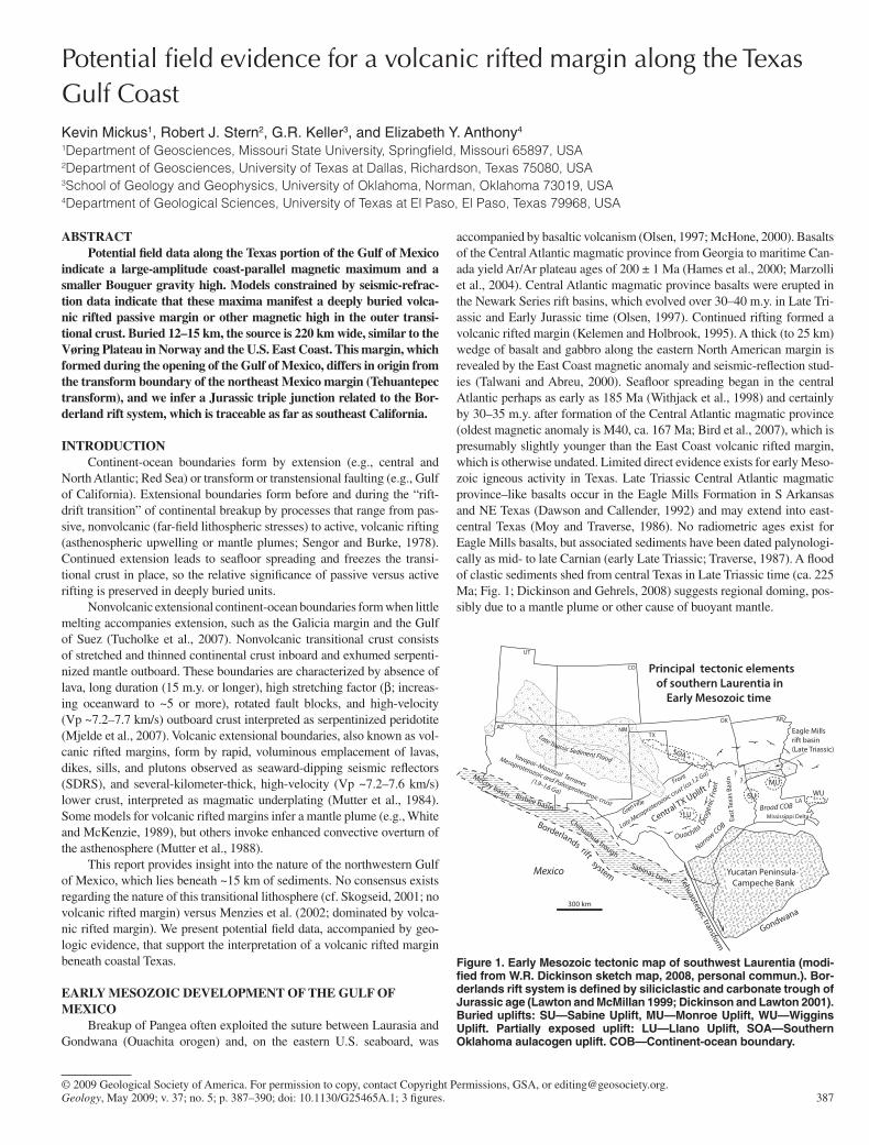
accompanied by basaltic volcanism (Olsen, 1997; McHone, 2000). Basalts of the Central Atlantic magmatic province from Georgia to maritime Can-ada yield Ar/Ar plateau ages of 200 ± 1 Ma (Hames et al., 2000; Marzolli et al., 2004). Central Atlantic magmatic province basalts were erupted in the Newark Series rift basins, which evolved over 30–40 m.y. in Late Tri-assic and Early Jurassic time (Olsen, 1997). Continued rifting formed a volcanic rifted margin (Kelemen and Holbrook, 1995). A thick (to 25 km) wedge of basalt and gabbro along the eastern North American margin is revealed by the East Coast magnetic anomaly and seismic-refl ection stud-ies (Talwani and Abreu, 2000). Seafl oor spreading began in the central Atlantic perhaps as early as 185 Ma (Withjack et al., 1998) and certainly by 30–35 m.y. after formation of the Central Atlantic magmatic province (oldest magnetic anomaly is M40, ca. 167 Ma; Bird et al., 2007), which is presumably slightly younger than the East Coast volcanic rifted margin, which is otherwise undated. Limited direct evidence exists for early Meso-zoic igneous activity in Texas. Late Triassic Central Atlantic magmatic province–like basalts occur in the Eagle Mills Formation in S Arkansas and NE Texas (Dawson and Callender, 1992) and may extend into east-central Texas (Moy and Traverse, 1986). No radiometric ages exist for Eagle Mills basalts, but associated sediments have been dated palynologi-cally as mid- to late Carnian (early Late Triassic; Traverse, 1987). A fl ood of clastic sediments shed from central Texas in Late Triassic time (ca. 225 Ma; Fig. 1; Dickinson and Gehrels, 2008) suggests regional doming, pos-sibly due to a mantle plume or other cause of buoyant mantle.
Geology, May 2009; v. 37; no. 5; p. 387–390; doi: 10.1130/G25465A.1; 3 fi gures.© 2009 Geological Society of America. For permission to copy, contact Copyright Permissions, GSA, or [email protected].
Potential fi eld evidence for a volcanic rifted margin along the Texas Gulf CoastKevin Mickus1, Robert J. Stern2, G.R. Keller3, and Elizabeth Y. Anthony4
1Department of Geosciences, Missouri State University, Springfi eld, Missouri 65897, USA2Department of Geosciences, University of Texas at Dallas, Richardson, Texas 75080, USA3School of Geology and Geophysics, University of Oklahoma, Norman, Oklahoma 73019, USA4Department of Geological Sciences, University of Texas at El Paso, El Paso, Texas 79968, USA
Yucatan Peninsula- Campeche Bank
SU
MUWU
300 km
Eagle Mills rift basin(Late Triassic)
??
East
Texa
s Ba
sin
OK AR
LA
Mississippi Delta
Ouachita
Oro
geni
c Fro
nt
Narrow COB
Broad COB
NM
CO
UT
AZTX
Chihuahua trough
Sabinas basin
McCoy basin
+
Tehuantepec transform
Gondwana
Bisbee basin
Late Triassic Sediment Flood
LU
SOA
Late Mesoproterozoic crust (ca.1.2 Ga)
Grenville
Front
Yavapai–Mazatzal Terranes
Mesoproterozoic and Paleoproterozoic crust
(1.9–1.6 Ga)
Mexico
Central TX Uplift
Borderlands rift system
Principal tectonic elements of southern Laurentia in Early Mesozoic time
Figure 1. Early Mesozoic tectonic map of southwest Laurentia (modi-fi ed from W.R. Dickinson sketch map, 2008, personal commun.). Bor-derlands rift system is defi ned by siliciclastic and carbonate trough of Jurassic age (Lawton and McMillan 1999; Dickinson and Lawton 2001). Buried uplifts: SU—Sabine Uplift, MU—Monroe Uplift, WU—Wiggins Uplift. Partially exposed uplift: LU—Llano Uplift, SOA—Southern Oklahoma aulacogen uplift. COB—Continent-ocean boundary.
388 GEOLOGY, May 2009
MAGNETIC AND GRAVITY EVIDENCE FOR A VOLCANIC RIFTED MARGIN
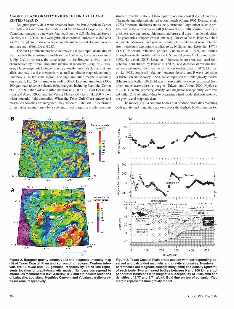
Bouguer gravity data were obtained from the Pan-American Center for Earth and Environmental Studies and the National Geophysical Data Center; aeromagnetic data were obtained from the U.S. Geological Survey (Bankey et al., 2002). Data were gridded, contoured, and color-scaled with a 45° sun angle to produce an aeromagnetic intensity and Bouguer gravity anomaly map (Figs. 2A and 2B).
The most prominent magnetic anomaly is a large-amplitude maximum that parallels the coastline from Mexico to Lafayette, Louisiana (anomaly 1, Fig. 2A). In contrast, the same region on the Bouguer gravity map is characterized by a small-amplitude maximum (anomaly 2, Fig. 2B). How-ever, a large-amplitude Bouguer gravity anomaly (anomaly 3, Fig. 2B) par-allels anomaly 1 and corresponds to a small-amplitude magnetic anomaly (anomaly 4) in the same region. The high-amplitude magnetic anomaly (anomaly 1, Fig. 2A) is similar in width (60–80 km) and amplitude (300–400 gammas) to some volcanic rifted margins, including Namibia (Corner et al., 2002). Other volcanic rifted margins (e.g., the U.S. East Coast; Tal-wani and Abreu, 2000) and the Vøring Plateau (Mjelde et al., 2007) have wider potential fi eld anomalies. When the Texas Gulf Coast gravity and magnetic anomalies are integrated, they widen to ~180 km. To determine if this wider anomaly may be a volcanic rifted margin, a profi le was con-
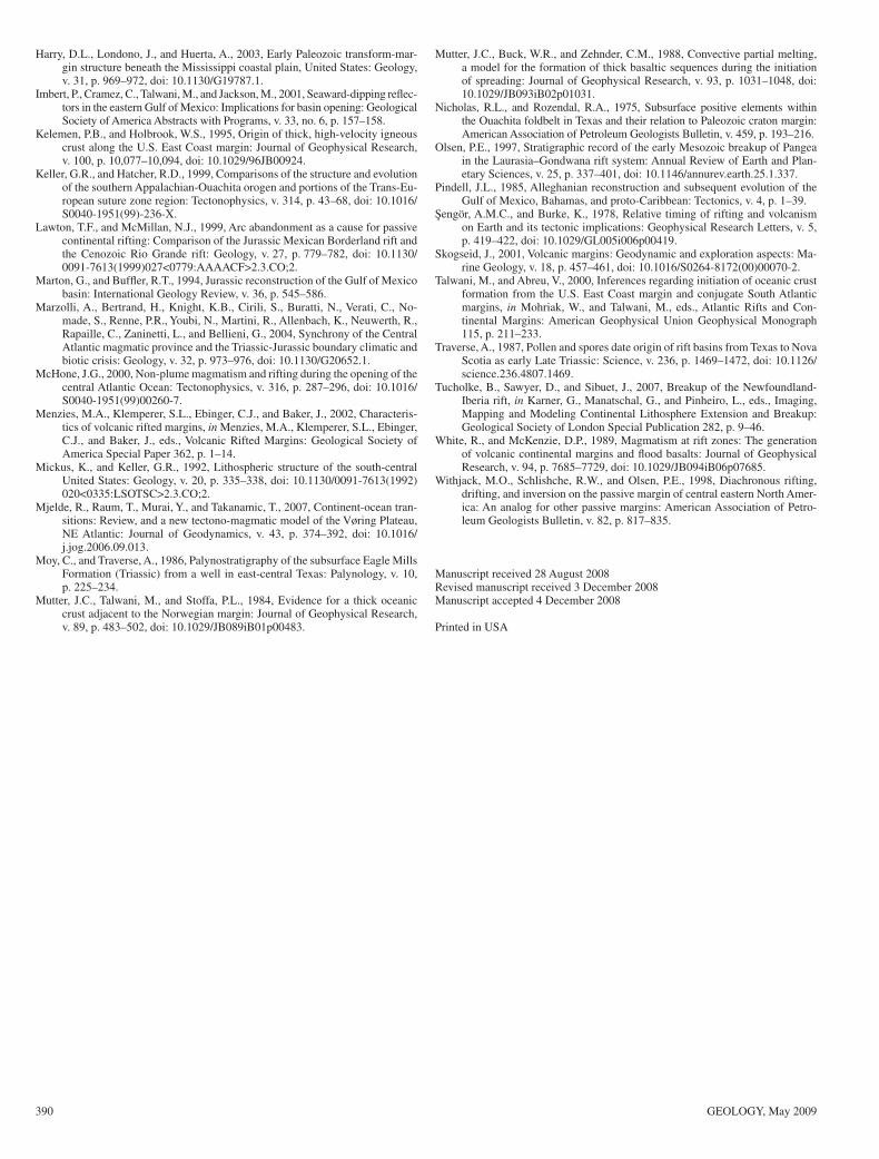
structed from the cratonic Llano Uplift to oceanic crust (Figs. 2A and 2B). The model includes seismic-refraction models (Cram, 1962; Dorman et al., 1972) for crustal thickness and velocity structure. Large-offset seismic pro-fi les within the northwestern gulf (Ebeniro et al., 1988) constrain sediment thickness, average crustal thickness, and crust and upper-mantle velocities. The geometries of upper-crustal units (e.g., Ouachita facies, Paleozoic shelf sediments, Mesozoic and younger coastal plain sediments) were obtained from petroleum exploration studies (e.g., Nicholas and Rozendal, 1975), COCORP seismic-refl ection profi les (Cullota et al., 1992), and similar lithospheric-scale profi les within the U.S. coastal plain (Mickus and Keller, 1992; Harry et al., 2003). Location of the oceanic crust was estimated from potential fi eld studies by Bird et al. (2005), and densities of various bod-ies were estimated from seismic-refraction studies (Cram, 1962; Dorman et al., 1972), empirical relations between density and P-wave velocities (Christensen and Mooney, 1995), and comparison to similar gravity models (Mickus and Keller, 1992). Magnetic susceptibilities were estimated from other studies across passive margins (Talwani and Abreu, 2000; Mjelde et al., 2007). Depth, geometry, density, and magnetic susceptibility were var-ied within 20% of initial values to determine a fi nal model that best matched the gravity and magnetic data.
The model (Fig. 3) contains bodies that produce anomalies matching both gravity and magnetic data except for the dashed, bolded line on top
Figure 3. Texas Coastal Plain cross section with corresponding ob-served and calculated magnetic and gravity anomalies. Numbers in parentheses are magnetic susceptibility (emu) and density (gm/cm3) of each body. Two unnamed bodies between 0 and 100 km are up-per-crustal intrusions with magnetic susceptibility of 0.005 emu and densities of 2.77 and 2.71 g/cm3. Bold line on top of volcanic rifted margin represents fi nal gravity model.
Figure 2. Bouguer gravity anomaly (A) and magnetic intensity map (B) of Texas Coastal Plain and surrounding regions. Contour inter-vals are 10 mGal and 100 gammas, respectively. Thick line repre-sents location of gravity/magnetic model. Numbers correspond to anomalies mentioned in text. Asterisk, KC, and YP indicate locations of Lafayette, Louisiana, Keathley Canyon, and Yucatan parallel grav-ity maxima, respectively.

GEOLOGY, May 2009 389
of the volcanic rifted margin in the fi nal gravity model. This fi nal model fi ts a gravity maximum at 360 km that is not apparent on the magnetic profi le. We assume that the source is within the volcanic rifted margin, but it may be caused by positive density contrasts in the sedimentary units above the volcanic rifted margin, e.g., younger volcanic rocks that are known from the region (Byerly, 1991). The fi nal model contains tectonic elements that affected the southern margin of North America, including a Paleozoic passive margin, late Paleozoic Ouachita orogeny, Mesozoic rifts, and younger passive margin sediments. All these tectonic features are shown in the fi nal model (Fig. 3), but the main focus here is the high den-sity and magnetic susceptibility material along the Texas coastline. The magnetic anomalies between 240 and 320 km and 410 and 480 km were fi rst modeled as individual bodies. When combined with the gravity data, one large body produced the best fi t. Two individual bodies would have to be shallower and have higher density and magnetic susceptibility values than those shown in Figure 3. Given the known thickness of the Mesozoic and younger coastal plain sediments, such a model was ruled out.
DISCUSSIONThe relatively high density (3.00 g/cm3) and magnetic susceptibility
(0.06 emu) for outer transitional crust suggest a large, deeply buried mafi c igneous complex, probably a volcanic rifted margin. This interpretation is new, although seaward-dipping seismic refl ectors have been seismically imaged in the eastern Gulf of Mexico (Imbert et al., 2001). Alternative hypotheses exist. Marton and Buffl er (1994) suggested that the transi-tional crust of this region was formed by low-angle normal faulting along a south-dipping detachment. The asymmetrical distribution of different crustal types under the Louisiana sector of the basin and differences in the sedimentary record between the northern and southern gulf support a lithospheric simple-shear model for the evolution of the basin’s conjugate passive margins. However, the nature of the transitional lithosphere var-ies markedly along strike; it is unlikely that the continent-ocean bound-ary from northeast Mexico to Louisiana has the same origin. The rifted zone in Texas from the Llano Uplift to the sea is relatively narrow (~250 km), but it is much broader (~500 km) in southern Arkansas and Louisi-ana (Fig. 1). In addition, the Sabine and other uplifts beneath Louisiana (Fig. 1) are buried continental tracts belonging to East Texas–Louisiana transitional lithosphere (Keller and Hatcher, 1999). The East Texas basin (Fig. 1) demarcates the boundary between these fundamentally different features. Also, Late Triassic uplift in central Texas adjacent to the narrow sector produced a northwestward-directed fl ood of clastic sediments about the same time that Eagle Mills rifting and basaltic activity occurred in southern Arkansas (Fig. 1). No evidence for a fl ood of clastic sediments shed from Arkansas-Louisiana is known.
Interpretation of the Texas continent-ocean boundary as a volcanic rifted margin provides a new perspective on the tectonic evolution of the western gulf region. A consensus exists that the NE Mexican margin is a transform continent-ocean boundary (Fig. 1), formed by the Jurassic Tehuantepec transform that allowed Yucatan to rotate counterclockwise away from Texas and Louisiana (Pindell, 1985; Dickinson and Lawton, 2001). Rifting of Yucatan (and Gondwanan fragments to the south) led to the formation of the northwestern Gulf of Mexico basin; this rotation occurred between ca. 160 Ma (Callovian) and 140 Ma (Valanginian) (Bird et al., 2005). Bird et al. (2005) inferred that a Late Jurassic mantle plume was involved with opening of the Gulf of Mexico in this region. Hotspot tracks today are marked by northwest-trending (Keathley Canyon) and southwest-trending (Yucatan parallel) gravity maxima (Fig. 2B) (Bird et al., 2005). The northern (Keathley Canyon) track originated near the South Texas boundary, which implies vigorous igneous activity during rifting.
Finally, the junction between the northwestern Mexico transform boundary and the Texas volcanic rifted margin is the terminus of the California-Coahuila rift, which can be traced ESE from southeast Cali-
fornia (Fig. 1; Marton and Buffl er, 1994; Lawton and McMillan, 1999). The Texas volcanic rifted margin, Tehuantepec transform, and California-Coahuila rift meet near the mouth of the Rio Grande at ~120° angles. This geometry is characteristic of a classic aulacogen, referred to as the Borderlands rift system.
CONCLUSIONSWe interpret potential fi eld data for the Texas coast as a deeply bur-
ied volcanic rifted margin. This interpretation is consistent with regional sedimentary patterns and detrital zircon ages, which indicate that central Texas was strongly uplifted in Late Triassic time prior to rifting, and it is also consistent with Yucatan separating from Texas along this rift and the postulated fossil hotspot track in the western Gulf of Mexico. The Texas volcanic rifted margin contrasts markedly with the northeastern Mexico margin, defi ned by the Tehuantepec transform. We conclude that the Texas volcanic rifted margin changes strike into a transform boundary to the south, defi ning a triple junction, and gradationally changes to a nonvolca-nic but still extensional boundary to the east along the Louisiana coast.
ACKNOWLEDGMENTSDiscussions with W.R. Dickinson about the Late Triassic clastic fl ood and the
Borderland rift system are greatly appreciated. We thank Tim Lawton, Dale Bird, and an anonymous reviewer for reviews. The research is supported by the Texas Advanced Research Program 003661-0003-2006 to Stern, Anthony, and Keller.
REFERENCES CITEDBankey, V., and 17 others, 2002, Digital data grids for the magnetic anomaly map of
North America: U.S. Geological Survey Open-File Report 02–414 (DVD). Bird, D.E., Burke, K., Hall, S.A., and Casey, J.F., 2005, Gulf of Mexico tec-
tonic history: Hotspot tracks, crustal boundaries, and early salt distribution: American Association of Petroleum Geologists Bulletin, v. 89, p. 311–328.
Bird, D.E., Hall, S.A., Burke, K., Casey, J.F., and Sawyer, D.S., 2007, Early cen-tral Atlantic Ocean seafl oor spreading history: Geosphere, v. 3, p. 282–298, doi: 10.1130/GES00047.1.
Byerly, G., 1991, Nature of igneous activity, in Salvador, A., ed., The Gulf of Mexico Basin: Boulder, Colorado, Geological Society of America, Geology of North America, v. J, p. 91–108.
Christensen, N.I., and Mooney, W., 1995, Seismic velocity structure and compo-sition of the continental crust; a global view: Journal of Geophysical Re-search, v. 100, p. 9761–9788, doi: 10.1029/95/JB00259.
Corner, B., Cartwright, J., and Swart, R., 2002, Volcanic passive margin of Na-mibia: A potential fi elds perspective, in Menzies, M.A., Klemperer, S.L., Ebinger, C.J., and Baker, J., eds., Volcanic Rifted Margins: Geological So-ciety of America Special Paper 362, p. 203–220.
Cram, I.H., 1962, Crustal structure of the Texas Coastal Plain region: American Association of Petroleum Geologists Bulletin, v. 46, p. 1721–1727.
Cullota, R.C., Latham, T., Sydow, M., Oliver, J., Brown, L., and Kaufman, S., 1992, Deep structure of the Texas Gulf passive margin and its Ouachita-Precambrian basement; results of the COCORP San Marcos Arch survey: American Association of Petroleum Geologists Bulletin, v. 76, p. 270–283.
Dawson, W.C., and Callender, C.A., 1992, Diagenetic and sedimentologic aspects of Eagle Mills–Werner conglomerate sandstones (Triassic-Jurassic), north-east Texas: Gulf Coast Association of Geological Societies Transactions, v. 24, p. 449–457.
Dickinson, W.R., and Gehrels, G.G., 2008, U-Pb ages of detrital zircons in relation to paleogeography: Triassic paleodrainage networks and sediment dispersal across southwest Laurentia: Journal of Sedimentary Research, v. 78, p. 745–764.
Dickinson, W.R., and Lawton, T.F., 2001, Tectonic setting and sandstone petrofa-cies of the Bisbee basin (USA-Mexico): Journal of South American Earth Sciences, v. 14, p. 475–504, doi: 10.1016/S0895-9811(01)00046-3.
Dorman, J., Worzel, J.L., Leyden, R., Crook, T.N., and Hatziemmanuel, M., 1972, Crustal section from seismic refraction measurements near Victoria, Texas: Geophysics, v. 37, p. 325–336, doi: 10.1191/1.1440262.
Ebeniro, J., Nakamura, Y., Sawyer, D.S., and O’Brien, W.P., 1988, Sedimentary and crustal structure of the northwestern Gulf of Mexico: Journal of Geo-physical Research, v. 93, p. 9075–9092, doi: 10.1029/JB093iB08p0975.
Hames, W.E., Renne, P.R., and Ruppel, C., 2000, New evidence for geologically instantaneous emplacement of earliest Jurassic Central Atlantic magmatic province basalts on the North American margin: Geology, v. 28, p. 859–862, doi: 10.1130/0091-7613(2000)28<859:NEFGIE>2.0.CO;2.
390 GEOLOGY, May 2009
Harry, D.L., Londono, J., and Huerta, A., 2003, Early Paleozoic transform-mar-gin structure beneath the Mississippi coastal plain, United States: Geology, v. 31, p. 969–972, doi: 10.1130/G19787.1.
Imbert, P., Cramez, C., Talwani, M., and Jackson, M., 2001, Seaward-dipping refl ec-tors in the eastern Gulf of Mexico: Implications for basin opening: Geological Society of America Abstracts with Programs, v. 33, no. 6, p. 157–158.
Kelemen, P.B., and Holbrook, W.S., 1995, Origin of thick, high-velocity igneous crust along the U.S. East Coast margin: Journal of Geophysical Research, v. 100, p. 10,077–10,094, doi: 10.1029/96JB00924.
Keller, G.R., and Hatcher, R.D., 1999, Comparisons of the structure and evolution of the southern Appalachian-Ouachita orogen and portions of the Trans-Eu-ropean suture zone region: Tectonophysics, v. 314, p. 43–68, doi: 10.1016/S0040-1951(99)-236-X.
Lawton, T.F., and McMillan, N.J., 1999, Arc abandonment as a cause for passive continental rifting: Comparison of the Jurassic Mexican Borderland rift and the Cenozoic Rio Grande rift: Geology, v. 27, p. 779–782, doi: 10.1130/0091-7613(1999)027<0779:AAAACF>2.3.CO;2.
Marton, G., and Buffl er, R.T., 1994, Jurassic reconstruction of the Gulf of Mexico basin: International Geology Review, v. 36, p. 545–586.
Marzolli, A., Bertrand, H., Knight, K.B., Cirili, S., Buratti, N., Verati, C., No-made, S., Renne, P.R., Youbi, N., Martini, R., Allenbach, K., Neuwerth, R., Rapaille, C., Zaninetti, L., and Bellieni, G., 2004, Synchrony of the Central Atlantic magmatic province and the Triassic-Jurassic boundary climatic and biotic crisis: Geology, v. 32, p. 973–976, doi: 10.1130/G20652.1.
McHone, J.G., 2000, Non-plume magmatism and rifting during the opening of the central Atlantic Ocean: Tectonophysics, v. 316, p. 287–296, doi: 10.1016/S0040-1951(99)00260-7.
Menzies, M.A., Klemperer, S.L., Ebinger, C.J., and Baker, J., 2002, Characteris-tics of volcanic rifted margins, in Menzies, M.A., Klemperer, S.L., Ebinger, C.J., and Baker, J., eds., Volcanic Rifted Margins: Geological Society of America Special Paper 362, p. 1–14.
Mickus, K., and Keller, G.R., 1992, Lithospheric structure of the south-central United States: Geology, v. 20, p. 335–338, doi: 10.1130/0091-7613(1992)020<0335:LSOTSC>2.3.CO;2.
Mjelde, R., Raum, T., Murai, Y., and Takanamic, T., 2007, Continent-ocean tran-sitions: Review, and a new tectono-magmatic model of the Vøring Plateau, NE Atlantic: Journal of Geodynamics, v. 43, p. 374–392, doi: 10.1016/j.jog.2006.09.013.
Moy, C., and Traverse, A., 1986, Palynostratigraphy of the subsurface Eagle Mills Formation (Triassic) from a well in east-central Texas: Palynology, v. 10, p. 225–234.
Mutter, J.C., Talwani, M., and Stoffa, P.L., 1984, Evidence for a thick oceanic crust adjacent to the Norwegian margin: Journal of Geophysical Research, v. 89, p. 483–502, doi: 10.1029/JB089iB01p00483.
Mutter, J.C., Buck, W.R., and Zehnder, C.M., 1988, Convective partial melting, a model for the formation of thick basaltic sequences during the initiation of spreading: Journal of Geophysical Research, v. 93, p. 1031–1048, doi: 10.1029/JB093iB02p01031.
Nicholas, R.L., and Rozendal, R.A., 1975, Subsurface positive elements within the Ouachita foldbelt in Texas and their relation to Paleozoic craton margin: American Association of Petroleum Geologists Bulletin, v. 459, p. 193–216.
Olsen, P.E., 1997, Stratigraphic record of the early Mesozoic breakup of Pangea in the Laurasia–Gondwana rift system: Annual Review of Earth and Plan-etary Sciences, v. 25, p. 337–401, doi: 10.1146/annurev.earth.25.1.337.
Pindell, J.L., 1985, Alleghanian reconstruction and subsequent evolution of the Gulf of Mexico, Bahamas, and proto-Caribbean: Tectonics, v. 4, p. 1–39.
Şengör, A.M.C., and Burke, K., 1978, Relative timing of rifting and volcanism on Earth and its tectonic implications: Geophysical Research Letters, v. 5, p. 419–422, doi: 10.1029/GL005i006p00419.
Skogseid, J., 2001, Volcanic margins: Geodynamic and exploration aspects: Ma-rine Geology, v. 18, p. 457–461, doi: 10.1016/S0264-8172(00)00070-2.
Talwani, M., and Abreu, V., 2000, Inferences regarding initiation of oceanic crust formation from the U.S. East Coast margin and conjugate South Atlantic margins, in Mohriak, W., and Talwani, M., eds., Atlantic Rifts and Con-tinental Margins: American Geophysical Union Geophysical Monograph 115, p. 211–233.
Traverse, A., 1987, Pollen and spores date origin of rift basins from Texas to Nova Scotia as early Late Triassic: Science, v. 236, p. 1469–1472, doi: 10.1126/science.236.4807.1469.
Tucholke, B., Sawyer, D., and Sibuet, J., 2007, Breakup of the Newfoundland-Iberia rift, in Karner, G., Manatschal, G., and Pinheiro, L., eds., Imaging, Mapping and Modeling Continental Lithosphere Extension and Breakup: Geological Society of London Special Publication 282, p. 9–46.
White, R., and McKenzie, D.P., 1989, Magmatism at rift zones: The generation of volcanic continental margins and fl ood basalts: Journal of Geophysical Research, v. 94, p. 7685–7729, doi: 10.1029/JB094iB06p07685.
Withjack, M.O., Schlishche, R.W., and Olsen, P.E., 1998, Diachronous rifting, drifting, and inversion on the passive margin of central eastern North Amer-ica: An analog for other passive margins: American Association of Petro-leum Geologists Bulletin, v. 82, p. 817–835.
Manuscript received 28 August 2008Revised manuscript received 3 December 2008Manuscript accepted 4 December 2008
Printed in USA


![West Contra Costa Unified School District · ELD 2A ELD 2B ELD 3A ELD 3B ELD 4 [P] Eng/Read(R180) English 1 [P] English 2 [P] ... English/Reading Ensemble [P] Environmental Science](https://img.pdfslide.us/doc/110x75/5ed3ab4e89ea24219c3ce538/west-contra-costa-unified-school-district-eld-2a-eld-2b-eld-3a-eld-3b-eld-4-p.jpg)