Embed Size (px)
DESCRIPTION
Diff. ancient cities
Citation preview

ANCIENT CITIES
AR 173P

ANCIENT CITY OF CATAL HUYUK
A settlement in Turkey about 7000 BCC
Contained domestic buildings attached to one another.
Access was through stairs and opening on the flat roof
Rooftops serve as place for outdoor activities. Also contained communal ovens
The people of Çatalhöyük buried their dead within the village.
Human remains have been found in pits beneath the floors and, especially, beneath hearths, the platforms within the main rooms, and under beds.
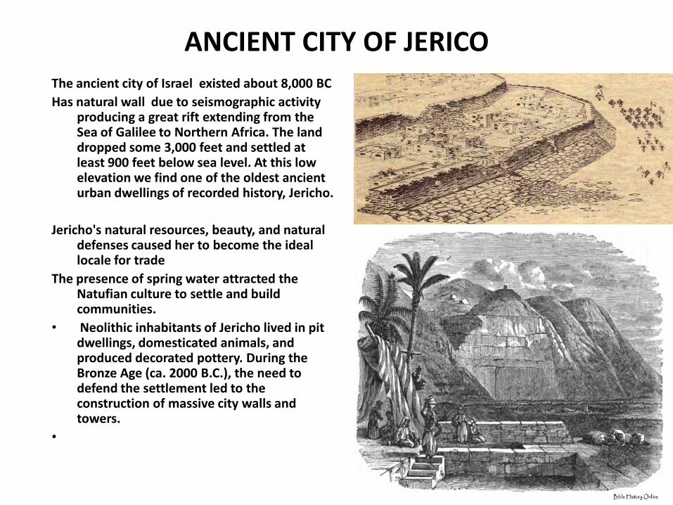
ANCIENT CITY OF JERICO The ancient city of Israel existed about 8,000 BC
Has natural wall due to seismographic activity producing a great rift extending from the Sea of Galilee to Northern Africa. The land dropped some 3,000 feet and settled at least 900 feet below sea level. At this low elevation we find one of the oldest ancient urban dwellings of recorded history, Jericho.
Jericho's natural resources, beauty, and natural defenses caused her to become the ideal locale for trade
The presence of spring water attracted the Natufian culture to settle and build communities.
• Neolithic inhabitants of Jericho lived in pit dwellings, domesticated animals, and produced decorated pottery. During the Bronze Age (ca. 2000 B.C.), the need to defend the settlement led to the construction of massive city walls and towers.
•
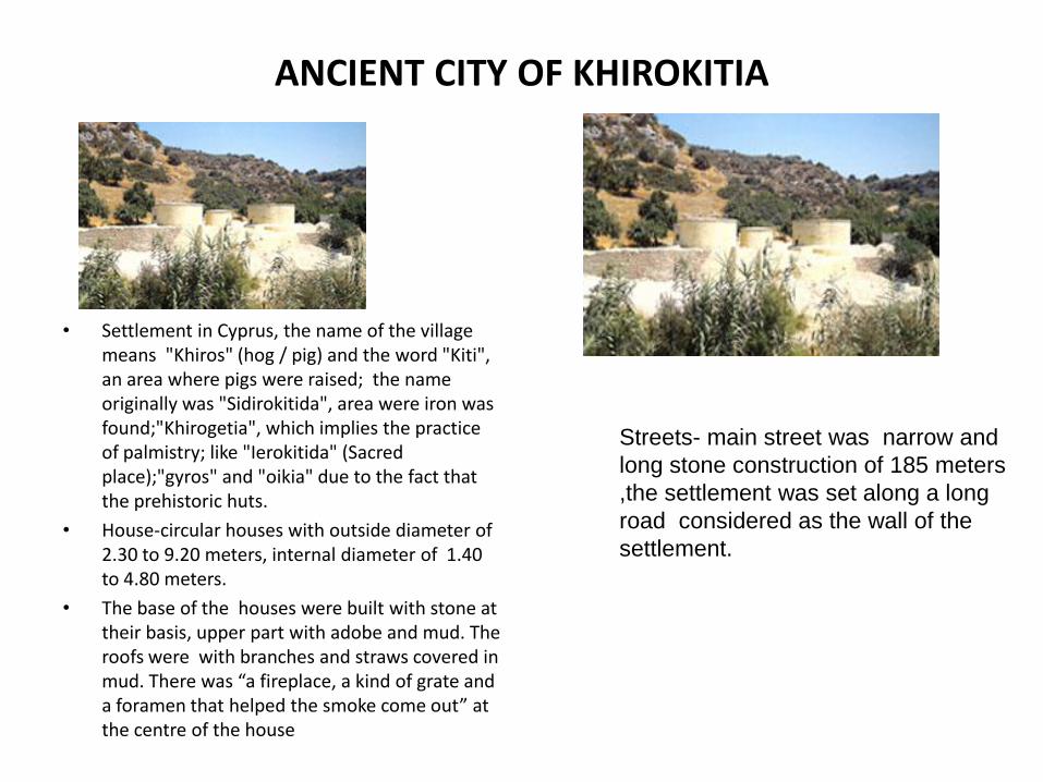
ANCIENT CITY OF KHIROKITIA
• Settlement in Cyprus, the name of the village means "Khiros" (hog / pig) and the word "Kiti", an area where pigs were raised; the name originally was "Sidirokitida", area were iron was found;"Khirogetia", which implies the practice of palmistry; like "Ierokitida" (Sacred place);"gyros" and "oikia" due to the fact that the prehistoric huts.
• House-circular houses with outside diameter of 2.30 to 9.20 meters, internal diameter of 1.40 to 4.80 meters.
• The base of the houses were built with stone at their basis, upper part with adobe and mud. The roofs were with branches and straws covered in mud. There was “a fireplace, a kind of grate and a foramen that helped the smoke come out” at the centre of the house
Streets- main street was narrow and
long stone construction of 185 meters
,the settlement was set along a long
road considered as the wall of the
settlement.

• It was a city-state of ancient Mesopotamia, the remains of which are found in present-day Al Hillah, Babil Province, Iraq
• Babylon was at first a small town, that had sprung up by the beginning of the 3rd millennium BC.
• The town flourished and attained prominence and political repute with the rise of the First Babylonian Dynasty.
• The city itself was built upon the Euphrates, and divided in equal parts along its left and right banks.
ANCIENT BABYLON

• It was the "holy city" of Babylonia by approximately 2300 BC, and the seat of the Neo-Babylonian Empire from 612 to 539 BC.
• The First Babylonian Dynasty was established by Sumu-abum, but the city-state controlled little surrounding territory until it became the capital of Hammurabi's empire a century later
• capital of the region known as Babylonia – although during the almost 400 years of domination by the Kassites during the Late Bronze Age, the city was renamed Karanduniash
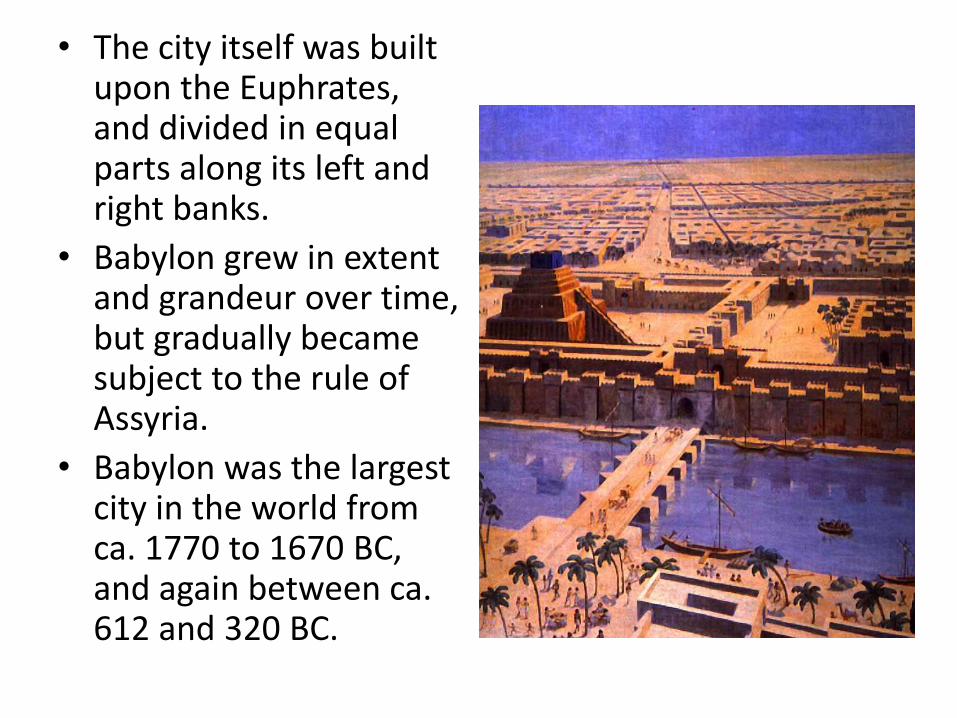
• The city itself was built upon the Euphrates, and divided in equal parts along its left and right banks.
• Babylon grew in extent and grandeur over time, but gradually became subject to the rule of Assyria.
• Babylon was the largest city in the world from ca. 1770 to 1670 BC, and again between ca. 612 and 320 BC.

• During the reign of Sennacherib of Assyria, Babylonia was in a constant state of revolt, led by Mushezib-Marduk, and suppressed only by the complete destruction of the city of Babylon.
• In 689 BC, its walls, temples and palaces were razed, and the rubble was thrown into the Arakhtu, the sea bordering the earlier Babylon on the south.
• his successor Esarhaddon rebuilt the old city, to receive there his crown, and make it his residence during part of the year.
• On his death, Babylonia was left to be governed by his elder son Shamash-shum-ukin, who eventually headed a revolt in 652 BC against his brother in Nineveh, Assurbanipal.

• Under Nabopolassar, Babylon threw off the Assyrian rule in 612 BC and became the capital of the Neo-Babylonian Chaldean Empire.
• his son Nebuchadnezzar II (604–561 BC) made Babylon into one of the wonders of the ancient world. He ordered the complete reconstruction of the imperial grounds, including rebuilding the Etemenanki ziggurat and the construction of the Ishtar Gate
• Nebuchadnezzar is also credited with the construction of the Hanging Gardens of Babylon (one of the seven wonders of the ancient world), said to have been built for his homesick wife Amyitis.

• Use of burnt brick
• It had an inner and outer part.
• Heavily fortified
• Inner town:
– Square in plan
– Contains the principal buildings, the Euphrates river in the west side
• Main streets intersected at right angles terminating in tower –framed bronze gates
CITY FORM AND SHAPE

• Between the main streets tiered dwellings, business houses, temples, chapels and shrines jostled in lively disorder
• Principal sites lined the river front, and behind them ran a grand professional way, its vista closed on the north by the Ishtar gate.
• There were palace-citadels and connected with Nebuchadnezzar’s great palace complex

SOCIO-CULTURAL AND ECONOMIC ASPECT
• CODE OF HAMMURABI – Code consists of 282 laws,
with scaled punishments, adjusting "an eye for an eye" as graded depending on social status, of slave versus free man. It also insists on justice to widows, orphans and to the poor.
– The code has been seen as an example of even a king not being able to change fundamental laws concerning the governing of a country which was the primitive form of what is now known as a constitution.
– “an eye for an eye, a tooth for a tooth”

• The Babylonians and their neighbors developed the earliest system of economics that was fixed in a legal code, using a metric of various commodities.
• The early law codes from Sumer could be considered the first (written) economic formula, and have many attributes still in use in the current price system today, such as codified amounts of money for business deals (interest rates), fines in money for wrongdoing, inheritance rules and laws concerning how private property is to be taxed or divided.

• Babylonian merchants were a powerful class and were even called the “rulers” in some communities.
• There were no coins then but the use lumps of silver of a given weight
• Schools were necessary to train men for business and government
• These were usually in or connected with the temple

STRUCTURES
• HANGING GARDENS OF BABYLON – Considered to be one of the
original Seven Wonders of the Ancient World.
– Sometimes referred to as the Hanging Gardens of Semiramis.
– Built by the Babylonian king Nebuchadnezzar II around 600 BC.
– He is reported to have constructed the gardens to please his homesick wife, Amytis of Media, who longed for the trees and fragrant plants of her homeland Persia. The gardens were destroyed by several earthquakes after the 2nd century BC.
A 16th-century hand-coloured engraving of the
"Hanging Gardens of Babylon" by Dutch artist Martin
Heemskerck

• ISHTAR GATE – Eighth gate to the inner city of
Babylon. It was constructed in about 575 BC by order of King Nebuchadnezzar II on the north side of the city.
– Dedicated to the Babylonian goddess Ishtar, the Gate was constructed of blue glazed tiles with alternating rows of bas-relief sirrush (dragons) and aurochs.
– The roof and doors of the gate were of cedar, according to the dedication plaque. Through the gate ran the Processional Way which was lined with walls covered in lions on glazed bricks (about 120 of them).
– Statues of the deities were paraded through the gate and down the Processional Way each year during the New Year's celebration.
The replica Ishtar Gate in Babylon in
2004

• ETEMENAKI – Was the name of a
ziggurat dedicated to Marduk in the city of Babylon of the 6th century BCE Neo-Babylonian dynasty.
– Originally seven stories in height, little remains of it now save ruins.
– Seven stories of the ziggurat reached a height of 91 meters, according to a tablet from Uruk, and contained a temple shrine at the top

ANCIENT EGYPT

Ancient Map

City Planning
Descriptions: • Grid Layout • Walled Cities • More on Square • Symmetrical Considerations: Settlements were located
along Nile • Residential –NE, SW • Mid-winter sunrise

Housing were according to
social classes
Presence of workers camp
to temporarily house worker
farmers commissioned as
construction workers


Ancient cities
Some examples:
• Memphis
• Abydos
• Alexandria
• Thebes
• Tanis

Memphis
Historical Development • Founded around 3100 BC by Menes • Memphis had some 30,000 inhabitants • It declined briefly during the 12th and 13th Dynasties which
had their Capital at Fayum • Memphis remained important as Lower Egypt Capital
during the dominance of Thebes • Became the seat of the Persian satraps, during the 27th
Dynasty. Second only to Alexandria under the Ptolemies and under Rome
• It finally declined with the founding of nearby Fustat by the Arabs

Memphis
• Type of settelement: Capital City
• Local Deity: Ptah
• Remains:
Saqqara
Temple of Ptah

Abydos
Historial Development
• kings of the 1st and 2nd Dynasty were buried here.
• Abydos became the centre of the worship of Osiris
• - 18th Dynasty - Large chapel of Ahmose 1, and then Tuthmose built larger temple, 40 x 90 m. - 19th Dynasty - Seti 1 founded a temple to the south of the town in honor of the ancestral kings of the early dynasties, this was finished by Ramses 2, who also built a lesser temple of his own.
• Ahmose 2 in the 26th Dynasty rebuilt the temple again, and placed in it a large monolith shrine of red granite

Abydos
• Type of Settlement:
Religious center
• Structures:
Great Osiris Temple
Temple of Seti
Rameses II Temple

Alexandria
Historical Development • Founded in 331 BC • The city flourished as the greatest center of Hellenistic civilization, • Alexandria formally became part of the Roman Empire in 30 BC • In A.D. 391, Theodosius I had pagan temples and other structures
razed. • Alexandria rivaled Rome and Constantinople as a center of Christian
learning • When the Arabs took Alexandria in 642, its prosperity had withered • In 969 Alexandria's decline continued, accelerating in the 14th
century,

Alexandria
• Architectural Planning: Designed by Dinocrates, the personal architect of Alexander the Great .
The city incorporated the best in Hellenic planning and architecture.
Streets had a grid square, well defined pattern, unlike any other city in the ancient world.
• Remains: • Pompey’s Pillar

Thebes
Historical Development • 3200 BC • a number of small settlements and a village called Waset • Mentuhotep I 11th Dynasty united Egypt
Amenemhet 1 of the 12th Dynasty moved his capital to Crocodilopolis
• Ahmose 1 18th Dynasty established Thebes as his Capital • Thebes went into decline. • For a time in the 11th cent. BC, it was a separate political
entity under sacerdotal rule. Thebes was sacked by the Assyrians in 661 BC
• The Romans sacked it in 29 BC

Thebes
• Type of settlement:
Capital City
• Local Deity: Amun
• Monument:
Temple of Karnak
Temple of Luxor
Presence of monumental structures such as temples and pyramids

Tanis
• Founded around the time of the 20th Dynasty - Capital city of the 21st and 22d dynasties - The Tanite rulers brought existing statues and monuments from elsewhere in Egypt to build - The city became an important port for Asiatic trade, and a centre of textiles manufacture - However, to due flooding problems, it declined during the Roman period, and by the 14th century, the region was deserted.

Tanis
• Type of Settlement:
Capital City
• Local Deity: Amun
• Structures:
Amun Temple

ANCIENT GREECE

• Classical Greek cities were
either the result of continuous
growth, extending prehistoric
times through Dark Age and
Archaic periods, or created at a
single moment, usually as the
result of colonial settlement.
• The Former had streets which
followed lines of communication,
curving and bending where
necessary to avoid obstacles or to
ease gradients.
• The latter generally Grid plans,
with straight streets crossing at right
angles, ignoring obstacles, and
becoming stairways where the
gradients were too steep,
• Towns always had fixed
boundaries.
• In the 6th century some were
surrounded by fortifications
• In the most Greek towns much of
the available area were devoted to
public rather than private use.


Hippodamus of Miletus
• was an ancient Greek architect, urban planner, physician, mathematician, meteorologist and philosopher and is considered to be the “father” of urban planning, the namesake of Hippodamian plan of city layouts (grid plan).
• His plans of Greek cities were characterized by order and regularity in contrast to the more intricacy and confusion common to cities of that period, even Athens.
Dinocrates of Rhodes
• was a Greek architect and technical adviser for Alexander the Great. He is known for his plan for the city of Alexandria, the monumental funeral pyre for Hephaestion and the reconstruction of the Temple of Artemis at Ephesus, as well as other works.


Socio-cultural

• Greece in the Archaic Period was made up from independent states, called Polis, or city state.
• Greek Society was mainly broken up between Free people and Slaves, who were owned by the free people. Slaves were used as servants and labourers, without any legal rights. Sometimes the slaves were prisoners of war or bought from foreign slave traders. Although many slaves lived closely with their owners, few were skilled craftsmen and even fewer were paid.
• The social classes applied to men only, as women all took their social and legal status from their husband or their male partner. Women in ancient Greece were not permitted to take part in public life.

• The Greeks developed three architectural systems, called
orders, each with their own distinctive proportions and
detailing. The Greek orders are: Doric, Ionic, and Corinthian.
Doric
The Doric style is rather
sturdy and its top (the
capital), is plain. This
style was used in
mainland Greece and the
colonies in southern
Italy and Sicily.
Ionic
The Ionic style is thinner
and more elegant. Its
capital is decorated with
a scroll-like design (a
volute). This style was
found in eastern Greece
and the islands.
Corinthian
The Corinthian style is
seldom used in the
Greek world, but often
seen on Roman temples.
Its capital is very
elaborate and decorated
with acanthus leaves.

Agora of Athens
• The important gathering place was the Agora, which was the placed conveniently for communication, on the flat ground and as easily accessible as possible from all directions.
• The agora of Athens was situated on low lying damp ground to the North of the Acropolis, which had been incorporated in the city in the early Archaic Period.
• The central space of Agora was free of buildings.
• Other public buildings included gymnasia and stadia and places for watching dramatic and related performances.
• Private houses were normally of the courtyard type.
• Most extensive series of houses of the Classical period are those excavated in the area immediately excavated at the North Aegean Town of Olynthus; a new area was laid out in grid plan.

Civic Buildings
• Other administrative buildings provided closed accommodation. On the west were the Bouleuterion or council house and the Tholos.
• Bouleuterion held five hundred
councilors who met in closed session .The original building was a square, probably with windows set high in plain walls and the roof was pyramidal. The building was divided internally into an anteroom and an auditorium.
• Tholos is a circular building. Though an official structure its walls were unbaked mud brick. The roof supports, were arranged not in a circle but in an ellipse. The roof itself was conical, with scale like tiles.
STOAS
• proved to be useful buildings in the context of the agora. They provide shelter, and served many purposes, especially when they include rooms behind the colonnade. In addition, they were a way of embellishing boundary of the agora, looking in towards the open space.
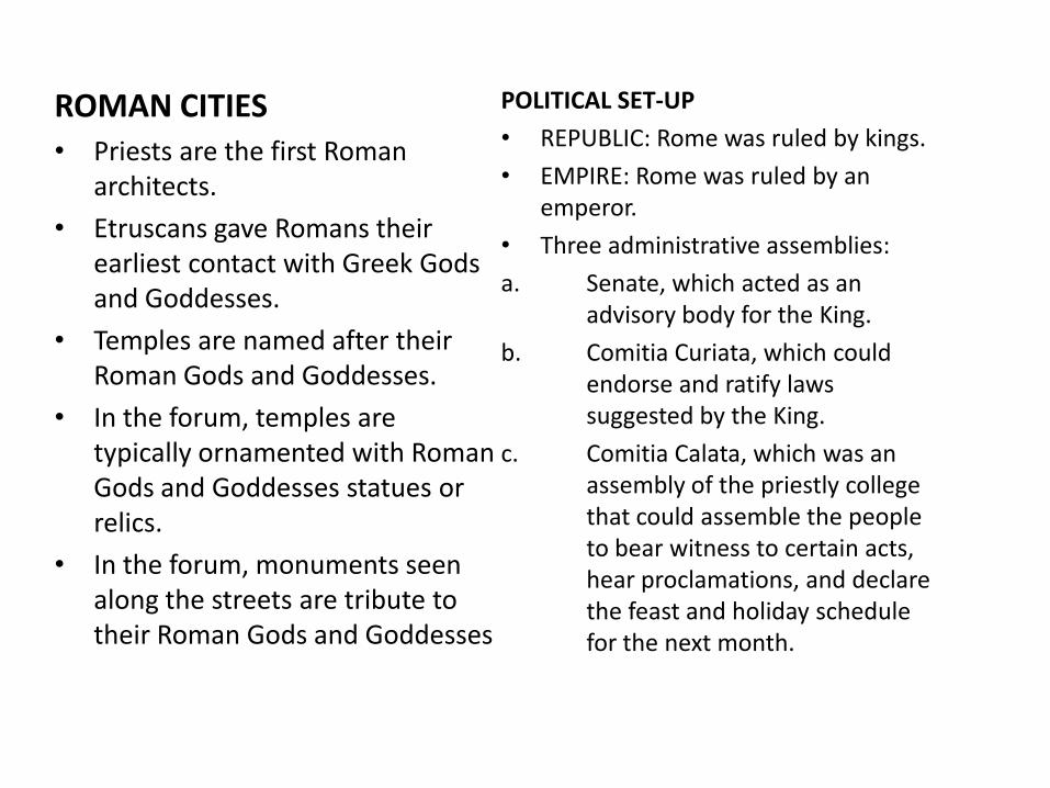
ROMAN CITIES • Priests are the first Roman
architects.
• Etruscans gave Romans their earliest contact with Greek Gods and Goddesses.
• Temples are named after their Roman Gods and Goddesses.
• In the forum, temples are typically ornamented with Roman Gods and Goddesses statues or relics.
• In the forum, monuments seen along the streets are tribute to their Roman Gods and Goddesses
POLITICAL SET-UP
• REPUBLIC: Rome was ruled by kings.
• EMPIRE: Rome was ruled by an emperor.
• Three administrative assemblies:
a. Senate, which acted as an advisory body for the King.
b. Comitia Curiata, which could endorse and ratify laws suggested by the King.
c. Comitia Calata, which was an assembly of the priestly college that could assemble the people to bear witness to certain acts, hear proclamations, and declare the feast and holiday schedule for the next month.

POLITICAL SET-UP
• Has an effective administration.
• Church and state are well respect.
• Administration brought large engineering projects: streets, aqueducts and effective city planning measures.
• Romans were the first to incorporate the methodical development of water supply systems into urban planning.
• THREE PERIODS:
a. REPUBLICAN PERIOD (510-44 B.C.)
b. EARLY EMPIRE (44 B.C.-A.D. 285)
c. LATE EMPIRE (A.D. 285-A.D.1453)
SOCIO-CULTURAL
• Roman families are characterized by strong ties and responsibilities among its members including father (pater familias), his wife, children, and other relatives.
• Families typically lived in:
a. Roman private residence (Domus) with the introduction of Impluvium and Compluvium.
b. Insulae house has no toilets, but public baths sprawled within the city are located near the house.
c. Multistory apartment blocks where ground floor is for commercial purposes while second floor typically with balcony is for living purposes.

STRUCTURES BUILT • FORUM (Market place) – an open
area usually rectangular in shape, and often surrounded by colonnades on one or two storeys typically have Basilica (law courts with money exchanges), treasuries, record offices and Comitium (assembly places).
• Temples - dedicated to Roman Gods and Goddesses, typically raised on a high podium, emphasis was given to the facade and often set either singly or in groups inside colonnaded enclosures.
• Churches – earliest worship were in rooms of private houses, and only the altar and decorations identified them as Christians.
• Roman house – have atrium, compluvium (a large room with rectangular opening in the middle of its roof.) and impluvium (a shallow rectangular basin set in the floor immediately beneath, which the rain water ran into a vaulted underground cistern.).
• Shopping centers – had a row of shops opening off a barrel vaulted market hall.
• Taberna (one roomed shop) :
a. Bakeries – had counters near the street where the bread was sold while at the back of the shop there was storage space for grain, mills and ovens.
b. Fish shop – had marble slabs for preparing the fish, water tanks and ovens.
c. Wine shop – had solid masonry counters with wide mouthed jars sunk into them.
• Theatre composed of three elements:
a. Cavea ( public seats)
b. Orchestra ( private seats)
c. Scaena ( stage)
• Amphitheatre – it is an elliptical with an oval arena in the center use either for gladiatorial games or venationes.

• Circus – It was used for chariot racing and ion occasion for venationes and was the largest of all buildings used for entertainment.
• Public baths have: a. Apodyterium (Dressing room) b. Palaestra (Gym) c. Sudatoria (Sweating room) d. Caldarium (Hot bath) e. Tepidarium (Warm bath) f. Frigidarium (Cold bath) Thermae – baths on the large scale Balnea – baths on the small scale Natatio (Swimming pool) • Bridges – It is built typically in one
major span.
• Aqueducts have three pipes:
a. Top pipe – for private houses.
b. Middle pipe – for public baths and circuses.
c. Lowest pipe – for public fountains.
• Triumphal arches – It is usually dedicated to the emperor or members of the imperial family, but sometimes to towns, municipalities or to divinities.
• Fortifications
• Tombs – Four burial methods:
a. Formae – burials in the ground covered with a stone slab.
b. Loculi – a burial slot in the wall of a catacomb.
c. Arcosolia – an arched recess with the body either immured or in sarcophagus underneath.
d. Chamber tomb

PUBLIC BATH PLAN

TRIUMPHAL ARCHES

CASTRUM / CASTRA (MILITARY CAMP)

CITY SHAPE AND FORM: POMPEII
• LAYOUT: a. City layout is not that of the ideal CASTRUM TYPE or TIMGAD type (GRID
PATTERN). b. City layout is irregular. c. Later, typical city layout after rules in city planning were implemented is
rectangular plan and is influenced due to military condition. • STREETS: a. Streets do not intersect at right angles. b. Streets are irregular and narrow. c. Stepping stones for pedestrians were spaced. d. Street intersections have public fountains. e. “STRADA DELL’ ABBONDANZA” a commercial street with small shops,
offices, taverns, bakeries, etc. f. Streets are paved with heavy flagstone. g. Introduction of CARDO (North to South) and DECUMANOS (East to West)
axis - a grid of smaller streets dividing the city into blocks, and a wall circuit with gates (Vesuvius and Stabian).
• BLOCKS: a. Islands (CITY BLOCKS) are irregular. b. Forums are set apart from the major traffic arteries, and vehicles cannot
enter it. c. Forum is situated in the intersection of the cardo and decumanos axis. d. Curia and basilica stands on south.

DECLINATION OF POMPEII
• Damaged by an earthquake in A.D. 63. • Demolished by an eruption of Mount Vesuvius in 24 August A.D. 79
burying to a depth of 4 – 5meters of volcanic ash, the eruption also changed the course of the Sarnus and raised the sea beach, placing the river and the sea at a considerable distance from the ruined city and obscuring the original site.
• They put “CIVITA” to remind people that once there had been city there until it was excavated in the 18th century.

MEDIEVAL CITIES
SOCIO-CULTURAL ECONOMIC
• the structure of society was determined by how hard it was to provide a steady food supply.
• the proportion of the
population freed of all agricultural tasks was extremely low, and the materials of luxury or warfare were rare and highly prized.
• the top of the system were kings and emperors, but with the spread of Christianity, they to exude a certain amount of priestly character.
• FEUDALISM

FEUDALISM
•Barbaric rulers established city-
states and rulers divided their
lands among vassal lords who
pledged military support for the
kingdom.
•People depended on agriculture
and entered a state of serfdom
under their lords. The feudal
system was the new order.
•Wars among the feudal lords
were frequent. Strategic sites
were sought for new castles,
within these structures were serf
dwelling for protection

CITY PLANNING
• Irregular pattern in planning was devised to confuse enemies.
• Open spaces, streets, plazas
developed as an integral part of site.
• Streets were used for pedestrian
while wheels were restricted to main roads.
• Early medieval town was dominated by church or monastry & castle of lords.
• towns were sited in irregular terrain, occupying hill tops or islands. Towns assumed informal & irregular character.
• Church plaza became a market place.
• Roads generally radiated from church plaza& market plaza to gates with secondary lateral roadways connecting them.
• Castle was surrounded by wall & moat as a protective elements.

Medieval City CHARACTERISTICS 1. Street Layout • Streets generally generated from
the church plaza and market square to the gates with secondary lateral roadway connecting them
• Irregular street pattern in planning was devised to confuse enemies.
• Open spaces, streets, plazas developed as an integral part of site.
• Streets were used for pedestrian while wheels were restricted to main roads.
CARCASSONNE
- It contains market square, castle
& church of St.Nazzair.
- Irregular pattern for streets is
seen.

CARCASSONNE

• Dominated by castles, church, or monasteries
• Church plaza became the market place
• Townhall and guild hall were build adjacent to the market plaza
• Castles were fortified to shelter the lords in case of war
NOERDLINGEN
- It shows the radial & lateral pattern of irregular
road ways with the church plaza as the principal
focal point of the town.
A Cathedral
B Moat

NOERDLINGEN

• Buildings assumed a functional character in both location and form
• Structures were built to be “picturesque”
• Accidental vista, contrast of form and color resulted from the contour of the land and the ingenious selection of sites for each structures
• Structures were of Romanesque or Gothic styles
Mont-Saint-Michel located in Normandy
PICTURESQUE TOWNS

Medieval towns
Mont-Saint-Michel – located in
Normandy
is one of the most picturesque
castles
this castle is also its own city, built in
the Saint-Michel bay.
tides would bring in a daily barrier of
water between the castle and the
mainland..

RENAISSANCE
The Italian urban palace and country villa were adapted to the different political, social, and economic conditions.
17th and 18th century royal initiatives were often connected with military training or military services.
18th century movements for social reform brought a renewed emphasis on public buildings.
late 18th and early 19th century were notable for the construction of hospitals, prisons and institutions of public education, such as museums and for entertainment such as theatres an opera houses.
Linked with military needs were Renaissance ideas of city planning based on radial streets systems and centralized plan.
Most commonly put into practiced in founding new fortress citadels such as the Venetian Town of Palmanova.

• The basic layout of the city was an eight point star, created by overlaying two squares so that all the coners were equidistant.
• This shape probably tied to Filarete’s interest in astrology.
• By superimposition of two square whitin a circle and 16 radial routes, he designed a radial layout of the city.
Within existing city, streets were widened, straightened or newly planned on geometrical principles to focus on important monuments, fountains and obelisks.
The need for military control and the increase in the use of carriages and coaches made wider streets desirable.
City Planning provided the opportunities for uniform architectural developments such as terraced housing and the beginning of speculative building.

The political history of Italy was marked by shifting alliances and petty wars between numerous city-states.
The economic prosperity of late medieval Italy depended on early urbanization, precocious development of banking and the textile industries, maritime trade and the revenues of the church.
The planning of churches was influenced by symbolism, liturgical change, reforming movements and the new religious orders.
‘Decorum’ was a fundamental rule of Renaissance culture and the function of a church was crucial to its plan.
Large urban dwellings (‘palazzi’) of the urban participate exhibit considerable regional variation in their plans.
Symmetrical planning was common from the early 15th century.

In Roman cardinals, palaces
were larger, initially more loosely planned.
The distinctive planning of Venetian palaces was related to their waterside setting and conservative mercantile occupants.
The villa as a distinctive architectural type remerges in the Renaissance after its disappearance in late antiquity.
After the end of the Hundred Years of War and the expulsion of the English in 1453, France was less Feudal Kingdom and more Modern Monarchy.
Many fine Roman buildings had survived in Provence but it was not until French invasions of Italy in 1494 and 1508.
End of 16th century, a growing proportion of royal and state business was conducted in Paris.

Paris saw the construction of a large number of rich residences – ‘hotels’ – which became the characteristic building type on domestic planning.
The most striking example in the 17th century was Antoine Le Pautre’s Hotel de Beavais, Rue Francios Miron, Paris (1656).
new Counter- Reformation had an important impact on Roman Catholic church buildings.
The Napoleonic era saw a brief preference for the antique temple form, as in the Madeleine, Paris (1806).
Unparalleled centralization of royal power produced in Versailles a building which remained in France.
Versailles is also the supreme example of the garden as an adjunct to the house.
In mid 16th century to Ledoux’s revolutionary designs, the organization of urban spaces was a constant preoccupation of French architects.
Second half of 18th century saw the emerge of new types of buildings.

RENAISSANCE
• The styles of antiquity inspired Renaissance urban planning.
• Earlier cities were reorganized
• Utopian plans for ideal states were popular yet seldom realized.
• Rich citizens patroned massive building campaigns that reshaped Renaissance Europe
• Ideal cities are imagined according to absolute standards.
• They aim to provide the best possible accommodation for the society to which they aspire.
• The ground plans of ideal cities are often based on grids or other geometrical patterns.
• Antonio Averlino (1400 -1469) known as Filarete, proposed the first complete ideal city plan of the Renaissance - Sforzinda.
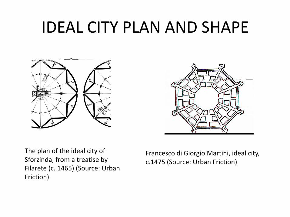
IDEAL CITY PLAN AND SHAPE
The plan of the ideal city of Sforzinda, from a treatise by
Filarete (c. 1465) (Source: Urban Friction)
Francesco di Giorgio Martini, ideal city, c.1475 (Source: Urban Friction)

Francesco di Giorgio Martini, mountain cities, c.1475 (Source: Urban Friction)
Giorgio Martini, mountain cities,
c.1475 (Source: Urban Friction)
Pietro Cataneo, pentagonal city plan, 1554