Embed Size (px)
Citation preview
Ancient Agricultural Soils of a Gridded Field Complex
in the Safford Basin
By Jeffrey A. Homburg1 and Jonathan A. Sandor2
1Statistical Research, Inc., 6099 Speedway Blvd., P.O. Box 31865, Tucson, Arizona 85751
2Agronomy Dept., Iowa State Univ., Ames, Iowa 50011

2
CONTENTS
Introduction
Methods
Results and discussion
Summary and conclusions
References cited
Appendix A. Soil profile descriptions
Profile description 1: grid interior, prospectorʼs pit 1
Profile description 2: next to rock pile, trench 2
Profile description 3: agricultural terrace, upslope of rock alignment, trench 1
Profile description 4: beneath rock alignment between two agricultural terraces,
trench 1b
Profile description 5: agricultural terrace, downslope of rock alignment, trench 1c
Profile 6: grid interior, shovel pit 4
List of figures
Figure 1. Aerial photograph showing soil sampling locations in gridded field locality 1.
Figure 2. Photograph of thick petrocalcic horizon exposed in prospectorʼs pit 1.
Figure 3. Photograph of shallow petrocalcic horizon below agricultural terraces and rock
alignments.
Figure 4. Photograph of argillic horizon exposed in prospectorʼs pit 2.
Figure 5. Histograms of soil chemistry and bulk density data.
Tables
Table 1. Soil chemistry and bulk density data for soil profiles in prospectorʼs pits.
Table 2. Particle-size data (%) for soil profiles in prospectorʼs pits.
Table 3. Soil chemistry and bulk density data for grid features, agricultural terraces, rock
piles and controls.
Table 4. Particle-size data (%) for grid features, agriculturl terraces, rock piles, and
controls.
INTRODUCTION
Soil properties associated with a Classic Period (~AD 1150-1450) agricultural complex
(site AZ CC:2:1[ASM]) were investigated to document and evaluate the soil fertility and
productivity of cultivated and uncultivated soils. The precise span of use is unknown, but the
presence of associated masonry field house structures, radiocarbon dates from roasting pit
features, and a small number of decorated sherds all point to Classic Period use. This field
system is located about two miles north of Pima, Arizona, situated on a Pleistocene fan terrace
that overlooks the Gila River flood plain (fig. 1). The fields consist chiefly of rock features built
into elaborate waffle-like grid patterns, rock piles, and agricultural terraces, with fields spread
over a 2.4 by 1.6-km area. Rock mulch systems similar to those at AZ CC:2:1(ASM) have been
identified in cobbly landscapes throughout the American Southwest (e.g., Fish and Fish, 1984;
Fish and others, 1992; Lightfoot, 1993a, 1993b; Homburg and Sandor, 1997). Ancient Hohokam,
Sinagua, and Ancestral Pueblo (formerly Anasazi) farmers placed gravel and cobbles on planting
surfaces as a way to reduce soil erosion by wind and water, increase soil temperature to extend
the growing season, increase water infiltration, and reduce evaporative water loss from the soil.
Rock mulch agricultural practices have also been documented in Israel, Italy, Peru, Argentina,
New Zealand, China, the Canary Islands, and other places with a moisture deficit during the
growing season (Evenari and others, 1982; Lightfoot, 1996).
Studies of ancient agricultural soils can contribute to research on agricultural
sustainability in the context of both modern and prehistoric farming systems (Sandor and
Gersper, 1988). Ancient agricultural soils of non-riverine fields in arid and semiarid regions
are particularly well-suited for agronomic research because: (1) soil formation processes (e.g.,
weathering, leaching, and illuviation) proceeds slowly, so soil changes caused by ancient
cultivation practices tend to persist and be detectable for about one millennium or longer; (2)
most ancient fields have not been cultivated since they were abandoned, so historic farming
practices such as plowing and artificial fertilizer applications have not masked or erased soil
properties reflecting prehistoric farming; (3) elevated landforms, including alluvial fan and river
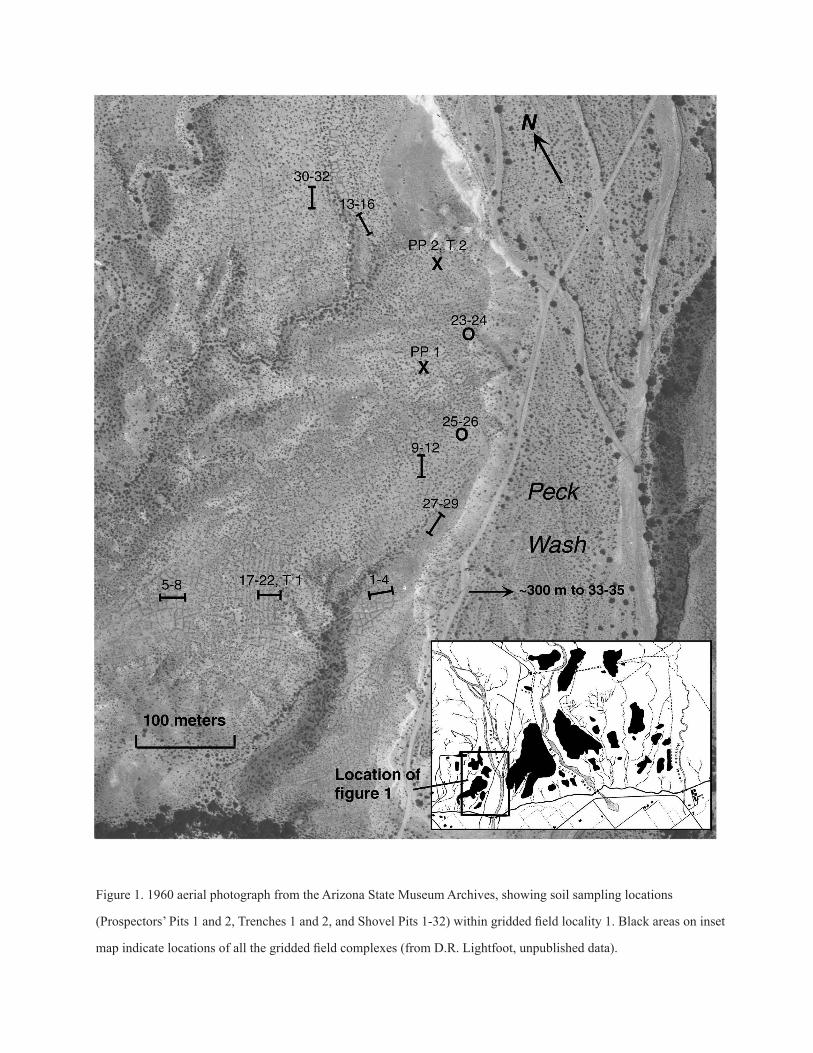
Figure 1. 1960 aerial photograph from the Arizona State Museum Archives, showing soil sampling locations
(Prospectors’ Pits 1 and 2, Trenches 1 and 2, and Shovel Pits 1-32) within gridded field locality 1. Black areas on inset
map indicate locations of all the gridded field complexes (from D.R. Lightfoot, unpublished data).
terraces, are often geomorphically stable, so ancient agricultural soils are readily accessible for
study; and (4) the presence or absence of agricultural facilities (rock alignments, rock piles, and
terraces) provide important clues for discerning and collecting cultivated and uncultivated soil
samples.
The harsh arid setting of the Safford Basin field system stands in stark contrast to the
highly productive, irrigated cotton fields of the Gila River flood plain today. Crops cultivated in
the thin, droughty soils of the gridded fields probably served to supplement the diet of ancient
farmers in the Safford Basin who focused on irrigation. There are advantages to farming on
elevated landforms such as that of the gridded field complex, however, including avoiding or
minimizing killing frosts caused by cold air drainage. Because of great variability in the length of
the growing season and unpredictable floods, combined with highly unpredictable precipitation
patterns both spatially and temporally, ancient farmers commonly spread their fields over
different soils and landforms as a buffering strategy to ensure adequate food supplies. Such
agricultural diversity is a hallmark of prehistoric agricultural systems in the Southwest as a way
to minimize the risk of crop failure. The few soil studies conducted thus far in the Southwest
indicate that the consequences of prehistoric cultivation in terms of soil productivity are highly
variable, due to many interacting environmental and cultural factors such as climate, topography,
hydrology, soil type, native vegetation, crop type and variety, agricultural technology, and
duration and intensity of cultivation. Previous soil studies have found that ancient farming
systems can degrade or enhance the nutrient status of agricultural soils. This study aims to assess
the effects of cultivation on soil productivity.
METHODS
Soil sampling focused on a variety of agricultural features in the westernmost locus of
the field, west of Peck Wash and north of the Gila River flood plain (fig. 1). This area, designated
Locality 1, was chosen for soil sampling because of its easy access and because a wide range
of agricultural feature types are present, including grid alignments, rock piles, and agricultural
terraces. In all, 49 soil samples were collected for analysis, 40 from 15-cm-deep shovel pits
(SP) or shallow trenches placed in agricultural features and nearby uncultivated controls, and
nine from two different soil profiles exposed in recent prospectors pits that were designated PP
1 and PP 2 (three samples from PP 1 and six from PP 2). The locations of all of these sampling
locations except for the controls for the agricultural terraces are shown in figure 1.
Soil sampling concentrated on the grid features; eight gridded rock alignment and grid
interior pairs were sampled and compared to six control samples from similar soils and landscape
positions where there was no indication of cultivation. Three rock piles were sampled, along with
control samples adjacent to each rock pile. A trench (T 1) and 6 SPʼs were excavated to sample
the agricultural terraces located on the prominent east-facing escarpment in the southern part
of Locality 1. Nine samples were collected from agricultural terrace contexts, including three
samples from terrace rock alignments and three from the terrace positions located immediately
above and below each sampled alignment. Three control samples for the terrace samples were
collected from the escarpment east of Locality 1 and Peck Wash, an area with a comparable
slope to that of the agricultural terraces. Deeper soil profile samples were obtained from the two
prospectorʼs pits, including a grid interior in the profile of PP 1 in the central part of Locality
1 and from a trench (T 2) excavated between PP 2 and a rock pile in the northern part of
Locality 1. Six soil profiles were described, which entailed identifying soil horizons, recording
morphological properties such as depth, color, texture, structure, and consistence, and classifying
pedons according to the U.S. Department of Agriculture (USDA) Soil Taxonomy. Soil analysis
included tests that tend to reflect long-term stability, such as particle-size distribution, bulk
density, pH, organic and inorganic carbon, nitrogen, total and available phosphorus, and calcium
carbonate equivalent. t-Tests were used to evaluate statistical differences between cultivated and
uncultivated soils of different agricultural contexts.
RESULTS AND DISCUSSION
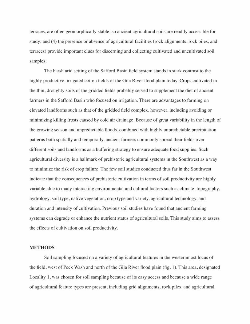
Petrocalcic and argillic horizons are dominant throughout the Safford gridded fields (figs.
2-4). Both of these diagnostic subsurface horizons function to impede or block water infiltration,
Figure 2. Photograph of thick petrocalcic horizon exposed in Prospectors’ Pit 1.
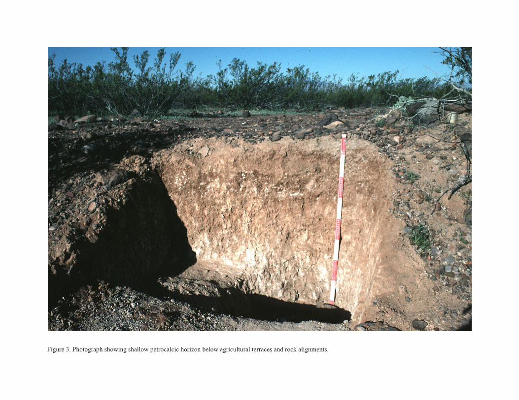
Figure 3. Photograph showing shallow petrocalcic horizon below agricultural terraces and rock alignments.
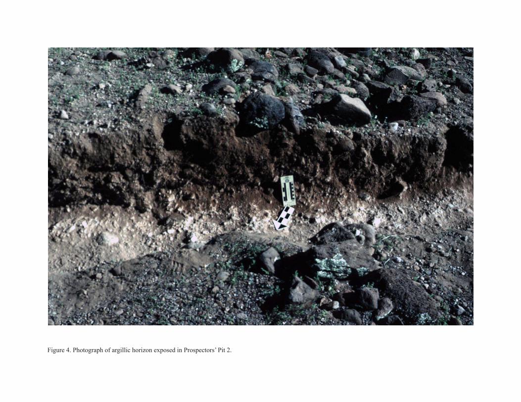
Figure 4. Photograph of argillic horizon exposed in Prospectors’ Pit 2.
and thereby conserve moisture in the rooting zone. Soil textures consist mainly of loams and
sandy loams, which have a high capacity for holding plant available moisture and promoting
rapid aeration and infiltration. Three soil map units are identified in the gridded field complex in
the Natural Resources Conservation Service (NRCS) soil survey of the Safford area: (1) Bitter
Spring-Pinaleno complex, 0-5% slopes, in the far western part of the field complex where the
present soil study was conducted; (2) Pinaleno-Cave complex, 0-5% slopes, throughout most of
the complex; and (3) Pinaleno cobbly loam, 2-5% slopes, in the northeastern part of the complex.
At the family level of the USDA Soil Taxonomy (Soil Survey Staff, 1998), the Bitter Spring
series is classified as Loamy-skeletal, mixed, superactive, thermic Typic Calciargids; the Cave
series as Loamy, mixed, superactive, thermic, shallow Typic Petrocalcids; and the Pinaleno series
as Loamy-skeletal, mixed, thermic Typic Haplargids. These soil series have little to no hazard
of water and wind erosion, low to fair moisture holding capacity, medium to rapid runoff, and
very slow to moderate permeability. Rooting depth, which is estimated at about 60 to 90 cm
for the Bitter Spring and Pinaleno series and 13 to 60 cm for the Cave series, is limited by a
weakly to strongly cemented zone of calcium carbonate. From a modern mechanized agricultural
perspective, these soils are not regarded as suitable for cultivation due to their droughty nature,
high gravel content, restricted rooting depth, low organic matter content, and low to medium
natural fertility. It is noteworthy, however, that many archaeological projects have documented
widespread evidence of ancient farming activity on these and similar soils throughout much of
Arizona.
Quantitative data for the soil profiles, agricultural contexts, and controls are summarized
in tables 1-4 and figure 5. No statistical differences were identified in the bulk density tests.
The lack of consistent trends suggests that ancient cultivation practices did not cause long-
term compaction. The bulk densities were mainly between about 1.30 and 1.45 g/cm3, and
none of the samples exceed 1.55 g/cm3, the level at which root growth may be restricted (Wild
1993:117). Soil pH was significantly lower in all likely agricultural contexts than the controls.
Because the controls have moderately alkaline pH levels (ca. pH 8.1-8.4), the reduction to about
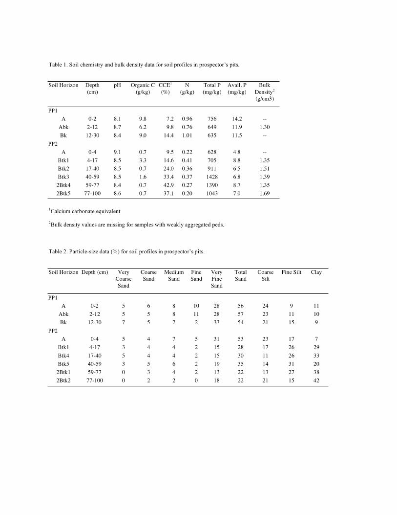
Table 1. Soil chemistry and bulk density data for soil profiles in prospector’s pits.
Soil Horizon Depth
(cm)
pH Organic C
(g/kg)
CCE1
(%)
N
(g/kg)
Total P
(mg/kg)
Avail. P
(mg/kg)
Bulk
Density2
(g/cm3)
PP1
A 0-2 8.1 9.8 7.2 0.96 756 14.2 --
Abk 2-12 8.7 6.2 9.8 0.76 649 11.9 1.30
Bk 12-30 8.4 9.0 14.4 1.01 635 11.5 --
PP2
A 0-4 9.1 0.7 9.5 0.22 628 4.8 --
Btk1 4-17 8.5 3.3 14.6 0.41 705 8.8 1.35
Btk2 17-40 8.5 0.7 24.0 0.36 911 6.5 1.51
Btk3 40-59 8.5 1.6 33.4 0.37 1428 6.8 1.39
2Btk4 59-77 8.4 0.7 42.9 0.27 1390 8.7 1.35
2Btk5 77-100 8.6 0.7 37.1 0.20 1043 7.0 1.69
1Calcium carbonate equivalent
2Bulk density values are missing for samples with weakly aggregated peds.
Table 2. Particle-size data (%) for soil profiles in prospector’s pits.
Soil Horizon Depth (cm) Very
Coarse
Sand
Coarse
Sand
Medium
Sand
Fine
Sand
Very
Fine
Sand
Total
Sand
Coarse
Silt
Fine Silt Clay
PP1
A 0-2 5 6 8 10 28 56 24 9 11
Abk 2-12 5 5 8 11 28 57 23 11 10
Bk 12-30 7 5 7 2 33 54 21 15 9
PP2
A 0-4 5 4 7 5 31 53 23 17 7
Btk1 4-17 3 4 4 2 15 28 17 26 29
Btk4 17-40 5 4 4 2 15 30 11 26 33
Btk5 40-59 3 5 6 2 19 35 14 31 20
2Btk1 59-77 0 3 4 2 13 22 13 27 38
2Btk2 77-100 0 2 2 0 18 22 21 15 42
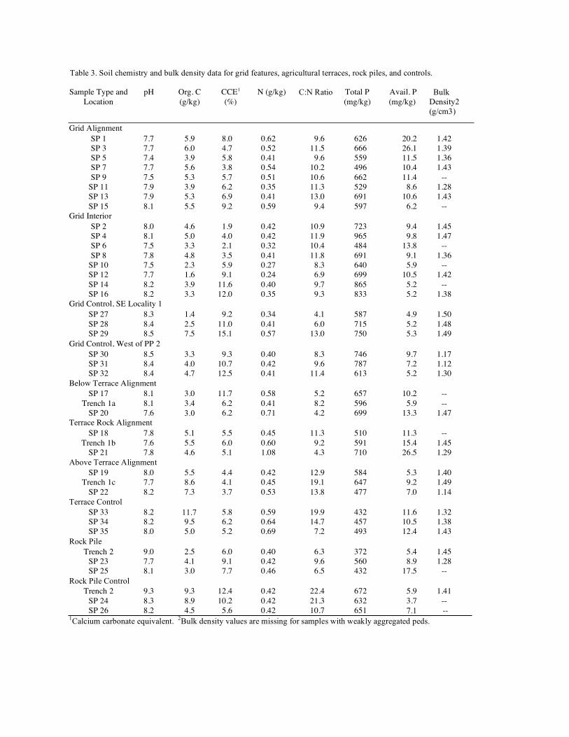
Table 3. Soil chemistry and bulk density data for grid features, agricultural terraces, rock piles, and controls.
Sample Type and
Location
pH Org. C
(g/kg)
CCE1
(%)
N (g/kg) C:N Ratio Total P
(mg/kg)
Avail. P
(mg/kg)
Bulk Density2 (g/cm3)
Grid Alignment
SP 1 7.7 5.9 8.0 0.62 9.6 626 20.2 1.42
SP 3 7.7 6.0 4.7 0.52 11.5 666 26.1 1.39
SP 5 7.4 3.9 5.8 0.41 9.6 559 11.5 1.36
SP 7 7.7 5.6 3.8 0.54 10.2 496 10.4 1.43
SP 9 7.5 5.3 5.7 0.51 10.6 662 11.4 --
SP 11 7.9 3.9 6.2 0.35 11.3 529 8.6 1.28
SP 13 7.9 5.3 6.9 0.41 13.0 691 10.6 1.43
SP 15 8.1 5.5 9.2 0.59 9.4 597 6.2 --
Grid Interior
SP 2 8.0 4.6 1.9 0.42 10.9 723 9.4 1.45
SP 4 8.1 5.0 4.0 0.42 11.9 965 9.8 1.47
SP 6 7.5 3.3 2.1 0.32 10.4 484 13.8 --
SP 8 7.8 4.8 3.5 0.41 11.8 691 9.1 1.36
SP 10 7.5 2.3 5.9 0.27 8.3 640 5.9 --
SP 12 7.7 1.6 9.1 0.24 6.9 699 10.5 1.42
SP 14 8.2 3.9 11.6 0.40 9.7 865 5.2 --
SP 16 8.2 3.3 12.0 0.35 9.3 833 5.2 1.38
Grid Control, SE Locality 1
SP 27 8.3 1.4 9.2 0.34 4.1 587 4.9 1.50
SP 28 8.4 2.5 11.0 0.41 6.0 715 5.2 1.48
SP 29 8.5 7.5 15.1 0.57 13.0 750 5.3 1.49
Grid Control, West of PP 2
SP 30 8.5 3.3 9.3 0.40 8.3 746 9.7 1.17
SP 31 8.4 4.0 10.7 0.42 9.6 787 7.2 1.12
SP 32 8.4 4.7 12.5 0.41 11.4 613 5.2 1.30
Below Terrace Alignment
SP 17 8.1 3.0 11.7 0.58 5.2 657 10.2 --
Trench 1a 8.1 3.4 6.2 0.41 8.2 596 5.9 --
SP 20 7.6 3.0 6.2 0.71 4.2 699 13.3 1.47
Terrace Rock Alignment
SP 18 7.8 5.1 5.5 0.45 11.3 510 11.3 --
Trench 1b 7.6 5.5 6.0 0.60 9.2 591 15.4 1.45
SP 21 7.8 4.6 5.1 1.08 4.3 710 26.5 1.29
Above Terrace Alignment SP 19 8.0 5.5 4.4 0.42 12.9 584 5.3 1.40
Trench 1c 7.7 8.6 4.1 0.45 19.1 647 9.2 1.49
SP 22 8.2 7.3 3.7 0.53 13.8 477 7.0 1.14
Terrace Control SP 33 8.2 11.7 5.8 0.59 19.9 432 11.6 1.32
SP 34 8.2 9.5 6.2 0.64 14.7 457 10.5 1.38
SP 35 8.0 5.0 5.2 0.69 7.2 493 12.4 1.43
Rock Pile
Trench 2 9.0 2.5 6.0 0.40 6.3 372 5.4 1.45
SP 23 7.7 4.1 9.1 0.42 9.6 560 8.9 1.28
SP 25 8.1 3.0 7.7 0.46 6.5 432 17.5 --
Rock Pile Control Trench 2 9.3 9.3 12.4 0.42 22.4 672 5.9 1.41
SP 24 8.3 8.9 10.2 0.42 21.3 632 3.7 --
SP 26 8.2 4.5 5.6 0.42 10.7 651 7.1 -- 1Calcium carbonate equivalent. 2Bulk density values are missing for samples with weakly aggregated peds.
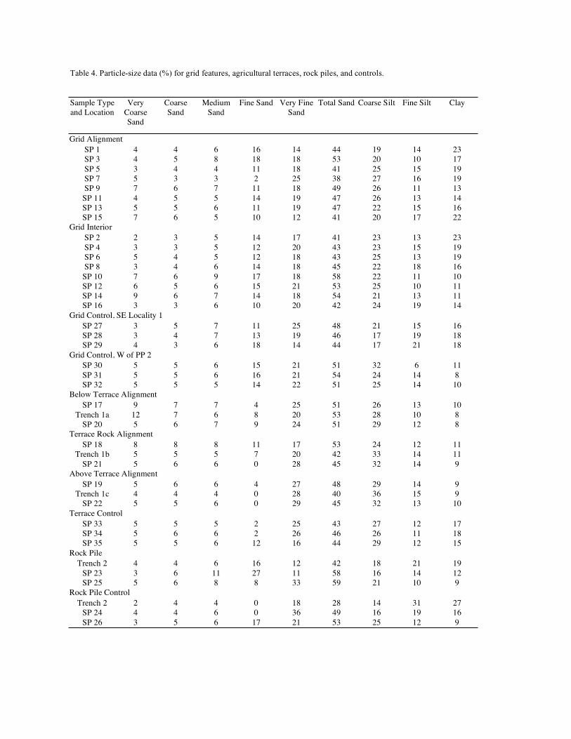
Table 4. Particle-size data (%) for grid features, agricultural terraces, rock piles, and controls.
Sample Type
and Location
Very
Coarse
Sand
Coarse
Sand
Medium
Sand
Fine Sand Very Fine
Sand
Total Sand Coarse Silt Fine Silt Clay
Grid Alignment
SP 1 4 4 6 16 14 44 19 14 23
SP 3 4 5 8 18 18 53 20 10 17
SP 5 3 4 4 11 18 41 25 15 19
SP 7 5 3 3 2 25 38 27 16 19
SP 9 7 6 7 11 18 49 26 11 13
SP 11 4 5 5 14 19 47 26 13 14
SP 13 5 5 6 11 19 47 22 15 16
SP 15 7 6 5 10 12 41 20 17 22
Grid Interior
SP 2 2 3 5 14 17 41 23 13 23
SP 4 3 3 5 12 20 43 23 15 19
SP 6 5 4 5 12 18 43 25 13 19
SP 8 3 4 6 14 18 45 22 18 16
SP 10 7 6 9 17 18 58 22 11 10
SP 12 6 5 6 15 21 53 25 10 11
SP 14 9 6 7 14 18 54 21 13 11
SP 16 3 3 6 10 20 42 24 19 14
Grid Control, SE Locality 1
SP 27 3 5 7 11 25 48 21 15 16
SP 28 3 4 7 13 19 46 17 19 18
SP 29 4 3 6 18 14 44 17 21 18
Grid Control, W of PP 2
SP 30 5 5 6 15 21 51 32 6 11
SP 31 5 5 6 16 21 54 24 14 8
SP 32 5 5 5 14 22 51 25 14 10
Below Terrace Alignment
SP 17 9 7 7 4 25 51 26 13 10
Trench 1a 12 7 6 8 20 53 28 10 8
SP 20 5 6 7 9 24 51 29 12 8
Terrace Rock Alignment
SP 18 8 8 8 11 17 53 24 12 11
Trench 1b 5 5 5 7 20 42 33 14 11
SP 21 5 6 6 0 28 45 32 14 9
Above Terrace Alignment
SP 19 5 6 6 4 27 48 29 14 9
Trench 1c 4 4 4 0 28 40 36 15 9
SP 22 5 5 6 0 29 45 32 13 10
Terrace Control
SP 33 5 5 5 2 25 43 27 12 17
SP 34 5 6 6 2 26 46 26 11 18
SP 35 5 5 6 12 16 44 29 12 15
Rock Pile
Trench 2 4 4 6 16 12 42 18 21 19
SP 23 3 6 11 27 11 58 16 14 12
SP 25 5 6 8 8 33 59 21 10 9
Rock Pile Control
Trench 2 2 4 4 0 18 28 14 31 27
SP 24 4 4 6 0 36 49 16 19 16
SP 26 3 5 6 17 21 53 25 12 9
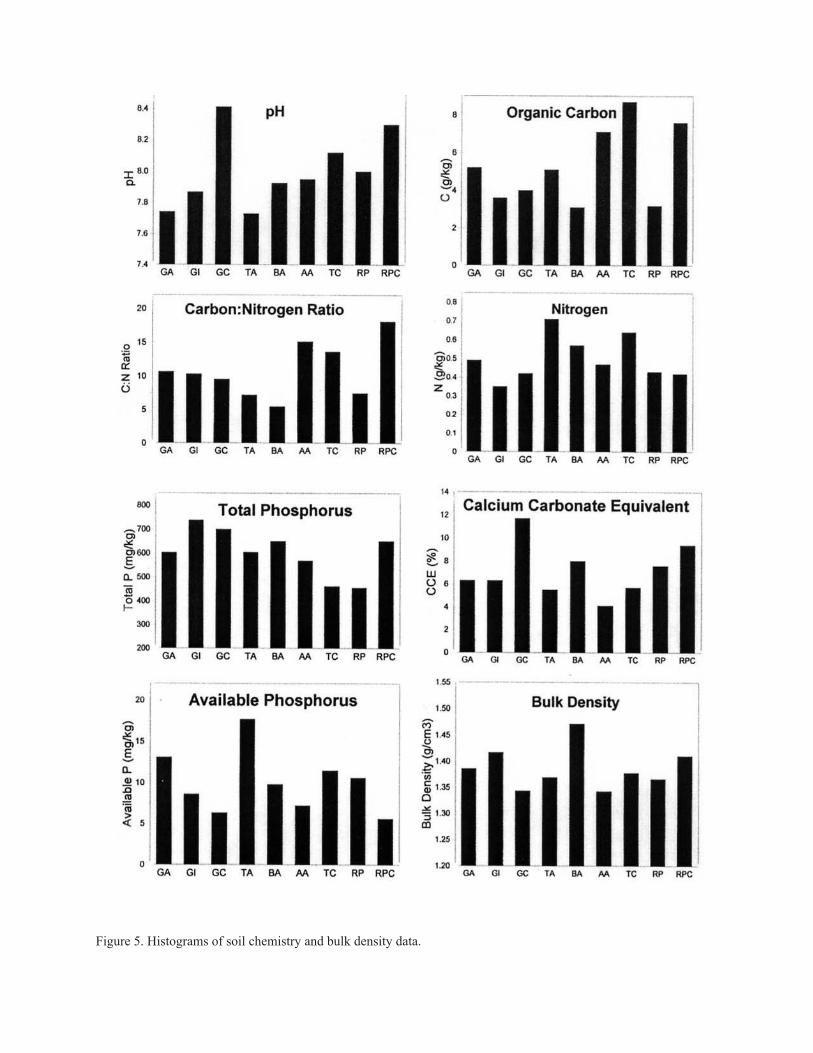
Figure 5. Histograms of soil chemistry and bulk density data.
7.7 to 8.0 in the cultivated soils is a beneficial effect for crop production, due to increased plant
availability of many essential nutrients. Decreased pH values were probably caused by organic
acids associated with elevated levels of organic matter. Organic carbon and total nitrogen were
found to be higher in the soils of grid alignments than the grid interiors and their controls. These
differences are statistically significant at the 0.05 level of significance. By contrast, agricultural
terrace samples had lower levels of organic carbon and similar to slightly reduced nitrogen levels
than their controls Compared to the controls, rock pile soils have similar levels of total nitrogen
and reduced levels of organic carbon. There is little difference in the mean carbon:nitrogen ratios
between the grid alignments and interiors and their controls, but the controls have higher ratios
than the rock pile soils and the soils within and below the terrace alignments. The C:N ratios of
soils presumed to have been cultivated are mainly in the range of 6:1 to 11:1, which indicates
that most organic debris is highly decomposed, a form in which much of the nitrogen is available
to plants.
Many agricultural contexts, including grid alignments, terrace positions above
alignments, and rock piles, have significantly lower total phosphorus levels than their controls.
Because total phosphorus levels are slow to change in the soil, reductions may reflect long-term
cultivation effects. More important to agricultural production, however, is the amount of plant
available phosphorus. The soils of all agricultural rock features have elevated levels of available
phosphorus compared to their controls, and these differences are statistically significant for the
grid and terrace alignments. Phosphorus requirements for crops are not well understood for many
Arizona soils, but available phosphorus levels below 2 mg/kg (or 2 ppm) are usually considered
low, and values above 5 mg/kg are considered sufficient. All of the cultivated soils from the
Safford gridded fields have available phosphorus levels above 5 mg/kg.
Soil analyses indicated that rock mulch features (grid alignments, terrace alignments,
and rock piles) and terrace positions immediately below the alignments are the most productive
agricultural contexts. It is noteworthy that the upper and lower terrace positions near the
alignments are where existing vegetation, mainly creosotebush, is concentrated today, thus
indicating the continued effectiveness of rock mulch features in conserving moisture in the
rooting zone. It is possible that the lower soil productivity of grid interiors was caused at least in
part by cultivation. However, it seems more likely that rock clearings within the grids functioned
primarily to facilitate runoff to the grid alignments immediately downslope rather than serving
as planting surfaces. Removal of gravel from the grid interiors has likely enhanced runoff due to
formation of a desert crust, similar to ancient farming practices documented in the Negev Desert
of Israel (Evenari and others, 1982).
SUMMARY AND CONCLUSIONS
Soils in the Safford gridded field complex consist chiefly of gravelly loams and clay
loams dominated by shallow petrocalcic or argillic horizons. Both of these horizons strongly
impede or block water infiltration and hold moisture in the rooting zone within or above these
zones. Compared to uncultivated soils, agricultural soils generally have reduced pH levels,
which would have been beneficial for crop production due to increased plant availability
for many essential nutrients. Nitrogen and available phosphorus content is consistently
higher in the gridded and terrace alignments soils, and upper terrace positions immediately
below terrace alignments. If these elevated nutrient levels are not the result of changes since
field abandonment, then cultivation is associated with improved soil fertility. Compared to
uncultivated controls, cultivated terrace and rockpile soils tend to have similar or slightly reduced
organic carbon levels. Importantly, the grid alignment soils have significantly elevated organic
carbon, nitrogen, and available phosphorus levels compared to the grid interiors. The precise
cause of these chemical soil differences is uncertain, but they may reflect either direct cultivation
effects or post-cultivation vegetation associations with agricultural features. Bulk density tests
do not indicate that ancient cultivation practices caused soil compaction. In short, there is no
indication that ancient farming activity seriously degraded the soil, and that is especially true for
the grid features, the dominant type of agricultural feature.
An especially puzzling and elusive aspect of this study is determining what crops were,
or might have been, cultivated. Soil data alone cannot answer this question, but it does provide
important clues about potential crops, especially when evaluated in the context of modern
soil and native plant associations relative to prehistoric agricultural features. The widespread
occurrence of lithic artifacts that are commonly associated with agave processing (e.g., tabular
knives and large flakes that may have served as cutting implements and steep-edged core tools/
pulping planes) in field areas and the recovery of charred agave remains from roasting pits in
the alluvium of Big Spring Wash provide important, though indirect, clues that agave was the
focus of cultivation. Colonies of Agave murpheyi, a domesticated species of agave, have been
identified in many valleys of central Arizona (Hodgson et al. 1989; Homburg 1997), usually
where traces of agricultural rock mulch features are found on cobbly, gently sloping alluvial
fans and river terraces . No such colonies have been found in the Safford Basin, but it is possible
that such colonies once existed but failed to survive without human aid or were completely
harvested by later occupants. Agave thrives in cobbly, calcareous, droughty soils, even soils with
low fertility in rugged terrain that support little other vegetation. Overall, soil nutrient levels
in the Safford gridded field complex are sufficient to have supported maize agriculture, but the
thin rooting zones, high temperatures, low rainfall, and low runoff throughout most landscape
positions of the field suggest that crops such as agave or other drought-tolerant plants were likely
the focus of agricultural production.
REFERENCES CITED
Evenari, M.L., Shanan, L., and Tadmor, N.H., 1982, The Negev--The Challenge of a Desert:
Cambridge, Harvard University Press,
Fish, P.R., and Fish, S.K., 1984, Agricultural maximization in the Sacred Mountain Basin,
Central Arizona, in Fish, S.K and Fish, P.R, eds., Prehistoric agricultural strategies in the
southwest: Arizona State University, Tempe, Anthropological Research Papers, No. 33, p.
147 -159.
Fish, S.K., Fish, P.R., and Madsen, John, 1992, The Marana community in the Hohokam world:
University of Arizona Press, Tucson, Anthropological Papers of the University of
Arizona, No. 56,
Hodgson, W., Nabhan, Gary, and Ecker, Liz, 1989, Prehistoric fields in central Arizona--
Conserving rediscovered agave cultivars: Agave, v. 3, no. 3, p. 9-11.
Homburg, J.A.,1997, Prehistoric dryland agricultural fields of the lower Verde, in Homburg,
J.A.and Ciolek-Torrello, R., eds., Agricultural, subsistence, and environmental studies:
SRI Press, Tucson, Vanishing River--Landscapes and lives of the lower Verde Valley, The
Lower Verde Archaeological Project, v. 2, CD-ROM, p. 103-126.
Homburg, J.A., and Sandor, J.A.,1997, An agronomic study of two Classic Period agricultural
fields in the Horseshoe Basin, in Homburg, J.A.and Ciolek-Torrello, R., eds.,
Agricultural, subsistence, and environmental studies: SRI Press, Tucson, Vanishing
River--Landscapes and lives of the lower Verde Valley, The Lower Verde Archaeological
Project, v. 2, CD-ROM, p. 127-148.
Lightfoot, D.R., 1993a, The landscape context of Anasazi pebble-mulched fields in the Galisteo
Basin, northern New Mexico: Geoarchaeology, v. 8, no. 5, p. 349-370.
____ 1993b, The cultural ecology of Puebloan pebble-mulch gardens: Human Ecology, v. 21. no.
2, p. 115-143.
____ 1996, The nature, history, and distribution of lithic mulch agriculture--An ancient technique
of dryland agriculture: TheAgricultural History Review, v. 44, no. 2 p. 206-222.
Sandor, J.A., and Gersper, P.L., 1988, Evaluation of soil fertility in some prehistoric agricultural
terraces in New Mexico: Agronomy Journal, v. 80, p. 846-850.
Wild, Alan, 1993, Soils and Environment--An Introduction: Cambridge University Press.
Cambridge.
APPENDIX A. SOIL PROFILE DESCRIPTIONS
Profiles were described by Jonathan A. Sandor and Jeffrey A. Homburg on March 10-13, 1997 in Locality 1, the
westernmost part of the agricultural complex. The parent material of all profiles consists of gravelly alluvium
derived from Gila Mountain conglomerates and miscellaneous volcanic rocks.
Profile Description 1: Grid interior, Prospectorʼs Pit 1Classification: Loamy, mixed, superactive, thermic Typic Petrocalcid (Cave series)
Geomorphic setting: Backslope of alluvial fan, elevation 901 m (2955 ft), 3-4% slope
Agricultural setting: Within grid interior; profile exposed in north wall of Prospectorʼs Pit 1
A 0-2 cm. Pinkish gray to light brown (7.5YR 6/3) gravelly loam, brown (7.5YR 4.5/3) moist; weak medium
and coarse plates plus weak to moderate fine and very fine subangular blocks; slightly hard, friable, slightly
sticky, slightly plastic; common very fine and few fine roots; few fine and medium tubular pores; 10%
gravel; slightly effervescent; moderately alkaline (pH 8.0-8.5; pH 6.5-8.0 under creosotebush); abrupt
smooth boundary. Mantled by 80-85% gravel pavement cover, with gravel typically 0.8-2.0 cm in size;
crust varies from 1 to 2 cm thick, with an algal crust on the surface, under creosote bush vegetation; some
soil is noncalcareous and some thin carbonate coatings noted on parts of the surface.
ABk 2-12 cm. Light brown (7.5YR 6/4) gravelly loam, brown (7.5YR 4/4) moist; weak fine and medium
subangular blocks; soft, friable, slightly sticky, slightly plastic; common very fine, fine, and medium roots,
with some pockets of many fine to very fine and few large roots; few fine tubular pores; 5-10% gravel and
20% cobbles; strongly effervescent; strongly alkaline (pH 8.0-8.5); clear smooth boundary.
Bk 12-30 cm. Light brown to (7.5YR 6.5/3.5) very gravelly sandy loam; brown (7.5YR 4.5/4) moist; weak
fine subangular blocks; soft, friable to very friable, slightly sticky, slightly plastic; common very fine and
fine roots; few fine tubular pores; 20% gravel and 25% cobbles; violently effervescent; strongly alkaline
(pH 8.0-8.5); abrupt smooth boundary.
Bkm1 30-31 cm (2 to 3 cm thick in places). Matrix is weakly cemented by white (10YR 8/1) carbonate, pink to
pinkish gray (7.5YR 7/3) moist (no texture estimate due to cement, but is gravelly/very cobbly); contains
some clayey zones of reddish yellow (7.5YR 6/6) stained by iron oxide (?), strong brown (7.5YR 5/6)
moist; 20% gravel; root mat on top; strongly effervescent on top to slightly effervescent below, carbonates
noted on all sides of gravel and cobbles, but often thickest on top; moderately alkaline (pH 8.0-8.5); abrupt
smooth to slightly wavy boundary.
Bkm2 31-71 cm. Matrix is weakly cemented by white (10YR 8/1) and pinkish white (7.5YR 8/2) carbonate, pink
to pinkish gray (7.5YR 7/3) moist (no texture estimate due to strong cement, but is gravelly/very cobbly);
contains some clayey zones of reddish yellow (7.5YR 6/6) stained by iron oxide (?), strong brown (7.5YR
5/6) moist; 35-40% gravel; rare fine and very fine roots; strongly effervescent, carbonate coatings up to 4
mm thick on the bottom of gravel; moderately alkaline (pH 8.0-8.5); clear smooth boundary.
Bkm3 71-118 cm. Matrix is weakly cemented by white (10YR 8/1) and pinkish white (7.5YR 8/2) carbonate,
pink to pinkish gray (7.5YR 7/3) moist (no texture estimate due to strong cement, but is gravelly/very
cobbly); contains some clayey zones of reddish yellow (7.5YR 6/6) stained by iron oxide (?), strong brown
(7.5YR 5/6) moist; 25% gravel and 15% cobbles; rare fine and very fine roots, but occasionally clustered
in pockets; violently effervescent carbonate matrix and effervescent clay plus iron (?); moderately alkaline
(pH 8.0-8.5); clear smooth boundary.
Bʼk 118-125 cm. Light brown (7.5YR 6/3) very gravelly sandy loam, pink to pinkish gray (7.5YR 7/3) moist;
massive structure; slightly hard, friable, slightly sticky, slightly plastic; few very fine and fine roots, often in
clusters; 15% gravel and 10-15% cobbles; violently effervescent, carbonate coatings on all sides of gravel;
moderately alkaline (pH 8.0-8.5); clear smooth boundary.
BCk 125-142 cm. Light brown (7.5YR 6/4) very gravelly sandy loam to very gravelly loamy sand, pink (7.5YR
7/4) moist; massive structure; soft, very friable, slightly sticky, slightly plastic; few very fine and fine
roots; 25% gravel and 10% cobbles; strongly to violently effervescent, few carbonate coatings on gravel;
moderately alkaline (pH 8.0-8.5); abrupt smooth boundary.
2C 142-162+ cm. Pink (7.5YR 7/3) loamy sand, strong brown to reddish yellow (7.5YR 5.5/6) moist; massive
structure; soft, very friable, nonsticky, nonplastic; few very fine and fine roots; 5% gravel; effervescent;
moderately alkaline (pH 8.0-8.5).
Profile Description 2: Next to rock pile, Trench 2Classification: Fine-loamy, mixed, thermic Calcic Paleargid (similar to Pinaleno series; would be classified as a
Typic Petroargid if petrocalcic horizon is present in 100-150 cm zone)
Geomorphic setting: Alluvial fan terrace, elevation 899 m (2950 ft), 4% slope
Agricultural setting: Desert pavement near rock pile feature; adjacent to west side of Prospectorʼs Pit 2
A 0-4 cm. Light brown (7.5YR 6/4) loam, brown to strong brown (7.5YR 5/5) moist; moderate medium
plates; slightly hard, very friable, slightly sticky, slightly plastic; few fine and very fine roots; many fine to
very fine vesicular pores; 10-20% gravel, mainly on the surface; effervescent; moderately alkaline (pH 8.0-
8.5); abrupt smooth boundary. Contains few filaments and faint spots of carbonate.
Btk1 4-17 cm. Light brown to reddish yellow (7.5YR 6/5) clay loam, brown to strong brown (7.5YR 4/5)
moist; moderate fine subangular blocks; slightly hard, friable, sticky, plastic; many moderately thick clay
films on ped faces and pores; common very fine and fine roots; few fine tubular pores; 5% gravel; strongly
effervescent; moderately alkaline (pH 8.0-8.5); clear smooth boundary. Contains common small (~1mm)
masses of carbonate, and the matrix consists of 5-10% carbonate filaments.
Btk2 17-40 cm. Light brown to reddish yellow (7.5YR 6/5) clay loam; strong brown (5YR-7.5YR 5/6) moist;
moderate fine subangular blocks; slightly hard, friable, sticky, plastic; many moderately thick clay films on
ped faces and pores; few very fine and fine roots; few fine tubular pores; 5% gravel; strongly effervescent;
moderately alkaline (pH 8.0-8.5); gradual smooth boundary. Contains common to many soft powdery
masses, with few moderately hard masses; several are 5-10 mm across and some are cylindrical in shape.
Btk3 40-59 cm. Light brown to reddish yellow (7.5YR 6/5) loam, strong brown (7.5YR 5/6) moist; moderate
fine and medium subangular blocks; hard, firm, sticky, plastic; common thin clay films on ped faces; few
very fine and fine roots; few very fine tubular pores; 5% gravel; strongly effervescent matrix, and violently
effervescent carbonate masses; moderately alkaline (pH 8.0-8.5); clear smooth boundary. Contains few to
common (5-10%) masses of carbonate and some finely disseminated carbonates; some consist of 6-10 mm
cylindrical carbonate concentrations, possibly formed in old insect burrows.
2Btk4 59-77 cm. Pinkish gray to light brown (7.5YR 6/3) clay loam, brown to yellowish brown (7.5-10YR 5/3
and 5/4) moist; hard, firm, sticky, plastic; many moderately thick clay films on ped faces; few very fine and
fine roots; few very fine tubular pores; <1% gravel; strongly effervescent matrix, and violently effervescent
carbonate masses; moderately alkaline (pH 8.0-8.5). Contains few to common moderately hard masses of
carbonate.
2Btk5 p 77-100+ cm. Pinkish gray to light brown (7.5YR 6/3) clay loam to clay, brown (7.5YR 5/3 and 5/4) moist;
weak fine prisms parting to moderate fine and medium subangular blocks; very hard, very firm, very
sticky, very plastic; some possible clay coatings on peds; rare fine roots; rare fine tubular pores; strongly
effervescent; moderately alkaline (pH 8.0-8.5); clear smooth boundary. Contains few to common seams
and filaments of carbonate.
Profile Description 3: Agricultural terrace, upslope of rock alignment, Trench 1c
Geomorphic setting: Backslope of fan terrace scarp, 10-11% slope
Agricultural setting: Terrace, 20 cm upslope of rock alignment
A1 0-5 cm. Pinkish gray to light brown (7.5YR 6/3) very gravelly sandy loam to loam, brown (7.5YR 4.5/3)
moist; weak to moderate fine and medium subangular blocks and some weak medium plates; soft, very
friable, slightly sticky, slightly plastic; few to common very fine roots; few very fine tubular pores; 35%
gravel, mainly on the surface; not effervescent; mildly alkaline (pH 7.5); abrupt smooth boundary. This
horizon has formed in the upper terrace fill deposit, and it is covered by a patchy gravel pavement.
A2 5-16 cm. Pinkish gray to light brown (7.5YR 6/3) gravelly sandy loam to loam, brown (7.5YR 4.5/3)
moist; weak fine subangular blocks and some weak medium plates at the top; slightly hard, very friable,
slightly sticky, slightly plastic; common very fine and fine roots; few very fine tubular pores; 15-20%
gravel; audibly effervescent; mildly alkaline (pH 7.5); clear smooth boundary. This horizon has formed in
the lower terrace fill deposit.
Bk1 16-30 cm. Pinkish gray to light brown (7.5YR 6/3) gravelly sandy loam to loam, brown (7.5YR 4.5/3)
moist; weak fine subangular blocks to massive; soft, very friable, slightly sticky, slightly plastic; common
very fine and few fine roots; few very fine tubular pores; 25% gravel; strongly effervescent; moderately
alkaline (pH 8.0-8.5); clear smooth boundary. Matrix is dominated by finely disseminated carbonates.
2Bk2 30-46 cm. Light brown (7.5YR 6/3.5) extremely gravelly sandy loam, brown (7.5YR 5/4) moist; weak
fine subangular blocks to massive; soft, very friable, slightly sticky, slightly plastic; 65% gravel and
some cobbles; common very fine and fine roots; strongly effervescent matrix, and violently effervescent;
moderately alkaline (pH 8.0-8.5); abrupt smooth boundary. Contains both finely disseminated carbonates
and gravel coatings on all sides.
2Bkm 46+ cm. Color of carbonate cement not described, but much lighter than above; massive, cemented; 60-
70% gravel; violently effervescent; moderately alkaline (pH 8.0-8.5). This horizon has a laminar cap of
carbonate above a massively cemented petrocalcic horizon.
Profile Description 4: Beneath rock alignment between two agricultural terraces, Trench 1bGeomorphic setting: Backslope fan terrace scarp, 10-11% slope
Agricultural setting: Beneath rock alignment
A1 0-5 cm. Pinkish gray to light brown (7.5YR 6/3) gravelly/very cobbly sandy loam to loam, brown to dark
brown (7.5YR 4/3) moist; weak fine subangular blocks and some weak medium plates; soft to slightly
hard, very friable, slightly sticky, slightly plastic; few fine roots; few very fine tubular pores; 15% gravel,
excluding surface gravel in rock alignment; not effervescent; mildly alkaline (pH 7.5); clear smooth
boundary. Upper boundary is irregular between rocks.
A2 5-18 cm. Pinkish gray to light brown (7.5YR 6/3) gravelly/very cobbly sandy loam to loam, brown (7.5YR
4.5/3) moist; weak fine subangular blocks; soft, very friable, slightly sticky, slightly plastic; few to common
very fine and fine roots; few very fine tubular pores; 25% gravel; not effervescent; mildly alkaline (pH 7.5);
clear smooth boundary. Surface gravel in rock alignment extends about 13 to 15 cm below surface.
Bk1 18-27 cm. Pinkish gray to light brown (7.5YR 6/3) gravelly/very cobbly sandy loam, brown (7.5YR
4.5/3.5) moist; weak fine subangular blocks; soft, very friable, slightly sticky, slightly plastic; few to
common very fine and few fine roots; few very fine tubular pores; 30% gravel; strongly effervescent;
moderately alkaline (pH 8.0-8.5); clear smooth boundary. Carbonate coatings were noted on all sides of
gravel.
2Bk2 27-40 cm. Light brown (7.5YR 6/4) extremely gravelly loam to sandy loam, brown (7.5YR 4.5/4) moist;
weak fine subangular blocks to massive; soft, very friable, slightly sticky, slightly plastic; 70% gravel and
cobbles; few to common very fine and fine roots; strongly effervescent; moderately alkaline (pH 8.0-8.5);
abrupt smooth boundary. Carbonate coatings were noted on all sides of gravel.
2Bkm 40+ cm. Color of carbonate cement not described, but much lighter than above; massive, cemented; 60-
70% gravel; violently effervescent; moderately alkaline (pH 8.0-8.5). This horizon has a laminar cap of
carbonate above a massively cemented petrocalcic horizon.
Profile Description 5: Agricultural terrace, downslope of rock alignment, Trench 1cGeomorphic setting: Backslope of fan terrace scarp, 10-11% slope
Agricultural setting: Terrace, 20 cm downslope of rock alignment
A 0-3 cm. Light brown (7.5YR 6/3.5) gravelly/very cobbly sandy loam, brown to dark brown (7.5YR 4/3)
moist; weak to moderate fine and medium subangular blocks to massive; loose to soft, very friable, slightly
sticky, slightly plastic; few very fine roots; few very fine tubular pores; 20% gravel, mainly on the surface;
effervescent; moderately alkaline (pH8.0-8.5); abrupt smooth boundary. This horizon has formed in the
upper terrace fill deposit, and it is covered by a gravel pavement.
Bk1 3-18 cm. Light brown (7.5YR 6/3.5) gravelly/very cobbly sandy loam, brown (7.5YR 4.5/4) moist; weak
to moderate fine and medium subangular blocks; soft, very friable, slightly sticky, slightly plastic; few
to common very fine and few fine roots; few very fine tubular pores; 20% gravel; strongly effervescent;
moderately alkaline (pH 8.0-8.5); clear smooth boundary. Contains disseminated carbonates in matrix and
coatings on all sides of gravel.
2Bk2 18-40 cm. Light brown (7.5YR 6/4) extremely gravelly sandy loam, brown (7.5YR 5/4) moist; weak fine
subangular blocks to massive; soft, very friable, slightly sticky, slightly plastic; 70% gravel and some
cobbles; few to common very fine and fine roots; few tubular pores; strongly effervescent; moderately
alkaline (pH 8.0-8.5); abrupt smooth boundary. Contains few to common (5-10%) masses of carbonate
and some finely disseminated carbonates; some consist of 6-10 mm cylindrical carbonate concentrations,
possibly formed in old insect burrows. Contains disseminated carbonates in matrix and coatings on all
sides of gravel.
2Btkm 40+ cm. Color of carbonate cement not described, but much lighter than above; illuvial clay is light brown
(7.5YR 6/4), brown (7.5YR 5/4) moist; weakly cemented, massive, with some clay breaking out in blocks;
many thick clay films on ped faces in clayey zones; 60-70% gravel; violently effervescent; moderately
alkaline (pH 8.0-8.5). Contains few to common moderately hard masses of carbonate.
Profile Description 6: Grid interior, Shovel Pit 4
Geomorphic setting: Nearly level part of alluvial fan terrace, 1-2% slope
Agricultural setting: Within grid interior
A 0-3 cm. Pink to light brown (7.5YR 6.5/3.5) gravelly/very cobbly sandy loam, brown (7.5YR 4.5/3) moist;
weak medium plates and weak fine subangular blocks; slightly hard, friable, slightly sticky, slightly plastic;
few very fine roots; few very fine vesicular pores; 20% gravel; mildly alkaline (pH7.5); abrupt smooth
boundary. This horizon has formed in the upper terrace fill deposit, and it is covered by a gravel pavement.
Bt 3-10 cm. Light brown (7.5YR 6/4) very gravelly/very cobbly sandy clay loam to loam, brown to dark
brown (7.5YR 4/4) moist; weak fine to medium subangular blocks; slightly hard, friable, slightly sticky,
slightly plastic; common thick clay bridges and colloidal stains on mineral grains; few to common very fine
roots; few very fine tubular pores; 30% gravel and 10% cobbles; strongly effervescent; mildly alkaline (pH
7.5); clear smooth boundary.
2Bk 10-41+ cm. Light brown (7.5YR 6/4) extremely gravelly sandy loam, brown to strong brown (7.5YR
4.5/5) moist; weak fine subangular blocks; soft, very friable, slightly sticky, slightly plastic; few thin clay
bridges; 40% gravel and 30% cobbles up to 12-15 cm in diameter; few to common very fine and fine
roots, mainly in clusters; strongly effervescent; moderately alkaline (pH 8.0-8.5); abrupt smooth boundary.
Contains disseminated carbonates in matrix, coatings on all sides of gravel, and some filaments.