Embed Size (px)
Citation preview
www.elsevier.com/locate/catena
Catena 65 (2006
Impacts of the ancient Maya on soils and soil erosion in the
central Maya Lowlands
T. Beach a,*, N. Dunning b, S. Luzzadder-Beach c, D.E. Cook d, J. Lohse e
a STIA, SFS, Georgetown University, Washington, DC 20057, USAb Department of Geography, University of Cincinnati, Cincinnati OH 45221-0131, USA
c Earth Systems and GeoInformation Sciences, School of Computational Sciences, George Mason University, Fairfax VA 22030-4444, USAd SCMRE, Smithsonian Institution, 4210 Silver Hill Road, Suitland, MD 20746, USA
e Texas Archeological Research Laboratory, The University of Texas at Austin, Austin, TX 78712-0714, USA
Abstract
Many studies across the central and southern Maya Lowlands of Belize, Guatemala, Honduras, and Mexico have produced records of
land degradation, mostly sedimentation and soil erosion, during the ancient Maya period from before 1000 BC to the Maya Collapse of c.
AD 900. This paper provides new data from two sites (Blue Creek and Cancuen), synthesizes more than a decade of the authors’ research
in Guatemala, Belize, and Mexico, and synthesizes other findings from this region. These research projects analyzed more than 100
excavations in upland and depression sites, cored lakes and wetland sediments, and studied sediments in the field and laboratory using
radiocarbon dating, a battery of soil chemistry tests, stratigraphic analysis, magnetic susceptibility, elemental analyses, and artifact
identification. Our objective was to date when sedimentation and soil erosion occurred, identify stable surfaces, and correlate them with
the state of knowledge about past land use. These findings indicate three general epochs of accelerated soil erosion and identified two
major paleosols. The three waves of soil erosion occurred in the Preclassic period (c. 1000 BC to AD 250), the Late Classic (AD 550 to
900), and in the last several decades. The major paleosol (FEklu’um_) in these sites is a well-developed Mollisol or Vertisol that started
forming in the early Holocene and was buried in either the Preclassic or Classic periods (AD 250 to 900). At some sites the Eklu’um
paleosol lies beneath sediments with a fainter paleosol, which in turn lies buried below Classic period and later sediments. This picture
shows higher than expected soil erosion linked to the region’s first pioneer farmers in the Preclassic and less than expected soil erosion in
the Late Classic when population peaked and land use was the most intensive. In other regions like Cancuen, Guatemala, however, most
soil erosion occurred during the Maya Late Classic (AD 550–830). Erosion here was intense but short-lived: depressions record 1–3 m of
aggradation in two centuries. A third epoch of accelerated soil loss and aggradation arose with the rapid land use changes brought by new
pioneers during the last several decades.
D 2005 Elsevier B.V. All rights reserved.
Keywords: Soil erosion; Paleosols; Maya Lowlands; Maya Civilization; Land degradation
1. Introduction
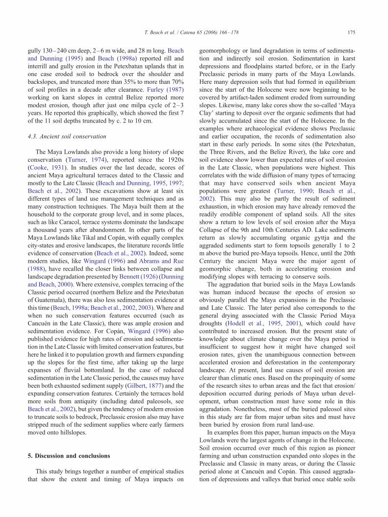
Since the early 20th century some scholars have linked
the thin soils of the southern Maya Lowlands (Fig. 1) with
ancient Maya induced soil erosion and sedimentation, to
which some even attributed the Maya Collapse of c. AD 900
(Bennett, 1926; Thompson, 1954; Morley, 1956). This
0341-8162/$ - see front matter D 2005 Elsevier B.V. All rights reserved.
doi:10.1016/j.catena.2005.11.007
* Corresponding author. Fax: +1 202 687 1431.
E-mail address: [email protected] (T. Beach).
proposition, however, did not consider that the region’s
limestone bedrock could naturally weather in this tropical
climate and leave only thin residual soils behind. The
hypothesis of severe ancient Maya land degradation,
deforestation and soil erosion, evolved into subsequent
notions of sound resource management by a complex
civilization living in hostile environment of a seasonally
dry tropical forest (Dunning and Beach, 2004b). Since the
early 1990s, however, the so-called FPristine Myth_ that Pre-Columbian peoples caused little environmental alteration
has fallen to an onslaught of empirical studies showing long,
) 166 – 178
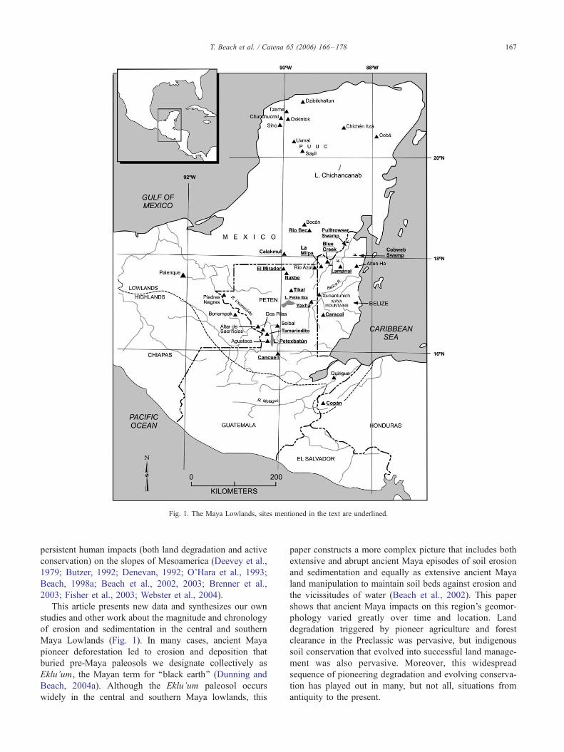
Fig. 1. The Maya Lowlands, sites mentioned in the text are underlined.
T. Beach et al. / Catena 65 (2006) 166–178 167
persistent human impacts (both land degradation and active
conservation) on the slopes of Mesoamerica (Deevey et al.,
1979; Butzer, 1992; Denevan, 1992; O’Hara et al., 1993;
Beach, 1998a; Beach et al., 2002, 2003; Brenner et al.,
2003; Fisher et al., 2003; Webster et al., 2004).
This article presents new data and synthesizes our own
studies and other work about the magnitude and chronology
of erosion and sedimentation in the central and southern
Maya Lowlands (Fig. 1). In many cases, ancient Maya
pioneer deforestation led to erosion and deposition that
buried pre-Maya paleosols we designate collectively as
Eklu’um, the Mayan term for ‘‘black earth’’ (Dunning and
Beach, 2004a). Although the Eklu’um paleosol occurs
widely in the central and southern Maya lowlands, this
paper constructs a more complex picture that includes both
extensive and abrupt ancient Maya episodes of soil erosion
and sedimentation and equally as extensive ancient Maya
land manipulation to maintain soil beds against erosion and
the vicissitudes of water (Beach et al., 2002). This paper
shows that ancient Maya impacts on this region’s geomor-
phology varied greatly over time and location. Land
degradation triggered by pioneer agriculture and forest
clearance in the Preclassic was pervasive, but indigenous
soil conservation that evolved into successful land manage-
ment was also pervasive. Moreover, this widespread
sequence of pioneering degradation and evolving conserva-
tion has played out in many, but not all, situations from
antiquity to the present.
T. Beach et al. / Catena 65 (2006) 166–178168
1.1. Background
Lake core and catena studies point to high levels of soil
erosion in the Maya Lowlands during periods of land use
change such as deforestation (Deevey et al., 1979; Furley,
1987; Wingard, 1996; Beach, 1998a). We have examined
modern soil erosion by rill, interrill, and gully processes
since 1991 in parts of this region, observing, for example,
the complete truncation of soils to bedrock along the
Petexbatun River in Guatemala’s Peten over a ten year
period (Beach and Dunning, 1995; Beach, 1998a). Two
major factors limiting quantities of soil erosion here are the
initial thinness of soils and the high infiltration rates into the
porous limestone parent material. In the example above and
another reported below from Blue Creek, Belize, soil
erosion preceded rapidly after deforestation (removing
whole soil profiles) but slowed significantly with reduced
sediment supplies and when the porous limestone parent
material became exposed, thus accelerating infiltration. In
Blue Creek, however, gullying continued to incise into the
limestone saprolite after complete soil removal.
The scientific literature includes much speculation about
ancient Maya soil erosion, based on archaeological and
geomorphological lines of evidence. For example, Stevens
(1964: 301–302) in his Soils of Middle America argued
that since many Maya sites across the Peten occur in
association with the shallow Rendzina soils of the Yaxa
Series (Simmons et al., 1959), the region’s soils are still
undergoing rejuvenation from accelerated erosion during
the Maya Classic. Further, Stevens (1964: 302) mentioned
the hypothesis that soil depletion caused the Late Classic
Maya collapse as outlined by Morley (1956: 71) and
proposed by H.H. Bennett (1926). Later, Bennett (1945:
166) estimated 50% of Mexico and 30% of Guatemala had
been ‘‘ruined for cultivation, nearly ruined and severely
affected’’. More recent studies have underscored the
severity of soil erosion across this region, including Furley
(1987) and Beach et al. (2003) in Belize, Abrams and Rue
(1988) and Wingard (1996) in Honduras, and Deevey et al.
(1979), Beach (1998a), and Rosenmeier et al. (2002) in
Guatemala’s Peten.
From outside the Maya Lowlands, and extending the
implications of this paper, has been the debate about erosion
at Lake Patzcuaro in Michoacan, Mexico. At this site
O’Hara et al. (1993) used data derived from sediment cores
to argue that erosion rates were at least as high during the
Late Preclassic and the Postclassic as they were after the
Spanish conquest and questioned whether indigenous
methods held any meaningful environmental advantages
for us today. In contrast, a study from the same lake basin by
Fisher et al. (2003) used evidence from cores, trenches, and
exposures to paint a different picture. They argued that the
Preclassic degradation was the second most severe episode
of soil erosion and that it was caused by initial land
clearance rather than long-term land-use practices. Fisher et
al. (2003) concluded that the most severe soil erosion
occurred after the epidemics of the European conquest
decimated indigenous populations and their ability to
maintain soil conservation practices. They also argued that
intensive management by high populations of Precolumbian
Tarascans produced low levels of erosion.
Thus far for the Maya lowlands there are only a few
syntheses and a handful of mostly unrelated studies and
historical hypotheses for the trends of land degradation.
The information available suggests that the relationship of
humans and soil erosion in broader Mesoamerica is
highly complicated and there are no simple correlations
between population levels and geomorphic impacts
(Beach et al., 2006).
2. Area descriptions
The Maya Lowlands is both a cultural and physical
region, named after a series of related cultures that have
occupied the region of generally low, limestone terrain with
tropical wet and dry climates (Fig. 1). This section provides
a brief cultural history to explain terms and possible trends
of land degradation on soils over time. Evidence of human
impacts in this region may date from as early as about
3000 BC, but Maya culture and its impacts on the
environment started in the Early Preclassic by 1000 BC
and have lasted with major ebbs and flows to the present
(Pohl et al., 1996; Brenner et al., 2003). The Preclassic
lasted till AD 250, followed by the Early Classic from AD
250–500, and the Late and Terminal Classic, which ran
from AD 550 to 950. Scholars have proposed collapses
and/or declines at the end of the Preclassic, between the
Early and Late Classic (AD 500–550), and in the Terminal
Classic (AD 830–950) in Guatemala’s Peten and later in
Mexico’s Yucatan (Demarest et al., 2004), though millions
of Mayan speakers still live across the region (Schwartz,
1990). The Maya attained extremely high population levels
in the Late Classic, when many urban centers had
sustaining dense populations that stretched far into the
hinterlands (Culbert and Rice, 1990; Turner, 1990). This
paper focuses on the central and southern Maya lowlands
to understand the general erosion trends of a relatively
broad (c. 100,000 km2) and relatively flat, karst region,
influenced by over 3000 years of human impacts.
The specific focus here is on the central and southern
Maya Lowlands that range from 15.45-N to 19-N latitude
and 88-W to 91-N longitude and from sea level to about
300 m in elevation (Fig. 1). This region is founded on the
Cretaceous and Tertiary Yucatan platform. The platform
ranges from little surface gradient and low elevation in the
northern and coastal plains to a region with about 250 m of
regional relief, structured by a series of normal faults and
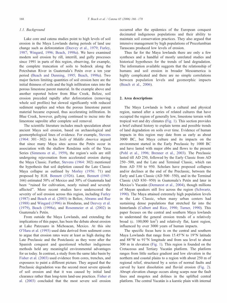
carved by karst dissolution and fluvial erosion (Fig. 2).
Abrupt elevation change occurs along scarps near the fault
lines and mogotes and dolines in the uplifted central
platform. The central Yucatan is a karstic plain with internal
Fig. 2. Maya Lowlands topographic cross section from northern Guatemala through northern Belize (after Dunning et al., 2002, Fig. 2).
T. Beach et al. / Catena 65 (2006) 166–178 169
drainage and has no perennial rivers, but the peripheries
have rivers and low gradient floodplains. This research
focuses largely on depressions, including lowland flood-
plain and coastal plain areas below 20 m in elevation and
upland karst depressions (regionally called bajos and
aguadas, ranging in karst terms from ponors to poljes) up
to 100 m elevation (Day, 1993). Many of the bajos are
seasonally inundated, and many of the near sea-level
dolines, floodplains, and coastal plain areas are perennial
lakes and wetlands. The floodplain sites in this study are
connected to the general fluvial and karst geomorphic
systems that flow into the coastal plain and Gulf of Mexico
or Caribbean. Sea-level changes have influenced sedimen-
tation in these low lands and depressions (Pohl et al., 1996).
The upland karst depressions, however, respond mainly to
local geomorphic conditions since most connect to sea level
only through ephemeral karst caves. Although there is low
local relief, the wide range in drainage conditions and some
soil variation supports a wide variety of ecosystems, from
tropical deciduous forest to low scrub forest and saw-grass
swamps (Brokaw and Mallory, 1993; Greller, 2000).
The soils of the region have similar factors of formation:
limestone or carbonate parent materials, low relief (though
short and steep karstic and scarp slopes), tropical forest
vegetation, and high rainfall with a pronounced dry season.
Rainfall varies from 1200 to more than 2500 mm, and
average temperature varies only from around 26 to 29 -C.Annual rainfall variation from year to year is high, and the
dry season lasts about half of the year from December to
May. The region has both Udic and Ustic soil moisture
regimes and has an Isohyperthermic temperature regime
(Van Wambeke, 1987). Along the flat northern plain and
short, steep Peten slopes, many soils are similar to the
sequence in Beach (1998b) and the catena in Beach (1998a).
Thin tropical Rendolls, some Alfisols, and Inceptisols
occupy upland slopes and Histosols and Vertisols have
formed in most depressions.
The study region includes five research areas across the
southern Maya Lowlands: the Blue Creek Region, the
adjacent Three Rivers area, the Pasion River area, the
Northern Peten area, and the southern Yucatan area (Fig. 1).
Another three areas across the central and southern Low-
lands provide more information: the Copan area of
Honduras, the Central Peten Lakes area around Tikal, and
northern Belize. All of these areas, except Belize, have
about 100–200 m of regional relief caused by the relative
uplift associated with normal faulting. Belize has both lower
relative relief on the coastal plain and much higher relief in
the crystalline Maya Mountains in the south.
Factors that accelerate soil erosion across this region
include frequent, intensive convective storms in the wet
season, high runoff and piping in expanding clay soils
(which naturally are well structured with blocky or granular
structure), moderate slope lengths with some steep sections,
tropical forests undergoing rapid deforestation, and little
modern conservation. Like many other places, deforestation
has accelerated typical slope processes such as raindrop
impact, sheet, rill, gully, piping, waterfall, and mass
wasting.
3. Methods
No full sediment budget is yet available for the Maya
region (Beach, 1994), though much basic soils and
geomorphic information is gradually coming into better
focus from settlement archaeology projects (Dunning and
Beach, 2004b). Our main proxies for erosion in this
landscape are the parts of the sediment budget lost on
slopes and retained in depressions, which represent a
significant amount of the non dissolved load in the region’s
internally drained karst sinks that have few drainage
connections to their underlying caves and aquifers. Since
1990, we have measured rills, gullies, and soil truncation,
and excavated hundreds of trenches, auger holes, and
archaeological units, many below the water table to
bedrock, recording artifacts, ecofacts, and cultural and
natural stratigraphy (Beach et al., 2002, 2003; Dunning et
al., 2002).
Our field soil analyses for Cancuen and Blue Creek
reported here and for the Petexbatun and Three Rivers
region synthesized here included color, texture, structure,
carbonate content (by HCl reaction), and other soil
descriptive terms as outlined by the Soil Survey Manual
(USDA, 1993). Samples were analyzed at the University of
Wisconsin–Milwaukee Physical Geography and Soils Lab,
the Milwaukee Soils Lab, and the Cornell Nutrient Analysis
Laboratories, and analyses included pH, exchangeable and
total P, concentration of K+, Ca2+, and Mg+ cations by
atomic absorption (P and K used the Bray 2 method
because of high carbonate), particle size by pipette method,
organic carbon (Walkley–Black), and Loss on Ignition
T. Beach et al. / Catena 65 (2006) 166–178170
organic content (Table 3). The Smithsonian Center for
Materials Research and Education (SCMRE) provided
further detailed analyses by inductively coupled plasma-
mass spectrometry ICP-MS of the inorganic chemistry of
soil samples from the Pasion River area (Fig. 5).
This regional synthesis discussed below uses both soil
geomorphic studies based on soil excavation units and
paleoenvironmental studies based on lake or wetland cores.
The lake and wetland core studies used multiple methods
including assays of sediment chemistry, grain-size analysis,
sedimentation rates, and magnetic susceptibility, and many
ecological proxies like pollen and oxygen isotopes (Deevey
et al., 1979; Hodell et al., 1995; Dunning et al., 1998;
Brenner et al., 2002; Rosenmeier et al., 2002). To estimate
soil erosion, Furley (1987) and Beach (1998a) used soil
catena studies; Dunning and Beach (1994) used the RUSLE
(Revised Universal Soil Loss Equation) and soil truncation
estimates; and Wingard (1996) modeled soil erosion and
fertility depletion with the EPIC (Erosion Productivity-
Impact Calculator) Model over time for Copan, Honduras.
Most other studies trenched through aggraded depressions
(Beach et al., 2002; Dunning et al., 2002), and profiled and
dated strata, often identifying pre-Maya paleosols by darker
colors, more organic matter, artifacts, changes in carbon
isotope signatures, radiocarbon dating, and increased
magnetic susceptibility and elemental concentrations (Fig.
4). Gunn et al. (2002), for example, distinguished the
Preclassic stable soil surfaces with multiple proxies,
especially in the lower profile heavy metal layers identified
through elemental analysis by inductively coupled plasma-
atomic emission spectrometry (ICP-AES).
4. Results and analyses
The general soil profiles in these sites start from
limestone or saprolitic limestone on which an indicator
paleosol formed, which in turn lies beneath 50 to 200 cm of
sediment with one or two later episodes of pedogenesis. The
surface of the paleosol in most sites dates to 1000–2000 or
more years ago and is well developed, meaning that it is
thicker, darker, contains more clay, has well developed
Fig. 3. Blue Creek Lan
structure, and often has manganese and iron nodules. In
most cases studied thus far, the sediments that cover the
paleosol and the top of the paleosol have artifacts, generally
horizontally laid potsherds, presumably deposited and
worked in from above. Based on radiocarbon dates and
the artifacts, the Eklu’um paleosol thus generally represents
the first soils encountered by the ancient Maya and some
group of processes over Maya times buried these soils.
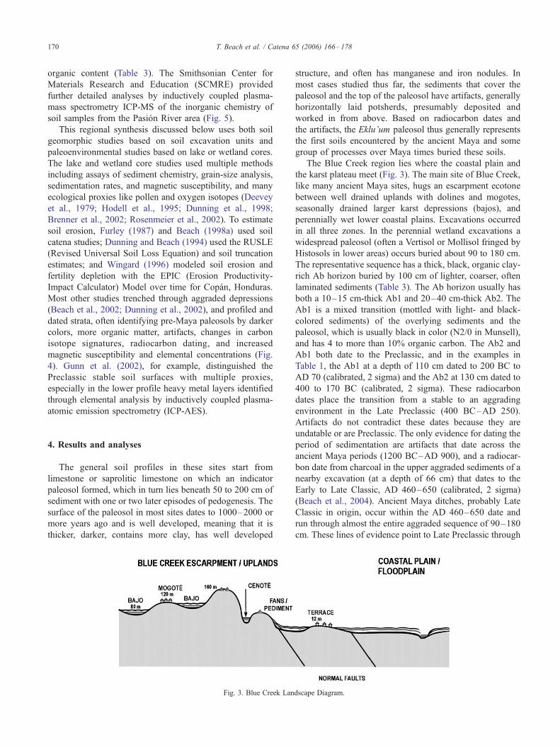
The Blue Creek region lies where the coastal plain and
the karst plateau meet (Fig. 3). The main site of Blue Creek,
like many ancient Maya sites, hugs an escarpment ecotone
between well drained uplands with dolines and mogotes,
seasonally drained larger karst depressions (bajos), and
perennially wet lower coastal plains. Excavations occurred
in all three zones. In the perennial wetland excavations a
widespread paleosol (often a Vertisol or Mollisol fringed by
Histosols in lower areas) occurs buried about 90 to 180 cm.
The representative sequence has a thick, black, organic clay-
rich Ab horizon buried by 100 cm of lighter, coarser, often
laminated sediments (Table 3). The Ab horizon usually has
both a 10–15 cm-thick Ab1 and 20–40 cm-thick Ab2. The
Ab1 is a mixed transition (mottled with light- and black-
colored sediments) of the overlying sediments and the
paleosol, which is usually black in color (N2/0 in Munsell),
and has 4 to more than 10% organic carbon. The Ab2 and
Ab1 both date to the Preclassic, and in the examples in
Table 1, the Ab1 at a depth of 110 cm dated to 200 BC to
AD 70 (calibrated, 2 sigma) and the Ab2 at 130 cm dated to
400 to 170 BC (calibrated, 2 sigma). These radiocarbon
dates place the transition from a stable to an aggrading
environment in the Late Preclassic (400 BC–AD 250).
Artifacts do not contradict these dates because they are
undatable or are Preclassic. The only evidence for dating the
period of sedimentation are artifacts that date across the
ancient Maya periods (1200 BC–AD 900), and a radiocar-
bon date from charcoal in the upper aggraded sediments of a
nearby excavation (at a depth of 66 cm) that dates to the
Early to Late Classic, AD 460–650 (calibrated, 2 sigma)
(Beach et al., 2004). Ancient Maya ditches, probably Late
Classic in origin, occur within the AD 460–650 date and
run through almost the entire aggraded sequence of 90–180
cm. These lines of evidence point to Late Preclassic through
dscape Diagram.
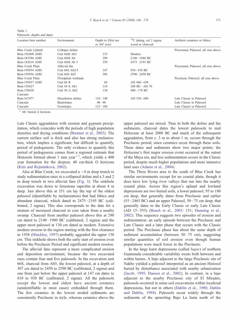
Table 1
Paleosols: depths and dates
Location beta number Environment Depth to Eklu’um
or Aba (cm)
14C dating, cal 2 sigma,
wood or charcoal
Artifacts ceramics or lithics
Blue Creek Upland Collapse doline Preceramic Paleosol, all eras above
Beta-182608 AMS Unit 66M Ab1 135 Modern
Beta-183586 AMS Unit 66M Ab 290 2140–1940 BC
Beta-182610 AMS Unit 66M Ab 5 350 2475–2195 BC
Blue Creek Plain Alluvial fan Preceramic Paleosol, all eras above
Beta-195854 AMS Unit 66S Ab2/3 147 930–810 BC
Beta-195856 AMS Unit 66S Ab5 306 2590–2450 BC
Blue Creek Plain Floodplain wetlands Preclassic Paleosol, all eras above
Beta-195857 AMS Unit 66 R 66 AD 460–650
Beta-158427 Unit 56 E Ab1 110 200 BC–AD 70
Beta-158428 Unit 56 A Ab2 130 400–170 BC
Cancuen
Beta-167477 Dissolution doline 110–140 AD 530–680 Late Classic to Paleosol
Cancuen Backslopes 40–48 Late Classic to Paleosol
Cancuen Footslopes 125–180 Late Classic to Paleosol
a Ab: buried A horizon.
T. Beach et al. / Catena 65 (2006) 166–178 171
Late Classic aggradation with erosion and gypsum precip-
itation, which coincides with the periods of high population
densities and drying conditions (Brenner et al., 2003). The
current surface soil is thick and also has strong melaniza-
tion, which implies a significant, but difficult to quantify,
period of pedogenesis. The only evidence to quantify this
period of pedogenesis comes from a regional estimate that
Histosols formed about 1 mm year�1, which yields a 400
year formation for the deepest, 40 cm-thick O horizons
(Kim and Rejmankova, 2002).
Also at Blue Creek, we excavated a ¨4 m deep trench to
study sedimentation rates in a collapsed doline and a 3 and 2
m deep trench in two alluvial fans (Fig. 3). The sinkhole
excavation was down to limestone saprolite at about 4 m
deep. Just above this at 351 cm lay the top of the oldest
paleosol (identifiable by melanization) that had lithics and
abundant charcoal, which dated to 2475–2195 BC (cali-
brated, 2 sigma). This also corresponds to the date for a
stratum of increased charcoal in core taken from a nearby
swamp. Charcoal from another paleosol above this at 290
cm dated to 2140–1900 BC (calibrated, 2 sigma) and the
upper most paleosol at 130 cm dated as modern. Extensive
modern erosion in the region starting with the first clearance
in 1958 (Hinckley, 1997) probably aggraded the upper 130
cm. This sinkhole shows both the early start of erosion even
before the Preclassic Period and significant modern erosion.
The alluvial fans represent a more complicated erosion
and deposition environment, because the two excavated
ones contain four and five paleosols. In fan excavation unit
66S, charcoal from Ab5, the lowest paleosol, at a depth of
307 cm dated to 2450 to 2590 BC (calibrated, 2 sigma) and
one from just below the upper paleosol at 147 cm dates to
810 to 930 BC (calibrated, 2 sigma). All the paleosols
except the lowest and oldest have ancient ceramics
(unidentifiable in most cases) embedded through them.
The few ceramics in the lowest eroded sediments are
consistently Preclassic in style, whereas ceramics above the
upper paleosol are mixed. Thus in both the doline and fan
sediments, charcoal dates the lowest paleosols to mid
Holocene at least 2000 BC and much of the subsequent
aggradation, from c. 3 m to about 1 m, occurs through the
Preclassic period, since ceramics occur through these soils.
These dates and sediments show two major points: the
Holocene’s first major erosion event occurred at the outset
of the Maya era, and less sedimentation occurs in the Classic
period, despite much higher populations and more intensive
land uses (Adams et al., 2004).
The Three Rivers area to the south of Blue Creek has
similar environments except for no coastal plain, though it
does have low lying river valleys that run into the nearby
coastal plain. Across this region’s upland and lowland
depressions are two buried soils, a lower paleosol, 95 to 180
cm deep, that generally dates from Preclassic and earlier
(55–2465 BC) and an upper Paleosol, 50–75 cm deep, that
generally dates to the Early Classic or early Late Classic
(AD 15–555) (Beach et al., 2003: 151; Dunning et al.,
2002). This sequence suggests two episodes of erosion and
sedimentation: an early episode between the Preclassic and
Late Classic and a later phase that occurs with the Classic
period. The Preclassic phase has about the same depth of
sediment accumulation (between 50–75 cm), suggesting
similar quantities of soil erosion even though human
populations were much lower in the Preclassic.
In the large karst depressions (called bajos) of northern
Guatemala considerable variability exists both between and
within basins. A bajo adjacent to the large Preclassic site of
Nakbe yielded a paleosol interpreted as an ancient Histosol
buried by disturbance associated with nearby urbanization
(Jacob, 1995; Hansen et al., 2002). In contrast, in a bajo
adjacent to the nearby Preclassic city of El Mirador,
paleosols occurred in some soil excavations within localized
depressions, but not in others (Dahlin et al., 1980; Dahlin
and Dahlin, 1994). Paleosols occur widely through the
sediments of the sprawling Bajo La Justa north of the
Fig. 4. Photo of Cancuen footslope excavation. Daesha Ramachandran is
pointing to the Late Classic (AD 550–850) paleosol.
T. Beach et al. / Catena 65 (2006) 166–178172
ancient city of Yaxha (Dunning et al., 2002, in press). In a
section of the huge Bajo de Santa Fe, however, there was a
Preclassic paleosol in one group of trenches, but none in
another group located in nearly identical topographical
contexts separated by 1 km (Dunning et al., in press). The
area investigated within the Bajo de Santa Fe has very little
local relief and the paleosol lies generally at less than 50 cm
depth. The variability between bajos clearly reflects the
variation in human impacts and different drainage hydrol-
ogy within these karst depressions even before the arrival of
the Maya. The two oldest paleosols yet discovered within
bajos are an apparent Histosol dated to 9610T360 BC
(uncalibrated) buried at about 4 m depth in the Bajo de
Santa Fe near Tikal (Cowgill and Hutchinson, 1963) and an
Oxisol dated to 13,480 to 12,300 BC (uncalibrated) buried
at a similar depth within the Dumbbell Bajo of northwestern
Belize. The variability and complexity of environmental
histories evident within bajos show that these sinks must be
studied individually in order to understand the regional
erosion histories (Dunning et al., in press).
In the Petexbatun region of the central Peten, a complex
record of environmental impacts shows more early environ-
mental change and less than expected change in the Late
Classic (Dunning et al., 1998). Soil erosion and sedimen-
tation evidence exists around upland fields and in lake cores
taken at Laguneta Tamarindito that started by about 1000
BC. Our lake cores also showed surprisingly lower
quantities of sedimentation in the Late Classic when human
populations here reached their highest level. This period of
lower than expected lake sedimentation correlates with a
vast expansion of ancient Maya agricultural terraces as well
as a soil landscape truncated by previous erosion (Beach,
1998a).
Finally, at Cancuen, in Guatemala’s southern Peten state,
soil stratigraphy in six separate depression and footslope
excavations showed well developed paleosols buried at 110
to 180 cm (Fig. 4). Even some backslope soils have a
distinct buried soil, though only at c. 40–50 cm depth.
Cancuen’s occupation is dominated by a short period of the
Late Classic (Kovacevich et al., 2003), and indeed these
excavations only yielded Late Classic artifacts down to the
paleosols and no horizontally deposited ceramics below this
(though some vertical or diagonal ceramics are embedded in
the buried Vertisols through cracks). The buried soils at
Cancuen are also easily distinguished by their chemical
composition, which is evident in the aggraded sequence of a
karst depression (Table 3) because the overlying Late
Classic Maya sediments have at least three times more total
P than the paleosol. Cook et al. (in press) demonstrated that
the Late Classic soil floors overlying buried soils have
significantly altered heavy metal and rare earth element
(REE) chemistry. The elevated concentrations of heavy
metals and REEs from areas of ancient human occupation
not only aids in their distinction from the buried soils (Fig.
5), but also provides specific information on the location
and nature of Maya land use in antiquity.
Radiocarbon dating of charcoal near the top of a paleosol
buried at 1.1 m in a small karst depression (Table 3) dates it to
the early part of the Late Classic (AD 530 to 680, calibrated, 2
sigma). At Cancuen the evidence suggests significant
environmental change occurred over a short time period in
the Late Classic because all of the colluvium is choked full of
Late Classic artifacts and is sandwiched by the well
developed pre-Late Classic paleo Vertisol and the surface
Rendoll (Tables 1–3). Much of the erosion at this site must
have been caused by urbanization since about half of the
buried soils occurred close enough to the highly built up site
core. Several sites with buried soils, nonetheless, occurred at
significant distance from the urban construction and must
have been covered by ancient agricultural erosion since they
have both well developed buried paleosols and surface soils.
4.1. Regional synthesis
Essentially equivalent to the paleosols described here and
the sediments that bury them are the FMaya Clays_ that
occur in many depressions in the southern Maya Lowlands
(Table 2) (Dunning et al., 1998). For example, in the coastal
plain of northern Belize and the floodplain of the Belize
River Valley comparable sequences of Preclassic surfaces
are buried by Classic ‘‘Maya Clay’’ fill (Jacob and
Hallmark, 1996; Pohl et al., 1996; Pope et al., 1996; Holley
et al., 2000; Gunn et al., 2002).
Similarly, lake cores from the central Peten show
evidence of these Maya Clays (Table 2) (Rice, 1996;
Rosenmeier et al., 2002). The first major change in the
sedimentation record comes from lake core pollen evidence
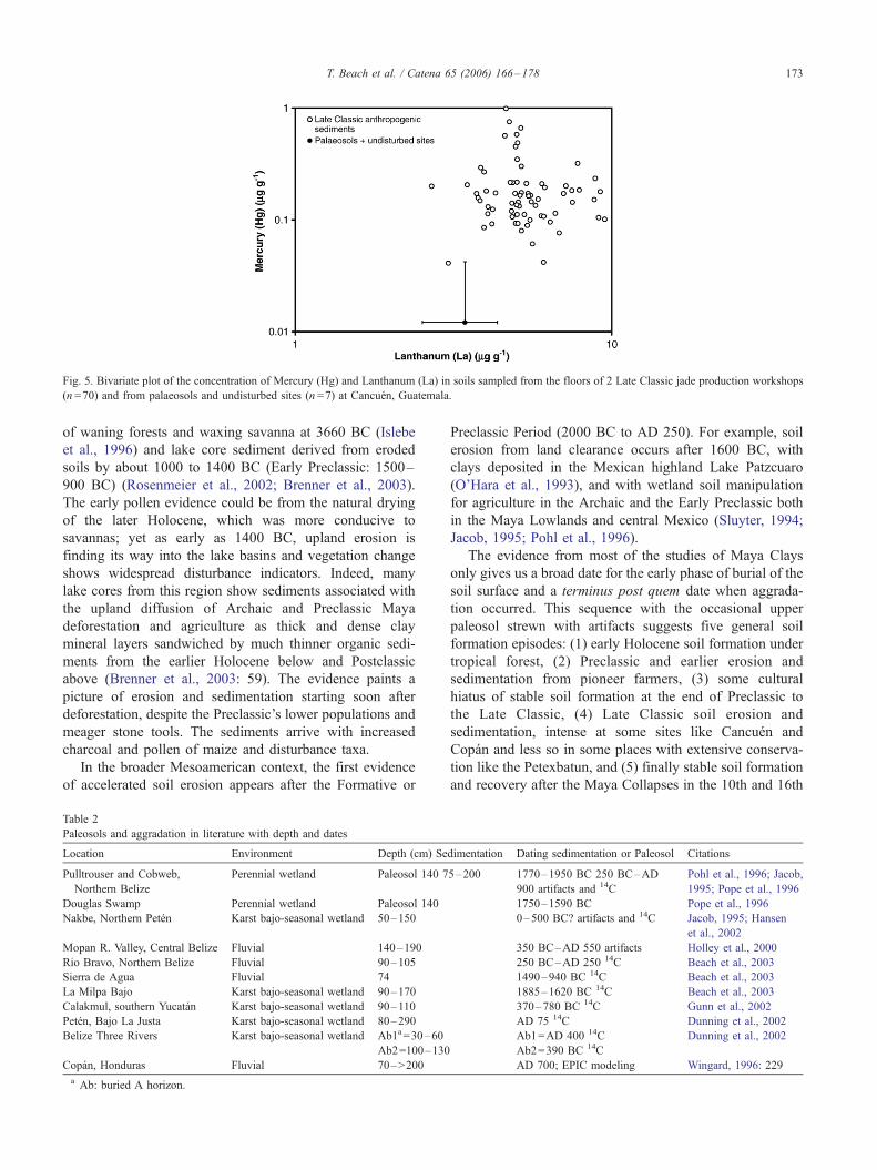
Fig. 5. Bivariate plot of the concentration of Mercury (Hg) and Lanthanum (La) in soils sampled from the floors of 2 Late Classic jade production workshops
(n =70) and from palaeosols and undisturbed sites (n =7) at Cancuen, Guatemala.
T. Beach et al. / Catena 65 (2006) 166–178 173
of waning forests and waxing savanna at 3660 BC (Islebe
et al., 1996) and lake core sediment derived from eroded
soils by about 1000 to 1400 BC (Early Preclassic: 1500–
900 BC) (Rosenmeier et al., 2002; Brenner et al., 2003).
The early pollen evidence could be from the natural drying
of the later Holocene, which was more conducive to
savannas; yet as early as 1400 BC, upland erosion is
finding its way into the lake basins and vegetation change
shows widespread disturbance indicators. Indeed, many
lake cores from this region show sediments associated with
the upland diffusion of Archaic and Preclassic Maya
deforestation and agriculture as thick and dense clay
mineral layers sandwiched by much thinner organic sedi-
ments from the earlier Holocene below and Postclassic
above (Brenner et al., 2003: 59). The evidence paints a
picture of erosion and sedimentation starting soon after
deforestation, despite the Preclassic’s lower populations and
meager stone tools. The sediments arrive with increased
charcoal and pollen of maize and disturbance taxa.
In the broader Mesoamerican context, the first evidence
of accelerated soil erosion appears after the Formative or
Table 2
Paleosols and aggradation in literature with depth and dates
Location Environment Depth (cm) Se
Pulltrouser and Cobweb,
Northern Belize
Perennial wetland Paleosol 140 7
Douglas Swamp Perennial wetland Paleosol 140
Nakbe, Northern Peten Karst bajo-seasonal wetland 50–150
Mopan R. Valley, Central Belize Fluvial 140–190
Rio Bravo, Northern Belize Fluvial 90–105
Sierra de Agua Fluvial 74
La Milpa Bajo Karst bajo-seasonal wetland 90–170
Calakmul, southern Yucatan Karst bajo-seasonal wetland 90–110
Peten, Bajo La Justa Karst bajo-seasonal wetland 80–290
Belize Three Rivers Karst bajo-seasonal wetland Ab1a=30–60
Ab2=100–130
Copan, Honduras Fluvial 70–>200
a Ab: buried A horizon.
Preclassic Period (2000 BC to AD 250). For example, soil
erosion from land clearance occurs after 1600 BC, with
clays deposited in the Mexican highland Lake Patzcuaro
(O’Hara et al., 1993), and with wetland soil manipulation
for agriculture in the Archaic and the Early Preclassic both
in the Maya Lowlands and central Mexico (Sluyter, 1994;
Jacob, 1995; Pohl et al., 1996).
The evidence from most of the studies of Maya Clays
only gives us a broad date for the early phase of burial of the
soil surface and a terminus post quem date when aggrada-
tion occurred. This sequence with the occasional upper
paleosol strewn with artifacts suggests five general soil
formation episodes: (1) early Holocene soil formation under
tropical forest, (2) Preclassic and earlier erosion and
sedimentation from pioneer farmers, (3) some cultural
hiatus of stable soil formation at the end of Preclassic to
the Late Classic, (4) Late Classic soil erosion and
sedimentation, intense at some sites like Cancuen and
Copan and less so in some places with extensive conserva-
tion like the Petexbatun, and (5) finally stable soil formation
and recovery after the Maya Collapses in the 10th and 16th
dimentation Dating sedimentation or Paleosol Citations
5–200 1770–1950 BC 250 BC–AD
900 artifacts and 14C
Pohl et al., 1996; Jacob,
1995; Pope et al., 1996
1750–1590 BC Pope et al., 1996
0–500 BC? artifacts and 14C Jacob, 1995; Hansen
et al., 2002
350 BC–AD 550 artifacts Holley et al., 2000
250 BC–AD 250 14C Beach et al., 2003
1490–940 BC 14C Beach et al., 2003
1885–1620 BC 14C Beach et al., 2003
370–780 BC 14C Gunn et al., 2002
AD 75 14C Dunning et al., 2002
Ab1=AD 400 14C
Ab2=390 BC 14C
Dunning et al., 2002
AD 700; EPIC modeling Wingard, 1996: 229
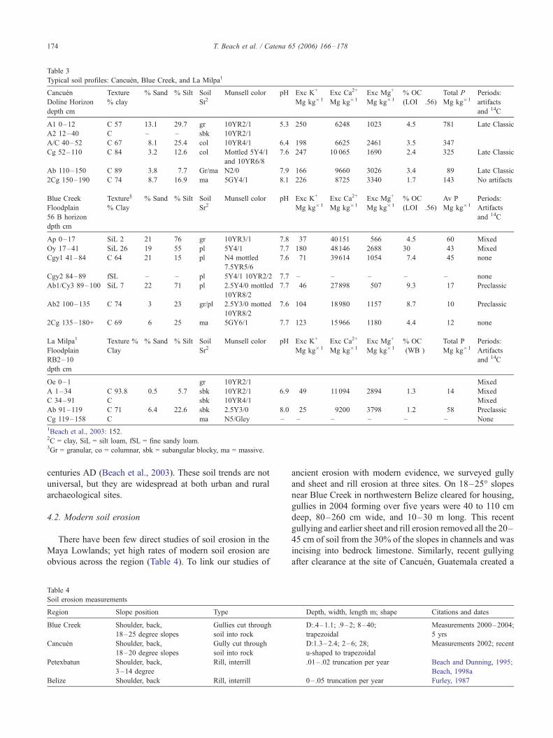
Table 3
Typical soil profiles: Cancuen, Blue Creek, and La Milpa1
Cancuen
Doline Horizon
depth cm
Texture
% clay
% Sand % Silt Soil
St2Munsell color pH Exc K+
Mg kg�1
Exc Ca2+
Mg kg�1
Exc Mg+
Mg kg�1
% OC
(LOI� .56)
Total P
Mg kg�1
Periods:
artifacts
and 14C
A1 0–12 C 57 13.1 29.7 gr 10YR2/1 5.3 250 6248 1023 4.5 781 Late Classic
A2 12–40 C – – sbk 10YR2/1
A/C 40–52 C 67 8.1 25.4 col 10YR4/1 6.4 198 6625 2461 3.5 347
Cg 52–110 C 84 3.2 12.6 col Mottled 5Y4/1
and 10YR6/8
7.6 247 10 065 1690 2.4 325 Late Classic
Ab 110–150 C 89 3.8 7.7 Gr/ma N2/0 7.9 166 9660 3026 3.4 89 Late Classic
2Cg 150–190 C 74 8.7 16.9 ma 5GY4/1 8.1 226 8725 3340 1.7 143 No artifacts
Blue Creek
Floodplain
56 B horizon
dpth cm
Texture‘
% Clay
% Sand % Silt Soil
Sr2Munsell color pH Exc K+
Mg kg�1
Exc Ca2+
Mg kg�1
Exc Mg+
Mg kg�1
% OC
(LOI� .56)
Av P
Mg kg�1
Periods:
Artifacts
and 14C
Ap 0–17 SiL 2 21 76 gr 10YR3/1 7.8 37 40151 566 4.5 60 Mixed
Oy 17–41 SiL 26 19 55 pl 5Y4/1 7.7 180 48146 2688 30 43 Mixed
Cgy1 41–84 C 64 21 15 pl N4 mottled
7.5YR5/6
7.6 71 39614 1054 7.4 45 none
Cgy2 84–89 fSL – – pl 5Y4/1 10YR2/2 7.7 – – – – – none
Ab1/Cy3 89–100 SiL 7 22 71 pl 2.5Y4/0 mottled
10YR8/2
7.7 46 27898 507 9.3 17 Preclassic
Ab2 100–135 C 74 3 23 gr/pl 2.5Y3/0 motted
10YR8/2
7.6 104 18980 1157 8.7 10 Preclassic
2Cg 135–180+ C 69 6 25 ma 5GY6/1 7.7 123 15966 1180 4.4 12 none
La Milpa1
Floodplain
RB2–10
dpth cm
Texture %
Clay
% Sand % Silt Soil
Sr2Munsell color pH Exc K+
Mg kg�1
Exc Ca2+
Mg kg�1
Exc Mg+
Mg kg�1
% OC
(WB )
Total P
Mg kg�1
Periods:
Artifacts
and 14C
Oe 0–1 gr 10YR2/1 Mixed
A 1–34 C 93.8 0.5 5.7 sbk 10YR2/1 6.9 49 11094 2894 1.3 14 Mixed
C 34–91 C sbk 10YR4/1 Mixed
Ab 91–119 C 71 6.4 22.6 sbk 2.5Y3/0 8.0 25 9200 3798 1.2 58 Preclassic
Cg 119–158 C ma N5/Gley – – – – – – None
1Beach et al., 2003: 152.2C = clay, SiL = silt loam, fSL = fine sandy loam.3Gr = granular, co = columnar, sbk = subangular blocky, ma = massive.
T. Beach et al. / Catena 65 (2006) 166–178174
centuries AD (Beach et al., 2003). These soil trends are not
universal, but they are widespread at both urban and rural
archaeological sites.
4.2. Modern soil erosion
There have been few direct studies of soil erosion in the
Maya Lowlands; yet high rates of modern soil erosion are
obvious across the region (Table 4). To link our studies of
Table 4
Soil erosion measurements
Region Slope position Type
Blue Creek Shoulder, back,
18–25 degree slopes
Gullies cut through
soil into rock
Cancuen Shoulder, back,
18–20 degree slopes
Gully cut through
soil into rock
Petexbatun Shoulder, back,
3–14 degree
Rill, interrill
Belize Shoulder, back Rill, interrill
ancient erosion with modern evidence, we surveyed gully
and sheet and rill erosion at three sites. On 18–25- slopesnear Blue Creek in northwestern Belize cleared for housing,
gullies in 2004 forming over five years were 40 to 110 cm
deep, 80–260 cm wide, and 10–30 m long. This recent
gullying and earlier sheet and rill erosion removed all the 20–
45 cm of soil from the 30% of the slopes in channels and was
incising into bedrock limestone. Similarly, recent gullying
after clearance at the site of Cancuen, Guatemala created a
Depth, width, length m; shape Citations and dates
D:.4–1.1; .9–2; 8–40;
trapezoidal
Measurements 2000–2004;
5 yrs
D:1.3–2.4; 2–6; 28;
u-shaped to trapezoidal
Measurements 2002; recent
.01– .02 truncation per year Beach and Dunning, 1995;
Beach, 1998a
0– .05 truncation per year Furley, 1987
T. Beach et al. / Catena 65 (2006) 166–178 175
gully 130–240 cm deep, 2–6 m wide, and 28 m long. Beach
and Dunning (1995) and Beach (1998a) reported rill and
interrill and gully erosion in the Petexbatun uplands that in
one case eroded soil to bedrock over the shoulder and
backslopes, and truncated more than 35% to more than 70%
of soil profiles in a decade after clearance. Furley (1987)
working on karst slopes in central Belize reported more
modest erosion, though after just one milpa cycle of 2–3
years. He reported this graphically, which showed the first 7
of the 11 soil depths truncated by c. 2 to 10 cm.
4.3. Ancient soil conservation
The Maya Lowlands also provide a long history of slope
conservation (Turner, 1974), reported since the 1920s
(Cooke, 1931). In studies over the last decade, scores of
ancient Maya agricultural terraces dated to the Classic and
mostly to the Late Classic (Beach and Dunning, 1995, 1997;
Beach et al., 2002). These excavations show at least six
different types of land use management techniques and as
many construction techniques. The Maya built them at the
household to the corporate group level, and in some places,
such as like Caracol, terrace systems dominate the landscape
a thousand years after abandonment. In other parts of the
Maya Lowlands like Tikal and Copan, with equally complex
city-states and erosive landscapes, the literature records little
evidence of conservation (Beach et al., 2002). Indeed, some
modern studies, like Wingard (1996) and Abrams and Rue
(1988), have recalled the closer links between collapse and
landscape degradation presented by Bennett (1926) (Dunning
and Beach, 2000). Where extensive, complex terracing of the
Classic period occurred (northern Belize and the Petexbatun
of Guatemala), there was also less sedimentation evidence at
this time (Beach, 1998a; Beach et al., 2002, 2003).Where and
when no such conservation features occurred (such as
Cancuen in the Late Classic), there was ample erosion and
sedimentation evidence. For Copan, Wingard (1996) also
published evidence for high rates of erosion and sedimenta-
tion in the Late Classic with limited conservation features, but
here he linked it to population growth and farmers expanding
up the slopes for the first time, after taking up the large
expanses of fluvial bottomland. In the case of reduced
sedimentation in the Late Classic period, the causes may have
been both exhausted sediment supply (Gilbert, 1877) and the
expanding conservation features. Certainly the terraces hold
more soils from antiquity (including dated paleosols, see
Beach et al., 2002), but given the tendency of modern erosion
to truncate soils to bedrock, Preclassic erosion also may have
stripped much of the sediment supplies where early farmers
moved onto hillslopes.
5. Discussion and conclusions
This study brings together a number of empirical studies
that show the extent and timing of Maya impacts on
geomorphology or land degradation in terms of sedimenta-
tion and indirectly soil erosion. Sedimentation in karst
depressions and floodplains started before, or in the Early
Preclassic periods in many parts of the Maya Lowlands.
Here many depression soils that had formed in equilibrium
since the start of the Holocene were now beginning to be
covered by artifact-laden sediment eroded from surrounding
slopes. Likewise, many lake cores show the so-called FMaya
Clay_ starting to deposit over the organic sediments that had
slowly accumulated since the start of the Holocene. In the
examples where archaeological evidence shows Preclassic
and earlier occupation, the records of sedimentation also
start in these early periods. In some sites (the Petexbatun,
the Three Rivers, and the Belize River), the lake core and
soil evidence show lower than expected rates of soil erosion
in the Late Classic, when populations were highest. This
correlates with the wide diffusion of many types of terracing
that may have conserved soils when ancient Maya
populations were greatest (Turner, 1990; Beach et al.,
2002). This may also be partly the result of sediment
exhaustion, in which erosion may have already removed the
readily erodible component of upland soils. All the sites
show a return to low levels of soil erosion after the Maya
Collapse of the 9th and 10th Centuries AD. Lake sediments
return as slowly accumulating organic gyttja and the
aggraded sediments start to form topsoils generally 1 to 2
m above the buried pre-Maya topsoils. Hence, until the 20th
Century the ancient Maya were the major agent of
geomorphic change, both in accelerating erosion and
modifying slopes with terracing to conserve soils.
The aggradation that buried soils in the Maya Lowlands
was human induced because the epochs of erosion so
obviously parallel the Maya expansions in the Preclassic
and Late Classic. The later period also corresponds to the
general drying associated with the Classic Period Maya
droughts (Hodell et al., 1995, 2001), which could have
contributed to increased erosion. But the present state of
knowledge about climate change over the Maya period is
insufficient to suggest how it might have changed soil
erosion rates, given the unambiguous connection between
accelerated erosion and deforestation in the contemporary
landscape. At present, land use causes of soil erosion are
clearer than climatic ones. Based on the propinquity of some
of the research sites to urban areas and the fact that erosion/
deposition occurred during periods of Maya urban devel-
opment, urban construction must have some role in this
aggradation. Nonetheless, most of the buried paleosol sites
in this study are far from major urban sites and must have
been buried by erosion from rural land-use.
In examples from this paper, human impacts on the Maya
Lowlands were the largest agents of change in the Holocene.
Soil erosion occurred over much of this region as pioneer
farming and urban construction expanded onto slopes in the
Preclassic and Classic in many areas, or during the Classic
period alone at Cancuen and Copan. This caused aggrada-
tion of depressions and valleys that buried once stable soils
T. Beach et al. / Catena 65 (2006) 166–178176
and lacustrine sediments that had formed through the
Holocene. At Cancuen, collapse came before the Maya
could respond with conservation. At Copan and the central
Peten lakes region, the Maya built few conservation features
(footslope terraces and artificial benches) around depres-
sions to counteract accelerated erosion. In many other
regions, like the Petexbatun, the Three Rivers Region,
Caracol, the Belize River Valley, and the Rio Bec region, the
Maya manipulated their landscapes into terraces and
diversions mainly during the Late Classic. This stemmed
upland erosion, and the sheer number and labor implications
of these terraces suggest their value to the Maya. The fact so
many terraces are still in place after more than 1000 years
shows the geomorphic longevity of their slope management
and the surprisingly slow rate of slope movement under the
thick cover of tropical forest. The main cause of slope
movement during the last millennium of high forest stability
has been creep and tree fall and root throw (Beach, 1998a).
A new cycle of erosion has returned in the last decades as
new groups of pioneers in increasing numbers have once
again deforested the slopes, and rain drops, sheets, rills and
gullies have increased slope movement dramatically.
A distant correlation within Mesoamerica is with Lake
Patzcuaro in the Mexican highlands. Our findings here
parallel those of Fisher et al. (2003) for Lake Patzcuaro in
three ways: they show evidence for very early sedimentation
and erosion, geographic and chronological connections to
urban development, and less-than-expected soil erosion
during periods of high populations and intensive indigenous
management. The urban connection is especially true
around Cancuen and the urban sites of northwestern Belize
like La Milpa, and the lower erosion and intensive land use
connection is especially true for northwestern Belize and
Tamarindito. Since these regions have very different and
heterogenous environments and histories, any correlations
are interesting and may give us insight into the broad
processes of land degradation.
There are both costs and benefits in synthesizing
research. The prevailing idea of the first part of the 20th
C. that Precolumbian Maya environmental impacts were
small was not a universal view. Indeed, Bennett (1926)
proposed soil erosion as a cause of the Maya collapse,
which Huntington (1915) had already ascribed to climatic
change. There is ample evidence for large-scale soil erosion
from uplands and sedimentation in depressions that
followed a pioneering path through the Maya Lowlands
and that it started before the Late Classic when population
pressure was highest. There is also ample evidence for
lower soil erosion at several sites during the periods of
highest human populations and intensive land uses (Beach
et al., 2002). Precolumbian people obviously caused
widespread geomorphic change, both in terms of soil
erosion and soil conservation. But their impacts started
near the beginning of their civilization, which persisted
more than a thousand years beyond the start of the
sediment cascade.
Acknowledgements
Many granting organizations provided funding for this
research, including the National Geographic Society, the
National Science Foundation, Georgetown University,
George Mason University, the Maya Research Program,
the University of Cincinnati, and the Smithsonian Institu-
tion. We thank the many people who contributed valuable
ideas, support, and information, including Vernon Scar-
borough Kevin Pope, Fred Valdez, Laura Kosakowsky,
Kerry Sagebiel, and Ron Bishop, and our many students:
Jessica Albietz, Beth Bauer, Suzanne Blake, Tagan Blake,
Grant Cavanaugh, Genevieve Croft, Tara Everhart, Chris
Henderson, Megan Liddle, Seth Miller, Daesha Ramachan-
dran, and Geta Uhl. We also thank two anonymous
reviewers for helpful edits and clarifications.
References
Abrams, E.M., Rue, D.J., 1988. The causes and consequences of de-
forestation among the Prehistoric Maya. Human Ecology 16, 377–395.
Adams, R.E.W., Robichaux, H., Valdez Jr., F., Houk, B., Mathews, R.,
2004. Transformations, periodicity, and urban developments in the
Three Rivers Region. In: Demarest, A., Rice, D., Rice, P. (Eds.), The
Terminal Classic in the Maya Lowlands: Collapse, Transition, and
Transformation. The University Press of Colorado, Boulder.
Beach, T., 1994. The fate of eroded soil: sediment sinks and sediment
budgets of agrarian landscapes in southern Minnesota, 1851–1988.
Annals of the Association of American Geographers 84, 5–28.
Beach, T., 1998a. Soil catenas, tropical deforestation, and ancient and
contemporary soil erosion in the Peten, Guatemala. Physical Geography
19, 378–405.
Beach, T., 1998b. Soil constraints on Northwest Yucatan, Mexico:
pedoarchaeology and Maya subsistence at Chunchucmil. Geoarchaeol-
ogy 13 (8), 759–791.
Beach, T., Dunning, N.P., 1995. Ancient Maya terracing and modern
conservation in the Peten Rain Forest of Guatemala. Journal of Soil and
Water Conservation 50, 138–145.
Beach, T., Dunning, N.P., 1997. An ancient Maya reservoir and dam at
Tamarindito, Peten, Guatemala. Latin American Antiquity 8 (1), 20–29.
Beach, T., Luzzadder-Beach, S., Dunning, N., Hageman, J., Lohse, J.,
2002. Upland agriculture in the Maya Lowlands: ancient Maya
soil conservation in northwestern Belize. Geographical Review 92,
372–397.
Beach, T., Luzzadder-Beach, S., Dunning, N., Scarborough, V., 2003.
Depression soils in the lowland tropics of northwestern Belize. In:
Gomez-Pompa, A., Allen, M., Fedick, S.L., Jimenez-Osornio, J.J.
(Eds.), Lowland Maya Area: Three Millennia at the Human-Wildland
Interface. Haworth Press, Binghamton, NY, pp. 139–173.
Beach, T., Luzzadder-Beach, S., Dunning, N., Lohse, J., 2004. Geo-
archaeology of wetland agriculture in the Maya Lowlands. Society of
American Archaeology. Montreal, Canada. Abstract in 69th Annual
SAA Meeting Abstracts.
Beach, T., Luzzadder-Beach, S., Dunning, N., 2006. A soils history of
Mesoamerica and the Caribbean Islands. In: Winiwarter, V., McNeill, J.
(Eds.), An Environmental History of Soils. The White Horse Press, Isle
of Harris, UK.
Bennett, H.H., 1926. Agriculture in Central America. Annals of the
Association of American Geographers 16, 63–84.
Bennett, H.H., 1945. Soil conservation in Latin America. In: Verdoorn, F.
(Ed.), Plants and Plant Sciences in Latin America, Chronica Botanica,
pp. 165–169.
T. Beach et al. / Catena 65 (2006) 166–178 177
Brenner, M., Rosenmeier, M., Hodell, D., Curtis, J., 2002. Paleolimnology
of the Maya Lowlands. Ancient Mesoamerica 13, 141–157.
Brenner, M., Hodell, D., Curtis, J.H., Rosenmeier, M., Anselmetti, F.,
Ariztegui, D., 2003. Paleolimnological approaches for inferring
past climate in the Maya region: recent advances and methodo-
logical limitations. In: Gomez-Pompa, A., Allen, M., Fedick, S.L.,
Jimenez-Osornio, J.J. (Eds.), Lowland Maya Area: Three Millennia
at the Human-Wildland Interface. Haworth Press, Binghamton, NY,
pp. 45–76.
Brokaw, N., Mallory, E., 1993. Vegetation of the Rio Bravo Conservation
and Management Area, Belize. Manomet Bird Sanctuary, Manomet,
Massachusetts.
Butzer, K., 1992. The Americas before and after 1492: an introduction to
current geographical research. Annals of the Association of American
Geographers 82, 345–368.
Cook, D., Kovacevich, B., Beach, T., Bishop, R., in press. Deciphering the
inorganic geochemical record of ancient human activity using ICP-MS:
a reconnaissance study of Late Classic soil floors at Cancuen,
Guatemala. Journal of Archaeological Science 33.
Cooke, C.W., 1931. Why the Mayan cities in the Peten District were
abandoned. Journal of the Washington Academy of Sciences 21,
283–287.
Cowgill, U.M., Hutchinson, G.E., 1963. El Bajo de Santa Fe. Transactions
of the American Philosophical Society 53 (7), 3–44.
Culbert, T.P., Rice, D. (Eds.), 1990. Precolumbian Population History in the
Maya Lowlands. University of New Mexico Press, Albuquerque.
Dahlin, B., Dahlin, A., 1994. Platforms in the Aklache at El Mirador, Peten,
Guatemala and their implications. Geoarchaeology 9, 203–237.
Dahlin, B., Foss, J., Chambers, M.E., 1980. Project Akalches: reconstruct-
ing the natural and cultural history of a seasonal swamp: preliminary
results. In: Matheny, R.T. (Ed.), El Mirador, El Peten, Guatemala: An
Interim Report, Papers of the New World Archaeological Foundation,
vol. 45. Brigham Young University, Provo, UT, pp. 37–58.
Day, M., 1993. Human impacts on Caribbean and Central American Karst.
Catena (Supplement 25), 109–125.
Demarest, A., Rice, D., Rice, P. (Eds.), 2004. The Terminal Classic in the
Maya Lowlands: Collapse, Transition, and Transformation. The
University Press of Colorado, Boulder.
Deevey, E.S., Rice, D.S., Rice, P.M., Vaughan, H.H., Brenner, M.,
Flannery, M.S., 1979. Mayan urbanism: impact on a tropical karst
environment. Science 206, 298–306.
Denevan, W., 1992. The pristine myth: the landscape of the Americas
in 1492. Annals of the Association of American Geographers 82 (3),
369–385.
Dunning, N., Beach, T., 1994. Soil erosion, slope management, and
ancient terracing in the Maya Lowlands. Latin American Antiquity 5,
51–69.
Dunning, N., Beach, T., 2000. Stability and instability in Prehispanic Maya
landscapes. In: Lentz, D. (Ed.), An Imperfect Balance: Landscape
Transformations in the Precolumbian Americas. Columbia University
Press, New York, pp. 179–202.
Dunning, N., Beach, T., 2004a. Fruit of the Luum: Lowland Maya soil
knowledge and agricultural practices. Mono y Conejo 2, 3–15.
Dunning, N., Beach, T., 2004b. Noxious or nurturing: Maya Civilization in
environmental contexts. In: Golden, C., Borgstede, G. (Eds.), Continu-
ity and Change in Maya Archaeology. Routledge Press, New York.
Dunning, N., Rue, D., Beach, T., Covich, A., Traverse, A., 1998. Human-
environment interactions in a tropical watershed: the paleoecology of
Laguna Tamarindito, El Peten, Guatemala. Journal of Field Archaeol-
ogy 25, 139–151.
Dunning, N., Luzzadder-Beach, S., Beach, T., Jones, J., Scarborough, V.,
Culbert, P., 2002. Arising from the Bajos: the evolution of a neotropical
landscape and the rise of Maya Civilization. Annals of the Association
of American Geographers 92, 267–283.
Dunning, N., Beach, T., Luzzadder-Beach, S., in press. Environmental
variability among bajos in the Maya Lowlands and its implications for
Maya Civilization and archaeology. In: Lucero, L., Fash, B. (Eds.),
Precolumbian Water Management: Ideology, Ritual, and Power.
University of Arizona Press, Tucson.
Fisher, C., Pollard, H., Israde, I., Garduno, V., Banerjee, S., 2003.
Reexamination of human induced environmental change within the
Lake Patzcuaro Basin, Michoacan, Mexico. Proceedings of the National
Academy of Sciences 100 (8), 4957–4962.
Furley, P.A., 1987. Impact of forest clearance on the soils of tropical cone
karst. Earth Surface Processes and Landforms 12, 523–529.
Gilbert, G.K., 1877. Report on the Geology of the Henry Mountains. U.S.
Geographical and Geological Survey of the Rocky Mountain Region,
Department of the Interior, Washington, DC.
Greller, A., 2000. Vegetation and floristic regions of North and Central
America. In: Lentz, D. (Ed.), An Imperfect Balance: Landscape
Transformations in the Precolumbian Americas. Columbia University
Press, New York, pp. 39–88.
Gunn, J.D., Foss, J., Folan, W., del Rosario Domınguez, M., Faust, B.,
2002. Bajo sediments and the hydraulic system of Calakmul, Cam-
peche, Mexico. Ancient Mesoamerica 13, 297–315.
Hansen, R., Bosarth, S., Jacob, J., Wahl, D., Schreiner, T., 2002. Climatic
and environmental variability in the rise of Maya Civilization: a
preliminary perspective from the northern Peten. Ancient Mesoamerica
13, 273–295.
Hinckley, K., 1997. A Mennonite Landscape: The Blue Creek Commu-
nity. Occasional Paper, vol. 1. Maya Research Program, San Antonio,
Texas.
Hodell, D., Curtis, J., Brenner, M., 1995. Possible role of climate in the
collapse of Classic Maya Civilization. Nature 375, 391–394.
Hodell, D., Brenner, M., Curtis, J., Guilderson, T., 2001. Solar forcing of
drought frequency in the Maya Lowlands. Science 292, 1367–1370.
Holley, G.R., Dalan, R., Woods, W., Watters, H., 2000. Implications of
a buried preclassic site in Western Belize. In: Ahler, S.R. (Ed.),
Mounds, Modoc, and Mesoamerica: Paper in Honor of Melvin L.
Fowler, Springfield, IL: Illinois State Museum Scientific Papers, vol. 28,
pp. 111–124.
Huntington, E., 1915. Maya civilizations and climatic changes. XIX
International Congress of Americanists Proceedings, pp. 150–164R
Washington, D.C.
Islebe, G., Hooghiemstra, H., Brenner, M., Curtis, J., Hodell, D., 1996. A
holocene vegetation history from Lowland Guatemala. The Holocene 6
(3), 265–271.
Jacob, J., 1995. Archaeological pedology in the Maya Lowlands.
Pedological Perspectives in Archaeological Research, Soil Science
Society of America Special Publication, vol. 44. Soil Science Society of
America, Madison, WI, pp. 51–80.
Jacob, J., Hallmark, C., 1996. Holocene stratigraphy of Cobweb Swamp, a
Maya wetland in Northern Belize. GSA Bulletin 108, 883–891.
Kim, J.G., Rejmankova, E., 2002. Recent history of sediment deposition in
marl- and sand-based marshes of Belize, Central America. Catena 48,
267–291.
Kovacevich, B., Cook, D.E., Beach, T., 2003. Areas de actividad domestica
en Cancuen: Perspectivas con base en datos Lıticos y Geoquımicos. In:
Laporte, J.P., Suasnavar, A.Cl., Arroyo, B. (Eds.), XVI Simposio de
Investigaciones Arqueologicas en Gautemala. Museo Nacional de
Arqueologia y Ethnologia, Guatemala, pp. 1–19.
Morley, S., 1956. The Ancient Maya, 3rd Edition, revised by Brainard,
G.M. Palo Alto, CA: Stanford University Press.
O’Hara, S., Street-Perrott, F., Burt, T., 1993. Accelerated soil erosion
around a Mexican Highland lake caused by prehispanic agriculture.
Nature 362, 48–51.
Pohl, M., Pope, K., Jones, J., Jacob, J., Piperno, D., deFrance, S.,
Lentz, D., Gifford, J., Danforth, M., Josserand, J., 1996. Early
agriculture in the Maya Lowlands. Latin American Antiquity 74 (4),
355–372.
Pope, K., Pohl, M., Jacob, J., 1996. Formation of ancient Maya wetland
fields: natural and anthropogenic processes. In: Fedick, S.L. (Ed.), The
Managed Mosaic: Ancient Maya Agriculture and Resource Use.
University of Utah Press, Salt Lake City, pp. 165–176.
T. Beach et al. / Catena 65 (2006) 166–178178
Rice, D.S., 1996. Paleolimnological analysis in the Central Peten. In:
Fedick, S. (Ed.), The Managed Mosaic: Ancient Maya Agriculture and
Resource Use. The University of Utah Press, Salt Lake City.
Rosenmeier, M., Hodell, D., Brenner, M., Curtis, J., Guilderson, T., 2002. A
4000-year lacustrine record of environmental change in the southern
Maya Lowlands, Peten, Guatemala. Quaternary Research 57, 183–190.
Schwartz, N.B., 1990. Forest Society: A Social History of Peten,
Guatemala. University of Pennsylvania Press, Philadelphia.
Simmons, C.S., Tarano, J.M., Pinto, Z., J.H., 1959. Clasificacion de
Reconocimiento de los Suelos de la Republica de Guatemala. Instituto
Agropecuario Nacional, Servicio Cooperativa Inter-Americana de
Agricultura, Guatemala.
Sluyter, Andrew, 1994. Intensive wetland agriculture in Mesoamerica:
space, time and form. Annals of the Association of American
Geographers 84 (4), 557–584.
Stevens, R.L., 1964. The soils of Middle America and their relation to
Indian peoples and cultures. In: West, R.C. (Ed.), Natural Environment
and Early Cultures, Handbook of Middle American Indians, vol. 1.
University of Texas Press, Austin.
Thompson, J.E., 1954. The Rise and Fall of Maya Civilization. University
of Oklahoma Press, Norman.
Turner II, B.L., 1990. The rise and fall of population and agriculture in the
Central Maya Lowlands: 300 BC to present. In: Newman, L.F. (Ed.),
Hunger in History. Basil Blackwell, Inc., Cambridge, MA.
Turner II, B.L., 1974. Prehistoric intensive agriculture in the Mayan
Lowlands. Science 185, 118–124.
USDA Soil Survey Staff, 1993. Soil Survey Manual. US Department of
Agriculture Handbook, Vol. 18. US Government Printing Office,
Washington, DC.
Van Wambeke, A., 1987. Soil Moisture and Temperature and Moisture
Regimes of Central America, Caribbean, Mexico. USDA Soil Manage-
ment Support Services Technical Monograph, vol. 16. Department of
Agronomy, Cornell University, Ithaca, N.Y.
Webster, D., Freter, A., Storey, R., 2004. Dating Copan culture-history:
implications for the terminal classic and the collapse. In: Demarest, A.,
Rice, D., Rice, P. (Eds.), The Terminal Classic in the Maya Lowlands:
Collapse, Transition, and Transformation. The University Press of
Colorado, Boulder.
Wingard, J.D., 1996. Interactions between demographic processes and soil
resources in the Copan Valley, Honduras. In: Fedick, S. (Ed.), The
Managed Mosaic: Ancient Maya Agriculture and Resource Use. The
University of Utah Press, Salt Lake City.