Embed Size (px)
Citation preview
ANCHOR POINT SUBAREA PLAN
The City of Kelso
Prepared By:
July 2017 Gibbs & Olson Project No. 0788.0178
Draft


1
Anchor Point Subarea Plan
Table of Contents
1.0 INTRODUCTION 1.1 Plan Outline/Executive Summary ........................................................................................................... 7 2.0 PLAN GOALS, POLICIES, AND OBJECTIVES 2.1 Purpose of Plan & Vision Statement ....................................................................................................... 8 2.2 Guiding Principals ................................................................................................................................... 8 2.3 Policies and Objectives ........................................................................................................................... 9 2.4 Economic Development ........................................................................................................................ 11 3.0 EXISTING CONDITIONS 3.1 Current Site Operations ........................................................................................................................ 15 3.2 Ownership & History of Site .................................................................................................................. 16 3.3 City of Kelso & Cowlitz County Overview.............................................................................................. 17 3.4 City of Kelso Industrial Lands Inventory ................................................................................................ 18 3.5 Capital Facilities, Public Services, and Utilities .................................................................................... 20 3.5.a Transportation ............................................................................................................................. 21 3.5.b Sanitary Sewer ............................................................................................................................. 23 3.5.c Water ........................................................................................................................................... 24 3.5.d Hydrology/Drainage .................................................................................................................... 25 3.5.e Electricity .................................................................................................................................... 26 3.5.f Natural Gas .................................................................................................................................. 26 3.5.g CATV/Phone ................................................................................................................................ 28 3.6 Environmental Factors ......................................................................................................................... 28 3.6.a Wetlands/Habitat ........................................................................................................................ 28 3.6.b Floodplains ................................................................................................................................... 29 3.6.c Shorelines ..................................................................................................................................... 31 3.6.d Cultural Resources ....................................................................................................................... 32 3.6.e Hazardous Materials .................................................................................................................... 33 3.6.f Cottonwood Island ....................................................................................................................... 33 4.0 DEVELOPMENT REGULATIONS 4.1 Land Use and Zoning ............................................................................................................................. 35 4.1.a Airport Overlay Zone .................................................................................................................. 36 4.2 Shoreline Master Plan & Critical Areas ................................................................................................. 38 4.3 Design Standards .................................................................................................................................. 40

2
5.0 PLAN CONCEPTS AND ACTIONS 5.1 Infrastructure Development ................................................................................................................ 42 5.1.a Site Access.................................................................................................................................... 42 5.1.b Utilities ......................................................................................................................................... 45 5.1.c Rail Access .................................................................................................................................... 49 5.1.d Marine Access .............................................................................................................................. 51 5.2 Public Health & Safety........................................................................................................................... 52 5.2.a Emergency Services ..................................................................................................................... 52 5.2.b Permitting ................................................................................................................................... 52 5.3 Land Use and Zoning ............................................................................................................................ 52 5.4 Development Alternatives ................................................................................................................... 53 5.4.a No Action .................................................................................................................................... 53 5.4.b Single Tenant ............................................................................................................................... 53 5.4.c Multi-Tenant ................................................................................................................................ 54 5.5 Marketing Framework .......................................................................................................................... 56 5.6 Industrial Development Guidelines - Anchor Point Overlay ................................................................. 56 5.6.a Site Planning and Design ............................................................................................................. 57 5.6.a.1 Site Grading ......................................................................................................................... 58 5.6.a.2 Site Access ........................................................................................................................... 58 5.6.a.3 Parking and Circulation ....................................................................................................... 58 5.6.a.4 Pedestrian Circulation ......................................................................................................... 59 5.6.a.5 Loading Facilities ................................................................................................................. 59 5.6.a.6 Open Space, Park Land, and Trails ...................................................................................... 59 5.6.a.7 Landscaping ......................................................................................................................... 59 5.6.a.8 Walls and Fencing ................................................................................................................ 60 5.6.b Trash and Recycling Enclosures ................................................................................................... 60 5.6.c Lighting ......................................................................................................................................... 60 5.6.c.1 Light Design ......................................................................................................................... 60 5.6.c.2 Glare ................................................................................................................................... 61 5.6.d Signage ......................................................................................................................................... 61 5.6.e Stormwater .................................................................................................................................. 62 5.6.f Fire and Safety Hazards ................................................................................................................ 62 5.6.g Emissions, Dust, and Odors ......................................................................................................... 62 5.6.h Liquid, Solid, and Hazardous Wastes ........................................................................................... 63 6.0 IMPLEMENTATION 6.1 Implementation Table ........................................................................................................................... 64 APPENDICES: BERGER ABAM PUBLIC INVOLVEMENT SUMMARY Appendix A: Public Involvement Plan Appendix B: Stakeholder Interview Summary Appendix C: Community Open House Summary Appendix D: Community Survey Summary

3
Anchor Point Subarea Plan
Abbreviations List
AO – Airport Overlay
AP – Anchor Point
BPA – Bonneville Power Administration
BSNF – Burlington Northern Santa Fe Railroad
CEDC – Cowlitz Economic Development Council
CERB – Washington State Community and Economic Revitalization Board; partner for the 2016 Anchor Point Feasibility Study (also known as CERB Study)
DNR – Washington State Department of Natural Resources
ELS – Ecological Land Services, Inc. of Longview, WA
FEMA – Federal Emergency Management Agency
FERC – Federal Energy Regulatory Commission
FIRM – Flood Insurance Rate Maps
GI – General Industrial
GMA – Growth Management Act
gpm – gallons per minute
GSP – General Sewer Plan
I-5 – Interstate 5
KMC – Kelso Municipal Code
LI – Light Industrial
MW - Megawatts
OHWM – Ordinary High Water Mark
PGG – Pacific Groundwater Group, of Seattle WA
PUD – Public Utility District
RCW – Revised Code of Washington
RHA – Riparian Habitat Area
SMP – Shoreline Master Program

4
SR-432 – State Route 432
SWRA – Southwest Washington Regional Airport
TRRWA – Three Rivers Regional Wastewater Authority
UPRR – Union Pacific Rail Road
WAC – Washington Administrative Code
WISAARD – Washington Information System for Architectural and Archaeological Records Data
WSP – Water System Plan
WWTP – Wastewater Treatment Plant

5
Anchor Point Subarea Plan
Exhibits & Tables
List of Exhibits
Exhibit 1-1 – Anchor Point Site Overview
Exhibit 3-1: Current Site Operations
Exhibit 3-2: 1980 Comprehensive Plan Land Use Map
Exhibit 3-3: City of Kelso & Cowlitz County Overview
Exhibit 3-4: Existing Vehicular Access
Exhibit 3-5: Existing Marine Access
Exhibit 3-6: Existing Rail Access
Exhibit 3-7: Existing Sanitary Sewer & Water Supply
Exhibit 3-8: Preliminary Mass Balance
Exhibit 3-9: Preliminary Wetlands & Aquatic Resources
Exhibit 3-10: Existing Natural Gas
Exhibit 3-11: Wetlands & Habitat
Exhibit 3-12: FEMA Flood Insurance Rate Maps, 2016
Exhibit 3-13: Existing Shoreline Jurisdictions
Exhibit 3-14: Cultural Resources
Exhibit 3-15: Cottonwood Island
Exhibit 4-1: City of Kelso Official Zoning Map, March 21, 2017
Exhibit 4-2: Airport Safety Overlay Zones
Exhibit 4-3: City of Kelso Shoreline Environmental Designations
Exhibit 5-1: Preferred Site Access
Exhibit 5-2: 2016 CERB Feasibility Study – Potential Utilities Connections
Exhibit 5-3: Potential Sewer & Water Connections
Exhibit 5-4: City of Kelso Water System Plan Update, 2012
Exhibit 5-5: Industrial Water Supply

6
Exhibit 5-6: Potential Rail Access
Exhibit 5-7: Proximity to Marine Access
Exhibit 5-8: Development Alternatives- Single Tenant
Exhibit 5-9: Development Alternatives – Multi-Tenant
Exhibit 5-10: Development Alternatives – Multi-Tenant with Rail
Exhibit 5-11: Example of a Well-Designed Site Plan
List of Tables
Table 2-1: Target Industry Clusters in Cowlitz County
Table 2-2: Key Industry Top Exporters, 2013
Table 3-1: Kelso Industrial Lands Inventory, as of May 2017
Table 4-1: Density, Dimension, Height, and Setback Requirements
7
Anchor Point Subarea Plan
1.0 Introduction
1.1 Plan Outline/Executive Summary
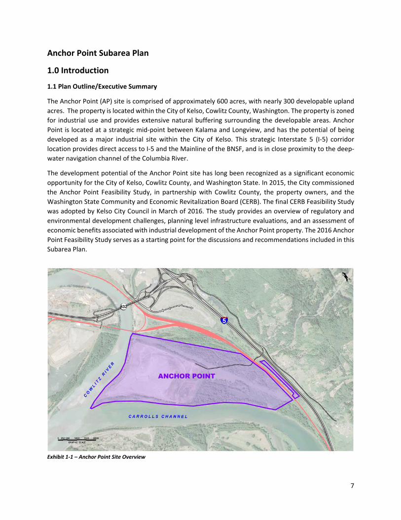
The Anchor Point (AP) site is comprised of approximately 600 acres, with nearly 300 developable upland acres. The property is located within the City of Kelso, Cowlitz County, Washington. The property is zoned for industrial use and provides extensive natural buffering surrounding the developable areas. Anchor Point is located at a strategic mid-point between Kalama and Longview, and has the potential of being developed as a major industrial site within the City of Kelso. This strategic Interstate 5 (I-5) corridor location provides direct access to I-5 and the Mainline of the BNSF, and is in close proximity to the deep-water navigation channel of the Columbia River.
The development potential of the Anchor Point site has long been recognized as a significant economic opportunity for the City of Kelso, Cowlitz County, and Washington State. In 2015, the City commissioned the Anchor Point Feasibility Study, in partnership with Cowlitz County, the property owners, and the Washington State Community and Economic Revitalization Board (CERB). The final CERB Feasibility Study was adopted by Kelso City Council in March of 2016. The study provides an overview of regulatory and environmental development challenges, planning level infrastructure evaluations, and an assessment of economic benefits associated with industrial development of the Anchor Point property. The 2016 Anchor Point Feasibility Study serves as a starting point for the discussions and recommendations included in this Subarea Plan.
Exhibit 1-1 – Anchor Point Site Overview
8
Anchor Point Subarea Plan
2.0 Plans, Goals, Policies & Objectives
2.1 Purpose of Plan
The Anchor Point Subarea Plan expands on the goals and guiding principles set forth in the City of Kelso’s Comprehensive Plan and Plan Updates. The Subarea Plan provides background on site history, previous technical studies, current development regulations, and a framework for moving forward through a series of plan concepts and actions.
Vision Statement
In its 2015 Comprehensive Plan, the City of Kelso envisioned a vibrant local community, with an array of employment opportunities and strong local economy. Chapter 2 – A Vision for Kelso:
Kelso’s economy is strong and diverse. A healthy mix of businesses provide valuable economic returns including varied employment opportunities and high wages, a strong tax base with sustainable revenues that help fund public services, and a broad range of goods and services. Our business districts are attractive, distinctive, and integral to the fabric of the City. Many serve as community gathering places and centers of cultural activity. Businesses choose to locate in Kelso because of our innovative and entrepreneurial spirit and because they are regarded as valued members of the community.
The Anchor Point property strengthens and supports this vision through its large-scale development potential as one of the City of Kelso’s key industrial sites:
The Anchor Point property sets the standard for industrial development within the City of Kelso. The development offers high paying family wage jobs and provides a strong tax base for the City and Cowlitz County residents. Located south of the City center, the development site is a close commute for Kelso residents, but does not disrupt the charm of Kelso’s historic downtown center. The site is safe, clean, and well maintained. Anchor Point is recognized throughout the region as an industry model for future industrial development.
2.2 Guiding Principles
The City of Kelso Comprehensive Plan contains planning policies and regulating codes that are relevant to the future of the Anchor Point site. The City is not required to fully plan under the Growth Management Act (GMA), and therefore had more flexibility in creating a Comprehensive Plan to meet local needs and priorities.
The City of Kelso’s Comprehensive Plan was updated and adopted on February 17, 2015 and includes more recent revisions, dated March 17, 2017. The series of Goals, Policies & Objectives found in the 2015 Plan and 2017 Plan Update were provided by the City Council in 2010 and updated through a series of discussions with the City Management Team, City Council, Planning Commission, and through public comment and recommendations. The published Goals, Policies & Objectives provide the framework for the future planning and actions at the City of Kelso.

9
The Anchor Point site is designated for heavy industrial use in the City’s 2015 Comprehensive Plan. Future development of the Anchor Point property has long been a key economic initiative for the City as evidenced by the fact that the Anchor Point property has been designated as heavy industrial as far back as the City of Kelso’s 1980 Comprehensive Plan
The City of Kelso Comprehensive Plan contains the following Goals, Policies, and Objectives that specifically relate to the development of the Anchor Point Subarea Plan:
Goal #3: Promote and sustain a diverse and well-balanced local economy.
Land Use Policy #1: Support more intensive use of land and actively seek to provide the same or higher levels of services more efficiently and cost effectively.
Economic Development Policy #2: Continue to support the potential for the development of the Wasser and Winters Company property in South Kelso for industrial uses perhaps featuring rail related uses.
Economic Development Policy #4: Encourage labor-intensive business development in industrial and commercial zones that maximizes the use of land by creating a higher-than-average number of jobs per acre.
Land Use Objective #13: In consultation with Cowlitz County and affected property owners, designate additional land in South Kelso for industrial development.
Transportation Objective #7: In consultation with Cowlitz County and affected property owners, explore the potential for improving access and circulation in South Kelso.
2.3 Proposed Policies & Objectives
As noted in Section 2.2 above, the primary focus of the City’s Comprehensive Plan is to implement a set of Goals, Policies and Objectives that will guide the City towards future growth. In addition, the Anchor Point Subarea Plan proposes to further the City’s commitment to strengthening its ability to provide a vibrant quality of life for its residents. The plan recommends the following Policies & Objectives be incorporated into the City of Kelso’s Comprehensive Plan:
Economic Development Policy #1: Encourage industrial development at the Anchor Point property that facilitates the creation of family wage jobs for City of Kelso residents.
Economic Development Objective #1: Maintain existing land use zoning and shoreline designations to allow for industrial development.
Economic Development Objective #2: Monitor the availability of industrial lands within the City of Kelso, and make special note of those impacted by Critical Areas or other development constraints.
Transportation Policy #1: Facilitate planning of industrial site access routes that do not conflict with access to major residential areas.
Transportation Objective #1: Implement public-private development of adequate infrastructure to access the site.

10
Transportation Objective #2: Develop a plan for well-defined access routes into the industrial area that include emergency access alternatives.
Fiscal Policy #1: Foster a private-public cooperative partnership between the City of Kelso and Cowlitz County that is supportive of industrial development.
Fiscal Objective #1: Encourage public- private development of site access for Anchor Point.
Fiscal Objective #2: Encourage economic development that creates positive fiscal impacts for the City of Kelso, special districts, and surrounding local communities.
Fiscal Objective #3: Communicate with the community and stakeholders to ensure successful development of industrial lands.
The Anchor Point Subarea Plan also recommends the reinstatement of the following Goals from the 1980 City of Kelso Comprehensive Plan, with Chapter Updates in 1987 and 1992:
Economic Development Policy #2: Provide for stable and diversified economic growth in the industrial and manufacturing sector.
Economic Development Policy #3: Buffer residential areas from industrial use generated noise, odors, lights and traffic.
Economic Development Policy #4: Attract industries and businesses that provide services and products for or utilize the raw materials of the existing industrial base of the Kelso-Longview Urban Area and Cowlitz County.
Additional planning considerations are discussed in Section 5.0 – Plans, Concepts, and Actions, which relate to specific site infrastructure developments.
A plan for implementing these proposed Policies & Objectives is found in Section 6.0 – Implementation.

11
2.4 Economic Development
City of Kelso Overview
As detailed in the 2015 Comprehensive Plan, the City of Kelso has experienced relatively little growth since 1980. The economy is diverse, with Manufacturing employing 14% of the workforce and retail trade employing roughly 12%. Educational services, healthcare and social assistance programs employ 20% of the workforce in the City. The majority of Kelso residents do not work within the city limits. However, 53% of Kelso residents commute less than 10 miles to work, which is mainly attributed to the City’s close proximity to the City of Longview. The next largest segment, however, includes residents who commute over 50 miles outside of the City.
As of July 2015, there were an estimated 3,376 unemployed individuals in Cowlitz County. The largest percentage of these unemployed workers came from the manufacturing sector, which constituted nearly one fifth of all unemployed workers. The Cowlitz County unemployment rate in manufacturing was approximately 18%, which is nearly double the national average for the 2015 year. Despite this relatively high industrial unemployment rate, the manufacturing industry is still seen as a primary component of the City of Kelso and Cowlitz County economies.
Target Industries
The 2016 Anchor Point Feasibility Study outlined the strongest performing industry clusters within Cowlitz County. These target industries are identified by looking at the overall production of jobs, job growth, and gross regional product relative to other industries in the same geographic delineation. The maximum score any industry can receive is 100. In Cowlitz County, the average industry score is 24, though most sub-industries scored above this County average. The following Table 2-1: Target Industry Clusters in Cowlitz County, excerpted from the CERB Study, displays the target industries and sub-industries in Cowlitz County. Note that government, education, and retail sectors are excluded from this analysis.
Table 2-1: Target Industry Clusters in Cowlitz County
NAICS INDUSTRY JOBS SCORE
Paper and Packaging: 86 322121 Paper (except Newsprint) Mills 1,183 100 322122 Newsprint Mills 279 68 322130 Paperboard Mills 760 82 322219 Other Paperboard Container Manufacturing 113 30 322299 All Other Converted Paper Product Manufacturing 25 22 Local Community and Civic Organizations: 61 624110 Child and Youth Services 49 16

12
Table 2-1: Target Industry Clusters in Cowlitz County NAICS INDUSTRY JOBS SCORE
624120 Services for the Elderly and Persons with Disabilities 1,138 94 624190 Other Individual and Family Services 61 11 624221 Temporary Shelters 29 4 813110 Religious Organizations 296 3 813319 Other Social Advocacy Organizations 73 5 813410 Civic and Social Organizations 122 10 813930 Labor Unions and Similar Labor Organizations 45 9 Upstream Chemical Products: 51 325110 Petrochemical Manufacturing 170 59 325180 Other Basic Inorganic Chemical Manufacturing 95 37 Wood Products: 37 321113 Sawmills 838 37 321999 All Other Miscellaneous Wood Product Manufacturing 12 11 Upstream Metal Manufacturing: 32 331221 Rolled Steel Shape Manufacturing 89 32 Livestock Processing: 32 311611 Animal (except Poultry) Slaughtering 123 14 311615 Poultry Processing 817 35 Forestry: 31 113110 Timber Tract Operations 54 43 113310 Logging 582 32 115310 Support Activities for Forestry 100 19 Nonmetal Mining: 29 212312 Crushed and Broken Limestone Mining and Quarrying 79 25 212321 Construction Sand and Gravel Mining 72 33 221122 Electric Power Distribution 70 41 517110 Wired Telecommunications Carriers 73 24 517911 Telecommunications Resellers 31 22 562910 Remediation Services 31 21 Construction Products and Services: 28 237130 Power and Communication Line and Related Structures Construction 71 28 237990 Other Heavy and Civil Engineering Construction 26 22 327420 Gypsum Product Manufacturing 71 31 Production Technology and Heavy Machinery: 28 332911 Industrial Valve Manufacturing 67 24 333120 Construction Machinery Manufacturing 68 20 333243 Sawmill, Woodworking, and Paper Machinery Manufacturing 150 38 333613 Mechanical Power Transmission Equipment Manufacturing 67 26 333924 Industrial Truck, Tractor, Trailer, and Stacker Machinery Manufacturing 52 20 339991 Gasket, Packing, and Sealing Device Manufacturing 21 20 Lighting and Electrical Equipment: 28

13
Table 2-1: Target Industry Clusters in Cowlitz County NAICS INDUSTRY JOBS SCORE
335122 Commercial, Industrial, and Institutional Electric Lighting Fixture Manufacturing 138 28 Food Processing and Manufacturing: 28 311111 Dog and Cat Food Manufacturing 36 19 424510 Grain and Field Bean Merchant Wholesalers 121 30 Distribution and Electronic Commerce: 26 423420 Office Equipment Merchant Wholesalers 43 16 423510 Metal Service Centers and Other Metal Merchant Wholesalers 173 30 423610 Electrical Apparatus and Equipment, Wiring Supplies, and Related Merchant
Wholesalers 36 22
423810 Construction and Mining (except Oil Well) Machinery and Equipment Merchant Wholesalers
129 26
423820 Farm and Garden Machinery and Equipment Merchant Wholesalers 30 18 423830 Industrial Machinery and Equipment Merchant Wholesalers 65 22 423840 Industrial Supplies Merchant Wholesalers 48 26 423850 Service Establishment Equipment and Supplies Merchant Wholesalers 26 17 423940 Jewelry, Watch, Precious Stone, and Precious Metal Merchant Wholesalers 47 16 424690 Other Chemical and Allied Products Merchant Wholesalers 31 21 424710 Petroleum Bulk Stations and Terminals 13 25 424720 Petroleum and Petroleum Products Merchant Wholesalers (except Bulk Stations
and Terminals) 68 25
424910 Farm Supplies Merchant Wholesalers 145 20 424930 Flower, Nursery Stock, and Florists' Supplies Merchant Wholesalers 12 9 425120 Wholesale Trade Agents and Brokers 192 38 454111 Electronic Shopping 21 12 493110 General Warehousing and Storage 16 17 493120 Refrigerated Warehousing and Storage 116 27 493130 Farm Product Warehousing and Storage 101 38 532412 Construction, Mining, and Forestry Machinery and Equip. Rental and Leasing 14 17 Metalworking Technology: 26 332812 Metal Coating, Engraving (except Jewelry and Silverware), and Allied Services to
Manufacturers 28 16
333511 Industrial Mold Manufacturing 145 28

14
Top Industry Exporters
The 2016 Anchor Point Feasibility Study also identified the top industries exporting goods and services in Cowlitz County in 2013. These core industries, shown in Table 2-2 Key Industry Top Exporters, 2013 below, can serve as a guiding tool as the City continues to recruit additional industries to the area.
Table 2-2: Key Industry Top Exporters, 2013
NAICS Industry Exports
322121 Paper (except Newsprint) Mills $1,100,939,316
322130 Paperboard Mills $434,978,468
322122 Newsprint Mills $316,827,160
321113 Sawmills $210,351,650
311615 Poultry Processing $189,762,525
325110 Petrochemical Manufacturing $186,690,310
211111 Crude Petroleum and Natural Gas Extraction $169,607,945
238290 Other Building Equipment Contractors $151,497,161
325199 All Other Basic Organic Chemical Manufacturing $86,284,145
113310 Logging $78,352,388
488320 Marine Cargo Handling $76,919,821
336413 Other Aircraft Parts and Auxiliary Equipment Manufacturing $73,674,882
331110 Iron and Steel Mills and Ferroalloy Manufacturing $52,390,665
333243 Sawmill, Woodworking, and Paper Machinery Manufacturing $50,774,392
325180 Other Basic Inorganic Chemical Manufacturing $47,538,262
331221 Rolled Steel Shape Manufacturing $46,155,207
Source: Washington State Employment Security Department, Labor Market and Economic Analysis Branch
The key industries and industry clusters identified in the 2016 Anchor Point Feasibility Study represent the types of industries that the City of Kelso and Cowlitz County should target for future growth. The City should use these industry examples as a framework for developing policies that allows for these industrial uses.
15
Anchor Point Subarea Plan
3.0 Existing Conditions
3.1 Current Site Operations
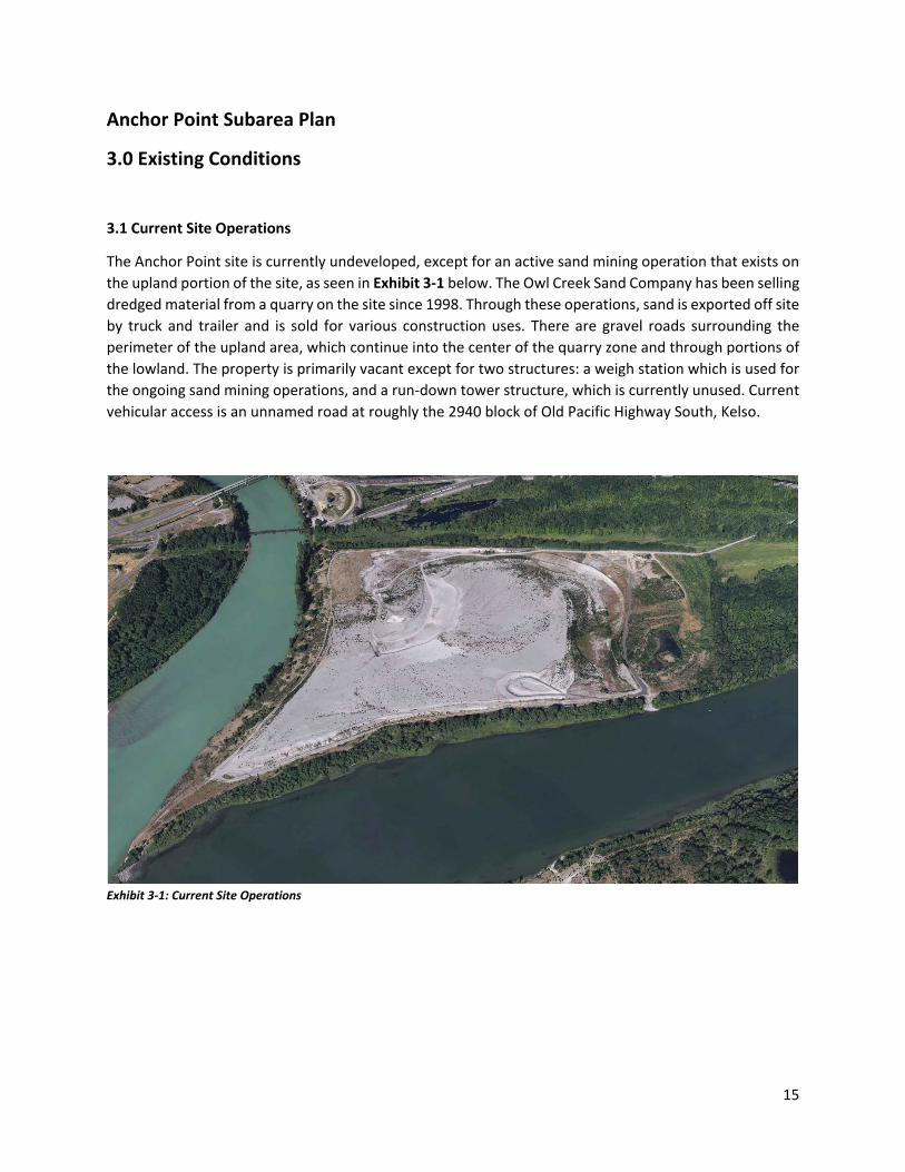
The Anchor Point site is currently undeveloped, except for an active sand mining operation that exists on the upland portion of the site, as seen in Exhibit 3-1 below. The Owl Creek Sand Company has been selling dredged material from a quarry on the site since 1998. Through these operations, sand is exported off site by truck and trailer and is sold for various construction uses. There are gravel roads surrounding the perimeter of the upland area, which continue into the center of the quarry zone and through portions of the lowland. The property is primarily vacant except for two structures: a weigh station which is used for the ongoing sand mining operations, and a run-down tower structure, which is currently unused. Current vehicular access is an unnamed road at roughly the 2940 block of Old Pacific Highway South, Kelso.
Exhibit 3-1: Current Site Operations

16
3.2 Ownership & History of Site
The Anchor Point site is situated along the Columbia River corridor. During glacial periods when sea level was over 300 feet lower, the Columbia River scoured a deep channel through the Kalama and Longview areas. The channel was subsequently backfilled with alluvial deposits (sand, gravel, silt, and clay) by the ancestral and present-day Cowlitz and Columbia Rivers. The Anchor Point site occupies a lowland deposit area, and lies directly adjacent to Carrolls Channel to the south and southwest, and is bordered by the Cowlitz River to the north and northwest.
Following the 1980 eruption of Mount St. Helens, the site was used as an emergency location to dispose of dredge material from the Cowlitz River. This dredge materially generally consisted of ash, sand, and other riverbed sediment. Following this initial use as an emergency dredge disposal site, Anchor Point continued to be used as a disposal site for materials dredged from the Cowlitz River. This continual placement of sand created the upland areas of the site that exist today.
The land was designated as entirely industrial in the 1980 City of Kelso Comprehensive Plan update, as seen in Exhibit 3-2 below. The western portion of the Anchor Point property was annexed to Kelso in 1965, and the remainder was annexed in 1982. As identified in the 1980 Comprehensive Plan, the industrial development potential has long been recognized by the City of Kelso.
The entire Anchor Point site is currently owned by the Winters family, who purchased the land in 1992/1993. Throughout the years, the family has considered a variety of uses for the property, ranging from industrial development to mixed use residential. Currently, the site houses a sand mining operation, as described in Section 3.1. The site has remained zoned for industrial use since the original designation in 1980.
Exhibit 3-2: 1980 Comprehensive Plan Land Use Map

17
3.3 City of Kelso & Cowlitz County Overview
The City of Kelso is located in Southwest Washington State along I-5 and at the confluence of the Columbia, Cowlitz, and Coweeman rivers. To the west, across the Cowlitz River, lies the City of Longview, Washington. Together, Kelso and Longview serve as the regional center for the surrounding western Cowlitz County communities. The two cities have distinct characters and identities but effectively function as a single urban area. The City of Kelso is the county seat for Cowlitz County.
Cowlitz County has its roots based on an economic history of heavy industrial manufacturing focused on the abundance of the timber natural resource that exists in Cowlitz County and Southwest Washington. The County continues to diversify from its historically prominent cluster of natural resource production into manufacturing and logistics, including export of bulk commodities. Two of the three ports in the county have significantly expanded activities in grain and bulk commodities export. The Port of Longview is in the early stages of developing its newest property, Barlow Point, which will expand deep water access. Millennium Bulk Terminals has made significant investment in environmental clean-up of the closed Reynolds Metals aluminum manufacturing facility and is in-the-midst of a lengthy permitting process for a proposed coal export terminal. The Port of Kalama continues with development plans for a large methanol manufacturing facility and a mixed business use property on the east side of I- 5. The Anchor Point Site is strategically located in this important industrial corridor along the Cowlitz River.
Exhibit 3-3: City of Kelso & Cowlitz County Overview
The City of Kelso experienced relatively steady growth from its incorporation in 1890 to 1910, remained stagnant for a decade, then experienced explosive growth between 1920 and 1930 when it tripled its population from 2,228 to 6,260. Between 1930 and 1990 the city experienced steady growth but has only grown by about 200 residents over the last two decades. The most recent population figure is the April

18
1st, 2016, estimate from the Washington State Office of Financial Management, which put the population at 11,940 for 2013.
A relatively low share of Kelso’s residents hold higher education degrees with only 10% of the population age 25 and over holding a bachelor’s degree or higher and only 21% holding an associate’s degree or higher. Residents age 25 and over with less than a high school diploma had a poverty rate of 31% while 8% of residents with a Bachelor’s degree were living in poverty according to the Census Bureau’s definition.
In 2012, Cowlitz County had an unemployment rate of 10.2%, which is a welcome decrease from the 14.1% unemployment experienced in 2009. The unemployment rate in the county has remained above the state unemployment rate between 1990 and 2012. Another measure of the health of the economy is the taxable retail sales and the value of taxable property. Taxable retail sales have experienced a 23% increase since 1994 and was $209 million in 2012. The assessed values of taxable total property have increased 74% since 1998 and was $743 million in 2012. Median Household Income decreased 10% from the 2005-2009 estimate to the 2007-2011 estimate of $34,391. Per capita income in the city, estimated at $18,411 for the 2007-2011 period, decreased 4% from the 2005-2009 estimate. Both median household income and per capita income in the City of Kelso remained below the state average for all three survey periods.
3.4 City of Kelso Industrial Lands Inventory
Existing and future land use designations were reviewed as part of the 2015 Comprehensive Plan update in Chapter 4 - B - Land Use Analysis. This section shows industrial designations in 2015 totaling only 3% of the City’s total acreage, with future land use plans of 28% industrial land. The Land Use Analysis also concludes that nearly 100% of all vacant commercial and industrial zoned lands are constrained by environmentally sensitive or critical areas.
As of May 2017, there are 25 vacant or redevelopable industrially-zoned sites within the City of Kelso limits, not including the Anchor Point site (See Table 3-1). This includes one 100+ acre property located at the base of the Southwest Washington Regional Airport, and 24 smaller properties clustered on both sides of 13th Avenue and Talley Way. Only 10 of the 25 identified parcels are larger than 2 acres and only four are larger than 5 acres. Excluding the Anchor Point site, there is a combined 158.4 acres of market value industrial properties available for development or redevelopment within the City of Kelso limits. The Anchor Point site, at approximately 600 acres and with nearly 300 acres of developable industrial land, far exceeds the combined total acreage of all other Kelso industrial properties. The Anchor Point site also provides a unique opportunity for a single or multi-user site that is much more strategically located for rail, highway, and marine transportation, which are limiting factors for the development potential of the other industrial sites in the City.
While the City’s industrial sites are predominately smaller in size, many are located adjacent to one another and could be assembled by the City or a private sector partner to become a more viable option for a larger-scale end user. However, this would take additional planning and coordination by City staff and private landowners, and does not represent an ideal scenario to provide for industrial lands.
The Anchor Point site is the only available property zoned for General Industrial (GI) use within Kelso city limits.

19
Table 3-1: Kelso Industrial Lands Inventory, as of May 2017
Map No Parcel No Account
No Owner Name Assessed Land Value (ASV)
Market Value Acres (MVA)
GIS Acres Cost Per Acre
1 22064 R036439 Dominic Marin $11,030 0.0 0.2 $55,150
2 22063 R036438 Dominic Marin $11,030 0.0 0.1 $110,300
3 23582 R038084 James and Penelope Monroe $117,610 0.0 1.0 $117,609.55
4 235770100 R038075 Steven Coulter $32,740 0.0 0.3 $95,843.25
5 243530100 R039154 Jeanette Kirk $508,240 5.5 5.5 $92,914.08
6 243530203 R090703 Michael Cowan $106,290 1.2 1.2 $87,122.95
7 243530202 R090702 Northwest Timber Development Inc $132,860 1.2 1.2 $108,901.64
8 243530201 R090701 C/LG Holdings LLC $115,440 1.1 1.1 $108,905.66
9 243530200 R039155 Rick Hart $115,440 1.1 1.1 $108,905.66
10 2356401 R038057 Cascade Natural Gas Corporation $71,870 0.0 0.8 $95,826.36
11 235690100 R038065 City of Kelso $478,280 0.0 5.0 $95,787.73
12 243470400 R039143 Process Products NW Profit Sharing $164,660 1.4 1.4 $117,614.29
13 24355 R039159 Pacific Tech Development LLC $304,180 4.0 3.7 $82,210.81
14 243470701 R039147 CDID #3 $1,070 0.4 0.3 $3,057.14
15 24347 R039136 Foster Poultry Farms $372,600 3.6 3.6 $102,362.64
16 243470600 R039145 Watkins Tractor and Supply Co. $305,330 2.8 2.8 $109,046.43
17 243470500 R039144 Watkins Tractor and Supply Co. $221,720 2.0 2.0 $110,860

20
Table 3-1: Kelso Industrial Lands Inventory, as of May 2017
Map No Parcel No Account
No Owner Name ASV MVA GIS Acres Cost Per Acre
18 243490100 R039150 Boatman Family Properties LLC $415,910 4.3 4.3 $95,831.80
19 24356 R039162 CDID #3 $26,410 8.7 8.7 $3,049.65
20 243650100 R051728 Olson Properties LLC $248,290 2.3 2.3 $108,899.12
21 24367 R039182 PUD #1 $168,800 0.0 1.6 $105,500
22 24368 R039183 1801 Baker Way LLC $185,130 0.0 1.7 $109,107.96
23 24352 R039152 CDID #3 $3,140 1.0 1.0 $3,048.54
24 2408715 R038781 Crown 8 LLC $309,540 3.2 3.2 $96,731.25
25 2408727 R038795 City of Kelso $10,852,820 114.6 8.3 $94,685.22
3.5 Capital Facilities, Public Services & Utilities
3.5.a Adjacent Transportation Infrastructure
Cowlitz County
Located along the I-5 Corridor, the Columbia River and the BNSF Class I mainline railroad, Cowlitz County is well situated to access global markets. The three port districts in the county, Port of Woodland, Port of Kalama, and Port of Longview, are all dependent on continued focus and partnerships with federal and state transportation agencies as well as the shipping communities, including rail and marine providers. These port districts are economic engines for the county and region. Their continued success is directly related to a modern, intermodal transportation system.
The Southwest Washington region, including Cowlitz County, heavily relies on rail service. In recent years, the infrastructure has expanded capacity and improved operations. Class 1 carriers BNSF Railroad and Union Pacific Railroad (UPRR) serve Cowlitz County. Amtrak also serves the region on the same rail lines with stops in Kelso and Chehalis. There are numerous rail spurs that serve five of the regional ports.
Anchor Point
The Anchor Point Site is ideally located in close proximity to several modes of transportation, including roadway, marine, and rail. Anchor Point is bordered by the Cowlitz River on its westerly boundary, Carrolls Channel of the Columbia River on its southerly boundary, BNSF/UPRR, State Route 432 and I-5 on its northerly and easterly boundaries. On the northeasterly side of the BNSF/UPRR railroad is an approximate 115-acre parcel that is currently vacant and zoned Commercial-Major Retail. This property has been partially developed with utility and roadway infrastructure and previously had a preliminary binding site

21
plan approved by the City for a proposed development known as Kelso Village. This binding site plan has expired and the property is currently listed for sale.
Westerly of the site, across the Cowlitz River there is a developed heavy industrial property. On the north side of SR 432 is the Southwest Washington Regional Airport, a partially developed light regional commercial development known as Coweeman Park, and a largely developed light industrial area in the City of Kelso. Easterly of the site is a low density residential area comprised of a mix of incorporated area of the City of Kelso and an unincorporated portion of Cowlitz County.
Existing Vehicular Access: The Anchor Point Site is located west of I-5, and the nearest interchange is State Route 432 (SR-432), located approximately one half mile northeast of the Site. Talley Way has been extended southerly into the proposed Kelso Village commercial development site and a future extension of Talley Way is proposed with further development of Kelso Village.
Existing vehicular access to the Anchor Point Site is located near the southern end of the Site, and is referred to as “Owl Creek” access road, as seen in Exhibit 3-4 below. This at-grade roadway is named due to its proximity to Owl Creek on the southern edge of the access road. This gravel roadway is approximately 20 feet wide and enters the site from Old Pacific Highway, crosses under two bridges carrying the northbound and southbound lanes of I-5, and then crosses under a railroad bridge carrying the BNSF Mainline rail. The gravel roadway continues into the Site in a northwesterly direction and passes through low lying areas, surrounded by wetlands. The existing horizontal clearance, of approximately 16.5 feet, between the existing columns for the BNSF structure is the roadway’s horizontal constriction point, reducing the roadway to essentially one lane at this location. This access serves the Owl Creek Sand Company’s truck & trailer vehicles, which haul sand from the site for construction.
Exhibit 3-4: Existing Vehicular Access
22
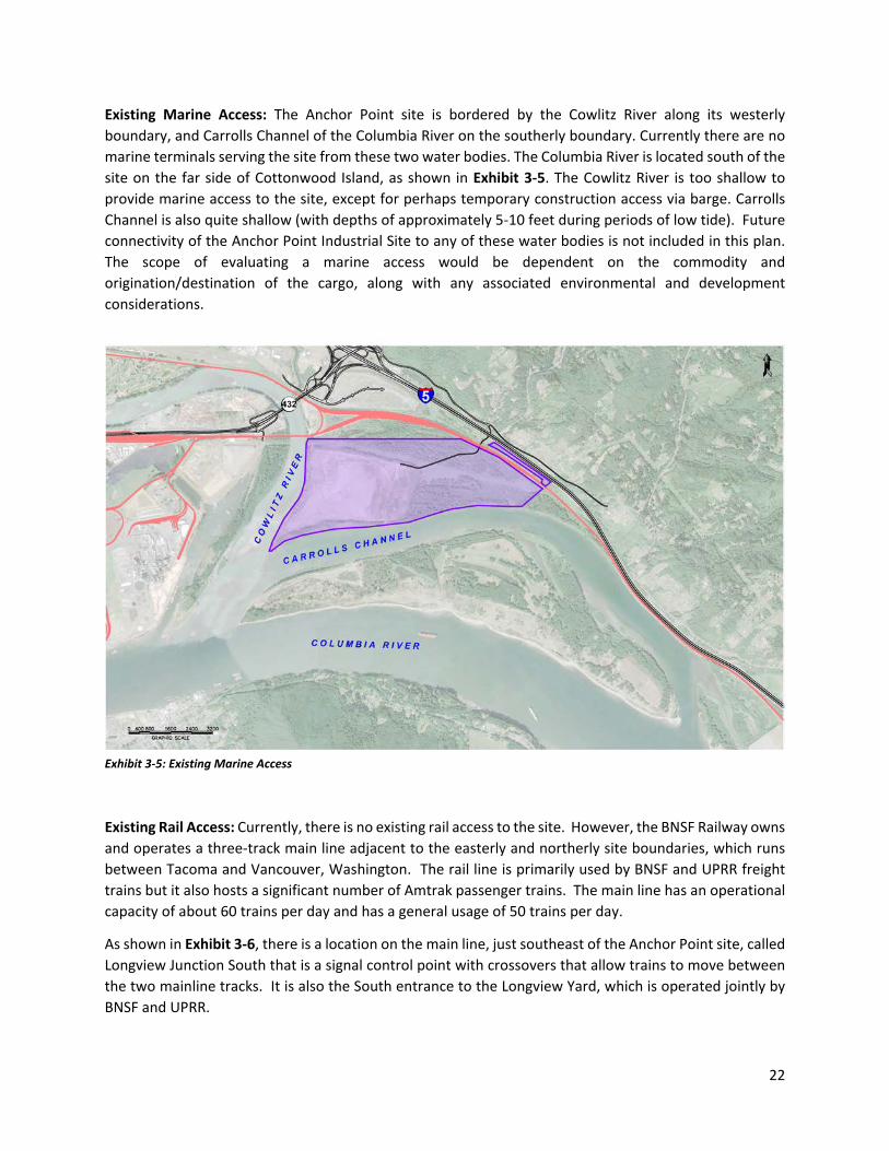
Existing Marine Access: The Anchor Point site is bordered by the Cowlitz River along its westerly boundary, and Carrolls Channel of the Columbia River on the southerly boundary. Currently there are no marine terminals serving the site from these two water bodies. The Columbia River is located south of the site on the far side of Cottonwood Island, as shown in Exhibit 3-5. The Cowlitz River is too shallow to provide marine access to the site, except for perhaps temporary construction access via barge. Carrolls Channel is also quite shallow (with depths of approximately 5-10 feet during periods of low tide). Future connectivity of the Anchor Point Industrial Site to any of these water bodies is not included in this plan. The scope of evaluating a marine access would be dependent on the commodity and origination/destination of the cargo, along with any associated environmental and development considerations.
Exhibit 3-5: Existing Marine Access
Existing Rail Access: Currently, there is no existing rail access to the site. However, the BNSF Railway owns and operates a three-track main line adjacent to the easterly and northerly site boundaries, which runs between Tacoma and Vancouver, Washington. The rail line is primarily used by BNSF and UPRR freight trains but it also hosts a significant number of Amtrak passenger trains. The main line has an operational capacity of about 60 trains per day and has a general usage of 50 trains per day.
As shown in Exhibit 3-6, there is a location on the main line, just southeast of the Anchor Point site, called Longview Junction South that is a signal control point with crossovers that allow trains to move between the two mainline tracks. It is also the South entrance to the Longview Yard, which is operated jointly by BNSF and UPRR.

23
Longview Switching Company operates out of this yard to transfer rail cars to and from various industrial customers along the Columbia River such as the Ports of Longview and Kalama as well as businesses located along the Columbia River in the SR 432 industrial corridor in Longview. The rail yard has 12 switching tracks, two south-facing lead tracks used for switching, and a single bypass track along the west side of the yard. The yard is unique as it is Y-shaped so that the western six yard tracks and the bypass track only access the BNSF main line at the south end of the yard.
Exhibit 3-6: Existing Rail Access
3.5.b. Sanitary Sewer
The Anchor Point property is identified as Sewer Basin K-17 in the City of Kelso’s General Sewer Plan (GSP), January, 2011. The property is currently not served by any sewer collection facilities. The GSP identifies sewer service to the property would be serviced by extending sewer collection facilities from the manhole on Talley Way near the Coweeman River, and terminating at the entrance to the proposed Kelso Village retail development located south of the interchange. In conjunction with the SR432/I-5 interchange improvement project completed in 2010, approximately 1,100 feet of 6-inch sewer force main was installed to the entrance of the proposed development. In 2011, the developer installed a 400 gpm sewer pump station, 3,400 feet of 8-inch gravity line, and 2,300 feet of 6-inch force main to serve the retail development. To date, the City of Kelso has not accepted these facilities until the developer completes final work and testing of the facilities. An additional 900 feet of 8-inch sewer main is scheduled to be constructed during the Phase II development of Kelso Village. (See Exhibit 3-7).
The City is a partner in the regional Three Rivers Regional Wastewater Authority’s (TRRWA) wastewater treatment plant (WWTP) and the City’s GSP shows the Anchor Point property within the City’s sewer

24
service area. The plant currently has adequate capacity to serve the Anchor Point Subarea. TRRWA and its member agencies have adopted industrial pretreatment regulations that stipulate discharge flow characteristics that are accepted by the regional WWTP.
Exhibit 3-7: Existing Sanitary Sewer & Water Supply
3.5.c Water Supply
The Anchor Point property is identified within the City of Kelso’s 2013 Water System Plan (WSP) service area. The property is currently not served with any City water system facilities. A 12-inch water main has been extended approximately 2,300 feet into the proposed Kelso Village retail development to the end of the proposed Phase I, as seen in Exhibit 3-7 above. The 12-inch water main will be extended an additional 1,100 feet southerly towards Anchor Point with the development of Phase II.
The City of Kelso water system is not currently sized for industrial water demand over 3,800 gpm, and the WSP discusses an alternate water source will be needed to supply a high industrial water use. The capacity of the City’s aging Ranney collector is no longer sufficient to meet the City’s forecasted demands and the condition and vulnerability of the Ranney collector are also of concern. The City has identified an alternative source of supply well location on the bank of the Cowlitz River to either supplement or replace the existing Ranney collector, but further examination of an additional source of supply will be evaluated in the upcoming update to the WSP, scheduled to begin in the fall of 2017.

25
3.5.d Hydrology/Drainage
The Anchor Point site is approximately 600-acres and is generally flat with stockpiled dredged sand at varying elevations, and existing ground contours ranging in elevation from 15 feet to 50 feet, as shown in Exhibit 3-8. Approximately 295 acres of upland exist on the property and are located in the northern portion of the site. These uplands have been cleared and filled, and are above and outside of the AE-flood zone as indicated on the FEMA flood maps. A preliminary mass-balance of the area considered for development has determined a finished development elevation of +/- 36-feet.
Exhibit 3-8: Preliminary Mass Balance
The southern portion of the site contains approximately 305-acres of wetlands, as shown in Exhibit 3-9 below. Four aquatic resources are located within or bordering Anchor Point.
The Cowlitz River is located along the northwest boundary of the study site. The Cowlitz River, which is tidally influenced, contains stretches both up and downstream and is diked, beginning miles upstream in Castle Rock and extending to the confluence with the Columbia River, which is located at the western most point of Anchor Point.
Carrolls Channel of the Columbia River, which is tidally influenced, is located along the southern boundary of Anchor Point.
Owl Creek enters the site at its easterly boundary and the stream flows from the northern part of Wetland D south through the wetland where it converges with the unnamed slough and runs west where it discharges into Carrolls Channel. The stream channel ranges from 4 to 15-feet wide and 4 to 10-feet deep with steep banks.

26
Exhibit 3-9: Preliminary Wetlands & Aquatic Resources
An unnamed slough is also located on the Anchor Point site. The centerline of the unnamed slough, Type Ns (non-fish bearing seasonal) was mapped using existing aerial images from Google Earth. The slough flows along the eastern edge of the BNSF railway along the eastern site boundary. The slough channel ranges from 12 inches to 10 feet wide with dry areas throughout the southern portion.
3.5.e Power
The Cowlitz PUD (PUD) has a 12.47kV distribution facility that is located between the BNSF/UPRR and I- 5, easterly of the Anchor Point Site. In addition, the Bonneville Power Administration (BPA) has a 115kV transmission line running along the northerly boundary of the Anchor Point Site parallel to the PUD distribution line. This line is connected to BPA’s Cowlitz and Cardwell substations. BPA also has the Longview and Lexington substations, which both serve Cowlitz County.
The PUD currently has available capacity in the system. A low and high power requirement of 20 megawatts (MW) and 300MW were explored for this site, both of which would entail construction of an onsite substation. However, until thorough studies have been completed by the PUD and BPA, there is no certainty that this concept could be implemented. A general description of the potential service options follows:
1- A 20 MW substation would be fed via a new overhead 115kV line extension off the BPA transmission line. The point of connection can be anywhere along the eastern property line as needed for site planning/critical areas. The estimated footprint for a new substation is 200 feet by 200 feet. The estimated substation construction timeline is approximately one year. The permitting timeline is anticipated to be approximately 6-months to 1-year and may be able to be

27
a joint submittal with the site design. In order to tap BPA’s 115kV line near the site for the 20MW option, BPA approval will be required.
2- A 300 MW substation would require construction of a 230kV overhead line extending to the BPA Longview substation, approximately 6-miles northwest of the site and along SR 432 and the Columbia River. The costs for constructing this length of overhead line are to be determined based on the future facility that will occupy the site. Representatives from the PUD have emphasized the difficulty of completing a 230kV line build option.
3.5.f Natural Gas
Natural gas transmission and distribution lines in the vicinity of the Anchor Point Site are shown on Exhibit 3-10. Cascade Natural Gas has a 12-inch transmission pipeline located north of the site, parallel to SR 432. This pipeline is interconnected to the Williams Pipeline’s bi-directional mainline, which provides access to British Columbia, Alberta, Rocky Mountain, and San Juan Basin gas supplies. Cascade Natural’s gas system is not currently sized to provide large volumes of gas to the Anchor Point Site and may only be sufficient to provide a low volume of gas needed for typical commercial use, not high industrial use.
Exhibit 3-10: Existing Natural Gas
Higher volumes of gas may be available by extending a new lateral directly from the Williams pipeline and approximately 2-miles to the site. The proposed improvements and associated costs for a high capacity gas line will be based on the needed volume and pressure for future facilities that will occupy the site.
Extensions for new facilities are regulated by the Federal Energy Regulatory Commission (FERC). The natural gas provider would be required to apply for a Certificate of Public Convenience and Necessity.

28
FERC’s determination of said Certificate takes in to consideration that the applicant is able and willing to conform to the requirements, rules, and regulations of the Commission, and that the proposed service, sale, operation, construction, extension, or acquisition, to the extent authorized by the certificate, is or will be required by the present or future public convenience and necessity.
3.5.g CATV/Phone
Comcast has existing service near the intersection of Old Pacific Highway and Brookside Drive or Talley Way. The cost of extending service can only be estimated by the cable company once a physical address and construction project is underway. Sprint has an easement and dark fiber facility located within Anchor Point on the northerly boundary of the property. Other service providers in the vicinity of the Anchor Point Site include AT&T, Century Link, and various other telecommunication companies.
3.6 Environmental Factors
3.6.a Wetlands & Habitat
Ecological Land Services, Inc. (ELS) has completed a preliminary critical areas report for Anchor Point, including preliminary wetland delineation. Multiple wetlands were delineated and vegetation, soil, and hydrology information was collected to determine the location and extent of the wetlands on the site.
Exhibit 3-11: Wetlands & Habitat
The site contains multiple habitats including: unvegetated industrial, weedy vegetation upland grass/forb, forested and herbaceous wetland, forested upland, and riparian. A large portion of the site is historically

29
filled with sandy dredge spoils removed from the Cowlitz and Columbia Rivers since 1980. The US Army Corps of Engineers (Corps) maintains permits to annually dredge 0.5 to 2.2 million cubic yards of sediment from the mouth of the Cowlitz River for flood control. The dredge spoils then are dewatered using a permitted temporary outfall structure and placed on Cowlitz County Parcels 24100 and 24393.
Since 1998, the Owl Creek Sand Company, who holds a Washington State Department of Natural Resources (DNR) mining permit, has been selling the dredged material from a quarry on the site. An approximately 2-acre man-made pond is located south east of the sand quarry within Cowlitz County Parcels 24393 and 24392. The property is primarily vacant except for two structures; one of which being a weigh station in current use located in the southeast corner of Cowlitz County Parcel 24100, and the second being a dilapidated tower structure located in the southern portion of Cowlitz County Parcel 24388. There are numerous existing gravel access roads throughout the property. A BNSF railway was constructed more than 30 years ago which also created an unnamed slough that parallels it along the northeastern and eastern site boundary in-between Cowlitz County Parcel 24390 and the rest of the site. I-5 forms the eastern site boundary as it parallels the railway on the eastern edge of Cowlitz County Parcel 24390. The addition of the railway and freeway likely altered the hydrology and connectivity between the wetlands onsite and those to the east. The Cowlitz River forms the northwestern site boundary and Carrolls Channel of the Columbia River forms the southwestern site boundary.
3.6.b Floodplains
New Preliminary Federal Emergency Management Agency (FEMA) Flood Insurance Rate Maps (FIRM) for the site area became effective December 16, 2016. Flood insurance is mandatory and local floodplain development codes apply. The FIRM indicates that the proposed development area for the site is mapped as Zone X. These properties are determined to be outside the 0.2 percent (0.2%) annual chance flood plain. The FIRM also indicates that a portion of the site will remain within Zone AE, as shown in Exhibit 3-12.
Zone AE areas have a high flood risk. These properties have a one-percent (1%) annual chance of flooding and a 26-percent chance of flooding over 30 years. The base flood elevation within the site has been determined to be approximately 21-feet. Recent field topography work shows current elevations of the site range between 15-60 feet. Preliminary grading analysis has determined that final developed site elevations will range between 30-36’ elevation, well above the 500-year flood elevation as determined by FEMA (see Exhibit 3-8).

30
Exhibit 3-12: FEMA Flood Insurance Rate Maps, 2016

31
Shorelines 3.6.c
The City of Kelso’s Shoreline Master Program (SMP) designates the Columbia River, including Carrolls Channel and the Cowlitz River as “Shorelines of Statewide Significance”. The shoreline jurisdiction extends 200-feet from the Ordinary High Water Mark (OHWM). Carrolls Channel and the Cowlitz River are also considered a Classification 1, Fish and Wildlife Habitat Conservation Area per KMC 17.26.060. The SMP designates a riparian habitat area (RHA) of 150-feet from the OHWM along these abutting rivers boarding the Anchor Point Site. Exhibit 3-13 shows the shorelines of statewide significance adjacent to the Anchor Point site.
Owl Creek becomes a Type S (Shoreline of the State) fish-bearing stream at its confluence with the slough. The stream channel ranges from 4 to 15-feet wide and 4 to 10-feet deep with steep banks. The Type S portion of the stream is considered a Classification 1, Fish and Wildlife Habitat Conservation Area per KMC 17.26.060. The SMP designates a RHA of 150-feet from the OHWM along this stretch of Owl Creek.
The Kelso SMP designates the unnamed slough as a RHA of 50-feet from the OHWM along the unnamed slough.
Exhibit 3-13: Existing Shoreline Jurisdictions

32
3.6.d Cultural Resources
The 2016 Anchor Point Feasibility Study conducted a review of the Washington Information System for Architectural and Archaeological Records Data (WISAARD). The study identified two potential cultural features in the site boundary, as shown in Exhibit 3-14 below. These findings include:
• A log bridge built circa 1850’s is present under the existing access drive near Owl Creek. A Phase II cultural assessment is recommended if this area will be impacted by future development, to further evaluate National Register significance.
• The BNSF rail siding was constructed approximately between 1907 and 1914, but no historic buildings or structures related to the railroad are located within the project limits.
Other confidential features could be present but are not identified in the WISAARD public database.
Exhibit 3-14: Cultural Resources

33
3.6.e Hazardous Materials
The 2016 Anchor Point Feasibility Study conducted a review of available regulatory and historical information, and did not find any known or potentially contaminated materials within the Anchor Point site. As indicated in the property history, prior to the deposit of dredge spoils, the site was primarily a wetland area and it is highly unlikely that any hazardous materials are present in the dredged material. Current mining operations do not allow the use of any hazardous materials and all equipment maintenance and operations utilize best management practices to avoid spills or deposition of hazardous materials.
3.6.f Cottonwood Island
Cottonwood Island is located immediately south of Anchor Point, near the Washington side of the Columbia River and stretches between Columbia River Miles (RM) 68 and 71.5. As seen in Exhibit 3-15, Cottonwood Island is separated from the Washington shore by Carrolls Channel and Carrolls Bluff rises alongside. Downstream are the Washington communities of Longview and Kelso and upstream is the community of Kalama. Across from Cottonwood Island, on the Oregon side of the Columbia River, is the Oregon community of Rainier and the small community of Prescott.
Exhibit 3-15: Cottonwood Island

34
The island is undeveloped and is jointly owned by the Ports of Vancouver, Woodland, Kalama, and Longview. The Ports purchased the island, in accordance with their responsibility to provide a dredge disposal area for the channel deepening and maintenance of the Columbia River. Prior to the eruption of Mt. St. Helens, there were two islands in this vicinity, known as Cottonwood and Howard Islands. After the eruption, volcanic mud flowed down the Toutle and Cowlitz River watersheds and deposited millions of yards of volcanic ash into the Columbia River, blocking the navigation channel. Emergency dredging took place and the dredged materials were placed on the islands and filled the small segment of water that separated the islands to create what is now known as Cottonwood Island. The aquatic area that was filled is now owned by the DNR. The island continues to be utilized for heavy industrial activities in its current use for depositing dredge spoils for maintaining the depth of the Columbia River’s navigation channel.
Cottonwood Island is located within the unincorporated Cowlitz County. Since 1976, the County’s Comprehensive Plan’s land use designation has been heavy industrial and the zoning code designation has remained heavy manufacturing. The island has long been recognized for its potential for industrial development, with multiple proposals for marine and industrial development considered over the years. The primary constraint for development is likely due to the lack of vehicular access.
Parts of Cottonwood Island have also been maintained for wildlife habitat. An experimental relocation of Columbia White tail deer and improvement of the habitat has had limited results. Other wildlife common to the aquatic related habitat do utilize those areas that have not been set aside for dredge disposal.
35
Figure 4-1: City of Kelso Official Zoning Map, March 21, 2017
Anchor Point Subarea Plan
4.0 Development Regulations
The City of Kelso maintains development guidelines that relate to land use, zoning, critical areas, overlay zones, and overall design standards. Section 4.0 highlights the existing development regulations and guidelines that are most relevant to potential development of the Anchor Point site.
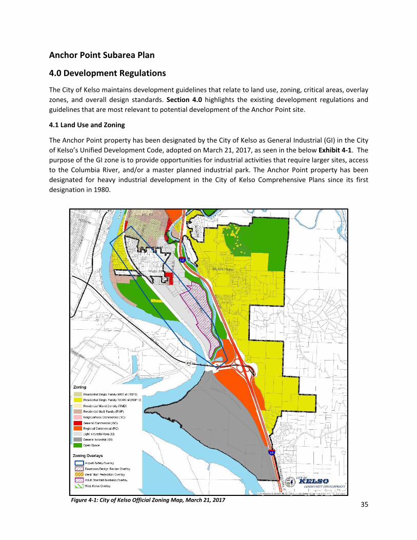
4.1 Land Use and Zoning
The Anchor Point property has been designated by the City of Kelso as General Industrial (GI) in the City of Kelso’s Unified Development Code, adopted on March 21, 2017, as seen in the below Exhibit 4-1. The purpose of the GI zone is to provide opportunities for industrial activities that require larger sites, access to the Columbia River, and/or a master planned industrial park. The Anchor Point property has been designated for heavy industrial development in the City of Kelso Comprehensive Plans since its first designation in 1980.

36
The City’s zoning code provides for a variety of uses in the general industrial zone. The following are land uses and development activities that are allowed as an outright permitted use, or are permitted subject to a conditional use permit (C).
Boat launch Dredge spoils storage Hazardous materials (C) Industrial facility-master planned Marine shipping facility Mining Public facility/park Retail sales/services Wireless communications, Category 1 Wireless communications, Category 2
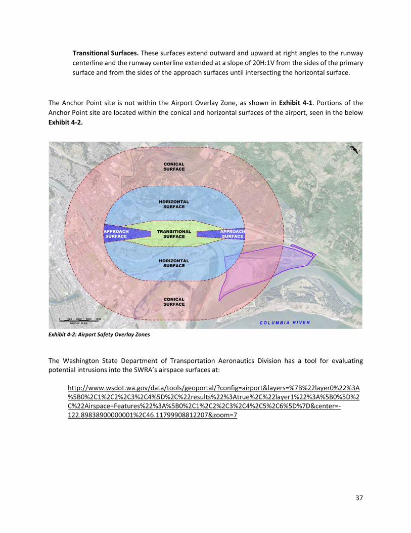
4.1.a Airport Safety Overlay
The Southwest Washington Regional Airport (SWRA) is located in the City of Kelso. This regional airport serves residents, business, and industries in Cowlitz County and the southwest region of Washington state. The airport safety overlay is intended to regulate or control the various types of air space obstructions and other hazards that may interfere with the safety of aircraft operations near the SWRA. The boundaries of the Airport Overlay (AO) are shown on the City of Kelso Zoning Map in Exhibit 4-1 above.
The Airport Safety Overlay KMC 17.22.150 applies to the area adjacent to and surrounding the SWRA with all additions and extensions thereof, and established as within the boundaries of the zone described as:
Horizontal Surface. A horizontal plane 167 feet above mean sea level, the perimeter of which is constructed by swinging arcs of ten thousand feet radii from the center of each end of the ultimate primary surface (five hundred feet by five thousand seven hundred thirty feet) and connecting the adjacent arcs by lines tangent to those arcs.
Conical Surface. A horizontal plane extending from 167 feet above mean sea level at a slope of 20 horizontal to 1 vertical (20H:1V) a distance of 4,000 feet, from the outer perimeter of the horizontal surface to an elevation of 367 feet above mean sea level, the perimeter of which is constructed by swinging arcs of 14,000 feet radii from the center of each end of the ultimate primary surface (500 feet by 5,730 feet) and connecting the adjacent arcs by lines tangent to those arcs.
Approach Surfaces. A horizontal plane longitudinally centered on the extended runway centerline commencing at the end of the primary surface of Runway End 12, and extending for a horizontal distance of 5,100 feet at a slope of 34H:1V to a final width of 2,030 feet at the interception of the horizontal surface; and a horizontal plane longitudinally centered on the extended runway centerline commencing at the end of the primary surface of Runway End 30, and extending for a horizontal distance of 3,000 feet at a slope of 20H:1V to a final width of 1,000 feet at the interception of the horizontal surface.
37
Transitional Surfaces. These surfaces extend outward and upward at right angles to the runway centerline and the runway centerline extended at a slope of 20H:1V from the sides of the primary surface and from the sides of the approach surfaces until intersecting the horizontal surface.
The Anchor Point site is not within the Airport Overlay Zone, as shown in Exhibit 4-1. Portions of the Anchor Point site are located within the conical and horizontal surfaces of the airport, seen in the below Exhibit 4-2.
Exhibit 4-2: Airport Safety Overlay Zones The Washington State Department of Transportation Aeronautics Division has a tool for evaluating potential intrusions into the SWRA’s airspace surfaces at:
http://www.wsdot.wa.gov/data/tools/geoportal/?config=airport&layers=%7B%22layer0%22%3A%5B0%2C1%2C2%2C3%2C4%5D%2C%22results%22%3Atrue%2C%22layer1%22%3A%5B0%5D%2C%22Airspace+Features%22%3A%5B0%2C1%2C2%2C3%2C4%2C5%2C6%5D%7D¢er=-122.89838900000001%2C46.11799908812207&zoom=7
38
As development of Anchor Point is considered, any potential user will be responsible for preparing and submitting a Notice of Proposed Construction or Alteration to the Federal Aviation Administration (FAA) Form 7460 for evaluation by FAA of any potential impacts and mitigation, if required. More information is available at the below link:
https://www.faa.gov/documentLibrary/media/Form/FAA_Form_7460-1_AJV-1-050117.pdf
4.2 Shoreline Master Plan & Critical Areas
The City of Kelso Unified Development Code, Chapter 17.26, regulates environmentally sensitive areas within the City. The environmentally sensitive, or critical areas, subject to the provisions of this Chapter consist of wetlands, geologically hazardous areas, fish and wildlife habitat conservation areas, frequently flooded areas, and, critical aquifer recharge areas. All proposed development activities that may impact environmentally sensitive areas or their buffers, shall include a critical areas report prepared in accordance with the provisions of this Chapter, unless this requirement is waived in writing by the City. The City of Kelso will use critical area site assessments at the time of permit or development application to confirm the presence, exact location, and classification of critical areas. The City of Kelso’s Shoreline Master Plan designates both the Columbia River, including Carrolls Channel, and the Cowlitz River as a “Shoreline of Statewide Significance”. The Anchor Point site abuts the Carrolls Channel of the Columbia River and the Cowlitz River. Owl Creek also is designated as a Type S (Shoreline of the State) fish-bearing stream at the confluence with the slough. (See Exhibit 3-13). The Shoreline Management Act designates all lands extending landward for 200-feet in all direction from the OHWM and all associated wetlands as within Shoreline Jurisdiction RCW 90.58.030. Chapter 8.2.F of the City of Kelso’s Shorelines Master Program (SMP) requires a shoreline permit (Shoreline Substantial Development Permit or Shoreline Conditional Use Permit) if development is proposed within a jurisdictional shoreline area or its critical areas buffer. Additionally, the City may request a technical assessment addressing how any proposed development incorporates best available science to reduce critical area impacts.
Under the City’s SMP, the Anchor Point shoreline is designated as a High-Intensity Shoreline Environment, as seen in Exhibit 4-3 below. Section 5.4.1 of the City’s SMP explains that the High-Intensity environment designation is given to shoreline areas within the City that currently support or are planned for high-intensity uses related to commercial, industrial, or transportation use.

39
Exhibit 4-3: City of Kelso Shoreline Environmental Designations
40
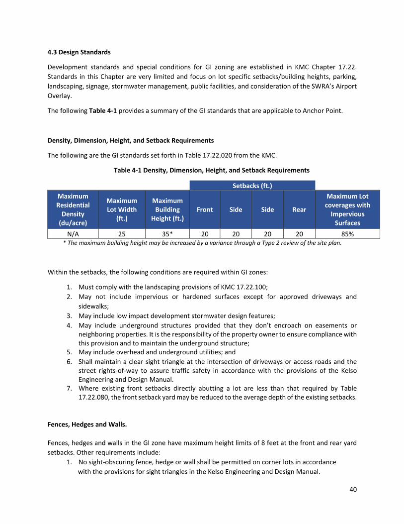
4.3 Design Standards
Development standards and special conditions for GI zoning are established in KMC Chapter 17.22. Standards in this Chapter are very limited and focus on lot specific setbacks/building heights, parking, landscaping, signage, stormwater management, public facilities, and consideration of the SWRA’s Airport Overlay.
The following Table 4-1 provides a summary of the GI standards that are applicable to Anchor Point.
Density, Dimension, Height, and Setback Requirements
The following are the GI standards set forth in Table 17.22.020 from the KMC.
Table 4-1 Density, Dimension, Height, and Setback Requirements
Setbacks (ft.) Maximum Residential
Density (du/acre)
Maximum Lot Width
(ft.)
Maximum Building
Height (ft.) Front Side Side Rear
Maximum Lot coverages with
Impervious Surfaces
N/A 25 35* 20 20 20 20 85% * The maximum building height may be increased by a variance through a Type 2 review of the site plan.
Within the setbacks, the following conditions are required within GI zones:
1. Must comply with the landscaping provisions of KMC 17.22.100; 2. May not include impervious or hardened surfaces except for approved driveways and
sidewalks; 3. May include low impact development stormwater design features; 4. May include underground structures provided that they don’t encroach on easements or
neighboring properties. It is the responsibility of the property owner to ensure compliance with this provision and to maintain the underground structure;
5. May include overhead and underground utilities; and 6. Shall maintain a clear sight triangle at the intersection of driveways or access roads and the
street rights-of-way to assure traffic safety in accordance with the provisions of the Kelso Engineering and Design Manual.
7. Where existing front setbacks directly abutting a lot are less than that required by Table 17.22.080, the front setback yard may be reduced to the average depth of the existing setbacks.
Fences, Hedges and Walls. Fences, hedges and walls in the GI zone have maximum height limits of 8 feet at the front and rear yard setbacks. Other requirements include:
1. No sight-obscuring fence, hedge or wall shall be permitted on corner lots in accordance with the provisions for sight triangles in the Kelso Engineering and Design Manual.

41
2. Height of fence, hedge or wall shall be measured from finished grade at the exterior side of the fence.
3. No person may construct a berm upon which to build a fence, hedge or wall unless the total height of the berm plus the fence does not exceed the maximum height allowable for the fence if the berm were not present.
4. No fence, hedge or wall shall be allowed to contain barbed, razor or other types of wire designed to cause injury to persons or animals except within the LI and GI zones.
Landscaping The purpose of the City of Kelso’s landscaping code, KMC 17.22.100, is to improve the aesthetic quality of the built environment, encourage the retention and protection of existing vegetation, reduce the impacts of development on environmentally sensitive areas and the natural environment, enhance the value of current and future development, and increase privacy for residential zones. GI zones require a minimum of 15% of the total lot area to be landscaped. Industrial GI Zones shall also provide an additional landscaped buffer, 20 feet in width, along any property lines abutting a Single Family Residential Zone. The Anchor Point site does not abut any residential areas. Parking KMC Chapter 17.22.110 outlines the requirements for parking in GI zones. All parking shall be provided on-site in GI zones. The City does not stipulate the number of spaces for GI zones, rather, for all non-residential uses, the minimum parking required will be determined by the City on a project specific basis. The project applicant shall supply the City with documentation regarding actual parking demand for the proposed use; or technical studies relating the parking needs for the proposed use; or required parking for the proposed use as determined by other comparable jurisdictions. The City will utilize this information in making its determination of minimum parking required for a specific project. Stormwater Management Stormwater management regulations are contained in KMC 17.22.120. The City is required to manage stormwater runoff in accordance with the provisions of federal and state law and a National Pollutant Discharge Elimination System Permit. The City has adopted the Stormwater Manual for Western Washington prepared by the Washington State Department of Ecology; adopted local stormwater standards; and encourages the implementation of low impact design features. The Kelso Engineering Design Manual contains the applicable stormwater standards and requirements. Signs
The City of Kelso regulates signs in KMC 17.22.210. The code applies to all signs within the City which are visible from any street, sidewalk, or public place, regardless of the type or nature. Specific permanent sign regulations that apply to the GI zone include freestanding, projecting, and wall signs. The sign regulations address height, size, and number of signs and provide for fixed messages, changeable copy, or digital signs.

42
Anchor Point Subarea Plan
5.0 Plan Concepts and Actions
The following Plan Concepts and Actions Section contains an overview of the various infrastructure components that are related to industrial development onsite, followed by specific actions the City can take to ensure successful development.
5.1 Infrastructure Development
Totaling nearly 600-acres, the Anchor Point site is the largest industrially zoned property in the City of Kelso. Anchor Point lies adjacent to the Columbia and Cowlitz Rivers, the BNSF mainline, and near I- 5. The land is zoned for General Industrial use.
The site is currently undeveloped, and is generally flat. Existing ground contours range in elevation from 15 to 50 feet. The upland portion of the site, totaling nearly 295 acres, is above and outside of the flood plain. The southern portion of the site contains approximately 305 acres of wetlands.
The presence of wetlands on the site will affect the design for all site infrastructure improvements, such as vehicular access, rail connection, and utility connections. Wetland buffers will be required, based on future delineations, and wetland mitigation will be necessary for any infrastructure-related impacts.
5.1.a Site Access & Proximity to I-5
Site Access Overview
The Anchor Point site is located west of I-5 and south of SR 432. Any future industrial development will require vehicular access for various uses, including employee access, supply deliveries, and emergency vehicles. As an industrial site, it is unlikely that high volumes of public traffic will occur. Therefore, the access could be developed as a private roadway, or as a public roadway in partnership with the City of Kelso.
The 2016 Anchor Point Feasibility Study initially identified six vehicular access alternatives for the site. These preliminary access alternatives have varying levels of environmental impacts, construction considerations, permitting requirements, and right of way requirements.

43
From 2016-2017, these six options were further analyzed by OBEC Consulting Engineers and Gibbs & Olson, based on construction costs, environmental constraints, and impacts to the BNSF mainline. Further review led to reducing the options to three access alternatives for further analyses, with the final preferred site access alternative ultimately being chosen due to limited environmental impacts and less disruption to the BNSF mainline. The engineering team also determined that the existing site access at Owl Creek could be maintained as a secondary and/or emergency access point, but there are too many economic and environmental constraints to using Owl Creek as the primary access for the site. The preferred site access route and potential emergency access route is shown in Exhibit 5-1 below.
Exhibit 5-1: Preferred Site Access
Preferred Site Access
The preferred vehicular access is located along the proposed Talley Way extension through Kelso Village, a planned regional commercial site at the I-5/SR-432 interchange consisting of approximately 120 acres. As of 2017, the Talley Way extension is partially constructed, and, continuation of this extension to the proposed BNSF crossing is the most logical point of access to the Anchor Point site. This access alternative will allow for a new grade separated crossing of BNSF tracks where no current crossing exists.
The proposed bridge will feature a structural steel truss, approximately 345 feet in length, and would span all BNSF tracks at the proposed location. The proposed bridge will have foundations and one abutment located within the BNSF right of way. Adequate clearance to all current and known future tracks is provided.

44
Site Access Actions
SA-1. Work with property owners to secure the Right-of-Way for the Talley Way extension through the proposed Kelso Village.
SA-2. Consider public-private financing of the access to the Anchor Point site through discussions with potential tenants, City of Kelso, Cowlitz County, Port of Longview, State & Federal Agencies.
SA-3. Any grade separated crossing will conform to the current BNSF-UPRR Guidelines for Railroad Grade Separation Projects and will need to be approved by BNSF.
SA-4. Further evaluate the benefits to securing access as a public roadway, or as a public-private partnership.
SA-5. Coordinate with BNSF to obtain entitlements and right-of-way access for the proposed grade separation & bridge, and detailed design to allow for potential public ownership.

45
5.1.b Utilities
Utilities Overview
The 2016 Anchor Point Feasibility Study evaluated utility connections to the Anchor Point site. These findings are detailed in Section 3.0-Existing Conditions. This study found that necessary utility improvements will vary depending on the specific site user(s) and ultimate facility needs. Connections to nearby domestic water, sanitary sewer, power (20MW substation), natural gas, and phone/communications can be made by either connecting to the site via Utility Corridor Option A or B, as seen in the below graphic from the 2016 CERB Feasibility Study.
Exhibit 5-2: 2016 CERB Feasibility Study - Potential Utilities Connections
Further study of potential utility corridor connections should occur in connection with site-specific development proposals.

46
Sanitary sewer and domestic water connections could be implemented by additional extension of the current sewer and water pipelines previously extended into the proposed Kelso Village development, as seen in Exhibit5-3. This development plan would align with the preferred access route into the site, and could result in decreased development costs. In this scenario, the sewer connections will likely consist of either a gravity collection system or a network of small individual grinder pump stations. Further exploration into the above-mentioned connections will be evaluated on a tenant-specific basis.
The City of Kelso has included the Anchor Point property in its water and sewer service areas. Industrial water supply and potential wastewater treatment facilities required for development of Anchor Point should be included in future updates of the City’s Water and Sewer Comprehensive Plans. Utilities Actions
UT-1. Maintain compatibility between utility providers and local, state, and federal plans. UT-2. Encourage underground utility distribution where economically and environmentally feasible. UT-3. Require further utility investigation and planning on a user-specific basis. UT-4. Evaluate facility needs and potential for public/private development of utilities to serve Anchor Point property in City of Kelso Sewer General Plan update and the Water System Plan update.
Figure 5-3: Potential Sewer & Water Connections

47
Figure 5-4: City of Kelso Water System Plan Update, 2013
5.1.b.1 Industrial Water Supply Industrial Water Supply Overview
Anchor Point is located within the City of Kelso’s “Future and Retail Service Area” identified in the City’s 2012 Water System Plan Update (published March 2013), as seen in the below Exhibit 5-4. The WSP’s projected water demand does not include new industrial developments; however, the WSP recognizes that the City “plans to develop an industrial park to the south of the City but as of yet, there are not any established users for the proposed industrial park.” (2012 WSP Section 2.5.3).
The Anchor Point site is located in the Cowlitz River drainage basin, which is designated as Water Resource Inventory Area 26 (WRIA 26). The Department of Ecology regulates the Cowlitz River basin under the State Water Code, utilizing recommendations in the Grays-Elochoman and Cowlitz Watershed Plan adopted by Wahkiakum, Lewis, Cowlitz, and Skamania counties. A formal instream flow protection rule has not been established for this basin under Washington Administrative Code. Both the original and 2014 amended Watershed Plans state that tidally-influenced areas of the Columbia, Cowlitz, and Coweeman Rivers should remain open to future water appropriations.

48
The City of Kelso water system is not currently sized for high-demand industrial water use. The need for an alternate source of water for industrial supply was identified in the 2016 CERB Anchor Point Feasibility Study. Following the recommendation of the CERB Study, Pacific Groundwater Group (PGG) and Environmental Land Services (ELS), on behalf of the property owners, conducted numerous technical studies to simulate industrial water usage at the Anchor Point site. PGG modeled a water system of 20,830 gallons per minute (gpm), sized to supply multiple tenants and water-dependent uses. This amount was determined based on the water usage amounts of similar industries along the Columbia River corridor. PGG determined that the water supply could be obtained in two ways – either through a series of vertical wells (less than 250 feet) or through one or more Ranney-type collector systems. The source of supply (vertical wells or Ranney-type collector) would likely be located along the Carrolls Channel of the Columbia River, as shown in Exhibit 5-5. The industrial water supply source for the Anchor Point site will be hydrologically connected to the tidally-influenced Carrolls Channel of the Columbia River.
Exhibit 5-5: Industrial Water Supply
The Anchor Point property owners have filed an application for a new water right for industrial supply to serve the site. This application has been evaluated by PGG under a cost reimbursement contract with the Washington Department of Ecology.
The pending application is for a water right to drill, install, test, and develop up to three Ranney collector wells or vertical groundwater wells to be completed in the Quaternary Alluvial Aquifer at depths less than 250 feet. The proposed water system could supply multiple tenants and water-dependent manufacturing and processing industries. The application requests an instantaneous withdrawal of 20,830 gpm and an annual withdrawal of 33,630 acre-feet per year for industrial, manufacturing, commercial, irrigation,

49
power generation, road construction and maintenance, and fire protection purposes. These quantities are sufficient to meet the anticipated demand for industrial water supply within Anchor Point upon full buildout.
Private development of a large-scale industrial water right will provide greater flexibility in site marketability and industrial development alternatives, to attract the Target Industries & Key Industry Exporters discussed in Section 2.5. Any privately-developed industrial water system should be capable of supplying multiple tenants and water-dependent industrial facilities.
The City of Kelso water system should be extended to supply domestic (potable) water to the site. The anticipated 2018 update of the City’s Water System Plan should include extension of a potable water supply line to Anchor Point, as well as recognition of a new private industrial water supply system within Anchor Point. Actions specific to the development of industrial water supply are included below.
Water Supply Actions
WS-1. Recognize and encourage the development of a privately-owned industrial water supply system to serve at the Anchor Point property in the City of Kelso 2018 Water System Plan Update.
WS-2. Support the issuance by the Department of Ecology of a new water right with sufficient capacity to meet industrial demand within the Anchor Point property.
5.1.c Rail Access
Rail Access Overview
Anchor Point lies immediately adjacent to the BNSF’s North/South Rail Mainline, along the strategic I-5 corridor running between Vancouver and Longview Washington, and with extended access to the Seattle Tacoma region. The mainline is strategic in that both of the Western Class 1 rail carriers have direct mainline access within this corridor, also known as Rail Carrier Neutrality. With direct access from both BNSF and UPRR, and switching support from the Longview Terminal Railroad, the Anchor Point Site provides potential for large scale railroading operations. The Terminal Railroad provides a strategic link to the site because of the Longview Rail Yard which is also adjacent to the site.
The site is uniquely situated for direct lead track access from the mainline, with connectivity at the southern end of the Site, service for Unit train arrivals and departures. Any future rail operations at the Anchor Point Site would stop short of the congested City of Longview rail yards and at-grade crossings throughout the City, further supporting reduced rail impacts for the City and area extending southward to Kalama.

50
As shown in the Exhibit 5-6 below, the upland portion of the Anchor Point Site could accommodate a modern unit train loop track, and maintain roughly 150-200 interior acres. This would provide a capability to chamber multiple unit trains off the congested mainline. This is strategic as the Class I railroads prefer industrial facilities configured to support unit train movements. Over the past several months, the property owner and BNSF have reviewed various configurations for gaining access to the mainline, and those evaluations are ongoing.
Exhibit 5-6: Potential Rail Access
The property owners maintain close communication and coordination with the BNSF, for both unit train access to the property as well as overhead access for the proposed vehicle bridge into Anchor Point. Likewise, the City should continue to work collaboratively with all the rail carriers to continually improve access and operational safety and efficiency through Kelso and surrounding areas.
Rail Access Actions
RA-1. Encourage additional planning between BNSF and the property owners to determine best alternatives for establishing direct rail access into the Anchor Point Site, from the adjacent mainline tracks.
RA-2. Work closely with the BSNF to understand potential impacts of potential new rail infrastructure on local rail operations and safety concerns.
RA-3. Work closely with the BNSF to gain the required access agreements to provide industrial and emergency vehicular access over or across the subject rail areas and infrastructure into Anchor Point.

51
5.1.d Marine Access
Marine Access Overview
Anchor Point is bordered by Carrolls Channel to the south and southwest, and by the Cowlitz River to the northwest. Both waterways feed into the Columbia River, which is maintained at a dredged depth of 43-feet, as shown in the below Exhibit 5-7. The City of Kelso should consider a range of industrial access opportunities for the Anchor Point Subarea, including marine.
Exhibit 5-7: Proximity to Marine Access
Marine Access Actions
MA-1. Maintain current shoreline designations which allow for industrial uses at the Anchor Point site.
MA-2. Encourage private investigation into marine access alternatives on a per-tenant basis.

52
5.2 Public Health & Safety
5.2a. Emergency Services
The City of Kelso Police, Cowlitz 2 Fire and Rescue, and medical response agencies will serve the Anchor Point site. As development is considered, close coordination with these agencies will be required to assure adequate emergency response capabilities are provided.
5.2.b Permitting
Development of the Anchor Point site will require permit approvals that will vary greatly depending on the type of site use, facility size, and all related development impacts. The environmental permit review process will need to address city, county, state and federal regulations. The City of Kelso plans to assume lead agency status for any proposed development project located at the Anchor Point site.
Public Health & Safety Actions
PH-1. Ensure development of adequate emergency response access and response capabilities for Anchor Point site.
PH-2. Industrial development will comply with all applicable Local, State, and Federal regulations.
PH-3. SEPA review, including potential for an EIS, will be completed on a project-specific basis, in accordance with the City of Kelso’s Unified Development Code.
PR-4. City of Kelso shall make available the staffing time and resources to act as the lead agency in SEPA review for a project on the Anchor Point property.
5.3 Land Use and Zoning
As described in Section 4.1, the Anchor Point site is zoned General Industrial (GI). As stated in KMC 17.18.03, the purpose of the General Industrial zone is to provide opportunities for industrial activities that require larger sites, access to the Columbia River, and/or a master planned industrial park. Following a review of the uses of the City’s Light Industrial (LI) zoning code, several uses have been identified that also meet the stated purpose of the GI zone and would be compatible in both the LI and GI zones. The following uses are recommended to be expanded to permitted uses in the GI zone: Aquaculture Construction/landscaping Manufacturing and processing Public works/utility buildings Rail service/repair Restaurants Warehouse

53
Land Use and Zoning Action ZA-1- In conjunction with annual City zoning code updates, expand LI uses as described in Section 5.3 above to GI Zone uses consistent with the City’s stated purpose for GI industrial land uses.
5.4 Development Alternatives
5.4.a No Action
The Anchor Point site currently has the zoning and shoreline designations in place to be a heavy industrial site. Therefore, a No-Action alternative would reflect development under the existing zoning, SMP, KMC, and Comprehensive Plan guidelines without any of the additive policies found in this Subarea Plan. The current site mining operations could continue, or one or more industrial user(s) could seek development of the site.
5.4.b Single Tenant
Based on existing footprints of the various industries found along the Columbia River, it is feasible that a single tenant could occupy the entire upland site for industrial development. Under this scenario, the tenant would work closely with the City of Kelso to advance the project through the planning, permitting, and approval phases. The additional policies, goals, and objectives presented in Section 2.3 of this Subarea Plan would serve as further guidance for industrial development of the site.
Exhibit 5-8: Development Alternatives – Single Tenant

54
The City of Kelso should assess the following economic factors when considering further approval of any Single Tenant Use:
• Economic Considerations: o Capital Investment Potential o Job Creation o Economic Impacts of Construction o Economic Impacts of On-Going Operations o Direct Fiscal Impacts of Construction o Direct Fiscal Effects of On-Going Operations
In addition to regulatory and environmental considerations, these factors should guide the City and property owners in determining the highest and best use for a single tenant at the Anchor Point site.
5.4.c Multi-Tenant
A multi-tenant development scenario could occur in several ways. The first scenario includes two or more users that share various portions of the upland site, as seen in Exhibit 5-9 below:
Exhibit 5-9: Development Alternatives – Multi-Tenant

55
Any multi-tenant development scenario could also include a rail component, with planned facility buildout, as seen in Exhibit 5-10 below:
Exhibit 5-10: Development Alternatives – Multi-Tenant with Rail
The City of Kelso and property owners should consider parcel size and highest and best use if the property is to be divided for multiple industrial uses. The City of Kelso and property owners also should consider how each use fits with any other existing uses.
In a multi-tenant scenario, the City of Kelso could consider adopting a Master Plan for the Anchor Point property, which would serve to guide future multi-tenant industrial use.
In addition to regulatory and environmental considerations, the City of Kelso should assess the following economic factors when considering any Multi-Tenant Use, on a tenant by tenant basis:
• Economic Considerations: o Capital Investment Potential o Job Creation o Economic Impacts of Construction o Economic Impacts of On-Going Operations o Direct Fiscal Impacts of Construction o Direct Fiscal Effects of On-Going Operations
These factors should be used to guide the City in determination of the highest and best use for multi-tenant use of the Anchor Point site.
56
Development Alternative Actions
DA-1. Environmental and economic impacts shall be considered when determining the allowed use(s) at the Anchor Point site.
DA-2. The Anchor Point site will be privately developed but shall be developed in close coordination with the City to meet all applicable codes and standards.
DA-3. The City of Kelso shall consider single tenant and multi-tenant alternatives when marketing the Anchor Point site.
DA-4. Identify preferred supply chain opportunities.
5.5 Marketing Framework
The Anchor Point Subarea Plan recommends a marketing focus for potential users based on the key industry types discussed in Section 2.4. The City of Kelso could strengthen the marketability of Anchor Point through a formal economic development partnership with both the Port of Longview and the Cowlitz Economic Development Council (CEDC). Anchor Point falls within the Port of Longview’s taxing district, though this information is not currently represented to the public on the Port’s website or on City marketing materials. The City should collaborate with the Port of Longview to include Anchor Point in their inventory of available industrial lands and marketing of the property in their economic development efforts. Greater communication and coordination between all parties would allow for successful development of the Anchor Point site.
Marketing Framework Actions
MF-1. Establish formal partnerships with CEDC and Port of Longview.
MF-2. Coordinate with Port of Longview and other Columbia River Ports on potential marine opportunities.
5.6 Industrial Development Guidelines - Anchor Point Overlay
The Anchor Point Overlay proposes to establish industrial development guidelines that reflect the character of the City of Kelso, the physical environment that exists at Anchor Point, and the surrounding natural resources and rural area. The purpose of the Anchor Point Overlay Industrial zone is to provide an appropriate location in the City of Kelso for heavy industrial uses and related activities in the City’s General Industrial zone which is intended for more intensive industrial and manufacturing activities. These guidelines are intended to ensure compatibility of heavy industrial/manufacturing development to protect and/or enhance the community character while limiting potentially harmful externalities that impact community aesthetics and public health.

57
Development standards in the Anchor Point Overlay are designed to promote the following:
1. Protect appropriate areas for industrial use from intrusion by residences and other inharmonious uses,
2. Provide opportunities for certain types of industrial uses to concentrate in mutually beneficial relationships to each other;
3. Provide adequate space to meet the needs of modern industrial development, including truck parking, off-street parking and loading;
4. Provide industrial employment opportunities for residents of the region; and 5. Establish standards that result in industrial development that is attractive and functional.
5.6.a Site Planning and Design Quality industrial site design should include the following attributes:
1. Controlled site access 2. Service and loading areas located at the sides and rear of buildings 3. Convenient access, visitor parking and on-site circulation 4. Screening of outdoor storage, work areas, and equipment, where appropriate 5. Emphasis on the main building entry and landscaping 6. Landscaped open space
Exhibit 5-11: Example of a Well-Designed Site Plan

58
5.6.a.1 Site Grading Grading should be minimized, where possible, to preserve the natural character of Anchor Point. Where grading is unavoidable, consider the following guidelines:
1. Follow the natural contours as much as possible. 2. Round and contour slopes to blend with the existing terrain. 3. Avoid large manufactured slopes in favor of several smaller slopes. 4. Retain and incorporate significant natural vegetation into the project. 5. Grading should be performed in such manner as to optimize water retention.
5.6.a.2 Site Access
Every business or principal structure shall front on or be located on property which fronts upon a principal access which is dedicated as a public access or a maintained access through a master planned development, if possible.
5.6.a.3 Parking and Circulation
1. Every permitted land use within Anchor Point shall provide off-street parking facilities for automobiles, as required by Chapter 17.22.110 of the KMC.
2. No parking shall be permitted to be closer than 7 feet from an interior property line. Adjacent to dedicated open space, no parking or pavement shall be permitted closer than 15 feet.
3. No parking is permitted on public streets. 4. On-site circulation should be designed to provide safe and efficient access for delivery vehicles,
visitors, employees, and pedestrians. 5. Delivery vehicle and visitor/employee vehicle access and parking to the site should be separate.
Visitor/employee parking spaces should never back into a delivery vehicle drive aisle. 6. Vehicles shall not be required to enter the street in order to move from one area to another on
the same site. 7. Site plans should balance the need to provide adequate vehicular access, with the need to
eliminate unnecessary driveway entrances and provide access points which are coordinated with other properties.
8. The site area adjacent to the street should not be dominated with parking. Parking should be concentrated in areas behind front pad buildings and away from the street when possible.
9. Locate structures and on-site circulation systems to minimize pedestrian/vehicle conflicts where possible.
10. Adequate areas for maneuvering, stacking, truck staging, loading and emergency vehicle access shall be provided.
11. Parking access points, whether located on front, side, or rear streets, should be located as far as possible from street intersections so that adequate stacking room is provided.
12. Dead end parking aisles should be avoided if possible.

59
5.6.a.4 Pedestrian Circulation
1. Safe, clear pedestrian circulation must be provided between buildings, parking areas and from offsite access points.
2. Access between transit/bus stops, if provided, to building entrances should be clearly defined. 3. The on-site pedestrian circulation system should be directly connected to off-site sidewalks. 4. Vehicle and pedestrian circulation should be separate. The need for pedestrians to cross parking
aisles and/or service aisles should be minimized.
5.6.a.5 Loading Facilities
1. Loading berths shall be permitted in the building setback areas, except that portion of a corner lot formed by connecting two points 60 feet from the intersection of the street property lines
2. Loading and delivery areas should be clearly marked with directional signage where multiple access points are provided.
3. Loading areas shall be designed so that trucks do not back onto or otherwise use the adjoining street.
5.6.a.6 Open Space, Park Land, and Trails
1. Provide open areas and amenities where employees can take advantage of recreational uses. Such improvements should be appropriate for the intended user(s).
2. Employee break/ recreational areas should be incorporated into the overall design of the project. 3. Outdoor public spaces and amenities used for sitting, eating, and gathering are an employee
benefit and should be designed into the project where the project scope and the numbers of employees merit.
5.6.a.7 Landscaping Plantings, and the Extent Thereof:
Industrial uses typically have more hardscape and building coverage, resulting in smaller landscape areas than other types of uses. Landscaping has a variety of functions, including softening the hard edges of development, screening unattractive views, buffering incompatible uses, providing shade, and increasing the overall identity for the project. The purpose of requiring landscaping and the planting of trees, shrubs, ground cover, grass and other planting materials is to develop and maintain Anchor Point as an attractive area.
It is intended that 5% of the lot shall be landscaped and the location and quality of such landscaping plantings shall be like the location and quality thereof that is maintained within the light industrial areas of the City of Kelso.
Landscaping should be compatible with the overall design of the project in terms of scale, function, and design theme. Since most industrial developments are not known for their unique architectural design, landscape design is an inexpensive way to create project identity. Focus should be on the areas in view from public rights of-way and project entries.

60
When appropriate for the type and size of industrial use, more intense landscaping and special landscape features should be provided at major focal points, such as project entries and pedestrian gathering areas.
When industrial/warehouse uses are located adjacent to less intense uses, additional landscaping in conjunction with appropriate decorative walls and setbacks should be provided to mitigate potential adverse impacts.
5.6.a.8 Walls and Fencing
1. No fence or wall shall be constructed closer than 10 feet from the right-of-way of a principal access and no fence or wall shall be constructed within a drainage easement.
2. All fences and walls shall be designed and constructed in a manner that is complimentary to the architectural design of the building.
3. Walls should be constructed as low as possible while performing their screening and security functions. 4. Except for walls or fences constructed to screen areas as required herein, no fence or wall shall
exceed 10 feet in height, plus appropriate barbed wire or other security devices. 5. Landscaping should be used in combination with such walls whenever possible.
5.6.b Trash and Recycling Enclosures
1. No garbage, refuse, or rubbish shall be deposited or kept on any Lot or building except in a suitable enclosed container.
2. All equipment and containers for the storage or disposal of trash, garbage, or other waste shall be kept in a clean and sanitary condition.
3. The trash and recycle enclosure should be consistent with the design of the project and building architecture. Similar or the same materials should be used on the enclosure as the buildings.
4. Every property should provide a trash enclosure that is capable of handling the refuse/recyclable generated by the site.
5. A pedestrian entrance to the trash enclosure shall be provided so that the large access gates do not have to be opened as often.
6. Recycling bins should be integrated into the enclosure. 7. Drainage from adjoining roof and pavement should be diverted around the trash-recycling area.
5.6.c Lighting 5.6.c.1 Light Design
1. Light fixtures should be designed or selected to be architecturally compatible with the main structure or theme of the building (typical shoe-box light fixtures are prohibited).
2. Height of a light pole should be appropriate in scale for the building or complex and the surrounding area.
3. All building entrances should be well lighted. 4. Lighting should be used to provide illumination for the security and safety of on-site areas such as
parking, loading, shipping, receiving, pathways and working areas.

61
5.6.c.2 Glare
1. The quality of light, level of light as measured in foot-candles, and the type of bulb or source should be carefully addressed. Lighting levels should not be so intense as to draw attention to the glow or glare of the project.
2. Spotlighting or glare from any site lighting should be shielded from adjacent properties and directed at a specific object or target area.
3. Exposed bulbs should not be used. Cut-off lighting is preferred. 4. Uplighting of building elements and trees should use the lowest wattage possible to minimize
impacts to the night sky. 5. Timers and sensors should be incorporated to avoid unnecessary lighting.
5.6.d Signage
1. The City’s sign regulations and guidelines as stated in the KMC shall be adhered to at all times. 2. Signs should coordinate with the building design, materials, color, size, and placement. 3. A single development with multiple users should provide a unifying sign theme. Individual wall-
mounted signs are appropriate in combination with a monument sign identifying the development and address.
4. Signs should not cover up windows or important architectural features. 5. Damaged wall surfaces should be resurfaced and/or painted when removing an existing sign or
prior to installing a new replacement sign. 6. Sign cabinets (i.e. can signs) are strongly discouraged. 7. Signs that reflect the type of business through design, shape, or graphic form are encouraged. 8. Hanging signs attached to buildings that project perpendicular to the building should be a
minimum of 8 feet from ground level to the bottom of the sign. Signs that project should be small and reflect the use of the business by incorporating symbols or logos of the business.
9. Wall mounted signs should be appropriately positioned within architectural features, such as a wall surface or parapet above the storefront. The size of a sign should not exceed 70% of the wall surface within an architectural feature.
10. Lighting of all exterior signs should illuminate the sign without producing glare on pedestrians, automobiles, or adjacent residential units.
11. The industrial site should be appropriately signed to give directions to loading and receiving, visitor parking, and other special areas.
12. Signs which restrict the view of adjoining properties or create confusion relative to interpretation of traffic signals shall not be permitted.
13. Any Lot Owner shall have the right to place signs upon such Owner’s Lot in accordance with advertising such premises for said or lease.

62
5.6.e Stormwater These stormwater guidelines propose to identify best low impact development practices to provide measures that promote protection of surface water quality through reduced pollutant loading and the treatment and infiltration of stormwater runoff onsite. Due to the significant filling of sandy dredge spoil material, the site has good characteristics for onsite LID practices. The following are recommended practices to be implemented, where practicable:
1. Permeable Pavement - Alternative paving materials such as permeable pavers, permeable asphalt, and pervious concrete can be used to locally infiltrate rainwater and reduce the runoff leaving a site. Consider the use of permeable surfacing in parking and loading areas, except where potential contamination or a specific industrial activity precludes its use. Contamination sources include vehicle fuel stations, storage of industrial chemicals, oils and grease, and other hazardous substances, dust and dirt storage, etc.
2. Native vegetation - Retain native vegetation areas to treat and manage stormwater 3. Bio-retention - Measures are encouraged to minimize, detain, and retain post development runoff
uniformly throughout a site so as to mimic the site's predevelopment hydrologic functions. Bio-retention cells provide an element of water quality control and can achieve quantity control as well. By infiltrating and temporarily storing runoff water, bio-retention cells reduce a site's overall runoff volume and help to maintain the predevelopment peak discharge rate and timing.
5.6.f Fire and Safety Hazards. The storage and handling of flammable and combustible liquids, liquefied petroleum, gases, explosives and flammable and/or combustible materials shall comply with all applicable local, state and federal rules 5.6.g Emissions, Dust and Odors. Air emissions shall meet applicable regulations of the Southwest Washington Clean Air Agency or other applicable federal, state or local laws. Emission of offensive gases or vapors shall not be permitted to exceed the odor threshold established by the Southwest Washington Clean Air Agency or other applicable agency with jurisdiction as measured at any point along the lot or lots on which the use or structure is located. No dust from the site shall be detectable by a person of ordinary sensitivity without instruments at any point outside the lot lines of the industrial use.

63
5.6.h Liquid, Solid and Hazardous Wastes. Any on-site or off-site hazardous waste generation, treatment, storage and/or disposal shall meet the requirements established by Chapter 70.105 RCW, and Chapters 173-303 and 173-340 WAC, and other applicable federal, state and local regulations. No use shall discharge into the air, storm drains, sewer systems, surface storm water drainageways, or across lot boundaries any toxic or noxious gases or matters in any concentrations as to be detrimental to or endanger the public health, safety or welfare, the surrounding environment, or cause injury or damage to animals, vegetation, property, or adjacent and nearby businesses. The disposal of all industrial waste types shall be governed by the regulations and standards of applicable state and federal agencies.
Development Guideline Actions
DG-1 City of Kelso shall adopt Anchor Point Overlay as set forth in this Subarea Plan.

64
Anch
or P
oint
Sub
area
Pla
n
6.0
Impl
emen
tatio
n
Actio
n #
Impl
emen
tatio
n M
easu
re
Le
ad
Ti
me
Fram
e
Cost
Land
Use
and
Zon
ing
Po
licy
ED-1
En
cour
age
indu
stria
l dev
elop
men
t at
the
Anch
or P
oint
pro
pert
y th
at
faci
litat
es th
e cr
eatio
n of
fam
ily
wag
e jo
bs fo
r City
of K
elso
re
siden
ts
Co
mm
unity
De
velo
pmen
t
Im
med
iate
Staf
f tim
e
O
bjec
tive
1. M
aint
ain
exist
ing
land
us
e zo
ning
and
shor
elin
e de
signa
tions
to a
llow
for i
ndus
tria
l de
velo
pmen
t
O
bjec
tive
2. M
onito
r the
av
aila
bilit
y of
indu
stria
l lan
ds
with
in th
e Ci
ty o
f Kel
so, a
nd m
ake
spec
ial n
ote
of th
ose
impa
cted
by
Criti
cal A
reas
or o
ther
dev
elop
men
t co
nstr
aint
s.
Polic
y ED
-2
Prov
ide
for s
tabl
e an
d di
vers
ified
ec
onom
ic g
row
th in
the
indu
stria
l an
d m
anuf
actu
ring
sect
or.
Co
mm
unity
De
velo
pmen
t
Im
med
iate
Staf
f tim
e
Polic
y ED
-3
Buffe
r res
iden
tial a
reas
from
in
dust
rial u
se g
ener
ated
noi
se,
odor
s, li
ghts
and
traf
fic.
Co
mm
unity
De
velo
pmen
t
Im
med
iate
Staf
f tim
e

65
Actio
n #
Impl
emen
tatio
n M
easu
re
Le
ad
Ti
me
Fram
e
Cost
Polic
y ED
-4
Attr
act i
ndus
trie
s and
bus
ines
ses
that
pro
vide
serv
ices
and
pro
duct
s fo
r or u
tilize
the
raw
mat
eria
ls of
th
e ex
istin
g in
dust
rial b
ase
of th
e Ke
lso-L
ongv
iew
Urb
an A
rea
and
Cow
litz C
ount
y.
Co
mm
unity
De
velo
pmen
t
Imm
edia
te
St
aff t
ime
Tran
spor
tatio
n
Polic
y T-
1 Fa
cilit
ate
plan
ning
of i
ndus
tria
l site
ac
cess
rout
es th
at d
o no
t con
flict
w
ith a
cces
s to
maj
or re
siden
tial
area
s.
Co
mm
unity
De
velo
pmen
t
Imm
edia
te
St
aff t
ime
O
bjec
tive
1. Im
plem
ent p
ublic
-pr
ivat
e de
velo
pmen
t of a
dequ
ate
infr
astr
uctu
re to
acc
ess t
he si
te.
O
bjec
tive
2. D
evel
op a
pla
n fo
r w
ell-d
efin
ed a
cces
s rou
tes i
nto
the
indu
stria
l are
a th
at in
clud
e em
erge
ncy
acce
ss a
ltern
ativ
es.
Fisc
al
Po
licy
F-1
Fost
er a
priv
ate-
publ
ic c
oope
rativ
e pa
rtne
rshi
p be
twee
n th
e Ci
ty o
f Ke
lso a
nd C
owlit
z Cou
nty
that
is
supp
ortiv
e of
indu
stria
l de
velo
pmen
t.
Co
mm
unity
De
velo
pmen
t
Im
med
iate
Staf
f tim
e
O
bjec
tive
1. E
ncou
rage
pub
lic-
priv
ate
deve
lopm
ent o
f site
acc
ess
for A
ncho
r Poi
nt

66
Actio
n #
Impl
emen
tatio
n M
easu
re
Le
ad
Ti
me
Fram
e
Cost
O
bjec
tive
2. E
ncou
rage
eco
nom
ic
deve
lopm
ent t
hat c
reat
es p
ositi
ve fi
scal
im
pact
s for
the
City
of K
elso
, spe
cial
di
stric
ts, a
nd su
rrou
ndin
g lo
cal
com
mun
ities
.
O
bjec
tive
3. C
omm
unic
ate
with
the
com
mun
ity a
nd st
akeh
olde
rs to
ens
ure
succ
essf
ul d
evel
opm
ent o
f ind
ustr
ial
land
s.
Sec
tion
5.1.
a -
Site
Acc
ess
SA
-1
Wor
k w
ith p
rope
rty
owne
rs to
secu
re
the
Righ
t-of
-Way
for t
he T
alle
y W
ay
exte
nsio
n th
roug
h th
e pr
opos
ed K
elso
Vi
llage
.
Ci
ty
Im
med
iate
TBD
SA-2
Co
nsid
er p
ublic
-priv
ate
finan
cing
of t
he
acce
ss to
the
Anch
or P
oint
site
thro
ugh
disc
ussio
ns w
ith p
oten
tial t
enan
ts, C
ity
of K
elso
, Cow
litz C
ount
y, P
ort o
f Lo
ngvi
ew, F
eder
al &
Sta
te A
genc
ies.
Ci
ty/P
rop.
Ow
ner
1-3
year
s
$40M
SA-3
Gr
ade
sepa
rate
d cr
ossin
g w
ill c
onfo
rm
to th
e cu
rren
t BN
SF-U
PRR
Guid
elin
es fo
r Ra
ilroa
d Gr
ade
Sepa
ratio
n Pr
ojec
ts.
Pr
oper
ty O
wne
r
Imm
edia
te
$1
50K
SA-4
Fu
rthe
r eva
luat
e th
e be
nefit
s to
secu
ring
acce
ss a
s a p
ublic
road
way
, or
as a
pub
lic-p
rivat
e pa
rtne
rshi
p.
Ci
ty/P
rop.
Ow
ner
Imm
edia
te
St
aff t
ime
SA-5
Co
ordi
nate
with
BN
SF to
obt
ain
entit
lem
ents
and
righ
t-of
-way
acc
ess
for t
he p
ropo
sed
grad
e se
para
tion
&
brid
ge, a
nd d
etai
led
desig
n to
allo
w fo
r po
tent
ial p
ublic
ow
ners
hip.
Ci
ty/ D
evel
oper
Im
med
iate
TBD

67
Actio
n #
Impl
emen
tatio
n M
easu
re
Le
ad
Ti
me
Fram
e
Cost
Sect
ion
5.1.
b -
Util
ities
UT-
1 M
aint
ain
com
patib
ility
bet
wee
n ut
ility
pro
vide
rs a
nd lo
cal,
stat
e,
and
fede
ral p
lans
.
Ci
ty
O
ngoi
ng
St
aff t
ime
UT-
2 En
cour
age
unde
rgro
und
utili
ty
dist
ribut
ion
whe
re e
cono
mic
ally
an
d en
viro
nmen
tally
feas
ible
.
De
velo
per
O
ngoi
ng
St
aff t
ime
UT-
3 Re
quire
furt
her u
tility
inve
stig
atio
n an
d pl
anni
ng o
n a
user
-spe
cific
ba
sis.
Ci
ty/D
evel
oper
Imm
edia
te
TB
D
UT-
4 Ev
alua
te fa
cilit
y ne
eds a
nd
pote
ntia
l for
pub
lic/p
rivat
e de
velo
pmen
t of u
tiliti
es to
serv
e An
chor
Poi
nt p
rope
rty
in C
ity o
f Ke
lso S
ewer
Gen
eral
Pla
n up
date
an
d th
e W
ater
Com
preh
ensiv
e Pl
an
upda
te.
Ci
ty
Im
med
iate
Staf
f tim
e pl
us
cons
ulta
nt
cost
Sect
ion
5.1.
b.1
- Wat
er S
uppl
y
WS-
1 Re
cogn
ize a
nd e
ncou
rage
the
deve
lopm
ent o
f a p
rivat
ely-
owne
d in
dust
rial w
ater
supp
ly sy
stem
to
serv
e at
the
Anch
or P
oint
pro
pert
y in
the
City
of K
elso
201
8 W
ater
Sy
stem
Pla
n U
pdat
e.
Ci
ty
Im
med
iate
Staf
f tim
e pl
us
cons
ulta
nt
cost
WS-
2 Su
ppor
t the
issu
ance
by
the
Depa
rtm
ent o
f Eco
logy
of a
new
w
ater
righ
t with
suffi
cien
t cap
acity
to
mee
t ind
ustr
ial d
eman
d w
ithin
th
e An
chor
Poi
nt p
rope
rty.
Ci
ty
Im
med
iate
Staf
f tim
e pl
us
cons
ulta
nt
cost

68
Actio
n #
Impl
emen
tatio
n M
easu
re
Le
ad
Ti
me
Fram
e
Cost
Sect
ion
5.1.
c - R
ail A
cces
s
RA-1
En
cour
age
addi
tiona
l pla
nnin
g be
twee
n BN
SF a
nd th
e pr
oper
ty
owne
rs to
det
erm
ine
best
al
tern
ativ
es fo
r est
ablis
hing
di
rect
rail
acce
ss in
to th
e An
chor
Po
int S
ite, f
rom
the
adja
cent
m
ainl
ine
trac
ks.
De
velo
per
1-
3 ye
ars
TB
D
RA-2
W
ork
clos
ely
with
the
BSN
F to
un
ders
tand
pot
entia
l im
pact
s of
pote
ntia
l new
rail
infr
astr
uctu
re
on lo
cal r
ail o
pera
tions
and
sa
fety
con
cern
s.
Ci
ty/D
evel
oper
1-3
year
s
TBD
RA-3
W
ork
clos
ely
with
the
BNSF
to
gain
the
requ
ired
acce
ss
agre
emen
ts to
pro
vide
indu
stria
l an
d em
erge
ncy
vehi
cula
r acc
ess
over
or a
cros
s the
subj
ect r
ail
area
s and
infr
astr
uctu
re in
to
Anch
or P
oint
.
Ci
ty/D
evel
oper
1-3
year
s
TBD
Sect
ion
5.1.
d - M
arin
e Ac
cess
MA-
1 M
aint
ain
curr
ent s
hore
line
desig
natio
ns w
hich
allo
w fo
r in
dust
rial u
ses a
t the
Anc
hor
Poin
t site
.
Ci
ty
Im
med
iate
Staf
f tim
e
MA-
2 En
cour
age
priv
ate
inve
stig
atio
n in
to m
arin
e ac
cess
alte
rnat
ives
on
a p
er-t
enan
t bas
is.
De
velo
per
1-
3 ye
ars
$5
0K
69
Actio
n #
Impl
emen
tatio
n M
easu
re
Le
ad
Ti
me
Fram
e
Cost
Sect
ion
5.2
– Pu
blic
Hea
lth &
Saf
ety
PH
-1
Ensu
re d
evel
opm
ent o
f ad
equa
te e
mer
genc
y re
spon
se
acce
ss a
nd re
spon
se c
apab
ilitie
s fo
r Anc
hor P
oint
site
Ci
ty/D
evel
oper
1-3
year
s
TBD
PH-2
In
dust
rial d
evel
opm
ent w
ill
com
ply
with
all
appl
icab
le L
ocal
, St
ate,
and
Fed
eral
regu
latio
ns
De
velo
per
3-
5 ye
ars
TB
D
PH-3
A
SEPA
revi
ew, i
nclu
ding
po
tent
ial f
or a
n EI
S, w
ill b
e co
mpl
eted
on
a pr
ojec
t-sp
ecifi
c ba
sis, o
nce
a sp
ecifi
c pr
ojec
t is
prop
osed
for t
he A
ncho
r Poi
nt
site,
and
in a
ccor
danc
e w
ith th
e Ci
ty o
f Kel
so’s
Uni
fied
Deve
lopm
ent C
ode.
De
velo
per
3-
5 ye
ars
TB
D
PH-4
Ci
ty o
f Kel
so sh
all m
ake
avai
labl
e th
e st
affin
g tim
e an
d re
sour
ces t
o ac
t as t
he le
ad
agen
cy in
SEP
A re
view
for a
pr
ojec
t on
the
Anch
or P
oint
pr
oper
ty.
Ci
ty
3-
5 ye
ars
St
aff
time
Sect
ion
5.3
– La
nd U
se &
Zon
ing
ZA
-1
In c
onju
nctio
n w
ith a
nnua
l City
zo
ning
cod
e up
date
s, e
xpan
d LI
us
es a
s des
crib
ed in
Sec
tion
5.3
abov
e to
GI Z
one
uses
con
siste
nt
with
the
City
’s st
ated
pur
pose
fo
r GI i
ndus
tria
l lan
d us
es.
Co
mm
unity
De
velo
pmen
t
Imm
edia
te
St
aff
Tim
e

70
Actio
n #
Impl
emen
tatio
n M
easu
re
Le
ad
Ti
me
Fram
e
Cost
Sect
ion
5.4
- Dev
elop
men
t Alte
rnat
ives
DA
-1
Envi
ronm
enta
l and
eco
nom
ic
impa
cts s
hall
be c
onsid
ered
w
hen
dete
rmin
ing
the
allo
wed
us
e(s)
at t
he A
ncho
r Poi
nt si
te.
De
velo
per
3-
5 ye
ars
TB
D
DA-2
Th
e An
chor
Poi
nt si
te w
ill b
e pr
ivat
ely
deve
lope
d bu
t sha
ll be
de
velo
ped
in c
lose
coo
rdin
atio
n w
ith th
e Ci
ty to
mee
t all
appl
icab
le c
odes
and
stan
dard
s.
De
velo
per
3-
5 ye
ars
TB
D
DA-3
Th
e Ci
ty o
f Kel
so sh
all c
onsid
er
singl
e te
nant
and
mul
ti-te
nant
al
tern
ativ
es w
hen
mar
ketin
g th
e An
chor
Poi
nt si
te.
Ci
ty
1-
3 ye
ars
St
aff
time
DA-4
Id
entif
y pr
efer
red
supp
ly c
hain
op
port
uniti
es
Ci
ty/C
EDC/
Port
Imm
edia
te
St
aff
time
Sect
ion
5.5
Mar
ketin
g Fr
amew
ork
MF-
1 Es
tabl
ish fo
rmal
par
tner
ship
s w
ith C
owlit
z EDC
and
Por
t of
Long
view
Ci
ty/C
EDC/
Port
Imm
edia
te
St
aff
time
MF-
2 Co
ordi
nate
with
Por
t of
Long
view
and
oth
er C
olum
bia
Rive
r Por
ts o
n po
tent
ial m
arin
e op
port
uniti
es.
Ci
ty/P
ort(
s)
Im
med
iate
Staf
f tim
e
Sect
ion
5.6
- Dev
elop
men
t Gui
delin
es
DG-1
Ci
ty o
f Kel
so sh
all a
dopt
Anc
hor
Poin
t Ove
rlay
as se
t for
th in
this
Suba
rea
Plan
.
Co
mm
unity
De
velo
pmen
t
Imm
edia
te
St
aff
time

Anchor Point Subarea Plan Public Involvement Summary
Prepared for: City of Kelso
Prepared by: BergerABAM
July 2017

City of Kelso Anchor Point Subarea Plan BergerABAM, A17.0268.00
Public Involvement Summary July 2017
Kelso, Washington Page 1
CITY OF KELSO ANCHOR POINT SUBAREA PLAN PUBLIC INVOLVEMENT SUMMARY
INTRODUCTION The City of Kelso (City), in cooperation with the landowner, is initiating a subarea planning
process for the Anchor Point industrial site. The Anchor Point subarea plan is a significant
planning effort for the City and public outreach is critical to project success. The City hired
BergerABAM to assist with public outreach, solicit feedback on the planning process, and
provide a venue for citizens to learn about the technical aspects of the project from subject‐
matter experts. BergerABAM began working with the City in May 2017 to develop a public
outreach plan and schedule.
A brief description of the outreach process and activities is included below. Summaries are
attached.
PUBLIC INVOLVEMENT PLAN The City hosted a kickoff meeting for the public involvement portion of the subarea plan on
25 May 2017. At the kickoff meeting, BergerABAM presented a public involvement plan (PIP) to
outline the City’s public involvement goals, outreach methods, and public involvement
schedule. The PIP is included as Appendix A.
STAKEHOLDER INTERVIEWS BergerABAM worked with the City to identify key business stakeholders in the Kelso area and
completed three stakeholder interviews on 6 June 2017. The interviews were intended to solicit
feedback on business expectations and/or concerns related to the development of Anchor Point.
Interviewers posed seven questions and each interview lasted approximately 30 minutes. In
general, respondents were supportive of industrial development on Anchor Point and indicated
they would like to see coordination between future industrial users and existing businesses and
local ports. Stakeholders did not express concerns with industrial development on the site, but
did indicate access constraints will need to be considered. The stakeholder interview summary
is included as Appendix B.
COMMUNITY OPEN HOUSE The City hosted a community open house on Thursday, 15 June 2017, at 5:30 p.m. at Wallace
Elementary School. The open house was arranged with five stations: (1) subarea planning
process; (2) potential development layouts and utility connections; (3) on‐site critical areas;
(4) transportation preferred alternative; and (5) water permit. Subject‐matter experts were
available at each station to answer questions and take comments. The open house was
announced on the City’s website and via a mailer distributed to property owners within the
project vicinity. The open house was attended by 22 community members.
Overall, attendees were supportive of the City’s efforts to create a subarea plan for Anchor Point
and were interested in learning more about the process. Participants asked questions related to

City of Kelso Anchor Point Subarea Plan BergerABAM, A17.0268.00
Public Involvement Summary July 2017
Kelso, Washington Page 2
on‐site critical areas and potential environmental impacts and about provisions for future
infrastructure and public access. Specific attendee comments are provided in Appendix C.
COMMUNITY SURVEY BergerABAM conducted an online community survey through SurveyMonkey in order to
solicit input from community members regarding the appropriate type of industrial
development on Anchor Point. The survey questions also asked respondents to share any
concerns they might have with future industrial development on Anchor Point. A total of
14 community members participated in the survey, which was open from 9 June 2017 to 26 June
2017. The survey was distributed via the City’s website and Facebook page, and was advertised
in the open house mailer.
All survey respondents, except one, live within 20 miles of Anchor Point. Most respondents
indicated a preference for warehouse/distribution, general manufacturing, high‐tech
manufacturing, fabrication, or a light industrial business park as industry types appropriate for
Anchor Point. Respondents also provided input on industries they feel are inappropriate for
Anchor Point, and these include heavy industry (heavy metals, chemical, industrial pollutants,
and petroleum‐ or coal‐related industries), food processing, retail, or waste transfer. A full
summary of survey responses is included in Appendix D.

City of Kelso Anchor Point Subarea Plan Public Involvement Summary Kelso, Washington
Appendix A Public Involvement Plan


Memorandum
Date: 25 May 2017
Subject: Anchor Point Subarea Plan – Public Involvement Plan
From: Nicole McDermott and Helen Devery
To: Tammy Baraconi (City of Kelso)
cc: Bob Gregory (Lower Columbia Development Services) and Jennifer Klein
(TransDevelopment Group)
OVERVIEW The City of Kelso (City) is initiating a subarea planning process for the Anchor Point Industrial
Site. This public involvement plan (PIP) outlines the strategic framework for communications
and public involvement activities for the subarea plan. The PIP outlines the City’s public
involvement goals, outreach methods, and public involvement schedule.
Site Description The property is bounded by the Cowlitz River to the northwest, Carrolls Channel to the south,
and the BNSF Railway mainline to the north and east. The site is zoned for industrial use (City
zoning – Industrial‐General Manufacturing [IGM]) and is currently used for dredge spoil
placement and removal with an approved surface mining permit. The subarea plan will identify
potential development alternatives and improvements required for future development.
Purpose The purposes of public involvement for the Anchor Point subarea plan include the following.
Develop an environment of trust between the City and citizens who are directly and
indirectly affected by the project.
Give citizens timely opportunities to comment upon various aspects of the project.
Provide the City with information about public attitudes and issues related to the project.
Provide a venue for citizens to learn about the technical aspects of the project from subject‐
matter experts.
Goals The City recognizes that project success requires effective, proactive, and responsive public
involvement and outreach, combined with open and candid interactions with stakeholders. The
City is committed to providing an open process with opportunities to inform and involve the
Ms. Tammy Baraconi
Public Involvement Plan
25 May 2017
Page 2
public. Community members will have the opportunity to interact with and receive responses
from the project team on issues of interest or concern.
The following goals will guide public involvement.
Promote an understanding of the purpose and need for the project and the process of its
development.
Involve the community and offer various means to provide comment.
Work with the City to incorporate public input in decision‐making.
OUTREACH METHODS The following outreach methods will be implemented for the Anchor Point subarea plan.
Stakeholder Interviews One‐on‐one interviews will be conducted with three key business stakeholders: Norm Krehbiel,
Port of Longview; Don Lemmons, Interstate Wood Products; and Ted Sprague, Cowlitz
Economic Development Council. Through these interviews, the City can better understand
business expectations and/or concerns about the project. Upon completion of these interviews,
BergerABAM will prepare a summary highlighting stakeholder comments, findings, and key
observations. The summary will be combined with the results of the community survey
(described below) and incorporated into a summary memorandum.
Community Survey An online community survey will be prepared to obtain feedback from the broader community
on the types of development envisioned for Anchor Point, as well as any concerns the
community may have regarding future development. BergerABAM will work with the City to
prepare the survey questions and develop the survey using SurveyMonkey. Following
completion of the survey, BergerABAM will tally the results and prepare a summary
memorandum.
Community Open House BergerABAM will work with City staff and other project team members to plan and implement
a 3‐hour community open house. The open house will provide community members with the
opportunity to discuss technical aspects of the project with subject‐matter experts. BergerABAM
will work with the City to prepare a public notice of the open house and comment forms will be
provided to solicit feedback on the subarea plan. Following the open house, BergerABAM will
prepare a summary memorandum, documenting comments received.

Ms. Tammy Baraconi
Public Involvement Plan
25 May 2017
Page 3
DELIVERABLE SCHEDULE
Product Tasks Lead Complete
Stakeholder Interviews
Draft Interview Questions Gather input from the City and project team and draft questions
BergerABAM 6/1/17
Final Interview Questions City approval City 6/5/17
Secure Interview Venue Facilitate use of available City venue for stakeholder interviews
City 6/5/17
Schedule Interviews Contact stakeholders and schedule interviews
City 6/1/17
Conduct Interviews Prepare for, facilitate, and attend three 30-minute stakeholder interviews
BergerABAM 6/6/17 or 6/8/17
Summarize Stakeholder Findings and Key Observations (in bullet form)
Prepare and send to City for review and comment
BergerABAM 6/16/17
Final Summary Memorandum (included in survey summary)
Incorporate City comments and finalize memorandum
BergerABAM 7/7/17
Community Survey
Draft Survey Questions Gather input from the City and project team and draft questions
BergerABAM 6/1/17
Final List of Survey Questions City approval City 6/5/17
Prepare SurveyMonkey Survey Insert questions into online survey form BergerABAM 6/8/17
Post Survey Post survey link on City website and distribute via City listserv – survey to remain active for two weeks
City 6/9/17
Survey Closes Remove link from City website City 6/26/17
Draft Survey Summary Prepare and send to City for review and comment
BergerABAM 6/30/17
Final Summary Memorandum Incorporate City comments and interview summary and finalize memorandum
BergerABAM 7/7/17
Open House
Prepare Open House Meeting Plan Prepare and send to City for review and comment
BergerABAM 6/9/17
Notify Public Prepare draft public notice, City distributes
BergerABAM/City 6/5/17
Prepare Open House Materials (non-technical materials; technical boards to be prepared by other project team members)
Comment forms, sign-in sheets, name tags, and easels
BergerABAM 6/12/17
Hold Open House (5:30 PM to 8 PM) Welcome the public, provide materials, and opportunities for public comment
City/BergerABAM/Project Team
6/15/17
Summarize Meeting Prepare draft meeting summary and provide to City for review and comment
BergerABAM 6/23/17
Final Summary Memorandum Incorporate City comments and finalize memorandum
BergerABAM 7/7/17

City of Kelso Anchor Point Subarea Plan Public Involvement Summary Kelso, Washington
Appendix B Stakeholder Interview Summary


City of Kelso Anchor Point Subarea Plan
Business Stakeholder Interview Summary
The City of Kelso, in cooperation with the landowner, is initiating a subarea planning process
for the Anchor Point Industrial Site. The planning process will identify potential development
alternatives and required infrastructure improvements needed to serve future development. To
solicit input from key business stakeholders, the City’s consultant, BergerABAM, conducted
three stakeholder interviews on 6 June 2017. Interviewers posed seven questions seeking to
understand individual and organizational perspectives. A summary of interview responses by
question is provided below.
1. How familiar are you with the Anchor Point Industrial Site? All respondents were familiar with the site and potential for development.
2. Are there industry sectors you feel are missing from the Kelso area that could be fulfilled on the Anchor Point site?
Some respondents provided specific ideas, while others indicated a potential for industrial
development on the site, with no specific industry in mind. Specific responses included:
Green tech/clean tech
Traded sector industry that produces something for export
Industry that provides above‐average wages
Industry that uses the water
Opportunity for industry that uses rail – perhaps a transfer facility from truck to rail
3. Would development on Anchor Point impact your business/organization? If so, how? Respondents indicated there could be some collaboration between future development on
Anchor Point and existing industrial development. A potential positive impact on the tax
base was also mentioned.
4. Do you have concerns regarding future industrial development on Anchor Point? Respondents did not express concerns with industrial development on Anchor Point, but
did indicate that traffic flow will need to be considered. The potential for a long permitting
timeline was also raised as a concern that could cause developers to walk away from the
site. The need to create cooperation, not competition, with existing development was
reiterated.
5. Do you think rail access is important for future industrial development? All respondents indicated rail access would be important. Some respondents indicated a
preference for marine access while others indicated marine access would likely be cost
prohibitive and rail would be less complicated.

Stakeholder Interview Summary
8 June 2017
Page 2
6. What do you think the City’s role should be in facilitating future development on Anchor Point?
Respondents indicated the City should help streamline permitting as much as possible.
However, it was also noted that state/federal permitting would likely be a much longer
timeline than the City permitting, and there may be little the City could do to streamline.
Respondents also indicated that private industry should pay their fair share of
development costs.
7. Is there anything else you’d like to add? Respondents provided a few additional thoughts including:
Development of Anchor Point is critical to future growth of Kelso – there is limited
industrial space.
Coordination between new industrial developments and local ports is important.
Jobs are needed in Kelso, and there is the workforce to support new jobs – could help
with upward mobility of workforce.
One respondent also indicated they had heard the Southwest Washington Regional Airport
could potentially be relocated to the Anchor Point site. The respondent indicated that
limited space exists to extend the runway at the airport’s current location and perhaps
Anchor Point would provide the needed space. The existing airport could then be
repurposed for industrial development.
Business Stakeholders Interviewed Don Lemmons, Interstate Wood Products
Ted Sprague, Cowlitz Economic Development Council
Norm Kreihbel, Port of Longview

City of Kelso Anchor Point Subarea Plan Public Involvement Summary Kelso, Washington
Appendix C Community Open House Summary


ANCHOR POINT SUBAREA PLAN KELSO, WASHINGTON
SUMMARY OF 15 JUNE 2017 OPEN HOUSE PURPOSE The 15 June 2017 open house was an opportunity for interested community members to learn
more about the subarea planning process being conducted by the City of Kelso (City) for the
Anchor Point industrial site as well as to speak with project team members.
PROJECT TEAM ATTENDANCE • Steve Taylor, City of Kelso
• Tammy Baraconi, City of Kelso
• Jenny Klein, TransDevelopment Group
• Bill Robbins, TransDevelopment Group
• Bob Gregory, Lower Columbia Development
Services
• Francis Naglich, Ecological Land Services
• Rich Gushman, Gibbs & Olson
• Andy Howe, OBEC Consulting Engineers
• Jill Van Hulle, Pacific Groundwater Group
• Nicole McDermott, BergerABAM
• Jen Colbert, BergerABAM
PROJECT BACKGROUND The City is initiating a subarea planning process for the Anchor Point industrial site, which is
bounded by the Cowlitz River to the northwest, Carrolls Channel to the south, and the BNSF
Railway mainline to the north and east. The site is zoned for industrial use (Industrial‐General
Manufacturing) and is currently used for dredge spoil placement and removal with an
approved surface mining permit. The subarea plan will identify potential alternatives for
development and the required improvements.
EVENT OVERVIEW The open house was held at Wallace Elementary School on Thursday, 15 June 2017 at 5:30 p.m.
The open house was announced on the City’s website and a mailer was sent to property owners
within the project vicinity (Attachment 1); 22 stakeholders attended (Attachment 2). Five
stations were set up where attendees could view displays and ask questions about impacts that
could affect them. Each station consisted of an overview of (1) the subarea planning process, (2)
potential development layouts and utility connections, (3) on‐site critical areas, (4) the
transportation preferred alternative, and (5) the water permit. Attendees could comment orally
to project team members and/or submit written comments. Pictures from the open house are
included in Attachment 3.
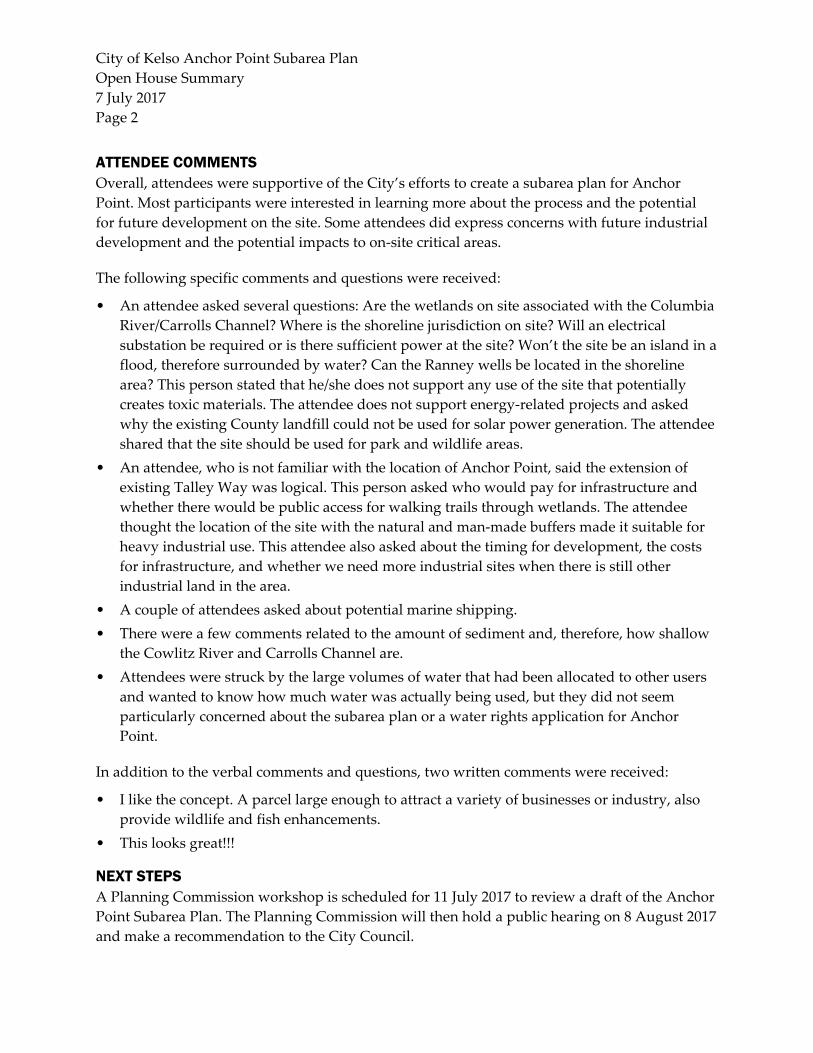
City of Kelso Anchor Point Subarea Plan
Open House Summary
7 July 2017
Page 2
ATTENDEE COMMENTS Overall, attendees were supportive of the City’s efforts to create a subarea plan for Anchor
Point. Most participants were interested in learning more about the process and the potential
for future development on the site. Some attendees did express concerns with future industrial
development and the potential impacts to on‐site critical areas.
The following specific comments and questions were received:
• An attendee asked several questions: Are the wetlands on site associated with the Columbia
River/Carrolls Channel? Where is the shoreline jurisdiction on site? Will an electrical
substation be required or is there sufficient power at the site? Won’t the site be an island in a
flood, therefore surrounded by water? Can the Ranney wells be located in the shoreline
area? This person stated that he/she does not support any use of the site that potentially
creates toxic materials. The attendee does not support energy‐related projects and asked
why the existing County landfill could not be used for solar power generation. The attendee
shared that the site should be used for park and wildlife areas.
• An attendee, who is not familiar with the location of Anchor Point, said the extension of
existing Talley Way was logical. This person asked who would pay for infrastructure and
whether there would be public access for walking trails through wetlands. The attendee
thought the location of the site with the natural and man‐made buffers made it suitable for
heavy industrial use. This attendee also asked about the timing for development, the costs
for infrastructure, and whether we need more industrial sites when there is still other
industrial land in the area.
• A couple of attendees asked about potential marine shipping.
• There were a few comments related to the amount of sediment and, therefore, how shallow
the Cowlitz River and Carrolls Channel are.
• Attendees were struck by the large volumes of water that had been allocated to other users
and wanted to know how much water was actually being used, but they did not seem
particularly concerned about the subarea plan or a water rights application for Anchor
Point.
In addition to the verbal comments and questions, two written comments were received:
• I like the concept. A parcel large enough to attract a variety of businesses or industry, also
provide wildlife and fish enhancements.
• This looks great!!!
NEXT STEPS A Planning Commission workshop is scheduled for 11 July 2017 to review a draft of the Anchor
Point Subarea Plan. The Planning Commission will then hold a public hearing on 8 August 2017
and make a recommendation to the City Council.

City of Kelso Anchor Point Subarea Plan
Open House Summary
7 July 2017
Page 3
Attachment 1. Public Open House Event Notice

City of Kelso Anchor Point Subarea Plan
Open House Summary
7 July 2017
Page 4
Attachment 2. Attendee Sign-In Sheet

City of Kelso Anchor Point Subarea Plan
Open House Summary
7 July 2017
Page 5

City of Kelso Anchor Point Subarea Plan
Open House Summary
7 July 2017
Page 6
Attachment 3. Open House Photos

City of Kelso Anchor Point Subarea Plan
Open House Summary
7 July 2017
Page 7

City of Kelso Anchor Point Subarea Plan
Open House Summary
7 July 2017
Page 8

City of Kelso Anchor Point Subarea Plan
Open House Summary
7 July 2017
Page 9


City of Kelso Anchor Point Subarea Plan Public Involvement Summary Kelso, Washington
Appendix D Community Survey Summary


Anchor Point Subarea Plan
Kelso, Washington Community Survey Summary
INTRODUCTION To solicit input from the public on the Anchor Point subarea planning process, the City of
Kelso’s consultant, BergerABAM, conducted an online community survey through
SurveyMonkey. Community survey respondents answered 11 questions related to potential
industrial development on the Anchor Point site. The survey was open from 9 June 2017 to
26 June 2017 and 14 people participated in the survey. A summary of responses is provided
below.
1. How long have you been a Kelso resident? If you do not live in Kelso, please indicate where you live?
Of the 14 respondents, 6 are Kelso residents that have lived in Kelso for an average of 15
years. Overall, the number of years respondents have lived in Kelso varied between 1 and
57 years. The remaining 8 respondents live relatively close to Kelso in the following
locations:
Castle Rock, Washington
Clark County, Washington
Longview, Washington
Onalaska, Washington
2. Do you work in the Kelso/Longview area? Seventy‐one percent of the respondents work in the Kelso/Longview area. Twenty‐nine
percent indicated they do not work in the Kelso/Longview area.
3. Approximately how far is your house/business from Anchor Point? Fifty percent of the respondents indicated they have a business or live within 5 miles of
Anchor Point. All but one of the remaining respondents have a business or live within 5 to
10 miles of Anchor Point. One respondent indicated they live more than 20 miles from
Anchor Point.

Anchor Point Community Survey Summary
July 2017
Page 2
4. If you work outside the area, approximately how far do you commute?
Fifty percent of the residents that live outside of the Kelso area have commutes of less than
10 miles. Thirteen percent of respondents have a commute of 20 to 30 minutes and the
remaining thirty‐eight percent of respondents have commutes greater than 40 miles.
50%
13%
38%
0% 10% 20% 30% 40% 50% 60%
Less than 10 miles
10 to 20 miles
20 to 30 miles
30 to 40 miles
Over 40 miles
Question 4. Commuting Distance

Anchor Point Community Survey Summary
July 2017
Page 3
5. In general, what types of industrial development do you think are most appropriate in Kelso? Select all that apply.
The majority of respondents indicated that the industries listed in the survey are
appropriate in Kelso (greater than 50 percent). Warehouse/distribution and high‐tech
manufacturing were the two industries that respondents believed were the most
appropriate in Kelso. Other responses to the survey included:
Costco
Aerospace/aviation manufacturing supply chain
Industrial hemp manufacturing
Cross‐laminated timber (CLT) manufacturing/building
Green sustainable products
”Clean” manufacturing
Office parks
93%
86%
79%
79%
79%
64%
29%
0% 10% 20% 30% 40% 50% 60% 70% 80% 90% 100%
Warehouse/distribution
High‐tech manufacturing
Fabrication
General Manufacturing
Light Industrial business park
Food Processing
Other (please specify)
Question 5. Appropriate Industrial Development

Anchor Point Community Survey Summary
July 2017
Page 4
6. What types of industrial development do you think would be most appropriate on Anchor Point? Select all that apply.
Similar to the responses to question 5, the majority of respondents—at least 50 percent—
thought that the following industries would be appropriate for Anchor Point:
Warehouse/distribution
General manufacturing
High‐tech manufacturing
Fabrication
Light Industrial business park
Food processing was the only industry type that less than 50 percent of respondents think is
appropriate for Anchor Point. Other responses included:
Aerospace/aviation supply chain
Industrial hemp manufacturing, CLT manufacturing, green/sustainable businesses
Mixed‐use development
None
71%
64%
64%
50%
50%
29%
36%
0% 10% 20% 30% 40% 50% 60% 70% 80%
Warehouse/distribution
General Manufacturing
High‐tech manufacturing
Fabrication
Light Industrial business park
Food Processing
Other (please specify)
Question 6. Appropriate Industrial Development for Anchor Point

Anchor Point Community Survey Summary
July 2017
Page 5
7. Are there specific industries you feel are not appropriate for Anchor Point? Please list. Of the total 14 respondents, 10 answered question 7 and 2 of those respondents indicated
there are no industries that they feel are inappropriate for Anchor Point. The 8 remaining
respondents listed several industries they thought would not be appropriate, including:
Heavy industry (heavy metals, chemical, industrial pollutants, and petroleum‐ or coal‐
related industries)
Food processing
Retail
Waste transfer
8. Do you have concerns regarding future industrial development on Anchor Point? For example, increased traffic, noise, air quality, environmental impacts, etc.
Survey respondents expressed several concerns associated with future development of the
Anchor Point site. Two respondents did not respond to this question and three responded
that they do not have any concerns. The remaining nine respondents had concerns that
included:
Traffic (access, infrastructure, bicycle and pedestrian options, and existing capacity)
Noise
Air quality
Environmental impacts
Visual aesthetics/design considerations
The potential for increased traffic and impacts on the existing road network was the most
common concern expressed by survey respondents.
9. How could the plan address your concerns? Nine respondents provided feedback on this question. Respondents stated several ways the
plan could address their concerns, including ensuring a transparent planning process and
the development of a plan that adequately addresses the environmental constraints and
impacts of future development. Respondents also included that addressing traffic impacts,
such as signalization and train scheduling, would help address their concerns.
10. What do you think the City’s role should be in facilitating future development on Anchor Point? For example, investment in infrastructure, expedited permitting, regulatory
changes.
Survey respondents had a wide variety of opinions on what the City’s role should be in
facilitating future development on Anchor Point. Responses included the following:
Infrastructure investment (roads, signalization, soil compaction, land preparation, etc.)
Environmental considerations (consider area for a wetlands mitigation bank)

Anchor Point Community Survey Summary
July 2017
Page 6
Expedited permitting (potentially offered to businesses with proven safety record for
products and the environment)
Streamlining permitting in association with development plans rather than expedited
permitting
Design review
Marketing of the City to attract businesses that can benefit the area
11. Is there anything else you would like to add? Respondents to the survey provided additional thoughts and feedback on potential
industrial development at the Anchor Point site. Overall, survey respondents thought this
was a good opportunity for Kelso and Cowlitz County. Additional feedback included an
emphasis on the following:
The planning process should consider environmental impacts.
A long‐term planning approach is better than short‐term benefits.
Importance of family‐wage and skilled labor jobs.
Significance of public leadership in ensuring the development process meets local
standards.
Consideration of land uses besides industrial, including mixed‐use or retail.
CONCLUSION The City of Kelso will consider the feedback summarized in the above survey results in
finalizing the subarea plan and submitting it to the Planning Commission for review. A
Planning Commission workshop is scheduled for 11 July 2017 to review the draft subarea plan.