Embed Size (px)
Citation preview
DOWNTOWN AND COUNTY
GOVERNMENT CAMPUS SUBAREA PLAN
City of Port Orchard, WAOctober 28, 2020
DRAFT
2
DRAFT
3Port Orchard Subarea Plan | Port Orchard, WA | 11.12.2020
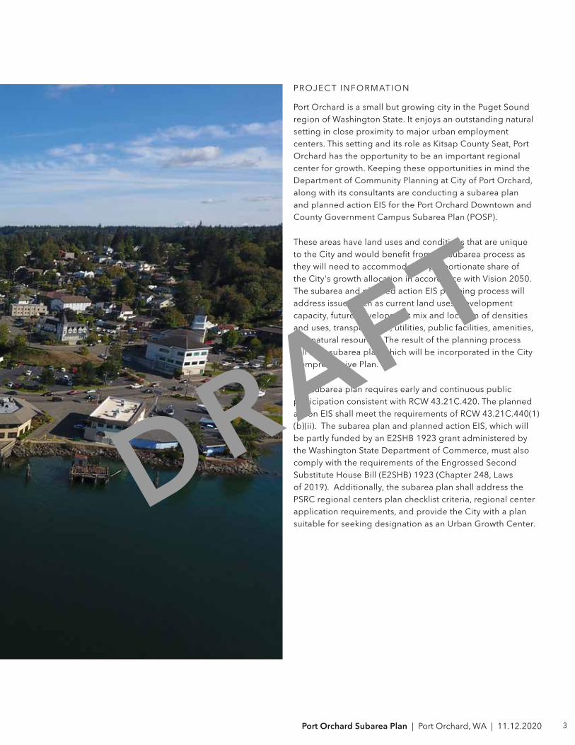
PROJEC T INFORMATION
Port Orchard is a small but growing city in the Puget Sound region of Washington State. It enjoys an outstanding natural setting in close proximity to major urban employment centers. This setting and its role as Kitsap County Seat, Port Orchard has the opportunity to be an important regional center for growth. Keeping these opportunities in mind the Department of Community Planning at City of Port Orchard, along with its consultants are conducting a subarea plan and planned action EIS for the Port Orchard Downtown and County Government Campus Subarea Plan (POSP).
These areas have land uses and conditions that are unique to the City and would benefit from the subarea process as they will need to accommodate a proportionate share of the City's growth allocation in accordance with Vision 2050. The subarea and planned action EIS planning process will address issues such as current land uses, development capacity, future development mix and location of densities and uses, transportation, utilities, public facilities, amenities, and natural resources. The result of the planning process will be a subarea plan which will be incorporated in the City Comprehensive Plan.
The subarea plan requires early and continuous public participation consistent with RCW 43.21C.420. The planned action EIS shall meet the requirements of RCW 43.21C.440(1)(b)(ii). The subarea plan and planned action EIS, which will be partly funded by an E2SHB 1923 grant administered by the Washington State Department of Commerce, must also comply with the requirements of the Engrossed Second Substitute House Bill (E2SHB) 1923 (Chapter 248, Laws of 2019). Additionally, the subarea plan shall address the PSRC regional centers plan checklist criteria, regional center application requirements, and provide the City with a plan suitable for seeking designation as an Urban Growth Center.
DRAFT
City of Port Orchard
Department of Community Development216 Prospect Street Port Orchard, WA 98366planning @cityofportorchard.us
Mayor:Robert Putaansuu
City Council Members:Bek Ashby John Clauson Fred Chang Cindy Lucarelli Scott Diener Jay Rosapepe Shawn Cucciardi
Planning Commission:Trish Tierney Stephanie Bailey Annette Stewart Mark Trenary David Bernstein Phil King Joe Morrison Suanne Martin Smith
City Staff:Nicholas Bond, AICP, Director Keri Sallee, Long Range Planner Jim Fisk, Associate Planner Stephanie Andrews, Associate Planner
Contact:Nick [email protected] [email protected]
ACKNOWLEDGMENTS
5Port Orchard Subarea Plan | Port Orchard, WA | 11.12.2020
CONSULTANT TEAM
Urban Design, Architect
GGLO1301 First Avenue, Suite 300Seattle, WA 98101 Contact:Jeff [email protected] [email protected]
Engineers and Environmental Services
EA Engineering, Science and Technology, Inc., PBC2200 6th Ave #707, Seattle, WA 98121Contact:Rich [email protected]
Civil Engineer - Storm Water
Reid Middleton, Inc.728 134th Street SW, Suite 200Everett, WA 98204Contact:Julian [email protected]
Real Estate and Economic Analysis
Heartland1301 First Avenue, Suite 200Seattle, WA 98101Contact:Mark [email protected]
Civil Engineer - Sanitary Sewer and Water Infrastructure
BHC Consultants, LLC1601 Fifth Avenue, Suite 500Seattle, WA 98101Contact:John [email protected]
Transportation Engineer
Transportation Solutions, Inc.8250 165th Ave NE, Suite 100Redmond, WA 98052Contact:Andrew [email protected]
6
CONTENTS
09 SECTION 1 - INTRODUCTION
1.1 INTRODUCTION
1.2 STUDY AREA
1.3 PSRC FRAMEWORK
15 SECTION 2 - EXISTING CONDITIONS SUMMARY ANALYSIS
2.1 HISTORY
2.2 RECENT ACHIEVEMENTS AND CURRENT PLANNING
2.3 EXISTING BUILT FORM AND CONTEXT
2.4 PREVIOUS PLANNING EFFORTS
2.5 EXISTING LAND USE AND ZONING
2.6 CIRCULATION, ACCESS AND PARKING
2.7 UTILITIES
2.8 ENVIRONMENT AND OPEN SPACE
2.9 MARKET CONDITIONS ASSESSMENT
2.9.1 ECONOMIC PROFILE
2.9.2 DEVELOPMENT PIPELINE
2.9.3 BUILD-ABLE LANDS
2.9.4 BASELINE ASSESSMENT AND ACTIVITY UNITS
2.9.5 MARKET YIELD ASSESSMENT
59 SECTION 3 - DRAFT SUBAREA PLAN GOALS AND VISION
3.1 PROPOSED ALTERNATIVES
3.2 URBAN DESIGN FRAMEWORK
3.2.1 WEST DOWNTOWN
3.2.2 EAST DOWNTOWN
DRAFT

7Port Orchard Subarea Plan | Port Orchard, WA | 11.12.2020
CONTENTS
3.2.3 COUNTY GOVERNMENT CAMPUS
3.3 LAND USE AND HOUSING
3.4 ENVIRONMENT AND OPEN SPACE
3.5 CIRCULATION, ACCESS, AND PARKING
SECTION 06 - APPENDIX
A - PUBLIC OUTREACH PLAN AND OUTREACH SUMMARY
B - HEARTLAND ECONOMIC PROFILE AND BUILD-ABLE LANDS ANALYSIS
C - RELATED PLANS AND REFERENCES
DRAFT

8
INTENTIONALLY LEFT BLANK
DRAFT
9Port Orchard Subarea Plan | Port Orchard, WA | 11.12.2020
SECTION 01 | INTRODUCTION
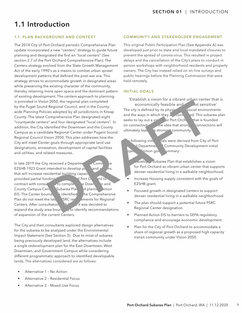
1.1 Introduction
1.1. PL AN BACKGROUND AND CONTE X T
The 2014 City of Port Orchard periodic Comprehensive Plan update incorporated a new "centers" strategy to guide future planning and designated the first en "local centers" (See section 2.7 of the Port Orchard Comprehensive Plan). The Centers strategy evolved from the State Growth Management Act of the early 1990's as a means to combat urban sprawl development patterns that defined the post-war era. This strategy strives to accommodate growth in designated areas while preserving the existing character of the community, thereby retaining more open space and the dominant pattern of existing development. The centers approach to planning is provided in Vision 2050, the regional plan completed by the Puget Sound Regional Council, and in the County-wide Planning Policies adopted by all jurisdictions in Kitsap County. The latest Comprehensive Plan designated eight “countywide centers” and four designated “local centers”. In addition, the City identified the Downtown and the County Campus as a candidate Regional Center under Pugent Sound Regional Council Vision 2050. This plan addresses how the City will meet Center goals through appropriate land use designations, annexation, development of capital facilities and utilities, and related measures.
In late 2019 the City received a Department of Commerce E2SHB 1923 Grant intended to develop plans and actions that will increase residential building capacity. The grant provided partial funding for the City of Port Orchard to contract with consultants to complete the Downtown and County Campus Centers Subarea Plan and planned action EIS. The Center boundaries identified in the Comprehensive Plan do not meet the latest PSRC requirements for Regional Centers. After consultation with PSRC it was decided to expand the study area boundary to identify recommendations of expansion of the current Centers.
The City and their consultants explored design alternatives for the subarea to be analyzed under the Environmental Impact Statement (See Section 3). Due to most of subarea being previously developed land, the alternatives include a single redevelopment plan for the East Downtown, West Downtown, and Government Campus while considering different programmatic approach to identified developable lands. The alternatives considered are as follows:
• Alternative 1 – No Action
• Alternative 2 – Residential Focus
• Alternative 3 – Mixed-Use Focus
COMMUNIT Y AND S TAKEHOLDER ENGAGEMENT
This original Public Participation Plan (See Appendix A) was developed just prior to state and local mandated closures to prevent the spread of corona-virus. This resulted in project delays and the cancellation of the City’s plans to conduct in person workshops with neighborhood residents and property owners. The City has instead relied on on-line surveys and public hearings before the Planning Commission that were held remotely.
INITIAL GOAL S
‘Establish a vision for a vibrant urban center that is economically feasible and context sensitive‘
The city is defined by its physical and social environments and the ways in which they are connected. This subarea plan seeks to lay out a vision for Port Orchard that is founded on connectivity and the idea that stronger connections will ultimately lead to a stronger community.
The following initial goals were derived from City of Port Orchard Department of Community Development initial project definition goals summary:
• Develop a Subarea Plan that establishes a vision for Port Orchard as vibrant urban center that supports denser residential living in a walkable neighborhood.
• Increase Housing supply consistent with the goals of E2SHB grant.
• Focused growth in designated centers to support denser residential living in a walkable neighborhood.
• The plan should support a potential future PSRC Regional Center designation.
• Planned Action EIS to barriers to SEPA regulatory compliance and encourage economic development.
• Plan for the City of Port Orchard to accommodate a share of regional growth as a proposed high capacity transit community under Vision 2050.
DRAFT
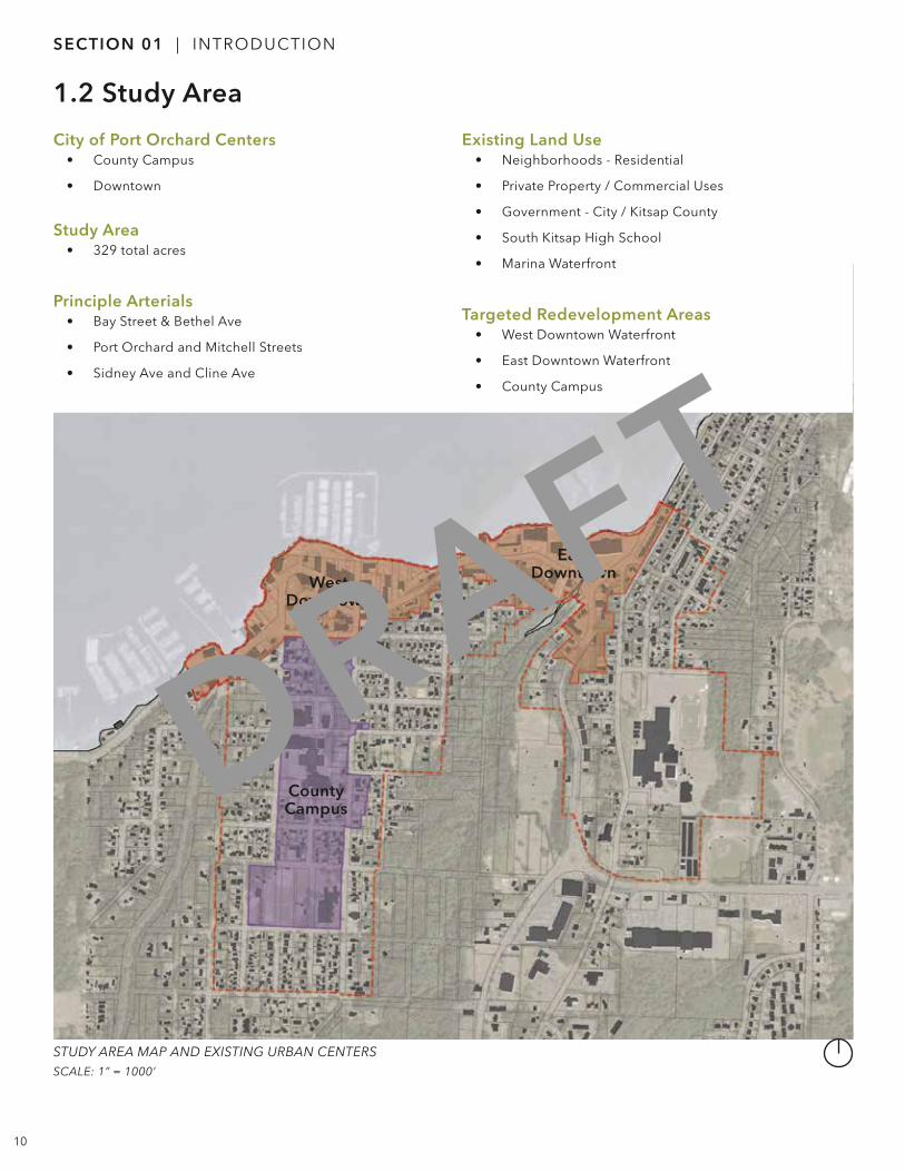
STUDY AREA MAP AND EXISTING URBAN CENTERS SCALE: 1” = 1000’
10
City of Port Orchard Centers• County Campus
• Downtown
Study Area• 329 total acres
Principle Arterials• Bay Street & Bethel Ave
• Port Orchard and Mitchell Streets
• Sidney Ave and Cline Ave
Existing Land Use• Neighborhoods - Residential
• Private Property / Commercial Uses
• Government - City / Kitsap County
• South Kitsap High School
• Marina Waterfront
Targeted Redevelopment Areas• West Downtown Waterfront
• East Downtown Waterfront
• County Campus
SECTION 01 | INTRODUCTION
CountyCampus
WestDowntown
East Downtown
1.2 Study Area
DRAFT
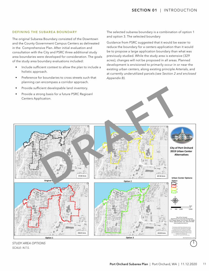
STUDY AREA OPTIONSSCALE: N.T.S.
11Port Orchard Subarea Plan | Port Orchard, WA | 11.12.2020
SECTION 01 | INTRODUCTION
BAY
SIDN
EY
RETS
IL
MIT
CHEL
L
CLIN
E
HULL
BETH
EL
TRAC
Y
KITSAP
MILE HILL
SROUFE
PORT
ORC
HARD
PERR
Y
WES
T
FARR
AGUT
SMITH
MAPLE
KENDALL
3RD
DEKALB
ARNO
LD
TACO
MA
WOLVES
KARC
HER
SEAT
TLE
DIVISION
TAYLOR
4TH
HIGH DWIGHT
LINCOLN
2ND
ADA
AUST
IN
1ST
PROSPECT
PLISKO
ROCK
WEL
L
SPO
KANE
MAHAN
PORT
LAND
GARR
ISON
PION
EER
MORTON
GRAN
T
ANNIES
STOCKTON
EDW
ARDS
MELCHER
SWEANY
HARR
ISON
WATER
GUY WETZEL
MYS
TERY
DECA
TUR
SUTT
ON
PORT
REDWOOD
KINSLEY
ORCH
ARD
PROSPECT
DIVISIONDIVISION
TAYLOR
MAP
LE
TAYLORHARR
ISON
SEATTLE
MELCHER
KITSAP
DWIGHT
AUST
IN
GRAN
T
HARR
ISON
DEKALB
SMITH
GARR
ISON
DWIGHT
WES
T
DEKALB
SWEANY
BAY
SIDN
EY
RETS
IL
MIT
CHEL
L
CLIN
E
HULL
BETH
EL
TRAC
Y
KITSAP
MILE HILL
SROUFE
PORT
ORC
HARD
PERR
Y
WES
T
FARR
AGUT
SMITH
MAPLE
KENDALL
3RD
DEKALB
ARNO
LD
TACO
MA
WOLVES
KARC
HER
SEAT
TLE
DIVISION
TAYLOR
4TH
HIGH DWIGHT
2ND
LINCOLN
ADA
AUST
IN
1ST
PROSPECT
PLISKO
ROCK
WEL
L
SPO
KANE
MAHAN
PORT
LAND
GARR
ISON
PION
EER
MORTON
GRAN
T
ANNIES
STOCKTON
EDW
ARDS
MELCHER
SWEANY
HARR
ISON
WATER
GUY WETZEL
MYS
TERY
DECA
TUR
SUTT
ON
PORT
REDWOOD
KINSLEY
ORCH
ARD
PROSPECT
DIVISIONDIVISION
TAYLOR
MAP
LE
TAYLORHARR
ISON
SEATTLE
MELCHER
KITSAP
DWIGHT
AUST
IN
GRAN
T
HARR
ISON
DEKALB
SMITH
GARR
ISON
DWIGHT
WES
T
DEKALB
SWEANY
BAY
SIDN
EY
RETS
IL
MIT
CHEL
L
CLIN
E
HULL
BETH
EL
TRAC
Y
KITSAP
MILE HILL
SROUFE
PORT
ORC
HARD
PERR
Y
WES
T
FARR
AGU
T
SMITH
MAPLE
KENDALL
3RD
DEKALB
ARNO
LD
TACO
MA
WOLVES
KARC
HER
SEAT
TLE
DIVISION
TAYLOR
4TH
HIGH DWIGHT
LINCOLN
2ND
ADA
AUST
IN
1ST
PROSPECT
PLISKO
ROCK
WEL
L
SPO
KANE
MAHAN
PORT
LAND
GARR
ISON
PION
EER
MORTON
GRAN
T
ANNIES
STOCKTON
EDW
ARDS
MELCHER
SWEANY
HARR
ISON
WATER
GUY WETZEL
MYS
TERY
DECA
TUR
SUTT
ON
PORT
REDWOOD
KINSLEY
ORCH
ARD
PROSPECT
DIVISIONDIVISION
TAYLOR
MAP
LETAYLORHA
RRIS
ON
SEATTLE
MELCHER
KITSAP
DWIGHT
AUSTIN
GRAN
T
HARR
ISON
DEKALB
SMITH
GARR
ISON
DWIGHT
WES
T
DEKALB
SWEANY
BAY
SIDN
EY
RETS
IL
MIT
CHEL
L
CLIN
E
HULL
BETH
EL
TRAC
Y
KITSAP
MILE HILL
SROUFE
PORT
ORC
HARD
PERR
Y
WES
T
FARR
AGUT
SMITH
MAPLE
KENDALL
3RD
DEKALB
ARNO
LD
TACO
MA
WOLVES
KARC
HER
SEAT
TLE
DIVISION
TAYLOR
4TH
HIGH DWIGHT
LINCOLN
2ND
ADA
AUST
IN
1ST
PROSPECT
PLISKO
ROCK
WEL
L
SPO
KANE
MAHAN
PORT
LAND
GARR
ISON
PION
EER
MORTON
GRAN
T
ANNIES
STOCKTON
EDW
ARDS
MELCHER
SWEANY
HARR
ISON
WATER
GUY WETZEL
MYS
TERY
DECA
TUR
SUTT
ON
PORT
REDWOOD
KINSLEY
ORCH
ARD
PROSPECT
DIVISIONDIVISION
TAYLOR
MAP
LE
TAYLORHARR
ISON
SEATTLE
MELCHER
KITSAP
DWIGHT
AUST
IN
GRAN
T
HARR
ISON
DEKALB
SMITH
GARR
ISON
DWIGHT
WES
T
DEKALB
SWEANY
Original Centers
Option 1
Option 2
Option 3
Urban Center OptionsOption
0
1
2
3
119.82 Acres
µ0 1,000 2,000500
Feet
222.84 Acres
Map Prepared January 17, 2020
City of Port Orchard2019 Urban Center
Alternatives
This map was created from existing map sources,not from field surveys. While great care was takenin using the most current map sources available,
no warranties of any sort, including accuracy, fitness,or merchantability accompany this product. The user
of this map assumes responsibility for determining its suitability for its intended use.
This map is not a substitute for field survey.
City of Port Orchard Department of Community Development
216 Prospect Street, Port Orchard, WA 98366Phone: (360) 874-5533 Fax: (360) 876-4980
www.cityofportorchard.us
207.83 Acres
258.81 Acres
DEFINING THE SUBARE A BOUNDARY
The original Subarea Boundary consisted of the Downtown and the County Government Campus Centers as delineated in the Comprehensive Plan. After initial evaluation and consultation with the City and PSRC three additional study area boundaries were developed for consideration. The goals of the study area boundary evaluations included:
• Include sufficient context to allow the plan to include a holistic approach.
• Preference for boundaries to cross streets such that planning can encompass a corridor approach.
• Provide sufficient developable land inventory.
• Provide a strong basis for a future PSRC Regioanl Centers Application.
The selected subarea boundary is a combination of option 1 and option 3. The selected boundary
Guidance from PSRC suggested that it would be easier to reduce the boundary for a centers application than it would be to propose a large application boundary than what was previously studied. While the study area is extensive (329 acres), changes will not be proposed in all areas. Planned development is envisioned to primarily occur in or near the existing urban centers, along existing principle Arterials, and at currently underutilized parcels (see Section 2 and enclosed Appendix B).
DRAFT
12
1.3 PSRC Urban Countywide Growth Centers Framework
SECTION 01 | INTRODUCTION
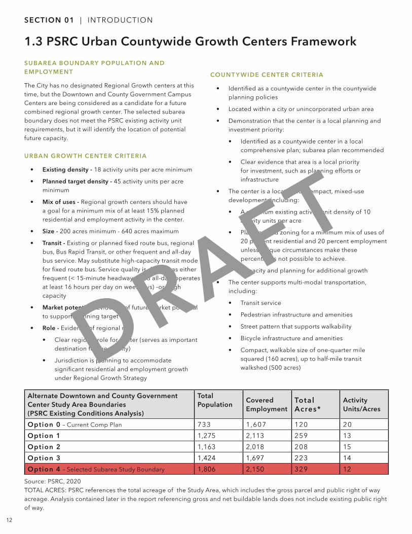
SUBARE A BOUNDARY POPUL ATION AND EMPLOY MENT
The City has no designated Regional Growth centers at this time, but the Downtown and County Government Campus Centers are being considered as a candidate for a future combined regional growth center. The selected subarea boundary does not meet the PSRC existing activity unit requirements, but it will identify the location of potential future capacity.
URBAN GROW TH CENTER CRITERIA
• Existing density - 18 activity units per acre minimum
• Planned target density - 45 activity units per acre minimum
• Mix of uses - Regional growth centers should have a goal for a minimum mix of at least 15% planned residential and employment activity in the center.
• Size - 200 acres minimum - 640 acres maximum
• Transit - Existing or planned fixed route bus, regional bus, Bus Rapid Transit, or other frequent and all-day bus service. May substitute high-capacity transit mode for fixed route bus. Service quality is defined as either frequent (< 15-minute headways) and all-day (operates at least 16 hours per day on weekdays) –or- high capacity
• Market potential - Evidence of future market potential to support planning target
• Role - Evidence of regional role
• Clear regional role for center (serves as important destination for the county)
• Jurisdiction is planning to accommodate significant residential and employment growth under Regional Growth Strategy
COUNT Y WIDE CENTER CRITERIA
• Identified as a countywide center in the countywide planning policies
• Located within a city or unincorporated urban area
• Demonstration that the center is a local planning and investment priority:
• Identified as a countywide center in a local comprehensive plan; subarea plan recommended
• Clear evidence that area is a local priority for investment, such as planning efforts or infrastructure
• The center is a location for compact, mixed-use development; including:
• A minimum existing activity unit density of 10 activity units per acre
• Planning and zoning for a minimum mix of uses of 20 percent residential and 20 percent employment unless unique circumstances make these percentages not possible to achieve.
• Capacity and planning for additional growth
• The center supports multi-modal transportation, including:
• Transit service
• Pedestrian infrastructure and amenities
• Street pattern that supports walkability
• Bicycle infrastructure and amenities
• Compact, walkable size of one-quarter mile squared (160 acres), up to half-mile transit walkshed (500 acres)
Alternate Downtown and County Government Center Study Area Boundaries(PSRC Existing Conditions Analysis)
Total Population
Covered Employment
Total Acres*
Activity Units/Acres
Option 0 – Current Comp Plan 733 1,607 120 20
Option 1 1,275 2,113 259 13
Option 2 1,163 2,018 208 15
Option 3 1,424 1,697 223 14
Option 4 – Selected Subarea Study Boundary 1,806 2,150 329 12
Source: PSRC, 2020TOTAL ACRES: PSRC references the total acreage of the Study Area, which includes the gross parcel and public right of way acreage. Analysis contained later in the report referencing gross and net buildable lands does not include existing public right of way.
DRAFT

13Port Orchard Subarea Plan | Port Orchard, WA | 11.12.2020
SECTION 01 | INTRODUCTION
INTENTIONALLY LEFT BLANK
DRAFT