Embed Size (px)
Citation preview

Nat. Hazards Earth Syst. Sci., 10, 1101–1113, 2010www.nat-hazards-earth-syst-sci.net/10/1101/2010/doi:10.5194/nhess-10-1101-2010© Author(s) 2010. CC Attribution 3.0 License.
Natural Hazardsand Earth
System Sciences
Analysis of volcanic threat from Nisyros Island, Greece,with implications for aviation and population exposure
H. S. Kinvig1,*, A. Winson1,*, and J. Gottsmann1
1Department of Earth Sciences, University of Bristol, Wills Memorial Building, Queen’s Road, Bristol, BS8 1RJ, UK* these authors contributed equally to this work
Received: 27 January 2010 – Revised: 19 May 2010 – Accepted: 21 May 2010 – Published: 7 June 2010
Abstract. Nisyros island in the South Aegean volcanic arc,Greece, is a Quaternary composite volcano with a 3.8 kmwide caldera that in 1996 entered a volcano-seismic crisis,which heralded the islands’ return to a state of unrest. Thecaldera has been the locus of at least thirteen phreatic erup-tions in historical times, the most recent in 1888, and thesystem is still presently affected by considerable hydrother-mal activity. Although the recent unrest waned off withouteruption, there are still open questions relating to the currentthreat of volcanic activity from the island. Here, we per-form a detailed and systematic assessment of the volcanicthreat of Nisyros using a threat analysis protocol establishedas part of the USGS National Volcano Early Warning Sys-tem (NVEWS). The evaluation involves a methodical assess-ment of fifteen hazard and exposure factors, and is based ona score system, whereby the higher the score, the higher thethreat is. Uncertainty in assessment criteria are expressed byallowing for a conservative and an extreme score for eachfactor. We draw our analysis from published data as well asfrom results of our research on Nisyros over the past years.Our analysis yields a conservative threat score of 163 andan extreme score of 262. The most adverse exposure factorsinclude significant scores relating to aviation and populationexposure to volcanic hazards from Nisyros. When lookedat in comparison to US volcanoes both scores place Nisy-ros in the “Very High Threat (VHT)” category, grouping itwith volcanoes such as Redoubt, Mount Ranier and CraterLake. We identify a short-fall in recommended surveillanceefforts for VHT volcanoes given existing monitoring capabil-ities on the island. We discuss potential pitfalls of applyingthe NVEWS scheme to Nisyros and suggest potential adapta-
Correspondence to:J. Gottsmann([email protected])
tion of analysis scheme to match industrial and societal con-ditions in Europe. At the same time, our findings indicatethat that volcanic threat posed by Nisyros volcano may cur-rently be underestimated.
1 Introduction
Nisyros Island is an 8 km wide Quaternary composite vol-cano, which constitutes the eastern most edge of the SouthAegean volcanic island arc, Greece (Fig. 1). The mostconspicuous geologic feature of Nisyros is its 3.8 km widecaldera, which is thought to have formed during a largeexplosive rhyolitic eruption∼45 ka before present (Vou-gioukalakis, 1998), and has since been partially refilled bydacitic domes (Figs. 1 and 2). Historically, there have been13 phreatic eruptions in the caldera, most recently during1871–1873 and in 1888 (Marini et al., 1993). More recently,in 1996–1998, Nisyros experienced a volcano-seismic crisis,accompanied by ground uplift of more than 10 cm, indicat-ing a period of unrest (Papadopoulos et al., 1998). Nisyrosvolcano presents an opportunity to study the threat posed bya relatively small volcano situated in an arc-island setting inboth Europe and a region of significant seasonal populationexposure. The island is easily accessible and despite only asmall stable population, Nisyros and surrounding areas areexposed to a large transient tourist population.
There have been several notable attempts to develop vol-canic hazard and risk ranking systems with the purpose of de-termining, which volcanoes are most dangerous and warrantfurther study and monitoring (Ewert, 2007). These systemshave been applied in the US (Bailey and Survey, 1983; Ew-ert, 2005), Papua New Guinea (Lowenstein and Talai, 1984)and globally (Yokoyama, 1984) with varying success.
Published by Copernicus Publications on behalf of the European Geosciences Union.

1102 H. S. Kinvig et al.: Analysis of volcanic threat from Nisyros Island
Fig. 1. (a)Map of the Dodecanese region of the Aegean indicatinglocation of Nisyros. For a regional context see Fig. 5.(b) Color-coded digital elevation model of Nisyros from SRTM 90 m data in-dicating location of main population centres of the island, the hy-drothermally active caldera floor (HT) and the post-caldera domes(D).
Bailey and Survey (1983) were the first to attempt to de-velop a general assessment of the potential for future erup-tions in the United States. This was done in response toheightened public awareness of the vulnerability of popula-tions to geological hazards following the 1980 eruption ofMount St Helens. The system groups volcanoes based ontheir most recent eruption and the eruption periodicities. Thisassessment is helpful in showing similarities between volca-noes but does not involve enough detailed analysis to providea quantifiable threat score.
Lowenstein and Talai (1984) developed a system to rankvolcanoes in Papua New Guinea by using a “danger score”.This system treated active and dormant volcanoes differ-ently, where an active volcano was defined as one that haderupted in historical times (Lowenstein and Talai, 1984).Dormant volcanoes were those with particularly youthful
Fig. 2. Panoramic image towards the NE showing the caldera floor(the Laki plain) and the hydrothermally active area as well as theexposed caldera wall. The phreatic Stefanos crater is located inthe centre together with other phreatic craters and domes to its left.Post-caldera dacitic domes mark the left border of the image. Thewidth of view is about 3 km.
morphological features, active or recently active fumarolesand indigenous stories or legends of eruptions (Lowensteinand Talai, 1984). The system included factors based on geo-logical features, historically recorded hazardous phenomena,and present features. The hazard factors were then summedwith the population data to generate a potential hazard rating.
Yokoyama et al. (1984) developed a system to evaluateall the volcanoes in the world as part of a UNESCO/UNEPstudy. The goal of the study was to review the status of theexisting volcano – monitoring capabilities of the countries inthe world and to prioritise the resources for mitigating vol-canic hazards worldwide. The assessment was carried outon all the active volcanoes in the world. In this case “activevolcanoes” were classified as volcanoes that have erupted inhistorical times or that still retain some fumarolic fields. Thisscheme involved using ten hazard factors and seven risk fac-tors that are scored; these results are then summed to identifyhigh risk volcanoes. Volcanoes receiving a total score of 10or greater were “arbitrarily” identified as “high risk”.
NVEWS, the system that we will use to generate a threatscore for Nisyros in this paper, was built on the previ-ous works mentioned above. It is the most comprehensivescheme developed to date, as it incorporates both volcanichazard and exposure factors in greater detail then any of theprevious three. Most importantly, the evaluation is targetedtowards the assessment of threat and therefore deviates sig-nificantly from the aforementioned schemes.
2 NVEWS threat scheme
The National Volcano Early Warning System (NVEWS)(Ewert, 2007) is intended to assess the threat posed by vol-canoes in the US by devising an analysis scheme that in-volves the assessment of several factors. Broadly, the factorscan be divided into those associated with a hazard (i.e. thedangerous/destructive natural phenomena produced by a vol-cano) or an exposure to assets (human and financial) poten-tially affected by the realisation of the hazard. The schemeworks by assigning values to a series of questions, allow-ing a threat score to be generated for the volcano. There are
Nat. Hazards Earth Syst. Sci., 10, 1101–1113, 2010 www.nat-hazards-earth-syst-sci.net/10/1101/2010/

H. S. Kinvig et al.: Analysis of volcanic threat from Nisyros Island 1103
15 hazard factors including seismicity within 20 km of a vol-cano, ground deformation in response to magma intrusionand gross changes to existing hydrothermal systems and de-gassing. The exposure factors include an assessment of thepopulation within a 30 km radius of the active volcanic cen-tre, the local aviation exposure and an assessment of localpower infrastructure. The goal of this system is to create athreat ranking of volcanoes so that an appropriate level ofmonitoring can be assessed (Ewert et al., 2005). The prin-ciple of the NVEWS scheme is that the degree and type ofearly warning monitoring at a particular volcano should beappropriate to the threat it poses. To achieve optimum vol-cano monitoring it is suggested by NVEWS to use an inte-grated combination of approaches such as ground-based, air-borne and remote sensing; with the rational that data fromadequately-monitored volcanoes enable scientists to assessensuing scenarios before they manifest, in contrast to activ-ity that remains unforeseen due to a lack of data. Here weapply the scheme to Nisyros to inform on the current threatlevel in the context of the NVEWS ranking.
In this paper we will be using the terms “Risk”, “Threat”,and “Vulnerability” as defined by the International Charter.“Threat” is defined as the frequency of potentially adverseevents, and in this case we can define threat as the physi-cal products of the volcano such gas emissions or pyroclas-tic flows. “Vulnerability” is the likelihood of success of aparticular threat category against a particular organisation orindividual and can usually be expressed as a “percentage oflikelihood”. The “Risk” is defined as a product of the threat,vulnerability and the total cost of the impact of a particularthreat, experienced by a vulnerable target. It is important tonote that in the context of this paper we will be generatinga threat assessment and not a risk assessment. The latter isbeyond the scope of this work as no attempt has been madeto quantify potential losses accompanying the realisation ofthreats from Nisyros.
3 A brief summary of the geological evolution of Nisy-ros and the recent episode of volcano unrest
The island of Nisyros is part of the Southern Aegean ActiveVolcanic Arc in Greece. This region is the site of active plateconvergence with calc-alkaline volcanism along the arc ini-tiating in the Tertiary as a result of northwards subductionof the African plate beneath the Aeagean-Anatolian plates(Innocenti, 1981; Papazachos et al., 2005). Other importantvolcanoes in this arc chain include Santorini, Milos, Porosand Methana. Nisyros hosts a 3.8 km wide caldera at its cen-tre (Fig. 2), and is itself considered to have developed onthe inferred edge of the larger submarine caldera created bythe region’s largest eruption – that of the Kos Plateau Tuff(KPT) 161 ka (Smith et al., 1996; Allen, 2001; Pe-Piper andPiper, 2005). Nisyros began its evolution with the subma-rine build up of basaltic-andesitic pillow lavas and hyalo-
clastites and eventually emerged above sea level allowing thedevelopment of a subaerial edifice. The inception of volcan-ism is poorly constrained, but deposits attributed to the KPTeruption are found at the top of the submarine lava sequence(Keller, 1971; Volentik et al., 2005) indicating that the onsetof subaerial volcanism was younger than 161 ka (Smith et al.,1996). Cone building continued with alternating episodes ofexplosive and more effusive activity gradually generating acomplex strato-volcano composed of tephra and lavas, witheruptive products ranging from basaltic-andesites to rhyolites(e.g. Volentik et al., 2005). Nisyros’ central caldera has beenattributed to the most recent of this explosive activity, associ-ated with two large Plinian eruptions (Lower Pumice and Up-per Pumice) (Limburg and Varekamp, 1991; Vougioukalakis,1998; Hardimann, 1999; Volentik et al., 2005).
The timing of volcanic activity on Nisyros is poorly con-strained despite numerous attempts at age dating by severaltechniques. Estimated ages for the Lower and Upper Pumicedeposits associated with caldera formation are spread over alarge range between 110±40 ka (Barberi et al., 1988, by fis-sion tracking in volcanic glass) and 24 ka (Vinci, 1983, 1985by the extrapolation of sedimentation rates), but some consis-tency is shown for an age of∼45 ka with14C dating of char-coal found in Upper Pumice surges yielding≥44 ka (Lim-burg and Varekamp, 1991), and correlation of a widespreadtephra marker found across the north Aegean with glass fromthe Lower and Upper Pumice, dated to ca. 46±6 ka (Margariet al., 2007; Aksu et al., 2008; Pyle and Margari, 2009).
Post-caldera volcanism is represented by the extrusion andgrowth of NE-SW aligned rhyo-dacitic lava domes whichtoday fill the western half of the caldera and spill over itssouth-western rim (Seymour and Vlassopoulos, 1989; Lim-burg and Varekamp, 1991; Volentik et al., 2005). The domesdenote the most recent magmatic eruptions on Nisyros, butthere has since been significant hydrothermal activity belowthe caldera floor and there have been thirteen phreatic erup-tions in historic times, most recently in 1871–1873 and 1888(Marini et al., 1993; Caliro et al., 2005). These phreaticeruptions were characterised by the formation of phreaticcraters, discharge of fumarolic fluids, H2S and associatedearthquakes (Marini et al., 1993). Today Nisyros is a site ofintense hydrothermal activity with surface expressions cov-ering an area of approximately 0.9 km2 in the southern partof the caldera floor; including active fumaroles, boiling mudpools, diffuse degassing of CO2 and additionally coastal hotsprings (Figs. 2 and 3).
In 1996–1998, Nisyros showed signs of unrest with a seis-mic crisis accompanied by intense ground deformation andincreased activity and geochemical variations of the island’sfumaroles (Papadopoulos et al., 1998; Sachpazi et al., 2002;Lagios et al., 2005; Caliro et al., 2005). During this period,more than 1600 earthquakes occurred (Papadopoulos et al.,1998). Sachpazi et al. (2002) suggest that these events werecompatible with the intrusion of a magmatic body at shal-low depth within the crust of the Nisyros region, rather than
www.nat-hazards-earth-syst-sci.net/10/1101/2010/ Nat. Hazards Earth Syst. Sci., 10, 1101–1113, 2010

1104 H. S. Kinvig et al.: Analysis of volcanic threat from Nisyros Island
Fig. 3. Plot of surface temperature data recorded at 20 cm depthinside Stefanos crater in May 2008. The data were obtained usinga K-type thermocouple and data logger over a grid of measurementpoints at 5 m spacing. The data are georeferenced and superim-posed over a high-precision digital elevation model obtained fromkinematic GPS surveying in May 2008.
being attributed to regional tectonic motions. Ground uplift,with a maximum amplitude of 14 cm, was recorded by In-SAR and GNSS (Lagios et al., 2005) during the crisis, thiswas followed by ground subsidence from 1999 onwards.
4 Volcanic threat analysis
4.1 NVEWS hazard factors
The NVEWS assessment presents a list of volcanic hazardcriteria, each of which receives a score of one if manifestedby the volcano within the Holocene. In the absence of evi-dence for realisation of a hazard the volcano scores no point.One of the major uncertainties in assessing whether or nota hazard occurred in the Holocene is the lack of unambigu-ous results from geochronology. To account for this uncer-tainty two scores have been generated for Nisyros: an ex-treme score (ES) which assumes activity occurred within theHolocene, and a conservative score (CS) which assumes ac-tivity was earlier.
4.1.1 Volcano type (CS=1/ES=1)
The NVEWS scheme uses the Smithsonian’s Global Volcan-ism Program (GVP) reference file to establish a specific vol-cano’s coordinates, type, and eruption frequency and erup-tion magnitude. Type 0 volcanoes in this scheme include;cinder cones, basaltic volcanic fields, shields, tuff rings and
fissure vents. Type 1 volcanoes are generally more explosive,for example, stratovolcanoes, lava domes, complex volca-noes, maars and calderas. In this category the scores simplyrepresent less dangerous versus more dangerous volcanoes,though we acknowledge that Type 0 volcanoes can still rep-resent significant volcanic hazards. The GVP identifies thevolcano type for Nisyros as a stratovolcano. This characteri-sation in addition to the presence of a caldera depression onNisyros, yields a score of 1 for Nisyros.
4.1.2 Maximum VEI (CS=1/ES=1)
The VEI is a general indicator of the explosive characterof an eruption (Newhall and Self, 1982). In the NVEWSscheme an eruption with a VEI of 3–4 is awarded 1 point,VEI 5–6’s are awarded 2 points and VEI 7–8’s are given3 points. If there is no eruption magnitude reported in theliterature then the score is determined by the volcano type.Type 0 volcanoes receive a score of 0 and Type 1 volcanoesreceive a score of 1. Although there has been no formal VEIdesignated for Nisyros, Limburg and Varekamp (1991) es-timated that the DRE for the caldera forming eruption wasbetween 2–3 km3 and the calculated plume height was 15–20 km high. These calculations were made by analysis oftwo pumice deposits on the island which are associated withthe formation of the summit caldera. These parameters indi-cate that the Plinian eruptions on Nisyros can be classified asVEI 4 (Newhall and Self, 1982). The score for this categoryis therefore 1. Given the small size of the island, and thusproximal location beneath a Plinian column, standard gran-ulometric techniques to calculate plume heights and thus aVEI may be inappropriate to apply to Nisyros. However, wenote here that a score of 1 would also be achieved by thecriteria of volcano type. We are therefore confident that theresultant score is a minimum of 1.
4.1.3 Explosive activity and major explosive activity(CS=0/ES=0 ; CS=0/ES=1)
These two factors emphasise systems that are active and ex-plosive whilst de-emphasising those that may have had ma-jor explosive activity at some point in the Holocene, buthave changed their eruptive styles or quietened down since.The eruption activity must be VEI 3 or above and have oc-curred within the last 500 years to score, therefore Nisyroswas given a score of 0 for this category. To score in the ma-jor explosive activity category there must have been activityof a VEI 4 or above within the last 5000 years. As there is alack of information for this category on Nisyros, the extremescore is given as 1 and the conservative score is given as 0.
4.1.4 Eruption recurrence (CS=1/ES=1)
This factor should reflect the average time between erup-tions, irrespective of the explosivity of these eruptions. If theeruption interval is between 1 and 99 years then the system
Nat. Hazards Earth Syst. Sci., 10, 1101–1113, 2010 www.nat-hazards-earth-syst-sci.net/10/1101/2010/

H. S. Kinvig et al.: Analysis of volcanic threat from Nisyros Island 1105
scores 4, if the interval is between 100 and 1000 years thescore is 3, a 1000–5000 year interval scores 2. If the eruptionrecurrence is 5000–10 000 years or if there is no Holoceneeruption but the system is a large Pleistocene silicic calderasystem and has erupted in the last 100 000 years, then thescore is 1. The system should also be demonstrating seis-mic, deformation and fumarolic unrest. If there is no knownHolocene eruption then the score is 0. The eruption historyat Nisyros is poorly constrained so the eruption interval isunknown. Due to the uncertainties in the Nisyros data for theeruption recurrence the score was given as 1. This is mainlyawarded because Nisyros is a silicic system and demonstratesseismic, deformation and fumarolic activity (Gottsmann etal., 2007; Papadopoulos et al., 1998; Caliro et al., 2005).
4.1.5 Holocene pyroclastic flows (CS=0/ES=1)
Pyroclastic flows are very destructive and represent the mostdangerous of volcanic hazards. If the system has producedpyroclastic flows in the past then it is considered to be capa-ble of producing them again and thus the presence of theirdeposits would lead to a score of 1. The rhyolitic Lower andUpper Pumice units on Nisyros include extensive pyroclasticflow deposits which are attributed to the island’s last majorexplosive episode. These deposits extend across the islandinto now populated areas; however, the ages of these flowsare not well constrained and so cannot be confirmed to haveoccurred within the Holocene. The conservative score forthis section is therefore 0, whilst the extreme score is 1.
4.1.6 Holocene lava flows (CS=0/ES=1)
This factor applies to volcanoes that have produced lavaflows that have travelled from the eruption site, beyond thevolcano and have reached populated areas. There are manylava flows on Nisyros, including those which extend intopopulated areas (after-which they are then named), howeverthe ages of these flows is once again poorly constrained andso cannot be attributed with confidence to the Holocene. Thelargest and most recent lava extrusions are represented by thedacitic post-caldera domes which have inundated the westernhalf of the caldera and extend beyond its south-western wall(these are considered to be Holocene products by Tibaldi etal., 2008). Another voluminous lava flow is the rhyoliticNikia Lava, which has a maximum thickness of 150 m andcovers most of the south-eastern part of the island includingthe old port of Avlaki, and on which the town of Nikia is built(e.g. Volentik et al., 2005). Due to the unknown age of theselava flows, the conservative score for this section is 0 and theextreme score is 1.
4.1.7 Holocene lahars (CS=0/ES=0)
This factor is similar to the lava flow category and applies tovolcanoes where large lahars have travelled from the eruptionsite, beyond the volcano and have reached populated areas.
As with the pyroclastic flow category, if lahars have reachedpopulated areas in the past then it is deemed likely that thiscould happen again. There are lahar deposits on Nisyros,including in the caldera floor surrounding the phreatic craterpits, within the vicinity of which there are small farms. How-ever, we found no evidence for lahar deposits inundating cur-rently permanently populated areas and therefore the score is0.
4.1.8 Holocene tsunami (CS=0/ES=1)
If there have been tsunamis generated by sector collapse butsector collapse is no longer an issue then the score for thiscategory is 0. If, however there have been tsunamis causedby factors that are still present then the score is given as 1(Ewert et al., 2005). For example, if there is evidence thatthere is potential for another sector collapse, explosive erup-tions into water or pyroclastic flows that could reach the sea.Whilst there is no geological evidence of Holocene tsunamison Nisyros (and therefore the conservative score is 0), sec-tor collapses have been suggested to have occurred in thenorth-west and south-east of the island (Volentik et al., 2005;Tibaldi et al., 2008). On Nisyros a sector collapse wouldinevitably deposit material into the sea, which could easilygenerate volcanogenic tsunamis. Pyroclastic flow depositshave also reached the coast in the past, and would likely doso again in the event of a similar size eruption in the future.As this is the case the extreme score for this section is 1.
4.1.9 Hydrothermal explosion potential (CS=1/ES=1)
This factor identifies if the system has evidence of signifi-cant Holocene phreatic explosive activity. A volcanic systemcan also score in this category if there are thermal featurespresent that are significant enough to have the potential forexplosive activity. Nisyros has a highly active hydrothermalsystem (Fig. 3) and hosts a high enthalpy geothermal reser-voir, with temperatures>300◦C at 1700 m depth (Caliro etal., 2005). At least thirteen phreatic eruptions have occurredin historic times, generating phreatic craters and associatedhot mud flows (e.g. Marini et al., 1993; Caliro et al., 2005).The last major phreatic eruptions occurred in 1888, formingthe Lofos Crater and went on for several days. Multiparame-ter investigations indicate anomalous geophysical signaturesassociated with magma degassing (Caliro et al., 2005; Gotts-mann et al., 2005, 2007) and an increase in hydrothermal ac-tivity during remote seismic triggering by two global earth-quakes in May 2006 (Gottsmann et al., 2007). These ob-servations demonstrate the susceptibility of the hydrothermalsystem to abruptly changing conditions in its physical char-acteristics. Sudden catastrophic discharge of hot mud androcks during phreatic eruptions poses therefore a significantthreat and a score of 1 is propagated for this category.
www.nat-hazards-earth-syst-sci.net/10/1101/2010/ Nat. Hazards Earth Syst. Sci., 10, 1101–1113, 2010

1106 H. S. Kinvig et al.: Analysis of volcanic threat from Nisyros Island
Fig. 4. Sketch illustrating the geometrical relationships between thepreferential NE-SW zone of magma injection across Nisyros islandand the location and failure direction of two sector collapses (mod-ified after Tibaldi et al., 2008). The post-caldera domes are alsomarked to illustrate their correspondence with a NE-SW trendingmagma injection. The collapse towards the NW is documented byVanderkluysen et al. (2005) and the collapse towards the SE is doc-umented by Tibaldi et al. (2008). Repeated magma injections aresuggested by Tibaldi et al. (2008) to generate a lateral magma pushdirected perpendicular to the NE-SW zone, which in turn causesdestabilization of the volcanic edifice and thus may explain the ori-entation of these two sector collapses.
4.1.10 Sector collapse potential (CS=1/ES=1)
This factor is limited to stratovolcanoes and large oceanicshield volcanoes. “Generally if a volcano is more thanca. 1000 m high with active fumaroles or large altered ar-eas and/or has a permanent snow and ice cover, and appearsto be steep sided, then it scored positively” (Ewert, 2007).Volcanoes which have a history of sector collapse where theedifice has been re-built also receive a score of 1. Two sec-tor collapses have been inferred to have occurred on Nisyros(Volentik et al., 2005; Principe and Marini, 2005; Tibaldi etal., 2008) and their proposed collapse scarps have since beenin-filled and the edifice rebuilt – giving Nisyros a score of 1.Figure 4 shows the suggested detachment scars for the pro-posed sector collapses and their possible relationship withmagmatic intrusions controlled by NE-SW aligned regionaltectonic structures. If such a tectonic structure is still ac-tive in controlling the location of magmatic injections, thena similar destabilisation of the current edifice could poten-
tially produce future sector collapses. The possibility of afuture sector collapse on Nisyros is also increased by thepresence of an active hydrothermal system, due to interac-tions between hydrothermal fluids and the volcanic edifice.These act to both induce rock dissolution and mineral alter-ation, generating weaker clay material which essentially lu-bricates the collapse, while earthquakes can act as physicaltriggers of collapse (Lopez and Williams, 1993). The pastcollapses on Nisyros combined with the presence of an ac-tive hydrothermal system and the existence of large domes(with elevations of almost 700 m a.s.l. rising ca. 550 m abovethe caldera floor), which could be prone to collapse, lead toa score of 1 for this category.
4.1.11 Primary lahar source (CS=0/ES=0)
As many volcanoes have not been mapped sufficiently to de-termine whether or not they have had lahars in the past, thisfactor addresses possible sources for future lahars. As wa-ter is needed to mobilise soft sediments this factor assesseswhether or not there is a water source in the form of ei-ther a crater lake or permanent snow cover that could po-tentially generate a lahar in the event of a volcanic eruption.A volcano will receive a score for this category if there is asource of permanent water/ice on the edifice with a volumeof 106 m3. If this criterion is met then the score for this cat-egory is 1. There is no permanent water source on Nisyros,so the score is 0. Heavy rainfall during rainy seasons canalso trigger lahars, however the current climate on Nisyrosdoes not demonstrate such episodic wet periods. It is how-ever worth mentioning that the historical phreatic eruptionson Nisyros generated hot mudflows which outpoured fromaround the explosion pits (Marini et al., 1993). Whilst notconsidered a permanent water supply in the true sense, andthat of the NVEWS scheme, the geothermal fluids associatedwith hydrothermal eruptions can generate minor lahars.
4.1.12 Historical unrest factors
In the NVEWS scheme “unrest” is taken to mean “abnor-mal geophysical activity since the last eruption” (Ewert etal., 2005). The “unrest factors” are relevant if unrest has oc-curred since the last eruption and is ongoing. This schemeconsiders that fumarolic activity and the presence of mag-matic gas isotopes in cold springs are the most persistentrepresentations of unrest. Seismic and deformation unrestare also used but these factors generally (though not always)require instrumental monitoring for detection.
4.1.13 Observed seismic unrest (CS=1/ES=1)
To score in this category there must be seismic activity within20 km of the volcano. Earthquakes that occur on regionalfaults and are not directly related to the volcanic system areexcluded. There was a volcano-seismic crisis on Nisyros be-tween 1996 and 1998, with over 1600 earthquakes recorded,
Nat. Hazards Earth Syst. Sci., 10, 1101–1113, 2010 www.nat-hazards-earth-syst-sci.net/10/1101/2010/

H. S. Kinvig et al.: Analysis of volcanic threat from Nisyros Island 1107
reaching up to magnitudeMs 5.3 on 27 August 1997 (Pa-padopoulos et al., 1998). The seismicity was attributed to theshallow intrusion of a magma body within the crust of theNisyros region (Sachpazi et al., 2002) and it was concludedthat the Nisyros caldera had entered a period of unrest, withlong-lasting earthquake activity (Papadopoulos et al., 1998).Nisyros scores 1 for this category.
4.1.14 Observed ground deformation (CS=1/ES=1)
This category is meant to highlight systems that are de-forming due to the intrusion of magma or that exhibit ma-jor changes in their hydrothermal system. This factor doesnot include systems that are solely subsiding. Nisyrosshowed significant ground deformation between 1996 and1998 (Sachpazi et al., 2002). Uplift of 14 cm was recorded,which was partly interpreted as the elastic response of theshallow volcanic edifice to the inflation of a magma chamber.A ground rupture 600 m in length formed along the calderafloor between 2001 and 2002 (Lagios et al., 2005). We derivea score of 1 for this category.
4.1.15 Observed fumarolic or magmatic degassing(CS=1/ES=1)
Any fumaroles or thermal features associated with a vol-canic system receive a score here. Nisyros’ active hydrother-mal system is comprised of two distinct aquifers beneath theLakki plain (Fig. 2) with fluids of both meteoric and mag-matic origin (Brombach et al., 2003). The deeper of theseis located at more than 900 m below sea level and is char-acterised by chloride rich fluids of temperatures higher than290◦C. The shallower aquifer is located in the southern halfof the Lakki plain between sea level and 500 m below. Inthis area the fluids within the aquifers have temperatures be-tween 170◦C and 255◦C (Chiodini et al., 1993). Chiodiniet al. (2002) recorded variations in the chemical compositionof fumarolic fluids following the 1996–1998 seismic crisis,and noted an increase in H2S/CO2 ratios and a decrease inCH4/CO2 ratios between 1997 and 2001. The same authorssuggested that this could be due to an increase in tempera-ture and pressure in the upper part of the hydrothermal sys-tem and concluded that the potential for hydrothermal explo-sions on Nisyros was higher than during the 1990’s. Caliroet al. (2005) mapped areas of significant CO2 emissions onNisyros with fluxes of>80 g m2/day. Coastal hotsprings arealso present around Nisyros, with measured temperatures upto 55◦C (Chiodini et al., 1993; Brombach et al., 2003). Nisy-ros scores 1 in this category.
4.2 Hazard factors total score
The total score for the Hazard factors of the NVEWS systemis 9 and 13 for the conservative and extreme score, respec-tively.
4.3 NVEWS exposure factors
4.3.1 Log10 of Volcano Population Index (VPI30)within 30 km (CS=6.93/ES=6.93)
The Volcano Population Index is the log10 of the numberof people who could potentially be affected by an eruption,within a 30 km radius of the volcano. The limit of 30 kmwas chosen by the USGS primarily because globally a dis-tance of 30 km appears to include most proximal populationsin all regions. Also, Newhall and Self (1982) state that for aVEI 4–5 eruption a pyroclastic flow has a chance of approx-imately 5% of exceeding 30 km distance from the vent. Itis also indicated that the probability of tephra accumulationsexceeding 10 cm at 30 km downwind are approximately 10%for a VEI 3 (Newhall and Hoblitt, 2002). The accumulationof several centimetres of tephra has adverse effects on sur-face transportation, electric power distribution and surfacewater supplies. To calculate the Nisyros threat score, censusdata from the 2001 European Union Census was used. TheVPI30 score for the local population is therefore the log10 of51 928 people giving a value of 4.72.
This total, however, is not representative of the large sea-sonal population brought to the island by tourism. To get amore accurate number of people that would potentially be af-fected by a large eruption it is important to look at the annualvisitor statistics. Approximately 60 000 people visit Nisyroseach year (Stiros, 2000; Vougioukalakis and Fytikas, 2005).This seasonal population flux was divided by 365 and thelog10 of this number added to the log10 population statis-tics to get the VPI30. In this case the addition of the touristfigures for Nisyros produces a VPI30 of 6.93. This annual-average population value of course would be an underesti-mate for the number of people that could be affected by aneruption during peak tourist season, but an over-estimate forthe off-season winter months. It must also be noted that thisnumber does not include visitors to the islands of Kos, Tilosor to neighbouring Turkey, all of which are within the 30 kmperimeter. As such both scores are based on an underesti-mate.
4.3.2 Approximate population downstream ordownslope outside 30 km (CS=0/ES=0)
The approximate population downstream or downslope is animportant consideration only if there is a primary lahar haz-ard or a significant lava flow hazard (similar to that at Ki-lauea, Hawaii) that extends farther than 30 km from vent ar-eas. As previously discussed, there is neither a permanentwater source nor potential for lava flows beyond a 30 kmdistance on the island, so both the conservative and extremescores for this category are 0.
www.nat-hazards-earth-syst-sci.net/10/1101/2010/ Nat. Hazards Earth Syst. Sci., 10, 1101–1113, 2010

1108 H. S. Kinvig et al.: Analysis of volcanic threat from Nisyros Island
4.3.3 Historical fatalities (CS=0/ES=1)
There is no record of any fatalities on the island of Nisy-ros, and therefore there was a score of 0 for this categoryin the conservative estimate score. It is important to con-sider, however that there may have been fatalities that wereundocumented. For this reason a score of 1 was given for thiscategory in the extreme estimate score.
4.3.4 Historical evacuations (CS=0/ES=1)
Whilst there have not been official compulsory evacuationson the island to our knowledge, there has been a substantialdecrease in the population due to emigration since the late1800’s; the timing of which coincided with the last phreaticexplosions. There is a measure of uncertainty on the link be-tween volcanic reactivation and mass emigration from Nisy-ros, as purely economic and societal factors cannot be ex-cluded. Therefore, a score of 0 is awarded for the conserva-tive estimate and a score of 1 for the extreme estimate.
4.3.5 Local aviation exposure (CS=2/ES=2)
The local aviation exposure is based on the primary threatvolcanic activity poses to airports. NVEWS implements a300 km radius in its exposure assessment. Several examplesin the US have shown that, on average, 75% of airports af-fected by volcanic activity are within 300 km of an eruptingvolcano (Ewert, 2007). If any type of volcano is within 50 kmof a jet service airport then that volcano will score 1. If atype 1 volcano, with a generally explosive potential, is within300 km of a jet service airport then the score will be 1. If thevolcano is a type 1 and is located within 300 km of a majorinternational airport then the score will be 2. We follow herethe NVEWS default radius for assessment of aviation expo-sure i.e. 300 km, but note here that the impact of volcaniceruptions on aviation in Europe is currently under scrutinyfollowing the Eyjafjallajokull volcano in spring 2010 (seealso Sect. 7). Nisyros is a type 1 volcano, and there are 30 in-ternational and domestic airports within a 300 km radius (seeFig. 5). The score is therefore 2 for the local aviation expo-sure.
4.3.6 Regional aviation exposure (CS=5.22/ES=5.22)
The regional aviation exposure is a log10 of the daily pas-senger count on jet aircraft. In this case the numbers of pas-sengers boarding at the international and domestic airportswithin a 300 km radius of the volcano were used (see Ta-ble 1). The data was gathered from the Ministry of Trans-port of both Turkey and Greece and allowed for the calcula-tion of a regional aviation exposure score. To calculate thisscore the yearly total of 61 590 115 passengers (taken fromflight information from the Hellenic Aviation Authority’s2006 statistics and the International Civil Aviation Autho-rity’s 2007 statistics) should be divided by 365, to calculate
Fig. 5. Possible impact of volcanic eruption on Nisyros on regionalair travel as quantified by circular areas with 300 km and 50 km ra-dius, respectively. The figure also shows the location of Nisyros inthe tectonic context of the Hellenic Arc and location of all interna-tional and domestic airports within the proposed impact areas.
the number of passengers flying on a particular day of theyear (168 740 passengers/day). The log10 of this number isthen calculated to give the regional aviation exposure score,in this case 5.22. This number does not take into consider-ation the threat to freight air transport, which is difficult toquantify, or military air movements and therefore is an un-derestimate.
4.3.7 Power infrastructure (CS=1/ES=1)
Power generation or transmission and distribution within30 km of a flow hazard zone or a general facility in the areatypically downwind of the volcano receives a score of 1. Asthere is power generation on both Nisyros and Kos, the scorehere is 1.
4.3.8 Transportation infrastructure (CS=1/ES=1)
This includes consideration for the disruption of port facil-ities, rail lines and major roads by volcanic activity. TheAegean Sea is home to many major shipping routes, which inthe event of an ash fall could be adversely affected. Thereforethe score is 1. Damage to transportation infrastructure couldalso affect evacuation protocols in the event of an eruption.
Nat. Hazards Earth Syst. Sci., 10, 1101–1113, 2010 www.nat-hazards-earth-syst-sci.net/10/1101/2010/

H. S. Kinvig et al.: Analysis of volcanic threat from Nisyros Island 1109
Table 1. List of conservative and extreme threat score for analysis criteria for Nisyros, using the guidelines set out in Ewert (2007).
Hazard Factors Nisyros NisyrosConservative Extreme
Score Score
Volcano Type 1 1Maximum Volcano Explosivity Index 1 1Explosive activity in the past 500 years 0 1Major Explosive Activity in the Past 5000 years 1 1Eruption Recurrence 0 1Holocene Pyroclastic Flows 1 1Holocene Lava Flows 0 1Holocene Lahars 0 0Holocene Tsunami 0 1Hydrothermal Explosion Potential 1 1Sector Collapse Potential 1 1Primary Lahar Source 0 0Observed Seismic Activity 1 1Observed Ground Deformation 1 1Observed Fumarolic or Magmatic Degassing 1 1Total Hazard Factors 9 13Exposure FactorsLog10 of Volcano Population Index (VPI) within 30 km 6.93 6.93Approximate Population Downstream or Downslope Outside 30 km 0 0Historical Fatalities 0 1Historical Evacuations 0 1Local Aviation Exposure 2 2Regional Aviation Exposure 5.22 5.22Power Infrastructure 1 1Transportation Infrastructure 1 1Major development in Sensitive Areas 1 1Volcano is a Significant Part of a Populated Island 1 1Total Exposure Factors 18.15 20.15Sum of all hazard factors· sum of exposurefactors = Relative threat ranking 163.35 261.95
4.3.9 Major development/sensitive areas (CS=1/ES=1)
This applies to areas that are either in economically or sym-bolically important places, or if the area has been developedinto a national park. Nisyros is a popular holiday destina-tion, with approximately 60 000 people visiting each year red(Vougioukalakis and Fytikas, 2005), and therefore a score of1 is given.
4.3.10 The Volcano is a significant part of a populatedisland (CS=1/ES=1)
It can be difficult to mitigate volcanic hazards on small is-lands. This is because if the volcano makes up a signifi-cant part of the island, evacuation can be very difficult. Asmentioned previously, the disruption of local water transportcould adversely affect evacuation protocols. Nisyros is anentirely volcanic island and therefore scores 1 for this cate-gory.
4.4 Exposure factors total score
The total score for the exposure factors of the NVEWS sys-tem was therefore 18.15 and 20.15 for the conservative andextreme scores, respectively.
5 Threat scores and monitoring gap analysis
5.1 Resultant NVEWS threat scores
A summary of conservative and extreme scores for the indi-vidual categories are shown in Table 1.
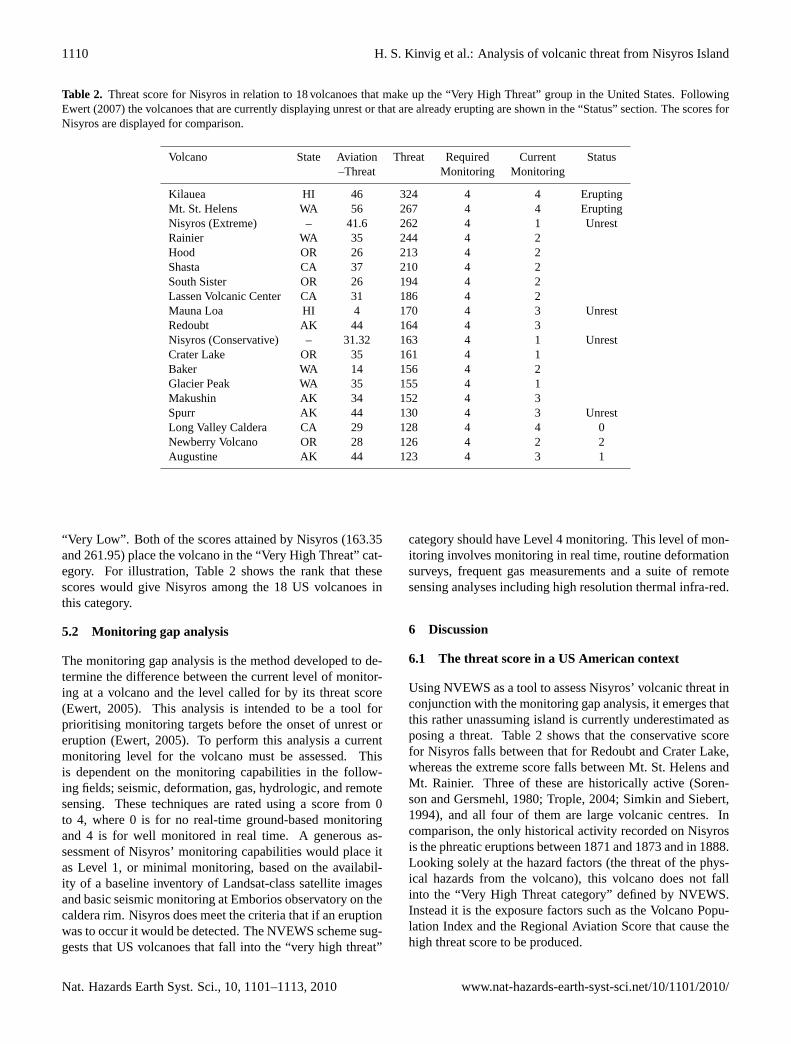
The scores generated by assessing the volcanic threat thatNisyros poses are more useful when seen in context withother volcanoes that have been assessed using the samescheme. Ewert et al. (2005) used the scores for the over-all threat score and the aviation threat score to divide theUS volcanoes into five threat groups from “Very High” to
www.nat-hazards-earth-syst-sci.net/10/1101/2010/ Nat. Hazards Earth Syst. Sci., 10, 1101–1113, 2010
1110 H. S. Kinvig et al.: Analysis of volcanic threat from Nisyros Island
Table 2. Threat score for Nisyros in relation to 18 volcanoes that make up the “Very High Threat” group in the United States. FollowingEwert (2007) the volcanoes that are currently displaying unrest or that are already erupting are shown in the “Status” section. The scores forNisyros are displayed for comparison.
Volcano State Aviation Threat Required Current Status–Threat Monitoring Monitoring
Kilauea HI 46 324 4 4 EruptingMt. St. Helens WA 56 267 4 4 EruptingNisyros (Extreme) – 41.6 262 4 1 UnrestRainier WA 35 244 4 2Hood OR 26 213 4 2Shasta CA 37 210 4 2South Sister OR 26 194 4 2Lassen Volcanic Center CA 31 186 4 2Mauna Loa HI 4 170 4 3 UnrestRedoubt AK 44 164 4 3Nisyros (Conservative) – 31.32 163 4 1 UnrestCrater Lake OR 35 161 4 1Baker WA 14 156 4 2Glacier Peak WA 35 155 4 1Makushin AK 34 152 4 3Spurr AK 44 130 4 3 UnrestLong Valley Caldera CA 29 128 4 4 0Newberry Volcano OR 28 126 4 2 2Augustine AK 44 123 4 3 1
“Very Low”. Both of the scores attained by Nisyros (163.35and 261.95) place the volcano in the “Very High Threat” cat-egory. For illustration, Table 2 shows the rank that thesescores would give Nisyros among the 18 US volcanoes inthis category.
5.2 Monitoring gap analysis
The monitoring gap analysis is the method developed to de-termine the difference between the current level of monitor-ing at a volcano and the level called for by its threat score(Ewert, 2005). This analysis is intended to be a tool forprioritising monitoring targets before the onset of unrest oreruption (Ewert, 2005). To perform this analysis a currentmonitoring level for the volcano must be assessed. Thisis dependent on the monitoring capabilities in the follow-ing fields; seismic, deformation, gas, hydrologic, and remotesensing. These techniques are rated using a score from 0to 4, where 0 is for no real-time ground-based monitoringand 4 is for well monitored in real time. A generous as-sessment of Nisyros’ monitoring capabilities would place itas Level 1, or minimal monitoring, based on the availabil-ity of a baseline inventory of Landsat-class satellite imagesand basic seismic monitoring at Emborios observatory on thecaldera rim. Nisyros does meet the criteria that if an eruptionwas to occur it would be detected. The NVEWS scheme sug-gests that US volcanoes that fall into the “very high threat”
category should have Level 4 monitoring. This level of mon-itoring involves monitoring in real time, routine deformationsurveys, frequent gas measurements and a suite of remotesensing analyses including high resolution thermal infra-red.
6 Discussion
6.1 The threat score in a US American context
Using NVEWS as a tool to assess Nisyros’ volcanic threat inconjunction with the monitoring gap analysis, it emerges thatthis rather unassuming island is currently underestimated asposing a threat. Table 2 shows that the conservative scorefor Nisyros falls between that for Redoubt and Crater Lake,whereas the extreme score falls between Mt. St. Helens andMt. Rainier. Three of these are historically active (Soren-son and Gersmehl, 1980; Trople, 2004; Simkin and Siebert,1994), and all four of them are large volcanic centres. Incomparison, the only historical activity recorded on Nisyrosis the phreatic eruptions between 1871 and 1873 and in 1888.Looking solely at the hazard factors (the threat of the phys-ical hazards from the volcano), this volcano does not fallinto the “Very High Threat category” defined by NVEWS.Instead it is the exposure factors such as the Volcano Popu-lation Index and the Regional Aviation Score that cause thehigh threat score to be produced.
Nat. Hazards Earth Syst. Sci., 10, 1101–1113, 2010 www.nat-hazards-earth-syst-sci.net/10/1101/2010/

H. S. Kinvig et al.: Analysis of volcanic threat from Nisyros Island 1111
6.2 The threat score in a European context
6.2.1 Comparison with other Southern Europeanvolcanoes
In order to assess Nisyros’s threat score in a European con-text, it is worth comparing the score to other European vol-canoes. In the absence of a similar study to the best of ourknowledge, we consult Yokoyama et al. (1984) who sug-gested grouping volcanoes by continent rather than attempt-ing to create a worldwide ranking. This may mean that tobetter understand the implication of the threat score it shouldbe compared to the scores for other volcanoes in the regionsuch as Santorini, Vesuvius, Campi Flegrei and Etna. Thesevolcanoes in addition to Nisyros were previously identified inthe Yokoyama et al. (1984) scheme as fitting the ’high risk’criteria. It would be of great interest to see how these othervolcanoes compare in terms of their NVEWS threat level toour findings for Nisyros. This may provide a better contextfor our results than by comparison with US volcanoes. The1996–1998 volcano-seismic crisis at Nisyros is not dissimilarto the 1982–1984 crisis at the Campi Flegrei and likely alsosimilar to other caldera unrest episodes in the Mediterraneanregion and elsewhere: significant ground uplift is detected,yet, not accompanied or immediately followed by eruption.For example, the net ground uplift of more than 2.5 m duringboth the 1969–1972 and 1982–1984 at Campi Flegrei is in-terpreted to result from pressurisation of either a purely mag-matic, a purely hydrothermal or a hybrid source (see Gotts-mann and Battaglia, 2008 for a recent review). These obser-vations compare with ground uplift of more than 7 m prior tothe 1538 Monte Nuovo eruption at the Campi Flegrei (Dvo-rak and Gaspirani, 1991). The implication of these obser-vations is that unrest periods remain poorly understood andcausative sources enigmatic.
6.2.2 Population and aviation exposure
The Volcano Population Index at 30 km distance for Nisy-ros is higher than any US volcano assessed by the NVEWSscheme. Steamboat has the highest score in the US at 5.41(Ewert et al., 2005), whereas Nisyros gives a score of 6.93.The high population density in the immediate vicinity ofNisyros has implications in its own right in terms of the po-tential impact on local population and infrastructure. How-ever, due to the high population density in Europe in gen-eral many more people could be affected by an eruption onNisyros. The air traffic disruption by the eruption of Ey-jafjallajokull volcano in spring 2010 showed the vulnerabil-ity of European society to volcanic hazards on an unprece-dented scale. With a Regional Aviation Score for Nisyroshigher than for any US volcano (a score of 5.15 for Steam-boat being the highest) and the minimum estimated cost ofUS$2.5 Bn to the global aviation industry at large for theEyjafjallajokull eruption (European Commission Press Re-
lease 27 April 2010), the impact on air traffic may be amongthe most severe scenarios of volcano reactivation on Nisyros,with implications on regional and possibly continental scale.Whether or not an area of 300 km radius around a volcano, ascurrently defined by the NVEWS scheme as a potential expo-sure zone with possible impact on air traffic, is appropriate toreflect the nature of European air traffic and the distributiondensity of airports in Europe is an open question. One an-ticipates that a post-mortem analysis of the recent Icelandiceruption and its impact on air traffic in Europe will provideadvances in this respect in an European context.
6.2.3 Adequate monitoring level
Using the threat score to analyse the monitoring gap on Nisy-ros shows that there is indeed a substantial difference be-tween what capabilities currently exist on Nisyros comparedto what would be required by the NVEWS recommendationsif this volcano was in the US. Even conservatively, Nisy-ros volcano appears inadequately monitored and we suggestthis situation be addressed to obtain a realistic understand-ing of base level activity on the island. It is perhaps realisticto expect a level of monitoring appropriate for the level ofthreat from a volcano. In this context it is clear that there is aneed for a higher monitoring level then is currently in placeon Nisyros. This would allow for the isolation of “anoma-lous” activity periods, such as the volcano-seismic crisis inthe 1990’s, and assess their importance.
7 Conclusions
Whilst it may be true that the exposure factors on Nisyrosmay cause a bias towards a higher comparable threat scorethen expected, our analysis provides a comprehensive steptowards understanding the volcanic hazards from this vol-canic island in a European context, not at least because ofthe recently exposed severe vulnerability of European soci-ety to volcanic eruptions as demonstrated by the case of theEyjafjallajokull volcano. The derived threat scores of 163and 262 bracket the range of possible scores for Nisyros asany permutation of the extreme and conservative scores forboth hazard and exposure factors is feasible.
From the analysis of volcanic threat presented in this paperit emerges that, coupled with an increase in monitoring capa-bility, a sensible course of action for the local and regionalauthorities would be to develop a volcanic hazard specific re-sponse protocol. This would increase the level of prepared-ness locally and regionally in the event of re-awakening ofvolcanic activity and therefore significantly reduce risk as-sociated with volcanic activity. Our analysis could representa first step towards a comprehensive risk analysis includinga combination of probabilistic volcanic hazard assessmentand eruption forecasting with cost-benefit analysis (Marzoc-chi and Woo, 2007).
www.nat-hazards-earth-syst-sci.net/10/1101/2010/ Nat. Hazards Earth Syst. Sci., 10, 1101–1113, 2010

1112 H. S. Kinvig et al.: Analysis of volcanic threat from Nisyros Island
Acknowledgements.This paper builds on work towards aM.Sc. degree by A. Winson and a Ph.D. degree by H. Kinvigat the University of Bristol, and both authors have contributedequally to this publication. All authors contributed to the analysis,the evaluation of results and the writing of the manuscript. ARoyal Society University Research Fellowship and research andstudentship grants by the Natural Environmental Research Councilsupported the work. JG also acknowledges support by BRISK(University of Bristol’s Research Centre for Environmental Risk).Staff and students of the 2008 Environmental Geosciences fieldschool are thanked for help with field data collection. E. Partingtonand A. Geyer assisted during the initial stages of the analysis.We thank A. Duncan and an anonymous reviewer for their valu-able comments, which led to significant improvements of this work.
Edited by: J. MartiReviewed by: A. Duncan and another anonymous referee
References
Aksu, A. E., Jenner, G., Hiscott, R. N., and Isler, E.: Occurrence,stratigraphy and geochemistry of Late Quaternary tephra layersin the Aegean Sea and the Marmara Sea, Mar. Geol., 252, 174–192, 2008.
Allen, S.: Reconstruction of a major caldera-forming eruption frompyroclastic deposit characteristics: Kos Plateau Tuff, easternAegean Sea, J. Volcanol. Geoth. Res., 105(1–2), 141–162, 2001.
Barberi, F., Navarro, J., Rosi, M., Santacroce, R., and Sbrana,A.: Explosive interaction of magma with ground water: insightsfrom xenoliths and geothermal drillings, Rendiconti della SocietaItaliana di Mineralogia e Petrologia, 43, 901–926, 1988.
Brombach, T., Caliro, S., Chiodini, G., Fiebig, J., Hunziker, J., andRaco, B.: Geochemical evidence for mixing of magmatic flu-ids with seawater, Nisyros hydrothermal system, Greece, B. Vol-canol., 65, 505–516, 2003.
Caliro, S., Chiodini, G., Galluzzo, D., Granieri, D., La Rocca, M.,Saccorotti, G., and Ventura, G.: Recent activity of Nisyros vol-cano, Greece) inferred from structural, geochemical and seismo-logical data, B. Volcanol. 67(4), 358–369, 2005.
Chiodini, G., Cioni, R., Leonis, C., Marini, L., and Raco, B.: Fluidgeochemistry of Nisyros island, Dodecanese, Greece, J. Vol-canol. Geoth. Res., 56(1-2), 95–112, 1993.
Dvorak, J. and Gasparini, P.: History of earthquakes and verti-cal ground movement in Campi Flegrei caldera, Southern Italy:comparison of precursory events to the A.D. 1538 eruption ofMonte Nuovo and of activity since 1968, J. Volcanol. Geoth.Res., 48, 77–92, 1991.
Ewert, J.: System for Ranking Relative Threats of US Volcanoes,Natural Hazards Review 8, 112–124, 2007.
Ewert, J., Guffanti, M., and Murray, T.: An Assessment of VolcanicThreat and Monitoring Capabilities in the United States – Frame-work for a National Volcanic Early Warning System, NVEWS),US Geological Survey Open-File Report 1164, 1–62, 2005.
Gottsmann, J. and Battaglia, M.: Deciphering causes of unrest atcollapse calderas: Recent advances and future challenges of jointgravimetric and ground deformation studies, in: Caldera volcan-ism: Analysis, modelling and response, edited by: Gottsmann, J.and Marti, J., Developments in Volcanology, Elsevier, 10, 417–446, 2008.
Gottsmann, J., Carniel, R., Coppo, N., Wooller, L., Hautmann,S., and Rymer, H.: Oscillations in hydrothermal systems as asource of periodic unrest at caldera volcanoes: Multiparameterinsights from Nisyros, Greece, Geophys. Res. Lett., 34, L07307,doi:10.1029/2007GL029594, 2007.
Gottsmann, J., Rymer, H., and Wooller, L. K.: On the interpretationof gravity variations in the presence of active hydrothermal sys-tems: Insights from the Nisyros Caldera, Greece, Geophys. Res.,Lett., 32, 7, doi:10.1029/2005GL024061, 2005.
Hardiman, J.: Deep sea tephra from Nisyros Island, eastern AegeanSea, Greece, Special Publication of the Geological Society Lon-don: Volcanoes in the Quaternary, 161, 69–88, 1999.
Innocenti, F., Manetti, P., Peccerillo, A., and Poli, G.: South Aegeanvolcanic arc: Geochemical variations and geotectonic implica-tions, B. Volcanol., 44(3), 377–391, 1981.
Innocenti, F., Manetti, P., Peccerillo, A., and Poli, G.: South Aegeanvolcanic arc: Geochemical variations and geotectonic implica-tions, B. Volcanol., 44(3), 377–391, 1981.
Keller, J.: The major volcanic events in recent eastern Mediter-ranean volcanism and their bearing on the problem of Santoriniash layers, Actu Internat. Sci. Congr. on the Volcano of Thera,152–167, 1971.
Keller, J., Rehren, T., and Stadlbauer, E.: Explosive Volcanismin the Hellenic Arc: a Summary and Review, in: Thera andthe Aegean World III: Proceedings of the Third InternationalCongress, Santorini, Greece, 3–9 September 1989, Thera Foun-dation, p. 13, 1990.
Lagios, E., Sakkas, V., Parcharidis, I., and Dietrich, V.: Grounddeformation of Nisyros Volcano, Greece) for the period 1995–2002: Results from DInSAR and DGPS observations, B. Vol-canol., 68(2), 201–214, 2005.
Limburg, E. and Varekamp, J.: Young pumice deposits on Nisyros,Greece, B. Volcanol., 54(1), 68–77, 1991.
Lopez, D. and Williams, S.: Catastrophic volcanic collapse: rela-tion to hydrothermal processes, Science, 260(5115), 1794–1796,1993.
Margari, V., Pyle, D., Bryant, C., and Gibbard, P.: Mediterraneantephra stratigraphy revisited: results from a long terrestrial se-quence on Lesvos Island, Greece, J. Volcanol. Geoth. Res.,163(1–4), 34–54, 2007.
Marini, L., Principe, C., Chiodini, G., Cioni, R., Fytikas, M., andMarinelli, G.: Hydrothermal eruptions of Nisyros, Dodecanese,Greece. Past events and present hazard, J. Volcanol. Geotherm.Res., 56, 71–94, 1993.
Marzocchi, W. and Woo, G.: Principles of volcanic risk met-rics: Theory and the case study of Mount Vesuvius andCampi Flegrei, Italy, J. Geophys. Res., 114(1), B03213,doi:10.1029/2008JB005908, 2009.
Newhall, C. and Hoblitt, R.: Constructing event trees for volcaniccrises, B. Volcanol., 64(1), 3–20, 2002.
Newhall, C. and Self, S.: The volcanic explosivity index/VEI/-Anestimate of explosive magnitude for historical volcanism, J. Geo-phys. Res., 87(C2), 12311238, doi:10.1029/JC087iC02p01231,1982.
Papadopoulos, G., Sachpazi, M., Panopoulou, G., and Stavrakakis,G.: The volcanoseismic crisis of 1996–97 in Nisyros, SE AegeanSea, Greece, Terra Nova, 10(3), 151–154, 1998.
Papazachos, B., Dimitriadis, S., Panagiotopoulos, D., Papazachos,C., and Papadimitriou, E.: Deep structure and active tectonics
Nat. Hazards Earth Syst. Sci., 10, 1101–1113, 2010 www.nat-hazards-earth-syst-sci.net/10/1101/2010/

H. S. Kinvig et al.: Analysis of volcanic threat from Nisyros Island 1113
of the Southern Aegean volcanic arc, The south Aegean activevolcanic arc: present knowledge and future perspectives, 47–64,2005.
Pe-Piper, G. and Piper, D.: The South Aegean active volcanicarc: relationships between magniatism and tectonics, The SouthAegean Active Volcanic Arc: Present Knowledge and FuturePerspectives, 2005.
Principe, C. and Marini, L.: Reaction path modelling of argillicalteration (AA) and advanced argillic alteration, AAA): Conse-quences for debris avalanches induced by flank collapse and hy-drothermal eruptions, The Geology, Geochemistry and Evolutionof Nisyros Volcano, Greece), in: Implications for the VolcanicHazards, Memoires de Geologie, Lausanne, 164–179, 2005.
Pyle, D. and Margari, V.: Reply: Correlation of a widespread Pleis-tocene tephra marker from the Nisyros–Yali volcanic complex,Greece, J. Volcanol. Geoth. Res., 181, 3–4, 251–254, 2009.
Sachpazi, M., Kontoes, C., Voulgaris, N., Laigle, M., Vou-gioukalakis, G., Sikioti, O., Stavrakakis, G., Baskoutas, J.,Kalogeras, J., and Lepine, J.: Seismological and SAR signatureof unrest at Nisyros caldera, Greece, J. Volcanol. Geoth. Res.,116(1–2), 19–33, 2002.
Simkin, T. and Siebert, L.: Volcanoes of the world, Arizona, Geo-science Press, Tucson, Arizona, 349 pp., 1994.
Smith, P., York, D., Chen, Y., and Evensen, N.: Single crystal 40Ar–39Ar dating of a Late Quaternary paroxysm on Kos, Greece:Concordance of terrestrial and marine ages, Geophys. Res. Lett.,23, 21, 3047–3050, 1996.
Sorensen, J. and Gersmehl, P.: Volcanic hazard warning system:Persistence and transferability, Environ. Manage., 4(2), 125–136,1980.
St. Seymour, K. and Vlassopoulos, D.: The potential for futureexplosive volcanism associated with dome growth at Nisyros,Aegean volcanic arc, Greece, J. Volcanol. Geoth. Res., 37, 351–364, 2008.
Stiros, S.: Fault pattern of Nisyros Island volcano (Aegean Sea,Greece): structural, coastal and archaeological evidence, in:The Archaeology of Geological Catastrophes, Geological Soci-ety London Special Publications, 171(1), 385–397, 2000.
Tibaldi, A., Pasquare, F., Papanikolaou, D., and Nomikou, P.: Dis-covery of a huge sector collapse at the Nisyros volcano, Greece,by on-land and offshore geological-structural data, J. Volcanol.Geoth. Res., 177(2), 485–499, 2008.
Trople, T.: Volcanic Hazards Vulnerability Assessment of theEnumclaw-Buckley, Washington Community, Department ofResource Analysis, Saint Mary’s University of Minnesota, avail-able at: http://www.gis.smumn.edu/GradProjects/TTrople.pdf(last access: 1 June 2010), 20 pp., 2004.
Vanderkluysen, L., Volentik, A., Principe, C., Hunziker, J., andJ. H.: Nisyros volcanic evolution: the growth of a stratocone,in: The Geology, Geochemistry and Evolution of Nisyros Vol-cano, Greece. Implications for the Volcanic Hazards, Memoiresde Geologie, Lausanne, 100–106, 2005.
Vinci, A.: A new ash-layer “Nisyros layer” in the Aegean Sea sed-iments, Bollettino di oceanologia teorica ed applicata, 341–342,1983.
Vinci, A.: Distribution and chemical composition of tephra lay-ers from eastern Mediterranean abyssal sediments, Mar. Geol.,64(1–2), 143–155, 1985.
Volentik, A., Vanderkluysen, L., Principe, C., and Hunziker, J.:Stratigraphy of Nisyros Volcano, Greece), in: The Geology, Geo-chemistry and Evolution of Nisyros Volcano, Greece. Implica-tions for the Volcanic Hazards, Memoires de Geologie, Lau-sanne, 26–66, 2005.
Vougioukalakis, G.: Blue Volcanoes: Nisyros, Published by Nisy-ros Regional Council, Nisyros, Greece, 1998.
Vougioukalakis, G. and Fytikas, M.: Volcanic hazards in theAegean area, relative risk evaluation, monitoring and presentstate of the active volcanic centers, The South Aegean ActiveVolcanic Arc: Present Knowledge and Future Perspectives, 2005.
Yokoyama, I., Tilling, R., and Scarpa, R.: International mobileearly-warning systems for volcanic eruptions and related seis-mic activities, UNESCO (Paris), EP/2106-8201 (2286), 102 pp.,1984.
Consulted webpages
Greek Ministry of Transport and Communications, Civil Aviation;http://www.hcaa.gr/home/index.asp
International Civil Aviation Organisation;http://www.icao.int/icao/en/mlinks.html
Republic of Turkey, Prime Ministry, Turkish Statistical Institute(Turkstat);http://www.die.gov.tr/ENGLISH/index.html
Republic of Turkey, Ministry of Transport and Communications,Director General of Civil Aviation;http://www.shgm.gov.tr/indexeng2.html
General Secertariat of the National Statistical Survey of Greece;http://www.statistics.gr/Maineng.asp
European Commission Press Room;http://ec.europa.eu/commission2010-2014/kallas/headlines/news/2010/04/doc/informationnotevolcanocrisis.pdf
www.nat-hazards-earth-syst-sci.net/10/1101/2010/ Nat. Hazards Earth Syst. Sci., 10, 1101–1113, 2010


![Untitled-1 [photopedia.info] · 2018-06-15 · 12*GRlECHENLAND 105 12kGRIECHENLANbJ CLANDSCHAFTEN ) 10 Christa Bauer 1 Acheron 2 Dadia 3 Lasithi-Hochebene 4 Mani 5 Methana 6 Pilion](https://img.pdfslide.us/doc/110x75/5e6088f720d710728e33a61b/untitled-1-2018-06-15-12grlechenland-105-12kgriechenlanbj-clandschaften-.jpg)