Embed Size (px)
DESCRIPTION
Â
Citation preview

An Analysis of Shoreline Development Risk for Secondary Dune Systems in TidewaterVirginia with Associated Management Recommendations
Lyle M. VarnellC. Scott Hardaway
Virginia Institute of Marine ScienceCollege of William and Mary
Gloucester Point, Virginia
November 2002
This project was funded by the Coastal Resources Management Programof the Virginia Department of Environmental Quality
through Grant #NA17OZ1142 of theNational Oceanic and Atmospheric Administration, Office of Ocean
and Coastal Resource Management,under the Coastal Zone Management Act of 1972, as amended.

1
Introduction
This project was done in response to concerns by environmental resource managers ofhistoric and potential adverse impacts to Virginia’s secondary dune ecosystems. Virginiaenvironmental regulatory programs have little decision-making authority over the use ofsecondary dunes as these areas are not included in the Coastal Primary Sand Dune Act (theDunes Act). These areas function as estuarine edge habitat and provide natural upland erosioncontrol, and are thus valuable to estuarine and coastal plain fauna and adjacent upland propertyowners.
Methods
Secondary dunes were identified, characterized, and classified through a related project(Hardaway et al. 2001a). The lack of a legal or science-based definition of estuarine secondarydunes made this project problematic; however, working definitions and delineation criteria weredeveloped through the previous project and formed the basis of these analyses.
Secondary dune physical parameters are based on the data of Hardaway et al. (2001a). The reported acreage represents only the secondary dune field and excludes adjacent primarydunes, uplands, and maritime forests that may be included in a land parcel.
Risk is defined as the potential for loss resulting from shoreline development of substrateand/or vegetation from secondary dunes. Risk of impacts from natural sources (erosion, stormeffects) were not analyzed. Adverse impacts determinations were defined based on the relativeamount of sand and vegetation removal and/or displacement.
Demographics for the localities containing secondary dunes were characterized fromUnited States Department of Commerce, Bureau of Economic Analysis (BEA) data. Landparcels containing all or portions of secondary dunes, their associated ownership, and 2001assessed values were obtained from locality records.
The criteria for determining the need for protection of individual secondary dune areaswere based on the investigators’ analyses of the area’s character, location, potential fordevelopment (based in part on accessibility and local development), uniqueness, size, probablehabitat value, probable sustainability (based on local sand resources and erosion rates), landscapesetting, and degree of current impact.
Results and Discussion
Secondary Dune Metrics
There are 99,423 linear feet (18.83 miles) of shoreline containing secondary dunes (Figure 1). This constitutes approximately 47.9% of the total dune shoreline length in Virginia’s ChesapeakeBay. These are found within the localities of Mathews (sites 2, 3, 8, and 13 ) (Figure 2),

2
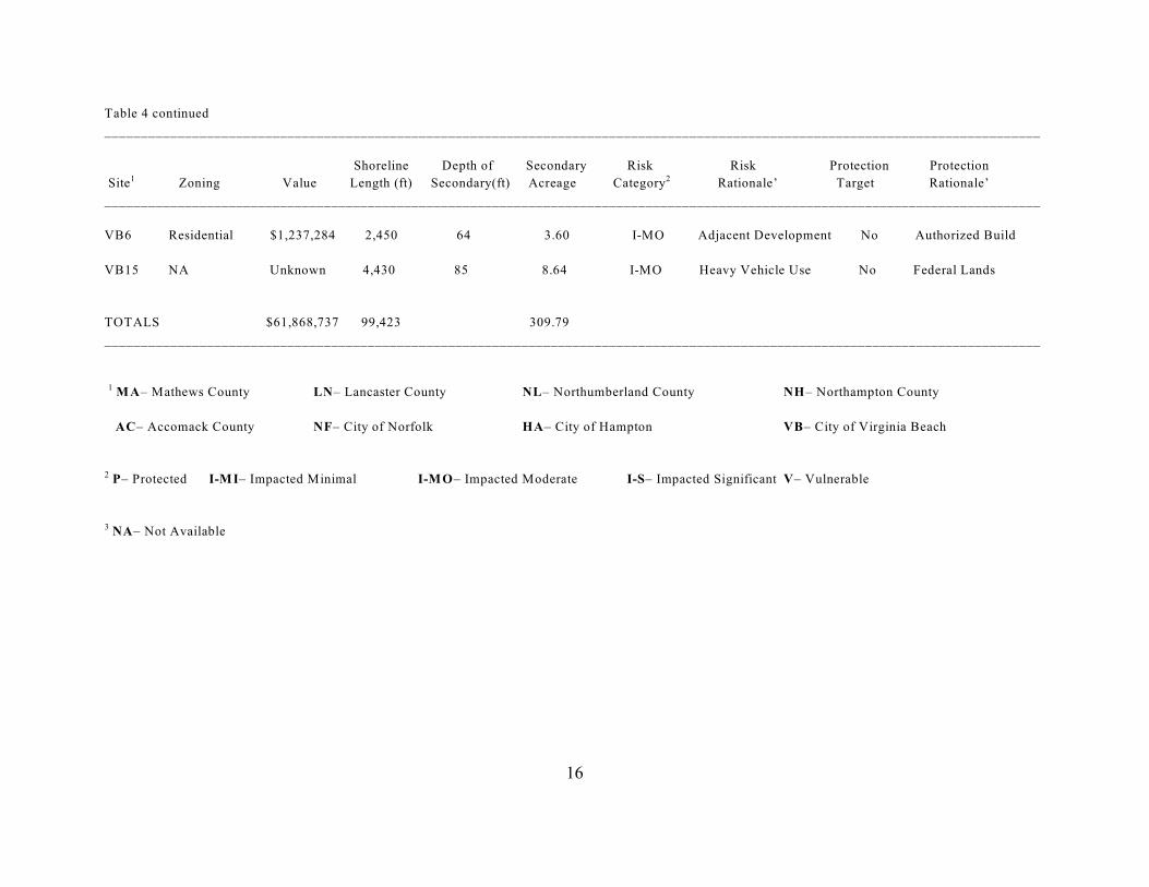
Lancaster (sites 11, 32, 39A, 68, 72, and 73) (Figure 3), Northumberland (sites 4, 42, 43, 54, 58,and 59) (Figure 4), Northampton (sites 14, 15, 33, 41B, 42, 43, 48, 51, 53 54, 57, and 58) (Figure5), Accomack (sites 27, 41, 61, 62, 65, 66, and 69) (Figure 6); and the cities of Norfolk (sites 5,8, 9A, 9B, and 11) (Figure 7), Hampton (sites 4, 7, and 12) (Figure 8), and Virginia Beach (sites4, 6, and 15) (Figure 9). Total estimated secondary dune acreage is 310.
Coastal Demographics
The Chesapeake Bay Coastal Zone population is expected to increase significantly and relativelyrapidly (Year 2020 Panel 1988). Population increases will require the associated infrastructuredevelopment necessary to accommodate the added needs within the locality.Increases in coastal zone development may increase the risk to shorelines, including dunes.
Historical Coastal Plain demographics (1980-1999) support the projected growth trends(U.S. Dept. of Commerce 2002). Population in dune-containing localities generally hasincreased significantly during the time series (Table 1). Building permits issued in Virginiacoastal localities increased from 19,682 in 1990 to 25,214 in 1999 (an increase of 22%), althoughthe number of building permits per year has generally declined (Table 2). Per capita income indune-containing coastal plain localities generally has shown significant increases (Table 3). Personal income is calculated as the sum of wage and salary disbursements, other labor income,proprietors' income, rental income, personal dividend income, personal interest income, andtransfer payments to persons, less personal contributions for social insurance. It does not includethe self-employed. In general, the higher the income, the more money is put into the localeconomy and the greater the economic vitality of the region. Per capita income is seen as theproxy for the overall economic health of a region or community, which can indicate theunderlying potential for growth.
Population growth in Northampton County may exceed projections due to recentimprovements to the Chesapeake Bay Bridge-Tunnel and toll reductions. Northampton Countycontains the largest dune resource in the lower Chesapeake Bay.
The information presented above provides evidence that the potential for risk toVirginia’s secondary dunes is significant.
Protection Targeting
Table 4 presents site-specific information for all Virginia secondary dunes. Total valueand zoning (2001) were not available for all parcels, and some minor assumptions were madeconcerning property limits and value. However, we are of the opinion that these data areaccurate to the degree that supports reasonable evaluations, and that greater accuracy would notalter our conclusions.
Ownership and zoning designation were two significant factors in classifying probablerisk. Ownership is not presented in Table 4, but is included in the archived data.

3
Approximately 55.1% of secondary dune shoreline length is privately owned (54,789feet). The remainder is owned by the Commonwealth of Virginia (21.9%), federal entities(9.1%), local government (9.5%), and Non-Governmental Organizations (NGO) (4.4%). 28.9%(28,893 linear feet) of the secondary dune shoreline length is zoned for residential development; 24.3% (24,274 linear feet) is zoned agriculture/forestry; 10.5% (10,480) is zoned conservation;and 36.3% (36,356 linear feet) is zoned for other categories.
At least 33,342 linear feet of secondary dune shoreline (33.3% of total secondary duneshoreline) have been developed (dwellings/structures are located on the lot(s)), with varyingdegrees of adverse impact. Structures contribute to the overall economic value of the land, andthe total assessed secondary dune land value (including structure values) is at least $61,868,737.
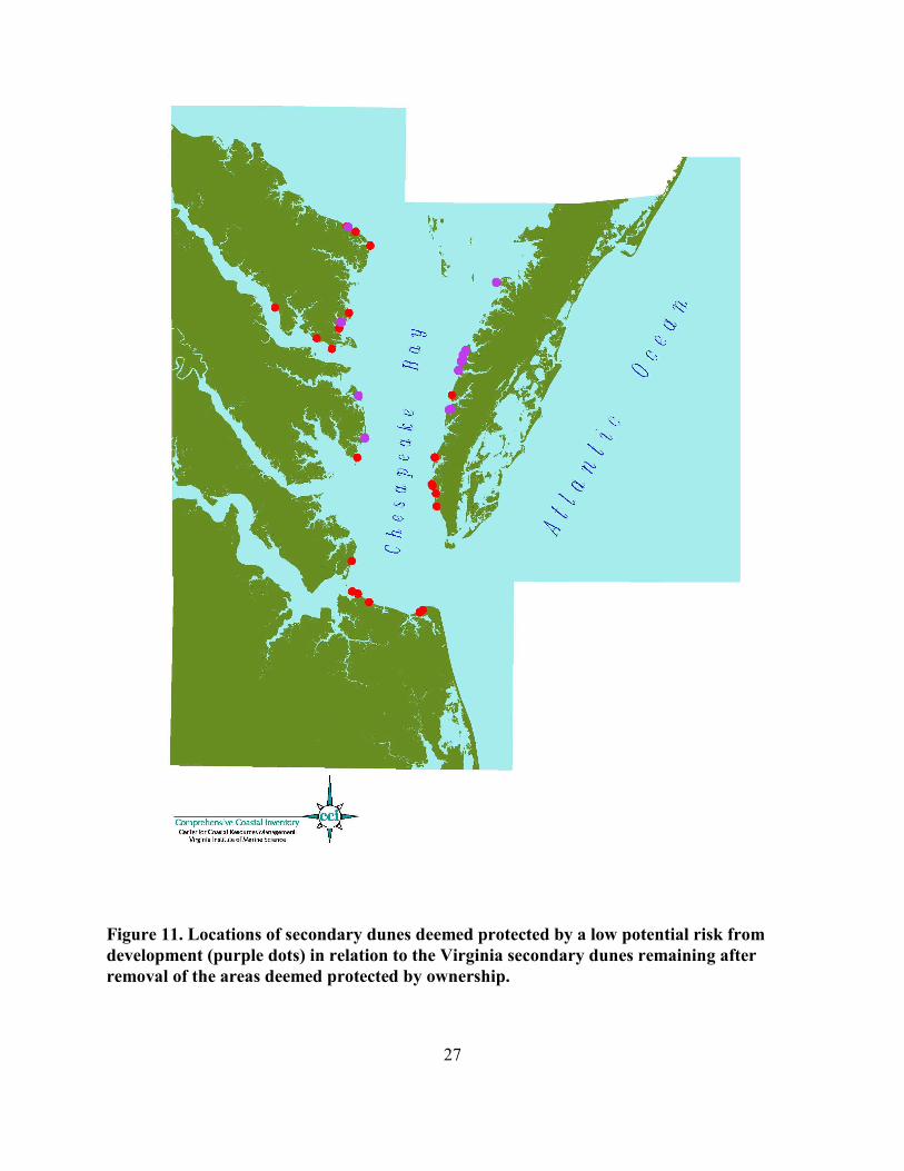
Approximately 49.5% of secondary dune acreage and 36.8% of the total dune shorelinelength are classified as “protected” due to government or NGO ownership (AC41, NH53/54,NH57/58, NH41B, VB4A/B, MA2, NL43, HP4, HP12, VB15, and NF11) (Figure 10). Anadditional 20.0% of the acreage and 16.9% of the dune shoreline length are classified as“protected” due to low potential risk from development (Figure 11). These areas are generallyremote and/or inaccessible by road (MA8, MA13, LN72/73, NL58, NH14/15, AC27, AC61/62,AC65/66, and AC69). A minor percentage (1.0% of the acreage and 1.8% of the dune shorelinelength) is contained in relatively small units and/or units with associated use resulting inquestionable value from an ecological and management perspective (LN32, LN68, NL54, NH30,and NH48) (Figure 12).
It is not considered prudent environmental policy to recommend protection strategies forareas where impacts to the secondary dunes (and frequently the primary dune) are alreadysignificant. Therefore, areas meeting this criterion were excluded from the candidate group. Theamount of secondary dunes impacted from development to the degree that function issignificantly impaired is 15.2% of the total acreage and 31.8% of dune shoreline length (MA3,LN11, NL42, NL59, NF5, NF8, NF9, HP7, VB4C, and VB6) (Figure 13). Due to the degree ofdevelopment at most of the significantly impaired sites, it is probable that little additionaldevelopment will occur. Coupled with the relatively minor additional adverse environmentalimpacts that would result from further development, the need for environmental review wasdeemed minor.
Exclusion of the areas discussed above based on ownership, access, level of probablefunction, and degree of adverse impacts results in approximately 14.3% of the total acreage (44.4acres) and 12.7% of the dune shoreline (2.4 miles) that may require management action tomaintain their current level of natural function. These sites are Mosquito Point in LancasterCounty (LN39), Bluff Point in Northumberland County (NL4), and sites in Northampton Countyconsisting of Savage Neck (NH33), Cape Charles (NH42/43), and Pond Drain (NH51) (Figure14). These are areas of generally high ecological value (expansive systems with high plantcommunity diversity) that are considered vulnerable to development and/or alteration based onownership, zoning, landscape situation, and ease of access.

4
Mosquito Point
Mosquito Point
Mosquito Point is located near the mouth of the Rappahannock River in LancasterCounty. This 3.4 acre dune feature covers approximately 850 linear feet of shoreline. MosquitoPoint is classified as a natural and relatively stablesalient dune field with a broad beach (greater than 60feet from primary dune crest to mean low water(MLW)) and a variable width nearshore gradient. Theprimary dune crest elevation ranges from 3.7 feet to5.3 feet above MLW. There is no local SAV.
This dune feature inhabits a unique position inthe landscape. Both Bay and river hydrology haveinfluenced the development of Mosquito Point. Differences in the character of the primary dunes areevidence of the multiple forces that have shaped thisfeature. The highest elevation primary dune facessoutheast toward the open Bay. The west-facingprimary dune’s crest elevation, formed fromcomparatively weaker upriver wind and hydrologicforces, generally rests 1.5 feet lower than thesoutheast-facing primary dune.
The primary dunes form a protective perimeteraround a secondary dune field that supports a diverseherb and shrub community. Species present include saltmeadow hay (Spartina patens),American beach grass (Ammophila breviligulata), seaside spurge (Chamaesyce polygonifolia),sea rocket (Cakile edentula), running dune grass (Panicum amarum), switchgrass (Panicumvirgatum), prickly pear cactus (Opuntia compressa), yucca (Yucca filamentosa), lazy daisy(Aphanostephus skirrhobasis), rabbit-tobacco (Gnaphalium chilense), horseweed (Conyzacanadensis), buttonweed (Diodia virginiana), various asters (Aster spp.), loblolly pine (Pinustaeda), red cedar (Juniperus virginiana), wax myrtle (Myrica cerifera), groundsel tree (Baccharishalimifolia), persimmon (Diospyros virginiana), black cherry (Prunus serotina), and sweetgum(Liquidambar styraciflua).
Mosquito Point is a privately owned residential community. The dunes and beaches areused recreationally and currently there is minimal development on the secondary area. This is aunique feature in Tidewater Virginia and one of the few prominent secondary dune fields on thewestern Bay shore. Uncertainties as to the fate of this area exist based on natural andanthropogenic factors. All of Mosquito Point is zoned Residential and houses occupy all lots. Itis probable that this area is “built out”, but accretion over the last few decades has createddevelopable land that did not exist prior to initial residential development.

5
Bluff Point
Mosquito Point was probably formed from erosion of the high banks immediatelyupstream. It appears that an erosion control structure placed near the downstream end of thepeninsula in the 1960s provided the initial mechanism for sand accumulation. The featurecurrently appears to be in a state of natural equilibrium; however, should further erosion controloccur on the upstream eroding banks thus removing the major sand supply that nourishes thisfeature, it is unclear how it will respond geologically.
Bluff Point
Bluff Point is an open Bay shoreline natural creek mouth barrier spit in NorthumberlandCounty. This three acre dune feature covers approximately 710 linear feet of shoreline. BluffPoint is characterized by abroad beach (greater than 140feet from the primary dunecrest to MLW) and a broadshallow offshore gradient. The primary dune crestelevation is approximately 5.6feet above MLW. There arenumerous small local patchesof SAV, and a large persistentbed exists approximately1000 meters north at JarvisPoint.
Bluff Point dune fieldis the result of the migrationof a barrier spit that becametrapped between eroding headlands. At this point in time Bluff Point is relatively stable, andshould remain stable until the maginal headlands erode to the point that local winds andhydrology (primarily from the east) have greater influence on the geomorphology of this dunesystem. The dunes support a diverse herb community that includes sea rocket (Cakile edentula),saltmeadow hay (Spartina patens), running dune grass (Panicum amarum), switchgrass(Panicum virgatum), common reed (Phragmites australis), Russian thistle (Salsola kali), andothers. This dune system is part of a mixture of diverse estuarine edge habitats. The surroundingland use is forest with some adjacent agriculture. Nontidal wetlands exist between the back ofthe secondary dune field and the forested upland.
Bluff Point is privately owned and zoned agricultural. Some of the local land parcels arecurrently for sale. The fate of this area is uncertain due to potential changes in local land use. The dune field is easily accessed from the upland, and surrounding upland development couldimpact the dune/wetland/adjacent shoreline complex.

6
Savage Neck
Savage Neck
Savage Neck is a northwest/west facing natural open Bay linear dune field covering 2,680linear feet of shoreline in NorthamptonCounty. Secondary dune acreage isrelatively small, about 2.46 acres, due tothe narrow herbaceous/shrub areabetween the primary dune crest andextensive maritime forest. The primarydune crest ranges from approximately 11feet to 30 feet above MLW and is frontedby a broad beach (120 feet to 287 feetfrom the primary dune crest to MLW). Savage Neck dune field is classified asland transgressive, with erosion of thenorthern reach feeding the offshore barcomplex immediately offshore of thesouthern, and relatively stable, end of thearea. These offshore bars supportextensive SAV beds.
The vegetative character of the secondary dunes is created by the relatively rapidtransition from the herb-dominated primary dune community of American beach grass(Ammophila breviligulata), saltmeadow hay (Spartina patens), and running dune grass (Panicumamarum) to the narrow shrub/woody-dominated community channelward of the maritime forest.
The Commonwealth of Virginia owns a small portion of this dune field, with theremainder held privately. The area is zoned for agriculture. Due to the projected growth ofNorthampton County and the market potential of beachfront property the fate of this area isuncertain.
Cape Charles
The Cape Charles dune field is located south of the Town of Cape Charles inNorthampton County. This 7.7 acre natural open Bay linear dune field covers approximately3,486 linear feet of shoreline below Cape Charles harbor. The Cape Charles dune field ischaracterized by high-elevation primary dune crests (ranging from 9.3 feet to 11.8 feet aboveMLW) fronted by a broad beach (greater than 120 feet from primary dune crest to MLW) and abroad shallow nearshore gradient. There are significant SAV resources immediately offshore ofthe beach.
The secondary dune area is vegetatively similar to the secondary dunes of Savage Neck. An herbaceous community dominated by American beach grass (Ammophila breviligulata),

7
Pond Drain
Cape Charles
saltmeadow hay (Spartina patens), and running dune grass (Panicum amarum) transitions into adense shrub community that is relatively broad along the northern portion of the shoreline butnarrows to the south.
This shoreline has been affectedby the maintenance dredging of CapeCharles harbor and is currentlyundergoing changes on the uplandlandward of the secondary dunes. Accretion has occurred on the northernportion of the shoreline from dredgespoil placement and appears relativelystable. The southern portion of theshoreline contains no primary orsecondary dunes and is experiencingerosion to its terminus at Elliots Creek.
The two tracts that include thesecondary dunes are zoned municipaland are owned by the IndustrialDevelopment Authority and an LLC. Thus, these are likely targeted for future development. Thearea landward of these parcels is a retirement/resort community and golf course complex. Thefate of this area is highly uncertain due to zoning and adjacent land use.
Pond Drain
Pond Drain is natural open Bay linear dune field in Northampton County. This is thelargest dune complex in the lower Chesapeake Bay and extends over 4,900 linear feet ofshoreline and contains approximately27.8 acres of secondary dune. Thisarea is characterized by broad beaches(approximately 100 feet from theprimary dune crest to MLW) and highprimary dunes (10.3 feet to 14.5 feetabove MLW). There are local beds ofSAV to the north.
Pond Drain’s secondary dunessupport a diverse herb and shrubcommunity. Species present includeAmerican beach grass (Ammophilabreviligulata), sea oats (Uniolapaniculata), saltmeadow hay (Spartina

8
patens), sea rocket (Cakile edentula), running dune grass (Panicum amarum), bluestem(Schizachyrium littorale), yucca (Yucca filamentosa), various asters (Aster spp.), seasidegoldenrod (Solidago sempervirens), trumpet vine (Campsis radicans), loblolly pine (Pinustaeda), red cedar (Juniperus virginiana), wax myrtle (Myrica cerifera), persimmon (Diospyrosvirginiana), black cherry (Prunus serotina), various oaks (Quercus sp.), and American holly (Ilexopaca).
This shoreline is considered relatively stable. Erosion south of the mouth of Elliots Creekhas supplied substrate to the Pond Drain dune field. Erosion control measures, now porposed forthis reach could affect Pond Drain’s current stability.
The Commonwealth of Virginia owns a portion of the Pond Drain dune field. Theremainder is privately owned and zoned for agriculture. Due to the projected growth ofNorthampton County and the market potential of beachfront property the fate of this area isuncertain.
Policy Recommendations
Management options currently available include no action, modified implementation ofthe Chesapeake Bay Preservation Act (Bay Act), modifying the Dunes Act, establishingconservation easements, procuring development rights, land acquisition, or combinations ofthese.
The no action option is not recommended if greater oversight of secondary dune use iswarranted.
Bay Act modifications would require that localities establish buffers entirely landward ofthe primary dune rather than from the high tide line. Many secondary dunes extend landwardgreater than the Resource Protection Area (RPA) width, leaving portions of some secondarydunes excluded from environmental review. If the Bay Act were implemented such that thechannelward extent of the RPA began at the landward extent of the primary dune (i.e. nooverlapping jurisdictions) with no granting of variances, approximately half (49,854 feet or 9.44miles)of the total dune shoreline length and 22.7% of the secondary dune acreage (70.19 acres)would be completely captured for regulatory review. Additionally, greater than 75% of thesecondary dune area could be captured for regulatory review for 10.6% (10,550 feet) of theshoreline and 8.6% (26.8 acres) of the acreage (cumulative 60.7% of the shoreline length and31.3% of the acreage); greater than 50% of the secondary dune area could be captured forregulatory review for 20.5% (20,369 feet) of the shoreline and 20.1% (62.44 acres) of the acreage(cumulative 81.2% of the shoreline length and 51.4% of the acreage); and greater than 25% ofthe secondary dune area could be captured for all secondary dunes (i.e. the RPA covers at least25% of all of the secondary dune areas). For the areas recommended for conservation action, theRPA would cover 100 % of NH33 and NH42, 57% of LN39, 54% of NL4, 68% of NH43, and40.5% of NH51. Therefore, modified implementation of the Bay Act would provide limited

9
management opportunities.
Dunes Act modifications may be impracticable due to the political and financial resourcesrequired to establish and administer an expanded program, and the limited number of privateholdings that would be regulated. The most cost effective, comprehensive protection strategiesare land acquisition, purchase of development rights, conservation easements, or combinations ofthese (collectively termed “land control”). Land control could be achieved more rapidly than anew regulatory structure can be created, probably would require much less financial resourcesthan those needed to develop, enact, and administer regulatory programs, and would afford agreater level of protection. The areas recommended for protection are currently assessed at$10,201,400 (including structures where present). This equates to $808 dollars per linear foot ofshoreline. Further economic analysis is warranted, but this amount appears cost-effective whencompared to restoration costs.
It would be imprudent to recommend expending public resources for protection of naturalareas that are subject to significant and rapid degradation from natural causes. The probability ofsustainability, absent anthropogenic impacts, was considered in our analyses and addressedabove. The secondary dune areas recommended for protection appear to have either adequatelocal sand supplies or favorable landscape situations, or both, and are considered sustainable. Relating these characteristics to erosion rates would provide a more complete assessment of theprobable sustainability of the targeted areas, but comprehensive erosion rates for TidewaterVirginia have not been quantified for many years and may not now be accurate. If land control isthe chosen course of action, we recommend quantifying erosion rates for the targeted areas.
Literature Cited
Hardaway, C.S., L.M. Varnell, D.A. Milligan, G.R. Thomas, and C.H. Hobbs, III. 2001a.Chesapeake Bay Dune Systems: Evolution and Status. Final Report to the NationalOceanic and Atmospheric Administration Office of Coastal Resources Management. 19 pp.
United States Department of Commerce, Bureau of Economic Analysis (2002).htp://www.bea.gov/bea/regional/reis/.
Year 2020 Panel. 1988. Population growth and development in the Chesapeake Bay watershedto the year 2020. Unpublished report. Richmond, Virginia. Council on the Environment. 52 pp.

10
Table 1. Population trends for jurisdictional tidewater localities containing dunes.__________________________________________________________________________________________________________
Percent Change Percent ChangeLocality 1980 1995 1999 1980-1999 1995-1999__________________________________________________________________________________________________________
Accomack 31,288 32,062 32,121 + 2.7 + <1
Lancaster 10,149 11,232 11,349 + 11.8 + 1
Mathews 8,016 8,819 9,255 + 15.5 + 5
Northampton 14,580 12,903 12,810 - 12.1 - <1
Northumberland 9,836 11,134 11,668 + 18.6 + 4.8
Hampton 123,148 138,575 137,193 + 11.4 - 1
Norfolk 268,469 239,723 225,875 - 15.9 -5.8
Virginia Beach 264,821 428,499 433,461 + 63.7 + 1.1__________________________________________________________________________________________________________

11
Table 2. Time series of building permits for single family and duplex dwellings issued to jurisdictional tidewater localities containing dunes._________________________________________________________________________
Locality 1990 1995 1999_________________________________________________________________________
Accomack 144 189 141
Lancaster 148 71 109
Mathews 194 61 50
Northampton 77 48 49
Northumberland 312 104 132
Hampton 482 368 332
Norfolk 258 175 191
Virginia Beach 1,555 1,439 1,304_________________________________________________________________________

12
Table 3. Time series of per capita personal income (dollars) for tidewater localities containing dunes.___________________________________________________________________________
Percent ChangeLocality 1980 1995 1999 1995-1999___________________________________________________________________________
Accomack 6,972 17,382 20,194 + 16
Lancaster 9,079 25,393 29,430 + 16
Mathews 9,005 22,911 27,081 + 18.2
Northampton 6,238 16,453 20,233 + 23
Northumberland 8,312 19,093 23,425 + 22.7
Hampton 8,338 19,064 22,250 + 16.7
Norfolk 9,223 19,405 22,390 + 15.4
Virginia Beach 10,882 23,681 28,356 + 19.7___________________________________________________________________________

13
Table 4. Secondary Dune physical and risk metrics by site.
________________________________________________________________________________________________________________________________
Shoreline Depth of Secondary Risk Risk Protection Protection
Site Zoning Value Length (ft) Secondary(ft) Acreage Category Rationale’ Target Rationale’1 2
________________________________________________________________________________________________________________________________
MA2 Conservation NA 1,600 168 6.17 P NGO owned No ow Risk3
MA3 Residential $6,160,200 4,290 90 8.86 I-MO Developed No Impacted
MA8 Conservation $34,900 3,150 160 11.57 P Remote/Zoning No Low Risk
MA13 Residential $158,800 450 31 0.32 I-MI Local Land Use/Zoning No Low Risk/Small
LN11 Residential $265,700 990 45 1.02 I-MO Sparce development No Impactec/Small
LN32 Residential $389,100 320 115 0.84 I-MI Community commons No Small
LN39 Residential $311,700 850 175 3.41 V Accessible/sparce use Yes Unique/High Value
LN68 Residential $300,100 250 60 0.34 I-MI Adjacent development No Small/Isolated
LN72 Residential $322,100 870 60 1.20 I-MO Adjacent development No Low Risk/Small
NL4 Agriculture $591,400 710 184 3.00 V Accessible/developable Yes Locally Significant
NL42 Residential Unknown 3,690 77 6.52 I-MI Local development No Impacted
NL43 Other $930,000 2,750 74 4.67 P NGO owned No Low Risk
NL54 Residential $39,800 240 22 0.12 I-MI Adjacent development No Small/Low value
14
Table 4 continued
________________________________________________________________________________________________________________________________
Shoreline Depth of Secondary Risk Risk Protection Protection
Site Zoning Value Length (ft) Secondary(ft) Acreage Category Rationale’ Target Rationale’1 2
________________________________________________________________________________________________________________________________
NL58 Residential $153, 100 900 103 2.13 V Accessible No Low Risk
NL59 Residential $275,500 1,680 39 1.50 I-MO Adjacent development No Impacted/Low Risk
NH10 Agriculture Unknown 300 64 0.44 V Accessible/Impacted No Small
NH14 Ag/Forest $1,347,700 854 32 0.63 P Remote/Unbuildable No Low Risk/Small
NH33 Agriculture $2,206,100 2,680 40 2.46 V Accessible/developable Yes Large/High Value
NH41 Residential Unknown 600 90 1.24 I-MO Public beach No Government Owned
NH42 Municipal $883,800 3,486 90 7.73 V Planned for Development Yes Large/High Value
NH48 Agriculture Unknown 703 87 1.40 I-MI Community Commons No Small/Planned Use
NH51 Agriculture $6,208,400 4,900 247 27.78 I-MI Accessible/Minor Use Yes Large/High Value
NH53 NA Unknown 4,900 237 26.66 I-MI State Park No Low Risk
NH58 Agriculture $387,700 4,100 93 8.75 P Federal Lands No Government Owned
AC27 Agriculture $26,000 970 151 3.36 P Inaccessible/Unbuildable No Low Risk/Small
AC41 Agriculture $46,500 1,380 130 4.12 P Inaccessible/Remote No Low Risk

15
Table 4 continued
________________________________________________________________________________________________________________________________
Shoreline Depth of Secondary Risk Risk Protection Protection
Site Zoning Value Length (ft) Secondary(ft) Acreage Category Rationale’ Target Rationale’1 2
________________________________________________________________________________________________________________________________
AC69 Agriculture $234,700 650 43 0.64 P Inaccessible/Remote No Low Risk/Small
AC62 Agriculture $543,700 4,880 203 22.74 P Inaccessible/Remote No Low Risk
AC65 Agriculture $335,100 1,040 55 1.31 P Accessible/Unbuildable No Low Risk
NF5 Residential $22,500,000 7,390 37 6.28 I-S Cluster Development No Highly Impacted
NF8 Residential $5,640,000 2,500 52 2.98 I-S Cluster Development No Highly Impacted
NF9 Residential $5,560,000 3,330 51 3.90 I-S Cluster Development No Highly Impacted
NF11 Open Space Unknown 900 285 5.89 I-MI Adjacent Development No Low Risk
HP4 Unknown NA 550 52 0.66 P Federal Lands No Low Risk
HP12 Unknown NA 4,200 106 10.22 P City Owned No Low Risk
HP7 Residential $1,509,800 1,540 80 2.83 I-S Cluster Development No Highly Impacted
VB4A NA Unknown 11,150 298 76.28 I-MI State Park No Low Risk
VB4C Residential $3,270,453 3,750 110 9.47 I-MO Adjacent Development No Impacted
16
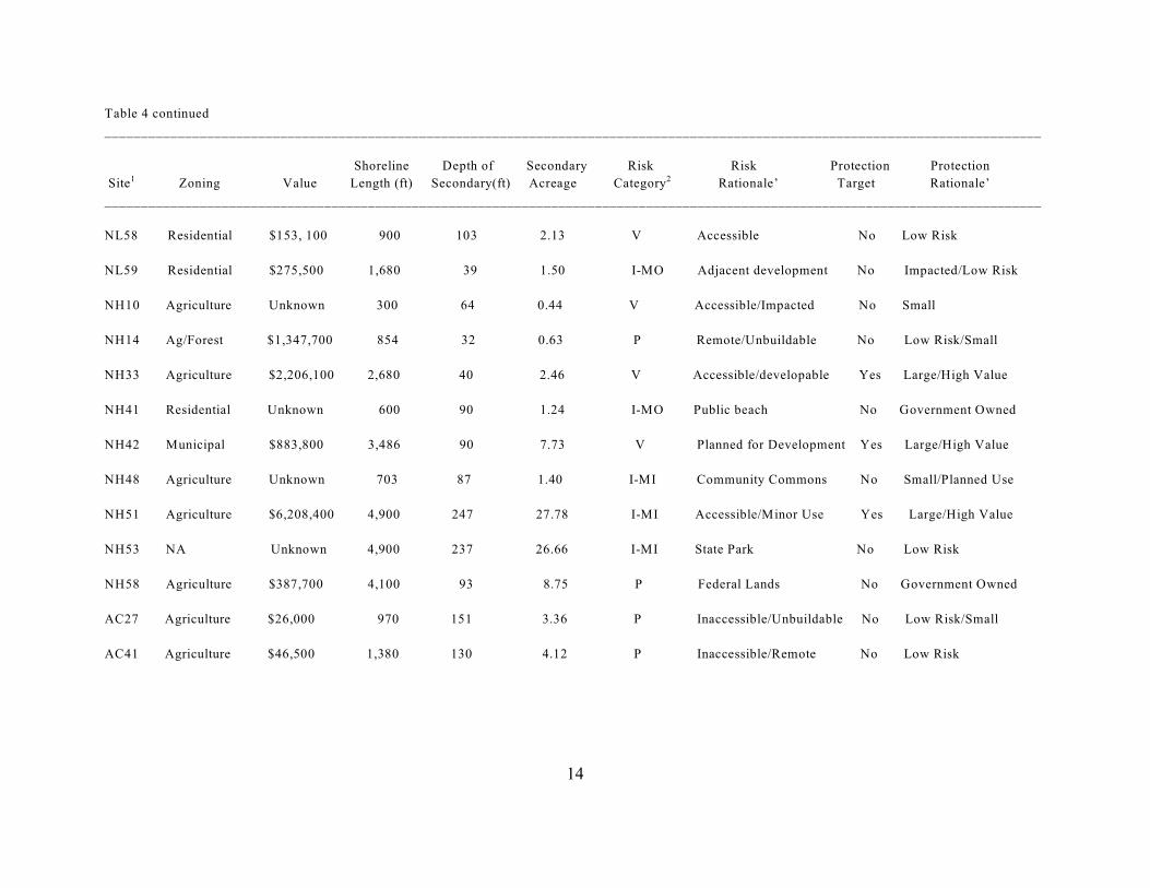
Table 4 continued
________________________________________________________________________________________________________________________________
Shoreline Depth of Secondary Risk Risk Protection Protection
Site Zoning Value Length (ft) Secondary(ft) Acreage Category Rationale’ Target Rationale’1 2
________________________________________________________________________________________________________________________________
VB6 Residential $1,237,284 2,450 64 3.60 I-MO Adjacent Development No Authorized Build
VB15 NA Unknown 4,430 85 8.64 I-MO Heavy Vehicle Use No Federal Lands
TOTALS $61,868,737 99,423 309.79
________________________________________________________________________________________________________________________________
M A– Mathews County LN– Lancaster County NL– Northumberland County NH– Northampton County1
AC– Accomack County NF– City of Norfolk HA– City of Hampton VB– City of Virginia Beach
P– Protected I-MI– Impacted Minimal I-MO– Impacted Moderate I-S– Impacted Significant V– Vulnerable2
NA– Not Available3

17
Figure 1. Locations (red dots) of all Virginia secondary dunes.

18
Figure 2. Mathews County dune locations.
19
Figure 3. Lancaster County dune locations.

20
Figure 4. Northumberland County dune locations.

21
Figure 5. Northampton County dune locations.

22
Figure 6. Accomack County dune locations.

23
Figure 7. City of Norfolk dune locations.

24
Figure 8. City of Hampton dune locations.

25
Figure 9. City of Virginia Beach dune locations.

26
Figure 10. Locations of secondary dunes deemed protected by ownership (lime green dots)in relation to all Virginia secondary dunes (red dots).
27
Figure 11. Locations of secondary dunes deemed protected by a low potential risk fromdevelopment (purple dots) in relation to the Virginia secondary dunes remaining afterremoval of the areas deemed protected by ownership.

28
Figure 12. Locations of secondary dunes deemed to possess relatively low potentialecological and coastal hazard value (orange dots) in relation to the Virginia secondarydunes remaining after removal of the areas deemed protected by ownership and lowdevelopment risk (red dots).

29
Figure 13. Locations of secondary dunes impacted by development (blue dots) in relationto the Virginia secondary dunes remaining after removal of the areas deemed protected byownership, low development risk, and low ecological/coastal hazard value (red dots).

30
Figure 14. Locations of secondary dunes considered at risk from potential development(red dots). These are considered to have a high coastal hazard value and are ecologicallyimportant.