Embed Size (px)
Citation preview

Academic Research International Vol. 9(1) March 2018
____________________________________________________________________________________________________________________________________________________________________________________________________________________________________________________________________________________________________________
Copyright © 2018 SAVAP International ISSN: 2223-9944, e ISSN: 2223-9553
www.savap.org.pk 50 www.journals.savap.org.pk
ANALYSIS OF PUBLIC PERCEPTIONS OF FUTURE SPATIAL
PLANNING DECISION MODEL LHOKSEUMAWE CITY
Emi Maulani 1, Cut Azmah Fithri
2, Mutammimul Ula
3
Faculty of Engineering, Universitas Malikussaleh, Aceh,
INDONESIA.
[email protected], [email protected], [email protected]
ABSTRACT
Lhokseumawe urban spatial planning for future development should be considered, to
determine the extent to which development feasibility in the application of decision
models in the analysis of public perception of the future planning of urban spatial
lhokseumawe. So that when the development has been reached the community can use
the facilities that have been built built and in accordance with the wishes of the
community. Therefore, it is necessary to analyze a decision model in the analysis of
community perception of the best future planning as a place of future planning.
The specific objective of this research is to analyze the impact of the policy according
to the society's perception on the future planning of urban spatial planning of
lhokseumawe by using the model in decision making for future planning of
Lhokseumawe urban spatial planning. Decision-makers can see the highest rankings
of future community perceptions for the changing spatial policy of the city of
Lhoksemawe seen from various variables that can be seen from the economic,
political and social facilities and infrastructure, and the form / concept of planning
future urban spatial planning in the perception of society's wishes.
Model in this research use Descriptive Analysis method in making variable analysis
according to society perception and model SAW (Simple Addictive Weigthing) in
ranking. The use of SAW model as one of decision model in decision making to
society. The data collected from this research through descriptive analysis from
perception of society toward policy analysis of spatial change of lhokseumawe cover
economic aspect consist of job opening, income earned, and income level;
environmental aspects include aesthetic concept, safety, hygiene function that will be
included into the process of ranking is the sum of matrix matrix normalized R with
weight vector to obtain the largest value selected as the best alternative as a solution
for the perception of society to the analysis of policy change of urban spatial.
Keywords: Spatial Change Policy, Descriptive Analysis, Saw, Decision
Making System
INTRODUCTION
Urban planning Lhokseumawe has an important role in shaping urban spatial planning. Urban
planning initially emerged as a response to modern cities experiencing growth especially in
economic activity. Developments in the trade sector for example led to the development of
new cities as the center of government and economic growth. Development contains an
understanding of improvement. While the definition of the Area, the region with the main
function of residential or housing space which is a geographical unity and all elements related
to it whose limits and systems are determined based on functional aspects and have specific /
specific / specific envy. (Spatial Law, 2010).
As with the development of cities in Indonesia in general, the development of the city of
lhokseumawe in particular experienced the same physical problems of the city. This is

Academic Research International Vol. 9(1) March 2018
____________________________________________________________________________________________________________________________________________________________________________________________________________________________________________________________________________________________________________
Copyright © 2018 SAVAP International ISSN: 2223-9944, e ISSN: 2223-9553
www.savap.org.pk 51 www.journals.savap.org.pk
evident from the not well-defined problem of good urban infrastructure. It is therefore
necessary to plan the future of the city of Lhokseumawe to overcome these problems and in
accordance with the wishes of community perception. There is a belief that social problems
can be solved by redesigning the city (Rydin, 1993: 17; Krueckeberg, 1997: 3; Yewlett, 2001:
1304; Thorns, 2002: 180; UN-Habitat, 2011: 49).
This brings with it sustainable planning to find a better paradigm to deal with the
complexities of urban environments. From here then began to develop the theory of planning
as a guide framework in planning. Programs in planning institutions typically present two
models of planning theory: theories about the planning process and theories about the context
or content (substance) of planning, eg theories about the structure of urban space (Fainstein,
2005: 121).
It can be said that planning theory consists of two elements, namely elements of things to be
achieved and elements of the way to achieve them (Rustiadi, 2009: 336) or procedural and
substantive components (Klaasen, 2003: 73). However, in recent decades there has been a
new paradigm of planning in guiding planners in the practical or professional world (Innes,
1983: 35; Pallagst, 2006: 7).
Concerning city spatial planning, Mirsa (2011: 15) says that: "In planning, designing and
programming of urban infrastructure, the main thing to note about the elements of urban
spatial planning itself is the preparation of planning, utilization and control". with that in
mind, the utilization of the elements or elements of urban spatial in this case is the City of
Administration will be more focused especially in realizing the development of
environmentally sound city.
In urban planning itself known as open space (open space) that is open place in urban
environment, open space consist of green open space and non-green open space (Pancawati,
2010: 6).
Green open spaces in urban areas are part of urban spatial arrangement that serves as a green
area of city parks, green areas of urban forest, green recreation areas of the city, green areas
of urban sports activities, green cemetery, green agricultural areas, green areas of greenways,
and green area of the yard (Fattah, 2001: 11).
LITERATURE REVIEW
Spatial
Space is an important element in human life that availability is limited. The space itself can
be distinguished into land space, sea, air space and inner space (Law No. 26 of 2010). Space
is said to be an important element because space is a container of all activities and interests
undertaken by humans. On the other hand activities carried out by humans are very diverse,
which is likely to occur conflicts of interest and may cause environmental damage. Therefore,
to avoid it required a spatial arrangement in order to accommodate all activities and interests
without causing negative impact.
Spatial Quality Based on Spatial Policy In relation to spatial planning activities, it is
necessary to understand the essence and understanding of everything related to spatial
planning activities, which can be understood through Law Number 26 Year 2007.
SAW (Simple Additive Weighting)
The SAW (Simple Additive Weighting) method is often called the weighted sum method.
The basic concept of the SAW method is to find the weighted sum of the performance of
each alternative on all attributes (Kusumadewi et al, 2010).

Academic Research International Vol. 9(1) March 2018
____________________________________________________________________________________________________________________________________________________________________________________________________________________________________________________________________________________________________________
Copyright © 2018 SAVAP International ISSN: 2223-9944, e ISSN: 2223-9553
www.savap.org.pk 52 www.journals.savap.org.pk
The SAW method requires the process of normalizing the decision matrix (X) to a scale
comparable to all existing alternative ratings. Furthermore, after the value obtained from the
weight of each criterion, will be included into the value of normaliasi rij that is as follows:
rij=
{
𝑥𝑖𝑗
𝑀𝑎𝑥 𝑥𝑖𝑗𝐼
𝐼𝑓 𝑗 𝑎𝑡𝑡𝑟𝑖𝑏𝑢𝑡𝑒 𝑏𝑒𝑛𝑒𝑓𝑖𝑡 (𝑏𝑒𝑛𝑒𝑓𝑖𝑡)
𝑀𝑎𝑥 𝑥𝑖𝑗𝐼
𝑥𝑖𝑗 𝐼𝑓 𝑗 𝑎𝑡𝑡𝑟𝑖𝑏𝑢𝑡𝑒 𝑐𝑜𝑠𝑡 (𝑐𝑜𝑠𝑡)
............................ (1)
Information:
rij = normalized performance rating value
xij = attribute value owned by each criterion
Max xij = the largest value of each criterion i
Min xij = the smallest value of each criterion i
Benefit = if the greatest value is best
cost = if the smallest value is best
Where rij is the normalized performance rating of the alternative Ai on the attribute Cj; i =
1,2, ..., m and j = 1,2, ..., n. The preference value for each alternative (Vi) is given as:
Vi =∑ 𝑤𝑗 𝑟𝑖𝑗𝑛𝑖=1 .................................................... (2)
Information :
Vi = rank for each alternative
wj = weighted value of each criterion AND rij = normalized performance rating value
RESEARCH METHODS
Stages of Research
Stages of research Application of Decision Model in the Analysis of Public Perceptions of
Future Planning Spatial Lhokseumawe is as follows:
i. Problem identification: (a) mapping the future spatial planning space utilization in
Lhokseumawe city, in this context the problem is about the analysis of the places that
will be the future development, for example the terminal, the fruit market of
lhokseumawe city and the inn for merchants . Analysis The arrangement of decision
models in the analysis of community perceptions of future planning includes
feasibility analysis of the building site, Spatial Planning Feasibility Analysis,
environmental analysis, non-physical analysis covering social, economic and social
culture.
ii. Decriptive analysis to analyze spatial planning of lhokseumawe in the future, which
will serve as a new decision making planning information which then analyze the
spatial period of tepan which is about spatial blood area for settlement in
Lhokseumawe City by paying attention to physical and non physical aspect and
making SAW model.
iii. Requirement Analysis: (a) analyzing the future spatial planning data requirements
obtained at the Regional Development Planning Board (BAPPEDA) for inclusion into
the SAW variable; (b) Analyzing initial data requirements of the Public Works

Academic Research International Vol. 9(1) March 2018
____________________________________________________________________________________________________________________________________________________________________________________________________________________________________________________________________________________________________________
Copyright © 2018 SAVAP International ISSN: 2223-9944, e ISSN: 2223-9553
www.savap.org.pk 53 www.journals.savap.org.pk
Department for Settlement Resilience Analysis; (c) Separation of all data to be
incorporated into the SAW model after being analyzed using the analytical deksktif;
iv. SAW Model At this stage of the study describes the criterion variable and determine
the alternative location planning future development. SAW model; (e) create tables of
criteria and alternatives that have been adapted for testing of the system; (f) create a
system input view, process and system results in the form of regional view that will
make the place of future planning.
v. Implementation of the Model: (a) Testing the application of the SAW model into the
normalization matrix (R), determining the weighting and the value of positive and
negative solutions, and calculating the preference value for each alternative; (b)
Displays the calculation results of the SAW model for the relocation site view and the
area to be designated for future planning sites.
VARIABLES OBSERVED / MEASURED
1. The first step of the analysis of public perceptions on the future planning of urban spatial
planning lhokseumawe include criteria:
a. The economic aspect (X1) consists of job opening (C1), earned income (C2), and
income earned (C3);
b. Environmental aspects (X2) include aesthetic concept (C1), security (C2), cleanliness
function (C3).
c. Aspects of Facilities and Facilities (X3): Transportation Facilities (C1), Road
Facilities (C2), Electricity Facilities (C3), Water Services (C4).
2. Decriptive analysis is to make the analysis before inserted into the system include
economic aspects (X1), environmental aspects (X2), Aspects of Facilities and Facilities
(X3) and provides a range of criteria to be used as assessment criteria.
3. Third Step The process of calculation of SAW method that has been analyzed in planning
future spatial lhokseumawe is as follows:
a. Provide the value of each alternative (Ai) on each criterion (Cj) that has been
determined, where the value is obtained based on crisp value; i = 1,2, ... m and j = 1,2,
... n.
b. Gives a weighted value (W) which is also obtained based on the perception value of
the decision maker.
c. Perform normalized matrices by calculating the normalized performance rating (rij)
value of the Ai alternatives in the Cj attribute based on the equation that is matched to
the attribute type (attribute benefit = Maximum or cost attribute / cost = Minimum).
d. If it is a profit meaning, the crisp (Xij) value of each attribute column is divided by
the crisp MAX (MAX Xij) value of each column, while for the cost attribute, the MIN
crisp (MIN Xij) value of each attribute column is divided by the crisp value (Xij) each
column.
e. Perform the ranking process by multiplying the normalized matrix (R) with the weight
value (W).
f. Determine the preference value for each alternative (Vi) by summing the product of
the normalized (R) matrix with the weight value (W). A larger value of Vi indicates
that Ai's alternatives are preferred.
4. The Fourth step is to see the results of the ranking process for each region that will be used
as the planning place for the future of lhokseumawe

Academic Research International Vol. 9(1) March 2018
____________________________________________________________________________________________________________________________________________________________________________________________________________________________________________________________________________________________________________
Copyright © 2018 SAVAP International ISSN: 2223-9944, e ISSN: 2223-9553
www.savap.org.pk 54 www.journals.savap.org.pk
RESEARCH DESIGN
Model steps for applying decisions in the analysis of community perceptions of future
planning of urban spatial planning lhokseumawe:
i. Analyzing the development of urban spatial planning lhokseumawe in accordance
with RUTRK Lhokseumawe Kepmen 33/1992 permendagri 2/1987 Perda no. 7/1999
ii. Analyze internal needs including Topography, Hydrology, Geography and External
cover Population, Economy, Transportation, Urban Service Facilities and Policy.
iii. Analyzing the Problem of Land Use Change (seen from the utilization, function and
objective according to RUTRK of Lhokseumawe).
iv. Analyzing Research Questions How to Perception of society Against the planning of
the next lhokseumawe city
v. Identifying the Public Perception on RUTRK Lhokseumawe, Identification of Land
Use, Identification of Spatial Structure of City, Identification of City Development
vi. Analyzing Public Perception Against RUTRK of Lhokseumawe City for planning of
development city in the future to be used as criteria
vii. Data analysis criteria include
a. Economic aspects (X1),
b. Environmental aspects (X2),
c. Aspects of Facilities and Facilities (X3)
viii. Creating process calculation model that has been analyzed criteria using SAW
method, as for the steps of topsis method include: determining criteria / variables that
will be used as a reference in decision making, making a normalized decision matrix,
making a normalized decision matrix weighted, ranking preferences.
Greater values indicate that the alternative future planning chosen based on the public
perception will be prioritized.
RESULTS AND DISCUSSION
System analysis
Developments in the trade sector for example led to the development of new cities as the
center of government and economic growth. Development contains a sense of development
and improvement. Lhokseumawe urban spatial planning for future development should be
considered, to determine the extent to which development feasibility in the application of
decision models in the analysis of public perception of the future planning of urban spatial
lhokseumawe. So that when the development has been reached the community can use the
facilities that have been built and in accordance with the wishes of the community.
Urban planning Lhokseumawe has an important role in shaping urban spatial planning. Urban
planning initially emerged as a response to modern cities experiencing growth especially in
economic activity. Analyze the impact of the policy according to society's perception of
future planning of lhokseumawe urban spatial using model in decision making for future
planning of Lhokseumawe urban spatial planning.
Decision-makers can see the highest rankings of future community perceptions for the
changing spatial policy of the city of Lhoksemawe seen from various variables that can be
seen from the economic, political and social facilities and infrastructure, and the form /
concept of planning future urban spatial planning in the perception of society's wishes.
Model in this research use Descriptive Analysis method in making variable analysis
according to society perception and model SAW (Simple Addictive Weigthing) in ranking.
The use of SAW model as one of decision model in decision making to society.

Academic Research International Vol. 9(1) March 2018
____________________________________________________________________________________________________________________________________________________________________________________________________________________________________________________________________________________________________________
Copyright © 2018 SAVAP International ISSN: 2223-9944, e ISSN: 2223-9553
www.savap.org.pk 55 www.journals.savap.org.pk
The data collected from this research through descriptive analysis from perception of society
toward policy analysis of spatial change of lhokseumawe cover economic aspect consist of
job opening, income earned, and income level; environmental aspects include the concept of
aesthetics, security, the best alternative as a solution for the community's perception of the
policy analysis of changes in urban spatial planning.
The result of this model is recommendation from each perception of society to analysis of
policy of change of urban spatial. The results of this study indicate that the analyzed system
has the ability to support decision makers in determining the future planning of urban spatial
planning lhokseumawe.
This SAW model seeks to analyze each future development plan that will be built based on
the analysis of the criteria of the feasibility assessment of the settlement analysis and the
analysis of data derived from the head of the public works office. The result of this system is
the highest ranking of future development planning based on people's perception.
Furthermore, SAW method can provide recommendations for the community and Dinas.
Model Testing Analysis
The process model in the development of simple addictive weighting system in manual
testing includes at the following stages:
Criteria Analysis
The analysis of public perceptions on the future planning model of spatial planning
Lhokseumawe City for each region are as follows:
Table 1. Criteria Table
A. Infrastructure and facilities
A.1 Clean Water and Electricity Adequate 5
Medium 3
Less 1
A.2 Drains Adequate 5
Medium 3
Less 1
A.3 Road Facilities Adequate 5
Medium 3
Less 1
A.4 Education: kindergarten, elementary,
junior high and high school
Kindergarten, elementary, junior
high and high school
5
Elementary, junior and senior high
school
3
Kindergarten and elementary school 1
A.5 Health, such as: Medical Center,
Maternity Hospital (BKIA),
Puskesmas, doctor and pharmacy
practice.
Maternity Hospital (BKIA),
Puskesmas, doctor and pharmacy
practice.
5
Puskesmas, doctors and pharmacies. 3
Puskesmas and pharmacies. 1
Academic Research International Vol. 9(1) March 2018
____________________________________________________________________________________________________________________________________________________________________________________________________________________________________________________________________________________________________________
Copyright © 2018 SAVAP International ISSN: 2223-9944, e ISSN: 2223-9553
www.savap.org.pk 56 www.journals.savap.org.pk
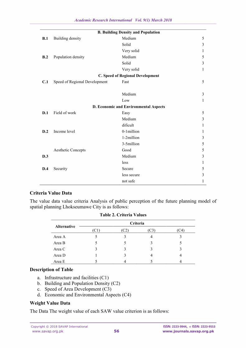
B. Building Density and Population
B.1 Building density Medium 5
Solid 3
Very solid 1
B.2 Population density Medium 5
Solid 3
Very solid 1
C. Speed of Regional Development
C.1 Speed of Regional Development Fast 5
Medium 3
Low 1
D. Economic and Environmental Aspects
D.1 Field of work Easy 5
Medium 3
dificult 1
D.2 Income level 0-1million 1
1-2million 3
3-5million 5
Aesthetic Concepts Good 5
D.3 Medium 3
less 1
D.4 Security Secure 5
less secure 3
not safe 1
Criteria Value Data
The value data value criteria Analysis of public perception of the future planning model of
spatial planning Lhokseumawe City is as follows:
Table 2. Criteria Values
Alternative Criteria
(C1) (C2) (C3) (C4)
Area A 5 3 4 3
Area B 5 5 3 5
Area C 3 3 3 3
Area D 1 3 4 4
Area E 5 4 5 4
Description of Table
a. Infrastructure and facilities (C1)
b. Building and Population Density (C2)
c. Speed of Area Development (C3)
d. Economic and Environmental Aspects (C4)
Weight Value Data
The Data The weight value of each SAW value criterion is as follows:

Academic Research International Vol. 9(1) March 2018
____________________________________________________________________________________________________________________________________________________________________________________________________________________________________________________________________________________________________________
Copyright © 2018 SAVAP International ISSN: 2223-9944, e ISSN: 2223-9553
www.savap.org.pk 57 www.journals.savap.org.pk
Table 3. Weights Each Criterion
Criteria Information Weight (w)
C1 Infrastructure and facilities 35
C2 Building Density and Population 25
C3 Speed of Regional Development 15
C4 Economic and Environmental Aspects 25
Making a Normalized Matrix
The following is the result of a normalized matrix for the analysis of public perception of the
future planning model of spatial planning Lhokseumawe City is as follows:
Table 4. Weight Normalization
Alternative Criteria
(C1) (C2) (C3) (C4)
Area A 1 0.6 0.8 0.6
Area B 1 1 0.6 1
Area C 0.6 0.6 0.6 0.6
Area D 0.2 0.6 0.8 0.8
Area E 1 0.8 1 0.8
The normalized matrix calculation of its completion steps is as follows:
Table 5. Weight Normalization
Name (C1) (C2) (C3) (C4)
Area A 5
5= 1
3
5= 0.6
4
5= 0.8
3
5= 0.6
Area B 5
5= 1
5
5= 1
3
5= 0.6
5
5= 1
Area C 3
5= 0.6
3
5= 0.6
3
5= 0.6
3
5= 0.6
Area D 1
5= 0.2
3
5= 0.6
4
5= 0.8
4
5= 0.8
Area E 5
5= 1
4
5= 0.8
5
5= 1
4
5= 0.8
Assessment of Alternative Value Vi
Table 6. Preferences Table
Alternative Criteria
(C1) (C2) (C3) (C4) Total
Area A 0.35 0.15 0.12 0.15 0.77
Area B 0.35 0.25 0.09 0.25 0.94
Area C 0.21 0.15 0.09 0.15 0.6
Area D 0.07 0.15 0.12 0.2 0.54
Area E 0.35 0.2 0.15 0.2 0.9

Academic Research International Vol. 9(1) March 2018
____________________________________________________________________________________________________________________________________________________________________________________________________________________________________________________________________________________________________________
Copyright © 2018 SAVAP International ISSN: 2223-9944, e ISSN: 2223-9553
www.savap.org.pk 58 www.journals.savap.org.pk
The calculation of the preference values of its completion steps are as follows:
Area A = (1𝑥0.35) + (0.6𝑥0.25) + (0.8𝑥 0.15) + (0.6𝑥0.25) = 0.77
Area B = (1𝑥0.35) + (1𝑥0.25) + (0.6𝑥 0.15) + (1𝑥0.25) = 0.94
Area C = (0.6𝑥0.35) + (0.6𝑥0.25) + (0.6𝑥 0.15) + (0.6𝑥0.25) = 0.54
Area D = (0.2𝑥0.35) + (0.6𝑥0.25) + (0.8𝑥 0.15) + (0.8𝑥0.25) = 0.54
Area E = (1𝑥0.35) + (0.8𝑥0.25) + (1𝑥 0.15) + (0.8𝑥0.25) = 0.9
Display login system in determining Model Decision Planning Future Spatial City
Lhokseumawe are as follows:
Figure 1. Login System
Home View
The main menu view of community perception analysis on decision models in Future
Planning of Lhokseumawe City Spatial Planning is as follows:
Figure 2. Display Home Page
Criteria Data View
The display of criteria menu data on the analysis of public perceptions of the decision model
in the Future Planning of Lhokseumawe City Spatial is as follows:

Academic Research International Vol. 9(1) March 2018
____________________________________________________________________________________________________________________________________________________________________________________________________________________________________________________________________________________________________________
Copyright © 2018 SAVAP International ISSN: 2223-9944, e ISSN: 2223-9553
www.savap.org.pk 59 www.journals.savap.org.pk
Figure 3. Display of Criteria Data
Alternative Data
The display of alternative menu data on the analysis of community perceptions of the
decision model in the Future Planning of Lhokseumawe City Spatial is as follows:
Figure 4. Display of Alternate Data
SAW Process Data View
Display data of participants' value of each alternative in the analysis of community
perceptions of the decision model in the Future Planning of Lhokseumawe City Spatial is as
follows:

Academic Research International Vol. 9(1) March 2018
____________________________________________________________________________________________________________________________________________________________________________________________________________________________________________________________________________________________________________
Copyright © 2018 SAVAP International ISSN: 2223-9944, e ISSN: 2223-9553
www.savap.org.pk 60 www.journals.savap.org.pk
Figure 5. Display of Alternate Data
SAW Report Data View
The data view of the report menu to see rankings on the analysis of public perceptions of the
decision models in the Lhokseumawe Urban Spatial Planning is as follows:
Figure 6. Display of Alternate Data
CONCLUSIONS
1. The result of this model is recommendation from each perception of society to analysis
of policy of change of urban spatial. The results of this study show that the analyzed
system has the ability to support decision makers in determining future planning of
urban spatial planning lhokseumawe
2. The result of this analysis is the future planning of lhokseumawe urban spatial as the
best development place based on the selected variable.
3. With the existence of this system analisisi facilitate the community in seeing the
direction of planning the city in the future.
RECOMMENDATIONS
1. The existence of other methods for the results in order for this system can be displayed
optimally and there is a method of weighting for more subjective results.
2. The database used should always change in a certain period to keep up to date and
better use oracle database for data collection can be larger.

Academic Research International Vol. 9(1) March 2018
____________________________________________________________________________________________________________________________________________________________________________________________________________________________________________________________________________________________________________
Copyright © 2018 SAVAP International ISSN: 2223-9944, e ISSN: 2223-9553
www.savap.org.pk 61 www.journals.savap.org.pk
REFERENCES
[1] Adair, J. (2007). Decision making & problem solving strategies. London: Kogan
Page.
[2] Agustino, L. (2008). Fundamentals of public policy. Bandung: Alfabeta.
[3] Hardi, R. (2015). Genetic algorithm in solving the TSP on the mineral water. Jakarta:
Intelligent Technology and Its Applications (ISITIA).
[4] Hardi, R. Z. 92017). Implementation of computer security system using system
integrated client server method service oriented architecture. Jakarta: Poltekba
Seminar.
[5] Kartono, K., & Gulo, D. (1987). Psychology dictionary. Bandung: Pioneer Jaya.
[6] Klaasen, I.T. (2003). Knowledge-based design: Developing Urban & regional design
into a science. Armsterdam: Delf University Press.
[7] Kusumadewi, S., Hartati, S., H, A., & Wardoyo, R. (2010). Fuzzy multi-attribute
decision making (FUZZY MADM). Yogyakarta: GrahaIlmu Publisher.
[8] Mertes, J. D., & Hall, J. R. (1995). Park, Recreation, open space and greenway
guidelines. Texas: National Recreation and Park Association.
[9] Mirsa, R. (2011). Urban spatial elements. Yogyakarta: GrahaIlmu.
[10] Nawanir, H. (2003). Study on economic and spatial development of Kota Sawahlunto
Pascatambang. Indonesia: Diponegoro University.
[11] Pallagst, K. (2006). Growth management in the San Francisco Bay Area:
Interdependence of theory and practice. USA: Institute of Urban and Regional
Development, UC Berkeley.
[12] Pancawati, T. (2010). Urban spatial planning. Yogyakarta: Student Literature.
[13] Rydin, Y. (1993). The British planning system - An introduction. London: Macmillan.
[14] Soetomo, S. (2010). Urbanization and morphology - The process of development of
civilization and containment of its physical space: Toward the space of human lives.
Yogyakarta: GrahaIlmu.
[15] Sujarto, D. (1992). Urban development approach viewed from local planning side.
Yogyakarta: BPA UGM.
[16] Syafii, I. K. (2006). Public administration science (revised edition). Jakarta: Rineka
Cipta.
[17] Tarigan, R. (2004). Regional development planning. Jakarta: Earth Literacy.
[18] Thorns, D. C. (2002). The transformation of cities - urban theory and urban life. New
York: Palgrave Macmillan.
[19] Turban, E. (2010). Decision support systems and intelligent system. Yogyakarta: Andi
Publisher.
[20] Wibisono, H. (1991). Development of Yogyakarta land use scheme review of land use
amendment between 1912 – 1940. Yogyakarta: FT UGM.
[21] Yunus, H. S. (2000). Spatial structure of the city. Yogyakarta: Student Library.