Embed Size (px)
Citation preview

TS 6 – 3D Cadastre Peter van Oosterom, Hendrik Ploeger and Jantien Stoter TS6.1 Analysis of 3D Property Situations in the USA From Pharaohs to Geoinformatics FIG Working Week 2005 and GSDI-8 Cairo, Egypt April 16-21, 2005
1/17
Analysis of 3D Property Situations in the USA
Peter VAN OOSTEROM, Hendrik PLOEGER and Jantien STOTER, The Netherlands
Key words: 3D Cadastre, geo-DBMS, cadastral data model, USA
SUMMARY In areas with high population densities, 3D property situations with high property values are common. To secure the legal rights and/or fair taxation in those situations an unambiguous and clear registration of 3D situations is required. In previous research we studied 3D property situations in the Netherlands, Denmark, Norway, Sweden, Queensland and British Columbia.
In this paper we will address the registration of 3D property situations in the USA by describing and studying two case studies. The aim of this paper is to show how legal information (including 3D geometry) of 3D property situations can currently be obtained from the existing registrations and if these registrations need improvement for 3D property situations. The fundamental shortcoming in current registrations in the USA (but also in other countries) is that 3D information is only available in drawings in separately filed documents, not digitally linked to administrative information. Therefore it is impossible to interactively view and query a 3D representation of a whole environment.
A promising prototype has been developed by Richland County GIS (South Carolina) for condominiums, which is based on truly 3D volumetric representations of the individual units and shared facilities. This prototype can be improved by addressing properties that cross several parcels, by addressing 3D properties that cannot easily be defined as condominiums in a level approach, and by using absolute height values in the definition of condominiums. Although registration of property in the USA is typically maintained at county level, 3D registration developments could gain from a centralised approach to address the 3D problems, since technology investments and the required knowledge for a full 3D system are much higher than the current 2D based systems.

TS 6 – 3D Cadastre Peter van Oosterom, Hendrik Ploeger and Jantien Stoter TS6.1 Analysis of 3D Property Situations in the USA From Pharaohs to Geoinformatics FIG Working Week 2005 and GSDI-8 Cairo, Egypt April 16-21, 2005
2/17
Analysis of 3D Property Situations in the USA
Peter VAN OOSTEROM, Hendrik PLOEGER and Jantien STOTER, The Netherlands
1. INTRODUCTION In areas with high population densities and intensive use of land, there is a growing interest in using space below and above the surface. This leads to 3D property situations. 3D property situations are situations in which different property units (with possibly different types of land use) are located on top of each other or constructed in even more complex structures, i.e. engaging one another. It has become a challenge to register those situations unambiguous and clear in today’s registration systems. To be able to define and manage the juridical representation in 3D situations, 3D geo-information is of growing importance (Lemmen and van Oosterom, 2003). In earlier research (Stoter, 2004, Stoter et al. 2004), we investigated the registration of 3D property situations in different parts of the world: Netherlands, Denmark, Norway, Sweden, Queensland and British Colombia. The models we developed for 3D cadastral registration were evaluated with the case studies from these countries (including both the legal and geometric aspects of the registration). The case from Queensland was used in a working prototype with 3D volume parcels related to the 2.5D surface of the earth (tessellated with ‘2D’ parcels). Until now no case studies were done in the USA. 1.1 Real property law Except of the state of Louisiana, real property law in the United States is based on the common law. Although the common law, like the on Roman law based civil law in continental Europe, knows the latin maxims superficies solo cedit (the owner of the land is owner of the attached buildings) and cuius est solus, eius est usque ad coelum et ad inferos (who owns the land, has a right from the sky, down into the depths of the earth) it is undisputed that ‘land’ (immovable property) may be held apart from the surface, and subject to horizontal division. So, titles to land can be stratified and vested in various owners simultaneously. The result is that each owner is holding a different portion (cubic space) either below or above the surface. This stratification of land has more often been achieved through the creation of leasehold rather than free hold estates, but it is not considered impossible for the landowner to ‘carve out’ of his estate a ‘flying freehold’. Another way of stratification is the concept of condominium or apartment ownership (Gray and Gray 2001).

TS 6 – 3D Cadastre Peter van Oosterom, Hendrik Ploeger and Jantien Stoter TS6.1 Analysis of 3D Property Situations in the USA From Pharaohs to Geoinformatics FIG Working Week 2005 and GSDI-8 Cairo, Egypt April 16-21, 2005
3/17
1.2 Cadastre and land registration Land records offices are highly decentralized in the USA. They are typically maintained at the county level. As a result, numerous jurisdictions exist with a wide variety of record keeping systems. The current system leaves the control and operation of the conveyancing system at the local or county government level (Onsrud 1989). 1.3 Case study In this paper we will analyze two cases from the USA, a country that includes some of the densest urban areas in the world with very high property values. The legal system in the USA differs quite a lot from the countries we discussed in our earlier papers. This is reflected in the ‘cadastral registration’ (systems and organization). However, the ‘real world’ is not that different (very dense population and constructions/ownership above and below each other). A classic 3D property case in the USA is the financing of the construction of Grand Central Station in New York City by the sale of “air rights” over the railway yards early 20th century. Even after the project was completed the owners continued to exploit the space above the railway and the terminal itself by the sale of construction rights. An example of the latter is the Pan Am Building (see figure 1). The cases from the USA will be described in more detail in order to reveal the currently used methods and to suggest some possible future improvements: 1. Covered pedestrian bridge (skywalk) in Ramsey
County in Minnesota; see Section 2. 2. Condominium example from Richland County
South Carolina; see Section 3
Figure 1: Pan Am building above Grand Central terminal.
2. CASE 1: SKYWALK SYSTEM IN MINNEAPOLIS/ST.PAUL 2.1 The real world situation In the Minnesota Twin Cities Minneapolis and St. Paul the pedestrian skywalks dominate the downtown streetscape and pull pedestrians away from street level. The system does not only consist of the covered skyways above the street (and sometimes also below the street via tunnels), but also in the buildings. The construction of this network was motivated by the fact that suburban enclosed shopping malls were attracting shoppers from the downtown area. Via

TS 6 – 3D Cadastre Peter van Oosterom, Hendrik Ploeger and Jantien Stoter TS6.1 Analysis of 3D Property Situations in the USA From Pharaohs to Geoinformatics FIG Working Week 2005 and GSDI-8 Cairo, Egypt April 16-21, 2005
4/17
the skywalk system of enclosed passages a story above the street and the downtown buildings are linked, making it possible to reach shops, restaurants and offices without going outside. Currently, 100 buildings in Minneapolis and 65 in St. Paul are linked. Figure 2 gives an impression of the skywalk system. This is a real 3D property case as the owners of the buildings, streets and the parts of the skywalk system (with overlap in the 2D projection) can be different persons. Figure 3 shows a map of (part of) the system. The case study is situated near the crossing of Seventh St. and Cedar st.
Figure 2: Top: left skyway near convention center, right: Crown Theater sign on Hennepin Eblock (from http://minneapolis.about.com); Bottom: 6th Street, double skyways connect 2th and 4rd floor (from http://www.cgstock.com).

TS 6 – 3D Cadastre Peter van Oosterom, Hendrik Ploeger and Jantien Stoter TS6.1 Analysis of 3D Property Situations in the USA From Pharaohs to Geoinformatics FIG Working Week 2005 and GSDI-8 Cairo, Egypt April 16-21, 2005
5/17
Figure 3: Map of the St.Paul skywalk system. 2.2 Legal situation There are two real estate recording systems in Minnesota: ‘Abstract Title’ and ‘Torrens Title’. Land, which has been registered pursuant to a District Court Order, is called ‘Torrens Land.’ The owner of registered land has ‘Torrens Title.’ Land, which has not been registered, is called ‘Abstract Land’. ‘Abstract’ refers to the ‘abstract of title’, that is not more than a condensed history of all registered deeds, mortgages and other documents relating to the land from the registry of deed. Before the enactment of the Torrens Act in 1901 (now Minnesota Statues Chapter 508), all land was Abstract land. Creation of condominium property is possible according to the rules provided in Minnesota Statues Chapter 515 and Chapter 515A (Uniform Condominium Act). A condominium can be registered or unregistered land. 2.3 The documents (Torrens Title)
2.3.1 Legal
The Torrens registration of land titles results in the creation of a Certificate of Title. The Registrar must examine the documents presented and determine that they meet the legal requirements to transfer the property. He will issue the Certificates of Title, which are proof of ownership for the purchaser. This Certificate is kept in the office of the Registrar of Titles (Minnesota Statues, Chapter 508.03-508.12)
TS 6 – 3D Cadastre Peter van Oosterom, Hendrik Ploeger and Jantien Stoter TS6.1 Analysis of 3D Property Situations in the USA From Pharaohs to Geoinformatics FIG Working Week 2005 and GSDI-8 Cairo, Egypt April 16-21, 2005
6/17
2.3.2 Surveying and plans
A Registered Land Survey (RLS) is a survey performed for the identification of registered Torrens lands, according to Minnesota Statues 508.47. A registered surveyor must certify the RLS to be a correct representation of the parcel. The RLS is filed in the office of the Registrar of Titles. Before this, the county surveyor must approve it. The RLS must correctly show the legal description of the land and the outside measurements of the parcel and all tracts delineated therein. All tracts are lettered consecutively beginning with the letter ‘A’. It is interesting to see that the law provides that multilevel tracts can be surveyed. Minnesota Statues 508.47 subd. 4 reads:
‘A registered land survey which delineates multilevel tracts shall include a map showing the elevation view of the tracts with their upper and lower boundaries defined by elevations referenced to National Geodetic Vertical Datum, 1929 adjustment.’
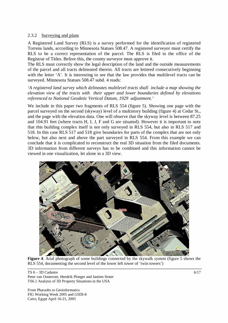
We include in this paper two fragments of RLS 554 (figure 5). Showing one page with the parcel surveyed on the second (skyway) level of a multistory building (figure 4) at Cedar St., and the page with the elevation data. One will observe that the skyway level is between 87.25 and 104.91 feet (where tracts H, I, J, F and G are situated). However it is important to note that this building complex itself is not only surveyed in RLS 554, but also in RLS 517 and 518. In this case RLS 517 and 518 give boundaries for parts of the complex that are not only below, but also next and above the part surveyed in RLS 554. From this example we can conclude that it is complicated to reconstruct the real 3D situation from the filed documents. 3D information from different surveys has to be combined and this information cannot be viewed in one visualization, let alone in a 3D view.
Figure 4: Arial photograph of some buildings connected by the skywalk system (figure 5 shows the RLS 554, documenting the second level of the lower left tower of ‘twin towers’)

TS 6 – 3D Cadastre Peter van Oosterom, Hendrik Ploeger and Jantien Stoter TS6.1 Analysis of 3D Property Situations in the USA From Pharaohs to Geoinformatics FIG Working Week 2005 and GSDI-8 Cairo, Egypt April 16-21, 2005
7/17
Figure 5: Two fragments of Registered Land Survey 554 (St. Paul case); part of skywalk system within a building. The 3D aspect is highlighted on the survey.

TS 6 – 3D Cadastre Peter van Oosterom, Hendrik Ploeger and Jantien Stoter TS6.1 Analysis of 3D Property Situations in the USA From Pharaohs to Geoinformatics FIG Working Week 2005 and GSDI-8 Cairo, Egypt April 16-21, 2005
8/17
2.4 Current registration The ‘Certificate of Title’ documents are registered at the office of the Registrar of Titles (Minnesota statues 508.34). Also the RLS, describing the geometric aspects of the involved real estate objects, is kept there (Minnesota Statues 508.47). Information is available for the public via Internet http://gis.ci.stpaul.mn.us/rcsurvey and http://rrinfo.co.ramsey.mn.us/public/characteristic/. http://maps.metro-inet.us/RamseyCoGIS/Viewer.htm offers the following services: access ‘Certificate of Title’, ‘Registered Land Survey’ and the cadastral map (see figure 6).
Figure 6: Base map fragment (showing parcels and structures) of the example used in this section. This information system gives access to the legal descriptions of the 3D properties. A search in the http://rrinfo.co.ramsey.mn.us/public/characteristic/index.asp shows for instance a legal description of a property in the Cedar Street complex (with Parcel Identification Number 06.28.22.12.0130) as:

TS 6 – 3D Cadastre Peter van Oosterom, Hendrik Ploeger and Jantien Stoter TS6.1 Analysis of 3D Property Situations in the USA From Pharaohs to Geoinformatics FIG Working Week 2005 and GSDI-8 Cairo, Egypt April 16-21, 2005
9/17
“Tracts B,E,I & J in RLS 554 & in sd RLS 518 tracts F & MM& those parts of tract KKK lying bet plane surface elevations of 173.64 ft and 185.40 ft & lying bet plane surface elevations of 232.38 ft & 267.64 ft & lying above a plane surface elevation of 350.66 ft city of St Paul datum & those part of tract KKK lying bet plane surface elevations of 104.91 ft & 114.97 ft city of St Paul datum & lying swly of a line drawn parallel with & 61.13 ft nely of as measured at right angles to the swly l of sd tract KKK”. This shows that the property itself involves tracts from both 518 and 554 and that the height measures are part of the actual description. 2.5 Future system The system is currently able to handle a 2D cadastral map representation of the situation, which can be used as an entry to related information, such as the legal/administrative information (extract, but also the source document) and the RLS which can contain 3D information as was shown in section 2.3. However, exploration of the 3D situation is limited to a case-by-case approach via documents (3D). In addition the 3D information of several neighbor surveys is not related. A future system might consider taking the 3D information out of the surveys and including them in a 3D geographic information system. This approach will have a number of advantages: - The 3D information itself is available in the information system (and can be linked to
legal information) - The user interface can become 3D (and therefore closer to the real world situation instead
of the flat 2D map) - The 3D information can be better checked on consistency; e.g. are two neighbor volume
properties correctly represented (based on the RLS source documents), that is, no overlap or gaps between these objects in 3D space (similar as one does not want this for the 2D parcel map).
In order to be able to obtain these results a number of problems have to be solved. The individual property objects from the RLS have to be converted into 3D geo-objects in the database (including conversion from local survey to global map coordinates and checking for completeness and validness of the specified 3D volume objects). Next, the 3D geo-objects have to be linked to the administrative and legal information that is registered for the 3D properties. 3. CASE 2: CONDOMINIUMS IN SOUTH CAROLINA, RICHLAND COUNTY 3.1 The real world situation The second case study is more common and is related to a situation, which is present all over the world: apartments or condominiums. The case that was studied and will be described here is located in South Carolina, Richland County (contains the city of Columbia, the state capital). Figure 7, left shows the location of the county and figure 7, right shows the specific complex (Middleborough), which will be analyzed in more detail.

TS 6 – 3D Cadastre Peter van Oosterom, Hendrik Ploeger and Jantien Stoter TS6.1 Analysis of 3D Property Situations in the USA From Pharaohs to Geoinformatics FIG Working Week 2005 and GSDI-8 Cairo, Egypt April 16-21, 2005
10/17
3.2 Legal situation Condominium ownership is defined by the South Carolina Horizontal Property Act (South Carolina code of laws Chapter 27), section 27-31-20 as: ’the individual ownership of a particular apartment in a building and the common right to a share, with other co-owners, in the general and limited common elements of the property’.
Figure 7: left location Richland county in South Carolina, right Middleborough condominiums. A building under ’horizontal property regime’ contains common elements (like the land on which the building stands, the foundations, main walls, roof, elevators, etc) and the privately owned apartments. An apartment is a part of the property intended for any type of independent use, including one or more rooms or enclosed spaces in a building, or a delineated place outside a building (e.g. spot for parking a car, or storage of a boat). An apartment owner has the exclusive ownership of his apartment, and a common right to a share in the common elements of the property (Horizontal Property Act section 27-31-60). So apartment ownership in South Carolina is based on the so-called dualistic system; exclusive ownership of the apartment, combined with a share in the common elements. 3.3 The documents 3.3.1 Legal Horizontal property regime is established by the recordation of a master deed or lease, executed by the owner (or owners) of the real property. This deed must contain inter alia (Horizontal Property Act section 27-31-100): - a description of the land and the buildings, - the general description and number of each apartment, expressing its area, location and
any other data necessary for its identification - the description of the common elements of the property - the value of the property and of each apartment and the percentage of the share of each of
the co-owners in the expenses and its rights in the common elements.

TS 6 – 3D Cadastre Peter van Oosterom, Hendrik Ploeger and Jantien Stoter TS6.1 Analysis of 3D Property Situations in the USA From Pharaohs to Geoinformatics FIG Working Week 2005 and GSDI-8 Cairo, Egypt April 16-21, 2005
11/17
- a description of the rights and obligations of the co-owners. After establishing the horizontal property regime each apartment unit can be transferred by recording a deed. This deed will refer to the master deed for a more accurate description of the property and interests. 3.3.2 Surveying and plans Attached to the master deed is filed a plot plan and building plan (Horizontal Property Act section 27-31-110). The plot plan is a map showing the horizontal and vertical location of the buildings within the boundary of the property under horizontal property regime. This must be signed and sealed by a registered land surveyor. There must also be attached a plot plan of the construction showing the location of the building and a set of floor plans of the building which must show graphically the dimensions, area, and location of each apartment, and the dimensions, area and location of common elements affording access to each apartment (e.g. stairways, corridors). Other common areas must only be shown graphically insofar as possible, but must be described in detail in words and figures. An authorized and licensed engineer or architect must certify the building plans. Each apartment must be designated on the plans by letter or number on the plans (see figure 8). 3.3.3. Description of the apartment boundaries in the master deed The master deed of the Middleborough condominiums gives the following description of the boundaries of each apartment (source master deed D 593 page 93): ‘Each Apartment encompasses and includes all that portion of the building designated on the Floor Plans as an Apartment and consisting of all living and storage place bounded by the upper surface of the floor slab, by the unexposed surfaces of the drywall or plastering forming interior walls and ceiling, and by the exterior surfaces of windows and window frames and of exterior doors and the door frames (…)’. It can be observed that the description not only refers to the floor plans, but also to the constructive elements of the building: walls, ceiling and floor.
Figure 8: Fragment of Property Tax Map (R11851) of Middleborough (levels 4 until 18 skipped as they all look the same)

TS 6 – 3D Cadastre Peter van Oosterom, Hendrik Ploeger and Jantien Stoter TS6.1 Analysis of 3D Property Situations in the USA From Pharaohs to Geoinformatics FIG Working Week 2005 and GSDI-8 Cairo, Egypt April 16-21, 2005
12/17
3.4 Current registration
The website http://www.richlandmaps.com/maps/maps.html can be used to obtain a map (including parcels, buildings, streets and aerial photographs) for any area of interest within Richland County. It is possible to locate an address or parcel number on the map (via the dated 1996 parcel layer) and it is also possible to obtain administrative valuation/taxation information via links to the website http://www2.richlandonline.com/Assessorearch (information dated December 2003) (for both websites see figure 9). In this process the property tax map (number) plays a linking role as via this number all related administrative information can be obtained including all condominiums involved, even as they are not directly visible on the parcel map. Via traditional means, that means not via an on-line information system (but via an analogue system), it is possible to obtain the involved property tax map itself and the master deed including the attached exhibits (such as building plans) as available for property under the (South Carolina) horizontal property regime. The building plans contain some height information, but this is not available as 3D information on the cadastral parcel map.
Figure 9: The Richland County Internet mapping Service for locating parcels and obtaining related on-line taxation information (including sale history of the property); notice the tall building, a little above the center of the map on the aerial photograph (Middleborough).

TS 6 – 3D Cadastre Peter van Oosterom, Hendrik Ploeger and Jantien Stoter TS6.1 Analysis of 3D Property Situations in the USA From Pharaohs to Geoinformatics FIG Working Week 2005 and GSDI-8 Cairo, Egypt April 16-21, 2005
13/17
3.5 Future system Investigations are going on in Richland County to improve the registration of condominiums by truly including the height information and moving from a 2D map model to a 3D cadastral model. The basic principle is that the whole county is covered with (non-overlapping) 2D parcels, called Simultaneous Conveyance (Simon) objects. In certain cases, e.g. when the domain type is ’Condo’, these objects are further subdivided into Simultaneous Conveyance Division (Simonyi). Again, these (sub)objects can be of different type; e.g. Unit, Common Element, Limited Common Element, Lake, Outlot, some of which can be 3D in nature (such as the condominium unit); see figure 10. A prototype system has been developed by Richland County GIS, in which the individual condominium unit has got its own 3D geometry (see figures 11 and 12).
Unit 1 Unit 2
Parking Lot
Unit 3
SimConDiv SimConDivID 6 SimConID 2 SimDivConTp Common Element (domain of values) Name New Stacks Parking Lot Level 1 Floor First Floor
SimConDiv SimConDivID 7 SimConID 2 SimDivConTp Unit (domain of values) Name Unit 2 Level 1 Floor First FloorSimConDiv
SimConDivID 9 SimConID 2 SimDivConTp Unit (domain of values) Name Unit 1 Level 1 Floor First Floor
SimConDiv SimConDivID 8 SimConID 2 SimDivConTp Common Element (domain of values) Name Entryway Level 1 Floor First Floor
Unit 1 Unit 2
Parking Lot
Unit 3
SimConDiv SimConDivID 10 SimConID 2 SimDivConTp Common Element (domain of values) Name Stairway Level 2 Floor 2
SimConDiv SimConDivID 11 SimConID 2 SimDivConTp Unit (domain of values) Name Unit 3 Level 2 Floor 2
Figure 10: The principle behind the prototype implementation of the system for the horizontal property regime: left, the ground level (with the ground parcel, shared entry/stairs, and two units) and right, the second level (with the entry/stairs and one unit); notice the registration of the shared facilities in yellow (ground parcel, stairs) and the individual units in orange.
Figure 11: The 3D interface (ArcScene) of the 3D representation of the condominiums, left the selection of a number of units, right the selection of a single unit and the display of a number of relevant attributes.

TS 6 – 3D Cadastre Peter van Oosterom, Hendrik Ploeger and Jantien Stoter TS6.1 Analysis of 3D Property Situations in the USA From Pharaohs to Geoinformatics FIG Working Week 2005 and GSDI-8 Cairo, Egypt April 16-21, 2005
14/17
Part of the prototype is related to giving the individual unit unique identifiers (’Tax Keys’) in the system. Until now these numbers were based on the Tax Map System number (TMS), completed with a unit number (within the tax map sheet). A more geographic oriented identifier has been tested with success. This is called Geographic Parcel Identification Number (GPIN), which is also defined for normal parcels (in addition to condominiums). The GPIN is based on centroid of parcel in State Plane Coordinates with a two-digit extension for level. The digits of the coordinates are interleaved (kind of Morton-coding) and extended with the level; for example: easting = 2,012,774 ft, northing = 0,800,231 ft and unit level = 04, then the GPIN would be 20081020727341.04 (ENENENENENEN.Level). In case of negative level (-1, -2,) these are encoded as levels 99, 98, etc. (note that for counties with taller buildings a three digit level extension ma be needed.
Figure 12: Again, 3D Condominiums from Richland County South Carolina (in ArcScene); this time only the first two layers are selected (of the Middleborough complex) and some additional houses in the environment; taken from von Meyer et al. 2004. Some aspects currently not covered in the 3D cadastral prototype of Richland are: 1) objects crossing several ground parcels (the solution proposed for condominiums may not be optimal for objects such as tunnels or pipelines), 2) 3D objects, which cannot be modeled in the level or layer approach (in case of more complex 3D configurations), and 3) absolute height of 3D objects instead of the relative ‘unstable’ height. One could imagine further developments in one of these directions. Concerning the z-value, a decision has to be made whether z-values should be defined relatively, with respect to the surface or specified in an absolute manner. Absolute coordinate are more stable and they provide unambiguous definitions of 3D objects, especially in mountainous areas. Absolute heights also require that the height of the surface (parcels) is available (in order to determine the position of a certain 3D object: above or below the surface).

TS 6 – 3D Cadastre Peter van Oosterom, Hendrik Ploeger and Jantien Stoter TS6.1 Analysis of 3D Property Situations in the USA From Pharaohs to Geoinformatics FIG Working Week 2005 and GSDI-8 Cairo, Egypt April 16-21, 2005
15/17
The condominium units are probably the most frequent type of real property unit (and relevant for taxation), so this is a very reasonable start. It may already proof to be difficult enough to take this step as the users have to make quite a big mental move from a 2D to a 3D model with difficult visualization and interaction aspects associated, e.g. one could imagine internal 3D (shared) objects which are not visible unless first some other objects are made transparent or not displayed (e.g. by removing top layers as in figure 11). 4. CONCLUSION This paper presented a general introduction to the cadastral registration in the USA, which is characterized by its highly decentralized and as a result non-homogeneous nature. This has some drawbacks for the nation-wide and uniform access to real property information. As a result this may have some negative effects on the transparency of the market and the legal security of real property. However, the USA as a nation seams to be able to cope with this situation (via a ‘work around’ such as insurance to deal with the lower level of legal security). There are states/counties in which this cadastral registration is quite advanced and locally a higher level of legal security can be provided. The ‘real world’ in the USA turned out not to be too different from the countries earlier investigated (Netherlands, Denmark, Norway, Sweden, Queensland and British Colombia) as especially in urban areas real estate objects of different owners are also more and more often built on top of each other (or in the subsurface) and thereby requiring a more explicit third dimension in cadastral registrations. It was investigated in two different states/counties (having already a more advanced cadastral registration in operation) how these situations are dealt with: parts of the skywalk system in Minneapolis/St. Paul (Minnesota) and condominiums in Richland County (South Carolina). As in other countries of the world it turns out that the registration could be improved through the application of the principles of a true 3D cadastral registration. Note that the two examined cases are just two examples (but representative for certain type of 3D real estate objects). Some other types of 3D real estate objects are: underground shopping malls or parking garages, tunnels, pipelines, 3D mining rights, etc. It is clear that these will also occur in the USA similar to other countries in the world. Technology investments and required knowledge levels for a full 3D cadastral system is (much) higher than the current 2D based systems. Instead of the distributed approach in which each county builds and operates an own system (which will be very expensive in the case of a 3D cadastral system), it will be much more effective to jointly set-up such a system (perhaps first at state level, but finally a the county level). This could also result in a more uniform cadastral registration (with all its positive side effects). The data ownership and maintenance responsibility can remain at the current local level and does not have to be changed. In a way, the nation will then have the best of both worlds: decentralized local expertise, but at the same time harmonized (and centralized/clustered, cost effective) data management and access to the information. This will then include the increasing need of 3D functionality (without every county to make large/impossible investments).

TS 6 – 3D Cadastre Peter van Oosterom, Hendrik Ploeger and Jantien Stoter TS6.1 Analysis of 3D Property Situations in the USA From Pharaohs to Geoinformatics FIG Working Week 2005 and GSDI-8 Cairo, Egypt April 16-21, 2005
16/17
ACKNOWLEDGEMENTS We would like to thank Alex Smith (and his colleagues) for providing us with the extensive material for the Richland County (South Carolina) case and even going out and taking pictures for us. We would further like to thank Bastiaan van Loenen for bringing the Minneapolis/St. Paul case under our attention. This publication is the result of the research program Sustainable Urban Areas (SUA) carried out by Delft University of Technology. We would like to thank the Geo-ICT industry partners for cooperation within our Geo-Database Management Center (GDMC). REFERENCES Gray, Kevin and Susan Francis Gray (2001), Elements of Land Law, Butterworths,
London/Edingburgh/Dublin 2001. C. Lemmen and P. van Oosterom. Editorial 3D Cadastres, In: Computers, Environment and
Urban Systems, Theme Issue: 3D Cadastres, Volume 27, Number 4, July 2003, pp. 337-343.
Nancy von Meyer, Wane Hewitt, Scott Oppmana, Don Dittmar, and Alex Smith. ArcGIS Data Models: Parcel Data Model, 24th Annual ESRI International User Conference, August 9–13, 2004. San Diego, USA.
Onsrud, Harlan J 1989. The Land Tenure System of the United States, Forum (Zeitschrift des Bundes der Öffentlich Bestellten Vermessungsingenieure), January 1989.
Jantien Stoter, Peter van Oosterom, Hendrik Ploeger and Henri Aalders, Conceptual 3D cadastral model applied in several countries. FIG Working Week 2004, 22-27 May, Athens, Greece.
J.E. Stoter, 3D Cadastre, PhD thesis, Delft University of Technology, September 2004. BIOGRAPHICAL NOTES Peter van Oosterom obtained a MSc in Technical Computer Science in 1985 from Delft University of Technology. In 1990 he received a PhD from Leiden University for this thesis "Reactive Data Structures for GIS" (updated version published by Oxford University Press, 1993). From 1985 until 1995 he worked at the TNO-FEL laboratory in The Hague, The Netherlands as a computer scientist. From 1995 until 2000 he was senior information manager at the Netherlands’ Kadaster, were he was involved in the renewal of the Cadastral (Geographic) database. Currently, professor Peter van Oosterom is head of the section ‘GIS Technology’ at the Delft University of Technology, OTB. His main research themes are spatial database management systems, GIS architectures, generalization, spatial analysis, querying and presentation, Internet/interoperable GIS and cadastral applications. Hendrik Ploeger studied law at Leiden University. In 1997 he finished his PhD-thesis on the subject of the right of superficies and the horizontal division of ownership rights (Horizontale splitsing van eigendom, Leiden 1997). The same year he did research at the E.M. Meijers-Institute of Legal Studies on the subject of bored tunnels and the rights of landowners. After an assistant-professorship in civil and notary law at Leiden University, he is since 2001

TS 6 – 3D Cadastre Peter van Oosterom, Hendrik Ploeger and Jantien Stoter TS6.1 Analysis of 3D Property Situations in the USA From Pharaohs to Geoinformatics FIG Working Week 2005 and GSDI-8 Cairo, Egypt April 16-21, 2005
17/17
assistant-professor at Delft University of Technology, OTB, section Geo-information and Land management. He is also chairman of the FIG working group on 3D-Cadastres. Jantien Stoter graduated in Physical Geography at Utrecht University in 1995 before beginning her career as a GIS specialist with the District Water Board of Amsterdam (1995-1997). From 1997 till 1999 she worked as a GIS consultant at the Engineering Office of Holland Rail Consult where she applied GIS analyses to support the planning of large infrastructure projects. Her university career started in 1999 as an assistant professor in GIS applications, section GIS technology, in the Department of Geodesy, Delft University of Technology. In September 2004 she finished her PhD research on 3D Cadastre. Since April 2004 she holds the position of assistant professor at the International Institute for Geo-Information Science and Earth Observation, ITC, Enschede, the Netherlands. Her main research and education responsibilities are generalization of geo-information and multi-scale databases. CONTACTS Peter van Oosterom and Hendrik Ploeger Delft University of Technology OTB, Section GIS-technology | Section Geo-information and Land management P.O. Box 5030 2600 GA Delft, NL Tel. +31 15 2786950 Fax +31 15 2782745 E-mail: {oosterom|h.ploeger}@otb.tudelft.nl Web site www.gdmc.nl, www.otb.tudelft.nl Jantien Stoter International Institute or Geo-Information Science and Earth Observation P.O. Box 6 7500 AA Enschede THE NETHERLANDS Tel. +31534874444 Fax +31534874400 E-mail: [email protected] Web site: www.itc.nl


![ISLAMIC BANKING & FINANCE - 3D EDUCATORSBROCHURE].pdf · FINAL CERTIFICATION AWARDED BY IMRTC - USA ISLAMIC BANKING & FINANCE Training Program Program is offered by: 3D Educators](https://img.pdfslide.us/doc/110x75/5b835f9e7f8b9a64618ce9a0/islamic-banking-finance-3d-educators-brochurepdf-final-certification-awarded.jpg)