Embed Size (px)
Citation preview

Renew. Energy Environ. Sustain. 6, 32 (2021)© K.M. Fasel et al., Published by EDP Sciences, 2021https://doi.org/10.1051/rees/2021033
Available online at:www.rees-journal.org
RESEARCH ARTICLE
An Overview of Wind Resource Assessments With SpecialReference to The Emirate of Ajman, UAEKais Muhammed Fasel, Abdul Salam K. Darwish* , Peter Farrell , and Hussein Kazem
University of Bolton, Bolton, UK
* e-mail: a
This is anO
Received: 28 June 2021 / Received in final form: 8 September 2021 / Accepted: 8 September 2021
Abstract. The continuous increase in clean energy demand and reduced CO2 emissions in the UAE andspecifically the Emirate of Ajman has put an extreme challenge to the Government. Ajman is one of the sevenemirates constituting the United Arab Emirates (UAE). Ajman is located along the Arabian Gulf on its Westand bordered by the Emirate of Sharjah on its North, South, and East. The government is taking huge steps inincluding sustainability principles and clean energy in all of its developments. Successful implementation ofgreen architecture law decree No 10 of 2018 effectively is a sign of such an initiative. Renewable energy sources inthis country have had two folds of interest in solar and wind. Recent research works supported the feasibility ofusing wind energy as an alternative clean source of energy. Site-specific and accurate wind speed information isthe first step in the process of bankable wind potential and wind Atlas. This study has compared how wind speedand its distribution varies for similar offshore and onshore locations between two different mesoscale datasources. Also, discussed the main environmental characteristics of Ajman that would influence theimplementation of a major wind energy project. In addition, the study made a brief critical overview of themajor studies undertaken in the Middle East and North Africa (MENA) region on wind resource assessment.Finally, based on the results, the study makes conclusions, recommendations and a way forward for a bankablewind resources assessment in the Emirate of Ajman. This paper would alert the wind energy industry about theconsequence of not considering the best error corrected site specific suitable wind resource data along with otherenvironmental characteristics. The study results show that for offshore, there is 2.9m/s and for Onshore 4.9m/svariations in wind speed at the same location between ECMWF Reanalysis (ERA-5) and NASA Satellite data.Hence It is concluded that error corrected site-specific wind resource assessment is mandatory for assessing theavailable bankable wind potential since there are considerable variations in wind speed distributions betweenmesoscale data sets for similar locations. The study also identifies that the Emirate of Ajman has limited spacefor onshore wind farms; hence the offshore site seems to have good potential that can be utilised for energygeneration. However, individual wind turbines can be installed for exploiting the available site-specific onshorewind energy. Finally, the study recommends a way forward for a comprehensive wind resource assessment tohelp the Emirate of Ajman form a sustainable wind power generation policy.
1 Introduction and background
Wind Resource Assessment (WRA) calculates how muchenergy is possible to extract from the wind blowing at alocation using a wind turbine. The results help generate awind atlas for the area showing the distribution of windenergy at various locations for wind energy deviceinstallations. WRA involves assessing and quantifyingwind resources to calculate average wind speed, averagewind energy density, and the average annual energy
penAccess article distributed under the terms of the CreativeComwhich permits unrestricted use, distribution, and reproduction
production (AEP) for a proposed wind power plant. In anylocation for designing a wind energy system, it is requiredto have site-specific knowledge of wind resources. Basically,a 5% error in wind data measurements can lead to 10%inaccuracy in AEP, which would cause±10% inaccuracy inrevenue. Finally, this error can be the difference between afinancially feasible and a non-feasible wind project [1].
Since wind is a weather phenomenon, there is inherentuncertainty in its long term predictions, especially over thelifetime of a wind farm as a year to year variation in windspeed is influenced by climate indices like El Niño, La Niña,and a variety of other long-term cyclical phenomena.Extrapolation of wind data to the lifetime of a wind farm
monsAttribution License (https://creativecommons.org/licenses/by/4.0),in any medium, provided the original work is properly cited.

2 K.M. Fasel et al.: Renew. Energy Environ. Sustain. 6, 32 (2021)
requires assumptions and the use of statistical models.Wind flow models are used in predicting the wind speed athub heights. These models are solved through varioussimplifications and assumptions. And these assumptionscreate ambiguity in assessments of average wind speed athub height and average AEP. This causes a reduction inrevenue and fails to meet the cost of maintenance andoperations. Therefore regardless of the size of the windproject, it is a must to conduct accurate WRA. The non-availability of accurate wind data at various hub heights isa serious issue in the wind industry. This causes to increasein the cost of wind projects. Due to conflicts of interests,there is no sharing of wind resource data betweendevelopers. Like rainfall, the wind is also a cyclicalphenomenon; hence, a short-term one-year data measure-ment is risky for predicting wind energy production for 20years in the future. Hence, a wind project without a high-quality long-term wind resource assessment is tough toconsider as bankable wind resources and lacks the chanceto get funded. Funding agencies require a project to havewind speed data of 3 to 5 years [1]. Even though thegovernment of Ajman already laid its foundation fordeveloping sustainable energy systems in the Emiratethrough the successful implementation of green architec-ture law decree No 10 of 2018, the literature review shows aconsiderable gap and no WRA study. This mandates acomprehensive WRA over the Emirate to understand thewind resources available either onshore or offshore to utilisethe wind resources and to produce the power required tomeet the growing demand of the Emirate.
According to the latest census data available, thepopulation of Ajman counts approximately 230,000inhabitants. Ajman city combines both the inveterateheritage that extends through many years of Emiratehistory and the magnificent present that builds itsrenaissance in the persuasion of achieving the highestlevel of development and progress. And the Emirate’sauthority has made complete implementation strategies tothe United Nations Sustainable Development Goals(UNSDGs) and appointed each SDG to the related activity[2]. Hence finding out suitable locations and identifying thetype of wind energy harnessing system(s) that can beutilised for optimum power exploitation from the availablewind resource in the Emirate is crucial. Especiallyconsidering the scarcity of accessible land, characteristicsof the terrain, sensitivity of the receptors and the socialimpacts. This, in turn, mandates a site-specific validatedwind resource assessment.
Wind power projects are often delayed or discarded dueto technical weakness in measurement instruments anddata management. Moreover, the wind characteristics,especially over Ajman, may depend on and influence by thevarious climatic factors, extreme events taking placeelsewhere in UAE. As stated by [3], we must not besatisified until we have all our energy produced usingrenewable energy. Referring to the monthly wind data [4]has concluded the opportunity for using different windenergy technology in the Emirate of Ajman by reviewingpossible technologies like seawater desalination, streetlighting, and buildings integration for lighting purposes.Most importantly, pointed out that desalination techniques
using Offshore wind energy are the most applicabletechnology to the Emirate of Ajman, and concludes thatthe available wind resource is expected to contribute 20% ofthe electricity need Emirate.
The literature review shows that previous researchersused long-term predicted winds obtained from globalreanalysis models as a reliable data source for WRA [1].They claimed that this data is sufficient when themeasuredor satellite observations are sparse in a specific region.Furthermore, several previous researchers like [5–10] usedCFSR, MERRA-2, ECMWF and ERA products such asERA 40, ERA-Interim, and ERA5 for WRA. Also, asstated by [11], ERA 5 wind data is highly used for windenergy assessments.
This study identifies the gaps and ambiguity in theprocess of WRA in the light of the prior studies and byanalysing the Wind data from a mesoscale model andsatellite data. The study results have been utilised torecommend developing an error correctionmethodology forthe WRA over the Emirate of Ajman.
1.1 Aim
In the light of identified gaps in the previous studiesmentioned in Section 1, this initial investigative studywould investigate the variations in wind speed distributionat the same selected onshore and offshore location in theEmirate of Ajman between global reanalysis ERA-5 andNASA Power data. The study would analyse aforemen-tioned data sets to identify the variations in wind speeddistributions in light of other environmental parameters inAjman. Finally, the study aims to recommend a wayforward to determine the formation of a methodology forthe future site-specific comprehensive WRA studies usingmeasured and a selected global reanalysis wind andweather data sets over the Emirate of Ajman.
The next part of this paper will proceed in the followingorder:
– Section 2 will discuss the details of the study area. – Section 3 will discuss the details of the data andmethodology adopted for this study.–
Section 4 will discuss the significant studies on WindResource Assessments in the MENA region.–
Section 5 will discuss some of the leading environmentalcharacteristics of the Emirate of Ajman, which wouldinfluence the implementation of a major wind energyproject.–
Section 6 will detail how wind speed varies for anOffshore and Onshore location in Ajman between twodifferent wind data sources.–
Section 7 will discuss the conclusion, way forward andrecommendations for a Bankable wind resource assess-ment in the Emirate of Ajman.2 Study area
2.1 The Emirate of Ajman
The Emirate of Ajman lies between the emirates of Sharjahand Um Al-Quwain at The Arabian Gulf with a length of26 km. It is the smallest among the emirates and has an area

Fig. 1. Overview map of the city of the Emirate of Ajman.
K.M. Fasel et al.: Renew. Energy Environ. Sustain. 6, 32 (2021) 3
of 460 sq. km. Thus this area is equal to 0.33% of the totalarea of the United The Arab Emirates. The Emirate ismade up of three far different regions in terms of thetopography and the extent of weather, and the regions are:Ajman City, Musfoot and Al-Manama area. The Emirateclimate is characterised by moderation, where thetemperature is moderate. Humidity is high during thesummer, whereas the temperature reaches 25 °C in winter.Musfoot Area is about 110 km from the city of Ajmanto thesoutheast. The area is famous for its fascinating naturethat includes the high mountains, such as (Dafta,Madeerah, the White Mountain, Leshan, and AbuFarajMountain) also there are valleys such as (Ghalfa, Leshan,Al-Sawamir, Al-Khanfarih, Al-Dafdi(frog) and leemvalley). The area is famous for agriculture due to itsfertile soil, vast valleys and moderate climate, making thearea an adequate centre for tourism and sightseeing. Al-Manama area is located in a plain full of pebbles and sands.The site is characterised by its fascinating nature, includingthe mountains such as Al-Ashqar and Bin ElwahMountain. There are some valleys such as Munsit,Al-Safsaf and Baee Al-Nakheel valley. The area is alsofamous of agricultural crops. Al-Manama Area is about60km away from Ajman city to the eastward. Most of themain Emirate’s landmass is developed, with extensivesuburbs stretching out almost to the E311 arterial road,with light industrial zones and warehousing towards thenortheast. The small areas of sandy desert outside the citysupport scant seasonal growths of wild grasses and scrub,ghaf trees and occasional date palms.
3 Data and methodology
3.1 Wind speed data location
Figure 1 shows the overview of the city of the Emirate ofAjman. The Offshore point P1 (Lat 25.4354, Long 55.4027)and the Onshore point P2 (Lat 25.4005, Long 55.5316) onthe Figure shows the study location where global reanalysiswind data and NASA satellite measured raw wind data hasbeen obtained for this study.
Knowing the uncertainty and how much is thevariation in site specific wind characteristics bothvertically and horizontally is a must to assess the windresources, install and successfully operate wind energydevices in any areas. In order to assess the site-specificwind energy resources, there must be long-term measuredsite-specific wind and climate data. In the absence of longterm measured wind and climate data at the hub height ofa wind turbine, literature shows that satellite or reanalysiswinds are used for wind resource assessments, and thisdata has been considered reliable for wind resourceassessments for both the offshore and onshore regionsaround the world. The studies such as [6–8,11–13], etc.,have all used reanalysis wind for their studies on windresource assessments. Among all the literature, ERA 5 isthe most used mesoscale predicted reanalysis data forwind resource assessments [12,13]. To date, there is novalidated mesoscale or satellite measured wind dataavailable for the Emirate of Ajman. Based on the aboveliterature as a preliminary investigation to make aprefeasibility overview of the variations in wind speedbetween two different data sources in the Emirate ofAjman, wind speed data sets from NASA satellitemeasured Power Data has been compared with ERA-5global reanalysis data set. The data has been obtained foran Offshore and Onshore Point. The result of this analysiswould be used as an input for further decision making for acomprehensive WRA. The following section details moreabout these data sources.
3.2 ECMWF reanalysis v5 (ERA5)
ERA5 is the fifth generation atmospheric reanalysis datafrom the European Center for Medium-Range WeatherForecasting. ERA5uses the IntegratedForecasting Systemsand includes atmospheric, land surface and ocean wavemodels. ERA5 has a high spatial and temporal resolution.The horizontal resolution is approximately 31 km andhas 137 vertical levels (https://www.ecmwf.int/en/forecasts/datasets/reanalysis-datasets/era5). For this presentstudy, wind data from1st Jan 2019 to 31 December 2019 at

4 K.M. Fasel et al.: Renew. Energy Environ. Sustain. 6, 32 (2021)
10-metre height has been used for an offshore and onshorepoint in the Emirate of Ajman (see Fig. 1).
3.3 NASA satellite power data
Through its Earth Science research program, NASA haslong supported satellite systems and research providingdata important to the study of climate and climateprocesses. The wind speed data from the NASA powersource is taken fromMERRA-2 and represents estimates at2m, 10m, and 50m above the local surface over a 0.5� 0.5°global grid; https://power.larc.nasa.gov/). These satelliteand model-based products have been shown to be accurateenough to provide reliable solar and meteorologicalresource data over regions where surface measurementsare sparse or nonexistent. For this present study, NASApower wind data from 1 January 2019 to 31 December 2019(at 10-metre height) has been used for an offshore andonshore point in the Emirate of Ajman (see Fig. 1).
4 Major studies on wind resourceassessments in MENA region
For several decades, researchers in different parts of theworld have carried out Wind energy studies. In the year2013, reference [14] analysed the efforts taken by Gulf GCCnations, and they discussed why the GCC nations musttake action towards researching and implementing renew-able energy resources. The study recommended that thegovernment fund the research and development projectsand the development organisations should work andsupport the Renewable energy resource and technologydevelopment [15]. Performed a spatial and temporal winddata analysis to find the areas having the highest windenergy potential at offshore regions of Oman. They usedWeibull statistical function to analyse the wind data. Theyfound that, in Oman, deploying offshore wind energyturbines can produce 1.34 times more wind energy thanonshore. They used ECMWRF ERA5 Reanalysis meso-scale wind data for this assessment without any site-specific extensive validation and verification of this modelpredicted data. Hence the study cannot be considered as abankable WRA study. Since the government of Oman istargeting a 30% renewable energy growth by 2030, thestudy recommended that, there should be further extensivewind resources assessment studies using more reliableoffshore wind data sets.
A study by [16] in Iran concluded that Tehran’s windpotential was not suitable for large-scale wind powerproduction. They used 11 years of wind data collected atthe height of 10metres from two locations. They found thatthe data was matching for a mean yearly Weibull scaleparametre of 2.02 and a mean yearly Weibull shapeparametre of 4.81. The highest wind potential observed wasin April. The lowest was in August. They concluded thatthe wind potential at the site is suitable only for localconsumptions like charging of the battery and pump water.Khonkar [17] studied the behaviour of offshore wind overthe Arabian Gulf using 47 years of mesoscale wind data sets
from the International Comprehensive Ocean-Atmosphere(ICOADS) model. This data set is low-resolution datacompared to other mesoscale data sets like ERA 5.Weibulldistribution statistical function has been used [17] tounderstand the wind speed distribution over the ArabianGulf. The study showed a 25% improvement in wind speedover the Arabian Gulf for the months like November,December, January and February, indicating the influenceof Shamal winds. The wind speed was increased to 7.77m/s.The study recommended that more data collection ononshore and offshore locations on anhourly basis is required.Even though theyused low-resolution data, therewas a clearindication that there is a clear influence of Shamal winds onthe Arabian Gulf’s wind patterns.
The wind resources in the Emirate of Ras Al Khaimah(RAK-UAE) was assessed by [18] using three years (2010–2012) weather data. They found that wind resources inRAK cannot be used for wind energy production. Theyhave also, used only three years of weather data from astation installed in the industrial area at 10 metres.Considering the large area of the RAK emirate, the data isnot sufficient to be used for decision making WRA.Moreover, the wind speed can vary significantly in longyears as the wind speed in the region is influenced by theIndian Ocean. The wind energy potential of the wholeArabian Gulf was studied by [19]. The study assessed thewind energy potential at 10m, 30m and 50m heightsfrom the sea surface. Weibull statistical function was fittedto the wind speed data. They found that the central part ofthe Arabian Gulf has a higher average wind speed rangingfrom 6 to 8m/s at 10m elevation, 7 to 8m/s at 30melevation and 8 to 9m/s at 50m elevations. Since thisregion lies in the Class 2 category of the Wind EnergyResource Atlas of the United States, they recommendeddeveloping a large scale wind power project at the centralregion of the Arabian Gulf at elevations of 30m or 50m.Since the study is not considering the influence of globalclimate indices and extreme events in the region as it hasgot strong influence on the wind speed duration, the studyneeds to be appended with a comprehensive wind resourceassessment using site-specific met-ocean parametres.
A feasibility study to design a floating offshore windenergy turbine in UAE was conducted [20]. The studyanalysed the economic feasibility and wind energy resourceutilisation chances in the Arabian Gulf. The studyconcluded that there is a high chance of installing floatingoffshore wind farms the offshore of AbuDhabi. AGIS studywas conducted by [21] to check the feasibility of installingwind turbines offshore of Abu Dhabi, UAE. The study wasconducted based on the site sensitivity criteria’s andsensitive receptors present in the Abu Dhabi waters. Thestudy showed that except around Delma Island and Northof Jabal Barakah in theWestern Region, all other areas areunsuitable due to various physical and biological con-straints. The study concludes that further research isneeded to identify the suitable wind energy device to beinstalled in the area by considering multiple physical andbiological constraints in the Arabian Gulf. Further, thestudy analysed win data at 50 metres height over UAEobtained from renewable energy laboratory. The datashowed that the Emirate of Abu Dhabi experiences a wind

K.M. Fasel et al.: Renew. Energy Environ. Sustain. 6, 32 (2021) 5
speed range of 5 to 6m/s. As per [21], this wind speed rangeis enough to construct a wind farm offshore of Abu Dhabi.
A climatological wind study over the Arabian gulf by[22] showed that sea breeze occurs in all seasons of the year,starting from late afternoon until evening. A strong landbreeze was noticed during the night due to the presence ofhills. In addition, the study noticed that during the summermonths, the Indian monsoon creates light north-westerlywinds over the Arabian Gulf, allowing for the formation ofthermally driven circulations. A comprehensive study ofwind potential over Algerian territory was studied by [23]using ERA-Interim reanalysis data for 33 years(1981–2014). The data were validated against observa-tional data using the two-sample Kolmogorov-Smirnovand the Wilcoxon–Mann–Whitney tests. The mean windspeed was in between 2.3m/s in the North and 5.3m/s inthe South. They found that, throughout the country, thewindiest periods were day time of the warmer months.Wind characteristics study over morocco by [24] using datasets from 11 stations showed a wind speed range from 5m/sto 10m/s with average power density ranging from100W/m2 to 1000W/m2. They opined that this powermight be suitable for installing wind turbines. They foundthat Morocco’s Wind speed distribution data was betterfitted with Weibull hybrid distribution in contrast to theWeibull distribution. Evaluation of wind power in Jordanby [25] using mean monthly wind speed data over a yearwere undertaken. They found that the wind distributiondata well fit with theWeibull distribution. They found thatin Jordan, eastern desert regions with wide plain lands areeconomically feasible to be used for wind farms. In Iraq, todevelop renewable energy resources [26], studied the way tooptimise wind energy production system for a low windspeed region with flat terrain through a comprehensive,iterative methodology by selecting, matching, laying outand installing the most suitable wind turbine system.
Selection of the best probability density function todescribe the wind speed distribution reduces the error inwind power estimation. The study by [27] used variousprobability distributions on wind speed data from 9stations. They found that the Kappa and GeneralizedGamma distributions best fit wind speed data at all heightsand stations. However, since the long-term wind speeddistribution of UAE varies with season and can beinfluenced by global climatic indices, the study wouldhave been given better results by considering other majorclimatic variables that affect the wind speed distributionsat the location.
Reference [28] first showed that the Weibull distribu-tion is the best fit in displaying the data obtained duringfield experiments and wind speed measurements. Work by[29,30] found that wind speed in the summer was associatedwith North Atlantic Oscillation, East Atlantic Oscillation,and the wind speed in winter and autumnwas influenced byEl Niño Southern Oscillation and the Indian Ocean Dipoleindices. In Kuwait, [31] studied wind power densities ofeight offshore stations from January 2012 to December2015. They had estimated the parameters of Weibulldistributions. Using the wind speed data, they analysed anoffshore wind turbine with 50 MW capacity and comparedit with an 800 MW thermal power plant. They found that
power production from the offshore wind turbine was about30% cheaper compared to the oil-based thermal powerplant.
In 2009 [32], studied the flow on a downwind, two-bladed, horizontal-axis wind turbine to investigate the flowlift, drag and wake characteristics on the tower bladeinteraction for implementing it in the low wind speedregion (3 to 5m/s). The study utilising the WAsP modeland Arc GIS program was used to produce the map of thewind energy distribution for 6 locations in Iraq by [33].They used this method to identify the best location forwind energy utilisation. Reference [34] used sample windspeed data for applying three methods for calculating theWeibull parameters and identifying the most accuratemethod. They found out that the maximum likelihoodmethod is the most suitable to be used for analysing time-series data and further concluded that the modifiedWeibull maximum likelihood method is recommendedfor use with wind data in frequency distribution format.The latest study by [35] concludes that, due to thetremendous decreases in the cost of wind turbines, by 2050,the world would be achieving a 100% clean energyproduction target by providing a huge amount of jobopportunities and reducing the caron emission by morethan 3.3 billions per year. Furthermore, the study pointouts that, Offshore floating wind turbine will dominate thefuture wind energy technology market.
5 Environmental characteristics of theEmirate of Ajman
This section discusses the main environmental character-istics of the Emirate of Ajman which would influence theimplementation of a major wind energy project.
5.1 Terrain and roughness length variations over theEmirate of Ajman
Figure 2 depicted and shows the terrain elevation details ofthe Emirate of Ajman. The terrain elevation varies fromthe east of the Emirate, where there is less construction andbuilding developments. This variation in terrain wouldcreate a difference in wind pattern between the rural andurban areas of Ajman. Due to these changes in terrainelevation, there is variation in the roughness length overonshore areas of Ajman. Figure 3 shows the changes in theroughness length over the Emirate. As shown in Figure 3,the higher roughness length in Ajman cities would slowdown the wind as the building would cause shelteringeffects and affect wind speed characteristics. Since the windspeed greatly influences the landscape change, site-specificwind resource assessment is mandatory by consideringthe variations in physical terrain characteristics over theEmirate. Analysis of the terrain data indicates thatthe eastern part of the Emirate on the onshore side andthe Hajar Mountains at Masfout and Manama may besuitable for installing smaller individual wind turbines orwind farms. These hilly mountain areas of Ajman can havehigh wind resources due to the speeding of the wind overthe mountains.

Fig. 3. Roughness length variations at the onshore areas of the Emirate of Ajman (Source: The Global Wind Atlas/the World Bankgroup).
Fig. 2. Ajman Terrain Elevation Model (Source: Ajman Municipality & Planning Department- Ajman-UAE).
6 K.M. Fasel et al.: Renew. Energy Environ. Sustain. 6, 32 (2021)
On the other hand, the bottom roughness of theEmirate of Ajman would highly affect the wind speed overonshore places due to the changes in the internal boundarylayer, which would mostly reach 100 metre from thesurfaces due to the presence of various obstacles. Due toroughness, height and obstacles, wind speed over landchanges and becomes less in the land than offshore. In
effect, this variability of the vertical wind shear, thevertical profile of the average horizontal wind speedstrongly depends on the bottom roughness. The bottomroughness strongly influences the wind velocity profile.This theoretical variation of the wind profile can beincorporated into the power-law exponent as a function ofsurface roughness and stability [36] using euro code as given

Table 1. Surface friction lengths (Zo) and minimum friction heights (Zmin) (Adopted from Euro Code).
Terrain No Terrain type Zo (m) zmin (m)
0 Coastal areas exposed to open sea 0.003 1I Lake shores and flat open areas with no obstacles 0.01 1II Areas with low vegitaton and isolated obstacles where the average obstacle
separation is more than 20 times the average obstacle height.0.05 2
III Villages and suburbs, where the average obstacle separation is less than 20times the average obstacle height.
0.3 5
IV City centers and similar areas, where more than %15 of the terrain is coveredwith structures taller than 15m.
1.0 10
Z0, surface friction length in metres. Zmin, minimum friction height in metres where the surface friction is constant.
Fig. 4. Rainfall in Sharja � 10 km from the nearest coastline of Ajman (Feulner 2006).
K.M. Fasel et al.: Renew. Energy Environ. Sustain. 6, 32 (2021) 7
in Table 1. So this indicates that it is mandatory to studythe long term changes in site-specific wind characteristicsat each of the potential locations over Ajman.
5.2 General climatology of the Emirate of Ajman
Generally, Ajman has a subtropical desert climatecharacterised by hot, dry conditions, with a hot summerand a warm winter. Humidity along the coast reachesabove 70%, and average precipitation is around 100mm(with significant annual fluctuations), with basically allrainfall occurring during the winter months. Data onrainfall and temperature are taken from Sharjah Airport,some 10 km in a south-western direction from the Site
(see Fig. 4). This would influence the climatology of Ajman,and it would vary between seasons. Hence, a comprehen-sive WRA in the Emirate of Ajman should consider thechanges in wind speed during Fall Transition (October–November), during the Northeast Monsoon (December–March), during the SouthwestMonsoon (June–September)and during the Spring Transition (April–May) seasons.
5.3 Variations in wind speed at an offshoreand onshore location in Ajman between two differentWind data sources
The annual wind speed and its distribution at anylocation decide the annual energy output from a wind

Fig. 6. Wind speed at onshore of Ajman at 10 metre height- ERA-5 Vs NASA satellite power data.
Fig. 5. Wind speed at offshore of Ajman at 10 metre height- ERA-5 Vs NASA satellite power data.
Table 2. Summary of raw data ECMWF reanalysis (ERA-5) raw data vs NASA satellite power raw data.
Data source Minimum (m/s) Maximum (m/s)
ECMWF Reanalysis (ERA-5) dataOffshore 1 7.0Onshore 3.3 4.6
NASA Satellite Power DataOffshore 1.3 9.7Onshore 1.0 9.5
8 K.M. Fasel et al.: Renew. Energy Environ. Sustain. 6, 32 (2021)
turbine system. Hence, error-free, precise wind speeddata has a great consequence. As we saw in Section 3.2,considerable researchers in the past used the fifthgeneration atmospheric reanalysis data sets and wind datasets measured by satellites for WRA. Since the above is thecase, this study looks in detail at how the wind speed and itsdistribution varies between two such data sources in thecase of the Emirate of Ajman to decide a way forward for acomprehensive WRA.
5.4 ECMWF reanalysis (ERA-5) Vs NASA satellitepower data
Figure 5 shows the plot of monthly variation of wind speedfor the year 2019 using ERA-5 reanalysis and NASASatellite measured raw data at 10-metre height offshore ofAjman. At Offshore of Ajman ERA-5, reanalysis raw datashows a maximum value of 4.64m/s, and NASA Satellite
Power Data Shows amaximum value of 9.74m/s. Similarlyas seen in Figure 6 at the Onshore point, ERA-5 reanalysisraw data shows a maximum value of 5.42m/s, and NASASatellite Power Data Shows a maximum value of 9.52m/s.As seen in Figure 5, this fluctuation in wind speed may beattributed to the shift in seasons over the Emirate of Ajman(see Sect. 5.2). Table 2 shows the data summary forECMWF Reanalysis (ERA-5) and NASA Satellite PowerRaw Data, indicating a high variation for maximum windspeed value.
5.5 Wind speed distribution at offshore and onshoreof Ajman-ECMWF reanalysis (ERA-5) raw datavs NASA satellite power raw data
Figures 7 and 8 shows wind speed distribution at Offshoreand Onshore of Ajman. The graph explains how oftenthe wind blows and its strength during the year 2019. Since
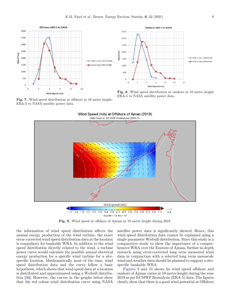
Fig. 7. Wind speed distribution at offshore at 10 metre height-ERA-5 vs NASA satellite power data.
Fig. 8. Wind speed distribution at onshore at 10 metre heightERA-5 vs NASA satellite power data.
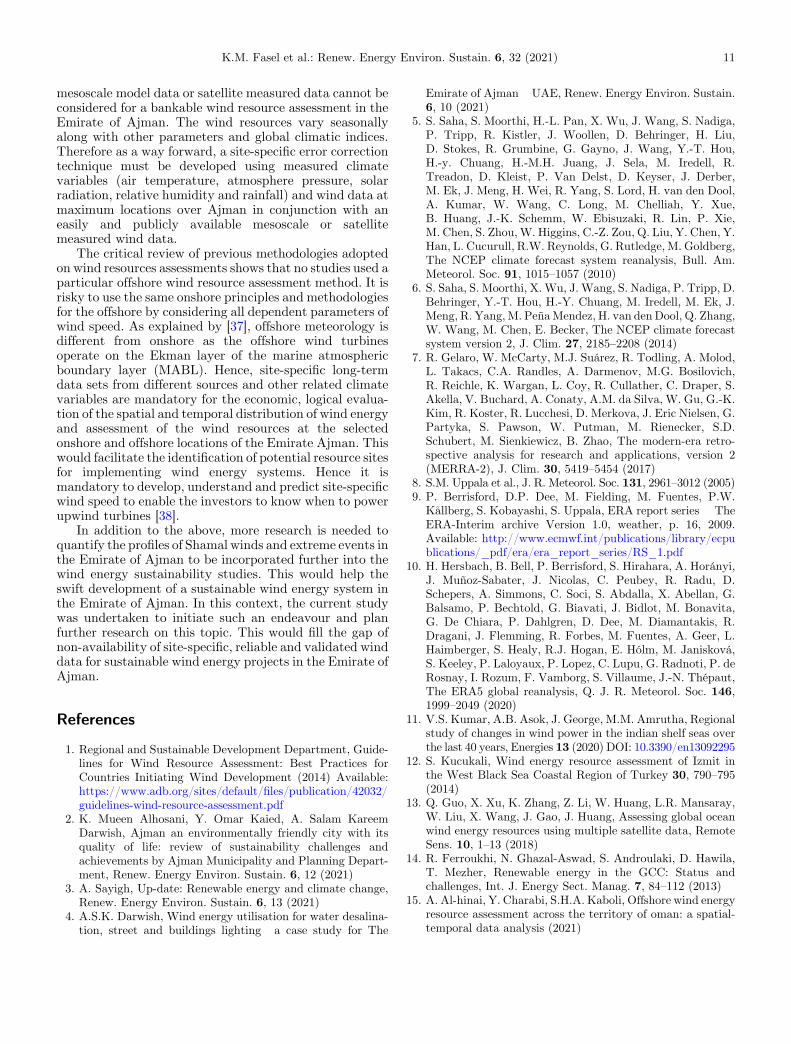
Fig. 9. Wind speed at offshore of Ajman at 10 metre height during 2019.
K.M. Fasel et al.: Renew. Energy Environ. Sustain. 6, 32 (2021) 9
the information of wind speed distribution affects theannual energy production of the wind turbine, the exacterror-corrected wind speed distribution data at the locationis compulsory for bankable WRA. In addition to the windspeed distribution directly related to the wind, a turbinepower curve would calculate the possible annual electricalenergy production for a specific wind turbine for a site-specific location. Mathematically most of the time, windspeed distribution data and the curve follow a basichypothesis, which shows that wind speed data at a locationis distributed and approximated using a Weibull distribu-tion [36]. However, the curves in the graphs below showthat the red colour wind distribution curve using NASA
satellite power data is significantly skewed. Hence, thiswind speed distribution data cannot be explained using asingle parameter Weibull distribution. Since this study is acomparative study to show the importance of a compre-hensive WRA over the Emirate of Ajman, further in-depthresearch using error-corrected long term measured winddata in conjunction with a selected long term mesoscalewind and weather data should be planned to support a site-specific bankable WRA.
Figures 9 and 10 shows ho wind speed offshore andonshore of Ajman varies at 10-metre height during the year2019 as per ECMWFReanalysis (ERA-5) data. The figuresclearly show that there is a good wind potential at Offshore

Fig. 10. Wind speed at onshore of Ajman at 10 metre height during 2019.
10 K.M. Fasel et al.: Renew. Energy Environ. Sustain. 6, 32 (2021)
of Ajman compared to Onshore. The study must beextended to understand the site-specific wind potential atall the potential identified sites by considering all thephysical constraints for a wind farm development.
Westerly and north-westerly winds dominate the windon the Offshore of Ajman throughout the year (see Figs. 9and 10). Wind speeds are most frequently within the rangeof 1–10m/s between two data sources. This can includewind speed during normal and during extreme events.Since extreme events at first 100 metres of the atmospherewould affect the wind turbine operations, this must befurther studied over the Emirate of Ajman.
5.6 Conclusion and way forward for the Emirateof Ajman
Over the years, many studies have been conductedworldwide to study offshore wind characteristics fordeveloping wind farms to generate sustainable electricity.Humans need for energy has been increasing. Thisrequirement can be met only by using sustainable energyresources like wind energy. Due to the sun earthrelationship, horizontal air pressure differences result inthe generation of sustainable wind energy. In the past, tosite a wind turbine and a wind farm, information onfrequency distribution and mean wind speed at hub heightwas only used. Still, due to the increase in size and height ofinstallation and high altitude wind energy devices (80m,150m, 500 metre etc., with power up to 9 MW), thesituation has been changed. It became mandatory toincorporate wind shear profile and all the related climate
variables and information about extreme events that needto be known to avoid underestimating total power from thewind energy systems. It is even economically andpractically hard to install the measuring masts in thesehigh heights. Installing and operating wind energy deviceswhere the long term changes and details of the atmos-phere’s vertical structure are not known would cause higheconomic loss.
This study finds that regional wind resource assessmentstudies carried out over Arabian Gulf using mesoscalemodel predicted data sets. The review indicates that windresources in the Arabian gulf vary seasonally with yearsdue to the influence of global climatic indices and extremeevents in the region. As this study suggests (see Figs. 5through 8), the mesoscale data sets from two differentsources give different results for a single specific locationand region.
As depicted in Figure 7, the analysis of ERA-5 Data at10-meter height at the Offshore location for the year 2019shows that wind speed with 4m/s occurs for 3500 hours/year. Still, for the same location, the data obtained from theNASA satellite for the same period shows that the windspeed with 4m/s had blown only for 2500 hours/year.Similarly, as seen in Figure 8, for onshore location, at10-meter height the ERA-5 data shows wind speed withmagnitude 4m/s has a duration of 1400 Hours/year,whereas NASA satellite Data shows that 4m/s wind speedhas a duration of 2400 hours/year.
The above results show that wind speed distribution ata particular location keeps varying with the source of winddata. Hence wind resource assessment only by using a
K.M. Fasel et al.: Renew. Energy Environ. Sustain. 6, 32 (2021) 11
mesoscale model data or satellite measured data cannot beconsidered for a bankable wind resource assessment in theEmirate of Ajman. The wind resources vary seasonallyalong with other parameters and global climatic indices.Therefore as a way forward, a site-specific error correctiontechnique must be developed using measured climatevariables (air temperature, atmosphere pressure, solarradiation, relative humidity and rainfall) and wind data atmaximum locations over Ajman in conjunction with aneasily and publicly available mesoscale or satellitemeasured wind data.
The critical review of previous methodologies adoptedon wind resources assessments shows that no studies used aparticular offshore wind resource assessment method. It isrisky to use the same onshore principles and methodologiesfor the offshore by considering all dependent parameters ofwind speed. As explained by [37], offshore meteorology isdifferent from onshore as the offshore wind turbinesoperate on the Ekman layer of the marine atmosphericboundary layer (MABL). Hence, site-specific long-termdata sets from different sources and other related climatevariables are mandatory for the economic, logical evalua-tion of the spatial and temporal distribution of wind energyand assessment of the wind resources at the selectedonshore and offshore locations of the Emirate Ajman. Thiswould facilitate the identification of potential resource sitesfor implementing wind energy systems. Hence it ismandatory to develop, understand and predict site-specificwind speed to enable the investors to know when to powerupwind turbines [38].
In addition to the above, more research is needed toquantify the profiles of Shamal winds and extreme events inthe Emirate of Ajman to be incorporated further into thewind energy sustainability studies. This would help theswift development of a sustainable wind energy system inthe Emirate of Ajman. In this context, the current studywas undertaken to initiate such an endeavour and planfurther research on this topic. This would fill the gap ofnon-availability of site-specific, reliable and validated winddata for sustainable wind energy projects in the Emirate ofAjman.
References
1. Regional and Sustainable Development Department, Guide-lines for Wind Resource Assessment: Best Practices forCountries Initiating Wind Development (2014) Available:https://www.adb.org/sites/default/files/publication/42032/guidelines-wind-resource-assessment.pdf
2. K. Mueen Alhosani, Y. Omar Kaied, A. Salam KareemDarwish, Ajman an environmentally friendly city with itsquality of life: review of sustainability challenges andachievements by Ajman Municipality and Planning Depart-ment, Renew. Energy Environ. Sustain. 6, 12 (2021)
3. A. Sayigh, Up-date: Renewable energy and climate change,Renew. Energy Environ. Sustain. 6, 13 (2021)
4. A.S.K. Darwish, Wind energy utilisation for water desalina-tion, street and buildings lighting� a case study for The
Emirate of Ajman�UAE, Renew. Energy Environ. Sustain.6, 10 (2021)
5. S. Saha, S. Moorthi, H.-L. Pan, X. Wu, J. Wang, S. Nadiga,P. Tripp, R. Kistler, J. Woollen, D. Behringer, H. Liu,D. Stokes, R. Grumbine, G. Gayno, J. Wang, Y.-T. Hou,H.-y. Chuang, H.-M.H. Juang, J. Sela, M. Iredell, R.Treadon, D. Kleist, P. Van Delst, D. Keyser, J. Derber,M. Ek, J. Meng, H. Wei, R. Yang, S. Lord, H. van den Dool,A. Kumar, W. Wang, C. Long, M. Chelliah, Y. Xue,B. Huang, J.-K. Schemm, W. Ebisuzaki, R. Lin, P. Xie,M. Chen, S. Zhou,W. Higgins, C.-Z. Zou, Q. Liu, Y. Chen, Y.Han, L. Cucurull, R.W. Reynolds, G. Rutledge, M. Goldberg,The NCEP climate forecast system reanalysis, Bull. Am.Meteorol. Soc. 91, 1015–1057 (2010)
6. S. Saha, S. Moorthi, X.Wu, J. Wang, S. Nadiga, P. Tripp, D.Behringer, Y.-T. Hou, H.-Y. Chuang, M. Iredell, M. Ek, J.Meng, R. Yang,M. PeñaMendez, H. van denDool, Q. Zhang,W. Wang, M. Chen, E. Becker, The NCEP climate forecastsystem version 2, J. Clim. 27, 2185–2208 (2014)
7. R. Gelaro, W. McCarty, M.J. Suárez, R. Todling, A. Molod,L. Takacs, C.A. Randles, A. Darmenov, M.G. Bosilovich,R. Reichle, K. Wargan, L. Coy, R. Cullather, C. Draper, S.Akella, V. Buchard, A. Conaty, A.M. da Silva, W. Gu, G.-K.Kim, R. Koster, R. Lucchesi, D. Merkova, J. Eric Nielsen, G.Partyka, S. Pawson, W. Putman, M. Rienecker, S.D.Schubert, M. Sienkiewicz, B. Zhao, The modern-era retro-spective analysis for research and applications, version 2(MERRA-2), J. Clim. 30, 5419–5454 (2017)
8. S.M. Uppala et al., J. R. Meteorol. Soc. 131, 2961–3012 (2005)9. P. Berrisford, D.P. Dee, M. Fielding, M. Fuentes, P.W.
Kållberg, S. Kobayashi, S. Uppala, ERA report series � TheERA-Interim archive Version 1.0, weather, p. 16, 2009.Available: http://www.ecmwf.int/publications/library/ecpublications/_pdf/era/era_report_series/RS_1.pdf
10. H. Hersbach, B. Bell, P. Berrisford, S. Hirahara, A. Horányi,J. Muñoz-Sabater, J. Nicolas, C. Peubey, R. Radu, D.Schepers, A. Simmons, C. Soci, S. Abdalla, X. Abellan, G.Balsamo, P. Bechtold, G. Biavati, J. Bidlot, M. Bonavita,G. De Chiara, P. Dahlgren, D. Dee, M. Diamantakis, R.Dragani, J. Flemming, R. Forbes, M. Fuentes, A. Geer, L.Haimberger, S. Healy, R.J. Hogan, E. Hólm, M. Janisková,S. Keeley, P. Laloyaux, P. Lopez, C. Lupu, G. Radnoti, P. deRosnay, I. Rozum, F. Vamborg, S. Villaume, J.-N. Thépaut,The ERA5 global reanalysis, Q. J. R. Meteorol. Soc. 146,1999–2049 (2020)
11. V.S. Kumar, A.B. Asok, J. George, M.M. Amrutha, Regionalstudy of changes in wind power in the indian shelf seas overthe last 40 years, Energies 13 (2020) DOI: 10.3390/en13092295
12. S. Kucukali, Wind energy resource assessment of Izmit inthe West Black Sea Coastal Region of Turkey 30, 790–795(2014)
13. Q. Guo, X. Xu, K. Zhang, Z. Li, W. Huang, L.R. Mansaray,W. Liu, X. Wang, J. Gao, J. Huang, Assessing global oceanwind energy resources using multiple satellite data, RemoteSens. 10, 1–13 (2018)
14. R. Ferroukhi, N. Ghazal-Aswad, S. Androulaki, D. Hawila,T. Mezher, Renewable energy in the GCC: Status andchallenges, Int. J. Energy Sect. Manag. 7, 84–112 (2013)
15. A. Al-hinai, Y. Charabi, S.H.A. Kaboli, Offshore wind energyresource assessment across the territory of oman: a spatial-temporal data analysis (2021)

12 K.M. Fasel et al.: Renew. Energy Environ. Sustain. 6, 32 (2021)
16. A. Keyhani, M. Ghasemi-Varnamkhasti, M. Khanali, R.Abbaszadeh, An assessment of wind energy potential as apower generation source in the capital of Iran, Tehran,Energy (2010) DOI: 10.1016/j.energy.2009.09.009
17. H. Khonkar, Complete survey of wind behavior over theArabian Gulf, J. King Abdulaziz Univ. Mar. Sci. (2009) DOI:10.4197/Mar.20-1.3
18. W. Kazim, O.B. Akash, Measurements and analysis ofwind characteristics in northern emirates for wind powergeneration, Int. J. Appl. Eng. Res. 11, 11165–11170 (2016)
19. K. Al-Salem, S. Neelamani, W. Al-Nassar, Wind energy mapof Arabian Gulf, Nat. Resour. 09, 212–228 (2018)
20. A.A. Al Qubaisi, S.S. Dol, M.S. Khan, A.A. Azeez,Feasibility study and design of floating offshore wind turbinefarm in United Arab Emirates (2018) DOI: 10.1109/ICASET.2018.8376800
21. N. Saleous, S. Issa, J. Al Mazrouei, GIS-based wind farm siteselection model offshore Abu Dhabi Emirate, UAE, ISPRS�Int. Arch. Photogramm. Remote Sens. Spat. Inf. Sci. (2016)DOI: 10.5194/isprs-archives-xli-b8-437-2016
22. R.E. Eager, S. Raman, A. Wootten, D.L. Westphal, J.S.Reid, A. Al Mandoos, A climatological study of the sea andland breezes in the Arabian Gulf region, J. Geophys. Res.Atmos. 113, 1–12 (2008)
23. S.M. Boudia, J.A. Santos, Assessment of large-scale windresource features in Algeria, Energy 189 (2019) DOI:10.1016/j.energy.2019.116299
24. H. Nfaoui, J. Buret, A.A.M. Sayigh,Wind characteristics andwind energy potential in Morocco, Sol. Energy 63, 51–60(1998)
25. H.D. Ammari, S.S. Al-Rwashdeh, M.I. Al-Najideen, Evalua-tion of wind energy potential and electricity generation at fivelocations in Jordan, Sustain. Cities Soc. 15, 135–143 (2015)
26. A.S. Darwish, S. Shaaban, E. Marsillac, N.M. Mahmood, Amethodology for improving wind energy production in lowwind speed regions, with a case study application in Iraq,Comput. Ind. Eng. 127, 89–102 (2019)
27. T.B.M.J. Ouarda et al., Probability distributions of windspeed in the UAE, Energy Convers. Manag. (2015) DOI:10.1016/j.enconman.2015.01.036
28. A.S.K. Darwish, A.A.M. Sayigh, Erratum: Expressionof concern (Wind energy potential in Iraq (1988) 27(1–3)(179–189), (0167610588900347)), J. Wind Eng. Ind. Aero-dyn. (2020) DOI: 10.1016/j.jweia.2020.104344
29. M.S. Naizghi, T.B.M.J. Ouarda, Teleconnections andanalysis of long-term wind speed variability in the UAE,Int. J. Climatol. 37, 230–248 (2017)
30. M.S. Naizghi, T.B.M.J. Ouarda, Teleconnections andanalysis of long-term wind speed variability in the UAE,Int. J. Climatol. (2017) DOI: 10.1002/joc.4700
31. W.K.Al-Nassar, S. Neelamani, K.A.Al-Salem,H.A.Al-Dashti,Feasibility of offshore wind energy as an alternative sourcefor the state of Kuwait, Energy 169, 783–796 (2019)
32. I. Janajreh, R. Qudaih, I. Talab, Z. Al Nahari, Atmosphericwind data collection and wind turbine analysis in UAE (2009)DOI: 10.1115/ES2009-90288
33. S.M. Ali, A.H. Shaban, A.K. Resen, Integrating WAsP andGIS tools for establishing best positions for wind turbines inSouth Iraq, Int. J. Comput. Inf. Technol. 03, 2279–764 (2014)
34. J.V. Seguro, T.W. Lambert, Modern estimation of theparametres of the Weibull wind speed distribution for windenergy analysis, J. Wind Eng. Ind. Aerodyn. (2000) DOI:10.1016/S0167-6105(99)00122-1
35. A.S. Darwish, R. Al-Dabbagh, Wind energy state of the art:present and future technology advancements, Renew. EnergyEnviron. Sustain. 5, 7 (2020)
36. D.P. Deea, S.M. Uppalaa, A.J. Simmonsa, P. Berrisforda, P.Polia, S. Kobayashib, U. Andraec, M.A. Balmasedaa, G.Balsamoa, P. Bauera, P. Bechtolda, A.C.M. Beljaarsa, L. vande Bergd, J. Bidlota, N. Bormanna, C. Delsola, R. Dragania,M. Fuentesa, A.J. Geera, L. Haimbergere, S.B. Healya, H.Hersbacha, E.V. Holm a, L. Isaksena, P. Kallberg, M. Kohler,M. Matricardia, A.P. McNallya, B.M. Monge-Sanzf,J.-J. Morcrettea, B.-K. Parkg, C. Peubeya, P. de Rosnaya,C. Tavolatoe, J.-N. Thepaut, F. Vitart, The ERA-Interimreanalysis: ConFigureuration and performance of the dataassimilation system,Q.J.R.Meteorol. Soc.137, 553–597 (2011)
37. S. Emeis, Wind Energy Meteorology (2013)38. U. Aswathanarayana, Wind power, in Green Energy:
Technology, Economics and Policy (2010)
Cite this article as: Kais Muhammed Fasel, Abdul Salam K. Darwish, Peter Farrell, Hussein Kazem, An Overview of WindResource Assessments With Special Reference to The Emirate of Ajman, UAE, Renew. Energy Environ. Sustain. 6, 32 (2021)