Embed Size (px)
Citation preview
AN ORGANISATION FOR A NATIONAL EARTH SCIENCE INFRASTRUCTURE PROGRAM
Virtual Geophysics Laboratory (VGL): Scientific workflows
Exploiting the CloudJosh Vote, Ryan Fraser, Terry Rankine
Ben Evans, Michael Chapman
Lesley Wyborn, Richard Chopping
CSIRO Workshop on Workflows, High-Throughput Imaging, Visualisation and Accelerated Computing. October 11-14, 2011

Scientific workflow – Virtual Geophysics Laboratory (VGL)
• Scientific Workflow Engine (or Virtual Laboratory)• Automates and massively expands Geophysicists
computational capacity via the Cloud– Amazon – EC2 / S3 (and others using this interface)
– OpenStack
• Collaboration between CSIRO, GA, NCI, Monash, UQ, and ANU
• VGL is just a pretty face– User Driven GUI
– Leverages data providers and cloud technologies to do all the heavy lifting
• Non-Restrictive Open-source
2

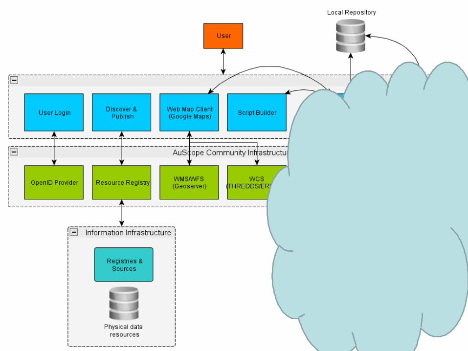
AuScope Grid and SISS
• AuScope Grid: Charged with delivering software infrastructure to enable Geoscience Community– Establishing governance and sustainability of services
– Delivering solutions to research and government organisations
– Interoperability
• Spatial Information Services Stack (SISS)• An open-source, open-standards SDI
• Achieves Interoperable data exchange
• Standardises on 3 components – Format, Content, Tools

V(what)GL
• VEGL – Virtual Exploration Geophysics Laboratory– One primary science collaboration
– One primary workflow
– One collection of geophysical data sets
• VGL - Virtual Geophysics Laboratory– Collaboration with multiple partners
– Supporting multiple workflows
– New data sets
– New data types
– New Use – Not just exploration.
DoneDone
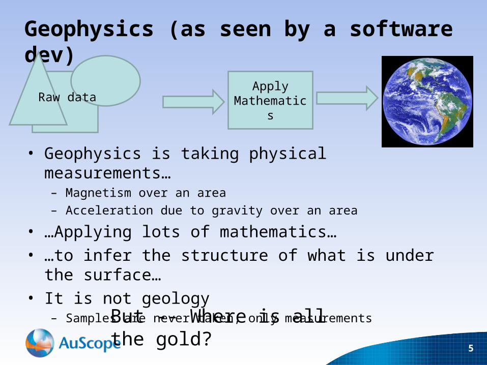
Geophysics (as seen by a software dev)
• Geophysics is taking physical measurements…– Magnetism over an area
– Acceleration due to gravity over an area
• …Applying lots of mathematics…• …to infer the structure of what is under the surface…• It is not geology
– Samples are never taken, only measurements
5
Apply Mathematics
Raw data
But -- Where is all the gold?

Our Geophysics Problem
• Measurements coming from the field are ‘raw’– Varying spatial reference systems
– Noisy
– Artifacts from collection process
• This data needs processing– From raw data to a data product
• Data products are valuable– They will be re-used and referenced repeatedly
• Processing is a time consuming process– Made worse by a purely manual workflow
6

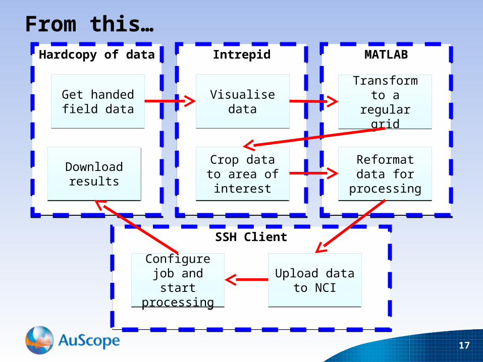
The Past
• Compile raw data using proprietary FORTRAN– Also use software – Intrepid
• Transform to a regular grid using more software– MATLAB, Intrepid, ER Mapper, ESRI ArcGIS, QGIS
• Crop data spatially to suit final data product – eg: everything in Victoria
• Transform data into a file format that can be read by proprietary scientific code.– This is usually done with some handwritten python or c
– There is no version control, code is often rewritten / redone
• Upload data to HPC– Manually enter input parameters/start job
7
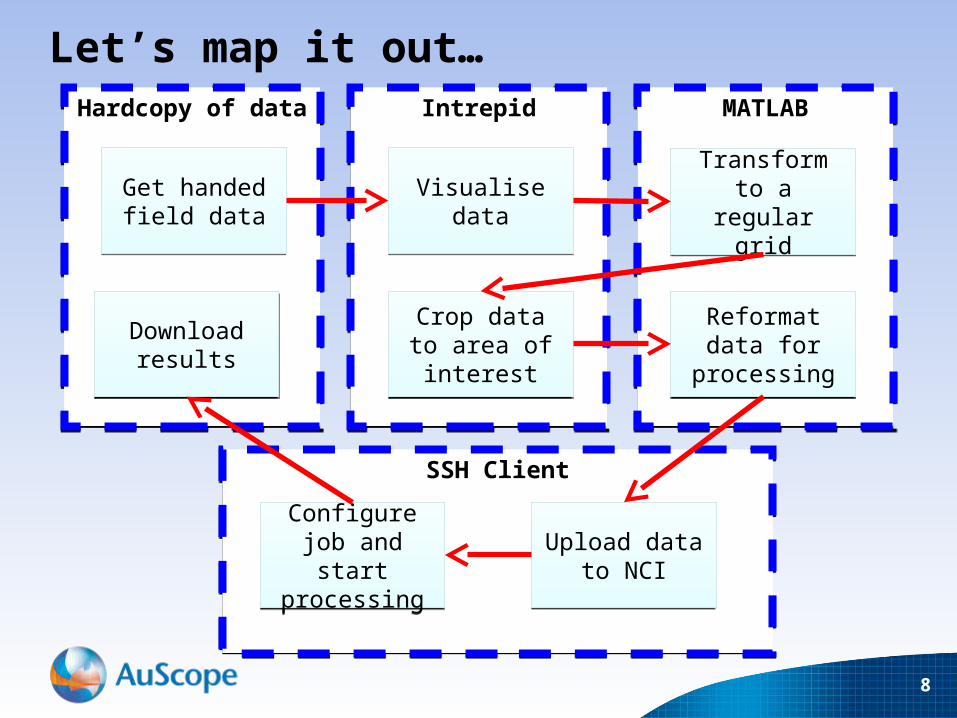
Hardcopy of dataHardcopy of data
SSH ClientSSH Client
MATLABMATLABIntrepidIntrepid
8
Let’s map it out…
Transform to a regular grid
Transform to a regular grid
Crop data to area of interest
Crop data to area of interest
Reformat data for processingReformat data for processing
Upload data to NCI
Upload data to NCI
Configure job and start
processing
Configure job and start
processing
Download results
Download results
Get handed field data
Get handed field data Visualise dataVisualise data
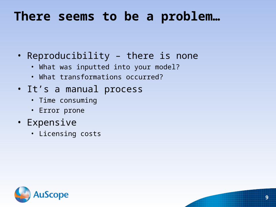
There seems to be a problem…
• Reproducibility – there is none• What was inputted into your model?
• What transformations occurred?
• It’s a manual process• Time consuming
• Error prone
• Expensive • Licensing costs
9
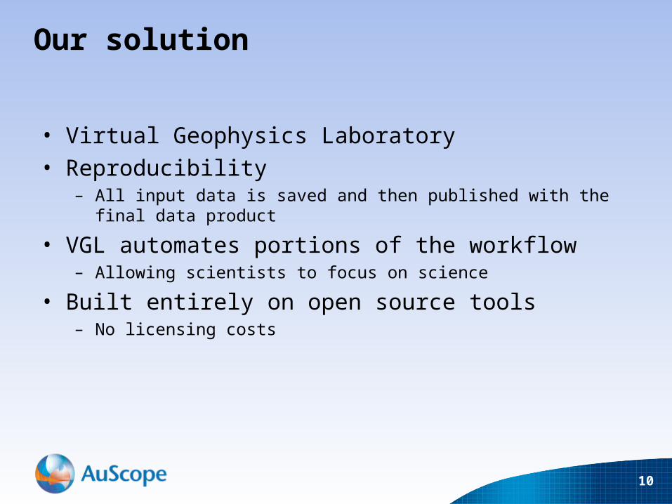
Our solution
• Virtual Geophysics Laboratory• Reproducibility
– All input data is saved and then published with the final data product
• VGL automates portions of the workflow– Allowing scientists to focus on science
• Built entirely on open source tools– No licensing costs
10
11

Data Discovery
12

Data Selection
13

Script Builder
14
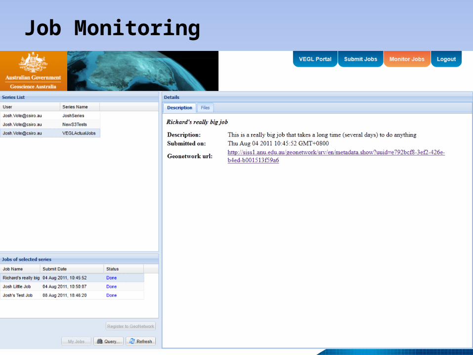
Job Monitoring
15

Published provenance records
16
17
From this…Hardcopy of dataHardcopy of data
SSH ClientSSH Client
MATLABMATLABIntrepidIntrepid
Transform to a regular grid
Transform to a regular grid
Crop data to area of interest
Crop data to area of interest
Reformat data for processingReformat data for processing
Upload data to NCI
Upload data to NCI
Configure job and start
processing
Configure job and start
processing
Download results
Download results
Get handed field data
Get handed field data Visualise dataVisualise data

…to thisVirtual Geophysics LaboratoryVirtual Geophysics Laboratory
Build “science” from existing
libraries
Build “science” from existing
libraries
Run jobRun jobCollect and
publish resultsCollect and
publish results
Discover raw data
Discover raw data
Select spatial bounds
Select spatial bounds

VGL - Summary
• VEGL has been built for a Geophysics workflow– Its concepts can be re-used for other scientific workflows
• Is in the process of being deployed at GA– It can produce actual scientific data products
• Is capable of integrating with any SISS data provider– Or any provider that understands the OGC standards
• It’s built from many ‘generic’ components that can be repurposed
• Is just a pretty face– The power lies with the underlying services
– These services are accessed using standardised protocols
19

Future Work• VGL - Virtual Geophysics Laboratory
– Collaboration with multiple partners– Supporting multiple workflows– New data sets– New data types– New Use – Not just exploration.
• Exploiting the generic– Modularising the workflow for general scientific usage
• Repurposing for other use cases – nature hazards, climate prediction, etc
• Commercial uptake• Integration with other VLs to achieve ultimate aim…
20
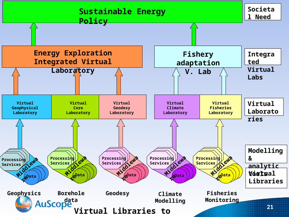
Sustainable Energy Policy Societal Need
Energy Exploration Integrated Virtual Laboratory
Fishery adaptationV. Lab
Integrated Virtual Labs
Virtual Geophysical Laboratory
Virtual Core Laboratory
Virtual Geodesy
Laboratory
Virtual ClimateLaboratory
Virtual Fisheries
Laboratory
Virtual Laboratories
Geophysics Borehole data Geodesy Climate Modelling
Fisheries Monitoring
Virtual Libraries
Processing Services
DataMiddleware
Processing Services
DataMiddleware
Processing Services
DataMiddleware
Processing Services
DataMiddleware
Processing Services
DataMiddleware
Modelling & analytic tools
Virtual Libraries to Laboratories 21

Thank you and for more information:
CSIRO Earth Science & Resource EngineeringJosh VoteSoftware Developer
Phone: +61 8 6436 8607Email: [email protected]
Web: www.csiro.auwww.seegrid.csiro.auwww.auscope.org
http://siss1.anu.edu.au/VEGL-Portal/
https://twiki.auscope.org/wiki/Grid/VEGLPortalDevelopment


![1 Vgl. Modulbeschreibung17.Literaturhinweise, Skripte [Empfohlene Literatur, Lehr- und Lernmaterialien, Literatur]](https://img.pdfslide.us/doc/110x75/55204d7749795902118cc0e9/1-vgl-modulbeschreibung17literaturhinweise-skripte-empfohlene-literatur-lehr-und-lernmaterialien-literatur.jpg)