Embed Size (px)
Citation preview
985
An investigation into the use of urban consolidation as a tool for sustainable land use management in Warrnambool, Victoria
Hanigan L; Wallis A; Versace V
Flinders University: [email protected] Abstract Urban consolidation has been used as a sustainable land use planning strategy in big cities for decades. Among other things its use has risen out of a desirability to reduce environmental impacts of development, sprawl, commute times, and to increase public accessibility to services. This study investigates the possibility of increasing the use of urban consolidation in the planning policies of an expanding rural city in Australia. Using a land suitability assessment technique, carried out in GIS, two future land use scenarios are developed: Scenario 1 with no change to current land use patterns and Scenario 2 with greater urban consolidation. A survey of Warrnambool’s residents was then conducted to determine their preference for land use development within the shire over the next 25 years. Results show that population growth could be retained within the city limits by increasing the current density by approximately 3 people per hectare. Although the majority of survey participants prefer the current planning regime almost one third indicated a preference for a consolidated city as suggested by Scenario 2. The research demonstrates that sustainable land use management will not only require land use planning strategies that commit to urban consolidation but also investment in participatory planning in a way that engages with residents in discussions on the issues surrounding urban sprawl and involving them in designing a consolidatedurban centre that maintains its liveability. Keywords: Urban consolidation; land suitability assessment; sustainable land use; urban sprawl; regional sustainability. 1. Introduction The pursuit of sustainable development and strategies to make progress continues to be a real challenge. With global population numbers rising new pressures are being placed on our natural and human systems. Inevitably our cities are growing, and it is without doubt that human impact on the environment will worsen (Newman, 2006). The location, design and density of human settlements have social, environmental and economic implications for current and future generations. Human settlement tends to congregate in and around existing townships (Newman, 2006) and along our coastlines (Bartlett et al., 2000). In Australia, coastal areas have become the most desirable regions for settlement outside of the major metropolitan areas (Bartlett et al., 2000, Australian Bureau of Statistics, 2010) accommodating over 86% of the population (Gagné and Fahrig, 2010). History has shown that new residential development within these coastal areas often occurs in the form of low-density urban landscapes with little comprehensive strategic planning (Bruegmann, 2001), a landscape pattern otherwise known as urban sprawl. Urban sprawl is a globally recognised issue (Martinuzzi et al., 2007, Couch and Karecha, 2006) having implications that can potentially be detrimental to communities if not managed carefully (Brueckner and Largey, 2008). The issues surrounding urban sprawl include that it often results in un-managed land fragmentation reducing natural habitat and species composition (Gagné and Fahrig, 2010) as well as reducing available agricultural land (Pham et al., 2007). It is also well documented that a sprawling city can have longer commute times, traffic congestion and increased air pollution (Brueckner and Largey, 2008). In response to these issues, planners are introducing highly planned, compact, transit-orientated cities (Bruegmann, 2001) and multidisciplinary planning schemes that call for more diversity in the planning of our cities (Parsons Brinckerhoff, 2010, Parsons Brinckerhoff, 2007). Urban consolidation has been recognised an appropriate sustainable land use technique for minimizing the effects of urban sprawl (Archer, 1994, Bruegmann, 2001, Bunker, 1989, Cardew, 1989, Gordon et al., 2009). Urban consolidation provides a means to increase the density of dwellings or people, or both, in the existing urban areas,
986 ensuring that serviced but vacant land is brought into use and wasteful fringe development is limited, ensuring the compact expansion of a city or town (Archer, 1994, Troy, 1989). Its use is now implemented across the globe in strategic plans and frameworks of established cities to mitigate the problems associated with urban sprawl (Bishop and Syme, 1995, Troy, 1989). In Australia new residential development within cities has traditionally occurred in the form of low-density urban landscapes leading to sprawling urban and regional centres. Although strategies are in place to incorporate urban consolidation into planning policies(Parsons Brinckerhoff, 2004)a preference still remains for large detached houses with big backyards(Buys et al., 2013) particularly in regional centres. Warrnambool is a small regional centre in southwest Victoria, Australia, that has undergone little urban consolidation and therefore provides a unique opportunity to investigate its introduction. This paper investigates the impacts of population expansion in Warrnambool under current land use planning regimes, under increased density regimes and explores the views of the local community toward the future land use options. Two future land use development scenarios produced during this study give both local planners and the community a geographical picture of the extent of urban development under different population densities and providesa visual aid to help determine desirability of urban consolidation.
2. Literature analysis In a world with ever increasing global population and rising issues associated with urban sprawl the introduction of sustainable land use management techniques, such as urban consolidation, must be incorporated into planning strategies not only in metropolitan centres but also into regional and rural townships. Past land use planning case studies have analysed the introduction of urban consolidation in various countries. For example, Nuissl and Rink (2005) identified the introduction of urban consolidation through change in government and urban policy in Germany. Others focus on the relationships between urban planning and urban sprawl and their effect on communities (Archer, 1994, Couch and Karecha, 2006, Dave, 2011, Pham et al., 2011, Phan et al., 2009, Yiftachel and Hedgcock, 1993). Studies in Australia have focused on topics such as the historical development of urban consolidation in Sydney (Bunker, 1989), what makes a liveable high density city (Buys et al., 2013), neighbourhood walkability (Leslie et al., 2005), residential intensification in the city of Casey, Melbourne (Phan et al., 2009) and limits to urban consolidation in Sydney (Searle, 2004). To date, however, little attention has been given to the impacts of such land use planning on coastal settlements in rural locations. The literature surrounding urban consolidation can be broken down into distinct categories, such as social studies, geographical studies and case studies. The major areas of focus for social studies are topics around community health and neighbourhood (Bernstein et al., 2007, Bishop and Syme, 1995, Brueckner and Largey, 2008, Hur et al., 2010, Leslie et al., 2005, Parra et al., 2010, Santana et al., 2009, Walter and Omariba, 2010, Wood et al., 2008). Such studies include assessing the perceived active park use among older adults within a neighbourhood (Parra et al., 2010), social interaction and urban sprawl (Brueckner and Largey, 2008), perceptions of walkability to amenities (Leslie et al., 2005) and personal characteristics to the risk of weight (Couch and Karecha, 2006, Santana et al., 2009). Neighbourhood studies include correlating alcohol consumption with neighbourhood health (Bernstein et al., 2007), looking at what makes a safe and social suburb (Wood et al., 2008) and perceived and objectively measured greenness of neighbourhoods (Leslie et al., 2005). The information social studies such as these provide helps to outline the key factors and implications of design when planning a neighbourhood. From these types of studies the overall expectations and perceptions of consolidated development by the community have been shown to be quite negative. Brueckner and Largey (2008) found that urban consolidation can be perceived to reduce community enjoyment and amenity, and therefore is considered an undesirable option by community members. (Howley et al., 2009)suggest that it is not high density per se that is the source of dissatisfaction for residents but rather factors such as environmental quality, noise, lack of community life, traffic and lack of services and facilities. Survey studies have
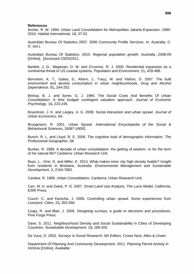
987 also investigated community perceptions of consolidated development in established consolidated areas (Bernstein et al., 2007, Hur et al., 2010, Parra et al., 2010). Although these studies are comprehensive it is rare for a study to investigate community opinions about consolidated development before it has been implemented to a large extent within a city. Therefore there is scope for such a study to be carried out in a rural city where pressures to consolidate are yet to be felt. Geographic studies are highly represented within the land use planning literature, as such studies create an ability to visualise data for the reader. One of the advantages of using Geographic Information Systems (GIS) in planning is the ability to combine database information to create digital maps, integrate disparate datasets for spatial analysis and predict future scenarios (Thomsom and Hardin, 2000). Past studies have used GIS to map a region’s past urban consolidation development allowing for comment on the increase in density of the region over time and the relationships between these changes and changes in policy (Archer, 1994, Phan et al., 2009). Other studies include using GIS for analysing accessibility of a neighbourhood based on its features (Pearce et al., 2006), mapping and monitoring of urban sprawl (Jat et al., 2008, Holloway and Bunker, 2003, Phan et al., 2009), and establishing urban growth boundary models (Tayyebi et al., 2011). There is however, little information showing predictive futures for a case study city based on the effects of implementing urban consolidation and what effect it may have on the sprawl of that city. Numerous land use-planning case studies have emerged that focus research on the history of urban consolidation in large cities (Nuissl and Rink, 2005, Salvati and Sabbi, 2011, Yiftachel and Hedgcock, 1993). Urban planning and urban sprawl relationships have also been analysed for their effect in various communities such as, Liverpool (Couch and Karecha, 2006), southern Europe (Salvati and Sabbi, 2011), Nigeria (Jiboye, 2011), and Jakarta (Archer, 1994) among many others. In Australia, for example, cities such as Melbourne (Phan et al., 2009), Sydney (Bunker, 1989)Brisbane (Buys et al., 2013) have all been the focus of case study analysis. A case study allows for a qualitative study to examine contemporary real-life situations and provide the basis for the application of ideas and extension of methods (Yin, 2009), yet few have been conducted at the regional city scale. This paper reports on an investigation into the desirability of using urban consolidation as a tool for sustainable land use management in a growing regional city. As few studies have incorporated the social, geographic and case study approaches into their design this study used the regional coastal city of Warrnambool as a case study area, a land use analysis tool in GIS to produce alternative future land use scenarios and a community survey to investigate if urban consolidation is a socially acceptable tool for use within the municipality. 3. Research methodology 3.1. Site description The city of Warrnambool is situated approximately 360km southwest of Melbourne, at the end of the Great Ocean Road (Figure 1). It is a coastal city located on the Southern Ocean and with a population of 30,391 (Australian Bureau of Statistics, 2007) is the largest urban centre in the region. The City of Warrnambool sits on the Princes Highway, and is directly linked with the transit route to Adelaide, Geelong and Melbourne. It is surrounded by rich agricultural land, and is one of the principal service centres for south-western Victoria (Parsons Brinckerhoff, 2004). In terms of urban design the old city core comprises significant heritage buildings and is situated south of the Princes Highway, while many new residential estates are developing to the north. Much of the urban landscape within the city boundaries comprises large quarter acre house blocks, however, block size is tending to decrease as each generation of land use development occurs. Of the 28,001 residences in Warrnambool in 2007, only 3,704 were medium density style housing such as semi-detached row or terrace house, townhouse, flat, unit or apartment (Australian Bureau of Statistics, 2007).
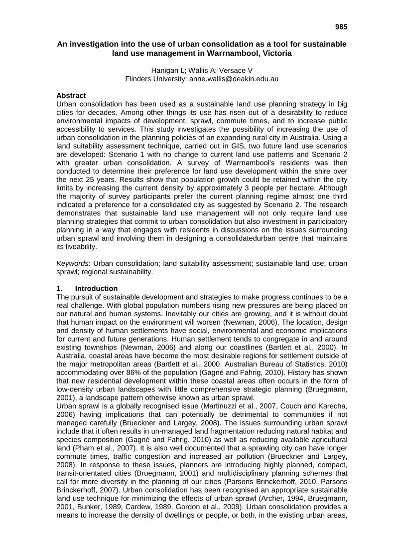
988 Town planning projections, available to the community through the forecasting company Forecast ID, predict an average annual growth rate of 1.31% from the year 2006 to the year 2031. Population numbers are exceeding growth expectations (Parsons Brinckerhoff, 2004) and current urban design is leading to reductions in the area of prime agricultural land surrounding the city. The Warrnambool Land Use Strategy, 2004 identifies the need to limit low-density urban growth so as not to compromise surrounding agricultural land. The Strategy however, does not indicate how this proposed sustainable land use policy would be implemented. These characteristics make Warrnambool an ideal case study to assess the possible influences urban sprawl and urban consolidation can have on the city’s future urban form.
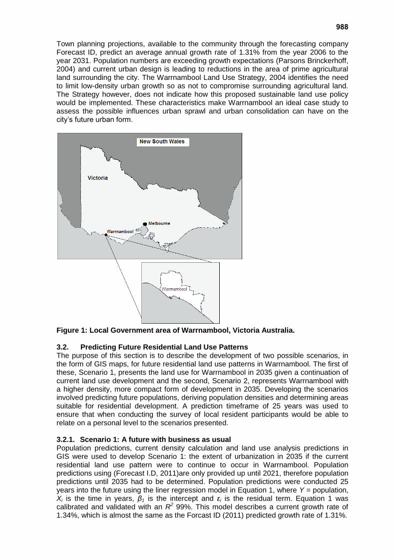
Figure 1: Local Government area of Warrnambool, Victoria Australia. 3.2. Predicting Future Residential Land Use Patterns The purpose of this section is to describe the development of two possible scenarios, in the form of GIS maps, for future residential land use patterns in Warrnambool. The first of these, Scenario 1, presents the land use for Warrnambool in 2035 given a continuation of current land use development and the second, Scenario 2, represents Warrnambool with a higher density, more compact form of development in 2035. Developing the scenarios involved predicting future populations, deriving population densities and determining areas suitable for residential development. A prediction timeframe of 25 years was used to ensure that when conducting the survey of local resident participants would be able to relate on a personal level to the scenarios presented. 3.2.1. Scenario 1: A future with business as usual Population predictions, current density calculation and land use analysis predictions in GIS were used to develop Scenario 1: the extent of urbanization in 2035 if the current residential land use pattern were to continue to occur in Warrnambool. Population predictions using (Forecast I.D, 2011)are only provided up until 2021, therefore population predictions until 2035 had to be determined. Population predictions were conducted 25 years into the future using the liner regression model in Equation 1, where Y = population, Xi is the time in years, β1 is the intercept and εi is the residual term. Equation 1 was calibrated and validated with an R2 99%. This model describes a current growth rate of 1.34%, which is almost the same as the Forcast ID (2011) predicted growth rate of 1.31%.
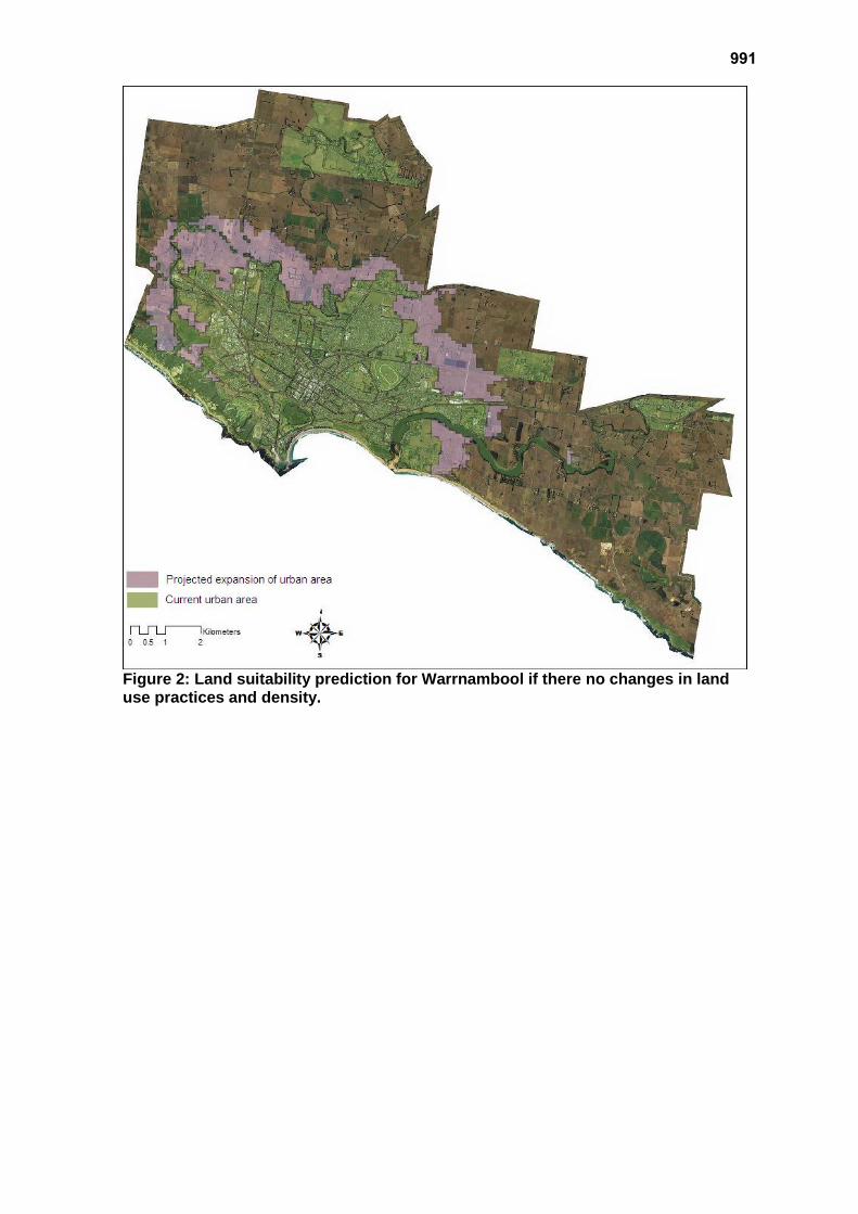
989 Y= β0 + β1Xi+ εi Equation 1: Linear regression model. Under Scenario 1 where population is predicted to increase while densities remain the same urban expansion will result in urban sprawl. To identify the most likely areas to be impacted by this expansion key city attributes for a residential environment were first identified. Key attributes are identified by (Wood et al., 2008) as ability to walk to amenities such as shops, open spaces, schools, and public transport. In this study a land suitability assessment was conducted using public open spaces, roads, small business and industrial business areas, schools, bus stops, and residential zones. The Euclidean distance tool in ArcGIS 9.2 (Esri Inc., 2011) was used to determine the suitability of cells outside the current city boundaries for residential development based on these key attributes (Carr and Zwick, 2007). Carr and Zwick (2007) recommend a suitability scale of 9 to 1, however, for this study the scale was altered to 20 to 1 in order to achieve a higher definition of potentially suitable cells. Layers for each of the 6 key attributes for a residential environment were established using predetermined data and data sourced from the Warrnambool City Council. The Euclidean distance tool was then used for each of 6 data files, setting the cell size to 100m x 100m, as this is representative of one square hectare, and easily interpretable for density calculations. This created six raster layers that were then collated and mean cell values calculated using the Raster Calculator. The resultant layer produced an overall suitability map for urban development in Warrnambool based from the 6 key attributes in the form of suitable cells. Predicting the location of the areas into which urbanization will spread required taking a ‘mask’ of the existing urban ‘footprint’ from the newly created suitability map. This left an area outside of the current urban boundary that was the next most suitable place into which the city could spread. Using the population prediction of approximately 45,000 people in the year 2035 the number of cells outside the current urban areas needed to accommodate the growth (approximately 11,337 people) was determined. Using the Identifier tool cells in the most suitable places for expand were selected until the extra area needed for the 11,337 people was included on the map. This simple technique was used as each cell represented one hectare, therefore the population change was divided with the current density of the city to determine how many extra hectares/cells were needed. Consideration was given to including the expansion zones that the Warrnambool City Council has already approved for future development. However, at the time of this study little physical development had taken place on these land parcels. Given that the land suitability analysis and current density of the city needed to be based on the currently developed area of Warrnambool it was felt that including the expansion zones may falsify the true density of the city and therefore the suitability analysis.
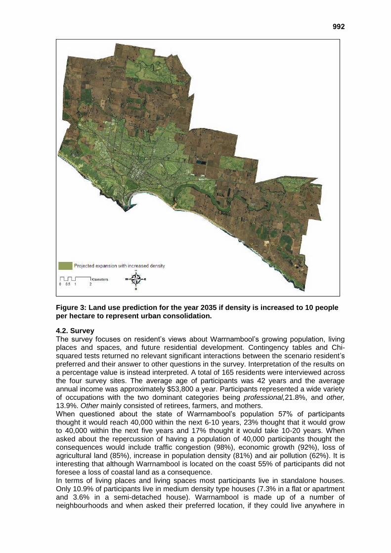
3.2.2. Scenario 2: A future with urban consolidation To determine the required population density under the urban consolidation scenario the current population density for Warrnambool needed to be derived. This was done using data from the Warrnambool City Council, showing all land use areas in the municipality. A ‘foot print’ of the city was created in ArcGIS 9.2 (Esri Inc., 2011) by merging all layers within the ‘urban boundaries’ of the city. The ‘foot print’ consisted of all possible places a resident of the city may utilize, being shops, places of work, residential areas, recreational areas etc. The total area of the city’s ‘foot print’ was measure to be 4551.6 hectares using a simple area measure tool in GIS. A simple division calculation was done using the current estimated population and the area if of the city ‘foot print’. Using this method the current density of Warrnambool city is estimated to be 7 people per hectare. Under Scenario 2 population growth for Warrnambool is accommodated within the current city limits by increasing population density. The literature provides very little guidance on what density might represent medium density residential living or how medium density housing could be implemented in an expanding rural city, such as Warrnambool. The strategic planning document for Melbourne, Melbourne 2030, suggests densities of 15
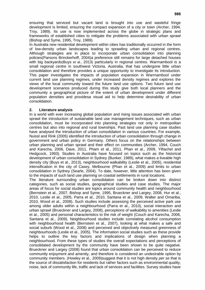
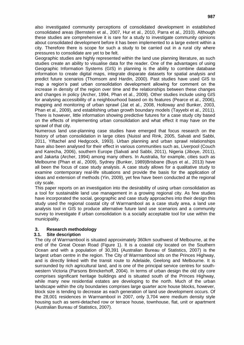
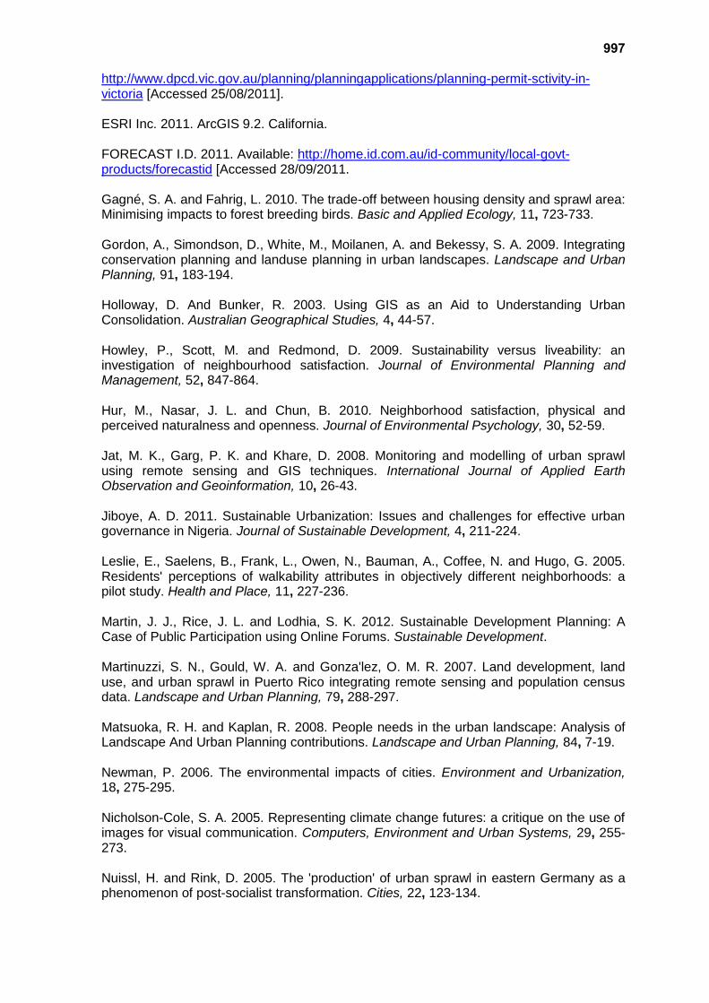
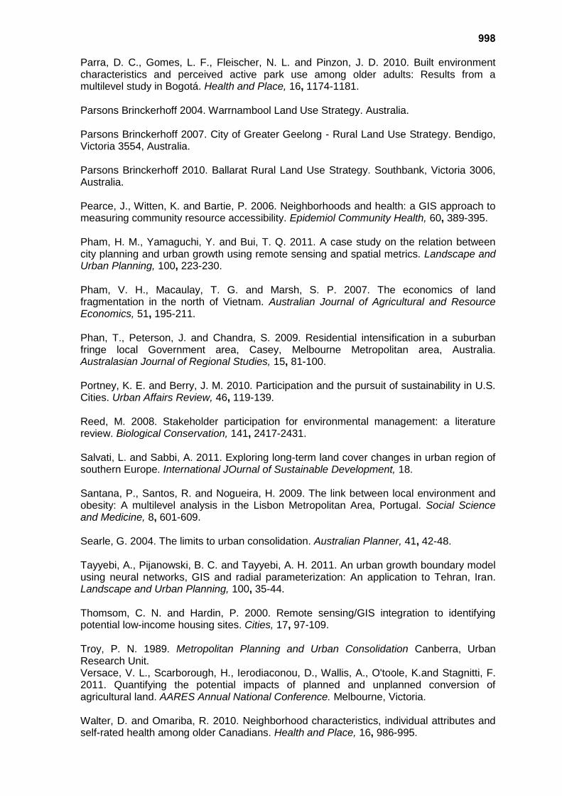
990 people per hectare in the outer suburbs to reduce the rate of urban sprawl in that city. The current density of Warrnambool has already been calculated to be 7 people per hectare, to increase this to 15 people per hectare may not be a realistic option to suit the current development and the high aesthetic quality of the city at this present time. Therefore, a density that was thought appropriate was derived by determining the population density needed to accommodate the 2035 population within the current city limits. By dividing the 2035 population estimate by the current city land area of the city it was determined that a density of 10 people per hectare would be needed to maintain the population of 2035 within the current city boundaries. The GIS maps produced for each scenario (Figures 2 & 3), were then used in developing the questionnaire for the community survey. 3.3. Community Survey In this study a survey of the community aimed to provide a socially balanced interpretation of the realistic potential for increasing the use of urban consolidation in a regional coastal town. A face-to-face questionnaire was developed to investigate community perceptions of the different scenarios as such an approach have been shown to allow easy inclusion of visual aids, high response rates, low bias sampling frame and low response bias (Czaja and Blair, 2005, De Vaus, 2002). Participants were asked for their preference to a scenario (Scenario 1 or Scenario 2) as well as questions seeking views on population growth, housing style and preference to a residential location in Warrnambool. Demographic data such as income, job and age were included but not analysed here. The survey was conducted at the entrance to each of Warrnambool’s four major supermarkets. These have locations dispersed across the city and regularly encounter high pedestrian traffic. Sampling was conducted four times a week over a one-month period from June to July 2011. Sampling times were selected to represent an even spread of times across the week: Tuesday and Thursday 10am-2pm, Friday 3-7pm and Sunday 10am-2pm. Participants to the survey were randomly selected from visitors to the supermarkets. 4. Results 4.1. Land use scenarios The two land use scenarios produced allow for a direct comparison of possible land use management strategies giving examples of how a change in management approach can affect the area impacted by urbanisation. Figure 1 shows with a population of 45,045 Warrnambool city will occupy an area of approximately 6,082.6 hectares, which will result in approximately 1,500 hectares of agricultural land being urbanised along the city’s northern edge. On the other hand Figure 2 demonstrates that maintaining the population growth within the current city limits will lead to a population density increase from 7 person per hectare to 10 persons. Urban consolidation could be achieved by sub-dividing large blocks of land and unused parcels of land to establish semi-detached homes, regular size houses on smaller lots, 1-2 storey units and 1 storey terrace houses and this will stop urban sprawl until at least 2035.
991
Figure 2: Land suitability prediction for Warrnambool if there no changes in land use practices and density.
992
Figure 3: Land use prediction for the year 2035 if density is increased to 10 people per hectare to represent urban consolidation.
4.2. Survey The survey focuses on resident’s views about Warrnambool’s growing population, living places and spaces, and future residential development. Contingency tables and Chi-squared tests returned no relevant significant interactions between the scenario resident’s preferred and their answer to other questions in the survey. Interpretation of the results on a percentage value is instead interpreted. A total of 165 residents were interviewed across the four survey sites. The average age of participants was 42 years and the average annual income was approximately $53,800 a year. Participants represented a wide variety of occupations with the two dominant categories being professional,21.8%, and other, 13.9%. Other mainly consisted of retirees, farmers, and mothers. When questioned about the state of Warrnambool’s population 57% of participants thought it would reach 40,000 within the next 6-10 years, 23% thought that it would grow to 40,000 within the next five years and 17% thought it would take 10-20 years. When asked about the repercussion of having a population of 40,000 participants thought the consequences would include traffic congestion (98%), economic growth (92%), loss of agricultural land (85%), increase in population density (81%) and air pollution (62%). It is interesting that although Warrnambool is located on the coast 55% of participants did not foresee a loss of coastal land as a consequence. In terms of living places and living spaces most participants live in standalone houses. Only 10.9% of participants live in medium density type houses (7.3% in a flat or apartment and 3.6% in a semi-detached house). Warrnambool is made up of a number of neighbourhoods and when asked their preferred location, if they could live anywhere in
993 the city they desired, it was found that some areas were more desirable than others, some participants (28.3%), however, do not show a preference for a particular neighbourhood. The neighbourhoods considered most desirable to live in were North Warrnambool (20.8%), East Warrnambool (13.9%), and close to the city centre (9.4%). These views suggest that many residents would prefer to live north of the city and not along the coast. Participants were also asked what factors they would consider when looking for a place to live. The most important factor identified was privacy(99.4% of participants), 89.1% considered noise, 90.9% indoor space, 90.3% outdoor space, 48.5% public transport and 28.5% consider the closeness of a house to shops parks and schools. This is supported by 80% of respondents feeling that privacy, noise, outdoor space, indoor space and indoor space would be very different in a standard house compare with a medium density style house. It is interesting that 66% of respondents actually felt there was no difference in access to public transport or closeness to shop between the two styles housing. Participants were asked to place in order of priority their preference for differing styles of medium density housing. Generally participants preferred a standalone house on a small block of land as their first priority of housing style. Second preference was for 1 storey housing (semi detached house or unit),while third preference was for 2-3-storey housing (townhouses and terraces). The least preferred style of medium density housing was 3-6 story housing (apartment complexes), with 86% of participants placing this as their last preferred style. 4.3. Future scenarios As their preferred future for Warrnambool’s urban development 60% of participants chose Scenario 1, a future where there was to be no change in the current land use patterns, and 31% preferred Scenario 2, a future where increased urban consolidation would take place to reduce sprawl. Of those who preferred Scenario 1, 25.7% liked it because they felt Warrnambool needs to grow out. Another 27.8% felt that it was less dense and 21.6% said they like having land. Of those who preferred Scenario 2 51.1% felt it would result in a reduced loss of surrounding land, and 32.5% of participants felt that it was a sustainable use of land. Residents were also asked why they did not choose the other scenario. Of the participants who didn’t like Scenario 2 34% said that it was too dense, 22.6% said it was not necessary and 20.6% said it was too congested. Of the participants who didn’t like Scenario 1, 83.7% said they didn’t like it because of the loss of surrounding land.Interestingly it was also found that there were significantly more participants who chose Scenario A who did not consider public transport when looking for a place to live compared to those who did not considered public transport and who choose Scenario 2. 5. Discussion There are pressing issues that come with sprawling cities, such as loss of fertile land, natural environments, and potentially more congested cities (Bruegmann, 2001). Warrnambool is currently facing the dilemma of an expanding population and the challenge of accommodating this expansion by using land use strategies that are sustainable. Using population growth estimates and GIS to conduct a land suitability assessment, this study was able to develop a spatial representation of Warrnambool’s urban footprint in the year 2035 under two different land use management options. Such visual tools have been shown to be useful for demonstrating the implications of land use management decisions on the environment because the ‘what if’ situations minimise the cognitive load effects, thus increasing the speed and accuracy with which people understand information (Bunch and Lloyd, 2006). Nicholson-Cole, 2005argue that visual images for decision making are very useful because: visual media is already prolific, the public are familiar with such images; computer generated images can make communication issues easier, images can convey strong messages, they are easier to recall, they can condense thoughts, and visual assessment is already a tool used for participatory planning exercises. Demonstrating the possible land use futures for Warrnambool on a map provides a visual aid that allows both land managers and the community to see the impacts of urbanisation on the surrounding agricultural landscape.
994 Understanding the areas where future urbanisation is likely to occur can help to influence zoning policies. Such information can assist management agencies to make decisions on solid predictions and it allows the community to foresee the impacts of these decisions. Such information will assist a partnership approach to planning for the growth of the city. According to Martin et al., (2012) such participatory planning has been shown to assist in promoting consensus and collective decision making (Reed, 2008, Wang, 2001), democratic social structures (Webler and Tuler, 2006, Webler et al., 2001) and long-term commitment to the sustainability of our communities (Portney and Berry, 2010). This study has demonstrated that the community understands that Warrnambool’s population will grow and that the impacts of this growth will include urbanisation of farmland to the north of the city or increases in residential densities. They also foresee other impacts of urban sprawl suggesting that there will be increases in air pollution, economic growth, traffic congestion and population. It is important to note that 42% of participants felt there would be no loss in small town character, 38% felt there would be no more public transport, 44% felt the population would not influence loss of natural habitats and 55% felt there would be no loss of coastal land. Even though the issues of urban sprawl are recognised, 60% of those surveyed would prefer the city to expand beyond the current limits. Such expansion is inevitable if no change is made to current land use patterns. This will be a future where Warrnambool city will engulf 1,500 hectares of productive farmland (Versace et al., 2011). Sprawl in a city such as this may also result in loss of watersheds, wetlands and open spaces (Martinuzzi et al., 2007), as well as potentially impact on food supply. With development efficiency concerns such as higher infrastructure costs (Brueckner and Largey, 2008) as well as social concerns where suggestions have been made that sprawl leads to impoverished social relationships and communities (Bruegmann, 2001). It is paramount the land managers and developers consider the needs of the community and housing requirements specific to the town to reduce these effects. Santana (2009) found that urban sprawl creates long commutes to facilities, unsafe and unpleasant environments, potentially poor housing conditions, and socio-material deprivation and has the potential to discourage planned activity, resulting in the influence of an unhealthy community. According population predictions Warrnambool is expected to grow to 40,000 in approximately 13 years time. Survey results suggest that Warrnambool residents are expecting growth to be faster than expected, which may indicate they could be willing to accept urban consolidation as a land management tool given that they are already expecting the city to change significantly. Population predictions aided in understanding the future of Warrnambool given the use of urban consolidation as a means to stem urban sprawl. It was established that a density of 10 people per hectare, only 3 more people per hectare than the current density, would be needed to prevent urban expansion. For a regional city, 3 more people per hectare is not a substantially increase, given that other cities have much higher densities. For example, there are semi-rural/urban areas on the outskirts of Melbourne that are currently at densities of 16 people per hectare (Department of Planning and Community Development, 2011). Using this as a comparison the density that Warrnambool city will require to eliminate urban sprawl is quite low and therefore may not change the aesthetics and character of the town significantly. Such a planning regime is already supported by almost one third of the population surveyed who view consolidated development as a means to reduced the loss of surrounding land, and is a more sustainable use of land. This should been seen as encouraging for Warrnambool City Council as they move to implement their Land Use Strategy. The strongest preference of still remains for Warrnambool to expand its boundaries with the majority of community members expressing a desire for development that is not too dense, not necessary and not too congested. These comments suggest that much of the Warrnambool community is not ready to embrace urban consolidation as this could change the spacious characteristic of the city that is. Enabling urban consolidation would require a shift in the views of Australians so that compact urban living is viewed in a more desirable light, this will require the coordinated efforts of policy-makers, developers, designers and end-users (Buys et al., 2013). In Warrnambool the large majority of residents still live in standalone houses with gardens, most would prefer it to stay that
995 way, and many have negative views regarding living in medium density housing, such as flats, apartments and town houses. Participants indicated a strong view that medium density style housing was less private, noisier, and had less outdoor and indoor space than a standard house in town. As found by Burton (1998) high density housing is often correlated with small dwelling size and less garden or open space. Although, access to facilities and amenities is often claimed to be an advantage of increased density (Dave, 2011), in Warrnambool it is a view of the majority of survey participants that this is not an issue, for example closeness to public transport is not particularly desired. These stereotype views that are aligned with medium density style housing seem to be a deterrent to people when making housing choices. Therefore if Warrnambool is to implement more medium density style housing land managers and developers must ensure they take these factors into consideration (Howley et al., 2009). With clever design and building materials many of these stereotypes could be reduced which may help to make medium density style housing more appealing to the wider community. A well-designed city is crucial not only to functionality but also to meet the desires of it residents for a liveable landscape. If urban consolidated is to be implemented effectively planners must ensure the city still provides the essential requirements of residents of their city, including contact with nature and each other, attractive environments’, places to recreate and play, privacy and a sense of community and identity (Matsuoka and Kaplan, 2008)with these in consideration urban consolidation may have a future in a regional centre. A well-planned, compact city has been shown to provide health benefits for residents as it provides better walkability and in turn promote healthier behaviour and higher social interaction (Bishop and Syme, 1995, Brueckner and Largey, 2008, Leslie et al., 2005). Proactive planning also helps to reduce the likelihood of a haphazard approach to medium density housing that may occur once land for urban development is close to exhaustion. This study provides evidence that Warrnambool has the ability to increase urban consolidation to help achieve sustainable land use management. It has also demonstrated that although many community members still support urban expansion at the fringe there is some support for a consolidation approach and this should be encouraging. With this information land managers can seriously consider this option as a means to take action to prevent urban encroachment into surrounding agricultural land. It provides a better understanding of what urban consolidation means for Warrnambool in 2035 and an insight into the community’s opinion towards it. Such information will better equip land managers in making sustainable land use management decisions in an expanding rural city. 6. Conclusion Determining a land use strategy for growing regional cities that is sustainable is a challenging task. Examining Warrnambool’s alternative futures using different land use densities allowed for a comprehensive picture of the impacts of different decisions. Increasing density by just three more people per hectare would result in a significant reduction of the cities sprawl and protect valuable agricultural land at least for another 20 years. However, the decision to move in this direction will require careful management to shift current perceptions so that urban consolidation is embrace rather than resented and to then design new development that enable liveability. It is recommended that where possible actions are taken to limit urban sprawl, even in regional cities, as these are locations that have the opportunity to be better thought out then their larger counterparts. Tools such as GIS can help predict the impacts of decisions made today on future urban landscapes. A visualisation of future urban form can contribute to participatory planning by making it easier for land use managers and the community to see likely outcomes before they happen providing an opportunity to work towards a well designed city, a healthier community and sustainably use the land.Land use planning studies provide insight into how the social, environmental and economic interactions influence the facets of a community and a city, however, to continuously improve the way in which land use management techniques are understood in the public eye, it is important to critically investigate the views of those living in the landscape before management decides on future planning options.
996 References Archer, R. W. 1994. Urban Land Consolidation for Metropolitan Jakarta Expansion, 1990-2010. Habitat International, 18, 37-52. Australian Bureau Of Statistics 2007. 2006 Community Profile Services. In: Australia, C. O. (ed.). Australian Bureau Of Statistics. 2010. Regional population growth, Australia, 2008-09 [Online]. [Accessed 23/03/2011. Bartlett, J. G., Mageean, D. M. and O'connor, R. J. 2000. Residential expansion as a continental threat to US coastal systems. Population and Environment, 21, 429-468. Bernstein, K. T., Galea, S., Ahern, J., Tracy, M. and Vlahov, D. 2007. The built environment and alcohol consumption in urban neighbourhoods. Drug and Alcohol Dependence, 91, 244-252. Bishop, B. J. and Syme, G. J. 1995. The Social Costs And Benefits Of Urban Consolidation: A time budget/ contingent valuation approach. Journal of Economic Psychology, 16, 223-245. Brueckner, J. K. and Largey, A. G. 2008. Social interaction and urban sprawl. Journal of Urban Economics, 64. Bruegmann, R. 2001. Urban Sprawl. International Encyclopedia of the Social & Behavioural Sciences, 16087-16092. Bunch, R. L. and Lloyd, R. E. 2006. The cognitive load of demographic information. The Professional Geographer, 58. Bunker, R. 1989. A decade of urban consolidation: the getting of wisdom- or for the term of his natural life? Canberra: Urban Research Unit. Buys, L., Vine, D. and Miller, E. 2013. What makes inner city high density livable? Insight from residents in Brisbane, Australia. Environmental Management and Sustainable Development, 2, 2164-7682. Cardew, R. 1989. Urban Consolidation, Canberra, Urban Research Unit. Carr, M. H. and Zwick, P. D. 2007. Smart Land Use Analysis, The Lucis Model, California, ESRI Press. Couch, C. and Karecha, J. 2006. Controlling urban sprawl: Some experiences from Liverpool. Cities, 23, 353-356. Czaja, R. and Blair, J. 2005. Designing surveys: a guide to decisions and procedures, Pine Forge Press. Dave, S. 2011. Neighbourhood Density and Social Sustainability in Cities of Developing Countries. Sustainable Development, 19, 189-205. De Vaus, D. 2002. Surveys in Social Research; 5th Edition, Crows Nest, Allen & Unwin. Department Of Planning And Community Development. 2011. Planning Permit Activity in Victoria [Online]. Available:
997 http://www.dpcd.vic.gov.au/planning/planningapplications/planning-permit-sctivity-in-victoria [Accessed 25/08/2011]. ESRI Inc. 2011. ArcGIS 9.2. California. FORECAST I.D. 2011. Available: http://home.id.com.au/id-community/local-govt-products/forecastid [Accessed 28/09/2011. Gagné, S. A. and Fahrig, L. 2010. The trade-off between housing density and sprawl area: Minimising impacts to forest breeding birds. Basic and Applied Ecology, 11, 723-733. Gordon, A., Simondson, D., White, M., Moilanen, A. and Bekessy, S. A. 2009. Integrating conservation planning and landuse planning in urban landscapes. Landscape and Urban Planning, 91, 183-194. Holloway, D. And Bunker, R. 2003. Using GIS as an Aid to Understanding Urban Consolidation. Australian Geographical Studies, 4, 44-57. Howley, P., Scott, M. and Redmond, D. 2009. Sustainability versus liveability: an investigation of neighbourhood satisfaction. Journal of Environmental Planning and Management, 52, 847-864. Hur, M., Nasar, J. L. and Chun, B. 2010. Neighborhood satisfaction, physical and perceived naturalness and openness. Journal of Environmental Psychology, 30, 52-59. Jat, M. K., Garg, P. K. and Khare, D. 2008. Monitoring and modelling of urban sprawl using remote sensing and GIS techniques. International Journal of Applied Earth Observation and Geoinformation, 10, 26-43. Jiboye, A. D. 2011. Sustainable Urbanization: Issues and challenges for effective urban governance in Nigeria. Journal of Sustainable Development, 4, 211-224. Leslie, E., Saelens, B., Frank, L., Owen, N., Bauman, A., Coffee, N. and Hugo, G. 2005. Residents' perceptions of walkability attributes in objectively different neighborhoods: a pilot study. Health and Place, 11, 227-236. Martin, J. J., Rice, J. L. and Lodhia, S. K. 2012. Sustainable Development Planning: A Case of Public Participation using Online Forums. Sustainable Development. Martinuzzi, S. N., Gould, W. A. and Gonza'lez, O. M. R. 2007. Land development, land use, and urban sprawl in Puerto Rico integrating remote sensing and population census data. Landscape and Urban Planning, 79, 288-297. Matsuoka, R. H. and Kaplan, R. 2008. People needs in the urban landscape: Analysis of Landscape And Urban Planning contributions. Landscape and Urban Planning, 84, 7-19. Newman, P. 2006. The environmental impacts of cities. Environment and Urbanization, 18, 275-295. Nicholson-Cole, S. A. 2005. Representing climate change futures: a critique on the use of images for visual communication. Computers, Environment and Urban Systems, 29, 255-273. Nuissl, H. and Rink, D. 2005. The 'production' of urban sprawl in eastern Germany as a phenomenon of post-socialist transformation. Cities, 22, 123-134.
998 Parra, D. C., Gomes, L. F., Fleischer, N. L. and Pinzon, J. D. 2010. Built environment characteristics and perceived active park use among older adults: Results from a multilevel study in Bogotá. Health and Place, 16, 1174-1181. Parsons Brinckerhoff 2004. Warrnambool Land Use Strategy. Australia. Parsons Brinckerhoff 2007. City of Greater Geelong - Rural Land Use Strategy. Bendigo, Victoria 3554, Australia. Parsons Brinckerhoff 2010. Ballarat Rural Land Use Strategy. Southbank, Victoria 3006, Australia. Pearce, J., Witten, K. and Bartie, P. 2006. Neighborhoods and health: a GIS approach to measuring community resource accessibility. Epidemiol Community Health, 60, 389-395. Pham, H. M., Yamaguchi, Y. and Bui, T. Q. 2011. A case study on the relation between city planning and urban growth using remote sensing and spatial metrics. Landscape and Urban Planning, 100, 223-230. Pham, V. H., Macaulay, T. G. and Marsh, S. P. 2007. The economics of land fragmentation in the north of Vietnam. Australian Journal of Agricultural and Resource Economics, 51, 195-211. Phan, T., Peterson, J. and Chandra, S. 2009. Residential intensification in a suburban fringe local Government area, Casey, Melbourne Metropolitan area, Australia. Australasian Journal of Regional Studies, 15, 81-100. Portney, K. E. and Berry, J. M. 2010. Participation and the pursuit of sustainability in U.S. Cities. Urban Affairs Review, 46, 119-139. Reed, M. 2008. Stakeholder participation for environmental management: a literature review. Biological Conservation, 141, 2417-2431. Salvati, L. and Sabbi, A. 2011. Exploring long-term land cover changes in urban region of southern Europe. International JOurnal of Sustainable Development, 18. Santana, P., Santos, R. and Nogueira, H. 2009. The link between local environment and obesity: A multilevel analysis in the Lisbon Metropolitan Area, Portugal. Social Science and Medicine, 8, 601-609. Searle, G. 2004. The limits to urban consolidation. Australian Planner, 41, 42-48. Tayyebi, A., Pijanowski, B. C. and Tayyebi, A. H. 2011. An urban growth boundary model using neural networks, GIS and radial parameterization: An application to Tehran, Iran. Landscape and Urban Planning, 100, 35-44. Thomsom, C. N. and Hardin, P. 2000. Remote sensing/GIS integration to identifying potential low-income housing sites. Cities, 17, 97-109. Troy, P. N. 1989. Metropolitan Planning and Urban Consolidation Canberra, Urban Research Unit. Versace, V. L., Scarborough, H., Ierodiaconou, D., Wallis, A., O'toole, K.and Stagnitti, F. 2011. Quantifying the potential impacts of planned and unplanned conversion of agricultural land. AARES Annual National Conference. Melbourne, Victoria. Walter, D. and Omariba, R. 2010. Neighborhood characteristics, individual attributes and self-rated health among older Canadians. Health and Place, 16, 986-995.
999 Wang, X. 2001. Assessing public participation in U.S. Cities. Public Performance & Management Review, 24, 322-336. Webler, T. and Tuler, S. 2006. Four perspectives on public participation process in environmental assessment and decision making. Policy Studies Journal, 6, 699-722. Webler, T., Tuler, S. and Krueger, R. 2001. What is a good public participation process? Environmental Management, 27, 435-450. Wood, L., Shannon, T., Bulsara, M., Pikora, T., Mccormack, G. and Giles-Corti, B. 2008. The anatomy of the safe suburb: An exploratory study of the built environment, social capitl and residents' perceptions of safety. Health and Place, 14, 15-31. Yiftachel, O. and Hedgcock, D. 1993. The Planning of an Australian city. Cities, May, 139-157. Yin, R. K. 2009. Case Study Research; Design and Methods- fourth edition, California, Sage.