1
Instrumentation Viewpoint 8 69 m7 The European Space Agency (ESA) will launch the Soil Moisture and Ocean Sa- linity (SMOS) mission in late 2009. This mission is aimed at monitoring, globally, surface soil moisture and sea surface salinity from radiometric L-band obser- vations [1]. Soil moisture is a critical state variable of the terrestrial water cycle and the factor that links the global water, energy and carbon cycles. Currently there are not observing systems that monitor this key variable, being SMOS an unprecedented initiative to provide global soil moisture mapping. SMOS obser- vations are expected to be highly accurate but, due to technological limitations, their spatial resolution is limited to 40-km. This resolution is adequate for many global applications but restricts the uses of the data in regional studies, where a resolution of 1-10 km is needed [2]. Specific disaggregation techniques using simulated SMOS brightness tempera- tures from the SMOS End-to-end Performance Simulator (SEPS) have been ex- plored to address the possibility of improving the spatial resolution of future SMOS observations: In [3], deconvolution techniques using improved Wiener, Constrained Least Squares and wavelet filters that may include different levels of brightness temperature information in the simulator were presented. With these techniques, the product spatial resolution and radiometric sensitivity was improved in a 49% over soil pixels and in a 30% over sea pixels. However, despite the improvements, results are still far for the 1-10 km goal. Within the preparato- ry activities for the SMOS cal/val at the REMEDHUS soil moisture station network [4], a high resolution brightness temperature generator and a dedicated Level 2 Soil Moisture processor have been conveniently added to SEPS. Thereby down- scaling techniques for improving the spatial resolution of SMOS soil moisture estimates using REMEDHUS high resolution in-situ ground measurements of soil temperature, vegetation canopy, and NDVI data could be developed. Several field experimental campaigns using the UPC Airborne RadIometer at L- band (ARIEL) have been conducted [5]. By using ARIEL airborne observations, this paper is devoted to evaluate and adjust soil moisture downscaling techniques The authors would like to thank J. Mart´ınez, N. S´anchez, C. P´erez, and G. Baroncini from the Centro Hispano- luso de Investigaciones Agrarias (CIALE), University of Salamanca, for provid- ing the REMEDHUS ground truth data. The work presented on this paper was AN EVALUATION OF SOIL mOISTURE DOwNSCALING TECHNIQUES USING L-bAND AIRbORNE ObSERVATIONS maría Piles, mercè Vall-llossera, Adriano Camps, and marco Talone Remote Sensing Laboratory, Dept. Teoria del Senyal i Comunicacions, Universitat Politècnica de Catalunya, barcelona, Spain SmOS barcelona Expert Centre, CmImA, barcelona, Spain supported by the projects MIDAS 4 ESP2005-06823-C05-02, MIDAS-5 ESP2007- 65667-C04-02 and AYA2008-05906-C02-01, and by the FPU grant AP2005-4912 of the Spanish Ministry of Science and Education. The SMOS-BEC is a joint ini- tiative of CSIC and UPC mainly funded by the Spanish Ministry of Science and Education through the National Program on Space. using real data, prior to their application to SMOS. Flights at different heights were performed over the Ebro River Mouth and over the REMEDHUS area with the ARIEL radiometer and L-band observations over these areas at different spatial resolutions were obtained: the deconvolution technique of [3] will be applied to brightness temperature data over the Ebro River Mouth, using an im- proved filter with a land-sea mask; pixel disaggregation techniques using high resolution in-situ auxiliary data will be tested using the brightness temperature data over REMEDHUS. An overview of the downscaling techniques developed and preliminary results of their application to airborne field experimental data will be presented at the conference. REFERENCES [1] Y. Kerr, P.Waldteufel, J.P.Wigneron, J. Font, and M. Berger, “Soil moisture retrieval from space: The soil moisture and ocean salinity (SMOS) mission,” IEEE Transactions on Geoscience and Re- mote Sensing, vol. 39, pp. 1729–1735, 2001. [2] D. Entekhabi, G.R. Asrar, A.K. Betts, K.J. Beven, R.L. Bras, et al., “An agenda for land surface hydrology research and a call for the Second International Hydrological Decade,” Bulletin of the American Meteorological Society, vol. 80, pp. 2043–2058, 1999. [3] M. Piles, A. Camps, M. Vall-llossera, and M. Talone, “Spatial-resolution enhancement of smos data: A deconvolutionbased approach,” IEEE Transactions on Geoscience and Remote Sensing, vol. 47, no. 7, pp. 2182–2192, July 2009. [4] A. Ceballos, K. Scipal, W. Wagner, and J. Martinez-Fernandez, “Validation of ers scatterom- eter-derived soil moisture data in the central part of the duero basin, spain,” Hydrological Pro- cesses, vol. 19, pp. 1549–1566, 2005. [5] R. Acevo-Herrera, A. Aguasca, X. Bosch-Lluis, and A. Camps, “On the Use of Compact L-band Dicke Radiometer (ARIEL) and UAV for Soil Moisture and Salinity Map Retrieval: 2008/2009 Field Experiments,” in Proc. IEEE International Geoscience and Remote Sensing Symposium IGARSS 2009, 2009.

AN EVALUATION OF SOIL mOISTURE DOwNSCALING …

  • Upload
    others

  • View
    2

  • Download
    0

Embed Size (px)

Citation preview

Instrumentation Viewpoint 869 m7

The European Space Agency (ESA) will launch the Soil Moisture and Ocean Sa-linity (SMOS) mission in late 2009. This mission is aimed at monitoring, globally, surface soil moisture and sea surface salinity from radiometric L-band obser-vations [1]. Soil moisture is a critical state variable of the terrestrial water cycle and the factor that links the global water, energy and carbon cycles. Currently there are not observing systems that monitor this key variable, being SMOS an unprecedented initiative to provide global soil moisture mapping. SMOS obser-vations are expected to be highly accurate but, due to technological limitations, their spatial resolution is limited to 40-km. This resolution is adequate for many global applications but restricts the uses of the data in regional studies, where a resolution of 1-10 km is needed [2].Specific disaggregation techniques using simulated SMOS brightness tempera-tures from the SMOS End-to-end Performance Simulator (SEPS) have been ex-plored to address the possibility of improving the spatial resolution of future SMOS observations: In [3], deconvolution techniques using improved Wiener, Constrained Least Squares and wavelet filters that may include different levels of brightness temperature information in the simulator were presented. With these techniques, the product spatial resolution and radiometric sensitivity was improved in a 49% over soil pixels and in a 30% over sea pixels. However, despite the improvements, results are still far for the 1-10 km goal. Within the preparato-ry activities for the SMOS cal/val at the REMEDHUS soil moisture station network [4], a high resolution brightness temperature generator and a dedicated Level 2 Soil Moisture processor have been conveniently added to SEPS. Thereby down-scaling techniques for improving the spatial resolution of SMOS soil moisture estimates using REMEDHUS high resolution in-situ ground measurements of soil temperature, vegetation canopy, and NDVI data could be developed.Several field experimental campaigns using the UPC Airborne RadIometer at L-band (ARIEL) have been conducted [5].By using ARIEL airborne observations, this paper is devoted to evaluate and adjust soil moisture downscaling techniques The authors would like to thank J. Mart´ınez, N. S´anchez, C. P´erez, and G. Baroncini from the Centro Hispano-luso de Investigaciones Agrarias (CIALE), University of Salamanca, for provid-ing the REMEDHUS ground truth data. The work presented on this paper was

AN EVALUATION OF SOIL mOISTURE DOwNSCALING TECHNIQUES USING L-bAND AIRbORNE ObSERVATIONS

maría Piles, mercè Vall-llossera, Adriano Camps, and marco TaloneRemote Sensing Laboratory, Dept. Teoria del Senyal i Comunicacions, Universitat Politècnica de Catalunya, barcelona, Spain SmOS barcelona Expert Centre, CmImA, barcelona, Spain

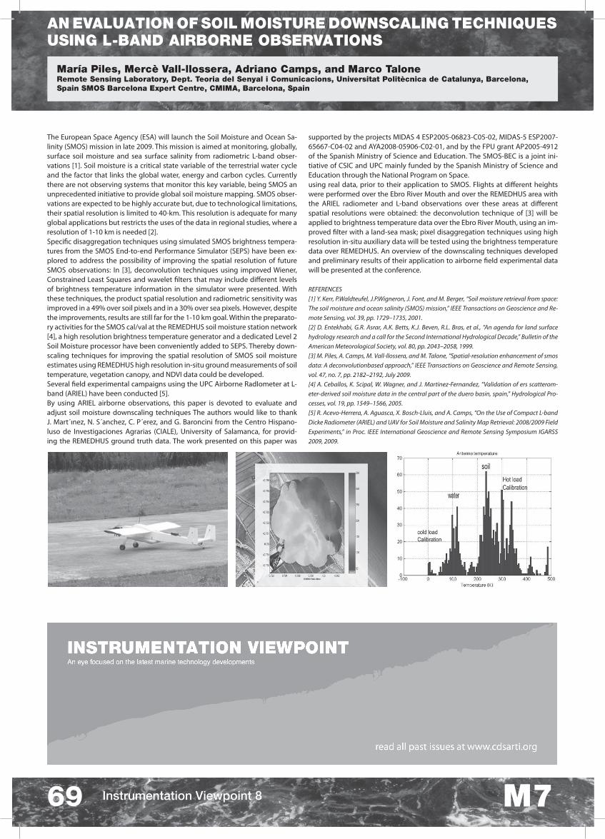
supported by the projects MIDAS 4 ESP2005-06823-C05-02, MIDAS-5 ESP2007-65667-C04-02 and AYA2008-05906-C02-01, and by the FPU grant AP2005-4912 of the Spanish Ministry of Science and Education. The SMOS-BEC is a joint ini-tiative of CSIC and UPC mainly funded by the Spanish Ministry of Science and Education through the National Program on Space.using real data, prior to their application to SMOS. Flights at different heights were performed over the Ebro River Mouth and over the REMEDHUS area with the ARIEL radiometer and L-band observations over these areas at different spatial resolutions were obtained: the deconvolution technique of [3] will be applied to brightness temperature data over the Ebro River Mouth, using an im-proved filter with a land-sea mask; pixel disaggregation techniques using high resolution in-situ auxiliary data will be tested using the brightness temperature data over REMEDHUS. An overview of the downscaling techniques developed and preliminary results of their application to airborne field experimental data will be presented at the conference.

REFERENCES[1] Y. Kerr, P.Waldteufel, J.P.Wigneron, J. Font, and M. Berger, “Soil moisture retrieval from space: The soil moisture and ocean salinity (SMOS) mission,” IEEE Transactions on Geoscience and Re-mote Sensing, vol. 39, pp. 1729–1735, 2001.[2] D. Entekhabi, G.R. Asrar, A.K. Betts, K.J. Beven, R.L. Bras, et al., “An agenda for land surface hydrology research and a call for the Second International Hydrological Decade,” Bulletin of the American Meteorological Society, vol. 80, pp. 2043–2058, 1999.[3] M. Piles, A. Camps, M. Vall-llossera, and M. Talone, “Spatial-resolution enhancement of smos data: A deconvolutionbased approach,” IEEE Transactions on Geoscience and Remote Sensing, vol. 47, no. 7, pp. 2182–2192, July 2009.[4] A. Ceballos, K. Scipal, W. Wagner, and J. Martinez-Fernandez, “Validation of ers scatterom-eter-derived soil moisture data in the central part of the duero basin, spain,” Hydrological Pro-cesses, vol. 19, pp. 1549–1566, 2005.[5] R. Acevo-Herrera, A. Aguasca, X. Bosch-Lluis, and A. Camps, “On the Use of Compact L-band Dicke Radiometer (ARIEL) and UAV for Soil Moisture and Salinity Map Retrieval: 2008/2009 Field Experiments,” in Proc. IEEE International Geoscience and Remote Sensing Symposium IGARSS 2009, 2009.