Embed Size (px)
Citation preview
ESTIMATING SURFACE SOIL MOISTURE USING RADARSAT-2
H. McNairn *, A. Merzouki, A. Pacheco
Agriculture and Agri-Food Canada, 960 Carling Avenue, Ottawa, Ontario, Canada K1A 0C6
KEY WORDS: Synthetic Aperture Radar, Soil Moisture, Integral Equation Model ABSTRACT: Extremes in soil moisture, either too much or too little, present a significant risk to agricultural productivity. Managing and mitigating risk requires information and knowledge to assess risk potential, implement risk reduction strategies and deliver responses to this risk. Synthetic aperture radars (SARs) are sensitive to the dielectric properties of soils and are thus well suited to provide quantitative soil moisture estimates to support effective risk assessment and mitigation. With the launch of RADARSAT-2 in 2007, Agriculture and Agri-Food Canada (AAFC) began testing the accuracy of fully polarimetric SAR data to estimate surface soil moisture. One model under investigation is the Integral Equation Model (IEM), including the calibrated IEM. The calibrated IEM introduces an optimum correlation length (�opt2) to improve the performance of the IEM. To test the ability of the IEM and the calibrated IEM to accurately estimate surface soil moisture, AAFC collected three quad-polarization RADARSAT-2 images in 2008 over their western Canadian test site. Coincident with each SAR acquisition, AAFC collected approximately 2000 in situ soil moisture measurements using hand-held soil moisture probes. Surface roughness was measured using a 1-metre needle profiler. Overall, a better agreement was found between the calibrated IEM results and SAR-based backscatter coefficients compared to the original IEM results. The calibrated IEM also reduced the impact of variation in incidence angle on both the HH and VV backscatter coefficients. Inversion of the calibrated IEM was implemented using a look up table (LUT) approach. The LUTs were generated by simulating HH and VV backscatter coefficients using the �opt2 formulation. When sample sites were averaged by soil texture, the calibrated IEM was able to estimate volumetric soil moisture with an RMSE of 5.37%.
2.1
* Corresponding author
1. INTRODUCTION
Managing and mitigating risk to the agriculture sector requires information and knowledge to assess risk potential, implement risk reduction strategies and deliver essential responses. The availability of water, in particular the amount of moisture held in the soil, presents a significant risk factor for this sector. Too little available moisture can lead to short and longer term drought while saturated soils can prevent seeding and impede crop productivity. Thus monitoring available soil moisture is important in the assessment of agricultural risk. Synthetic aperture radars (SARs) are sensitive to the dielectric properties of soils and are thus well suited to provide quantitative soil moisture estimates to support effective risk assessment and mitigation. Since the launch of RADARSAT-2 in December of 2007, Agriculture and Agri-Food Canada (AAFC) has been evaluating the accuracy of these data for estimating surface soil moisture. Several approaches can be taken to model soil moisture from SAR backscatter. These approaches include the use of simple empirical models, semi-empirical models such as the Dubois (Dubois et al., 1995) and Oh (Oh, 2004) models, and physically-based models such as the Integral Equation Model (IEM) (Fung et al., 1992). Empirical and semi-empirical models require the derivation or adaptation of model coefficients to suit local conditions. Thus these approaches present challenges for large area operational implementation. Physical models are more robust, yet solving models such as the IEM is a complex task. This paper describes results achieved in estimating surface soil moisture using data from RADARSAT-2 and the IEM. An optimization technique is applied to the IEM model and
accuracy statistics are presented for data collected over a Canadian research site.
2. METHODOLOGY
Site Description and Data Collection
RADARSAT-2 and coincident ground data were acquired over an Agriculture and Agri-Food (AAFC) research site located in Canada’s western prairie region. The Carman site is located in the Red River Valley of southern Manitoba, Canada (49.50°N; 97.18°W). This site is mixed prairie agriculture, with a large production of cereals (primarily wheat, barley and oats) and oilseeds (canola, flaxseed, sunflower and soybean). This site transitions from rich clay soils in the west, to better drained silty and clay loams and sandy soils in the east. For the purposes of this research, RADARSAT-2 data were acquired in the spring of 2008. RADARSAT-2 is equipped with a fully polarimetric SAR operating at C-band (5.3 GHz). With RADARSAT-2’s quad-polarization mode microwaves are transmitted and received in both horizontal and vertical polarizations, and the phase between these polarizations is preserved. This configuration permits the synthesis of any polarization. In April and May of 2008, fine quad polarization acquisitions were programmed for the Carman research site (Table 1). These fine quad pol data have a nominal spatial resolution of 8 meters, with a swath of 25 km. Incidence angles for these acquisitions ranged from 30o to 35o.
International Archives of the Photogrammetry, Remote Sensing and Spatial Information Science, Volume XXXVIII, Part 8, Kyoto Japan 2010
576
Date Mode Orbit April 23 FQ11 ASC May 10 FQ15 ASC May 17 FQ11 ASC
Table 1. 2008 RADARSAT-2 acquisitions over Carman, Manitoba
Surface soil moisture was measured coincident to each SAR acquisition using the ThetaProbe (Delta-T Devices), at a 6 cm depth. For each SAR acquisition soil moisture was measured at 46 sites (within 31 fields). At each site, soil moisture was measured at 16 sample points with three replicates collected at each point. Thus for each SAR acquisition, more than 2200 soil moisture measurements were collected. Surface roughness measurements were also collected for each field using a one-meter needle profiler. The profile photos were processed to extract the surface roughness parameters rms height ( ) and correlation length ( ). Measurements were taken in the look direction of the radar (78 degrees azimuth with respect to true north). Five sampling points were established for each site with a minimum distance of 5 metres between each point. Two replicates were obtained at each sampling point, thus yielding ten surface roughness profiles per site.
s�
2.2
2.3
Data Processing
Pre-processing of RADARSAT-2 data was achieved using the SAR Polarimetry Workstation (SPW), an add-on module of PCI Geomatica®. A 5x5 boxcar filter was applied to the single look complex data to reduce speckle noise. Once the intensity channels were derived, slant range to ground range conversion was applied. These ground range products were then geo-referenced using a set of thirty ground control points, with an average root-mean-square error of less than two pixels achieved for all SAR images. The image registrations were performed using a third-order polynomial transformation and nearest-neighbour resampling.
The Integral Equation Model
For a given radar configuration, the backscatter models simulate the backscatter coefficient of a surface from its physical proprieties. In this study, a model based on the theory of electromagnetic wave scattering from a rough surface under simplifying assumptions has been used: The Integral Equation Model (IEM). This model is appropriate for randomly dielectric rough surfaces (Fung et al. 1992). It is based on analytical solutions of the integral equations for tangential surface fields and accounts for both single and multiple surface diffusion phenomena. In a broad sense, it can be applied to simulate the backscattering behaviour in a wide range of roughness values that are usually encountered for agricultural surfaces. The validity domain of the IEM is defined by a set of inequalities such that (Fung, 1994): 3�sk , rsk ����2 and
1}))sin1(92,0(exp{ ])46,0()cos[( 5,05,02 ���� ���� kksk , where �r is the soil dielectric constant, is the roughness correlation length (cm), s is the roughness RMS height, � is the local incidence angle, k is the wave number (cm
�
-1), and � is a constant equal to 1.2 or 200 for exponential or Gaussian roughness autocorrelation functions, respectively.
Before testing the performance of the IEM to estimate soil moisture, forward modeling was used to compare simulated (from the IEM) to measured (from RADARSAT-2) backscatter. Backscatter was simulated using field data (soil moisture and roughness) and the RADARSAT-2 configuration parameters (frequency, polarization, and incidence angle) as inputs into the IEM. The model developed by Peplinski et al. (1995) was used to obtain the relative soil dielectric constant from measured volumetric water content.
To improve the performance of the IEM, the semi-empirical calibration approach proposed by Baghdadi et al. (2006) was also evaluated. Baghdadi et al. (2006) introduced an optimum roughness correlation length �opt2 expression in the backscatter coefficient calculation. This parameter is obtained by forcing the IEM until a good agreement is reached between simulations and SAR image data. These calculations were performed using measured RMS roughness height as well as soil moisture content as ground data input parameters. This optimum correlation length is expressed as:
� � � ����� rms�� sinopt2� (1)
Where:
026.4HH ��289.3VV ��
744.1VVHH ��� ��0025.0VVHH ��� ��
551.1HH ��222.1VV ��026.4HH ��289.3VV ��
744.1VVHH ��� ��0025.0VVHH ��� ��
551.1HH ��222.1VV ��
To test the efficiency of this calibration technique, a validation was undertaken by comparing measured and simulated backscatter coefficients for the original IEM, where � values are those measured at each sampling site, and the calibrated version of IEM, where � values are replaced by the optimum values �opt2.
3. RESULTS AND DISCUSSION
Simulated data by the original IEM showed significant fluctuations with an overestimation of SAR backscatter. This result is not surprising, since previous studies have shown that correlation length measurements are very sensitive to profile length (Davidson et al., 1998) and relatively short lengths were used in this study (1 m). Very long profile lengths (>200 � , where is the roughness correlation length) are required to achieve accurate estimation of roughness parameters. However, such measurements are difficult to achieve during validation campaigns where many measurements are needed under constantly varying field conditions.
�
In addition to assessing errors on a site-by-site basis, the performance of the IEM was also evaluated by averaging samples according to broad soil texture classes. These classes included clay soils, sandy soils and a third class of silty and clayey loams. This averaging approach significantly reduced noise in the error analysis. Ideally, site specific soil moisture estimates are preferred. However, provision of average soil moisture estimates over areas with similar soil properties is of value for landscape or watershed based modeling and decision-making.
International Archives of the Photogrammetry, Remote Sensing and Spatial Information Science, Volume XXXVIII, Part 8, Kyoto Japan 2010
577
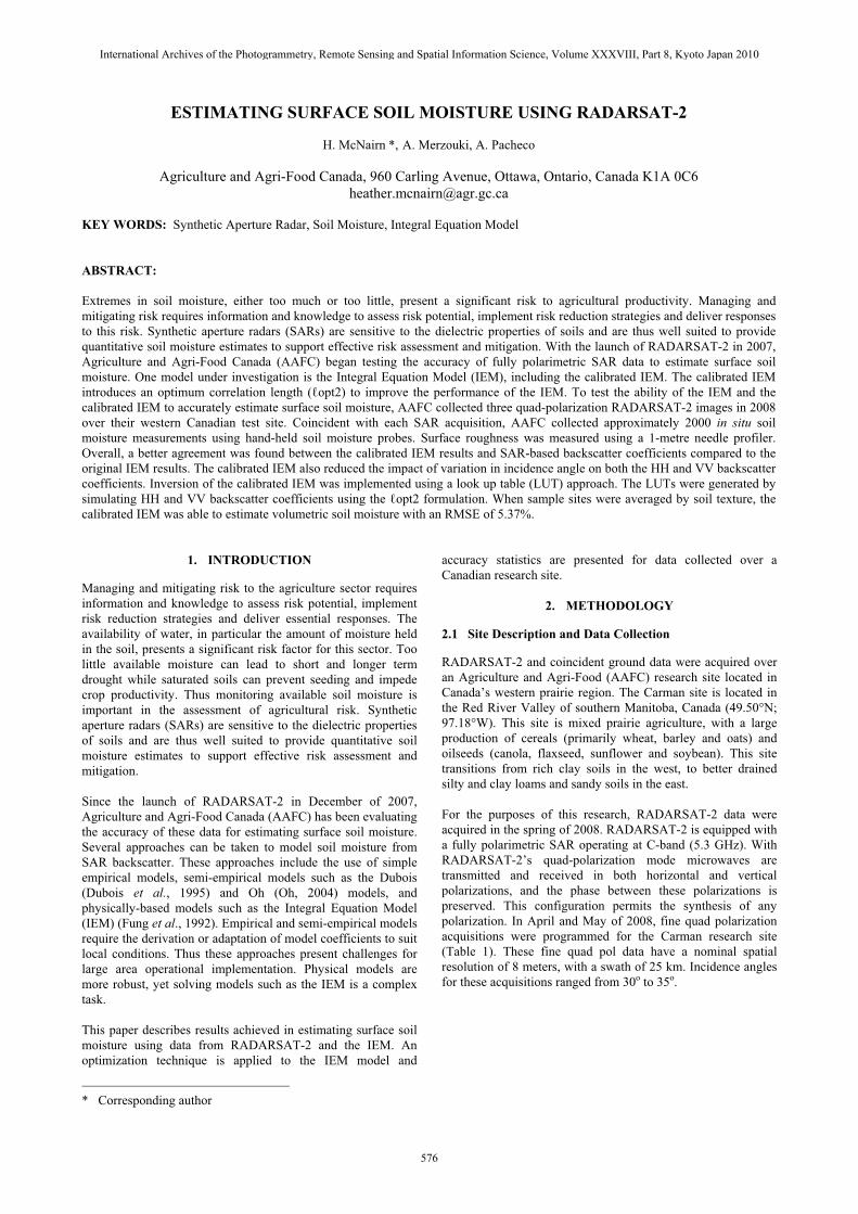
The associated statistical calculations are summarized in Table 2. Overall, a better agreement was found between the calibrated IEM results and SAR-based backscatter coefficients compared to the original IEM results. This was particularly true for the HH polarization. Only a small reduction in error was observed for VV. When averaged over texture classes, differences between the simulated and measured backscatter were significantly reduced for all models (Table 1 and Figure 1). In addition, improvements in the IEM performance when using the optimum correlation length were more pronounced for the VV polarization, when the data were averaged.
RMSE (dB) Pol. Model Individual
sites Averaged per soil
texture class IEM 7.43 3.81 HH
Calibrated IEM 6.65 3.08 IEM 5.09 3.79 VV Calibrated IEM 5.06 2.90
(a) Original IEM and HH backscatter
Table 2. Root mean square error (dB) statistics for IEM model predictions
-35
-30
-25
-20
-15
-10
-5
0
-35 -30 -25 -20 -15 -10 -5 0
Measured backscatter coefficient (dB)
Mod
eled
bac
ksca
tter c
oeffi
cien
t (dB
) IEM
Calibrated IEM
-35
-30
-25
-20
-15
-10
-5
0
-35 -30 -25 -20 -15 -10 -5 0
Measured backscatter coefficient (dB)
Mod
eled
bac
ksca
tter c
oeffi
cien
t (dB
) IEM
Calibrated IEM
Figure 1. Simulated HH (top) and VV (bottom) backscatter coefficients averaged by soil type using IEM and calibrated IEM plotted against derived backscatter coefficients from
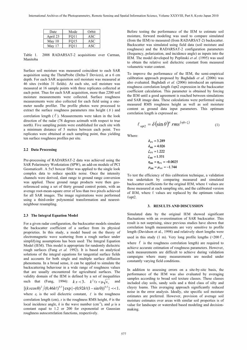
RADARSAT-2 images The calibrated IEM also reduced the impact of variation in the local incidence angle on both the HH and VV backscatter coefficients (Figure 2). This reduced sensitivity will be beneficial when implementing the calibrated IEM over agricultural landscapes with topographic variability.
Figure 2. Simulated HH backscatter coefficients (z-axis) versus
incidence angle (y-axis) and soil moisture (x-axis) using the original IEM and calibrated IEM
(b) Calibrated IEM and HH backscatter
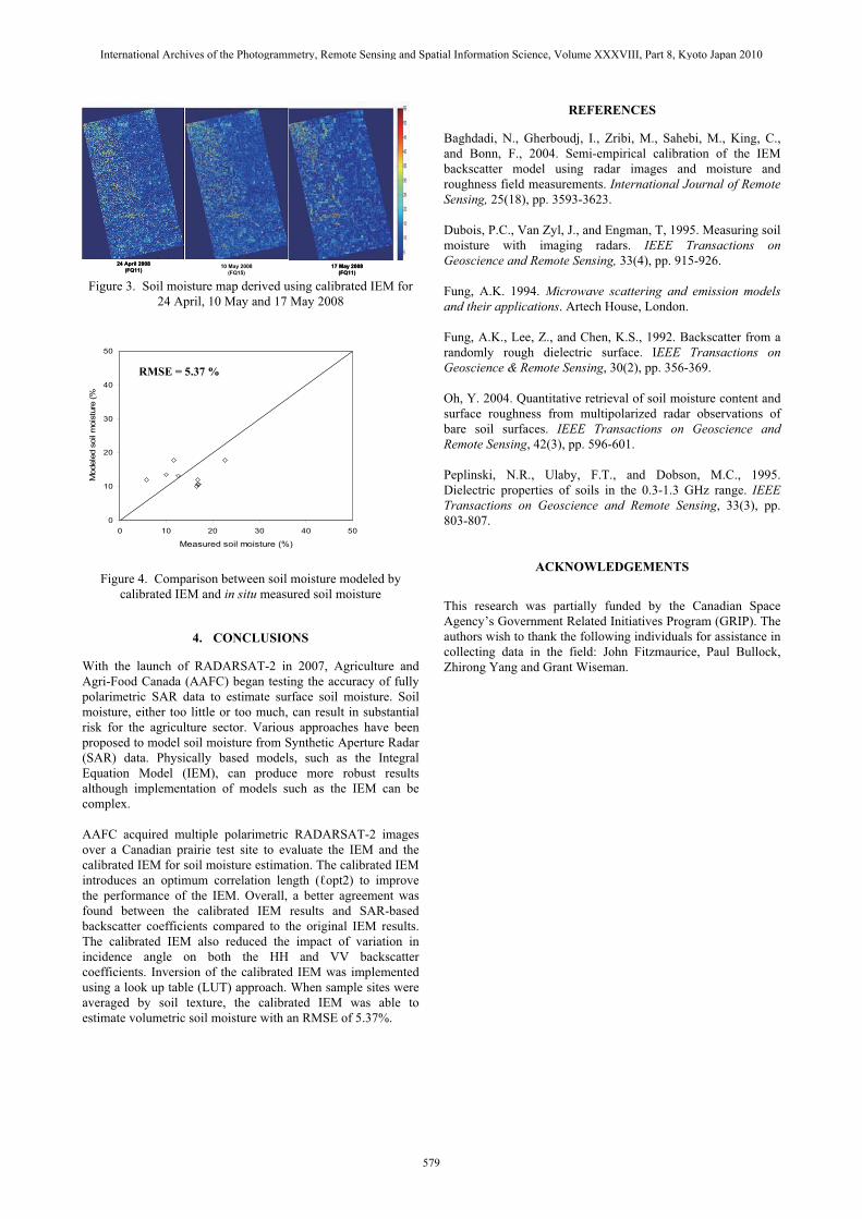
The calibrated IEM inversion to estimate surface soil moisture was implemented using a Look-Up Table (LUT) approach. This method involves the creation of a table of backscatter values associated with surface soil moisture, roughness rms height, and incidence angle values generated by performing multiple runs of the calibrated IEM model within its validity range. The implemented direct search algorithm attempts to minimize a scalar value representing the difference between measured and simulated backscatter coefficients. The IEM inversion was applied on a pixel-by-pixel basis to each of the three RADARSAT-2 quad-pol images. Figure 3 provides maps of estimated volumetric soil moisture for April 24, May 10 and May 17. Comparing the in situ soil moisture measurements to the estimates from the calibrated IEM, and averaged over soil texture, the root mean square error of the soil moisture estimate was 5.37% (Figure 4).
International Archives of the Photogrammetry, Remote Sensing and Spatial Information Science, Volume XXXVIII, Part 8, Kyoto Japan 2010
578
24 April 2008 (FQ11)
10 May 2008 (FQ15)
17 May 2008 (FQ11)
24 April 2008 (FQ11)
10 May 2008 (FQ15)
17 May 2008 (FQ11)
Figure 3. Soil moisture map derived using calibrated IEM for 24 April, 10 May and 17 May 2008
Figure 4. Comparison between soil moisture modeled by calibrated IEM and in situ measured soil moisture
4. CONCLUSIONS
With the launch of RADARSAT-2 in 2007, Agriculture and Agri-Food Canada (AAFC) began testing the accuracy of fully polarimetric SAR data to estimate surface soil moisture. Soil moisture, either too little or too much, can result in substantial risk for the agriculture sector. Various approaches have been proposed to model soil moisture from Synthetic Aperture Radar (SAR) data. Physically based models, such as the Integral Equation Model (IEM), can produce more robust results although implementation of models such as the IEM can be complex. AAFC acquired multiple polarimetric RADARSAT-2 images over a Canadian prairie test site to evaluate the IEM and the calibrated IEM for soil moisture estimation. The calibrated IEM introduces an optimum correlation length (�opt2) to improve the performance of the IEM. Overall, a better agreement was found between the calibrated IEM results and SAR-based backscatter coefficients compared to the original IEM results. The calibrated IEM also reduced the impact of variation in incidence angle on both the HH and VV backscatter coefficients. Inversion of the calibrated IEM was implemented using a look up table (LUT) approach. When sample sites were averaged by soil texture, the calibrated IEM was able to estimate volumetric soil moisture with an RMSE of 5.37%.
REFERENCES
Baghdadi, N., Gherboudj, I., Zribi, M., Sahebi, M., King, C., and Bonn, F., 2004. Semi-empirical calibration of the IEM backscatter model using radar images and moisture and roughness field measurements. International Journal of Remote Sensing, 25(18), pp. 3593-3623. Dubois, P.C., Van Zyl, J., and Engman, T, 1995. Measuring soil moisture with imaging radars. IEEE Transactions on Geoscience and Remote Sensing, 33(4), pp. 915-926. Fung, A.K. 1994. Microwave scattering and emission models and their applications. Artech House, London. Fung, A.K., Lee, Z., and Chen, K.S., 1992. Backscatter from a randomly rough dielectric surface. IEEE Transactions on Geoscience & Remote Sensing, 30(2), pp. 356-369.
0
10
20
30
40
50
0 10 20 30 40 50
Measured soil moisture (%)
Mod
eled
soi
l moi
stur
e (%
RMSE = 5.37 % )
Oh, Y. 2004. Quantitative retrieval of soil moisture content and surface roughness from multipolarized radar observations of bare soil surfaces. IEEE Transactions on Geoscience and Remote Sensing, 42(3), pp. 596-601. Peplinski, N.R., Ulaby, F.T., and Dobson, M.C., 1995. Dielectric properties of soils in the 0.3-1.3 GHz range. IEEE Transactions on Geoscience and Remote Sensing, 33(3), pp. 803-807.
ACKNOWLEDGEMENTS
This research was partially funded by the Canadian Space Agency’s Government Related Initiatives Program (GRIP). The authors wish to thank the following individuals for assistance in collecting data in the field: John Fitzmaurice, Paul Bullock, Zhirong Yang and Grant Wiseman.
International Archives of the Photogrammetry, Remote Sensing and Spatial Information Science, Volume XXXVIII, Part 8, Kyoto Japan 2010
579