Embed Size (px)
Citation preview
An Approach for Localization in Underwater Wireless Sensor Network
Kritika SharmaDepartment of Electronics and Communication Engineering
Shoolini University of Biotechnology and Management Sciences, Solan, Himachal Pradesh, India
Vivek KanwarDepartment of Electronics and Communication Engineering
Shoolini University of Biotechnology and Management Sciences, Solan, Himachal Pradesh, India
Abstract- Awareness of location among the participating nodes is one of the essential needs in designing of solutions for various issues related to Underwater Wireless Sensor Networks (UWSNs) especially when sensor nodes are randomly organized in the network. Unlike in the terrestrial positioning, the global positioning system (GPS) cannot work efficiently underwater due to the limited bandwidth, the ruthlessly impaired channel and the costly equipment. All these collectively makes the localization problem extremely challenging. Although it is difficult to deploy beacon nodes at predetermined locations. Localization schemes with a mobile beacon on the sea surface or along the planned path are inherently convenient, accurate, having low energy requirements. This paper discusses about a range free localization mechanism for UWSNs that uses the mobile beacons for localization.
Keywords – Localization, UWSNs, Beacons, RMSE
I. INTRODUCTION
The majority of the earth’s surface is covered by water. Various underwater applications have been researched, e.g., environmental monitoring, undersea explorations, disaster prevention, mine reconnaissance, etc. [1].Sensor networks that are utilized underwater are usually called Underwater Wireless Sensor Networks (UWSNs). Although they share the same principles as their terrestrial counterparts, the particular characteristics of the underwater environment introduce new challenges for the research community.Nowadays the need for underwater monitoring is rising day by day (e.g. for exploration of natural undersea resources, gathering of scientific data or detection of marine incidents such as chemical pollution or oil spill) but the existing technologies do not measure up to the demanding requirements [5]. The amount of energy consumed by acoustic communication of sensor is much larger than the radio communication. In previous work, many researchers proposed a number of approaches to locate the position of nodes for terrestrial wireless ad hoc and sensor networks [7]. There are still many issues yet to be solved for the large scale UWSNs, such as reliable transport, efficient routing, Medium Access Control, and localization because of the limited bandwidth, and high propagation delays, severely impaired underwater channel, limited battery power [6].Localization schemes for UWSN can be classified into two categories:1. Range-based schemes (schemes that use range or bearing information).2. Range-free schemes (schemes that do not use range or bearing information).Range-based schemes: These schemes use range or bearing information. Here precise distance or angle measurements are made to approximate the location of nodes. The parameters used in these techniques are, Time of Arrival (ToA), Time Difference of Arrival (TDoA) and Angle of Arrival (AoA). These are used for fine grained location estimation. These include infrastructure-based scheme, distributed positioning scheme, scheme that use mobile beacons/anchors, scheme without anchor/references points.Range-free schemes: These do not use range or bearing information. Advantages of these schemes lie in their simplicity. These only provide a coarse estimation of node’s location. These include area localization schemes, hop count based schemes, centroid schemes and signal processing/probabilistic scheme.
The rest of the paper is organized as follows. Related work is discussed in section II. Proposed work isexplained in section III. Results obtained are presented in section IV. Conclusion is given in section V. Then references are given in section VI.
II. RELATED WORKGuangjie Han [1] has performed a survey on the various localization techniques for under water wireless Sensor Networks. He concluded that, although GPS does not work efficiently on underwater sensor nodes with GPS is often expensive, most researchers still adopt anchor nodes to localize unknown nodes. Meanwhile, unknown node in sub-sea environment can be localized by the hierarchical approaches such as LSHL, LSLS. In these networks, bandwidth constraint, sensor nodes’ mobility, and unpredicted variation in channel behaviour make
International Journal of Latest Trends in Engineering and Technology (IJLTET) ISSN: 2278-621X
33 Vol 7 issue 2 July 2016http://dx.doi.org/10.21172/1.72.506
range methods based on received signal strength (RSS) and angle of arrival (AoA) unprecise and yet inapplicable.Sangho Lee and Kiseon Kim [2] has proposed a new range-free Localization with a Mobile Beacon (LoMoB). According to the proposed technique, mobile beacon periodically broadcasts a beacon message containing its location. Sensor nodes are individually localized by passively receiving the beacon messages without inter-node communications. A set of potential locations are obtained as candidates for a node’s location and then the node’s location is calculated by the weighted mean of all the potential locations with the weight measured based on residuals, for estimating the location of nodes.Cristina Albaladejo [3] has proposed a design and implementation for a new multisensor monitoring buoy system. The design is based on the fundamental requirements that make this approach different from other recent proposals such as low cost of implementation, the possibility of application in coastal shallow-water marine environments, suitable dimensions for deployment and stability of the sensor system in a shifting environment like the sea bed, and total autonomy of power supply and data recording. The buoy system has successfully performed remote monitoring of temperature and marine pressure, temperature and atmospheric pressure. He has performed an operational trail in a marine environment to validate the above requirements. The presented system thus seems to offer a broad range of applications.Ying Zhang [4] has analysed the mobility patterns of water near the seashore, a localization method for UWSNs based on a Mobility Prediction and a Particle Swarm Optimization algorithm (MP-PSO) is proposed. In this method, the range-based PSO algorithm is used to locate the beacon nodes, and their velocities can be calculated. The velocity of an unknown node is calculated by using the spatial correlation of underwater object’s mobility, and then their locations can be predicted. The range-based PSO algorithm may cause considerable energy consumption and its computation complexity is a little bit high, nevertheless the number of beacon nodes is relatively smaller, so the calculation for the large number of unknown nodes is succinct, and this method can obviously decrease the energy consumption and time cost of localizing these mobile nodes. The simulation results indicate that this method has higher localization accuracy and better localization coverage rate compared with some other widely used localization methods in this field.Melike Erol and Luiz F. M. Vieira et al. [9] explored a localization technique, Dive ‘N’ Rise (DNR) positioning for underwater acoustic sensor networks. Localization is one of the main challenges of UASNs. Acoustic channels are used which have low bandwidth, large propagation delay and high error rate. DNR positioning applies to large scale, 3-D space USN. DNR beacons learn their coordinates using GPS system when floating over water. While diving, they broadcast their coordinates which are used by sensor nodes to localize themselves. Assumed that nodes are synchronized and after hearing from several DNR beacons, they can estimate their coordinates. Sensor nodes can use boundary box or triangulation techniques to find their coordinates. Qualnet simulator is used for implementing DNR-positioning. Here performance of DNR positioning is analysed in the presence of current and without current. Performance of this technique is evaluated based on number of localized nodes and localization errors. Result showed that it can localize all nodes with small error and minimal message exchange is required.Vijay Chandrasekhar and Winston KG Seah et al. [10] surveyed the different localization schemes that can be used in underwater wireless sensor networks and the challenges in meeting those schemes. As underwater sensor networks use acoustic channels, so bandwidth limitation, propagation delay and bit error rate are main challenges. Most localization schemes require the location of some nodes in the network to be known in advance. These are called anchor nodes or reference nodes. Localization that uses reference nodes can be classified into two categories- first range based schemes that use range/bearing information, second range free schemes that do not use range/ bearing information. Range based schemes use one of time of arrival (ToA), time difference of arrival (TDoA), angle of arrival (AoA) for precise distance or angle measurement. Time synchronization and propagation delay are main challenges in range based scheme. Range free schemes do not use ToA, TDoA or AoA. Hop count based schemes and area based schemes are range free schemes. By comparison, range based schemes are used for fine grained location estimation while range free schemes only provide a coarse estimate of node’s location.Mari Carmen Domingo and Rui Prior [11] analysed the energy consumption of different routing protocol in UWSNs. Energy saving is main concern in UWSNs because sensor nodes are powered by batteries which are difficult to replace or recharge. In underwater environment, transmission consumes more power than receiving. Two scenario- shallow water and deep water are analysed here. Different routing protocols like packet relaying, direct transmission and clustering are analysed and compared them in both shallow and deep water scenario. In shallow water, total energy consumed is less in clustering method than data relaying for same number of nodes. Energy expanse increases with increase in distance between sensor nodes in both clustering and data relaying methods. In deep water, total energy consumed is slightly less in clustering than relaying method. Direct transmission is worst method in both scenarios.Jun-Hong Cui and Jiejun Kong et al. [12] studied the challenges in building scalable mobile UWSN. Radio transmission is not used in underwater environment because they get attenuated in water. So acoustic channels
International Journal of Latest Trends in Engineering and Technology (IJLTET) ISSN: 2278-621X
34 Vol 7 issue 2 July 2016http://dx.doi.org/10.21172/1.72.506
are used. Low bandwidth, high propagation delay, high bit error rate and floating node mobility are main challenge in mobile UWSN. Mobile UWSNs are compared with ground based sensor networks and static UWSNs. Mobile UWSNs are different from ground based sensor networks in using diff. communication model and node mobility underwater. In this network, sensor nodes are densely deployed and these are self-organizing.Different localization method is required as nodes are mobile. Two architectures for mobile UWSNs are presented -1. Mobile UWSN for long-term non-time critical aquatic monitoring and 2. Mobile UWSNs for short-term time critical aquatic exploration. For first, main challenges are energy saving and localization for long time monitoring. For second, real time data transfer is more important. Research challenges in mobile UWSNs design are studied in top-down manner in network protocol stack.Antonio Caruso and Francesco Paparella et al. [13] proposed a novel Meandering Current Mobility model (MCM) for underwater mobile acoustic sensor networks. A realistic mobility model that can capture the physical movement of the sensor nodes with ocean currents gives better understanding on the problems like localization and networking protocols. We studied how the model affects a range-based localization protocol, and its impact on the coverage and connectivity of the network under different deployment scenarios.
III. PROPOSED WORKThis research proposes a range-free Localization with a Mobile Beacon. The mobile node periodically
broadcasts a message containing its location. Sensor nodes are individually localized by passively receiving the messages without inter-node communications. Passive listening helps in minimizing the energy consumption of sensor node. As they are battery operated devices so their energy is limited. As less energy is used so this helps to improve the lifetime of the sensor node and network too.A. Design of algorithm-
The work proposed is shown below in flowchart and discussed below:1. For the sensor nodes S1, S2, S3,…, Sk , initialize the beacon nodes in the network.2. Then apply PSO for best position estimation.3. Localize the nodes in UWSN with the help of directional beacons using the acoustic communication. This
communication is useful in UWSN scenario as GPS (Global Positioning System) don’t work well.4. The distance is calculated by using 3D Euclidean distance estimation method. The formula is given as
(1)
Where the distance is calculated between x and y vectors. Here x vector represents the original position of first node and the y vector represents the original position of second node.
5. Then the difference is calculated between the estimated and original positions which is represented as thelocalization error.
6. The formulae to calculate the localization error is shown below(2)
7. If there is no localization error then the process will stop, but if there is any localization error found then the process will give the positions of nodes by forming paths between them.
8. Here localize the nodes using biograph in MATLAB R2012a. 9. Broadcast message.10. From S1, S2, S3,…, Sk calculate shortest distance by 3D-Euclidean distance.11. Assign the weights to the paths and find the cheating nodes and show graph with red colour. From {S1, S2,
S3,…, Sk} – {C1, C2, C3,…, Cj} draw final localized graph and then do analysis where { C1, C2, C3,…, Cj} are cheating/ malicious nodes.
International Journal of Latest Trends in Engineering and Technology (IJLTET) ISSN: 2278-621X
35 Vol 7 issue 2 July 2016http://dx.doi.org/10.21172/1.72.506
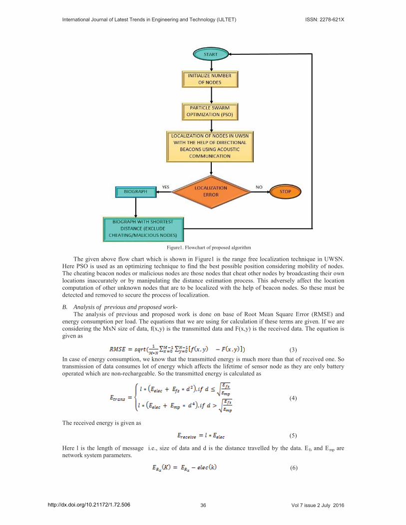
Figure1. Flowchart of proposed algorithm
The given above flow chart which is shown in Figure1 is the range free localization technique in UWSN. Here PSO is used as an optimizing technique to find the best possible position considering mobility of nodes. The cheating beacon nodes or malicious nodes are those nodes that cheat other nodes by broadcasting their own locations inaccurately or by manipulating the distance estimation process. This adversely affect the location computation of other unknown nodes that are to be localized with the help of beacon nodes. So these must be detected and removed to secure the process of localization.
B. Analysis of previous and proposed work- The analysis of previous and proposed work is done on base of Root Mean Square Error (RMSE) and
energy consumption per load. The equations that we are using for calculation if these terms are given. If we are considering the MxN size of data, f(x,y) is the transmitted data and F(x,y) is the received data. The equation is given as
(3)In case of energy consumption, we know that the transmitted energy is much more than that of received one. So transmission of data consumes lot of energy which affects the lifetime of sensor node as they are only battery operated which are non-rechargeable. So the transmitted energy is calculated as
(4)
The received energy is given as
(5)
Here l is the length of message i.e., size of data and d is the distance travelled by the data. Efs and Emp are network system parameters.
(6)
International Journal of Latest Trends in Engineering and Technology (IJLTET) ISSN: 2278-621X
36 Vol 7 issue 2 July 2016http://dx.doi.org/10.21172/1.72.506
(7)
Eelec is the energy of the receiver for K bit data packet transmitted from the transmitter node. Accuracy can be calculated by using formula given below
(8)
IV. RESULTS
For this work, MATLAB R2012a is used as a simulation platform. This provide a very interactive way to perform the task in the form of process. The results are quite efficient as compare to previous localization techniques and these are discussed below.
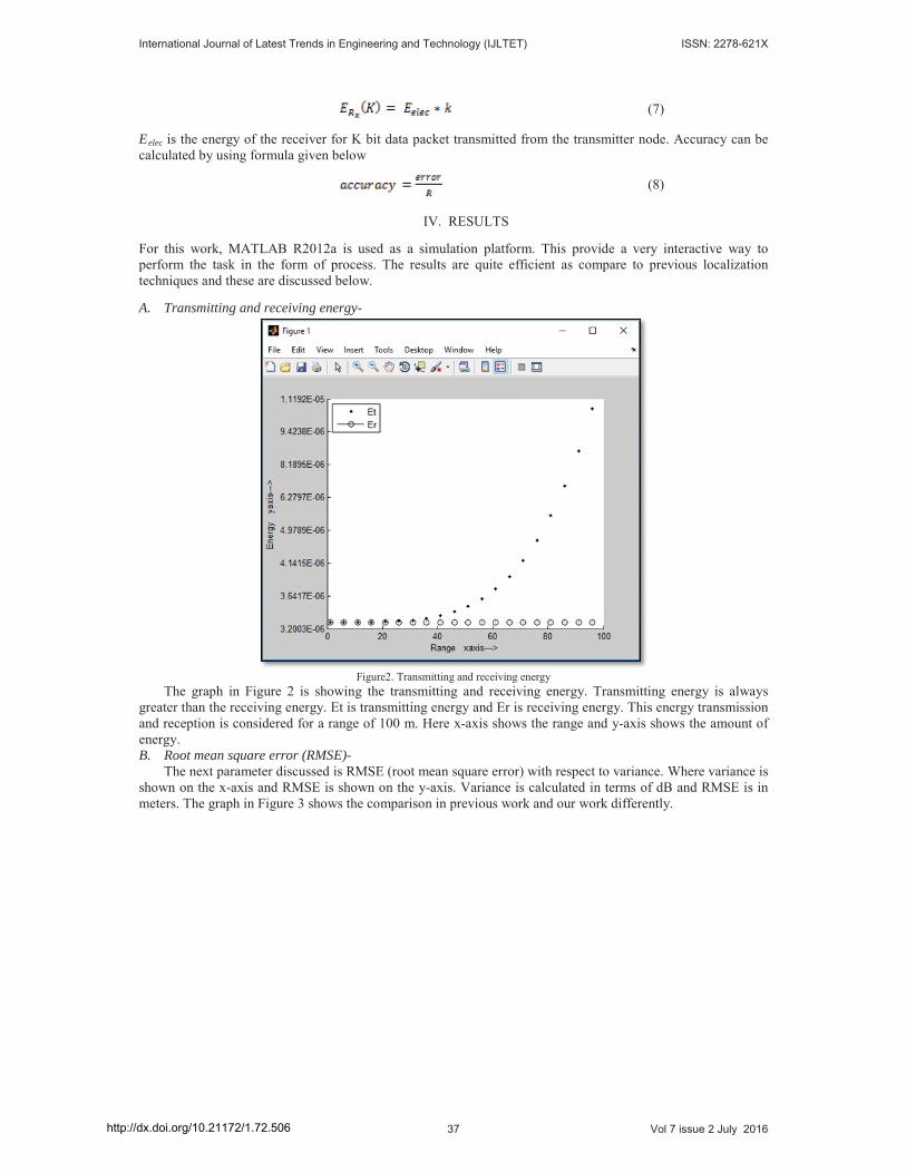
A. Transmitting and receiving energy-
Figure2. Transmitting and receiving energyThe graph in Figure 2 is showing the transmitting and receiving energy. Transmitting energy is always
greater than the receiving energy. Et is transmitting energy and Er is receiving energy. This energy transmission and reception is considered for a range of 100 m. Here x-axis shows the range and y-axis shows the amount of energy.B. Root mean square error (RMSE)-
The next parameter discussed is RMSE (root mean square error) with respect to variance. Where variance is shown on the x-axis and RMSE is shown on the y-axis. Variance is calculated in terms of dB and RMSE is in meters. The graph in Figure 3 shows the comparison in previous work and our work differently.
International Journal of Latest Trends in Engineering and Technology (IJLTET) ISSN: 2278-621X
37 Vol 7 issue 2 July 2016http://dx.doi.org/10.21172/1.72.506
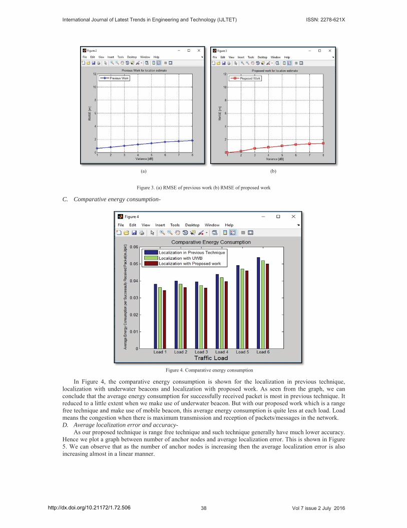
(a) (b)
Figure 3. (a) RMSE of previous work (b) RMSE of proposed work
C. Comparative energy consumption-
Figure 4. Comparative energy consumption
In Figure 4, the comparative energy consumption is shown for the localization in previous technique, localization with underwater beacons and localization with proposed work. As seen from the graph, we can conclude that the average energy consumption for successfully received packet is most in previous technique. It reduced to a little extent when we make use of underwater beacon. But with our proposed work which is a range free technique and make use of mobile beacon, this average energy consumption is quite less at each load. Load means the congestion when there is maximum transmission and reception of packets/messages in the network.D. Average localization error and accuracy-
As our proposed technique is range free technique and such technique generally have much lower accuracy. Hence we plot a graph between number of anchor nodes and average localization error. This is shown in Figure 5. We can observe that as the number of anchor nodes is increasing then the average localization error is also increasing almost in a linear manner.
International Journal of Latest Trends in Engineering and Technology (IJLTET) ISSN: 2278-621X
38 Vol 7 issue 2 July 2016http://dx.doi.org/10.21172/1.72.506
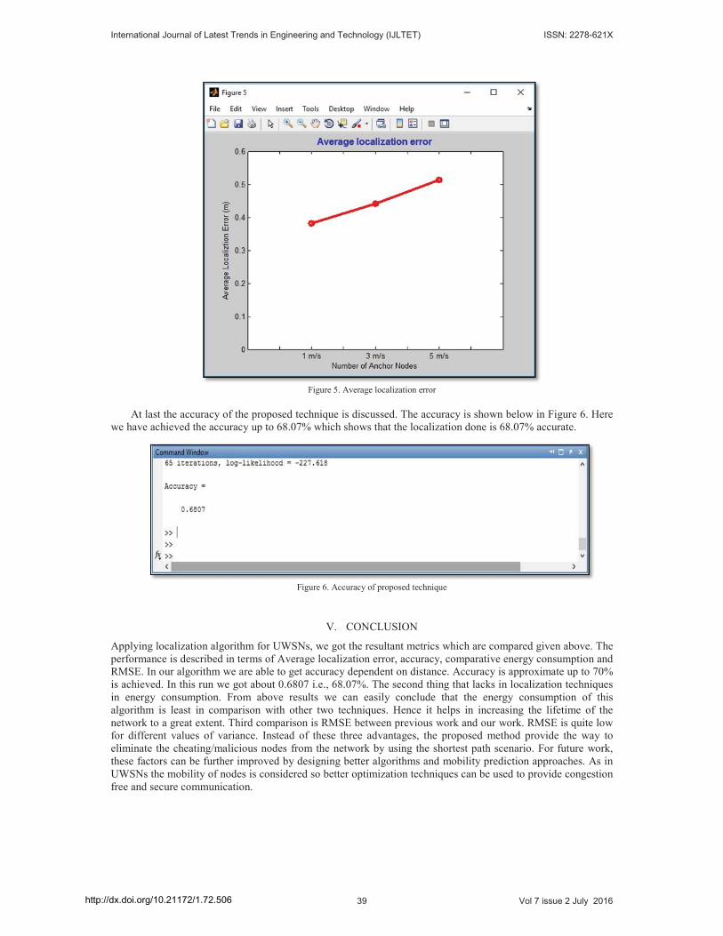
Figure 5. Average localization error
At last the accuracy of the proposed technique is discussed. The accuracy is shown below in Figure 6. Here we have achieved the accuracy up to 68.07% which shows that the localization done is 68.07% accurate.
Figure 6. Accuracy of proposed technique
V. CONCLUSION
Applying localization algorithm for UWSNs, we got the resultant metrics which are compared given above. The performance is described in terms of Average localization error, accuracy, comparative energy consumption and RMSE. In our algorithm we are able to get accuracy dependent on distance. Accuracy is approximate up to 70% is achieved. In this run we got about 0.6807 i.e., 68.07%. The second thing that lacks in localization techniques in energy consumption. From above results we can easily conclude that the energy consumption of this algorithm is least in comparison with other two techniques. Hence it helps in increasing the lifetime of the network to a great extent. Third comparison is RMSE between previous work and our work. RMSE is quite low for different values of variance. Instead of these three advantages, the proposed method provide the way to eliminate the cheating/malicious nodes from the network by using the shortest path scenario. For future work, these factors can be further improved by designing better algorithms and mobility prediction approaches. As in UWSNs the mobility of nodes is considered so better optimization techniques can be used to provide congestion free and secure communication.
International Journal of Latest Trends in Engineering and Technology (IJLTET) ISSN: 2278-621X
39 Vol 7 issue 2 July 2016http://dx.doi.org/10.21172/1.72.506
REFERENCES
[1] Guangjie Han, Jinfang Jiang, Lei Shu, Yongjun Xu, Feng Wang, “Localization Algorithms of Underwater Wireless Sensor Networks: ASurvey”, Sensors 2012.
[2] Sangho Lee, Kiseon Kim, “Localization with a Mobile Beacon in Underwater Acoustic Sensor Networks”, Sensors 2012.[3] Cristina Albaladejo, Fulgencio Soto, Roque Torres, Pedro Sánchez and Juan A. López, “A Low-Cost Sensor Buoy System for
Monitoring Shallow Marine Environments”, Sensors 2012.[4] Ying Zhang, Jixing Liang, Shengming Jiang, Wei Chen, “A Localization Method for Underwater Wireless Sensor Networks Based on
Mobility Prediction and Particle Swarm Optimization Algorithms”, Sensors 2016. [5] Mari Carmen Domingo, Rui Prior, “Energy analysis of routing protocols for underwater wireless sensor networks”, Computer
Communication, vol. 31, 2008, pp. 1227–1238.[6] Kai Chen, Yi Zhou, Jianhua He, “A Localization Scheme for Underwater Wireless Sensor Networks”, International Journal of
Advanced Science and Technology, vol. 4, March, 2009. [7] Hanjiang Luo, Yiyang Zhao , Zhongwen Guo , Siyuan Liu , Pengpeng Chen, Lionel M. Ni, “UDB: Using Directional Beacons for
Localization in Underwater Sensor Networks”, 14th IEEE International Conference on Parallel and Distributed Systems , 2008. [8] Vijay Chandrasekhar, Winston KG Seah, “Localization in Underwater Sensor Networks — Survey and Challenges”, Network
Technology Department Institute for Infocomm Research, Singapore, 2006. [9] M. Erol, L. F. Vieira, and M. Gerla, “Localization with Dive’N’Rise (DNR) beacons for underwater acoustic sensor networks”, in
Proceedings of the second ACM workshop on Underwater networks, Sep. 2007, pp. 97–100.[10] V. Chandrasekhar, W. K. Seah, Y. S. Choo, and H. V. Ee, “Localization in underwater sensor networks: survey and challenges”,
Proceedings of the 1st ACM international workshop on Underwater networks, pp. 33–40, Sep. 2006.[11] M. C. Domingo and R. Prior, “Energy analysis of routing protocols for underwater wireless sensor networks,” Computer
Communications, April 2008, vol. 31, no. 6, pp. 1227–1238.[12] J.-H. Cui, J. Kong, M. Gerla, and S. Zhou, “The challenges of building mobile underwater wireless networks for aquatic applications,”
IEEE Network, May 2006, vol. 20, no. 3, pp. 12–18.[13] A. Caruso, F. Paparella, L. F. M. Vieira, M. Erol, and M. Gerla, “The Meandering Current Mobility Model and its Impact on
Underwater Mobile Sensor Networks,” in Proceedings of IEEE INFOCOM the 27th Conference on Computer Communications, April 2008, pp. 221-225, 13-18.
International Journal of Latest Trends in Engineering and Technology (IJLTET) ISSN: 2278-621X
40 Vol 7 issue 2 July 2016http://dx.doi.org/10.21172/1.72.506

![Distributed Multi-Robot Localization from Acoustic Pulses ...schwager/MyPapers/Hals... · For instance, in underwater multi-robot applications [4], localization is typically hindered](https://img.pdfslide.us/doc/110x75/5ff550ce57d4ee371b7d670c/distributed-multi-robot-localization-from-acoustic-pulses-schwagermypapershals.jpg)