Embed Size (px)
Citation preview

Amazonis Planitia: The role of geologically recent volcanism and
sedimentation in the formation of the smoothest plains on Mars
Elizabeth R. Fuller and James W. Head IIIDepartment of Geological Sciences, Brown University, Providence, Rhode Island, USA
Received 10 January 2002; revised 19 March 2002; accepted 5 June 2002; published 22 October 2002.
[1] Amazonis Planitia, located between the two main volcanic provinces on Mars(Tharsis and Elysium), is characterized by extremely smooth topography at several scalelengths, as smooth as oceanic abyssal plains topography on Earth. We use Mars GlobalSurveyor (MGS) data (primarily very high resolution Mars Orbiter Laser Altimeter(MOLA) topography and derivative slope maps, gradient maps, and detrended maps)to examine the surface morphology of Amazonis Planitia and the stratigraphicrelationships among previously mapped and newly defined units. These new data revealthe presence of a 1300 km diameter Noachian impact basin in northwest AmazonisPlanitia and an extensive Late Hesperian lava flow unit that appears to have originatedfrom the Olympus Mons source area prior to aureole formation. The presence of thispreviously unrecognized flow unit strongly suggests that Olympus Mons activity datesback to at least the Hesperian, as did activity on the Tharsis Montes. Emplacement ofthis �100 meter thick flow unit formed a barrier along the northern margin of AmazonisPlanitia which had a profound influence on the subsequent geologic history of theregion. Formation of Olympus Mons aureole deposits created an eastern topographicbarrier, and subsequent Tharsis Montes lava flows entered the basin from the south,flowing around the aureole. These three barriers (degraded Noachian crater rim, proto-Olympus Mons flow unit, and Olympus Mons aureole) caused subsequent lava flows andoutflow channel effluents, primarily from the Elysium region to the west, to pond on thefloor of Amazonis Planitia, preferentially smoothing the terrain there. Mars OrbiterCamera (MOC) images substantiate that at least two very fluid lava flows alternated withfluvial episodes from Elysium Planitia, flowing through Marte Valles onto the floor ofthe Amazonis Planitia basin. Within Amazonis Planitia, MOC images show flow-liketextures heavily mantled by sediments, and radar data reveal the presence of rough lavaflow surfaces underlying the sedimentary debris. These data thus suggest that the uniquesmoothness of Amazonis Planitia is the result of deposition of thin fluid lava flows andfluvial sediments in an enclosed basin. Crater counts suggest that the most recentresurfacing may have occurred in the latest Amazonian Period, in the last 1% of thehistory of Mars. In light of its unique history, it is somewhat ironic to note that AmazonisPlanitia was originally thought to be a typical young Martian surface and therefore usedto name the Amazonian era. INDEX TERMS: 6225 Planetology: Solar System Objects: Mars; 5415
Planetology: Solid Surface Planets: Erosion and weathering; 5470 Planetology: Solid Surface Planets:
Surface materials and properties; 5480 Planetology: Solid Surface Planets: Volcanism (8450); 4267
Oceanography: General: Paleoceanography; KEYWORDS: Mars, water, Amazonis Planitia, Marte Vallis,
volcanism, Amazonian
Citation: Fuller, E. R., and J. W. Head III, Amazonis Planitia: The role of geologically recent volcanism and sedimentation in the
formation of the smoothest plains on Mars, J. Geophys. Res., 107(E10), 5081, doi:10.1029/2002JE001842, 2002.
1. Introduction
[2] Amazonis Planitia (Figure 1) is of extreme interestin terms of the geological history of Mars as the locationof persistent volcanic and outflow channel deposition,
including some of the youngest fluvial deposits and lavaflows on the planet [Scott and Tanaka, 1986] (Figures 2and 3). Remote sensing data have shown that AmazonisPlanitia contains some of the smoothest deposits yetdetected in the Solar System [Aharonson et al., 1998,2001; Kreslavsky and Head, 1999, 2000] and units withradar backscatter properties suggestive of young volcanism[Harmon et al., 1999]. In this analysis, we use MGS data
JOURNAL OF GEOPHYSICAL RESEARCH, VOL. 107, NO. E10, 5081, doi:10.1029/2002JE001842, 2002
Copyright 2002 by the American Geophysical Union.0148-0227/02/2002JE001842$09.00
11 - 1

to characterize the geology of Amazonis Planitia, to reex-amine stratigraphic units and their sequence, and to addressthe reasons for its extreme smoothness (Figures 3–7). Wefind that early Tharsis-radial lava flows of likely LateHesperian age created a barrier across northern AmazonisPlanitia that heavily influenced its later history, forming ashallow basin that trapped lava flows and outflow channeleffluents. Subsequent lava flow and outflow channelemplacement events during the Hesperian and Amazonianrepeatedly resurfaced Amazonis Planitia, contributing to itsextreme smoothness. This activity has continued until geo-logically very recently.
2. Background
2.1. Geography
[3] Amazonis Planitia is located between Tharsis andElysium, at approximately 140–175�W, 15–45�N (Figure1). It is a topographically low region approximately 1300 by900 kilometers in area (halfway in total area between Texasand Alaska, or about one-third the size of western Europe)that is dominated by smooth topography showing nomeasurable roughness at kilometer scales. This smooth areacorrelates approximately with unit Aa3 of Scott and Tanaka
[1986], the middle member of their Arcadia Formation, andis contiguous with the Cerberus Formation of Plescia[1990] (Figure 2).
2.2. Geological Mapping
[4] The 1:15 million scale maps, text, and correlationcharts of Scott and Tanaka [1986] and Greeley and Guest[1987] (Figures 2 and 3) summarize the geological historyof Amazonis Planitia on the basis of Viking data; thissection reviews their findings. During the Noachian, heavybombardment and volcanic resurfacing reshaped the initialcrust and the dichotomy boundary was formed. South of thedichotomy, Noachian-aged terrain is widespread, exposedprimarily as heavily cratered plains. North of the boundary,Noachian-aged outcrops are rare, limited to degraded knobsmantled or embayed by younger terrain. Recent MarsOrbiter Laser Altimeter (MOLA) analysis also suggeststhe presence of numerous modified and buried Noachiancraters in the northern lowlands [Frey et al., 2001]. Ama-zonis Planitia is located north of the dichotomy boundary;the exact character of the boundary zone in this region isunclear, as the extension of the scarp is largely buriedbeneath the Medusae Fossae Formation [Scott and Tanaka,1986; Greeley and Guest, 1987]. Nonetheless, the boundary
Figure 1. Regional context map showing Amazonis Planitia and surrounding geologic features: majorvolcanic edifices (Mons and Montes); Mangala Valles, a set of outflow channels; Marte Valles, avolcanically resurfaced outflow channel; Elysium Planitia, a volcanic plain and the site of the CerberusFormation volcanism; the Vastitas Borealis, the subpolar lowlands; the Medusae Fossae Formation, anextensive, friable unit whose origins are under debate [cf. Zimbelman et al., 1999] but appear to be an airfall ash deposit [Bradley et al., 2002]. Map is a hemispheric, Lambert equal-area projection, MOLA-derived gradient map centered at 15�N, 165�W.
11 - 2 FULLER AND HEAD: FORMATION OF AMAZONIS PLANITIA, MARS

here appears to be a distinctive topographic break up to 2–3kilometers in elevation above the northern lowlands.[5] Hesperian-aged units show evidence of outflow chan-
nel activity, tectonism, and extensive volcanism. In Ama-zonis Planitia, Lower Hesperian volcanic plains (Hr) wereemplaced and subsequently deformed by wrinkle ridges. Inthe Late Hesperian, outflow channels carved the MangalaValles to the south; to the north, the Vastitas BorealisFormation was emplaced in the majority of the northernlowlands [Scott and Tanaka, 1986; Greeley and Guest,1987; Tanaka and Scott, 1987]. Flows from Alba Patera(Hal) and from the Tharsis Montes (Ht1–2) may have alsoinfluenced Amazonis Planitia.[6] The Amazonian Period was marked by extensive
effusive volcanism from Olympus Mons and the volcanoesof the Tharsis Montes (Tharsis Montes Formation), and thewaning stages of volcanism from Alba Patera (Figure 3). Forthe Amazonis Planitia region, the most important Amazo-nian events were the Olympus Mons aureole emplacement tothe east (the Olympus Mons Formation, Aoa1–4), ElysiumPlanitia channel activity to the southwest, and emplacementof the Arcadia Formation (Aa1–5). In addition, the MedusaeFossae Formation was emplaced along the dichotomy boun-dary just to the south of Amazonis Planitia. The presence of
unconformities between the subunits of the Medusae FossaeFormation [e.g., Scott and Tanaka, 1986;Greeley and Guest,1987; Sakimoto et al., 1999] suggests that it may have oncebeen more widespread than it is at present.[7] Studies published subsequent to the 1:15,000,000-
scale global maps offered various reinterpretations of theArcadia Formation and the Amazonis Planitia region. Ples-cia [1990] and Scott and Chapman [1991] examined Vikingimages of Elysium Planitia and came to opposite conclu-sions. Plescia [1990] interpreted the region as volcanicallyresurfaced, resulting from one or more low-viscosity (prob-ably basaltic) volcanic flooding events. He argued that thelava first pooled in a regional low within Elysium Basin,then moved eastward through the previously carved chan-nels within Marte Valles, then spread laterally into Ama-zonis Planitia, terminating in digitate lobes. He tentativelyproposed that the fluvial and volcanic activities wererelated, suggesting that the channels might have beeninitially carved by a catastrophic flood that resulted fromthe melting of ground ice by magma intruding into theregion [Plescia, 1990].[8] Scott and Chapman [1991] interpreted Elysium Basin
to be a large lake or inland sea which overflowed throughMarte Valles into Amazonis Planitia. They acknowledged
Figure 2. Generalized geologic map of Amazonis Planitia, after Scott and Tanaka [1986]. Units referredto in the text are labeled. Nf, on the eastern margin, is a tip of the Noachian Acheron Fossae. HNu,undifferentiated material of the Hesperian and/or Noachian era, forms an arc in the western part of theregion. Hr, Hesperian-aged wrinkle ridges, are visible in the southwest. Ao includes all Olympus Monsaureole members. Aa1-Aa5 are members of the Arcadia Formation, an Amazonian volcanic suite. Acheand Achp, visible in the southwest corner, are the channel deposits and outwash plain of the UpperAmazonian Marte Valles outflow. 140�–180�W, 10�–40�N, north at the top.
FULLER AND HEAD: FORMATION OF AMAZONIS PLANITIA, MARS 11 - 3

Figure 3. Stratigraphy of the units present in the study area, after Scott and Tanaka [1986]. Units notidentified in their stratigraphy are highlighted. Aa1-Aa5 are members of the volcanic Arcadia Formation,all of which have been reinterpreted in this study. The Cerberus Formation, unit Ac, was first mapped byPlescia [1990]; the geometry of the northeastern distal portion is refined in this study. The Amazoniandebris-mantled flows entered Amazonis Planitia through Marte Valles and are visible in radar data (cf.Figure 8). The post-aureole flows curve around the southeastern boundary of the Olympus Mons aureoleand likely originate from Tharsis. The proto-Olympus flows predate the emplacement of the OlympusMons aureole (units Aoa1–4) and extend WNW from Olympus Mons across northern Amazonis Planitia.All units discussed in text.
11 - 4 FULLER AND HEAD: FORMATION OF AMAZONIS PLANITIA, MARS
the presence of lava flows, but argued that fluvial activitypostdated volcanic activity on the basis of surface featuresthat they interpreted as terraces and scour marks or ‘‘etch-ing’’ of underlying lava [Scott and Chapman, 1991].[9] Parker et al. [1993] drew Contact 2, one of two
interpreted shorelines for their proposed Hesperian northernocean, near the margins of the central smooth unit of
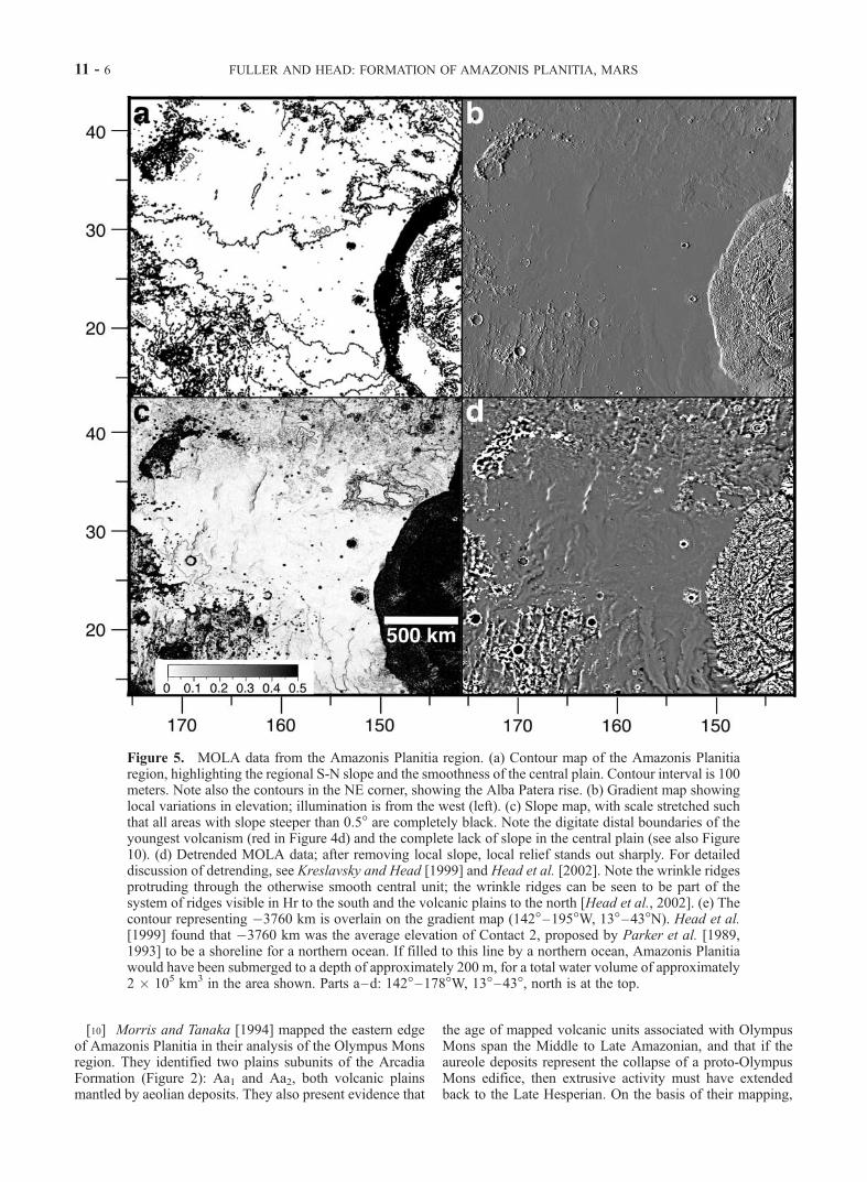
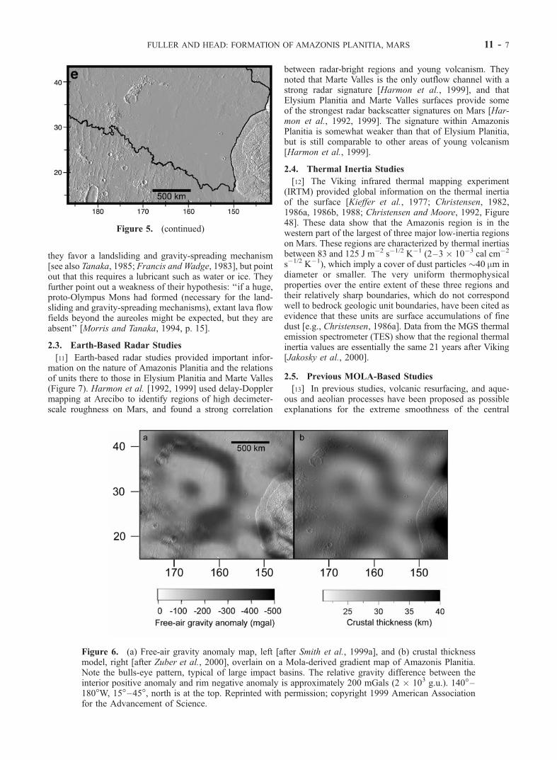
Amazonis Planitia. Head et al. [1999], using MOLA data,assessed the elevation of the two contacts, and found thatContact 1 deviated substantially from an equipotential line,but that Contact 2 was much closer to being level, with amean elevation of 3760 m below the Martian datum. Figure5e shows the trace of the �3760 m contour through theAmazonis Planitia region.
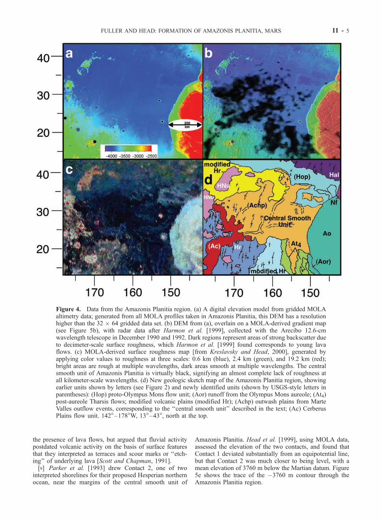
Figure 4. Data from the Amazonis Planitia region. (a) A digital elevation model from gridded MOLAaltimetry data; generated from all MOLA profiles taken in Amazonis Planitia, this DEM has a resolutionhigher than the 32 � 64 gridded data set. (b) DEM from (a), overlain on a MOLA-derived gradient map(see Figure 5b), with radar data after Harmon et al. [1999], collected with the Arecibo 12.6-cmwavelength telescope in December 1990 and 1992. Dark regions represent areas of strong backscatter dueto decimeter-scale surface roughness, which Harmon et al. [1999] found corresponds to young lavaflows. (c) MOLA-derived surface roughness map [from Kreslavsky and Head, 2000], generated byapplying color values to roughness at three scales: 0.6 km (blue), 2.4 km (green), and 19.2 km (red);bright areas are rough at multiple wavelengths, dark areas smooth at multiple wavelengths. The centralsmooth unit of Amazonis Planitia is virtually black, signifying an almost complete lack of roughness atall kilometer-scale wavelengths. (d) New geologic sketch map of the Amazonis Planitia region, showingearlier units shown by letters (see Figure 2) and newly identified units (shown by USGS-style letters inparentheses): (Hop) proto-Olympus Mons flow unit; (Aor) runoff from the Olympus Mons aureole; (At4)post-aureole Tharsis flows; modified volcanic plains (modified Hr); (Achp) outwash plains from MarteValles outflow events, corresponding to the ‘‘central smooth unit’’ described in the text; (Ac) CerberusPlains flow unit. 142�–178�W, 13�–43�, north at the top.
FULLER AND HEAD: FORMATION OF AMAZONIS PLANITIA, MARS 11 - 5
[10] Morris and Tanaka [1994] mapped the eastern edgeof Amazonis Planitia in their analysis of the Olympus Monsregion. They identified two plains subunits of the ArcadiaFormation (Figure 2): Aa1 and Aa2, both volcanic plainsmantled by aeolian deposits. They also present evidence that
the age of mapped volcanic units associated with OlympusMons span the Middle to Late Amazonian, and that if theaureole deposits represent the collapse of a proto-OlympusMons edifice, then extrusive activity must have extendedback to the Late Hesperian. On the basis of their mapping,
Figure 5. MOLA data from the Amazonis Planitia region. (a) Contour map of the Amazonis Planitiaregion, highlighting the regional S-N slope and the smoothness of the central plain. Contour interval is 100meters. Note also the contours in the NE corner, showing the Alba Patera rise. (b) Gradient map showinglocal variations in elevation; illumination is from the west (left). (c) Slope map, with scale stretched suchthat all areas with slope steeper than 0.5� are completely black. Note the digitate distal boundaries of theyoungest volcanism (red in Figure 4d) and the complete lack of slope in the central plain (see also Figure10). (d) Detrended MOLA data; after removing local slope, local relief stands out sharply. For detaileddiscussion of detrending, see Kreslavsky and Head [1999] and Head et al. [2002]. Note the wrinkle ridgesprotruding through the otherwise smooth central unit; the wrinkle ridges can be seen to be part of thesystem of ridges visible in Hr to the south and the volcanic plains to the north [Head et al., 2002]. (e) Thecontour representing �3760 km is overlain on the gradient map (142�–195�W, 13�–43�N). Head et al.[1999] found that �3760 km was the average elevation of Contact 2, proposed by Parker et al. [1989,1993] to be a shoreline for a northern ocean. If filled to this line by a northern ocean, Amazonis Planitiawould have been submerged to a depth of approximately 200 m, for a total water volume of approximately2 � 105 km3 in the area shown. Parts a–d: 142�–178�W, 13�–43�, north is at the top.
11 - 6 FULLER AND HEAD: FORMATION OF AMAZONIS PLANITIA, MARS
they favor a landsliding and gravity-spreading mechanism[see also Tanaka, 1985; Francis and Wadge, 1983], but pointout that this requires a lubricant such as water or ice. Theyfurther point out a weakness of their hypothesis: ‘‘if a huge,proto-Olympus Mons had formed (necessary for the land-sliding and gravity-spreading mechanisms), extant lava flowfields beyond the aureoles might be expected, but they areabsent’’ [Morris and Tanaka, 1994, p. 15].
2.3. Earth-Based Radar Studies
[11] Earth-based radar studies provided important infor-mation on the nature of Amazonis Planitia and the relationsof units there to those in Elysium Planitia and Marte Valles(Figure 7). Harmon et al. [1992, 1999] used delay-Dopplermapping at Arecibo to identify regions of high decimeter-scale roughness on Mars, and found a strong correlation
between radar-bright regions and young volcanism. Theynoted that Marte Valles is the only outflow channel with astrong radar signature [Harmon et al., 1999], and thatElysium Planitia and Marte Valles surfaces provide someof the strongest radar backscatter signatures on Mars [Har-mon et al., 1992, 1999]. The signature within AmazonisPlanitia is somewhat weaker than that of Elysium Planitia,but is still comparable to other areas of young volcanism[Harmon et al., 1999].
2.4. Thermal Inertia Studies
[12] The Viking infrared thermal mapping experiment(IRTM) provided global information on the thermal inertiaof the surface [Kieffer et al., 1977; Christensen, 1982,1986a, 1986b, 1988; Christensen and Moore, 1992, Figure48]. These data show that the Amazonis region is in thewestern part of the largest of three major low-inertia regionson Mars. These regions are characterized by thermal inertiasbetween 83 and 125 J m�2 s�1/2 K�1 (2–3 � 10�3 cal cm�2
s�1/2 K�1), which imply a cover of dust particles �40 mm indiameter or smaller. The very uniform thermophysicalproperties over the entire extent of these three regions andtheir relatively sharp boundaries, which do not correspondwell to bedrock geologic unit boundaries, have been cited asevidence that these units are surface accumulations of finedust [e.g., Christensen, 1986a]. Data from the MGS thermalemission spectrometer (TES) show that the regional thermalinertia values are essentially the same 21 years after Viking[Jakosky et al., 2000].
2.5. Previous MOLA-Based Studies
[13] In previous studies, volcanic resurfacing, and aque-ous and aeolian processes have been proposed as possibleexplanations for the extreme smoothness of the central
Figure 5. (continued)
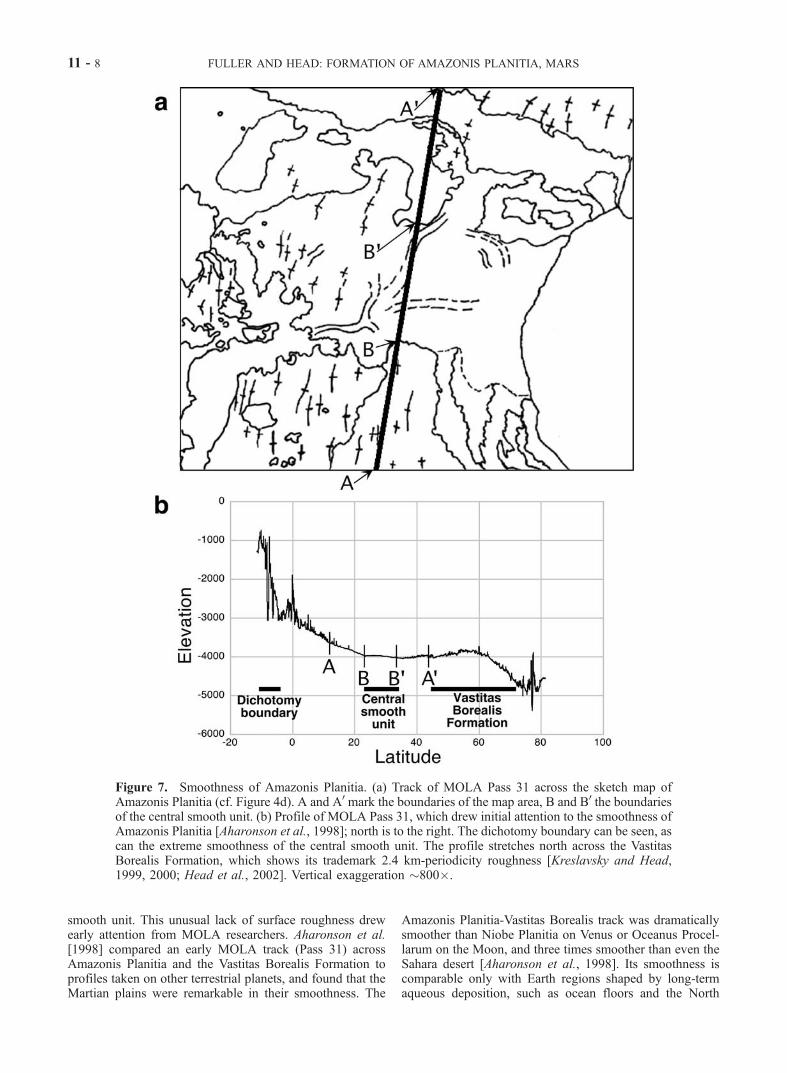
Figure 6. (a) Free-air gravity anomaly map, left [after Smith et al., 1999a], and (b) crustal thicknessmodel, right [after Zuber et al., 2000], overlain on a Mola-derived gradient map of Amazonis Planitia.Note the bulls-eye pattern, typical of large impact basins. The relative gravity difference between theinterior positive anomaly and rim negative anomaly is approximately 200 mGals (2 � 103 g.u.). 140�–180�W, 15�–45�, north is at the top. Reprinted with permission; copyright 1999 American Associationfor the Advancement of Science.
FULLER AND HEAD: FORMATION OF AMAZONIS PLANITIA, MARS 11 - 7
smooth unit. This unusual lack of surface roughness drewearly attention from MOLA researchers. Aharonson et al.[1998] compared an early MOLA track (Pass 31) acrossAmazonis Planitia and the Vastitas Borealis Formation toprofiles taken on other terrestrial planets, and found that theMartian plains were remarkable in their smoothness. The
Amazonis Planitia-Vastitas Borealis track was dramaticallysmoother than Niobe Planitia on Venus or Oceanus Procel-larum on the Moon, and three times smoother than even theSahara desert [Aharonson et al., 1998]. Its smoothness iscomparable only with Earth regions shaped by long-termaqueous deposition, such as ocean floors and the North
Figure 7. Smoothness of Amazonis Planitia. (a) Track of MOLA Pass 31 across the sketch map ofAmazonis Planitia (cf. Figure 4d). A and A0 mark the boundaries of the map area, B and B0 the boundariesof the central smooth unit. (b) Profile of MOLA Pass 31, which drew initial attention to the smoothness ofAmazonis Planitia [Aharonson et al., 1998]; north is to the right. The dichotomy boundary can be seen, ascan the extreme smoothness of the central smooth unit. The profile stretches north across the VastitasBorealis Formation, which shows its trademark 2.4 km-periodicity roughness [Kreslavsky and Head,1999, 2000; Head et al., 2002]. Vertical exaggeration �800�.
11 - 8 FULLER AND HEAD: FORMATION OF AMAZONIS PLANITIA, MARS
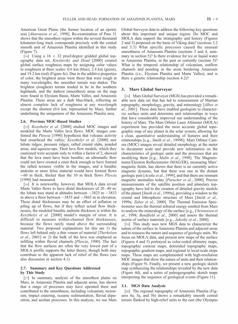
American Great Plains (the former location of an epeiricsea) [Aharonson et al., 1998]. Re-examination of Pass 31shows that the smoothest region within the several thousandkilometer-long track corresponds precisely with the centralsmooth unit of Amazonis Planitia identified in this study(Figure 7).[14] Using a 16 � 32 pixel/degree gridded global top-
ography data set, Kreslavsky and Head [2000] createdglobal surface roughness maps by assigning color valuesto roughness at three scales: 0.6 km (blue), 2.4 km (green),and 19.2 km (red) (Figure 4c). Due to the additive propertiesof color, the brightest areas were those that were rough atmany wavelengths; the smoother terrain was darker. Thebrightest (roughest) terrain tended to be in the southernhighlands, and the darkest (smoothest) areas on the mapwere found in Elysium Basin, Marte Valles, and AmazonisPlanitia. These areas are a dark blue-black, reflecting analmost complete lack of roughness at any wavelengthexcept the shortest (0.6 km, represented by blue), furtherunderlining the uniqueness of the Amazonis Planitia area.
2.6. Previous MOC-Based Studies
[15] Keszthelyi et al. [2000] studied MOC images andmodeled the Marte Valles lava flows. MOC images con-firmed the Plescia [1990] hypothesis that volcanic activityhad resurfaced the valley; Keszthelyi et al. [2000] sawlobate ridges, pressure ridges, rafted crustal slabs, pondedareas, and squeeze-ups. Their lava flow models, which theycautioned were accurate only to within a factor of 2, showedthat the lava must have been basaltic; an ultramafic flowcould not have created a crust thick enough to have formedthe rafted textures visible in the images, and a basalticandesite or more felsic material would have formed flows�60 m thick, thicker than the 10 m thick flows Plescia[1990] had measured.[16] It is noteworthy, however, that MOLA data reveal
Marte Valles flows to have distal thicknesses of 20–40 m:the lobate toes stand at altitudes between �3823 to �3833m above a floor between �3855 and �3865 m in elevation.These distal thicknesses may be an effect of inflation orpiling up of flows, but if they reflect actual flow thick-nesses, the modeled basaltic andesite thickness is within theKeszthelyi et al. [2000] model’s margin of error. It isdifficult to measure within-channel flow thicknesses,because the flows rarely stand above the surroundingmaterial. Two proposed explanations for this are 1) theflows left behind only a thin veneer of material [Therkelsenet al., 2001] or 2) the bulk of the lava was emplaced asinfilling within fluvial channels [Plescia, 1990]. The factthat the flow surfaces are often the very lowest part of aMOLA profile supports the latter theory, though both maycontribute to the apparent lack of relief of the flows (seealso discussion in section 4.1).
2.7. Summary and Key Questions Addressedby This Study
[17] In summary, analysis of the smoothest plains onMars, in Amazonis Planitia and adjacent areas, has shownthat a range of processes may have operated there andcontributed to the smoothness, including volcanism, tecton-ism, impact cratering, oceanic sedimentation, fluvial depo-sition, and aeolian processes. In this analysis, we use Mars
Global Surveyor data to address the following key questionsabout this important and unique region: Do MOC andMOLA data support the stratigraphy and history (Figures2 and 3) proposed on the basis of Viking data? (sections 3.2and 3.3) What specific processes caused the unusualsmoothness of Amazonis Planitia (sections 3 and 4, sum-mary in section 5)? Is there evidence for ice or liquid waterin Amazonis Planitia, in the past or currently (section 5)?What is the temporal relationship of volcanism, outflowchannels and ponding in the areas bordering AmazonisPlanitia (i.e., Elysium Planitia and Marte Valles), and isthere a genetic relationship (section 4.2)?
3. Mars Global Surveyor
[18] Mars Global Surveyor (MGS) has provided a remark-able new data set that has led to reassessment of Martiantopography, morphology, gravity, and mineralogy [Albee etal., 2001]. These data have enabled geologists to character-ize surface units and determine unit relationships in waysthat have considerably improved our understanding of thehistory of Mars. The Mars Orbiter Laser Altimeter (MOLA)experiment has provided the most accurate global topo-graphic map of any planet in the solar system, allowing fora clear, quantitative understanding of features and theirrelationships [e.g., Smith et al., 1999b]. Mars Orbiter Cam-era (MOC) images reveal detailed morphology at the meterto decameter scale and provide new information on thecharacteristics of geologic units and the processes that aremodifying them [e.g., Malin et al., 1998]. The Magneto-meter/Electron Reflectometer (MAG/ER), measuring Mars’magnetic fields, has shown that there is no currently activemagnetic dynamo, but that there was one in the distantgeologic past [Acuna et al., 1999], and that there are remnantmagnetic anomalies today [Purucker et al., 2000]. Precisemeasurements of the satellite position and planetary top-ography have led to the creation of detailed gravity modelsof the planet [Smith et al., 1999a], providing a window to thecrustal and lithospheric structure of Mars [Smith et al.,1999a; Zuber et al., 2000]. The Thermal Emission Spec-trometer uses the thermal infrared energy emitted from Marsto analyze the mineralogy of the surface [e.g., Christensen etal., 1998; Bandfield et al., 2000] and assess the thermalinertia of surface materials [e.g., Jakosky et al., 2000].[19] This study uses new MGS data to characterize the
nature of the surface in Amazonis Planitia and adjacent areasand to reassess the nature and sequence of geologic units. Wefocus on MOLA data, and present new maps of the surface(Figures 4 and 5) portrayed as color-coded altimetry maps,topographic contour maps, detrended topography maps,topographic gradient maps, and regional to local-scale slopemaps. These maps are complemented with high-resolutionMOC images that show the nature of units and their relation-ships (Figure 9). Finally, we present a new geologic sketchmap synthesizing the relationships revealed by the new data(Figure 4d), and a series of paleogeographic sketch mapsinterpreting the sequence of geological events (Figure 11).
3.1. MGS Data Analysis
[20] The regional topography of Amazonis Planitia (Fig-ures 4a, 5a, and 5b) shows a remarkably smooth centralterrain flanked by high-relief units to the east (the Olympus
FULLER AND HEAD: FORMATION OF AMAZONIS PLANITIA, MARS 11 - 9
Mons aureole), the northeast (the tip of Acheron Fossae andthe flanking slopes of Alba Patera), the northwest (remnantsof arcuate outcrop of Hesperian-Noachain-aged terrain,HNu), and the southwest and south (the eastern margin ofElysium and the northern edge of Lucus Planum). Regionaltopography shows that the floor of Amazonis Planitia isvery flat, tilts toward the north and north-northwest, and istopographically open in that direction, toward the northernlowlands. Topographic gradient maps (Figure 5b) anddetrended topography maps (Figure 5d) confirm the pres-ence of extensive wrinkle ridges that are superposed on theHesperian ridged plains (Hr; Figure 2). The detaileddetrended map (Figure 5d) permits the mapping of thesestructures into the northern lowlands and Head et al. [2002]have shown that they are pervasive there, underlying theLate Hesperian Vastitas Borealis Formation. It is also clearthat these features trend across western Amazonis Planitiaas part of a pervasive texture of ridges that are broadlycircumferential to the Tharsis rise, and that they are pro-gressively buried by younger units in central and easternAmazonis (Figure 5d).[21] Closer investigation reveals a variety of subtle tex-
tures that we use to identify, define, and map geologic units(Figures 4 and 5). Detrending the topographic data (Figure5d) [Head et al., 2002] reveals surface textures and rough-ness signatures which help to distinguish units; it alsohighlights locations of sharp topographic relief. For exam-ple, a series of prominent lobate flow-like features is nowseen to enter Amazonis Planitia from the south, curvingaround the Olympus Mons aureole, and thus postdating it.Comparison of the roughness maps of Kreslavsky and Head[1999, 2000] (Figure 4c) and the detrended map suggest thatthese are lava flows that enter the basin but are truncated bysuperposed flow-like features extending in a west-eastdirection from the Marte Valles region. Detailed analysisof the detrended map (Figure 5d) also reveals the presenceof a narrow zone of small lobes along the front of theOlympus Mons aureole, features suggesting that there mayhave been drainage or erosion from the oldest aureole facies(see Figure 9d), consistent with previous observations that itis more degraded than younger aureole deposits [e.g.,Morris and Tanaka, 1994].[22] We also generated slope maps with MOLA data,
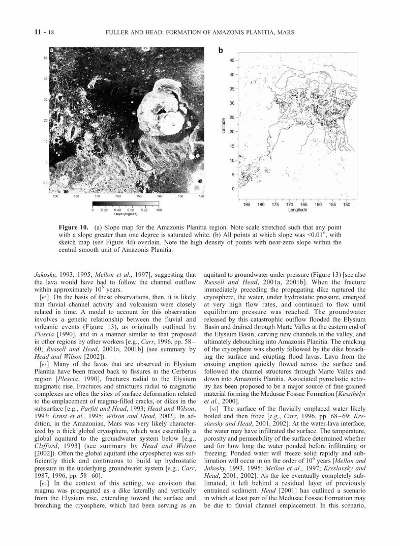
quantifying the terrain’s steepness at any given location.The gradient map (Figure 5b) and slope map (Figures 5c,10a) of Amazonis Planitia highlight the extreme smoothnessof the central smooth unit, and the low relief of the entireregion. In Figure 5c, the data has been stretched such that allareas with a slope steeper than 0.5� are completely black, tobetter illustrate the subtle slopes between 0–0.5�. Figure 10ashows a larger area, with an inverted scale. Figures 5c and10a also show that the slope within Marte Valles is less than0.1�. The slope maps (Figures 5c, 10a), together with thedetrended topography (Figure 5d) and the roughness data(Figure 4c), can be used to identify and map lava flowboundaries (e.g., Figure 10b). Clearly visible are lobateboundaries of a flow unit (mapped in Figure 4d) extendingWNW across the top of the map area from the base of thenorthern edge of the Olympus Mons aureole, and obscuringwrinkle ridges as it extends out over northern AmazonisPlanitia for a distance of over 1500 km. This flow unit occursin an area previously mapped as the Arcadia Formation, and
includes parts of all of the subunits (Aa1-Aa5) [Scott andTanaka, 1986] (Figure 2). The new data show that it is morelikely to be dominated by a single major flow unit (Figure4d), with several smaller lobate flow units along the easternedge. The sharp contact between the aureole and what appearto be the proximal upslope parts of the flow units stronglysuggests that this flow unit predates formation of the aureole.This aureole-flow contact, combined with the downslopedirection of the flow unit, suggest that it originated in thevicinity of Olympus Mons. This flow may therefore repre-sent evidence of the ‘‘extant lava flow fields beyond theaureoles’’ thatMorris and Tanaka [1994] pointed out shouldbe expected if the aureoles formed from collapse of a proto-Olympus Mons edifice, but which they did not see evidencefor in Viking data.[23] Also visible in these data are lobate flow and channel-
like features and units that appear to enter Amazonis Planitiathrough Marte Valles (to the west), and extend in a west toeast direction across the floor of the plains (Figures 4c and5d). These same data show that these units overlie lava flowunits from the Tharsis Montes that enter the basin from thesouth. All of these units appear to have been contained inAmazonis Planitia by the extensive lobate flow unit stretch-ing across the northern margin of the map area.
3.2. Mapping
[24] MGS data thus allow us to extend and enhance thegeologic mapping done on the basis of Viking data. Theimproved geomorphologic resolution from MOLA hasrevealed features (summarized in Figure 4d) whose gentleslopes and mild relief made them indistinct or invisible inViking Orbiter data, such as post-aureole flows from south-ern Tharsis, with slopes on the order of a tenth of a degree,and the detailed channel textures visible within the smoothcentral unit. The improved topography data also provide amuch more detailed three-dimensional look at the Martiansurface, permitting analysis of complicated stratigraphicrelationships to an unprecedented degree.[25] The map produced from MGS data (Figure 4d) adds
two major elements to the 1:15,000,000 scale map (Figure2) [Scott and Tanaka, 1986]: 1) the Late Hesperian proto-Olympus Mons flow, which was not previously mapped andwhich cuts across the boundaries of units Aa1–5; 2) theAmazonian post-aureole Tharsis flows, which are includedin Scott and Tanaka’s [1986] unit Aa3. We also reinterpretseveral units. Aa3, the smooth central unit, mapped as avolcanic plain, is interpreted to be a complex sequence ofsedimentary and volcanic units, which have also undergoneaeolian modification. Ach/Achp, described as a fluvialchannel and its outwash plain, is interpreted to be a channelcarved by fluvial activity and volcanically resurfaced atleast twice. The western outcropping of Aa4 correspondsclosely to the digitate distal lobes of the most recent MarteValles lava flow event. The portion of Aa1 mapped near thesouthern margin of the map area is reinterpreted to be an Hrsurface modified by outwash from Mangala Valles. Theoutcrops of HNu, forming a large arc, are interpreted to bethe remnant of an ancient impact crater.
3.3. Observations and Geologic History
[26] We now review the basic characteristics and geo-logic history of the region, based on these new MGS data
11 - 10 FULLER AND HEAD: FORMATION OF AMAZONIS PLANITIA, MARS
and interpretations andgrounded in theprevious1:15,000,000scale map [Scott and Tanaka, 1986].3.3.1. Noachian[27] The free-air gravity anomaly map of Mars [Smith et
al., 1999a] and the crustal thickness map of Mars [Zuber etal., 2000] reveal a �1300 km diameter, round feature innorthwest Amazonis (Figure 6) consisting of a bulls-eyepattern with, moving outwards from the center, a negativegravity anomaly, a surrounding positive anomaly, and aringing negative anomaly (Figure 6a).[28] We have tentatively interpreted this anomalous
region to be the trace of an ancient impact event (Figure11a). The �1300 km diameter anomaly is similar in scale tothe Isidis impact basin [Schultz and Frey, 1990], which alsoshows a circular positive anomaly within a ringing negativeanomaly [Smith et al., 1999a]. The central positive anomalyin Isidis is significantly larger than that of this proposedimpact basin; Isidis has a �g (difference in gravity anomalybetween the center and rim, following the convention ofPilkington and Grieve [1992]) of approximately 500 mGals,whereas the �g of this basin is approximately 200 mGals.For comparison, Argyre Basin has a �g of approximately300 mGals and Hellas Basin approximately 150 mGals.This proposed basin, therefore, shows a gravitational anom-aly signature of the right order of magnitude for a largeMartian impact basin.[29] The presence of a central negative anomaly offers
the strongest argument against interpreting this proposedbasin as an ancient impact; the other large Martian impactsdo not have a central negative anomaly. The negativegravity anomaly and positive (thickened) crustal thicknessanomaly are suggestive of a central peak, but impact basinsof this size do not typically have central peak structures[Wood and Head, 1976].[30] Where is the current topographic expression of this
proposed ancient impact event? Repeated infilling andresurfacing can easily explain the lack of a basin struc-ture, but what about the crater rim and ejecta blanket?The area of negative gravity anomaly and crustal thicken-ing, where one would expect to find rim material [Bratt etal., 1985; Pilkington and Grieve, 1992], does correspondwith an arcuate ridge of highstanding, high-relief material.Mapped as HNu in the USGS map (Figure 2) [Scott andTanaka, 1986], this arcuate topographic ridge is of theright age and in the right location to be remnant crater rimmaterial.[31] This basin rim and a tip of Acheron Fossae are the
only Noachian-aged outcrops visible in the study area. Theheavily cratered plains typical of the southern highlands, ifpresent, have been mantled and buried by subsequentactivity. Frey et al. [2001] have proposed that the entirenorthern lowland region is Noachian in age, based on thepresence of numerous ‘‘quasi-circular depressions,’’ visiblein MOLA data, interpreted as craters. They have mapped nosuch hidden craters in Amazonis Planitia, indicating thatthey, too, would assign an Amazonian age to the surface.Indeed, the lack of craters in the Frey et al. [2001] study orin the Head et al. [2002] analysis of ‘‘stealth’’ cratersunderlying the Vastitas Borealis Formation, provides furtherevidence that Amazonis Planitia underwent a differenthistory than that typical of the northern lowlands. In lightof its unique history, it is somewhat ironic to note that
Amazonis Planitia was originally seen as the type locale foryoung Martian surfaces, even giving the name to theAmazonian era.3.3.2. Early Hesperian[32] A large occurrence of Early Hesperian-aged ridged
plains (Hr) is seen in the southwest region of the study area[Scott and Tanaka, 1986] (Figures 2, 4d, and 11b). Thesuperposed wrinkle ridges are subdued in the central smoothunit, but appear again in the northeastern corner of the studyarea. In the southwest, the ridges are oriented approximatelyN5�E, and show a slight clockwise rotation across theregion, culminating in an orientation of approximatelyN25�E in northeast Amazonis Planitia (see also discussionof Plescia [1993]). They appear to be circum-Tharsis inorientation, and are likely part of the system of circum-Tharsis wrinkle ridges found throughout the northernlowlands by Head et al. [2002, cf. Figure 7].[33] Wrinkle ridges can be seen protruding through the
central smooth unit, but there the relief between the ridgecrest and the surrounding plain (typically 25–40 m, withone ridge rising 75 m above the plain) is approximately onethird that of the less modified Hesperian ridges to the westand south (typically 80–150 m). This, together with strati-graphic relationships, suggests that the Hr unit underliestens of meters of material (�40–125 m) that have mantledthe basin floor since the emplacement of the ridged plainsunit. Previous work showing that the ridges in the centralsmooth unit are significantly more subdued than ridges inthe Vastitas Borealis Formation concluded that the ridgedplains within Amazonis Planitia were mantled first by theVastitas Borealis Formation and then by additional material[Head et al., 2002].3.3.3. Late Hesperian[34] The Vastitas Borealis Formation (Hv) has been
assigned a Late Hesperian age (Figure 3) [Scott andTanaka, 1986], an age confirmed by a more recent studyincluding ‘‘stealth’’ craters interpreted to be superposedon Hr (ridged plains) underlying the Vastitas BorealisFormation [Head et al., 2002]. Contemporaneous units(Figure 3) include those of the numerous outflow channels,and several researchers have proposed that the northernlowlands were once the location of an ocean that formedas a result of the floods that formed the outflow channels[Parker et al., 1989, 1993]. The outer contact of the VastitasBorealis Formation inmany areas corresponds approximatelyto the position of Contact 2, a boundary interpreted byParker et al. [1989, 1993] to represent the shoreline of anocean. Head et al. [1999] found that the average elevation ofContact 2 was approximately �3760 m. On the basis of ananalysis of the stratigraphy and structure of the northernlowlands, Head et al. [2002] concluded that the VastitasBorealis Formation averaged about 100 meters in thicknessand represented the sedimentary residue of the emplacementand evaporation/sublimation of the outflow channel effluentemplaced in the northern lowlands [see also Kreslavsky andHead, 2001, 2002]. If Contact 2 of Parker et al. [1993] doesindeed represent the shoreline of an ancient ocean, thiswould correspond to a depth in Amazonis Planitia ofapproximately 200 m (Figure 5e), for a total water volumeof approximately 2� 105 km3. In any case, it is probable thata layer of the Vastitas Borealis Formation, perhaps of theorder of 50–100 m thick, overlies the Hesperian ridged
FULLER AND HEAD: FORMATION OF AMAZONIS PLANITIA, MARS 11 - 11

plains (Hr) and underlies units presently exposed at thesurface in Amazonis Planitia.[35] At the northern boundary of the Amazonis Planitia
central smooth unit, a volcanic unit extends WNW, with atleast three visible flow lobes (Figure 4d). The easternmostvisible flow emerges from beneath the aureole approxi-mately 800 km from the summit of the Olympus Monsedifice. The 1800-km long flow unit is generally Tharsis-radial, but the eastern-most flows are clearly radial toOlympus Mons, suggesting that this material originatedfrom a source in the Olympus Mons region, perhaps earlyOlympus Mons volcanism that was deflected to the west bythe regional slope from Alba Patera (Figure 11c). It is alsopossible that lava was contributed from Alba Patera and/orthe Tharsis Montes, which were volcanically active aroundthis time (Figures 1 and 3), but the roughness signaturevisible in this unit [Kreslavsky and Head, 2000] is markedlydifferent from that of the Alba Patera and Tharsis MontesLate Hesperian flows. The roughness map [Kreslavsky andHead, 2000] (Figure 4) shows that the visible Alba Pateraand Tharsis Montes flow surfaces are rougher (at 2.4 kmbaselength roughness) than these flows. Furthermore, slopemaps (e.g., Figures 5a and 5c) show that the presentlyvisible Alba Patera lava apron has more dramatic internalrelief than this flow. Due to the subsequent emplacement ofthe Olympus Mons aureole, the roughness signatureof proto-Olympus flows cannot be known, but the lack ofcorrelation with the signatures of early Alba Patera (Hal)and Tharsis (Ht1 and Ht2) flows, combined with the Olym-pus-radial orientation of the uppermost flows, leads us toconclude that the most likely provenance of this flow is pre-aureole Olympus Mons. If so, this unit confirms theprediction of Morris and Tanaka [1994] that there shouldbe ‘‘lava flow fields beyond the aureoles’’ if the aureolesresulted from gravity spreading mechanisms or landslidingfrom a proto-Olympus Mons edifice.[36] Also in the Late Hesperian (Figure 3), in the south-
ern part of the region, channel outflow activity carved theMangala Valles [Tanaka and Chapman, 1990;Milton, 1973].Flow through Mangala Valles and Labou Vallis, the north-west branch of the Mangala Valles system, moved fromsouth to north; the water debouching from the northernreach of the channel likely flowed down the topographicslope into the Amazonis basin (Figure 11c). The Amazo-nian-aged Medusae Fossae Formation (Figure 1) [Scott andTanaka, 1986], which currently stands between Mangalaand Amazonis, was not present at this time to be an obstacleto this Hesperian channel flow. Additionally, recent work byBradley et al. [2002] shows that outflow channels fromLabou Vallis can be traced approximately 300 km farther tothe north, beneath the Medusae Fossae Formation. Thesechannels must have carried a considerable volume of waterand sediment into Amazonis Planitia. Quantifying thevolume of material that flowed into Amazonis Planitia isdifficult because both the discharge rate and the duration offlow must be known. Both Baker [1982] and Komar [1979]estimated that the Mangala Valles flood discharge wasapproximately 2 � 107 m3/s. That figure was calculatedusing topography estimates from Viking, which gave anapproximate channel depth of 100 m. MOLA data show thatthe average channel depth is closer to 250–300 m; apreliminary reexamination of their calculations with MOLA
data suggests that if the channel was filled, the flooddischarge would be closer to 1 � 108 m3/s, an order ofmagnitude larger than the Viking-based value. It is interest-ing to note that, in the absence of a northern ocean, MangalaValles outflow alone could fill the Amazonis basin to theheight of the proto-Olympus lava flow, depending on theduration of the channel activity. If the discharge was atthe level calculated from Viking, it would take approxi-mately two months of outflow; if at the level estimated fromMOLA data, it would take 8–10 days of channel activity.Zimbelman et al. [1992], arguing from Darcy’s Law andprobable hydraulic conductivities, generated dramaticallylower flow rate estimates for the Mangala Valles outflow; attheir estimated maximum flow rate of 105 m3/s, filling theAmazonis basin would take approximately 30 years.[37] Given the poor constraints on the relative timing of
these three Late Hesperian events, six scenarios are possi-ble. For clarity of discussion, each event is assigned a letter:the formation of the Mangala Valles (M), the pre-aureoleOlympus Mons flow (O), and the emplacement of theVastitas Borealis Formation (V). The possible orders ofevents, therefore, are the following: MOV, MVO, VMO,VOM, OVM, OMV. Each scenario will be presented below,then tested with MGS data.[38] MOV (Mangala Valles outflow, proto-Olympus vol-
canism, Vastitas Borealis Formation emplacement): Waterand sediment from Mangala Valles debouch into AmazonisPlanitia. The water runs downslope toward the northernlowlands, ultimately ponding, infiltrating, freezing, boiling,and/or sublimating [e.g., Kreslavsky and Head, 2001,2002]. Lava from Olympus flows westward. The proposednorthern ocean, spreading southwards, is temporarilydammed by the flow and the rim of the ancient crater, butultimately overtops them and floods the Amazonis Basinwith approximately 2 � 105 km3 of water. The oceanfreezes and sublimates, leaving Vastitas Borealis Formationmaterial draped over Amazonis Planitia, the proto-Olympusflow, and the northern lowlands.[39] MVO (Mangala Valles outflow, Vastitas Borealis
Formation emplacement, proto-Olympus volcanism):Again, water and sediment from the southern highlandsflow into Amazonis Planitia. It is either frozen, lost to theatmosphere, or, if it remains liquid, continues north (downgradient) via infiltration and groundwater recharge or over-land flow. The water feeds the nascent northern ocean thathas begun to spread outwards from enclosed basins in thenorth. Ultimately, the waters rise high enough to fillAmazonis Planitia to approximately 200 meters depth (seeFigure 5e). Liquid water not being stable at the surface, theocean freezes solid and rapidly sublimates [e.g., Kreslavskyand Head, 2001, 2002]. If the proto-Olympus flow entereda liquid water ocean, we might expect to find pillowtextures from cooling and quenching, and possibly basalticglass fragments from phreatomagmatic explosions. If thelava flowed under a layer of ice, we might expect to see flat-topped domes [Chapman et al., 2000; Ghatan and Head,2001]; if it flowed across an icy surface, rootless cones(‘‘pseudocraters’’) could form within the flow margins. Ifthe eruption postdated the sublimation of the ice, the lavawould have simply flowed out over a layer of dry VastitasBorealis Formation material, and we would not expect tosee evidence of phreatomagmatic interactions.
11 - 12 FULLER AND HEAD: FORMATION OF AMAZONIS PLANITIA, MARS

[40] VMO and VOM (Vastitas Borealis Formationemplacement, Mangala Valles outflow, proto-Olympus vol-canism; Vastitas Borealis Formation emplacement, proto-Olympus volcanism, Mangala Valles outflow): In bothscenarios, Mangala Vallis debouches into an ocean thatfilled the Amazonis Basin; we would not expect to seedeltaic deposits because the slope is so shallow that thewater entered essentially as sheet flow [see Ivanov andHead, 2001]. The proto-Olympus flow would behave asdescribed under MVO. One difference between these twoscenarios (VMO and VOM) is the fate of the sedimententrained in the Mangala Valles effluent: if the MangalaValles outflow event predated the proto-Olympus lava flow,the sediment would have washed into the northern lowland.If not, we would expect to see evidence of a sediment trap.[41] OVM (proto-Olympus volcanism, Vastitas Borealis
Formation emplacement, Mangala Valles outflow): Lavafrom the proto-Olympus eruption flows westward acrossAmazonis Planitia. Together, the crater rim remnants andthe flow create a barrier approximately 100 m high, tem-porarily preventing the rising northern ocean from enteringAmazonis Planitia. This dam is ultimately overtopped, andwater floods the basin. When the Mangala Valles outflowenters the basin, it simply deepens the water level anddeposits its sediment load. If the Mangala Valles outflowevent postdated the sublimation of the northern ocean, wewould expect to find Mangala Valles sediments above theVastitas Borealis Formation (Hv), and perhaps evidence ofchannels carved through the Hv deposits.[42] OMV (proto-Olympus volcanism, Mangala Valles
outflow, Vastitas Borealis Formation emplacement): Asdescribed under OVM, the proto-Olympus lava flow createsa dam, enclosing the Amazonis Basin. Water and sedimentsfrom Mangala Valles debouch into Amazonis Planitia. Thewater either infiltrates, sublimates, or creates a shallow lake(Figure 11c). If a northern ocean overtops the proto-Olym-pus lava flow, then the water would flow into the AmazonisBasin. Depending on the fate of the water from MangalaValles, it either deepened the standing water, flowed acrossthe saturated surface, or pooled above the ice. This lastoption seems unlikely, because if the climate in AmazonisPlanitia could not support liquid water at the surface[Mellon and Jakosky, 1995], it seems very unlikely that anorthern ocean would be liquid.[43] Reexamining the data with these predictions in mind,
some of the scenarios stand out as more plausible thanothers. MOC images (e.g., Figure 9c) of the proto-Olympusflow reveal rootless cones, as well as crater-like collapsestructures that could result from the melting or sublimationof blocks of ice underneath the lava, implying that the lavadid not flow across a desiccated surface. This suggests thatthe latter two scenarios, in which the proto-Olympus flowpredated either of the aqueous events, are less likely. Thegroundwater or ground ice which mixed with lava to formthe rootless cones could have been provided by the MangalaValles outflow event, but that seems unlikely, due to thedistance—more than two thousand kilometers—betweenthe lava flow, at �40�N, and the northernmost trace ofthe channel, which Bradley et al. [2002] have placed at�10�N. The water or ice that fed the phreatomagmaticeruptions, therefore, most likely came from the northernocean or its residual deposits. If correct, this narrows the six
scenarios down to the three in which the northern oceanprecedes the lava flow: MVO, VOM, and VMO.[44] In summary, although subsequent events have pro-
duced deposits which have obscured the earlier history ofAmazonis Planitia (Figure 4d), it appears likely that theproto-Olympus Mons flows post-dated the emplacement ofthe Vastitas Borealis Formation.3.3.4. Early Amazonian[45] At the beginning of the Amazonian, the Amazonis
Basin is encircled by Lucus Planum and Hesperian-agedflows from Tharsis to the south, the Elysium rise and theheavily degraded remnants of the ancient impact basin tothe west, the proto-Olympus Mons edifice to the east andthe distal Olympus Mons flows to the north (Figure 11c).Subsequent to this, a series of collapse events alongthe flanks of Olympus Mons form a 550 km diameteraureole adjacent to the edifice on its west, modifying thewestern apron of pre-existing Olympus volcanic flankdeposits (Figure 11d). At least two units (Aoa1 and Aoa4),representing discrete collapse events, are visible in themapped area of the aureole. Other intermediate-agedaureole structures are found elsewhere around the edifice[e.g., Scott and Tanaka, 1986; Morris and Tanaka, 1994].[46] The reason for the formation of the aureole structures
at this time may have been the growth of the edifice to sucha significant size that its flanks became unstable due toloading and flexure [e.g., Comer et al., 1985; McGovernand Solomon, 1993]. Preferential formation toward Ama-zonis Planitia is likely to have been due to the regionalslopes away from the Tharsis region toward Amazonis(Figure 1). Such regional slopes would enhance instabilitiesand large-scale gravity sliding. A further factor may havebeen the former presence of water or water-saturated sedi-ments in Amazonis Planitia (e.g., Mangala Valles outflow,Vastitas Borealis Formation), a factor that would not havebeen as influential higher on the Tharsis slopes. Discussinggravity spreading models for the emplacement of theOlympus Mons aureole, Tanaka [1985] showed that ice inthe Amazonis Planitia region could have lubricated theextensional motion, but he lacked a source for the ice. Heproposed that hydrothermal circulation of water by Olym-pus Mons volcanism could have produced such ground ice,but the aqueous emplacement of water- or ice-rich sedi-ments is a much simpler mechanism for bringing ice to theflanks of the proto-Olympus Mons edifice. The presence ofa 50 m thick layer at the base of the aureole would lubricatesurface extension and allow for an aureole growth rate of 3cm/yr [Tanaka, 1985]. Bulmer and McGovern [1999] pro-posed that the aureole was emplaced as a gigantic landslidewith total emplacement duration of less than an hour. Such alandslide would have generated a large quantity of dust thatmight easily have blanketed Amazonis Planitia and adjacentparts of the northern lowlands.[47] In the detrended MOLA data (Figure 5d), the south-
western edge of the aureole scarp shows what appear to befluid-like lobate flows (mapped in Figures 4d and 11d). AMOC image taken from near the western boundary of thismaterial (Figure 9d) shows clear evidence of fluvial channelformation in an east-west direction, possibly representingdewatering flows from the exposure of ground ice by theemplacement process. These flows are clearly not volcanic;they show none of the surface textures of the Marte Valles
FULLER AND HEAD: FORMATION OF AMAZONIS PLANITIA, MARS 11 - 13

flood lavas, and they are much smaller in scale. Also, thesketch map in Figure 9d illustrates that the dewatering flowscut through a field of intercutting lava flow fronts beforewidening laterally and becoming difficult to trace. Themorphology is similar to an Australian flood-out, whereconcentrated runoff from extreme rainfall events carvesdeep channels before broadening into sheet flow [Bourkeand Zimbelman, 2001].[48] Subsequent to the formation of the Olympus Mons
aureole in the mapped area, flows from the southern Tharsisregion flowed onto the southeastern portion of AmazonisPlanitia (Figure 11e). It is difficult to trace the lava flowsback to their origin, as their original paths are partiallyburied under impact ejecta and the Medusae Fossae For-mation; the general direction of flow suggests that the lavaoriginated at Arsia Mons and/or Pavonis Mons (Figure 1).The flows clearly curve around the Olympus Mons aureole,showing that this flow postdated the emplacement of at leastthe oldest unit of the aureole. These flows can also be seenin radar-based maps of Harmon et al. [1999, Figure 4d,Figure 8], who found that areas with significant surfaceroughness on decimeter scale lengths (which appear blackin Figure 8) correlate strongly with areas of relatively youngvolcanism [Harmon et al., 1992, 1999]. Harmon et al.[1999] have mapped these flows as originating in AHt3,part of the Tharsis Montes volcanism. That seems logical onthe basis of geographic proximity, but the stratigraphiccorrelation chart of Scott and Tanaka [1986] (Figure 3)shows that, as this volcanism post-dated the emplacement ofthe aureole, it must also have post-dated the AHt3 volcan-
ism, and instead correlates with At4 or At5. At4,5 crop outmuch farther to the east, suggesting that this unit representsa discrete but contemporaneous flank flow event fromTharsis.[49] Also prominent in the radar data of Figure 8 is a
large radar-bright area to the west, interpreted as lavaoriginating from eruptions in Elysium that flowed throughMarte Valles into Amazonis Planitia. This material producesone of the four ‘‘brightest’’ radar signatures on Mars[Harmon et al., 1999]. These radar-visible flows follow ap-proximately the same course through Marte Valles as muchyounger flows [Keszthelyi et al., 2000] (Figure 11i) butextend much further out into Amazonis Planitia (Figure 4b;Figures 8 and 11g). The fact that these are discrete flows isclear from MOC images, which show that the flows visiblein radar data are much more heavily mantled than theuppermost flows of Marte Valles (e.g., Figures 9e and 9f ).[50] The radar data [Harmon et al., 1992, 1999] were
collected with a 12.6 cm wavelength radar, which translatesinto ground-penetrating depth of approximately a meter.Precise values for radar penetration depth vary as a functionof surface moisture; due to the extreme aridity of the currentclimate, the ground penetration may be as deep as severalmeters [Elachi, 1987, pp. 238–239]. The flows are not vi-sible in MOLA topography, and some MOC images takenin the radar-bright region are similar to those taken furthereast in areas that do not show radar backscatter; their lack ofsurface expression suggests that these flows have beenmantled by overlying material. Figures 9e and 9f, showinga MOC image from the radar-bright region with an image
Figure 8. Radar data from 12 cm-wavelength telescope at Arecibo superposed over MOLA-derivedgradient map for the Elysium and Amazonis Planitiae region (142�–212�W, �4�–42�N). Dark areascorrespond to strong radar backscatter (ssc > 0.25) and correlate closely with regions of young volcanism.Lavas emerged from the Cerberus Fossae in northwestern Elysium Planitia [Plescia, 1990; Keszthelyi etal., 2000] and flowed through Marte Valles into Amazonis Planitia. The post-aureole flows insoutheastern Amazonis Planitia are also visible.
11 - 14 FULLER AND HEAD: FORMATION OF AMAZONIS PLANITIA, MARS

from the younger, overlying Marte Valles volcanism, sup-port this hypothesis. Both surfaces show pressure ridgestypical of rafted flows [Keszthelyi et al., 2000], but the olderflow surface (Figure 9f ) rarely shows low-lying areasbetween rafted plates, clearly visible in the younger flow(Figure 9e). The fact that the topographically higher featuresare visible, while the low-lying features often are not,strongly supports the idea that aqueous and/or aeolianprocesses have mantled the lava surfaces. Comparison ofthe topography of the fresh flows and these depositssuggests that the thickness of the mantling material is onthe order of a few meters to several tens of meters. Thoughevidence for the initial carving of Marte Valles (Figure 11f )has been buried by subsequent fluvial and volcanic activity,the presence of the debris-mantled, radar visible flows isindirect evidence that the channel must have been carvedprior to the Mid-Amazonian eruption. Scott and Chapman[1995] have shown that Marte Valles cuts Amazonianmaterial, constraining the initial outflow to the Early-MidAmazonian.3.3.5. Middle Amazonian[51] During the middle Amazonian, Olympus Mons
aureole formation continued, as did volcanic activity form-ing members of the Tharsis Montes Formation (Figure 3).During this time, the initial members of the Medusae FossaeFormation were emplaced. This unit spans much of theAmazonian Period (Figure 3) and consists of uncon-formable accumulations of easily eroded material; earlydeposits are draped over underlying topography andevidence of stripping (e.g., yardangs) indicates that de-position has ceased and erosion has been going on forundetermined periods of time. Outliers suggest that thedeposit covered a much broader region in the past.[52] Sakimoto et al. [1999] have recently reexamined the
Medusae Fossae Formation on the basis of MOLA data andhave found that the upper, lower, and middle memberdesignations made from Viking images often conflict withthe stratigraphy apparent in MOLA data; for example, inseveral places Aml, the lower member, is above Amu, theupper member. The MFF is lightly cratered (<200 craters >2km � 106 km2) and interpreted to be Amazonian in age,with the lower boundary shown to be well into the Ama-zonian Period [Scott and Tanaka, 1986; Greeley and Guest,1987] (Figure 3). Numerous hypotheses have been proposedto account for the origin of these deposits (see summary byZimbelman et al. [1999]) and studies are underway to assessthe full range of these hypotheses using new MGS data[Zimbelman et al., 1997, 1999; Sakimoto et al., 1999; Head,2001]. As reviewed and summarized by Zimbelman et al.[1999], proposed hypotheses for the origin of the MFFinclude paleopolar deposits related to true polar wander,ignimbrites, aeolian deposits, and ocean-related deposits.Recently, Head [2001] has drawn attention to the similarityof the MFF to polar and circumpolar deposits seen in MGSdata and assessed origins related to 1) equatorial volatiledeposition during obliquity extremes, and 2) orographicdeposition during late-stage fluvial channel events [see alsoHead and Kreslavsky, 2001b, 2001c].3.3.6. Late Amazonian[53] Superposed on the mid-Amazonian radar-visible
lava flows are young lava flows that correspond to thetopographically lowest sections of MOLA profiles. The
presence of these low-lying lava flows suggests that afluvial event, stratigraphically between the eruptions,carved channels through the older flows; the young flowsare preferentially flowing through these channels, resultingin the presently visible inverted topography (Figures 9g–9i). On the basis of previous analyses, it is known thatsediment-laden water flowed northeast from ElysiumPlanitia, through Marte Valles into Amazonis Planitia[Scott and Chapman, 1991, 1995; Plescia, 1990] (Figure11h). Due to the previously formed topographic barriers atthe margins of the basin, the effluent almost certainlyponded in Amazonis Planitia, depositing sediments thatsoftened the flow surface textures; the water then mostlikely infiltrated, froze and sublimated. In the detrendedMOLA data, channel-like features can be seen to cutthrough the plain (see Figure 5d, fine-scaled features inFigure 11h); these may represent flow across a dry surface,but are suggestive, in their profile and discontinuity, ofchannels carved within a standing body of water by sub-aqueous current flow (see discussion of hyperpycnal flowby Ivanov and Head [2001]).[54] The rough correlation of some of these channels with
the mid-Amazonian lava flows (see Figures 8 and 11g)could suggest that they are lava flow tubes, but the prepon-derance of the evidence supports an aqueous interpretation.In particular, the cross-sectional morphology of the channelsnear the lava (Figure 12, profiles A, C) is virtually identicalto that of channels in northeastern Amazonis that are tens ofkilometers away from the flow (Figure 12, profiles B, D, E).The cross-sectional profiles of the Amazonis Planitia chan-nels (Figure 12, profiles A–E) are marked by a broad, flatbottom, often cut by a deeper central channel. By contrast,the dendritic channels at the head of Marte Valles, inwestern Elysium [Head and Kreslavsky, 2001a], are muchnarrower and have steeper sides (Figure 12, profile F). Thevolcanically resurfaced channels within Marte Valles (Fig-ure 12, profile G) are much deeper and have much steepersides than the channels on the floor of the Amazonis basin.The change in profile from the narrowly carved channelswithin the valley to the broader form within the basin is alsoconsistent with catastrophic flow onto a desiccated plain, asin Australian flood-outs [Bourke and Zimbelman, 2001].3.3.7. Latest Amazonian[55] Volcanic material from Elysium Planitia (the
Cerberus Formation of Plescia [1990]) flowed throughMarte Valles, occupying and resurfacing the previously-carved channels, ultimately extending out into the westernedge of Amazonis Planitia (Figure 11i). At the southwestedge of Amazonis Planitia, a flow front can be seen to besuperposed on an intrabasinal channel (Figure 4d),supporting the previously suggested hypothesis that thismost recent volcanism postdated Marte Valles fluvialactivity [Plescia, 1990; Keszthelyi et al., 2000]. The slopethrough Marte Valles is currently less than 0.1�; Gregg andSakimoto [2000] have shown that this implies a high lavaeffusion rate, on the order of 103 to 104 m3/s.[56] Crater counts on lava flow surfaces within Marte
Valles by Hartmann et al. [1999] and Berman et al. [2001]have been interpreted to indicate absolute ages ranging fromone to twelve million years, but all within the latest 1% ofMartian history; this young age is supported by the virtuallypristine flow surface textures visible in MOC images (see
FULLER AND HEAD: FORMATION OF AMAZONIS PLANITIA, MARS 11 - 15
discussion by Keszthelyi et al. [2000]). The crater dates areaccurate to approximately a factor of two, depending on theR value used (see discussion by Hartmann and Neukum[2001]), but show that this young volcanism is certainlyyounger than �24 My—that is, well within the youngest1% of Martian history—and probably much younger.[57] The unusually smooth MOLA track (Pass 31) that
drew early attention to this region actually stretched beyondAmazonis Planitia and through the Vastitas Borealis For-mation; close examination shows that the smoothest sectionwithin it is the portion running across the central smoothunit of Amazonis Planitia (Figure 7). Kreslavsky and Head[1999] showed that the Vastitas Borealis Formation has acharacteristic 2.4 km wavelength roughness, which Head etal. [2002] interpreted to be sedimentary residue that com-prises the Vastitas Borealis Formation. The central smoothunit of Amazonis Planitia is completely smooth at kilometerscales, lacking this 2.4 km roughness signature, because ithas been resurfaced several times since the late Hesperian,and the exposed Vastitas Borealis Formation has not.
4. Discussion
4.1. Flow Thickness of the Youngest Marte VallesFlows
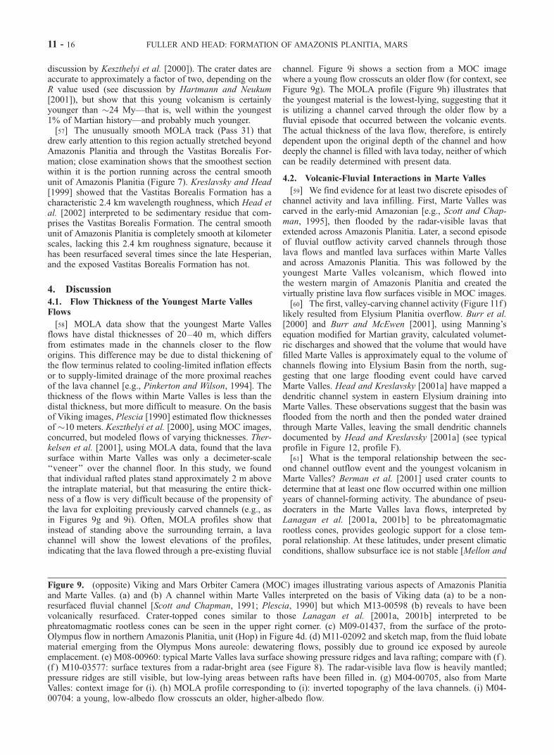
[58] MOLA data show that the youngest Marte Vallesflows have distal thicknesses of 20–40 m, which differsfrom estimates made in the channels closer to the floworigins. This difference may be due to distal thickening ofthe flow terminus related to cooling-limited inflation effectsor to supply-limited drainage of the more proximal reachesof the lava channel [e.g., Pinkerton and Wilson, 1994]. Thethickness of the flows within Marte Valles is less than thedistal thickness, but more difficult to measure. On the basisof Viking images, Plescia [1990] estimated flow thicknessesof �10 meters. Keszthelyi et al. [2000], using MOC images,concurred, but modeled flows of varying thicknesses. Ther-kelsen et al. [2001], using MOLA data, found that the lavasurface within Marte Valles was only a decimeter-scale‘‘veneer’’ over the channel floor. In this study, we foundthat individual rafted plates stand approximately 2 m abovethe intraplate material, but that measuring the entire thick-ness of a flow is very difficult because of the propensity ofthe lava for exploiting previously carved channels (e.g., asin Figures 9g and 9i). Often, MOLA profiles show thatinstead of standing above the surrounding terrain, a lavachannel will show the lowest elevations of the profiles,indicating that the lava flowed through a pre-existing fluvial
channel. Figure 9i shows a section from a MOC imagewhere a young flow crosscuts an older flow (for context, seeFigure 9g). The MOLA profile (Figure 9h) illustrates thatthe youngest material is the lowest-lying, suggesting that itis utilizing a channel carved through the older flow by afluvial episode that occurred between the volcanic events.The actual thickness of the lava flow, therefore, is entirelydependent upon the original depth of the channel and howdeeply the channel is filled with lava today, neither of whichcan be readily determined with present data.
4.2. Volcanic-Fluvial Interactions in Marte Valles
[59] We find evidence for at least two discrete episodes ofchannel activity and lava infilling. First, Marte Valles wascarved in the early-mid Amazonian [e.g., Scott and Chap-man, 1995], then flooded by the radar-visible lavas thatextended across Amazonis Planitia. Later, a second episodeof fluvial outflow activity carved channels through thoselava flows and mantled lava surfaces within Marte Vallesand across Amazonis Planitia. This was followed by theyoungest Marte Valles volcanism, which flowed intothe western margin of Amazonis Planitia and created thevirtually pristine lava flow surfaces visible in MOC images.[60] The first, valley-carving channel activity (Figure 11f )
likely resulted from Elysium Planitia overflow. Burr et al.[2000] and Burr and McEwen [2001], using Manning’sequation modified for Martian gravity, calculated volumet-ric discharges and showed that the volume that would havefilled Marte Valles is approximately equal to the volume ofchannels flowing into Elysium Basin from the north, sug-gesting that one large flooding event could have carvedMarte Valles. Head and Kreslavsky [2001a] have mapped adendritic channel system in eastern Elysium draining intoMarte Valles. These observations suggest that the basin wasflooded from the north and then the ponded water drainedthrough Marte Valles, leaving the small dendritic channelsdocumented by Head and Kreslavsky [2001a] (see typicalprofile in Figure 12, profile F).[61] What is the temporal relationship between the sec-
ond channel outflow event and the youngest volcanism inMarte Valles? Berman et al. [2001] used crater counts todetermine that at least one flow occurred within one millionyears of channel-forming activity. The abundance of pseu-docraters in the Marte Valles lava flows, interpreted byLanagan et al. [2001a, 2001b] to be phreatomagmaticrootless cones, provides geologic support for a close tem-poral relationship. At these latitudes, under present climaticconditions, shallow subsurface ice is not stable [Mellon and
Figure 9. (opposite) Viking and Mars Orbiter Camera (MOC) images illustrating various aspects of Amazonis Planitiaand Marte Valles. (a) and (b) A channel within Marte Valles interpreted on the basis of Viking data (a) to be a non-resurfaced fluvial channel [Scott and Chapman, 1991; Plescia, 1990] but which M13-00598 (b) reveals to have beenvolcanically resurfaced. Crater-topped cones similar to those Lanagan et al. [2001a, 2001b] interpreted to bephreatomagmatic rootless cones can be seen in the upper right corner. (c) M09-01437, from the surface of the proto-Olympus flow in northern Amazonis Planitia, unit (Hop) in Figure 4d. (d) M11-02092 and sketch map, from the fluid lobatematerial emerging from the Olympus Mons aureole: dewatering flows, possibly due to ground ice exposed by aureoleemplacement. (e) M08-00960: typical Marte Valles lava surface showing pressure ridges and lava rafting; compare with (f ).(f ) M10-03577: surface textures from a radar-bright area (see Figure 8). The radar-visible lava flow is heavily mantled;pressure ridges are still visible, but low-lying areas between rafts have been filled in. (g) M04-00705, also from MarteValles: context image for (i). (h) MOLA profile corresponding to (i): inverted topography of the lava channels. (i) M04-00704: a young, low-albedo flow crosscuts an older, higher-albedo flow.
11 - 16 FULLER AND HEAD: FORMATION OF AMAZONIS PLANITIA, MARS
FULLER AND HEAD: FORMATION OF AMAZONIS PLANITIA, MARS 11 - 17
Jakosky, 1993, 1995; Mellon et al., 1997], suggesting thatthe lava would have had to follow the channel outflowwithin approximately 105 years.[62] On the basis of these observations, then, it is likely
that fluvial channel activity and volcanism were closelyrelated in time. A model to account for this observationinvolves a genetic relationship between the fluvial andvolcanic events (Figure 13), as originally outlined byPlescia [1990], and in a manner similar to that proposedin other regions by other workers [e.g., Carr, 1996, pp. 58–60; Russell and Head, 2001a, 2001b] (see summary byHead and Wilson [2002]).[63] Many of the lavas that are observed in Elysium
Planitia have been traced back to fissures in the Cerberusregion [Plescia, 1990], fractures radial to the Elysiummagmatic rise. Fractures and structures radial to magmaticcomplexes are often the sites of surface deformation relatedto the emplacement of magma-filled cracks, or dikes in thesubsurface [e.g., Parfitt and Head, 1993; Head and Wilson,1993; Ernst et al., 1995; Wilson and Head, 2002]. In ad-dition, in the Amazonian, Mars was very likely character-ized by a thick global cryosphere, which was essentially aglobal aquitard to the groundwater system below [e.g.,Clifford, 1993] (see summary by Head and Wilson[2002]). Often the global aquitard (the cryosphere) was suf-ficiently thick and continuous to build up hydrostaticpressure in the underlying groundwater system [e.g., Carr,1987, 1996, pp. 58–60].[64] In the context of this setting, we envision that
magma was propagated as a dike laterally and verticallyfrom the Elysium rise, extending toward the surface andbreaching the cryosphere, which had been serving as an
aquitard to groundwater under pressure (Figure 13) [see alsoRussell and Head, 2001a, 2001b]. When the fractureimmediately preceding the propagating dike ruptured thecryosphere, the water, under hydrostatic pressure, emergedat very high flow rates, and continued to flow untilequilibrium pressure was reached. The groundwaterreleased by this catastrophic outflow flooded the ElysiumBasin and drained through Marte Valles at the eastern end ofthe Elysium Basin, carving new channels in the valley, andultimately debouching into Amazonis Planitia. The crackingof the cryosphere was shortly followed by the dike breach-ing the surface and erupting flood lavas. Lava from theensuing eruption quickly flowed across the surface andfollowed the channel structures through Marte Valles anddown into Amazonis Planitia. Associated pyroclastic activ-ity has been proposed to be a major source of fine-grainedmaterial forming the Medusae Fossae Formation [Keszthelyiet al., 2000].[65] The surface of the fluvially emplaced water likely
boiled and then froze [e.g., Carr, 1996, pp. 68–69; Kre-slavsky and Head, 2001, 2002]. At the water-lava interface,the water may have infiltrated the surface. The temperature,porosity and permeability of the surface determined whetherand for how long the water ponded before infiltrating orfreezing. Ponded water will freeze solid rapidly and sub-limation will occur in on the order of 106 years [Mellon andJakosky, 1993, 1995; Mellon et al., 1997; Kreslavsky andHead, 2001, 2002]. As the ice eventually completely sub-limated, it left behind a residual layer of previouslyentrained sediment. Head [2001] has outlined a scenarioin which at least part of the Medusae Fossae Formation maybe due to fluvial channel emplacement. In this scenario,
Figure 10. (a) Slope map for the Amazonis Planitia region. Note scale stretched such that any pointwith a slope greater than one degree is saturated white. (b) All points at which slope was <0.01�, withsketch map (see Figure 4d) overlain. Note the high density of points with near-zero slope within thecentral smooth unit of Amazonis Planitia.
11 - 18 FULLER AND HEAD: FORMATION OF AMAZONIS PLANITIA, MARS

evaporation and sublimation of these fluvial channel efflu-ents is followed by condensation of the volatiles and theirredeposition at the orographic rise represented by the low-land-upland scarp. Dohm et al. [2000] have proposed thatthe Medusae Fossae Formation was shaped by large-volumefluvial activity originating on Tharsis and debouching intothe Amazonis Planitia region during the Noachian or ear-liest Hesperian; effects of such activity would be similar tothose seen from the Mangala Valles and Marte Vallesoutflow events discussed here.
4.3. Unusual Rectilinear Basins in Amazonis Planitia
[66] In northeastern Amazonis Planitia (Figures 2 and 4)are two rectilinear basins of enigmatic origin (Figure 14).They were mapped by earlier workers (Figure 2) as rimmedby Aa1, the oldest member of the Amazonian-aged ArcadiaFormation, and floored by Aa3, an intermediate Amazonian-aged member of the Arcadia Formation (Figure 3) [Scottand Tanaka, 1986]. The floor of the western basin isapproximately 100 m below the floor of Amazonis Planitia(the eastern basin is somewhat shallower, its floor being
approximately 70 m lower than the surrounding plain)(Figures 4a and 14). Both basin floors are entirely smooth(Figure 4c) and similar to the rest of the floor of centralAmazonis Planitia, suggesting that they may have enclosedponded water for some interval. A narrow spillway betweenthe basins can be observed (Figure 14, see arrow), suggest-ing that one of the basins filled and then poured out into theother. Examination of the surface texture of the depressionmargins in MOC images and in roughness maps (Figure 4c),as well as in the detailed topography (Figure 14) stronglysuggest that the basins are entirely enclosed by high-reliefmaterial that is lobate and rugged, and appears to bevolcanic in origin.[67] This high-relief material is interpreted to be early
proto-Olympus Mons flows of Late Hesperian age thatextended out into the Amazonis basin prior to the formationof the aureole. We interpret the rectilinear aspect to be dueto the flows extending radially from the direction ofOlympus Mons, and then encountering wrinkle ridges onthe underlying Hesperian ridged plains (Hr) striking almostnormal to the direction of the flow of lava. Though a
Figure 11. Paleogeographic sketch maps. Refer to Figure 4d for unit map. (a) Large impact event in theNoachian or earliest Hesperian. (b) Emplacement and tectonic deformation of the Hesperian ridgedplains. (c) Lava flows from the pre-aureole Olympus Mons volcano form rectilinear depression and unit(Hop). Hesperian outflow events from Mangala Valles flow northward into Amazonis Planitia (seearrow), eroding and embaying the remaining crater rim. (d) Emplacement of the Olympus Mons aureoleand dewatering flows. (e) Lava flows, probably originating in the Tharsis Montes, flow around theaureole. (f ) Marte Valles carved, Amazonis Planitia flooded. (g) Lava flows from Elysium Planitia piratethe channels in Marte Valles and flow into Amazonis Planitia. (h) A propagating dike breaches thecryosphere in Elysium Planitia, catastrophically releasing water which resurfaces Amazonis Planitia andcarves new channels into the Marte Valles lava flows. (i) The dike breaches the surface, flooding lavasinto Elysium Planitia which flow through the re-carved channels into western Amazonis Planitia.
FULLER AND HEAD: FORMATION OF AMAZONIS PLANITIA, MARS 11 - 19

wrinkle ridge is not presently visible there, the strike of thewestern margin of the basin corresponds closely to the strikeof wrinkle ridges to the immediate north (Figure 5d). Itseems plausible that the flows banked up against the wrinkleridges, changed direction, and then extended laterally untilmeeting one of the other radial flows. In this manner, thewrinkle ridges served as barriers which caused the flows toform rectilinear basins. If this interpretation is correct, thenthe present depth of the basins (Figure 14) is a betterapproximation of the original elevation of the Hesperianridged plains (or the overlying Vastitas Borealis Formation)than the present surface of the central smooth unit inAmazonis Planitia (Figure 4d). On average, the basin floorsare 70–100 m below the surrounding plain (Figure 14),similar to the independently derived estimate of 40–125 mof mantling material deposited on top of the Hesperianridged plains (Hr). Interestingly, the uppermost lava flowsfrom pre-aureole Olympus Mons clearly tend to flowaround this structure (Figure 4d), showing that it is theoldest of the pre-aurole flow units.
4.4. Effects of Regional Tectonism
[68] The structural history of the region also played a rolein the shaping of the current Amazonis Planitia surface.Downwarping of the area surrounding the Tharsis Montes[Phillips et al., 2001] could have allowed for increasedbasin fill in eastern Amazonis Planitia, and could thereforebe responsible for the relatively greater thickness of thedeposits close to Olympus Mons; in the eastern half ofAmazonis Planitia, there are no visible wrinkle ridges,though ridges can be seen to the north and south. Thecomplete burial of the wrinkle ridges suggests that the
mantling layers are thicker there than they are further west,of the order of 100–200 meters (Figure 5d). Additionally,isostatic rebound or increased subsidence from the increasedload on Tharsis or the emplacement of the Olympus Monsaureole could be responsible for the fractures that can beseen in southeastern Amazonis Planitia (Figure 5d).
4.5. Evidence for Water in Amazonis Planitia
[69] There is other evidence for water—either liquid or inice form—in Amazonis Planitia. Lanagan et al. [2001a,2001b] have argued that the rootless cones present in theMarte Valles lava flows are phreatomagmatic eruptionsresulting from the presence of water ice in the subsurface.We have identified additional small domes interpreted to berootless cones in Marte Valles, as well as in the proto-Olympus Mons flow. Indirect evidence for water in Ama-zonis Planitia includes the channels to the south and west ofthe basin. Marte Valles clearly debouches into AmazonisPlanitia, and detrended MOLA data show channel-likedepressions. There is less direct evidence that outflow fromMangala Valles reached Amazonis Planitia, but the channelsdid reach beyond the dichotomy boundary [Bradley et al.,2002] and probably continued northward, carrying waterand sediments into the Amazonis Basin.[70] Could the apparent sedimentary deposits have
resulted from aeolian deposition? MOC images and thermalinertia data show that aeolian activity has certainly alteredthe surface of Amazonis Planitia (Figure 9) throughout itsrecent history, but it is presently unknown whether thedunes and streaks typical of this region are 1) modificationsof sedimentary deposits or 2) whether they represent amajor influx of material by aeolian processes. Because of
Figure 12. (a) Cross-sectional profiles of channels within the Amazonis Planitia region derived fromMOLA 32 � 64 gridded data and (b) location map of profiles. A–E are from the floor of AmazonisPlanitia and are interpreted to be hyperpycnal, or subaqueously incised channels (see discussion in text).They are marked by a broader, shallower cross-section than channels at the head of and within MarteValles (F and G, respectively), due to the lack of lateral confinement.
11 - 20 FULLER AND HEAD: FORMATION OF AMAZONIS PLANITIA, MARS

the evidence for fluvial emplacement of sediments inAmazonis Planitia, we presently favor the first option.
5. Summary
[71] MGS data provide a view of the surface of Mars withunprecedented clarity, and also allow a more detailed look
into the interior than ever before. Gravitational anomalies[Smith et al., 1999a] reveal a ring-shaped pattern similar tothat seen at other major Martian impacts. The correlationbetween the predicted area of crustal thickening [Zuber et al.,2000] with an arcuate topographic ridge of high-relief, highlymodified terrain, is strongly suggestive of a Noachian- orEarly Hesperian-aged major impact event (Figure 11a).
Figure 13. Diagrammatic and interpretative cross-section illustrating the relationship and history ofdike emplacement, cracking of the cryospheric seal, release of confined groundwater, and the eruption oflava in the Elysium-Amazonis region. (a) Pre-event setting in a profile from the Elysium Rise, acrossElysium Planitia and through Marte Valles (dome represents the high topography through which thechannel, upper dashed line, passes), and into Amazonis Planitia. (b) Dike propagates laterally from belowthe Elysium rise and penetrates the cryosphere. (c) Release of groundwater under hydrostatic pressure. (d)Further propagation of the dike penetrates to the surface, causing an eruption. Lavas follow floodwatersdown toward Amazonis Planitia, interacting with the recently emplaced water and sediment deposits.From Head and Wilson (manuscript in preparation, 2002).
FULLER AND HEAD: FORMATION OF AMAZONIS PLANITIA, MARS 11 - 21

Figure 14. (a) Topographic map of the area of the rectilinear depressions, showing the lobate flow-likenature of the north and south margins, their orientation parallel to a direction radial to proto-OlympusMons, and the similarity of their orientation to the extensive proto-Olympus flow just to the north. Alsonote that the margins trending in a direction just east of north are parallel to the orientation of wrinkleridges in the underlying Hesperian ridged plains (Hr), well-illustrated in Figures 5b, 5c, and 5d and inFigure 4d. The nature and configuration of the rectilinear depression margins supports the interpretationthat they represent proto-Olympus Mons volcanism that flowed into Amazonis Planitia and was deflectedupon encountering wrinkle ridges in the underlying Hesperian ridged plains. (b) Topographic profilesacross the rectilinear depressions, showing the flat floor of the interior, and its greater depth compared toAmazonis Planitia. This supports the interpretation that the floor was protected from much of thesedimentation and subsequent lava flows entering Amazonis Planitia by the marginal barriers, and thus itssurface elevation represents a closer approximation of the original Hr or Hv elevation. Arrow in (a) showspossible location of spillover channels.
11 - 22 FULLER AND HEAD: FORMATION OF AMAZONIS PLANITIA, MARS

[72] MOLA also provides evidence that the Hesperian-aged ridged plains underlie the current Amazonis Planitiasurface: wrinkle ridges, continuous in orientation with thosein a circum-Tharsis ring that covers half of Mars [Head et al.,2002], protrude through the overlyingmaterial. The emplace-ment of the wrinkle-ridged volcanic plains was the firstresurfacing event for which we have data (Figure 11b); therepeated resurfacing of Amazonis Planitia, which has con-tinued until very recently, led to the unusual smoothness ofthe central smooth unit of Amazonis Planitia (e.g., Figure 10).[73] Reduced relief of the wrinkle ridges within the
central smooth unit, when compared to those in unmodifiedHr, shows that between 50 and 100 m of material ismantling the intrabasinal ridges, and as much as 150–200m of material has completely buried the ridges in eastern-most Amazonis Planitia. There are several sources for thismaterial. Volcanic material from southern Tharsis flowedinto the southeast corner of the region after the emplace-ment of the Olympus Mons aureole; the flows appear toreach 23�N, but one flow shows no clear distal margin(Figure 5d), suggesting that the flow may have continuedfor some distance into Amazonis Planitia. Perhaps moreimportantly, at least two volcanic phases produced flowsinto Amazonis Planitia from the west, from Elysium Plani-tia. Radar mapping [Harmon et al., 1999] and Viking[Plescia, 1990] and MOC images [Keszthelyi et al., 2000]reveal two distinct flow events debouching into AmazonisPlanitia through Marte Valles (Figures 11g and 11i). Aque-ous deposition also contributed material to Amazonis Pla-nitia; the Mangala Valles, to the south, are a large system ofchannels that transported significant volumes of water andsediment from the southern highlands into the Amazonisregion (Figure 11c). Another source of fluvial activity isfrom the west (Figures 11f and 11h); the fluvial origin ofMarte Valles was first identified from Viking images [Scottand Chapman, 1991, 1995]. In addition, we interpret thestructures within the proto-Olympus flow of apparentphreatomagmatic origin (Figure 9c) to mean that the flowunit was emplaced on top of the water-rich Vastitas BorealisFormation, which is correlated with the outflow channeleffluents and may be related to the proposed northern oceanof Parker et al. [1989, 1993].[74] Each resurfacing event smoothed the surface at
different scales; the volcanic flows erased any prominenttopographic features and filled in craters [cf. Hartmann etal., 1999] and the aqueous events created laterally extensivesedimentary units that softened the rough-textured volcanicsurfaces. The youngest of these, covering even early-mid Amazonian lava flows [Harmon et al., 1992, 1999]occurred recently enough to remain almost entirely unal-tered, creating the current surface, the smoothest plains onMars.[75] The extreme youth of the youngest volcanism and its
associated fluvial activity suggest that Mars is volcanicallyactive today; for reference, the Marte Valles flood volcan-ism is approximately contemporaneous with the emplace-ment of the Columbia River Basalt Group on Earth[Hooper, 1997; Tolan et al., 1989]. It also suggests thatliquid water was present, if not stable, on the Martiansurface within the last 24 million years. The smoothnessand youth of Amazonis Planitia, the two most distinctivefeatures of the region, together point to a history of regional
resurfacing that extends back more than three billion years,and has continued until the geologic present.[76] The most important factors in producing the smooth-
est plains on Mars include 1) the formation of a barrier bythe proto-Olympus Mons flow unit between outflow chan-nel effluents from the south and the northern lowlands, 2)the trapping in the resulting basin of fluid lava flows andsedimentary effluent from the outflow channels, and 3) thevery young volcanic and fluvial activity from ElysiumPlanitia.[77] The dike swarm feeding the lava flows in Elysium
Planitia is likely responsible for propagating the fracturethat breached the damming cryosphere in southeasternElysium Planitia and led to the catastrophic outflow ofwater through Marte Valles and into Amazonis Planitia(Figure 13) [Head and Wilson, 2002].[78] The geological environment and history of Amazonis
Planitia also has astrobiological implications. The mostrecent of the lava flows associated with the emplacementof these plains have been dated as extremely young geo-logically (less than 24 million years old [Hartmann andBerman, 2000]). If fossil or extant life existed at depth in thesubsurface groundwater system at this time (a troglodyticfauna), it is highly likely that they would be among thematerial erupted to the surface during the cryosphere-crack-ing, dike-emplacement event (J. W. Head and L. Wilson, Amodel of simultaneous dike intrusion, cryospheric cracking,groundwater release and the eruption of lava: Examples fromthe Elysium Rise, Mars, manuscript in preparation, 2002),and washed down into Elysium and Amazonis Planitiae. Thefate of such effluents under Mars conditions has recentlybeen modeled [Kreslavsky and Head, 2001, 2002] and it hasbeen shown that standing bodies of water at this scale wouldquickly freeze over and sublimate, leaving a sedimentarysublimation residue. Thus, Elysium and Amazonis Planitiaemay be excellent locations to sample recently emplacedtroglodytic faunal remains.
[79] Acknowledgments. We gratefully acknowledge the MGS datathat made this analysis possible, and the MGS spacecraft and missionoperations team at the Jet Propulsion Laboratory and Lockheed MartinAstronautics for their contributions. We also thank the MOLA engineeringand science support team, and Greg Neumann for his superior datapreparation and analysis. We gratefully acknowledge the assistance ofStephen Pratt in the preparation of figures and Mikhail Kreslavsky fordiscussions. We thank Jim Zimbelman and an anonymous reviewer for theirhelpful comments and suggestions.
ReferencesAcuna, M. H., et al., Global distribution of crustal magnetism discovered bythe Mars Global Surveyor MAG/ER experiment, Science, 284, 790–793,1999.
Aharonson, O., M. T. Zuber, G. A. Neumann, and J. W. Head III, Northernhemisphere slopes and slope distributions, Geophys. Res. Lett., 25,4413–4416, 1998.
Aharonson, O., M. T. Zuber, and D. H. Rothman, Statistics of Mars’ topo-graphy from MOLA: Slopes, correlations and physical models, J. Geo-phys. Res., 106, 23,723–23,736, 2001.
Albee, A. A., R. E. Arvidson, F. D. Palluconi, and T. Thorpe, Overview ofthe Mars Global Surveyor mission, J. Geophys. Res., 106, 23,291–23,316, 2001.
Baker, V. R., The Channels of Mars, 198 pp., Univ. of Tex. Press, Austin,1982.
Bandfield, J. L., V. E. Hamilton, and P. R. Christensen, A global view ofMartian surface compositions from MGS-TES, Science, 287, 1626–1630, 2000.
Berman, D. C., W. K. Hartmann, and D. M. Burr, Marte Valles and the
FULLER AND HEAD: FORMATION OF AMAZONIS PLANITIA, MARS 11 - 23
Cerberus Plains: Evidence of young water flow on Mars, Lunar Planet.Sci. [CD-ROM], XXXII, abstract 1732, 2001.
Bourke, M. C., and J. R. Zimbelman, The Australian paleoflood model forunconfined fluvial deposition on Mars, Lunar Planet. Sci. [CD-ROM],XXXII, abstract 1679, 2001.
Bradley, B. A., S. E. H. Sakimoto, H. Frey, and J. R. Zimbelman, MedusaeFossae Formation: New perspectives from Mars Global Surveyor,J. Geophys. Res., 107(E8), 5058, doi:10.1029/2001JE001537, in press,2002.
Bratt, S. R., S. C. Solomon, and J. W. Head III, The evolution of impactbasins: Cooling, subsidence, and thermal stress, J. Geophys. Res., 90,12,415–12,433, 1985.
Bulmer, M. H., and P. J. McGovern, Emplacement kinematics of the north-ern Olympus Mons aureole deposit, Lunar Planet. Sci. [CD-ROM], XXX,abstract 2016, 1999.
Burr, D., and A. McEwen, Recent extreme floods on Mars, in The Extremesof the Extremes: Extraordinary Floods, edited by J. Snorrason, H. P.Finnsduttir, and M. Moss, IAHS Press, Wallingford, Oxfordshire, Eng-land, 2001.
Burr, D. M., A. S. McEwen, and P. D. Lanagan, Recent fluvial activity inand near Marte Valles, Mars, Lunar Planet. Sci. [CD-ROM], XXXI, ab-stract 1951, 2000.
Carr, M. H., Water on Mars, Nature, 326, 30–35, 1987.Carr, M. H., Water on Mars, 229 pp., Oxford Univ. Press, New York, 1996.Chapman, M. G., C. C. Allen, M. T. Gudmunsson, V. C. Gulick, S. P.Jakobsson, B. K. Lucchitta, I. P. Skilling, and R. B. Waitt, Volcanismand ice interactions on Earth and Mars, in Environmental Effects onVolcanic Eruptions: From Deep Oceans to Deep Space, edited by J. R.Zimbelman and T. K. P. Gregg, pp. 39–73, Kluwer Acad., Norwell,Mass., 2000.
Christensen, P. R., Martian dust mantling and surface composition: Inter-pretation of thermophysical properties, J. Geophys. Res., 84, 9985–9998,1982.
Christensen, P. R., Regional dust deposits on Mars: Physical properties,age, and history, J. Geophys. Res., 91, 3533–3545, 1986a.
Christensen, P. R., The spatial distribution of rocks on Mars, Icarus, 68,217–238, 1986b.
Christensen, P. R., Global albedo variations of Mars: Implications for activeaeolian transport, deposition, and erosion, J. Geophys. Res., 93, 7611–7624, 1988.
Christensen, P. R., and H. J. Moore, The Martian surface layer, in Mars,edited by H. H. Kieffer et al., pp. 686–729, Univ. of Ariz. Press, Tucson,1992.
Christensen, P. R., et al., Results from the Mars Global Surveyor ThermalEmission Spectrometer, Science, 279, 1692–1698, 1998.
Clifford, S. M., A model for the hydrologic and climatic behavior of wateron Mars, J. Geophys. Res., 98, 10,973–11,016, 1993.
Comer, R. P., S. C. Solomon, and J. W. Head III, Mars: Thickness of thelithosphere from the tectonic response to volcanic loads, Rev. Geophys.,23, 61–92, 1985.
Dohm, J. M., R. C. Anderson, V. R. Baker, J. C. Ferris, T. M. Hare, R. G.Strom, L. P. Rudd, J. W. Rice Jr., R. R. Casavant, and D. H. Scott, Systemof gigantic valleys northwest of Tharsis, Mars: Latent catastrophic flood-ing, northeast watershed and implications for northern plains ocean, Geo-phys. Res. Lett., 27, 3559–3562, 2000.
Elachi, C., Introduction to the Physics and Techniques of Remote Sensing,413 pp., John Wiley, New York, 1987.
Ernst, R. E., J. W. Head III, E. Parfitt, E. Grofils, and L. Wilson, Giantradiating dike swarms on Earth andVenus,Earth Sci. Rev., 39, 1–58, 1995.
Francis, P. W., and G. Wadge, The Olympus Mons aureole: Formation bygravitational spreading, J. Geophys. Res., 88, 8333–8344, 1983.
Frey, H. V., K. M. Shockey, E. L. Frey, J. H. Roark, and S. A. H. Sakimoto,A very large population of likely buried impact basins in the northernlowlands of Mars revealed by MOLA data, Lunar Planet. Sci. [CD-ROM], XXXII, abstract 1680, 2001.
Ghatan, G. J., and J. W. Head III, Candidate subglacial volcanoes in thesouth polar region of Mars, Lunar Planet. Sci. [CD-ROM], XXXII, ab-stract 1039, 2001.
Greeley, R., and J. E. Guest, Geologic map of the eastern equatorial regionof Mars, 1:15,000,000, U.S. Geol. Surv. Misc. Invest. Ser., Map I-1802-B,1987.
Gregg, T. K. P., and S. A. H. Sakimoto, Marte Valles lava channel flowrates and rheology from MOC and MOLA data, Lunar Planet. Sci. [CD-ROM], XXXI, abstract 1758, 2000.
Harmon, J. K., M. P. Sulzer, P. J. Perillat, and J. F. Chandler, Mars radarmapping: Strong backscatter from the Elysium Basin and outflow chan-nel, Icarus, 95, 153–156, 1992.
Harmon, J. K., R. E. Arvidson, E. A. Guinness, B. A. Campbell, and M. A.Slade, Mars mapping with delay-Doppler radar, J. Geophys. Res., 104,14,065–14,089, 1999.
Hartmann, W. K., and D. Berman, Elysium Planitia lava flows: Crater countchronology and geological implications, J. Geophys. Res., 105, 15,011–15,025, 2000.
Hartmann, W. K., and G. Neukum, Cratering chronology and the evolutionof Mars, Space Sci. Rev., 96, 165–194, 2001.
Hartmann, W. K., M. Malin, A. S. McEwen, M. Carr, L. Soderblom,P. Thomas, E. Danielson, P. James, and J. Veverka, Evidence for recentvolcanism on Mars from crater counts, Nature, 397, 586–589, 1999.
Head, J. W., III, Medusae Fossae Formation as ancient polar deposits?:Tests and new data on stratigraphic relationships, Lunar Planet. Sci.[CD-ROM], XXXII, abstract 1394, 2001.
Head, J. W., III, and M. A. Kreslavsky, Plains in Eastern Elysium Planitia,Mars: Topographic evidence for aqueous channels and lava flows, LunarPlanet. Sci. [CD-ROM], XXXII, abstract 1002, 2001a.
Head, J. W., III, and M. A. Kreslavsky, Standing bodies of water on Mars:A review of their mode of emplacement, scale, behavior and fate, EosTrans. AGU, 82(47), Fall Meet. Suppl., U12B-05, 2001b.
Head, J. W., III, and M. A. Kreslavsky, Medusae Fossae Formation asvolatile-rich airborne material deposited during outflow events and/orperiods of high obliquity: Tests of the hypotheses, in Vernadsky-BrownMicrosymposium 34 [CD-ROM], vol. 025, Vernadsky Inst., Moscow,2001c.
Head, J. W., III, and L. Wilson, Lunar graben formation due to near-surfacedeformation accompanying dike emplacement, Planet. Space Sci., 41,719–727, 1993.
Head, J. W., III, and L. Wilson, Mars: General environments and geologicalsettings of magma/H2O interactions, in Volcano-Ice Interaction on Earthand Mars, Geol. Soc. Spec. Publ., in press, 2002.
Head, J. W., III, H. Hiesinger, M. I. Ivanov, M. A. Kreslavsky, S. Pratt, andB. J. Thomson, Possible ancient oceans on Mars: Evidence from MarsOrbiter Laser Altimeter data, Science, 286, 2134–2137, 1999.
Head, J. W., M. A. Kreslavsky, and S. Pratt, Northern lowlands of Mars:Evidence for widespread volcanic flooding and tectonic deformation inthe Hesperian Period, J. Geophys. Res., 107(E1), 10.1029/200JE001445,2002.
Hooper, P. R., The Columbia River Flood Basalt Province: Current status,in Large Igneous Provinces: Continental, Oceanic, and Planetary FloodVolcanism, Geophys. Monogr. Ser., vol. 100, edited by J. J. Mahoney andM. F. Coffin, pp. 1 –27, American Geophysical Union, Washington,D.C., 1997.
Ivanov, M. A., and J. W. Head III, Chryse Planitia, Mars: Topographicconfiguration from MOLA data and tests for hypothesized lakes andshorelines, J. Geophys. Res., 106, 3275–3295, 2001.
Jakosky, B. M., M. T. Mellon, H. H. Kieffer, P. R. Christensen, E. S.Varnes, and S. W. Lee, The thermal inertia of Mars from the Mars GlobalSurveyor Thermal Emission Spectrometer, J. Geophys. Res., 105, 9643–9652, 2000.
Keszthelyi, L., A. S. McEwen, and T. Thordarson, Terrestrial analogs andthermal models for Martian flood lavas, J. Geophys. Res., 105, 15,027–15,049, 2000.
Kieffer, H. H., T. Z. Martin, A. R. Peterfreund, B. M. Jakosky, E. D. Miner,and F. D. Palluconi, Thermal and albedo mapping of Mars during theViking primary mission, J. Geophys. Res., 82, 4249–4291, 1977.
Komar, P. D., Comparisons of the hydraulics of water flows in Martianoutflow channels with flows of similar scale on Earth, Icarus, 37, 156–181, 1979.
Kreslavsky, M. A., and J. W. Head III, Kilometer-scale slopes on Mars andtheir correlation with geologic units: Initial results from Mars OrbiterLaser Altimeter (MOLA) data, J. Geophys. Res., 104, 21,911–21,924,1999.
Kreslavsky, M. A., and J. W. Head III, Kilometer-scale roughness of Mars:Results from MOLA data analysis, J. Geophys. Res., 105, 26,695–26,711, 2000.
Kreslavsky, M. A., and J. W. Head III, The fate of outflow channel effluentsin the northern lowlands of Mars: The Vastitas Borealis Formation, EosTrans. AGU, 82(20), P31A-03, 2001.
Kreslavsky, M. A., and J. W. Head III, The fate of outflow channel effluentsin the northern lowlands of Mars: The Vastitas Borealis Formation as asublimation residue from frozen ponded bodies of water, J. Geophys.Res., 107, 10.1029/2001JE001831, in press, 2002.
Lanagan, P. D., A. S. McEwen, and L. S. Link, Geomorphologic mappingof Cerberus Plains, Mars, Lunar Planet. Sci. [CD-ROM], XXXII, abstract2077, 2001a.
Lanagan, P. D., A. S. McEwen, L. P. Keszthelyi, and T. Thordarson, Root-less cones on Mars indicating the presence of shallow equatorial groundice in recent times, Geophys. Res. Lett., 28, 2365–2367, 2001b.
Malin, M. C., et al., Early views of the Martian surface from the MarsOrbiter Camera of Mars Global Surveyor, Science, 279, 1681–1685,1998.
McGovern, P. J., and S. C. Solomon, State of stress, faulting and eruption
11 - 24 FULLER AND HEAD: FORMATION OF AMAZONIS PLANITIA, MARS
characteristics of large volcanoes on Mars, J. Geophys. Res., 98, 23,533–23,579, 1993.
Mellon, M. T., and B. M. Jakosky, Geographic variations in the thermal anddiffusive stability of ground ice on Mars, J. Geophys. Res., 98, 3345–3364, 1993.
Mellon, M. T., and B. M. Jakosky, The distribution and behavior of Martianground ice during past and present epochs, J. Geophys. Res., 100,11,781–11,799, 1995.
Mellon, M. T., B. M. Jakosky, and S. E. Postawko, The persistence ofequatorial ground ice on Mars, J. Geophys. Res., 102, 19,357–19,369,1997.
Milton, D. J., Water and processes of degradation in the Martian landscape,J. Geophys. Res., 78, 4037–4047, 1973.
Morris, E. C., and K. L. Tanaka, Geologic maps of the Olympus Monsregion of Mars, 1:2,000,000, U.S. Geol. Surv. Misc. Invest. Ser., MapI-2327, 1994.
Parfitt, E. A., and J. W. Head, Buffered and unbuffered dike emplacementon Earth and Venus: Implications for magma reservoir size, depth, andrate of magma replenishment, Earth Moon Planets, 61, 249–261, 1993.
Parker, T. J., R. S. Saunders, and D. M. Schneeberger, Transitional mor-phology in the west Deuteronilus Mensae region of Mars: Implicationsfor the modification of the lowlands-uplands boundary, Icarus, 82, 111–145, 1989.
Parker, T. J., D. S. Gorsline, R. S. Saunders, D. C. Pieri, and D. M.Schneeberger, Coastal geomorphology of the Martian northern plains,J. Geophys. Res., 98, 11,061–11,078, 1993.
Phillips, R. J., et al., Ancient geodynamics and global-scale hydrology onMars, Science, 291, 2587–2591, 2001.
Pilkington, M., and R. A. F. Grieve, The geophysical signature of terrestrialimpact craters, Rev. Geophys., 30, 161–181, 1992.
Pinkerton, H., and L. Wilson, Factors controlling the lengths of channel-fedlava flows, Bull. Volcanol., 56, 108–120, 1994.
Plescia, J. B., Recent flood lavas in the Elysium Region of Mars, Icarus, 88,465–490, 1990.
Plescia, J. B., Wrinkle ridges of Arcadia Planitia, Mars. J. Geophys. Res.,98, 15,049–15,059, 1993.
Purucker, M., D. Ravat, H. V. Frey, C. Voorhies, T. Sabaka, and M. H.Acuna, An altitude-normalized magnetic map of Mars and its interpreta-tion, Geophys. Res. Lett., 27, 2449–2452, 2000.
Russell, P. R., and J. W. Head III, Elysium/Utopia flows: Characteristicsfrom topography and a model of emplacement, Lunar Planet. Sci. [CD-ROM], XXXII, abstract 1040, 2001a.
Russell, P. R., and J. W. Head III, Implications for hydrologic conditions onMars from Lyot Crater, Eos Trans. AGU, 80(20), P41A-03, 2001b.
Sakimoto, S. E. H., H. V. Frey, J. B. Garvin, and J. H. Roark, Topography,roughness, layering, and slope properties of the Medusae Fossae forma-tion from Mars Orbiter Laser Altimeter (MOLA) and Mars Orbiter Cam-era (MOC) data, J. Geophys. Res., 104, 24,141–24,154, 1999.
Schultz, R. A., and H. V. Frey, A new survey of large multiring impactbasins on Mars, J. Geophys. Res., 95, 14,175–14,189, 1990.
Scott, D. H., and M. G. Chapman, Mars Elysium Basin: Geologic/volu-metric analyses of a young lake and exobiologic implications, Proc.Lunar Planet. Sci. Conf. 21st, 669–677, 1991.
Scott, D. H., and M. G. Chapman, Geologic and topographic maps of theElysium Paleolake Basin, Mars, 1:5,000,000, U.S. Geol. Surv. Misc. In-vest. Ser., Map I-2397, 1995.
Scott, D. H., and K. L. Tanaka, Geologic map of the western equatorialregion of Mars, 1:15,000,000, U.S. Geol. Surv. Misc. Invest. Ser., MapI-1802-A, 1986.
Smith, D. E., W. L. Sjogren, G. L. Tyler, G. Balmino, F. G. Lemoine, andA. S. Konopliv, The gravity field of Mars: Results from Mars GlobalSurveyor, Science, 286, 94–97, 1999a.
Smith, D. E., et al., The global topography of Mars and implications forsurface evolution, Science, 284, 1495–1503, 1999b.
Tanaka, K. L., Ice-lubricated gravity spreading of the Olympus Mons aur-eole deposits, Icarus, 62, 191–206, 1985.
Tanaka, K. L., and M. G. Chapman, The relation of catastrophic flooding ofMangala Valles, Mars, to faulting of Memnonia Fossae and Tharsis vol-canism, J. Geophys. Res., 95, 14,315–14,323, 1990.
Tanaka, K. L., and D. H. Scott, Geologic map of the polar regions of Mars,1:15,000,000, U.S. Geol. Surv. Misc. Invest. Ser., Map I-1802-C, 1987.
Therkelsen, J. P., S. S. Santiago, E. B. Grosfils, S. E. H. Sakimoto, C. V.Mendelson, and J. E. Bleacher, Eruption constraints for a young channe-lized lava flow, Marte Valles, Mars, Lunar Planet. Sci. [CD-ROM],XXXII, abstract 1112, 2001.
Tolan, T. L., S. P. Reidel, M. H. Beeson, J. L. Anderson, K. R. Fecht, andD. A. Swanson, Revisions to the estimates of the areal extent and volumeof the Columbia River Basalt Group, in Volcanism and Tectonism in theColumbia River Flood-Basalt Province, edited by S. P. Reidel and P. R.Hooper, Spec. Pap. Geol. Soc. Am., 239, 1–20, 1989.
Wilson, L., and J. W. Head III, Heat transfer and melting in subglacialbasaltic volcanic eruptions: Implications for volcanic deposit morphologyand meltwater volumes, in Volcano-Ice Interaction on Earth and Mars,Geol. Soc. Spec. Publ., in press, 2002.
Wood, C. A., and J. W. Head III, Comparison of impact basins on Mercury,Mars, and the Moon, Proc. Lunar Sci. Conf. 7th, 3629–3651, 1976.
Zimbelman, J. R., R. A. Craddock, R. Greeley, and R. O. Kuzmin, Volatilehistory of Mangala Valles, Mars, J. Geophys. Res., 97, 18,309–18,317,1992.
Zimbelman, J. R., D. A. Crown, J. A. Grant, and D. M. Hooper, TheMedusae Fossae Formation, Amazonis Planitia, Mars: Evaluation of pro-posed hypotheses of origin, Lunar Planet. Sci., 1623–1624, 1997.
Zimbelman, J. R., D. M. Hooper, D. A. Crown, J. A. Grant, S. E. H.Sakimoto, and H. V. Frey, Medusae Fossae Formation, Mars: An assess-ment of possible origins utilizing early results from Mars Global Sur-veyor, Lunar Planet. Sci. [CD-ROM], XXX, abstract 1652, 1999.
Zuber, M. T., et al., Internal structure and early thermal evolution of Marsfrom Mars Global Surveyor topography and gravity, Science, 287, 1788–1793, 2000.
�����������E. R. Fuller and J.W. Head III, Department of Geological Sciences, Brown
University, Box 1846, Providence, RI 02912, USA. ([email protected])
FULLER AND HEAD: FORMATION OF AMAZONIS PLANITIA, MARS 11 - 25