Embed Size (px)
Citation preview
www.cet.edu.au
Petrophysics:
Local rock properties
Geology:
Structure & rock type
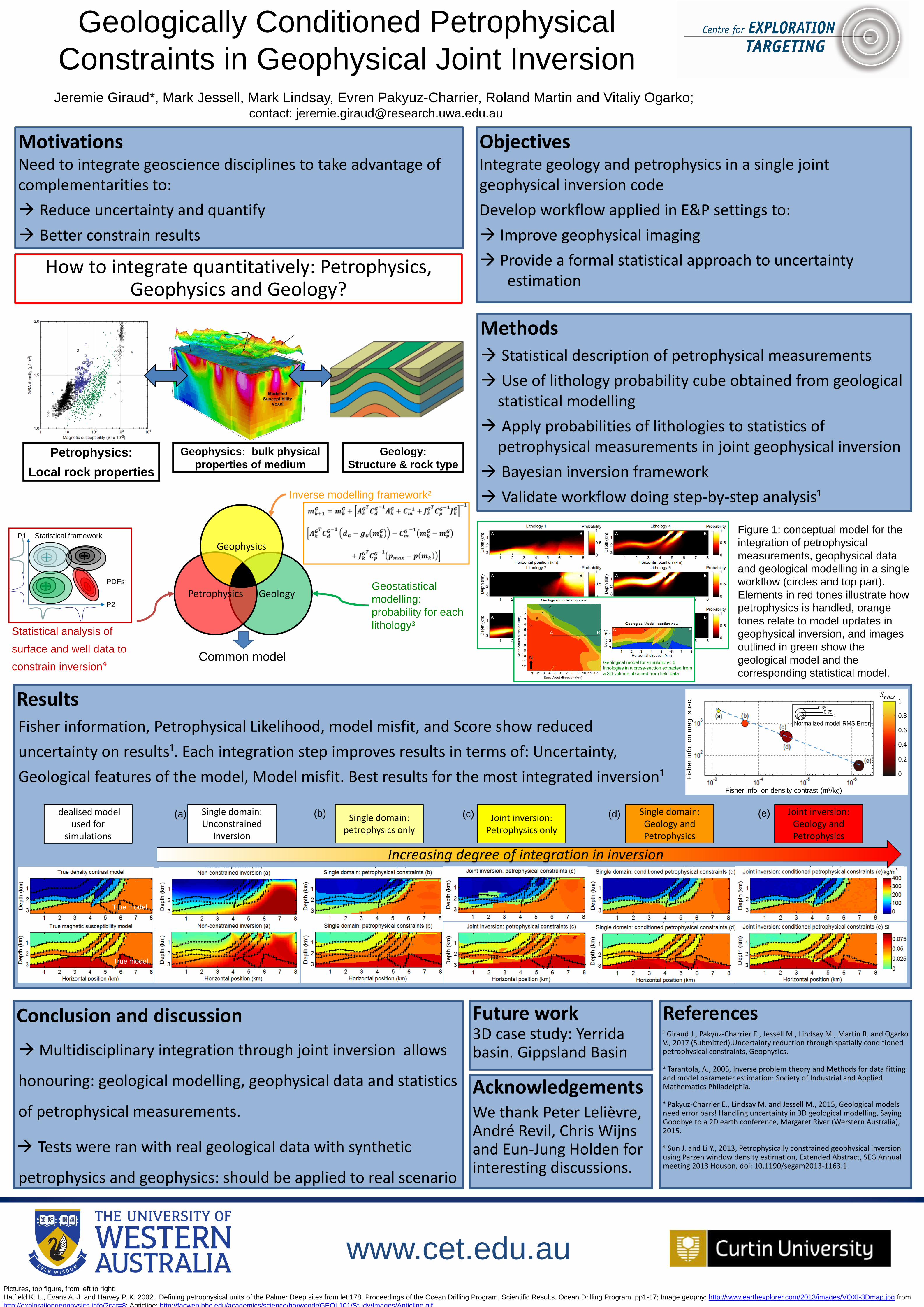
Geologically Conditioned Petrophysical
Constraints in Geophysical Joint InversionJeremie Giraud*, Mark Jessell, Mark Lindsay, Evren Pakyuz-Charrier, Roland Martin and Vitaliy Ogarko;
contact: [email protected]
MotivationsNeed to integrate geoscience disciplines to take advantage of complementarities to:
Reduce uncertainty and quantify
Better constrain results
Geophysics: bulk physical
properties of medium
GeologyPetrophysics
Geophysics
Common model
ObjectivesIntegrate geology and petrophysics in a single joint geophysical inversion code
Develop workflow applied in E&P settings to:
Improve geophysical imaging
Provide a formal statistical approach to uncertainty estimation
Methods Statistical description of petrophysical measurements
Use of lithology probability cube obtained from geological statistical modelling
Apply probabilities of lithologies to statistics of petrophysical measurements in joint geophysical inversion
Bayesian inversion framework
Validate workflow doing step-by-step analysis¹Inverse modelling framework²
Statistical analysis of
surface and well data to
constrain inversion⁴
Geostatistical
modelling:
probability for each
lithology³
Statistical frameworkP1
P2
PDFs
A B
A B
A B
A B
A B
A B
ResultsFisher information, Petrophysical Likelihood, model misfit, and Score show reduced
uncertainty on results¹. Each integration step improves results in terms of: Uncertainty,
Geological features of the model, Model misfit. Best results for the most integrated inversion¹
Figure 1: conceptual model for the
integration of petrophysical
measurements, geophysical data
and geological modelling in a single
workflow (circles and top part).
Elements in red tones illustrate how
petrophysics is handled, orange
tones relate to model updates in
geophysical inversion, and images
outlined in green show the
geological model and the
corresponding statistical model.
Conclusion and discussion
Multidisciplinary integration through joint inversion allows
honouring: geological modelling, geophysical data and statistics
of petrophysical measurements.
Tests were ran with real geological data with synthetic
petrophysics and geophysics: should be applied to real scenario
AcknowledgementsWe thank Peter Lelièvre, André Revil, Chris Wijns and Eun-Jung Holden for interesting discussions.
References¹ Giraud J., Pakyuz-Charrier E., Jessell M., Lindsay M., Martin R. and Ogarko V., 2017 (Submitted),Uncertainty reduction through spatially conditioned petrophysical constraints, Geophysics.
² Tarantola, A., 2005, Inverse problem theory and Methods for data fitting and model parameter estimation: Society of Industrial and Applied Mathematics Philadelphia.
³ Pakyuz-Charrier E., Lindsay M. and Jessell M., 2015, Geological models need error bars! Handling uncertainty in 3D geological modelling, Saying Goodbye to a 2D earth conference, Margaret River (Werstern Australia), 2015.
⁴ Sun J. and Li Y., 2013, Petrophysically constrained geophysical inversion using Parzen window density estimation, Extended Abstract, SEG Annual meeting 2013 Houson, doi: 10.1190/segam2013-1163.1
Increasing degree of integration in inversion
Single domain: Unconstrained
inversion
Single domain:petrophysics only
Joint inversion: Petrophysics only
Single domain:Geology and Petrophysics
Joint inversion: Geology and Petrophysics
Idealised model used for
simulations
12
34
5
6A B
2
3
4
5
6
N
A B
(a) (b) (c) (d) (e)
Future work 3D case study: Yerridabasin. Gippsland Basin
Normalized model RMS Error
10.75
0.35
Fisher info. on density contrast (m³/kg)
Fis
her
info
. on m
ag.
susc. 1
0.8
0.6
0.4
0.2
0
Pictures, top figure, from left to right:
Hatfield K. L., Evans A. J. and Harvey P. K. 2002, Defining petrophysical units of the Palmer Deep sites from let 178, Proceedings of the Ocean Drilling Program, Scientific Results. Ocean Drilling Program, pp1-17; Image geophy: http://www.earthexplorer.com/2013/images/VOXI-3Dmap.jpg from
http://explorationgeophysics.info/?cat=8; Anticline: http://facweb.bhc.edu/academics/science/harwoodr/GEOL101/Study/Images/Anticline.gif
Geological model for simulations: 6
lithologies in a cross-section extracted from
a 3D volume obtained from field data.
How to integrate quantitatively: Petrophysics, Geophysics and Geology?
True model
True model