Embed Size (px)
Citation preview
ALUR 1971-72
Tundra Disturbance Studies in the Western Canadian Arctic.
D. E. Kerfoot Department of Geography Brock University
This report was prepared under contract for the Arctic Land Use Research Program, Northern Economic Development Branch, Department of Indian Affairs and Northern Development. The views, conclusions and recommendations expressed herein are those of the author and not necessarily those of the Department.
TABLE OF CONTENTS
PAGE
ACKNOWLEDGENENTS ........................................ iii
INTRODUCTION . . . . . . . . . . . . . . . . . . . . . . . . . . . 1
WINTERROADS . . . . . . . . . . . . . . . . . . . . . . . . . . . Shingle Point Site . . . . . . . . . . . . . . . . . . .
Depth of Thaw P r o f i l e s . . . . . . . . . . . . . . . Quadrat Studies . . . . . . . . . . . . . . . . . . . Ground Temperature Measurements . . . . . . . . . . .
Sitidgi Creek S i t e . . . . . . . . . . . . . . . . . . . J i m y Lake S i t e . . . . . . . . . . . . . . . . . . . . .
SUMMER SEISMIC OPERATIONS . . . *
1970 Summer Seismic Lines . . . . . . . . . . . . . . . . 1971 Summer Seismic Lines . . . . . . . . . . . . . . . .
WINTER SEISMIC OPERATIONS . . . . . Caribou Hills Area . . . . . . . . . . . . . . . . . . . Banks Island . . . . . . . . . . . . . . . . . . . . . .
Storkerson Bay Rig S i t e . . . . . . . . . . . . . . .
S W R Y AND RJZCOWNDATIONS . . e . 9
LIST OF FIGURES ......................................... LIST OF TABLES ..........................................
5
6
9
16
33
42
55
61
6 3
70
97
98
100
106
107
113
115
iii
ACKNOWLEDGMENTS
My gratitude is expressed t o the following people who assisted
in the preparation of t h i s report:- Mr. E. Makkreel, Miss A . Swick,
Mr. G. Ironside, Mr. E. Kaps and Mr. U, Wilner f o r t h e i r aid in the
co l l ec t ion of the field data; Mr. W. Liachomsky for assistance in t h e
computer mapping programme; Mr. L. Nealey for laboratory analyses of
sediment samples; Mr. A. Carpenter, President of the Banks Island Trappers
Association, and Mr. D. Urquhart, Territorial Game Officer in Sachs
Harbour, f o r advice on t h e winter seismic operations on Banks Island;
Mr. R . Prudholme, Gulf Oil Canada Limited, Mr. A. Straub, Mr. D. Davis
and a l l the crew of Party 3 , Globe Universal Sciences Canada L i m i t e d , for
all the assistance and hospitality extended to u6e in our study of t h e i r
summer seismic programme; Mr. E. Boodle of the Mackenzie Forest Service
in Inuvik; the s taf f of the P r i n t Shop, Brock University; and, f i n a l l y ,
to my wife, Helen, f o r the innumerable occasions that: Z was able t o depend
on her in the roles of f i e l d assistant, researcher, cartographer and
typist.
INTRODUCTION
This repor t covers the results of research undertaken on a con-
tract b a s i s as part of the Arctic Land Use Research (ALUR) Programme of
the Department of Indian Affairs and Northern Development during t h e
sumer of 1971. The broad terms of r e f e r e n c e f o r t h i s c o n t r a c t were t o
inves t iga te and assess the immediate and long- te rm e f fec ts on the su r face
vegetation a n d t e r r a i n of va r ious types, designs and operat ing procedures
of veh ic l e s employed by t h e r e s o u r c e e x p l o r a t i o n i n d u s t r y i n b o t h t h e
fores ted and tundra reg ions of far nor thern Canada. The s p e c i f i c s t u d i e s
t o be inves t iga t ed as p a r t of this cont rac t inc luded:
(a) the 1970 veh ic l e t es t sites a t Tuktoyaktuk, Tununuk
and Shingle Point .
(b ) r ep resen ta t ive sites of winter road opera t ions near
t he Blow River , Y.T., on the Tuktoyaktuk Peninsula,
and on the Gulf O i l i c e r o a d from Inuvik t o the s i t e
of r i g C-38.
(c) two si tes , t o be s e l e c t e d by t he D i rec to r , where
se i smic opera t ions were c a r r i e d o u t during the win-
ter of 1970-71 i n f o r e s t e d areas of discont inuous
permafrost, the one subjec ted t o wheeled vehicular
t r a f f i c , and the o t h e r t o f l e x i b l e tracked v e h i c l e s
only
(d) t h e si te of win ter se i smic opera t ions carried o u t
in 1970-71 by E l f O i l Exploration and Production
Canada, Limited, and Deminex (Canada) Limited, on
2
Banks I s l a n d , N , W . T .
This r e sea rch programme was t o be undertaken i n co l l abora t ion w i th Dr. J.D.
H . Lambert, Department: of Biology, Carleton University, and Mr. John D.
Radforth of the Muskeg R e s e a r c h I n s t i t u t e of t he Un ive r s i ty of New Bruns-
wick,
Problems re la t ing t o the inadequate arrangements f o r logistical
support and the absence of any necessary background information on t h e
terrain d i s tu rbance features to be i n v e s t i g a t e d , r e s u l t e d i n a n e x c l u s i o n
of t h e s t u d i e s of seismic lines i n t h e forested areas and winter roads on
the Tuktoyaktuk Peninsula E rom the summer f i e l d programme. S i m i l a r d i f f - i cu l t ies , toge ther wi th p roblems in schedul ing a f i e l d programme t h a t
co inc ided w i th t ha t of Mr. Radforth, led t o a f u r t h e r e x c l u s i o n of i n v e s t -
i g a t i o n s of t h e 1970 v e h i c l e t e s t sites. However, since Mr. Radforth was
the on ly research worker t o have done t h e p r e l i m i n a r y s t u d i e s on these
sites dur ing t he p rev ious summer, it. was considered t o be appropr i a t e that
he should continue t h e s e i n v e s t i g a t i o n s . I n c o n t r a s t to these omissions,
i n v e s t i g a t i o n s of a win te r road s i t e near S i t i d g i Creek, t h e 1970 and 1971
summer se i smic ope ra t ions of Gulf O i l Canada Limited, and a d r i l l - r i g site
near S torkerson Bay on Banks I s l a n d were added t o t h e programme of f i e l d
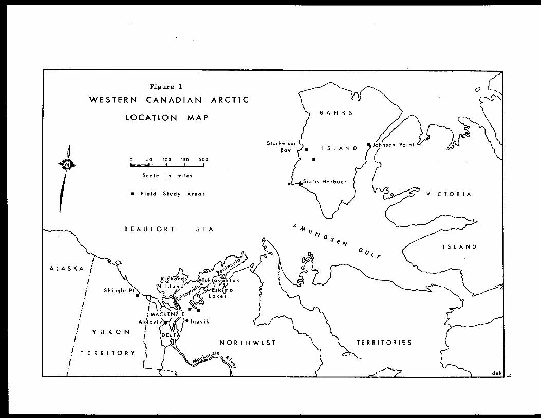
s t u d i e s . The g e n e r a l l o c a t i o n s of t h e v a r i o u s f i e l d areas are shown i n
F i g u r e 1.
The f i e l d work for t h i s programme was c a r r i e d o u t , i n collabor-
ation wi th Dr. Lambert, between June 4 and September 4 , 1971. Both
q u a n t i t a t i v e and qua l i t a t ive p rocedures were u t i l i z e d t o assess the degree
of tundra t e r r a i n d i s t u r b a n c e . Q u a n t i t a t i v e d a t a was c o l l e c t e d to eva l -
uate r e l a t i v e c h a n g e s i n surface micro re l i e f f ea tu re s and t he thickness
and thermal regime of t h e a c t i v e l a y e r i n d i s t u r b e d as compared t o a d j a c e n t
a
4
undisturbed sites. Wherever possible, soil samples were collected for de-
terminations of the granulometric composition and potential for thermokarst
development of the frozen substrate. In addition to these quantitative
measurements, qualitative assessments were also made of the degree of dis-
turbance of the tundra vegetation cover. Although some of the latter
.material has been incorporated into this report, to provide a more compre-
hensive description of the research programme, more specific and detailed
analyses of this particular aspect of the tundra disturbances can be ob-
tained from Dr. Lambert's report.
For clarity and convenience, the various studies of the tundra
disturbances investigated under the contract are grouped according to
specific types of activity associated with the resource exploration indus-
try operating in the north. The first section of the report incorporates
the results of studies of winter road sites which were selected to provide
relative data on the optimum type of construction and period of usage of
these access routes. These sites included examples of winter roads which
were constructed using conventional snow packing techniques, blading of
the organic layer or the ice road method, and which were used for one OK
two consecutive years. The second section presents the results of investi-
gations designed to assess the. feasibility of summer seismic operations in
certain parts of the Mackenzie Delta area, and includes descriptions of
summer seismic l ines from one to nine years old, as well as a detailed
series of observations made during the course of an actual seismic pro-
gramme in the summer of 1971. The third section of the report covers a
largely qualitative assessment of winter seismic operations and includes
some observations of a programme in the Caribou Hills area in February,
1971, and the terrain disturbances associated with the first winter
5
se ismic opera t ions on Banks Is land toge ther wi th some prel iminary surveys
of t h e site of the first well t o be d r i l l e d on t h e i s l a n d . The concluding
pages of t h e report con ta in a summary of t h e f indings and some recomenda-
t i o n s for cons idera t ion o r possible incorporation in t h e application or
enforcement of t h e Land Use Regulat ions i n far nor thern Canada.
WINTER ROADS
The crose- tundra movement of heavy, especial ly wheeled, vehicles
o r loads is r e s t r i c t e d t o those months of t he yea r when t h e a c t i v e layer is
f rozen. Even a t these times, however, the es tab l i shment of access r o u t e s
f o r the movement of d r i l l i n g r i g s , camps, equipment and s u p p l i e s n e c e s s i t -
ates the use of ce r t a in cons t ruc t ion t echn iques i n order t o minimize the
d i s r u p t i v e e f f e c t s of such loca l ieed , intense t r a f f i c on the t e r r a i n . The
most common method of b u i l d i n g t h e s e w i n t e r r o a d s i n t h e Mackenzie Delta
area involves the packing o r conso l ida t ion of a l aye r of wet snow i n a n
a t tempt to p rovide a smooth, compact surface capable of suppor t ing t he
heavier wheeled or t r acked veh ic l e s . The scan t nature of t h e snow cover ,
p a r t i c u l a r l y in exposed, wind-swept areas, o r the d ry , powdery consis tency
of the snow, frequently combine t o limit the p r o t e c t i v e e f f e c t i v e n e s s of
t h i s method of construction and, consequently, many of t he w in te r roads
are almost completely denuded of t h e i r s u r f a c e v e g e t a t i o n cover.
The i n t e n s i t y of the t e r r a in d i s tu rbance a s soc ia t ed w i th such a
loca l ized concent ra t ion of c r o s s - t u n d r a t r a f f i c p r e s e n t s two primary prob-
lems with r e s p e c t t o w i n t e r road opera t ions , The f i r s t centres around the
adequacy of the convent iona l snow packing technique, and t h e re la t ive merits
of a l t e r n a t i v e methods of cons t ruc t ion . eg. i ce roads . The second problem
6
relates t o t h e optimum length of time f o r which individual access routes
should be used. Since the use of a road of ten results i n a severe d i s rup-
t i o n of t h e surface vege ta t ion cove r a f t e r on ly one win te r ' s ope ra t ions , i t
i s debatab le as to whether o r not the same access rou te should be u t i l i z e d
in fo l lowing yea r s . Ce r t a in ly , any re-use of a win ter m a d can only resul t
i n an i n t e n s i f i c a t i o n o r compounding of the degree of dis turbance, thereby
prolonging the time period required f o r a re -es tab l i shment of t he vege ta t -
ion layer and increasing t h e risk that thermokarst development will take
place. On the other hand, i f an access rou te is n o t t o be used again, t h i s
may r e q u i r e t h e c o n s t r u c t i o n of a second winter road i n the same area, and
t h i s r e s u l t s i n a cor re spond ing i nc rease i n t he areal e x t e n t of t h e t e r r a i n
d is turbance .
These appa ren t ly con f l i c t ing aspects of e i t h e r r e s t r i c t i n g t h e
intensity of t e r r a i n damage t o a c c e p t a b l e l e v e l s , o r minimizing i t s areal
exten t , have yet t o be reso lved , and a cons iderable part of the 1 9 7 1 f i e l d
programme cen t r ed a round t he co l l ec t ion of q u a n t i t a t i v e d a t a p e r t a i n i n g t o
t h e optimum method of construct ion and period of usage of these win ter
roads.
Sh ing le Po in t S i t e .
I n t h e w i n t e r of 1969-70, Imper ia l O i l Limited b u i l t a win te r
road, approximately fourteen miles i n l e n g t h , from t h e i r s t a g i n g p o i n t on
the coas t , nea r t he DEW L i n e S t a t i o n a t Shing le Po in t , to t h e i r IOE Blow
River (E-47) rig si te loca ted a t about longi tude 137' 2 7 ' W and l a t i t u d e
68' 47' N (see Figure 2). Sec t ions of t h i s r o a d were invest igated under
the ALUR programme dur ing t he summer of 1970, when it: was found t h a t , des-
pi te an extreme pulver izat ion of t he o rgan ic layer, some p lan t spec ie s ,
8
espec ia l ly the Cloudberry (Rubus chamaemorus), appeared t o have survived
through the disturbance and some regene ra t ion was in p rogress . Fur thermore ,
it was f e l t t h a t t h e e x i s t e n c e of some shredded organic material would
assist in the re -growth of t hese species as well as c o n t r i b u t i n g t o t h e re-
t a r d a t i o n of sur face runoff and providing some form of i n s u l a t i o n f o r t h e
underlying f rozen ground, Rather than promote an intensif icat ion of t he
e x i s t i n g level of d is turbance , th rough a fu r the r r educ t ion i n t he t h i ckness
of t h e organic l a y e r , it was sugges ted tha t the access rou te should no t be
used aga in du r ing t he w in te r of 1970-71, and I t was recommended t h a t a new
win te r road be cons t ruc t ed t o hau l t he drilling r i g and camp t o t h e N-58
s i te loca ted a few miles t o t h e west of the Spr ing River a t longi tude 138O
58' W and l a t i t u d e 69O 15 N.
I n d i r e c t c o n t r a s t t o t h i s recommendation made f o r the Shingle
Po in t area, Dr. L.C. Bliss, of t he Un ive r s i ty of A lbe r t a , was of the view
t h a t Imperial Oil's win te r roads on the Tuktoyaktuk Peninsula could be
u t i l i z e d f o r a second year without involving an e x c e s s i v e i n t e n s i f i c a t i o n
of t h e t e r r a i n d i s t u r b a n c e . I n l i g h t of these con t ra s t ing op in ions ,
Imper ia l O i l e l e c t e d t o move t h e i r d r i l l i n g r i g northward, along the 1969-
70 win ter road , t o a poin t approximate ly th ree miles south of t he s t ag ing
area a t Shingle Point , before turning westward and construct ing a new
w i n t e r r o a d t o t h e N-58 s i t e (see Figure 2) . The s e c t i o n of the road be-
tween t h e c o a s t and t h e t u r n - o f f , t h r e e miles t o the sou th , was also used
a g a i n t o t r a n s p o r t s u p p l i e s f o r the camp a t t h e N-58 s i te .
This sequence of events p rovided an oppor tuni ty to compare t h e
t e r r a i n d i s t u r b a n c e s a s s o c i a t e d w i t h w i n t e r roads t h a t had been used fo r
e i t h e r one or two y e a r s and were cons t ruc ted us ing the snow packing
method. A f i e l d camp was e s t a b l i s h e d j u s t t o t h e n o r t h of the tu rn-of f
9
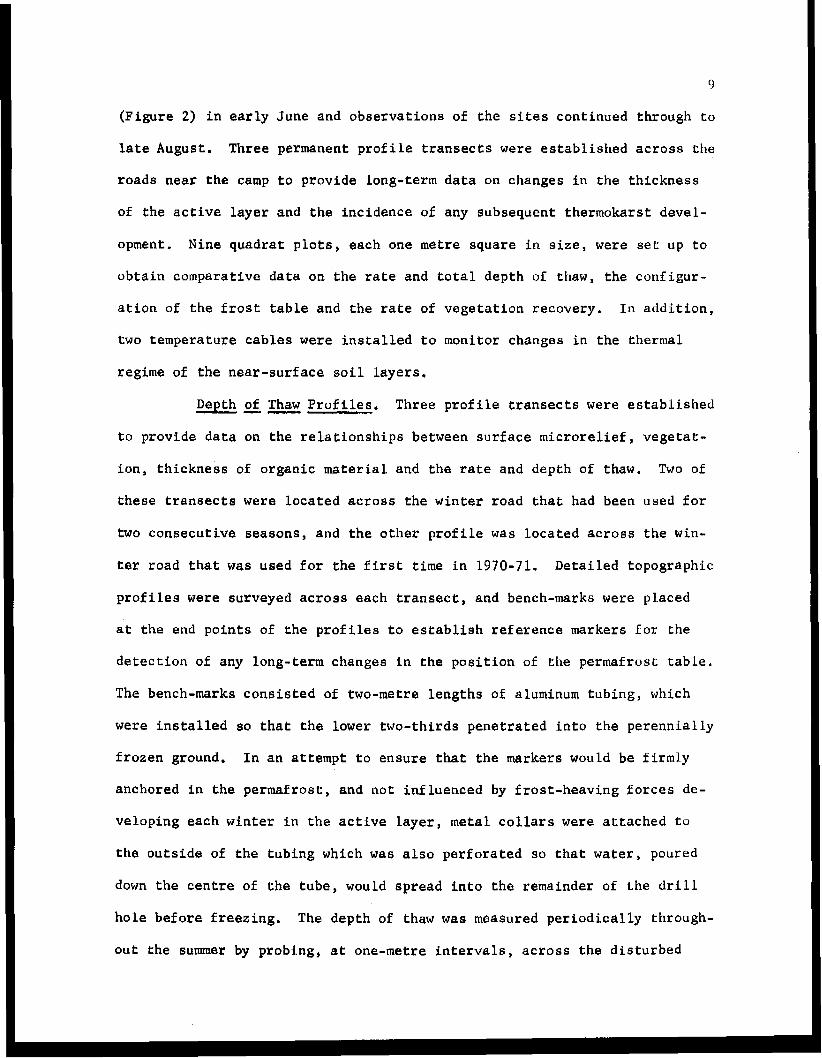
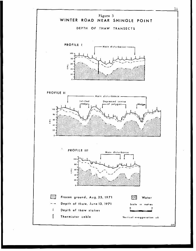
(Figure 2) i n ea r ly June and obse rva t ions of t he si tes continued through t o
l a te August. Three permanent profile t r a n s e c t s were e s t a b l i s h e d across t he
roads near the camp to p rovide long- te rm da ta on changes in the thickness
of the ac t ive l ayer and the inc idence o l any subsequent thermokarst devel-
opment. Nine quadrat p lots , each one metre square in size, were set: up t o
obtain comparative data on the rate and t o t a l d e p t h of thaw, the configur-
a t i o n of t h e f r o s t t a b l e a n d t h e rate of vege ta t ion r ecove ry . In add i t ion ,
two t empera ture cab les were ins t a l l ed t o mon i to r changes i n t he t he rma l
regime of the near -sur face s o i l l a y e r s ,
Depth of Thaw Pro f i l e s , Three p ro f i l e t r ansec t s were e s t ab l i shed
t o provide da ta on the r e l a t ionsh ips be tween su r f ace mic ro re l i e f , vege ta t -
i on , t h i ckness of organic material. and the rate and depth of thaw. Two of
t h e s e t r a n s e c t s were loca ted across t he w in te r road t ha t had been used for
two consecut ive seasons, and t h e o t h e r p r o f i l e was l oca t ed ac ross t he win-
ter r o a d t h a t was used f o r the f i r s t time i n 1970-71. Detai led topographic
p r o f i l e s were surveyed across each t ransect , and bench-marks were placed
a t the end po in t s of t h e p r o f i l e s t o e s t a b l i s h r e f e r e n c e m a r k e r s f o r the
d e t e c t i o n of any long-term changes i n t h e p o s i t i o n of the permafros t t ab le .
The bench-marks cons i s t ed of two-metre lengths of aluminum tubing, which
were i n s t a l l e d so t h a t t h e lower two-thirds penetrated into the perennia l ly
f rozen ground. In an attempt t o ensure that the markers would be f i rmly
anchored in the permafrost , and not inf luenced by f ros t -heav ing fo rces de-
veloping each win ter i n t h e a c t i v e l a y e r , metal c o l l a r s were a t t a c h e d t o
t h e o u t s i d e of t he t ub ing which was a l s o p e r f o r a t e d so t h a t water, poured
down t h e c e n t r e of t he t ube , would spread in to the remainder of t h e d r i l l
ho le before f reez ing . The depth of thaw was measured periodically through-
out the summer by probing, a t one-met re in te rva ls , ac ross the d i s turbed
10
area and a t r ep resen ta t ive po in t s i n ad j acen t und i s tu rbed si tes. The
d e t a i l s of the surface topography, and the posi t ion of t he frost t a b l e a t
the beginning and end of the observation period, are shown i n F i g u r e 3 , and
a d d i t i o n a l d a t a on the depth of thaw measurements are p r e s e n t e d i n Table I.
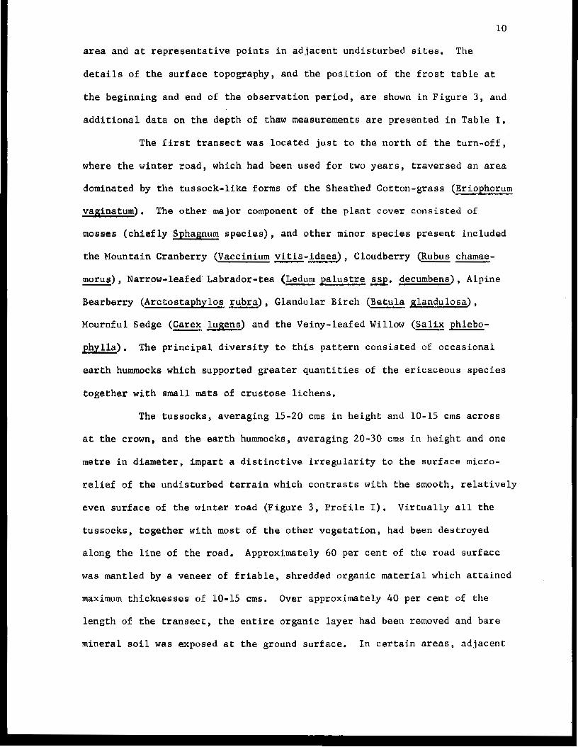
The f i r s t transect was loca ted j u s t t o t h e n o r t h of t h e t u r n - o f f ,
where the winter road, which had been used for two yea r s , t r ave r sed an area
dominated by the tussock- l ike forms of the Sheathed Cotton-grass (Eriophorum
vaginatum). The other major component of the p lan t cover cons is ted of
mosses ( c h i e f l y Sphagnum s p e c i e s ) , and o t h e r minor species present included
the Mountain Cranberry (Vaccinium vit is-idaea), Cloudberry (Rubus chamae-
- morus), Narrow-leafed Labrador-tea (Ledum palustre ssq. decumbens), Alpine
Bearberry (Arttostaphylos rubra) , Glandular Birch (Betula glandulosa) ,
Mournful Sedge (Carex - lugens) and the Veiny-leafed Willow (Salix phlebo-
phy l l a ) . The p r i n c i p a l d i v e r s i t y t o t h i s p a t t e r n c o n s i s t e d of occas iona l
e a r t h hummocks which supported greater quant i t ies of t he e r i caceous spec ie s
together with small mats of c rus tose l i chens .
The tussocks, averaging 15-20 crns i n h e i g h t and 10-15 crns ac ross
a t t h e crown, and t h e e a r t h hummocks, averaging 20-30 crns i n h e i g h t and one
metre in d i ame te r , i m p a r t a d i s t i n c t i v e i r r e g u l a r i t y t o the surface micro-
relief of the und i s tu rbed t e r r a in wh ich con t r a s t s w i th t he smooth, r e l a t i v e l y
even surface of the win ter road (Figure 3 , Profile I). V i r t u a l l y all t h e
tussocks , toge ther with most of t he o the r vege ta t ion , had been destroyed
a long t he l i ne of the road. Approximately 60 per cen t of the road sur face
was mantled by a veneer of f r i ab le , sh redded o rgan ic material which a t ta ined
maximum th icknesses of 10-15 crns. Over approximately 40 per cent of the
length of t h e t r a n s e c t , t h e e n t i r e o r g a n i c layer had been removed and bare
mineral s o i l was exposed a t t h e ground sur face . In cer ta in areas, ad jacent
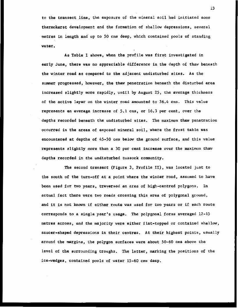
D E P T H OF T H A W T R A N S E C T S
P R O F I L E I M a i n d i s t u r b a n c e 1
P R O F I L E I1 M a i n d i s t u r b a n c e
I n f b l l e d D e p r e s s e d c e n t r e
" P R O F I L E I l l M a i n d i s t u r b a n c e
a Frozen g r o u n d , A u g . 2 5 , 1971 W a t e r
-.- D e p t h o f t h a w , J u n e 13, 1971 S c a l e in m e t r e s
0 -5 I D e p t h o f t h a w s t a k e s
I T h e r m i s t o r cab le V e r t i c a l e x a g g e r a t i o n x 6
dek
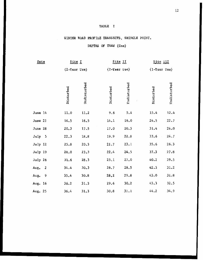
Date -
June 14
June 21
June 28
July 5
J u l y 12
July 19
J u l y 26
Aug. 2
hug. 9
Aug. 16
Aug. 25
12
TABLE I
WINTER ROAD PROFILE TRANSECTS, SHINGLE POINT,
DEPTHS OF T H A W (Cms)
Si te I "
(2-Year Use)
" Site I1
(2 -Year use)
Site I11
(1-Year Use)
"
a aJ $4 & 3
cn -4
P
c3 3 d
11.0 11.2
16.5 16.5
20.3 17.5
22.3 18.8
25.8 20 .3
28.0 23.3
3 1 . 6 28.3
3 4 . 4 30.3
3 5 . 4 30.8
3 6 . 2 31.3
36.4 31.3
9 . 6 9.4
14.1 16.0
17.0 20.5
19.9 2 2 . 8
21 .7 23.1
22 .4 2 4 . 5
25.1 27 .0
26.7 28-5
28.2 29.8
2 9 . 6 30.2
30.8 3 1 . 1
15.4 1 2 . 4
24.5 22.7
3 1 , 4 24 .0
33.6 24.7
3 5 . 6 2 6 . 3
37 * 3 27.8
40.2 29.5
4 2 . 3 31.2
4 3 . 0 31.8
4 3 . 3 32.5
44.2 3 4 . 9
13
t o t h e t r a n s e c t l i n e , the exposure of the minera l soil had i n i t i a t e d some
thermokarst development and the formation of sha l low depress ions , severa l
metres i n l e n g t h and' up t o 50 crns deep, which contained pools of s tanding
water.
As Table I shows, when the p r o f i l e was f i r s t i n v e s t i g a t e d i n
e a r l y June, t h e r e was no apprec iab le d i f f e rence i n the depth of thaw beneath
the winter road as compared t o the adjacent undis turbed sites. A s t h e
summer progressed, however, the thaw penetration beneath the disturbed area
increased s l ight ly more r a p i d l y , u n t i l by August 25, the average th ickness
of t h e a c t i v e l a y e r on the w in te r road amounted t o 36.4 crns. This va lue
r ep resen t s an average increase of 5.1 crns, o r 16.3 per cen t , over the
depths recorded benea th the undis turbed sites. The maximum thaw pene t r a t ion
occurred i n t h e areas of exposed mineral s o i l , where t h e f r o s t table was
encountered at depths of 45-50 crns below the ground surface, and this value
r e p r e s e n t s s l i g h t l y more than a 30 per cent increase over the maximum thaw
depths recorded in the undis turbed tussock community.
The second t ransect (Figure 3 , P r o f i l e 11), was loca ted j u s t t o
the south of the tu rn-of f a t a point where the winter road, assumed t o have
been used f o r two yea r s , t r ave r sed an area of high-centred polygons. In
a c t u a l fact t h e r e were two r o a d s c r o s s i n g t h i s area of polygonal ground,
and it is n o t known i f either r o u t e was used for two yea r s or i f each r o u t e
cor responds to a s ing le yea r ' s u sage . The polygonal forms averaged 12-15
metres ac ross , and t h e majority were e i the r f l a t - topped o r con ta ined shallow,
saucer-shaped depressions i n t h e i r c e n t r e s . A t their highest: p o i n t s , usua l ly
around the margins, the polygon surfaces were about 50-60 crns above t h e
l e v e l of the surrounding t roughs. The latter, marking the posi t ions of t h e
ice-wedges, contained pools of water 15-60 crns deep.
14
The dominant vascular species growing on t h e r a i s e d c e n t r e s of
t h e t u n d r a polygons inc luded the Glandular Bi rch (Betu la g landu1osa) ,
Narrow-leafed Labrador-tea (Ledum p a l u s t r e ssp. decumbens), Cloudberry
(Rubus - chamaemorus), Mountain Cranberry (Vaccinium vitis-idaea) and Common
Crowberry (Empetrum nigrum). Various lichen and moss species also formed
an almost continuous ground cover. Some of t h e more moist areas i n t h e
central p a r t s of t h e polygons supported small tussocks of the Sheathed
Cotton-grass (Eriophorum vaginaturn). Sedge spec ie s , pa r t i cu la r ly t h e
Aquatic Sedge (Carex aquatllls), Cormnon Cotton-grass (Eriophorum angusti-
folium) and the Arct ic Cot ton-grass (E. scheuchzeri) , and mosses were the
p r i n c i p a l components of the vegetat ion growing a long the lines of the i ce -
wedges.
"
The most o b v i o u s e f f e c t s of t h e t e r r a i n disturbance cons i s t ed of
an a lmost complete d e s t r u c t i o n of the sur face vege ta t ion , cover , over a width
of approximately 20 metres, and an exposure of t he unde r ly ing o rgan ic
material. Some organic matter was a l so s c raped from t he tops of t h e poly-
gons since many of t h e wedge l ines were filled wi th up t o 20-30 crns of
shredded peat. I n places, the edges of the polygons had been more heavi ly
damaged, and larger blocks of peat had been dislodged from the sides i n t o
the ad jacent t roughs .
The depth of thaw measurements shown i n F i g u r e 3 ( P r o f i l e 11)
and Table L i n d i c a t e that t h e removal of t h e v e g e t a t i o n l a y e r had l i t t l e
o r no effect on the t h i ckness of the ac t ive l ayer . Throughout most of t h e
summer, t he ave rage thaw dep th i n t he und i s tu rbed s i tes was 2-3 crns g r e a t e r
t h a n t h a t i n t h e d i s t u r b e d areas, but by l a t e A u g u s t t h e d i f f e r e n t i a l
amounted t a less than 0.5 crns. S i n c e t h e t y p i c a l s u b s t r a t e i n these poly-
gonal areas c o n s i s t s of thick accumulat ions of peat material, the absence
15
of any marked d i f f e r e n t i a l i n the depth of thaw i s perhaps t o be expected,
p a r t i c u l a r l y as t he f rozen peat o f t e n c o n t a i n s s u b s t a n t i a l q u a n t i t i e s of
ice. The high heat capac i ty of t h i s material, toge the r w i th t he i n su la t ing
propertie's of t h e o r g a n i c a c t i v e layer, would m i t i g a t e a g a i n s t any r ap id
changes i n the t h i cknees of the thawed zone. The slow response to any
augmented heat i n f l u x i n t o t h e ground may accoun t fo r t he s l i gh t ly l ower
depth of thaw i n the d i s tu rbed areas a t the end of the observa t ion per iod .
The t h i r d t r a n a e c t ( F i g u r e 3 , P r o f i l e 111), was s i t u a t e d just t o
the west of the turn-off on t h e new winter r o a d , b u i l t i n 1970-71, t o move
t h e rig and camp t o t h e N-58 site, The t r a n s e c t was loca ted on t h e floor
of a f l a t t e r r a c e s u r r o u n d e d by low bluf fs , and the vege ta t ion cover was
similar t o t h a t d e s c r i b e d for the f i r s t p r o f i l e study, The dominance of
the Eriophorum tussocks was less pronounced however, and there was an
i n c r e a s e i n t h e area of earth hummock forms.
The main d i s tu rbed area was approximately 5 metres i n wid th , and
the impressions of t h e tracks were 5-10 cms below the level of t h e
su r round ing t e r r a in , Bare mineral s o i l was exposed over about 45 per cen t
of the wid th of t hese tracks, and the remaining areas were mantled with a
layer of shredded organic material wi th l i t t l e or no l iv ing p l an t cove r .
The less d i s tu rbed areas on e i t h e r s i d e of t h e main t racks conta ined iso-
lated patches of exposed organic material and mineral s o i l , but most of t h e
su r face was l i t t e r e d with broken tussocks and other fragmented plant debris.
The depth of thaw measurements i n F i g u r e 3 (Profile 111) and
Table I r e f l e c t t h e effects of t h e d e s t r u c t i o n of t he vege ta t ion l aye r .
Although t he re was no apprec iab le d i f f e rence i n the t h i ckness of t h e a c t i v e
l a y e r i n the disturbed and undis turbed sites i n t h e middle of J u n e , t h e
average depth of thaw benea th the sur face of the win ter road was i n excess
16
of 44 cms by the end of the summer: a value which corresponds to a 9 . 3 CmS
or 27 per cent increase over the average thaw depths in the vegetated areas.
The maximum thaw penetration in the disturbed area, amounting to 52 crns in
the bare mineral soil patches, however, represents an approximate increase
of only slightly more than 15 per cent over the maximum depths of thaw
recorded in the earth hummock areas in the undisturbed sites.
The greater average increase in the thickness of the active layer
iri the winter road which was used for only one year, as compared to the
road followed for two years, suggests that the re-use of these access routes
has not resulted in any real intensification of the topographic aspects of
the terrain disturbance. On the other hand, it should be noted that the
extent of the more severely disrupted areas in the winter road used for only
one year averaged less than one-third of the width of similar areas on the
roads which were re-used, Moreover, the combination of the narrower width
involved, the slightly higher proportion of exposed mineral soil, and the
possibility that a larger percentage of the road surface may have traversed
earth-hummock structures could limit the statistical v a l i d i t y of the data
obtained. To some extent, this problem could have been alleviated by more
extensive sampling and the establishment of additional transects, but the
scope of the f i e l d programme posed restrictions on this possibility. More-
over, as in a l l post-mortem studies, the difficulty of determining the
precise pre-disturbance conditions still presents the greatest obstacle t o
any rigaurous evaluation of the extent of 'the damage to the terrain.
Quadrat Studies. In addition t o the observations of the three
depth of thaw transects, a number of quadrats, each measuring one metre
square, was established by Dr. Lambert to investigate the impact of the
winter road operations on the vegetation communities. Nine of these
1 7
quadra t s were selected fo r fu r the r compara t ive s tud ie s of changes i n t h e
conf igu ra t ions of t h e s u r f a c e microrelief and t h e frost t a b l e . For each
quadra t , t he su r f ace con tour s were measured by e r e c t i n g a h o r i z o n t a l frame,
graduated in dec imet res , over the p lo t and tak ing plumb r e a d i n g s t o t h e
ground surface on a 10 cma grid pa t t e rn . Th i s same network of po in t s was
used t o o b t a i n data on t h e t h i c k n e s s of t h e active layer which was probed
on a two-weekly b a s i s over the period June 18 t o August 13, and again on
August 25.
At the end of tha f i e l d season, a s tandard total a€ 700 d a t a
values, 100 for the s u r f a c e microrelief and 600 f o r t h e p o s i t i o n of t h e
f r o s t t a b l e , had been col lected for each metre quadrat. These va lues were
processed us ing the SYM4P computer mapping programme, developed by t h e
Laboratory for Computer Graphics at Narvard Universi ty , t o produce the
series of contour maps shown i n F i g u r e s 4-12. As far as poss ib le , each of
t h e s e maps wag drawn us ing a 2.5 cms contour in te rva l , a l though i n two
cases, Quadrats 'Dl and ' G I , t h e extreme range of va lues ob ta ined necess i -
tated a depa r tu re from this e tandard procedure and the use of a 5.0 cms
con tour i n t e rva l t o i l l u s t r a t e t h e p o s i t i o n and configurat ion of the f r o s t
t a b l e . I n i n t e r p r e t i n g t h e s e maps, it is important t o n o t e t h a t s i n c e t h e
i s o l i n e 8 r e p r e s e n t the depth of t h e frozen ground beneath the ground surface,
the h igher va lues thus cor respond t o d e p r e s s i o n s i n t h e f r o s t t a b l e .
S t a t i s t i c a l d a t a , i n c l u d i n g t h e mean, maximum, minimum, s tandard deviation
and c o e f f i c i e n t of v a r i a t i o n of t h e d e p t h s of thaw at s e l e c t e d times
throughout the summer, are summarized f o r each quadra t i n Table 11.
Four of t h e q u a d r a t s were l oca t ed t o t h e n o r t h of t h e t u r n - o f f ,
in and adjacent t o t h e w i n t e r r o a d t h a t had been used i n 1969-70 and again
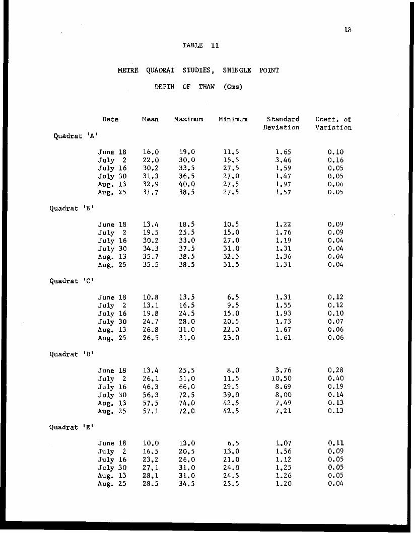
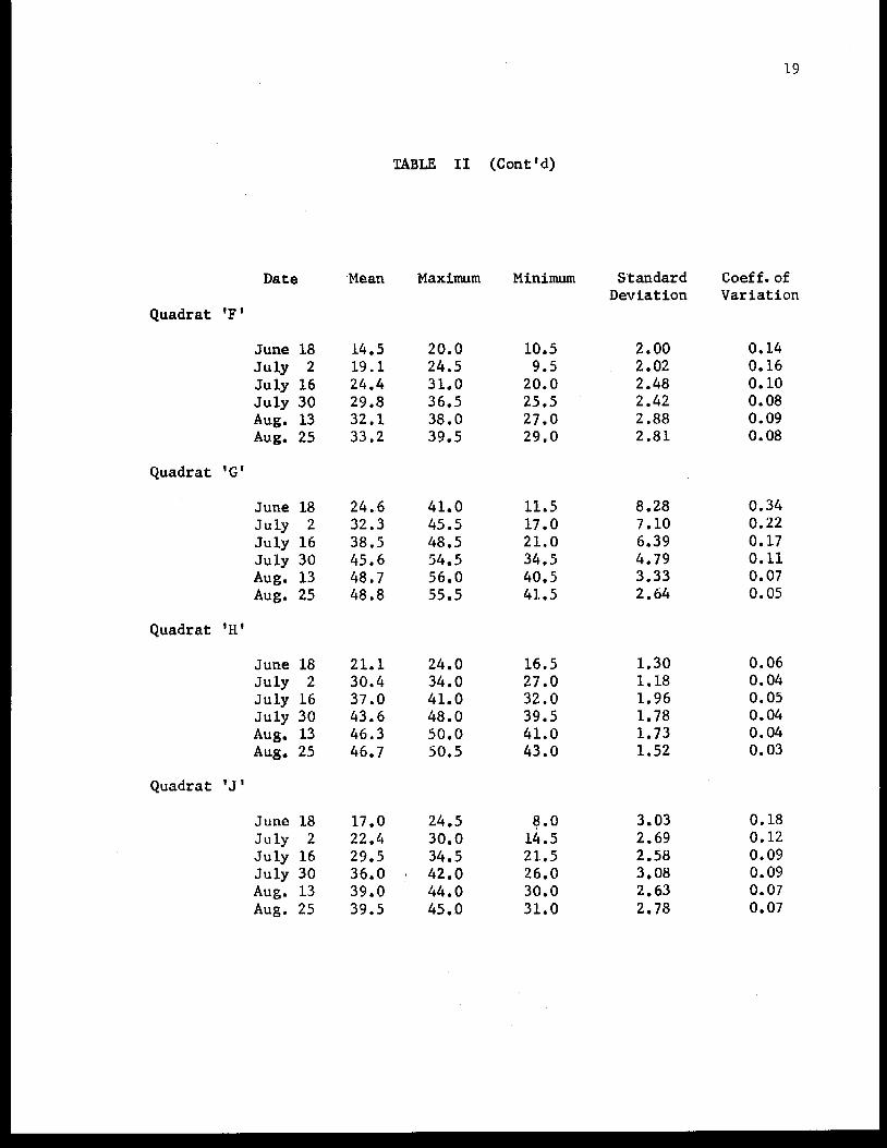
TABLE 11
METRE QUADMT STUDIES, SHINGLE
Date
Quadrat 'A
June 18 J u l y 2 J u l y 16 July 30 Aug. 13 Aug. 25
Quadrat 'B '
June 18 July 2 July 16 J u l y 30 Aug. 13 Aug. 25
Quadrat 'C'
June 18 July 2 July 16 July 30 Aug. 13 Aug. 25
Quadrat ID'
June 18 J u l y 2 July 16 July 30 Aug, 13 Aug. 25
Quadrat ' E
June 18 July 2 July 16 July 30 Aug. 13 Aug. 25
DEPTH OF THAW (Cms)
Mean
16.0 22.0 30.2 31.3 32.9 31.7
13.4 19.5 3 0 , 2 3 4 . 3 35.7 35.5
10.8 13.1 19.8 24.7 26.8 26.5
13.4 26.1 46.3 56.3 57,5 57,l
10.0 16.5 23.2 27.1 28.1 28.5
Maximum
19.0 30.0 33.5 36.5 40.0 38.5
18.5 25.5 33.0 37.5 38.5 38.5
13.5 16.5 24.5 28.0 31.0 31.0
25.5 51.0 66.0 72.5 74.0 72.0
13.0 20.5 26.0 31.0 31.0 34.5
M in imum
11.5 15.5 27.5 27.0 27.5 2 7 . 5
10.5 15.0 27.0 31.0 32,5 31.5
6.5 9.5
1 5 . 0 20 .5 2 2 . 0 23 .0
8.0 11.5 29.5 39.0 42,5 42.5
6.5 13.0 21.0 24.0 24.5 2 5 . 5
POINT
Standard Deviation
1.65 3 .46 1.59 1.47 1.97 1.57
1.22 1.76 1.19 1.31 1.36 1.31
1.31 1.55 1 .93 1.73 1.67 1.61
3 ,76 10.50 8.69 8.00 7 . 4 9 7 . 2 1
1.07 1.56 1.12 1.25 1.26 1.20
Coeff. of Variation
0.10 0.16 0,05 0.05 0.06 0.05
0.09 0.09 0,04 0.04 0.04 0 .04
0.12 0.12 0.10 0.07 0.06 0.06
0.28 0.40 0.19 0 . 1 4 0.13 0 . 1 3
0.11 0.09 0.05 0.05 0.05 0.04
Date
Quadrat 'F
June 18 J u l y 2 July 16 July 30 Aug. 13 Aug. 25
Quadrat 'G'
June 18 July 2 July 16 July 30 Aug. 13 Aug. 25
Quadrat 'H'
June 18 July 2 July 16 July 30 Aug. 13 Aug. 25
Quadrat ' J I
June 18 July 2 July 16 July 30 Aug. 13 Aug. 25
Mean
14.5 19.1 24.4 29.8 32.1 33.2
24.6 32.3 38.5 45.6 48.7 48.8
21.1 30.4 37.0 43.6 46.3 46.7
17.0 22.4 29.5 36.0 39.0 39.5
TABLE I1 (Cont Id)
Maximum
20.0 24.5 31.0 36.5 38.0 39.5
41.0 45.5 48.5 54.5 56.0 55.5
24.0 34.0 41.0 48.0 50.0 50.5
24.5
34.5 42.0 44.0 45.0
30.0
Minimum
10.5 9.5 20.0 25.5 27.0 29 .0
11.5 17.0 21.0 34.5 40.5 41.5
16.5 27 .O 32.0 39.5 41.0 43.0
8.0 14.5 21.5 26.0 30.8 31.0
S.tandard Deviation
2.00 2.02 2.48 2.42 2.88 2.81
8.28 7.10 6.39 4.79 3.33 2.64
1.30 1.18 1.96 1.78 1.73 1.52
3.03 2.69 2.58 3.08 2.63 2.78
19
Coef f. of Variation
0.14 0.16 0.10 0.08 0.09 0.08
0.34 0.22 0.17 0.11 0.07 0.05
0.06 0.04 0.05 0.04 0.04 0.03
0.18 0.12 0.09 0.09 0.07 0.07
20
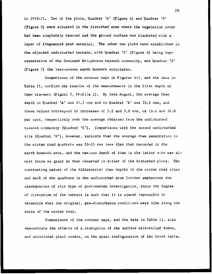
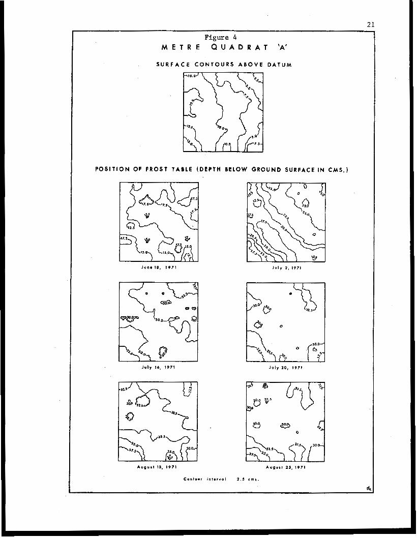
in 1970-71. Two of t h e plots, Quadrat ' A ' (Figure 4 ) and Quadrat 'B'
(Figure 5) were situated in the disturbed area where t h e vegetation cover
had been completely removed and the ground surface was blanketed with a
layer of fragmented peat material. The o the r two plots were established in
the adjacent undisturbed terrain, with Quadrat ' C ' (Figure 6) being rep-
resentative of the dominant Eriophorum tussock community, and Quadrat 'D'
(Figure 7) the less-common earth hummock structures.
Comparisons of the contour maps in Figures 4 - 7 , and the data in
Table 11, confirm the results of the measurements in the f i r s t depth of
thaw transect (Figure 3 , Profile I). By late August, the average thaw
depth in Quadrat ' A ' was 31.7 cms and in Quadrat 'El was 35.5 crns, and
these values correspond to increases of 5.2 and 9.0 crns, o r 19.6 and 34.0
per cen t , r e s p e c t i v e l y over the average obtained from t h e undisturbed
tussock community (Quadrat I C ' ) . Comparisons wi th the second undisturbed
site (Quadrat 'D'), however, indicate that the average thaw penetration in
the winter road quadrats was 20-25 crns less than that recorded in the
earth hummock area, and the maximum depth of thaw in the latter site was al-
most twice as great as that observed in either of the disturbed plots. The
contrasting nature of the differential thaw depths in the winter road sites
and each of the quadrats in the undisturbed area further emphasizes the
inadequacies of this type of post-mortem investigation, since the degree
of disruption of the terrain is such that it is almost impossible to
determine what the original, pre-disturbance conditions were like along the
route of the winter road.
Comparisons of the contour maps, and the data in Table 11, also
demonstrate the effects of a disruption of the surface microrelief forms,
and associated plant covers, on the areal configuration of the frost table.
21
Figure 4 M E T R E Q U A D R A T ‘A’
S U R F A C E CONTOURS A B O V E D A T U M
P O S I T I O N OF F R O S Y TABLE (DEPTH BELOW GROUND S U R F A C E IN CMS. )
June 18 , 1971 J u l y 2 , 1971
J u l y 16, 1971 July 3 0 , 1971
A u o u r t 13, 1971 A u g u s t 23. 1971
Contour intmrval 1 . 5 c m r .
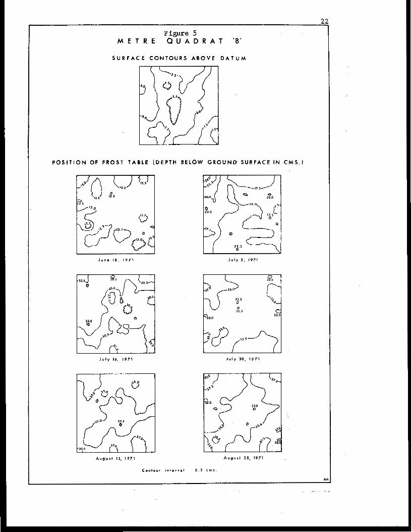
Figure 5 M E T R E Q U A D R A T ‘B ’
S U R F A C E C O N T O U R S A B O V E D A T U M
P O S I T I O N OF FROST T A B L E ( D E P T H BELOW G R O U N D SURFACE IN C M S . )
I 2 3
I J u n e IS. 1 9 7 1 J u l y 2 , 1971
J u l y 14, 1 9 7 1 J u l y 3 0 , 1 9 7 1
A u g u s t 13. 1971 A u g u r 1 25, 1971
Contour i n 1 e r v . 1 2 . 5 c m s .
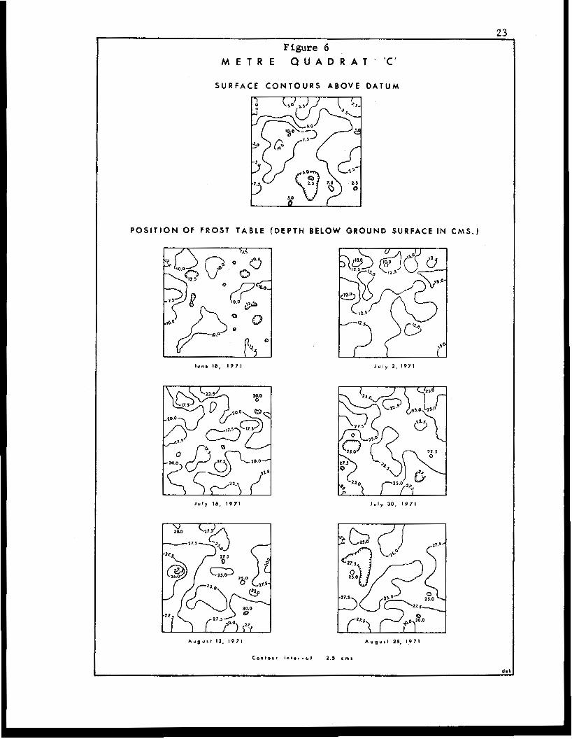
Figure 6 M E T R E Q U A D R A T ' K '
S U R F A C E C O N T O U R S A B O V E D A T U M
POSITION OF F R O S T T A B L E ( D E P T H BELOW G R O U N D S U R F A C E IN C M S . )
l u n a 18, I971 J u l y 2 , I971
l u l y 16, 1 9 7 1 l u l y 3 0 , 1 9 7 1
A u g u s t 13. I971 A u p u r l 25, 1 9 7 1
c o n t o u r I " l * , Y . l 2 . 5 c m ,
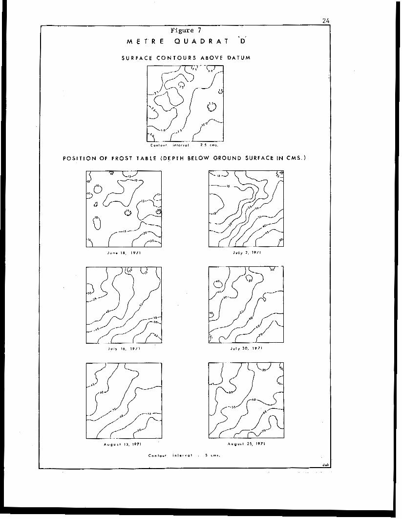
Figure 7
M E T R E Q U A D R A T 'D'
S U R F A C E C O N T O U R S A B O V E D A T U M
c o n t o u r i n t e r Y O l . 2 . 5 c m ,
POSIT ION OF FROST T A B L E ( D E P T H BELOW G R O U N D S U R F A C E IN C M S . )
J u n e 18, 1 9 7 1
J u l y 10, 1 9 7 1
A u g u s t 13, 1971 A u g u s t 25, 1971

25
I n the undis turbed si tes, variations in t h e m i c r o r e l i e f f a c t o r , t y p e of
vege ta t ion cover, and amount of organic material i n t h e s u b s t r a t e , combine
t o i m p a r t a n i r r e g u l a r topography t o t h e top of the frozen ground. In
gene ra l , t he uppe r su r f ace of the f rozen ground occurs a t greater depths
under e levated portions of the ground surface, as i n t he t u s sock and ea r th
hummock forms, and where the s u b s t r a t a is composed primarily of mineral
s o i l . Conversely, t h e lowest depths of thaw occur beneath the depressions
i n t h e ground surface which also usua l ly correspond to the sites of g r e a t e r
accumulations of organic material. The i n f luence of t h e s e f a c t o r s i s re-
f l e c t e d i n t h e i r r e g u l a r n a t u r e , and number of c losed depress ions , of t h e
con tour pa t t e rns for the upper surface of the frozen ground, and the higher
c o e f f i c i e n t of v a r i a t i o n i n the depths of chaw (Table 11) , i n t he und i s tu rbed
sites of Quadra ts ' C ' and 'D' (Figures 6 and 7). The r e l a t i v e c o m p l e x i t i e s
of t h e s e c o n t o u r p a t t e r n s c o n t r a s t with t he s imp le r na tu re of t h e i s o l i n e s ,
i n d i c a t i n g a more uniform depth of thaw, exhibited by t he quadra t s l oca t ed
i n the d i s tu rbed area (Figures 4 and 5 ) .
Two of the quadra t s were loca ted i n and adjacent t o the sec t ion
of t he w in te r road t r ave r s ing t he area of high-centred polygons descr ibed
i n t h e second depth of thaw t r ansec t (F igu re 3 , P r o f i l e 11). One of t h e
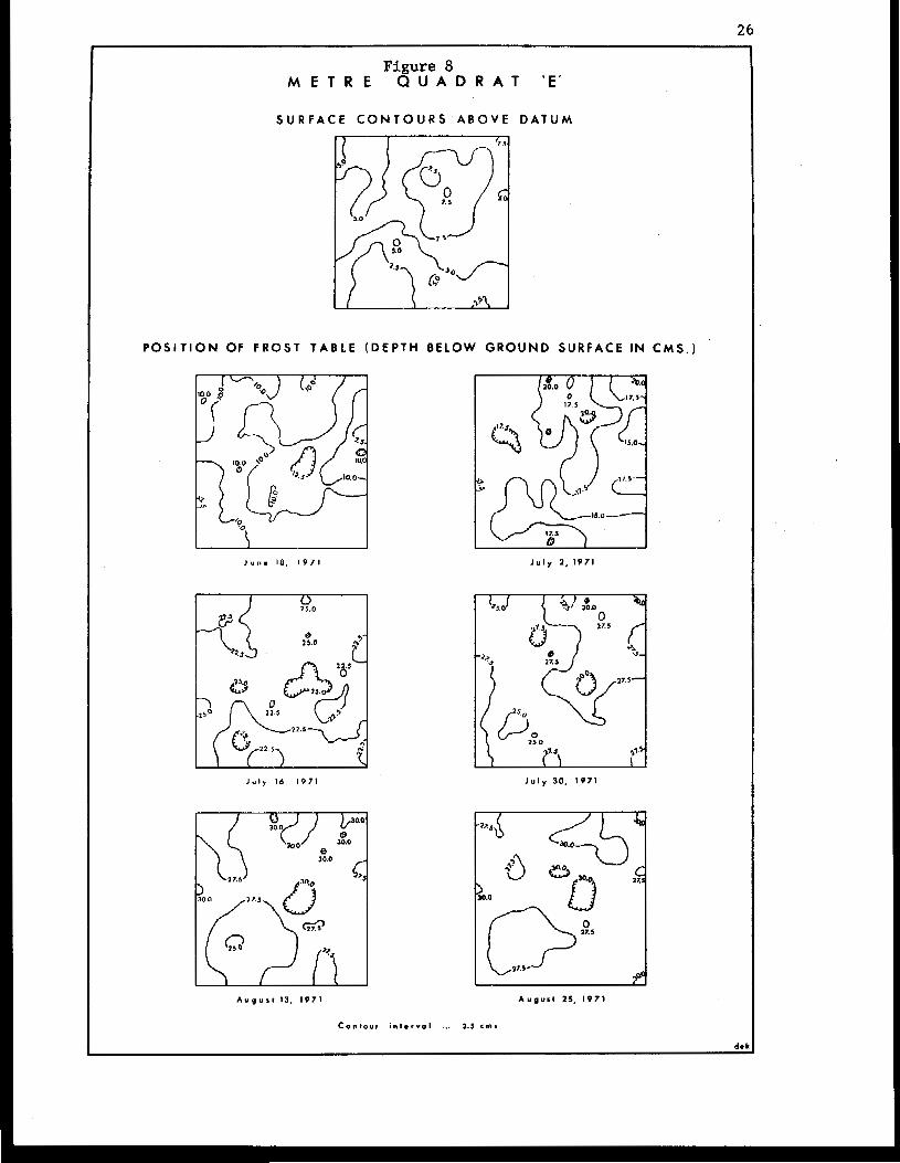
plots, Quadrat ' E ' (F igure 8 ) was e s t a b l i s h e d on t h e d i s t u r b e d area, where
t h e ground su r face cons i s t ed of bare o rganic material from which t h e plant
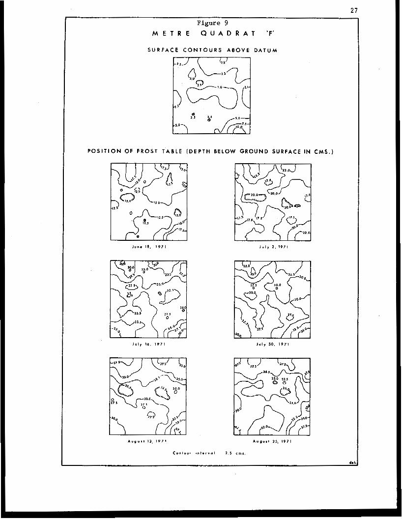
cover had been completely removed. The o t h e r si te, Quadrat 'F' (Figure 9),
was e s t a b l i s h e d on an undis turbed sur face of a polygon where the principal
components o€ the vege ta t ion cons i s t ed of l i c h e n s and mosses t oge the r w i th
a few er icaceous spec ies .
The results obtained f rom camparat ive s tudies of t h e s e two
quadra ts agree closely wi th t he observations i n t he dep th of thaw transect :
26
Fi ure 8 M E T R E 8 U A D R A T ' E '
SURFACE C O N T O U R S A B O V E D A T U M
POSITION OF FROST T A B L E (DEPTH BELOW GROUND SURFACE I N C M S . )
J u l y 16, I971
A u g u s t 13. I971
J u l l 2 , 1971
J u l y 30, IS71
A u g u I I 25. I971
C o n t o u r i n t o r v o l ... 2.5 c m r
27
Figure 9 M E T R E Q U A D R A T 'F '
P O S I T I O N OF F R O S T T A B L E (DEPTH BELOW GROUND S U R F A C E IN C M S . )
Junm 18. 1 9 7 1 J u l y 2 , 1971
J u l y I d , 1 9 7 1 J u l y 30, 1 9 7 1
A u g u s l 13 , 1 9 7 1 August 25, I V 7 1
Conlour ~ n t . r v o l 2 . 5 ems.
28
which was l o c a t e d i n t h e same gene ra l area. Throughout the summer, t h e
average thaw p e n e t r a t i o n i n t h e u n d i s t u r b e d s i t e (Quadrat IF') was s e v e r a l
cen t ime t re s greater than tha t recorded i n the und i s tu rbed area. Whereas
the t r a n s e c t s t u d y i n d i c a t e d t h a t this d i f f e r e n t i a l was v i r t u a l l y e l i m i n a t e d
by late August, however, t he quadra t measurements showed t h a t , a t t h e end of
t h e summer, the average th ickness of t h e a c t i v e layer i n t he vege ta t ed s i t e
was 4.7 cms, or 16.0 per cent, greater t han t ha t benea th t he surface of t h e
win te r road. A B Figures 8 and 9 also show, t h e g r e a t e r d i v e r s i t y of the
ground surface cond i t ions in the undis turbed s i te (Quadrat IF') con t r ibu ted
t o a more complex p a t t e r n of thaw depths as is i nd ica t ed by t h e i r r e g u l a r
contour pa t te rns of t h e f r o s t t a b l e i l l u s t r a t e d in Figure 9. These p a t t e r n s
aga in contrast w i t h t h e much s impler conf igura t ion of t h e upper s u r f a c e of
the frozen ground under the more u n i f o r m t e r r a i n c h a r a c t e r i s t i c s of Quadra t
'E ' i n t h e winter road s i te (F igure 8). F u r t h e r i n d i c a t i o n of t h e c o n t r a s t -
i n g n a t u r e of t h e thaw p e n e t r a t i o n s is contained i n Table 11, where the
c o e f f i c i e n t of v a r i a t i o n s t a t i s t i c s show that , even at t h e end o f . t h e
summer, t h e relative d i spe r s ion i n the depths of thaw i n the undis turbed
s i te was exac t ly tw ice as much as t h a t i n t h e d i s t u r b e d area.
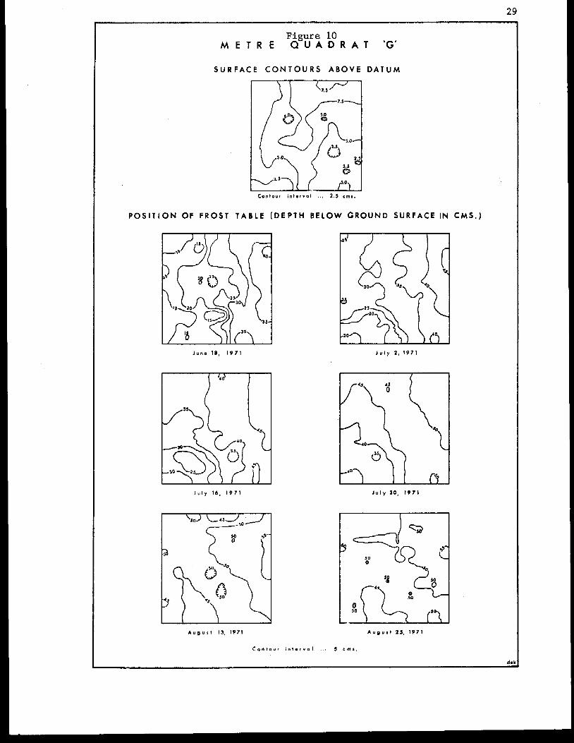
The final three quadra t s were loca ted i n and ad jacen t t o a s e c t i o n
of t he w in te r road used f o r t h e first time i n t h e w i n t e r of 1970-71. Two
of the quadra t s , Quadrat 'G' (F igure 10) and Quadrat 'H' (Figure 11) were
e s t a b l i s h e d on t h e d i s t u r b e d area. Quadrat 'G' was s i t u a t e d on one of t h e
most seve re ly d i s rup ted s ec t ions of the access route , where approximately
one- th i rd of t h e s u r f a c e area of t h e p l o t cons i s t ed of exposed mineral soi l
and the remainder was covered with a layer of loose, shredded organic
material. The e n t i r e surface of Quadrat 'H' was mantled by a l a y e r of
similar organ ic material which, by late August, supported a s p a r s e
29
Figure 10 M E T R E Q U A D R A T 'G'
S U R F A C E C O N T O U R S ABOVE DATUM
POSITION OF F R O S T TABLE (DEPTH BELOW GROUND SURFACE IN C M S . )
J u n e 18, 1971 J u l y 2 , 1971
J u l y t6 , 1 9 7 1 J u l y 3 0 , t 9 7 t
A u n u l t 13. t97 t A u ~ u s l 25. 1971
C o n t o u t i n t - r v o l .- . 5 c m ~ .
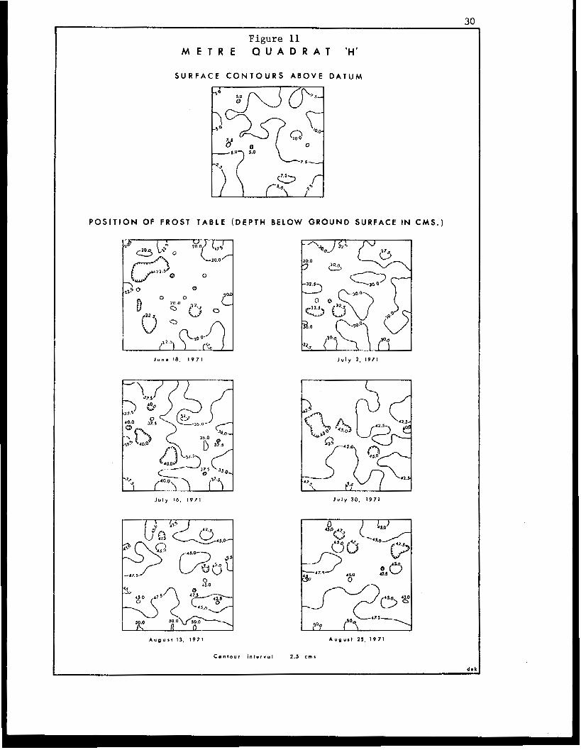
Figure 11 M E T R E Q U A D R A T ’H’
S U R F A C E C O N T O U R S A B O V E DATUM
P O S I T I O N OF FROST T A B L E ( D E P T H BELOW GROUND SURFACE IN C M S . )
Juris 18, 1 9 7 1 J u l y 2 , 1971
J u l y IO, 1971 J u l y 3 0 , 1 9 7 1
0 45.0
A u g u r , 13. 1971 A u g u s t 25 . 1 9 7 1
C o n t o u r i n r o r v o l 2.S c m *
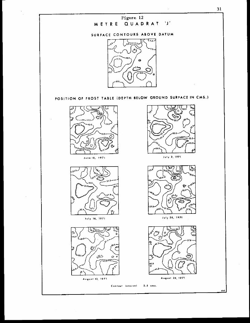
Figure 12 M E T R E Q U A D R A T ' J '
S U R F A C E C O N T O U R S A B O V E D A T U M
POSITION OF F R O S T T A B L E ( D E P T H BELOW GROUND S U R F A C E IN C M S . )
June ! e , 1971 J u l y 2 , 1971
J u l y 14, 1971 J u l y 3 0 . I971
32
vegetat ion cover that included the Sheathed Cot ton-grass (Eriophorum
vaginaturn), Cloudberry (Rubus - chamaemorus), Aquatic Sedge (Carex a q u a t i l i s ) , Narrow-leafed Labrador-tea (Ledum palustre ssp. decumbens) and Sphagnum.
The th i rd p lo t , Quadra t 'J' (Figure 12), was e s t a b l i s h e d i n t h e a d j a c e n t
undis turbed area cha rac t e r i zed by Eriophorurn tussocks, which accounted for
35-40 per can t of t he vascu la r spec ie s p re sen t , and subdued e a r t h hummocks
which supported such species as the Cloudberry, Glandular Birch (Betula
Klandulosa), Mountain Cranberry (Vaccinium vit is-idaea), Qonunon Crowberry
(Empetrum and the Narrow-leafed Labrador-tea. The depress ions ,
between t h e tussocks and earth hummocks, a l s o c o n t a i n e d s i g n i f i c a n t quan-
t i t ies of moss ( c h i e f l y Sphamurn species) i n t h e i r v e g e t a t i o n cover.
Comparat ive s tudies of t hese t h ree quadra t s also a g r e e c l o s e l y
w i t h t h e results of obse rva t ions i n t he dep th of thaw t r a n s e c t (Figure 3 ,
P r o f i l e 111). The thaw penetrat ion proceeded more rap id ly , and t o g r e a t e r
depths , benea th the darker , unvegeta ted sur faces of t h e p l o t s on the win ter
road , so t h a t by t h e end of t h e summer, t h e mean th i ckness of t h e a c t i v e
l a y e r i n Quadrats 'G' and 'H' was r e s p e c t i v e l y 9 . 3 and 7.2 cms, o r 23.5 and
18.2 per cen t , g rea t e r t han t he ave rage thaw depth in t he und i s tu rbed s i te
(Quadrat 'J'), The s l i g h t l y h i g h e r i n c r e a s e i n t h e th i ckness of t h e a c t i v e
l a y e r , a n d t h e l a r g e r r e l a t i v e d i s p e r s i o n of t h e thaw values (see Table II),
in Quadra t I G ' , as compared to t he o the r p lo t (Quadra t 'HI) i n t h e d i s t u r b e d
area, can be accounted for by the occurrence of bare mineral s o i l a t t h e
g round su r f ace i n t h i s site. As Figures 10-12 show, t h e i n f l u e n c e of
changes i n t h e d i v e r s i t y of t h e s u r f a c e c h a r a c t e r i s t i c s i s again r e f l e c t e d
i n t he conf igu ra t ion of the upper surface of the frozen ground, with the
more complex , i r regular contour pa t te rns of t h e f r o s t table' beneath the
undis turbed surface forming a marked c o n t r a s t with t he s imp le r , more
33
uniform thaw depths in t he quadra t s l oca t ed on the win ter road .
The depth of thaw measurements i n t h e q u a d r a t s t u d i e s are
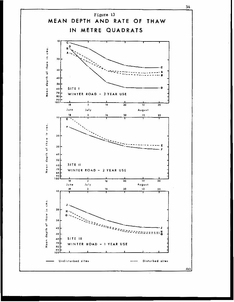
sumnwrized i n F i g u r e 13 which shows the changes i n t he mean thaw depths f o r
each quadra t ove r t he en t i r e obse rva t ion pe r iod . Wi th t he excep t ion of
S i t e 11, loca ted on the area of high-centred polygons, and the ear th hummock
q u a d r a t i n S i t e I , it can readi ly be observed that t h e d e s t r u c t i o n of t h e
vege ta t ion cover and su r face mic ro re l i e f forms, r e s u l t i n g from t h e con-
s t r u c t i o n af the winter roads, has produced a p r e d i c t a b l e i n c r e a s e i n t h e
thaw depths benea th the d i s turbed areas. However, whereas the observat ions
of t h e t r a n s a c t s i n d i c a t e d that a re-use of t h e access routes did not con-
t r i b u t e t o any real i n t e n s i f i c a t i o n of the topographic effects of t h e
t e r r a i n d i s t u r b a n c e , t h e d a t a from the quadra t s tud ie s would a p p e a r t o
s u g g e s t t h a t t h i s i s no t t he ca se . As Figure 13 i l l u s t r a t e s ,
wi th the quadra ts loca ted in the undis turbed areas i n Sites 1
i n d i c a t e t h a t t h e r e was a greater inc reaee i n t h e r e l a t i v e t h i
comparisons
and 111,
ckness of t h e
ac t ive l ayer , amount ing to an average of almost 27 per cent , beneath the
su r face of the win te r road t ha t was used fo r two consecut ive years , which
compares t o an average increase of s l i g h t l y l e a s t h a n 21 p e r c e n t i n t h e
thaw depths under the win ter road which was used f o r only one yea r ' s ope ra -
t i o n s . Once aga in , however, in in te rpre t ing these measurements i t i s i m -
p e r a t i v e t o n o t e t h a t t h e l i m i t e d s a m p l e size , t h e i n a b i l i t y t o e s t a b l i s h
the p re -d i s tu rbance t e r r a in cond i t ions wiKh any real degree of accuracy, and
the absence of in format ion per ta in ing t o t h e o p e r a t i n g c o n d i t i o n s , especially
such factors as t h e depth of snow, amounts and types of v e h i c u l a r a c t i v i t y ,
p l ace s eve re l imi t a t ions on t h e s ta t is t ical v a l i d i t y of t he da t a ob ta ined .
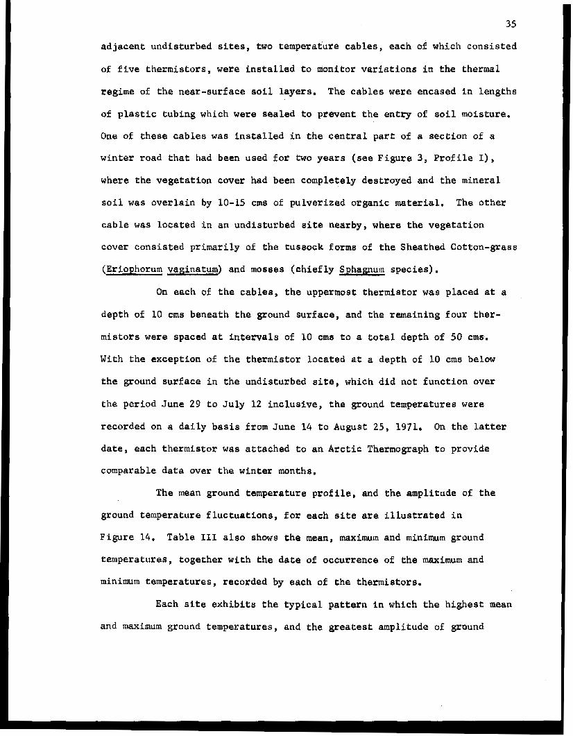
- Ground Temperature Measurements. To complement the observa t ions
on the comparative rate a n d t o t a l d e p t h of thaw i n t h e d i s tu rbed and
34
Figure 13 M E A N DEPTH A N D R A T E OF T H A W
IN M E T R E Q U A D R A T S
IC
20
30
4 0
50
6 0
70 B O
100 90
-. SITE I * D
W I N T E R R O A D - 2 YEAR USE
I I I I I I
18 2 14 30 13 25
J u n e J u l y August
IO 18 2 16 30 13 25
E I I 1 I I
4 0 t
y o b WINTER ROAD - 2 YEAR USE 80 9 0
J- :s I I 1 1 I 2 16 30 13 25
J u n e J u l y August
6 0 - S I T E I l l
W I N T E R R O A D - 1 Y E A R U S E a0 - 9 0 -
100 I I I I I I
- U n d i s t u r b e d sites - Disturbed sites
35
adjacent undis turbed sites, two t empera ture cab les , each of which consisted
of f i v e t h e r m i s t o r s , were i n s t a l l e d t o m o n i t o r v a r i a t i o n s i n the thermal
regime of t h e n e a r - s u r f a c e s o i l l a y e r s , T h e c a b l e s were encased i n lengths
of p l a s t i c t u b i n g which were sealed t o preven t t he en t ry of soil moisture.
One of these cab le s was i n s t a l l e d i n t h e c e n t r a l part: of a s e c t i o n of a
winter road that : had been used for two y e a r s (see F i g u r e 3 , Prof i le I),
where the vegetat ion cover had been completely destroyed and the mineral
s o i l was o v e r l a i n by 10-15 crns of pulver ized organic material. The o the r
cab le was l oca t ed i n an und i s tu rbed s i te nearby, where the vege ta t ion
cover cons is ted primarily of the t u s sock forms of the Sheathed Cot ton-grass
(Eriophorum vaginatum) and mosseg ( c h i e f l y Sphagnum species).
On each of the cables , the uppermost thermistor was placed a t a
depth of 10 crns beneath the ground surface, and the remain ing four ther -
mistors were spaced a t i n t e m a l s of 10 crns t o a t o t a l d e p t h of 50 cme.
With the except ion of t h e t h e r m i s t o r located a t a depth of 10 crns below
the ground s u r f a c e i n t h e u n d i s t u r b e d site, which d i d not function over
the pe r iod June 29 t o July 12 inc lus ive , the g round tempera tures were
recorded on a daily b a s i s from June 14 t o August 25, 1971. On t h e lat ter
date, each thermistor was a t t ached t o a n A r c t i c Thermograph t o p r o v i d e
comparable data over t he win ter months.
The mean ground temperature p r o f i l e , sad the ampl i tude of t h e
ground temperature f luctuat ions, for each s i t e are i l l u s t r a t e d i n
Figure 14. Table 111 also shows t h e mean, maximum and minimum ground
tempera tures , toge ther wi th the date of occurrence of t h e maximum and
minimum temperatures , recorded by each of the t h e m i s t o r s .
Each s i t e e x h i b i t s t h e t y p i c a l p a t t e r n i n which the h ighes t mean
and maximum ground t empera tures , and the g rea tes t ampl i tude of ground
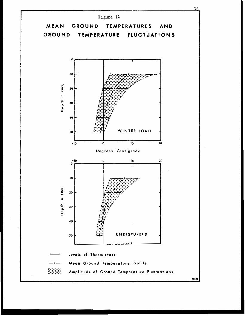
Figure 14
M E A N GROUND T E M P E R A T U R E S A N D
GROUND T E M P E R A T U R E F L U C T U A T I O N S
E n
U
c .* x c P 0 n
-x-
,>:.:.:.:.:.:.# I' . . . . . . , ~"""""."' . . . . . . .I *......
0
10
20
30
40
50
-10
0 - 10
10
20
30
40
50
0 10
Degrees C e n t i g r a d e
0 10
leve ls of T h e r m i s t o r s
M e a n G r o u n d T e m p e r a t u r e P r o f i l e
A m p l i t u d e of G r o u n d Tempera ture F l u c t u a t i o n s
DEK
37
TABLE I11
GROUND TEMPERATURES RECORDED AT DIFFERENT DEPTHS
U N D m A WINTER ROAD AND ADJACENT UNDISTURBED SITE NEAR SHINGLE POINT
( i n Degrees Centigrade)
Depth below Sur face Mean Max. Date of Min. Date of Amplitude (Cms . ) Max . Min
WINTER ROAD:
10
20 30 40 50
UNDISTURBED SITE:
lW* 20 30 40 50
8.9 18.5 (9 .0 ) (18.5) 3.7 8.6 1.5 4.7 0.1 2.2 -1.0 0.1
7.3 12.7 3.1 6.7 0.8 2.5
-0.4 0.3 -1.1 -0.4
Aug. 18
J u l y 27 J u l y 27 Aug. 20 Aug. 2W
(Augm 18)
J u l y 27 July 27 J u l y 27 Aug. 24 A u ~ . 19*
2.3 June 14 (2 .3) (June 14) -0.1 June 14 -1.5 June 14 - 2 . 4 June 14 -3.3 June 14
2.5 Aug, 13 0.7 June 14 -0.7 June 14 -1.7 June 14 -2.4 June 14
16.2 (16.2)
6 . 2 4 . 6 3 .4
8.7
10.2 6.0 3.2 2.0 2.0
9<
** Earliest date a t which temperature was a t t a i n e d .
The ground temperature values f o r the thermistor l oca t ed at a depth of 10 cms beneath t h e undis turbed surface are for the per iod June 14 - June 28 and Ju ly 13 - August 25. Comparable values, for t h e same time period, for the thermistor l oca t ed at a similar depth beneath t h e s u r f a c e 05 t h e w in te r road are shown i n b r a c k e t s .
38
temperature fluctuations, were recorded by the thermistors located at the
shallowest depths beneath the ground surface. As Table 111 shows, the mean
summer ground temperature at a depth of 10 crns below the disturbed surface
of the winter road was approximately 1.7'C higher than that recorded at a
comparable depth in the undisturbed site. The near-surface soil layers in
the disturbed area also experienced a much greater range of temperature
fluctuations, and the maximum recorded temperature of 1 8 . 5 O C and the range
of 16.2OC both represent increases of about 6.0 C over corresponding values
measured beneath the vegetation cover. Each site also exhibits the charac-
teristic pattern in which the mean ground temperature, and the amplitude of
the temperature fluctuations decrease w i t h increasing depth beneath the
ground surface but, as Figure 14 shows, the rate of decrease differed
appreciably between the two sites. The most gradual decrease occurred
below t h e surface of the winter road, where the mean ground temperature far
the summer months d i d not f a l l below O°C until a depth of 44 crns beneath
the surface, and the amplitude of the temperature fluctuations was still in
excess of 3OC at a depth of 50 crns. These figures contrast with the much
more abrupt rate of decrease in the undisturbed area, where the mean ground
temperature reached 0 C at a depth of approximately 35 cms, and amplitudes
in excess of 3 O C were not experienced below a depth of about 31 crns.
0
0
The graphs in Figure 14 and the data in Table I11 summarize the
absolute magnitude of the ground temperature changes at each site over the
entire observation period. This general account conceals the number, and
depth of penetration, of short-term temperature fluctuations which bear a
distinct temporal relationship to changes in the mean daily air temperature.
Figure 15 presents a more detailed illustration of these smaller temperature
fluctuations by showing the pattern of isotherms in the near-surface so i l
40
l a y e r s over t h e same time period.
The near -sur face soil l a y e r s a t each s i te underwent a number of
d e f i n i t e c y c l e s of warming and cool ing over time per iods ranging from two
t o seven days. Maximum tempera tures ach ieved dur ing these cyc les re f lec ted
an almost immediate response to a warming of the ambient air temperatures,
w i th t he l ag f ac to r i nvo lved be ing gene ra l ly less than one day in the d i s -
turbed area and on ly s l igh t ly longer in the vege ta ted si te. Although the
number of cyc le s was similar a t each s i te , the response was most rapid and
t h e f l u c t u a t i o n s were l a rges t benea th t he su r f ace of the winter road, where
temperature changes of as much as 7-8'C over a 24-hour period were observed
a t a depth of 10 cms. As i n t he ca se of t h e overall seasonal ampli tudes,
these short- term cycles general ly penetrated to lower depths , and more
slowly i n the undis turbed as compared t o t h e d i s t u r b e d site. In bo th si tes,
however, most of t h e f l u c t u a t i o n s were damped o u t complete.ly below depths
of 30 cms beneath the ground surface where the thermal regime e x h i b i t s a
f a i r l y c o n s i s t e n t , p r o g r e s s i v e warming t rend , wi th the ex t remes of t h e
tempera ture record occur r ing a t the beginning (coldest) and end (warmest)
of the observa t ion period.
The data ob ta ined i n t he g round t empera tu re s tud ie s suppor t t he
resul ts of the depth of thaw measurements. J u s t as t h e d e s t r u c t i o n of t h e
surface v e g e t a t i o n l a y e r r e s u l t s i n a t o t a l i n c r e a s e i n the depth of thaw
t o t h e f r o s t t a b l e , so it also in f luences the g round tempera ture pa t te rns
i n the ac t ive l ayer and uppermost par t s of the underlying permafrost . The
par t ia l or complete removal of t he o rgan ic material w i t h i t a i m p o r t a n t
i n s u l a t i n g p r o p e r t i e s , t h e p o s s i b l e r e d u c t i o n of heat losses from reduced
evapot ranspi ra t ion ac t iv i ty , and the decreased a lbedo of the exposed peat
material, combine t o augment t h e h e a t i n p u t i n t o t h e g r o u n d i n t h e d i s t u r b e d
41
sites wi th a c o n c o m i t a n t i n c r e a s e i n the ground temperatures in the near-
s u r f a c e s o i l l a y e r s ,
The small magnitude of the r e l a t i v e i n c r e a s e s i n t h e t o t a l d e p t h
of thaw, averaging only 5.1 cms o r less than 20 per cent , and mean summer
ground t empera tures , less than 2OC, under a winter road tha t has been used
f o r two consecu t ive yea r s i s r a t h e r s u r p r i s i n g . I n p a r t t h i s may r e f l e c t
l i m i t a t i o n s of t he s ampl ing p rocedure w i th r e spec t t o t he number of s i tes
i n v e s t i g a t e d , o r i t may be that t h e s e c t i o n of t h e a c c e s s road t o the no r th
of the turn-off was not used very in tens ive ly dur ing the win ter of 1970-71.
Yet a n o t h e r a l t e r n a t i v e e x p l a n a t i o n may be c o n t a i n e d i n t h e i n i t i a l p a r t
of t h e t e m p e r a t u r e r e c o r d shown i n F i g u r e 15, where i t can be seen t h a t ,
throughout the lat ter ha l f of t h e month of June and p o s s i b l y i n t o e a r l y
July, the ground temperatures recorded a t a depth of 10 cms below t h e un-
d i s tu rbed su r f ace were severa l degrees warmer than t hose at: a similar depth
benea th the sur face of t h e w i n t e r road. Although most of t h e snow had
disappeared from the open tundra when the f i e l d o b s e n t a t i o n s commenced i n
e a r l y June, accumula t ions i n t he va l l eys of t he small c reeks were s t i l l
s e v e r a l metres th i ck . It i s p o s s i b l e t h e r e f o r e that t h e r e may have been
s u f f i c i e n t snowfall d u r i n g t h e w i n t e r of 1970-71 t o r ende r t he snow-pack
method of win te r road cons t ruc t ion e f f ec t ive . The development of a sub-
s t a n t i a l t h i c k n e s s of compacted snow on t h e road could account f o r t h e
general absence of any pronounced i n t e n s i f i c a t i o n of the topographic effects
of the t e r r a in d i s tu rbance du r ing t he s econd yea r of u s e , and the p e r s i s t e n c e
of t h i s l a y e r of snow could de lay the pene t ra t ion of t h e summer thaw which
could , in tu rn , account f o r the lower depths of thaw and ground tempera-
tures observed i n the d i s tu rbed area dur ing t he early p a r t of t h e summer.
I
.~
42
S i t i d x i Creek S i t e .
The second site s e l e c t e d f o r i n v e s t i g a t i o n s of winter road opera-
tions was loca ted a t about longi tude 132' 49' W and l a t i t u d e 68' 40' N,
near the ou t f low of S i t i d g i Lake into S i t i d g i Creek. I n t h e a b s e n c e of any
o f f i c i a l r e c o r d of t h e h i s t o r y of t h e r e s o u r c e e x p l o r a t i o n act ivi t ies a t
t h i s s i te , an a t tempt was made t o e s t a b l i s h t h e s e q u e n c e of events through
d i scuss ions w i th local r e s i d e n t s i n Inuvik. Since this area i s important
i n t h e r e c r e a t i o n a l p a t t e r n s far many of these r e s iden t s , and t he re i s a
f i sh ing l odge on the l ake a t t h e s i te , t h e following account is probably
qu i t e accu ra t e a l t hough t he spec i f i c yea r s men t ioned may be quest ionable .
The t e r r a i n d i s t u r b a n c e s a t S i t i d g i C r e e k appear t o represent t h e
c u m u l a t i v e e f f e c t s of a t least t h r e e s e p a r a t e p e r i a d s of ac t iv i ty . Al though
some r e s i d e n t s t h o u g h t t h a t t h e area may have been used as an access rou te
a t an earlier d a t e , t h e f i r s t of these per iods of a c t i v i t y a p p e a r s t o h a v e
been i n t h e w i n t e r of 1964-65, o r 1965-66, when the French company,
Pe t ropar , cons t ruc ted an a c c e s s r o u t e t o move equipment and s u p p l i e s f o r
t h e i r w i n t e r seismic ope ra t ions i n t h e v i c i n i t y of the Anderson River.
Whether or not the crews simply attempted to scrape up a d d i t i o n a l s u p p l i e s
of snow f rom the ad jacent tundra , o r de l ibe ra t e ly b l aded away the o rgan ic
l a y e r , t o bu i ld up t h e s u r f a c e of the win te r road is not known, b u t t h e r e
i s no doub t t ha t t he method of cons t ruc t ion employed r e s u l t e d i n a complete
removal of t h e s u r f i c i a l o r g a n i c l a y e r , The exposure of the minera l s o i l
l e d t o pronounced thermokarst development during the following summer thaw.
There is also no doubt that th is thermokarst development , which i s res-
p o n s i b l e f o r t h e most aevere a s p e c t s of t h e t e r r a i n damage, had a l r eady
taken p lace before the second ident i f iab le per iod of a c t i v i t y which occurred
i n 1966. I n t h i s y e a r , I m p e r i a l O i l Limited located a win te r seismic l i n e
43
along exactly the same route, and the existence of shot-holes, which are
still open at the ground surface, on the f loo r of the settled areas testifies
to the fact that the subsidence had already taken place p r i o r to this date.
The third, and most recent, activity contributing to the terrain distur-
bance at this point occurred i n 1968-69, or 1969-70, when Gulf Oil Canada
Limited also used this same route as an access road f o r their winter seismic
operations.
It is impossible to ascertain as to whether or not these second
and third uses of the same winter road resulted in any further intensi-
fication of the topographic affects of the terrain disturbance, but they
d i d , in a l l probability, retard the rate of re-establishment of the plant
cover. In any case, this re-use of the same access route f o r a second and
third occasion, thereby compounding the degree of disturbance or prolonging
the time period required for recovery of the vegetation, raises an important
question with respect to the Land Use Regulations which require that any
company make use of existing 'lines' or 'rights of way' wherever possible,
In view of the severity of the damage t o the tundra which resulted from
the construction of the first winter road in the Sitidgi Creek area, it may
be argued that this question is of minor relevance, but additional examples,
to be referred t o later in the report, from this and other areas will a l s o
serve to illustrate some of the ambiguities in this regulation.
The field investigations at the Sitidgi Creek site included the
surveying of a section, 30 metres in length, of the winter road to prepare
a contour map illustrating the topographic aspects of the terrain distur-
bance. Eight: transects, or profiles, were also established across various
parts of the access route to illustrate comparative changes in the thick-
44
t h e S h i n g l e P o i n t s i te , descr ibed earlier (p . 9), bench marks were i n -
s t a l l e d on t h e s e t r a n s e c t s t o assist i n t h e d e t e c t i o n of any subsequent,
long- te rm changes in the pos i t ion of the upper sur face of t h e frozen ground,
and, i n p a r t i c u l a r , t o see whether any future es tab l i shment of a continuous
vegeta t ion cover i s r e f l e c t e d i n a corresponding aggradat ion of t h e perma-
frost t a b l e . Six of t h e t r a n s e c t s were a l s o s e l e c t e d t o examine t he p rec i se
role of thermokars t ac t ion i n the development of the topography of t h e d i s -
turbed area, and drill core samples were c o l l e c t e d for analyses of t h e i r
ice content .
The topographic fea tures of a s e c t i o n of the winter road are
i l l u s t r a t e d i n the contour map of F igu re 16. The main d i s tu rbed area,
ranging from 15-20 metres i n w id th , can be subd iv ided i n to t h ree d i s t i nc t
u n i t s . The f i r s t of t hese , t he w in te r road i t s e l f , c o n s i s t s of a narrow
r idge - l ike f ea tu re , ave rag ing 5-7 metres across , and accounts for approx-
imately one- th i rd of the total width of t he damaged area. The road i s
bounded on e i t h e r side by the o the r two units, varying from 5-8 metres and
3-4 metres a c r o s s on t h e e a s t e r n and western s ides of t h e road r e s p e c t i v e l y ,
which de l imi t the areas from which the organic layer was e i t h e r i n a d -
vertently o r d e l i b e r a t e l y removed. The exposure of the mineral s o i l i n
these sect ions has been fol lowed by a subsidence of the ground surface,
so t ha t t he floors of the settled areas are now as much a s 90-100 cms below
the l e v e l of t he su r f aces of the win ter road and ad jacent undis turbed
t e r r a i n , As Figure 16 a l s o i n d i c a t e s , many of the depress ions i n t h e floors
of these subsided areas are occupied by pools of s tanding water which are
several metres in l ength and as much as 30 cms deep. On e i t h e r s i d e of t h e
main d i s tu rbed area, a n d p a r t i c u l a r l y t o t h e east, and extending f a r d i s -
tances of up t o 1-2 metres, t he ground surface has been buried beneath a
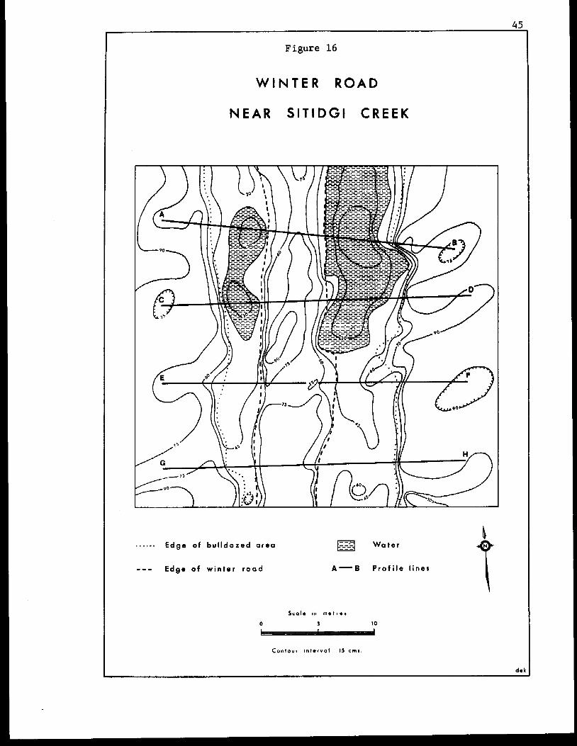
45
Figure 16
W I N T E R R O A D
N E A R SITIDGI C R E E K
A ...... Edge of bulldozed a r e a Water
--- Edge o f w i n t e r r o a d A-B P r o f i l e l ines
Scalo In m e t r e 5
0 5 IO
C o n t o u r i n t - r v o l 13 c m s
4 6
l i t ter of bulldozed organic material.
The u n d i s t u r b e d t e r r a i n was cha rac t e r i zed by the development of
small e a r t h hummock s t r u c t u r e s , up t o 50-60 crns across and i n t h e o r d e r of
15-20 crns high. The most impor tan t vascular spec ies represented in the
vege ta t ion cover of t h e s e areas included the Glandular Birch ( B e t u l a
Blandulosa) , Mountain Cranberry (Vaccinium vitis-idaea) , Narrow-leaf ed
Labrador-tea (Ledum palustre ssp. decumbens), Cloudberry (Rubus chamaemorus),
Common Crowberry (Empetrum niRrum) and Lapland But te rbur (Pe tas f tes
f r i g i d u s ) , t o g e t h e r w i t h o c c a s i o n a l t u s s o c k s of the Sheathed Cot ton-grass
(Eriophorum vaginaturn). I n many p a r t s , however, extensive mats of l i chen
(especially Cetraria and Cladonia species) and moss provided the dominant
form of ground cover:.
-
I n c o n t r a s t t o t h e s e areas, t h e s u r f a c e of t h e w i n t e r road was
largely devoid of any l iv ing p lan t cover , and most of the road sur face
cons i s t ed of loose accumulat ions, as much as 20-25 crns t h i c k i n p l a c e s , of
dead organic litter. The floors of t h e t r e n c h e s , on e i t h e r s i d e of t h e
win ter road , conta ined la rge expanses of bare , compacted minera l soil,
w h i l s t t he mo i s t e r areas of ten suppor ted a f l o u r i s h i n g growth of grasses and
sedges (p r inc ipa l ly Arc t ag ros t i s , Calamagrostis and Eriophorum species)
which, i n places, were as much as 50-70 cms tall. These d i s t u r b e d sites
were also cha rac t e r i zed by increased percentages of Cloudberry and the
Lapland But terbur in the plant species composi t ion.
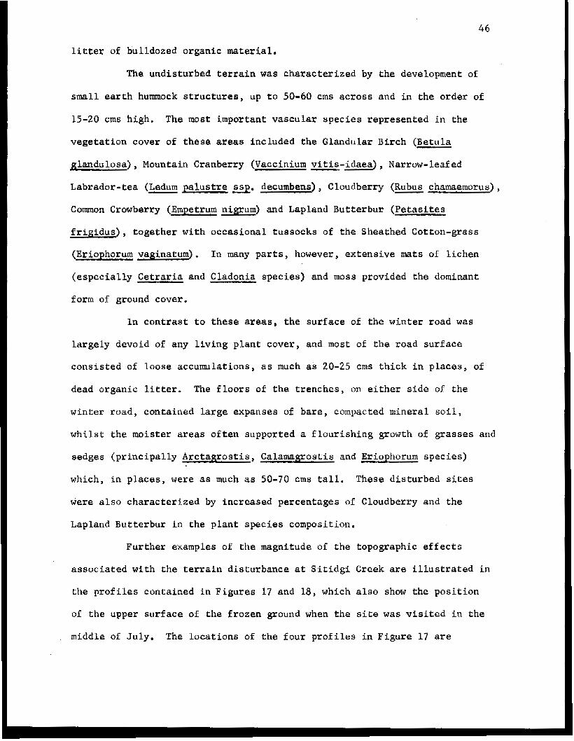
Further examples of the magnitude. of the topographic e f fec ts
a s s o c i a t e d w i t h t h e t e r r a i n d i s t u r b a n c e a t S i t i d g i Creek are i l l u s t r a t e d i n
t h e profi les con ta ined i n F igu res 17 and 18, which also show the p o s i t i o n
of the upper sur face of the frozen ground when t h e s i t e was v i s i t e d i n t h e
middle of July. The l o c a t i o n s of t h e f o u r p r o f i l e s i n Figure 17 are
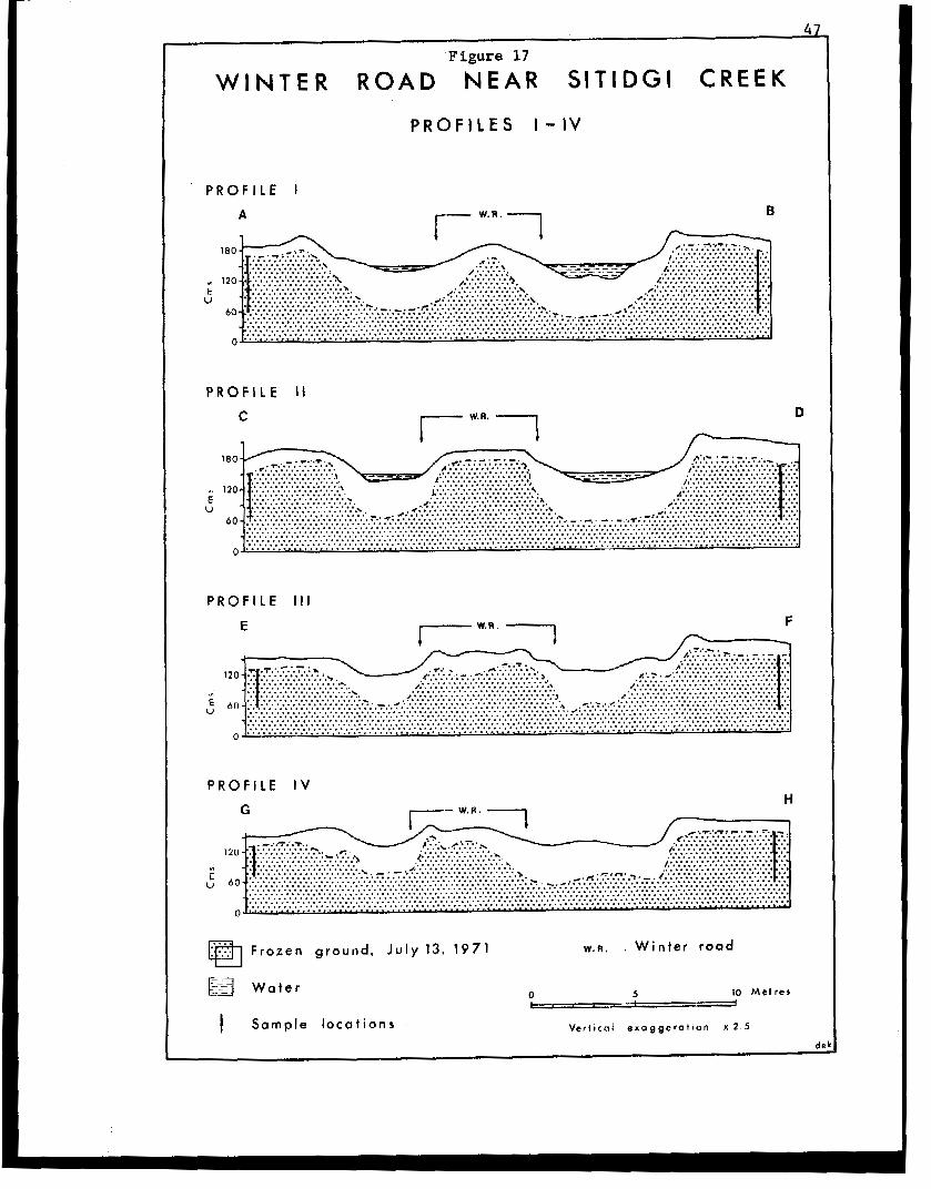
Figure 17
W I N T E R R O A D " N E A R S I T I D G I C R E E K
P R O F l l E S I - I V
P R O F I L E I
A
C
P R O F I L E I V H
F r o z e n g r o u n d , J u l y 13, 1971 W . R . . W i n t e r r o a d
O- 10 M e t r e s
V e r t i c a l e x a g g e r a t i o n X 2 . 5
I P R O F I L E S V-VI I I
I P R f F ' L E I W ' R ' 1 N -I
c 120 I..._.... /.~;.~.~.~:.~.~.~:.~ ..::.:......: :::.. . ........................... E, ............................. Ir ~..:..:., ~.~~.~~:~...~.~::.~.~...~.~~.~.~.~.~.~.~
PROFILE VI1
N 7 W. R . 1 0
VI
E U
I P R O F I L E V l l l P
D i s t u r b e d a r e a - ." 180" -.
........................... ......................... u ............................................................. . . . . . . . . . . . . . . . . . . . . . . . . . . . . . . . . . . . . . . . . . . . . . . . . . . . . ............................................................. . . ........................................................................... '.':::..,':;.'.':; ~.*.* :;~;;;:.'.'.'.';:,';:;;~; .. ;~::;.';:;:;:;::;:;.': .. :::::::;: . ~ . ~ . :.; .. ........................... ::.,., ;.... ..
............................ , ~ , _. \ ..H : .,?.*j,* : .~:.:.:.:.:.:.:.:...:.:.:,~~.~~:~~:.:I.....:..:.: .......... ....................................................................... ~~~~':~~~~.';;.~~'~'~'~;;;~;;~~~:;~~~~~'~'~'~'.':;;~~~~~~~~;~:~~~~:;;~;;~~'~';;;::;;;:;:~~:~.~, *.~,~,.;:::;.';;:.';,';;;:;:;;~':.';~':;;;;;~;;.~;;:::.~:::;..:::...~::;:::;:;:;~;::::::;..;:. ..................................................................................................................................................
I 0 Frozen ground, July 13. 1971 W . R . W i n t e r r o a d
I a Frozen ground, July 26, 1971 0 5 10 P M e t r e s
I Sample l o c a t i o n s V e r t i c a l e x a g g e r a t i o n x 2 . 5
49
i nd ica t ed on the contour map of F i g u r e 16. P r o f i l e s V and V I (F igure 18)
r ep resen t two a d d i t i o n a l t r a n s e c t s a c r o s s t h e w i n t e r road immediately t o
t h e south of t h e area shown i n F i g u r e 16. Profiles V I 1 and VI11 (Figure 18)
c h a r a c t e r i z e a r a t h e r d i f f e r e n t t y p e of disturbance found nearer t o t h e
a c t u a l c r e e k c r o s s i n g located just t o t h e n o r t h of t h e same area.
The e f f e c t s of the removal of the su r face o rgan ic l aye r on t h e
position of t h e f r o s t table i s e v i d e n t i n each of t h e s e t r a n s e c t s , where i t
can be s e e n t h a t t h e average t h i ckness of t h e thawed l a y e r i n t h e un-
d i s tu rbed areas waa 20-30 crns. The mean thaw depths under the sur face of
t he w in te r road showed no apprec iab le d i f f e rence as compared t o t h e un-
d i s tu rbed si tes, and t h i s c a n p o s s i b l y be a t t r i b u t e d t o t h e i n s u l a t i n g
p r o p e r t i e s of t he add i t iona l o rgan ic material which was placed along the
l i n e af the road. Indeed, the lower thaw va lues a s soc ia t ed with certain
s e c t i o n s of t h e a c c e s s r o u t e may i n d i c a t e t h a t t h e r e has been a slight
rise i n the permafros t table i n these areas. I n c o n t r a s t t o t h i s , t h e
depth of thaw measurements a c r o s s t h e f l o o r s of t h e s e t t l e d areas i n d i c a t e
a subs t an t i a l deg rada t ion o r lowering of the upper sur face of t h e frozen
ground. The th i ckness of the thawed l a y e r i n t h e s e areas typ ica l ly r anged
from 50-70 crns i n t h e bare m i n e r a l s o i l s e c t i o n s , t o more than one metre in
and a d j a c e n t t o t he pools of water. I n t h e e x t r e m e cases, these va lues
r ep resen t i nc reases i n excess of 300 pe r cen t over t h e maximum thaw depths
recorded i n the undis turbed areas.
The genera l appearance of t h e terrain d i s tu rbance exh ib i t ed by
this s e c t i o n of winter road near S i t i d g i Creek is similar t o the many miles
of 1965 bulldozed eummer se i smic l i nes on t h e Tuktoyaktuk Peninsula . (The
principal d i f f e r e n c e i s the absence of any prominent ridge of bulldozed
50
winter road). The t ransformat ion of t h e s e seismic lines in to sha l low t r enches
o r cana ls over much of t he i r l eng th has been c i t ed as proof of the dangers
of chronic e ros ion by s u r f a c e water moving a l o n g t h e lines, and t he re appea r s
t o be a gene ra l r e luc t ance , by some writers, t o a c c e p t the f a c t t h a t thermo-
karst development is f r e q u e n t l y t h e primary e x p l a n a t i o n f o r t h e trans-
formations.
Data obtained from the measurement of ind iv idua l b locks of
material l y ing l oose a long t he marg ins of t h e d i s t u r b e d area and the edges
of the win ter road, sugges t t ha t a l a y e r of organic material, averaging less
than 10-13 cms i n t h i c k n e s s , was removed from the bladed area dur ing t he
i n i t i a l c o n s t r u c t i o n of t he w in te r road . In p l aces , the f l o o r s of t h e
depressed areas are now almost one metre below t h e l e v e l of t h e a d j a c e n t
und i s tu rbed t e r r a in . The absence of any s igns of su r face e ros ion by running
water, l eads t o the conclus ion that any accentuation of the topographic
e f f e c t s of t he d i s tu rbance must have been the resu l t of thermokarst sub-
s idence. In order t o verify this conclusion, the comparative measurements
of the depth of thaw i n the dis turbed and immediately adjacent undis turbed
sites were used to p rovide an approximat ion of t h e amount of r e l a t i v e d i s -
placement of t h e f r o s t t a b l e c r e a t e d by the damage to the t e r r a i n . Drill
core samples , the lengths of which corresponded to the displacement values
obta ined , were t h e n c o l l e c t e d from t h e f r o z e n s u b s t r a t e i n t h e u n d i s t u r b e d
areas as shown i n Profiles I - V I (Figures 1 7 and 18). Analyses of t h e ice
conten t of these samples provided a measure of t h e p o t e n t i a l amount of
thermokarst subsidence that could be expected as a r e s u l t of a thawing of
t hese columns of material, and these values were compared t o the es t imated
amount of s e t t l emen t of t h e ground surface as recorded i n t he t opograph ic
p r o f i l e s .
I 51
Data p e r t a i n i n g t o t h e d r i l l c o r e s a m p l e s , t o g e t h e r w i t h c a l -
c u l a t i o n s of t he t he rmokar s t po ten t i a l , are p resen ted i n Tab le I V , t oge the r
wi th the estimates of t h e s e t t l i n g of t h e ground sur face ob ta ined f rom the
p r o f i l e s t u d i e s . The average volume of each of t h e twelve samples co l lec ted
was almost 500 ccs , of which an average of 83.5 per cen t cons i s t ed of i ce .
A combination of t h i s value wi th a c a l c u l a t e d mean lowering of t h e f r o s t
t a b l e of about 101 cms, is enough t o provide for a n a v e r a g e s e t t l i n g of t h e
ground s u r f a c e of 84 cms i f complete therrnokarst subsidence were to occu r .
Estimates of t h e amount of s e t t l i n g of the g round sur face tha t has occur red
range from 35-90 cms, and y ie ld an average of s l i g h t l y more than 64 cms.
As Table I V shows, t h e p o t e n t i a l for thermokarst subsidence indicated by
ind iv idua l samples , in each case, exceeds the es t imated amount of lowering
of the ground surface that has taken place by values ranging f rom 5.0 t o
38.0 cm8. Although the water logged na ture of t h e d i s t u r b e d sites sugges ts
t h a t the thermokarst subsidence did not achieve i t s maximum p o t e n t i a l i n
many areas ( i . e . much of t h e water remained i n the pore spaces of the s o i l ) ,
and desp i t e t he i nhe ren t i naccurac i e s of t h e method employed ( p r i n c i p a l l y
i n the form of inaccura t e estimates of t he he igh t of the o r i g i n a l ground
s u r f a c e ) , t h e r e s u l t s o b t a i n e d would a p p e a r t o j u s t i f y the conc lus ion t ha t
the lower ing of the g round sur face in the d i s turbed areas can be a t t r i bu ted
s o l e l y t o therrnokarst subsidence.
Each phase of the r e s o u r c e e x p l o r a t i o n a c t i v i t y i n t h e S i t i d g i
Creek area was faced wi th t he problem of cons t ruc t ing an access r o u t e across
the creek. The s t r e n g t h of t he outflow from S i t i d g i Lake i s such t ha t t he
channel does n o t f r eeze ove r du r ing t he w in te r months, and the absence of
an ice cove r necess i t a t ed t he dumping of l a r g e q u a n t i t i e s of snow i n t o t h e
creek t o form a bridge. The r a p i d removal of much of t h i s material by t h e
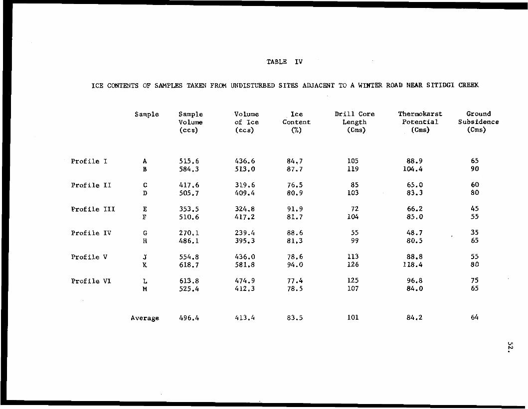
TABLE I V
ICE CONTENTS OF SAMFLES TAW FRm UNDISTURBED SITES ADJACENT TO A WLNTER ROAD NEAR SITIDGI CREEK
Prof i l e I
Profile I1
Prof i l e I11
Prof i le IV
Profile V
Profile Vl
S amp le
A B
c D
E E
G H
J K
L M
Average
Sample Volume
515.6 584.3
417.6 505.7
353.5 510.6
270.1 486.1
554.8 618.7
613.8 525.4
496.4
Volume of Ice (cc s>
436 .6 513.0
319.6 409.4
324.8 417.2
2 3 9 . 4 395.3
436.0 581.8
474.9 412.3
413.4
Ice Content
GI
84.7 87.7
76.5 80.9
91.9 81.7
88 .6 81.3
78.6 94.0
77.4 78.5
83.5
Drill Core Length
(ems)
105 119
85 103
72 104
55 99
113 126
125 107
101
Tfiermkar st Potential
( c 4
88.9 104.4
65.0 83.3
66.2 85 .O
48.7 80.5
88.8 118.4
96.8 84.0
84.2
Ground Subsidence
(ems>
65 90
60 80
45 55
35 65
55 80
75 65
64
53
flow of the river c o n t r i b u t e d t o a f u r t h e r increase i n t h e amount of snow
that had t o be scraped from t h e ad jacent tundra on e i t h e r side of the stream.
Although each of t h e s e e f f o r t s was t e m p o r a r i l y f r u s t r a t e d by the v e l o c i t y of
t h e f lowing water, Imper ia l O i l b u i l t such a strong br idge i n 1966 t h a t it
requ i r ed the use of dynamite for i t s eventual removal, and t h e explos ion
produced a local widening of the creek of almost 50 per cent.
The repea ted a t tempts t o obta in adequate suppl ies of snow f i l l f o r
t h e br idge crossing have increased the areal e x t e n t of t h e t e r r a i n d i s -
turbance immediately adjacent t o t h e creek. Whereas t h e w i d t h of t h e damaged
area associated w i t h the actual winter road averages approximately 20 mefrea,
the d i s tu rbed area c l o s e r t o the creek banks is anywhere from 60 t o 100
metres across. P r o f i l e s VI1 and VI11 (F igure 18), i l l u s t r a t e some a s p e c t s
o f t h e t e r r a i n d i s t u r b a n c e in these areas, In P r o f i l e V I I , it is s t i l l
poseibls t o d e t e c t t h e l i n e of the winter road, b u t i n Profile VIII, t h e
r o u t e of the access road is v i r t u a l l y i n d i s t i n g u i s h a b l e f r o m t h e d i s t u r b e d .
areas on e i t h e r s i d e . The sc rap ing of snow from t h e tundra was i n e v i t a b l y
accompanied by a removal of some of the organic material. As Profiles VYI
and VI11 show, however, t h e d e s t r u c t i o n of t h e organic l aye r was not a8
severe as i n the winter road location, and t h e e f f e c t s of thexmokarst sub-
s idence are not as pronounced. Qual i ta t ive assessments would suggest t h a t
t h e ground surface i n these areas has been lowered by an average of 25-35 cms
r e l a t i v e t o the l e v e l of t he und i s tu rbed terrain. In t he most extreme cases,
where t h e organic cover was removed completely, there has been a t o t a l
collapse of the hummock s t r u c t u r e s and s e t t l i n g has resulted in t h e for-
mation of small p i t s or dep res s ions i n t he g round surface. The thaw pene-
t r a t i o n i n t h e bare mineral soil of these areas reached depths of 86 cms,
which was almost twice as great as t h e maximum value recorded i n t h e
54
undis turbed hummocks. Elsewhere, much of the vegeta t ion appeared t o have
been k i l l e d , r a t h e r t h a n removed, and the average thaw d e p t h s i n t h e s e d i s -
turbed areas were approximately 30-35 per cen t i n excess of c h o s e i n t h e
ad jacent undis turbed sites.
The t e r r a i n d i s t u r b a n c e s a s s o c i a t e d w i t h the winter road opera t ions
i n the v i c i n i t y of Si t idgi Creek demonstrate the extreme form of damage t h a t
can result when t h e s u r f a c e o r g a n i c l a y e r i s des t royed to a po in t where pro-
nounced thermokarst subsidence will take place. Although the major aspects
of t h e damage t o the tundra appear t o have resulted from extreme c a r e l e s s -
ness dur ing t he cons t ruc t ion of t h e f i r s t winter road a t t h i s s i te , it is
qu i t e conce ivab le t ha t a similar l e v e l of d i s turbance could have developed
over a longer period of time, by a repea ted usage of t h e same route,which
i s encouraged i n t he p re sen t Land Use Regulations.
The sequence of even t s a t S i t i d g i Creek also r a i s e d q u e s t i o n s
p e r t a i n i n g t o the adequacy of the planning procedures used by the resource
e x p l o r a t i o n i n d u s t r y i n t h e s e l e c t i o n of r o u t e s f o r t h e w i n t e r r o a d s . The
problems of having t o c r o s s t h e open water of S i t i d g i Creek could have been
a n t i c i p a t e d , e i t h e r as a result of d i s c u s s i o n s w i t h l o c a l r e s i d e n t s i n
Inuvik o r on t h e b a s i s of d i f f i c u l t i e s e n c o u n t e r e d by the p rev ious a t tempts
t o bridge the stream, and modi f ica t ions of t he programmes, o r at least
their timing, might have been introduced. For example, scheduling the move-
ments for later i n t he w in te r when, t h e i c e t h i c k n e s s on S i t i d g i Lake i s
capable of suppor t ing vehic les , might have been possible . Furthermore, the
high i c e c o n t e n t of the frozen ground i n t h i s area is appa ren t i n the
slumping along the shore of S i t idg i Lake , and th i s should have ind ica ted
the need for extreme caut ion if thermokarst subsidence were t o be avoided.
55
2” Jim Lake Site.
The t h i r d s i te s e l e c t e d f o r i n v e s t i g a t i o n s of winter road
ope ra t ions was loca ted a t about longi tude 133 47’ W and l a t i t u d e 68’ 40’ N,
a few miles t o the west of Jimmy Lake. The s e c t i o n of winter r’oad s tud ied
was used i n t h e win ter of 1969-70 t o move a d r i l l i n g rig, camp and s u p p l i e s
from the Gulf P-60 r i g site t o the l o c a t i o n of t h e i r C-38 well. The same
access route was used t o move t h e r i g southward, i n t h e w i n t e r of 1970-71,
t o t h e A-01 well s i t e i n t h e Caribou Hills area j u s t south of Reindeer
Stat ion. Thia re-use of the win te r road for two consecut ive years is thus
comparable to the s i t u a t i o n at Shingle P o i n t , descr ibed earlier i n this
r epor t . Whereas the win ter road a t Shingle Poin t was c o n s t r u c t e d u s i n g t h e
convent iona l mow packing technique, the access r o u t e in t h e Jimmy Lake area
was an i ce road, and it was hoped that t hese observations would permit
comparative evaluations of t he two methods of cons t ruc t ion employed i n terms
of t h e i r impact on the tundra landscape.
0
The f i r s t stage i n t h e construction of t h e Gulf win te r road i n -
volved using a t racked vehicle t o drag a beam along t h e proposed route t o
fill i n most of t h e d e p r e s s i o n s i n the ground surface with snow, and create
a r e l a t i v e l y smooth sur face . F la t - t racked vehic les , wi th water tanks mounted
on the back, were then used t o spray water on the su r face of the road, and
t h i s procedure was repea ted s eve ra l times u n t i l a l aye r of ice was developed
which was capable of suppor t ing a similar water truck mounted on wheels.
This v e h i c l e was then used to spray additional q u a n t i t i e s of water on t he
road s u r f a c e u n t i l t h e layer of i c e was s t r o n g enough t o suppor t the heavier
wheeled v e h i c l e s used t o t r a n s p o r t t h e d r i l l i n g rig, Throughout the earlier
part of t h e w i n t e r , a r o u t e was selected which followed t h e areas of h igher
ground and detours were made around the major water bodies. Later i n t h e
56
win te r , as t h e t h i c k n e s s of ice on the l akes i nc reased , many of these
de tour s were abandoned i n f a v o u r of more d i r e c t r o u t e s across the l akes ,
A h e l i c o p t e r s u r v e i l l a n c e wa8 made a long the e n t i r e l e n g t h of t h e
i c e road, a n d P r o f i l e I (Figure 19) r e p r e s e n t s a t r a n s e c t across a t y p i c a l
s e c t i o n of the road immediately north of t h e P-60 well site. The undisturbed
terrain i n t h e v i c i n i t y of the p r o f i l e was cha rac t e r i zed by the development
of prominent e a r t h hummocks, one t o two metres a c r o s s , w i t h t h e hummock c e n t r e s
r i s i n g 25-35 cms above the levels of the in te rvening depress ions . The pr in-
c i p a l v a s c u l a r species growing i n t h e s e si tes included the Glandular Birch
(Betula glandulosa) , Arctic Blueberry (Vaccinium uliginosum) , Mountain Cran-
berry (Vaccinium vi t is- idaea) , Common Crowberry (Empetrum nigrum), Narrow-
leafed Labrador- tea (Ledum palustre =, decumbens), Arctic Lupin (Lupinus
arct icus) and Alpine Bearberry (Arctostaphylos rubra), t o g e t h e r w i t h S a l i x
species and a ground cover of mosses and l ichens. When the s i te was v i s i t e d
in early August, the maximum depths of thaw i n t h e hummock centres ranged
from 50-65 crns, and i n t h e inter-hummock depressions the f r o s t table was
encountered at depths varying from 12-25 crns below the ground surface.
- - -
As P r o f i l e I (Figure 19) shows, t h e t o t a l w i d t h of the d i s tu rbed
area was approximately 34 metres, but the degree of damage t o the tundra
var ied considerably across t h e road. The main d i s tu rbance , cove r ing a
width of almost 16 met res , cons is ted of sc raped and f la t tened hummocks from
which some of the o rganic material had been removed. The majority of t he
hummock s t ructures were s t i l l i n t a c t , however, and a major f ac to r con t r ibu t ing
t o t h e subdued microrel ief in t h i s s e c t i o n of t h e t r a n s e c t was t h e i n f i l l i n g
of t h e i n t e r -humock dep res s ions w i th loose organic debr i s . Many of t h e
hummock s u r f a c e s consisted of bare o rganic material, b u t t h e r e was a
no t i ceab le lack of any extensive areas of exposed mineral s o i l . Although
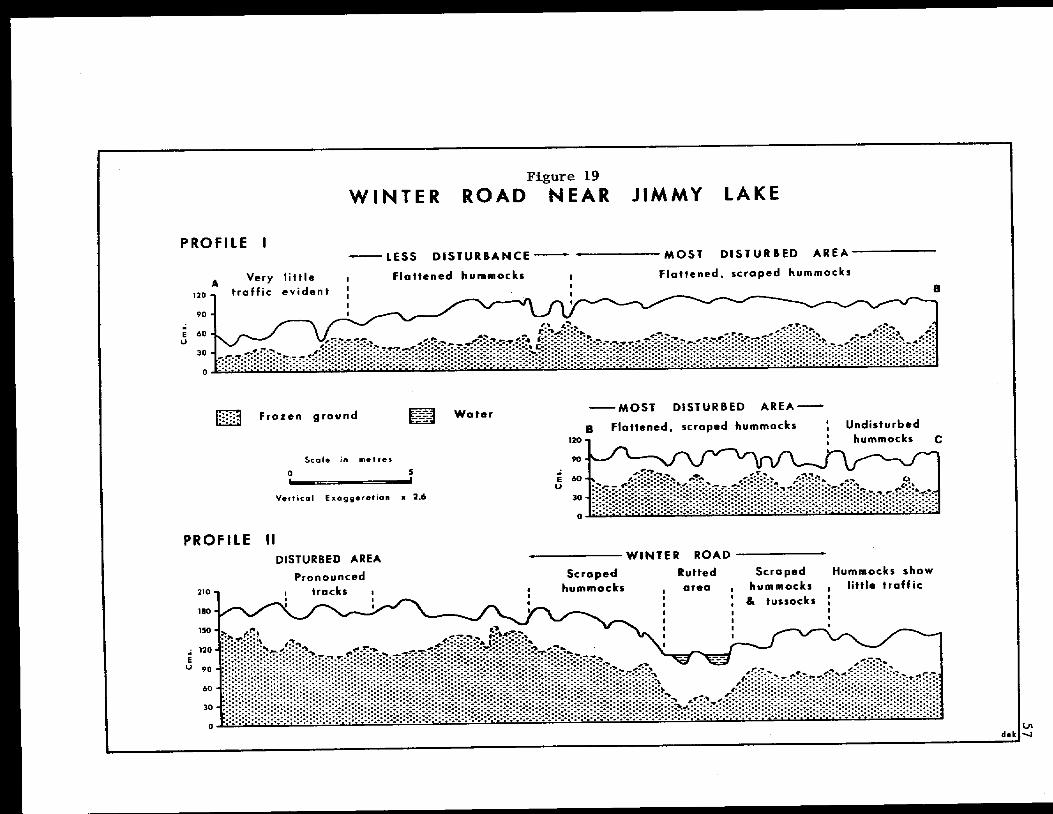
57 - ".
Y
58
there were few plants growing on the scraped hummocks, the intervening
depressions euppozted pockets of vegetation which, compared to the undis-
turbed sites, contained greater percentages of grasses in their plant species
composition. Profile I (Figure 19) also shows that the terrain disturbance
had had relatively little effect on the thickness of the active layer, The
maximum thaw penetration in the scraped hummocks was only 68 cms, which was
less than 5 per cent greater than the value recorded in the undisturbed site,
The lesser used areas adjacent t o the main section of the road
exhibited correspondingly fewer signs of disturbance. Some of the more
prominent: hummocks showed obvious signs of flattening and there were
occasional patches of bare organic material, Some of the depressions also
appeared to have been widened as a result of a compression of material on
the sides of the hummocks, Apart from a slight reduction in the amount and
height of the shrub layer, the vegetation cover of these areas appeared to
have suffered minimal disruption. The depths of thaw in these parts of the
winter road also showed no appreciable differences from those in the adjacent
undisturbed sites,
The type of terrain disturbance exemplified by the transect: in
P r o f i l e I is characteristic of most of the length of the access route, and
the low degree of damage involved indicates the value of this method of
winter road construction, It would seem appropriate, therefore, to en-
courage a more frequent adopt ion of this method, particularly if any
inadequacy in the thickness of the snow cover threatens to limit the effect-
iveness of the snow packing technique, or if it is proposed to use the same
access route for more than one winter's operations.
Attempts t o locate the route of the Gulf ice road were complicated
by the absence of any maps, showing the position of the road, and the maze
59
of l i nes t r ave r s ing t he t undra l andscape in this area. The reconnaissance
surveys revea led the ex is tence of one set of l ines which ind ica ted an
excess ive degree of damage t o t h e t e r r a i n . Over much of its lengch, t h i s
rou te cons i s t ed of two prominent ru t s of black organic material which, i n
wetter areas, c o n t a i n e d s u b s t a n t i a l q u a n t i t i e s of s tanding water. I n some
areas, however, t h e number of ruts increased t o as many 8 8 twelve and, even
worse, i n a few places extensive s lumping had occurred and widespread thermo-
karst subsidence had been i n i t i a t e d .
The route of these t r a i l s i n t s r e e c t e d t h e line of the Gulf ice
road a few miles t o the south of t h e P-60 well site, and P r o f i l e I1
(Figure 19) r ep reean t s a t r ansec t ac roas t he combined r o u t e s j u s t south of
the i n t e r s e c t i o n . This p a r t i c u l a r l o c a t i o n was s e l e c t e d because it i l l u -
strated t h e d i f f e r e n c e s i n t h e type of terrain disturbance r e s u l t i n g from
the use of the i ce road and the newer route. The area traversed by the
winter road i n t h i s second transect was similar in it8 microrelief f e a t u r e s
and vegetat ion cover t o t h a t d e s c r i b e d for the profile study above, with
the except ion that t h e greater a v a i l a b i l i t y of water a t t h i s second s i t e
was r e f l ec t ed i n t he p re sence of such species as the Sheathed Cot ton-grass
(Eriophorum vaginaturn) and the Lapland But terbur (Petasites f r i g i d u s ) .
Apart from t h e ex i s t ence of a number of broken tussocks, t h e t e r r a i n dis-
turbances assoc ia t ed w i th t he w in te r road were also similar t o those
described f o r t h e f i r s t transect, cons i s t ing p r imar i ly of f l a t t e n e d and
scraped hummocks and exposures of bare organic material.
A 3 Profile 11 (Figure 19) shows, the level of damage incur red
a long t he route of the ice road was r e l a t i v e l y i n s i g n i f i c a n t compared t o t h e
d is turbances associated with the two parallel t r a c k s of t h e a d d i t i o n a l
t r a i l . I n t he most heavi ly damaged area, where the new trail t r ave r sed t he
60
r o u t e of t he o lde r ice road, t he d i s tu rbance was characterized by two
prominent ruts, covering a total width of about 3 metres and ranging from
30-50 crns i n depth, which were f i l l e d with 15-20 crns of s t and ing water. A l l
of the vege ta t ion had been completely destroyed i n t h i s s e c t i o n , and bare
mineral s o i l was exposed a long the r idge formed between the l ines of t he
main tracks. The th ickness of the thawed layer beneath the r u t t e d area
averaged 65-70 crns, which r e p r e s e n t s an i nc rease of 10-15 cms over t h e mean
values recorded i n o the r p a r t s of t h e winter road and t h e ad jacen t un-
d i s tu rbed si tes . The g r e a t e r thaw depths , combined wi th t he lower l e v e l of
the ground s u r f a c e i n t h e ruts, i n d i c a t e t h a t t h e r e has been a marked
degradat ion of t he upper su r face oE t h e f rozen ground fallowing the d i s -
turbance.
A second t r a i l , t ravers ing; undis turbed terrain ad jacen t t o the
l i n e of t h e winter road (Figure 19, P r o f i l e II), exh ib i t ed less severe forms of
damage t o the tundra , but: the l i n e s of t h e t r a c k s were a l s o e v i d e n t i n the
shape of prominent ruts. The e n t i r e o r g a n i c layer had also been removed from
t he t o p s of t he l a rge r hurmnocks, and p a r t s of t h e route, immediately adjacent
t o t h e t r a n s e c t , r e v e a l e d t h a t large blocks of organic material and mineral
s o i l , as much as one metre across and 30-35 crns t h i c k , had been dislodged
during the passage of the veh ic l e s .
Even though sections of the newer rou te exh ib i t ed more severe levels
of t e r r a in d i s tu rbance t han t hose shown i n F i g u r e If), Profile 11, this f i e l d
evidence does i n d i c a t e t h a t more physical damage t o the tundra was incur red
dur ing a s ingle passage of theee .vehicles than in two years' use of t h e
win ter road. A s far as we c a n a s c e r t a i n , t h i s damage was the result of two
crews moving southward, from the Tuktoyaktuk Pen insu la t o Inuv ik , a f t e r t h e
spring thaw had commenced, Such movements, involv ing heavy v e h i c l e s
( b u l l d o z e r s ) , c o n s t i t u t e a b l a t a n t v i o l a t i o n of t h e s t i p u l a t i o n s of t h e
Land Use Regulations. It is also understood t h a t these crews requested
pe rmis s ion t o travel a long the route of t h e Gulf w i n t e r road and that,
a l t h o u g h t h i s r e q u e s t was denied, a t least one crew did fol low the l i n e o
t h e road i n p l aces .
61
f
The above sequence of even t s , i f correct, is f u r t h e r evidence f o r
the need t o clear up same of the inadequacias o r ambigui t ies of t h e Land
Use Regulation which encourages a company t o make u s e of a n e x i s t i n g l i n e o r
r i g h t of way wherever possible . If t h e r e g u l a t i o n s are t o have any real
meaning, and are t o be enforced properly, any individual company must be held
respons ib le f o r any damage t o the terrain incur red as a r e s u l t of i t s opera-
t i o n s on the tundra, This should a lso i nc lude t he r equ i r emen t t ha t t hese
companies be made t o take any appropriate r e s t o r a t i v e m e a s u r e s i f t h e lave1
of d is turbance is deemed t o be excessive by the land use inspec tors . In
theory, t h e r e f o r e , the t e r r a in d i s tu rbances a8saCla t ed w i th the use of the
winter road should be the respons ib i l i ty of Gulf O i l Canada Limited, but it
i s known t h a t this company was not respons ib le for the severe damage which
has occurred a l o n g c e r t a i n s e c t i o n s of the rou te . C lea r ly , such matters as
t h e e x t e n t of this r e s p o n s i b i l i t y , t h e period over which it applies, and the
r i g h t t o c o n t r o l movements of o the r compan ies a long t he l i nes , r equ i r e fu r -
t h e r consideration i f the type of damage t ha t has occu r red i n the Jimmy Lake
area is t o be prevented in t h e f u t u r e .
SUMMER SEISMIC OPERATIONS
In a recent ar t ic le d e s c r i b i n g the effects of o i l exploration
a c t i v i t y on t he t undra landscape i n t h e v i c i n i t y of the Mackenzie Delta,
Kevan concludes tha t a l l cross- tundra traff ic should be prohib i ted on the
62
unfrozen tundra and when a i r temperatures a t the ground exceed freezing. 1
There is little doub t t ha t the p r i m a r y b a s i s f o r t h i s argument consists of
t h e miles of 1965 summer seismic lines bulldozed across the tundra land-
scapE of the Tuktoyaktuk Peninsula. I n this area, the complete removal of
t h e a c t i v e layer, and t he i n su la t ing vege ta t ion cove r i n p a r t i c u l a r , by the
bul ldozers exposed h igh ice-content sed iments in the upper p a r t of t h e
permafrost, and subsequent thermokarst development has t ransformed the
o r i g i n a l seismic l i n e s i n t o s h a l l o w t r e n c h e s o r c a n a l s o v e r much of t h e i r
length. This unquestionable evidence of unnecessary, excessive damage t o
the t undra , combined wi th p reva i l ing , though often unsubs tan t i a t ed , con-
c e p t s of t h e f r a g i l i t y or vulnerability of t h e arctic environment, appears
t o explain why se ismic opera t ions in the Mackenzie Delta area are pr imar i ly
r e s t r i c t e d to t he w in te r months.
Although a s u b j e c t i v e b a s i s f o r t h e r e s t r i c t e d e x p l o r a t i o n
a c t i v i t y i n the summer months is quite eas i ly der ived , the quest f o r a more
o b j e c t i v e r a t i o n a l e f o r t h e d e c i s i o n c o n s t i t u t e s a much more d i f f i c u l t task.
A s wi th most a s p e c t s of o i l and gas explora t ion in a rc t ic Canada, many of t h e
r epor t s pub l i shed t o date have tended t o give undue emphasis t o t h e more
severe examples of tundra damage. Dr. Kevan's r e fe rence t o t h e 1965 b u l l -
dozed summer s e i s m i c l i n e s on t h e T u k t o y a k t u k P e n i n s u l a i l l u s t r a t e s t h i s
s i t u a t i o n admirably, No r e f e r e n c e is made t o o the r summer seismic opera-
t i o n s , u t i l i z i n g d i f f e r e n t methods and c a r r i e d o u t p r i o r t o 1965, which took
place a few miles t o the west. On Richards Island, for example , in many
places i t i s almost impossible to f i n d traces of se i smic l ines comple ted
i
'Kevan, P.G. (1971) " O i l under the Tundra i n t h e Mackenzie Delta Region", The Canadian - F i e l d - N a t u r a l i s t , Vol. 85, No. 2 , p. 99.
63
dur ing the summer of 1962. In t he Ca r ibou Hills area t o t he sou th , s e i smic
l ines completed during t h e summers of 1962 and 1963, a l though still v i s i b l e ,
support an a lmost cont inuous vege ta t ion cover . Dr. Kevan also expres ses t he
fear that thermokarst development may lead t o c h r o n i c e r o s i o n as water f lows
along the subsided t racks, ' Al though t h i s p o s s i b i l i t y d o e s e x i s t , careful
studies of most of t h e seismic l i n e s i n the Mackenzie Delta area reveal
t h a t any subsequent erosion by running water i s very seldom of more than
minor s ign i f i cance .
This a p p a r e n t l y c o n f l i c t i n g n a t u r e of t h e field evidence poses
t he rea l ques t ion as t o j u s t how s e n s i t i v e i s the tundra t o the a r t i f i c i a l
stresses of human a c t i v i t y a n d , i n p a r t i c u l a r , w h e t h e r the present: tendency
t o place an embargo on summer seismic operations on the tundra i s r e a l l y
warranted. I n an attempt t o ob ta in add i t iona l i n fo rma t ion on t h i s problem,
a series of i nves t iga t ion8 was made of 1970 and o ther pas t summer seismic
l ines , and dur ing an actual seismic programe undertaken i n t h e summer of
1971.
- 1970 Summer Seismic Lines,
A l l of the seismic l i n e s i n v e s t i g a t e d i n t h i s p r o j e c t were run for
Gulf O i l Canada Limited on the i r ho ld ings i n t h e Parsons Lake area t o the
ea8t of the Caribou Hills. This Parsons Lake area i nc ludes examples of
seismic l i n e s which were completed during the summers of 1962, 1963 and
1970, (see Figure 2 0 ) . With very few excep t ions , t he 1962 and 1963 seismic
l i n e s e x h i b i t e x t r e m e l y f i n e rates of recovery. Although the l i n e s are o f t e n
q u i t e readily descern ib le f rom the air, it is sometimes, as i n t h e case of
l i n e BA 10-26, very d i f f i c u l t t o locate the t r ack impress ions on the ground.
' Ibid, -
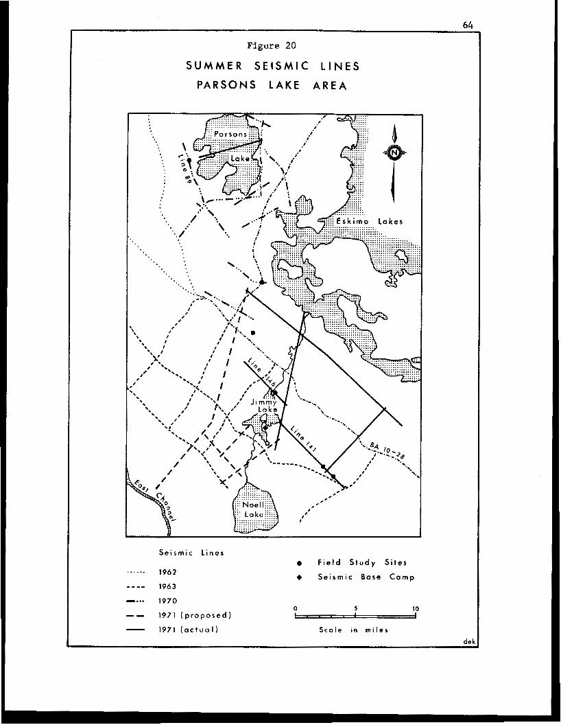
Figure 20
SUMMER S E I S M I C L I N E S
P A R S O N S L A K E A R E A
Seismic L ines e F i e l d S t u d v S i t e s ...... 1942
1943
e... 1970
-- 1971 ( p r o p o s e d ) - 1971 ( a c t u a l )
4 Seismic Base Camp
0 5 10
S c a l e i n m i l e s
dek
65
This is particularly the case i n many of the drier upland areas where the
initial degree of disturbance t o the vegetation cover may have been less
pronounced, In other areas, with more abundant moisture supplies, the
imprint of the vehicle tracks remains in the form of shallow ruts reaching
maxima of 25-30 cms in depth. Comparative measurements of the thickness of
the active layer, made in mid-July, revealed that the depth of thaw in the
disturbed area8 was only slightly greater than in adjacent undisturbed areas.
Almost a l l sections of the lines now possess a continuous vegetation cover.
In terms of species compoaition, however, the disturbed sites usually con-
tain much higher percentages of grass and sedge, and it is this attribute
which i s primarily responsible f o r the persistence of the lines as idsnti-
f iab le features in the tundra landscape.
Studies of the 1970 summer seismic lines were of particular
interest because the disturbances associated with these operations are of
such recent origin. Furthermore, the seismic survey method employed in-
volved the establishment of a permanent, as opposed to mobile, base camp
with the vehicles remaining in the field, rather than returning to the
camp each day, and the movement of personnel by helicopter. The adoption
of such a survey method has the obvious benefits in that it reduces the
amount of cross-tundra traffic to a minimum.
J
A helicopter surveillance was made along almost the entire length
of the 1970 summer seismic lines, and detailed f i e l d observations and
measurements were taken at two locations. These particular locations were
selected on the basis of being representative of examples o f the maximum
and minimum amounts of disturbance observed along the lines.
An example of the maximum type of disturbance associated with the
1970 summer seismic Operations occurred on Line 89 a t approximately 68' 5 7 ' N
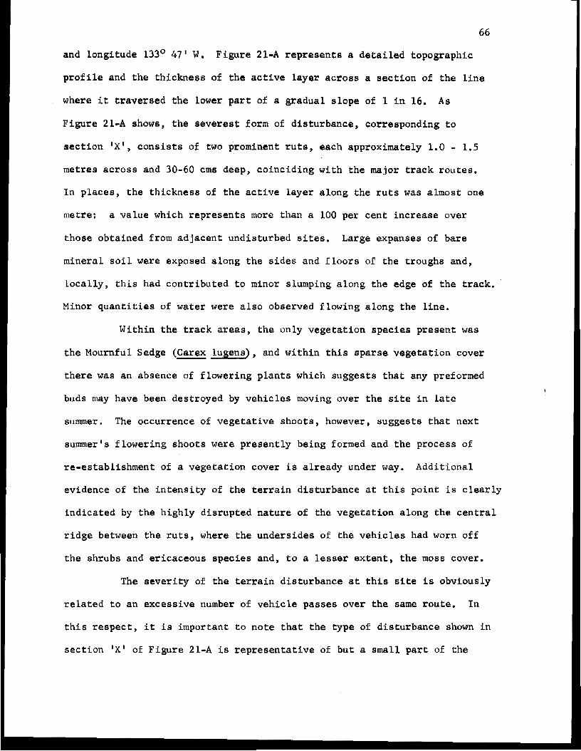
66
and longi tude 13J0 47' W . F igu re 21-A r e p r e s e n t s a de ta i l ed t opograph ic
profile and t he t h i ckness of t h e a c t i v e layer a c r o s s a s e c t i o n of t h e l i n e
where it t r a v e r s e d t h e lower part of a gradual slope of 1 in 16. As
Figure 21-A showB, the severes t form of diaturbance, corresponding t o
section # X 1 , c o n s i s t s of two prominent ruts, each approximately 1.0 - 1.5
metres across and 30-60 cms deep, coinc id ing wi th the major track routes .
In p l aces , t he t h i ckness of t h e a c t i v e l a y e r along t h e r u t s was almost: one
metre: a value which r e p r e s e n t s more than a 100 per cent increase over
those obtained f rom adjacent undis turbed sites. Large expanses of bare
m i n e r a l s o i l were exposed a long the s ides and floors of t h e troughs and,
l o c a l l y , t h i s had con t r ibu ted t o minor slumping along the edge of t h e t r a c k .
Minor q u a n t i t i e s of water were a lso observed f lowing a long the l ine .
Wi th in the track areas, the on ly vege ta t ion spec ie s p re sen t was
the Mournful Sedge (Carex lugens) , and wi th in th i s sparse vegeta t ion cover
t h e r e was an absence of f lower ing plants which suggests that any preformed
buds may have been destroyed by vehicles moving over t h e s i te i n late
summer. The occurrence of vegetative shoots, however, suggests that next
summer's f lower ing shoots were present ly being formed and the process of
re -es tab l i shment of a vegeta t ion cover is a l r eady under way. Addi t iona l
evidence of t h e i n t e n s i t y of t h e t e r r a i n d i s t u r b a n c e a t t h i s p o i n t is c l e a r l y
ind ica t ed by the h igh ly d i s rup ted na tu re oE the vege ta t ion along t h e c e n t r a l
r i d g e between t h e r u t s , where the unders ides of the v e h i c l e s had worn of f
the shrubs and er icaceous species a n d , t o a lesser e x t e n t , t h e moss cover.
-
The s e v e r i t y of t h e t e r r a i n disturbance at t h i s site is obviously
r e l a t e d t o an excess ive number of v e h i c l e passes over the same route . I n
t h i s r e s p e c t , i t i s i m p o r t a n t t o n o t e t h a t t h e t y p e of d i s turbance shown i n
s e c t i o n !X' of Figure 21-A i s r e p r e s e n t a t i v e of but a small part of t h e
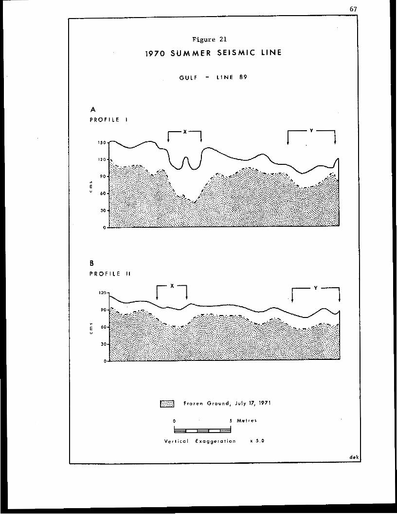
Figure 21
1970 S U M M E R S E I S M I C L I N E
GULF - LINE 8 9
A P R O F I L E I
I 5 O - rxl n ryl
de
B P R O F I L E I I
1201 rxl l"-yl + I 1
F r o z e n G r o u n d , J u l y 17, 1971
0 5 M e t r e s - V e r t i c a l E x a g g e r a t i o n X 5 . 0
67
68
seismic lines. Line 89 is an example of a seismic l i ne wh ich d i d n o t ' l i n k
up' with many o t h e r lines i n t he exp lo ra t ion programme. Consequently, the
v e h i c l e s moved northward along t h e l i n e and then returned southward along
the same route ra ther than e l sewhere along another seismic route. This
double passage of t h e vehicles i s undoubtedly responsible for the degree of
disturbance involved, and addi t iona l evidence s u g g e s t s t h a t t h e s e v e r i t y of
t h e damage could have been reduced considerably i f t h e vehicles had followed
a sepa ra t e rou te on the re turn journey . Section 'Y' of Figure 21-A
i l l u s t r a t e s t h e t e r r a i n d i s t u r b a n c e i n t h e v i c i n i t y of a shot hole. The
topograph ic e f f ec t of t h i s t y p e of d i s turbance i s considerably less than
t h a t a s s o c i a t e d w i t h section 'XI, and the vege ta t ion COVER: was also less
adve r se ly a f f ec t ed . The s i g n i f i c a n c e of these observa t ions i s related t o
the fact t ha t , a l t hough f ewer veh ic l e s moved over t he tundra at t h i s point,
t h e damage is assoc ia t ed w i th t he movement of t h e drill rig unit which is
the heav ie s t veh ic l e used i n the se ismic opera t ion .
\
Figure 21-B r e p r e s e n t s a second p r o f i l e across Line 89 a t a point
where i t t r a v e r s e s a low- ly ing , re la t ive ly wet area immediately a t t h e base
of t h e s l o p e r e f e r r e d t o i n t h e f irst p r o f i l e (Figure 21-A). I n terms of
v e h i c u l a r a c t i v i t y , section 'XI, showing t h e effects of t h e double passage
of most of t h e t r a f f i c , and section lYl, t he passage of t h e d r i l l r i g u n i t ,
correspond t o t h e s i m i l a r l y labelled s e c t i o n s of Figure 21-A. It i s r e a d i l y
apparent that the degree of t e r r a i n disturbance was much less pronounced at
this second s i te i n terms of its topographic effect, and c o n t r a s t s i n amount
of damage t o t h e vegetation cover were equally pronounced. The dominant
species growing in the d i s tu rbed areas was aga in Carex lugens and t h i s was
est imated t o account f o r almost 50 per c e n t of t he plant cover. Approximately
40 per cent of t h e line area cons i s t ed of black organic material exposed at
69
the aurface, but viable root and rhizome systems were p resen t i n the sub-
strate. Shrub spec ies a long the l i n e e x h i b i t e d t h e scarred e f f e c t s of con-
tact w i t h t h e v e h i c l e t r a c k s , b u t , i n many ins t ances , new l eaves were
developed on several of the branches and the growth of sucker shoots was
also evident .
I n o t h e r similar environments, the type of t e r r a i n d i s t u r b a n c e
more closely resembled the form shown i n F igure 21-A.(sec t ion 'XI), with t h e
existence of prominent ruts and large exposures of black organic material.
I n a number of areas t h e s e r u t s were f i l l e d with pools of s t and ing water.
Even a t these lOCatiOn5, however, desp i t e t he i r unaes the t i c appea rance ,
t h e l e v e l of d i s turbance d id no t seem t o be unduly severe. The ex i s t ence
of v i a b l a root systems i n the organic substrate , and the abundance of
hydrophi l ic apecies in t h e v e g e t a t i o n of ad jacent undis turbed areas, mem
t o assure a reasonably r a p i d r e c o l o n i z a t i o n of the d i s tu rbed areas.
The second area i n v a e t i g a t e d i n deta i l was located at t h e Inter-
section of a 1963 and 1970 line a t approx ima te ly l a t i t ude 68' 47'N and
longi tude 133' 32IW. Al thoush t he ex i s t ence of several parallel t ra i l s
WBB evident from the a i r , the majority of these had l i t t le or no topo-
graphic express ion a t the ground surface, Despite the fact that the l i n e a
t r ave r sed a number of hummocky mud-bails, up t o two metres acroea and 30
cme high , there was v i r t u a l l y no disturbance of the irregular terrain 8ave
for t he occas iona l presence of cleat impressions on parts of the 1970 l i n e .
Comparative measurements of the t h i ckness of the a c t i v e l a y e r r e v e a l e d t h a t
there were no a p p r e c i a b l e d i f f e r e n c e s between d i s tu rbed and undis turbed
sites. The minimal impact upon t h e hummock t undra vege ta t ion was equal ly
s t r i k i n g . S m a l l m a t s of lichens showed some signs of d i s tu rbance , but the
mos8 cover , especially Sphagnum species, appeared t o be v i r t u a l l y u n d i s t u r b e d .
70
Occasionally, where vehicles had traversed the sides of the hummocks, there
was some minor tearing of the vegetation cover.
The information collected during t h i s study would suggest that,
in certain areas a t least, and with the adoption of suitable operational
techniques, terrain disturbances associated with summer seismic operations
in a tundra environment need not be of a serious nature. Indeed, the
evidence that a drilling unit, the heaviest vehicle used in a summer seismic
operation, can traverse t h e unfrozen tundra surface with minimal disruption
of the terrain, suggests that the real question w i t h respect t o cross-tundra
traffic in the summer thaw period is the maximum number of vehicle passes
that the ground surface can tolerate before the degree of disturbance begins
t o exceed acceptable levels. This critical number of passes is quite
obviously related t o such factors as the terrain conditions and the types of
vehicles involved, and will vary accordingly; and a unique opportunity to
investigate this problem occurred last summer in the form of observations
of an actual summer seismic programme in the Jimmy Lake area (see Figure 20).
- 1971 Summer Seismic Lines.
In July 1971, Gulf Oil Canada Limited obtained permission to
perform summer seismic work in the Jimmy Lake area, as part of an experiment
designed to assess the feasibility of summer seismic operations on the
tundra. This seismic programme involved the establishment of a base camp
on the shore of Jimmy Lake (Figure 20), and the daily transportation of
crews by helicopter, to and from the operations. A s part of the terms of the
experiment, Gulf also agreed t o underwrite the costs of the logistics in-
volved in our an-site research and during follow-up investigatians of any
long-term effects of the disturbances f o r a period of up t o five years, as
71
well as t ak ing t h e r i s k of being shut down if the t e r r a i n d i s t u r b a n c e
exceeded acceptable levels as determined by a land use inspec tor . The
acceptance of these terms, and t h e u n s p a r i n g e f f o r t s of Gulf Oil and Globe
Universa l Sciences Canada L i m i t e d , who c a r r i e d o u t t h e seismic work, i n
a s s i s t i n g us t o meet our research o b j e c t i v e s , i s a t r i b u t e t o t h e genuine
w i l l i n g n e s s of these companies t o coopera te on research i n t o t h e a c t i v i t i e s
of t h e r e source exp lo ra t ion i ndus t ry i n nor thern Canada.
As f a r as possible, we hoped that t h e r e s u l t s of our research
would r e f l ec t : t h e ope ra t ions of a t y p i c a l summer seismic programme, I n t h i s
r e s p e c t , in a d d i t i o n t o s t u d i e s of t h e t e r r a i n d i s t u r b a n c e , we were also
i n t e r e s t e d i n the selection criteria used by t h e f i e l d p a r t i e s i n e s t a b l i s h i n g
t h e p r e c i s e r o u t e of t h e seismic l i n e s . Once these r o u t e s had been marked
by p i n f l a g s , a number of f i e l d sites (see F i g u r e 20), r e p r e s e n t a t i v e of
v a r i o u s t e r r a i n u n i t s , was selected fo r i n v e s t i g a t i o n s of t h e t e r r a i n
d is turbances . Only a t this stage d i d we request movements of vehicles over
par t icu lar rou tes . For example , it: was soon observed that many v e h i c l e
operators showed a tendency to avoid t h e wetter areas of the tundra; and
i n order t o obtain d a t a on l e v e l s of d i s tu rbance i n these areas we suggested
local modi f i ca t ions of t h e r o u t e s by d i r e c t i n g them across these sites.
Fur thermore , in o rder t o establish any t o l e r a n c e levels for the va r ious
t e r r a i n u n i t s , i n terms of t h e number of passes of v e h i c l e s , i t was also
necessary to ask t h e f i e l d crews t o f o l l o w s p e c i f i c t r a c k s in places.
E i g h t t r a n s e c t s were selected t o examine t h e effects o f the
seismic ope ra t ions on v a r i o u s t e r r a i n u n i t s f o u n d i n t h e Jimmy Lake area.
A series of s e q u e n t i a l p r o f i l e s was surveyed a t each of the sites and these
are shown i n F i g u r e s 22-29. On each of these diagrams, the f i rs t profile
( A ) , shows t h e Surface conf igura t ion of t h e t e r r a i n p r i o r t o t h e passage o f
72
any veh ic l e s across t h e l i n e of t h e t r a n s e c t . I n some cases, as i n
Figures 26-29, d i f f i c u l t i e s i n schedul ing o ther parts of our summer pro-
grarmne with those of the seismic p a r t y , resulted i n t h e s e initial surveys
being made after the passage of the bombardier used to survey t h e lines.
S i n c e i n many place8 i t was almost impossible t o f i n d the tracks of the
vehicle, i t was f e l t that t h e s e i n i t i a l surveys were still r e p r e s e n t a t i v e of
t he und i s tu rbed t e r r a in cond i t ions . The second a n d t h i r d p r o f i l e s ( B and C)
r ep resen t t he su r f ace conf igu ra t ions immedia t e ly following the passages of
the d r i l l i n g u n i t s and line crewlrecording units r e s p e c t i v e l y , and t h e d o t t e d
l ines on each of t h e s e profiles i l l u s t r a t e the changes a t the g round sur face
wnich were a s s o c i a t e d w i t h each of these phases of t h e seismic operat ion,
The f i n a l p r o f i l e (D) on each of these diagrams, shows t he ne t changes i n
the surface topography produced by t h e e n t i r e seismic opera t ion , and the
d o t t e d l i n e i n t h i s case r e p r e s e n t s t h e o r i g i n a l , u n d i s t u r b e d t e r r a i n .
The s e q u e n t i a l p r o f i l e s t u d i e s of F i g u r e s 22-29 record the mag-
n i t u d e of the immediate or shor t - te rm d is turbances assoc ia ted wi th the
vehicle passes , Af te r the passage of t h e last v e h i c l e i n t h e seismic pro-
gramme across each t r a n s e c t , a probe was used t o e s t a b l i s h t h e t h i c k n e s s of
t h e thawed layer as shown i n t h e profile (D) on each of the diagrams. Bench
marks were a l so i n s t a l l e d o n each t r a n s e c t t o f a c i l i t a t e o b s e r v a t i o n s of any
further long-term changes i n t h e re la t ive p o s i t i o n s of t h e ground surface
and the upper surface of t h e f rozen ground. In order t o c o r r e l a t e any
changes in the t opograph ic p ro f i l e w i t h the development of therrnokarst sub-
s idence , core samples for analysis of their ice content were col lected i n
10 cms increments over a t o t a l d e p t h of 30 crns, from the upper part of t h e
f r o z e n s u b s t r a t e i n t h e most d i s t u r b e d areas. I n some of t h e t r a n s e c t s ,
however, t h e water logged nature of t h e thawed layer made t h e collection
73
of such samples impossible.
The f irs t four t r a n s a c t s were located towards the south eas te rn
end of t h e main s e c t i o n of Line 141 (see F igure 20). One of t h e t r a n s e c t s ,
P r o f i l e I (Figure 22), wa8 establ ished where a s e c t i o n of the l i n e between
shot po in t s 42 and 43 t r ave r sed a series of very prominent earth.hummocks.
These humock s t ructures averaged one t o two metres across and t h e raised
c e n t r e s were as much as 50-60 cms above the levels of the i n t e rven ing
depress ions (Figure 22-A). The vege ta t ion cover included a shrub layer of
Mountain Alder (Alnus crispa) and the more prominent vascu la r spec ie s growing
on t h e hummocks cons i s t ed of the Harrow-leafed Labrador-tea (Ledum palustre
ssp. dacumbens), Mountain Cranberry (Vaccinium vitis-idaea) and tussocks of
Sheathed Cotton-grass (Eriophorum vaginatum}. The drier surfaces of some
of the l a r g e r hummocks a l s o supported t h i n mats of l ichens .
A s Figure 22-B shows, the maximum change a t t h e ground su r face
fo l lowing the paseage of two d r i l l r i g units, each weighing about 11 tons ,
wae i n t h e o r d e r of 15-18 cms where t h e two v e h i c l e s moved along i d e n t i c a l
t racks . Most of this value r e p r e s e n t s a compression of t h e loose vegeta t ion
cover growing on the side of an ear th humock. Elsewhere, the change8 i n the
su r face profi le were less than 5 crns, and for t he most p a r t t h e s e also rep-
r e sen ted a compression of the o rganic layer, a l though t he re was some local
removal of t h e l i c h e n mat and some exposure of bare mineral s o i l i n t h e
deeper cleat marks of the t r a c k s ,
Other sections of the l i n e , t r a v e r s i n g similar i r r e g u l a r t e r r a i n ,
were cha rac t e r i zed by a more severe form of damage i n which large blocks of
vege ta t ion and mineral soil, one t o two metres across and up t o 20 cms t h i c k ,
were peeled from the surfaces of the hummocks. It was observed that t h i s
damage was being created by t h e rear end of the underside of the v e h i c l e ,
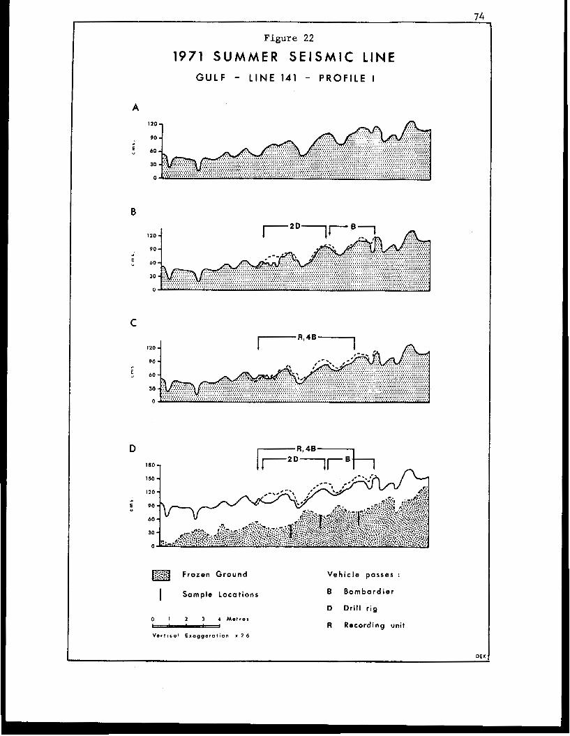
Figure 22
1971 SUMMER S E I S M I C LINE GULF - LINE 141 - PROFILE I
A
90
5 40
90
C
90
40
D
1 150 - I20 -
Frozen Ground
0 I 2 3 4 M e t r e s - V e r l l c o l Exaggeration Y 2 4
V e h i c l e passas :
B Bombardier
D Drill r ig
R Recording unit
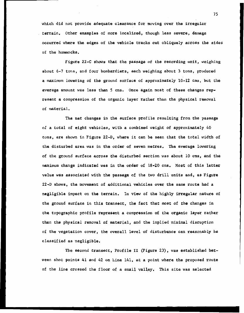
occurred where the edges of the vehicle tracks cut obliquely across the sides
of the hummocks.
Figure 2 2 4 shows that the passage of the recording unit, weighing
about 6-7 tons, and four bombardiers, each weighing about 3 tons, produced
a msxirnurn lowering of the ground surface of approximately 10-12 crns, but the
average amount was less than 5 crns. Once again most of these changes rep-
resent a compression of the organic layer rather than the physical removal
of material.
The net changes in the surface profile resulting from the passage
of a total of eight vehicles, with 8 combined weight of approximately 40
tons, are shown in Figure 224, where it can be seen that the total width of
the disturbed area was in the order of seven metres. The average lowering
of the ground surface acrosg the disturbed section was about 10 crns, and the
maximum change indicated wae in the order of 18-20 crns. Most of this latter
value was associated with the passage of the two drill units and, as Figure
22-D showa, the movement of additional vehicles over the same route had a
negligible impact on the terrain. In view of the highly irregular nature of
the ground surface in this transect, the fact that most of the changes in
the topographic profile represent a compression of the organic layer rather
t h a n the physical removal of material, and the implied minimal disruption
of the vegetation cover, the overall level of disturbance can reasonably be
classif iad as negligible.
The second transect, Profile 11 (Figure 23), was established bet-
ween shot points 41 and 42 on Line 141, at a point where the proposed route
of the line crossed the f loo r of a small valley. This site was selected
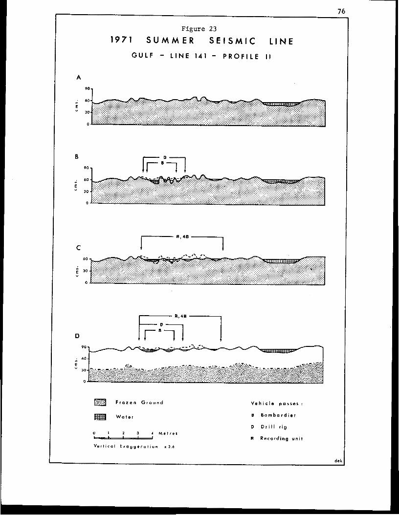
76
F i g u r e 23
1971 S U M M E R S E I S M I C L I N E
G U L F - L I N E 141 - P R O F I L E I I
A
90 1
90 1
F r o z e n G r o u n d
W a t e l
0 1 2 3 A M e t r e s - Vertical E x a g g c r o t i o n x 2.6
V e h i c l e passes :
B B o m b a r d i e r
0 D r i l l r i g
R Recording u n i t
77
s i n c e i t represented one of t h e wetter areas, r e f e r r e d t o earlier, which
many v e h i c l e o p e r a t o r s t e n d t o a v o i d . I n f a c t , b o t h of t h e d r i l l r i g u n i t s
avo ided t he l i ne of our t ransect and, a l though one of t h e v e h i c l e s d i d c r o s s
the f l o o r of t he dep res s ion via another rou te , the o ther vehic le fo l lowed a
much more c i r c u i t o u s r o u t e along the edge of t h e firmer ground. It i s in -
t e r e s t i n g t o note t h a t i n a d d i t i o n t o i n c r e a s i n g t h e l e n g t h of t h e 'damaged'
area, this a l t e r n a t e r o u t e along the higher ground, which incidental ly was
favoured by the l and use i n s p e c t o r , also r e s u l t e d l o c a l l y i n g r e a t e r l e v e l s
of t e r r a in d i s tu rbance t han t hose deve loped a long t he more d i r e c t r o u t e
across t h e f loor of the depression. This h igher l eve l of damage t o t h e
t u n d r a r e f l e c t e d t h e greater i r r e g u l a r i t y of the hummocky t e r r a i n a l o n g t h i s
path and the need for t h e v e h i c l e t o make fairly t i g h t t u r n s t o c h a n g e
d i r e c t i o n . It was also l earned that the p r imary reason for avoid ing t h e
wetter areas was a f e a r that t h e v e h i c l e would get s t u c k i n t h e 'muskeg' and
it was d i f f i c u l t , at f i r s t , t o convince the opera to r t ha t t he uppe r su r f ace
of the frozen ground was only about 20 cms beneath the ground surface.
Fur ther ev idence of t he w i l l i ngnees of the geophysical company t o c o o p e r a t e
i n t h e r e s e a r c h was provided when t h e party manager requested one of t h e d r i l l
u n i t s t o r e t u r n t o t h e area and t o move across the line of our transect.
Figure 23-A shows t h a t t h e g r o u n d s u r f a c e i n t h i s s e c o n d tranaect
was r e l a t i v e l y f e a t u r e l e s s w i t h a n a v e r a g e m i c r o r e l i e f of only 10-15 cms.
Although no permanent stream occup ied t he f l oo r of the v a l l e y a t t h i s p o i n t ,
t h e thawed l a y e r c o n s i s t i n g e n t i r e l y of o rgan ic material, was waterlogged and
t h e l a r g e r d e p r e s s i o n s i n t h e ground s u r f a c e were f i l l e d w i t h s h a l l o w pools
of s t and ing water. Sedges (chief ly Carex species) and mosses were t h e
p r i n c i p a l components of t h e v e g e t a t i o n community which also included such
spec ie s as t h e Narrow-leafed Labrador-tea (Ledum p a l u s t r e ssp, decumbens),
78
Cloudberry (Rubus chamaemorus), Common Crowberry (Empetrum nigrum), and
Arctic Blueberry (Vaccinium ul iginosum), together with occasional tussocks
of the Sheathed-Cot ton-grass (Eriophorum vaginaturn) and i so l a t ed pa t ches of
the Mountain Alder (Alnus cr ispa) . The passages af t h e survey bombardier and the d r i l l rig u n i t
(F igure 23-B) produced some accentua t ion of t h e m i c r o r e l i e f by the compression
of organic material a l o n g t h e main l i n e s of the t r acks . I n some parts, t h i s
compression produced a lowering of the ground surface i n t h e o r d e r of 10-15
cms and the impressions of t h e t r a c k s were f i l l e d w i t h s h a l l o w pools of
water 5-10 cms deep. The other most n o t i c e a b l e a s p e c t of t h e d i s t u r b a n c e
was a E l a t t e n i n g of many of the sedges. The t r a f f i c a s s o c i a t e d with t h e
l i n e crew and recording unit produced a fur ther compression of t he o rgan ic
material, p r i m a r i l y i n t h e areas between the t racks of t h e d r i l l rig u n i t ,
and an i n c r e a s e i n t h e e x t e n t of t h e area occupied by pools of s t and ing
water.
The d i s t u r b e d area as soc ia t ed w i th t he pas sage of a t o t a l of seven
v e h i c l e s , w i t h a combined weight of approximately 30 tons, covered a width
of 6-7 metres. W i t h i n t h i s area t h e n e t c h a n g e s i n t h e l e v e l of t h e ground
su r face cons i s t ed of a lowering of 10-12 cms and, as F i g u r e 23-I, shows, a
l a rge p ropor t ion of the depressed area contained pools of s tanding water .
As indicated above, however , the depression of t h e ground surface was
e n t i r e l y t h e result of a compression of t he organic l ayer and n o t the
physical removal of material.
There i s no doubt that t h e t y p e of d i s tu rbance incurred i n this
second t ransect shows up very prominently from t h e a i r , to a point where
the appearance of t h e r o u t e o f t e n results i n the l e v e l of t e r r a i n damage
being descr ibed as excess ive , The da rke r co lou ra t ion of t h e l ines, r e s u l t i n g
79
from a f l a t t e n i n g of the vegetat ion, and the emphasis of t h e main tracks
due t o t h e pools of s tanding water, are t h e most prominent fac tors i n -
f l uenc ing t h e appearance of t he l i nes . The existence of water i n t he main
t r a c k s often leads t o f e a r s that water i s moving a l o n g t h e l i n e s and may
eventua l ly l ead to chronic e ros ion . Despi te the appearance of the l i n e s i n
t h i s t r a n s e c t f r o m t h e air , the d a t a o b t a i n e d f r o m t h e s e q u e n t i a l p r o f i l e s
would suggest that t he actual l e v e l of t e r r a i n d i s t u r b a n c e i s neg l ig ib l e .
S ince t he most prominent r u t s were t h e result of a compression of t he
organic l aye r it may be assumed t h a t the ground surface i n t he dep res sed
areas will rise as the organic material expands. Furthermore, t h e r e was no
observed flow of water i n the t r a c k areas, and t h e fact that t hese are
aligned almost at: r i g h t angles to the d r a i n a g e r o u t s precludes any major
accentuation of the r u t s aB a r e s u l t of watar f lowing along t h e linea.
F i n a l l y , apart from a f l a t t e n i n g of the taller 8pecies, t he re appea red t o
be l i t t l e or no obviou8 signs of any permanent damage t o the vege ta t ion
cover, and most of the spec ie s can be expected t o ehow rap id rates of
recovery from any minor disruption. Since much of t h i s recovery may not
take place u n t i l t he summer of 1972, there may be some merit i n schedul ing
any f u t u r e summer seiemic programmes f o r t h e month of July, r a t h e r t h a n
August, t o enable more r ecove ry t o take place i n the same growing season
r a t h e r than i n t h a t of t he fo l lowing year. Only time w i l l tell whether the
long- te rm e f fec ts of t he t e r r a i n d i s t u r b a n c e are different from those pos-
t u l a t e d above, or whether the rate of recovery differs apprec iab ly f rom tha t
i n the h igher and dr ie r terrain u n i t s ,
The t h i r d t r a n s e c t , P r o f i l e III (Figure 24) was e s t a b l i s h e d on t h e
s l i g h t l y h i g h e r ground a d j a c e n t t o t h e d e p r e s s i o n referred t o i n the p rev ious
transect. As Figure 24-A shows, tha s u r f a c e microrelief averaged 20-30 cms
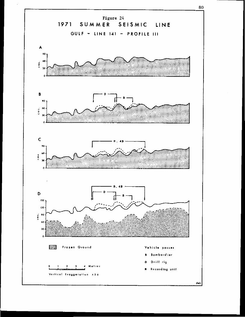
Figure 24 1971 S U M M E R S E I S M I C L I N E
G U L F - LINE 141 - P R O F I L E I l l
A
90 .I
90 I 1
D
I20 - 9 0 -
5
a F r o z e n G r o u n d
0 I 2 3 4 M e t r e s I I
V e r t i c o l E x a g g e r a t i o n x 2 . 4
V e h i c l e passes
I B o m b a r d i e r
D D r i l l r i g
R R e c o r d i n g u n i t
81
and t h i s c o n s i s t e d of subdued e a r t h hummocks in t e r spe r sed w i th t he t u s sock
forms of the Sheathed Cotton-grass (Eriophorum vaginaturn). The thawed
l a y e r i n t h i s s i t e also c o n t a i n e d s u b s t a n t i a l q u a n t i t i e s of water.
Figures 24-B and 244 show that t h e maximum depression of t h e
ground su r face ae soc ia t ed with the passages of t h e d r i l l i n g crews and l i ne
crews amounted to abou t 15 cms and averaged 5-10 cms. I n each c a s e , most of
the change was attributed t o a f l a t t e n i n g of the tussocks and a compression
of o the r components of t he o rgan ic l aye r , a l t hough t he re was a local
sc rap ing of t h e s u r f a c e s of some of t h e larger hummocks and minor exposures
of m i n e r a l s o i l i n some of the deepe r c l ea t marks,
The overall width of t h e damaged area amounted t o 6-7 metres
(F igure 24-D) over which there was an average depression of t h e ground
su r face of 10-15 cme. Apart from a few broken limbs of the Mountain Alder
(Alnua c r i spa) and the Glandular Birch (Betula plandulosa) , and despite a
f l a t t e n i n g of many of t h e tussocks, there seemed t o be no marked o r perma-
nent damage t o the vegeta t ion cover . The level of terrain d i s tu rbance i n
t h i s t r a n s e c t , t h e r e f o r e , also could be classed as neg l ig ib l e and t he re is
little reason t o e x p e c t t h a t t h i s level will be a c c e n t u a t e d i n the f u t u r e .
The f i n a l t r a n s e c t i n t h i s f i r s t study area was e s t a b l i s h e d on
t e r r a i n similar t o that descr ibed f o r P r o f i l e I (Figure 22). This site was
selected,however, t o reveal a n y d i f f e r e n c e s i n damage tha t might occur where
the veh ic l e s a scend , rather than descend (as i n the c a s e of t h e first
t r a n s e c t l o c a t i o n ) a s lope . As F igure 25-A i l l u s t r a t e s , t h e t e r r a i n con-
d i t i o n s i n this f o u r t h p r o f i l e s t u d y were even more i r r e g u l a r t h a n t h o s e
i n any of the previous sites, and the most prominent earth hummocks were as
much as 3-4 metres across and up t o 60-70 cms high, Bare minera l soil was
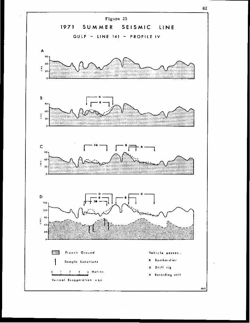
82
Figure 25
1971 S U M M E R S E I S M I C L I N E
G U L F - L I N E 141 - P R O F I L E I V
A
B I O 1
D
F r o z e n G r o u n d
I S a m p l e ~ o c a t i o n s
0 1 2 3 4 M e t r e s "44
V e r t i c a l E x o g g c r a t i o n x 2.6
V e h i c l e p a s s e s :
B B o m b a r d i e r
D D r i l l r i g
R Recording uni t
dek
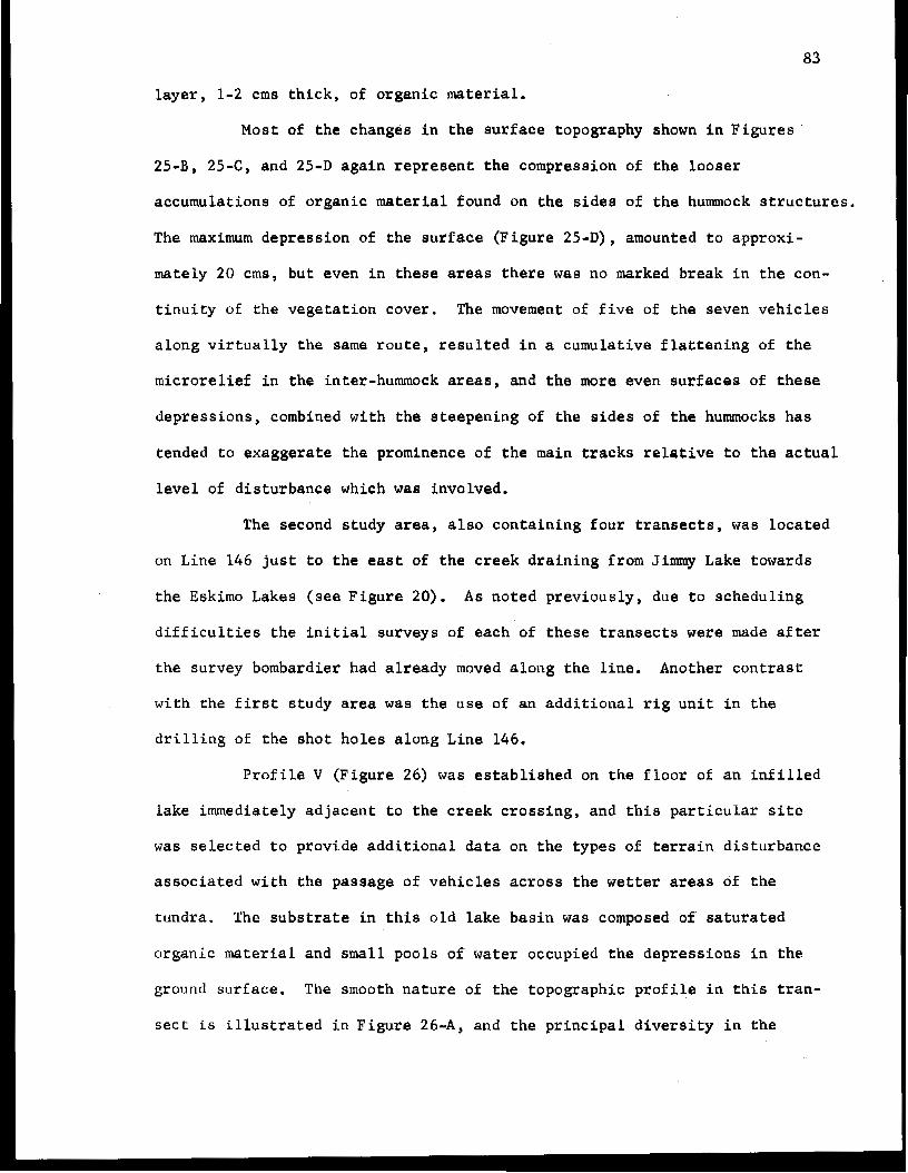
83
layer, 1-2 crns t h i c k , of organic material.
Most of the changes i n the surface topography ahown i n F i g u r e s
25-B, 2 5 4 , and 25-D again represent the compress ion of the l oose r
accumulations of organic material found on the s idea of t h e hummock s t r u c t u r e s .
The maximum depress ion of t he su r f ace (F igu re 25-D), amounted t o approxi-
mately 20 crns, bu t even in these areas t h e r e was no marked break i n t h e con-
t i n u i t y of the vegetat ion cover . The movement of f i v e of the seven vehic les
a l o n g v i r t u a l l y t h e same r o u t e , r e s u l t e d i n a cumula t ive f l a t t en ing of t h e
mic ro re l i e f i n the inter-hummock areas, and the more even surfaces of t h e s e
depress ions , combined wi th the s teepening of t h e s i d e s of t he hummocks has
tended to exaggerate the prominence of the main t r a c k s r e l a t i v e t o t h e a c t u a l
l e v e l of disturbance which waB involved.
The second study area, also con ta in ing four t r a n s e c t s , was loca ted
an Line 146 j u s t t o t h e east of t h e c r e e k d r a i n i n g from Jimmy Lake towards
t h e Eskimo Lakes (see F i g u r e 20). As noted previous ly , due to schedul ing
d i f f i c u l t i e s t h e i n i t i a l surveys of each of these t r a n s e c t s were made a f t e r
the survey bombardier had already moved a l o n g t h e l ine. Another cont ras t
w i t h t h e f i r s t s t u d y area was t h e use of a n a d d i t i o n a l r i g u n i t i n the
d r i l l i n g of t h e s h o t h o l e s a l o n g L i n e 146,
P r o f i l e V (Figure 26) was e s t a b l i s h e d on t h e f l o o r of a n i n f i l l e d
lake immediately adjacent t o t h e c r e e k c r o s s i n g , a n d t h i s p a r t i c u l a r s i t e
was s e l e c t e d t o p r o v i d e a d d i t i o n a l d a t a on the types of t e r r a i n d i s t u r b a n c e
a s s o c i a t e d w i t h the passage of v e h i c l e s a c r o s s t h e wetter areas of the
tundra. The s u b s t r a t e i n t h i s o l d lake b a s i n was composed of s a t u r a t e d
organic material and small pools of water occupied the depress ions in the
ground surface. The smooth n a t u r e of t h e t o p o g r a p h i c p r o f i l e i n t h i s t r a n -
sect is i l l u s t r a t e d i n F i g u r e 26-A, and t h e p r i n c i p a l d i v e r s i t y i n the
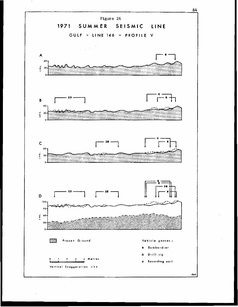
." ..
Figure 26
1971 S U M M E R S E I S M I C L I N E
A IEl
C I 1 I" 7%
1207 """""-"
9 0 -
/
40-
a F r o z e n G r o u n d V e h i c l e p a s s e s ;
0 I 2 3 4 M e t r e s
V e r t i c a l E x a g g e r a t i o n x 2 . 6
B B o m b a r d i e r
b D r i l l r i g
R Recording u n i t
dek
85
su r face cond i t ions cons i s t ed of small mounds of peaty material averaging
20-40 crns across and 15-20 crns i n he ight . A l ack of diversity a lso
cha rac t e r i zed the vege ta t ion community i n t h i s s i t e which was dominated by
almost pure s tanda, 20-60 crns tall, of two spec ies : the Aquatic Sedge
(Carex a q u a t i l i s ) and the Marsh o r P u r p l e C i n q u e f o i l ( P o t e n t i l l a p a l u s t r i s ) ,
t oge the r w i th a ground cover of mosses,
I n an a t tempt t o e v a l u a t e t h e e f f e c t s of varying amounts of
t r a f f i c on the terrain, two of t he drilling r i g s were r e q u e s t e d t o move
a long exac t ly t he same r o u t e a c r o s s t h e l i n e of the t ransec t and the o t h e r
r i g was asked t o f o l l o w t h e earlier t r a c k s of the survey bombardier. A s
Figure 26-B shows, t h e r e was no appreciable difference i n t h e level of
d i s tu rbance along each of t h e s e r o u t e s . I n both areas, the ground surface
was depressed by amounts ranging from 5-10 crns as a result of a compression
of the o rganic l ayer under the main l i n e s of t he t r acks . The ground su r face
i n t h e i n t e r - t r a c k areas of the r o u t e followed by t h e two drill rigs was
a c t u a l l y r a i s e d i n p l a c e s , a s some of the mounds were f l a t t e n e d across t h e
intervening depressions and some organic material was squeezed up from
beneath t h e track areas. Small pools of water, 1-2 crns deep , co l l ec t ed
t empora r i ly i n t he more heavily compressed areas,but these d i d n o t p e r s i s t
f o r any length of time. Most of the v e g e t a t i o n was f l a t t ened a long each
rou te , bu t very few p l a n t s were e i ther b roken or uprooted.
The passage of t h e l i n e crew and recording uni t (Figure 26-C)
produced an additional lowering of the g round sur face , also as a result of
compression of t h e o r g a n i c s u b s t r a t e , and a further f l a t t e n i n g of t he
vege ta t ion . Most of these veh ic l e s f a l lowed t he same r o u t e as t h e s i n g l e
d r i l l r i g and survey bombardier, yet despite the movement of five v e h i c l e s
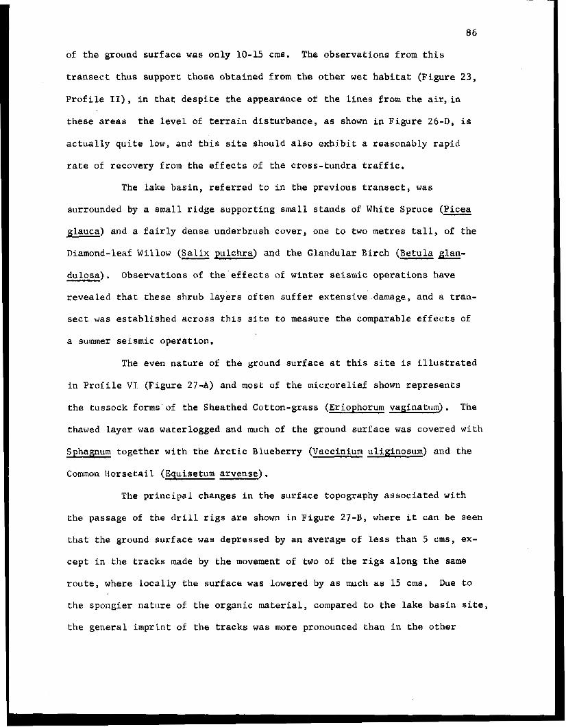
86
of the ground surface was only 10-15 cms. The observa t ions from t h i s
t r a n s e c t t h u s support: those obtained f rom the o the r wet h a b i t a t ( F i g u r e 23,
Profile 11), i n t h a t d e s p i t e t h e a p p e a r a n c e of t h e l i n e s f r o m t h e a i r , i n
t hese areas t h e l e v e l of t e r r a i n d i s t u r b a n c e , as shown i n F igu re 26-D, i s
actually q u i t e low, and t h i s s i t e should also exhibit a reasonably r a p i d
ra te of recovery f rom the e f fec ts of the c ross - tundra traff ic .
The l a k e b a s i n , r e f e r r e d t o i n t he p rev ious t r ansec t , was
surrounded by a small r idge suppor t ing small s t ands of White Spruce (Picea
glauca) and a fa i r ly dense underbrush cover , one t o two metres t a l l , of t h e
Diamond-leaf Willow ( S a l i x - pulchra) and the Glandular Birch (Betula glan-
dulosa) . Observa t ions of t h e e f f e c t s of winter seismic operat ions have
r evea led t ha t t hese sh rub l aye r s o f t en su f f e r ex t ens ive damage, and a t r an -
sect was establ ished across t h i s s i t e t o measure the comparable e f f e c t s of
a summer se i smic opera t ion .
The even nature of the ground surface a t t h i s s i t e i s i l l u s t r a t e d
i n P r o f i l e V I (Figure 27-A) and most of the microre l ie f shown r e p r e s e n t s
the tussock forms of the Sheathed Cotton-grass (Eriophorum vaginaturn). The
thawed l aye r was waterlogged and much of the ground surface was covered with
Sphagnum together w i t h the Arctic Blueberry (Vaccinium uliginosum) and the
Common H o r s e t a i l (Equisetum arvense) .
The pr inc ipa l changes in the sur face topography assoc ia ted with
t he passage of the dri l l rigs are shown i n F i g u r e 27-B, where i t can be seen
t h a t the ground surface was depressed by an average of less than 5 cms, ex-
c e p t i n the t r a c k s made by t h e movement of two of t h e r i g s a l o n g t h e same
r o u t e , where l o c a l l y t h e s u r f a c e was lowered by as much as 15 cms. Due to
t h e spongier na tu re of t h e organic material, compared t o t h e lake basin si te ,
the general imprint of t h e t r a c k s was more pronounced than i n t h e o t h e r
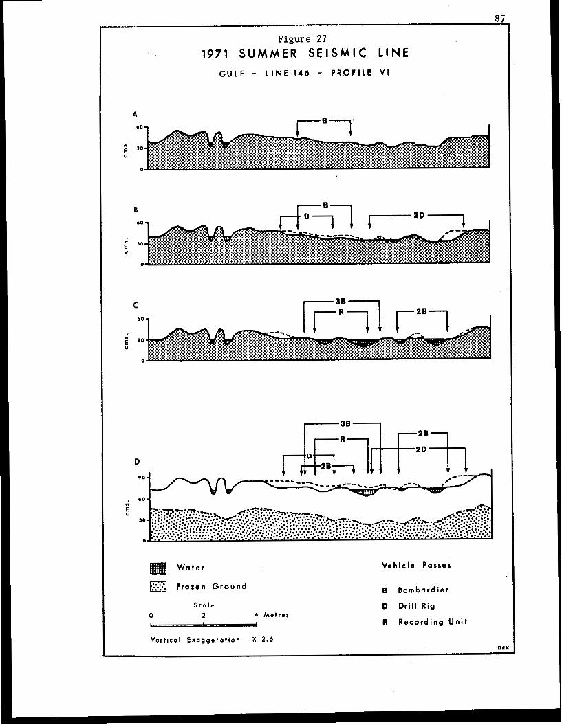
87
Figure 27
1971 SUMMER S E I S M I C LINE GULF - L I N E 146 - P R O F I L E V I
B
Water
Frozen Ground
S c a l e 2 4 M e t r e s
Vehicle Passes
B Bombardier
D Dri l l Rig
R Recording U n i t
V e r t i c a l E x a g g e r a t i o n X 2.6 011
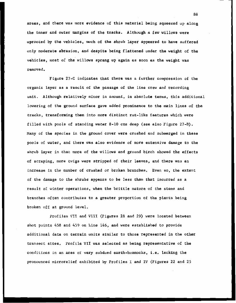
88
areas, and there was more evidence af t h i s material being squeezed up a long
the i nne r and outer margins of t h e tracks. Although a few willows were
uprooted by t h e v e h i c l e s , much of the sh rub l aye r appeared t o have suffered
only moderate abrasion, and despi te being f l a t t e n e d under the weight of the
v e h i c l e s , most of the willows sprang up again a s soon as the weight was
removed
F igure 2 7 4 indicates t h a t there was a fur ther compress ion of the
organic l aye r as a r e s u l t of the passage of t h e l i n e crew and r eco rd ing
u n i t . Although r e l a t i v e l y minor i n amount, i n a b s o l u t e terms, t h i s a d d i t i o n a l
lowering of the ground surface gave added prominence t o t h e main l i n e s of the
t racks , t ransforming them i n t o more d i s t i n c t rut-like features which were
f i l l e d w i t h p o o l s of s tanding water 8-10 cms deep (see a l so Figure 27-D).
Many of the spec ies in the g round cover were crushed and submerged i n these
pools of water, and there was also evidence of more ex tens ive damage t o t h e
shrub layer i n t h a t more of the willows and ground birch showed t h e e f f e c t s
of s c rap ing , more twigs were s t r i p p e d of the i r l eaves , and there was an
i n c r e a s e i n t h e number of crushed or broken branches. Even so , t he ex t en t
of t he damage t o the shrubs appears to be less t h a n t h a t i n c u r r e d as a
r e s u l t of w in te r ope ra t ions , when t h e b r i t t l e n a t u r e of t h e stems and
branches o f ten cont r ibu tes t o a grea te r p ropor t ion of the p l a n t s being
broken of€ a t ground l e v e l .
Prof i les V I 1 and VI11 (F igures 28 and 29) were located between
shot p o i n t s 458 and 459 on Line 146, and were e s t ab l i shed t o p rov ide
a d d i t i o n a l d a t a on terrain u n i t e similar t o those r ep resen ted in t h e o t h e r
t r a n s e c t sites. P r o f i l e V I 1 was selected as be ing r ep resen ta t ive of t h e
c o n d i t i o n s i n a n area of very subdued earth-hummocks, i.e. l ack ing the
pronounced microrel ief exhibi ted by Profiles I and I V (F igures 22 and 25
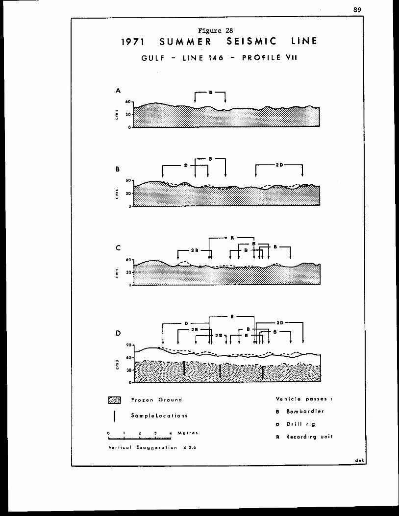
89
I Figure 28
1971 S U M M E R S E I S M I C LINE
GULF - L I N E 1 4 6 - P R O F I L E VI1
D
a F r o z e n G r o u n d V e h i c l e passes :
0 1 1 3 4 M e t r e s
V e r t i c a l E x a g g e r a t i o n x 2 . 6
tl B o m b a r d i e r
D D r i l l r i g
R Record ing u n i t
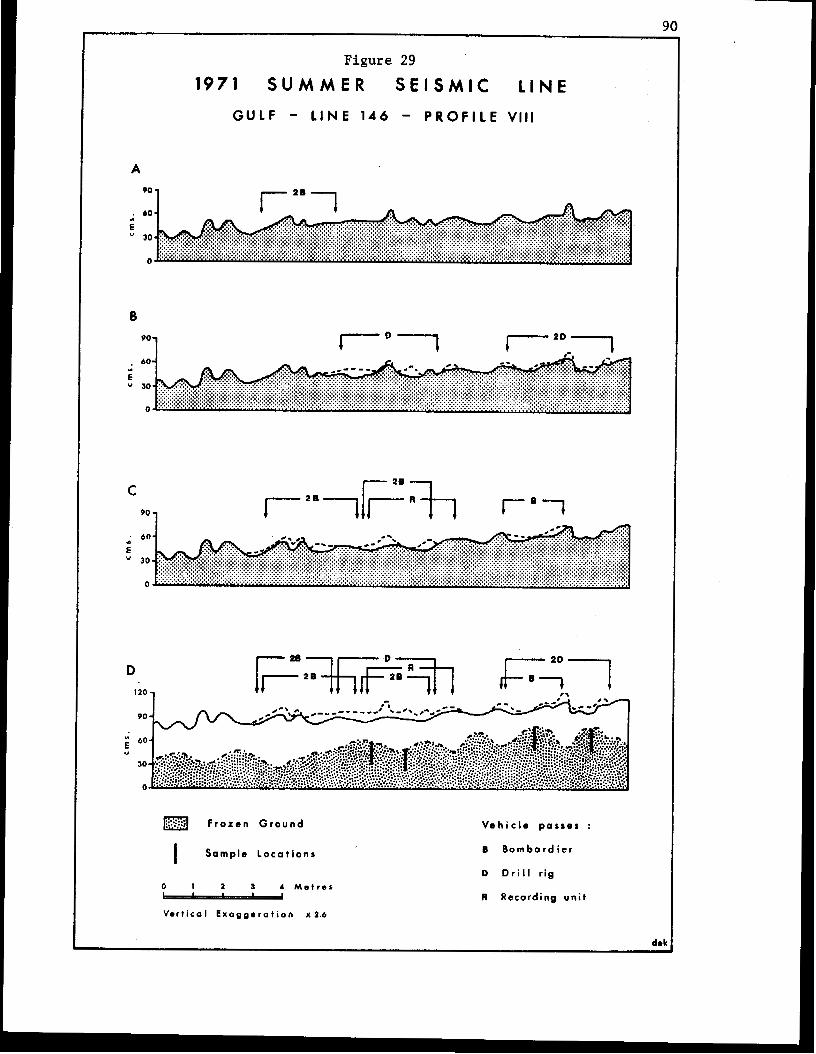
90
A
O0 1
Figure 29
1971 S U M M E R S E I S M I C LINE
GULF - LINE 146 - P R O F I L E V l l l
I 1
B
1"l
C 1
I 28 1
D 120 -I
90 -
a F r o t e n G r o u n d V e h i c l e p o s s e 8 :
0 I 2 3 1 M e t r e s - V e r t i c a l E x o g g s r o t i o n x 1 . 6
B B o m b a r d i e r
D D r i l l r ig
R Recording unit
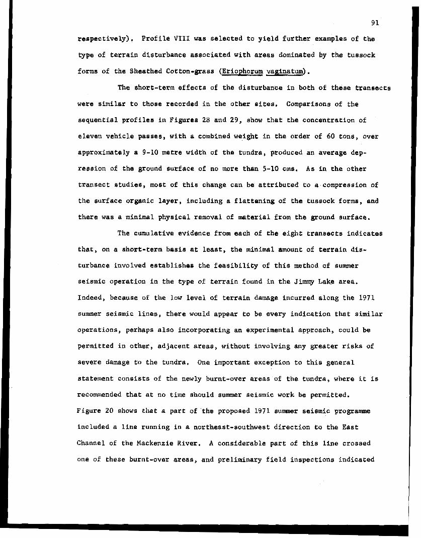
91
r e s p e c t i v e l y ) . P r o f i l e VI11 was s e l e c t e d t o yield f u r t h e r examples of t h e
type of t e r r a i n d i s t u r b a n c e a s s o c i a t e d w i t h areas darninated by t he tussock
forms of t he Sheathed Cotton-grass (Eriophorurn vaginaturn).
The s h o r t - t e r m e f f e c t s of t h e d i s t u r b a n c e i n both of t h i s e t r a n e e c t a
were similar t o those r eco rded i n t he other sites. Comparisons of the
sequential profiles i n F i g u r e s 2% and 29, show t h a t the concen t r a t ion of
e l even veh ic l e passes, wi th a combined weight i n t h e o r d e r of 60 tons , over
approximately a 9-10 metre width of the tundra, produced an average dep-
r e s s i o n of the ground surface of no more than 5-10 cms, As i n t h e o t h e r
t r a n s e c t s t u d i e s , most of t h i s change can be a t t r i b u t e d t o a compression of
the su r face o rgan ic l aye r , i nc lud ing a f l a t t e n i n g of the tussock forms, and
t h e r e was a minimal physical removal of material from the ground sur face .
The cumulative evidence from each of t h e e i g h t transects i n d i c a t e s
t h a t , on a shor t - te rm basis at least, t h e minimal amount: of t e r r a i n dis-
turbance i n v o l v e d e s t a b l i s h e s t h e f e a s i b i l i t y of t h i s method of SU~UU@K
seismic o p e r a t i o n i n the type of t e r r a i n found i n t h e Jimmy Lake area.
Indeed, because of t he low level of t e r r a i n damage incur red along t h e 1971
summer seiemic l i n e s , t h e r e would appear t o be e v e r y i n d i c a t i o n t h a t similar
operations, perhaps also i nco rpora t ing an experimental approach, could be
p e r m i t t e d i n o t h e r , a d j a c e n t areas, without involv ing any g r e a t e r risks of
severe damage t o the tundra, One important except ion t o t h i s g e n e r a l
statement c o n s i s t s of the newly burnt-over areas of t h e tundra, where i t is
recommended that a t no time should summer seismic work be permitted.
Figure 20 shows that a part of the proposed 1971 summer seiernic programme
included a l i n e runn ing i n a nor theas t - southwes t d i rec t ion t o t h e East
Channel of the Mackenzie River. A cons iderable part of this line crossed
one of these burnt-over areas, and p re l imina ry f i e ld i n spec t ions i nd ica t ed
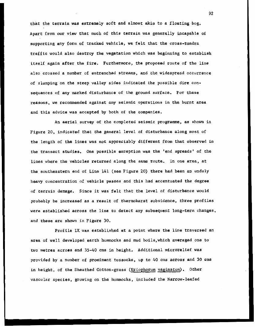
92
t h a t t h e terrain was extremely soft and a lmost ak in t o a Eloating bog.
Apart from our view t h a t much of this t e r r a i n was genera l ly incapable of
aupport ing any Eorm of t racked vehic le , we f e l t t h a t t h e c r o s s - t u n d r a
t r a f f i c would a l so des t roy t he vege ta t ion wh ich was b e g i n n i n g t o e s t a b l i s h
i t s e l f a g a i n after the fire. Furthermore, the proposed route of t h e l i n e
a l s o c r o s s e d 8 number of entrenched streams, and the widespread occurrence
of slumping on t h e s t e e p v a l l e y s i d e s i n d i c a t e d t h e p o s s i b l e d i r e con-
sequences of any marked d is turbance of the ground surface, For these
reasons , we recommended against any seismic o p e r a t i o n s i n t h e burnt area
and this advice was accepted by both of the companies.
An aerial survey of the completed seismic programme, as shown i n
F igu re 20, i n d i c a t e d t h a t the gene ra l level of d i s turbance along most of
t he l eng th of t h e l i n e s was not apprec iab ly d i f fe ren t f rom tha t observed in
t h e t r a n s e c t s t u d i e s , One poss ib le except ion was the 'end spreads' of the
l ines where the veh ic l e s r e tu rned along t h e same route. In one area, a t
the sou theas t e rn end of Line 141 (see F i g u r e 20) t h e r e had been an unduly
heavy concentration of v e h i c l e passes and t h i s had accentuated the degree
of terrain damage. Since it was f e l t t h a t t h e l e v e l of d i s turbance would
probably be increased as a result of thermokars t subs idence , th ree p rof i les
were establ ished across the l ine to detect any subsequent long-term changes,
and these are shown i n F i g u r e 30.
Profile IX was established a t a po in t where the l i n e t r a v e r s e d an
area of well developed earth humocks and mud boi ls ,which averaged one t o
two metres acroaB and 35-40 crns i n h e i g h t , A d d i t i o n a l m i c r o r e l i e f was
provided by a number of prominent tussocks, up t o 40 crns across and 30 cm8
i n he igh t , of the Sheathed Cotton-grass (Eriophorum vaginaturn). Other
vascular species , growing on t h e hummocks, included the Narrow-leafed
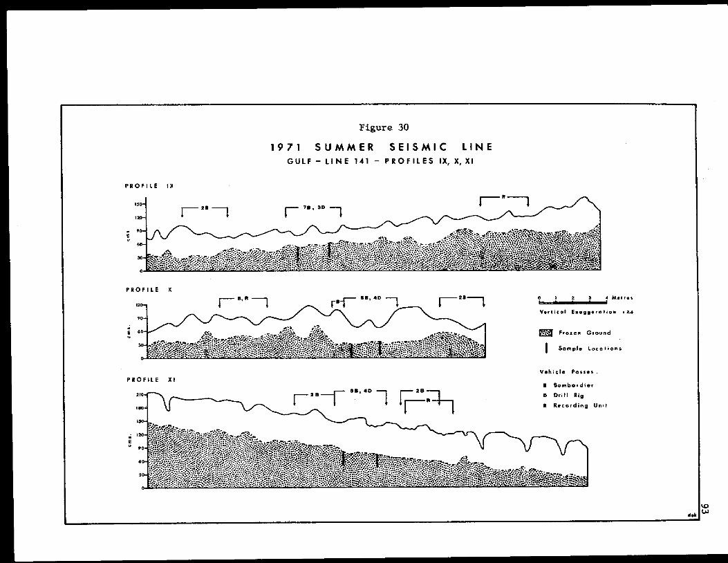
93
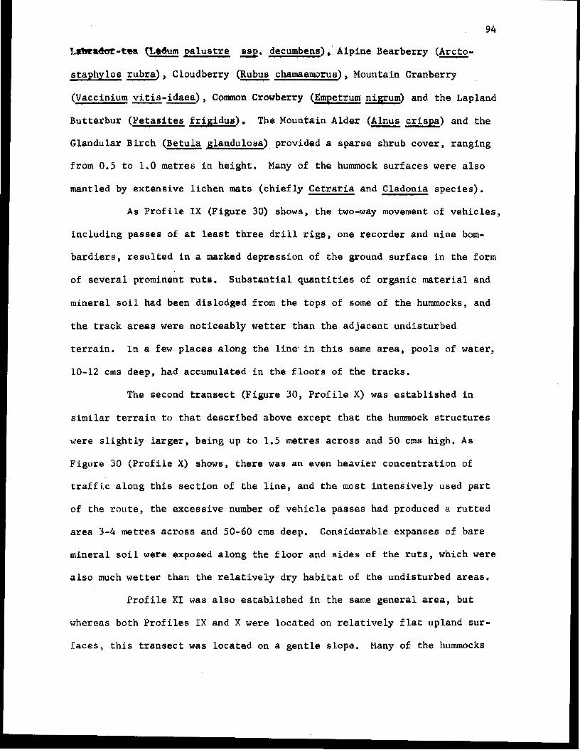
94
L*adm-tta f7,mdurn p a l u s t r e ssp. decumbens),' Alpine Bearberry (Arcto- - s t aphy los rubra) , Cloudberry (Rubu,s chamemorus), Mountain Cranberry
(Vaccinium vi t is- idaea) , Common Crowberry (Empetrum nrgrum) and the Lapland
Bu t t e rbu r (Petasites f r i g i d u s ) . The Mountain Alder (Alnus - crispa) and the
Glandular Birch (Betula glanduloaa) provided a sparse shrub cover , ranging
from 0.5 t o 1.0 metres i n h e i g h t . Many of the hummock surfaces were also
mantled by ex tens ive l i chen mats ( c h i e f l y Cetraria and Cladonia species),
As P r o f i l e I X (F igure 30) shows, t h e two-way movement of v e h i c l e s ,
i nc lud ing pas ses of a t least t h r e e drill rigs, one recorder and nine born-
b a r d i e r e , r e s u l t e d i n a marked depress ion of the ground surface in the form
of seve ra l p rominen t ru t s . Subs t an t i a l quan t i t i e s of organic material and
minera l soil had beep dislodged f rom the tops of some of t h e hummocks, and
t h e t r a c k areas were no t i ceab ly wetter t han t he ad jacen t und i s tu rbed
t e r r a i n . I n a Zew places a long the l i n e . i n t h i s same area, pools of water,
10-12 cms deep, had accumulated i n t h e floors of the t r acks .
The second t ransect (Figure 30, P r o f i l e X) was e s t a b l i s h e d i n
similar t e r r a i n t o tha t descr ibed above except t h a t the hummock e t r u c t u r e s
were s l i g h t l y larger, being up t o 1.5 metres across and 50 cms high. As
Figure 30 ( P r o f i l e X) shows, t h e r e was an even heavier concentrat ion of
t r a f f i c a l o n g t h i s s e c t i o n of t h e l i n e , a n d t h e most i n t e n s i v e l y used p a r t
of t h e route, the excess ive number of vehicle passes had produced a r u t t e d
area 3 - 4 metres a c r o s s and 50-60 cms deep. Considerable expanses of bare
m i n e r a l s o i l were exposed along t h e f l o o r and sides of t h e r u t s , which were
a l s o much wetter than the r e l a t i v e l y d r y h a b i t a t of t he und i s tu rbed areas.
P r o f i l e X I was a l so e s t a b l i s h e d i n the same gene ra l area, but
whereas both Prof i les I X and X were loca ted on r e l a t i v e l y f l a t upland sur-
faces, t h i s t r a n s e c t was l oca t ed on a gentle slope. Many of the hummocks
mud b o i l s had been smeared along sections of the l i n e . The primary reason
f o r s e l e c t i n g this si te , however, was the fact t h a t minor q u a n t i t i e s of
water were slowly moving along nome of the t racks and the conf igura t ion of
t h e ground surface was es t ab l i shed t o de t e rmine i f t h e r e i s any subsequent
e ros ion by sur face runoff .
Since Line 141 was the first t o be completed in t h e programme, i t
was poss ib l e t o use theae observa t ions t o modify or con t ro l t he number of
passes a long other similar s e c t i o n s of line, I n some caaes , almost a l l of
the shot ho ias along the end-spreads were d r i l l e d by a s i n g l e rig, thereby
reducing the requi red number of passes of the heavies t vehicle t o two,
Where t h i s was not feasible, the vehic les were reques ted no t to follow t h e
eame r o u t e on t he return journey.
The majority of the stream crossings involved i n the seismic
programme were extremely well executed with l i t t l e or no damage t o e i t h e r
the banks or bed of the stream. The one major blemish on this record
occurred along t he access rou te used t o move t h e v e h i c l e s t o the northwest
end of Line 146. A t one poin t a long th i s access road , one dri l l r i g crossed
one of the creeks and then attempted t o move up the v a l l e y of a small tribu-
t a r y stream. The rig was not able t o proceed too far before it became s tuck
i n t h e soft ground and was compelled to back o u t again. Two p r o f i l e s
(Profiles XI1 and X I I I ) were surveyed across t he d i s tu rbed area to see i f
there i s any subsequent erosion by water moving along the t r a c k s , and t hese
p r o f i l e s are shown i n F i g u r e 31.
As Figure 31 showe, t h e track area, covering a width of 2.5 t o
3.0 metres was cha rac t e r i zed by the development of prominent ruts , which in
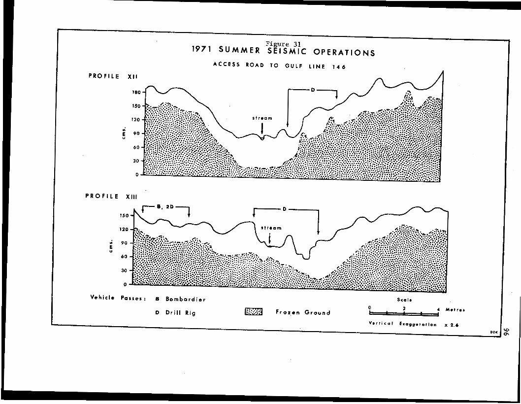
97
p laces were 30-50 cms deep. Most of the vege ta t ion cover had been des-
t r o y e d i n t h e r u t t e d s e c t i o n , a n d t h e ground su r face cons i s t ed of wet mud.
Although there w m not a great d e a l of water f l o w i n g i n t h e t r i b u t a r y , a
steady t r i c k l e had been diverted from i t s o r i g i n a l course and was flowing
down t h e tracks. It i e d i f f i c u l t t o comprehend why the operator even
attempted t o follow t h i s route. The o t h e r drill r i g moved along a nearby
route used by the survey bombardier, and subsequently followed by t h e
second rig, and, as P r o f i l e XI11 shows, the dis turbances along t h i s
a l t e r n a t i v e r o u t e were far l e a s severe.
F i n a l l y , t h e access route t o Line 146 8160 followed an old
summer seismic l i n e f a r : a e h o r t distance and the degree of d i r tu rbance along
this sec t ion was f a r more pronounced than when an e n t i r e l y new route was
se l ec t ed , Thie aga in po in t s t o t he need t o q u a l i f y that s e c t i o n of the
Land Use Regulat ions which encourages vehicle operators t o fo l low
exis t ing l ines wherever poss ib le .
WINTW SEISMIC OPERATIONS
Seismic o p e r a t i o n s i n moat of the Western Canadian Arctic are
p r i m a r i l y r e s t r i c t e d t o the winter months, and most of the s tud ie s o f t he
types of t e r r a i n d i s t u r b a n c e a s s o c i a t e d w i t h t h e s e operations have been
conducted i n t h e form of a post-mortem or a f t e r - the -even t i nves t iga t ions
in the fo l lowing , o r even later, summers. The l i m i t a t i o n s of this method
of study are tha t , wh i l e t hey do permit an approximate determinat ion of t h e
r e l a t ive magn i tude of t h e t a r r a i n damage, they do n o t y i e l d any information
on the irmnediate or short-term, as opposed t o t h e long-term, e f f e c t s of t h e
dis turbance, nor do they allow a ready evaluation of t h e c a u s a l f a c t o r s
98
involved. These limitations are compounded by the difficulties encountered
in obtaining necessary background information on the seismic programmes,
in terms of the terrain conditions, types of vehicles used, the number of
passes of each type, and the level of disturbance associated with indivi-
dual vehicles. The implications are that t h i s method of investigation can,
at best, provide some index as to whether or not the amount of damage
conforms t o acceptable levels; but the research has only limited value i n
terms of being able t o predict the effects of future operations, or t o
suggest: how the operational procedures can be modified to minimize the
level of disturbance to the tundra. This type of information can only be
obtained by either experimental manipulations of plots which attempt t o
reproduce the type of damage incurred, or better still, by on-site research
and observations during an actual winter seismic operation.
This section of the report covers studies embracing both the
on-site and ’post-mortem’ methods of investigation. The first part in-
cludes some comments based on observations, largely qualitative, of a
winter seismic operation in the Mackenzie Delta area, and the second part
describes the terrain disturbances associated with the first winter seismic
operations on Banks Island.
Caribou Hills Area. ”
In February, 1971, Gulf Oil Canada Limited, in cooperation with
Globe Party #3, provided an opportunity t o study and observe their winter
seismic operation in the Caribou Hills are8 near t o Reindeer Station.
Unfortunately, the limited time available f o r the field investigations,
combined with difficulties in the scheduling of the operations at: the
same time, resulted in the observations being restricted t o qualitative
assessments.
99
Two t r a n s e c t s were es t ab l i shed i n the undisturbed terrain acroes
the proposed route of one of t h e seismic lines. One of t h e s e t r a n s e c t s was
loca ted an a bare upland surface from which most of t h e snow had been re-
moved by the wind, and the second was s i t u a t e d i n the floor of a depression
where the snow cover was as much as one metre th ick . Each prof i le was
surveyed t o p r o v i d e d e t a i l s of the conf igura t ion of the ground surface and
t he t h i ckness of t he snow cover , and th i s procedure was r e p e a t e d i m e d i a t e l y
following t h e passage of two bulldozers used t o clear t he snow off t h e line.
Since the bulldozers did no t a r r i v e , u n t i l the day that we uere scheduled t o
return south, and there would be no opportuni ty to record the e f f e c t s of the
passages of other v e h i c l e s i n the seismic opera t i ans , no add i t iona l r e sea rch
was performed on these t r ansec t s . Fu r the rmare , i n the case of the upland
s i te t h e s u b e t r a t e was composed of frozen gravel, i n which no appreciable
t e r r a i n damage is t o be ant ic ipa ted , and in the lowland area several c e n t i -
metres of snow remained on the ground su r face , as a compact layer, a f t e r t h e
two vehicles had moved through.
Surveys of the completed seismic l ines showed that i n l o c a l i z e d
areas t h e snow cover had been completely removed and t he ground su r face had
been disturbed. Observat ions of the movements of all the v e h i c l e s i n t h e
seismic programme also showed t h a t t h e blade of the bu l ldoze r , desp i t e
having shoes a t tached, was r e s p o n s i b l e f o r most of t h e damage f o t he t e r r a i n .
Although the use of these veh ic l e s may be e s s e n t i a l t o win ter opera t ions , i t
i s ques t ionable as t o whether o r not they need t o blade away as much of the
snow cover along t he l i nes . I n t h i s r e s p e c t , it may be worthwhile t o en-
courage fur ther research to develop a type of geophone that can provide
good seismic records through the snow layer.
100
" Banks 1 s land.
!ho major f ac to r s h inde red a comprehensive survey of t h e t e r r a i n
d i s tu rbances aesociated with the seismic operations completed on Banks
Island, during t he w in te r of 1970-71, by E l f O i l Explora t ion and Production
Canada Limited, and Deminex (Canada) Limi ted . F i r s t l y , t he i n fo rma t ion
p rov ided t o us i n map form outlined the original proposed seismic ope ra t ions
for each company, and no t t he work which was actual ly completed. This was
p a r t i c u l a r l y s i g n i f i c a n t i n t h e case of Elf's programe in which many of the
l ines were not completed, and also i n Deminex's p r o g r a m e where a number of
changes occurred. Secondly, the l o g i s t i c a l s u p p o r t p r o v i d e d i n t h e form of
a Twin Otter equipped with f loats , was fo r t h i s survey far from adequate.
This a i r c r a f t is of only limited va lue for such surveys, due t o the speed
and a l t i t u d e a t which i t must operate , and its e x t r e m e l y r e s t r i c t e d
v e r s a t i l i t y w i t h r e s p e c t t o landing a t the disturbed sites. S i n c e a major
p a r t of our observations had t o be made from e l e v a t i o n s of several hundred
feet above the ground surface, a Hel io-Courier , equipped with tundra tyres ,
was chartered from Nahanni Air Services Ltd. , t o f a c i l i t a t e observations
from much lower altitudes, and landings at any sites which appeared t o
e x h i b i t s i g n s of more severe environmental d is turbance,
Fo r tuna te ly , our task was made considerably easier due. to the
a s s i s t a n c e of Mr. Andrew Carpenter , President of the Banks Ia land Trappers '
Association, and Mr. Douglas Urquhart , Terr i tor ia l Game O f f i c e r , Sachs
Harbour, Both of these people had c a r r i e d out numerous observations of the
a c t u a l seismic ope ra t ions du r ing the win te r , and had recorded any s i t e s
where environmental disturbances appeared t o be most severe.
Although detailed ground inspec t ions were only conducted a t
three sites, t h e r e is l i t t l e d o u b t t h a t t h e t e r r a i n d i s t u r b a n c e s a s s o c i a t e d
~
101
wi th t he w in te r seismic operations on Banks Island are negligible, Con-
s i d e r a b l e d i f f i c u l t y was experienced i n l o c a t i n g many of the lines and,
even than, it was v i r t u a l l y impossible from the air t o follow the lines for
any apprec iab le d i s tances . In many instances, the locations of the shot
h o l e s , o r mors p r e c i s e l y t h e sticks used as shq t po in t markers, provided
the only real clues to t h e e x i s t e n c e of the seismic l i nes . This was par-
t i c u l a r l y noticeable on the d r ie r , up land areas which possess a scan t
vege ta t ion cover. In t he lower, wetter areas, t h e lines were somewhat
easier t o d e t e c t , b u t even i n t h e s e areas t h e r e were few examples of any
marked d is turbance of the t e r r a i n .
Equal dif f icul ty .wae encountered i n locating the ereismic l i n e s
on the ground. Ground inspec t ions were made i n the vicinity of E l f shot
po in t #1385, loca ted a t approximately longitude 1 2 4 O 20'W and latitude
73' IO'N. S e v e r a l p a r a l l e l tracks, occupying a total width of about 10
metres, were examined i n a r e l a t i v e l y f l a t , lowland area of somewhat
r e s t r i c t e d d r a i n a g e . The site was cha rac t e r i zed by the development of low
hummocks and mud boils, with a maximum microre l ie f of about,l0-15 cms. The
only sur face express ion of t he tracks cons i s t ed of occas iona l minor dep-
ressions, less than 5-10 cms deep, and there was no evidence of any mineral
soil being exposed by o the r t han na tu ra l means (i.s. t h e bare su r faces of
the mud boils). Comparative measurements of t he t h i ckness of t h e a c t i v e
layer i n the d i s turbed and ad jacent undis turbed areas revealed no
apprec i ab le d i f f e rences . In bo th areas the depth of thaw rangad from
25-30 cms beneath vegetated eurfaces t o 60-65 cms under the bare mineral
s o i l . The vege ta t ion of t he s i te was dominated by p r o s t r a t e willow,
cotton-grass, sedges, avens and mosses. Disturbance or damage t o t h e
102
depressions, some of t h e mosses had been d i s s e c t e d by t h e v e h i c l e tracks
and could be eaeily d i s l o d g e d , b u t t h e g r e a t e r a v a i l a b i l i t y of moisture i n
these dep res s ions will probably promote the regenerat ion and recovery of
t h i s moss l ayer .
Immediately to the south of the above site, t h e aeiamdc l i n e
t r ave r sed a bet ter-drained, upland area which was characterized by a
greater predominance of mud boils. Approximately 55 per cent of the ground
su r face cons i s t ed of exposures of bare mineral so i l . There was v i r t u a l l y
no topographic expression of t h e v e h i c l e t r a c k s acrom this area and the
depth of thaw, 65-70 cms, was i d e n t i c a l i n t he ' d i s tu rbed ' and t he un-
d i s t u r b e d t e r r a i n . The vege ta t ion cove r , p r inc ipa l ly Dryas, was no greater
than 45 per cent, and of t h i s , 50-65 per cen t cons i s t ed of attached dead
leaves t h a t c o u l d e a s i l y be dislodged by foo t . Any d i s tu rbance of such
vege ta t ion mats would probably be d i f f i c u l t i n w i n t e r , when f rozen and
covered with snow. However, cons ider ing that this type of community is
r e p r e s e n t a t i v e of a major por t ion of the area i n which the winter seismic
opera t ions were conducted, the importance of t h e v e g e t a t i o n i n s t a b i l i z i n g
s o i l s t r u c t u r e and moisture condi t ions , and the ease with which the
vege ta t ion can be removed dur ing t he summer, it i s imperat ive that t hese
facts are not overlooked if applications are made f o r summer seismic
operations.
These ground i n spec t ions of the sites s u b s t a n t i a t e d the con-
c lus ion that win ter se i smic opera t ions had resu l ted in a n e g l i g i b l e
d is turbance of the terrain. During discussions with the l o c a l r e s i d e n t s ,
however, f r equen t mention was made of an i n s t ance , last February, when a
bulldozer was ' l o s t ' i n the v i c i n i t y of the Big River. Apparently the
opera tor had i nadve r t en t ly moved in to , or close t o , the waterfowl sanctuary
103
whilst attempting t o locate the start ing point of a seismic l ine; and the
disturbance was considered t o be extensive. Despite the assistance of
Mr. Carpenter and Mr. Urquhart, considerable d i f f i c u l t y was encountered in
locating the site which proved t o be a t approximately longitude 123' 55' W
and lat i tude 7 2 O 28' N, close t o the north bank of the Big River. The
seismic l i n e , at this point traversed an al luvia l terrace mantled by a
fairly continuous vegetation cover of Dryas humocks. Although the imprint
of the vehicle tracks was slightly more pronounced than that described in
the previous sites above, the most obvious effect of the disturbance ap-
peared to be a suppression of the growth of the Dryas resul t ing in a higher
proportion of dead leaves along the tracks.
The primary concern of the residents, however, wag not the
seismic l ine , but a patch of pound that had been disturbed by the t ight
turning action of a bulldozer, Although this had resulted in the local
removal of 5-10 cms of material, exposing mineral s o i l , the level of damage
should be considered to be minor. Since the subaurface materials a t thiH
point cons is t of well-drained sand and gravel, any further accentuation of
the damage i s mast improbable, The presence of new leaves and shoots on
damaged willows, and vegetative shoots on the sedges, further indicates
that a reasonably rapid recovery of at least some of the vegetation is t o
b e anticipated. Despite the minor nature of the disturbance a t this site,
there appeared t o be a number of other instances where individual v8hicbs
apparently had moved randomly across the tundra adjacent t o the seismic
l ines . Although none of these trails has had a markedly deleterious e f f e c t
upon the terrain, there would appear to be no logical necesekty f o r such
additional movements and, in future operations, it would seem that they
104
the seismic operat ion.
There is l i t t le d i f f i c u l t y i n a c c o u n t i n g for t h e n e g l i g i b l e
dis turbance encauntered along the seismic lines. Doubtless, bath companies
have, fo r the most p a r t , made a concerted effort: to minimize any adverse
effette of t h e i r operations on tha tundra. Apart from the care which was
obviously exercised i n the genera l opera t ion of the veh ic l e s , t he s inuous
na tu re of t h e l i n e e r e f l e c t s an attempt to minimize any damage, by moving,
as far as poaeib le , a long the d r ie r , up land sites. Movement a long these
upland areas, with their scant vegeta t ion cover , has r e s t r i c t e d t h e amount
of d i s tu rbance s ince it is the vegetative layer which usua l ly exhibits the
more obvious signs of darrrage, The high percentage of bare ground fur ther
implies t h a t t h e r e w i l l be minimal a l t e r a t i o n s t o t h e thermal regime of
t h e a c t i v e l a y e r and, consequent ly , l imited possibilities of any f u t u r e
accentua t ion of the d i s turbance a long the lines due t o t h e m k a r s t sub-
sidence. The wide spacing of the seismic l i n e s also serves t o minimize any
u n a e s t h e t i c q u a l i t i e s of the opera t ion . These fac to re , t oge the r w i th t he
monitoring i n f luence of the residents of Sachs Harbour have, cumulatively,
resulted in opera t ions which establish what can be done an Banks Island.
It is t o be hoped t h a t t h e s e same f a c t o r s will assure t h a t any fu ture
operations w i l l at least maintain the same high standards. The dangers of
complacency should be se l f - ev iden t s ince t he neg lec t of any one of the
above factors could only serve t o increase t h e amount of t e r r a i n d i s -
tu rbance . In this respect it should ba noted t h a t , due t o t h e more severe
environmental cond i t ions , any l e v e l of d i s tu rbance will probably take as
long t o recover as a more severe form of d i s tu rbance in the delta area t o
the south.
As mentioned previausly the locotiaaa of t he shot: ho le s , o r shot
1Q5
p o i n t markers, f requent ly p rovided the easiest means of tracing t h e
seismic l i n e s . Hawever, it appears that soma of the s h o t h o l e s are no t
b e i n g f i l l e d i n , as s t i p u l a t e d i n t h e r e g u l a t i o n s (e.& E l f shot point
81385 wa8 open t o a depth of 55 cme and shot paint 11393 t o a depth of more
t han 1.5 metres). Wooden marker s t i c k s a n d s h o t wire wez0 also l e f t l y i n g
on the ground and could have been removed with comparat ive easa.
Despite the cont inued presence of a member of t h e Banks Island
Trappers ' Association on each operation, piles of garbage, pr,esumably
marking the p o e i t i o n s of campsi tes , were observed at at least s ix sites. It
was gathered, however, from d i scuss ions w i th some of the people a t Sachs
Harbour, that several prolonged storms had occurred during the winter with
the r e s u l t that garbage could have been obscured by enow and not no t i ced
when t h e camp was moved. S ince the Land Use Regula t ions are quite explicit
with r e s p e c t t o t h e d i s p o s a l of garbage it i~ suggestad that the companies
be reques ted t o clean up them sites as quickly as poss ib le .
The E l f O i l Company win te r road from the staging area a t
Johnson Point t o t h e s i te of the seismic ope ra t ions i s approximately 45
miles i n length. The amount of care and t hough t i nvo lved i n t he s e l ec t ion
of the r o u t e , t o follow as much of t he h ighe r ground 8 8 p o s s i b l e , is
reflected i n t h e negligible d i s tu rbance along t h e route and the consrequent
d i f f i c u l t y i n t r a c i n g i t from the air. The only major exception t o this
pattern occurred where t h e w i n t e r road intersected t h e most e a s t e r l y of
the north-south seismic l i n e s . Here, an i n o r d i n a t e number of separate
t r a c k s made it d i f f i c u l t t o establish the real p o e i t i o n of t h e road. The
trace of t h e road also seemed t o be more prominent where the route involved
an oblique traverse of a slope. This can possibly be a t t r i b u t e d t o t h e fact
that i n such locations the weight of the vehicle is unevenly d i s t r ibu ted
106
an the tracks. Thie problem can poss ib ly be alleviated i n the r o u t i n g of
subsequent winter roads (and seismic l i n e s ) by following paths which run
d i r e c t l y up or down a slope wherever t h e g r a d i e n t permits.
The Daminex winter road from the s t ag ing area a t Herbert: Poin t
was almost impossible to detect over much of its l e n g t h i n d i c a t i n g
neg l ig ib l e d i s tu rbance of the terrain.
The s t a g i n g area a t Johnson Point was extremely clean and tidy
and provided an excellent example of how a base camp can be operated. The
p r i n c i p a l exception to t h i s p a t t e r n occurred where a t racked vehicle had
moved a long a l i n e between the dynamite s torage sheds and airstrip after
the g round had s ta r ted to thaw. As a result of t h i s movement, p a r a l l e d
ruts, up t o 70 cms across and up t o 30 crns deep ( including 20 crns of water)
had been formed i n a number of wet areae. The depth of thaw beneath the
imprint of the tracks averaged 48 crns, compared t o an average depth of
68 crns in ad jacen t undisturbed areas, sugges t ing that the p o s i t i o n of the
f r o s t t a b l e had a l r eady been lowered by approximately 10 cms. The
vege ta t ion i n t h e water wi th in the tracks was still alive, however, and
had obviously not su f fe red ex tens ive damage as a result of t h e compression
a n d p a r t i a l submergence. This soli tary example apa r t , t he re appea red to
have been no excessive use of veh ic l e s ou t s ide t he i nmed ia t e camp area.
The staging area a t Herbe r t Po in t for t h e Deminex opera t ion was
only inspected from t h e a i r , and also appeared t o be c lean and tidy, except
f o r a l a r g e number of shot po in t marker s t i c k s which were sca t t e red ove r
the ground on the east s i d e of the camp.
Storkerson Bay Rig S i t e . I n July, 1971, w e were informed that
a site had been s e l e c t e d , near t h e southern end of S torksrson Bay, for the
l oca t ion of t h e first well t o be d r i l l e d on Banks Island. It was a l s o
107
unde r s tood t ha t t he p rec i se area of t h e rig site had been marked out on the
ground and that an access route had been siinilarly marked for t h e movement
of t h e r i g and camp from a s t ag ing po in t on the coast. This movement was
scheduled to t a b place in early August. Since th i s schedule appeared t o
r ep resen t an exce l l en t oppor tun i ty t o become i n v o l v e d i n a d d i t i o n a l o n - s i t e
r e sea rch , we r e tu rned t o Banks Island eo conduct surveys of the undis turbed
t e r r a i n c o n d i t i o n s a n d r e c o r d t h e e f f e c t s of t h e v e h i c l e s t o be used i n the
t r a n s p o r t a t i o n of t he r ig . h a t o unforeseen circumstances, the barges
t r a n s p o r t i n g t h e r i g d i d not arrive while we were a t t h e site, Most of the
pin f lags, used t o mark t h e line of the access route, had also been removed
by the wind, and even though it was even tua l ly poss ib l e t o r econs t ruc t the
p o s i t i o n of the proposed road, it was fe l t t h a t the r o u t e along t h e coast,
from t h e s t a g i n g area t o the start of t h e road wag auch that it would be
v i r tua l ly imposs ib l e t o use. The observations a t Storkereon Bay weze
t h e r e f o r e r e s t r i c t e d t o six p r o f i l e s of the undis turbed terrain cond i t ions
across the proposed r i g site. These profiles will, i n t h e future, permit
an evalua t ion of the t e r r a in d i s tu rbances i ncu r red as a r e s u l t of t h e
d r i l l i n g o p e r a t i o n s .
SUMMARY AND RECOMMENDATIONS
This f i n a l s e c t i o n of the r e p o r t summarizes t h e f i n d i n g s of the
summer research programme. It also inc ludes some recommendations pertaining
t o t h e a p p l i c a t i o n o f , and fu ture research into, t h e Land Use Regulations
with respect: t o the a c t i v i t i e s of the r e s o u r c e e x p l o r a t i o n i n d u s t r y i n far
nor thern Canada. I n i n t e r p r e t i n g these c m n t s , it is imperative t o
remember that the limited sample sizes, the i n a b i l i t y t o e s t a b l i s h the
108
pre -d i s tu rbance t e r r a in cond i t ions w i th any real degree of accuracy, and
t h e a l m o s t t o t a l a b s e n c e of any v i t a l i n f o r m a t i o n regarding t h e o p e r a t i n g
cond i t ions and amounts and types of v e h i c u l a r t r a f f i c i n v o l v e d , s e r i o u s l y
limit the ulsefulness of some of the conclusions.
The i n v e s t i g a t i o n s of t h e sites of winter road opera t ions ahow
t h a t t h e d e s t r u c t i o n of the vegeta t ion cover and sur face microre l ie f forms
has produced a p r e d i c t a b l e i n c r e a s e i n t h e thaw depths and ground temperatures
beneath the d i s tu rbed areas as compared t o the ad jacent undis turbed terrain.
T h i s o b l i t e r a t i o n of the surface mic ro re l i e f has also l e d t o more uniformity
i n t h e thaw pene t r a t ions i n t h e damaged areas, and i f the recovery process
is to include the development of t h e s e features, t h i s will involve a much
longer time period than t h a t r e q u i r e d t o r e - e s t a b l i s h a cont inuous
vegetat ion cover . The f i e l d obse rva t ions sugges t t ha t t he ice road method
of cons t ruc t ion i s much more e f f e c t i v e t h a n t h e snow packing technique in
l i m i t i n g t h e level of t e r r a i n d i s t u r b a n c e , b u t a d d i t i o n a l r e s e a r c h is
necessary t o determine more p r e c i s e l y t h e number of years that t h e same
access route should be used, Data from the quadrat: studies i n t h e S h i n g l e
P o i n t area i n d i c a t e tha t , i n comparison t o t h e u n d i s t u r b e d terrain, t h e
re-use of t h e road produced a relative increase i n t h e thickness of the
a c t i v e layer of almost 27 per cent, which compares with an i nc rease of
slightly less than 2 1 per cent i n the winter road which was used for only
one year's opera t ions . Th i s d i f f e r e n c e , of less than 6 per cen t , may be
too i n s i g n i f i c a n t t o w a r r a n t a cons ide ra t ion of t h e r e s t r i c t i o n of t h e
u s e of an accew r o u t e t o only one year, but i t r e m a i n s t o be seen whether
Dr. Lamber t ' s vege ta t ion studies reveal any more apprec i ab le d i f f e rences .
I n terms of the genera l appearance of the two winter roads a t Shing le
P o i n t , however, there is no doubt that t h e s e access routes should not be
109
used for more than two years' operat ions. The extreme form of damage
exh ib i t ed by the winter road a t Sitidgi Creek demonstrates what can happen
when t h e surface organic layer is f i n a l l y d e s t r o y e d t o a point where pro-
nounced thermokarst subsidence i s i n i t i a t e d . The sequence of even t s
a s s o c i a t e d w i t h t h e a c t i v l t i e s of t he r e source exp lo ra t ion i ndus t ry i n the
S i t i d g i C r e e k area, p a r t i c u l a r l y 8s r e l a t e d t o t h e c r o s s i n g of t h e open
water of t he creek i n winter, a l s o i n d i c a t e s t h a t there is a need f o r
improvements i n the planning procedures used t o s e l e c t the routes f o r t h e
winter roads.
The i n v e s t i g a t i o n s of s m e r se i smic l i nes , from one t o nine
years o ld , and those made du r ing an ac tua l summer seismic programme
demonstrate conclusively that, i n c e r t a i n areas a t least, and with the
adoption of s u i t a b l e o p e r a t i o n a l t e c h n i q u e s , t h e t e r r a i n d i s t u r b a n c e s
assoc ia ted wi th these opera t ions need no t result i n any sa t ioua damage t o
the tundra . Indeed , the negl ig ib le mount of t e r r a i n d i s t u r b a n c e revealed
i n the 1971 se i smic opera t ions sugges ts that t h e r e are i n fact c e r t a i n
merits in s chedu l ing summer programmes. Most of t h e d i s r u p t i o n of t h e
ground surface was i n fact due t o a compression of the o rganic l ayer and
t h i s a b i l i t y of the terrain t o undergo s l ight deformation i n response t o
the weight of t h e v e h i c l e s may produce lass damage than the a b r a s i v e e f f e c t s
of v e h i c l e s on the same t e r r a i n when it is f rozen so l id . S i m i l a r l y , the
supple nature of the vegetat ive cover , and the shrub layer i n p a r t i c u l a r ,
i n t he summer allows it t o wi ths tand the passages of vehic les wi th fewer
adverse effects than i n t he w in te r months. The o n - s i t e i n v e s t i g a t i o n s also
confirmed that , for t he most p a r t , t h e real problem with respect t o c ross -
tundra movements i n t h e summer thaw period i s t h e maximum number of v e h i c l e
110
begins to exceed acceptable levels. Even wi th the uae of a s t a t i o n a r y base
camp, an excessive number of v e h i c l e passes along t h e same r o u t e is p o s s i b l e
a n d , u n l e s s a d d i t i o n a l f u t u r e r e s e a r c h i n d i c a t e s otherwise, it appears that
no more than two of t h e heavier vehicles (a.g. dr i l l r i g s or r eco rd ing
uni t ) should be encouraged to fo l low the sama tracks,
The terrain d ie tu rbancee a s soc ia t ed w i th the 1970-71 win te r
seismic ope ra t ions of E l f O i l Explora t ion and Product ion Canada Limited,
and Deminex (Canada) Limited, on Banks Island are neg l ig ib l e . The minimal
na tu re of the dis turbance reflects a combination of factors i nc lud ing
(a) t h e e f f i c i e n c y of each company's operations, (b) t h e careful s e l e c t i o n
of r o u t e s for both t h e seismic lines and the winter roads, and (c) t h e
cont inued presence of a local r e s i d e n t d u r i n g the ac tua l ope ra t ions .
Hawever, c l o s e r s c r u t i n y i s apparent ly necessary in c e r t a i n aspects of t h e
o p e r a t i o n s , p a r t i c u l a r l y with respect to a cur t a i lmen t of any unnecessary
movements of v e h i c l e s over t h e t u n d r a , t h e f i l l i n g i n of shot: holes and
garbage disposal.
The fol lowing tentat ive recommendat ions are made wi th regard to
the application o f , and fu tu re r e sea rch i n to , the Land Use Regulat ions as
appl i ed t o the ope ra t ions of the resource exploration i ndus t ry i n the
tundra regions of far nor the rn Canada.
1. Winter roads, cons t ruc ted by using conventional snow packing
techniques, should no t be used for more than two consecutive
winters I operations.
2. The ice road method of bu i ld ing w in te r roads results i n less
damage t o t h e terrain than the maw packing method of con-
s t ruc t ion , and a wider adopt ion of t h i s method should be
112
encouraged in general , and p a r t i c u l a r l y when there is a scant
snow cover or where it is d e f i n i t e l y intended t o uee t he same
accesa route for two consecutive years.
3. There is a need t o consider more thoroughly the section of the
Land Use Regulations which encourages vehicle operators t o
follow e x i s t i n g l i n e s , trails or rights-of-way wherever possible .
I n most cases the accentuated damage along t he old l i n e i s much
more seve re t han t he l eve l of d i s t u r b a n c e t h a t would be incur red
in fo l lowing a new route across previously undisturbed terrain.
4. The extreme form of damage as soc ia t ed w i th t he late passage of
v e h i c l e s along the Gulf ice road i n d i c a t e s t h a t there is also a
need f o r a s t r i c t e r c o n t r o l , through the issuance of specific
permi ts , of a l l cross- tundra movements of vehic les . The rights
of individual companies t o r e e t r i c t the movements of o the r
companies along routes for which they have the prime responsibility
should also be firmly es t ab l i shed .
5. If t h e Land Use Regulations are t o have any real meaning, severe
p e n a l t i e s must be l ev ied against any b l a t a n t v i o l a t i o n s of these
r egu la t ions ,
6. Sunrmer seismic opera t ions i n the Mackenzie Delta area need not
result i n any serious damage t o the t e r r a i n , b u t no summer
seismic work should be permit ted on any recent ly bumbover areas
of the tundra.
7. The r evege ta t ion of any disturbed areas, resulting from sunnner
seismic opera t iona , w i l l probably be enhanced i f t h e work is
112
performed dur ing the ear ly par t of t h e swmner (e. g. late June and
J u l y ) , t h e r e b y f a c i l i t a t i n g same recovery of t he vege ta t ion du r ing
the remainder of the summer, r a t h e r t h a n i n the fol lowing year .
8 . The level of d is turbance assoc ia ted wi th summer seismic
opera t ions i s i n t i m a t e l y r e l a t e d t o t h e number of heavier
v e h i c l e s moving a long t he same route , and rather than encourage
a concent ra t ion of such traffic wi th in a 33-foot width of t h e
tundra, i t would appear t o be adv i sab le t o promote a dispersion
of t h i s v e h i c u l a r a c t i v i t y .
9. On-si te research, conducted during actual operations, provides
the on ly means of record ing the precise na tu re and extent of t h e
terrain dis turbance , the causa l fac tors involved , and the
c o l l e c t i o n of da t a that can be applied immediately t o minimize
t h e damage t o t he t undra i n f u t u r e land use opera t ions , The
advantages of t h i s method of study are such that a concerted
effort should be made to seek the further cooperat ion of the
r e s o u r c e e x p l o r a t i o n i n d u s t r y i n p r o m o t i n g t h i s t y p e of r e sea rch
as much as poss ib le .
10. Where 'after-the-event' or ' post-mortem' i nves t iga t ions o f
terrain d i s tu rbances are the only f e a s i b l e method of s tudy,
there is an immediate and compelling need t o e s t a b l i s h a
comprehensive data bank system which should inc lude exac t maps
of the ope ra t ions , and de t a i l s of t h e numbers and types of
vehic les used , number of passes and tonnages involved, as well
as any re levant in format ion (e .g. depth of snow cover) per ta ining
t o the operat ing condi t ions under which the work was performed.
113
LIST OF FIGURES
PAGE F IGlJRE
1.
2.
3.
4.
5 .
6.
7.
8 .
9.
10.
11,
12.
13 . 14.
Western Canadian Arctic: Location Map . , . . . . . . Winter Roads near Shingle Poin t . . . . . . . . . . b Winter Road near Shingle Point : Depth of Thaw Transects . Metre Quadrat ' A I : Surface Contours above datum and
Position of Frost Table, June 18 - August 25, 1971 . . Metre Quadrat IB': Surface Contours abwe datum and
Por f t ion of Frost Table, June 10 - August 25, 1971 . . . Metre Quadrat I C ' : Surface Contoure above datum and
Poai t ion of F r o s t Table, June 18 - August 25, 1971 , . Metre Quadrat 'Dl: Surface Contours above datum and
Pos i t ion of Frost Table, June 18 - August 25, 1971 . . Metre Quadrat 'E': Surface Contours above datum and
Position of Frost Table , June 18 - August 25, 1971 . Metre Quadrat 'F': Surface Contours above datum and
Position of F r o s t Tabla, June 18 - August 25, 1971 . . , Metre Quadrat 'GI: Surface Contoure above datum and
Position of Frost Tabla, June 18 - August 25, 1971 . . . Metre Quadrat 'HI: Surface Contours above datum and
Position of F r o s t Table, June 18 - August 25, 1971 . . . Metre Quadrat IJ': Surface Contours above datum and
Pos i t ion of Frost Table, June 18 - August: 25, 1971 . . Mean Depth and Rate of Thaw i n Metre Quadrats . . . . Mean Ground Temperatures and Ground Temperature
Fluctuations . . . . . . . . . . . , . . . .
3
7
11
21
22
23
24
26
27
2 9
30
31
34
36
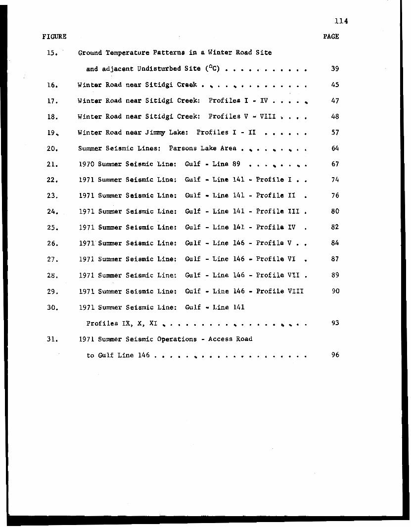
FIGURE
15 .
16.
17
18,
19
20.
21.
22 . 23.
24.
25 . 26.
27 .
28.
29.
30.
31.
Ground Temperature Patternr i n a Winter Road Sits
and adjacent Undisturbed Site (OC) . . . . . . . . . . . Winter Road near S i t i d g i Creek . . . . . . . m . . I Winter Road near S i t i d g i Creak: Profiles I - IV . . . . Winter Road near S i t i d g i Creek: Profiles V - VI11 . . . Winter Road near Jimmy Lake: Profiles I - I1 . . . . . . Summer Seismic Lines: Parsons Lake Area . . . . . , 1970 Summer Seismic Line: Gulf - Line 89 . . . . . 1971 Summer Seiarnic Line: Gulf - Line 141 - Profile I , . 1971 Sumer Ssismic Line: Gulf - Line 141 - Profile I1 . 1971 Summer Seismic Line: Gulf - Line 141 - Profile I11 ,
1971 Summer Seismic Line: Gulf - Line 141 - Profile IV . 1971 Summer Seismic Line: Gulf - Line 146 - Profile V . . 1971 Summer Seiemic Line: Gulf - Line 146 - Profile VI ,
1971 Summer Seismic Line: Gulf - Line 146 - Profile VI1 . 1971 Summer Seismic Line: Gulf - Line 146 - Profile VI11 1971 Summer Seismic Line: Gulf Line 141
Profiles IX, x, XI . . . . . 0 . . . . * . . . . 1971 Summer Seismic Operations - Access Road
t o Gulf Line 146 . . . . , . . . . . . . . . . . .
114
PAGE
39
45
47
48
57
64
67
74
76
80
82
84
87
89
90
93
96
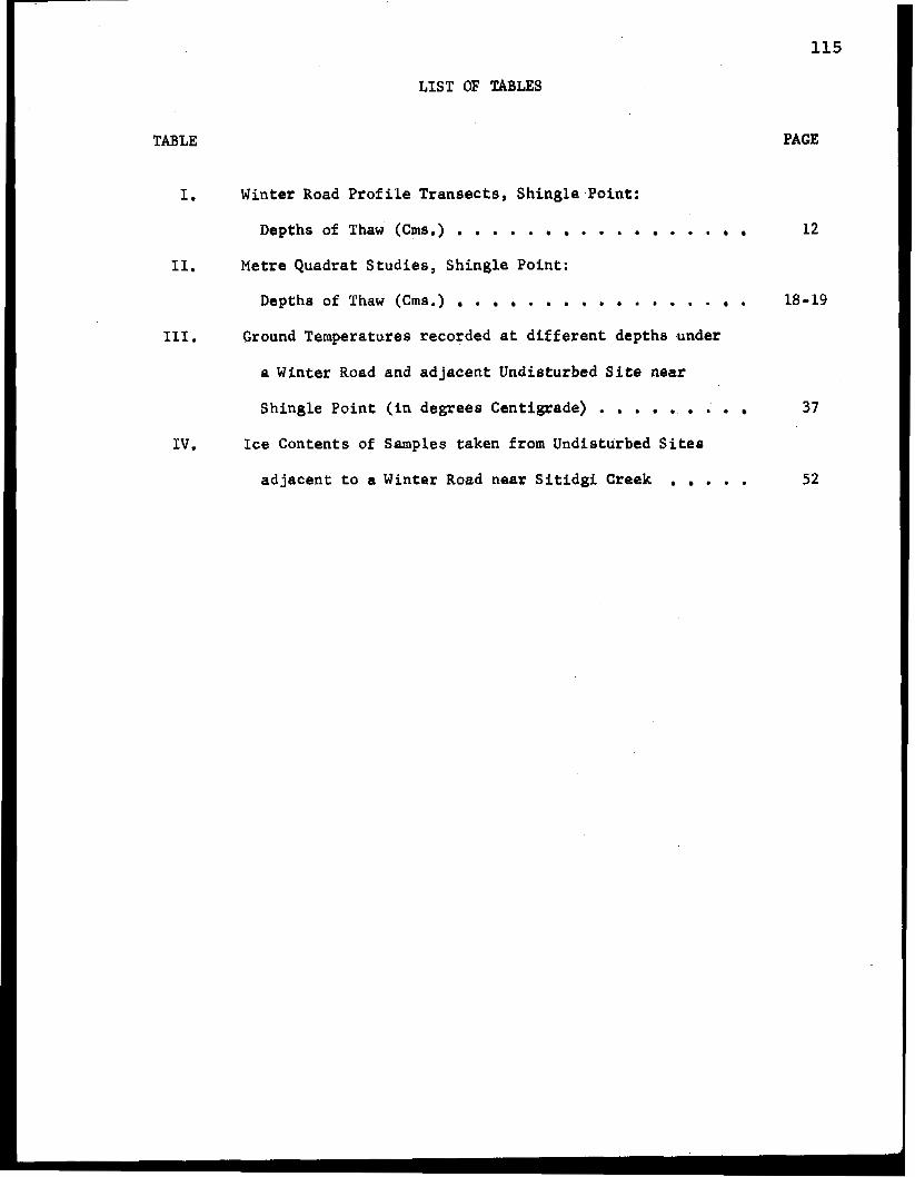
LIST OF TABLES
TABLE
1.
11.
111.
IV .
Winter Road Profile Transects, Shingle Point:
Depths of Thaw (Crns.) . . . . . . . . . . . . . Metre Quadrat Studies , Shingle Point:
Depths of Thaw (Crns.) . . . . . . . . . . . Ground Temperatures recorded a t different depths under
a Winter Road and adjacent Undisturbed Si te near
Shingle Point ( i n degrees Centigrade) . . . . . . . . Ice Contents of Samples taken from Undisturbed Sites
adjacent t o a Winter Road near S i t i d g i Creek . . .
115
PAGE
12
18 - 19
37
52


![ALUR PROSES_2 [Compatibility Mode]-1](https://img.pdfslide.us/doc/110x75/577c80a11a28abe054a98777/alur-proses2-compatibility-mode-1.jpg)


![ALUR PROSES_3 [Compatibility Mode]](https://img.pdfslide.us/doc/110x75/563db80e550346aa9a90290c/alur-proses3-compatibility-mode.jpg)