Embed Size (px)
Citation preview
Parks Victoria Phone 13 1963 www.parks.vic.gov.au
Getting there
The area is about 400 km north east of Melbourne. From the north access is via the Omeo Highway past Mount Wills, or over Sassafras Gap on the Corryong – Benambra Road.
From the south, travel via Omeo (Omeo Highway), Benambra and the Limestone - Black Mountain Road.
Mountain roads are often unsealed, narrow and winding. Chains must be carried during the snow season and fitted where directed.
Things to see and do
Walking
Some of the best mountain walking country in Australia is found in the Alps. Some tracks are suitable for day and weekend family walks. Others are long, rough and challenging, requiring a high degree of bushwalking skill and stamina.
Mount Wills – 6km, 3 hours return
This track starts at Mount Wills Carpark, just off Omeo Highway. It is a challenging climb but the views are well worth it. The rocky granite summit offers stunning alpine scenery among Snow Gums and fragrant herb fields.
Harrington’s Track – 20km, 8 hours one way
This historic bridle trail stretches along the Murray River from Tom Groggin to Bunroy Station. The walk is steep and challenging at times but rewards with spectacular views of the Main Range and the Murray River Valley.
This trail is also popular with horse riders.
Upper Pioneer Trail – 3.5km, 2 hours one way
Upper Pioneer Trail in Pioneer Mine Historic Area passes through a magnificent stand of Brittle Gum and offers excellent views of the Pioneer Mine and the Mitta Valley. Keep an eye out for the myriad of water races that supplied water to the mining operations. Please stay well away from the steep edge of the Pioneer Mine. A moderately steep descent takes you back to the Omeo Highway 1km south of the hamlet.
The Historic Area links to other walks is the area, such as the 3.5km loop that takes in River and Deep Gully walks.
Australian Alps Walking Track (AAWT)
The long distance Australian Alps Walking Track (AAWT) passes through the area on its 650 km route between Walhalla (Gippsland, Vic) and Tharwa (near Canberra, ACT).
This ‘track’, which at times is barely a foot pad, crosses the vein of the alpine country, climbing the higher ridges and spurs of Mount Wills, Johnnies Top and Davies Plain and plummeting into the remote valleys of Morass, Buenba and Limestone Creeks.
Bushwalking along the AAWT is only for experienced walkers with navigation and self sufficiency skills.
Mining heritage
Greens Creek Historic Battery
Take a short walk from Dartmouth Track, accessible by 4WD. Explore the site of former Greens Creek Gold Battery and relics of the past, including remains of a 10-head stamping battery, horizontal steam engine, two multi tubular boilers, and various other pieces of machinery. Installed in 1884, the battery is one of the most intact sites of its kind and age in Victoria.
Pioneer Mine Historic Area
The Pioneer Claim at Mitta Mitta was reputedly the largest open cut gold mine in Victoria during its days of operation between 1859 and 1913.
A number of walks start in this historic area. The Pioneer Mine Track is a 1.5km return walk with steps and board walks that passes through the revegetated mine site and mounds of separated rock. Look out for the entrance to the Pioneer tail race tunnel that removed sludge from the mine under Wombat Gully to the river.
Oriental Claims Historic Area
To access the Oriental Claims, turn off the Great Alpine Road then either turn left for the Pioneer Hill lookout, or turn right for the picnic area. Two leisurely loop walks are accessible from there: Pioneer Loop and Ah Fong’s Loop. It is also a great spot for a picnic, with tables, barbecues, fireplaces and toilets available.
It is also possible to walk to the Claims from the Omeo Picnic Area along a track following Livingstone Creek.
Victoria Falls Historic Area
Victoria Falls Historic Area is the site of Victoria’s first hydro-electric scheme, operating from 1908 to 1917. Today, it has a large camping area and a serene picnic area beside Victoria River. Take a short drive to the waterfalls lookout and explore this unique area.
Alpine National Park – around Mitta Mitta, Omeo, Tallangatta and Corryong Visitor Guide
Lake Dartmouth and the Mitta Mitta River, nestled in the folds of the ranges, are the main recreational and scenic focus for the area. There are many other interesting destinations to explore like the rugged granite summit of Mount Wills, historic Glen Wills and the bush tracks that wind through tall mountain forests, along snow gum clad ridge tops or besides racing mountain streams.
Mitta Mitta
Swifts Creek
Omeo
Gelantipy
Cobberas
Henlow
Wulgulmerang West
Dartmouth
Benambra
Nariel Creek
Tongio West
Hodgson Crossing
Wulgulmeran East
The Walnuts Butchers Ridge
Brumby
Bald Hills
Cravensville
Cassilis
Willow Crossing
Tongio
Nariel Valley
Tom Groggin
Bindi
Shanahan
Nunniong
Bucheen Creek
Phanek
The Lightwood
Crawford Crossing
Wulgulmerang
Tongio Munjie
Staceys Bridge
Alpine National Park
Alpine National Park
Mount GibboN.F.S.R .
Marb le Gul lyMount Tambo N.C.R.
Mount MurphyHis tor ic Area
Mount Wi l l sHis tor ic Area
GREAT ALPINE
LIMESTONE RD
OM
EO
HW
Y
LIMESTONE
RD
BENAM
BRA
CORR
YO
NG
RD
SPLITTERS
RD
RAN
GE
NU
NN
ION
G
RD
ALP
INE
WAY
HARRINGTONS
TRK
RD
N E W
S O U T H
W A L E S
Tam
bo
Rive
rMitta
Mit
ta
River
Buenba
Creek
Mur
ray
Rive
r
Buchan
River
Wh
eeler
CreekLake Dartmouth
Lake Omeo
Mount Wills(Walking only)
Green CreekBattery
Dart Arm
Bundara River
Wombat Post Office The Poplars
King Cassilis Visito
CRB Camp
Dogmans Hut
Tom GrogginCampground
(NSW)
Quart Pot Flat
Limestone Creek
Victoria FallsHistoric Area
Oriental ClaimsHistoric Area
Davies Plain Hut
Ah Syes
Charlies Creek
Glen Dart
Middle Creek
Taylors Crossing
Anglers Rest
Mount Benambra
Six Mile
Eight Mile Creek Eustaces
Jokers FlatCamping
Big River Bridge
Kennedy Hut
Native Dog Flat
Mount BarlowHiggins Knob
Mount Unicorn
Mount Bunroy
Mount Morgan
Gentle Annie
Mount Tempest
Hermit Mountain
Mount Pinnibar
The Grassy KnobMount Gibbo
Price Hills
Mount Saint John
Mount Hope
Mount Murphy
Round Mountain
Mount Cobberas No. 2Mount Cobberas
Mount Enano
Forest Hill
Big Hill
Glen Dart
Mount Cudgewa
Mount Sassafras
Larsens Hill
Mount Benambra
Mount Cravensville
Peppermint Hill
Tower Hill Mount Pleasant
Mcfarlanes Lookout
Pendergast Lookout
Mount Misery
Mount Leinster
Mount Pendergast
TheLadder
Langtree Hill
MountSeldom Seen
Forlorn Hope
Blue Hill
Mount Wombargo
Dingo Hill
Mount Nunyong
Mount Misery
Brumby Hill
Mt .Fraser
Porphyry Hill
Timmins Lookout
Mount Cooper
Mount Tambo
Mount Nugong
Mount Stewart
Bull Hill
Mount Wills
Mount Burt
Mount Parslow
Cobungra Hill
Mount Battery
West Hill
Walshs Lookout
BELOKA RD TR
L
WHEAT PADDOCK
CREEK TRK
TURN
BACK
CRK
TRK
R W
A P TR
K
FORLORN
HO
PE
TRK
J P GAP TRK
DART
TRK
DARTMOUTH TRK
SHEE
VER
S RD
EUSTACE
GA
P
TRK
MT PINNIBARTRK
MT
HOPE
TOM GROGGINTRKRD
DA
VIES
PLAINTRK
KIN
GS
PLAIN
TRK
COBBERAS TRK
BUEN
BA
GAP
TRK
NATIVE
CAT TR
K
REEDY TRK
BUCKWONG TRK
MISERY
Tom Groggin Station(Private property)
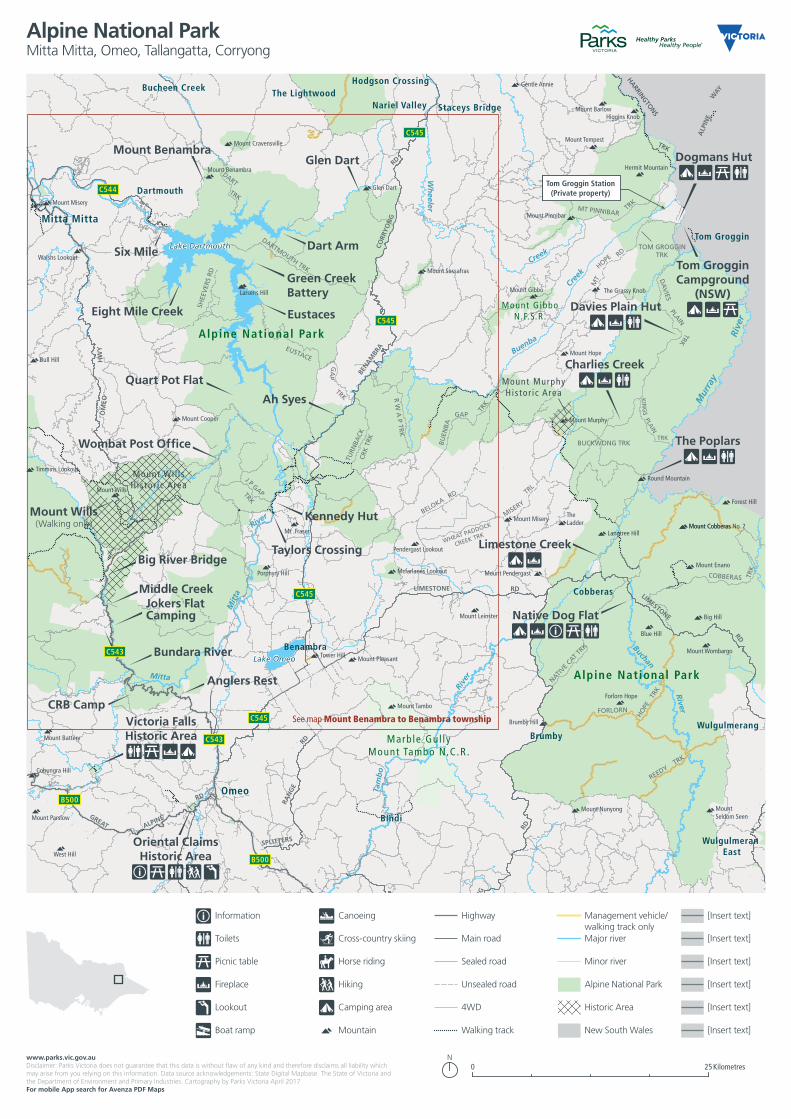
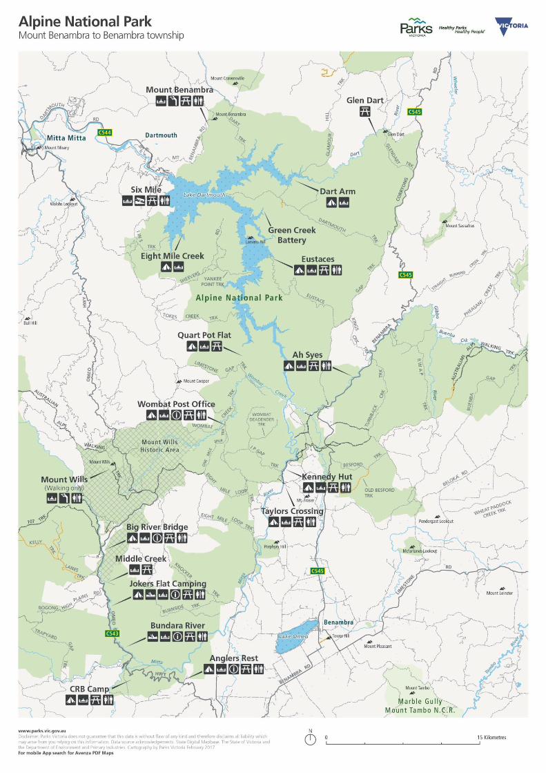
See map Mount Benambra to Benambra township
www.parks.vic.gov.auDisclaimer: Parks Victoria does not guarantee that this data is without flaw of any kind and therefore disclaims all liability which may arise from you relying on this information. Data source acknowledgements: State Digital Mapbase. The State of Victoria and the Department of Environment and Primary Industries. Cartography by Parks Victoria April 2017For mobile App search for Avenza PDF Maps
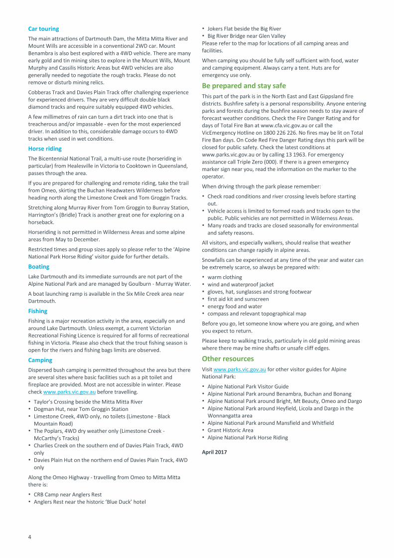
Toilets Cross-country skiing
Information Canoeing
Main road
Picnic table Horse riding Sealed road
Fireplace Hiking Unsealed road
Lookout Camping area 4WD
Boat ramp Mountain Walking track
Major river
Minor river
Alpine National Park
Historic Area
New South Wales
[Insert text]
[Insert text]
[Insert text]
[Insert text]
[Insert text]
Highway Management vehicle/walking track only
[Insert text]
Kilometres0 25
Alpine National ParkMitta Mitta, Omeo, Tallangatta, Corryong
3
4
Car touring
The main attractions of Dartmouth Dam, the Mitta Mitta River and Mount Wills are accessible in a conventional 2WD car. Mount Benambra is also best explored with a 4WD vehicle. There are many early gold and tin mining sites to explore in the Mount Wills, Mount Murphy and Cassilis Historic Areas but 4WD vehicles are also generally needed to negotiate the rough tracks. Please do not remove or disturb mining relics.
Cobberas Track and Davies Plain Track offer challenging experience for experienced drivers. They are very difficult double black diamond tracks and require suitably equipped 4WD vehicles.
A few millimetres of rain can turn a dirt track into one that is treacherous and/or impassable - even for the most experienced driver. In addition to this, considerable damage occurs to 4WD tracks when used in wet conditions.
Horse riding
The Bicentennial National Trail, a multi-use route (horseriding in particular) from Healesville in Victoria to Cooktown in Queensland, passes through the area.
If you are prepared for challenging and remote riding, take the trail from Omeo, skirting the Buchan Headwaters Wilderness before heading north along the Limestone Creek and Tom Groggin Tracks.
Stretching along Murray River from Tom Groggin to Bunray Station, Harrington’s (Bridle) Track is another great one for exploring on a horseback.
Horseriding is not permitted in Wilderness Areas and some alpine areas from May to December.
Restricted times and group sizes apply so please refer to the ‘Alpine National Park Horse Riding’ visitor guide for further details.
Boating
Lake Dartmouth and its immediate surrounds are not part of the Alpine National Park and are managed by Goulburn - Murray Water.
A boat launching ramp is available in the Six Mile Creek area near Dartmouth.
Fishing
Fishing is a major recreation activity in the area, especially on and around Lake Dartmouth. Unless exempt, a current Victorian Recreational Fishing Licence is required for all forms of recreational fishing in Victoria. Please also check that the trout fishing season is open for the rivers and fishing bags limits are observed.
Camping
Dispersed bush camping is permitted throughout the area but there are several sites where basic facilities such as a pit toilet and fireplace are provided. Most are not accessible in winter. Please check www.parks.vic.gov.au before travelling.
Taylor’s Crossing beside the Mitta Mitta River Dogman Hut, near Tom Groggin Station Limestone Creek, 4WD only, no toilets (Limestone - Black
Mountain Road) The Poplars, 4WD dry weather only (Limestone Creek -
McCarthy’s Tracks) Charlies Creek on the southern end of Davies Plain Track, 4WD
only Davies Plain Hut on the northern end of Davies Plain Track, 4WD
only
Along the Omeo Highway - travelling from Omeo to Mitta Mitta there is:
CRB Camp near Anglers Rest Anglers Rest near the historic ‘Blue Duck’ hotel
Jokers Flat beside the Big River Big River Bridge near Glen Valley Please refer to the map for locations of all camping areas and facilities.
When camping you should be fully self sufficient with food, water and camping equipment. Always carry a tent. Huts are for emergency use only.
Be prepared and stay safe
This part of the park is in the North East and East Gippsland fire districts. Bushfire safety is a personal responsibility. Anyone entering parks and forests during the bushfire season needs to stay aware of forecast weather conditions. Check the Fire Danger Rating and for days of Total Fire Ban at www.cfa.vic.gov.au or call the VicEmergency Hotline on 1800 226 226. No fires may be lit on Total Fire Ban days. On Code Red Fire Danger Rating days this park will be closed for public safety. Check the latest conditions at www.parks.vic.gov.au or by calling 13 1963. For emergency assistance call Triple Zero (000). If there is a green emergency marker sign near you, read the information on the marker to the operator.
When driving through the park please remember:
Check road conditions and river crossing levels before starting out.
Vehicle access is limited to formed roads and tracks open to the public. Public vehicles are not permitted in Wilderness Areas.
Many roads and tracks are closed seasonally for environmental and safety reasons.
All visitors, and especially walkers, should realise that weather conditions can change rapidly in alpine areas.
Snowfalls can be experienced at any time of the year and water can be extremely scarce, so always be prepared with:
warm clothing wind and waterproof jacket gloves, hat, sunglasses and strong footwear first aid kit and sunscreen energy food and water compass and relevant topographical map
Before you go, let someone know where you are going, and when you expect to return.
Please keep to walking tracks, particularly in old gold mining areas where there may be mine shafts or unsafe cliff edges.
Other resources
Visit www.parks.vic.gov.au for other visitor guides for Alpine National Park:
Alpine National Park Visitor Guide Alpine National Park around Benambra, Buchan and Bonang Alpine National Park around Bright, Mt Beauty, Omeo and Dargo Alpine National Park around Heyfield, Licola and Dargo in the
Wonnangatta area Alpine National Park around Mansfield and Whitfield Grant Historic Area Alpine National Park Horse Riding April 2017