Embed Size (px)
Citation preview
Alkimos Wastewater Treatment Plant Site A (Assessment 1582)
Water Corporation
Report and recommendations of the Environmental Protection Authority
Environmental Protection Authority Perth, Western Australia
Bulletin 1238 November 2006
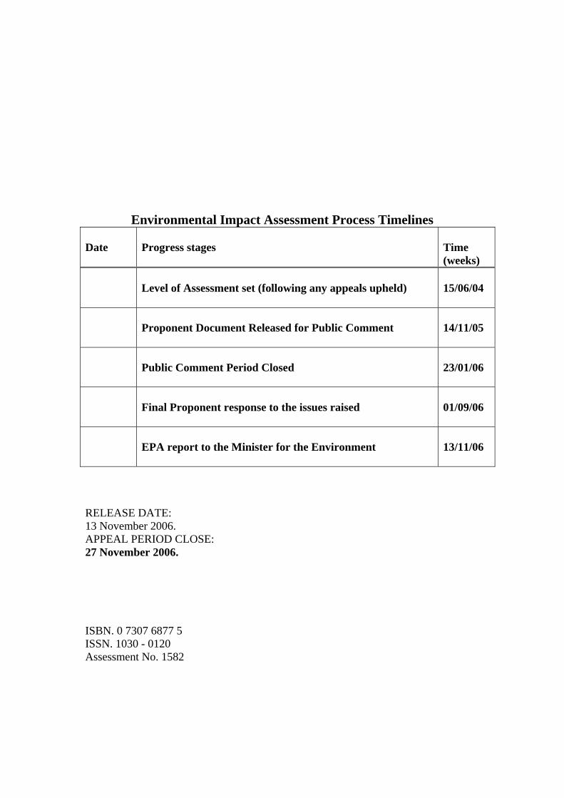
Environmental Impact Assessment Process Timelines Date
Progress stages
Time (weeks)
Level of Assessment set (following any appeals upheld)
15/06/04
Proponent Document Released for Public Comment
14/11/05
Public Comment Period Closed
23/01/06
Final Proponent response to the issues raised
01/09/06
EPA report to the Minister for the Environment
13/11/06
RELEASE DATE: 13 November 2006. APPEAL PERIOD CLOSE: 27 November 2006. ISBN. 0 7307 6877 5 ISSN. 1030 - 0120 Assessment No. 1582
Summary and Recommendations This report provides the advice and recommendations of the Environmental Protection Authority (EPA) to the Minister for the Environment on the environmental factors and principles relevant to the proposal by the Water Corporation to construct, operate and maintain a new Wastewater Treatment Plant (WWTP) and ocean outfall at Alkimos. The proposal is to develop the plant in stages up to an operational capacity of 160ML/day beyond 2050. There are two proposed sites for the WWTP, Site A and Site B. This report discusses the Environmental Impact Assessment of Site A; Site B is discussed in Bulletin 1239. The proposed WWTP at Site A is situated on the coast between Yanchep and Quinns, approximately 40km north of Perth, Western Australia. Section 44 of the Environmental Protection Act 1986 requires the EPA to report to the Minister for the Environment on the environmental factors relevant to the proposal and on the conditions and procedures to which the proposal should be subject, if implemented. In addition, the EPA may make recommendations as it sees fit. The EPA is also required to have regard for the principles set out in section 4A of the Environmental Protection Act 1986.
Relevant environmental factors and principles The EPA decided that the following environmental factors relevant to the proposal required detailed evaluation in the report:
a) Biodiversity – Terrestrial and Marine;
b) Odour; and
c) Marine – Offshore Disposal of Treated Wastewater. There were a number of other factors that were very relevant to the proposal, but the EPA is of the view that the information set out in Appendix 3 provides sufficient evaluation. The EPA considered all of the principles listed in Section 4A of the Environmental Protection Act 1986. The following principles were considered to be particularly relevant by the EPA in relation to this proposal: a) Principle 3 - Conservation of biological diversity and ecological integrity should
be a fundamental consideration; b) Principle 4b - The polluter pays principle - those who generate pollution and waste
should bear the cost of containment, avoidance, and abatement; and c) Principle 5 - All reasonable and practicable measures should be taken to minimise
the generation of waste and its discharge into the environment.
i
Conclusion Biodiversity The EPA notes that the proponent proposes to use Launch Site 1B for the Alkimos WWTP irrespective of whether WWTP Site A or Site B is developed. The EPA notes that the proponent has indicated that construction of Launch Site 1B will avoid most of the limestone vegetation unit and will have a reduced impact on the reef from the pipeline construction. The EPA considers that the requirement to prepare and implement a Launch Site and Pipe Construction Management Plan to address the design, construction and installation of pipes on land will ensure that pipeline construction and installation is carried out in an environmentally acceptable manner. The EPA notes that a total loss of approximately 7ha of BPPH is likely to be lost/damaged due to construction of the outlet. This equates to a loss of approximately 0.34% of BPPH within the 50km2 management unit (assuming 41% of management unit is vegetated). The EPA considers this loss acceptable as it falls below the 1% limit in the EPA’s BPPH Guidance No.29. The EPA notes that the potential extent and severity of turbidity effects will depend on the nature of material to be excavated and the methods used. Other activities which will have implications for indirect impacts such as management of excess excavated material (because the pipeline will fill part of the volume of the excavation) and anchoring of the pipe-lay vessel will require attention during management planning. The EPA also notes that underwater blasting may be used to manage the production of fines from excavation. The EPA considers that if blasting is to be employed then this matter needs to be assessed by the EPA. The EPA considers that a requirement to prepare and implement an Ocean Outlet Pipe Construction Management Plan will address pipeline installation in marine waters. Odour The EPA notes that the proponent will incorporate odour control in the WWTP as the plant develops in stages. The EPA notes that the proposed buffer based on odour modelling is predicted to be 600m to the west and north, 500m to the east and 450m to the south from the plant boundary. Whilst the EPA considers that buffer areas should not be viewed as an alternative to providing best practicable emission controls and appropriate management practices, the EPA considers that the proposed buffer is a reasonable separation distance that should apply to prevent adverse affects on the wider environment, health, welfare and amenity of nearby land users. The EPA expects the proponent to ensure that the odours will be managed by the implementation of best practice design and operation and unacceptable impacts will be contained within this buffer.
ii
Marine – offshore disposal of treated wastewater The EPA notes that the proponent has increased the length of the pipeline from 3.5km to 3.7km. The modified length of pipeline to 3.7km, which includes the 300m diffuser, will ensure that the diffuser is placed in slightly deeper water. This would allow for greater initial dilution and provide an additional distance from and reduce any impact of the discharge plume on the shore parallel reef system inshore of the diffuser. The EPA considers that the potential impact of nutrients on the reef chain system extending inshore of the diffuser would be reduced. The EPA notes that up to 40ML/day of treated wastewater is proposed to be discharged via the outfall pipe by 2020 with an ultimate design of 160ML/day beyond 2050. The EPA advises that licences established under Part V of the EPA Act would need to be reviewed and re-assessed to determine whether wastewater discharge to marine waters and odour management is environmentally acceptable for each stage of development of the Alkimos Wastewater Treatment Plant. This assessment should occur when the plant reaches a capacity of 40ML/day and for each significant increment from thereon. The EPA expects that wastewater disposal via the ocean outfall to meet the National Water Quality Management Strategy for Fresh and Marine Waters ANZECC & ARMCANZ, 2000). The EPA notes that the proponent, through this assessment and following the public review period, has committed to adopt the NWQMS guidelines to ensure that treated wastewater is discharged in an environmentally acceptable manner via the ocean outfall pipe. The EPA notes that the proponent is considering alternative methods including Managed Aquifer Recharge (MAR) as a means of managing a significant volume of the treated wastewater from the Alkimos Wastewater Treatment Plant. The EPA supports in principle the concept of wastewater reuse and recognises the potential for MAR using treated wastewater to play an important role in the sustainable management of Western Australia’s water resources. Proponents of MAR schemes will be expected to undertake a systematic risk assessment of their proposals. Any MAR proposal that is likely, if implemented, to have a significant effect on the environment must be referred to the EPA under section 38 of the Environmental Protection Act 1986.
Recommendations The EPA submits the following recommendations to the Minister for the Environment:
1. That the Minister notes that the proposal being assessed is to construct, operate and maintain a WWTP at Alkimos with an ocean outfall pipe for an ultimate processing capacity of 160ML/day;
2. That the Minister considers the report on the relevant environmental factors and principles as set out in Section 3;
iii
3. That the Minister notes that the EPA has concluded that it is unlikely that the EPA’s objectives would be compromised, provided there is satisfactory implementation by the proponent of the recommended conditions set out in Appendix 4, and summarised in Section 4, including the proponent’s commitments; and
4. That the Minister imposes the conditions and procedures recommended in Appendix 4 of this report.
Conditions Having considered the information provided in this report, the EPA has developed a set of conditions that the EPA recommends be imposed if the proposal by the proponent to construct a WWTP on Site A and an ocean outfall pipe is approved for implementation. These conditions are presented in Appendix 4. Matters addressed in the conditions include the following:
1. Pipe Launch Site and Pipe Construction Management Plan;
2. Fauna Management Plan;
3. Marine Treated Wastewater Discharge Management Plan;
4. Odour Management Plan;
5. Ocean Outlet Pipeline Construction Management Plan;
6. Seabed and Benthic Habitat Monitoring and Management Plan; and
7. Decommissioning and Closure Plan.
iv
Contents Page
Summary and Recommendations ...............................................................................i
1. Introduction and Background ............................................................................1 1.1. Previous Assessment......................................................................................1
2. The Proposal.........................................................................................................2
3. Relevant Environmental Factors and Principles ..............................................4 3.1. Biodiversity..................................................................................................11
3.1.1 Terrestrial .............................................................................................11 3.1.2 Marine ..................................................................................................15
3.2. Odour ...........................................................................................................19 3.3. Marine – Offshore Disposal of Treated Wastewater ...................................23 3.4. Relevant Environmental Principles..............................................................27
4. Conditions...........................................................................................................27 4.1. Recommended Conditions ...........................................................................27
5. Other Advice.......................................................................................................27
6. Conclusions.........................................................................................................28
7 Recommendations ..............................................................................................30
Tables Table 1: Summary of Key Proposal Characteristics .....................................................3 Table 2: Direct Loss of BPPH due to Construction of the Proposed Alkimos Ocean
Outlet............................................................................................................15 Table 3: Identification of Relevant Environmental Factors and Principles. ...............36 Figures Figure 1: Alkimos Location Map...................................................................................5 Figure 2: Alkimos Site Map...........................................................................................6 Figure 3: Geoheritage Landforms..................................................................................7 Figure 4: Site A, Site A Buffer, Launch Sites and the local vegetation Areas as
identified by the EPA in Bulletin 1207..........................................................8 Figure 5: Management Zones for Alkimos Ocean Outlet: Nutrients.............................9 Figure 6: Estimated locations of Benthic habitats along the proposed Alkimos ocean
outlet pipeline route .....................................................................................10 Appendices 1. List of Submitters 2. References 3. Summary of Identification of Relevant Environmental Factors 4. Recommended Environmental Conditions 5. Oceanica Report - Alkimos BPPH Loss Assessment (12 October 2006) 6. Summary of submissions and proponent’s response to submissions
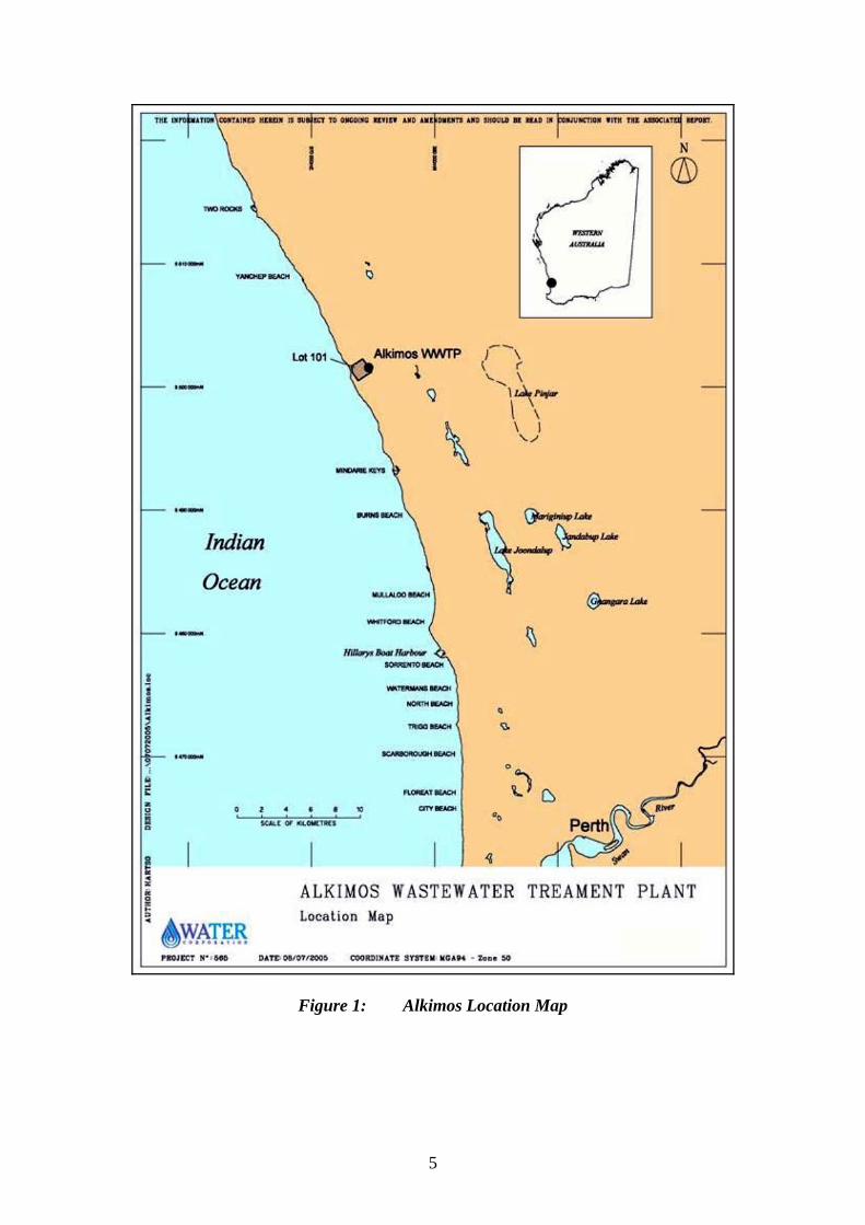
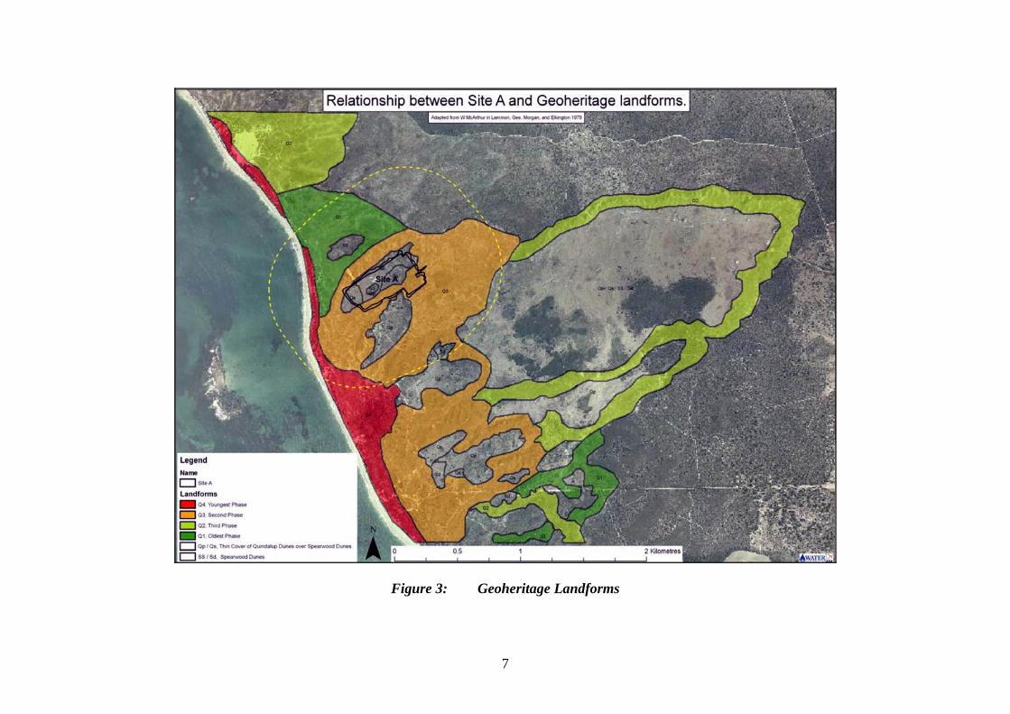
1. Introduction and Background This report provides the advice and recommendations of the Environmental Protection Authority (EPA) to the Minister for the Environment on the environmental factors and principles relevant to the proposal by the Water Corporation to construct, operate and maintain a new Wastewater Treatment Plant (WWTP) and ocean outfall at Alkimos. The proposal is to develop the plant in stages up to an operational capacity of 160ML/day beyond 2050. There are two proposed sites for the WWTP, Site A and Site B. This report discusses the Environmental Impact Assessment of Site A; Site B is discussed in Bulletin 1239. The proposed WWTP at Site A is situated on the coast between Yanchep and Quinns, approximately 40km north of Perth, Western Australia (see Figure 1 and 2). The EPA set the level of assessment at Public Environmental Review (PER) in accordance with Section 44 (1) of the Environmental Protection Act 1986. Further details of the proposal are presented in Section 3 of this report. Section 3 discusses the environmental factors and principles relevant to the proposal. The Conditions to which the proposal should be subject, if the Minister determines that it may be implemented, are set out in Section 4. Section 5 provides Other Advice by the EPA, Section 6 presents the EPA’s Conclusions and Section 7, the EPA’s Recommendations. Appendix 6 contains a summary of submissions and the proponent’s response to submissions and is included as a matter of information only and does not form part of the EPA’s report and recommendations. Issues arising from submissions, and which the EPA has taken into account, appear in the report itself. 1.1. Previous Assessment The EPA has previously assessed the implications of the proposal on Vegetation, Fauna and Geoheritage for siting the WWTP at Site A (Bulletin 1207). Site A is located in an area of Dune Swale with native vegetation that is mostly in a Degraded to Good condition (Figure 3 and 4). The EPA considered that, while it was desirable to retain this area if possible, the values within this area were adequately represented and protected elsewhere in the Alkimos-Eglinton region and that the natural values in Site A did not justify inclusion of the area within a Parks and Recreation reserve (Bulletin 1207, section 5.4). The Minister accepted the advice and the Appeals Convenor issued a report in March 2006. The MRS Amendment was gazetted on 7 July 2006. The Vegetation, Fauna and Geoheritage implications of siting the WWTP at Site A are therefore not considered further in the present bulletin. However, the EPA has not previously assessed the environmental impact associated with odour, onshore and offshore pipeline installation and wastewater disposed to the marine environment. These environmental factors are discussed in this report.
1
2. The Proposal The proposal involves the construction, operation and maintenance of a WWTP at Alkimos. The plant will be developed in stages up to a proposed operational capacity of 160ML/day beyond 2050. It includes the disposal of treated wastewater via an ocean outlet, with future opportunities for wastewater re-use. WWTP - Treatment Processes The Alkimos WWTP will be based on advanced versions of the activated sludge process, and includes all or some of the following processes: • screening and grit removal tanks at the eastern end of the site; • primary sedimentation tanks; • secondary treatment by an advanced version of activated sludge designed to
maximise nitrogen removal; • sludge thickening; • sludge digesters (anaerobic digestion when primary treatment installed); • gas engines for energy recovery (when primary treatment installed); • digested sludge storage tanks; • a sludge dewatering building, wherein sludge is dewatered using centrifuges (as at
the Subiaco, Beenyup and Woodman Point WWTP’s); • treated wastewater balancing lagoons; • outlet flume, in the west of the site; • water reclamation plant; • product-water tank(s); and • odour control extraction and scrubbing plants, with discharge via vent stacks. The WWTP will have a footprint of around 23ha, which includes the plant footprint, access roads, ocean outfall launch site and associated infrastructure. It will be located at the centre of an odour buffer zone of approximately 110 ha, being predominantly 600m from the edge of the plant. The odour buffer will contain compatible land-uses and facilitate the protection of conservation values. Ocean Outfall Pipeline and Infrastructure An ocean outfall pipeline will be constructed for the disposal of treated wastewater. The pipeline will include: • a 1.0 to 1.2m inner diameter (1.4 to 1.5m outer diameter) land outlet pipeline
connecting the WWTP to the ocean outlet; • an approximately 3.7km long pipe of 1.0 to 1.2m inner diameter (1.4 to 1.5m outer
diameter) with a 300m long diffuser. The pipeline would be laid at grade through the inner reef, and laid over the middle reef profile to minimise excavation; and
• A launch site for launching lengths of pipe into the marine environment that has an approximate area of 0.06km2.
The main characteristics of the proposal are summarised in Table 1 below.
2
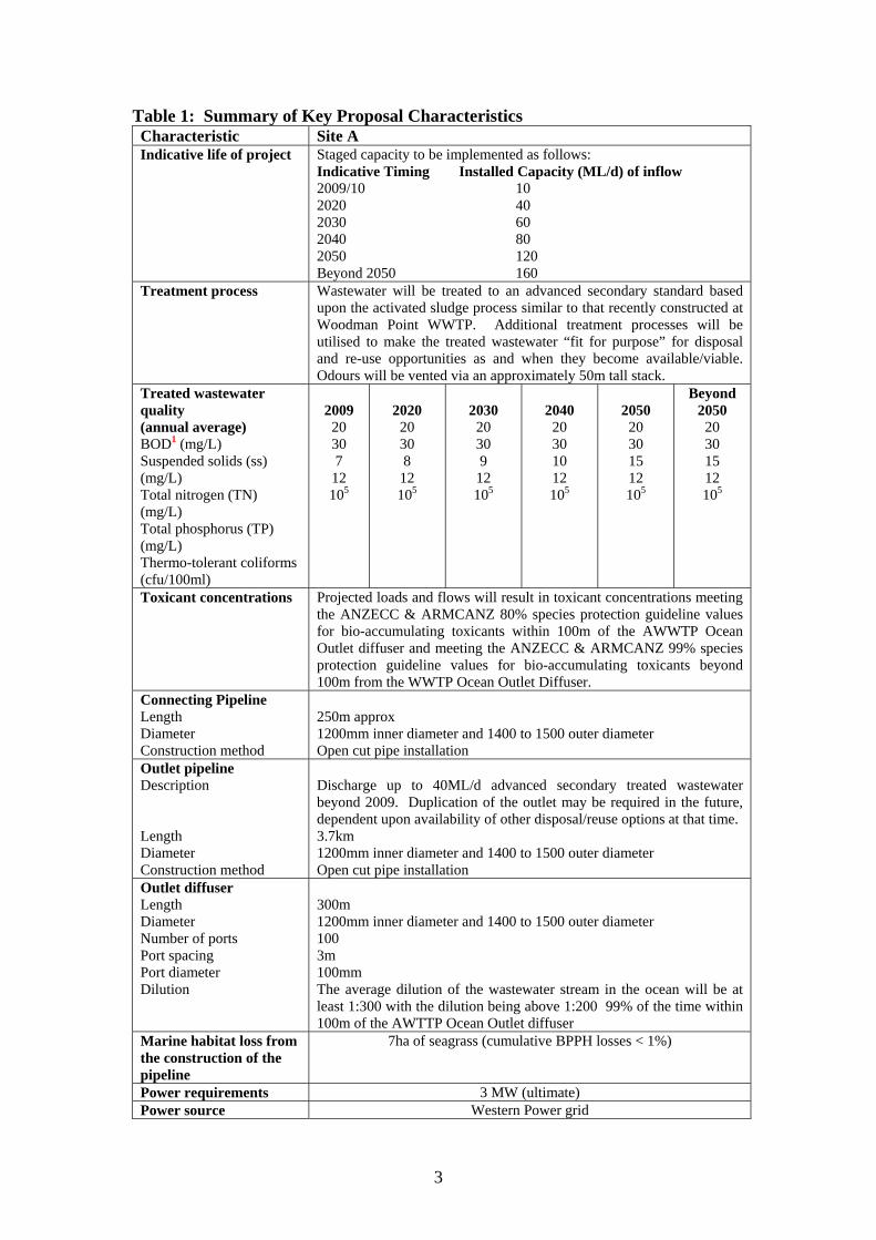
Table 1: Summary of Key Proposal Characteristics Characteristic Site A Indicative life of project Staged capacity to be implemented as follows:
Indicative Timing Installed Capacity (ML/d) of inflow 2009/10 10 2020 40 2030 60 2040 80 2050 120 Beyond 2050 160
Treatment process Wastewater will be treated to an advanced secondary standard based upon the activated sludge process similar to that recently constructed at Woodman Point WWTP. Additional treatment processes will be utilised to make the treated wastewater “fit for purpose” for disposal and re-use opportunities as and when they become available/viable. Odours will be vented via an approximately 50m tall stack.
Treated wastewater quality (annual average) BOD1 (mg/L) Suspended solids (ss) (mg/L) Total nitrogen (TN) (mg/L) Total phosphorus (TP) (mg/L) Thermo-tolerant coliforms (cfu/100ml)
2009 20 30 7
12 105
2020 20 30 8
12 105
2030 20 30 9
12 105
2040 20 30 10 12 105
2050 20 30 15 12 105
Beyond 2050 20 30 15 12 105
Toxicant concentrations Projected loads and flows will result in toxicant concentrations meeting the ANZECC & ARMCANZ 80% species protection guideline values for bio-accumulating toxicants within 100m of the AWWTP Ocean Outlet diffuser and meeting the ANZECC & ARMCANZ 99% species protection guideline values for bio-accumulating toxicants beyond 100m from the WWTP Ocean Outlet Diffuser.
Connecting Pipeline Length Diameter Construction method
250m approx 1200mm inner diameter and 1400 to 1500 outer diameter Open cut pipe installation
Outlet pipeline Description Length Diameter Construction method
Discharge up to 40ML/d advanced secondary treated wastewater beyond 2009. Duplication of the outlet may be required in the future, dependent upon availability of other disposal/reuse options at that time. 3.7km 1200mm inner diameter and 1400 to 1500 outer diameter Open cut pipe installation
Outlet diffuser Length Diameter Number of ports Port spacing Port diameter Dilution
300m 1200mm inner diameter and 1400 to 1500 outer diameter 100 3m 100mm The average dilution of the wastewater stream in the ocean will be at least 1:300 with the dilution being above 1:200 99% of the time within 100m of the AWTTP Ocean Outlet diffuser
Marine habitat loss from the construction of the pipeline
7ha of seagrass (cumulative BPPH losses < 1%)
Power requirements 3 MW (ultimate) Power source Western Power grid
3
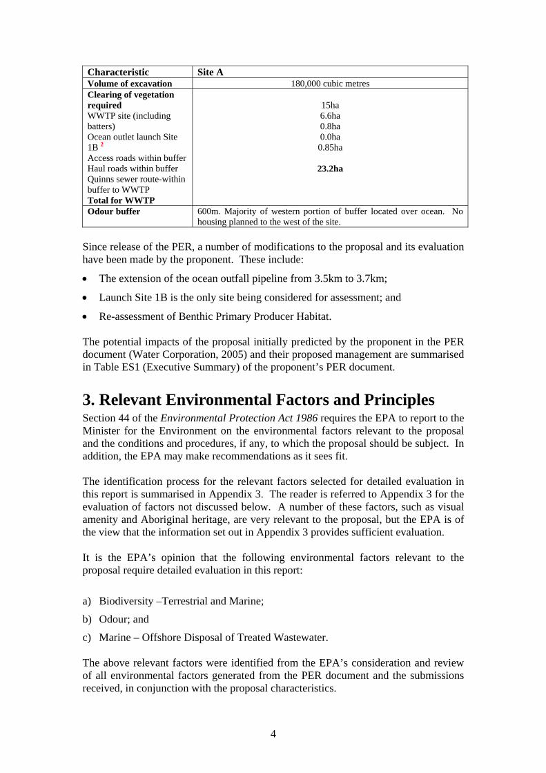
Characteristic Site A Volume of excavation 180,000 cubic metres Clearing of vegetation required WWTP site (including batters) Ocean outlet launch Site 1B 2Access roads within buffer Haul roads within buffer Quinns sewer route-within buffer to WWTP Total for WWTP
15ha 6.6ha 0.8ha 0.0ha 0.85ha
23.2ha
Odour buffer 600m. Majority of western portion of buffer located over ocean. No housing planned to the west of the site.
Since release of the PER, a number of modifications to the proposal and its evaluation have been made by the proponent. These include:
• The extension of the ocean outfall pipeline from 3.5km to 3.7km;
• Launch Site 1B is the only site being considered for assessment; and
• Re-assessment of Benthic Primary Producer Habitat. The potential impacts of the proposal initially predicted by the proponent in the PER document (Water Corporation, 2005) and their proposed management are summarised in Table ES1 (Executive Summary) of the proponent’s PER document.
3. Relevant Environmental Factors and Principles Section 44 of the Environmental Protection Act 1986 requires the EPA to report to the Minister for the Environment on the environmental factors relevant to the proposal and the conditions and procedures, if any, to which the proposal should be subject. In addition, the EPA may make recommendations as it sees fit. The identification process for the relevant factors selected for detailed evaluation in this report is summarised in Appendix 3. The reader is referred to Appendix 3 for the evaluation of factors not discussed below. A number of these factors, such as visual amenity and Aboriginal heritage, are very relevant to the proposal, but the EPA is of the view that the information set out in Appendix 3 provides sufficient evaluation. It is the EPA’s opinion that the following environmental factors relevant to the proposal require detailed evaluation in this report:
a) Biodiversity –Terrestrial and Marine;
b) Odour; and
c) Marine – Offshore Disposal of Treated Wastewater. The above relevant factors were identified from the EPA’s consideration and review of all environmental factors generated from the PER document and the submissions received, in conjunction with the proposal characteristics.
4
5
Figure 1: Alkimos Location Map
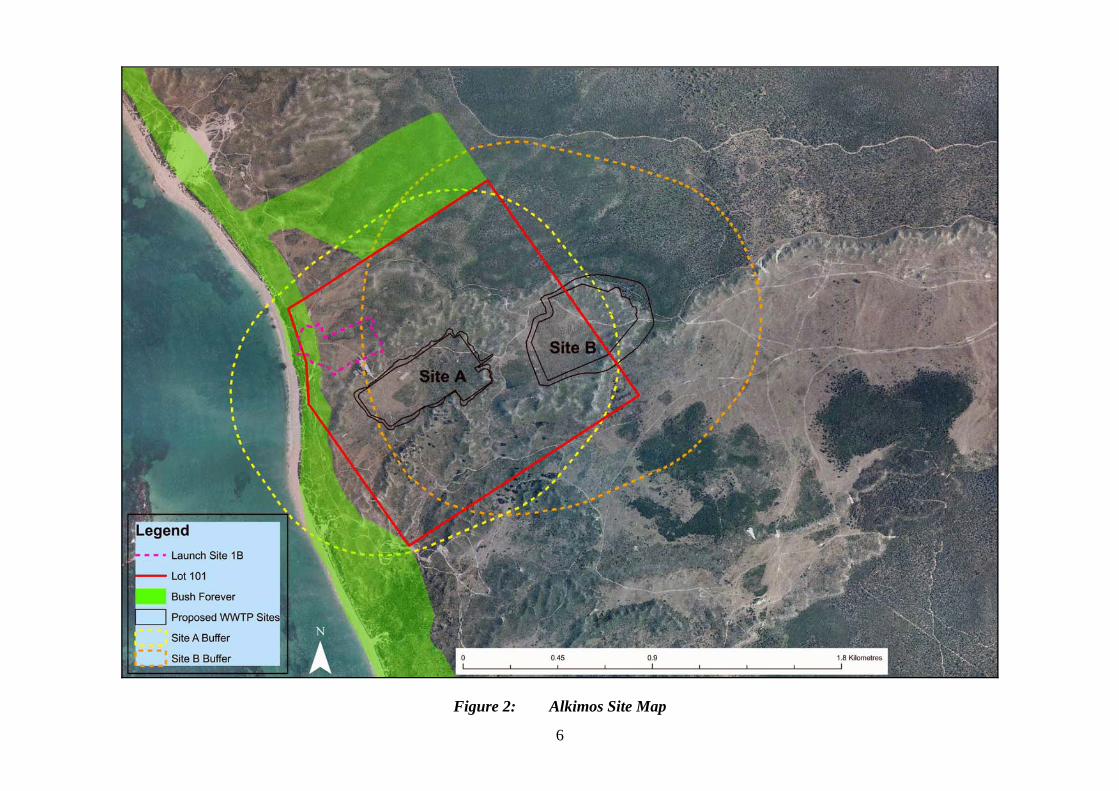
Figure 2: Alkimos Site Map
6
7
Figure 3: Geoheritage Landforms
8
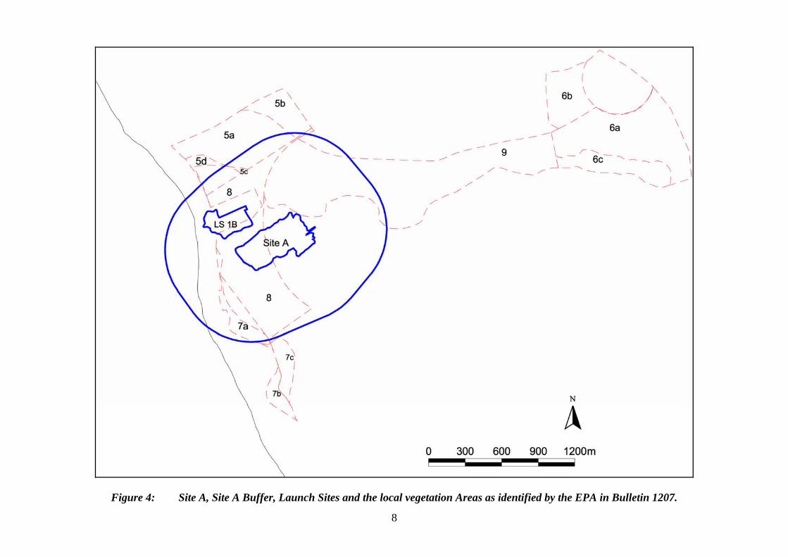
Figure 4: Site A, Site A Buffer, Launch Sites and the local vegetation Areas as identified by the EPA in Bulletin 1207.
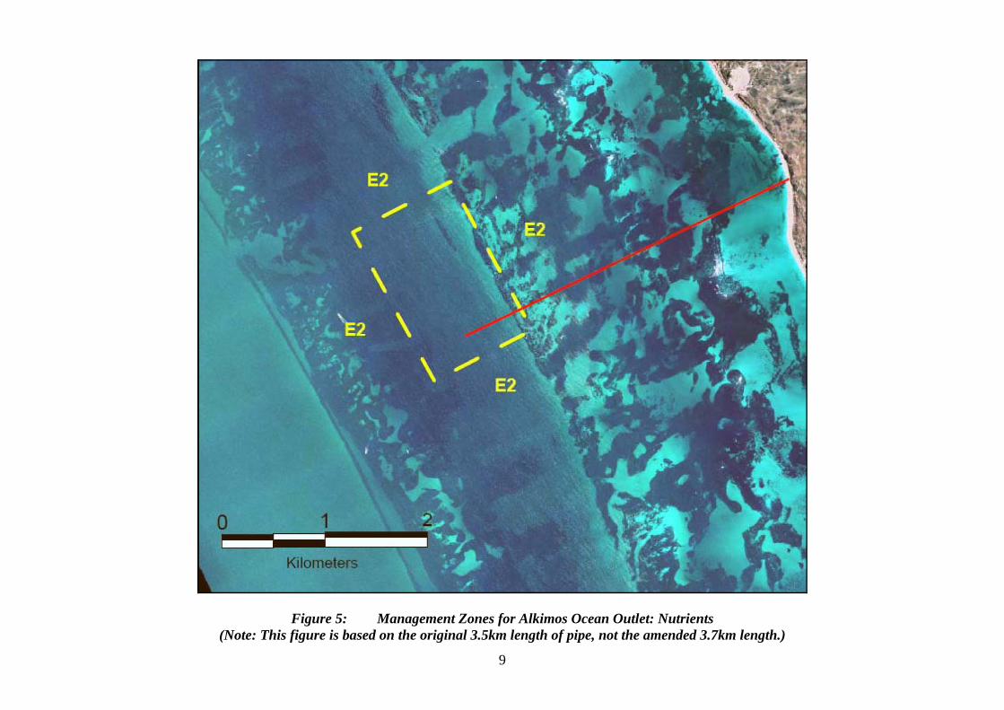
Figure 5: Management Zones for Alkimos Ocean Outlet: Nutrients (Note: This figure is based on the original 3.5km length of pipe, not the amended 3.7km length.)
9
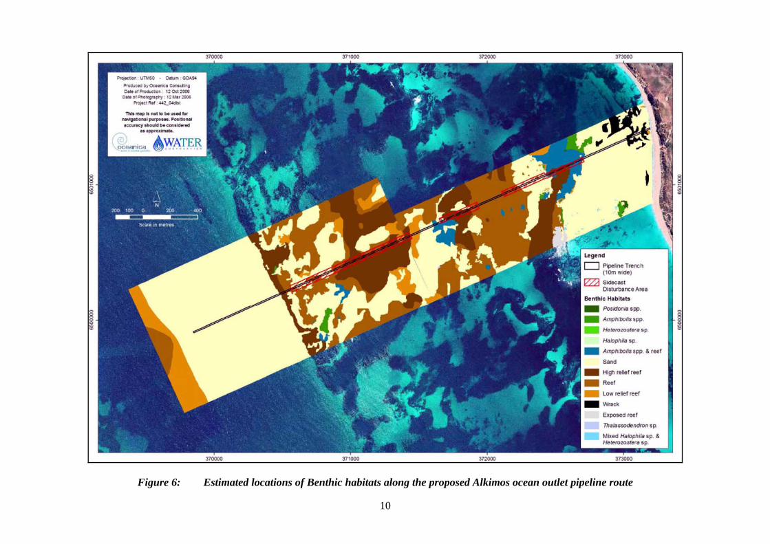
Figure 6: Estimated locations of Benthic habitats along the proposed Alkimos ocean outlet pipeline route
10
Details on the relevant environmental factors and their assessment are contained in Sections 3.1 - 3.3. The description of each factor shows why it is relevant to the proposal and how it will be affected by the proposal. The assessment of each factor is where the EPA decides whether or not a proposal meets the environmental objective set for that factor. The EPA considered all of the principles listed in Section 4A of the Environmental Protection Act 1986. The following principles were considered to be particularly relevant by the EPA in relation to this proposal: a) Principle 3 - Conservation of biological diversity and ecological integrity should
be a fundamental consideration; b) Principle 4b - The polluter pays principle - those who generate pollution and waste
should bear the cost of containment, avoidance, and abatement; and c) Principle 5 - All reasonable and practicable measures should be taken to minimise
the generation of waste and its discharge into the environment.
3.1. Biodiversity Description The construction and laying of the ocean outfall pipe, both on land and in the marine environment has the potential to impact on biodiversity. In addition there is also potential for biodiversity to be impacted due to the prefabrication of pipe lengths on the launch site for the ocean outlet pipe.
3.1.1 Terrestrial The pipeline construction on land will consist of a number of pipeline sections between the WWTP, the launch site and the coast from where the marine outfall pipeline connects. The proponent has provided preliminary design details of the construction and installation of the outfall pipeline for the terrestrial and marine components. Drilling and open-cut methods are proposed for use for the terrestrial component. The final design will be developed prior to any earthworks being carried out by the proponent. Preliminary details of Launch Site Launch Site 1B is proposed to be used for the Alkimos WWTP irrespective of whether Site A or B is developed. The Site is approximately 300m long and 200m wide and will be used for the preparation of the outfall pipe prior to it being installed on the seabed. The pre-production of long pipe lengths will help to minimise the time taken to assemble and install the pipeline. This site is proposed because it will result in minimum impact on significant vegetation (Fig 2). There are two communities that are considered to be significant. The first community is a limestone vegetation unit that is representative of a threatened ecological community Melaleuca huegelii – Melaleuca systena (formerly known as Melaleuca huegelii – Melaleuca acerosa). Melaleuca huegelii – Melaleuca
11
acerosa shrublands on Limestone ridges (26a) are unusual in this Quindalup Dune location and its floristic composition exhibits maritime influences, thus it may be regarded as having greater significance than typical occurrences of 26a. In addition, this unit is an important habitat for the Carpet Python, a threatened Scheduled 4 reptile listed under the WA Wildlife Conservation Act 1950. The second significant vegetation community is the vegetation unit Fp (Frankenia pauciflora Very Low to Low Shrubland). It is locally significant because it does not occur elsewhere in Alkimos or Eglinton and it is in a Bush Forever area (Area 397) on the coast. The proponent has stated that the condition of the vegetation where the Launch Site will be located has been degraded. The launch site will need to be level and clear of all obstructions. The site will need to be cleared of vegetation and topsoil; it will require about 6.6ha of vegetation to be cleared (6.3ha on the site and 0.3ha for access roads). This material will be stockpiled and preserved for the rehabilitation of the site once the pipe launch is complete. Pipeline from WWTP to Launch Site The section of pipeline between the WWTP Site A and the launch site will be about 250 metres long. This section of the pipeline will be installed using open cut methods through the dune landform that separates the WWTP from the launch site. The proponent has stated that the excavation through the dune will take place through an existing blowout. Pipeline from Launch Site to the Coast It is proposed to install the pipeline section from the launch site to the beach using drilling and open cut methods. The area of land between the launch site and the beach is a Bush Forever site which contains significant flora, Frankenia pauciflora. It is proposed that a trench be cut through the fore dune for the installation of the pipeline as the dune structure is not stable enough for the use of drilling techniques. The excavation will require 80,000m3 of material to be removed and the cut may be up to 70m wide. This material will be stockpiled and preserved for the rehabilitation of the site once the pipe launch is complete. The dune is in a degraded condition and it is turning into a blowout. The proponent proposes to rehabilitate the dune, after pipe installation, to better than its current condition. Beach Crossing The beach crossing will be undertaken using an open cut method of installation using a cofferdam. The pipe will be buried below the sand level on the beach and to the 5m contour depth level (5m below mean sea level). After the pipe has been towed out to its correct position, it will be filled with water and the trench backfilled using the side cast produced from the excavation process. The beach crossing trench will be re-instated including the removal of the reception /connection pit.
12
The proponent has stated that the pipe will be buried at a depth sufficient to ensure that pipe exposure will not occur even during a worst storm event (i.e. a 1 in 100 year frequency storm). Geotechnical investigations are currently being undertaken by the proponent to determine the geology in the area with a view to a buried beach crossing.
Submissions The main issues raised in the submissions were: • The launch site contains regional significant conservation values, including:
- a diversity of landforms (limestone and dunes); - a vegetation unit considered to be a threatened ecological community; - part of the Alkimos dune system of geoheritage significance; - high flora species richness; and - important fauna habitats.
Assessment The EPA’s environmental objectives for this factor are: • To maintain the abundance, diversity, geographic distribution and productivity of
native flora and fauna at species, community and ecosystem levels through avoidance or mitigation of adverse impacts and improvement of knowledge.
• To ensure that native flora and fauna are conserved consistent with the Wildlife Conservation Act (1950) and the Environment Protection and Biodiversity Conservation Act (1999).
• To ensure that changes to the biophysical environment do not adversely affect geoheritage values.
The EPA notes that the proponent proposes to use Launch Site 1B for the Alkimos WWTP irrespective of whether WWTP Site A or Site B is developed. The EPA notes that the proponent has indicated that construction of Launch Site 1B will avoid most of the limestone unit and will have a reduced impact on the reef from the pipeline construction. Preliminary design of the construction and installation of the pipeline on land indicates that there will be a number of pipelines between the WWTP, the launch site and the coast to convey the treated wastewater to a point where the marine outfall pipeline connects. Pipeline from WWTP to Launch Site The EPA considers that drilling techniques are normally the preferred and more environmentally acceptable methods for the installation of the pipe through these dune landforms. The EPA understands that these methods will not be practicable for the pipeline installation from Site A to the launch site because the dune is not stable enough. If trenching is used, the EPA considers that the pipe trench should be rehabilitated immediately after installation of the pipe when open cut methods are used.
13
Pipeline from Launch Site to the Coast The pipeline section from the launch site to the beach crosses a Bush Forever site that contains significant flora, Frankenia pauciflora. The EPA considers that the open-cut method may not be environmentally acceptable due to the potential impact of excavating a trench through the dune and limestone cliff structure on the coastline. As this dune is a Bush Forever site, the EPA requires the proponent to liaise with the Bush Forever Office at the Department of Planning and Infrastructure (DPI) to seek guidance on the significance of this site in relation to the proposed pipeline route. The proponent should address any issue raised by the DPI when preparing its Pipe Launch Site and Pipe Construction Management Plan. Beach Crossing The EPA notes that the proponent has stated that the pipeline will be buried below the sand level on the beach and to the 5m contour depth level (5m below mean sea level). The pipe could be exposed by erosion if it is not buried deep enough; this may lead to a groyne effect interfering with coastal processes. The EPA considers that burying the pipe at a depth that will withstand exposure to a one in one hundred year storm will reduce the potential for the pipe to be exposed by erosion to an acceptable level. The EPA considers that the requirement to prepare and implement a Launch Site and Pipe Construction Management Plan to address the design, construction and installation of pipes on land will ensure that pipeline construction and installation is carried out in an environmentally acceptable manner. The plan should address, but not be limited to: • access roads; • geotechnical information; • methods of installation; and • Bush Forever site avoidance, including Frankenia pauciflora. Summary The EPA considers the issue of Biodiversity can be adequately addressed and meet the EPA’s objectives for this factor provided that:
a) a Pipe Launch Site and Pipe Construction Management Plan is prepared and implemented;
b) the DPI are satisfied with the management of the Bush Forever site;
c) the pipe trench is progressively rehabilitated immediately following installation of the pipe when using open cut methods; and
d) the pipe is buried over the beach to a depth that will withstand exposure to a one in one hundred year storm.
14
3.1.2 Marine Direct Losses The proposed pipeline route crosses a number of vegetated habitats including Amphibolis spp. beds and algae-dominated reef. The shallow (<20m deep) nearshore waters off Perth include a variety of habitats, varying from meadow forming seagrasses that are dominant in the more sheltered sandy areas, to limestone reefs and platforms supporting a variety of algal communities, in the more exposed coastal waters. The low nutrient environment and high water clarity mean that seagrasses are a common feature and may typically be found at depth between 1m to 15m. The vegetated habitat includes dense beds (>80% cover) of Amphibolis spp. and Posidonia australis. Other Posidonia species (Posidonia sinuosa and Posidonia angustifolia) occur within isolated patches only. Halophila ovalis and Heterozostera tasmanica, are more variable in cover, ranging from 20% to 100%. Over its entire 3.7km length, the pipeline route crosses approximately 1.4km of sand habitat and 2.3km of vegetated habitat (Figure 6). During construction a ≤ 10m wide swathe of seabed along the pipeline route will be cleared and the piping laid on the seabed (see Appendix 5). In three sections, trenching will be required prior to laying the pipeline and the trenched material will then be side-cast (Figure 6). Trenching/side-casting will disturb habitats along each section to a maximum width of about 50m. In areas where the loss of seagrasses can be reduced by side casting to one side of the trench only, this will be carried out. Following placement of the pipe, backfilling will occur along the trenched sections to anchor the pipe in place. Potential loss of Benthic Primary Producer Habitat (BPPH) from direct impact is given in Table 2. Table 2: Direct Loss of BPPH due to Construction of the Proposed Alkimos Ocean Outlet.
Habitat Loss (ha) Habitat Type*
Clearing
(10m swathe)
Trenching/side
casting
Sub-total (ha)
% loss (within
groundtruthed area – 332ha)
Amphibolis spp. & reef
0.048 0.460 0.510 5.020
High relief reef
0.040 3.381 3.420 7.430
Low relief reef 0.078 0.198 0.280 1.380 Reef 0.248 2.445 2.693 4.160
TOTAL 6.898 *Details of each habitat type given in PER (Water Corporation, 2005) The majority of habitat losses due to the clearing of a 10m wide swathe along the pipeline route will occur to ‘reef’ habitat (Table 2), whereas the greatest losses due to trenching/side casting will occur to ‘high relief reef’ habitat.
15
A total of approximately 7ha of BPPH are likely to be lost/damaged due to construction of the outlet. This equates to a loss of approximately 0.34% of BPPH within the 50km2 management unit, assuming 41% of the management unit is vegetated (PER Section 4.1.7.1, Water Corporation, 2005). Back-filling with rock and the presence of the pipe will form habitat for recolonisation and will counter some of the loss of hard substrate. It is anticipated that the recolonising faunal and algal communities would be similar to those already found in the area. Indirect Losses The construction of the pipeline is proposed to occur over two summer/autumn periods, for four to five months each year (2008–2009). In addition to the direct loss/damage of benthic habitats, indirect losses associated with the generation of turbidity may occur. Studies of sediment indicate that the sand habitats within 3.5km of the shoreline in the Alkimos area were generally found to be dominated by medium to coarse sands and exhibited zero fines (silt and clay fraction). One site approximately 3km offshore, 1.4km north of the proposed pipeline route was mainly fine sands. The majority of sites along the proposed pipeline route were dominated by medium/coarse sands, although the sediment at two inshore sites (approximately 0.7km offshore) and one offshore site (approximately 3km offshore) was described as medium/fine clean sand (Water Corporation, 2005). Turbidity caused during the trenching and backfilling of sand habitats is likely to be minimal and short-lived (medium sands [250–500Hm] settle at over 0.05m/s while coarse sands [500–1,000Hm] settle at over 0.2m/s). Although some smothering by settling sand is likely to occur immediately adjacent to the pipeline route during trenching and back-filling, the local flora and fauna is likely to be relatively tolerant to some degree of smothering (given the rough conditions occurring naturally at the site during the summer sea breeze and winter storms, sand is likely to be resuspended regularly and deposited on reef areas). Turbidity caused by trenching through the limestone reef features is largely dependent upon the type of dredging equipment used, which is in turn dependent upon the hardness of the rock and types of equipment available. During the Port of Geraldton dredging program the use of a large cutter-suction dredge, which directly filled hopper barges, was estimated to produce approximately 1,800 tonnes/day of fines (<100Hm). It is anticipated that the use of blasting, followed by backhoe dredging to side-cast the rock material, would result in significantly less fines being produced. The most appropriate construction methodology to be used at Alkimos will not be determined until the geotechnical works have been completed. The majority of the reef habitats present along the pipeline route are algae dominated with Amphibolis spp., limited to discrete areas approximately 750m and 1,750m offshore, and small patches of Posidonia spp. seagrasses present inshore (Water Corporation, 2005). Algal assemblages are likely to recover rapidly (1–2years) despite impact due to turbidity and smothering. The worst-case longer term indirect impacts are likely to be limited to impacts on the seagrasses Amphibolis spp. and Posidonia spp. adjacent to the pipeline route where reef is being trenched. If losses of
16
seagrass/algae in such areas were to occur, it would result in the loss of approximately 10ha (0.5%) of vegetated habitats within the 50km2 management unit (assuming 41% of management unit is vegetated).
Submissions
• Further information is required detailing construction, location of infrastructure (temporary and permanent) and longer-term management of the proposed pipe;
• Potential for impacts on coastal processes due to construction or presence of a pipe across the beach and near shore has not been properly discussed; and
• The extent of the Benthic Primary Producer Habitat (BPPH) loss is unknown. Assessment Construction and installation of the marine outfall pipe has the potential to impact on the marine ecosystem, in particular on Benthic Primary Producers (BPP) such as seagrasses, seaweeds and turf algae. The proposal also has the potential to impact on water quality in terms of turbidity caused from sediment movement during construction. The EPA’s Guidance Statement No. 29 addresses the protection of BPP such as seagrasses, seaweeds and turf algae. It also covers BPPH, that is, the BPP and the substrate which can or does support them. The proponent proposes a management unit of 50km2 in accordance with the EPA’s Guidance Statement. The area offshore from Alkimos is a high protection area and falls under category B, in which a cumulative loss of no more than 1% of the historic BPPH is recommended and would meet the EPA’s objectives stated in the guidance statement. During the formal assessment process and following the public review period, the EPA sought additional information from the proponent on the potential impacts (direct and indirect) on BPPH from the construction. The proponent submitted revised data on the potential loss of BPPH from direct and indirect impacts (see Appendix 5, Oceanica Report). The EPA notes that the recent data provided in the Oceanica report provides a greater level of detail about potential impacts of pipeline installation on BPPHs than any previous documentation from the proponent. The EPA notes that Oceanica’s evaluation of impacts on BPPH is based on a 3.7km long pipeline. This is 200m longer than the pipeline proposal described in the PER and consistent with discussions held between the EPA and Water Corporation about extending the pipeline to manage risk posed to high-relief reefs by nutrient rich treated wastewater. Direct Impacts The pipeline installation will directly impact BPPH within a 10m wide swathe centred about a 1.4m wide pipe. The EPA notes that there are defined sections of the proposed pipeline route where the direct impacts on BPPH may be up to 50m wide due to trenching and side-casting. The boundaries of the trenching and side-casting
17
areas have been defined to minimise (though not totally eliminate) the direct impacts of these activities on areas of seagrass. The EPA considers that the proponent should investigate alternatives such as piping excavated material to an area where it would be stable and environmentally less sensitive than most areas along the pipeline route. The majority of habitat losses due to the clearing of a 10m wide swathe along the pipeline route will occur to ‘reef’ habitat (Table 2), whereas the greatest losses due to trenching/side casting will occur to ‘high relief reef’ habitat. The EPA notes that a total area of approximately 7ha of BPPH is likely to be lost/damaged due to construction of the outlet. This equates to a loss of approximately 0.34% of BPPH within the 50km2 management unit (assuming 41% of management unit is vegetated). The EPA considers that the predicted loss is less than the 0.1% recommended by the EPA and is therefore considered to be environmentally acceptable. The EPA considers that the requirement to prepare and implement a Seabed and Habitat Monitoring and Management Plan to address monitoring and reporting of habitat loss during, and post, construction, and methods to protect the seabed and benthic habitat, will ensure that construction of pipeline is carried out in an acceptable manner. Indirect Impacts The EPA considers that the potential indirect impact to BPPH is less predicable. Indirect impacts on BPPH that could arise from the construction phase of the proposal include: • Smothering of BPPH outside the predicted footprint area due to dispersion of
side-cast material, particularly sands and finer rocky material; • Light deprivation effects caused by the liberation of fine sediment particles to the
water column during excavation operations, particularly excavation of harder limestone material;
• Extent and severity of any erosion halo that may form around the excavated or backfilled areas; and
• Potential for excavated areas that remain exposed between summer to autumn periods to accumulate seagrass/algal wrack or sediment requiring additional dredging in the following year.
The EPA notes that underwater blasting is not part of this proposal and if it is to be employed then the proposal would need to be assessed as a new proposal by the EPA. The preliminary design of construction and installation of the marine outfall pipe indicates that the proponent has stated that the bottom-pull method will be used to winch the pipe into place. The EPA understands that the method includes the winch being secured into place for operation and then moved to the next location without damaging the sea floor in the way the tugging method does. This method is considered to be the least destructive to the marine habitat at Alkimos if managed in an environmentally acceptable manner.
18
The EPA notes that Amphibolis and Posidonia are species of seagrasses that propagate slowly and their potential for replacement using restoration techniques is low to moderate (EPA, 2004). The proponent should avoid clearing seagrasses wherever possible and especially make sure that Amphibolis or Posidonia are not affected. The EPA considers that a requirement to prepare and implement an Ocean Outlet Pipeline Construction Management Plan will address pipeline installation in the marine environment. The plan will address, but not be limited to: • route design; • material to be excavated; • rehabilitation; • blasting techniques; • pipe-lay vessel dredge support; • mooring pattern design; • water quality; and • Benthic community. Summary Having particular regard to the:
(a) bottom pull method of pipe construction for the portion of pipe from the beach to the open water;
(b) Ocean Outlet Pipeline Construction Management Plan, as per Condition 7;
(c) cumulative BPPH losses in the area are below 1%; and
(d) Seabed and Habitat Monitoring and Management Plan, as per Condition 8. it is the EPA’s opinion that the proposal can be managed to meet the EPA’s environmental objective for this factor. 3.2. Odour Description Construction and operation of the proposed WWTP has the potential to generate odours which can affect the health, welfare and amenity of people if not properly managed. The Alkimos region covers a large future urban catchment to the north and north-east of Perth, thus wastewater will travel in the sewers for hours before it reaches the treatment plant. Biological activity in sewers decomposes some of the organic material present in sewage and the wastewater arriving at the WWTP is odorous. Biological treatment of sewage at the plant also has the potential to further generate odours. These odours if not managed in an environmentally acceptable manner have the potential to adversely impact human amenity and users of land surrounding the plant.
19
Plant Odour Emissions At the ultimate design capacity of 160ML/day, the predicted average odour emission at ground level is expected to be 27,000 Odour Units per second (OUs). This concentration is the sum of residual odour concentration from the covered tanks as a result of minor leaks, pressure variations under the covers due to wind effects, inspections and maintenance activities (Water Corporation, 2005). The proponent’s environmental objective for odour reduction at the WWTP is to ensure that the 5 OU contour (99.9th percentile, 1-hour average, Australian Standard threshold certainty Odour Unit), predicted using the specific odour model developed to simulate conditions at the Alkimos WWTP, falls within the recommended zone. The 5 OU objective is based on comparison of odour model predictions and community complaints around the Subiaco, Beenyup and Woodman Point treatment plants. These predictions were based on the proponent using the latest version of the Ausplume model for odour modelling. The modelling incorporated a stack height design of 50 metres. Note: The proponent has selected a criteria different to the ‘greenlight’ criteria in EPA Guidance 47 because the proponent believes that experience has shown the 5 OU criteria to better represent WWTP than the general criteria in Guidance 47. Buffer At Site A, the zone in which a distinct odour (5 OU or more) could occur for 8 hours or more per year, was predicted to extend 600m to the west and to the north, 500m to the east and 450m to the south (Water Corporation, 2005). These predicted distances are the basis for the proponent’s recommended buffer zone for the plant at Site A. A part of the recommended buffer zone extends offshore and that part does not involve any commitment of land. Odour Management- Wastewater Treatment Plant Design and Construction The proponent will design and construct the WWTP to ensure that odour emissions are managed in an environmentally acceptable manner so that odours do not adverse impact on the community. The proponent has undertaken to: • Consider appropriate siting to minimise odour impacts on surrounding lands; • Adopt best practice odour emission control in the design of plant including covers
on all treatment units, collection of gases from beneath the covers, effective scrubbing units, backup treatment and scrubbing units to maximise operations and 50 metre tall stacks to discharge the gases after scrubbing;
• Install odour control equipment equal to those recently installed at the Subiaco and Beenyup WWTPs;
20
• Adopt appropriate computer-controlled monitoring and operating systems, fully trained operations personnel and maintenance procedures designed to minimise the release of fugitive odours and leakage;
• Adopt an odour management system so that the residual leakage from the plant does not exceed 27,000 OUs in normal operations. This, according to the proponent, corresponds to 97% efficiency in the capture of odours;
• Manage its operations within the buffer identified in Plan 1 in Addendum 1 of the PER (Water Corporation, 2005); and
• Prevent incompatible land-uses within the buffer and not to affect sensitive land uses outside the buffer.
Submissions The main issues raised in the submissions on odour for Site A include: • A buffer of 600 meters may not be adequate; • The proposed major road, regional centre, surrounding proposed houses,
businesses, social and cultural areas should not be subjected to odours from the WWTP;
• Appropriate meteorological data should be used when modelling odour behaviour for the WWTP; and
• Proponent should accept 5 OU 1-hour average 99.9th percentile as the criterion.
Assessment
The EPA’s environmental objective for this factor is to ensure that:
• Atmospheric emissions do not adversely affect the environment or health, welfare and amenity of nearby land users by meeting statutory requirements (including Section 51 of the Environmental Protection Act, 1986) and acceptable standards;
• Atmospheric emissions, both individually and cumulatively, meet appropriate criteria and do not cause an environmental or human health problem; and
• All reasonable and practicable measures are used to minimise the discharge of atmospheric emissions.
In order to manage industrial emissions, including odour, the EPA’s preferred hierarchy is:
• Avoidance of impacts;
• Minimise the creation and discharge of waste by implementing best practice; or
• Ensure environmental impacts from industrial emissions are acceptable and meet the relevant regulations and health criteria beyond the boundary of the site, industrial estate or buffer area. (EPA, 2005).
The EPA notes that at the ultimate design capacity of 160ML/day the predicted odour emission at ground level is 27,000 OUs. This concentration of odour will mainly be due to residual odour leakage from covered tanks, pressure variations under the covers and during maintenance. The EPA notes that the proponent will incorporate odour control in the WWTP as the plant develops in stages. Odorous processes will be covered to contain and permit
21
extraction of odorous gas. The extracted gas will be treated in chemical and/or biological scrubbing systems and, in the longer term, the treated gas released via a stack(s) suitably sized for the purpose, probably over 50m high. The EPA notes that the final stack height has not been finalised. The height should be determined by detailed design and by the works approval process as per Condition 11. The EPA also notes that the size, number and location of scrubbers, soil bed filters and discharge stacks will be determined to ensure that the WWTP complies with target emissions. The EPA notes that the proposed buffer based on odour modelling is predicted to be 600m to the west and north, 500m to the east and 450m to the south from the plant boundary. Whilst the EPA considers that buffer areas should not be viewed as an alternative to providing best practicable emission controls and appropriate management practices, the EPA considers that the proposed buffer is a reasonable separation distance that should apply to prevent adverse affects on the wider environment, health, welfare and amenity of nearby land users. The EPA notes that the proponent has proposed an odour criterion of 5OU. The EPA notes that this criterion should be periodically reviewed to ensure there are no impacts as the wastewater capacity increases. The EPA expects the proponent to ensure that the odours will be managed by the implementation of best practice design and operation and unacceptable impacts will be contained within this buffer. The EPA considers that a requirement to prepare and implement an Odour Management Plan will ensure that odour is managed to environmentally acceptable levels. The plan should address the following matters: • A dynamic olfactometry determination; • The biofilter acclimation period; • Procedures for the replacement of the biofilter media; • Regular checks of biofilter loading to ensure the biofilter is balanced and to
identify any short circuits (e.g. surface flow rate measurements and smoke tests); • Height of stack; • Odour criteria and triggers when appropriate remedial actions are required; • Regular qualitative determination of odour from the facility; • Contingency plans during upset or maintenance conditions; • Complaint registration, investigation and response; • Periodic reviews of new odour reduction technologies and consideration of the use
in plant; • Odour surveys every 5 years; and • Alternative methods such as channelling.
22
Summary Having particular regard to the:
a) odour minimisation strategy over time, and opportunity to periodically review the Part V licence, as the plant increases in capacity;
b) modelling methods used; and
c) Odour Management Plan, as per Condition 11. it is the EPA’s opinion that the proposal can be managed to meet the EPA’s environmental objective for this factor. 3.3. Marine – Offshore Disposal of Treated Wastewater Description Treated wastewater will be disposed of via an ocean outlet pipe. The pipe will be 3.7km long, 1.0 to 1.2m in diameter with a 300m long diffuser. A submarine trench will be excavated to accommodate the ocean outlet pipe. 40ML/day of treated wastewater is proposed to be disposed of by 2020; the proposed ultimate capacity is 160ML/day beyond 2050. Hydro Modelling Consulting Environmental Engineers Pty Ltd (CEE) and WorleyParsons Ltd undertook hydrodynamic modelling of the ocean outlet at Alkimos. This work examined the initial dilution and far-field dilution of the wastewater. The model took into account the tides, wind, currents, wave climate, vertical structure and bathymetry. The proponent has also carried out a validation run to compare measured data versus modelled data. The proponent suggests that overall, the modelled data provides a conservative assessment of the fate of the wastewater plume and confidence that the potential impacts of the plume are most likely to be less than predicted. By proposing a diffuser 3.7km offshore at a depth of 20m, the proponent considers the modelling results demonstrated that at the proposed diffuser location: • A highly dispersive environment suitable for maximising the dilution of treated
wastewater will be produced; • The initial dilution (in 20m deep waters) would be 200-fold under calm
conditions; • There will be no adverse impacts on recreational water quality at the closest reef
systems (i.e. Alkimos Reef and Eglinton Rocks); • There will be no exceedence of toxicant criteria outside of an initial mixing zone
and all E2 toxicant criteria would be met within 100m of the diffuser; • The closest reef systems will not be exposed to increased nutrient concentrations
as E2 nutrient criteria are expected to be met at the edge of the rectangular area (Figure 5), that is based on the modelled distance over which a 1:1000-fold dilution of the wastewater plume is achieved. At this dilution, nitrogen concentrations in the treated wastewater will be within the range of background concentrations; and
23
• Prevailing winds and currents will generally carry the plume north (as is the case at Perth’s other ocean outlets).
The modelled initial bacterial concentrations (at the diffuser) were thermo-tolerant coliform (TTC) concentrations of 100,000 coliform–forming units (cfu) per 100mL and enterococci concentrations of 20,000cfu/100mL. The bounding criteria used for TTC was the 50th percentile exceedence contour where TTC counts are less than 14cfu/100mL. The results for TTC concentrations of the summer season modelling for 80ML/day flows show the 14cfu/100mL exceedence contour is 2.1km from the diffuser (Water Corporation, 2005). However, the plume remains a relatively constant width of around 1km. The calmer conditions in autumn mean that the typical plume shape is wider and less elongated than the summer plume. As south-westerly winds still dominate in these calmer conditions, the plume is still generally found north of the diffuser. The bacterial modelling also indicated that there would be no exceedences of human health criteria in areas used for primary contact recreation beyond an initial dilution zone or any exceedences of shellfish harvesting criteria at the closest reefs that could possibly be used for recreational shellfish harvesting. In addition, the proponent’s modelling results showed that there would be no exceedence of secondary contact recreation criteria. Water Re-use The proponent has considered infiltration as a possible way of reusing treated wastewater and has found it not to be a viable method for disposing of the wastewater due to the uncertainty surrounding the fate and transport of nutrients to near shore and the probability of exceedances of the E2 level of protection at the beach. The proponent has stated that it will continue to seek reuse options for the treated wastewater. Submissions • Detail of the proponent’s analysis of PLOOM data for the purpose of producing
the PER and the assumptions it makes in relation to the application/transferability of PLOOM data to Alkimos are not sufficiently described in the PER; and
• The potential of recycling treated wastewater to reduce the risk of contamination of coastal waters and impact on the marine environment should be considered.
Assessment The EPA’s environmental objective for this factor is to manage the environmental impacts of wastewater disposal to the marine environment at acceptable levels and to maintain marine ecosystem integrity. The EPA notes that the proponent has increased the length of the pipeline from 3.5km to 3.7km. The modified length of pipeline to 3.7km, which includes the 300m
24
diffuser, will ensure that the diffuser is placed in slightly deeper water. This would allow for greater initial dilution and provide an additional distance from and reduce any impact of the discharge plume on the shore parallel reef system inshore of the diffuser. The EPA considers that the potential impact of nutrients on the reef chain system extending inshore of the diffuser would be reduced. The EPA notes that up to 40ML/day of treated wastewater is proposed to be discharged via the outfall pipe by 2020 with an ultimate design of 160ML/day beyond 2050. The EPA advises that licences established under Part V of the EPA Act would need to be reviewed and re-assessed to determine whether wastewater discharge to marine waters and odour management is environmentally acceptable for each stage of development of the Alkimos Wastewater Treatment Plant. This assessment should occur when the plant reaches a capacity of 40ML/day and for each significant increment from thereon. The EPA expects wastewater disposal via the ocean outfall to meet the National Water Quality Management Strategy for Fresh and Marine Waters ANZECC & ARMCANZ, 2000. The EPA notes that the proponent, through this assessment and following the public review period, has committed to adopt these guidelines to ensure that treated wastewater is discharged in an environmentally acceptable manner via the ocean outfall pipe. Hydro modelling The EPA notes that the proponent has not adequately demonstrated that the modelled data provides a conservative assessment of plume fate; the model does not increase confidence that the potential impacts of the plume will be less than predicted. The EPA considers that the plume should be modelled and monitored on commencement of wastewater discharge via the outlet to determine plume behaviour. The EPA notes that health criteria for enterococci (200cfu/100mL for primary contact recreation) would be met at the edge of a mixing zone area within 100m of the diffuser and that criteria for secondary contact recreation would be met everywhere at the surface. For thermo-tolerant coliforms, the proponent has only considered it relevant to ensure that there are no exceedances at the closest reefs that could possibly be used for recreational shellfish harvesting. The EPA considers that a Marine Treated Wastewater Discharge Management Plan is necessary which addresses, but is not limited to:
• Marine water quality;
• Hydrodynamic modelling of the buoyant plume;
• Establishment of marine habitat stress criteria; and
• Establishment of triggers which determine when appropriate remedial actions are required.
The EPA notes that the shore parallel reef chain systems extend both inshore and offshore of the diffuser. The reef chain systems extending inshore of the diffuser are
25
generally shallower (typically 5m) and therefore potentially more susceptible to the effects of discharged nutrients in a buoyant plume than the deeper (typically 10m) offshore systems. The EPA notes that the proponent has committed to modify the length of the pipe from 3.5km to 3.7km. The 3.7km length of pipeline is inclusive of the 300m diffuser. The increase in pipeline length of 200m will ensure that the diffuser is now placed in deeper water. This would subsequently allow for an increase in initial dilution and reduce the potential impact on the shore parallel reef system inshore of the diffuser. The EPA also notes that the proponent has committed to ensure that the discharge of Alkimos treated wastewater will be managed in accordance with the NWQMS strategic guidelines (see Appendix 5). Water Reuse The EPA notes that the proponent is considering alternative methods including Managed Aquifer Recharge (MAR) as a means of managing a significant volume of the treated wastewater from the Alkimos Wastewater Treatment Plant. The EPA notes that the proponent has indicated that up to 75% of the volume of treated wastewater can be reclaimed through advanced treatment technologies such as reverse osmosis . This volume is estimated to be up to 120ML/day (Water Corporation, 2005). In July 2005, the EPA provided advice to the Minister for the Environment regarding managed aquifer recharge (MAR) using treated wastewater on the Swan Coastal Plain. In preparing this advice to the Minister, the EPA released a Discussion Paper on the topic for 12 weeks public review on 4 April 2005 and held 6 forums around the Perth Metropolitan area. This allowed the EPA to obtain feedback on the issues raised in the Discussion Paper and to consider public and government agency comments. The EPA supports in principle the concept of wastewater reuse and recognises the potential for MAR using treated wastewater to play an important role in the sustainable management of Western Australia’s water resources. However the EPA also considers that there is a range of potential environmental and health impacts associated with MAR which must be addressed prior to the implementation of any significant MAR scheme. Proponents of MAR schemes will be expected to undertake a systematic risk assessment of their proposals or on a case by case basis. Any MAR proposal that is likely, if implemented, to have a significant effect on the environment must be referred to the EPA under section 38 of the Environmental Protection Act 1986. Summary Having particular regard to the:
a) proposed modified pipeline length from 3.5km to 3.7km;
26
b) the need for marine water quality to comply with the Environmental Quality Objectives as described in the Perth’s Coastal Waters: Environmental Values and Objectives; and
c) Marine Treated Wastewater Discharge Management Plan, as per Condition 10. it is the EPA’s opinion that the proposal can be managed to meet the EPA’s environmental objective for this factor.
3.4. Relevant Environmental Principles In preparing this report and recommendations, the EPA has had regard for the object and principles contained in s4A of the Environmental Protection Act (1986). Appendix 3 contains a summary (Table 3) of the EPA’s consideration of the principles. 4. Conditions Section 44 of the Environmental Protection Act 1986 requires the EPA to report to the Minister for the Environment on the environmental factors relevant to the proposal and on the conditions and procedures to which the proposal should be subject, if implemented. In addition, the EPA may make recommendations as it sees fit. 4.1. Recommended Conditions Having considered the information provided in this report, the EPA has developed a set of conditions that the EPA recommends be imposed if the proposal by the proponent to construct a WWTP at Alkimos with an ocean outfall pipe and an ultimate processing capacity of 160ML/day, is approved for implementation. These conditions are presented in Appendix 4. Matters addressed in the conditions include the following:
1. Pipe Launch Site and Pipe Construction Management Plan;
2. Fauna Management Plan;
3. Marine Treated Wastewater Discharge Management Plan;
4. Odour Management Plan;
5. Ocean Outlet Pipeline Construction Management Plan;
6. Seabed and Benthic Habitat Monitoring and Management Plan; and
7. Decommissioning and Closure Plan.
5. Other Advice The EPA notes that up to 40ML/day of treated wastewater is proposed to be discharged via the outfall pipe by 2020 with an ultimate design of 160ML/day beyond 2050. The EPA advises that it may not be possible for the proponent to develop the plant to full capacity and still be able to contain odour impacts within land they control.
27
The EPA advises that licences established under Part V of the EPA Act would need to be reviewed and re-assessed to determine whether wastewater discharge to marine waters and odour management is environmentally acceptable for each stage of development of the Alkimos Wastewater Treatment Plant. This re-assessment should occur when the plant reaches a capacity of 40ML/day and periodically thereafter.
6. Conclusions Biodiversity The EPA notes that the proponent proposes to use Launch Site 1B for the Alkimos WWTP irrespective of whether WWTP Site A or Site B is developed. The EPA notes that the proponent has indicated that construction of Launch Site 1B will avoid most of the limestone vegetation unit and will have a reduced impact on the reef from the pipeline construction. The EPA considers that the requirement to prepare and implement a Launch Site and Pipe Construction Management Plan to address the design, construction and installation of pipes on land will ensure that pipeline construction and installation is carried out in an environmentally acceptable manner. The EPA notes that a total loss of approximately 7ha of BPPH is likely to be lost/damaged due to construction of the outlet. This equates to a loss of approximately 0.34% of BPPH within the 50km2 management unit (assuming 41% of management unit is vegetated). The EPA considers this loss acceptable as it falls below the 1% limit in the EPA’s BPPH Guidance No.29. The EPA notes that the potential extent and severity of turbidity effects will depend on the nature of material to be excavated and the methods used. Other activities which will have implications for indirect impacts such as management of excess excavated material (because the pipeline will fill part of the volume of the excavation) and anchoring of the pipe-lay vessel will require attention during management planning. The EPA also notes that underwater blasting may be used to manage the production of fines from excavation. The EPA considers that if blasting is to be employed then this matter needs to be assessed by the EPA. The EPA considers that a requirement to prepare and implement an Ocean Outlet Pipe Construction Management Plan will address pipeline installation in marine waters. Odour The EPA notes that the proponent will incorporate odour control in the WWTP as the plant develops in stages. The EPA notes that the proposed buffer based on odour modelling is predicted to be 600m to the west and north, 500m to the east and 450m to the south from the plant boundary. Whilst the EPA considers that buffer areas should not be viewed as an alternative to providing best practicable emission controls and appropriate
28
management practices, the EPA considers that the proposed buffer is a reasonable separation distance that should apply to prevent adverse affects on the wider environment, health, welfare and amenity of nearby land users. The EPA expects the proponent to ensure that the odours will be managed by the implementation of best practice design and operation and unacceptable impacts will be contained within this buffer. Marine – offshore disposal of treated wastewater The EPA notes that the proponent has increased the length of the pipeline from 3.5km to 3.7km. The modified length of pipeline to 3.7km, which includes the 300m diffuser, will ensure that the diffuser is placed in slightly deeper water. This would allow for greater initial dilution and provide an additional distance from and reduce any impact of the discharge plume on the shore parallel reef system inshore of the diffuser. The EPA considers that the potential impact of nutrients on the reef chain system extending inshore of the diffuser would be reduced. The EPA notes that up to 40ML/day of treated wastewater is proposed to be discharged via the outfall pipe by 2020 with an ultimate design of 160ML/day beyond 2050. The EPA advises that licences established under Part V of the EPA Act would need to be reviewed and re-assessed to determine whether wastewater discharge to marine waters and odour management is environmentally acceptable for each stage of development of the Alkimos Wastewater Treatment Plant. This assessment should occur when the plant reaches a capacity of 40ML/day and for each significant increment from thereon. The EPA expects that wastewater disposal via the ocean outfall to meet the National Water Quality Management Strategy for Fresh and Marine Waters ANZECC & ARMCANZ, 2000). The EPA notes that the proponent, through this assessment and following the public review period, has committed to adopt the NWQMS guidelines to ensure that treated wastewater is discharged in an environmentally acceptable manner via the ocean outfall pipe. The EPA notes that the proponent is considering alternative methods including Managed Aquifer Recharge (MAR) as a means of managing a significant volume of the treated wastewater from the Alkimos Wastewater Treatment Plant. The EPA supports in principle the concept of wastewater reuse and recognises the potential for MAR using treated wastewater to play an important role in the sustainable management of Western Australia’s water resources. Proponents of MAR schemes will be expected to undertake a systematic risk assessment of their proposals. Any MAR proposal that is likely, if implemented, to have a significant effect on the environment must be referred to the EPA under section 38 of the Environmental Protection Act 1986.
29
7 Recommendations The EPA submits the following recommendations to the Minister for the Environment:
1. That the Minister notes that the proposal being assessed is to construct, operate and maintain a WWTP at Alkimos, with an ocean outfall pipe, for an ultimate processing capacity of 160ML/day;
2. That the Minister considers the report on the relevant environmental factors and principles as set out in Section 3;
3. That the Minister notes that the EPA has concluded that it is unlikely that the EPA’s objectives would be compromised, provided there is satisfactory implementation by the proponent of the recommended conditions set out in Appendix 4, and summarised in Section 4, including the proponent’s commitments; and
4. That the Minister imposes the conditions and procedures recommended in Appendix 4 of this report.
30

Appendix 1
List of Submitters

Organisations: City of Wanneroo Conservation Council of WA, Department of Environment Department for Planning and Infrastructure Quins Rock Environmental Group Urban Bushland Council WA Inc Individuals: Private Citizens – 7 members

Appendix 2
References
ANZECC & ARMCANZ (2000) Australian and New Zealand Guidelines for Fresh and Marine Water Quality. National Water Quality Management Strategy Paper No 4. Australian and New Zealand Environment and Conservation Council and Agriculture and Resource Management Council of Australia and New Zealand, October 2000. EPA (2000) Perth’s Coastal Waters: Environmental Values and Objectives. The Position of the EPA, Environmental Protection Authority, February 2000. EPA (2004) Guidance for the Assessment of Environmental Factors – Benthic Primary Producer Habitat Protection for Western Australia’s Marine Environment (No. 29). Environmental Protection Authority, June 2004. EPA (2005) Alkimos-Eglinton Metropolitan Regional Scheme Amendment No. 1029/33. Environmental Protection Authority Bulletin 1207, November 2005. Government of Western Australia (2004). State Water Quality Management Strategy No. 6: Implementation Framework for Western Australia for the Australian and New Zealand Guidelines for Fresh and Marine Water Quality, Monitoring and Reporting (National Water Quality Management Strategy). Report No. SWQ6, Department of Environment, Perth. Government of Western Australia (2005). State Environmental (Cockburn Sound) Policy 2005. Western Australia, State Environmental Policy Series 01. WAPC (2006) Alkimos-Eglinton Metropolitan Regional Scheme Amendment No. 1029/33 - Appeal Convenor’s Report (2006). Western Australian Planning Commission, March 2006. Water Corporation (2005) Alkimos Wastewater Treatment Plant - Public Environmental Review. Water Corporation, November 2005. Water Corporation (2006) Alkimos Wastewater Treatment Plant - Response to Public Submissions. Water Corporation, March 2006.

Appendix 3
Summary of identification of relevant environmental factors and principles
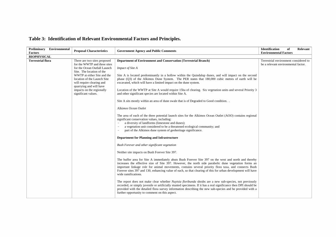
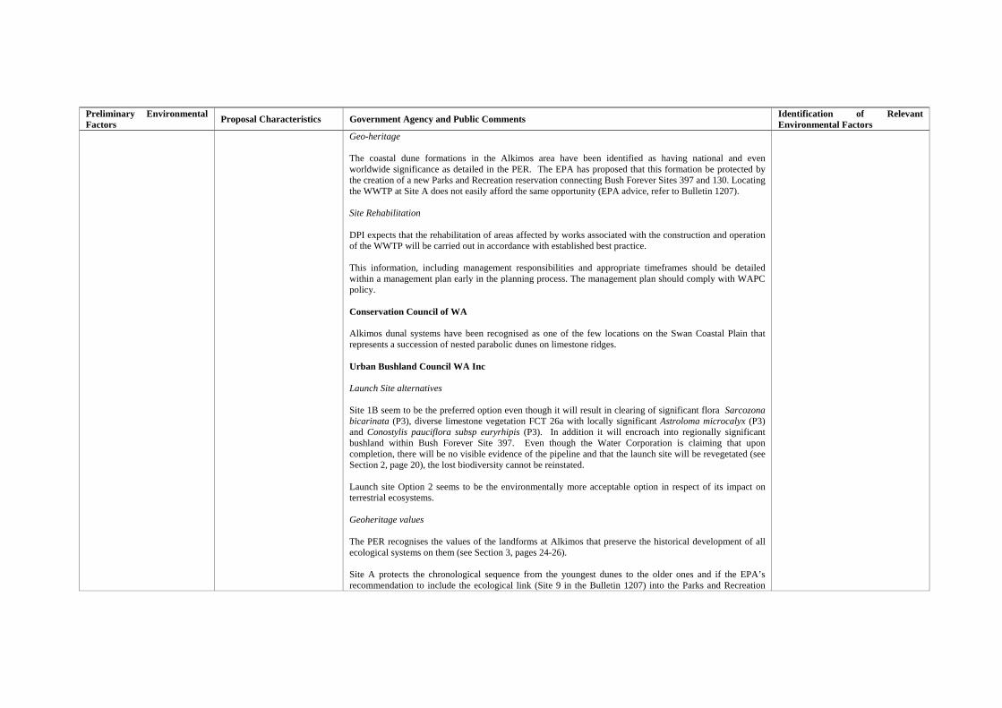
Table 3: Identification of Relevant Environmental Factors and Principles. Preliminary Environmental Factors Proposal Characteristics Government Agency and Public Comments Identification of Relevant
Environmental Factors BIOPHYSICAL Terrestrial flora There are two sites proposed
for the WWTP and three sites for the Ocean Outfall Launch Site. The location of the WWTP at either Site and the location of the Launch Site will require clearing and quarrying and will have impacts on the regionally significant values.
Department of Environment and Conservation (Terrestrial Branch) Impact of Site A Site A is located predominantly in a hollow within the Quindalup dunes, and will impact on the second phase (Q3) of the Alkimos Dune System. The PER states that 180,000 cubic metres of earth will be excavated, which will have a limited impact on the dune system. Location of the WWTP at Site A would require 15ha of clearing. Six vegetation units and several Priority 3 and other significant species are located within Site A. Site A sits mostly within an area of dune swale that is of Degraded to Good condition. . Alkimos Ocean Outlet The area of each of the three potential launch sites for the Alkimos Ocean Outlet (AOO) contains regional significant conservation values, including: - a diversity of landforms (limestone and dunes); - a vegetation unit considered to be a threatened ecological community; and - part of the Alkimos dune system of geoheritage significance. Department for Planning and Infrastructure Bush Forever and other significant vegetation Neither site impacts on Bush Forever Site 397. The buffer area for Site A immediately abuts Bush Forever Site 397 on the west and north and thereby increases the effective size of Site 397. However, the north side parabolic dune vegetation forms an important linkage role for animal movements, contains several priority flora taxa, and connects Bush Forever sites 397 and 130, enhancing value of each, so that clearing of this for urban development will have wide ramifications. The report does not make clear whether Nuytsia floribunda shrubs are a new sub-species, not previously recorded, or simply juvenile or artificially stunted specimens. If it has a real significance then DPI should be provided with the detailed flora survey information describing the new sub-species and be provided with a further opportunity to comment on this aspect.
Terrestrial environment considered to be a relevant environmental factor.
Preliminary Environmental Factors Proposal Characteristics Government Agency and Public Comments Identification of Relevant
Environmental Factors Geo-heritage The coastal dune formations in the Alkimos area have been identified as having national and even worldwide significance as detailed in the PER. The EPA has proposed that this formation be protected by the creation of a new Parks and Recreation reservation connecting Bush Forever Sites 397 and 130. Locating the WWTP at Site A does not easily afford the same opportunity (EPA advice, refer to Bulletin 1207). Site Rehabilitation DPI expects that the rehabilitation of areas affected by works associated with the construction and operation of the WWTP will be carried out in accordance with established best practice. This information, including management responsibilities and appropriate timeframes should be detailed within a management plan early in the planning process. The management plan should comply with WAPC policy. Conservation Council of WA Alkimos dunal systems have been recognised as one of the few locations on the Swan Coastal Plain that represents a succession of nested parabolic dunes on limestone ridges. Urban Bushland Council WA Inc Launch Site alternatives Site 1B seem to be the preferred option even though it will result in clearing of significant flora Sarcozona bicarinata (P3), diverse limestone vegetation FCT 26a with locally significant Astroloma microcalyx (P3) and Conostylis pauciflora subsp euryrhipis (P3). In addition it will encroach into regionally significant bushland within Bush Forever Site 397. Even though the Water Corporation is claiming that upon completion, there will be no visible evidence of the pipeline and that the launch site will be revegetated (see Section 2, page 20), the lost biodiversity cannot be reinstated. Launch site Option 2 seems to be the environmentally more acceptable option in respect of its impact on terrestrial ecosystems. Geoheritage values The PER recognises the values of the landforms at Alkimos that preserve the historical development of all ecological systems on them (see Section 3, pages 24-26). Site A protects the chronological sequence from the youngest dunes to the older ones and if the EPA’s recommendation to include the ecological link (Site 9 in the Bulletin 1207) into the Parks and Recreation

Preliminary Environmental Factors Proposal Characteristics Government Agency and Public Comments Identification of Relevant
Environmental Factors Reservation, this would provide a better environmental outcome. We recommend that inclusion of site 9. Opportunities to protect flora and fauna within the WWTP buffer The PER concludes that the vegetation and flora within the Site A buffer is more important and significant than the vegetation and flora within the Site B buffer. City of Wanneroo The PER appears to include a discrepancy in information on vegetation clearing for both Sites A and B and preferred launch site option 1b, this discrepancy needs to be clarified and/or corrected. Quinns Rocks Environmental Group A sequence of dune landforms and habitats at Alkimos need to be reserved to maximise protection of biodiversity and geoheritage values. Private Citizens The Alkimos area is one of the last large areas of coastal bushland in the Perth region and a significant conservation reserve should be established. Site A provides a greater opportunity for protection of coastal habitats without the threat of housing development and would better protect geoheritage values by retaining four landform units and linking areas identified by the EPA. The Site A buffer has a greater proportion of bushland in good condition and of conservation significance than that for Site B (section 4 page 10). Whichever site is chosen, there should be a linked conservation reserve that covers significant landforms and habitats, extending beyond the EPA’s current proposal to include most of the wastewater treatment plant buffer zone. The proponent should ensure appropriate management of the bushland in the buffer zone to control weeds and feral animals and minimise fire. Why can’t the developer use some of the land for localised treatment plants? There seems to be a sketchy review of the many other sites looked at for siting the plant and no information on what the costs of pumping over distances are as an alternative to coastal siting.
Terrestrial fauna There are two sites proposed Department of Environment and Conservation Terrestrial environment considered to
Preliminary Environmental Factors Proposal Characteristics Government Agency and Public Comments Identification of Relevant
Environmental Factors Terrestrial fauna
for the WWTP. The location of the WWTP at either Site A or B will require clearing and quarrying and will have impacts on the regionally significant values. There are two sites proposed for the WWTP. The location of the WWTP at either Site A or B will require clearing and quarrying and will have impacts on the regionally significant values.
Alkimos Ocean Outlet The area of the three launch sites for the Alkimos Ocean Outlet (AOO) contains regionally significant conservation values, including: - high flora species richness; and - important fauna habitat. Conservation Council of WA The area covered by the Alkimos-Eglinton urban development is covered in substantial tracts of Banksia woodland complex, Dryandra heath land and Tuarts, both mallee form and forest. This complex of rich biodiversity provides extensive feeding and foraging and breeding grounds for many terrestrial birds, reptiles and mammals. I.e. Carnaby’s Cockatoo and Baudin’s Cockatoo. Any ecological connectivity between Yanchep National Park and the coastal heath and dune flora should be retained, in order to preserve these two species of cockatoo. This means that the decision to Site the Alkimos Waste Water Treatment Plant must be made using a triple-bottom line approach to sustainability. Urban Bushland Council WA Inc Fauna assessment is based on one site visit and a desktop assessment instead of a rigorous assessment as recommended in the EPA’s Guidance No. 56 (Environmental Protection Authority, 2004). Multiple fauna surveys would establish a much better picture about the faunal assemblage of the area and so help with planning of a management strategy for their protection. Without the more detailed information on the fauna actually present, comparison is difficult between the sites. The UBC very strongly supports that the whole buffer zone around the future WWTP should be retained for bushland conservation. More detailed information about the fauna present in the area might be helpful in determining the future land use within the buffer, as there might be pressure to allow other ‘compatible uses’ (See Section 6, page 12). Carnaby’s Black Cockatoos The UBC is concerned that decisions are being sought on developments, such as this one and the future urban development at Alkimos-Eglinton that will result in significant loss of habitat for Carnaby’s Black Cockatoos. The UBC strongly recommends a substantial increase of the conservation estate as originally proposed in the 1977 North-West Corridor Structure Plan (see Section 3, Figure 3.10 on page 28). No further decisions should be made on development proposals until adequate assessment of the continuous loss of feeding and potential breeding habitat of the Carnaby’s Black Cockatoos is done in the Perth Metropolitan Region.
be a relevant environmental factor.
Preliminary Environmental Factors Proposal Characteristics Government Agency and Public Comments Identification of Relevant
Environmental Factors Private Citizens Urban development around Perth is removing feeding grounds for the threatened Carnaby’s Black Cockatoo. A strategy is needed to maintain and manage feeding grounds for the long-term survival of the species.
Sustainability The Water Corporation seeks to maximise the benefit as far as practicable in all Objects and Principles of the Act.
No specific concerns were raised in the submissions that were received. Relevant factor but no significant impact anticipated. This environmental factor does not require further evaluation by the EPA
Groundwater The process of short-term disposal of secondary treated wastewater via infiltration ponds in an environmentally acceptable manner has been considered by the Water Corporation. .
Department of Environment and Conservation Concerns that the proponent’s assertion that similarity between Bunbury and Gordon Rd WWTPs and Alkimos provides confidence in predictions of impacts at Alkimos. The PER suggests that combinations of a number of scenarios were modelled. One scenario was “Treated wastewater quality between 6 mg/L and 10 mg/L with and without denitrification occurring in the aquifer”. Specification of parameters, the quoted concentration ranges and technical justifications for selecting the ranges used, is not satisfactory. On page 14 of 60 the proponent concludes: “The Water Corporation has rejected infiltration as an interim option for disposal of treated wastewater due to the uncertainty surrounding the: - fate and transport of nutrients to near shore; - probability of exceedance of the high E2 level and protection at the beach”. No information is provided in the PER to describe the risk assessment process applied by the proponent to arrive at the second point above. Private Citizens More thought on the reuse of treated water should be considered. Public parks and gardens irrigation and re-filtering through natural sand and limestone into the water table. Pumping into the aquifer. Encourage industry to use the treated water. It would be a missed opportunity of great matter to install a new system without recycling options. Genuine consideration of alternative wastewater technologies (e.g. household reuse) and alternatives to the Alkimos sites were excluded. These should have been part of the community consultation process. Thirty years is too long to wait for significant reuse of water from the Alkimos plant (PER section 1 page 15). Embracing alternative wastewater technologies, such as household re-use and the use of successful models
Relevant factor but no significant impact anticipated. This environmental factor does not require further evaluation by the EPA
Preliminary Environmental Factors Proposal Characteristics Government Agency and Public Comments Identification of Relevant
Environmental Factors set up around the world, need to be implemented to solve the problem of short water supplies.
Subterranean fauna Stygofauna should not be affected by the AWWTP, as there will be no infiltration of water to affect the groundwater.
No specific concerns were raised in the submissions that were received. Relevant factor but no significant impact anticipated. This environmental factor does not require further evaluation by the EPA
Coastal Processes Oceanographic processes and shoreline stability should not be significantly impacted by the construction and operation of the Alkimos ocean outlet.
Department of Environment and Conservation There is little information provided in this section of the PER (and no cross-references to other relevant sections are provided) regarding the proposed location, placement and construction of the proposed pipeline on which to base informed comment on the potential for impacts on coastal processes due to construction or presence of a pipeline across the beach and nearshore. It is noted that the Atteris report (Appendix C) suggests that there is sometimes a need for special construction methods to “limit the construction footprint and protect the shoreline from erosion during construction”. This is not reflected nor discussed further in the PER document. On page 18 of 20 in Section 2.4.2, the PER suggests that a temporary groyne or jetty would be built across the beach offshore to the 3-4m depth contour. The potential for environmental impacts associated with this proposed structure are not identified or discussed in the PER. Further information is required detailing construction, location of infrastructure (temporary and permanent) and longer-term management of the proposed pipeline in order to allow informed advice to be provided on the potential impacts of the proposal on coastal processes. Private Citizens Proposed launch site 1B would have less impact on coastal habitat.
Marine environment considered to be a relevant environmental factor.
Preliminary Environmental Factors Proposal Characteristics Government Agency and Public Comments Identification of Relevant
Environmental Factors Benthic Habitats Direct loss/damage of Benthic
Primary Producers’ Habitats (BPPH) is expected from proposed pipeline construction and operation.
Department of Environment and Conservation There are several examples in the PER in which the EPA’s Guidance Statement (GS) No.29 has been misapplied. The GS No.29 explicitly states that the “EPA expects a hierarchy of principles to be addressed by all proponents and the EPA will apply these to its consideration of proposals that could cause damage/loss of BPPH”. The proponent must set out how the EPA’s principles of assessment (see Section 5.2 of GS No.29) have been applied before the cumulative loss of BPPH can be considered further. For a proposal of this type, it would normally be expected that proponents determine the extent and distribution of benthic habitats in the entire defined management unit. Where assumptions are made, it is expected that substantial technical information is provided to support those assumptions. Technical information is not supplied in the PER to substantiate assumptions relating to BPPH distribution. When applying GS No.29, proponents should determine the cumulative loss of each of the different BPPHs within the management unit. The proponent should clarify whether the predicted loss of, and/or serious damage to, BPPHs present in the PER accounts for the pipeline trench footprint only, or whether peripheral impacts associated with sidecasting of dredged material and turbidity/sedimentation effects have also been taken into account. The proponent should ensure that all direct and indirect loss/serious damage are included in the calculations made to determine cumulative loss.
Marine environment considered to be a relevant environmental factor.
Sediment The exposed physical oceanographic setting of the Alkimos ocean outlet, together with the coarse, calcareous sediment characteristics of the area, are likely to aid in the dispersal and further mitigation of any potential sediment impacts from the Alkimos ocean outlet.
No specific concerns were raised in the submissions that were received. Marine environment considered to be a relevant environmental factor.
Water Quality (Marine)
The Water Corporation is proposing a 3.7km ocean outlet pipe with a diffuser.
Department of Environment and Conservation Consideration and evaluation of alternatives to ocean discharge Insufficient information is provided to assess the extent the proponent has gone towards considering alternatives to an ocean outlet for the discharge of the treated wastewater. Proponents seeking approval for ocean discharge should be using best practice technologies, and exploring and considering all viable alternatives to discharge of freshwater to the ocean.
Marine environment considered to be a relevant environmental factor.
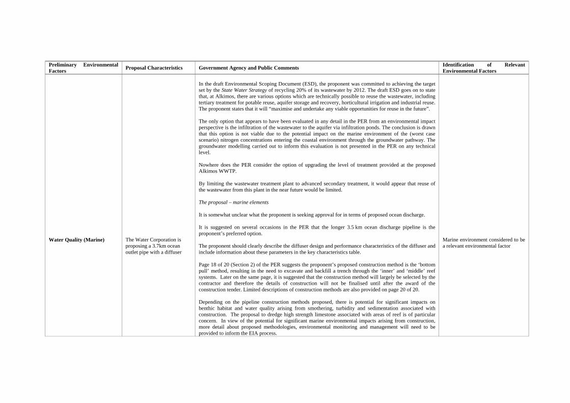
Preliminary Environmental Factors Proposal Characteristics Government Agency and Public Comments Identification of Relevant
Environmental Factors Water Quality (Marine)
The Water Corporation is proposing a 3.7km ocean outlet pipe with a diffuser
In the draft Environmental Scoping Document (ESD), the proponent was committed to achieving the target set by the State Water Strategy of recycling 20% of its wastewater by 2012. The draft ESD goes on to state that, at Alkimos, there are various options which are technically possible to reuse the wastewater, including tertiary treatment for potable reuse, aquifer storage and recovery, horticultural irrigation and industrial reuse. The proponent states that it will “maximise and undertake any viable opportunities for reuse in the future”. The only option that appears to have been evaluated in any detail in the PER from an environmental impact perspective is the infiltration of the wastewater to the aquifer via infiltration ponds. The conclusion is drawn that this option is not viable due to the potential impact on the marine environment of the (worst case scenario) nitrogen concentrations entering the coastal environment through the groundwater pathway. The groundwater modelling carried out to inform this evaluation is not presented in the PER on any technical level. Nowhere does the PER consider the option of upgrading the level of treatment provided at the proposed Alkimos WWTP. By limiting the wastewater treatment plant to advanced secondary treatment, it would appear that reuse of the wastewater from this plant in the near future would be limited. The proposal – marine elements It is somewhat unclear what the proponent is seeking approval for in terms of proposed ocean discharge. It is suggested on several occasions in the PER that the longer 3.5 km ocean discharge pipeline is the proponent’s preferred option. The proponent should clearly describe the diffuser design and performance characteristics of the diffuser and include information about these parameters in the key characteristics table. Page 18 of 20 (Section 2) of the PER suggests the proponent’s proposed construction method is the ‘bottom pull’ method, resulting in the need to excavate and backfill a trench through the ‘inner’ and ‘middle’ reef systems. Later on the same page, it is suggested that the construction method will largely be selected by the contractor and therefore the details of construction will not be finalised until after the award of the construction tender. Limited descriptions of construction methods are also provided on page 20 of 20. Depending on the pipeline construction methods proposed, there is potential for significant impacts on benthic habitat and water quality arising from smothering, turbidity and sedimentation associated with construction. The proposal to dredge high strength limestone associated with areas of reef is of particular concern. In view of the potential for significant marine environmental impacts arising from construction, more detail about proposed methodologies, environmental monitoring and management will need to be provided to inform the EIA process.
Marine environment considered to be a relevant environmental factor
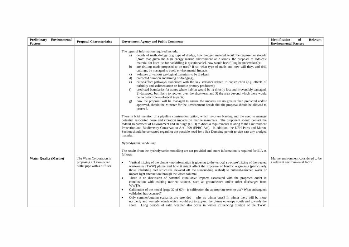
Preliminary Environmental Factors Proposal Characteristics Government Agency and Public Comments Identification of Relevant
Environmental Factors Water Quality (Marine)
The Water Corporation is proposing a 3.7km ocean outlet pipe with a diffuser.
The types of information required include:
a) details of methodology (e.g. type of dredge, how dredged material would be disposed or stored? [Note that given the high energy marine environment at Alkimos, the proposal to side-cast material for later use for backfilling is questionable], how would backfilling be undertaken?);
b) are drilling muds proposed to be used? If so, what type of muds and how will they, and drill cuttings, be managed to avoid environmental impacts.
c) volumes of various geological materials to be dredged; d) predicted duration and timing of dredging; e) cause-effect pathways associated with the key stressors related to construction (e.g. effects of
turbidity and sedimentation on benthic primary producers); f) predicted boundaries for zones where habitat would be 1) directly lost and irreversibly damaged,
2) damaged, but likely to recover over the short-term and 3) the area beyond which there would be no detectible ecological impacts;
g) how the proposal will be managed to ensure the impacts are no greater than predicted and/or approved, should the Minister for the Environment decide that the proposal should be allowed to proceed.
There is brief mention of a pipeline construction option, which involves blasting and the need to manage potential associated noise and vibration impacts on marine mammals. The proponent should contact the federal Department of Environment and Heritage (DEH) to discuss requirements relating to the Environment Protection and Biodiversity Conservation Act 1999 (EPBC Act). In addition, the DEH Ports and Marine Section should be contacted regarding the possible need for a Sea Dumping permit to side-cast any dredged material. Hydrodynamic modelling The results from the hydrodynamic modelling are not provided and more information is required for EIA as follows: • Vertical mixing of the plume – no information is given as to the vertical structure/mixing of the treated
wastewater (TWW) plume and how it might affect the exposure of benthic organisms (particularly those inhabiting reef structures elevated off the surrounding seabed) to nutrient-enriched water or impact light attenuation through the water column?
• There is no discussion of potential cumulative impacts associated with the proposed outlet in combination with existing nutrient sources, such as groundwater and/or other discharges from WWTPs.
• Calibration of the model (page 32 of 60) – is calibration the appropriate term to use? What subsequent validation has occurred?
• Only summer/autumn scenarios are provided – why no winter ones? In winter there will be more northerly and westerly winds which would act to expand the plume envelope south and towards the shore. Long periods of calm weather also occur in winter influencing dilution of the TWW.
Marine environment considered to be a relevant environmental factor
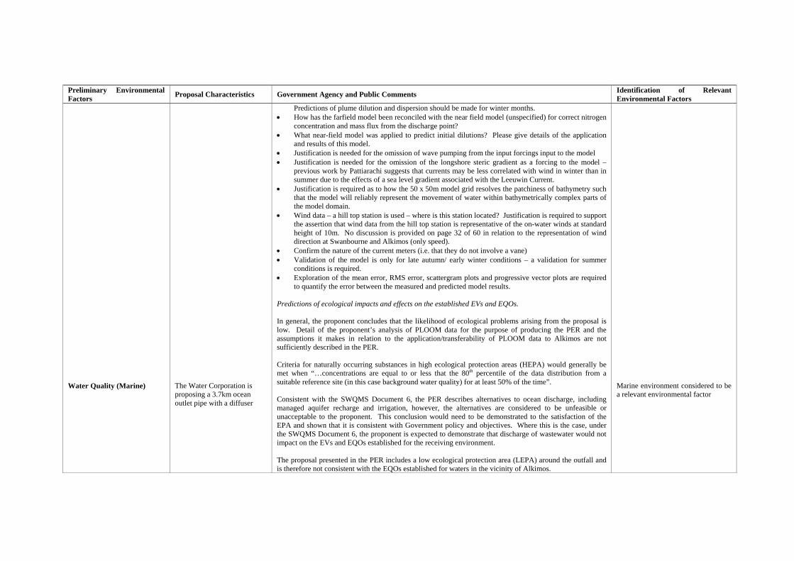
Preliminary Environmental Factors Proposal Characteristics Government Agency and Public Comments Identification of Relevant
Environmental Factors Water Quality (Marine)
The Water Corporation is proposing a 3.7km ocean outlet pipe with a diffuser
Predictions of plume dilution and dispersion should be made for winter months. • How has the farfield model been reconciled with the near field model (unspecified) for correct nitrogen
concentration and mass flux from the discharge point? • What near-field model was applied to predict initial dilutions? Please give details of the application
and results of this model. • Justification is needed for the omission of wave pumping from the input forcings input to the model • Justification is needed for the omission of the longshore steric gradient as a forcing to the model –
previous work by Pattiarachi suggests that currents may be less correlated with wind in winter than in summer due to the effects of a sea level gradient associated with the Leeuwin Current.
• Justification is required as to how the 50 x 50m model grid resolves the patchiness of bathymetry such that the model will reliably represent the movement of water within bathymetrically complex parts of the model domain.
• Wind data – a hill top station is used – where is this station located? Justification is required to support the assertion that wind data from the hill top station is representative of the on-water winds at standard height of 10m. No discussion is provided on page 32 of 60 in relation to the representation of wind direction at Swanbourne and Alkimos (only speed).
• Confirm the nature of the current meters (i.e. that they do not involve a vane) • Validation of the model is only for late autumn/ early winter conditions – a validation for summer
conditions is required. • Exploration of the mean error, RMS error, scattergram plots and progressive vector plots are required
to quantify the error between the measured and predicted model results. Predictions of ecological impacts and effects on the established EVs and EQOs. In general, the proponent concludes that the likelihood of ecological problems arising from the proposal is low. Detail of the proponent’s analysis of PLOOM data for the purpose of producing the PER and the assumptions it makes in relation to the application/transferability of PLOOM data to Alkimos are not sufficiently described in the PER. Criteria for naturally occurring substances in high ecological protection areas (HEPA) would generally be met when “…concentrations are equal to or less that the 80th percentile of the data distribution from a suitable reference site (in this case background water quality) for at least 50% of the time”. Consistent with the SWQMS Document 6, the PER describes alternatives to ocean discharge, including managed aquifer recharge and irrigation, however, the alternatives are considered to be unfeasible or unacceptable to the proponent. This conclusion would need to be demonstrated to the satisfaction of the EPA and shown that it is consistent with Government policy and objectives. Where this is the case, under the SWQMS Document 6, the proponent is expected to demonstrate that discharge of wastewater would not impact on the EVs and EQOs established for the receiving environment. The proposal presented in the PER includes a low ecological protection area (LEPA) around the outfall and is therefore not consistent with the EQOs established for waters in the vicinity of Alkimos.
Marine environment considered to be a relevant environmental factor
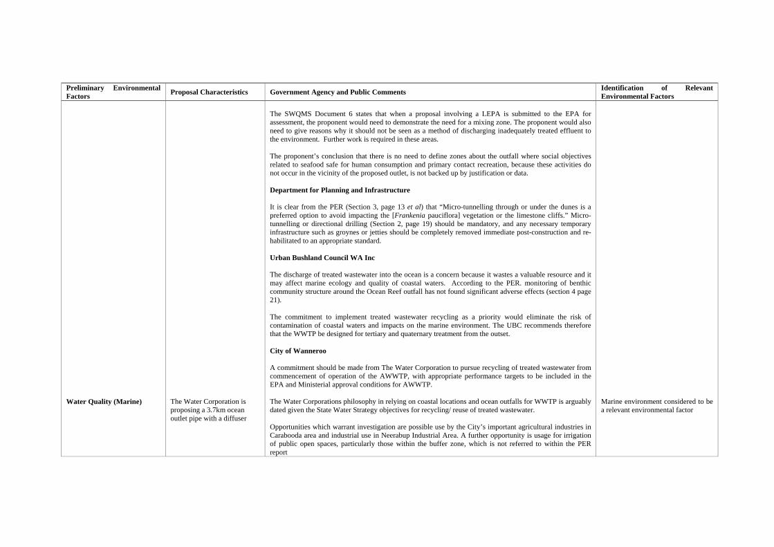
Preliminary Environmental Factors Proposal Characteristics Government Agency and Public Comments Identification of Relevant
Environmental Factors Water Quality (Marine)
The Water Corporation is proposing a 3.7km ocean outlet pipe with a diffuser
The SWQMS Document 6 states that when a proposal involving a LEPA is submitted to the EPA for assessment, the proponent would need to demonstrate the need for a mixing zone. The proponent would also need to give reasons why it should not be seen as a method of discharging inadequately treated effluent to the environment. Further work is required in these areas. The proponent’s conclusion that there is no need to define zones about the outfall where social objectives related to seafood safe for human consumption and primary contact recreation, because these activities do not occur in the vicinity of the proposed outlet, is not backed up by justification or data. Department for Planning and Infrastructure It is clear from the PER (Section 3, page 13 et al) that “Micro-tunnelling through or under the dunes is a preferred option to avoid impacting the [Frankenia pauciflora] vegetation or the limestone cliffs.” Micro-tunnelling or directional drilling (Section 2, page 19) should be mandatory, and any necessary temporary infrastructure such as groynes or jetties should be completely removed immediate post-construction and re-habilitated to an appropriate standard. Urban Bushland Council WA Inc The discharge of treated wastewater into the ocean is a concern because it wastes a valuable resource and it may affect marine ecology and quality of coastal waters. According to the PER. monitoring of benthic community structure around the Ocean Reef outfall has not found significant adverse effects (section 4 page 21). The commitment to implement treated wastewater recycling as a priority would eliminate the risk of contamination of coastal waters and impacts on the marine environment. The UBC recommends therefore that the WWTP be designed for tertiary and quaternary treatment from the outset. City of Wanneroo A commitment should be made from The Water Corporation to pursue recycling of treated wastewater from commencement of operation of the AWWTP, with appropriate performance targets to be included in the EPA and Ministerial approval conditions for AWWTP. The Water Corporations philosophy in relying on coastal locations and ocean outfalls for WWTP is arguably dated given the State Water Strategy objectives for recycling/ reuse of treated wastewater. Opportunities which warrant investigation are possible use by the City’s important agricultural industries in Carabooda area and industrial use in Neerabup Industrial Area. A further opportunity is usage for irrigation of public open spaces, particularly those within the buffer zone, which is not referred to within the PER report
Marine environment considered to be a relevant environmental factor
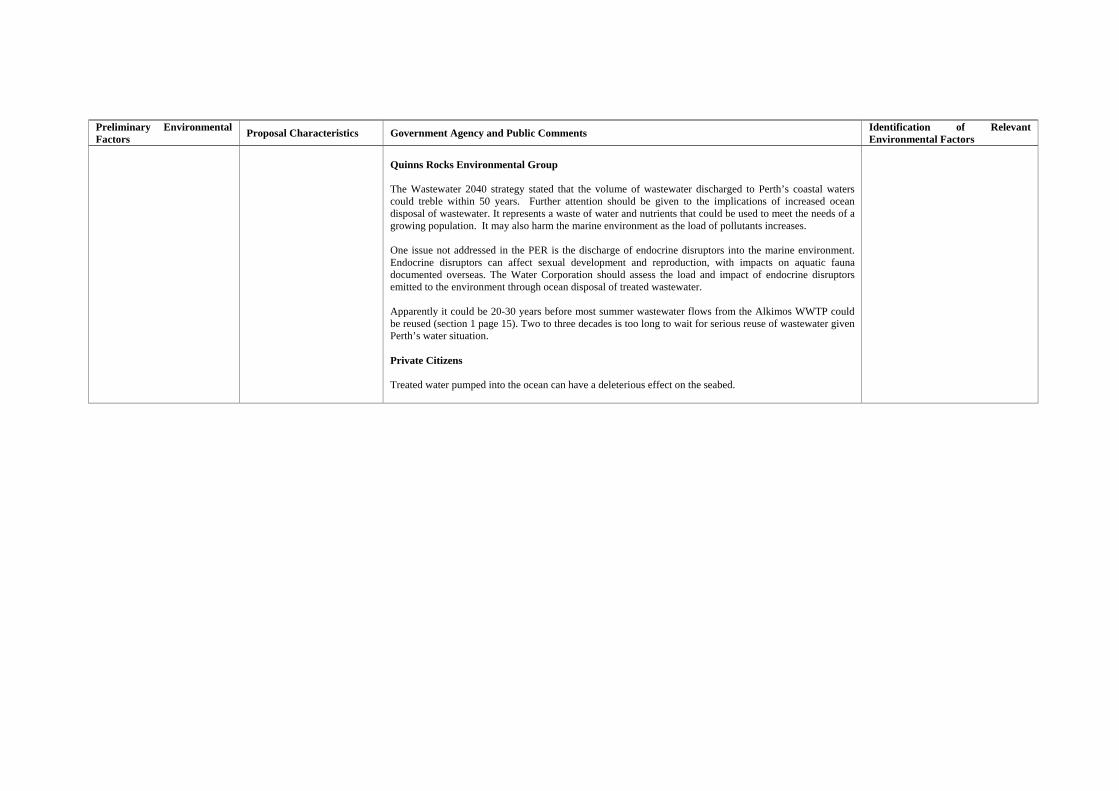
Preliminary Environmental Factors Proposal Characteristics Government Agency and Public Comments Identification of Relevant
Environmental Factors
Quinns Rocks Environmental Group The Wastewater 2040 strategy stated that the volume of wastewater discharged to Perth’s coastal waters could treble within 50 years. Further attention should be given to the implications of increased ocean disposal of wastewater. It represents a waste of water and nutrients that could be used to meet the needs of a growing population. It may also harm the marine environment as the load of pollutants increases. One issue not addressed in the PER is the discharge of endocrine disruptors into the marine environment. Endocrine disruptors can affect sexual development and reproduction, with impacts on aquatic fauna documented overseas. The Water Corporation should assess the load and impact of endocrine disruptors emitted to the environment through ocean disposal of treated wastewater. Apparently it could be 20-30 years before most summer wastewater flows from the Alkimos WWTP could be reused (section 1 page 15). Two to three decades is too long to wait for serious reuse of wastewater given Perth’s water situation. Private Citizens Treated water pumped into the ocean can have a deleterious effect on the seabed.
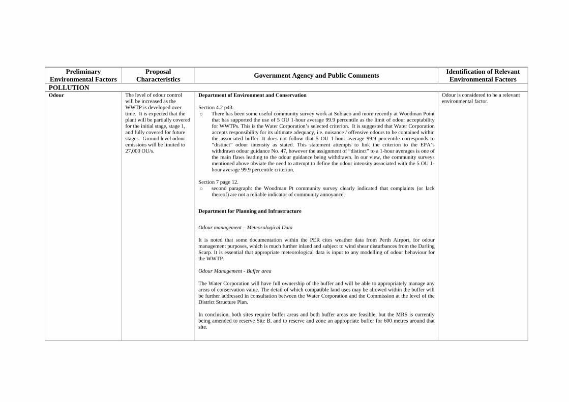
Preliminary
Environmental Factors Proposal
Characteristics Government Agency and Public Comments Identification of Relevant Environmental Factors
POLLUTION Odour
The level of odour control will be increased as the WWTP is developed over time. It is expected that the plant will be partially covered for the initial stage, stage 1, and fully covered for future stages. Ground level odour emissions will be limited to 27,000 OU/s.
Department of Environment and Conservation Section 4.2 p43. o There has been some useful community survey work at Subiaco and more recently at Woodman Point
that has supported the use of 5 OU 1-hour average 99.9 percentile as the limit of odour acceptability for WWTPs. This is the Water Corporation’s selected criterion. It is suggested that Water Corporation accepts responsibility for its ultimate adequacy, i.e. nuisance / offensive odours to be contained within the associated buffer. It does not follow that 5 OU 1-hour average 99.9 percentile corresponds to “distinct” odour intensity as stated. This statement attempts to link the criterion to the EPA’s withdrawn odour guidance No. 47, however the assignment of “distinct” to a 1-hour averages is one of the main flaws leading to the odour guidance being withdrawn. In our view, the community surveys mentioned above obviate the need to attempt to define the odour intensity associated with the 5 OU 1-hour average 99.9 percentile criterion.
Section 7 page 12. o second paragraph: the Woodman Pt community survey clearly indicated that complaints (or lack
thereof) are not a reliable indicator of community annoyance.
Department for Planning and Infrastructure
Odour management – Meteorological Data It is noted that some documentation within the PER cites weather data from Perth Airport, for odour management purposes, which is much further inland and subject to wind shear disturbances from the Darling Scarp. It is essential that appropriate meteorological data is input to any modelling of odour behaviour for the WWTP. Odour Management - Buffer area The Water Corporation will have full ownership of the buffer and will be able to appropriately manage any areas of conservation value. The detail of which compatible land uses may be allowed within the buffer will be further addressed in consultation between the Water Corporation and the Commission at the level of the District Structure Plan. In conclusion, both sites require buffer areas and both buffer areas are feasible, but the MRS is currently being amended to reserve Site B, and to reserve and zone an appropriate buffer for 600 metres around that site.
Odour is considered to be a relevant environmental factor.
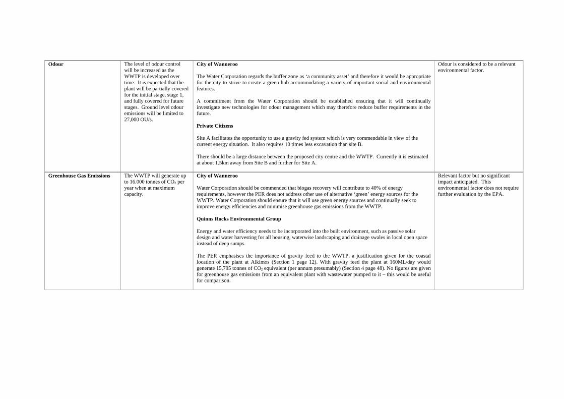
Odour
The level of odour control will be increased as the WWTP is developed over time. It is expected that the plant will be partially covered for the initial stage, stage 1, and fully covered for future stages. Ground level odour emissions will be limited to 27,000 OU/s.
City of Wanneroo The Water Corporation regards the buffer zone as ‘a community asset’ and therefore it would be appropriate for the city to strive to create a green hub accommodating a variety of important social and environmental features. A commitment from the Water Corporation should be established ensuring that it will continually investigate new technologies for odour management which may therefore reduce buffer requirements in the future. Private Citizens Site A facilitates the opportunity to use a gravity fed system which is very commendable in view of the current energy situation. It also requires 10 times less excavation than site B. There should be a large distance between the proposed city centre and the WWTP. Currently it is estimated at about 1.5km away from Site B and further for Site A.
Odour is considered to be a relevant environmental factor.
Greenhouse Gas Emissions The WWTP will generate up to 16.000 tonnes of CO2 per year when at maximum capacity.
City of Wanneroo Water Corporation should be commended that biogas recovery will contribute to 40% of energy requirements, however the PER does not address other use of alternative ‘green’ energy sources for the WWTP. Water Corporation should ensure that it will use green energy sources and continually seek to improve energy efficiencies and minimise greenhouse gas emissions from the WWTP. Quinns Rocks Environmental Group Energy and water efficiency needs to be incorporated into the built environment, such as passive solar design and water harvesting for all housing, waterwise landscaping and drainage swales in local open space instead of deep sumps. The PER emphasises the importance of gravity feed to the WWTP, a justification given for the coastal location of the plant at Alkimos (Section 1 page 12). With gravity feed the plant at 160ML/day would generate 15,795 tonnes of CO2 equivalent (per annum presumably) (Section 4 page 48). No figures are given for greenhouse gas emissions from an equivalent plant with wastewater pumped to it – this would be useful for comparison.
Relevant factor but no significant impact anticipated. This environmental factor does not require further evaluation by the EPA.
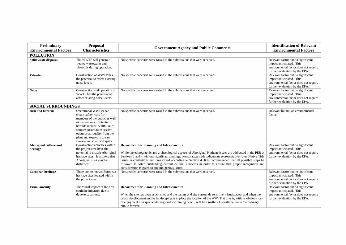
Preliminary
Environmental Factors Proposal
Characteristics Government Agency and Public Comments Identification of Relevant Environmental Factors
POLLUTION Solid waste disposal The WWTP will generate
treated wastewater and biosolids during operation.
No specific concerns were raised in the submissions that were received. Relevant factor but no significant impact anticipated. This environmental factor does not require further evaluation by the EPA.
Vibration Construction of WWTP has the potential to affect existing noise levels.
No specific concerns were raised in the submissions that were received. Relevant factor but no significant impact anticipated. This environmental factor does not require further evaluation by the EPA.
Noise Construction and operation of WWTP has the potential to affect existing noise levels.
No specific concerns were raised in the submissions that were received. Relevant factor but no significant impact anticipated. This environmental factor does not require further evaluation by the EPA.
SOCIAL SURROUNDINGS Risk and hazards Operational WWTPs can
create safety risks for members of the public as well as the workers. Potential hazards include health issues from exposure to excessive odour or air quality from the plant and exposure to raw sewage and chemical spills.
No specific concerns were raised in the submissions that were received. Relevant but not an environmental factor.
Aboriginal culture and heritage
Construction activities within the project area have the potential to disturb Aboriginal heritage sites. It is likely that Aboriginal sites may be disturbed.
Department for Planning and Infrastructure While the ethnographic and archaeological aspects of Aboriginal Heritage issues are addressed in the PER at Sections 3 and 4 without significant findings, consultation with indigenous representatives over Native Title issues is contentious and unresolved according to Section 4. It is recommended that all possible steps be followed to solve outstanding current cultural concerns in order to ensure that proper recognition and consideration is given to any indigenous issues.
Relevant factor but no significant impact anticipated. This environmental factor does not require further evaluation by the EPA.
European heritage There are no known European heritage sites located within the project area.
No specific concerns were raised in the submissions that were received. Relevant factor but no significant impact anticipated. This environmental factor does not require further evaluation by the EPA.
Visual amenity The visual impact of the area could be impacted due to dune excavations.
Department for Planning and Infrastructure When the site has been established and the batters and site surrounds sensitively landscaped, and when the urban development and its landscaping is in place the location of the WWTP at Site A, with its obvious loss of enjoyment of a spectacular regional swimming beach, will be a matter of consternation to the ordinary public forever.
Relevant factor but no significant impact anticipated. This environmental factor does not require further evaluation by the EPA.
Recreational activities
The WWTP could potentially have an impact on recreational activities in the general area.
Department for Planning and Infrastructure Site A enables development of the beach front at a reduced scale from that envisaged under Site B, in particular food premises and a lifesaving club will be incompatible uses and therefore, with Site A, the beach will be unsafe for swimming and could not support the bus service discussed above. The Alkimos beach is unmatched for many kilometres north and south, and it has the attributes to meet the beach-going needs of the future community, thereby creating considerable opportunity for sustainable transit oriented development. This opportunity may only be realised by siting the WWTP at ‘B’ and developing a beachside village at the southern (protected) end of the beach, whereas siting the WWTP at ‘A’ will promote a coastal foreshore with few, if any, services or amenities. The recreational benefits of developing a coastal village with appropriate facilities are considered to be beneficial to the general public. There are identified transport sustainability benefits although the social benefits are also important. Not only do these include the provision of an attractive space to socialise, but also the community building activities of a surf club, encouragement of physical activity and the sense of place. Conservation Council of WA From the Proponent’s own scoping document and sustainability assessment it would appear that Site A is much more sustainable when examining the social, economic and environmental benefits of locating the WWTP at either site. Site B offers substantially less conservation opportunities for habitat protection than Site A, something vital when considering threatened species known to reside and migrate to the area. Urban Bushland Council WA Inc The PER discusses other ‘compatible’ uses that the UBC does not support. Indeed the suggested uses for golf courses, waste transfer stations etc are totally incompatible with conservation and should be rejected explicitly. This does not mean that the area should be closed off or that there will not be access to the beach. There could still be opportunity to use the buffer for limited passive recreation. City of Wanneroo Recent Water Corporation brochure material on the potential development of the buffer zone is of concern. The extent and type of facilities being promoted has not been tested and it is doubtful that they could be accommodated on the land. Many are or national and international standards and the cost of provision would be enormous. The brochure material is somewhat misleading and may well cause community expectations of the level and extent of facility being raised unnecessarily. If the land is to be used for recreational purposes, the land must be ceded to the Crown or City and the issue of who meets the cost of facility provision and ongoing maintenance must be determined. Any development of the buffer must be linked to discussions relating to the Regional and District level recreation facility
Relevant factor but no significant impact anticipated. This environmental factor does not require further evaluation by the EPA.
Recreational activities
The WWTP could potentially have an impact on recreational activities in the general area.
provision for the area. If it is determined that regional level facilities are appropriate in the buffer, then responsibility for this should rest with the State. Quinns Rocks Environmental Group The link between Neerabup and Yanchep National Parks along Wanneroo Road needs to be protected –includes privately held land previously proposed for regional open space but vulnerable to intensive land use on the absence of planning controls. If extensive urban development is to proceed, then it is urged that the corporation works with the natural topography rather than removing it, to retain some sense of place, requiring a site-responsive approach to neighbourhood and building design. If extensive urban development is to proceed, there is a need to promote access by walking, bicycle and public transport by focusing the city centre around the train station, providing a comprehensive and safe pathway network and using grid-based local street layout. If extensive urban development is to proceed, a wide habitat corridor from the coast at Eglinton through to Yanchep National Park (Ningana wedge) will need to be retained, with infrastructure and transport routes through the corridor minimised and the interface with proposed development carefully planned. If extensive urban development is to proceed, then there is a need to encourage local employment including provision for home based businesses and affordable space for small businesses, especially new starters – to minimise travel demand and enhance community. Private Citizens There is no need for the plant to be placed on the coast; it would be more beneficial to place it further inland to be more accessible to a greater range of users. On looking at the two sites suggested, Site A appears to provide a greater opportunity for protection of coastal habitats and would better protect geoheritage values by retaining four landform units and linking areas identified by the EPA. The report states that Site A buffer has a greater proportion of bushland in good condition and of conservation significance than that for Site B. The Water Corp has advised they will own the land including the buffer. It concerns me that other areas they own are not managed except to keep people out and installing an annual firebreak. It would need to be ensured that they actually manage the area properly for long term conservation. At the presentation there was a variety of suggested land uses for the buffer. Even a golf course was discussed. That seems very incompatible with conservation and no guarantee that the land uses will be restricted.
Relevant factor but no significant impact anticipated. This environmental factor does not require further evaluation by the EPA.
PRINCIPLES
Principle RelevantYes/No
If yes, Consideration
1. The precautionary principle Where there are threats of serious or irreversible damage, lack of full scientific certainty should not be used as a reason for postponing measures to prevent environmental degradation. In application of this precautionary principle, decisions should be guided by – (a) careful evaluation to avoid, where practicable, serious or irreversible damage to the environment; and (b) an assessment of the risk-weighted consequences of various options.
YES
The Water Corporation will, as far as practicable, minimise the ecological footprint of its development, and offer to the conservation estate areas identified as of high ecological value within its buffer zone to augment/complement those identified in the MRS amendment. The Water Corporation will establish, maintain and manage a buffer around the AWWTP.
2. The principle of intergenerational equity The present generation should ensure that the health, diversity and productivity of the environment is maintained and enhanced for the benefit of future generations.
YES
The Water Corporation will: • Reduce long term energy consumption through gravity conveyance and TWW disposal to the ocean; • Reclaim and reuse wastewater as far as practicable; and • Build the wastewater system to achieve the lowest whole of life cost by reducing dependence on energy consumption and make provision for the
recovery of energy from the treatment process. 3. The principle of the conservation of biological diversity and ecological integrity
Conservation of biological diversity and ecological integrity should be a fundamental consideration.
YES
The Water Corporation will, as far as practicable, minimise the ecological footprint of its development, and offer to the conservation estate areas identified as of high ecological value within its buffer zone to augment/complement those identified in the MRS amendment.
4. Principles relating to improved valuation, pricing and incentive mechanisms (a) Environmental factors should be included in the valuation of assets and services. (b) The polluter pays principles – those who generate pollution and waste should bear the cost of containment, avoidance and abatement. (c) The users of goods and services should pay prices based on the full life-cycle costs of providing goods and services, including the use of natural resources and assets and the ultimate disposal of any waste. (d) Environmental goals, having been established, should be pursued in the most cost effective way, by establishing incentive structure, including market mechanisms, which enable those best placed to
maximize benefits and/or minimize costs to develop their own solution and responses to environmental problems.
YES
The balance between environmental values and development of the Alkimos region will be determined by the MRS Amendment 1029/33. The Water Corporation:
• Has undertaken a whole of life economic assessment of the AWWTP as part of its Capital Investment Program; • Routinely funds the installation of new, pollution prevention technologies for WWTP systems, and clean-up and repair of incidents as they occur; • Applies the tariffs for provision of wastewater treatment services as set by Government; and • Will locate, design and install the wastewater treatment and conveyance system according to best industry standards.
5. The principle of waste minimisation All reasonable and practicable measures should be taken to minimize the generation of waste and its discharge into the environment.
YES
The Water Corporation will: • Undertake several pilot projects (e.g. Managed Aquifer Recharge) to assess the viability of re-use opportunities and implement them as soon as the
technical, environmental, public health, political and societal acceptability is established; • Manage and monitor the reuse of Bio-solids in accordance with the Western Australian Guidelines for Direct Land Application of Biosolids and Bio-
solids Products as required by Part V Environmental Licences; and • Reclaim biogas for electricity generation as the scale of the plant increases.

Appendix 4
Recommended Environmental Conditions
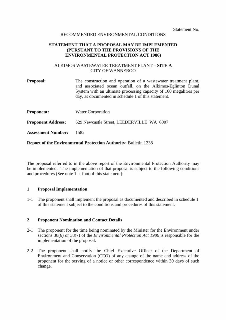
Statement No. RECOMMENDED ENVIRONMENTAL CONDITIONS
STATEMENT THAT A PROPOSAL MAY BE IMPLEMENTED
(PURSUANT TO THE PROVISIONS OF THE ENVIRONMENTAL PROTECTION ACT 1986)
ALKIMOS WASTEWATER TREATMENT PLANT – SITE A
CITY OF WANNEROO
Proposal: The construction and operation of a wastewater treatment plant, and associated ocean outfall, on the Alkimos-Eglinton Dunal System with an ultimate processing capacity of 160 megalitres per day, as documented in schedule 1 of this statement.
Proponent: Water Corporation Proponent Address: 629 Newcastle Street, LEEDERVILLE WA 6007 Assessment Number: 1582 Report of the Environmental Protection Authority: Bulletin 1238 The proposal referred to in the above report of the Environmental Protection Authority may be implemented. The implementation of that proposal is subject to the following conditions and procedures (See note 1 at foot of this statement): 1 Proposal Implementation 1-1 The proponent shall implement the proposal as documented and described in schedule 1
of this statement subject to the conditions and procedures of this statement. 2 Proponent Nomination and Contact Details 2-1 The proponent for the time being nominated by the Minister for the Environment under
sections 38(6) or 38(7) of the Environmental Protection Act 1986 is responsible for the implementation of the proposal.
2-2 The proponent shall notify the Chief Executive Officer of the Department of
Environment and Conservation (CEO) of any change of the name and address of the proponent for the serving of a notice or other correspondence within 30 days of such change.
3 Time Limit of Authorisation 3-1 The authorisation to implement the proposal provided for in this statement shall lapse
and be void within five years after the date of this statement if the proposal to which this statement relates is not substantially commenced.
3-2 The proponent shall provide the CEO with written evidence which demonstrates that
the proposal has substantially commenced on or before the expiration of five years from the date of this statement.
4 Compliance Reporting 4-1 The proponent shall submit to the CEO environmental compliance reports annually
reporting on the previous twelve-month period, unless required by the CEO to report more frequently.
4-2 The environmental compliance reports shall address each element of an audit program
approved by the CEO and shall be prepared and submitted in a format acceptable to the CEO.
4-3 The environmental compliance reports shall:
1. be endorsed by signature of the proponent's Chief Executive Officer or a person, approved in writing by the CEO, delegated to sign on behalf of the proponent's Chief Executive Officer;
2. state whether the proponent has complied with each condition and procedure
contained in this statement; 3. provide verifiable evidence of compliance with each condition and procedure
contained in this statement; 4. state whether the proponent has complied with each key action contained in any
environmental management plan or program required by this statement; 5. provide verifiable evidence of conformance with each key action contained in any
environmental management plan or program required by this statement; 6. identify all non-compliances and non-conformances and describe the corrective
and preventative actions taken in relation to each non-compliance or non-conformance;
7. provide an assessment of the effectiveness of all corrective and preventative
actions taken; and 8. describe the state of implementation of the proposal.
4-4 The proponent shall make the environmental compliance reports required by condition
4-1 publicly available in a manner approved by the CEO.

5 Performance Review 5-1 The proponent shall submit a Performance Review report every five years after the start
of construction to the Environmental Protection Authority, which addresses:
1. the major environmental issues associated with implementing the project; the environmental objectives for those issues; the methodologies used to achieve these; and the key indicators of environmental performance measured against those objectives;
2. the level of progress in the achievement of sound environmental performance, including industry benchmarking, and the use of best available technology where practicable;
3. significant improvements gained in environmental management, including the use of external peer reviews;
4. stakeholder and community consultation about environmental performance and the outcomes of that consultation, including a report of any on-going concerns being expressed; and
5. the proposed environmental objectives over the next five years, including improvements in technology and management processes.
6 Pipe Launch Site and Pipe Construction Management Plan (Terrestrial) 6-1 At least three months prior to commencement of installation of the pipeline, the
proponent shall prepare, in consultation with the Department of Environment and Conservation, a Pipe Launch Site and Pipe Construction Management Plan.
The objective of this Plan is to protect native vegetation and landforms.
This Plan shall address the following:
1. launch site dimensions; 2. access roads; 3. sheds, amenities, and other facilities to be installed; 4. geotechnical information; 5. methods for installation of the pipe through the dunes; 6. depth of pipe burial on the beach/shore; 7. dynamic nature of the beach profile; 8. depth that will withstand exposure to a one-in-one hundred year storm; 9. Bush Forever site, including Frankenia pauciflora; 10. Threatened Ecological Communities; and 11. rehabilitation of the launch site/s.
6-2 The proponent shall implement the Pipe Launch Site and Pipe Construction
Management Plan required by condition 6-1. 6-3 The proponent shall make the Pipe Launch Site and Pipe Construction Management
Plan required by condition 6-1 publicly available in a manner approved by the CEO. 6-4 The proponent shall review and revise the Pipe Launch Site and Pipe Construction
Management Plan required by condition 6-1, as and when directed by the CEO.

6-5 The proponent shall make any revisions of the Pipe Launch Site and Pipe Construction Management Plan, as required by condition 6-4, publicly available in a manner approved by the CEO.
6-6 Prior to ground-disturbing activities and in consultation with the Department of
Environment and Conservation, the proponent shall put in place measures (which may include fencing and/or signposting) to delineate and protect the locations of plants, vegetation, or other areas of particular conservation significance.
6-7 In carrying out rehabilitation activities, the proponent shall only use native plant species
of local provenance, defined as plant material or seeds collected within ten kilometres of the project site, except with permission in writing from the CEO.
7 Ocean Outlet Pipeline Construction Management Plan (Marine) 7-1 At least three months prior to commencement of installation of the pipeline, the
proponent shall prepare an Ocean Outlet Pipeline Construction Management Plan to the requirements of the Minister for the Environment on advice of the Environmental Protection Authority.
The objective of this Plan is to ensure the maintenance of the ecological integrity of the
marine waters surrounding the Alkimos site.
This Plan shall address the following: 1 route design; 2 geotechnical information; 3 amount of material to be excavated; 4 amount of rock to be removed; 5 rehabilitation of excavation trenches; 6 blasting techniques and areas where blasting occurs; 7 identify where drilling and open-cut techniques (minimising open-cut technique)
are to be used for the entire pipe installation; 8 positioning of pipe-laying vessels and dredge support vessels; 9 management of benthic community in construction areas; 10 mooring pattern design; 11 monitoring and establishment of impact from anchoring, wire and chain sweep
techniques, marine dredging and supra-tidal excavation techniques used; 12 identification of areas to be dredged, excavated, timing and duration of
dredging/excavation; 13 water quality targets for management of sedimentation and protection of benthic
community; 14 impact on natural littoral drift processes and beach profiles; 15 procedures for monitoring littoral drift and beach profiles; and 16 contingencies in the event that criteria for water quality targets are not being met.
7-2 To ensure the diffuser is located in a position to reduce the likelihood of plume impacts
on high relief algal reefs immediately to the east of the outlet, the proponent shall extend the pipe length by 200m from the end of the pipe shown in Figure 4.17 of the proponent’s Public Environmental Review document, Version 3, 8 November 2005. This will give a total pipe length of 3.7km from the high water mark.
7-3 The proponent shall implement the Ocean Outlet Pipeline Construction Management Plan required by condition 7-1.
7-4 The proponent shall make the Ocean Outlet Pipeline Construction Management Plan
required by condition 7-1 publicly available in a manner approved by the CEO. 7-5 The proponent shall review and revise the Ocean Outlet Pipeline Construction
Management Plan required by condition 7-1, as and when directed by the CEO. 7-6 The proponent shall make any revisions of the Ocean Outlet Pipeline Construction
Management Plan, as required by condition 7-5, publicly available in a manner approved by the CEO.
8 Seabed and Benthic Habitat Monitoring and Management Plan 8-1 Prior to commencement of construction of the Alkimos ocean outlet, the proponent
shall prepare, in consultation with the Department of Environment and Conservation, a Seabed and Benthic Habitat Monitoring and Management Plan.
The objective of this Plan is to ensure that seabed and benthic habitat loss is minimised during construction and re-instated following construction.
This Plan shall include:
1. procedures for obtaining and providing to the CEO, within six months following
the completion of pipeline installation, an accurate total area and geographically referenced location map of areas of seabed (subtidal, intertidal and beaches) modification and benthic primary producer habitats lost or damaged during pipeline construction;
2. details of the methodology of a programme of at least three years of annual
monitoring of seabed and benthic habitat condition in, and adjacent to, areas of seabed and benthic primary producer habitats damaged during pipeline installation, which is to be used as the basis for annually updating the areas and mapped locations referred to in item 1 above;
3. provision for a ‘contingency action’ trigger, based on predictions of loss and
impact made, attributable to the effects of pipeline installation, above which the proponent is required to;
• continue annual seabed and benthic habitat monitoring; and • within six months, commence contingency actions which ensure that the
rate of post-construction seabed and/or benthic primary producer habitat loss or damage in and adjacent to the areas disturbed by the pipeline, is restricted and reduced;
4. provision for a trigger to cease or reduce the frequency of monitoring after three
years following construction or, in the event of the trigger level referred to in item 3 above being exceeded, after the proponent has demonstrated the success of contingency actions in reducing the rate of annual seagrass loss or damage to less
than the contingency trigger level referred to in item 3 above, for three successive years; and
5. reporting procedures.
8-2 The proponent shall implement the Seabed and Benthic Habitat Monitoring and
Management Plan required by condition 8-1. 8-3 The proponent shall make the Seabed and Benthic Habitat Monitoring and Management
Plan required by condition 8-1 publicly available in a manner approved by the CEO. 8-4 The proponent shall review and revise the Seabed and Benthic Habitat Monitoring and
Management Plan required by condition 8-1, as and when directed by the CEO. 8-5 The proponent shall make any revisions of the Seabed and Benthic Habitat Monitoring
and Management Plan, as required by condition 8-4, publicly available in a manner approved by the CEO.
9 Fauna Management 9-1 Prior to ground-disturbing activity, the proponent shall prepare a Fauna Management
Plan to the requirements of the Minister for the Environment on advice of the Environmental Protection Authority.
This Plan shall address the following:
1 clearing of the construction area in a step-wise fashion as the plant expands, to reduce impacts on fauna;
2 avoidance of clearing land when Carnaby Cockatoos are actively breeding or foraging in the area; and
3 presence of terrestrial fauna and their translocation. 9-2 The proponent shall implement the Fauna Management Plan required by condition 9-1. 9-3 The proponent shall make the Fauna Management Plan required by condition 9-1
publicly available in a manner approved by the CEO. 10 Marine Treated Wastewater Discharge Management Plan 10-1 Prior to ground-disturbing activity, the proponent, in consultation with Department of
Environment and Conservation, shall prepare a Marine Treated Wastewater Discharge Management Plan to the requirements of the Minister for the Environment on advice of the Environmental Protection Authority.
The objective of this Plan is to ensure that the discharge of Alkimos treated wastewater is managed to achieve simultaneously the following Environmental Quality Objectives as described in the Environmental Protection Authority’s 2000 document Perth’s Coastal Waters: Environmental Values and Objectives: • The Environmental Quality Objective 1 (Maintenance of Ecosystem Integrity),
with spatially-assigned Levels of Protection as shown in Figure 2 of Schedule 1;
• The Environmental Quality Objective 2 (Maintenance of aquatic life for human consumption) assigned to all parts of the marine environment surrounding the Alkimos ocean outlet with the exception of zones shown in Figure 2 of Schedule 1; and
• The Environmental Quality Objectives 3 and 4 (Maintenance of primary contact recreation values, and Maintenance of secondary contact recreation values) assigned to all parts of the marine environment surrounding the Alkimos ocean outlet with the exception of zones shown in Figure 2 of Schedule 1.
This Plan shall address the following:
1. monitoring and evaluation, including remodelling, of the environmental effects of
discharging treated wastewater into the marine environment off Alkimos; 2. setting environmental values and objectives; 3. identity of zones for protection and the spatial extent of zones; 4. identification of a single set of spatially defined levels of protection for
'Ecosystem Health' which will be used to manage all stressors (e.g. toxicants and nutrients);
5. designation of the zone of initial dilution; 6. designation of low ecological protection area for toxicants and nutrients; 7. designation of high level of Ecological Protection area for toxicants and nutrients; 8. “trigger” levels for the implementation of remedial, management and/or
preventative actions to protect the water quality and the environment off Alkimos (‘Environmental Quality Standards’);
9. a program to undertake whole-of-effluent toxicity testing of Alkimos treated wastewater of the Alkimos ocean outlet;
10. verification of diffuser performance in terms of achieving required number of initial dilutions within the Low Ecological Protection Area as predicted under low energy/calm meteorological and sea-state conditions;
11. protocols and schedules for reporting performance against the EQOs; and 12. employment of Marine Habitat stress criteria to determine trigger levels above
which appropriate remedial actions are required. 10-2 The proponent shall implement the Marine Treated Wastewater Discharge Management
Plan required by condition 10-1. 10-3 The proponent shall make the Marine Treated Wastewater Discharge Management Plan
required by condition 10-1 publicly available in a manner approved by the CEO. 10-4 Prior to submitting a Works Approval application for the plant, the proponent shall:
1 characterise the physico-chemical composition and flow rates of all wastewater streams within the site;
2 determine, for all non-negligible contaminants and nutrients, the total annual loads of contaminants and nutrients in the wastewater discharge exiting the site; and
3 determine, for normal and worst-case conditions, the concentrations of contaminants and nutrients (for agreed averaging periods) in the wastewater discharge exiting the site.
10-5 Prior to submitting a Works Approval application for the plant, the proponent shall demonstrate that the wastewater discharge will meet “best practicable technology” and waste minimisation principles for contaminants and nutrients.
10-6 Prior to submitting a Works Approval application for the plant, the proponent shall
design, and subsequently operate, plant and equipment on the site such that:
1. the contaminant concentrations in the wastewater effluent from the site, just prior to entry to the wastewater discharge system, meet (in order of preference):
• the ANZECC/ARMCANZ (2000) 99% species protection level; or • the ANZECC/ARMCANZ (2000) 99% species protection level at the edge
of the approved mixing zone (100 metres from the diffuser); or • other acceptable limits, if the Environmental Protection Authority
determines the regional background concentration of a given contaminant in seawater to be significant.
2. mass balances and inventories of toxicants can be maintained throughout the life
of the plant so that their fate can be traced; and 3. the load of nutrients causes no resultant detectable change beyond natural
variation in the diversity of the species and biological communities and abundance/biomass of marine life, beyond the designated mixing zone.
10-7 Within three months following commissioning and stabilizing of plant operations, the
proponent shall conduct an analysis demonstrating that effluent properties are substantially consistent with predictions. Similar analyses shall also be conducted within three months following every major increase in the volume of treated wastewater discharged from the plant.
10-8 The proponent shall develop a Contingency Wastewater Management Plan which will
consider alternate options for wastewater disposal in the event that the Water Quality Objectives are not met.
10-9 In the event that effluent properties are not substantially consistent with predictions,
the proponent shall conduct toxicological studies on the actual effluent, or provide acceptable alternative information such as risk assessment, to the timing and other requirements of the Minister for the Environment.
These studies and/or information shall be consistent with ANZECC requirements.
10-10 In the event that the findings resulting from condition 10-9 indicate that the effluent
poses a significant risk to the diversity of the species and biological communities and abundance/biomass of marine life, the proponent shall implement the Contingency Wastewater Management Plan required by condition 10-8.
10-11 The proponent shall review and revise as appropriate the Contingency Wastewater
Management Plan required by condition 10-8 in liaison with the Department of Environment and Conservation.

10-12 The proponent shall make any revisions of the Contingency Wastewater Management Plan, as required by condition 10-11, publicly available in a manner approved by the CEO.
11 Odour Management Plan 11-1 At least six months prior to commencement of operation, the proponent shall prepare an
Odour Management Plan to manage the impacts of odour on health and amenity, to the requirements of the Minister for the Environment on advice of the Environmental Protection Authority.
This Plan shall address the following: 1. an initial dynamic olfactometry determination; 2. the biofilter acclimation period; 3. procedures for the replacement of the biofilter media; 4. regular checks of biofilter loading to ensure that the biofilter is balanced and to
identify any short circuits (e.g. surface flow rate measurements and smoke tests); 5. the size of the stack; 6. compliance with the buffer–odour criteria to determine/trigger when appropriate
remedial actions are required; 7. regular qualitative determination of odour from the facility; 8. odour surveys every five years; 9. contingency plans during upset or maintenance conditions; 10. contingency plans in the event of exceedances; 11. complaint registration, investigation and response; and 12. future avenues of Odour Reduction Technology which the plant may use (note: if
the technology comprises of a process which will cause an environmental impact, it must be reviewed by the Environmental Protection Authority).
11-2 The proponent shall implement the Odour Management Plan required by condition 11-1. 11-3 The proponent shall make the Odour Management Plan required by condition 11-1
publicly available in a manner approved by the CEO. 11-4 Prior to the issue of a works approval, the proponent shall provide a detailed design
report that specifies the size of the stack, to the requirements of the Minister for the Environment on advice of the Environmental Protection Authority.
Note: If an “odour channel” is considered as an option, a referral to the Environmental Protection Authority will be necessary.
12 Decommissioning and Closure Plan 12-1 At least two years prior to the anticipated date of decommissioning and closure, or at a
time agreed by the Environmental Protection Authority, the proponent shall prepare a Decommissioning and Closure Plan to the requirements of the Minister for the Environment on advice of the Environmental Protection Authority and the Department of Industry and Resources.
The Decommissioning and Closure Plan shall include: 1. removal or, if appropriate, retention of plant and infrastructure in consultation
with relevant stakeholders; 2. rehabilitation to a standard suitable for the agreed new land use(s); and 3. identification of contaminated areas, including provision of evidence of
notification and proposed management measures to relevant statutory authorities. 12-2 The proponent shall implement the Decommissioning and Closure Plan required by
condition 12-1 until such time as the Minister for the Environment determines, on advice of the Environmental Protection Authority, that the proponent’s decommissioning and closure responsibilities have been fulfilled.
12-3 The proponent shall make the Decommissioning and Closure Plan required by condition
12-1 publicly available in a manner approved by the CEO. Notes 1. In the event that implementation of this proposal at Site A (Assessment No. 1582) is
approved, implementation of the similar proposal at Site B (Assessment No. 1529), will not be approved.
2. The CEO may seek the advice of the Environmental Protection Authority, government
agencies and relevant parties, as necessary, for the preparation of written notice to the proponent.
3. The proponent is required to apply for a Works Approval and Licence for this project
under the provisions of Part V of the Environmental Protection Act 1986. 4. The CEO will review the licence when the wastewater flow reaches 40 ML per day, and
periodically thereafter.
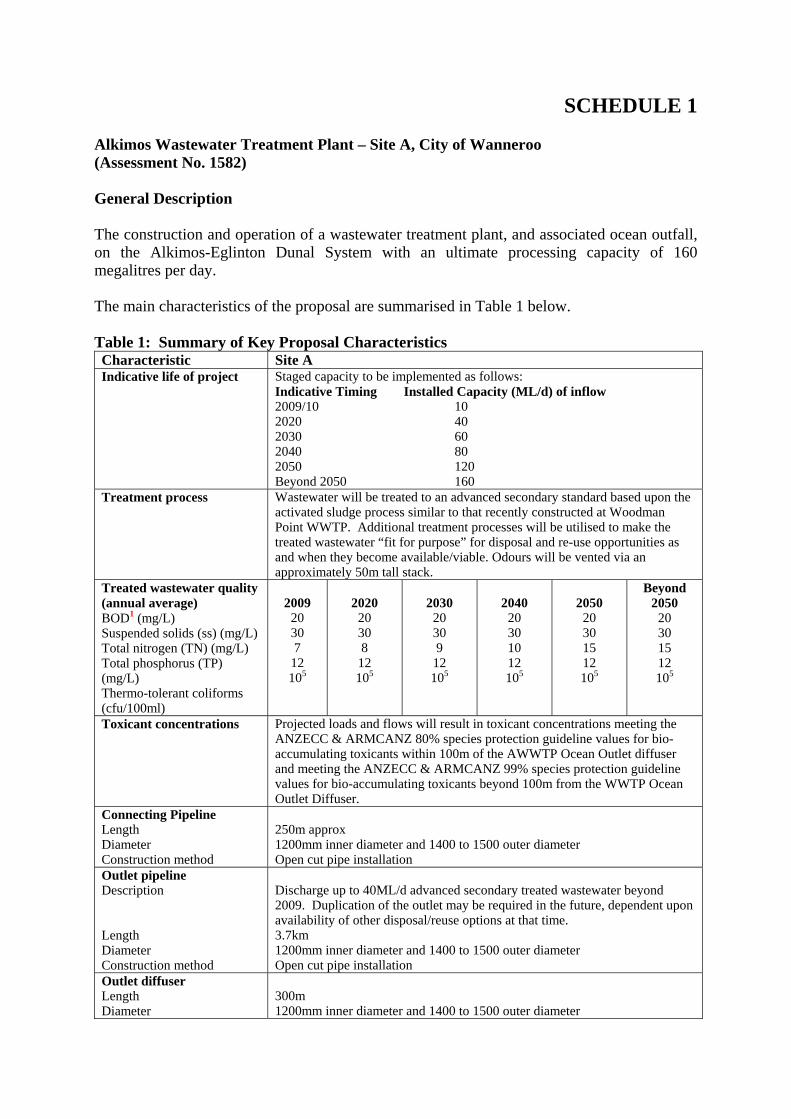
SCHEDULE 1 Alkimos Wastewater Treatment Plant – Site A, City of Wanneroo (Assessment No. 1582) General Description The construction and operation of a wastewater treatment plant, and associated ocean outfall, on the Alkimos-Eglinton Dunal System with an ultimate processing capacity of 160 megalitres per day. The main characteristics of the proposal are summarised in Table 1 below. Table 1: Summary of Key Proposal Characteristics Characteristic Site A Indicative life of project Staged capacity to be implemented as follows:
Indicative Timing Installed Capacity (ML/d) of inflow 2009/10 10 2020 40 2030 60 2040 80 2050 120 Beyond 2050 160
Treatment process Wastewater will be treated to an advanced secondary standard based upon the activated sludge process similar to that recently constructed at Woodman Point WWTP. Additional treatment processes will be utilised to make the treated wastewater “fit for purpose” for disposal and re-use opportunities as and when they become available/viable. Odours will be vented via an approximately 50m tall stack.
Treated wastewater quality (annual average) BOD1 (mg/L) Suspended solids (ss) (mg/L) Total nitrogen (TN) (mg/L) Total phosphorus (TP) (mg/L) Thermo-tolerant coliforms (cfu/100ml)
2009
20 30 7
12 105
2020
20 30 8
12 105
2030
20 30 9
12 105
2040
20 30 10 12 105
2050
20 30 15 12 105
Beyond 2050
20 30 15 12 105
Toxicant concentrations Projected loads and flows will result in toxicant concentrations meeting the ANZECC & ARMCANZ 80% species protection guideline values for bio-accumulating toxicants within 100m of the AWWTP Ocean Outlet diffuser and meeting the ANZECC & ARMCANZ 99% species protection guideline values for bio-accumulating toxicants beyond 100m from the WWTP Ocean Outlet Diffuser.
Connecting Pipeline Length Diameter Construction method
250m approx 1200mm inner diameter and 1400 to 1500 outer diameter Open cut pipe installation
Outlet pipeline Description Length Diameter Construction method
Discharge up to 40ML/d advanced secondary treated wastewater beyond 2009. Duplication of the outlet may be required in the future, dependent upon availability of other disposal/reuse options at that time. 3.7km 1200mm inner diameter and 1400 to 1500 outer diameter Open cut pipe installation
Outlet diffuser Length Diameter
300m 1200mm inner diameter and 1400 to 1500 outer diameter
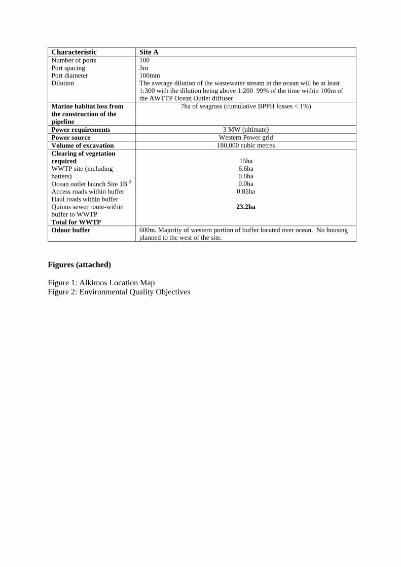
Characteristic Site A Number of ports Port spacing Port diameter Dilution
100 3m 100mm The average dilution of the wastewater stream in the ocean will be at least 1:300 with the dilution being above 1:200 99% of the time within 100m of the AWTTP Ocean Outlet diffuser
Marine habitat loss from the construction of the pipeline
7ha of seagrass (cumulative BPPH losses < 1%)
Power requirements 3 MW (ultimate) Power source Western Power grid Volume of excavation 180,000 cubic metres Clearing of vegetation required WWTP site (including batters) Ocean outlet launch Site 1B 2Access roads within buffer Haul roads within buffer Quinns sewer route-within buffer to WWTP Total for WWTP
15ha 6.6ha 0.8ha 0.0ha
0.85ha
23.2ha
Odour buffer 600m. Majority of western portion of buffer located over ocean. No housing planned to the west of the site.
Figures (attached) Figure 1: Alkimos Location Map Figure 2: Environmental Quality Objectives
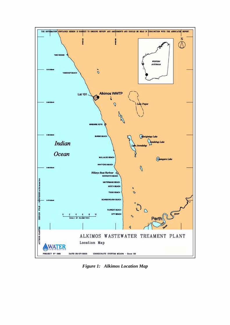
Figure 1: Alkimos Location Map
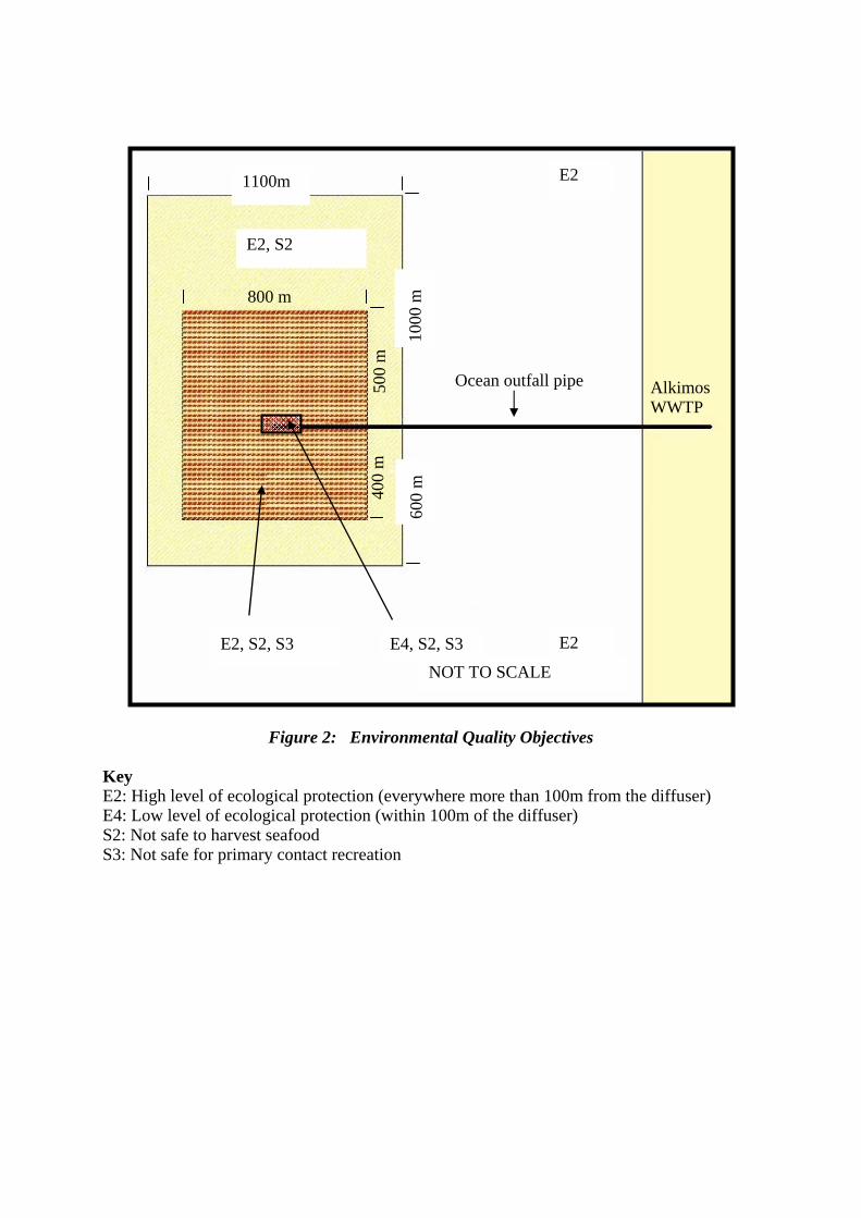
Ocean outfall pipe
E2
800 m
1000
m
1100m
E2, S2
400
m
E4, S2, S3 E2, S2, S3 NOT TO SCALE
600
m
E2
500
m
Alkimos WWTP
Figure 2: Environmental Quality Objectives Key E2: High level of ecological protection (everywhere more than 100m from the diffuser) E4: Low level of ecological protection (within 100m of the diffuser) S2: Not safe to harvest seafood S3: Not safe for primary contact recreation

Appendix 5
Oceanica Report – Alkimos BPPH Loss Assessment, 12 October 2006
Oceanica Report – Alkimos BPPH Loss Assessment, 12 October 2006
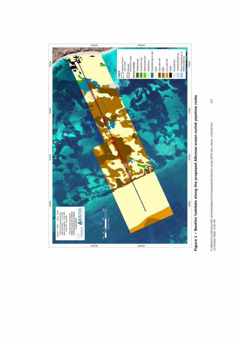
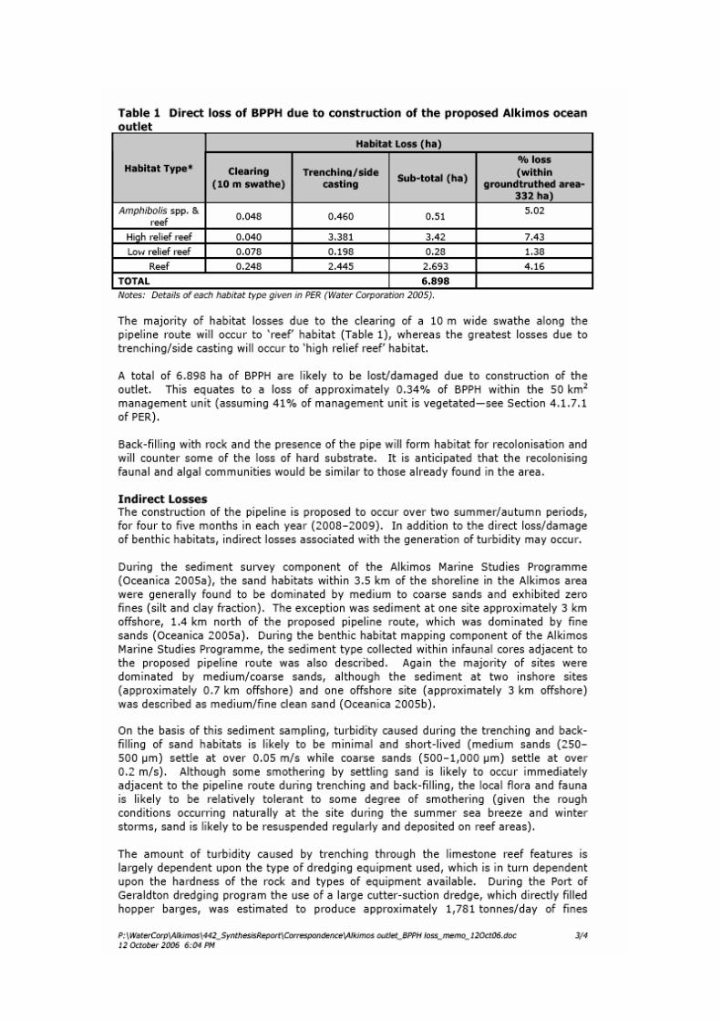

Appendix 6
Summary of Submissions and Proponent’s Response to Submissions
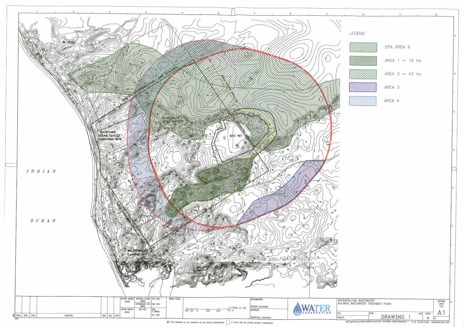
___________________________________________________________________________
___________________________________________________________________________ Response to Submissions Alkimos Wastewater Treatment Plant & Ocean Outfall WATER CORPORATION 1
ALKIMOS WASTEWATER TREATMENT PLANT AND OCEAN OUTFALL
EPA Assessment Number SITE A – 1582, SITE B - 1529
RESPONSE TO PUBLIC SUBMISSIONS ON PUBLIC ENVIRONMENTAL REVIEW The public submission period for the Water Corporations’ Alkimos Wastewater Treatment Plant (AWWTP) and Ocean Outfall proposal, Public Environmental Review (PER) commenced on 8 November 2005 for a period of eight weeks, ending on 23 January 2006. The Environmental Protection Authority (EPA) received 14 submissions on the project (See Attachment 1). The principal issues raised in the submissions related to environmental and social issues. Many submissions were framed in the form of statements and the essence of these is reproduced here. It may be helpful to the proponent to view these in the form of questions where possible and respond accordingly. Although not all of the issues raised in the submissions are environmental, the proponent is asked to address all issues, comments and questions, as they are relevant to the proposal. In summary the key issues were identified as: 1. General
1.1 The proposal 2. Biophysical Environment
2.1 Geoheritage 2.2 Fauna (Carnaby’s Black Cockatoo’s & Terrestrial Fauna) 2.3 Conservation of Flora & Vegetation 2.4 Site Rehabilitation 2.5 Fire & Pest Control 2.6 Groundwater 2.7 Benthic Habitat 2.8 Energy Usage
3. Pollution
3.1 Wastewater Discharge (Ocean Outfall) 3.2 Air Quality – Odour Emissions
4. Social Surroundings
4.1 Land Development Issues 4.2 Justification – Alternatives 4.3 Indigenous Consultation
4.4 Economics 5. Other
5.1 Water Re-Use 5.2 Construction of WWTP & Ocean Outfall
6. Matrix Table - Identifying issues raised by public and various groups in response to PER

___________________________________________________________________________
___________________________________________________________________________ Response to Submissions Alkimos Wastewater Treatment Plant & Ocean Outfall WATER CORPORATION 2
Appendices Appendix 1: Alkimos MRS Site B Map Appendix 2: Alkimos Hydrology Final Report (Rockwater 2004)
___________________________________________________________________________
___________________________________________________________________________ Response to Submissions Alkimos Wastewater Treatment Plant & Ocean Outfall WATER CORPORATION 3
1.0 GENERAL From the submissions received, five indicate support for the construction of AWWTP at Site A with three submissions supporting the Site B proposal. The remaining submissions were undecided or neutral and mainly commented on various positive and negative aspects for both sites. All submissions indicated support for the re-use of water and questioned the Water Corporation’s intentions. The Majority of the submissions addressed the geoheritage and flora and fauna issues associated with the construction of the plant, including the impacts on the parabolic dunes, Carnaby’s Cockatoos and Bush Forever land. A significant number of the submissions also addressed a range of pollution related issues such as odour and treated wastewater discharge from the proposed ocean outfall. Social impacts associated with land development and other issues were also raised. Responses to the issues are provided below: 1.1 The Proposal 1.1.1 Launch Site 2 has been summarily dismissed because of cost and complexity
(Section 2, page 19), when allied to the need to provide airflow channel from Site B this site it appears to be the most preferable option (Submission 13).
A. The towed ocean outlet can be launched from either Site 1 or Site 2. However Launch
Site 2 poses more constraints when compared to Launch Site 1B. Launch Site 1B is in direct alignment with the preferred route (to minimise disturbance of reef and marine habitat) for the Alkimos Ocean Outlet (AOO), whereas Site 2 is approximately 350 metres to the south. Site 2 requires removal of more sensitive vegetation than Site 1, and leads to a pipeline route that requires more excavation of reef. Also, the seabed inshore of the reef is shallower on the alignment from site 2 compared to the alignment from Site 1. For these reasons, Site 1 was preferred to Site 2.
Regardless of the chosen AWWTP site, it is Water Corporation’s intention to launch
the initial ocean outlet from Site 1B. If Site B is chosen and if an odour channel is constructed in the future, a subsequent ocean outfall may be launched from Launch Site 2.
1.1.2 Proposed launch site 1B would have less impact on coastal habitat
(Submission 2, 7). A. Launch Site 1B will have less impact on coastal habitat. To launch from Site 2 will
necessitate the destruction of the proposed coastal Regional Open Space and limestone cliffs that are a feature of the Alkimos beach, whereas at Site 1B the disturbance will be limited to a swale in the coastal dune which can be rehabilitated.
1.1.3 Launch site Option 2 seems to be environmentally more acceptable option in
respect of its impact on terrestrial ecosystems (Submission 3). A. Site 1B is preferable to Site 2. Launch site 1B can be oriented to align with the
preferred sea floor route, with reduced disturbance of terrestrial habitat, coastal dune formations and reef structures. Launch site 2 however requires more destructive and complex excavation of the nearer offshore reefs at Eglinton Rocks to achieve the desired alignment.
1.1.4 The buffer zone for site A is largely contained in the Water Corporation’s land
holdings. You can place conditions on the Water Corporation to maintain the buffer in its natural state and enhance it where destruction by Homo Sapiens has already occurred. For Site B the Water Corporation would have to purchase
___________________________________________________________________________
___________________________________________________________________________ Response to Submissions Alkimos Wastewater Treatment Plant & Ocean Outfall WATER CORPORATION 4
huge tracks of land (or exchange it plus, no doubt, big dollars for the developer) before you can realistically impose similar conditions (Submission 11).
A. The 1977 MRPA plan in 1977 and the Metropolitan Region Scheme (MRS) plan in
1994 had located the AWWTP at site A. However land planning drivers in the late 1990’s, particularly by the other landowners to enhance the beach usage for development and commercial purposes created an all round compromise resulting in the site B location.
It is the Water Corporation’s intention to acquire and manage for conservation purposes (to the extent required by the Environmental Protection Authority (EPA)) the buffer zones as delineated within the PER. For Site A this will require limited extra acquisition, for Site B significantly more. The cost the acquisition of the Site B buffer will be off-set by the sale of the developable land on the Water Corporation’s existing Lot 101.
1.1.5 The Western Australian Planning Commission (and therefore the Department
for Planning and Infrastructure) has already indicated support for Site B for the development of the Alkimos Wastewater Treatment Plant through its current planning initiatives associated with MRS Amendment 1029/33, although it is noted that there are some environmental benefits to Site A (Submission 13).
A. The Water Corporation is working towards giving effect to it at Site B (see responses
1.1.6 and 1.1.7). However, the Water Corporation has proposed an alternate site, Site A, as a fall-back position should technical, financial, environmental or social constraints render Site B unavailable to it to develop the AWWTP in the timeframes necessary to service the planned development of the Northwest Corridor.
1.1.6 It appears from the MRS Amendment 1029/33 and from the substantive
comments in the PER document, the proposed site for the AWWTP is to be at Site B.
“At a high level meeting held in September 2004 between the Developers, the Water Corporation and the DPI, Site B was chosen as the agreed site for the AWWTP so that the land most desirable for urban development, to the west, could be available for residential development. Site A remained as a fallback position should any fatal flaws be identified with Site B” (Section 1.1.7.5, WC PER)
The MRS amendment proposed by the EPA suggests that in order to maintain ecological linkages it would be necessary to reserve a significant section of the Alkimos landscape. Site B appears to intrude quite far into this reservation. At public meetings held with the Water Corporation it appears as if there could be further adjustment to the site location and consideration for Site B to be moved west and south of the proposed Site B identified in the PER. So in effect we could be looking at ‘Bananas in Pyjamas’ – B1 and B2! (Submission 5)
A The Water Corporation recognises the EPA’s desire to protect the geological time
sequence of the Quindalup Dune system at Alkimos, and the unique geological, landform and scientific values they represent. The Water Corporation has explored the possibility of moving the site of proposed AWWTP to the South and West to avoid the areas identified as of high conservation significance by the Environmental Protection Authority in Bulletin 1207 Alkimos-Eglinton MRS Amendment No. 1029/33 (Area 9).
Representations by the Department of Planning and Infrastructure (DPI), LandCorp and developers during the MRS appeals process have indicated that the planning and social benefits postulated to be accrued from the development will be seriously
___________________________________________________________________________
___________________________________________________________________________ Response to Submissions Alkimos Wastewater Treatment Plant & Ocean Outfall WATER CORPORATION 5
compromised by such a move making the development unviable. Therefore, the Water Corporation believes the AWWTP could remain in the original position (Site B) proposed in the PER. The reasons for this include wider social benefit and better planning outcomes balanced against the purely environmental imperatives as enunciated in the EPA Bulletin. The Water Corporation believes that any environmental impact from remaining at Site B can be adequately offset as follows: 1. The Water Corporation, through engineering measures will reduce as far as practicable the slope (and therefore the real extent of disturbance to the Q3 Quindalup Dune) of the batter on the eastern end of Site B as delineated by the yellow line on the attached plan. This will still result in the disturbance (loss) of 8 hectares of the Q3 Dune within the EPA’s Area 9 conservation area. 2. The Water Corporation will agree to dedicate other areas within its buffer zone to be managed for conservation purposes to offset that disturbance. Those areas are: • 19 hectares of Q3 Quindalup Dune system delineated by the hatched area 1 on
the attached plan, located to the immediate South and West of the AWWTP site resulting in a 2.4:1 offset of like for like geomorphological structure; and
• 43 hectares of Banksia woodlands located immediately North of the EPA’s Area 9
conservation area bounded by the AWWTP buffer, delineated as the hatched area 2 on the attached plan.
3. The Water Corporation is amenable to Ministerial conditions being applied to require the continued management of the areas identified for conservation purposes in perpetuity within the buffer, with the following caveats: • That the opportunity to construct an odour channel to the west of the site to
mitigate the odour ponding phenomenon not be constrained by the conservation areas; and
• The ability to traverse the conservation areas for the installation of essential linear
infrastructure (pipes and power) and access roads to the AWWTP not being compromised. The Water Corporation would commit to avoidance of the affected areas, sensitive route planning, minimal disturbance and rehabilitation where practicable to maximize the conservation values.
1.1.7 The EPA in their report suggested that important ecological linkages are
environmentally unacceptable, as evidenced by the recommendation to reserve Area 9 (MRS Appendix 6). From the MRS Report it appears to the EPA that Site B is environmentally unacceptable and can only be environmentally acceptable through the inclusion of substantial assets of land to be reserved (Submission 5).
A. The Water Corporation recognises the EPA’s desire to protect the geological time
sequence of the Quindalup Dune system at Alkimos, and the unique geological, landform and scientific values they represent. The Water Corporation has explored the possibility of moving the site of proposed AWWTP to the South and West to avoid the areas identified as of high conservation significance by the EPA in Bulletin 1207 Alkimos-Eglinton MRS Amendment No. 1029/33 (Area 9).
Representations by the DPI, LandCorp and developers during the MRS appeals process have indicated that the planning and social benefits postulated to be accrued from the development will be seriously compromised by such a move making the development unviable. Therefore, the Water Corporation believes the AWWTP could remain in the original position (Site B) proposed in the PER. The reasons for this include wider social benefit and better planning outcomes balanced against the purely environmental imperatives enunciated in the EPA Bulletin. The Water Corporation
___________________________________________________________________________
___________________________________________________________________________ Response to Submissions Alkimos Wastewater Treatment Plant & Ocean Outfall WATER CORPORATION 6
believes that any environmental impact from remaining at Site B can be adequately offset as follows: 1. The Water Corporation, through engineering measures will reduce as far as practicable the slope (and therefore the real extent of disturbance to the Q3 Quindalup Dune) of the batter on the eastern end of Site B as delineated by the yellow line on the attached plan. This will still result in the disturbance (loss) of 8 hectares of the Q3 Dune within the EPA’s Area 9 conservation area. 2. The Water Corporation will agree to dedicate other areas within its buffer zone to be managed for conservation purposes to offset that disturbance. Those areas are: • 19 hectares of Q3 Quindalup Dune system delineated by the hatched area 1 on
the attached plan, located to the immediate South and West of the AWWTP site resulting in a 2.4:1 offset of like for like geomorphological structure; and
• 43 hectares of Banksia woodlands located immediately North of the EPA’s Area 9
conservation area bounded by the AWWTP buffer, delineated as the hatched area 2 on the attached plan.
3. The Water Corporation is amenable to Ministerial conditions being applied to require the continued management of the areas identified for conservation purposes in perpetuity within the buffer, with the following caveats: • That the opportunity to construct an odour channel to the west of the site to
mitigate the odour ponding phenomenon not be constrained by the conservation areas; and
• The ability to traverse the conservation areas for the installation of essential linear
infrastructure (pipes and power) and access roads to the AWWTP not being compromised. The Water Corporation would commit to avoidance of the affected areas, sensitive route planning, minimal disturbance and rehabilitation where practicable to maximize the conservation values.
1.1.8 Site A is cheaper to establish and construct, while providing fewer expensive
technical and engineering fixes to operate (Submission 5). A. The excavation and sensitive disposal of approximately 3,000,000 cubic metres of
sand and limestone poses some serious technical and significant financial differentials between Site B when compared to Site A. However, the intention is that the sale of coastal land by developers to the west of Site B would partially offset the higher cost of developing Site B. The shortfall will potentially be funded by a special head-works contribution (developer contribution) and/or government contribution that reflect the additional value to the community through commercial and retail activities. Both sites will require the same operating effort if the appropriate buffer size is applied particularly for odour ponding. Site B may require an odour channel or other odour mitigation and management due to the odour ponding phenomenon. Site A does not have an odour ponding issue and will not rely on additional odour control measures.
1.1.9 There is an agreement in place with a number of the AE Landowners and the Water Corporation for the Alkimos Water Treatment Plant (AWTP) to be relocated to Site B. This agreement has been in place for a number of years giving effect to MRS Amendment 1029/33. The understanding of all parties to the agreement to relocate to Site B is that Site A is included in the AWTP-PER as a fallback position at the request of the EPA. The preferred position of all key stakeholders since 2000 is Site B and to this end all planning and comprehensive site analysis, associated research and community consultation undertaken since this time has been to facilitate the MRS Amendment 1029/33.
___________________________________________________________________________
___________________________________________________________________________ Response to Submissions Alkimos Wastewater Treatment Plant & Ocean Outfall WATER CORPORATION 7
Consideration is given to promote and reinforce that Site B is the preferred location by all key stakeholders (Submission 6).
A. The Water Corporation acknowledges the agreement, and is working towards giving
effect to it at Site B (see responses 1.1.6 and 1.1.7). However, the Water Corporation has proposed an alternate site, Site A, as a fall-back position should technical, financial, environmental or social constraints render Site B unavailable for it to develop the AWWTP in the timeframes necessary to service the planned development of the Northwest Corridor.
1.1.10 Site B and its associated buffer facilitates a superior environmental outcome
than Site A in relation to vegetation, flora and geoheritage and this outcome should be clearly reflected in future documentation (Submission 6).
A. Site B does not offer greater conservation opportunities than Site A from an ecological
or geoheritage perspective, merely different opportunities. The buffer zone surrounding Site A would enable partial conservation of three of the four geological/ecological phases (Q1, Q3 and Q4) augmenting and providing linkages with the conservation of the third phase (Q2) identified in the MRS process (Area 9). The AWWTP would be built over a Spearwood limestone enclave containing a Priority 3 species (Sarcozona bicarinata) which is widely distributed elsewhere within the buffer zone of the AWWTP, and thus can be adequately protected.
The buffer zone surrounding Site B would enable the opportunity to conserve some of the near coastal complexes in the oldest phase (Q1) and second phase (Q3) of the Alkimos cuspate forelands and nested parabolic dune system. It also offers the opportunity to partially augment the Bush Forever Site 397 to the north, but offers little or no opportunity to achieve a contiguous linkage between all phases, given it does not encompass the youngest phase (Q4) of the Alkimos system. Furthermore, Site B significantly impacts on the confluence of the second (Q3) and third (Q2) phases of the Quindalup dune system identified by the EPA in Bulletin 1207 Alkimos-Eglinton MRS Amendment No. 1029/33 (Area 9), which the Water Corporation believes may be compensated by offsets.
1.1.11 The buffer area for Site A immediately abuts Bush Forever Site 397 on the west
and north and thereby increases the effective size of Site 397. However, the north side parabolic dune vegetation forms an important linkage role for animal movements, contains several priority flora taxa, and connects Bush Forever sites 397 and 130, enhancing value of each, so that clearing of this for urban development will have wide ramifications. EPA Bulletin 1207 proposes that if the WWTP is located at Site B then this dune formation should be protected. This is a significant benefit that can only be provided by locating the WWTP at Site B (Submission 13).
A. Site B does not offer greater conservation opportunities than Site A from an ecological
or geoheritage perspective, merely different opportunities. The areas identified by the EPA as being areas of environmental significance relevant to the AWWTP in EPA Bulletin 1207, being Areas 9 and 6c, provides for a contiguous linkage from Bush Forever Site 397 to 130 irrespective of the location of the AWWTP. To locate the AWWTP at Site B will cause disruption to the high value landform (the Q2/Q3 conjunction) which may be able to be offset as proposed in responses 1.1.6 and 1.1.7. Site A better augments the EPA’s conservation objectives without the requirement for offsets.
1.1.12 Site B allows for residential development close to the coast and enables a
proposed commercial/retail node (i.e. a beachside village) within the south-west corner of the buffer, enhancing the status of the beach as a regional focal point, and providing significant sustainability benefits by enabling the operation of a
___________________________________________________________________________
___________________________________________________________________________ Response to Submissions Alkimos Wastewater Treatment Plant & Ocean Outfall WATER CORPORATION 8
direct and frequent bus service to, and from, the proposed railway station at Alkimos (Submission 13).
A. The Water Corporation’s objective in agreeing to include Site B as a potential WWTP site in it’s PER is to assist developers maximise the planning and development opportunities in the Alkimos area. However, the Water Corporation has retained Site A as a fall-back site should technical, financial, environmental or social constraints render Site B unavailable for it to develop the AWWTP in the timeframes necessary to service the planned development of the Northwest Corridor. Site B allows for a residential development and coastal node to the west of the AWWTP. Under the Site A option, these developments would be moved south and north of the Alkimos beach area. The town centre and train station would remain in the virtually the same location. Bus services would still be able to be operated to adjoining destinations such as the beach, coastal developments etc. The Water Corporation has explored the possibility of moving the site of proposed AWWTP to the South and West to avoid the areas identified as of high conservation significance by the Environmental Protection Authority in Bulletin 1207 Alkimos-Eglinton MRS Amendment No. 1029/33 (Area 9). Representations by the DPI, LandCorp and developers during the MRS appeals process have indicated that the planning and social benefits postulated to be accrued from the development will be seriously compromised by such a move making the development unviable. Therefore, the Water Corporation believes the AWWTP could remain in the original position (Site B) proposed in the PER with offsets as proposed in responses 1.1.6 and 1.1.7.
1.1.13 Site A enables development of the beach front at a reduced scale from that
envisaged under Site B, in particular food premises and a lifesaving club will be incompatible uses and therefore, with Site A, the beach will be unsafe for swimming and could not support the bus service discussed above (Submission 13).
A. Kiosks, surf life-saving clubs, beach parking, active recreational facilities and the like
would all be considered compatible land-uses within the buffer on the beach front. High value restaurants, housing and the like would not. Commercial centres could be located to the south and north of the buffer boundary.
The beach would not be “un-safe” as all normal lifesaving services will be able to be provided in a location not affected by the proximity of the AWWTP or the ocean outlet. The land behind the beach front would not be available for residential development, and virtually left in its natural state.
1.1.14 On balance, site A would have less environmental impact. In its findings on the MRS amendment, the EPA has recommended moving the site B to the west. This may overcome some of the problems but further investigation is needed (Submission 10).
A. This is a reasonable interpretation of the EPA’s findings in Bulletin 1207 given the
conservation value they have placed on Area 9. Any proposition by the Water Corporation to move from Site B to anywhere other than Site A would require further evaluation by the EPA. The Water Corporation has explored the possibility of moving the site of proposed AWWTP to the South and West to avoid the areas identified as of high conservation significance by the EPA, however representations by the DPI, LandCorp and developers during the MRS appeals process have indicated that the planning and social benefits postulated to be accrued from the development will be seriously compromised by such a move making the development unviable. Therefore, the Water Corporation believes the AWWTP could remain in the original position (Site B) proposed in the PER with offsets as proposed in responses 1.1.6 and 1.1.7.
___________________________________________________________________________
___________________________________________________________________________ Response to Submissions Alkimos Wastewater Treatment Plant & Ocean Outfall WATER CORPORATION 9
1.1.15 The PER should have included the following: 1. a map with a scale along the
lines of Plan 01, Appendix B (not like Figure 3.11, Section 3, page 29) for each site A and B with land use, spoil disposal areas, coastal buffers, odour buffers, temporary construction site for launching the ocean outlet, major roads, urban railway etc., and 2. the report from the AWWTPCC (Submission 11).
A. Location of spoil from the excavation has not been addressed fully in the PER, as it is
not the responsibility of the Water Corporation. The land developers will utilise the spoil to terra-form the developments outside the Water Corporation’s buffer to prepare the area for urban development. The other information requested is in the relevant locations within the PER document.
1.1.16 From the Proponent’s own scoping document and sustainability assessment it would appear that Site A is much more sustainable when examining the social, economic and environmental benefits of locating the WWTP at either site. The Site B option appears to sever important ecological linkages and the evidence of dunal succession. This would compromise the integrity for the benefit of the few who would pay for a sea view to support their elite lifestyles (Submission 5).
A. An over-riding consideration from a whole of government context is to ensure the
viability of the proposed development as a whole (the “best planning outcome”, involving urban and commercial development, transportation energy and wastewater treatment services).
The Water Corporation has presented a sustainability assessment for Sites A and B in the PER (Table 4.1). The assessment shows that there are significant technical, social, economic and environmental differences between the Site A and Site B. Due to the possibility of these differences not being acceptable, the Water Corporation has proposed Site A as a fall-back site. The Water Corporation has also explored the possibility of moving the site of proposed AWWTP to the South and West to avoid the areas identified as of high conservation significance by the EPA subsequent to the release of the PER. However, representations by the DPI, LandCorp and developers during the MRS appeals process have indicated that the planning and social benefits postulated to be accrued from the development will be seriously compromised by such a move making the development unviable. The excavation and sensitive disposal of approximately 3,000,000 cubic metres of sand and limestone poses some serious technical and significant financial differentials between Site B when compared to Site A. However, the intention is that the sale of coastal land by developers to the west of Site B would partially offset the higher cost of developing Site B. The shortfall will potentially be funded by a special head-works contribution (developer contribution) and/or government contribution that reflect the additional value to the community, for example, through commercial and retail activities.
Water Corporation is unable to comment on lifestyle values. 2.0 BIOPHYSICAL ENVIRONMENT 2.1 Geoheritage 2.1.1 Site B damages the integrity of the significant landforms due to the extensive
excavation required (Submission 2, 7).
___________________________________________________________________________
___________________________________________________________________________ Response to Submissions Alkimos Wastewater Treatment Plant & Ocean Outfall WATER CORPORATION 10
A. The location of the AWWTP at Site B creates disruption to the high value landform (the Q2/Q3 conjunction). The EPA has identified the geological time sequence of the Quindalup Dune system at Alkimos, and the unique geological, landform and scientific values they represent as areas of high conservation significance in Bulletin 1207 Alkimos-Eglinton MRS Amendment No. 1029/33 (Area 9).
The Water Corporation believes that any environmental impact from remaining at Site B can be adequately offset as follows: 1. The Water Corporation, through engineering measures will reduce as far as practicable the slope (and therefore the real extent of disturbance to the Q3 Quindalup Dune) of the batter on the eastern end of Site B as delineated by the yellow line on the attached plan. This will still result in the disturbance (loss) of 8 hectares of the Q3 Dune within the EPA’s Area 9 conservation area. 2. The Water Corporation will agree to dedicate other areas within its buffer zone to be managed for conservation purposes to offset that disturbance. Those areas are: • 19 hectares of Q3 Quindalup Dune system delineated by the hatched area 1 on
the attached plan, located to the immediate South and West of the AWWTP site resulting in a 2.4:1 offset of like for like geomorphological structure; and
• 43 hectares of Banksia woodlands located immediately North of the EPA’s Area 9
conservation area bounded by the AWWTP buffer, delineated as the hatched area 2 on the attached plan.
3. The Water Corporation is amenable to Ministerial conditions being applied to require the continued management of the areas identified for conservation purposes in perpetuity within the buffer, with the following caveats: • That the opportunity to construct an odour channel to the west of the site to
mitigate the odour ponding phenomenon not be constrained by the conservation areas; and
• The ability to traverse the conservation areas for the installation of essential linear
infrastructure (pipes and power) and access roads to the AWWTP not being compromised. The Water Corporation would commit to avoidance of the affected areas, sensitive route planning, minimal disturbance and rehabilitation where practicable to maximize the conservation values.
2.1.2 Site B would have an environmentally unacceptable impact on geoheritage
values of the site, as it would damage the integrity of the parabolic dune due to the extensive excavation of 3 million cubic metres of limestone required to accommodate the WWTP at this site. In addition, this option fails to protect in the buffer the youngest dune formations and would open to disturbance the chronological sequence of the whole dune complex (Submission 3).
A. The EPA has identified the geological time sequence of the Quindalup Dune system
at Alkimos, and the unique geological, landform and scientific values they represent as areas of high conservation significance in Bulletin 1207 Alkimos-Eglinton MRS Amendment No. 1029/33 (Area 9). The location of the AWWTP at Site B creates disruption to the high value landform (the Q2/Q3 conjunction) which may be able to be offset as proposed in responses 1.1.6, 1.1.7. and 2.1.1. To locate the AWWTP at Site A augments the EPA’s conservation objectives and offers the opportunity to protect to some extent the youngest phases (Q4) of the dune system, although these are identified by the EPA in Bulletin 1207 as being of conservation significance and are likely to be placed within the conservation estate irrespective of the location of the AWWTP.
___________________________________________________________________________
___________________________________________________________________________ Response to Submissions Alkimos Wastewater Treatment Plant & Ocean Outfall WATER CORPORATION 11
The excavation and sensitive disposal of approximately 3,000,000 cubic metres of sand and limestone poses some serious technical difficulties. Location of spoil from the excavation has not been addressed fully in the PER, as it is not the responsibility of the Water Corporation. The land developers will utilise the spoil to terra-form the developments outside the Water Corporation’s buffer to prepare the area for urban development.
2.1.3 Site A provides a greater opportunity for protection of coastal habitats without
the threat of housing development and would better protect geoheritage values by retaining four landform units and linking areas identified by the EPA (Submission 2, 7, 4).
A. The EPA has identified the geological time sequence of the Quindalup Dune system
at Alkimos, and the unique geological, landform and scientific values they represent as areas of high conservation significance in Bulletin 1207 Alkimos-Eglinton MRS Amendment No. 1029/33. The location of the AWWTP at Site B creates disruption to the high value landform (the Q2/Q3 conjunction) which may be able to be offset as proposed in responses 1.1.6, 1.1.7 and 2.1.1. To locate the AWWTP at Site A augments the EPA’s conservation objectives and offers the opportunity to protect to some extent the youngest phases (Q4) of the dune system, although these are identified by the EPA in Bulletin 1207 as being of conservation significance and are likely to be placed within the conservation estate irrespective of the location of the AWWTP.
2.1.4 The Site A buffer offers the opportunity to preserve a greater variety of dune
habitat, providing a greater range of intact and well vegetated ecosystems, internationally significant geoheritage landforms (Submission 5).
A. The EPA has identified the geological time sequence of the Quindalup Dune system
at Alkimos, and the unique geological, landform and scientific values they represent as areas of high conservation significance in Bulletin 1207 Alkimos-Eglinton MRS Amendment No. 1029/33. The location of the AWWTP at Site B creates disruption to the high value landform (the Q2/Q3 conjunction) which may be able to be offset as proposed in responses 1.1.6, 1.1.7. and 2.1.1.
To locate the AWWTP at Site A augments the EPA’s conservation objectives and offers the opportunity to protects to some extent the youngest phases (Q4) of the dune system, although these are identified by the EPA in Bulletin 1207 as being of conservation significance and are likely to be placed within the conservation estate irrespective of the location of the AWWTP.
2.1.5 Site A protects the chronological sequence from the youngest dunes to the
older ones and if the EPA’s recommendation to include the ecological link (Site 9 in the Bulletin 1207) into the Parks and Recreation Reservation, this would provide a better environmental outcome. It is recommended that inclusion of site 9 is essential (Submission 3).
A. The Water Corporation will, regardless of whether the AWWTP is built on Site A or
Site B, recognise and manage for conservation purposes the portion of Area 9 delineated by the EPA that lies within its buffer for conservation purposes.
2.1.6 The geoheritage values have received little attention in detailed land use planning of the Alkimos – Eglinton area, though they were documented as long ago as 1979. More recent work by Semeniuk points to the lack of representation of these landform types in the conservation estate. A sequence of dune landforms and habitats at Alkimos need to be reserved to maximise protection of biodiversity and geoheritage values (Submission 10).
___________________________________________________________________________
___________________________________________________________________________ Response to Submissions Alkimos Wastewater Treatment Plant & Ocean Outfall WATER CORPORATION 12
A. The Water Corporation has identified and reported on the geoheritage significance of the area in the PER. The value has been recognised in the EPA’s Bulletin 1207 and the extent of the areas to be reserved for conservation therein. The Water Corporation recognises the interest and significance attributed to the geo-heritage landforms in the Alkimos region, and will be bound by the recommendations of the EPA and decisions of the Minister for Environment regarding conservation of these values for its AWWTP.
2.1.7 The coastal dune formations in the Alkimos area have been identified as having
national, and even worldwide significance as detailed in the PER (refer to PER section 3 pp 25-26 – Semeniuk V & C Research Group – A description of coastal and marine zones of the Alkimos area). As discussed above the EPA response to MRS Amendment 1029/33 (i.e. Bulletin 1207) has proposed that this formation be protected by the creation of a new Parks and Recreation reservation connecting Bush Forever Sites 397 and 130. Locating the WWTP at Site A does not easily afford the same opportunity (Submission 13).
A. This assertion is incorrect and misleading. The areas identified by the EPA as of
environmental significance in EPA Bulletin 1207, being Areas 9 and 6c, provides for a contiguous linkage from Bush Forever Site 397 to 130 irrespective of the location of the AWWTP. Site B does not offer greater conservation opportunities than Site A from an ecological or geoheritage perspective, merely different opportunities. The buffer zone surrounding Site A would enable partial conservation of three of the four geological/ecological phases (Q1, Q3 and Q4) augmenting and providing linkages with the conservation the third phase (Q2) identified in the MRS process (Area 9). The AWWTP would be built over a Spearwood limestone enclave containing a Priority 3 species (Sarcozona bicarinata) which is widely distributed elsewhere within the buffer zone of the AWWTP, and thus can be adequately protected.
The buffer zone surrounding Site B would enable the opportunity to conserve some of the near coastal complexes in the oldest phase (Q1) and second phase (Q3) of the Alkimos cuspate forelands and nested parabolic dune system. It also offers the opportunity to partially augment the Bush Forever Site 397 to the north, but offers little or no opportunity to achieve a contiguous linkage between all phases, and not encompassing the youngest phase (Q4) of the Alkimos system. To locate the AWWTP at Site B also creates disruption to the high value landform (the Q2/Q3 conjunction) which may be able to be offset as proposed in responses 1.1.6 and 1.1.7.
2.1.8 The majority of Site B is situated within a depression in the Alkimos Dune
System, although part of the facility is located on the dune system itself, and will impact on the second (Q3) and third (Q2) phases of the Alkimos Dune System. The PER states that approximately 3,000,000 cubic metres of earth would be required to be excavated. Significant excavation of the dunes on the eastern side of the Site B and battering will be required to position the treatment plant to allow gravity wastewater inflow (Submission14).
A. The provision of gravity conveyancing of the large quantities of sewage to the
AWWTP, and the gravity flow through the plant to ocean disposal of the advanced secondary treated wastewater in the event of system failure is fundamental to the protection of public health. To achieve this, the excavation and sensitive disposal of approximately 3,000,000 cubic metres of sand and limestone will be necessary at Site B. Location of spoil from the excavation has not been addressed fully in the PER, as it is not the responsibility of the Water Corporation. The land developers will utilise the spoil to terra-form the developments outside the Water Corporation’s buffer to prepare the area for urban development.
___________________________________________________________________________
___________________________________________________________________________ Response to Submissions Alkimos Wastewater Treatment Plant & Ocean Outfall WATER CORPORATION 13
The EPA has identified the geological time sequence of the Quindalup Dune system at Alkimos, and the unique geological, landform and scientific values they represent as areas of high conservation significance in Bulletin 1207 Alkimos-Eglinton MRS Amendment No. 1029/33. The location of the AWWTP at Site B creates disruption to the high value landform (the Q2/Q3 conjunction) which may be able to be offset as proposed in responses 1.1.6, 1.1.7. and 2.1.1.
2.1.9 Site A sits mostly within an area of dune swale that is Degraded to good
condition (Submission 14). A. The AWWTP at Site A would be built over a Spearwood limestone enclave containing
some Priority 3 species (Sarcozona bicarinata) which is widely distributed elsewhere within the buffer zone of the AWWTP, and thus can be adequately protected.
2.1.10 Site A is located predominantly in a hollow within the Quindalup dunes, and will
impact on the second phase (Q3) of the Alkimos Dunal System. The PER states that 180,000 cubic meters of earth will be excavated, which will have a limited impact on the dune system (Submission 14).
A. The impact upon the Q3 second phase Quinadlup Dune formations is limited, with
large portions of Q3, adjacent to the Q1 (oldest phase) and Q4 youngest phase lying within the proposed buffer for Site A, thus providing conservation opportunities for these values that could link to the Area 9 conservation values (Q2 or third phase) identified by the EPA in Bulletin 1207.
Approximately one third of the area of site A impacts on the second phase (Q3) of the
Alkimos dunal system although the Q3 phase surrounding site A remains intact. By contrast site B occupies nearly all of the Q3 phase and totally severs the linkage with the adjacent Q2 phase.
2.2 Fauna 2.2.1 Urban development around Perth is removing feeding grounds for the
threatened Carnaby’s Black Cockatoo. A strategy is needed to maintain and manage feeding grounds for the long-term survival of the species (Submission 2, 7).
A. The AWWTP will have limited impact upon the feeding habitat of the Carnaby’s Black
Cockatoo, consisting of only a 28.2 ha footprint, a small proportion of which is the habitat. The Water Corporation is a supporting member/co-ordinator of the Cockatoo Care program. The proposed buffer around both sites offer opportunities for some conservation of the feeding habitat of Carnaby’s Cockatoo, however in the context of the overall urban development of approximately 1300 ha outside the buffers, these opportunities are small.
2.2.2 Site B protects areas of Banksia and Dryandra that are important feeding
habitat for Carnaby’s Cockatoo (Submission 2, 7). A. Banksia and Dryandra spp are important feeding habitat for Carnaby’s Cockatoo. The
Water Corporation will minimise disruption (due to the footprint of the plant) of these habitats as far as practicable. Furthermore, the proposed buffer around both sites offer opportunities for some conservation of the feeding habitat of Carnaby’s Cockatoo, however in the context of the overall urban development of approximately 1300 ha outside the buffers, these opportunities are small.
___________________________________________________________________________
___________________________________________________________________________ Response to Submissions Alkimos Wastewater Treatment Plant & Ocean Outfall WATER CORPORATION 14
2.2.3 The area covered by the Alkimos Eglington urban development is covered in substantial tracts of Banksia woodland complex, Dryandra heath land and Tuarts, both mallee form and forest. This complex of rich biodiversity provides extensive feeding and foraging and breeding grounds for many terrestrial birds, reptiles and mammals. Carnaby’s Cockatoo and Baudin’s Cockatoo are both listed as ‘Schedule 1, Fauna that is rare or is likely to become extinct’ under the Wildlife Conservation Act 1950. Carnaby’s Cockatoo is listed as ‘Nationally endangered’ under the Environmental Protection and Biodiversity Conservation Act 1999, Baudin’s Cockatoo is likely to be so listed in the near future. It is vital that any ecological connectivity between Yanchep National Park and the coastal heath and dune flora be retained, in order to preserve these two species of cockatoo. This means that the decision to Site the Alkimos Waste Water Treatment Plant must be made using a triple-bottom line approach to sustainability (Submission 5).
A. The Water Corporation cannot comment on the acceptability (or otherwise) of the
proposed broad scale urban development (delineated in the MRS Amendment 1207) on the Carnaby’s Cockatoo feeding habitats. The Water Corporation has presented a sustainability assessment for Sites A and B in the PER (Table 4.1). Recognising the high biodiversity and feeding habitat of the Carnaby’s Cockatoo, the Water Corporation will be referring the project to the Department of Environment and Heritage as required by the EPBC Act prior to conclusion of the State environmental impact assessment process. The Water Corporation will minimise disruption (due to the footprint of the plant) of these habitats as far as practicable. Furthermore, the proposed buffer around both sites offer opportunities for some conservation of feeding habitat of Carnaby’s Cockatoo, however in the context of the overall urban development of approximately 1300ha outside the buffers, these opportunities are small.
2.2.4 Concerns that decisions are being sought on developments, such as this one
and the future urban development at Alkimos-Eglinton that will result in significant loss of habitat for Carnaby’s Black Cockatoos. This Endangered species, protected under the Environmental Protection and Biodiversity Conservation Act 1999 and the Wildlife Conservation Act 1956, is threatened by these development proposals without any publicly available adequate information on the size of the population of these birds, without any estimation of the sustainable size of the feeding habitat necessary to support them, or an assessment of the regional impact of the proposed clearing.
It is recommended that no further decisions on development proposals are made until adequate assessment of the continuous loss of feeding and potential breeding habitat of the Carnaby’s Black Cockatoos is done in the Perth Metropolitan Region (Submission 3).
A. No data is available and regarding the population size or breeding and
feeding/foraging range of Calyptorhynchus latirostris (Carnaby’s Cockatoo) in the greater Alkimos area, or the areal extent necessary to be reserved to sustain the population (or assist it to recover). The Water Corporation will take a maximum of 28.2ha, a small proportion of which will involve some feeding habitat. This needs to be viewed in the context of up to 1300ha to be cleared for the urban development the AWWTP will eventually service. The Water Corporation will minimise disruption (due to the footprint of the plant) of these habitats as far as practicable. Furthermore, the proposed buffer around both sites offer opportunities for some conservation of feeding habitat of Carnaby’s Cockatoo, however in the context of the overall urban development of approximately 1300 ha outside the buffers, these opportunities are small.
___________________________________________________________________________
___________________________________________________________________________ Response to Submissions Alkimos Wastewater Treatment Plant & Ocean Outfall WATER CORPORATION 15
2.2.5 Site B sits within an area of dunes and swale that contains various heathland, shrubland and woodland habitats. The proposed Site B earthworks will significantly impact on important feeding habitats, especially Banksia woodland, for the Endangered Carnaby’s Cockatoo (Submission 14).
A. The Water Corporation will take a maximum of 28.2ha at Site B, a small proportion of
which will involve some feeding habitat. It will involve the excavation of up to 3,000,000 cubic metres of sand and limestone within this area. However, the areal extent of the impact needs to be viewed in the context of the large tracts of land to be cleared for the urban development that the AWWTP will eventually service. The Water Corporation will minimise disruption (due to the footprint of the plant) of these habitats as far as practicable within its control. Furthermore, the proposed buffer around both sites offer opportunities for some conservation of feeding habitat of Carnaby’s Cockatoo, however in the context of the overall urban development outside the buffers, these opportunities are small.
2.2.6 Adoption of Site B also avoids triggering the Commonwealth Environmental
Protection and Biodiversity Act 1999 because the Site B buffer will facilitate the protection of foraging habitats of the Carnaby’s Cockatoo, via: Habitats “4 and 5 found predominantly within the Site B buffer are extremely important in terms of conservation.” (Section 7, page 10) (Submission 13)
A. Contrary to this assertion, the Commonwealth Department of Environment and
Heritage has expressed interest in the AWWTP project, and wishes to make the determination whether or not it triggers the EPBC Act as a “controlled action”. Thus excavation of Site B may trigger the EPBC Act due to the taking of the Banksia woodlands to the immediate east of the WWTP site because of the extensive batters necessary to stabilise the site. The Water Corporation will not pre-empt the decision of the Commonwealth Minister for Environment and Heritage, and will refer the AWWTP project to the Commonwealth for a determination. The opportunity to offset any habitat losses elsewhere within the buffer will be canvassed within that referral.
2.2.7 It is unacceptable that fauna assessment is based on one site visit and a
desktop assessment instead of a rigorous assessment as recommended in the EPA’s Guidance No 56 (Environmental Protection Authority 2004). According to the Guidance No 56, in general fauna surveys conducted for baseline information should be multiple surveys conducted in each season appropriate for the region and the faunal group (page12) (Submission 3).
A. The flora and fauna surveys were undertaken by competent professionals in close
consultation with the relevant Environmental Protection Authority Service Unit officers. 2.2.8 The PER compares the two sites A and B in respect of the habitat preferred by
different types of fauna. Without the more detailed information on the fauna actually present it is difficult to compare the sites, as one site might offer a greater variety of habitat that could be protected within the proposed buffer. But if you take into account the requirements of individual species of fauna it might not achieve much because the habitat favoured by the certain species will not be large enough to accommodate a viable population of that species. In fact, an option that would provide an opportunity to conserve a large area of a smaller variety of habitats might offer a better environmental outcome (Submission 3).
A. The commentator has correctly identified the quandary choosing the “best”
environmental outcomes given that Site B does not offer greater conservation opportunities than Site A from an ecological or geoheritage perspective, merely different opportunities. The flora and fauna surveys were undertaken by competent
___________________________________________________________________________
___________________________________________________________________________ Response to Submissions Alkimos Wastewater Treatment Plant & Ocean Outfall WATER CORPORATION 16
professionals in close consultation with the relevant Environmental Protection Authority Service Unit officers. In the context of the wider urban development front surrounding the AWWTP and its buffer (irrespective of which site is chosen), the impact of the AWWTP is relatively small and represents the provision of essential strategic infrastructure to service the planning and development approved in the corridor. Thus, in this context the Water Corporation believes sufficient study has been undertaken to enable the EPA to draw appropriate conclusions and recommendations regarding the AWWTP.
2.3 Conservation of Flora and Vegetation 2.3.1 The Site A buffer has a greater proportion of bush land in good condition and of
conservation significance than that for Site B (section 4 page 10) (Submission 2, 7, 4).
A. The buffer zone surrounding Site A would enable partial conservation of three of the
four geological/ecological phases (Q1, Q3 and Q4), augmenting and providing linkages with the conservation the third phase (Q2) identified in the MRS process (Area 9). The AWWTP would be built over a Spearwood limestone enclave containing a Priority 3 species (Sarcozona bicarinata) which is widely distributed elsewhere within the buffer zone of the AWWTP, and thus can be adequately protected.
The buffer zone surrounding Site B would enable the opportunity to conserve some of the near coastal complexes in the oldest phase (Q1) and second phase (Q3) of the Alkimos cuspate forelands and nested parabolic dune system. It also offers the opportunity to partially augment the Bush Forever Site 397 to the north, but offers little or no opportunity to achieve a contiguous linkage between all phases, and not encompassing the youngest phase (Q4) of the Alkimos system. To locate the AWWTP at Site B also creates disruption to the high value landform (the Q2/Q3 conjunction) which may be able to be offset as proposed in responses 1.1.6 and 1.1.7. Thus Site B does not offer greater conservation opportunities than Site A from an ecological or geoheritage perspective, merely different opportunities.
2.3.2 Alkimos area is one of the last large areas of coastal bush land in the Perth
region and we are belatedly looking at planning for conservation. A significant conservation reserve should be established as envisaged in 1970’s (Submission 2, 7).
A. The wider planning policy issue of the expanding urban front in the Northwest
Corridor, and the impact it has on high ecological and geoheritage values is not a matter for the Alkimos Wastewater Treatment Plant PER, rather was most appropriately considered in the MRS Amendment and the EPA’s Bulletin 1207. The Water Corporation’s efforts at assisting in any conservation initiatives should be seen in this context albeit relatively small.
2.3.3 The MRS Amendment recommends the bulldozing of much of this precious
ecological asset while saving small patches of biodiversity. Where is the ‘sense of place’ that informs so much of the Governments much vaunted ‘Network City’ Policy? (Submission 5)
A. The Alkimos area, especially that bounded by the parabolic dune system is of high
ecological and geoheritage value with extraordinary plant diversity and species richness. The wider planning policy issue of the expanding urban front in the Northwest Corridor that will impact upon this area is not a matter for the Alkimos Wastewater Treatment Plant PER, rather was most appropriately considered in the MRS Amendment 1029/33 and the EPA’s Bulletin 1207. The Water Corporation’s efforts at assisting in any conservation efforts should be seen in this context albeit relatively small.
___________________________________________________________________________
___________________________________________________________________________ Response to Submissions Alkimos Wastewater Treatment Plant & Ocean Outfall WATER CORPORATION 17
2.3.4 The PER claims that Nuytsia floribunda Closed Low Heath (Nf) is found only at
Site B. It characterises the Nuytsia floribunda (Christmas Tree) found in this location as “shrubs and heaths” (Section 3, page 13) and distinguishes these from the trees, which are relatively common throughout the area. The report does not make clear whether Nuytsia floribunda shrubs are a new sub-species, not previously recorded, or simply juvenile or artificially stunted specimens. It is most unlikely that a new sub-specie (sic) has been discovered – if only because it would no doubt have been ‘claimed’ by the botanist concerned – and therefore it must be assumed that these are simply juvenile specimens of no real significance. A detailed flora survey information describing the new sub-specie and be provided with a further opportunity to comment on this aspect (Submission 13).
A. The flora and fauna surveys were undertaken by competent professionals in close
consultation with the relevant Environmental Protection Authority Service Unit officers. The work undertaken, and subsequent consultation is considered sufficient given the the small footprint of the AWWTP relative to the proposed urban development. The Nuytsia floribunda Closed Low Heath (Nf) “only found” at Site B, being characterised in this location as “shrubs and heaths” as distinguished these from “trees”, are most likely exhibiting the concept of phenotypic plasticity identified Clausen, Kerk and heisey in the 1940’s. This concept suggests that different forms of species of identical genetic makeup are possible from differences in soil fertility, mineralization, rainfall, wind regimes, impact of salt spray and the like. That the tree-forms are within pollinating range of the shrub and heath form is highly unlikely to be other than a manifestation of this phenotypic plasticity.
2.3.5 Site B offers substantially less conservation opportunities for habitat protection
than Site A, something vital when considering threatened species known to reside and migrate to the area (Submission 5).
A. The buffer zone surrounding Site A would enable partial conservation of three of the
four geological/ecological phases (Q1, Q3 and Q4), augmenting and providing linkages with the conservation the third phase (Q2) identified in the MRS process (Area 9). The AWWTP would be built over a Spearwood limestone enclave containing a Priority 3 species (Sarcozona bicarinata) which is widely distributed elsewhere within the buffer zone of the AWWTP, and thus can be adequately protected.
The buffer zone surrounding Site B would enable the opportunity to conserve some of the near coastal complexes in the oldest phase (Q1) and second phase (Q3) of the Alkimos cuspate forelands and nested parabolic dune system. It also offers the opportunity to partially augment the Bush Forever Site 397 to the north, but offers little or no opportunity to achieve a contiguous linkage between all phases, and not encompassing the youngest phase (Q4) of the Alkimos system. To locate the AWWTP at Site B also creates disruption to the high value landform (the Q2/Q3 conjunction) which may be able to be offset as proposed in responses 1.1.6 and 1.1.7. Thus Site A does not offer greater conservation opportunities than Site B from an ecological or geoheritage perspective, merely different opportunities.
2.3.6 The two options might provide very similar outcomes for the protection of flora
and fauna within the buffer zone. The PER concludes that the vegetation and flora within the Site A buffer is more important and significant than the vegetation and flora within the Site B buffer (see Section 4, page 10) (Submission 3).
___________________________________________________________________________
___________________________________________________________________________ Response to Submissions Alkimos Wastewater Treatment Plant & Ocean Outfall WATER CORPORATION 18
A. The buffer zone surrounding Site A would enable partial conservation of three of the four geological/ecological phases (Q1, Q3 and Q4), augmenting and providing linkages with the conservation the third phase (Q2) identified in the MRS process (Area 9). The AWWTP would be built over a Spearwood limestone enclave containing a Priority 3 species (Sarcozona bicarinata) which is widely distributed elsewhere within the buffer zone of the AWWTP, and thus can be adequately protected.
The buffer zone surrounding Site B would enable the opportunity to conserve some of the near coastal complexes in the oldest phase (Q1) and second phase (Q3) of the Alkimos cuspate forelands and nested parabolic dune system. It also offers the opportunity to partially augment the Bush Forever Site 397 to the north, but offers little or no opportunity to achieve a contiguous linkage between all phases, and not encompassing the youngest phase (Q4) of the Alkimos system. To locate the AWWTP at Site B also creates disruption to the high value landform (the Q2/Q3 conjunction) which may be able to be offset as proposed in responses 1.1.6 and 1.1.7. Thus Site B does not offer greater conservation opportunities than Site A from an ecological or geoheritage perspective, merely different opportunities.
2.3.7 Whichever site is chosen, there should be a linked conservation reserve that
covers significant landforms and habitats, extending beyond the EPA’s current proposal to include most of the wastewater treatment plant buffer zone (Submission 2, 7).
A. The Water Corporation will, regardless of whether the AWWTP is built on Site A or
Site B, recognise and manage for conservation purposes the portion of Area 9 delineated by the EPA in Bulletin 1207 and augment it with any other conservation initiatives required by the EPA within the AWWTP’s buffer zones for conservation purposes as a result of this assessment.
2.3.8 There is strong support that the whole buffer zone around the future WWTP
should be retained for bushland conservation. More detailed information about the fauna present in the area might be helpful in determining the future land use within the buffer, as there might be pressure to allow other ‘compatible uses’ (See Section 6, page 12) (Submission 3).
A. The Water Corporation will, regardless of whether the AWWTP is built on Site A or
Site B, recognise and manage for conservation purposes the portion of Area 9 delineated by the EPA in Bulletin 1207 and augment it with any other conservation initiatives required by the EPA within the AWWTP’s buffer zones for conservation purposes as a result of this assessment.
2.3.9 Clearing of bushland habitat will affect biodiversity and threatened species,
increasing water and energy demand and increasing emissions of greenhouse gases and air pollutants. These impacts are recognised and changes have been proposed. The 1987 Review of the Perth Corridor Plan recommended curtailing the north-west corridor in the vicinity of Alkimos to achieve a more consolidated urban form. Then in 2002 the public demonstrated its concern at urban sprawl, supporting an Urban Growth Boundary, at the Dialogue with the City, the Ministry for Planning initiative seeking to find better management of urban growth. Despite this, urban development north beyond Alkimos and south beyond Mandurah is proceeding.
With less then 28% of bushland of the coastal plain portion of metropolitan Perth remaining, areas such as Alkimos-Eglinton provide one of the very few opportunities to protect what used to be here for future generations (as at 2000). The area has great potential for conservation because of the range and condition of habitats and landforms present and the opportunity to link the coastal reserve with other significant conservation reserves north, east and south (Submission 3).
___________________________________________________________________________
___________________________________________________________________________ Response to Submissions Alkimos Wastewater Treatment Plant & Ocean Outfall WATER CORPORATION 19
A. The Alkimos area, especially that bounded by the parabolic dune system is of high
ecological and geoheritage value with extraordinary plant diversity and species richness. The wider planning policy issue of the expanding urban front in the Northwest Corridor that will impact upon this area is not a matter for the Alkimos Wastewater Treatment Plant PER (this assessment), rather was most appropriately considered in the MRS Amendment 1029/33 and the EPA’s Bulletin 1207. The Water Corporation’s efforts at assisting in any conservation efforts should be seen in this context albeit relatively small.
The total required to be cleared for the WWTP is in the order of 28.2 ha. The area to be cleared for urban and commercial purposes exceeds 1300 ha. The Water Corporation will, regardless of whether the AWWTP is built on Site A or Site B, recognise and manage for conservation purposes the portion of Area 9 delineated by the EPA in Bulletin 1207 and augment it with any other conservation initiatives required by the EPA within the AWWTP’s buffer zones for conservation purposes as a result of this assessment.
2.3.10 It is clear from the bulletin that the location of Site B and its associated buffer
(notwithstanding the need for minor modifications to accommodate the footprint for Site B) will provide more opportunity to preserve the areas identified as regionally significant bushland (identified as Area 9 within the bulletin) within the public purpose zoning proposed under the MRS Amendment (Submission 6).
A. This assertion is incorrect and misleading. The areas identified by the EPA as of
environmental significance in EPA Bulletin 1207, being Areas 9 and 6c, provides for a contiguous linkage from Bush Forever Site 397 to 130 irrespective of the location of the AWWTP. Site B does not offer greater conservation opportunities than Site A from an ecological or geoheritage perspective, merely different opportunities. The buffer zone surrounding Site A would enable partial conservation of three of the four geological/ecological phases (Q1, Q3 and Q4) augmenting and providing linkages with the conservation the third phase (Q2) identified in the MRS process (Area 9). The AWWTP would be built over a Spearwood limestone enclave containing a Priority 3 species (Sarcozona bicarinata) which is widely distributed elsewhere within the buffer zone of the AWWTP, and thus can be adequately protected.
The buffer zone surrounding Site B would enable the opportunity to conserve some of the near coastal complexes in the oldest phase (Q1) and second phase (Q3) of the Alkimos cuspate forelands and nested parabolic dune system. It also offers the opportunity to partially augment the Bush Forever Site 397 to the north, but offers little or no opportunity to achieve a contiguous linkage between all phases, and not encompassing the youngest phase (Q4) of the Alkimos system. To locate the AWWTP at Site B also creates disruption to the high value landform (the Q2/Q3 conjunction) which may be able to be offset as proposed in responses 1.1.6 and 1.1.7.
2.3.11 The Water Corp has advised they will own the land including the buffer. It’s
concerning that other areas they own are not managed except to keep people out and installing an annual firebreak. It would need to be ensured that they actually manage the area properly for long term conservation (Submission 4).
A. The Water Corporation will ensure that an appropriate management regime will be put
in place to deliver the EPA’s conservation objectives within the buffer zone.
___________________________________________________________________________
___________________________________________________________________________ Response to Submissions Alkimos Wastewater Treatment Plant & Ocean Outfall WATER CORPORATION 20
2.3.12 Site B maximises the opportunity to achieve the recommendations of the EPA's bulletin in relation to vegetation, flora and geoheritage in this area (Submission 6).
A. This assertion is incorrect and misleading. The areas identified by the EPA as of
environmental significance in EPA Bulletin 1207, being Areas 9 and 6c, provides for a contiguous linkage from Bush Forever Site 397 to 130 irrespective of the location of the AWWTP. Site B does not offer greater conservation opportunities than Site A from an ecological or geoheritage perspective, merely different opportunities. The buffer zone surrounding Site A would enable partial conservation of three of the four geological/ecological phases (Q1, Q3 and Q4) augmenting and providing linkages with the conservation the third phase (Q2) identified in the MRS process (Area 9). The AWWTP would be built over a Spearwood limestone enclave containing a Priority 3 species (Sarcozona bicarinata) which is widely distributed elsewhere within the buffer zone of the AWWTP, and thus can be adequately protected.
The buffer zone surrounding Site B would enable the opportunity to conserve some of the near coastal complexes in the oldest phase (Q1) and second phase (Q3) of the Alkimos cuspate forelands and nested parabolic dune system. It also offers the opportunity to partially augment the Bush Forever Site 397 to the north, but offers little or no opportunity to achieve a contiguous linkage between all phases, and not encompassing the youngest phase (Q4) of the Alkimos system. To locate the AWWTP at Site B also creates disruption to the high value landform (the Q2/Q3 conjunction) which may be able to be offset as proposed in responses 1.1.6 and 1.1.7.
2.3.13 The EPA recently examined Natural values in the area in relation to proposed amendments to the scheme and proposed retention of some sites to better represent geoheritage and vegetation habitat values. We welcome this investigation but feel the EPA has taken a minimalist approach in deciding what bushland is worthy of retention. Given the natural values at stake and the need to maintain functional ecosystems amidst an urbanising landscape, it is important that a relatively large and contiguous area be secured for conservation (Submission 10).
A. The Water Corporation has identified and reported on the geoheritage and ecological
significance of the Alkimos area in it’s PER. Those values have been recognised in the EPA’s Bulletin 1207, and the extent of the areas to be reserved for conservation recommended therein. The Water Corporation recognises the interest and significance attributed to the geo-heritage landforms and biodiversity in the Alkimos region, and will be bound by the recommendations of the EPA and decisions of the Minister for Environment regarding conservation of these values for its AWWTP. However, uncertainty still remains in this regard. For example, no data is available and regarding the population size or breeding and feeding/foraging range of Calyptorhynchus latirostris (Carnaby’s Cockatoo) in the greater Alkimos area, or the areal extent necessary to be reserved to sustain the population (or assist it to recover).
The Water Corporation will take a maximum of 28.2ha, a small proportion of which will involve some feeding habitat. This needs to be viewed in the context of up to 1300ha to be cleared for the urban development the AWWTP will eventually service. The Water Corporation will minimise disruption (due to the footprint of the plant) of these habitats as far as practicable. Furthermore, the proposed buffer around both sites offer opportunities for some conservation of feeding habitat of Carnaby’s Cockatoo, flora and fauna habitat and geoheritage values. However in the context of the overall urban development of approximately 1300 ha outside the buffers, these opportunities are relatively small
.
___________________________________________________________________________
___________________________________________________________________________ Response to Submissions Alkimos Wastewater Treatment Plant & Ocean Outfall WATER CORPORATION 21
2.3.14 The PER appears to include a discrepancy in information on vegetation clearing for both Sites A and B and preferred launch site option 1b. Table 2.1 of the PER indicates clearing of 23.2ha and 28.2ha respectively, whereas Table 4.14 indicates 21.5ha and 30.4ha. This discrepancy needs to be clarified and/or corrected (Submission 8).
A. The correct values are found in Table 2.1. The values cited in table 4.14 are an
editorial oversight. 2.3.15 Site B would require clearing 28.2ha of biodiversity to create a footprint of 14ha
for the plant and an odour buffer ranging between 600 to 800m; Site A requires a total of 23.2 ha of clearing (6.2) and an odour buffer of 600m. Site B clearing and engineering would activate the relatively stable dunal systems present on the eastern edge of the site; this would lead to dune blowout and loss of remnant vegetation to the east (Submission 5).
A. The risk of disturbing the stable dune formations at site B is acknowledged. The
batters of Site B will be minimised to reduce the encroachment to the east, and stabilised to minimise the risk of blow-out. The Water Corporation will avoid, minimise or rehabilitate any terrestrial impacts upon high value ecological values identified by the EPA as worthy of conservation in accordance with best practise.
2.4 Rehabilitation 2.4.1 Site B will leave a greater footprint in the landscape that will require significant
investment in bushland restoration (Submission 3). A. The Water Corporation will avoid, minimise or rehabilitate any terrestrial impacts upon
high value ecological values identified by the EPA as worthy of conservation in accordance with best practise.
2.4.2 Site 1B seem to be the preferred option even though it will result in clearing of
significant flora Sarcozona bicarinata (P3), diverse limestone vegetation FCT 26a with locally significant Astroloma microcalyx (P3) and Conostylis pauciflora subsp euryrhipis (P3). In addition it will encroach into regionally significant bushland within Bush Forever Site 397. The Water Corporation is claiming that upon completion, there will be no visible evidence of the pipeline and that the launch site will be revegetated (see Section 2, page 20), the lost biodiversity cannot be reinstated (Submission 3).
A. Launch site 1B will, as will all other options (Launch sites 1A and 2), encroach upon
Bush Forever Site 397 where the ocean outlet crosses the coastal reservation. The Water Corporation will endeavour to utilise “cutting edge” technologies (directional drilling, tunnelling etc) to avoid these impacts if found technically viable. Launch site 1B is preferable to site 2. It can be oriented to align with the preferred sea floor route, with reduced disturbance of terrestrial habitat, coastal dune formations and reef structures. Launch site 2 however requires more destructive and complex excavation of the nearer offshore reefs at Eglinton Rocks to achieve the desired alignment. Any terrestrial impacts upon high value ecological values identified by the EPA will be rehabilitated in accordance with best practise.
2.4.3 It is expected that the rehabilitation of areas affected by works associated with
the construction and operation of the WWTP will be carried out in accordance with established best practise, this includes detailed analysis of local communities and their specific location preferences, harvesting of topsoil for re-use, and replanting/seeding in accordance with the findings of the initial analysis. Battering of slopes at a constant grade and profile should be avoided. Profiles should be developed with complement the remaining dune formation
___________________________________________________________________________
___________________________________________________________________________ Response to Submissions Alkimos Wastewater Treatment Plant & Ocean Outfall WATER CORPORATION 22
and the properly maintained for some years until stable floristic communities, reminiscent of those removed, have been established (Submission 13).
A. The Water Corporation will rehabilitate disturbed areas that are identified by the EPA
as having high conservation values, in accordance with best practise. 2.5 Fire and Pest Control 2.5.1 The proponent should ensure appropriate management bushland of the buffer
zone to control weeds and feral animals and minimise fire (Submission 2, 7). A. The Water Corporation will ensure appropriate management of the buffer zone to
control weeds and feral animals and minimise fire risk in accordance with best practise.
2.6 Groundwater 2.6.1 The only option that appears to have been evaluated in any detail in the PER from
an environmental impact perspective is the infiltration of the treated wastewater to the aquifer via infiltration ponds. The conclusion is drawn that this option is not viable due to the potential impact on the marine environment of the (worst case scenario) nitrogen concentrations entering the coastal environment through the groundwater pathway. The groundwater modelling carried out to inform this evaluation is not presented in the PER on any technical level (Submission 14).
A. The Water Corporation has included the Rockwater (2004) modelling with this
response (Appendix 2).
The viability of the infiltration option was not based solely on the potential for marine Impacts. The experience of the Water Corporation with other coastal infiltration schemes in similar geological environments was that infiltration is only suitable for flows up to about 20 ML/d. On-site infiltration of 80 ML/d is not a feasible option. Due to the lack of year round local reuse options for this volume of treated wastewater, the Water Corporation found that only other viable alternative is marine disposal. The Corporation’s preference is to secure Alkimos flows for future MAR or other reuse options (see Section 2.3.3). MAR will require a marine outlet for the saline reject resulting from Reverse Osmosis (RO) processes, and also to enable safe disposal peak winter treated wastewater flows that are beyond the capacity of the downstream MAR process trains (expected to be Microfiltration and RO).
Infiltration would not be able to cater for growth beyond about 20 ML/d, at which point ocean disposal would be needed. The Water Corporation believes that the impacts associated with ocean disposal will be acceptable and by implementing ocean disposal from the outset, it will avoid unnecessary effects on groundwater quality and potential increases in nutrient concentrations in the nearshore. Further, it is not possible to accurately predict adverse impacts resulting from infiltration (e.g. localised nutrient enrichment of the nearshore caused by preferential flow through solution channels). By progressing with ocean disposal alone, the Water Corporation has minimised the extent of the potential effects on the marine environment and the risk of adverse impacts.
Furthermore, the footprint of the required infiltration basins within the sensitive terrestrial environment with unique geoheritage formations and associated flora and fauna communities further inhibited the potential for infiltration.
___________________________________________________________________________
___________________________________________________________________________ Response to Submissions Alkimos Wastewater Treatment Plant & Ocean Outfall WATER CORPORATION 23
2.6.2 The PER suggests that combinations of a number of scenarios were modelled. One scenario was “Treated wastewater quality between 6 mg/l and 10 mg/L with and without denitrification occurring in the aquifer”. This statement does not specify what parameter, or parameters, the quoted concentration range relates to, nor does it provide any technical justification for selecting that range. Similarly, on page 14 of 60 concentrations of nitrogen are quoted (1.5 and 5 mg/L), however, it is unclear what form of nitrogen these values relate to (Submission 14)
A. The quoted parameter is Total Nitrogen and the range (6 to 10 mg/L) is selected
based on what is practically achievable, given the treated wastewater characteristics in Perth. The form of nitrogen leaching to marine waters will be predominantly Nitrate-N.
2.6.3 There is insufficient detail in the PER describing how the results listed at the
bottom of page 13 of 60 were arrived at. It is therefore not possible to provide informed advice/comment on the analysis applied to arrive at the conclusions listed (Submission 14).
A. The Water Corporation has included the Rockwater (2004) modelling report with this
response (Appendix 2). 2.6.4 On page 14 of 60 the proponent concludes:
“The Water Corporation has rejected infiltration as an interim option for disposal and treated wastewater due to the uncertainty surrounding the: • fate and transport of nutrients to near shore; • probability of exceedance of the high E2 level and protection at the beach”.
No information is provided in the PER to describe the risk assessment process applied by the proponent to arrive at the second point above. Therefore it is not possible to comment on the validity or otherwise of the proponent’s conclusions. It would however appear that the logic applied in the PER to arrive at the second point above is internally inconsistent. In the left hand column on page 14 the PER states “The end result of the dilution is that the influence of groundwater will be very difficult to measure immediately away from the seabed where it emerges”. In contrast, text in the right hand column of the same page states “It is likely that this [nutrient enriched groundwater discharge to the nearshore marine environment] would result in measurable change in nutrient related water quality at the shoreline” and “…groundwater discharging over approximately 1,500m of coast may result in localised increases in primary productivity in the nearshore region” (Submission 14).
A. The following clarification is provided:
Nitrogen Loading Issue: Infiltration will increase the concentrations of bio-available nitrogen in the groundwater. Primary productivity in the marine environment is limited by the availability of nitrogen and therefore, where the groundwater enters the ocean, there will be potential for increases in phytoplankton biomass in the water column, increases in algal biomass on adjacent reefs and increases in epiphyte loading on any adjacent seagrasses.
Impact: The level of increase in groundwater nitrogen concentrations is likely to be low due to the high level of treatment at the AWWTP (~7 mg.N/L) and is likely to be below levels subject to anthropogenic influence elsewhere along the metropolitan coast. The groundwater is discharging to an energetic environment and mixing will be rapid. There are no seagrass beds adjacent to the shoreline. There is negligible risk of phytoplankton blooms occurring. However, there is a risk that phytoplankton biomass may increase by detectable amounts at the shoreline sampling sites. The
___________________________________________________________________________
___________________________________________________________________________ Response to Submissions Alkimos Wastewater Treatment Plant & Ocean Outfall WATER CORPORATION 24
environmental consequence of this would be insignificant; however, there is a small risk that locally derived Environmentally Quality Criteria may be exceeded from time to time as the beach will be classified as having a high (E2) level of ecological protection.
Nutrient removal Issue: The heterogeneous nature of the sand and limestone matrix that the groundwater travels through to the coast means that the rate of denitrification will vary. The load of nitrogen to the coast could be less than or greater than that predicted with the denitrification rates derived by Rockwater (2004).
The Water Corporation does not foresee phosphorus being a problem as Tamala Limestone has a high adsorptive capacity and elevated phosphorus concentrations are rarely seen in groundwater (Rockwater, 2004). Further, it is well established that productivity in Perth’s coastal waters is limited by the availability of nitrogen and not by the availability of phosphorus (Lord and Hillman 1995).
Impact: The most conservative impact assessment would assume that all the nitrogen that is discharged to the ponds ends up at the coast. This would change concentrations from about 1.5 mg/L to about 5 mg/L. If it assumed that this groundwater discharges to the shoreline, this may result in a measurable change in nutrient related water quality at the shoreline.
In summary, hydrogeological investigations into the onshore impact of infiltration at the Alkimos WWTP have shown that infiltration is technically sound. In particular: • Infiltrated treated wastewater would not flow east towards the proposed Eglington
borefield; • Groundwater mounding would be minimal, ~ 0.2 m beneath the infiltration ponds; • Infiltrated treated wastewater would take a minimum of 4 months to reach the
coastline, suggesting high virus and bacteria removal; and • Nitrogen loadings to the coast should be low if denitrification rates found in similar
schemes in WA occur at Alkimos.
The following management measures were proposed however given that infiltration was dropped as an option due to a number of factors discussed above (see 2.6.1) the monitoring and management regime was not included in the PER:
Nitrogen Loading The Water Corporation will determine the monthly load of each contaminant in the treated wastewater discharged from the plant (except pH and bacteria) using flow weighted data. The loads will be based on the treated wastewater discharge rate and the concentration; with the daily flow rate estimated in cubic meters per day (m3/day). Monthly and annual average loads of each contaminant shall be reported in the annual monitoring report, in kilograms per day (kg/day).
In addition, the Water Corporation will monitor nitrogen concentrations (as ammonia and nitrate+nitrite) in the AWTTP monitoring bores and at the marine water quality monitoring sites.
In the event that results of nitrogen sampling shows that denitrification is not occurring to the expected levels, then the shoreline water quality monitoring data will be closely interrogated to check for nutrient related effects. The results will be discussed with the DoE and additional monitoring/studies may be implemented if required.”
The potential impact on marine water quality was not the sole reason for dropping the infiltration option. Rather, it was the fact that an ocean outlet would be required regardless of whether an infiltration scheme was commissioned (refer to response to 2.6.1).
2.7 Benthic Habitat
___________________________________________________________________________
___________________________________________________________________________ Response to Submissions Alkimos Wastewater Treatment Plant & Ocean Outfall WATER CORPORATION 25
2.7.1 There are several examples in the PER in which the EPA’s Guidance Statement
(GS) No.29 has been misapplied. The GS No.29 explicitly states that the “EPA expects a hierarchy of principles to be addressed by all proponents and the EPA will apply these to its consideration of proposals that could cause damage/loss of BPPH”. The GS also states that the cumulative loss thresholds for benthic primary producer habitats (BPPH) in each management unit will be applied only after proponents can demonstrate to the EPA that all options to avoid/minimize damage/loss of BPPH have been considered. The proponent has not demonstrated in the PER that it has applied the EPA’s fundamental principles of impact avoidance and minimisation and best practice in the context of BPPH protection. The proponent must set out how the EPA’s principles of assessment (see Section 5.2 of GS No.29) have been applied before the cumulative loss of BPPH can be considered further (Submission 14).
A. The fundamental principles of impact avoidance and minimisation are supported.
However, the treated wastewater must go somewhere. At this point in time considerable research is proposed to overcome the EPA’s and HDWA’s conservative approach with respect to aquifer recharge, which is the only sensible option available for the storage of winter flows. If and when the EPA, HDWA and community accept recharge of groundwater aquifers, then the discharge of treated wastewater to the ocean can be minimised, but not totally eliminated.
The pipe route was selected to avoid, where possible, major reef features, to minimise the damage caused to benthic habitat primary producer habitats as well as to minimise engineering costs.
2.7.2 An area of concern is one where the proponent has made significant, and
untested, assumptions about the distribution and extent of benthic habitats within the 50 km2 management unit. The proponent has extrapolated the extent of ‘vegetated habitats’ within the entire management unit based on information gathered for small mapped (~20%) and ground-truthed (~ 6.6%) areas within the management unit. For a proposal of this type, it would normally be expected that proponents determine the extent and distribution of benthic habitats in the entire defined management unit. Where assumptions are made, it is expected that substantial technical information is provided to support those assumptions. Technical information is not supplied in the PER to substantiate assumptions relating to BPPH distribution. The proponent should clarify whether the predicted loss of, and/or serious damage to, BPPHs present in the PER accounts for the pipeline trench footprint only, or whether peripheral impacts associated with sidecasting of dredged material and turbidity/sedimentation effects have also been taken into account. The proponent should ensure that all direct and indirect loss/serious damage are included in the calculations made to determine cumulative loss (Submission 14).
A. The Water Corporation disagrees with this comment. It is not practical to ground truth
50km2 of benthic habitat, especially within an area as spatially heterogeneous as the nearshore waters of Alkimos. Therefore detailed groundtruthing was undertaken along the corridor of the proposed pipeline only, to provide detailed information on the habitats potential impacted by the proposal. An area to the north of the pipeline corridor was also surveyed using towed video and a similar distribution of habitats was recorded. Therefore the types of habitat present and their relative coverage within the region can be reliably estimated. The coverage of vegetated versus unvegetated habitat in shallow waters (<20m) can be readily mapped from aerial imagery, and this was done for a 9.7km2 area surrounding the proposed pipeline. Examination of aerial photography of the entire 50km2 management unit shows that the proportion of vegetated versus unvegetated habitats remains similar throughout
___________________________________________________________________________
___________________________________________________________________________ Response to Submissions Alkimos Wastewater Treatment Plant & Ocean Outfall WATER CORPORATION 26
the region. Therefore the coverage of BPPH within the management unit can be accurately estimated.
If the extrapolation of the extent of ‘vegetated habitats’ within the entire management unit from information gathered for a small mapped area (~20%) is genuinely not acceptable to the EPA, then the potential losses of BPPH can be estimated as a percentage of the mapped area only: • Direct losses of BPPH within mapped area of 9.7km² = 2.3 ha = 0.5% (Note:
Disturbed areas will be re-colonised within a relatively short timeframe)
If the extrapolation of the extent of each vegetated habitat type within the entire management unit based on information gathered for a small ground-truthed area (~6.6%) is genuinely not acceptable to the EPA, then the potential losses of BPPH can be estimated as a percentage of the ground-truthed area only: • Direct losses of BPPH within ground-truthed area = 2.3 ha = 1.33% (Note:
Disturbed areas will be re-colonised within a relatively short timeframe)
This demonstrates that even within the ground-truthed area (0.00023km2) losses of BPPH only slightly exceed 1%. Within the management unit losses of reef, high relief reef, wrack and Amphibolis spp. & reef will not even approach 1%.
The Alkimos project was fortunate in that full water penetration photography was obtained for the area, providing reasonable confidence in the results. This is more likely to be the exception than the rule for other projects in WA. The Oceanica benthic habitat mapping report is included with this response.
Turbidity/sedimentation impacts were not estimated as the construction method was not known (tunnelling or trenching). .
2.8 Energy 2.8.1 Water Corporation should be commended that biogas recovery will contribute
to 40% of energy requirements, however the PER does not address other use of alternative ‘green’ energy sources for the AWWTP. Water Corporation should ensure that it will use green energy sources and continually seek to improve energy efficiencies and minimise greenhouse gas emissions from the AWWTP (Submission 8).
A. The Water Corporation has proposed a predominantly gravity conveyancing system in
the interests of reducing energy consumption (and public health risk) thereby reducing greenhouse gas emissions. As the plant scales up in volumes of waste treated, energy recovery technologies (use of biogas) will be employed to further reduce the demand on conventional power supplies, further reducing greenhouse gas emissions per unit sewage treated. The Water Corporation is committed to use of alternative energy sources when available and wherever practicable.
2.8.2 Energy and water efficiency needs to be incorporated into the built
environment, such as passive solar design and water harvesting for all housing, waterwise landscaping and drainage swales in local open space instead of deep sumps (Submission 10).
A. The Water Corporation has proposed a predominantly gravity conveyance system in
the interests of reducing energy consumption (and public health risk) thereby reducing greenhouse gas emissions and pursues further energy efficiencies in the design and operation of its infrastructure.
___________________________________________________________________________
___________________________________________________________________________ Response to Submissions Alkimos Wastewater Treatment Plant & Ocean Outfall WATER CORPORATION 27
The Water Corporation continues to promote and encourage water efficiency in the built environment and the construction of the Alkimos WWTP will not preclude the further development of water efficient strategies nor will these strategies eliminate the need for the AWWTP.
3.0 POLLUTION 3.1 Treated wastewater Discharge (Ocean Outfall) 3.1.1 It is somewhat unclear what the proponent is seeking approval for in terms of
proposed ocean discharge (Submission 14). A. The proponent is seeking approval to construct a 3.5 km long ocean outlet, with a
300m long diffuser. A large pipeline diameter (in the range of 1000 mm to 1200 mm) is needed to allow the treated wastewater to flow through the outfall by gravity.
3.1.2 It has been proven that treated water pumped into various parts off the coast
has had a deleterious effect on the seabed (Submission 1). A. The Water Corporation disagrees with this assertion which infers that the discharge of
highly treated wastewater to the marine environment is somehow bad and unacceptable. The purpose of this PER process is to assess the effects of ocean discharge on the marine environment and determine the parameters that are acceptable for such a practice to be permitted. The Water Corporation has a long and successful history of such practices, with no unacceptable deleterious effects on the seabed.
The comprehensive monitoring work for Perth’s Long-term Ocean Outlet Monitoring (PLOOM) program has examined potential impacts on the seabed through a variety of means (routine sediment contamination studies, seagrass health studies and algal studies). None of the studies has found any suggestion of deleterious effect on the benthic ecosystem near the outlets due to treated wastewater discharge.
This is primarily a result of: • The high level of initial treatment; • The fact that the plume is buoyant, and has to mix up through the water column
before it can influence the seabed (i.e. it is highly diluted before it is ‘seen’ by the seabed);
• The diffusers to be installed (no less than 10 m in depth); • The dispersive, open waters generally act to rapidly disperse the plumes; and • The deliberate siting of the outlets in sandy areas, where the mobile nature of the
seabed near the outlets means that any algal growth on the seabed is continually lost to large scale sand movement.
The major findings of the PLOOM programme can be summarised as follows: • Nutrient-related water quality undergoes consistent seasonal changes, with
highest background concentrations of nitrate+nitrite and filterable reactive phosphorus occurring in winter.
• Nitrogen is the nutrient limiting primary productivity in Perth’s coastal waters, with nitrogen limitation most pronounced in summer.
• Currents above the outlets tend to flow parallel to the coast from south to north and are wind-driven.
• There is a ‘signature’ of elevated nitrogen concentrations in the water column ‘downstream’ (north) from the diffusers.
• There are small increases in phytoplankton biomass (measured as water column chlorophyll a concentration) north of the outlets which are attributed to the outlets,
___________________________________________________________________________
___________________________________________________________________________ Response to Submissions Alkimos Wastewater Treatment Plant & Ocean Outfall WATER CORPORATION 28
but concentrations are below national (ANZECC/ARMCANZ, 2000) guidelines for nearshore waters.
• There is enhanced periphyton growth up to 2 km north of the outlets. • Hydrodynamic modelling has predicted the extent of bacterial contamination with
accuracy suitable for using the results to generate environmental licence conditions.
• The outlets do not result in bacterial contamination of Perth’s beaches. • Sand movement appears to be the dominant factor influencing macroalgal
communities growing on the seabed near the Ocean Reef outlet. • There is no detectable contamination of sediments or biota by metals or
pesticides from treated wastewater discharged from the outlets. • Ecotoxicological testing of treated wastewater samples from the outlets found that
in no case was there any toxicity observed at the test concentrations representing the dilution achieved at the edge of the outlet mixing zones.
These findings for the period from 1995 to 2005 coincided with the highest concentrations of nutrients (and nutrient loads) discharged from Perth’s ocean outlets since monitoring began in the 1960s. Nutrient loads to Perth’s coastal waters decreased substantially in 2002, due to an upgrade from primary treatment to advanced secondary treatment at Woodman Point WWTP and, to a lesser extent, treatment improvements at Beenyup WWTP.
3.1.3 The discharge of treated wastewater into the ocean is a concern because it
wastes a valuable resource and it may affect marine ecology and quality of coastal waters. According to the PER monitoring of benthic community structure around the Ocean Reef outfall has not found significant adverse effects (section 4 page 21) (Submission 3).
A. This statement is correct. Ideally, if there was a guaranteed user for the entire treated
wastewater flow for the life of the WTTP, the Water Corporation would not have to dispose of treated wastewater to the ocean. Unfortunately, there are currently no potential users who can take all the flow all the time. The Water Corporation will continue to seek re-use options for the treated wastewater, however, there will always be a need for a proven, low risk disposal system for disposal of any treated wastewater that cannot be re-used.
The Water Corporation recognises that the discharge of treated wastewater to the marine environment may pose some risk through the introduction of excess nutrients, pathogens and contaminants. As such the Water Corporation operates all of its ocean outlets in accordance with relevant regulatory frameworks and undertakes a rigorous monitoring program which examines the treated wastewater characteristics and ecotoxicity and the water and sediment quality. The results are reported publicly and presented to stakeholders and regulators on a regular basis. The monitoring program has found that although the influence of the treated wastewater can be detected in the water column, there are no impacts on the seabed (benthic impacts).
Water Corporation policy is to seek options for and to maximise the sensible and sustainable reuse of treated wastewater.
3.1.4 A precautionary approach to the use of water would manage the risk to the
environment and the economy by valuing re-use of water above the search for new sources, while encouraging water conservation. The disposal of treated wastewater to the ocean is a waste of resources and has harmful affect to the marine environment (Submission 5).
A. Refer to Response to 3.1.2 and 3.1.3.
___________________________________________________________________________
___________________________________________________________________________ Response to Submissions Alkimos Wastewater Treatment Plant & Ocean Outfall WATER CORPORATION 29
3.1.5 There is brief mention of a pipeline construction option, which involves blasting
and the need to manage potential associated noise and vibration impacts on marine mammals. The proponent should contact the federal Department of Environment and Heritage (DEH) to discuss requirements relating to the EPBC Act. In addition, the DEH Ports and Marine Section should be contacted regarding the possible need for a Sea Dumping permit to side cast any dredged material (Submission 14).
A. This is correct. The Water Corporation will seek Commonwealth Approvals for the
project in relation to EPBC Act matters and Sea Dumping matters. The Water Corporation, concurrent with the PER Process is referring the project to the Commonwealth Department of Heritage and Environment for determination of whether it constitutes a controlled action under the Environment Protection and Biodiversity Conservation Act 1999. The requirement for sea dumping permits will be canvassed at that time.
3.1.6 Most of the environmental impact predictions made in the PER in relation to the
discharge of treated wastewater (TWW) are drawn from information contained in monitoring reports prepared for the proponent as part of the Perth Long Term Ocean Outlet Monitoring Program (PLOOM). In general, the proponent concludes that the likelihood of ecological problems arising from the proposal is low. Detail of the proponent’s analysis of PLOOM data for the purpose of producing the PER and the assumptions it makes in relation to the application/transferability of PLOOM data to Alkimos are not sufficiently described in the PER (Submission 14).
A. The following table is an updated form of a preliminary risk assessment provided to
Water Corporation by Oceanica in 2004. Further details on comparisons between water and sediment quality are contained in the Oceanica draft synthesis report (which discusses all marine data collected as part of the studies for the PER assessment) which is available on request.
The Beenyup WWTP and its associated Ocean Reef outlet is probably the most similar to the Alkimos proposal in terms of treated wastewater quality, flows and receiving marine environment. It is on this basis that an initial environmental risk assessment was undertaken by comparing Ocean Reef outlet with the Alkimos proposal.
This preliminary assessment found that environmental impacts at Alkimos are likely to be similar or smaller than those at the Ocean Reef outlet. The key factors which lead to the likelihood of reduced risks are: 1. There is a more energetic marine environment at Alkimos (Ocean Reef outlet has
high reef partially surrounding which reduces flushing); 2. The diffuser will be located in deeper water, thus improving initial dilution; 3. The diffuser will be located further offshore, further reducing an already negligible
risk of beach contamination and interaction with recreational activities; 4. The flow of treated wastewater is smaller; 5. Improvements in level of treatment due to ongoing improvements in treatment
technologies mean concentrations of nitrogen are likely to be lower; and 6. The Alkimos outlet will not be located in a marine park.
Preliminary Environmental Risk Assessment: Alkimos vs. Ocean Reef
Characteristic Alkimos Beenyup WWTP / Ocean Reef outlet
Impact at Alkimos
Comments
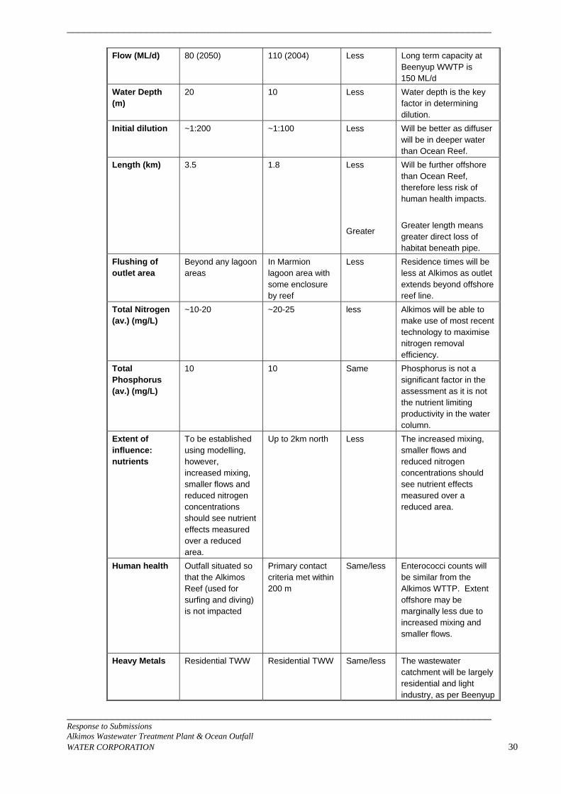
___________________________________________________________________________
___________________________________________________________________________ Response to Submissions Alkimos Wastewater Treatment Plant & Ocean Outfall WATER CORPORATION 30
Flow (ML/d) 80 (2050) 110 (2004) Less Long term capacity at Beenyup WWTP is 150 ML/d
Water Depth (m)
20 10 Less Water depth is the key factor in determining dilution.
Initial dilution ~1:200 ~1:100 Less Will be better as diffuser will be in deeper water than Ocean Reef.
Length (km) 3.5 1.8 Less Greater
Will be further offshore than Ocean Reef, therefore less risk of human health impacts. Greater length means greater direct loss of habitat beneath pipe.
Flushing of outlet area
Beyond any lagoon areas
In Marmion lagoon area with some enclosure by reef
Less Residence times will be less at Alkimos as outlet extends beyond offshore reef line.
Total Nitrogen (av.) (mg/L)
~10-20 ~20-25 less Alkimos will be able to make use of most recent technology to maximise nitrogen removal efficiency.
Total Phosphorus (av.) (mg/L)
10 10 Same Phosphorus is not a significant factor in the assessment as it is not the nutrient limiting productivity in the water column.
Extent of influence: nutrients
To be established using modelling, however, increased mixing, smaller flows and reduced nitrogen concentrations should see nutrient effects measured over a reduced area.
Up to 2km north Less The increased mixing, smaller flows and reduced nitrogen concentrations should see nutrient effects measured over a reduced area.
Human health Outfall situated so that the Alkimos Reef (used for surfing and diving) is not impacted
Primary contact criteria met within 200 m
Same/less Enterococci counts will be similar from the Alkimos WTTP. Extent offshore may be marginally less due to increased mixing and smaller flows.
Heavy Metals Residential TWW Residential TWW Same/less The wastewater catchment will be largely residential and light industry, as per Beenyup
___________________________________________________________________________
___________________________________________________________________________ Response to Submissions Alkimos Wastewater Treatment Plant & Ocean Outfall WATER CORPORATION 31
WWWTP. Ecotox and sediment testing at Beenyup has shown that there are no issues with contaminants. Higher initial dilution and lower flows should mean lower concentrations of toxicants after initial dilution.
Benthic habitat (nutrient effects)
Sand Sand/Seagrass/ low relief reef
Same/less There is no evidence to suggest any impact on benthic habitat at Beenyup. Discharge to 20 m water depth where seabed is dominated by sand coupled with higher dilution and lower flows manes a lower risk of nutrient effects on habitat.
Management Objectives
The outlet will not be located in a Marine Park.
The outlet is located in Marmion Marine Park.
Less There are additional management considerations and community perception issues associated with locating an outlet in a marine park.
3.1.7 In section 4.1.9.4, it is suggested that criteria for naturally occurring substances
in high ecological protection areas (HEPA) would generally be met when “…concentrations are equal to or less that the 80th percentile of the data distribution from a suitable reference site (in this case background water quality) for at least 50% of the time”. Please clarify (Submission 14).
A. The document “Perth’s Coastal Waters: Environmental Values and Objectives” (EPA
2000) notionally put forward that the majority of Perth’s Coastal Waters should be managed to meet a High Level of Ecological Protection (E2). The EPA’s 2005 document “Environmental Quality Criteria Reference Document for Cockburn Sound (2003 – 2004)”, states that:
“For nutrients and physical stressors (e.g. dissolved oxygen, light attenuation coefficient, temperature, salinity and pH) the approach for high ecological protection areas is to compare the median of the test site data with the 20th and/or 80th percentiles (depending upon the stressor under consideration) of an equivalent reference distribution, or with the default guideline trigger values provided in this document.”
In this case, median (50%ile) concentrations were compared to the 80%ile.
3.1.8 The proposal presented in the PER includes a low ecological protection area
(LEPA) about the outfall and is therefore not consistent with the EQOs established for waters in the vicinity of Alkimos (Submission 14).
___________________________________________________________________________
___________________________________________________________________________ Response to Submissions Alkimos Wastewater Treatment Plant & Ocean Outfall WATER CORPORATION 32
The SWQMS Document 6 states that when a proposal involving a LEPA is submitted to the EPA for assessment, the proponent would need to demonstrate the need for a mixing zone. The proponent would also need to give reasons why it should not be seen as a method of discharging inadequately treated wastewater to the environment. Further work is required in these areas (Submission 14).
A. The proposal requires the modification of the notional EQOs for the region. This is a
fundamental requirement for development in Western Australia. The aim of the SWQMS Document 6 was not to put all future marine developments off limits, e.g.
“There is a tendency among some to automatically assume that the highest level of protection should be applied to areas that are deemed pristine. Unless a pristine area is deemed to have a high conservation and/or high ecological value, such an assumption should not be made automatically. If that assumption were correct, the ramification would be that most of WA’s pristine coastline would be potentially quarantined from most anthropogenic activities. The corollary of this is that some areas that are already disturbed but have very high conservation and/or ecological value may not be given the appropriate level of protection.” (pp10-11)
In the EPA’s 2000 working document, “Perth’s Coastal Waters: Environmental Values and Objectives”, it was put forward that the broad objective for Perth’s coastal waters is that they should be managed to meet an EQO of “High Ecological Protection”. There was some allowance for existing outlets through the depiction of notional mixing zones by the EPASU (which were not subject to the same public discussion process), however there was no discussion regarding the process for establishing future mixing zones. The EPA 2000 document was deliberately titled ‘A working document’ to acknowledge the additional work required. As such, the statement that all of Perth’s Coastal Waters outside of the EPA’s notional mixing zones have been “established” as “High Ecological Protection” areas is premature.
It is not best practice when undertaking ocean disposal to reduce contaminant, nutrient and bacterial levels to the extent that a mixing zone is not required. Best practice is to use the process of initial dilution to demonstrate lack of environmental harm at the edge of defined mixing zones. Should there be no mixing zone allowed there would be an excessive dollar, energy and greenhouse cost in treatment for no environmental gain.
The role of the Water Corporation is to ensure that the ecosystem is not compromised through the implementation of its proposal and that any mixing zone required is kept to the minimum size needed. To do this, treated wastewater will be treated to maximize nitrogen removal, however best practice yields results of approximately 5 mg/L (mostly as nitrate-N), which is still more than two orders of magnitude greater that background levels in the ocean. The proposal will reduce nitrogen to the maximum extent that is practical, given the carbon source available.
The Water Corporation has undertaken the studies underpinning the PER to ensure that areas of high marine conservation value will not be impacted. The operation of an ocean outlet for the public good requires the definition of a mixing zone. The Water Corporation has sought to establish the zone in an area where there will be no adverse ecological impact and such that the size of the zone is minimised.
3.1.9 The proponent’s conclusion that there is no need to define zones about the
outfall where social objectives related to seafood safe for human consumption and primary contact recreation, because these activities do not occur in the vicinity of the proposed outlet is not backed up by justification or data (Submission 14).
___________________________________________________________________________
___________________________________________________________________________ Response to Submissions Alkimos Wastewater Treatment Plant & Ocean Outfall WATER CORPORATION 33
A. The relevant policy is contained in the NHMRC’s 2005 document “Guidelines for Managing Risks in Recreational Water”.
In this, recreational activities are classified by the degree of water contact as follows:
1. Whole-body contact (primary contact) — activity in which the whole body or the
face and trunk are frequently immersed or the face is frequently wetted by spray, and where it is likely that some water will be swallowed or inhaled, or come into contact with ears, nasal passages, mucous membranes or cuts in the skin (e.g. swimming, diving, surfing or whitewater canoeing).
2. Incidental contact (secondary contact) — activity in which only the limbs are regularly wetted and in which greater contact (including swallowing water) is unusual (e.g. boating, fishing, wading), and including occasional and inadvertent immersion through slipping or being swept into the water by a wave.
3. No contact (aesthetic uses) — activity in which there is normally no contact with water (e.g. angling from shore), or where water is incidental to the activity (such as sunbathing on a beach).
Sanitary Inspections (combined with microbial assessment), are recommended in the Guidelines for Recreational Water Managers (RWM’s), to classify designated recreational water bodies. The inspections require performing risk analysis on influences such as ocean outlets, drains, pump stations, etc.
Sewage-related risk arises from the likelihood of pollution and (where pollution occurs) the degree of inactivation through treatment. Sewage discharges, or outfalls, may be classified into three principal types: • those where discharge is directly onto the beach (above low-water level and
intertidal areas); • those where discharge is through ‘short’ outfalls (discharge is into the water but
sewage-polluted water is likely to contaminate the recreational water area); • those where discharge is through ‘long deepwater’ outfalls (sewage is diluted and
dispersed, and the design criteria for the outfall ensure that sewage is unlikely to pollute recreational water areas).
Direct discharge of crude, untreated sewage (e.g. through short outfalls that carry a mixture of raw sewage and stormwater) into recreational areas presents a serious risk to public health. The Guidelines (Table 5.10 on p84) provide a risk rating of “low” for the probability of sewage reaching designated recreational waters from effective ocean outlets with secondary treated wastewater. The closest recreational activity to the proposed ocean outlet location occurs on the Alkimos Reef (surfing and diving). The modelling work found that there would be no exceedence of primary contact human health criteria at Alkimos Reef.
3.1.10 The Wastewater 2040 strategy said that the volume of wastewater discharged to
Perth’s coastal waters could treble within 50 years. Further attention should be given to the implications of increased ocean disposal of wastewater. It represents a waste of water and nutrients that could be used to meet the needs of growing population. It may also harm the marine environments the load of pollutants increase (Submission 10).
A. A Refer sections in PER on reuse, and sections on marine impacts. The Water Corporation is putting significant effort into increasing reuse in the Perth
Metro area. The Water Corporation disagrees with this assertion which infers that the discharge of
highly treated wastewater to the marine environment is somehow bad and

___________________________________________________________________________
___________________________________________________________________________ Response to Submissions Alkimos Wastewater Treatment Plant & Ocean Outfall WATER CORPORATION 34
unacceptable. The purpose of this PER process is to assess the effects of ocean discharge on the marine environment and determine the parameters that are acceptable for such a practice to be permitted. The Water Corporation has a long and successful history of such practices, with no unacceptable deleterious effects on the seabed.
3.1.11 Perth’s wastewater strategy was drawn up 10 years ago it deserves a review
given pressure on water resources and the government’s recent commitment to increase wastewater use (20% by 2012) (Submission 2,7).
A. Wastewater 2040 Strategy provides a broad framework for the wastewater system
and the Water Corporation direction is based on it together with recent changes in the wider external environment such as the State Water Strategy.
It is intended to update Wastewater 2040 in 2007. The Water Corporation is working towards the targets in the State Water Strategy and reuse of treated wastewater has now reached 14%.
3.1.12 One issue not addressed in the PER is the discharge of endocrine disruptors into the marine environment. Endocrine disruptors can affect sexual development and reproduction, with impacts on aquatic fauna documented overseas. The Water Corporation should assess the load and impact of endocrine disruptors emitted to the environment through ocean disposal of treated wastewater (Submission 10).
A. The effect of endocrine disruptors in industrial and sewage effluents has become a
recent focus of attention. Endocrine disruption has been attributed to: • some persistent organochlorines (PCBs, dioxins, DDT, chlorophenols and some
pesticides), • nonyl phenol ethoxylates, • nonyl phenol (a breakdown product of industrial detergents), • phthalate esters, • phytoestrogens and • pulp mill effluent.
Some metals/metalloids (arsenic, cadmium, lead, mercury) and PAHs are also suspected endocrine disruptors. The majority of significant endocrine disruption effects reported in the literature involve the discharge of wastewater into rivers or estuaries, especially when the discharge is a large proportion of stream flow.
Research indicates the majority of endocrine disrupting activity in domestic treated wastewater is due to natural estrogens (e.g. estradiol and estrone), synthetic estrogens (used in birth control and hormone replacement prescriptions) and natural androgens (e.g. testosterone) or their breakdown products, unless a large proportion of industrial treated wastewater is present. Secondary treatment of domestic sewage using an activated sludge process removes the majority of estrogenic and androgenic activity in treated wastewater. Endocrine disruptors are not considered an environmental risk in Perth’s coastal waters as treated wastewater from the Beenyup, Subiaco and Woodman Point WWTPs has undergone secondary treatment using an activated sludge process, contains a small proportion of industrial treated wastewater, and is discharged well offshore into a well mixed marine environment (refer Perth Long-Term Ocean Outlet Monitoring Programme (2001/02): Treatsed Wastewater Characterisation. DAL Science & Engineering, October 2002).
3.1.13 The lack of recent public review of wastewater management options is a source
of concern during the review period for the PER (Submission 10).
___________________________________________________________________________
___________________________________________________________________________ Response to Submissions Alkimos Wastewater Treatment Plant & Ocean Outfall WATER CORPORATION 35
A. The Water Corporation has conducted extensive public consultation and engagement
regarding the AWWTP project, as evidenced in Section 5 of the PER.
Also, as a key stakeholder in the process, the Water Corporation has participated in a wide community consultation regarding treated wastewater re-use that was undertaken by the EPA and reported in Bulletin 1199 Section 16 Advice – Manage Aquifer Recharge using Treated Wastewater on the Swan Coastal Plain of 2005. Section 2.2.3 of the PER describes some of the re-use options considered by the Water Corporation during these processes.
3.1.14 The Water Corp put the blame on why the water has to be discharged and not
reused on the Health Department and others. This conflict between departments needs to be resolved and a whole of government approach adopted to review best practise and set more realistic guidelines for use of treated wastewater (Submission 4).
A The Water Corporation supports the precautionary approach taken by the regulators.
There is no blame involved. The requirements in terms of protection of public health is the responsibility of the Department of Health. The Water Corporation has no problems with the requirements set and is prepared to work within these. It should be noted that one of the most profound measures taken over the last millennium to protect public health was to separate water supply from waste discharge. The re-connection of this fundamental cycle needs to be undertaken with caution.
Given Western Australia’s high reliance on groundwater as a potable water supply, a high degree of certainty is justifiably required by the Health Department and government before community “social licence” can be obtained. This will require revision and change of existing policies, scientific studies to relevant government agencies satisfaction, subsequent social acceptance and political will to implement.
3.1.15 The PER describes alternatives to ocean discharge, including managed aquifer
recharge and irrigation however the alternatives are considered to be unfeasible or unacceptable to the proponent. This conclusion would need to be demonstrated to the satisfaction of the EPA and shown that it is consistent with Government policy and objectives. Where this is the case, under the SWQMS Document 6, the proponent is expected to demonstrate that discharge of wastewater would not impact on the EVs and EQOs established for the receiving environment (Submission 14).
A. The proposal requires the modification of the notional EQOs for the region. This is a
fundamental requirement for development in Western Australia. The aim of the SWQMS Document 6 was not to put all future marine developments off limits, e.g.
“There is a tendency among some to automatically assume that the highest level of protection should be applied to areas that are deemed pristine. Unless a pristine area is deemed to have a high conservation and/or high ecological value, such an assumption should not be made automatically. If that assumption were correct, the ramification would be that most of WA’s pristine coastline would be potentially quarantined from most anthropogenic activities. The corollary of this is that some areas that are already disturbed but have very high conservation and/or ecological value may not be given the appropriate level of protection.” (pp10-11)
In the EPA’s 2000 working document, “Perth’s Coastal Waters: Environmental Values and Objectives”, it was put forward that the broad objective for Perth’s coastal waters is that they should be managed to meet an EQO of “High Ecological Protection”. There was some allowance for existing outlets through the depiction of notional mixing zones by the EPASU (which were not subject to the same public discussion
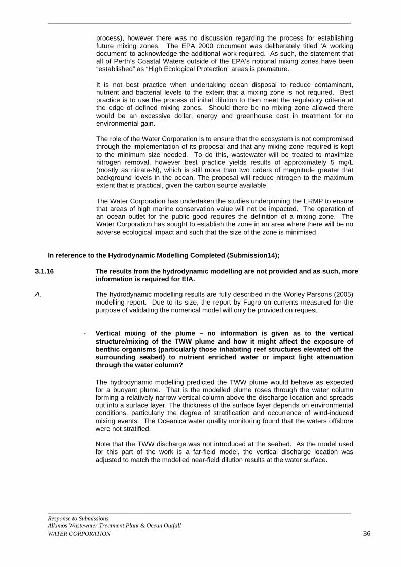
___________________________________________________________________________
___________________________________________________________________________ Response to Submissions Alkimos Wastewater Treatment Plant & Ocean Outfall WATER CORPORATION 36
process), however there was no discussion regarding the process for establishing future mixing zones. The EPA 2000 document was deliberately titled ‘A working document’ to acknowledge the additional work required. As such, the statement that all of Perth’s Coastal Waters outside of the EPA’s notional mixing zones have been “established” as “High Ecological Protection” areas is premature.
It is not best practice when undertaking ocean disposal to reduce contaminant, nutrient and bacterial levels to the extent that a mixing zone is not required. Best practice is to use the process of initial dilution to then meet the regulatory criteria at the edge of defined mixing zones. Should there be no mixing zone allowed there would be an excessive dollar, energy and greenhouse cost in treatment for no environmental gain.
The role of the Water Corporation is to ensure that the ecosystem is not compromised through the implementation of its proposal and that any mixing zone required is kept to the minimum size needed. To do this, wastewater will be treated to maximize nitrogen removal, however best practice yields results of approximately 5 mg/L (mostly as nitrate-N), which is still more than two orders of magnitude greater that background levels in the ocean. The proposal will reduce nitrogen to the maximum extent that is practical, given the carbon source available.
The Water Corporation has undertaken the studies underpinning the ERMP to ensure that areas of high marine conservation value will not be impacted. The operation of an ocean outlet for the public good requires the definition of a mixing zone. The Water Corporation has sought to establish the zone in an area where there will be no adverse ecological impact and such that the size of the zone is minimised.
In reference to the Hydrodynamic Modelling Completed (Submission14);
3.1.16 The results from the hydrodynamic modelling are not provided and as such, more information is required for EIA.
A. The hydrodynamic modelling results are fully described in the Worley Parsons (2005)
modelling report. Due to its size, the report by Fugro on currents measured for the purpose of validating the numerical model will only be provided on request.
- Vertical mixing of the plume – no information is given as to the vertical structure/mixing of the TWW plume and how it might affect the exposure of benthic organisms (particularly those inhabiting reef structures elevated off the surrounding seabed) to nutrient enriched water or impact light attenuation through the water column?
The hydrodynamic modelling predicted the TWW plume would behave as expected for a buoyant plume. That is the modelled plume roses through the water column forming a relatively narrow vertical column above the discharge location and spreads out into a surface layer. The thickness of the surface layer depends on environmental conditions, particularly the degree of stratification and occurrence of wind-induced mixing events. The Oceanica water quality monitoring found that the waters offshore were not stratified.
Note that the TWW discharge was not introduced at the seabed. As the model used for this part of the work is a far-field model, the vertical discharge location was adjusted to match the modelled near-field dilution results at the water surface.
___________________________________________________________________________
Figure 1. Vertical slice through diffuser discharge, orientated along shore, showing plume confined to surface layers
Under calm or low wind conditions, the fresh treated wastewater plume will rise to the surface (undergoing significant dilution as it rises) and then be dispersed in the surface waters. Under stronger wind conditions, the plume will be rapidly mixed in the water column and will not reach the water surface. The numerical modelling examined the potential for the plume to reach nearby reefs. The reason for the longer (3.5 km) outlet configuration being selected was to minimise the risk of the plume reaching the nearby reefs.
- How has the farfield model been reconciled with the near field model
(unspecified) for correct nitrogen concentration and mass flux from the discharge point?
The mass flux of nitrogen was represented by a conservative tracer with a constant concentration of 100 in the TWW discharge. Consequently, the mass flux of any conservative component of the discharge, for example nitrogen, is conserved and any reductions in the tracer concentration are due to dilution. The achievement of the appropriate level of dilution in the far-field model was checked against the predicted dilutions in the near-field model by running the far field model under the same discharge and background conditions as the near-field model. The concentration of the tracer was extracted from the surface model cell containing the discharge. The position of the discharge was then adjusted vertically to ensure the dilution achieved at the surface matched the dilution predicted in the near-field modelling. In the modelled scenarios moving the discharge point vertically in the water column is an appropriate way to achieve the required surface concentration
___________________________________________________________________________ Response to Submissions Alkimos Wastewater Treatment Plant & Ocean Outfall WATER CORPORATION 37
___________________________________________________________________________
___________________________________________________________________________ Response to Submissions Alkimos Wastewater Treatment Plant & Ocean Outfall WATER CORPORATION 38
because the total mass flux into the model is conserved and the discharge rapidly forms a buoyant surface plume.
- What near-field model was applied to predict initial dilutions? Please give
details of the application and results of this model.
The near-field modelling of the TWW discharge to predict initial dilutions was carried out by Consulting Environmental Engineers (CEE 2005). WorleyParsons reviewed the design using the US EPA approved model CORMIX. The Cornell Mixing Zone Expert System (CORMIX) is a software system for the analysis, prediction, and design of aqueous toxic or conventional pollutant discharges into diverse water bodies. It is a recommended analysis tool in key US EPA guidance documents on the permitting of industrial, municipal, thermal, and other point source discharges to receiving waters. The systems major emphasis is on predicting the geometry and dilution characteristics of the initial mixing zone so that compliance with water quality regulatory constraints may be judged, although it also predicts the behavior of the discharge plume over larger distances, subject to simplified oceanographic assumptions. Key features of CORMIX include prediction of the geometry and dilution characteristics of the treated wastewater flow resulting from a discharge that is:
• Of an arbitrary density (positively, neutrally, or negatively buoyant),
• In an arbitrary location with arbitrary geometry, and
• Into an ambient receiving water body that may be stagnant or flowing and have ambient density stratification of different types.
Overall, WorleyParsons found that, when modelled using the following parameters in CORMIX for the discharge density: treated wastewater density 999 kg/m3, seawater density 1025 kg/m3, and in low background currents, initial dilutions of 200 to 300:1 could be achieved with the release of the discharge in water 23 m deep. This was in agreement with the work by CEE (2005), allowing for differences between the models used by CEE and WorleyParsons.
- Justification is needed for the omission of wave pumping from the input forcings input to the model
Nearshore circulation may be driven by a number of different forces, including wind driven currents, tidal currents, wave pumping, alongshore pressure gradients etc. Given the complexity of nature, a hydrodynamic model must necessarily make some simplifications and prioritize the relative importance of different forces to create a manageable yet reliable prediction of the real world.
To identify the relative importance of input forcing a review of the general regional oceanography and near shore circulation at Alkimos was undertaken prior to hydrodynamic modelling of the proposed TWW discharge at Alkimos (WorleyParsons 2005a). The review was based on the following documents:
• Brown & Root Services Asia Pacific Pty Ltd. 2000. Perth Long-term ocean outlet monitoring (PLOOM) Programme 2000: Project M1: Hydrodynamic and Transport Modelling Final Report 1996-2000. Prepared for Water Corporation of Western Australia. Ref PE6026-DO-007, Rev.0
• Lord, D.A. and Hillman, K. 1995. Perth Coastal Waters Study Summary Report. Distributed by The Water Authority of Western Australia.
The PLOOM study characterised oceanographic conditions at Swanbourne, Woodman Pt and Ocean Reef outfalls. The conditions at Ocean Reef are likely to be
___________________________________________________________________________
___________________________________________________________________________ Response to Submissions Alkimos Wastewater Treatment Plant & Ocean Outfall WATER CORPORATION 39
more similar to the proposed outfall site at Alkimos than conditions at Swanbourne and Woodman Pt, which are both further away and dissimilar in bathymetry. In summary, the nearshore circulation at Ocean Reef was characterised as follows:
• The area experiences a complex combination of wind-forcing, tidal and wave pumping, basin seiching, long period motions and gravitational currents.
• The relative strength of the individual mechanisms varies with meteorological conditions and seasonal changes.
• Wind is the dominant forcing mechanism.
• The circulation in the lagoon is predominantly barotropic.
• During summer southerly winds dominant, while during winter the wind speed and direction are more variable.
• As winds are predominately southerly, northward currents dominate. During summer, up to 60% of the variance in the current field may be explained by the wind field.
• Wind speeds greater than 3-5 m/s are sufficient to dominate the flow dynamics.
• Tidal current speeds are only around 0.02 m/s and tidal influence is therefore negligible.
• Wave energy within the Whitfords lagoon is low due to dissipation or reflection off the reef line. Attenuation of significant wave heights by up to 40-60% have been reported.
• Baroclinic forcing on circulation is negligible as while temperature stratification occurs due to diurnal heating and cooling, the column is generally vertically mixed in temperature in the morning as a result of convective cooling and wind mixing.
Given the above characterisation of the physical environment and hydrodynamics, the key forcing likely to affect plume dispersion and transport at Alkimos appears to be variability in wind conditions. Wave pumping was not expected to be a significant forcing when compared to wind over a seasonal time scale and can therefore be excluded from the input forcings.
- Justification is needed for the omission of the longshore steric gradient as a
forcing to the model – previous work by Pattiarachi suggests that currents may be less correlated with wind in winter than in summer due to the effects of a sea level gradient associated with the Leeuwin Current. The hydrodynamic model was calibrated against currents recorded between April and the end of June, at a time when the sea level gradient associated with the Leeuwin Current is increasing. If currents were correlated to a sea level gradient rather than strongly correlated to winds, excluding the longshore gradient should have produced a consistent bias either above or below the recorded currents. This was not observed during model calibration. We would attribute this to the near shore, shallow location of the current recordings. In this type of environment it is known frictional damping reduces the impact of the sea level gradient on currents.
- Justification is required as to how the 50 x 50m model grid resolves the
patchiness of bathymetry such that the model will reliably represent the movement of water within bathymetrically complex parts of the model domain. The model bathymetry was based on hydrographic survey data supplied by the Water Corporation. This data covers only those areas with sufficient water depth for ship-
___________________________________________________________________________
___________________________________________________________________________ Response to Submissions Alkimos Wastewater Treatment Plant & Ocean Outfall WATER CORPORATION 40
based soundings. Additional digitising of unsurveyed reefs was undertaken by WorleyParsons from marine charts WA 986 and WA 1076. The area of the digitised reef features varied from approximately 3,800 m2 up to 83,000 m2, which is equivalent to between 1 and 33 of the 50 x 50 m model cells. As such, the model grid is fine enough to resolve the patchiness of the bathymetry. The reliability of the predicted movement of water within the bathymetrically complex parts of the model was assessed against current data recorded at an inner reef site. Mooring A was located approximately 1.85 km offshore between Eglinton Rocks and the -15 m contour, in a water depth of 12 m. The comparison between the measured and modelled currents at Mooring A was generally good, with mean modelled current speeds within 0.01 m/s of the measured speeds (WorleyParsons 2005). Overall, the good match between measured and modelled current speeds indicated the model was reliably representing the movement of water within bathymetrically complex parts of the model.
- Wind data – a hill top station is used – where is this station located?
Justification is required to support the assertion that wind data from the hill top station is representative of the on-water winds at standard height of 10m. No discussion is provided on page 32 of 60 in relation to the representativeness of wind direction at Swanbourne and Alkimos (only speed).
The hill top wind station named Weather Station 100 and is located at RL 30.58, 374274.90m E and 6501680.11m N (GDA94). It is located approximately 1 km inshore. WorleyParsons considers this data is the most appropriate for use in modelling as it is the closest available data to the area of interest and is relatively close to the coast. Wind data was supplied to WorleyParsons after processing for quality assurance and correction to the standard height of 10 m by the Water Corporation. Queries concerning the detail of pre-processing and quality assurance should be directed to the Water Corporation. The long-term representativeness of wind direction at Alkimos could not be directly assessed as a long-term data set is not available at the site. Consequently, to establish whether the records were likely to be representative of long term trends, analysis of 2005 data against longer term records was undertaken using data from the Bureau of Meteorology’s Swanbourne station. The analysis involved comparison of the total wind speed and direction record at Swanbourne for selected months. The analysis involved calculation of wind speed summary statistics for the modelled months, comparisons of wind roses for the modelled months and preparation of joint frequency tables for wind speed and direction for the modelled seasons. The full analysis is presented in WorleyParsons (2005). However a brief summary, including seasonal JFTs, is presented here. In general, the mean wind speed recorded for each of the months January to May 2005 is close to the mean of all months between 1999 and 2005 (ie. the mean of all Januarys compares well to the mean wind speed in January 2005). The maximum difference in mean wind speeds is 11% in the comparison of March 2005 to all March records. Therefore, it seems reasonable to assume the average wind speeds calculated for January to May 2005 are representative of the longer term average conditions. The other summary statistics also indicate the distribution of wind speed records in January to May 2005 around the mean is similar to the longer term record.
Table 1. Summary statistics for wind speed. All speeds reported in m/s Summary statistics of Wind speed (m/s)
Month Dec Dec Jan Jan Feb Feb Mar Mar Apr Apr May May
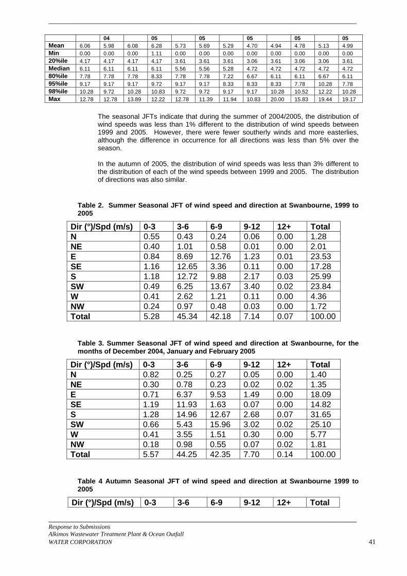
___________________________________________________________________________
___________________________________________________________________________ Response to Submissions Alkimos Wastewater Treatment Plant & Ocean Outfall WATER CORPORATION 41
04 05 05 05 05 05 Mean 6.06 5.98 6.08 6.28 5.73 5.69 5.29 4.70 4.94 4.78 5.13 4.99 Min 0.00 0.00 0.00 1.11 0.00 0.00 0.00 0.00 0.00 0.00 0.00 0.00 20%ile 4.17 4.17 4.17 4.17 3.61 3.61 3.61 3.06 3.61 3.06 3.06 3.61 Median 6.11 6.11 6.11 6.11 5.56 5.56 5.28 4.72 4.72 4.72 4.72 4.72 80%ile 7.78 7.78 7.78 8.33 7.78 7.78 7.22 6.67 6.11 6.11 6.67 6.11 95%ile 9.17 9.17 9.17 9.72 9.17 9.17 8.33 8.33 8.33 7.78 10.28 7.78 98%ile 10.28 9.72 10.28 10.83 9.72 9.72 9.17 9.17 10.28 10.52 12.22 10.28 Max 12.78 12.78 13.89 12.22 12.78 11.39 11.94 10.83 20.00 15.83 19.44 19.17
The seasonal JFTs indicate that during the summer of 2004/2005, the distribution of wind speeds was less than 1% different to the distribution of wind speeds between 1999 and 2005. However, there were fewer southerly winds and more easterlies, although the difference in occurrence for all directions was less than 5% over the season. In the autumn of 2005, the distribution of wind speeds was less than 3% different to the distribution of each of the wind speeds between 1999 and 2005. The distribution of directions was also similar.
Table 2. Summer Seasonal JFT of wind speed and direction at Swanbourne, 1999 to 2005
Dir (°)/Spd (m/s) 0-3 3-6 6-9 9-12 12+ Total N 0.55 0.43 0.24 0.06 0.00 1.28 NE 0.40 1.01 0.58 0.01 0.00 2.01 E 0.84 8.69 12.76 1.23 0.01 23.53 SE 1.16 12.65 3.36 0.11 0.00 17.28 S 1.18 12.72 9.88 2.17 0.03 25.99 SW 0.49 6.25 13.67 3.40 0.02 23.84 W 0.41 2.62 1.21 0.11 0.00 4.36 NW 0.24 0.97 0.48 0.03 0.00 1.72 Total 5.28 45.34 42.18 7.14 0.07 100.00
Table 3. Summer Seasonal JFT of wind speed and direction at Swanbourne, for the months of December 2004, January and February 2005
Dir (°)/Spd (m/s) 0-3 3-6 6-9 9-12 12+ Total N 0.82 0.25 0.27 0.05 0.00 1.40 NE 0.30 0.78 0.23 0.02 0.02 1.35 E 0.71 6.37 9.53 1.49 0.00 18.09 SE 1.19 11.93 1.63 0.07 0.00 14.82 S 1.28 14.96 12.67 2.68 0.07 31.65 SW 0.66 5.43 15.96 3.02 0.02 25.10 W 0.41 3.55 1.51 0.30 0.00 5.77 NW 0.18 0.98 0.55 0.07 0.02 1.81 Total 5.57 44.25 42.35 7.70 0.14 100.00
Table 4 Autumn Seasonal JFT of wind speed and direction at Swanbourne 1999 to 2005
Dir (°)/Spd (m/s) 0-3 3-6 6-9 9-12 12+ Total
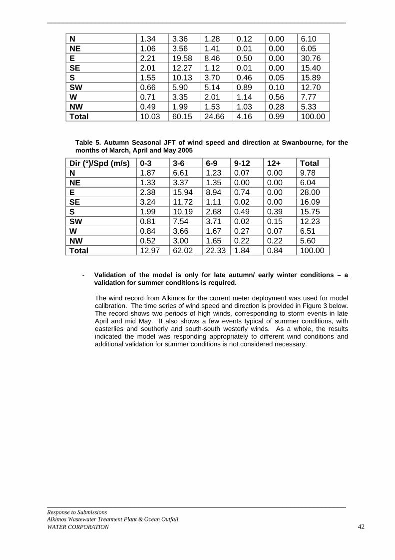
___________________________________________________________________________
___________________________________________________________________________ Response to Submissions Alkimos Wastewater Treatment Plant & Ocean Outfall WATER CORPORATION 42
N 1.34 3.36 1.28 0.12 0.00 6.10 NE 1.06 3.56 1.41 0.01 0.00 6.05 E 2.21 19.58 8.46 0.50 0.00 30.76 SE 2.01 12.27 1.12 0.01 0.00 15.40 S 1.55 10.13 3.70 0.46 0.05 15.89 SW 0.66 5.90 5.14 0.89 0.10 12.70 W 0.71 3.35 2.01 1.14 0.56 7.77 NW 0.49 1.99 1.53 1.03 0.28 5.33 Total 10.03 60.15 24.66 4.16 0.99 100.00
Table 5. Autumn Seasonal JFT of wind speed and direction at Swanbourne, for the months of March, April and May 2005
Dir (°)/Spd (m/s) 0-3 3-6 6-9 9-12 12+ Total N 1.87 6.61 1.23 0.07 0.00 9.78 NE 1.33 3.37 1.35 0.00 0.00 6.04 E 2.38 15.94 8.94 0.74 0.00 28.00 SE 3.24 11.72 1.11 0.02 0.00 16.09 S 1.99 10.19 2.68 0.49 0.39 15.75 SW 0.81 7.54 3.71 0.02 0.15 12.23 W 0.84 3.66 1.67 0.27 0.07 6.51 NW 0.52 3.00 1.65 0.22 0.22 5.60 Total 12.97 62.02 22.33 1.84 0.84 100.00
- Validation of the model is only for late autumn/ early winter conditions – a validation for summer conditions is required.
The wind record from Alkimos for the current meter deployment was used for model calibration. The time series of wind speed and direction is provided in Figure 3 below. The record shows two periods of high winds, corresponding to storm events in late April and mid May. It also shows a few events typical of summer conditions, with easterlies and southerly and south-south westerly winds. As a whole, the results indicated the model was responding appropriately to different wind conditions and additional validation for summer conditions is not considered necessary.
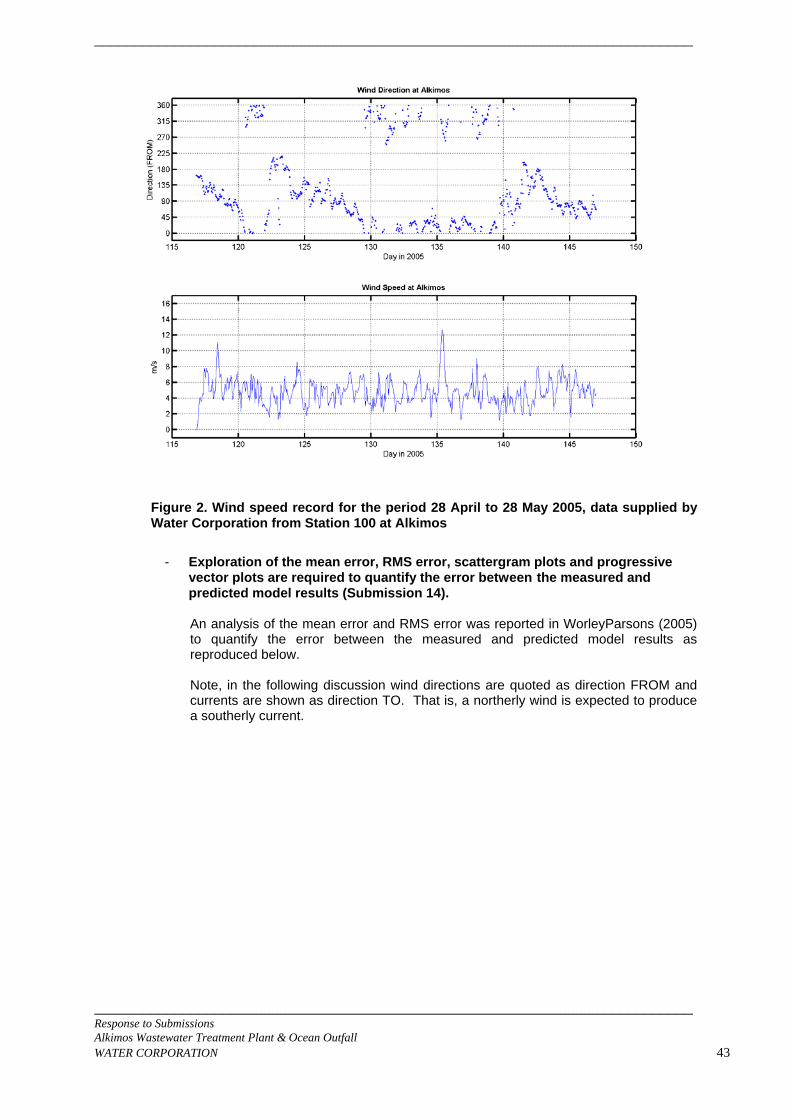
___________________________________________________________________________
Figure 2. Wind speed record for the period 28 April to 28 May 2005, data supplied by Water Corporation from Station 100 at Alkimos
- Exploration of the mean error, RMS error, scattergram plots and progressive
vector plots are required to quantify the error between the measured and predicted model results (Submission 14). An analysis of the mean error and RMS error was reported in WorleyParsons (2005) to quantify the error between the measured and predicted model results as reproduced below. Note, in the following discussion wind directions are quoted as direction FROM and currents are shown as direction TO. That is, a northerly wind is expected to produce a southerly current.
___________________________________________________________________________ Response to Submissions Alkimos Wastewater Treatment Plant & Ocean Outfall WATER CORPORATION 43
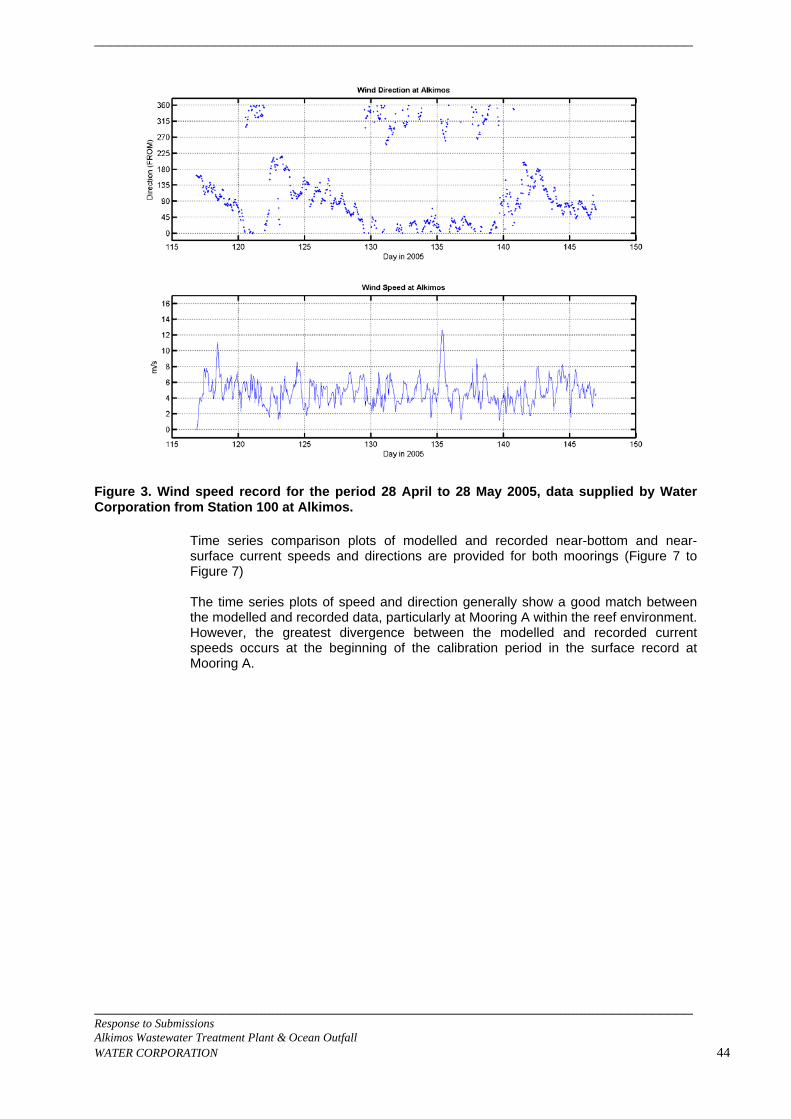
___________________________________________________________________________
Figure 3. Wind speed record for the period 28 April to 28 May 2005, data supplied by Water Corporation from Station 100 at Alkimos.
Time series comparison plots of modelled and recorded near-bottom and near-surface current speeds and directions are provided for both moorings (Figure 7 to Figure 7) The time series plots of speed and direction generally show a good match between the modelled and recorded data, particularly at Mooring A within the reef environment. However, the greatest divergence between the modelled and recorded current speeds occurs at the beginning of the calibration period in the surface record at Mooring A.
___________________________________________________________________________ Response to Submissions Alkimos Wastewater Treatment Plant & Ocean Outfall WATER CORPORATION 44
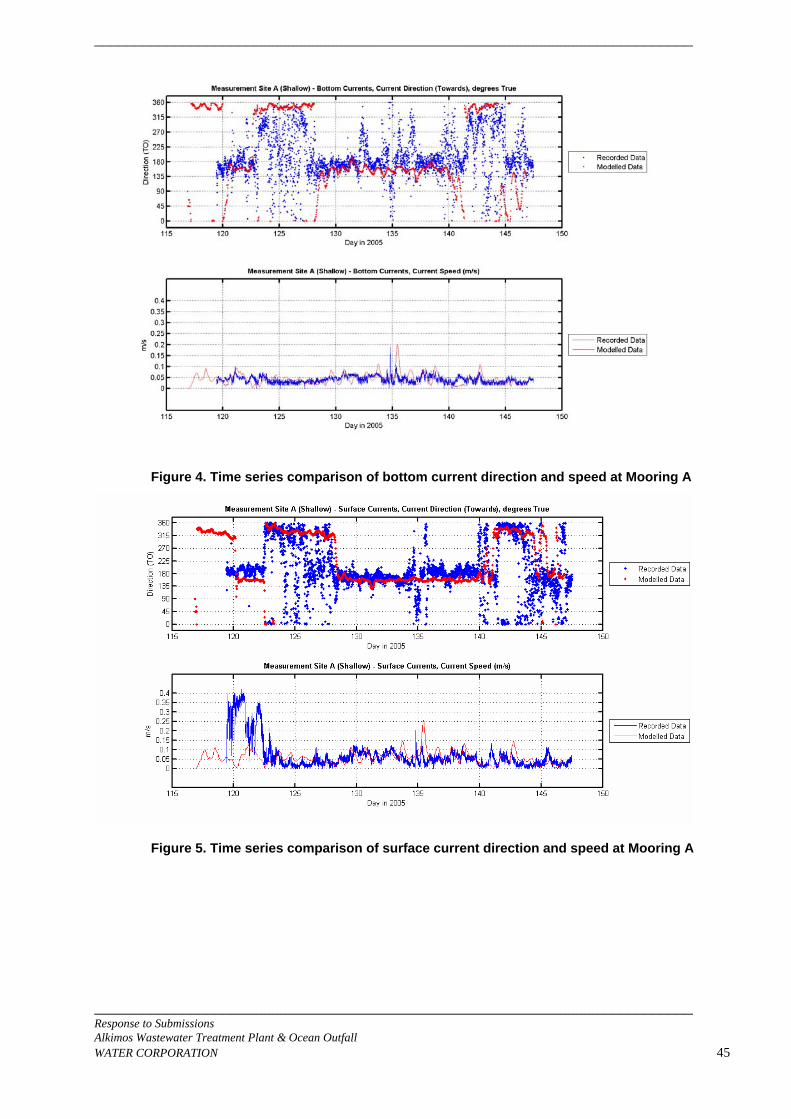
___________________________________________________________________________
Figure 4. Time series comparison of bottom current direction and speed at Mooring A
Figure 5. Time series comparison of surface current direction and speed at Mooring A
___________________________________________________________________________ Response to Submissions Alkimos Wastewater Treatment Plant & Ocean Outfall WATER CORPORATION 45
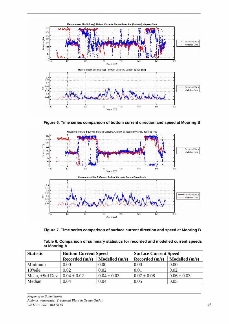
___________________________________________________________________________
Figure 6. Time series comparison of bottom current direction and speed at Mooring B
Figure 7. Time series comparison of surface current direction and speed at Mooring B
Table 6. Comparison of summary statistics for recorded and modelled current speeds at Mooring A
Bottom Current Speed Surface Current Speed Statistic Recorded (m/s) Modelled (m/s) Recorded (m/s) Modelled (m/s)
Minimum 0.00 0.00 0.00 0.00 10%ile 0.02 0.02 0.01 0.02 Mean, ±Std Dev 0.04 ± 0.02 0.04 ± 0.03 0.07 ± 0.08 0.06 ± 0.03 Median 0.04 0.04 0.05 0.05
___________________________________________________________________________ Response to Submissions Alkimos Wastewater Treatment Plant & Ocean Outfall WATER CORPORATION 46
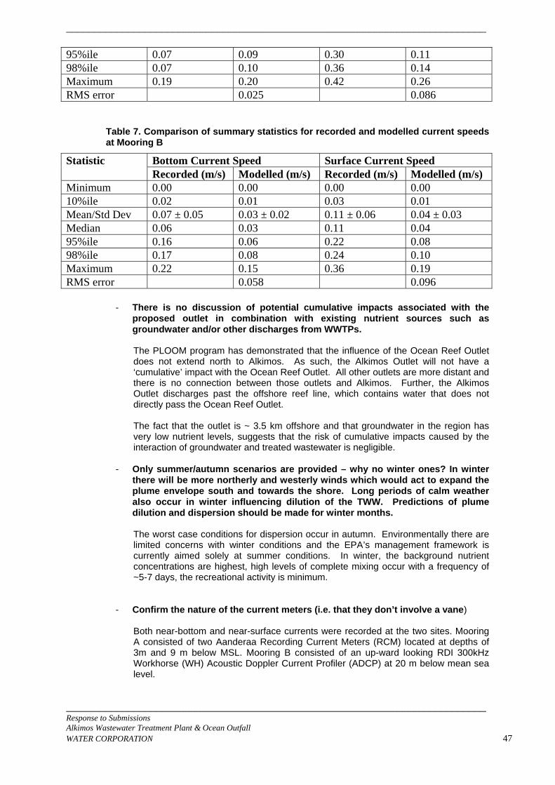
___________________________________________________________________________
___________________________________________________________________________ Response to Submissions Alkimos Wastewater Treatment Plant & Ocean Outfall WATER CORPORATION 47
95%ile 0.07 0.09 0.30 0.11 98%ile 0.07 0.10 0.36 0.14 Maximum 0.19 0.20 0.42 0.26 RMS error 0.025 0.086
Table 7. Comparison of summary statistics for recorded and modelled current speeds at Mooring B
Bottom Current Speed Surface Current Speed Statistic Recorded (m/s) Modelled (m/s) Recorded (m/s) Modelled (m/s)
Minimum 0.00 0.00 0.00 0.00 10%ile 0.02 0.01 0.03 0.01 Mean/Std Dev 0.07 ± 0.05 0.03 ± 0.02 0.11 ± 0.06 0.04 ± 0.03 Median 0.06 0.03 0.11 0.04 95%ile 0.16 0.06 0.22 0.08 98%ile 0.17 0.08 0.24 0.10 Maximum 0.22 0.15 0.36 0.19 RMS error 0.058 0.096
- There is no discussion of potential cumulative impacts associated with the proposed outlet in combination with existing nutrient sources such as groundwater and/or other discharges from WWTPs. The PLOOM program has demonstrated that the influence of the Ocean Reef Outlet does not extend north to Alkimos. As such, the Alkimos Outlet will not have a ‘cumulative’ impact with the Ocean Reef Outlet. All other outlets are more distant and there is no connection between those outlets and Alkimos. Further, the Alkimos Outlet discharges past the offshore reef line, which contains water that does not directly pass the Ocean Reef Outlet. The fact that the outlet is ~ 3.5 km offshore and that groundwater in the region has very low nutrient levels, suggests that the risk of cumulative impacts caused by the interaction of groundwater and treated wastewater is negligible.
- Only summer/autumn scenarios are provided – why no winter ones? In winter there will be more northerly and westerly winds which would act to expand the plume envelope south and towards the shore. Long periods of calm weather also occur in winter influencing dilution of the TWW. Predictions of plume dilution and dispersion should be made for winter months. The worst case conditions for dispersion occur in autumn. Environmentally there are limited concerns with winter conditions and the EPA’s management framework is currently aimed solely at summer conditions. In winter, the background nutrient concentrations are highest, high levels of complete mixing occur with a frequency of ~5-7 days, the recreational activity is minimum.
- Confirm the nature of the current meters (i.e. that they don’t involve a vane) Both near-bottom and near-surface currents were recorded at the two sites. Mooring A consisted of two Aanderaa Recording Current Meters (RCM) located at depths of 3m and 9 m below MSL. Mooring B consisted of an up-ward looking RDI 300kHz Workhorse (WH) Acoustic Doppler Current Profiler (ADCP) at 20 m below mean sea level.
___________________________________________________________________________
___________________________________________________________________________ Response to Submissions Alkimos Wastewater Treatment Plant & Ocean Outfall WATER CORPORATION 48
The near-field modelling was carried out by CEE using a merging plume model that has been published in peer- reviewed journals and verified by comparison of the predicted dilution with the measured dilution for several actual outfalls.
3.2 Odour 3.2.1 Site B poses greater risk of odour problems for future residents. The proposed
odour channel is unproven and may require clearing of coastal dunes (Submission 2, 7).
A. The use of an odour channel to mitigate and control odour impacts generated by the
ponding phenomenon is purely hypothetical at this stage. However the increased risk can be managed by increasing the buffer, as is proposed. In future, if an odour channel is proven beyond doubt to be technically viable and environmentally acceptable, it may be possible to relax the 800m buffer required to the west and north-west to 600m.
3.2.2 Despite the wider buffer on the western end of the Site B, this option poses
greater risk of odour problems if urban development is allowed between the coast and the WWTP site. The proposed odour channel is unproven and if not effective might require clearing of coastal dunes in the future (Submission 3).
A. The use of an odour channel to mitigate and control odour impacts generated by the
ponding phenomenon is purely hypothetical at this stage.The increased risk can be managed by increasing the buffer, as is proposed. It is correct that an odour channel, if implemented, will require clearing of high value vegetation.
3.2.3 In the case of Alkimos, a major road regional center is proposed quite near to the WWTP and it is particularly important that this center is not subject to odours from the WWTP (Submission 13).
A. The Water Corporation agrees that sensitive land uses should be segregated from the
odour sources, hence the proposition for an odour buffer of 600m at Site A and 600m with 800m to the west and north west at Site B.
3.2.4 The Water Corporation regards the buffer zone as ’a community asset’ and therefore it would be appropriate for the city to strive to create a green hub accommodating a variety of important social and environmental features (Submission 8).
A. The Water Corporation has explored a range of compatible land uses it could offer for
use within the buffer zone. However, the final “community asset” opportunities available will depend on the amount of land remaining after the EPA’s conservation objectives have been met.
3.2.5 The Site B option appears to expose more proposed houses, businesses,
social and cultural uses to a rather inadequate odour buffer area. This would require the government to spend more on odour control to limit exposure to odour across a wide area of the metropolis. Increased costs the public are currently unwilling to outlay through taxation, when the issue can be solved through correct sitting in the first instance (Submission 5).
A. It is true that Site B exposes more odour sensitive premises to the west; however the
increased risk can be managed within the 800m buffer, as is proposed.
___________________________________________________________________________
___________________________________________________________________________ Response to Submissions Alkimos Wastewater Treatment Plant & Ocean Outfall WATER CORPORATION 49
3.2.6 Site A will expose fewer humans to potential odour issues while preserving full
access to the coast for the many, rather than a few rich elites. Access to biodiversity and geoheritage is a question of intergenerational equity; it is the responsibility of those present to preserve precious assets for the next generations (Submission 5).
A. Intergenerational equity is one of the objects of the Environmental Protection Act. A
multi-criteria analysis incorporating environmental impacts, social benefit and capital and future enconomics forms the basis of a sustainability assessment. The Water Corporation has undertaken a sustainability comparison between Site A and Site B in Table 4.1 of the PER.
The Water Corporation can not comment on lifestyle values.
3.2.7 It is noted that some documentation within the PER cites weather data from
Perth Airport, for odour management purposes, which is much further inland and subject to wind shear disturbances from the Darling Scarp. It is essential that appropriate meteorological data is input to any modelling of odour behaviour for the WWTP. If the Water Corporation's on-site stations cannot provide a sufficiently long period of records, a site with similar coastal influences to Alkimos should be utilised as a data source (Submission 13).
A. All odour modelling for the proposed Alkimos treatment plant used winds and
meteorological data measured at two sites at Alkimos. No data from Perth airport was used.
3.2.8 Should modelling suggest that a buffer of 600 metres may not be adequate, there is limited flexibility in the planning for land uses beyond the 600 metre notational buffer. Consequently, the Water Corporation will need to manage odours to comply with the 600-metre buffer (Submission 13).
A. A 600m buffer is required for site A. A larger buffer of 800m to the west and North
West is required for site B. Water Corporation is confident that it can manage odours within these buffer zones. It is agreed that, once this buffer is set, the Water Corp will have to manage within this constraint.
3.2.9 The proposed buffer for Site B, including the 800m component, may be
appropriate, although that has not been demonstrated either for the existing basin or an excavated basin. The 800-metre distance is an educated guess, which Water Corporation should be required to accept responsibility for (Submission 14).
A. Water Corporation will accept the responsibility for managing its operations within the
600m buffer (800m to the west and north-west), subject to securing the proposed distances.
3.2.10 The likely success of an odour channel from Site B is unknown (not modelled to date). Short-term odour events (10 to 20 minutes) may be an issue if ponding in an excavated basin is not adequately mitigated by a channel (Submission 14).
A. The use of an odour channel to mitigate and control odour impacts generated by the
ponding phenomenon is purely hypothetical at this stage. The Water Corporation is not currently proposing an odour channel, although such an option has been
___________________________________________________________________________
___________________________________________________________________________ Response to Submissions Alkimos Wastewater Treatment Plant & Ocean Outfall WATER CORPORATION 50
discussed. It is a possible future addition that may be able to reduce the odour buffer at site B from 800m in the west and north-west to 600m.
3.2.11 The rationale behind site B is making coastal land available for residential development, however any residents may be at risk of exposure to odour given uncertainties over ponding and the odour channel idea. The wind data used in the modelling was not obtained from the Alkimos area (Submission 10).
A. All odour modelling for the proposed Alkimos treatment plant used winds and
meteorological data measured at two sites at Alkimos. The use of an odour channel to mitigate and control odour impacts generated by the ponding phenomenon is purely hypothetical at this stage. The Water Corporation is not currently proposing an odour channel, although such an option has been discussed.
3.2.12 A commitment from the Water Corporation should be established ensuring that
it will continually investigate new technologies for odour management which may therefore reduce buffer requirements in the future (Submission 8).
A. The Water Corporation has a Process Expertise Group (PEG), whose role is to stay
abreast of emerging wastewater technologies, including odour mitigation and management technologies.
3.2.13 The odour ponding assessments undertaken to date have been based on
inaccurate site characteristics. The buffer at Site B should be maintained to a maximum of 600 metres in all directions until firstly an odour ponding phenomena is actually identified within the actual ultimate typography and secondly all solutions to alleviate the ponding be considered (Submission 6).
A. It is not prudent to restrict the buffer to the west and north west to 600m. The
precautionary principle would suggest the establishment of the odour buffer out to 800m in those directions, with a commitment to reduce the buffer to the appropriate size with the emergence of more reliable information and performance over time. The odour ponding process has been clearly identified from the wind and air temperature measurements made at two monitoring stations at the proposed Site B. Thus there is no doubt that ponding occurs now, and will continue to occur when the basin is deepened. The best way to manage ponding is to provide a greater buffer zone downwind of the site (i.e., to the west and north west). An alternative solution is to provide the odour release channel, which involves removing one side of the basin to allow cold air to drain horizontally from the basis thereby minimising the risk of formation of a vertically stratified pond. The use of an odour channel to mitigate and control odour impacts generated by the ponding phenomenon is purely hypothetical at this stage. The Water Corporation is not currently proposing an odour channel, although such an option has been discussed.
3.2.14 Under the Commission's Statement of Planning Policy No 4.1 Draft State
Industrial Buffer Policy of June 2004 (Draft SPP 4.1) at section 5.3 it states ‘The proposed buffer area is considered to have met the objectives of the policy once it has been agreed on by the WAPC in consultation with local governments and other appropriate regulatory authorities.’ It is the Commission’s position that in this instance it is the EPA’s responsibility to propose an appropriate buffer and the Commission’s responsibility to determine how to prevent incompatible uses establishing within the buffer. In this instance the EPA has, in Bulletin 1207, defined an appropriate odour buffer for Site B as 600 metres, in all directions.
___________________________________________________________________________
___________________________________________________________________________ Response to Submissions Alkimos Wastewater Treatment Plant & Ocean Outfall WATER CORPORATION 51
In arriving at this decision the EPA had regard to the fact that the plant is going to be built in stages over a long timeframe, the likelihood that odour management would improve over time, and the fact that the research from which the odour ponding conclusions had been drawn had not correctly incorporated the actual terrain in the calculations, nor the possibility of creating an ‘air flow channel’ by modifying that terrain (i.e. the low dunes immediately to the west of Site B). The Commission supports these conclusions and is making arrangements (through MRS Amendment 1029/33) to ensure that appropriate land use controls apply within the proposed buffer (Submission 13).
A. The proponent understands that the EPA has made an interim decision to provide a buffer zone of 600 m for Site A and 600 to 800 m for Site B.
The EPA recommendation is taken out of context. Page IV of the EPA Bulletin 1207 states:
“The EPA recommends that a 600m buffer measured from the boundary of the WWTP should be reserved for Public Purposes, to prevent the siting of odour sensitive land uses within an area likely to be impacted by unacceptable odour levels from the WWTP. An 800m buffer west and north west of the WWTP measured from boundary of the WWTP should be reserved for Public Purposes if the site is subject to ponding and an odour channel is not provided.”
3.2.15 There has been some useful community survey work at Subiaco and more
recently at Woodman Point that has supported the use of 5 OU 1-hour average 99.9 percentile as the limit of odour acceptability for WWTPs. This is Water Corporation’s selected criterion it is suggested that Water Corporation accepts responsibility for its ultimate adequacy, i.e. nuisance / offensive odours to be contained within the associated buffer. It does not follow that 5 OU 1-hour average 99.9 percentile corresponds to “distinct” odour intensity as stated. This statement attempts to link the criterion to the EPA’s withdrawn odour guidance No. 47, however the assignment of “distinct” to 1-hour averages is one of the main flaws leading to the odour guidance being withdrawn. In our view, the community surveys mentioned above obviate the need to attempt to define the odour intensity associated with the 5 OU 1-hour average 99.9 percentile criterion (Submission 14).
A. It is agreed that the community surveys are a valuable indication of the validity of the
5 OU 1-hour average 99.9 percentile odour criterion used by the Water Corporation. The Corporation has established at several treatment plants that the 5 OU contour, predicted using the Ausplume model and a local wind file, at 99.9 percentile frequency and 1-hour averaging, delineated the outer extent of odour complaints or nuisance for a wastewater treatment plant. It also is agreed that no further work is needed to relate the 5 OU criterion to the ‘distinct’ level of odour.
3.2.16 The CSIRO produced quantitative estimates (for the current, not deepened
basin) of odour concentrations, which one might have expected to see reproduced in the PER in summary form at least. The estimates of 40% increase in odour and 800 metre buffer requirements are educated guesses that Water Corp needs to take responsibility for with respect to ultimate adequacy
Re the paragraph: The Water Corporation will complete investigations on the impact of odour ponding and receive a consolidated report and recommendations from CEE. This will follow further discussions with DoE on the methodology adopted by CEE to interpret the additional effect of ponding at Site B.
Results of this work have not been seen (Submission 14).
___________________________________________________________________________
___________________________________________________________________________ Response to Submissions Alkimos Wastewater Treatment Plant & Ocean Outfall WATER CORPORATION 52
A. The CSIRO work reported was based on the first year of wind and meteorological
records at the Alkimos site. The CSIRO is currently examining the wind and meteorological records for a longer period. The proponent is continuing to work with CSIRO, CEE and DoE to examine the ponding process at Alkimos. A consolidated report is still scheduled to be prepared and submitted to DoE.
The “educated guesses” by CEE that led to the recommended 800 m buffer zone are based on field studies and investigations of ponding in the Koonung valley and Mullum Mullum valley over the last 10 years, and analysis of two years of wind and meteorological measurements at Alkimos. It is agreed that the Water Corporation has the responsibility to confine noticeable odour to within the defined buffer zone, and will make every effort in designing, equipping and operating treatment plants to achieve this objective in a sustainable manner.
3.2.17 In reference to the sentence “Odour modelling was carried out using the latest
version of the Ausplume model, and following DoE procedures.” The modelling for site B using Ausplume was not “in accordance with DoE procedures”. To be true, the modelling would need to have followed the DoE’s Odour Methodology Guideline (2002) which in turn requires a proponent to do modelling in accordance with the current Air Quality and Air Pollution Modelling Guidance Notes. One of the points from these notes reads (in part)
Model capability
The models and/or worst case calculation procedures and data employed in the assessment must be demonstrably capable of simulating, or accounting for, all of the features which are important in the context of determining the air quality impact of the project. The proponent is responsible for identifying and properly accommodating these. The following list may not be exhaustive but is provided for checking purposes:
(11 dot points follow including): • topographic influences - impact of plumes on elevated
terrain, effect on spatially varying wind fields, valley winds (anabatic and katabatic winds), ponding of air in stable conditions;
Ausplume cannot simulate topographic features like ponding more sophisticated field investigation and modelling id required (Submission 14).
A. The comment is correct in that Ausplume cannot directly simulate ponding. Thus a
CSIRO model was used to simulate ponding and two additional models (Ausplume and a CSIRO line source model) were used to predict odour levels downwind of the pond, representing the release of odour from the surface of the pond formed by stratified air within a deep basin. The CSIRO has advised that both models are reasonable approximations. The Ausplume model simulated the emissions from the surface of the pond as a set of area sources.
3.2.18 The meteorological measurements, and hence the interpretation of the ponding
process, at Alkimos relate to the present topography of the site and not to a basin that has been deepened to allow construction of a treatment plant at a lower elevation. We do not have information on the frequency and magnitude of emissions from a deeper pond (Submission 14).
A. It is anticipated that the process by which odour is sheared from the surface of a deeper pond will be the same as the surface of the existing basin at Alkimos.
___________________________________________________________________________
___________________________________________________________________________ Response to Submissions Alkimos Wastewater Treatment Plant & Ocean Outfall WATER CORPORATION 53
3.2.19 The PER emphasises the importance of gravity feed to the WWTP, a
justification given for the coastal location of the plant at ALkimos (Section 1 page 12). With gravity feed the plant at 160ML/day would generate 15,795 tonnes of CO2 equivalent (per annum presumably) (Section 4 page 48). No figures are given for greenhouse gas emissions from an equivalent plant with wastewater pumped to it – this would be useful for comparison (Submission 10).
A. This is dependent on the location of the pumping station in relation to the WWTP. As
an example (Munster Pumping Station), at 160ML/d a 20m lift would require three 600kW pumps (greenhouse emissions are estimated at 6,000 CO2e tonne).
4.0 SOCIAL SURROUNDINGS 4.1 Land Development 4.1.1 Planning for the WWTP is a complex issue. Greatly concerned that there is not
a real commitment to manage the continued urban growth across the Swan Coastal Plain in a more sustainable way (Submission 3).
A. This subject is outside the PER. The Water Corporation responds to (is not the driver
of) the land planning policy decisions of the Western Australian Planning Commission in providing services for urban areas. In the case of Alkimos WWTP it has made every attempt to integrate the WWTP into the MRS.
4.1.2 If Alkimos is the only solution then there really needs to be a halt on housing
development until better methods are found (Submission 4). A. This subject is outside the PER. The Water Corporation responds to (is not the driver
of) the land planning policy decisions of the Western Australian Planning Commission in providing services for urban areas. In the case of Alkimos WWTP it has made every attempt to integrate the WWTP into the MRS. Stopping urban development is not within the control of the Water Corporation, and hence it by legislation (its operating licence) has to provide services for rezoned urban land.
4.1.3 Why can’t the developer use some of the land for localised treatment plants? I
want to stipulate that they aren’t to clear more land to achieve this but be included in the area to be developed (Submission 4).
A. Large centralised plants such as Alkimos provide efficiencies in terms of capital and
operating costs, and importantly, buffer area. Land footprint is minimised because multiple plants would each require buffer zones not in proportion to the smaller amounts of flows.
Locating WWTP’s is a very inflexible process due to the many competing criteria, such as land use, engineering constraints, and environmental constraints. As such it is important to identify and secure WWTP sites many years in advance of the urban development front. The Alkimos site (Site A) was first identified in the late 1970’s and subsequently purchased in 1986.
4.1.4 This area is on of the last large areas of coastal bushland left in the Perth
region. When it has been planned since the 1970’s that urban growth is going to go in this direction why it is only now that conservation reserves are being considered? (Submission 4)
___________________________________________________________________________
___________________________________________________________________________ Response to Submissions Alkimos Wastewater Treatment Plant & Ocean Outfall WATER CORPORATION 54
A. The planning of the 1970’s (see Section 3.3.7 of the PER) recognised the biodiversity and geoheritage values of the area, and took them into account. Subsequent regional planning has seen these values incrementally reduced.
4.1.5 If Site B is adopted, developers will try everything to get hold of the land
situated between the Site B buffer and the coast to develop for housing. This will greatly compromise any opportunity to retain a series of dune landforms from the coast back into the hinterland (Submission 4).
A. The Water Corporation cannot comment upon the future aspirations or perceived
intent of developers. Much of the land to the west of site B (buffer) will be owned by Water Corporation so that it will have control over future encroachment within buffer zones; the remainder will be available for urban development.
4.1.6 At the presentation there was a variety of suggested land uses for the buffer. Even a golf course was discussed. That seems very incompatible with conservation and no guarantee that the land uses will be restricted (Submission 4).
A. The Water Corporation has explored a range of compatible land uses it could offer for
use within the buffer zone. However, the final “community asset” opportunities available will depend on the amount of land remaining after the EPA’s conservation objectives have been met. At the public presentation possible concepts were illustrated, such as a golf course. Conservation area definition has to occur first before any other land can be assessed for other uses. Other land uses will be explored in the District Structure Planning and Town Planning Scheme processes.
4.1.7 Third pipe systems should be mandatory for ALL new developments, urban
fringe suburbs are consistently characterised by profligate water use while establishing new exotic gardens and any progress towards the adoption of ‘fit-for-use schemes’ should be mandatory (Submission 5).
A. Third pipe systems are a very high cost and the risk of cross connection has led to
this approach being banned, for instance in Utrecht in the Netherlands. Other options for integrated water management more suited to local WA conditions, for instance the use of neighbourhood bores to supply fit for purpose groundwater to garden watering, are under consideration.
4.1.8 The plant would appear highly visible in the landscape to residents (WC,
Section Seven PER images) and would be incongruous in any urban landscape (Submission 5).
A. Aspects of the plant will be visible; however the design will address visual aspects to
preserve harmony with the landscape. An example of recent design is the odour stack at the Subiaco WWTP in Shenton Park.
4.1.9 The location of Site A and its associated buffer (the distance from the footprint
of Site A to the coastline of the Alkimos Regional Beach as depicted in Plan 9, Appendix B of the PER is approximately 300 metres) will have a significant affect on usage of the Alkimos Regional Beach by the community and limit the development of this beach as a regional focal point including the provision of major public landscape and urban design elements to cater for expected regional patronage (Submission 6).
A. All fundamental beach activities will be unrestricted, and it could equally be argued
that there will be easier access for genuine beach users. There will be no nuisance for beach goers, and it is unlikely that genuine beach goers will be discouraged by the
___________________________________________________________________________
___________________________________________________________________________ Response to Submissions Alkimos Wastewater Treatment Plant & Ocean Outfall WATER CORPORATION 55
presence of the WWTP. In contrast residences are places where people are for very long periods, day and night. This is why the odour criteria is very stringent for odour sensitive premises, such as residential housing.
4.1.10 Site A does not allow for the development of the Alkimos Coastal Node and its
associated commercial and community benefits. In a study undertaken by the AE Landowners (Alkimos Wastewater and Eglinton Groundwater Treatment Plants - Total Community Cost Benefit Analysis: Woodward Clyde 1999 Updated 2005) the ongoing community benefits from the potential development of the Alkimos Coastal Node adjacent to the beach (considering factors such as employment, beach usage by the community, beach retail culture etc) could generate around $500M of benefit to all layers of the community over time (Submission 6).
A. Site A does not allow development of the coastal node in this particular location as it
places odour sensitive premises within the plant buffer.
The “Total Cost Benefit Analysis” needs to be read in full to understand that it does not take into account the economic externalities. For example, the major component of the “ongoing community benefit” is the accumulated retail sales (from the Alkimos Node) expressed as a Present Value. Another large component is the employment and commuting benefits. In reality, all or at least most of this economic activity/benefit will occur elsewhere in a free market economy. Yet the “Total Cost Benefit Analysis”, with respect to retail sales for example, assumes that only 30% of this activity will be duplicated outside the immediate area if the Coastal Nodes did not exist in this location (p3-6). This study is misleading if quoted out of context, as it is in Submission 6.
4.1.11 The location of Site B and its associated 600 metre buffer allows for the full
development potential including a strong public domain along the Alkimos Regional Beach supported by a vital and vibrant hub at the Alkimos Coastal Node. Notwithstanding that Site A is a fallback location; consideration should be given to restrict the buffer impact of Site A on the Alkimos Regional Beach and the Alkimos Coastal Node (Submission 6).
A. The proposed buffer size at B is not 600m in all directions. It extends to 800m to the
west and North West. A reduction in the buffer size, for either Site A or Site B, would disproportionately limit the future capacity of the WWTP. This is not an acceptable position as the Corporation has an obligation to service growth in wastewater services beyond the medium term, and has already invested large sums of money on behalf of the State in the installation of existing infrastructure (pump stations and sewage reticulation) based upon forward planning to establish the WWTP at Alkimos over many years.
4.1.12 In September 2004, the Water Corporation, the developers and DPI committed
to pursue Site B so that land to the west of the plant could be used for residential development. Site A remains a fall back option in the event of unmanageable environmental, technical or commercial constraints emerging for Site B. This decision resulted in MRS Amendment 1029/33 Alkimos-Eglinton, which was assessed in EPA Bulletin 1207 (Submission 13).
A. The Water Corporation acknowledges the agreement, and is working towards giving
effect to it at Site B (see responses 1.1.6 and 1.1.7). However, the Water Corporation continues to propose an alternate site, Site A, as a fall-back position should technical, financial, environmental or social constraints render Site B unavailable to it to develop the AWWTP in the timeframes necessary to service the planned development of the Northwest Corridor.
___________________________________________________________________________
___________________________________________________________________________ Response to Submissions Alkimos Wastewater Treatment Plant & Ocean Outfall WATER CORPORATION 56
4.1.13 How was this decision arrived at, and was your department involved with the
AWWTPCC (ES page iii)? The sole reason for this decision seems to be in Section 4 Page 8 in 4.1.1.4. (Submission 11)
A. This decision had been debated at various planning forums including the Western
Australian Planning Commission (WAPC) in the late 1990’s. In 1998 the WC advised the WAPC subcommittee that it would consider relocation of the WWTP 600m inland from its original planned location at site A if the relocation costs were met. The WC, LandCorp and Eglinton Estates funded a Cost Benefit Analysis in 1999 that showed there was a considerable cost benefit to the community if a commercial node and housing was located on the beachfront. In 2001 an agreement was made to relocate the WWTP subject to the odour buffer being satisfactory to the EPA and the WC and the cost of relocation being borne by the developers, not Government. The Alkimos Waste Water Treatment Plant Consultative Committee reviewed the WWTP location. The Water Corporation was a representative stakeholder. Desired urban development to the west of the WWTP particularly a commercial node, was a primary driver for that decision. The Water Corporation can operate a WWTP at either site B or site A with virtually the identical plant design.
4.1.14 The distance between the WWTP at the site B and the proposed city center is very close – 1.5 kilometers or so. Just imagine a WWTP of the size proposed for Alkimos the same distance away from Joondalup City Center! You should ensure that as much distance as possible is provided between the city center and the plant! (Submission 11)
A. Noted. The location of the city centre from the WWTP is a factor just like any other
land use. 4.1.15 No urban development on the Western Side of the plant at Site B would, in
perpetuity, eliminate 25% of any future concerns from local residents, whether these concerns are real or imaginary. Concerns folk have living close to the Beenyup and Subiaco facilities should be reviewed. Put yourself in a position of the future resident folk, who have no say in this matter at this point in time, and in 30 years time the present developers, planners, and politicians will all be but a faint memory (Submission 11).
A. It is the responsibility of the West Australian Planning Commission to ensure that
these matters are taken into consideration to protect the long term interests of the residents in the area. The Water Corporation responsibility will be to manage odours to an acceptable level to within the boundary of the buffer. It is agreed though that urban development on the west side of the WWTP will increase the number of residents surrounding the WWTP, and there is a higher risk of odour nuisance to the west if insufficient buffer is provided. The EPA has recommended a 600m buffer with 800m on the west and northwest side. The Water Corporation proposed this buffer distance and considers it to be an appropriately conservative buffer based on modelling and actual experience at other major plants such as Subiaco and Beenyup.
4.1.16 The link between Neerabup and Yanchep National Parks along Wanneroo Road
needs to be protected –includes privately held land previously proposed for regional open space but vulnerable to intensive land use on the absence of planning controls (Submission 10).
A. The matters concerning giving effect to protection of ecological linkages and areas at
a regional scale is not the province of this PER. Consideration of these matters correctly lies with the EPA’s deliberations on the MRS Amendment 1029/33
___________________________________________________________________________
___________________________________________________________________________ Response to Submissions Alkimos Wastewater Treatment Plant & Ocean Outfall WATER CORPORATION 57
4.1.17 What happened to the greenbelt coastal strip along the northern coastline for
protection? At one stage this was planned to be 300 meters! The node at Alkimos especially needs this coastal protection (Figure 3.13 Section 3 page 32) and it would not come from urban development. Such a greenbelt coastal buffer would all but eliminate any residential development for site B (Submission 11).
A. The matters concerning giving effect to protection of ecological linkages and areas at
a regional scale are not the province of this PER. Consideration of these matters correctly lies with the EPA’s deliberations on the MRS Amendment 1029/33.
4.1.18 Recent Water Corporation brochure material on the potential development of
the buffer zone is of concern. The extent and type of facilities being promoted has not been tested and it is doubtful that they could be accommodated on the land. Many are or national and international standards and the cost of provision would be enormous. The brochure material is somewhat misleading and may well cause community expectations of the level and extent of facility being raised unnecessarily (Submission 8).
A. It is agreed that land uses inside the buffer would have to be carefully evaluated
before they were approved. The Water Corporation has explored a range of compatible land uses it could offer for use within the buffer zone. However, the final “community asset” opportunities available will depend on the amount of land remaining after the EPA’s conservation objectives have been met through this PER Process. These land-uses are only concepts at this stage and need further evaluation. Since land in an urban setting is valuable, it should be evaluated for compatible uses, including conservation.
4.1.19 If the land is to be used for recreational purposes the land must be ceded to the
Crown or City and the issue of who meets the cost of facility provision and ongoing maintenance must be determined. Any development of the buffer must be linked to discussions relating to the Regional and District level recreation facility provision for the area. If it is determined that regional level facilities are appropriate in the buffer, then responsibility for this should rest with the State (Submission 8).
A. The Water Corporation will ensure that an appropriate management regime will be put
in place to deliver the EPA’s conservation objectives within the buffer zone. The WC will own all the land in the required buffer so that it is unable to be rezoned without its consent. It will agree to lease land for compatible uses.
4.1.20 If extensive urban development is to proceed then it is urged that the
corporation works with the natural topography rather than removing it, to retain some sense of place, requiring a site responsive approach to neighbourhood and building design (Submission 10).
A. Site A will require the excavation of 180,000 cubic metres of material over an area of
15 ha, nestled within the dunes. Site B will require the excavation of 3,000,000 cubic metres of material over a footprint of 19 ha, higher in the dune formations. The Water Corporation will only undertake earthworks necessary to construct the WWTP. Otherwise compatible land uses inside the buffer, outside of conservation areas, may require some alteration of landform.
4.1.21 If extensive urban development is to proceed there is a need to promote access
by walking, bicycle and public transport by focusing the city center around the train station, providing a comprehensive and safe pathway network and using grid-based local street layout (Submission 10).
___________________________________________________________________________
___________________________________________________________________________ Response to Submissions Alkimos Wastewater Treatment Plant & Ocean Outfall WATER CORPORATION 58
A. This is subject to the District Structure Planning by DPI and the landowners which is
currently underway and should be substantially progressed by June 2006. 4.1.22 If extensive urban development is to proceed a wide habitat corridor from the
coast at Eglinton through to Yanchep National Park (Ningana wedge) will need to be retained, with infrastructure and transport routes through the corridor minimised and the interface with proposed development carefully planned (Submission 10).
A. Severance of linkages in the proposed conservation estate due to transport routes,
although requiring careful consideration in their design are matters concerning giving effect to protection of ecological linkages and areas at a regional scale. This is not the province of this PER. Consideration of these matters correctly lies with the EPA’s deliberations on the MRS Amendment 1029/33.
4.1.23 If extensive urban development is to proceed then there is a need to encourage
local employment including provision for home based businesses and affordable space for small businesses, especially new starters – to minimise travel demand and enhance community (Submission 10).
A. This is not the province of this PER. This is a matter for the DPI. 4.1.24 New Coastal Assets are examining options for future marina developments
along this section of the coast, but none of the options are impacted upon by the proposed pipeline (because any marina will be located in sheltered waters whereas the outfall is deliberately sited to pass through the gap in the reef) (Submission 13).
A. The Water Corporation cannot comment on the potential impacts of any proposed
marina on its pipeline, as it is not privy to any planning or considerations of such a proposal.
4.1.25 The recreational benefits of developing a coastal village with appropriate
facilities are considered to be beneficial to the general public. There are identified transport sustainability benefits although the social benefits are also important. Not only do these include the provision of an attractive space to socialise, but also the community building activities of a surf club, encouragement of physical activity and the sense of place (Submission 13).
A. Noted. 4.1.26 When the site has been established and the batters and site surrounds
sensitively landscaped (see above), and when the urban development and its landscaping is in place the location of the WWTP at Site B, hidden within a ‘horseshoe’ of high dunes, will be unremarkable. Conversely, the location of the plant at Site A, with its obvious loss of enjoyment of a spectacular regional swimming beach, will be a matter of consternation to the ordinary public forever (Submission 13).
A. Kiosks, surf life-saving clubs, beach parking, active recreational facilities and the like
would all be considered compatible land-uses within the buffer on the beach front. The land behind the beach front would not be available for residential development, and virtually left in its natural state. High value restaurants and the like would not be compatible. Commercial centres could be located to the south and north of the buffer boundary.
The beach would not be “un-safe” as all normal lifesaving services will be able to be
provided in a location not affected by the proximity of the WWTP or the ocean outlet.
___________________________________________________________________________
___________________________________________________________________________ Response to Submissions Alkimos Wastewater Treatment Plant & Ocean Outfall WATER CORPORATION 59
Thus Site A option will not compromise the use of the beach. It will though make it a different experience. The main loss is residential development, and a commercial node in the desired location on the coastal point. The coastal commercial node would have to be moved out of the buffer area by a few hundred metres.
4.2 Justification- Alternatives
4.2.1 If the water is made available, using safe methods, there is no need for the ‘plant’ to be placed on the coast. In fact it would be more beneficial to place further in land to be more accessible to a greater range of users (Submission 1).
A. The demand for recycled water is generally seasonal, while the treatment plant
produces a wastewater stream year round with higher flows in wet weather. Land is not available for surface storage and current levels of knowledge preclude aquifer storage. An ocean outfall is required to discharge treated wastewater when there is no demand. Water quality requirements to protect health and environment would probably require RO treatment. This produces a saline reject stream, and the safest and most environmentally sustainable management for this is to discharge to ocean.
4.2.2 It appears that the Water Corporation has purchased the land and been
installing pipes etc as if it was a forgone conclusion that this huge piece of infrastructure was to be built in this site. There seems to be a sketchy review of the many other sites looked at for siting the plant and no information on what the costs of pumping over distances are as an alternative to coastal siting (Submission 4).
A. Substantially more than a “sketchy review has been undertaken over many years by
numerous agencies. The location for the WWTP at Site A was planned as far back as 1977 (refer to 1977 MRPA plan). The current MRS, until this amendment is approved shows the WWTP at site A. The Water Corporation is guided by these planning instruments in providing its assets to serve the growth of urban land.
Many alternative sites were reviewed between 1982 and 2003.
In 1982 the site was selected after evaluating six coastal and inland locations
on environmental and economic terms In 1986 160 ha of land was purchased for the WWTP which was located
within a proposed green belt In 1989 LandCorp engaged Camp Scott Furphy to consider relocating the
WWTP either to the north or south along the coast In 1990 R O’Conner and Associates undertook an Aboriginal Heritage survey
of the proposed WWTP site In 1990 The Water Corporation engaged Gutteridge Haskin and Davey to
undertake a land use study In 1991 LandCorp engaged Feilman Planning Consultants to prepare a
structure plan for lot 102 In 1992 the DEP granted Works Approval for the first stage of a WWTP In 1995 The Alkimos Eglington Joint Venture engaged SKM to review the
location of the WWTP. 11 sites were assessed In 1996 Fielman Planning Consultants reviewed the findings of the SKM
report In 1997 SKM extended their report to review 3 more sites In 1997 the Corporation engaged GHD to review the location of the WWTP In 1998 The DEP wrote to the Water Corporation stating that “the Water
Corporation’s gravity proposal at Alkimos is environmentally preferred over any other proposal involving a major pumping station.”
___________________________________________________________________________
___________________________________________________________________________ Response to Submissions Alkimos Wastewater Treatment Plant & Ocean Outfall WATER CORPORATION 60
In 1999 Woodward Clyde was engaged by Alkimos Eglington Joint Venture to undertake a Cost Benefit analysis
In 2003 The Alkimos Eglington Joint Venture engaged Cossil and Webley Consulting Engineers to investigate relocating the WWTP further inland
In 2003 The Water Corporation assessed five sites for the WWTP In 2003 The Water Corporation assessed another two sites for the WWTP
Constraints and critical issues considered for the location of WWTP sites include
• Having gravity flow into and through the plant to reduce pumping costs and greenhouse gas emissions. This also ensures security and continuity of operation in the event of power or mechanical failure
• An ocean outfall to handle any flows that cannot be reused such as waste stream from RO treatment or excess wet weather flows when demand for reuse is reduced
• Secure routes for incoming sewers • Availability of land for both the WWTP and an associated buffer • Sustainable in the long term • Environmental impact • Social impact • Long term cost to the community
The Alkimos site was best able to satisfy the many constraints that any WWTP site encounters.
4.2.3 What seems to have been overlooked within this Public Environmental Review
is the option of having staged waste water treatment plants coming on-line when demand was required, being much smaller in the landscape and individual power use, but also offering much easier integration of waste water treatment and reuse capacities in the areas that are using the water (Submission 5).
A. Large centralised plants such as Alkimos provide efficiencies in terms of capital and
operating costs, and importantly, buffer area. Land footprint is minimised because multiple plants would each require buffer zones not in proportion to the smaller amounts of flows.
Locating WWTP’s is a very inflexible process due to the many competing criteria, such as land use, engineering constraints, and environmental constraints. As such it is important to identify and secure WWTP sites many years in advance of the urban development front. The Alkimos site (Site A) was first identified in the late 1970’s and subsequently purchased in 1986.
A number of smaller plants will each have there own requirements for land and will each need a substantial buffer. There will still be a need to dispose of the waste stream from RO treatment (as currently planned for MAR) or excess wet weather flows when demand for reuse is reduced. Each plant will have its own impact on:
• Sustainability in the long term • Environmental impact • Social impact • Long term cost to the community • Land required for the plant and buffer
These impacts are likely to be greater in total than a single WWTP.
The Alkimos WWTP will be staged as required by incoming flows as development proceeds.
___________________________________________________________________________
___________________________________________________________________________ Response to Submissions Alkimos Wastewater Treatment Plant & Ocean Outfall WATER CORPORATION 61
4.2.4 On page 18 of 20 in Section 2.4.2, the PER suggests that a temporary groyne or jetty would be built across the beach offshore to the 3- 4m depth contour. The potential for environmental impacts associated with this proposed structure are not identified or discussed in the PER (Submission 14).
A. The impact of a temporary jetty is expected to be minimal. A temporary groyne is an
option, but the disadvantage, of course, is that it will interrupt sand migration during the construction period. A temporary groyne will only be considered if impacts are acceptable to the EPA and alternative launch technologies are unavailable.
4.2.5 An alternative option may be to site the new treatment plant to the pine forest –
parallel to the Gnangara Road which has the advantage of being nestled by pine trees. The pine trees, in effect would act as a buffer (Submission 9).
A. This is an option, however it will eventually require approx 10million kWhr per year of
additional energy to lift the wastewater from the urban zone (where it is generated), to the mound. Siting of a WWTP within a Priority 1 drinking water catchment is currently against government policy.
There would be additional capital and operational expenditure to transport excess
wastewater and the saline waste stream from potential RO treatment to a suitable disposal point. Pumping the wastewater to the pine plantation and the waste away again would have a higher risk of failure in the event of power or electrical failure resulting in unacceptable public health risk to drinking water supplies and from exposure to raw sewage.
4.2.6 Treated wastewater liquid could be piped to the nearest entrance of the existing
sewage pipes and the new sewage pipes be laid to intercept the existing water pipeline presently used for fresh water to Kalgoorlie. Furthermore, some of the untreated wastewater is to be provided to the mining industries presently using the water from the Mundaring Weir for purposes other than human consumption. A further advantage of using the existing freshwater pipe to Kalgoorlie, is in the use of the nearby train that can haul the treated sludge in the adjacent fields for use in new agriculture of non-food items, cotton, hemp, wild flowers and various tree species (Submission 9).
A. Pumping treated wastewater to Kalgoorlie would require substantial energy input and
subsequent production of greenhouse gases. It would need a considerable storage dam to accommodate the flow from the treatment plant when demand was not as high as the incoming supply.
Pumping treated wastewater into a system also used for direct human consumption is
a high risk solution. 4.2.7 Alternative locations have been suggested. The PER says that 23 sites have
been considered for the WWTP since 1996, however if does not provide details (Section 1 page 12/13). A recent review of “all reasonable options” for the WWTP is referred to, though the reasons given for rejecting alternatives are brief (Section 1 page 14). A more comprehensive review of alternatives should have been included in the PER process.
Issues to address in selecting an appropriate location for a WWTP should
include: - Energy consumption and greenhouse gas emissions from transport of
wastewater to (impacts of gravity feed vs. pump feed)
___________________________________________________________________________
___________________________________________________________________________ Response to Submissions Alkimos Wastewater Treatment Plant & Ocean Outfall WATER CORPORATION 62
- Proximity to and the potential impact on sensitive ecosystems such as
remnant bushland and wetlands, karst systems and associated stygofauna – including effects of pipe infrastructure
- Protection of water resources – avoid priority water supply catchments and
watersheds of significant wetlands and other water dependent ecosystems - Effect on existing and potential land uses including health, safety and amenity
of people living or working in proximity to site – odour and spillage are concerns for WWTP facilities – and opportunities for conservation in the buffer zone
- System resilience – capacity to deal with power failure that could affect wastewater flow to plant or operation of the plant and ultimate disposal. Options to minimise environmental and public health impacts are important
- Potential for wastewater reuse – so location near potential users of treated
wastewater could be important (Submission 10). A. A substantial review has been undertaken over many years by numerous agencies.
The location for the WWTP at site A was planned as far back as 1977 (refer to 1977 MRPA plan). The current MRS, until this amendment is approved shows the WWTP at site A. The Water Corporation is guided by these planning instruments in providing its assets to serve the growth of urban land.
Many alternative sites were reviewed between 1982 and 2003.
In 1982 the site was selected after evaluating six coastal and inland locations
on environmental and economic terms In 1986 160 ha of land was purchased for the WWTP which was located
within a proposed green belt In 1989 LandCorp engaged Camp Scott Furphy to consider relocating the
WWTP either to the north or south along the coast In 1990 R O’Conner and Associates undertook an Aboriginal Heritage survey
of the proposed WWTP site In 1990 The Water Corporation engaged Gutteridge Haskin and Davey to
undertake a land use study In 1991 LandCorp engaged Feilman Planning Consultants to prepare a
structure plan for lot 102 In 1992 the DEP granted Works Approval for the first stage of a WWTP In 1995 The Alkimos Eglington Joint Venture engaged SKM to review the
location of the WWTP. 11 sites were assessed In 1996 Fielman Planning Consultants reviewed the findings of the SKM
report In 1997 SKM extended their report to review 3 more sites In 1997 the Corporation engaged GHD to review the location of the WWTP In 1998 The DEP wrote to the Water Corporation stating that “the Water
Corporation’s gravity proposal at Alkimos is environmentally preferred over any other proposal involving a major pumping station.”
In 1999 Woodward Clyde was engaged by Alkimos Eglington Joint Venture to undertake a Cost Benefit analysis
In 2003 The Alkimos Eglington Joint Venture engaged Cossil and Webley Consulting Engineers to investigate relocating the WWTP further inland
In 2003 The Water Corporation assessed five sites for the WWTP In 2003 The Water Corporation assessed another two sites for the WWTP
Constraints and critical issues considered for the location of WWTP sites include
• Having gravity flow into and through the plant to reduce pumping costs and greenhouse gas emissions. This also ensures security and continuity of operation in the event of power or mechanical failure
___________________________________________________________________________
___________________________________________________________________________ Response to Submissions Alkimos Wastewater Treatment Plant & Ocean Outfall WATER CORPORATION 63
• An ocean outfall to handle any flows that cannot be reused such as waste stream from RO treatment or excess wet weather flows when demand for reuse is reduced
• Secure routes for incoming sewers • Availability of land for both the WWTP and an associated buffer • Sustainable in the long term • Environmental impact • Social impact • Long term cost to the community
The Alkimos site was best able to satisfy the many constraints that any WWTP site encounters. Alternative sites that were assessed, particularly those that were further inland, failed to meet more of the criteria. Generally these sites had a higher impact on the local environment, were less economical, had a greater need for wastewater to be pumped or were higher risk to operate.
4.2.8 A more detailed review of locations considered could have enhanced the rigour
of the PER process and public understanding of the issues involved (Submission 10).
A.
A substantial review has been undertaken over many years by numerous agencies. The location for the WWTP at site A was planned as far back as 1977 (refer to 1977 MRPA plan). The current MRS, until this amendment is approved shows the WWTP at site A. The WC is guided by these planning instruments in providing its assets to serve the growth of urban land.
Many alternative sites were reviewed between 1982 and 2003.
In 1982 the site was selected after evaluating six coastal and inland locations
on environmental and economic terms In 1986 160 ha of land was purchased for the WWTP which was located
within a proposed green belt In 1989 LandCorp engaged Camp Scott Furphy to consider relocating the
WWTP either to the north or south along the coast In 1990 R O’Conner and Associates undertook an Aboriginal Heritage survey
of the proposed WWTP site In 1990 The Water Corporation engaged Gutteridge Haskin and Davey to
undertake a land use study In 1991 LandCorp engaged Feilman Planning Consultants to prepare a
structure plan for lot 102 In 1992 the DEP granted Works Approval for the first stage of a WWTP In 1995 The Alkimos Eglington Joint Venture engaged SKM to review the
location of the WWTP. 11 sites were assessed In 1996 Fielman Planning Consultants reviewed the findings of the SKM
report In 1997 SKM extended their report to review 3 more sites In 1997 the Corporation engaged GHD to review the location of the WWTP In 1998 The DEP wrote to the Water Corporation stating that “the Water
Corporation’s gravity proposal at Alkimos is environmentally preferred over any other proposal involving a major pumping station.”
In 1999 Woodward Clyde was engaged by Alkimos Eglington Joint Venture to undertake a Cost Benefit analysis
In 2003 The Alkimos Eglington Joint Venture engaged Cossil and Webley Consulting Engineers to investigate relocating the WWTP further inland
In 2003 The Water Corporation assessed five sites for the WWTP In 2003 The Water Corporation assessed another two sites for the WWTP
___________________________________________________________________________
___________________________________________________________________________ Response to Submissions Alkimos Wastewater Treatment Plant & Ocean Outfall WATER CORPORATION 64
Constraints and critical issues considered for the location of WWTP sites include • Having gravity flow into and through the plant to reduce pumping costs and
greenhouse gas emissions. This also ensures security and continuity of operation in the event of power or mechanical failure
• An ocean outfall to handle any flows that cannot be reused such as waste stream from RO treatment or excess wet weather flows when demand for reuse is reduced
• Secure routes for incoming sewers • Availability of land for both the WWTP and an associated buffer • Sustainable in the long term • Environmental impact • Social impact • Long term cost to the community
The Alkimos site was best able to satisfy the many constraints that any WWTP site encounters. Alternative sites that were assessed, particularly those that were further inland, failed to meet more of the criteria. Generally these sites had a higher impact on the local environment, were less economical, had a greater need for wastewater to be pumped or were higher risk to operate.
4.3 Indigenous Consultation 4.3.1 While the ethnographic and archaeological aspects of Aboriginal Heritage
issues are addressed in the PER at Sections 3 and 4 without significant findings, consultation with indigenous representatives over Native Title issues is contentious and unresolved according to Section 4. It is recommended that all possible steps be followed to solve outstanding current cultural concerns in order to ensure that proper recognition and consideration is given to any indigenous issues (Submission 13).
A. The Water Corporation will ensure all indigenous and native title issues are concluded
to the requirements of the Department of Indigenous Affairs 4.4 Economics 4.4.1 In terms of economic sustainability, at Site B there are substantial additional
costs for excavation ($25m extra) along with extra costs for odour control ($6m) and for the required longer land section of outfall pipe ($5m). However, these will be directly compensated by the opportunities for coastal development on the seaward side of the proposed Site B WWTP (Submission 13)
A. The estimates for the extra cost for site B civil works are order of cost only and are
based on minimal geotechnical investigations. Depending upon the properties of the rock to be encountered, excavation costs may increase and there may be additional cost for processing oversize rock for placing as subdivisional fill. Costs could be offset by the value of coastal land released for development The costs do not reflect the disposal of the spoil, as this is considered the province of the developers under the agreement.
4.4.2 Economically it would appear that Site B would cost more to excavate and
construct. The Site B option involves the removal of an estimated 3 million cubic meters of sand, soil and limestone from the environment to lower the treatment plant to the required extent for the gravity sewer and outfall to operate, Failure to lower the treatment plant at Site B to Site A level would result in huge power costs to maintain a pumped sewerage system. The
___________________________________________________________________________
___________________________________________________________________________ Response to Submissions Alkimos Wastewater Treatment Plant & Ocean Outfall WATER CORPORATION 65
environmental, social and economic costs should power fail would be enormous (Submission 5).
A. The Water Corporation recognises the importance of a gravity solution as
environmentally responsible regarding long term energy costs and to avoid catastrophic events in the event of power or equipment failure.
5.0 OTHER 5.1 Water Re-Use 5.1.1 Water re-use should be pursued. For example through: Public parks and
gardens and re-filtering through natural sand and lime stone into the water table (Submission1).
A. The irrigation of parks is an option that can be facilitated by the proposed works. Re-
filtering to the water table is also an option which was discounted due to uncertain effects, albeit minor, however this can also be implemented in the future.
The Water Corporation is progressing a number of research projects in conjunction
with health and environmental regulators investigating the water quality improvements associated with infiltrating treated wastewater. Depending on the outcomes of this research large scale infiltration to the aquifer may be feasible in the future. Flexibility is the key here.
5.1.2 As industry is a greater user of water than the general public, by approx 80%
why could they not have been encouraged (forced) to use the treated water? (Submission 1)
A. If suitable industries were to be located within economic range of reuse, then treated
wastewater could be made available. The great majority of industry which could use recycled water is in Kwinana. The
Water Corporation has successfully introduced a treated wastewater recycling plant in Kwinana to provide good quality water to local industries and will continue pursue other opportunities where appropriate.
Planning for the Beenyup/Alkimos catchment will allow supply of recycled water to eg
Neerabup industrial area when this is financially viable.
5.1.3 The board should not lose sight of the fact that Western Australia, the Perth
Metro area in particular, is critically short of a natural water supply. Instead of depleting natural sources to a dangerous and non renewable level more thought and effort should be put into reuse (Submission 1).
A. The Water Corporation is putting significant effort into increasing reuse in the Perth
Metro area where this can substitute for public drinking water. The Kwinana Water Reclamation Plant is now approaching capacity, supplying about 6GL/yr of recycled water to industry.
The Water Corporation has also recognised recycled water as a potential source
option via MAR into the Gnangara Mound, with the earliest date of implementation being 2014, and are working with Departments of Health and Environment to better understand risks and define regulations for this approach.
___________________________________________________________________________
___________________________________________________________________________ Response to Submissions Alkimos Wastewater Treatment Plant & Ocean Outfall WATER CORPORATION 66
5.1.4 Thirty years is too long to wait for significant reuse of water from the Alkimos plant (PER section 1 page 15) (Submission 2, 7).
A. It is anticipated that significant reuse will occur from Alkimos well before this time. The
Water Corporation has committed to having an indirect potable supply of recycled water using MAR as a source option by 2014. Flows from Alkimos could form a part of this approach, but costs would be high as flows in 2014 will be small (less than 10ML/d, which would lead to poor economies of scale). Given the unknowns, thirty years was indicated in the PER as an upper bound, however it could happen as early as 2014.
5.1.5 Apparently it could be 20-30 years before most summer wastewater flows from
the Alkimos WWTP could be reused (section 1 page 15). Two to three decades is too long to wait for serious reuse of wastewater given Perth’s water situation (Submission 10).
A. It is anticipated that significant reuse will occur from Alkimos well before this time. The
Water Corporation has committed to having an indirect potable supply of recycled water using MAR as a source option by 2014. Flows from Alkimos could form a part of this approach, but costs would be high as flows in 2014 will be small (less than 10ML/d, which would lead to poor economies of scale). Given the unknowns, thirty years was indicated in the PER as an upper bound, however it could happen as early as 2014.
5.1.6 In this day and age it seems unbelievable that we are not doing more to embracing alternative wastewater technologies such as household re-use and use successful models set up around the world to solve the problem. Thirty years is far too long to wait for significant re-use of water (Submission 4).
A. It is anticipated that significant re-use will occur from Alkimos well before this time.
The Water Corporation has committed to having an indirect potable supply of recycled water using MAR as a source option by 2014. Flows from Alkimos could form a part of this approach, but costs would be high as flows in 2014 will be small (less than 10ML/d, which would lead to poor economies of scale). Given the unknowns, thirty years was indicated in the PER as an upper bound, however it could happen as early as 2014. With respect to household reuse, third pipe systems are a very high cost and the risk of cross connection has led to this approach being banned, for instance in Utrecht in the Netherlands. Other options for integrated water management are more suited to local WA conditions, for instance the use of neighbourhood bores to supply fit for purpose groundwater to garden watering, are under consideration.
5.1.7 Genuine consideration of alternative wastewater technologies (e.g. household
re-use) and alternatives to the Alkimos sites was excluded. These should have been part of the community consultation process (Submission 2, 7).
A. The existing urban development in the Mindarie / Quinns area continues to grow
quickly and facilities are urgently needed at Alkimos to treat the wastewater from these houses. The construction of Alkimos WWTP will not preclude the development of alternative treatment strategies at household level and any alternative strategies will not eliminate the need for the WWTP. Options for integrated water management which are more likely to be suited to local WA conditions include the use of neighbourhood bores to supply fit for purpose groundwater to garden watering, and these are under consideration.

___________________________________________________________________________
___________________________________________________________________________ Response to Submissions Alkimos Wastewater Treatment Plant & Ocean Outfall WATER CORPORATION 67
5.1.8 This section offers a brief summary of considerations alternative sites and alternative wastewater technologies that might have replaced the current proposal of the wasterwater treatment facility at Alkimos. These discussions should have been part of the community consultation, as we are not convinced by justifications given for rejections of some alternatives in these sections. A more detailed review of locations considered could have enhanced the rigour of the PER process and public understanding of the issues involved (Submission 3).
A. A substantial review has been undertaken over many years by numerous agencies.
The location for the WWTP at Site A was planned as far back as 1977 (refer to 1977 MRPA plan). The current MRS, until this amendment is approved shows the WWTP at Site A. The Water Corporation is guided by these planning instruments in providing its assets to serve the growth of urban land.
Many alternative sites were reviewed between 1982 and 2003.
• In 1982 the site was selected after evaluating six coastal and inland locations
on environmental and economic terms • In 1986 160 ha of land was purchased for the WWTP which was located
within a proposed green belt • In 1989 LandCorp engaged Camp Scott Furphy to consider relocating the
WWTP either to the north or south along the coast • In 1990 R O’Conner and Associates undertook an Aboriginal Heritage survey
of the proposed WWTP site • In 1990 The Water Corporation engaged Gutteridge Haskin and Davey to
undertake a land use study • In 1991 LandCorp engaged Feilman Planning Consultants to prepare a
structure plan for lot 102 • In 1992 the DEP granted Works Approval for the first stage of a WWTP • In 1995 The Alkimos Eglington Joint Venture engaged SKM to review the
location of the WWTP. 11 sites were assessed • In 1996 Fielman Planning Consultants reviewed the findings of the SKM
report • In 1997 SKM extended their report to review 3 more sites • In 1997 the Corporation engaged GHD to review the location of the WWTP • In 1998 The DEP wrote to the Water Corporation stating that “the Water
Corporation’s gravity proposal at Alkimos is environmentally preferred over any other proposal involving a major pumping station.”
• In 1999 Woodward Clyde was engaged by Alkimos Eglington Joint Venture to undertake a Cost Benefit analysis
• In 2003 The Alkimos Eglington Joint Venture engaged Cossil and Webley Consulting Engineers to investigate relocating the WWTP further inland
• In 2003 The Water Corporation assessed five sites for the WWTP • In 2003 The Water Corporation assessed another two sites for the WWTP
Constraints and critical issues considered for the location of WWTP sites include
• Having gravity flow into and through the plant to reduce pumping costs and greenhouse gas emissions. This also ensures security and continuity of operation in the event of power or mechanical failure
• An ocean outfall to handle any flows that cannot be reused such as waste stream from RO treatment or excess wet weather flows when demand for reuse is reduced
• Secure routes for incoming sewers • Availability of land for both the WWTP and an associated buffer • Sustainable in the long term • Environmental impact • Social impact
___________________________________________________________________________
___________________________________________________________________________ Response to Submissions Alkimos Wastewater Treatment Plant & Ocean Outfall WATER CORPORATION 68
• Long term cost to the community
The Alkimos site was best able to satisfy the many constraints that any WWTP site encounters.
5.1.9 While we support the Water Corporation’s intentions to seek options for reuse
of the treated wastewater for various purposes, we do not accept the suggested timeframe of 20-30 years (page 15) for water recycling being implemented. Many believe wastewater recycling needs to be considered as a top priority (Commonwealth of Australia, 2005 and a whole-of-government approach is needed to maximize wastewater reuse (Submission 3).
A. It is anticipated that significant reuse will occur from Alkimos well before this time. The
Water Corporation has committed to having an indirect potable supply of recycled water using MAR as a source option by 2014. Flows from Alkimos could form a part of this approach, but costs would be high as flows in 2014 will be small (less than 10ML/d, which would lead to poor economies of scale). Given the unknowns, thirty years was indicated in the PER as an upper bound, however it could happen as early as 2014. It is agreed that a whole of government approach is needed to maximise treated wastewater re-use. Water Corporation is working with government and key regulatory agencies to progress this issue.
5.1.10 We recommend the introduction of an immediate education campaign to inform
the public about the benefits, economics and safety of using recycled water as a condition of any approval of wastewater treatment plant in the north-west corridor (Submission 3).
A. The Water Corporation is currently working with government and key regulatory
agencies to progress this issue. 5.1.11 The commitment to implement treated wastewater recycling as a priority would
eliminate the risk of contamination of coastal waters and impacts on the marine environment. It is recommended therefore that the WWTP be designed for tertiary and quaternary treatment from the outset (Submission 3).
A. The current levels of treatment utilised for marine discharge does not cause adverse
impact (refer PLOOM studies). The re-use of treated wastewater will not eliminate the need for ocean disposal as is currently proposed. This is due to water reclamation technologies only being able to produce up to 75% of the volume treated, the other 25% concentrate will still require disposal (in the case of MAR using RO). Furthermore, seasonal peak flows above advanced treatment capacity will need to be catered for, as will emergency bypass. Therefore the ocean discharge capability is essential to safe operations of a WWTP. The WWTP will be adaptable to add these phases of treatment when required.
5.1.12 Opportunities for reducing usage and promoting re-use should be actively
promoted by the lead water agency in Western Australia, the Water Corporation, Department of Water and Department of Environment. Although mentioned in the PER document at 2.3.4, this proposal fails to actively plan for and implement innovative wastewater reuse schemes and is a tragic oversight by the Water Corporation and the Department of Planning and Infrastructure (Submission 5).
A. Water Corporation has committed to having an indirect potable supply of recycled
water using MAR as a source option by 2014. Flows from Alkimos could form a part of this approach, but costs would be high as flows at this time would be small. Nevertheless, flows from Alkimos have been earmarked for recycling via MAR.
___________________________________________________________________________
___________________________________________________________________________ Response to Submissions Alkimos Wastewater Treatment Plant & Ocean Outfall WATER CORPORATION 69
5.1.13 Coupled with the initiatives proposed by the Water Corporation in terms of their
re-use options (under 2.3.3 of the AWTP-PER) consideration should be given as to whether an alternative facility (to complement the AWTP) be constructed in a more strategic location (say within the catchments which require pumping) to firstly minimise the high cost and high risk of pumping untreated wastewater and secondly to maximise the options for re-use. For instance could a facility be constructed in proximity to the eastern edge of the Gnangara Mound to accommodate any future MAR proposals? (Submission 6)
A. A large number of sites were considered;
• In 1982 the site was selected after evaluating six coastal and inland locations on environmental and economic terms
• In 1986 160 ha of land was purchased for the WWTP which was located within a proposed green belt
• In 1989 LandCorp engaged Camp Scott Furphy to consider relocating the WWTP either to the north or south along the coast
• In 1990 R O’Conner and Associates undertook an Aboriginal Heritage survey of the proposed WWTP site
• In 1990 The Water Corporation engaged Gutteridge Haskin and Davey to undertake a land use study
• In 1991 LandCorp engaged Feilman Planning Consultants to prepare a structure plan for lot 102
• In 1992 the DEP granted Works Approval for the first stage of a WWTP • In 1995 The Alkimos Eglington Joint Venture engaged SKM to review the
location of the WWTP. 11 sites were assessed • In 1996 Fielman Planning Consultants reviewed the findings of the SKM
report • In 1997 SKM extended their report to review 3 more sites • In 1997 the Corporation engaged GHD to review the location of the WWTP • In 1998 The DEP wrote to the Water Corporation stating that “the Water
Corporation’s gravity proposal at Alkimos is environmentally preferred over any other proposal involving a major pumping station.”
• In 1999 Woodward Clyde was engaged by Alkimos Eglington Joint Venture to undertake a Cost Benefit analysis
• In 2003 The Alkimos Eglington Joint Venture engaged Cossil and Webley Consulting Engineers to investigate relocating the WWTP further inland
• In 2003 The Water Corporation assessed five sites for the WWTP • In 2003 The Water Corporation assessed another two sites for the WWTP
Constraints and critical issues considered for the location of WWTP sites include;
• Having gravity flow into and through the plant to reduce pumping costs and greenhouse gas emissions. This also ensures security and continuity of operation in the event of power or mechanical failure
• An ocean outfall to handle any flows that cannot be reused such as waste stream from RO treatment or excess wet weather flows when demand for reuse is reduced
• Secure routes for incoming sewers • Availability of land for both the WWTP and an associated buffer • Sustainable in the long term • Environmental impact • Social impact • Long term cost to the community
The Alkimos site was best able to satisfy the many constraints that any WWTP site encounters. Establishment of AWWTP does not preclude construction of other plants
___________________________________________________________________________
___________________________________________________________________________ Response to Submissions Alkimos Wastewater Treatment Plant & Ocean Outfall WATER CORPORATION 70
at inland sites in the future if issues such as odour buffers, management of flows which exceed demand can be resolved satisfactorily.
Alkimos WWTP can be used as a source for MAR schemes. As public confidence in
these schemes increases it may be feasible to use MAR in other areas. However, such development does not remove the current or future need for a WWTP at Alkimos.
The option of constructing a WWTP on the eastern edge of the Gnangara Mound will
require significant additional energy to lift the wastewater from the urban zone (where it is generated), to the mound. Siting of a WWTP within a Priority 1 drinking water catchment is currently against government policy.
There would be additional capital and operational expenditure to transport excess
treated wastewater and the saline waste stream from potential RO treatment to a suitable disposal point. Pumping the wastewater to the mound and the waste away again would have a higher risk of failure in the event of power or electrical failure.
5.1.14 Insufficient information is provided to assess the extent the proponent has gone
towards considering alternatives to an ocean outlet for the discharge of the treated wastewater. Proponents seeking approval for ocean discharge should be using best practice technologies and exploring and considering all viable alternatives to discharge of freshwater to the ocean. A large number of the alternatives listed in the PER do not appear to be relevant at this stage in the project eg reducing grey water waste or limiting population growth. Alternatives such as upgrading the treatment level so as to allow MAR and wetland recharge to be viable options from health and environmental protection perspectives should also have been considered (Submission 14).
A. The EPA has provided strategic advice on the issue of MAR using recycled water.
The Water Corporation has concluded that, with current levels of knowledge, RO would probably be required to gain environmental approval for MAR at most locations on the Swan Coastal Plain. A 100% MAR scheme involving RO will still require discharge of RO reject (which includes salts and the residual nutrients not removed in the upstream treatment processes) to the marine environment.
The Water Corporation is progressing a number of research projects in conjunction
with health and environmental regulators investigating the water quality improvements associated with infiltrating treated wastewater. Depending on the outcomes of this research large scale infiltration to the aquifer may be feasible in the future. Flexibility is the key here.
5.1.15 Given that some of the catchments identified in the AWTP-PER are not gravity
based and given the re-use options identified in the AWTP-PER, consideration should be given to other future wastewater facilities in appropriate areas to minimise pumping of untreated wastewater and maximise re-use potential (Submission 6).
A. The plan is flexible enough that other future wastewater facilities could be built to
facilitate local re-use. The critical factor in this is identifying and acquiring the necessary land for the necessary treatment plant and odour buffer.
5.1.16 We are greatly concerned that there seems to be a reluctance to pursue water-
recycling options due to assumptions that the public is not ready for it. The House of Representatives Standing Committee on Environment and Heritage has also identified this as one of the unfortunate situations when they began the inquiry into the development of sustainable cities (Commonwealth of
___________________________________________________________________________
___________________________________________________________________________ Response to Submissions Alkimos Wastewater Treatment Plant & Ocean Outfall WATER CORPORATION 71
Australia, 2005). Here we have just missed one great opportunity to find out the community’s acceptance of using treated wastewater for other purposes than just its disposal into the ocean (Submission 3).
A. Large scale re-use will be only viable with social acceptance, technical security,
protection of public health, policy adjustment and political will together with provision of adequate funding. This will occur in the future, however achieving that license is outside the boundaries of the PER.
The Water Corporation has committed to having an indirect potable supply of
recycled water using MAR as a source option by 2014. Flows from Alkimos could form a part of this approach, but costs would be high as flows in 2014 will be small (less than 10ML/d, which would lead to poor economies of scale). Given the unknowns, thirty years was indicated in the PER as an upper bound, however it could happen as early as 2014. The Water Corporation is working with government and key regulatory agencies to progress this issue.
. 5.1.17 Nowhere does the PER consider the option of upgrading the level of treatment
provided at the proposed Alkimos WWTP. However, in the draft ESD, the proponent commits to “Principles of environmental protection [to] provide the framework for addressing…groundwater recharge as the preferred method of short to medium term treated wastewater management subject to ongoing studies to establish environmental acceptability”.
By limiting the wastewater treatment plant to advanced secondary treatment, it would appear that reuse of the wastewater from this plant in the near future would be limited (Submission 14).
A Re-use will only be limited by demand, and community and regulator acceptance. The
treatment technology will be readily adaptable for reuse. Such reuse needs to be sustainable which includes being affordable to the community.
5.1.18 Water recycling options should be included in the Treatment Plants design.
Such recycled water could be pumped back into the aquifer. Clearly there are a number of other uses of such water that could also be considered (Submission 12).
A The plant is designed to incorporate further treatment to allow recycling in the future. 5.1.19 The proximity of the Alkimos WWTP to proposed urban development and a
major horticultural area provides an opportunity for reuse. The irrigation of horticultural areas provides an opportunity for reuse. The irrigation of active open space, third pipe systems for residential and commercial development and irrigation of horticultural crops should be considered. The apparent lack of serious attention to these possibilities in planning the Alkimos Wastewater scheme is of concern (Submission 10).
A The Water Corporation currently re-uses 14% of wastewater treated and will continue
to look for opportunities to re-use treated wastewater from each of its WWTPs. The Alkimos WWTP will be another source of treated wastewater in the NW corridor that could be used as suggested.
The Water Corporation has committed to having an indirect potable supply of
recycled water using MAR as a source option by 2014. Flows from Alkimos could form a part of this approach, but costs would be high as flows in 2014 will be small (less than 10ML/d, which would lead to poor economies of scale).
___________________________________________________________________________
___________________________________________________________________________ Response to Submissions Alkimos Wastewater Treatment Plant & Ocean Outfall WATER CORPORATION 72
With respect to household re-use, third pipe systems are a very high cost and the risk of cross connection has led to this approach being banned, for instance in Utrecht in the Netherlands. Other options for integrated water management are more suited to local WA conditions, for instance the use of neighbourhood bores to supply fit for purpose groundwater to garden watering, are under consideration.
5.1.20 The Wastewater 2040 strategy was adopted some ten years ago. This strategy
should be reviewed given the increased need for wastewater reuse and greater community concern about sustainability – for example State Water Strategy target for 20% wastewater reuse by 2012 (Submission 10).
A Wastewater 2040 Strategy provides a broad framework for the wastewater system
and the Water Corporation direction is based on it together with recent changes in the wider external environment such as the State Water Strategy.
It is intended to update Wastewater 2040 in 2007. The Water Corporation is working towards the targets in the State Water Strategy and reuse of treated wastewater has now reached 14%.
5.1.21 A commitment should be made from The Water Corporation to pursue
recycling of treated wastewater from commencement of operation of the AWWTP, with appropriate performance targets to be included in the EPA and Ministerial approval conditions for AWWTP (Submission 8).
A The Water Corporation is constantly looking for opportunities for treated wastewater
re-use and the Alkimos Wastewater Treatment Plant will be no exception. However it is inappropriate that conditions be applied to broader re-use issues through this project.
5.1.22 The Water Corporations philosophy in relying on coastal locations and ocean
outfalls for WWTP is arguably dated given the State Water Strategy objectives for recycling/ reuse of treated wastewater (Submission 8).
A
The demand for recycled water is generally seasonal, while the treatment plant produces a wastewater stream year round with higher flows in wet weather. Land is not available for surface storage and current levels of knowledge preclude local aquifer storage. An ocean outfall is required to discharge treated wastewater when there is no demand, and for the disposal of saline reject in the case of MAR systems involving RO.
If the wastewater is treated to a lower level (without RO) suitable for direct irrigation
and horticultural use it would only be needed during the dry summer months. During the rest of the year an alternative outlet for the treated wastewater would be required.
The source of the wastewater is in the urban corridor, and the proposed WWTP location minimises conveyance energy by avoiding large inefficient wastewater pumping systems.
5.1.23 Opportunities which warrant investigation are possible use by the City’s
important agricultural industries in Carabooda area and industrial use in Neerabup Industrial Area. A further opportunity is usage for irrigation of public open spaces, particularly those within the buffer zone, which is not referred to within the PER report (Submission 8).
___________________________________________________________________________
___________________________________________________________________________ Response to Submissions Alkimos Wastewater Treatment Plant & Ocean Outfall WATER CORPORATION 73
A Currently the Water Corporation re-uses 14% of treated wastewater and will continue to look for opportunities to re-use treated wastewater from each of its WWTPs. The Alkimos WWTP will be another source of treated wastewater in the NW corridor that could be used as suggested.
The Water Corporation is progressing a number of research projects in conjunction
with health and environmental regulators investigating the water quality improvements associated with various techniques including infiltrating treated wastewater and direct re-use (e.g. Magillvray Oval in Shenton Park).
Planning for the Beenyup/Alkimos catchment will allow supply of recycled water to eg
Neerabup industrial area when this is financially viable The Water Corporation is providing support to the DPI on water recycling options as
part of investigating the viability of creating a horticultural precinct in Carabooda, with direct piping of recycled water as the recommended approach for supply. The Corporation notes that there is significant uncertainty regarding how such a scheme would be funded, for instance, what price growers would be prepared to pay for recycled water. The project is not currently part of the Corporation’s five year Strategic Development Plan and thus is not funded.
5.2 Construction of WWTP & Ocean Outfall
5.2.1 There is little information provided in this section of the PER (and no cross
references to other relevant sections are provided) regarding the proposed location, placement and construction of the proposed pipeline on which to base informed comment on the potential for impacts on coastal processes due to construction or presence of a pipeline across the beach and nearshore. It is noted that the Atteris report (Appendix C) suggests that there is sometimes a need for special construction methods to “limit the construction footprint and protect the shoreline from erosion during construction”. This is not reflected nor discussed further in the PER document (Submission 14).
A. The statement referred to in the Atteris report (that there is sometimes a need for
special construction methods to “limit the construction footprint and protect the shoreline from erosion during construction”) relates to a general construction practise applied when a pipeline is built across a sandy shoreline by open cut trenching, whereby a sheetpiled cofferdam is used to shore the trench such that the construction footprint is minimised. Given that the shoreline geology is likely to be dominated by shallow limestone rock it is not expected to be technically feasible to apply sheetpiled shoring. The Atteris report presents a range of potentially feasible solutions, including open cut trenching without shoring, pipe-jacking and horizontal directional drilling, however a final selection of the shore crossing construction method cannot be made without having a better understanding of the geotechnical conditions at the crossing location. Certain construction methods, in particular pipejacking and horizontal directional drilling cannot be applied in unfavourable conditions, for example when cavernous rock is present, when the rock is highly fractured, or when the underground is dominated by a coarse granular material such as gravel and/or cobbles. A geotechnical survey is currently underway, and the survey data will be used during the next phase of engineering to assess the best construction method whereby minimising environmental impact will be a key consideration. A Construction Management Plan and an Environmental Management Plan will be a requirement of the contract, and it is expected that these will be issued to DoE for their approval of aspects relevant to environmental impacts.
___________________________________________________________________________
___________________________________________________________________________ Response to Submissions Alkimos Wastewater Treatment Plant & Ocean Outfall WATER CORPORATION 74
5.2.2 If the “spoil” from Site B were distributed evenly over the remaining 132 ha this would raise the ground level by 2.27 meters! This is a huge volume! It is stated in Table 4.1 Social Issues 2, page 6 of Section 4 Cut material to be spread over development area as nominated by developer, and ‘to the specification of the developer – Section 7, Page 4! This total volume of material will be available at the outset – will the developer be ready to accept it and where? If it doesn’t meet the developer’s specification, where will it go? (Submission 11)
A. Location of spoil from the excavation has not been addressed fully in the PER, as it is
not the responsibility of the Water Corporation. Land developers have provided assurance that the material will be utilised as spoil to terraform developments outside the Water Corporation’s buffer to prepare the area for urban development.
5.2.3 Page 18 of 20 (Section 2) of the PER suggests the proponent’s proposed
construction method is the ‘bottom pull’ method, resulting in the need to excavate and backfill a trench through the ‘inner’ and ‘middle’ reef systems. Later on the same page, it is suggested that the construction method will largely be selected by the contractor and therefore the details of construction will not be finalised until after the award of the construction tender. Limited descriptions of construction methods are also provided on page 20 of 20 (Submission 14).
A. The most straight forward construction method for an ocean outfall of this size is the
prefabrication of outfall sections onshore, and launching them by bottom-tow method. This method will require seabed preparation (trenching or levelling) along the outfall alignment. Alternative construction methods may be feasible, as presented in the Atteris report, however technical feasibility cannot be proven until additional site (geotechnical and metocean) data has been collected, and the use of specialist marine equipment, possibly sourced from overseas, is secured under contractual agreement.
5.2.4 It is suggested on several occasions in the PER that the longer 3.5 km long
ocean discharge pipeline is the proponent’s preferred option. However, there are statements in the PER such as “The 2km pipeline (Option 1b) may be extended to 3.5km in the future, particularly with increased outflows as the area serviced by the Alkimos WWTP becomes more populated” (Page 19 of 60, Section 4.1.7.2) which introduce uncertainty into what is proposed.
The proponent should clearly describe the diffuser design and performance characteristics of the diffuser and include information about these parameters in the key characteristics table. The types of information required include: • details of methodology (e.g. type of dredge, how dredged material would be
disposed or stored? (Note that given the high energy marine environment at Alkimos, the proposal to side cast material for later use for backfilling is questionable), how would backfilling be undertaken?);
• are drilling muds proposed to be used? If so, what type of muds and how will they, and drill cuttings, be managed to avoid environmental impacts.
• volumes of various geological materials to be dredged; • predicted duration and timing of dredging; • cause-effect pathways associated with the key stressors related to
construction (eg. effects of turbidity and sedimentation on benthic primary producers);
• predicted boundaries for zones where habitat would be 1) directly lost and irreversibly damaged, 2) damaged, but likely to recover over the short term
___________________________________________________________________________
___________________________________________________________________________ Response to Submissions Alkimos Wastewater Treatment Plant & Ocean Outfall WATER CORPORATION 75
and 3) the area beyond which there would be no detectible ecological impacts;
• how the proposal will be managed to ensure the impacts are no greater than predicted and/or approved, should the Minister for Environment decide that the proposal should be allowed to proceed (Submission 14).
A. The proponent plans to construct an ocean outfall that is 3.5 km long, including a
300 m long diffuser (as set out in Figure 4-5 of the PER). The method of construction will be determined from offers from experienced marine contractors, taking account of environmental concerns and constraints, cost and other factors. The Corporation seeks to retain flexibility in this regards, but wants the environmental constraints defined so they can be included in the tender requirements. The existing ocean outfalls that serve Perth, and the outfall completed recently in Bunbury, were all constructed by the being towed offshore into an excavated trench. Thus the PER has been written around this construction alternative.
An alternative construction method for outfalls is to use horizontal directional drilling – this was recently used in Dongara to install gas and water pipeline beneath the shoreline and the Venus bay outfall was recently completed in Victoria using this technique. However the large diameter and length of the proposed outfall at Alkimos, and the possible presence of caves in the limestone forming the seabed, are a source of risk and mean that a horizontal directional drilling alternative may not be technically feasible. The Corporation is examining alternatives, but seeks to retain flexibility in the event that there are major obstacles to drilling.
5.2.5 Further information is required detailing construction, location of infrastructure (temporary and permanent) and longer-term management of the proposed pipeline in order to allow informed advice to be provided on the potential impacts of the proposal on coastal processes (Submission 14).
A. This cannot be done until the final alignment and construction method has been
selected.
A Construction Management Plan and an Environmental Management Plan will be a requirement of the contract, and it is expected that these will be issued to DoE for their approval of aspects relevant to environmental impacts.
5.2.6 It is clear from the PER (Section 3, page 13 et al) that “Micro-tunnelling through
or under the dunes is a preferred option to avoid impacting the [Frankenia pauciflora] vegetation or the limestone cliffs.” This should result in minimised impact on affected vegetation and substrates during construction and the least possible post-construction visual impact. Micro-tunnelling or directional drilling (Section 2, page 19) should be mandatory and any necessary temporary infrastructure such as groynes or jetties should be completely removed post-construction and re-habilitated to an appropriate standard (Submission 13).
A. Micro-tunnelling is currently not a viable option for the proposed length and diameter.
Directional drilling is a possible option, however the large diameter and length of the proposed outfall at Alkimos, and the possible presence of caves in the limestone forming the seabed, are a source of risk and mean that a horizontal directional drilling alternative may either not be technically feasible or may require several parallel boreholes to be installed. The Water Corporation is examining this alternative, but seeks to retain flexibility in the event that there are major obstacles to drilling.
5.2.7 A management plan to clearly outline environmental management responsibilities should be prepared early in the planning process. The management plan should detail and guide landscape excavation works and remediation, including proposed battering, flora rehabilitation and maintenance and clearly detail or recommend a management agent for all affected public

___________________________________________________________________________
___________________________________________________________________________ Response to Submissions Alkimos Wastewater Treatment Plant & Ocean Outfall WATER CORPORATION 76
land with where relevant, a specified timeframe for management (Submission 13).
A. A construction management plan will be prepared.
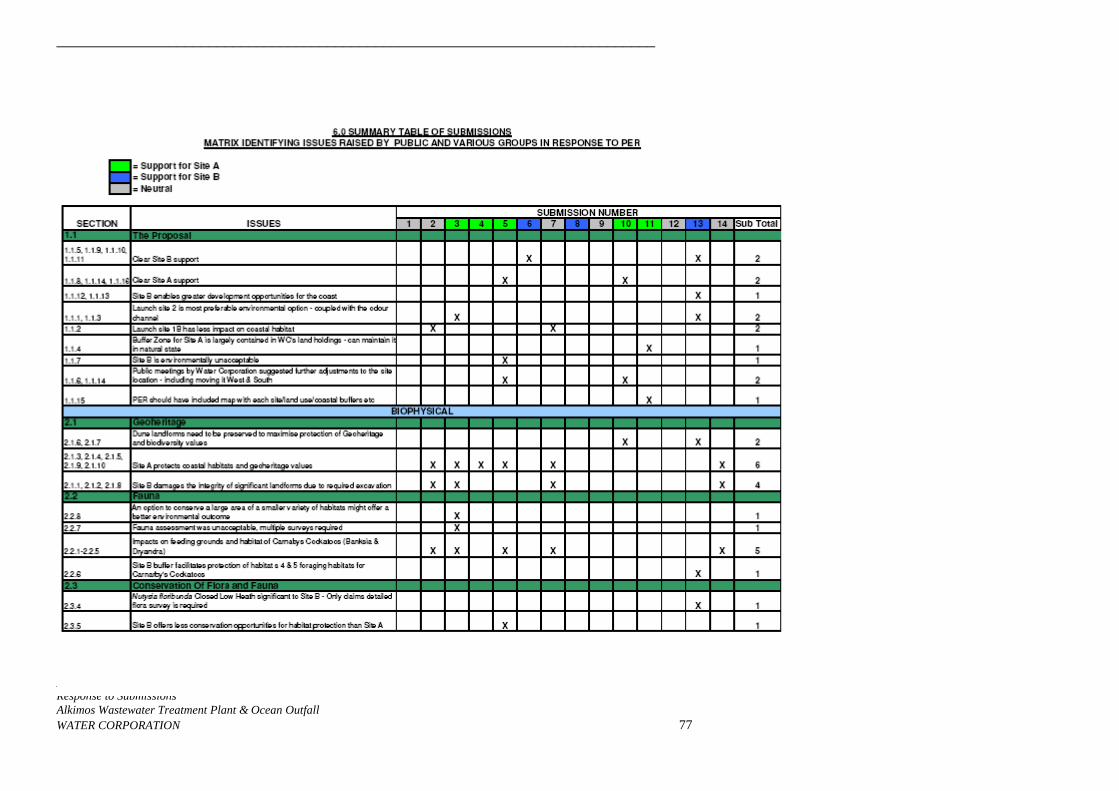
___________________________________________________________________________
___________________________________________________________________________ Response to Submissions Alkimos Wastewater Treatment Plant & Ocean Outfall WATER CORPORATION 77
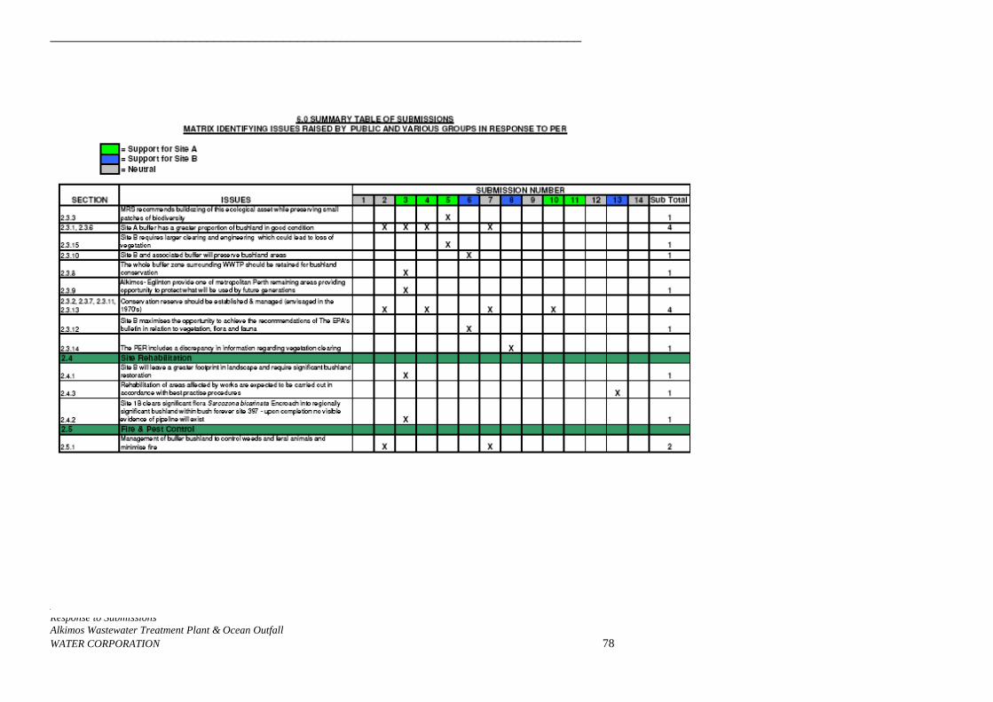
___________________________________________________________________________
___________________________________________________________________________ Response to Submissions Alkimos Wastewater Treatment Plant & Ocean Outfall WATER CORPORATION 78
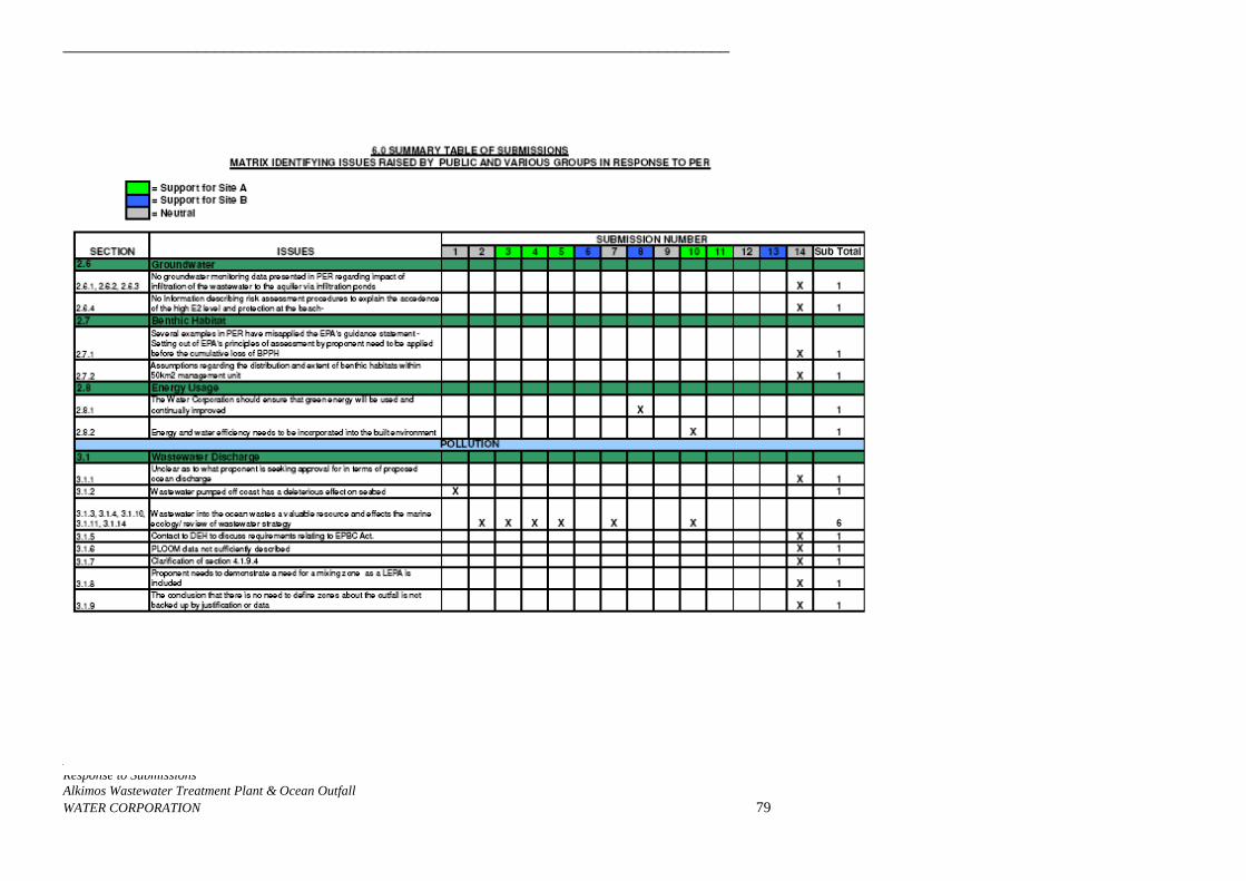
___________________________________________________________________________
___________________________________________________________________________ Response to Submissions Alkimos Wastewater Treatment Plant & Ocean Outfall WATER CORPORATION 79
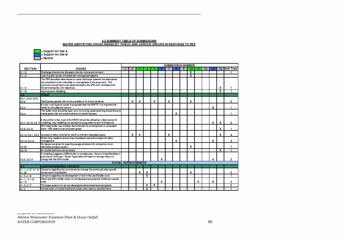
___________________________________________________________________________
___________________________________________________________________________ Response to Submissions Alkimos Wastewater Treatment Plant & Ocean Outfall WATER CORPORATION 80
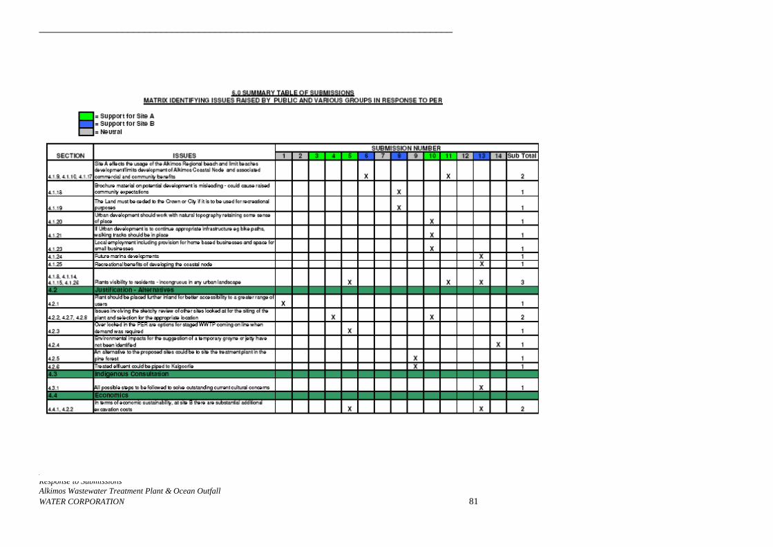
___________________________________________________________________________
___________________________________________________________________________ Response to Submissions Alkimos Wastewater Treatment Plant & Ocean Outfall WATER CORPORATION 81
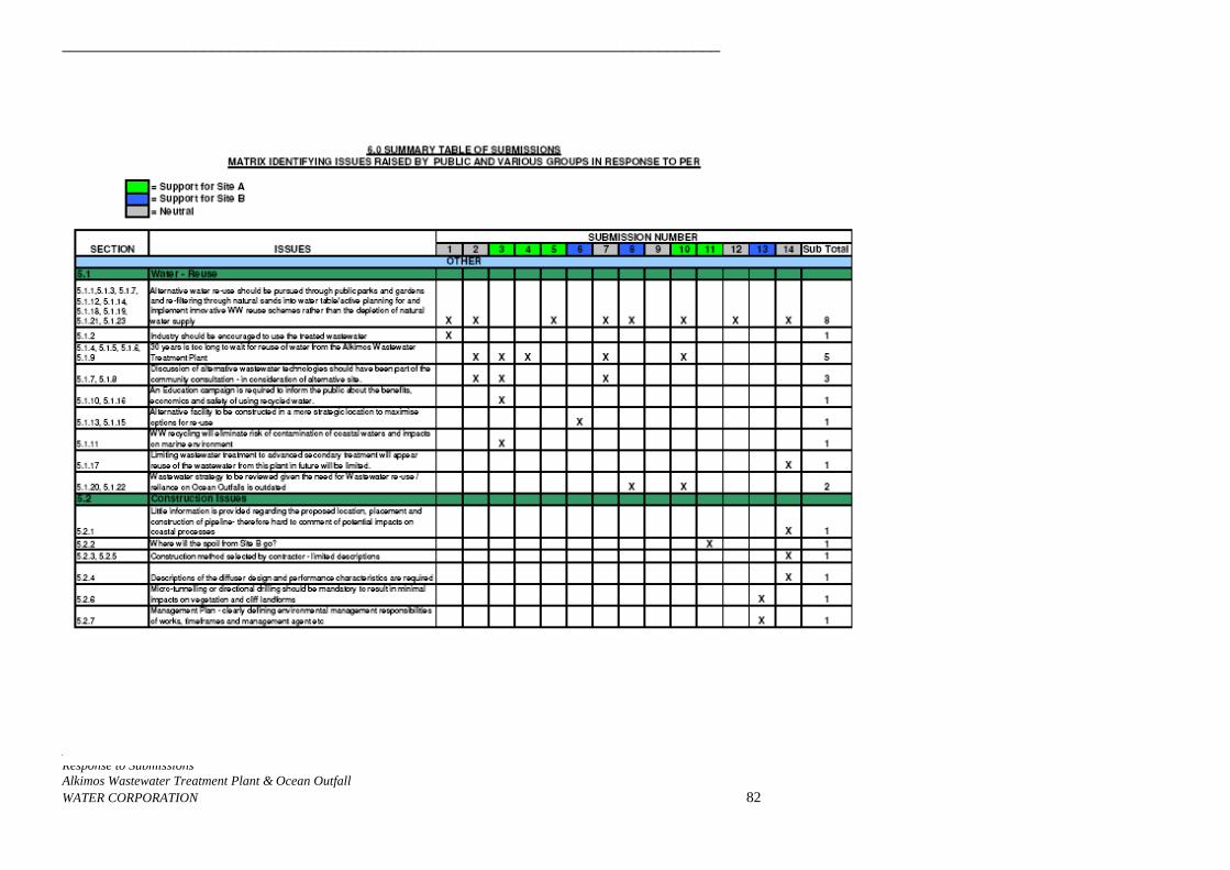
___________________________________________________________________________
___________________________________________________________________________ Response to Submissions Alkimos Wastewater Treatment Plant & Ocean Outfall WATER CORPORATION 82

___________________________________________________________________________
___________________________________________________________________________ Response to Submissions AlkimosWAT
Wastewater Treatment Plant & Ocean Outfall ER CORPORATION 83

___________________________________________________________________________
___________________________________________________________________________ Response to Submissions Alkimos Wastewater Treatment Plant & Ocean Outfall WATER CORPORATION 84
P R O P R I E T A R Y L I M I T E D
76 Jersey Street Jolimont 6014 Western Australia ABN: 43 008 804 653Postal: PO Box 201 Wembley 6913 Western Australia Ph: 61 8 9284 0222 Fax: 61 8 9284 1785 Email: [email protected] www.rockwater.com.au
Rockwater Pty Ltd 236.38/04/1
TABLE OF CONTENTS PAGE NO.
1 INTRODUCTION 1
2 HYDROGEOLOGICAL SETTING 1
3 WWTP SITE INVESTIGATIONS 1 3.1 Method 2 3.2 Results 2
3.2.1 Sieve Analyses 2 3.2.2 Pit Soak-Away Tests 2 3.2.3 Ring Infiltrometer Tests 3 3.2.4 Phosphorus Retention Indices 3 3.2.5 Discussion of Results 5
4 NUMERICAL MODELLING OF EFFECTS OF WASTEWATER INFILTRATION 5 4.1 Purpose and Scope 5 4.2 Description of Model 6 4.3 Model Parameters, Boundary Conditions 6 4.4 Model Calibration 7 4.5 Flow and Flow-Path Modelling 7
4.5.1 Modelling Results 8 4.6 Solute Transport Modelling 9
4.6.1 Nitrogen 10 4.6.2 Phosphorus 11
5 EFFECT OF NUTRIENTS ON NEAR-SHORE ENVIRONMENT 13
6 CONCLUSIONS 13
REFERENCES 15 Tables
Table 1 – Pit Soak-Away Test Results 3
Table 2 – Ring Infiltrometer Test Results 4
Table 3 – Phosphorus Retention Indices Results 4
Table 4 – Adopted Aquifer Parameters 7
Table 5 – Results Of Flow and Flow-Path Modelling 8
Table 6 – Nitrogen Loads In Groundwater Discharging To Ocean 10 Figures 1 Location of Proposed Alkimos WWTP 2 Location of Test Sites And Planned infiltration Ponds, Alkimos WWTP
Rockwater Pty Ltd 236.38/04/1
3 Extent Of Model Grid 4 Comparison Between Model-Calculated Summer Groundwater Levels, and Levels
Measured 19 March 1990 5 Calculated Groundwater-Level Rise And Flowlines After 13 Years Infiltration At
Up To 10 ML/d, Without Eglinton Bores Pumping 6 Calculated Groundwater-Level Rise And Flowlines After 13 Years Infiltration At
Up To 10 ML/d, With Eglinton Bores Pumping 7 Calculated Groundwater-Level Rise And Flowlines After 13 Years Infiltration At
Up To 20 ML/d, Without Eglinton Bores Pumping 8 Calculated Groundwater-Level Rise And Flowlines After 13 Years Infiltration At
Up To 20 ML/d, With Eglinton Bores Pumping 9 Calculated Groundwater-Level Rise And Flowlines After 13 Years Infiltration At
Up To 10 ML/d, With Eglinton Bores Pumping, (Revised Borefield Configuration) 10 Calculated Groundwater-Level Rise And Flowlines After 13 Years Infiltration At
Up To 10 ML/d, With Eglinton Bores And Re-Use Bores Pumping (Case 6) 11 Calculated Groundwater-Level Rise And Flowlines After 13 Years Infiltration At
Up To 10 ML/d, With Eglinton Bores And Re-Use Bores Pumping (Case 7) 12 Calculated Groundwater-Level Rise And Flowlines After 13 Years Infiltration At
Up To 20 ML/d, With Eglinton Bores And Re-Use Bores Pumping (Case 8) 13 Calculated Nitrogen Concentrations After 13 Years Infiltration At Up To 10 ML/d,
Without Eglinton Bores Pumping 14 Calculated Nitrogen Concentrations After 13 Years Infiltration At Up To 10 ML/d,
With Eglinton Bores Pumping 15 Calculated Nitrogen Concentrations After 13 Years Infiltration At Up To 20 ML/d,
Without Eglinton Bores Pumping 16 Calculated Nitrogen Concentrations After 13 Years Infiltration At Up To 20 ML/d,
With Eglinton Bores Pumping 17 Model-Calculated N Concs At Shore West Of WWTP, 10 ML/d Maximum
Infiltration 18 Model-Calculated N Concs At Shore West Of WWTP, 20 ML/d Maximum
Infiltration 19 Calculated Nitrogen Concentrations After 13 Years Infiltration At Up To 10 ML/d,
With Only 6 mg/L N, & Eglinton Bores Pumping 20 Calculated Nitrogen Concentrations After 13 Years Infiltration At Up To 10 ML/d,
With Only 6 mg/L N, & Eglinton Bores Pumping, Without Denitrification 21 Calculated Nitrogen Concentrations After 13 Years Infiltration At Up To 10 ML/d,
With Eglinton And Re-Use Bores Pumping (Case 6) 22 Calculated Nitrogen Concentrations After 13 Years Infiltration At Up To 10 ML/d,
With Eglinton And Re-Use Bores Pumping (Case 7) 23 Calculated Nitrogen Concentrations After 13 Years Infiltration At Up To 20 ML/d,
With Eglinton And Re-Use Bores Pumping (Case 8)
Rockwater Pty Ltd 236.38/04/1
Appendices I Lithological Descriptions of Pit Samples
II Sieve Analyses, Pit Samples
III Pit Soak-Away Test Results
IV Ring Infiltrometer Test Results
V Phosphorus Retention Indices (PRI) Results
VI Commentary on impacts from nitrogen loading to the shoreline resulting from short-term infiltration to groundwater (Oceanica Consulting report)
Report on Hydrogeological Investigations at the Proposed Alkimos WWTP Site Page 1
Rockwater Pty Ltd 236.38/04/1
1 INTRODUCTION Field investigations were carried out at Alkimos, between Quinns Rocks and Yanchep (Fig.1), planned for a new wastewater treatment plant (WWTP), to assess the infiltration capacity of soils. Seven potential sites for infiltration ponds were investigated, as shown in Figure 2. In addition, a numerical groundwater model was used to predict the impact on groundwater of infiltrating treated wastewater at the site. This report presents the methods and results of the field investigations and the numerical modelling.
2 HYDROGEOLOGICAL SETTING The proposed Alkimos WWTP site is about 1 km from the coast, within recent mobile sand dunes known as the Quindalup Dune System (Safety Bay Sand). The Safety Bay Sand consists of fine to medium grained quartz sand and shell fragments, and overlies calcareous sand and limestone of the Tamala Limestone. These formations comprise the Superficial aquifer. At the Alkimos WWTP site, the Safety Bay Sand is generally unsaturated: the Tamala Limestone crops out in swales in the northern part of the area, particularly near test sites 1 and 2 (Fig. 2). The top of the limestone is usually hard cap-rock, of variable thickness. The Tamala Limestone is karstic in nature, and has high permeability. The water table is between 5 m (Site 4) and 20 m (Site 5) depth (below ground level). Groundwater in the Tamala Limestone is recharged by rainfall infiltration, and flows westwards to discharge to the ocean. Groundwater flow in the formation is largely controlled by the location, and degree of interconnection, of solution channels within the limestone (Davidson, 1995). A study by Barber et al (1990) in an area 10 km south of Alkimos, indicated groundwater flow velocities of between 85 and 335 m/year. Groundwater salinity in the Superficial aquifer at the WWTP site is about 500 mg/L TDS, increasing to 1,000 mg/L near the coast. Background nutrient concentrations in the area are low: nitrate concentrations are about 1 mg/L, and phosphorus concentrations are less than 0.03 mg/L (Davidson 1995, Plates 60 and 61).
3 WWTP SITE INVESTIGATIONS Seven potential areas for the location of infiltration ponds, within swales around the planned WWTP, were selected for investigation. The test sites are shown in Figure 2.
Report on Hydrogeological Investigations at the Proposed Alkimos WWTP Site Page 2
Rockwater Pty Ltd 236.38/04/1
3.1 METHOD At each site, test pits were excavated to approximately 3 m depth. Material excavated from them was geologically logged, and falling-head (“soak-away”) permeability tests were conducted in them. The test results were analysed using a method given in Sommerville (1986). Representative soil samples were taken for sieve analysis to determine grain-size distribution. Access to the site was difficult: unconsolidated, sandy tracks prevented access of water trucks for the permeability tests. Water was carted to site in a small (1,100 L) tank mounted on the tray of a 4WD utility. Ring infiltrometer tests were carried out at Sites 3 to 7, using a steel ring of 560 mm diameter. Sites 1 and 2, where limestone cap-rock crops out, were not tested. The rings were pushed into the ground to at least 10 cm depth, and soil was tamped on the outside of them, to ensure there was no lateral leakage. After saturating the soil first to eliminate entrapped air, the ring was filled with water and the rate of water-level decline was recorded. The tests were repeated at each site. Permeability was calculated using a method given in Cedergren (1977). 3.2 RESULTS The pits intersected bioclastic and/or quartz-dominated sands, and weakly- to well-cemented (caprock) limestone. Geological logs of soil samples from the test pits are included in Appendix I. 3.2.1 Sieve Analyses Sieve analyses of samples taken from the pits show that the strata consist of moderately- to well-sorted, fine to medium grained sand (Sites 1, 3 (1.0 m), 4 (2.0 m), and 7 (2.5 m)), medium-grained sand (Sites 2, 3 (2.0 m), and 4 (0.6 m)); fine to coarse grained sand (Sites 6 (1.0 m), and 7 (1.0 m)); or medium to coarse-grained sand (Site 5 (1.0 m)). The data are presented in Appendix II. 3.2.2 Pit Soak-Away Tests Results of the pit soak-away tests (Table 1, and Appendix III) suggest there is variable permeability in the study area. Moderate permeabilities were recorded at Sites 5 and 6 (6.5 and 3.4 m/day), and there were moderate to high permeabilities (27, 17 and 26 m/day) at Sites 1, 2 and 7. High permeabilities were measured at Sites 3 and 4 (145 and 80 m/day). The measured permeability values represent both horizontal and vertical components.
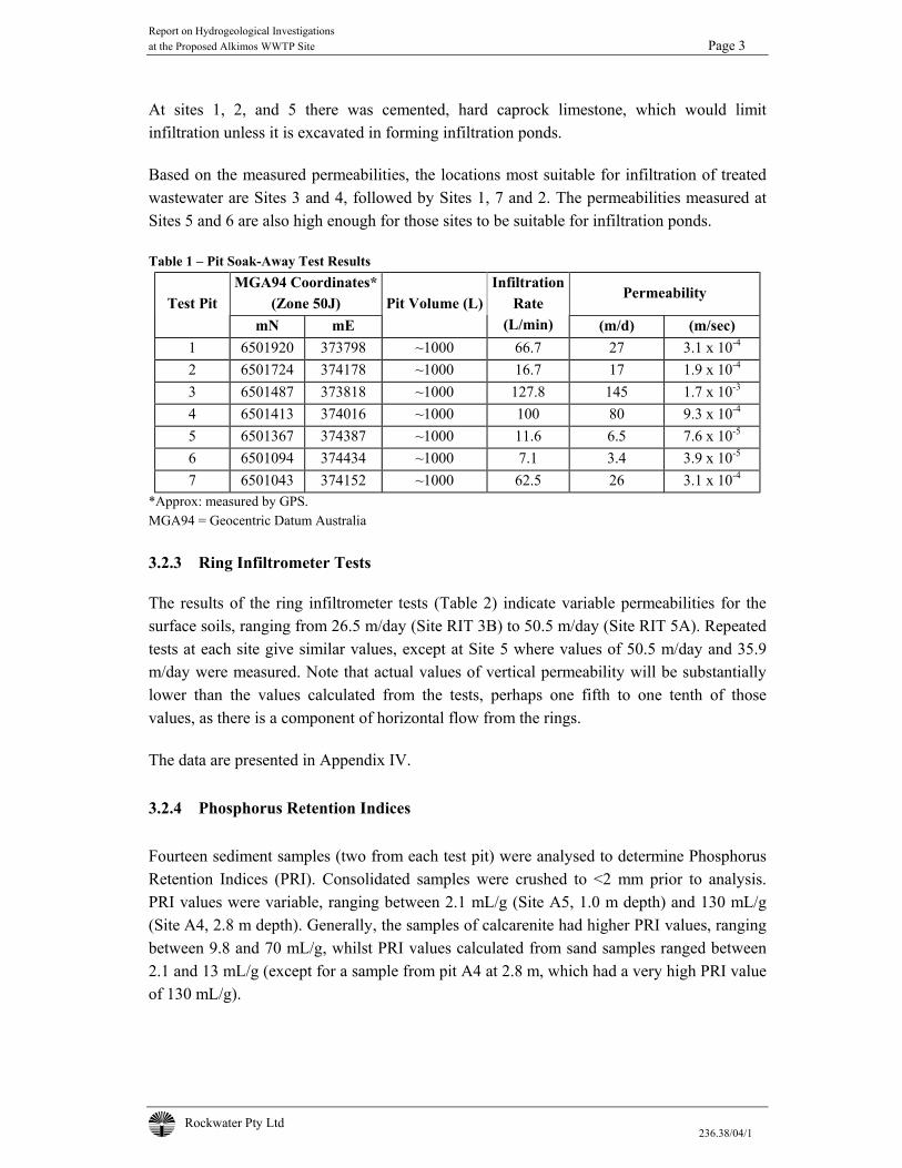
Report on Hydrogeological Investigations at the Proposed Alkimos WWTP Site Page 3
Rockwater Pty Ltd 236.38/04/1
At sites 1, 2, and 5 there was cemented, hard caprock limestone, which would limit infiltration unless it is excavated in forming infiltration ponds. Based on the measured permeabilities, the locations most suitable for infiltration of treated wastewater are Sites 3 and 4, followed by Sites 1, 7 and 2. The permeabilities measured at Sites 5 and 6 are also high enough for those sites to be suitable for infiltration ponds. Table 1 – Pit Soak-Away Test Results
MGA94 Coordinates* (Zone 50J)
Permeability Test Pit
mN mE Pit Volume (L)
Infiltration Rate
(L/min) (m/d) (m/sec) 1 6501920 373798 ~1000 66.7 27 3.1 x 10⁻⁴
2 6501724 374178 ~1000 16.7 17 1.9 x 10⁻⁴
3 6501487 373818 ~1000 127.8 145 1.7 x 10⁻³
4 6501413 374016 ~1000 100 80 9.3 x 10⁻⁴
5 6501367 374387 ~1000 11.6 6.5 7.6 x 10⁻⁵
6 6501094 374434 ~1000 7.1 3.4 3.9 x 10⁻⁵
7 6501043 374152 ~1000 62.5 26 3.1 x 10⁻⁴
*Approx: measured by GPS. MGA94 = Geocentric Datum Australia 3.2.3 Ring Infiltrometer Tests The results of the ring infiltrometer tests (Table 2) indicate variable permeabilities for the surface soils, ranging from 26.5 m/day (Site RIT 3B) to 50.5 m/day (Site RIT 5A). Repeated tests at each site give similar values, except at Site 5 where values of 50.5 m/day and 35.9 m/day were measured. Note that actual values of vertical permeability will be substantially lower than the values calculated from the tests, perhaps one fifth to one tenth of those values, as there is a component of horizontal flow from the rings. The data are presented in Appendix IV. 3.2.4 Phosphorus Retention Indices Fourteen sediment samples (two from each test pit) were analysed to determine Phosphorus Retention Indices (PRI). Consolidated samples were crushed to <2 mm prior to analysis. PRI values were variable, ranging between 2.1 mL/g (Site A5, 1.0 m depth) and 130 mL/g (Site A4, 2.8 m depth). Generally, the samples of calcarenite had higher PRI values, ranging between 9.8 and 70 mL/g, whilst PRI values calculated from sand samples ranged between 2.1 and 13 mL/g (except for a sample from pit A4 at 2.8 m, which had a very high PRI value of 130 mL/g).
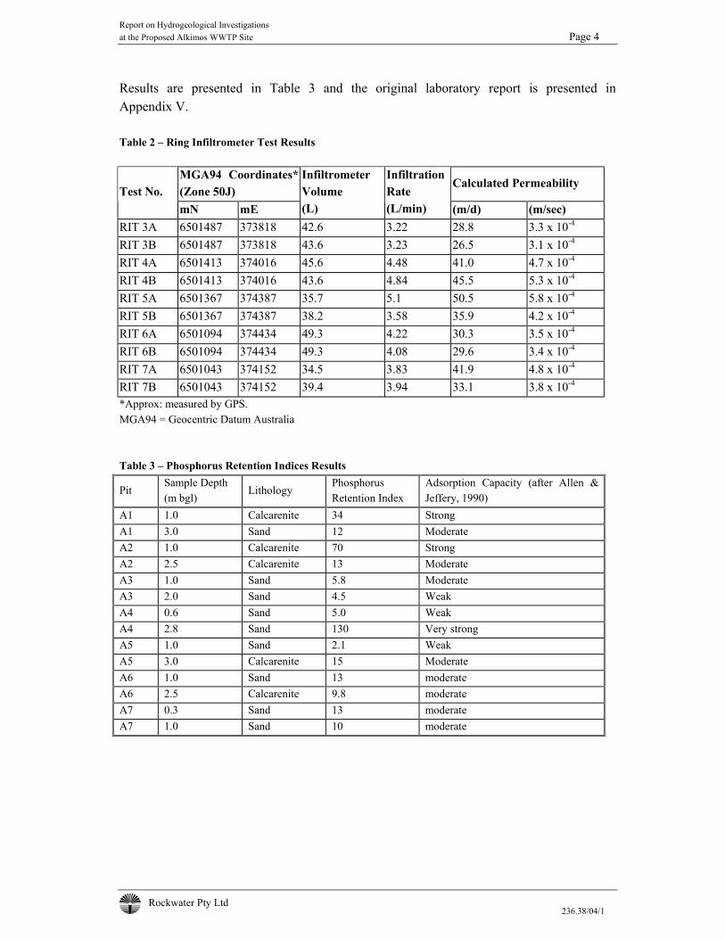
Report on Hydrogeological Investigations at the Proposed Alkimos WWTP Site Page 4
Rockwater Pty Ltd 236.38/04/1
Results are presented in Table 3 and the original laboratory report is presented in Appendix V. Table 2 – Ring Infiltrometer Test Results
MGA94 Coordinates* (Zone 50J)
Calculated Permeability Test No.
mN mE
Infiltrometer Volume (L)
Infiltration Rate (L/min) (m/d) (m/sec)
RIT 3A 6501487 373818 42.6 3.22 28.8 3.3 x 10⁻⁴
RIT 3B 6501487 373818 43.6 3.23 26.5 3.1 x 10⁻⁴
RIT 4A 6501413 374016 45.6 4.48 41.0 4.7 x 10⁻⁴
RIT 4B 6501413 374016 43.6 4.84 45.5 5.3 x 10⁻⁴
RIT 5A 6501367 374387 35.7 5.1 50.5 5.8 x 10⁻⁴
RIT 5B 6501367 374387 38.2 3.58 35.9 4.2 x 10⁻⁴
RIT 6A 6501094 374434 49.3 4.22 30.3 3.5 x 10⁻⁴
RIT 6B 6501094 374434 49.3 4.08 29.6 3.4 x 10⁻⁴
RIT 7A 6501043 374152 34.5 3.83 41.9 4.8 x 10⁻⁴
RIT 7B 6501043 374152 39.4 3.94 33.1 3.8 x 10⁻⁴
*Approx: measured by GPS. MGA94 = Geocentric Datum Australia Table 3 – Phosphorus Retention Indices Results
Pit Sample Depth (m bgl)
Lithology Phosphorus Retention Index
Adsorption Capacity (after Allen & Jeffery, 1990)
A1 1.0 Calcarenite 34 Strong A1 3.0 Sand 12 Moderate A2 1.0 Calcarenite 70 Strong A2 2.5 Calcarenite 13 Moderate A3 1.0 Sand 5.8 Moderate A3 2.0 Sand 4.5 Weak A4 0.6 Sand 5.0 Weak A4 2.8 Sand 130 Very strong A5 1.0 Sand 2.1 Weak A5 3.0 Calcarenite 15 Moderate A6 1.0 Sand 13 moderate A6 2.5 Calcarenite 9.8 moderate A7 0.3 Sand 13 moderate A7 1.0 Sand 10 moderate
Report on Hydrogeological Investigations at the Proposed Alkimos WWTP Site Page 5
Rockwater Pty Ltd 236.38/04/1
3.2.5 Discussion of Results The cap-rock limestone would greatly restrict the infiltration of treated wastewater, and will need to be stripped in forming infiltration ponds. It was removed in digging the test pits at sites 1 and 2, and there was also some at site 5. Permeability values calculated from falling-head test data for the test pits, and for the ring infiltrometers, indicate there is variable permeability, related to factors such as variations in grain-size, sorting, and compaction. The ring infiltrometers tested the surface soil, whereas the falling-head tests in the test pits relate to sub-soil sands. The permeability values from both sets of tests are moderate to high and will not be the main factor limiting infiltration rates around the WWTP site. As at other WWTP sites in the Tamala Limestone, wastewater quality (nutrients and suspended solids), the ability to allow ponds to dry, and the maintenance of pond floors will be the main controlling factors of infiltration capacity. Based on experience at other WWTP’s in the Tamala Limestone, infiltration rates of at least 0.4 m/d, and probably more than 0.5 m/d will be achievable with high quality effluent containing total phosphorus and nitrogen concentrations at 10 mg/L, or less. For example, at the Gordon Road WWTP at Mandurah, infiltration rates are at least 0.48 m/d with treated wastewater of good quality. Prior to the plant upgrade, infiltration rates were much lower. At Geraldton, infiltration rates are believed to be about 0.4 m/d where permeabilities of 5.6 to 7.2 m/d were indicated from ring infiltrometer tests; and 12 to 16 m/d from constant-head permeability tests carried out in auger holes (Rockwater, 1993).
4 NUMERICAL MODELLING OF EFFECTS OF WASTEWATER INFILTRATION
4.1 PURPOSE AND SCOPE Groundwater flow and solute transport modelling was carried out to determine the effects of infiltrating treated wastewater at the site. Calculation of nitrogen loads in groundwater discharging to the ocean, and whether the infiltrated wastewater could flow back to the planned Eglinton production bores, was particularly important. Also, changes to groundwater levels and the fate of phosphorus in the treated wastewater were to be determined.
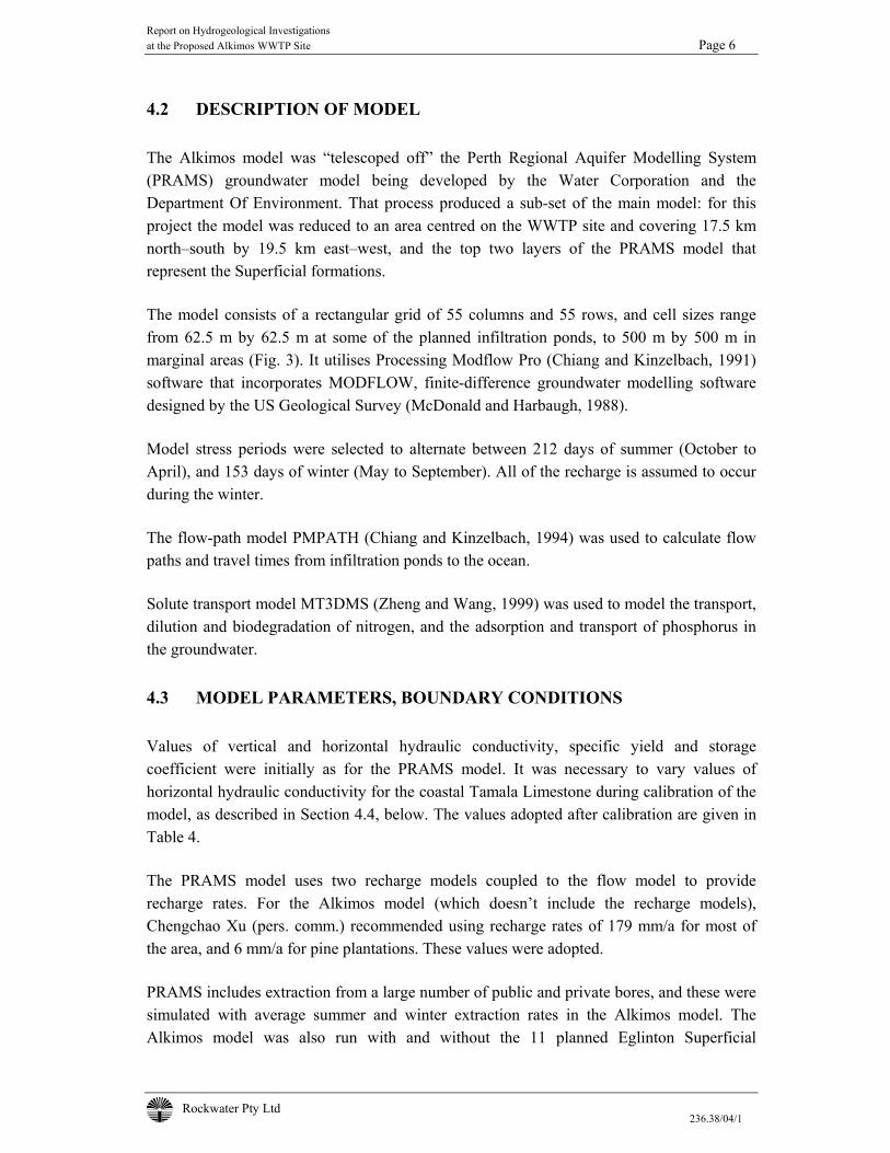
Report on Hydrogeological Investigations at the Proposed Alkimos WWTP Site Page 6
Rockwater Pty Ltd 236.38/04/1
4.2 DESCRIPTION OF MODEL The Alkimos model was “telescoped off” the Perth Regional Aquifer Modelling System (PRAMS) groundwater model being developed by the Water Corporation and the Department Of Environment. That process produced a sub-set of the main model: for this project the model was reduced to an area centred on the WWTP site and covering 17.5 km north–south by 19.5 km east–west, and the top two layers of the PRAMS model that represent the Superficial formations. The model consists of a rectangular grid of 55 columns and 55 rows, and cell sizes range from 62.5 m by 62.5 m at some of the planned infiltration ponds, to 500 m by 500 m in marginal areas (Fig. 3). It utilises Processing Modflow Pro (Chiang and Kinzelbach, 1991) software that incorporates MODFLOW, finite-difference groundwater modelling software designed by the US Geological Survey (McDonald and Harbaugh, 1988). Model stress periods were selected to alternate between 212 days of summer (October to April), and 153 days of winter (May to September). All of the recharge is assumed to occur during the winter. The flow-path model PMPATH (Chiang and Kinzelbach, 1994) was used to calculate flow paths and travel times from infiltration ponds to the ocean. Solute transport model MT3DMS (Zheng and Wang, 1999) was used to model the transport, dilution and biodegradation of nitrogen, and the adsorption and transport of phosphorus in the groundwater.
4.3 MODEL PARAMETERS, BOUNDARY CONDITIONS Values of vertical and horizontal hydraulic conductivity, specific yield and storage coefficient were initially as for the PRAMS model. It was necessary to vary values of horizontal hydraulic conductivity for the coastal Tamala Limestone during calibration of the model, as described in Section 4.4, below. The values adopted after calibration are given in Table 4. The PRAMS model uses two recharge models coupled to the flow model to provide recharge rates. For the Alkimos model (which doesn’t include the recharge models), Chengchao Xu (pers. comm.) recommended using recharge rates of 179 mm/a for most of the area, and 6 mm/a for pine plantations. These values were adopted. PRAMS includes extraction from a large number of public and private bores, and these were simulated with average summer and winter extraction rates in the Alkimos model. The Alkimos model was also run with and without the 11 planned Eglinton Superficial
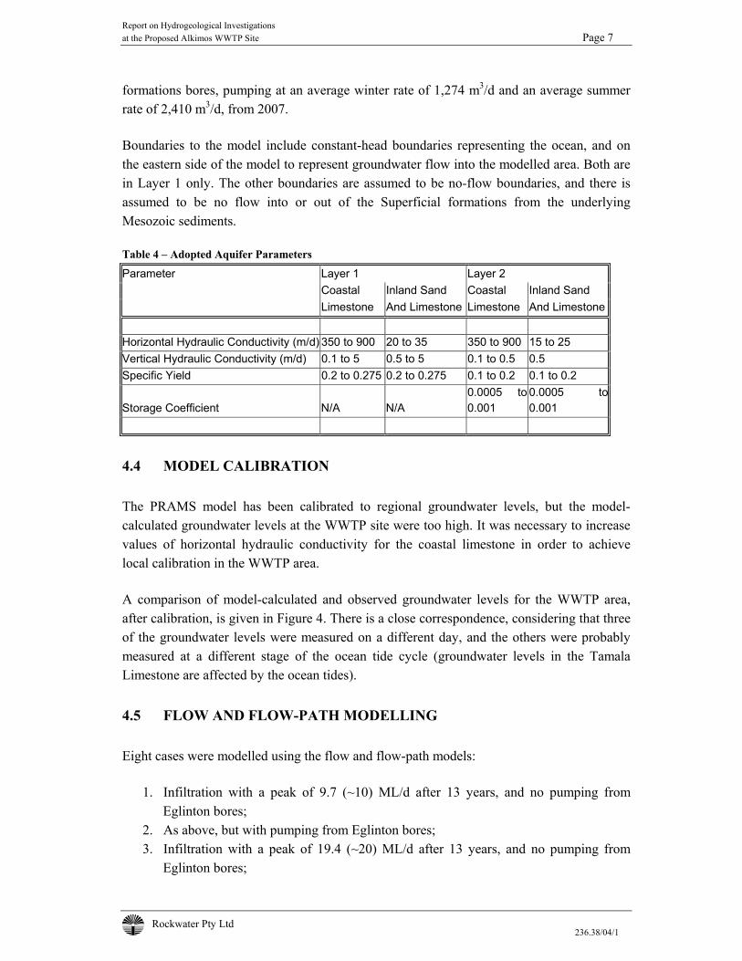
Report on Hydrogeological Investigations at the Proposed Alkimos WWTP Site Page 7
Rockwater Pty Ltd 236.38/04/1
formations bores, pumping at an average winter rate of 1,274 m3/d and an average summer rate of 2,410 m3/d, from 2007. Boundaries to the model include constant-head boundaries representing the ocean, and on the eastern side of the model to represent groundwater flow into the modelled area. Both are in Layer 1 only. The other boundaries are assumed to be no-flow boundaries, and there is assumed to be no flow into or out of the Superficial formations from the underlying Mesozoic sediments. Table 4 – Adopted Aquifer Parameters Parameter Layer 1 Layer 2 Coastal Inland Sand Coastal Inland Sand Limestone And Limestone Limestone And Limestone Horizontal Hydraulic Conductivity (m/d) 350 to 900 20 to 35 350 to 900 15 to 25 Vertical Hydraulic Conductivity (m/d) 0.1 to 5 0.5 to 5 0.1 to 0.5 0.5 Specific Yield 0.2 to 0.275 0.2 to 0.275 0.1 to 0.2 0.1 to 0.2
Storage Coefficient N/A N/A 0.0005 to 0.001
0.0005 to0.001
4.4 MODEL CALIBRATION The PRAMS model has been calibrated to regional groundwater levels, but the model-calculated groundwater levels at the WWTP site were too high. It was necessary to increase values of horizontal hydraulic conductivity for the coastal limestone in order to achieve local calibration in the WWTP area. A comparison of model-calculated and observed groundwater levels for the WWTP area, after calibration, is given in Figure 4. There is a close correspondence, considering that three of the groundwater levels were measured on a different day, and the others were probably measured at a different stage of the ocean tide cycle (groundwater levels in the Tamala Limestone are affected by the ocean tides).
4.5 FLOW AND FLOW-PATH MODELLING Eight cases were modelled using the flow and flow-path models:
1. Infiltration with a peak of 9.7 (~10) ML/d after 13 years, and no pumping from Eglinton bores;
2. As above, but with pumping from Eglinton bores; 3. Infiltration with a peak of 19.4 (~20) ML/d after 13 years, and no pumping from
Eglinton bores;

Report on Hydrogeological Investigations at the Proposed Alkimos WWTP Site Page 8
Rockwater Pty Ltd 236.38/04/1
4. As above, but with pumping from Eglinton bores. 5. As for Case 2, except replacing the bore planned to be north-east of the WWTP with
two new bores located north and south of the WWTP. Each of the new bores would be pumped at half the rate of the other Eglinton bores.
6. As for Case 2, but with up to four re-use bores installed down-gradient of the WWTP to extract 8.8 GL/yr from 2008, including 33.6 KL/d in summer and 9.2 KL/d in winter. The bores are to be located to capture as much wastewater flow as possible, and to allow a nominal travel time of two months between infiltration ponds and the bores.
7. As for Case 6, but with re-use bores extracting 15.3 KL/d in summer and 4.2 KL/d in winter in 2008, increasing to 25.9 KL/d in summer and 7.1 KL/d in winter (6.6 GL/yr) in 2020.
8. Similar to Case 7, except wastewater infiltration increasing to 20 ML/d by 2020; and with re-use bores extracting 18.2 KL/d in summer and 5.0 KL/d in winter in 2008, increasing to 33.6 KL/d in summer and 9.2 KL/d in winter (8.8 GL/yr) in 2020.
The models were used to determine changes in groundwater levels resulting from the infiltration, flow paths, and travel times to the coast or to re-use bores. Infiltration ponds used in the modelling were selected according to proximity to the WWTP, and to spread infiltration across the direction of groundwater flow, i.e. in a north-south direction. A maximum infiltration rate of 0.4 m/d was assumed: a minimum number of infiltration ponds were used/assumed in the modelling, and additional ponds were added in the model once the infiltration capacity of the ponds was approached. 4.5.1 Modelling Results The flow modelling results are summarised in Table 5, and are shown in Figures 5 to 12.
Table 5 – Results Of Flow and Flow-Path Modelling
Case Max. Water Travel Time Travel Time (Section 4.5) Level Rise (m) To Coast (Months) To Re-Use Bores (Months)
After 13 Years Infiltration 1 0.4 8 to 10 Not Applicable (N/A) 2 0.2 8 to 10 N/A 3 0.6 4 to 9 N/A 4 0.5 4 to 10 N/A 5 0.2 8 to 10 N/A 6 0.1 >13 Years for N 2 to 3 7 0.1 >13 Years for N 2 to 3 8 0.4 4 to 7 Years for N 2 to 6
Report on Hydrogeological Investigations at the Proposed Alkimos WWTP Site Page 9
Rockwater Pty Ltd 236.38/04/1
Pumping from the Eglinton bores will reduce the degree and extent of mounding that results from wastewater infiltration, but there is indicated to be little effect of the pumping on the minimum travel time from infiltration ponds to the ocean: that time is more dependent on the rate of wastewater infiltration. Flow-path modelling results indicate there is no possibility of groundwater beneath the infiltration ponds being drawn towards the Eglinton bores. Even if the bores were pumped at their planned peak rates of extraction, and if two bores are located close to the WWTP (Case 5, Fig. 9), all groundwater beneath the ponds would continue to flow towards the ocean. Extraction from re-use bores (Cases 6 to 8) would capture much of the groundwater containing treated wastewater, and greatly increase travel time to the coast. The results of the solute-transport modelling (Section 4.6) indicate that capture by the re-use bores, and the additional time available for denitrification, would mean that nitrogen in the treated wastewater would not reach the coast within 13 years in Cases 6 and 7; and would first reach the coast after four to seven years in Case 8, the timing depending on bore layout and numbers. In practice, more than four re-use bores would be needed to extract up to 8.8 GL/yr, to minimise drawdowns and the possibility of up-coning of saline groundwater from beneath the saltwater wedge. The additional bores would also be more efficient at capturing groundwater containing treated wastewater. Also, some of the re-use bores would need to be abandoned and others constructed further to the west, as additional infiltration ponds are commissioned west of the WWTP.
4.6 SOLUTE TRANSPORT MODELLING Eleven cases were run using the MT3DMS solute-transport model: Cases 1 to 8 were as described above, with nitrogen (or phosphorus) source concentrations assumed to be 10 mg/L (Cases 1 to 4) and 6 mg/L nitrogen for Case 5. The three additional cases were as follows:
9. As for Case 2 (up to 10 ML/d infiltration, and pumping from Eglinton bores in the positions originally planned), but with nitrogen source concentration of 6 mg/L;
10. As for Case 9, but with no denitrification occurring in the aquifer; 11. A run to determine the loadings of nitrogen in groundwater discharging to the ocean, with
the background nitrate concentration of 1 mg/L (= 0.2 mg/L nitrogen). Dispersion was assumed to be zero.
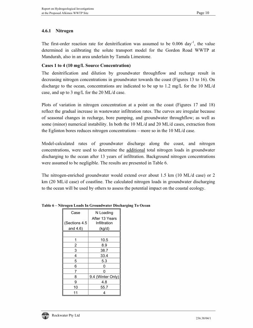
Report on Hydrogeological Investigations at the Proposed Alkimos WWTP Site Page 10
Rockwater Pty Ltd 236.38/04/1
4.6.1 Nitrogen The first-order reaction rate for denitrification was assumed to be 0.006 day-1, the value determined in calibrating the solute transport model for the Gordon Road WWTP at Mandurah, also in an area underlain by Tamala Limestone.
Cases 1 to 4 (10 mg/L Source Concentration) The denitrification and dilution by groundwater throughflow and recharge result in decreasing nitrogen concentrations in groundwater towards the coast (Figures 13 to 16). On discharge to the ocean, concentrations are indicated to be up to 1.2 mg/L for the 10 ML/d case, and up to 3 mg/L for the 20 ML/d case. Plots of variation in nitrogen concentration at a point on the coast (Figures 17 and 18) reflect the gradual increase in wastewater infiltration rates. The curves are irregular because of seasonal changes in recharge, bore pumping, and groundwater throughflow; as well as some (minor) numerical instability. In both the 10 ML/d and 20 ML/d cases, extraction from the Eglinton bores reduces nitrogen concentrations – more so in the 10 ML/d case. Model-calculated rates of groundwater discharge along the coast, and nitrogen concentrations, were used to determine the additional total nitrogen loads in groundwater discharging to the ocean after 13 years of infiltration. Background nitrogen concentrations were assumed to be negligible. The results are presented in Table 6. The nitrogen-enriched groundwater would extend over about 1.5 km (10 ML/d case) or 2 km (20 ML/d case) of coastline. The calculated nitrogen loads in groundwater discharging to the ocean will be used by others to assess the potential impact on the coastal ecology. Table 6 – Nitrogen Loads In Groundwater Discharging To Ocean
Case N Loading
(Sections 4.5 After 13 Years
Infiltration and 4.6) (kg/d)
1 10.5 2 8.9 3 38.7 4 33.4 5 5.3 6 0 7 0 8 9.4 (Winter Only) 9 4.8 10 55.7 11 4
Report on Hydrogeological Investigations at the Proposed Alkimos WWTP Site Page 11
Rockwater Pty Ltd 236.38/04/1
Cases 5, 9 and 10 (6 mg/L Source Concentration) The results indicate that with denitrification (Cases 5 and 9), nitrogen concentrations would be up to 0.6 mg/L above background concentrations in groundwater discharging to the ocean (Fig.19). This would add about 5 kg/d of nitrogen in groundwater discharging to the ocean. Changing the position of Eglinton bores near the WWTP has no significant effect on nitrogen loads: the small difference in the Case 5 and 9 results is due to numerical instability of the MT3DMS model. Without any denitrification (Case 10), nitrogen concentrations would be up to 4.0 mg/L above background concentrations in groundwater discharging to the ocean (Fig. 20). The additional loading of nitrogen in groundwater discharging to the ocean would be about 56 kg/d.
Case 11 (Background Nitrogen Concentrations) With background nitrogen concentrations of 0.2 mg/L, there would be about 4 kg/d of nitrogen in groundwater discharging along the length of coast that would be affected by the 10 ML/d wastewater infiltration.
Cases 6 to 8 (With Re-Use Bores) With the re-use bores pumping at the stipulated rates, nitrogen would not reach the ocean at concentrations above background levels within the 13-year period simulated in Cases 6 and 7 (Figs. 21 and 22). In Case 8, some nitrogen would reach the coast from the northern part of the plume in winter after four years, and from the rest of the plume after seven years. All of the nitrogen would be captured during the summer throughout the 13-year period simulated, because of higher rates of extraction from the re-use bores, and lower rates of groundwater throughflow. In winter, there would be about 9.4 kg/d of nitrogen discharging to the ocean, over about 1.3 km of coastline (Fig.23). 4.6.2 Phosphorus The retardation of phosphorus in aquifers can be modelled using adsorption isotherms such as the non-linear Freundlich isotherm, and this method was used in the Alkimos solute-transport model. Phosphorus retention indices (PRI) measured for sand and limestone at the site can be used to calculate the Freundlich adsorption coefficient (A) for input into the solute transport model, using the following formula (Gerritse, pers. comm.):
Report on Hydrogeological Investigations at the Proposed Alkimos WWTP Site Page 12
Rockwater Pty Ltd 236.38/04/1
A = PRI {1000/(100+5*PRI)}1-b1
(1) Where b1 is an experimentally derived exponent. Gerritse (1996) has derived values for A and b1, for various Western Australian soils, using a time-dependent Freundlich adsorption isotherm: ∆Cs = A (∆C)b1 tb2 (2) Where ∆Cs = change in the sorbed concentration of phosphorus (mg/kg) with time, ∆C = the change in the concentration of phosphorus in solution (mg/L) with time t and b2 = an empirical exponent. Values of ∆Cs and ∆C are then used to calculate the retardation of phosphorus in the aquifer material. The MTD3MS solute transport-modelling package includes an option to use an equilibrium Freundlich isotherm to calculate retardation, using the following equation:
Cs = A Cb1 (3) Gerritse (1996) calculated an adsorption coefficient A = 30 L/kg and a Freundlich exponent b1 = 0.4 from laboratory experiments on a calcareous sand. The bulk density of the sand was 1.45 kg/L. These values were used in the model. The modelling method tends to over-estimate phosphorus concentrations in groundwater, because the Freundlich adsorption coefficient (A) and exponent (b1) used in the modelling have been calculated for a time-dependent isotherm, where the total amount of phosphorus adsorbed increases with time. More phosphorus is adsorbed the longer groundwater is in contact with aquifer material. The equilibrium Freundlich isotherm used by MT3DMS assumes that adsorption has gone to completion, limiting the effects of retardation to the continuing adsorption/desorption process. The impact of using an equilibrium Freundlich isotherm can be seen in modelling results for phosphorus transport from the Esperance WWTP (Rockwater, 2002): the calculated phosphorus concentration after 25 years of infiltration, 100 m down-gradient of the WWTP, was 6 mg/L, an order of magnitude greater than the concentration of 0.6 mg/L measured in a monitoring bore. The Alkimos solute-transport model was run to simulate a 100-year period with a worst-case infiltration of 20 ML/d from day one for the entire period, without the Eglinton bores pumping. The results suggest that it would take about 28 years for phosphorus to first reach the coast, and after 100 years, phosphorus concentrations in groundwater at the coast would be 7 to 8 mg/L. As stated above, we expect actual travel times to be much greater, and
Report on Hydrogeological Investigations at the Proposed Alkimos WWTP Site Page 13
Rockwater Pty Ltd 236.38/04/1
concentrations much smaller than indicated by the modelling. The model can be calibrated to observed concentrations after, say, 10 years of operation, so that better predictions can be made.
5 EFFECT OF NUTRIENTS ON NEAR-SHORE ENVIRONMENT The modelling results indicate that without extracting groundwater for re-use, relatively small quantities of nitrogen originating from infiltration ponds will reach the ocean. Much larger quantities discharge with groundwater to the ocean in many parts of the coastal plain where elevated concentrations of nitrate occur naturally in the groundwater. If groundwater is extracted for re-use, most or all of the nitrogen could be captured. A preliminary report by Oceanica on the potential impact on the near-shore environment of groundwater discharge containing nutrients is included as Appendix VI. It states that:
• There are a number of offshore reefs within 2 km of the beach west of the WWTP. • The EPA has general requirements to maintain or improve water quality, and to not
adversely affect seagrass or other benthic habitat. • An appropriate response would be to describe the existing marine environment, any
increase in nutrient concentrations likely to occur, and the effects of these increases. Groundwater flows will enter the ocean through the intertidal zone, and will be dispersed by a prevailing northerly current along the coast. The near-shore water will be well mixed vertically by the swell and the wind.
6 CONCLUSIONS The planned WWTP site is underlain by sand and limestone that are generally of moderate to high permeability, that will enable treated wastewater to be infiltrated to groundwater from ponds in swales, with only minor mounding of the water table. In three swales, hard cap-rock of low permeability outcrops, or occurs at shallow depth. This will need to be excavated in forming infiltration ponds. Based on rates achieved at other WWTP’s in the Tamala Limestone, infiltration rates of at least 0.4 m/d, and probably more than 0.5 m/d, should be sustainable with the planned high quality of the treated wastewater. The infiltration rates will be limited by the wastewater quality, cycling of ponds, and the maintenance of pond bases rather than the intrinsic permeability of soils at the site.
Report on Hydrogeological Investigations at the Proposed Alkimos WWTP Site Page 14
Rockwater Pty Ltd 236.38/04/1
The results of numerical flow and solute transport modelling of the infiltration planned for the first 13 years of operation, and groundwater flows, indicates the following: • Pumping from the planned Eglinton Superficial formations borefield will not induce
flows of groundwater containing treated wastewater to the borefield, but will reduce the degree of mounding beneath infiltration ponds, and the rate and concentrations of nutrients moving towards the coast.
• The travel time from beneath the infiltration ponds to the coast will range from four to ten months, depending on pond location, maximum infiltration rate (10 or 20 ML/d), and whether or not the Eglinton bores are pumping.
• The maximum groundwater-level rise beneath the WWTP will be between 0.2 m and 0.6 m, again depending on the above factors.
• Nitrogen-enriched groundwater will discharge over 1.5 to 2 km of coastline west of the WWTP, with peak total nitrogen concentrations in the groundwater of between 0.6 and 3 mg/L.
• Additional nitrogen loads in groundwater discharging at the coast will be between 5 and 39 kg/d after 13 years of infiltration (depending on the above factors, and nitrogen concentrations of the treated wastewater). At present, about 4 kg/d of naturally occurring nitrogen is discharging along the length of coastline that would be affected with 10 ML/d infiltration.
• Extraction of groundwater down-gradient of the WWTP for re-use, could prevent most or all of the nitrogen entering the groundwater from infiltration ponds from reaching the ocean. The effectiveness of extraction in capturing groundwater elevated in nitrogen will depend on the number of bores and seasonal pumping rates, and the infiltration rate of treated wastewater.
• The transport of phosphorus in groundwater is difficult to predict accurately, because the adsorptive capacity of the sand and limestone is variable and uncertain. Modelling results suggest that at 20 ML/d continuous infiltration and without the Eglinton bores pumping, phosphorus in groundwater would first reach the coast after about 28 years, and after 100 years phosphorus concentrations in groundwater at the coast would be around 7 to 8 mg/L. However, a comparison of modelling results and observed concentrations in a similar hydrogeological environment suggests that the model over-estimates phosphorus concentrations by an order of magnitude. The Tamala Limestone generally has a high adsorptive capacity, and elevated phosphorus concentrations are rarely seen in groundwater from the formation.
• A preliminary report by Oceanica suggests that an investigation should be carried out to characterise the near-shore environment west of the WWTP, and to assess the potential impact of nutrients in groundwater discharging at the coast.
Report on Hydrogeological Investigations at the Proposed Alkimos WWTP Site Page 15
Rockwater Pty Ltd 236.38/04/1
Dated: 11 OCTOBER 2004 Rockwater Pty Ltd C E S New Hydrogeologist P H Wharton Principal Hydrogeologist
REFERENCES Allen, D. G. and Jeffery, R. C., 1990, Methods for Analysis of Phosphorus in Western Australian Soils. Report of Investigation No. 37, Chemistry Centre of Western Australia, March 1990. Barber, C., Davis, G.B., and Buselli, G., 1990, Development of procedures for more efficient monitoring and assessment of groundwater contamination from point sources of pollution: Final Report to AWRAC, EPA, WAWA. The Mindarie Regional Council and The Atlas Group. Cedergren, H.R., 1977, Seepage, drainage and flow nets. John Wiley & Sons (Second Edition). Chiang W.H., and Kinzelbach, W., 1991, Processing Modflow (PM), Pre- and post-processors for the simulation of flow and contaminant transport in groundwater system with MODFLOW, MODPATH and MT3D. Distributed by Scientific Software Group, Washington, DC. Chiang W.H., and Kinzelbach W, (1994), PMPATH. An advective transport model for Processing Modflow and Modflow. Geological Survey of Hamburg, Germany. Davidson, W. A., 1995, Hydrogeology and groundwater resources of the Perth Region, Western Australia: Western Australian Geological Survey, Bulletin 142. Gerritse, R.G., 1996, Transport times of dissolved inorganic phosphate in soils. Journal of Environmental Quality Vol. 25, No.1.
Report on Hydrogeological Investigations at the Proposed Alkimos WWTP Site Page 16
Rockwater Pty Ltd 236.38/04/1
McDonald, M.G., and W.A. Harbaugh, 1988, MODFLOW, A Modular Three-Dimensional Finite-Difference Ground-Water Flow Model. U.S. Geological Survey, Washington, DC. (A:3980), open file report 83–875, Chapter A1. Rockwater, 2002, The results of additional groundwater flow, and solute transport modelling for proposed wastewater treatment plant No.2, Esperance. Unpub. Rept. to Water Corporation. Rockwater, 1993, Geraldton WWTP No2, Capacity for infiltration of treated wastewater, and groundwater effects. Unpub. Rept. to Water Authority of WA. Sommerville, S.H., 1986, Control of groundwater for temporary works. Pub. CIRIA, London. Zheng, C., and Wang, P.P., 1999, MT3DMS: A modular three-dimensional multispecies model for simulation of advection, dispersion and chemical reactions of contaminants in groundwater systems; documentation and user's guide. Contract report SERDP-99-1, U.S. Army Engineer Research and Development Center, Vicksburg, MS.

Rockwater Pty Ltd 236.38/04/1
FIGURES
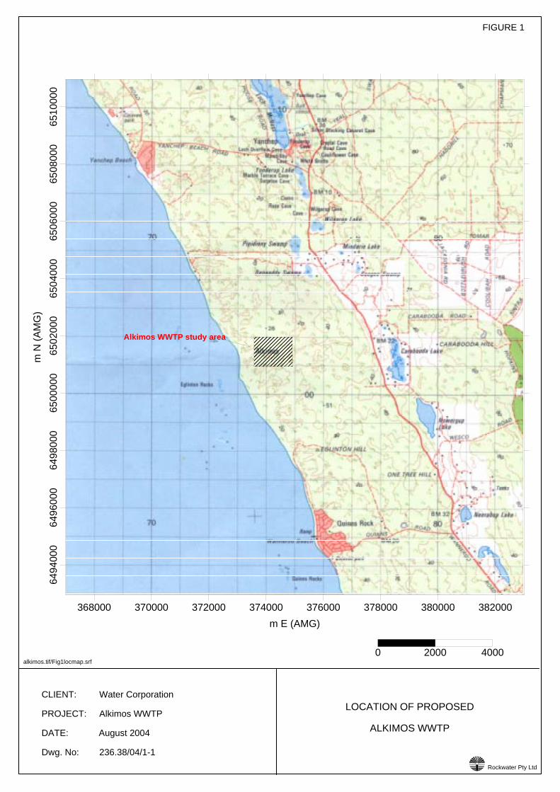
CLIENT: Water Corporation
PROJECT: Alkimos WWTP
DATE: August 2004
Dwg. No: 236.38/04/1-1
LOCATION OF PROPOSED
ALKIMOS WWTP
Rockwater Pty Ltd
FIGURE 1
!
alkimos.tif/Fig1locmap.srf
368000 370000 372000 374000 376000 378000 380000 382000m E (AMG)
6494
000
6496
000
6498
000
6500
000
6502
000
6504
000
6506
000
6508
000
6510
000
m N
(AM
G)
0 2000 4000
���������Alkimos WWTP study area
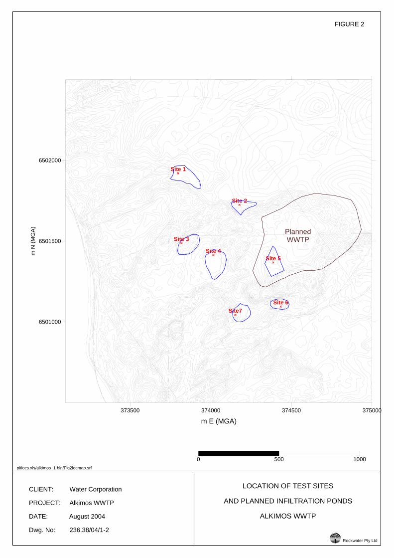
CLIENT: Water Corporation
PROJECT: Alkimos WWTP
DATE: August 2004
Dwg. No: 236.38/04/1-2
LOCATION OF TEST SITES
AND PLANNED INFILTRATION PONDS
ALKIMOS WWTP
Rockwater Pty Ltd
FIGURE 2
!
373500 374000 374500 375000
m E (MGA)
6501000
6501500
6502000
m N
(MG
A)
Site 1
Site 2
Site 3
Site 4Site 5
Site 6Site7
0 500 1000pitlocs.xls/alkimos_1.bln/Fig2locmap.srf
PlannedWWTP
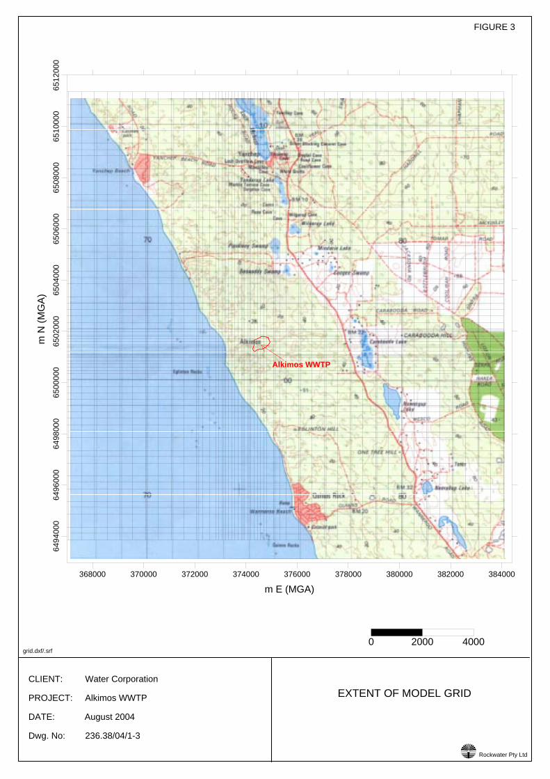
CLIENT: Water Corporation
PROJECT: Alkimos WWTP
DATE: August 2004
Dwg. No: 236.38/04/1-3
EXTENT OF MODEL GRID
Rockwater Pty Ltd
FIGURE 3
!
grid.dxf/.srf
368000 370000 372000 374000 376000 378000 380000 382000 384000
m E (MGA)
6494
000
6496
000
6498
000
6500
000
6502
000
6504
000
6506
000
6508
000
6510
000
6512
000
m N
(MG
A)
0 2000 4000
Alkimos WWTP
CLIENT: Water Corporation
PROJECT: Alkimos WWTP
DATE: August 2004
Dwg No: 236.38/04/1-4
FIGURE 4
COMPARISON BETWEEN MODEL-CALCULATED
SUMMER GROUNDWATER LEVELS
(CONTOURS, m AHD) AND LEVELS MEASURED
19 MARCH 1990 (BORE VALUES)
rlwls.xls/sssumwl.dat/.grd/.srf
Rockwater Pty Ltd!
372000 372500 373000 373500 374000 374500 375000 375500 376000 376500m E (MGA)
6499000
6499500
6500000
6500500
6501000
6501500
6502000
6502500
6503000
6503500
6504000
6504500m
N (M
GA)
1.13
1.20
0.41
1.12
1.05
0.76
1.00
1.12
1.21
WWTPSite
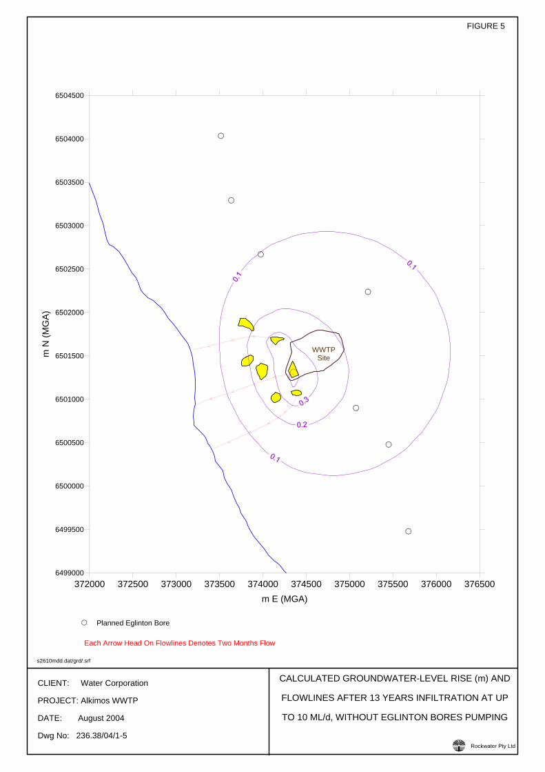
CLIENT: Water Corporation
PROJECT: Alkimos WWTP
DATE: August 2004
Dwg No: 236.38/04/1-5
FIGURE 5
CALCULATED GROUNDWATER-LEVEL RISE (m) AND
FLOWLINES AFTER 13 YEARS INFILTRATION AT UP
TO 10 ML/d, WITHOUT EGLINTON BORES PUMPING
s2610mdd.dat/grd/.srf
Rockwater Pty Ltd!
372000 372500 373000 373500 374000 374500 375000 375500 376000 376500m E (MGA)
6499000
6499500
6500000
6500500
6501000
6501500
6502000
6502500
6503000
6503500
6504000
6504500
m N
(MG
A)
WWTPSite
Planned Eglinton Bore
Each Arrow Head On Flowlines Denotes Two Months Flow
CLIENT: Water Corporation
PROJECT: Alkimos WWTP
DATE: August 2004
Dwg No: 236.38/04/1-6
FIGURE 6
CALCULATED GROUNDWATER-LEVEL RISE (m) AND
FLOWLINES AFTER 13 YEARS INFILTRATION AT UP
TO 10 ML/d, WITH EGLINTON BORES PUMPING
s2610medd.dat/grd/.srf
Rockwater Pty Ltd!
372000 372500 373000 373500 374000 374500 375000 375500 376000 376500m E (MGA)
6499000
6499500
6500000
6500500
6501000
6501500
6502000
6502500
6503000
6503500
6504000
6504500
m N
(MG
A)
WWTPSite
Planned Eglinton Bore
Each Arrow Head On Flowlines Denotes Two Months Flow

CLIENT: Water Corporation
PROJECT: Alkimos WWTP
DATE: August 2004
Dwg No: 236.38/04/1-7
FIGURE 7
CALCULATED GROUNDWATER-LEVEL RISE (m) AND
FLOWLINES AFTER 13 YEARS INFILTRATION AT UP
TO 20 ML/d, WITHOUT EGLINTON BORES PUMPING
s2620mdd.dat/grd/.srf
Rockwater Pty Ltd!
372000 372500 373000 373500 374000 374500 375000 375500 376000 376500m E (MGA)
6499000
6499500
6500000
6500500
6501000
6501500
6502000
6502500
6503000
6503500
6504000
6504500
m N
(MG
A)
WWTPSite
Planned Eglinton Bore
Each Arrow Head On Flowlines Denotes Two Months Flow
CLIENT: Water Corporation
PROJECT: Alkimos WWTP
DATE: August 2004
Dwg No: 236.38/04/1-8
FIGURE 8
CALCULATED GROUNDWATER-LEVEL RISE (m)
AND FLOWLINES AFTER 13 YEARS INFILTRATION
AT UP TO 20 ML/d, WITH EGLINTON BORES PUMPING
s2620medd.dat/grd/.srf
Rockwater Pty Ltd!
372000 372500 373000 373500 374000 374500 375000 375500 376000 376500m E (MGA)
6499000
6499500
6500000
6500500
6501000
6501500
6502000
6502500
6503000
6503500
6504000
6504500
m N
(MG
A)
WWTPSite
Planned Eglinton Bore
Each Arrow Head On Flowlines Denotes Two Months Flow
CLIENT: Water Corporation
PROJECT: Alkimos WWTP
DATE: September 2004
Dwg No: 236.38/04/1-9
FIGURE 9
CALCULATED GROUNDWATER-LEVEL RISE (m)
AND FLOWLINES AFTER 13 YEARS INFILTRATION
AT UP TO 10 ML/d, WITH EGLINTON BORES PUMPING
(REVISED BOREFIELD CONFIGURATION)
13y10nbdd.dat/grd/13ynbpth.dxf/.srf
Rockwater Pty Ltd!
372000 372500 373000 373500 374000 374500 375000 375500 376000 376500m E (MGA)
6499000
6499500
6500000
6500500
6501000
6501500
6502000
6502500
6503000
6503500
6504000
6504500
m N
(MG
A)
WWTPSite
Planned Eglinton Bore
Each Arrow Head On Flowlines Denotes Two Months Flow
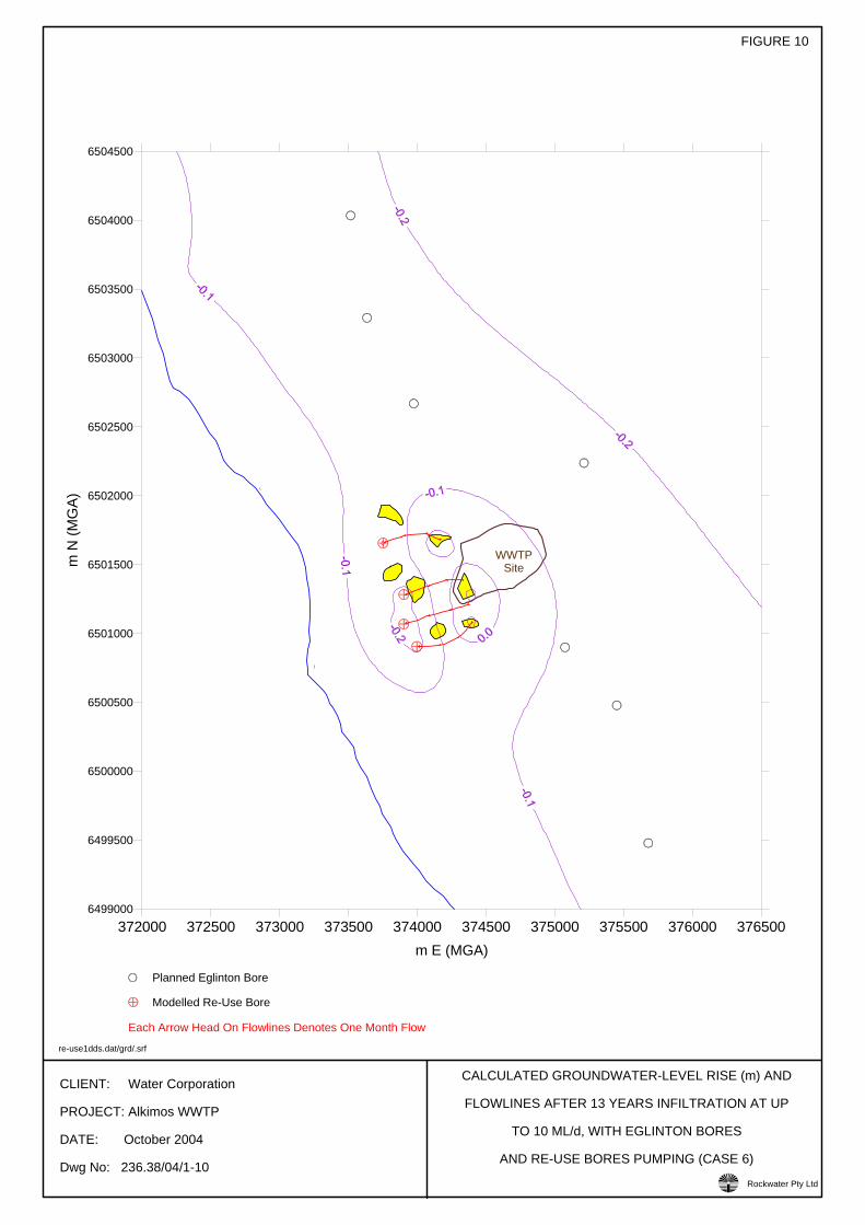
CLIENT: Water Corporation
PROJECT: Alkimos WWTP
DATE: October 2004
Dwg No: 236.38/04/1-10
FIGURE 10
CALCULATED GROUNDWATER-LEVEL RISE (m) AND
FLOWLINES AFTER 13 YEARS INFILTRATION AT UP
TO 10 ML/d, WITH EGLINTON BORES
AND RE-USE BORES PUMPING (CASE 6)
re-use1dds.dat/grd/.srf
Rockwater Pty Ltd!
372000 372500 373000 373500 374000 374500 375000 375500 376000 376500m E (MGA)
6499000
6499500
6500000
6500500
6501000
6501500
6502000
6502500
6503000
6503500
6504000
6504500
m N
(MG
A)
WWTPSite
Planned Eglinton Bore
Modelled Re-Use Bore
Each Arrow Head On Flowlines Denotes One Month Flow
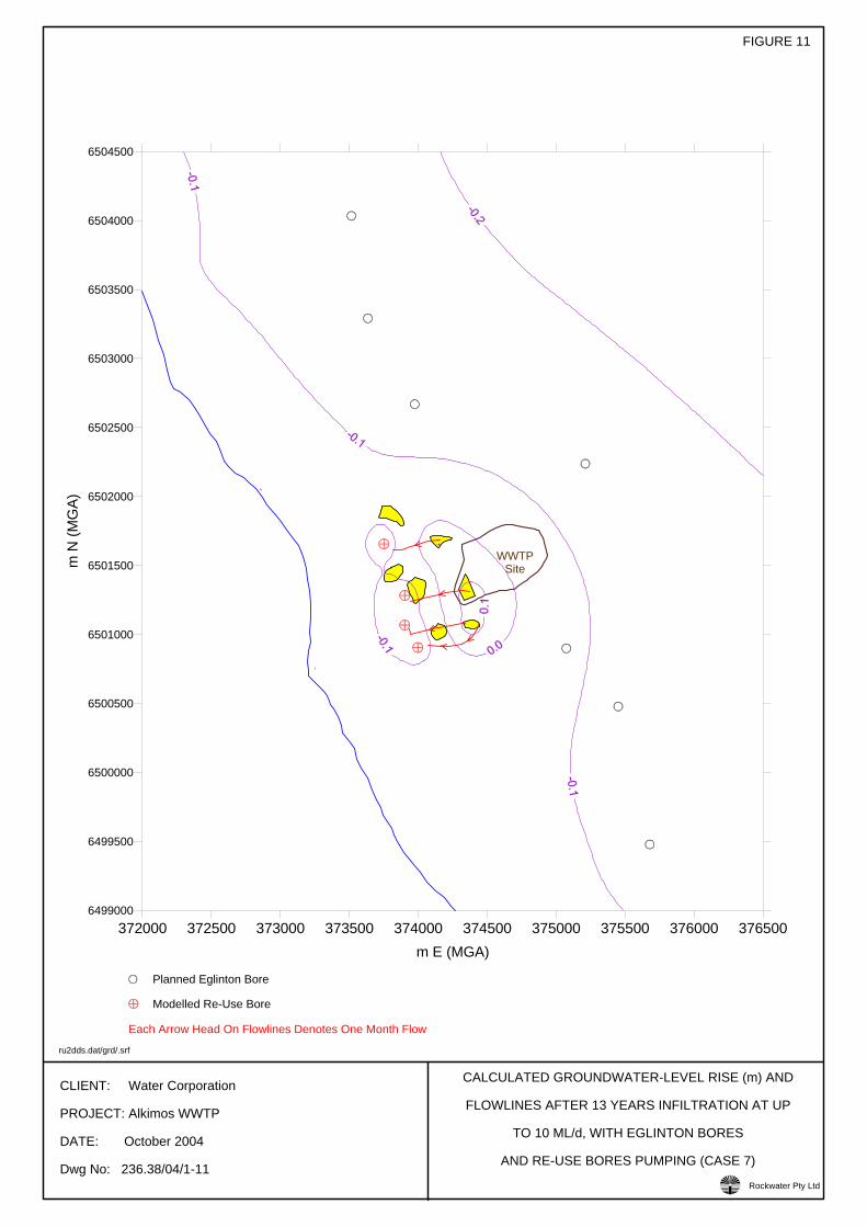
CLIENT: Water Corporation
PROJECT: Alkimos WWTP
DATE: October 2004
Dwg No: 236.38/04/1-11
FIGURE 11
CALCULATED GROUNDWATER-LEVEL RISE (m) AND
FLOWLINES AFTER 13 YEARS INFILTRATION AT UP
TO 10 ML/d, WITH EGLINTON BORES
AND RE-USE BORES PUMPING (CASE 7)
ru2dds.dat/grd/.srf
Rockwater Pty Ltd!
372000 372500 373000 373500 374000 374500 375000 375500 376000 376500m E (MGA)
6499000
6499500
6500000
6500500
6501000
6501500
6502000
6502500
6503000
6503500
6504000
6504500
m N
(MG
A)
WWTPSite
Planned Eglinton Bore
Modelled Re-Use Bore
Each Arrow Head On Flowlines Denotes One Month Flow
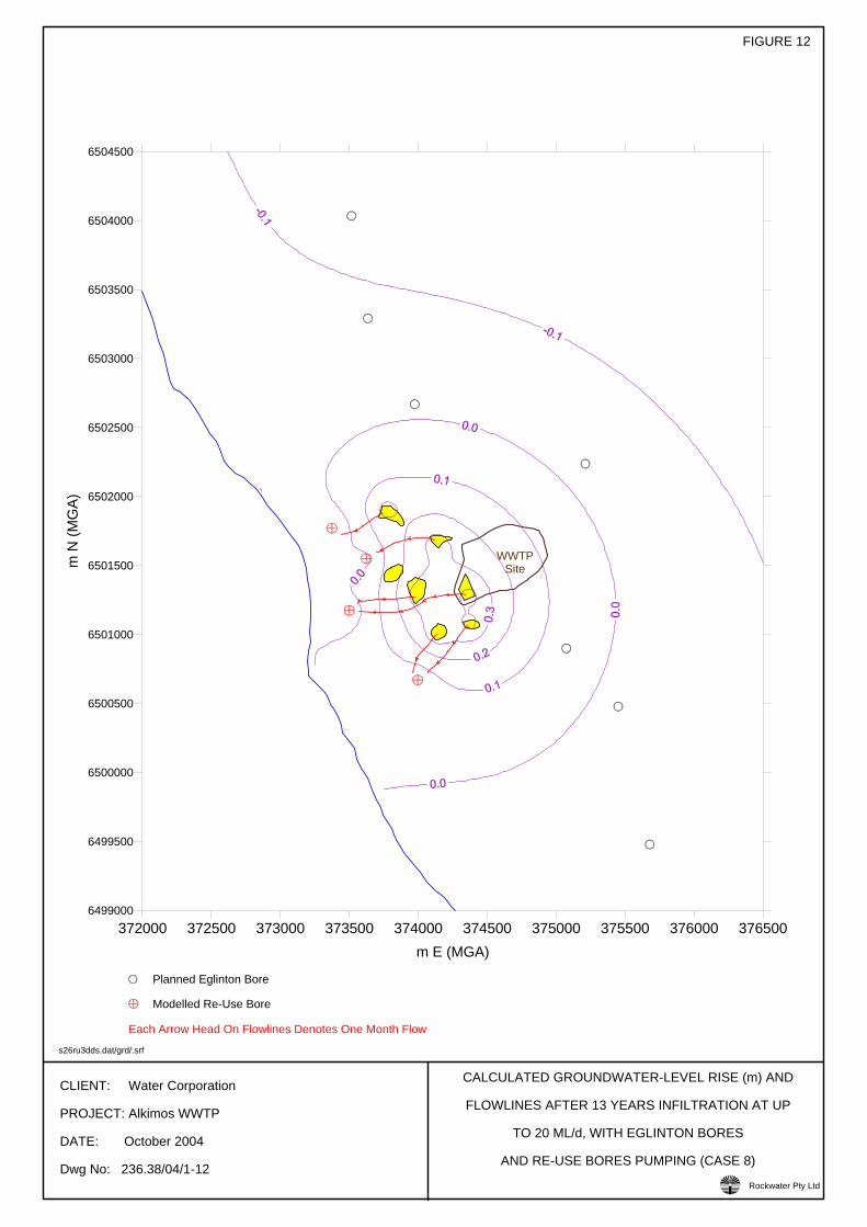
CLIENT: Water Corporation
PROJECT: Alkimos WWTP
DATE: October 2004
Dwg No: 236.38/04/1-12
FIGURE 12
CALCULATED GROUNDWATER-LEVEL RISE (m) AND
FLOWLINES AFTER 13 YEARS INFILTRATION AT UP
TO 20 ML/d, WITH EGLINTON BORES
AND RE-USE BORES PUMPING (CASE 8)
s26ru3dds.dat/grd/.srf
Rockwater Pty Ltd!
372000 372500 373000 373500 374000 374500 375000 375500 376000 376500m E (MGA)
6499000
6499500
6500000
6500500
6501000
6501500
6502000
6502500
6503000
6503500
6504000
6504500
m N
(MG
A)
WWTPSite
Planned Eglinton Bore
Modelled Re-Use Bore
Each Arrow Head On Flowlines Denotes One Month Flow
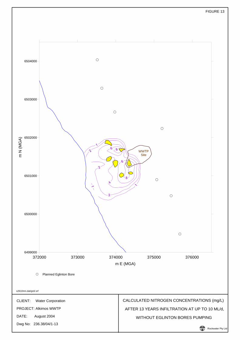
CLIENT: Water Corporation
PROJECT: Alkimos WWTP
DATE: August 2004
Dwg No: 236.38/04/1-13
FIGURE 13
CALCULATED NITROGEN CONCENTRATIONS (mg/L)
AFTER 13 YEARS INFILTRATION AT UP TO 10 ML/d,
WITHOUT EGLINTON BORES PUMPING
s2610mn.dat/grd/.srf
Rockwater Pty Ltd!
372000 373000 374000 375000 376000m E (MGA)
6499000
6500000
6501000
6502000
6503000
6504000
m N
(MG
A)
WWTPSite
Planned Eglinton Bore
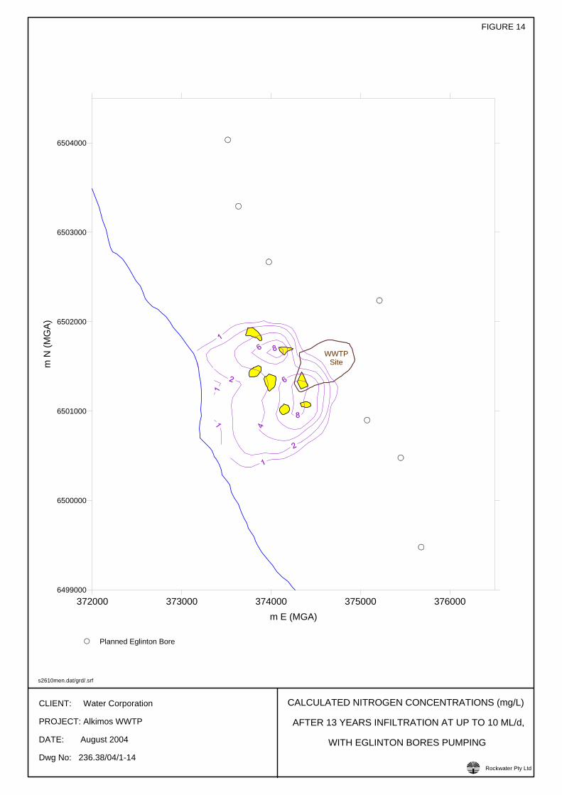
CLIENT: Water Corporation
PROJECT: Alkimos WWTP
DATE: August 2004
Dwg No: 236.38/04/1-14
FIGURE 14
CALCULATED NITROGEN CONCENTRATIONS (mg/L)
AFTER 13 YEARS INFILTRATION AT UP TO 10 ML/d,
WITH EGLINTON BORES PUMPING
s2610men.dat/grd/.srf
Rockwater Pty Ltd!
372000 373000 374000 375000 376000m E (MGA)
6499000
6500000
6501000
6502000
6503000
6504000
m N
(MG
A)
WWTPSite
Planned Eglinton Bore
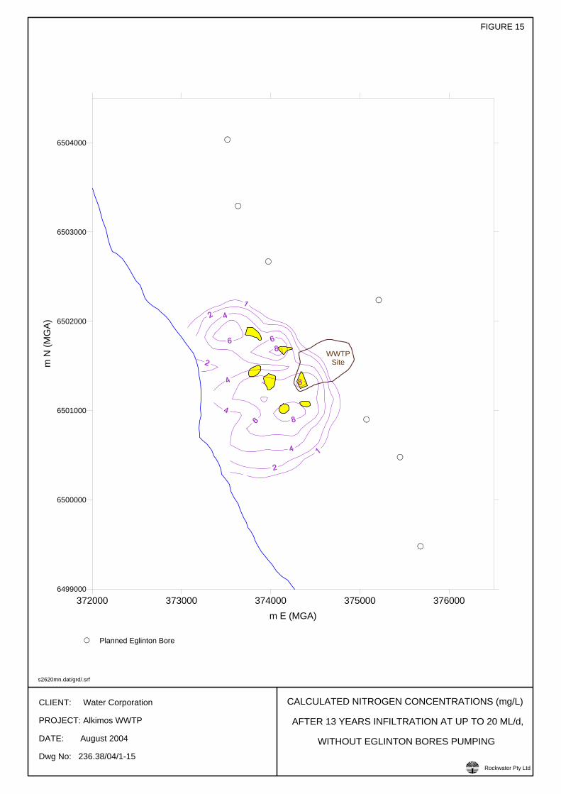
CLIENT: Water Corporation
PROJECT: Alkimos WWTP
DATE: August 2004
Dwg No: 236.38/04/1-15
FIGURE 15
CALCULATED NITROGEN CONCENTRATIONS (mg/L)
AFTER 13 YEARS INFILTRATION AT UP TO 20 ML/d,
WITHOUT EGLINTON BORES PUMPING
s2620mn.dat/grd/.srf
Rockwater Pty Ltd!
372000 373000 374000 375000 376000m E (MGA)
6499000
6500000
6501000
6502000
6503000
6504000
m N
(MG
A)
WWTPSite
Planned Eglinton Bore
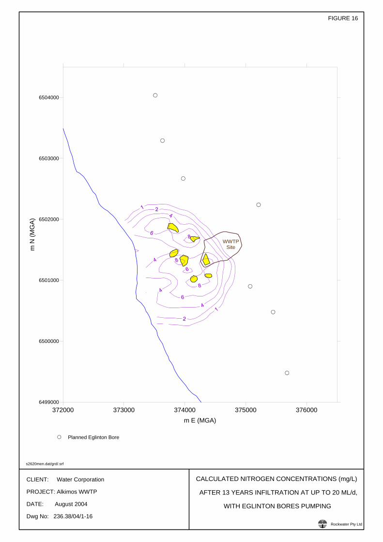
CLIENT: Water Corporation
PROJECT: Alkimos WWTP
DATE: August 2004
Dwg No: 236.38/04/1-16
FIGURE 16
CALCULATED NITROGEN CONCENTRATIONS (mg/L)
AFTER 13 YEARS INFILTRATION AT UP TO 20 ML/d,
WITH EGLINTON BORES PUMPING
s2620men.dat/grd/.srf
Rockwater Pty Ltd!
372000 373000 374000 375000 376000m E (MGA)
6499000
6500000
6501000
6502000
6503000
6504000
m N
(MG
A)
WWTPSite
Planned Eglinton Bore

Client: W
ater Corporation
Project: Alkimos W
WTP
Date: August 2004
Dw
g. No: 236.38/04/1-17
MO
DEL-C
ALCU
LATED N
CO
NC
S (mg/L)
AT SHO
RE W
EST OF W
WTP
10 ML/d M
AXIMU
M IN
FILTRATIO
N
FIGU
RE 17
Rockw
ater Pty Ltd
nconcs.xls/.grf
!
0 1000 2000 3000 4000 5000Days From 1 September 2007
0.0
0.1
0.2
0.3
0.4
0.5
0.6
0.7
0.8
0.9
1.0
Nitrogen C
oncentration (mg/L)
With Eglinton Bores Pumping From 2010Without Eglinton Bores
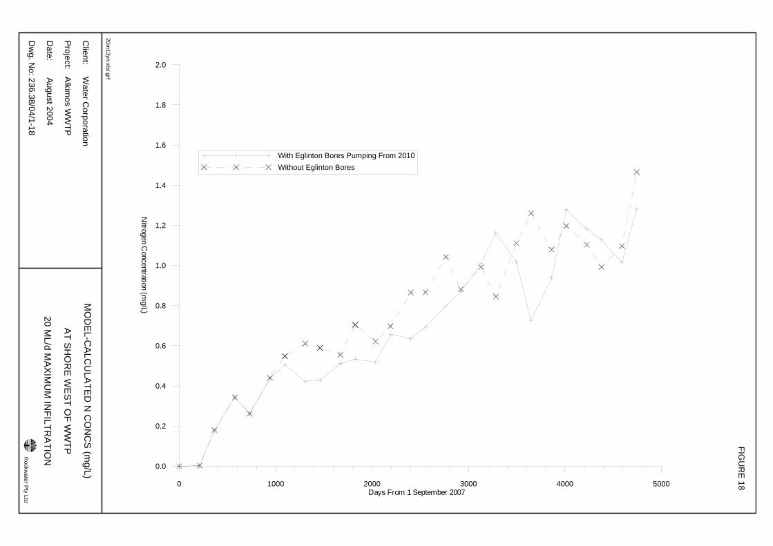
Client: W
ater Corporation
Project: Alkimos W
WTP
Date: August 2004
Dw
g. No: 236.38/04/1-18
MO
DEL-C
ALCU
LATED N
CO
NC
S (mg/L)
AT SHO
RE W
EST OF W
WTP
20 ML/d M
AXIMU
M IN
FILTRATIO
N
FIGU
RE 18
Rockw
ater Pty Ltd
20m13yn.xls/.grf
!
0 1000 2000 3000 4000 5000Days From 1 September 2007
0.0
0.2
0.4
0.6
0.8
1.0
1.2
1.4
1.6
1.8
2.0
Nitrogen C
oncentration (mg/L)
With Eglinton Bores Pumping From 2010Without Eglinton Bores
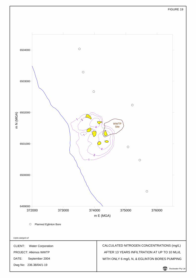
CLIENT: Water Corporation
PROJECT: Alkimos WWTP
DATE: September 2004
Dwg No: 236.38/04/1-19
FIGURE 19
CALCULATED NITROGEN CONCENTRATIONS (mg/L)
AFTER 13 YEARS INFILTRATION AT UP TO 10 ML/d,
WITH ONLY 6 mg/L N, & EGLINTON BORES PUMPING
13y6n.dat/grd/.srf
Rockwater Pty Ltd!
372000 373000 374000 375000 376000m E (MGA)
6499000
6500000
6501000
6502000
6503000
6504000
m N
(MG
A)
WWTPSite
Planned Eglinton Bore
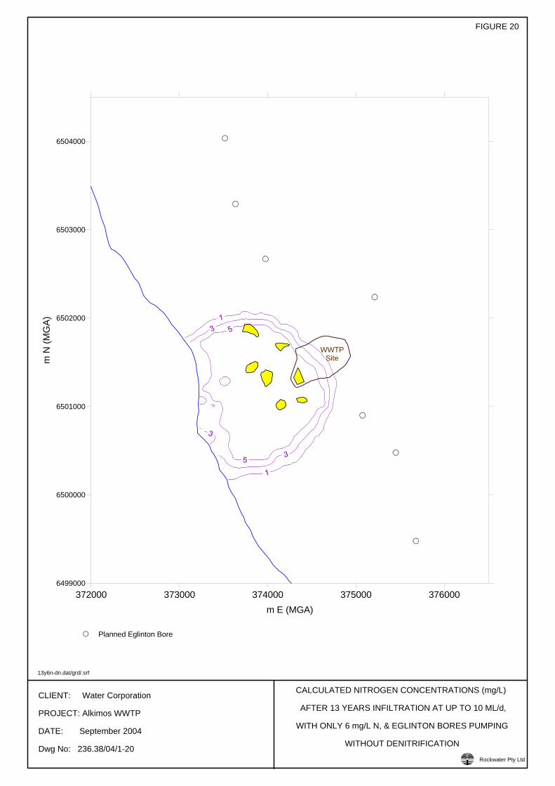
CLIENT: Water Corporation
PROJECT: Alkimos WWTP
DATE: September 2004
Dwg No: 236.38/04/1-20
FIGURE 20
CALCULATED NITROGEN CONCENTRATIONS (mg/L)
AFTER 13 YEARS INFILTRATION AT UP TO 10 ML/d,
WITH ONLY 6 mg/L N, & EGLINTON BORES PUMPING
WITHOUT DENITRIFICATION
13y6n-dn.dat/grd/.srf
Rockwater Pty Ltd!
372000 373000 374000 375000 376000m E (MGA)
6499000
6500000
6501000
6502000
6503000
6504000
m N
(MG
A)
WWTPSite
Planned Eglinton Bore
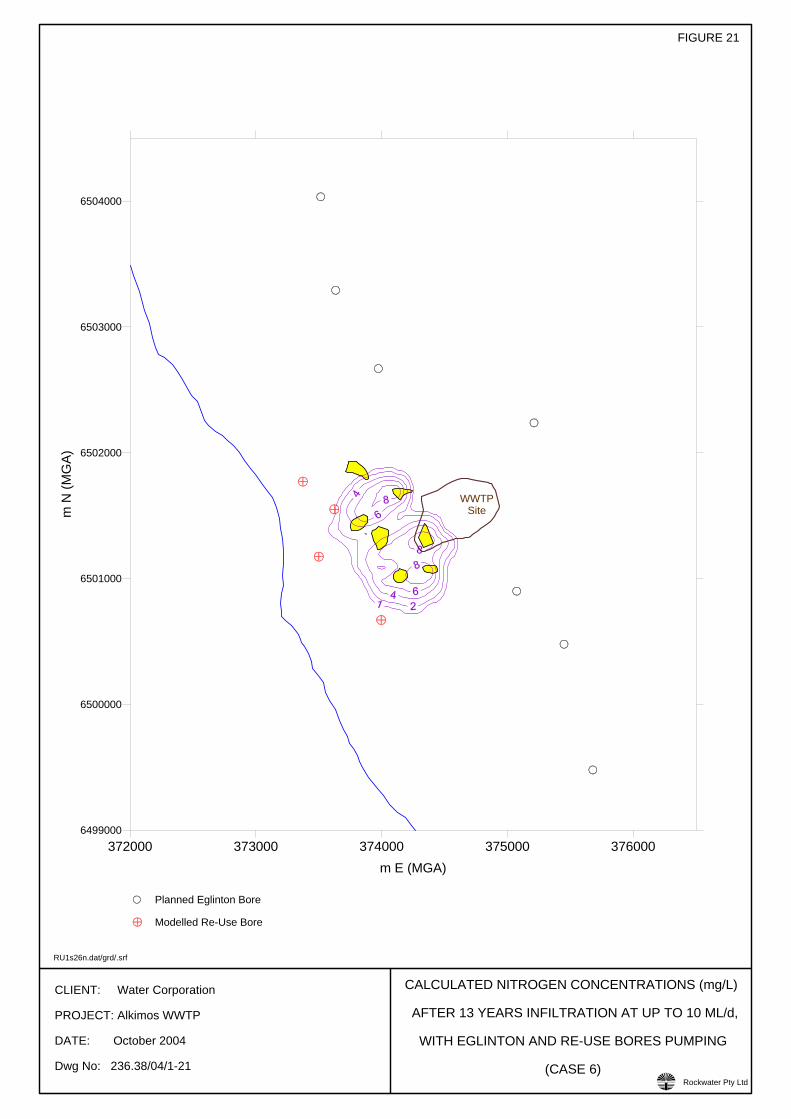
CLIENT: Water Corporation
PROJECT: Alkimos WWTP
DATE: October 2004
Dwg No: 236.38/04/1-21
FIGURE 21
CALCULATED NITROGEN CONCENTRATIONS (mg/L)
AFTER 13 YEARS INFILTRATION AT UP TO 10 ML/d,
WITH EGLINTON AND RE-USE BORES PUMPING
(CASE 6)
RU1s26n.dat/grd/.srf
Rockwater Pty Ltd!
372000 373000 374000 375000 376000m E (MGA)
6499000
6500000
6501000
6502000
6503000
6504000
m N
(MG
A)
WWTPSite
Planned Eglinton Bore
Modelled Re-Use Bore
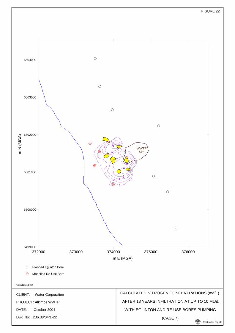
CLIENT: Water Corporation
PROJECT: Alkimos WWTP
DATE: October 2004
Dwg No: 236.38/04/1-22
FIGURE 22
CALCULATED NITROGEN CONCENTRATIONS (mg/L)
AFTER 13 YEARS INFILTRATION AT UP TO 10 ML/d,
WITH EGLINTON AND RE-USE BORES PUMPING
(CASE 7)
ru2n.dat/grd/.srf
Rockwater Pty Ltd!
372000 373000 374000 375000 376000m E (MGA)
6499000
6500000
6501000
6502000
6503000
6504000
m N
(MG
A)
WWTPSite
Planned Eglinton Bore
Modelled Re-Use Bore
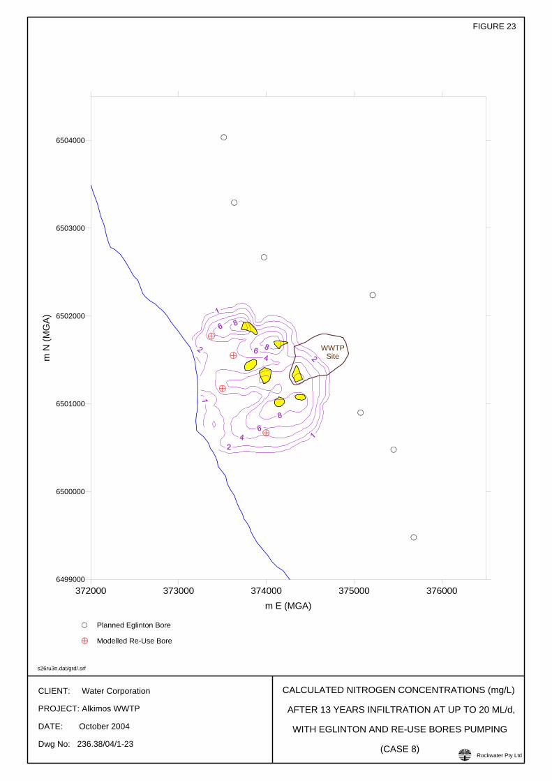
CLIENT: Water Corporation
PROJECT: Alkimos WWTP
DATE: October 2004
Dwg No: 236.38/04/1-23
FIGURE 23
CALCULATED NITROGEN CONCENTRATIONS (mg/L)
AFTER 13 YEARS INFILTRATION AT UP TO 20 ML/d,
WITH EGLINTON AND RE-USE BORES PUMPING
(CASE 8)
s26ru3n.dat/grd/.srf
Rockwater Pty Ltd!
372000 373000 374000 375000 376000m E (MGA)
6499000
6500000
6501000
6502000
6503000
6504000
m N
(MG
A)
WWTPSite
Planned Eglinton Bore
Modelled Re-Use Bore

Rockwater Pty Ltd 236.38/04/1
APPENDICES

Rockwater Pty Ltd 236.38/04/1
APPENDIX I
LITHOLOGICAL DESCRIPTIONS OF PIT SAMPLES, ALKIMOS
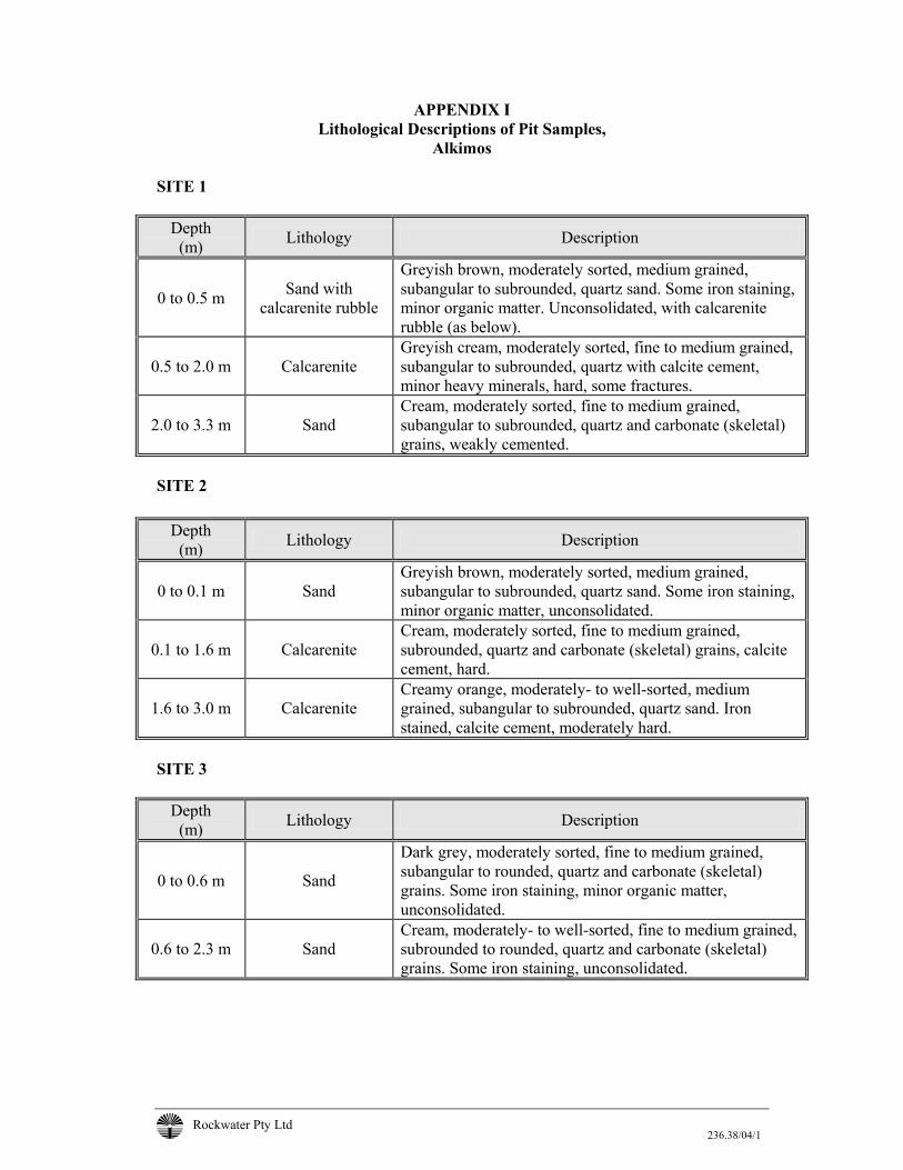
Rockwater Pty Ltd 236.38/04/1
APPENDIX I Lithological Descriptions of Pit Samples,
Alkimos SITE 1
Depth (m) Lithology Description
0 to 0.5 m Sand with calcarenite rubble
Greyish brown, moderately sorted, medium grained, subangular to subrounded, quartz sand. Some iron staining, minor organic matter. Unconsolidated, with calcarenite rubble (as below).
0.5 to 2.0 m Calcarenite Greyish cream, moderately sorted, fine to medium grained, subangular to subrounded, quartz with calcite cement, minor heavy minerals, hard, some fractures.
2.0 to 3.3 m Sand Cream, moderately sorted, fine to medium grained, subangular to subrounded, quartz and carbonate (skeletal) grains, weakly cemented.
SITE 2
Depth
(m) Lithology Description
0 to 0.1 m Sand Greyish brown, moderately sorted, medium grained, subangular to subrounded, quartz sand. Some iron staining, minor organic matter, unconsolidated.
0.1 to 1.6 m Calcarenite Cream, moderately sorted, fine to medium grained, subrounded, quartz and carbonate (skeletal) grains, calcite cement, hard.
1.6 to 3.0 m Calcarenite Creamy orange, moderately- to well-sorted, medium grained, subangular to subrounded, quartz sand. Iron stained, calcite cement, moderately hard.
SITE 3
Depth (m) Lithology Description
0 to 0.6 m Sand
Dark grey, moderately sorted, fine to medium grained, subangular to rounded, quartz and carbonate (skeletal) grains. Some iron staining, minor organic matter, unconsolidated.
0.6 to 2.3 m Sand Cream, moderately- to well-sorted, fine to medium grained, subrounded to rounded, quartz and carbonate (skeletal) grains. Some iron staining, unconsolidated.
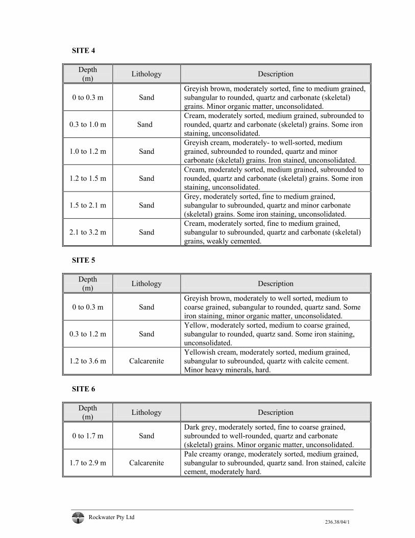
Rockwater Pty Ltd 236.38/04/1
SITE 4
Depth (m) Lithology Description
0 to 0.3 m Sand Greyish brown, moderately sorted, fine to medium grained, subangular to rounded, quartz and carbonate (skeletal) grains. Minor organic matter, unconsolidated.
0.3 to 1.0 m Sand
Cream, moderately sorted, medium grained, subrounded to rounded, quartz and carbonate (skeletal) grains. Some iron staining, unconsolidated.
1.0 to 1.2 m
Sand Greyish cream, moderately- to well-sorted, medium grained, subrounded to rounded, quartz and minor carbonate (skeletal) grains. Iron stained, unconsolidated.
1.2 to 1.5 m
Sand Cream, moderately sorted, medium grained, subrounded to rounded, quartz and carbonate (skeletal) grains. Some iron staining, unconsolidated.
1.5 to 2.1 m
Sand Grey, moderately sorted, fine to medium grained, subangular to subrounded, quartz and minor carbonate (skeletal) grains. Some iron staining, unconsolidated.
2.1 to 3.2 m
Sand Cream, moderately sorted, fine to medium grained, subangular to subrounded, quartz and carbonate (skeletal) grains, weakly cemented.
SITE 5
Depth (m) Lithology Description
0 to 0.3 m Sand Greyish brown, moderately to well sorted, medium to coarse grained, subangular to rounded, quartz sand. Some iron staining, minor organic matter, unconsolidated.
0.3 to 1.2 m Sand Yellow, moderately sorted, medium to coarse grained, subangular to rounded, quartz sand. Some iron staining, unconsolidated.
1.2 to 3.6 m Calcarenite Yellowish cream, moderately sorted, medium grained, subangular to subrounded, quartz with calcite cement. Minor heavy minerals, hard.
SITE 6
Depth (m) Lithology Description
0 to 1.7 m Sand Dark grey, moderately sorted, fine to coarse grained, subrounded to well-rounded, quartz and carbonate (skeletal) grains. Minor organic matter, unconsolidated.
1.7 to 2.9 m Calcarenite Pale creamy orange, moderately sorted, medium grained, subangular to subrounded, quartz sand. Iron stained, calcite cement, moderately hard.

Rockwater Pty Ltd 236.38/04/1
SITE 7
Depth (m) Lithology Description
0 to 0.6 Sand Black, moderately-poorly sorted, fine to medium grained, silty, quartz and carbonate (skeletal) grains. Carbonaceous, unconsolidated.
0.6 to 1.5 Sand Greyish black, moderately sorted, fine to coarse grained, quartz and carbonate (skeletal) grains. Carbonaceous, unconsolidated.
1.5 to 3.0 Sand Cream, moderately sorted, fine to medium grained, subrounded to rounded, quartz and carbonate (skeletal) grains. Some iron staining, unconsolidated.

Rockwater Pty Ltd 236.38/04/1
APPENDIX II
SIEVE ANALYSIS, PIT SAMPLES, ALKIMOS
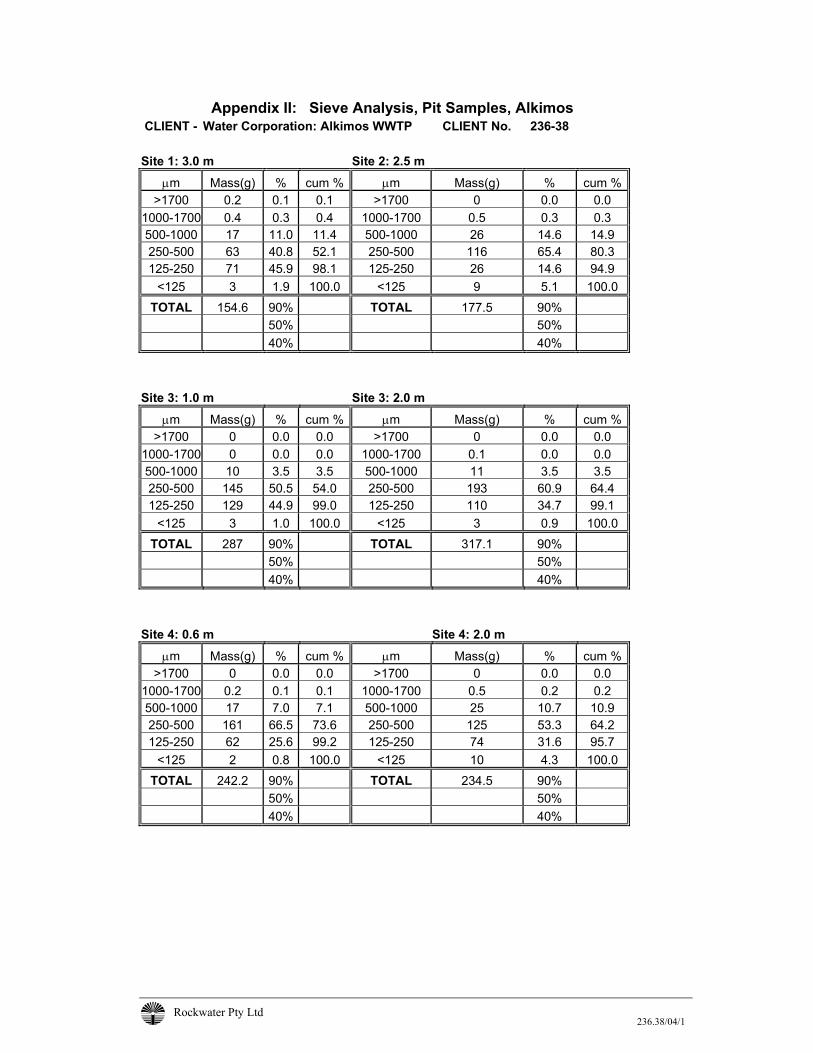
Rockwater Pty Ltd 236.38/04/1
Appendix II: Sieve Analysis, Pit Samples, Alkimos CLIENT - Water Corporation: Alkimos WWTP CLIENT No. 236-38
Site 1: 3.0 m Site 2: 2.5 m
µm Mass(g) % cum % µm Mass(g) % cum % >1700 0.2 0.1 0.1 >1700 0 0.0 0.0
1000-1700 0.4 0.3 0.4 1000-1700 0.5 0.3 0.3 500-1000 17 11.0 11.4 500-1000 26 14.6 14.9 250-500 63 40.8 52.1 250-500 116 65.4 80.3 125-250 71 45.9 98.1 125-250 26 14.6 94.9
<125 3 1.9 100.0 <125 9 5.1 100.0 TOTAL 154.6 90% TOTAL 177.5 90%
50% 50% 40% 40%
Site 3: 1.0 m Site 3: 2.0 m
µm Mass(g) % cum % µm Mass(g) % cum % >1700 0 0.0 0.0 >1700 0 0.0 0.0
1000-1700 0 0.0 0.0 1000-1700 0.1 0.0 0.0 500-1000 10 3.5 3.5 500-1000 11 3.5 3.5 250-500 145 50.5 54.0 250-500 193 60.9 64.4 125-250 129 44.9 99.0 125-250 110 34.7 99.1
<125 3 1.0 100.0 <125 3 0.9 100.0 TOTAL 287 90% TOTAL 317.1 90%
50% 50% 40% 40%
Site 4: 0.6 m Site 4: 2.0 m
µm Mass(g) % cum % µm Mass(g) % cum % >1700 0 0.0 0.0 >1700 0 0.0 0.0
1000-1700 0.2 0.1 0.1 1000-1700 0.5 0.2 0.2 500-1000 17 7.0 7.1 500-1000 25 10.7 10.9 250-500 161 66.5 73.6 250-500 125 53.3 64.2 125-250 62 25.6 99.2 125-250 74 31.6 95.7
<125 2 0.8 100.0 <125 10 4.3 100.0 TOTAL 242.2 90% TOTAL 234.5 90%
50% 50% 40% 40%
Rockwater Pty Ltd 236.38/04/1
Appendix II: Sieve Analysis, Pit Samples, Alkimos CLIENT - Water Corporation: Alkimos WWTP CLIENT No. 236-38 Site 5: 1.0 m Site 6: 1.0 m
µm Mass(g) % cum % µm Mass(g) % cum % >1700 0.1 0.0 0.0 >1700 0 0.0 0.0
1000-1700 3 0.9 0.9 1000-1700 0.5 0.2 0.2 500-1000 116 33.2 34.1 500-1000 60 25.9 26.1 250-500 204 58.4 92.6 250-500 126 54.4 80.6 125-250 23 6.6 99.1 125-250 38 16.4 97.0
<125 3 0.9 100.0 <125 7 3.0 100.0 TOTAL 349.1 90% TOTAL 231.5 90%
50% 50% 40% 40%
Site 7: 1.0 m Site 7: 2.5 m
µm Mass(g) % cum % µm Mass(g) % cum % >1700 0.2 0.1 0.1 >1700 0 0.0 0.0
1000-1700 0.8 0.3 0.4 1000-1700 0.5 0.2 0.2 500-1000 56 22.4 22.8 500-1000 45 15.2 15.3 250-500 111 44.4 67.2 250-500 152 51.3 66.6 125-250 66 26.4 93.6 125-250 93 31.4 98.0
<125 16 6.4 100.0 <125 6 2.0 100.0 TOTAL 250 90% TOTAL 296.5 90%
50% 50% 40% 40%
Rockwater Pty Ltd
100
1,00
020
030
040
050
060
070
080
090
020
00
Gra
in S
ize
( µm
)
0102030405060708090100
Cumulative % Retained
Site
1 (3
.0 m
)
Figure A1
236-38/Grapher/Data/Sieve Tests.xls/Sieves Site 1 and 2.grf
Client: Water Corporation Project : Alkimos WWTP Site Date : July 2004 Dwg. No: 236.38/04/1-A1
Grain Size Curves For Pits at Sites 1 and 2
100
1,00
020
030
040
050
060
070
080
090
020
00
Gra
in S
ize
( µm
)
0102030405060708090100
Cumulative % Retained
Site
2 (2
.5 m
)
Rockwater Pty Ltd
100
1,00
020
030
040
050
060
070
080
090
020
00
Gra
in S
ize
( µm
)
0102030405060708090100
Cumulative % Retained
Site
3 (1
.0 m
)
Figure A2
236-38/Grapher/Data/Sieve Tests.xls/Sieves Site 3.grf
Client: Water Corporation Project : Alkimos WWTP Site Date : July 2004 Dwg. No: 236.38/04/1-A2
Grain Size Curves For Pit at Site 3
100
1,00
020
030
040
050
060
070
080
090
020
00
Gra
in S
ize
( µm
)
0102030405060708090100
Cumulative % Retained
Site
3 (2
.0 m
)
Rockwater Pty Ltd
100
1,00
020
030
040
050
060
070
080
090
020
00
Gra
in S
ize
( µm
)
0102030405060708090100
Cumulative % Retained
Site
4 (0
.6 m
)
Figure A3
236-38/Grapher/Data/Sieve Tests.xls/Sieves Site 4.grf
Client: Water Corporation Project : Alkimos WWTP Site Date : July 2004 Dwg. No: 236.38/04/1-A3
Grain Size Curves For Pit at Site 4
100
1,00
020
030
040
050
060
070
080
090
020
00
Gra
in S
ize
( µm
)
0102030405060708090100
Cumulative % Retained
Site
4 (2
.0 m
)
Rockwater Pty Ltd
100
1,00
020
030
040
050
060
070
080
090
020
00
Gra
in S
ize
( µm
)
0102030405060708090100
Cumulative % Retained
Site
5 (1
.0 m
)
Figure A4
236-38/Grapher/Data/Sieve Tests.xls/Sieves Sites5 and 6.grf
Client: Water Corporation Project : Alkimos WWTP Site Date : July 2004 Dwg. No: 236.38/04/1-A4
Grain Size Curves For Pits at Sites 5 and 6
100
1,00
020
030
040
050
060
070
080
090
020
00
Gra
in S
ize
( µm
)
0102030405060708090100
Cumulative % Retained
Site
6 (1
.0 m
)
Rockwater Pty Ltd
100
1,00
020
030
040
050
060
070
080
090
020
00
Gra
in S
ize
( µm
)
0102030405060708090100
Cumulative % Retained
Site
7 (1
.0 m
)
Figure A5
236-38/Grapher/Data/Sieve Tests.xls/Sieves Site 7.grf
Client: Water Corporation Project : Alkimos WWTP Site Date : July 2004 Dwg. No: 236.38/04/1-A5
Grain Size Curves For Pit at Site 7
100
1,00
020
030
040
050
060
070
080
090
020
00
Gra
in S
ize
( µm
)
0102030405060708090100
Cumulative % Retained
Site
7 (2
.5 m
)

Rockwater Pty Ltd 236.38/04/1
APPENDIX III
PIT SOAKAWAY TEST RESULTS

Rockwater Pty Ltd 236.38/04/1
Appendix III: Pit Soakaway Test Results
SITE # 1
(Using Somervilles' Method For Test-pits) Formula: a = 2.72 (Area, m2) k i (t2-t1) = log (h1/h2) - log (αh1+1/αh2+2) p = 6.60 (Pit perimeter, m) h1 = 0.36 (Head at t1, m) where: α = P/2A h2 = 0.30 (Head at t2,m)
(P = mean perimeter, A = area) t1 = 1.0 (Time at h1 in mins) (Assumes hydraulic gradient is unity) t2 = 4 (Time at h2 in mins) t2 - t1 = 3.0 α = 1.213
k 3.0 = 0.0792 - 0.0226 (Interim Calculation) k = 1.89E-02 m/min = 3.14E-04 m/sec Hydraulic Conductivity = 27.17 m/day
(i:\blanks\permsom.xls) Time (min) Time (sec) Head (mm) H (m) 0 0 400 0.4 0.5 30 370 0.37 1 60 360 0.36 2 120 340 0.34 3 180 320 0.32 4 240 300 0.3 5 300 280 0.28 6 360 260 0.26 7 420 240 0.24 8 480 190 0.19 9 540 110 0.11 11 660 50 0.05 15 900 0 0
Rockwater Pty Ltd 236.38/04/1
Appendix III: Pit Soakaway Test Results SITE # 2
(Using Somervilles' Method For Test-pits)
Formula: a = 2.85 (Area, m2) k i (t2-t1) = log (h1/h2) - log (αh1+1/αh2+2) p = 6.80 (Pit perimeter, m) h1 = 0.36 (Head at t1, m) where: α = P/2A h2 = 0.26 (Head at t2,m)
(P = mean perimeter, A = area) t1 = 1.0 (Time at h1 in mins) (Assumes hydraulic gradient is unity) t2 = 10 (Time at h2 in mins) t2 - t1 = 9.0 α = 1.193
k 9.0 = 0.1413 - 0.0378 (Interim Calculation) k = 1.15E-02 m/min = 1.92E-04 m/sec Hydraulic Conductivity = 16.56 m/day
(i:\blanks\permsom.xls) Time (min) Time (sec) Head (mm) H (m) 0 0 370 0.37 0.5 30 360 0.36 1 60 360 0.36 2 120 340 0.34 3 180 330 0.33 4 240 320 0.32 5 300 310 0.31 6 360 310 0.31 7 420 300 0.3 8 480 290 0.29 9 540 270 0.27 10 600 260 0.26 15 900 230 0.23 20 1200 190 0.19 25 1500 160 0.16 30 1800 130 0.13 35 2100 110 0.11 40 2400 80 0.08 45 2700 60 0.06 50 3000 40 0.04 55 3300 20 0.02 60 3600 0 0
Rockwater Pty Ltd 236.38/04/1
Appendix III: Pit Soakaway Test Results
SITE # 3
(Using Somervilles' Method For Test-pits) Formula: a = 1.6 (Area, m2) k i (t2-t1) = log (h1/h2) - log (αh1+1/αh2+2) p = 5.200 (Pit perimeter, m) h1 = 0.16 (Head at t1, m) where: α = P/2A h2 = 0.07 (Head at t2,m)
(P = mean perimeter, A = area) t1 = 1.0 (Time at h1 in mins) (Assumes hydraulic gradient is unity) t2 = 4 (Time at h2 in mins) t2 - t1 = 3.0 α = 1.625
k 3.0 = 0.3556 - 0.0535 (Interim Calculation) k = 1.01E-01 m/min = 1.68E-03 m/sec Hydraulic Conductivity = 144.99 m/day
(i:\blanks\permsom.xls) Time (min) Time (sec) Head (mm) H (m) 0 0 195 0.195 0.5 30 177 0.177 1 60 161 0.161 2 120 128 0.128 3 180 100 0.1 4 240 71 0.071 5 300 48 0.048 6 360 25 0.025 7 420 10 0.01 7.83 470 0 0
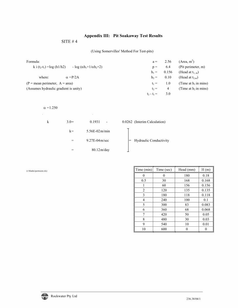
Rockwater Pty Ltd 236.38/04/1
Appendix III: Pit Soakaway Test Results
SITE # 4
(Using Somervilles' Method For Test-pits) Formula: a = 2.56 (Area, m2) k i (t2-t1) = log (h1/h2) - log (αh1+1/αh2+2) p = 6.4 (Pit perimeter, m) h1 = 0.156 (Head at t1, m) where: α = P/2A h2 = 0.10 (Head at t2,m)
(P = mean perimeter, A = area) t1 = 1.0 (Time at h1 in mins) (Assumes hydraulic gradient is unity) t2 = 4 (Time at h2 in mins) t2 - t1 = 3.0 α = 1.250
k 3.0 = 0.1931 - 0.0262 (Interim Calculation) k = 5.56E-02 m/min = 9.27E-04 m/sec Hydraulic Conductivity = 80.12 m/day
(i:\blanks\permsom.xls) Time (min) Time (sec) Head (mm) H (m) 0 0 180 0.18 0.5 30 168 0.168 1 60 156 0.156 2 120 135 0.135 3 180 118 0.118 4 240 100 0.1 5 300 83 0.083 6 360 68 0.068 7 420 50 0.05 8 480 30 0.03 9 540 10 0.01 10 600 0 0
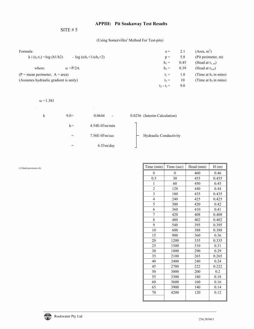
Rockwater Pty Ltd 236.38/04/1
APPIII: Pit Soakaway Test Results SITE # 5
(Using Somervilles' Method For Test-pits)
Formula: a = 2.1 (Area, m2) k i (t2-t1) =log (h1/h2) - log (αh1+1/αh2+2) p = 5.8 (Pit perimeter, m) h1 = 0.45 (Head at t1, m) where: α = P/2A h2 = 0.39 (Head at t2,m)
(P = mean perimeter, A = area) t1 = 1.0 (Time at h1 in mins) (Assumes hydraulic gradient is unity) t2 = 10 (Time at h2 in mins) t2 - t1 = 9.0 α = 1.381
k 9.0 = 0.0644 - 0.0236 (Interim Calculation) k = 4.54E-03 m/min = 7.56E-05 m/sec Hydraulic Conductivity = 6.53 m/day
(i:\blanks\permsom.xls) Time (min) Time (sec) Head (mm) H (m) 0 0 460 0.46 0.5 30 455 0.455 1 60 450 0.45 2 120 440 0.44 3 180 435 0.435 4 240 425 0.425 5 300 420 0.42 6 360 410 0.41 7 420 408 0.408 8 480 402 0.402 9 540 395 0.395 10 600 388 0.388 15 900 360 0.36 20 1200 335 0.335 25 1500 310 0.31 30 1800 290 0.29 35 2100 265 0.265 40 2400 240 0.24 45 2700 222 0.222 50 3000 200 0.2 55 3300 180 0.18 60 3600 160 0.16 65 3900 140 0.14 70 4200 120 0.12
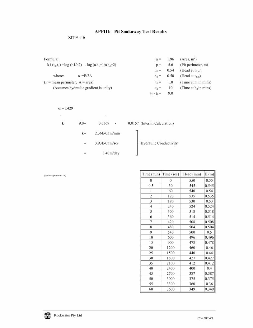
Rockwater Pty Ltd 236.38/04/1
APPIII: Pit Soakaway Test Results SITE # 6
Formula: a = 1.96 (Area, m2)
k i (t2-t1) =log (h1/h2) - log (αh1+1/αh2+2) p = 5.6 (Pit perimeter, m) h1 = 0.54 (Head at t1, m)
where: α = P/2A h2 = 0.50 (Head at t2,m) (P = mean perimeter, A = area) t1 = 1.0 (Time at h1 in mins)
(Assumes hydraulic gradient is unity) t2 = 10 (Time at h2 in mins) t2 - t1 = 9.0
α = 1.429
k 9.0 = 0.0369 - 0.0157 (Interim Calculation) k = 2.36E-03 m/min = 3.93E-05 m/sec Hydraulic Conductivity = 3.40 m/day
(i:\blanks\permsom.xls) Time (min) Time (sec) Head (mm) H (m)
0 0 550 0.55 0.5 30 545 0.545 1 60 540 0.54 2 120 535 0.535 3 180 530 0.53 4 240 524 0.524 5 300 518 0.518 6 360 514 0.514 7 420 508 0.508 8 480 504 0.504 9 540 500 0.5 10 600 496 0.496 15 900 478 0.478 20 1200 460 0.46 25 1500 440 0.44 30 1800 427 0.427 35 2100 412 0.412 40 2400 400 0.4 45 2700 387 0.387 50 3000 375 0.375 55 3300 360 0.36 60 3600 349 0.349
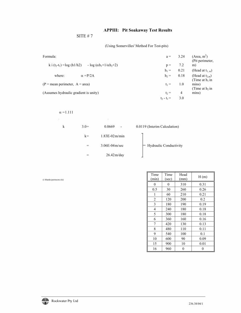
Rockwater Pty Ltd 236.38/04/1
APPIII: Pit Soakaway Test Results SITE # 7
(Using Somervilles' Method For Test-pits)
Formula: a = 3.24 (Area, m2)
k i (t2-t1) = log (h1/h2) - log (αh1+1/αh2+2) p = 7.2 (Pit perimeter, m)
h1 = 0.21 (Head at t1, m) where: α = P/2A h2 = 0.18 (Head at t2,m)
(P = mean perimeter, A = area) t1 = 1.0 (Time at h1 in mins)
(Assumes hydraulic gradient is unity) t2 = 4 (Time at h2 in mins)
t2 - t1 = 3.0 α = 1.111
k 3.0 = 0.0669 - 0.0119 (Interim Calculation) k = 1.83E-02 m/min = 3.06E-04 m/sec Hydraulic Conductivity = 26.42 m/day
(i:\blanks\permsom.xls) Time (min)
Time (sec)
Head (mm) H (m)
0 0 310 0.31 0.5 30 260 0.26 1 60 210 0.21 2 120 200 0.2 3 180 190 0.19 4 240 180 0.18 5 300 180 0.18 6 360 160 0.16 7 420 130 0.13 8 480 110 0.11 9 540 100 0.1 10 600 90 0.09 15 900 10 0.01 16 960 0 0

Rockwater Pty Ltd 236.38/04/1
APPENDIX IV
RING INFILTROMETER TEST RESULTS
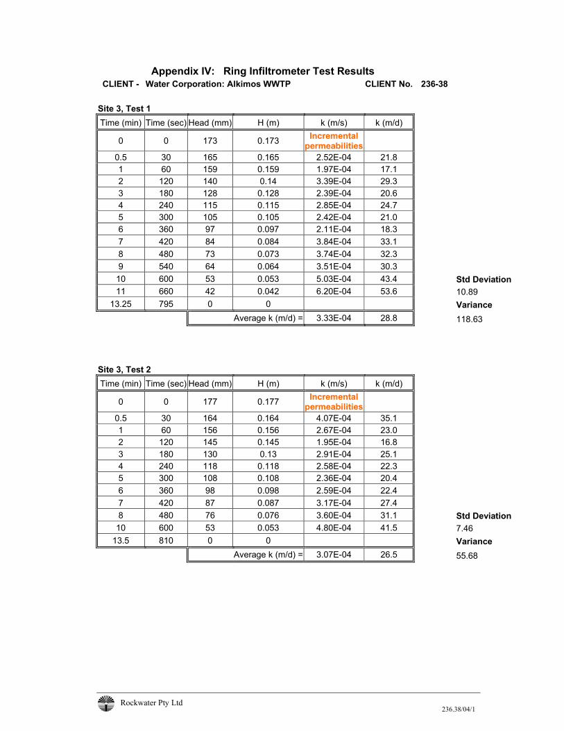
Rockwater Pty Ltd 236.38/04/1
Appendix IV: Ring Infiltrometer Test Results CLIENT - Water Corporation: Alkimos WWTP CLIENT No. 236-38
Site 3, Test 1 Time (min) Time (sec) Head (mm) H (m) k (m/s) k (m/d)
0 0 173 0.173 Incremental permeabilities
0.5 30 165 0.165 2.52E-04 21.8 1 60 159 0.159 1.97E-04 17.1 2 120 140 0.14 3.39E-04 29.3 3 180 128 0.128 2.39E-04 20.6 4 240 115 0.115 2.85E-04 24.7 5 300 105 0.105 2.42E-04 21.0 6 360 97 0.097 2.11E-04 18.3 7 420 84 0.084 3.84E-04 33.1 8 480 73 0.073 3.74E-04 32.3 9 540 64 0.064 3.51E-04 30.3
10 600 53 0.053 5.03E-04 43.4 Std Deviation 11 660 42 0.042 6.20E-04 53.6 10.89
13.25 795 0 0 Variance Average k (m/d) = 3.33E-04 28.8 118.63
Site 3, Test 2 Time (min) Time (sec) Head (mm) H (m) k (m/s) k (m/d)
0 0 177 0.177 Incremental permeabilities
0.5 30 164 0.164 4.07E-04 35.1 1 60 156 0.156 2.67E-04 23.0 2 120 145 0.145 1.95E-04 16.8 3 180 130 0.13 2.91E-04 25.1 4 240 118 0.118 2.58E-04 22.3 5 300 108 0.108 2.36E-04 20.4 6 360 98 0.098 2.59E-04 22.4 7 420 87 0.087 3.17E-04 27.4 8 480 76 0.076 3.60E-04 31.1 Std Deviation
10 600 53 0.053 4.80E-04 41.5 7.46 13.5 810 0 0 Variance
Average k (m/d) = 3.07E-04 26.5 55.68
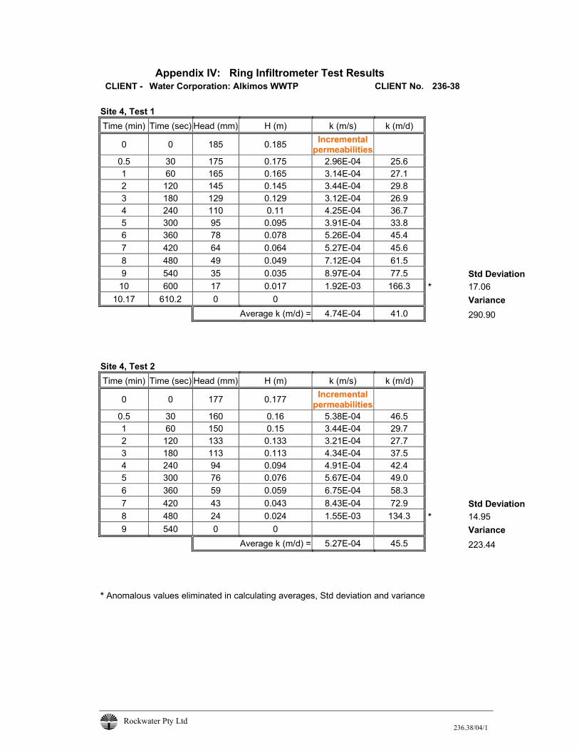
Rockwater Pty Ltd 236.38/04/1
Appendix IV: Ring Infiltrometer Test Results CLIENT - Water Corporation: Alkimos WWTP CLIENT No. 236-38
Site 4, Test 1 Time (min) Time (sec) Head (mm) H (m) k (m/s) k (m/d)
0 0 185 0.185 Incremental permeabilities
0.5 30 175 0.175 2.96E-04 25.6 1 60 165 0.165 3.14E-04 27.1 2 120 145 0.145 3.44E-04 29.8 3 180 129 0.129 3.12E-04 26.9 4 240 110 0.11 4.25E-04 36.7 5 300 95 0.095 3.91E-04 33.8 6 360 78 0.078 5.26E-04 45.4 7 420 64 0.064 5.27E-04 45.6 8 480 49 0.049 7.12E-04 61.5 9 540 35 0.035 8.97E-04 77.5 Std Deviation
10 600 17 0.017 1.92E-03 166.3 * 17.06 10.17 610.2 0 0 Variance
Average k (m/d) = 4.74E-04 41.0 290.90
Site 4, Test 2 Time (min) Time (sec) Head (mm) H (m) k (m/s) k (m/d)
0 0 177 0.177 Incremental permeabilities
0.5 30 160 0.16 5.38E-04 46.5 1 60 150 0.15 3.44E-04 29.7 2 120 133 0.133 3.21E-04 27.7 3 180 113 0.113 4.34E-04 37.5 4 240 94 0.094 4.91E-04 42.4 5 300 76 0.076 5.67E-04 49.0 6 360 59 0.059 6.75E-04 58.3 7 420 43 0.043 8.43E-04 72.9 Std Deviation 8 480 24 0.024 1.55E-03 134.3 * 14.95 9 540 0 0 Variance Average k (m/d) = 5.27E-04 45.5 223.44
* Anomalous values eliminated in calculating averages, Std deviation and variance
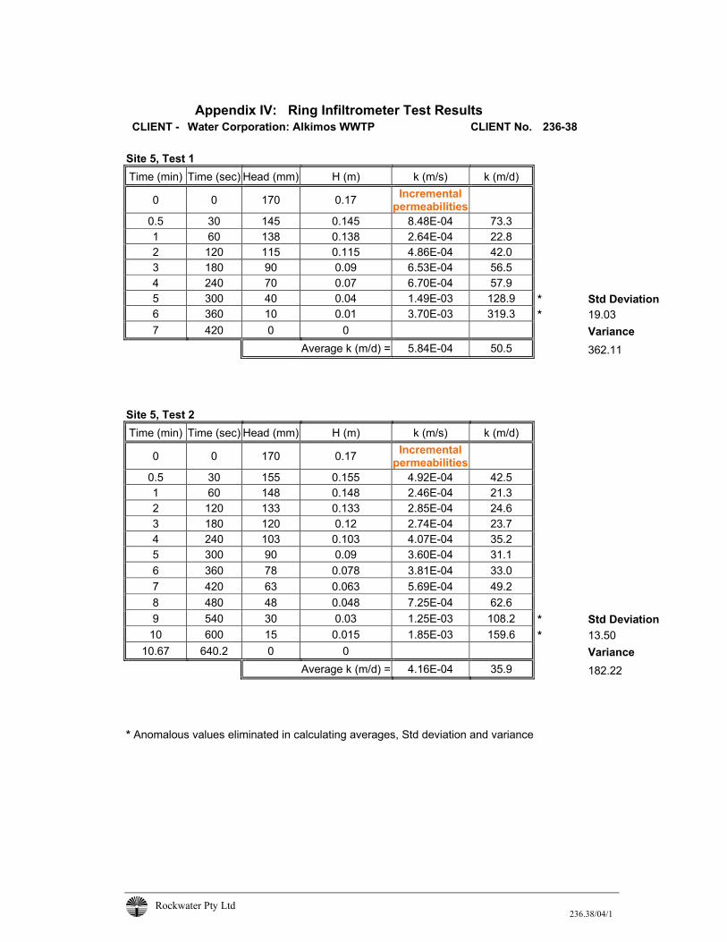
Rockwater Pty Ltd 236.38/04/1
Appendix IV: Ring Infiltrometer Test Results CLIENT - Water Corporation: Alkimos WWTP CLIENT No. 236-38
Site 5, Test 1 Time (min) Time (sec) Head (mm) H (m) k (m/s) k (m/d)
0 0 170 0.17 Incremental permeabilities
0.5 30 145 0.145 8.48E-04 73.3 1 60 138 0.138 2.64E-04 22.8 2 120 115 0.115 4.86E-04 42.0 3 180 90 0.09 6.53E-04 56.5 4 240 70 0.07 6.70E-04 57.9 5 300 40 0.04 1.49E-03 128.9 * Std Deviation 6 360 10 0.01 3.70E-03 319.3 * 19.03 7 420 0 0 Variance Average k (m/d) = 5.84E-04 50.5 362.11
Site 5, Test 2 Time (min) Time (sec) Head (mm) H (m) k (m/s) k (m/d)
0 0 170 0.17 Incremental permeabilities
0.5 30 155 0.155 4.92E-04 42.5 1 60 148 0.148 2.46E-04 21.3 2 120 133 0.133 2.85E-04 24.6 3 180 120 0.12 2.74E-04 23.7 4 240 103 0.103 4.07E-04 35.2 5 300 90 0.09 3.60E-04 31.1 6 360 78 0.078 3.81E-04 33.0 7 420 63 0.063 5.69E-04 49.2 8 480 48 0.048 7.25E-04 62.6 9 540 30 0.03 1.25E-03 108.2 * Std Deviation
10 600 15 0.015 1.85E-03 159.6 * 13.50 10.67 640.2 0 0 Variance
Average k (m/d) = 4.16E-04 35.9 182.22 * Anomalous values eliminated in calculating averages, Std deviation and variance
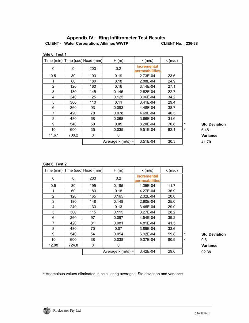
Rockwater Pty Ltd 236.38/04/1
Appendix IV: Ring Infiltrometer Test Results CLIENT - Water Corporation: Alkimos WWTP CLIENT No. 236-38
Site 6, Test 1 Time (min) Time (sec) Head (mm) H (m) k (m/s) k (m/d)
0 0 200 0.2 Incremental permeabilities
0.5 30 190 0.19 2.73E-04 23.6 1 60 180 0.18 2.88E-04 24.9 2 120 160 0.16 3.14E-04 27.1 3 180 145 0.145 2.62E-04 22.7 4 240 125 0.125 3.96E-04 34.2 5 300 110 0.11 3.41E-04 29.4 6 360 93 0.093 4.48E-04 38.7 7 420 78 0.078 4.69E-04 40.5 8 480 68 0.068 3.66E-04 31.6 9 540 50 0.05 8.20E-04 70.8 * Std Deviation
10 600 35 0.035 9.51E-04 82.1 * 6.46 11.67 700.2 0 0 Variance
Average k (m/d) = 3.51E-04 30.3 41.70
Site 6, Test 2 Time (min) Time (sec) Head (mm) H (m) k (m/s) k (m/d)
0 0 200 0.2 Incremental permeabilities
0.5 30 195 0.195 1.35E-04 11.7 1 60 180 0.18 4.27E-04 36.9 2 120 165 0.165 2.32E-04 20.0 3 180 148 0.148 2.90E-04 25.0 4 240 130 0.13 3.46E-04 29.9 5 300 115 0.115 3.27E-04 28.2 6 360 97 0.097 4.54E-04 39.2 7 420 81 0.081 4.81E-04 41.5 8 480 70 0.07 3.89E-04 33.6 9 540 54 0.054 6.92E-04 59.8 * Std Deviation
10 600 38 0.038 9.37E-04 80.9 * 9.61 12.08 724.8 0 0 Variance
Average k (m/d) = 3.42E-04 29.6 92.38 * Anomalous values eliminated in calculating averages, Std deviation and variance
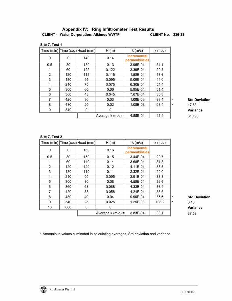
Rockwater Pty Ltd 236.38/04/1
Appendix IV: Ring Infiltrometer Test Results CLIENT - Water Corporation: Alkimos WWTP CLIENT No. 236-38
Site 7, Test 1 Time (min) Time (sec) Head (mm) H (m) k (m/s) k (m/d)
0 0 140 0.14 Incremental permeabilities
0.5 30 130 0.13 3.95E-04 34.1 1 60 122 0.122 3.39E-04 29.3 2 120 115 0.115 1.58E-04 13.6 3 180 95 0.095 5.09E-04 44.0 4 240 75 0.075 6.30E-04 54.4 5 300 60 0.06 5.95E-04 51.4 6 360 45 0.045 7.67E-04 66.3 7 420 30 0.03 1.08E-03 93.4 * Std Deviation 8 480 20 0.02 1.08E-03 93.4 * 17.63 9 540 0 0 Variance Average k (m/d) = 4.85E-04 41.9 310.93
Site 7, Test 2 Time (min) Time (sec) Head (mm) H (m) k (m/s) k (m/d)
0 0 160 0.16 Incremental permeabilities
0.5 30 150 0.15 3.44E-04 29.7 1 60 140 0.14 3.68E-04 31.8 2 120 120 0.12 4.11E-04 35.5 3 180 110 0.11 2.32E-04 20.0 4 240 95 0.095 3.91E-04 33.8 5 300 80 0.08 4.58E-04 39.6 6 360 68 0.068 4.33E-04 37.4 7 420 58 0.058 4.24E-04 36.6 8 480 40 0.04 9.90E-04 85.6 * Std Deviation 9 540 25 0.025 1.25E-03 108.2 * 6.13
10 600 0 0 Variance Average k (m/d) = 3.83E-04 33.1 37.58
* Anomalous values eliminated in calculating averages, Std deviation and variance

Rockwater Pty Ltd 236.38/04/1
APPENDIX V
PHOSPHORUS RETENTION INDICES (PRI) RESULTS
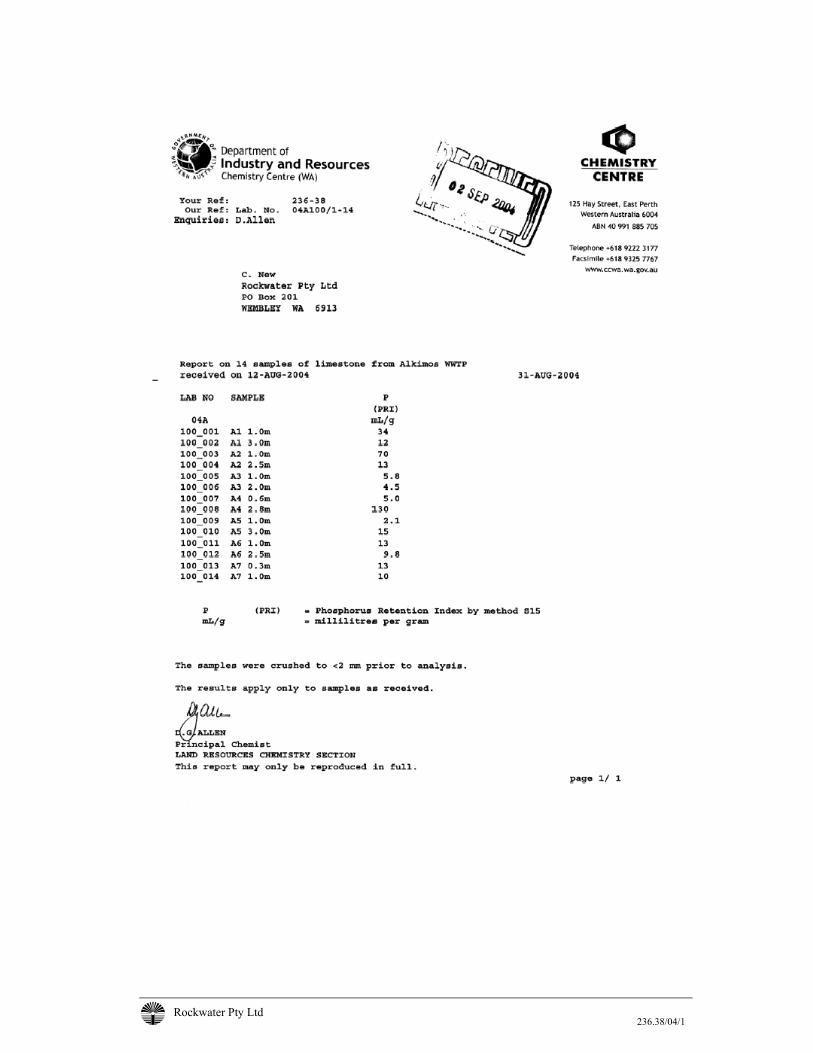
Rockwater Pty Ltd 236.38/04/1

Rockwater Pty Ltd 236.38/04/1
Appendix VI: Commentary On Impacts From Nitrogen Loading To The Shoreline Resulting From Short-Term Infiltration To Groundwater (Oceanica Consulting Report)
i:\236-38\raw data\report version of comments mcb 8_10_04 rev3.doc
Alkimos Wastewater Treatment Plant
Commentary on impacts from nitrogen loading to the shoreline resulting from short-term infiltration to groundwater
Prepared for:
Rockwater
Prepared by:
Oceanica Consulting Pty Ltd
October 2004
Report No. 426/1

D R A F T
Revisions history
Submitted to client Report Version Prepared by Reviewed by Copies Date
FINAL 1 M Bailey P Wharton/ K Congdon
1 digital 11/10/04
Disclaimer This report has been prepared on behalf of and for the exclusive use of Rockwater, and is subject to and issued in accordance with the agreed terms and scope between Rockwater and Oceanica Consulting Pty Ltd. Oceanica Consulting Pty Ltd accepts no liability or responsibility whatsoever for it in respect of any use of or reliance upon this report by any third party. Copying this report without the permission of Rockwater or Oceanica Consulting Pty Ltd is not permitted. © Copyright 2004 Oceanica Consulting Pty Ltd
Oceanica: Rockwater: Alkimos Wastewater Treatment Plant i
Contents
1. Introduction ........................................................................................................ 3
2. Background ........................................................................................................ 4
3. EPA Policy .......................................................................................................... 6
4. Existing Environment ........................................................................................ 7
5. Potential impacts of groundwater infiltration ................................................. 9 5.1 Water quality ....................................................................................................................9 5.2 Odour................................................................................................................................9 5.3 Ponding ..........................................................................................................................10 5.4 Suggested strategy for assessment ............................................................................10
6. References........................................................................................................ 11
Oceanica: Rockwater: Alkimos Wastewater Treatment Plant ii
List of Tables Table 2.1 Modelled scenarios ................................................................................. 5 Table 2.2 Discharged nitrogen concentrations and loadings after 13 years of
infiltration. Values for scenarios 1-6 represent loadings above background level (scenario 8)................................................................. 5
List of Figures Figure 1.1 Project location........................................................................................ 3 Figure 5.1 Example of shoreline water quality monitoring data adjacent to
Bunbury WWTP ...................................................................................... 9
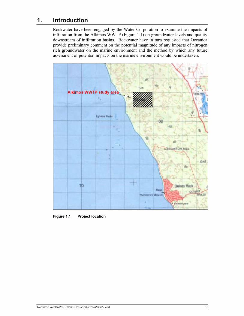
Oceanica: Rockwater: Alkimos Wastewater Treatment Plant 3
1. Introduction Rockwater have been engaged by the Water Corporation to examine the impacts of infiltration from the Alkimos WWTP (Figure 1.1) on groundwater levels and quality downstream of infiltration basins. Rockwater have in turn requested that Oceanica provide preliminary comment on the potential magnitude of any impacts of nitrogen rich groundwater on the marine environment and the method by which any future assessment of potential impacts on the marine environment would be undertaken.
Figure 1.1 Project location
Oceanica: Rockwater: Alkimos Wastewater Treatment Plant 4
2. Background The Water Corporation (2004) submitted a Referral Document to the EPA for the project which contains the following relevant section concerning groundwater infiltration: “It is intended to defer the large capital expenditure required for the construction of the ocean outfall system for approximately 10 years. This will also allow sufficient flows to build up for satisfactory operation of the ocean outlet system at lower flows and velocities. Up to a capacity of 10-15ML/d, it is proposed to recharge the surface aquifer. Following treatment, the wastewater will be discharged to between five and ten infiltration lagoons on Lot 101. These lagoons will generally be sited at lower locations across the site approximately 500m from the shoreline. As far as practical they will be spread in a north-south direction to minimise groundwater mounding. The treated wastewater will be pumped to the basins on rotation, to allow for basin resting and maintenance. ….. This proposal can also be compared to the recently decommissioned system at the Bunbury, where approximately 7ML/d was infiltrated into lagoons located much closer to the shoreline. At Bunbury measurements showed faecal coliform levels along the adjacent shoreline well within the National guidelines for primary contact recreation. At Bunbury the nitrogen and phosphorus (nutrient) levels in the treated wastewater were higher than those found in the natural environment and this resulted in elevated nutrient levels in the nearshore area adjacent to the Bunbury WWTP. At Alkimos, natural groundwater nitrogen concentrations are expected to be higher and the treated wastewater concentrations lower than at Bunbury.” The following information was provided by Phil Wharton of Rockwater: “Evaluating Acceptability of Marine Nitrogen Loading: An evaluation of the acceptability of modelled nitrogen loads to the nearshore environment is required. This needs to consider: • The fact that Lot 101 is adjacent to a fairly enclosed environment, due to reefs
and reef platforms; how much flushing/dilution would be occurring; • The likely DoE position on what would be deemed an ‘acceptable’ load, i.e.
maximum allowable nitrogen load; • That modelled scenarios 5 and 6 are the most likely scenarios; and • That natural groundwater nitrogen concentrations further north are higher
than at the Alkimos site (e.g. Yanchep ~3-6 mg/L TN); could loadings discharged from infiltration be within this natural variation?
This information will be used in evaluating whether infiltration is the best short term disposal option for Alkimos. We are not concerned with an exact, modelled solution, but an assessment on the acceptability of proposed nitrogen loadings. If the answer is not clear, modelling may be undertaken in the future.
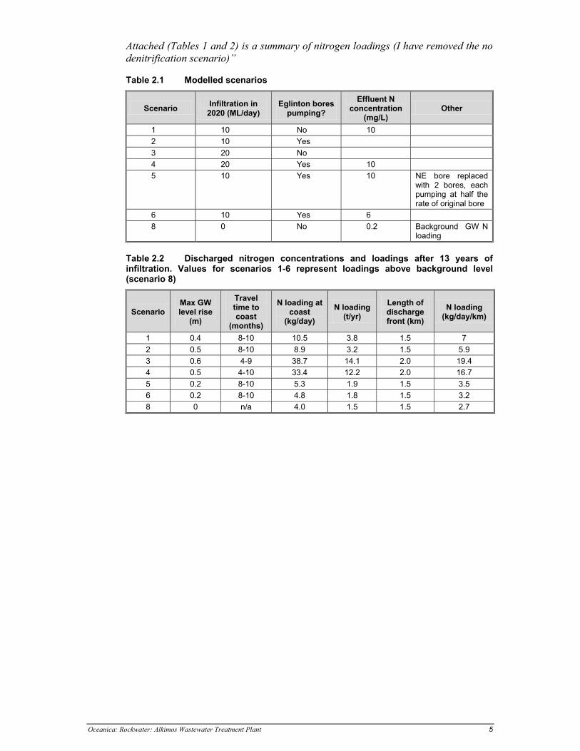
Oceanica: Rockwater: Alkimos Wastewater Treatment Plant 5
Attached (Tables 1 and 2) is a summary of nitrogen loadings (I have removed the no denitrification scenario)”
Table 2.1 Modelled scenarios
Scenario Infiltration in 2020 (ML/day)
Eglinton bores pumping?
Effluent N concentration
(mg/L) Other
1 10 No 10 2 10 Yes 3 20 No 4 20 Yes 10 5 10 Yes 10 NE bore replaced
with 2 bores, each pumping at half the rate of original bore
6 10 Yes 6 8 0 No 0.2 Background GW N
loading
Table 2.2 Discharged nitrogen concentrations and loadings after 13 years of infiltration. Values for scenarios 1-6 represent loadings above background level (scenario 8)
Scenario Max GW level rise
(m)
Travel time to coast
(months)
N loading at coast
(kg/day) N loading
(t/yr) Length of discharge front (km)
N loading (kg/day/km)
1 0.4 8-10 10.5 3.8 1.5 7 2 0.5 8-10 8.9 3.2 1.5 5.9 3 0.6 4-9 38.7 14.1 2.0 19.4 4 0.5 4-10 33.4 12.2 2.0 16.7 5 0.2 8-10 5.3 1.9 1.5 3.5 6 0.2 8-10 4.8 1.8 1.5 3.2 8 0 n/a 4.0 1.5 1.5 2.7
Oceanica: Rockwater: Alkimos Wastewater Treatment Plant 6
3. EPA Policy The EPA does not have a policy on "Acceptable Nitrogen Loading" as such, rather, there is a general requirement to maintain or improve water quality and then there are criteria for chlorophyll_a (a measure of phytoplankton biomass) which is in turn is usually a measure in response to nitrogen loadings. There is also a general requirement not to adversely affect seagrass or other benthic habitat. The following documents provide guidance on these issues: • Revised Environmental Quality Criteria Reference Document (Cockburn
Sound) (November 2002); and • EPA Guidance Statement 29: Benthic Primary Producer Habitat Protection for
Western Australia's Marine Environment (June 2004).
Oceanica: Rockwater: Alkimos Wastewater Treatment Plant 7
4. Existing Environment There is limited information at hand to describe the existing marine environment in detail at Alkimos. A brief reconnaissance study was undertaken by DA Lord & Associates (1997). Key findings from this study were: • The study area was characterised by reasonably wide beaches which varied in
width from approximately 100 m (due south of the southern breakwater of the Mindarie Keys Marina) to as little as 20 m in the pocket beach zone immediately north of the breakwater/marina entrance. The average beach width in the study area was in the order of 60 m;
• The beach condition directly opposite Lot 101 was moderately steep. The beach profile was about 1:15 and the materials involved comprised of thick, loosely packed sand;
• There was no exposed reef platform on the beach immediately opposite Lot 101;
• No clear impression was gained of the distribution of seagrass meadows in the nearshore environment. However, from the seagrass mapping that was undertaken by Alan Tingay and Associates (1991) it was assumed that, in common with the rest of Perth’s metropolitan coastal waters, a mosaic of seagrass meadows occurs throughout the study area;
• Throughout the study area, opportunities exist for a wide variety of recreational pursuits, ranging from active sports such as swimming, surfing, diving and angling to more passive forms of recreation such as sunbathing and beachcombing. Due to the shelter offered by fringing reefs, relatively calm and safe bathing conditions occur throughout the study area; and
• There were a number of localities in the study area where emergent reefs occur offshore. It was considered significant from the point of view of the study that about half of these offshore emergent reefs (these being centred upon Pamela Shoal, Eglington Rocks and Alkimos Reef), lay within 2 km of Lot 101. The seven main reefs (from south to north) were: • Burns Rocks—1 km offshore; • Quinns Rocks—1.5 km offshore; • Pamela Shoal—1 km offshore; • Eglington Rocks—750 m offshore; • Alkimos Reef—1.5 km offshore; • Pipidinny Reef—1.3 km offshore; • El Reef—700 m offshore; and • Laurance Reef—450 m offshore.
If this area is typical of the limestone/sand coast elsewhere in the region, then the groundwater flows will enter the ocean through the intertidal zone, possibly with preferred flow pathways through tunnels in karst formations and possibly enhanced flows to the ocean near limestone headlands. Seawater levels will have some affect on flows, with the overall peak flow to the sea likely to be in late winter and spring, primarily due to the effect of winter recharge combined with reducing sea levels as high pressure systems start to dominate the local weather conditions (e.g. Jervoise Bay Groundwater Recovery Scheme, Parsons Brinckerhoff 2003). In relation to the dispersion of groundwater, the waters will be clear, low in nutrients and currents will generally be wind driven, with a prevailing northerly current along

Oceanica: Rockwater: Alkimos Wastewater Treatment Plant 8
the coast driven by the predominant south-westerly winds. Swell and wind will generally mean that the waters nearshore will be well mixed vertically with longshore currents likely to be in the range of 5 to 15 cm/s.
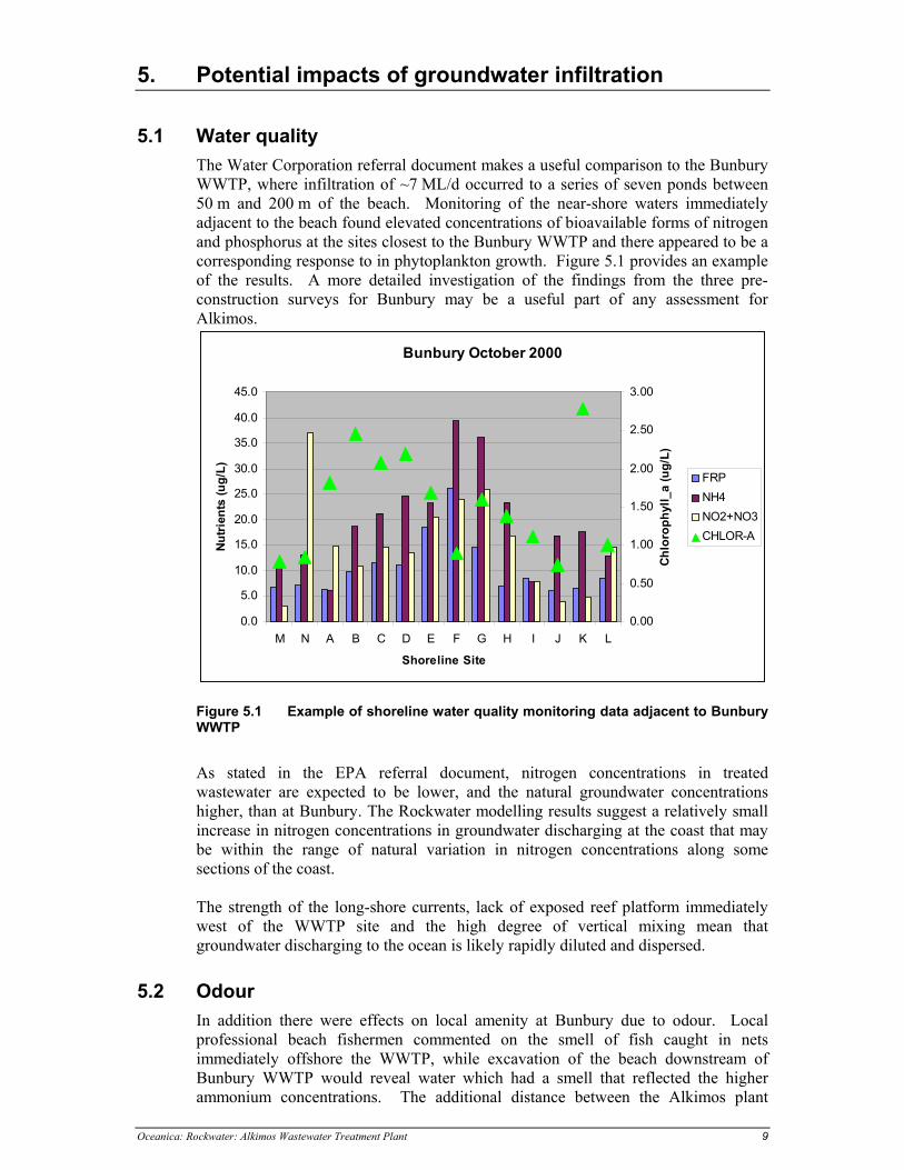
Oceanica: Rockwater: Alkimos Wastewater Treatment Plant 9
5. Potential impacts of groundwater infiltration
5.1 Water quality The Water Corporation referral document makes a useful comparison to the Bunbury WWTP, where infiltration of ~7 ML/d occurred to a series of seven ponds between 50 m and 200 m of the beach. Monitoring of the near-shore waters immediately adjacent to the beach found elevated concentrations of bioavailable forms of nitrogen and phosphorus at the sites closest to the Bunbury WWTP and there appeared to be a corresponding response to in phytoplankton growth. Figure 5.1 provides an example of the results. A more detailed investigation of the findings from the three pre-construction surveys for Bunbury may be a useful part of any assessment for Alkimos.
Bunbury October 2000
0.0
5.0
10.0
15.0
20.0
25.0
30.0
35.0
40.0
45.0
M N A B C D E F G H I J K L
Shoreline Site
Nutri
ents
(ug/
L)
0.00
0.50
1.00
1.50
2.00
2.50
3.00
Chlo
roph
yll_
a (u
g/L)
FRPNH4NO2+NO3CHLOR-A
Figure 5.1 Example of shoreline water quality monitoring data adjacent to Bunbury WWTP
As stated in the EPA referral document, nitrogen concentrations in treated wastewater are expected to be lower, and the natural groundwater concentrations higher, than at Bunbury. The Rockwater modelling results suggest a relatively small increase in nitrogen concentrations in groundwater discharging at the coast that may be within the range of natural variation in nitrogen concentrations along some sections of the coast. The strength of the long-shore currents, lack of exposed reef platform immediately west of the WWTP site and the high degree of vertical mixing mean that groundwater discharging to the ocean is likely rapidly diluted and dispersed.
5.2 Odour In addition there were effects on local amenity at Bunbury due to odour. Local professional beach fishermen commented on the smell of fish caught in nets immediately offshore the WWTP, while excavation of the beach downstream of Bunbury WWTP would reveal water which had a smell that reflected the higher ammonium concentrations. The additional distance between the Alkimos plant
Oceanica: Rockwater: Alkimos Wastewater Treatment Plant 10
(600 m to 1,100 m) and the coast is expected to allow all the nitrogen to be oxidised to nitrate and so the are unlikely to be any odour issues. However, this possible concern can be addressed in the approvals documentation.
5.3 Ponding Ponding of water on the beach was one of the key impacts at Bunbury. Apart from odour and community perception of potential health concerns, the elevated groundwater levels were thought to reduce the capacity of the beach to resist erosion at a time when strong storms may still occur (late winter early spring). The greater distance of the Alkimos WTTP from the plant from the ocean means that groundwater levels are not expected to be significantly raised at the coast (Rockwater modelling suggests ~5 cm above background) and so there should be no ponding or instability of the beach at Alkimos.
5.4 Suggested strategy for assessment An appropriate response would be to describe the existing marine environment in terms of nutrient related water quality, residence times, groundwater loadings and benthic habitat and then describe any increase in nutrient concentrations likely to occur and the effects of these increases relative to existing conditions. Given that; • the flows will be similar or larger than those at Bunbury; • the Rockwater model results seem to suggest an increase in nitrogen
concentrations at the coast; • there is reasonable evidence from Bunbury to show the likely nature of any
impacts; and • Then it is recommended that, if the option of infiltration is to be pursued, a
detailed study to address the impacts of nutrients. The potential for ponding and odours on the beach are unlikely to be issues, but should be considered. The tasks would include: • Model likely increases in groundwater levels and changes in nutrient
concentrations; • Review results from Bunbury and Jervoise Bay and any other relevant studies
to develop a likely range of water quality impacts due to groundwater nutrient loads;
• Obtain good background water quality data for the Alkimos shoreline; • Assess the likely residence times of the waters along the shore and the risk of
localised nutrient enrichment; • Assess the any possible impacts on recreational amenity and beach stability;
and • Assess the potential compliance with EPA’s nutrient related water quality
guidelines.
Oceanica: Rockwater: Alkimos Wastewater Treatment Plant 11
6. References Alan Tingay & Associates Pty Ltd, 1991. Eglington Beach Resort Public
Environmental Review. D.A. Lord & Associates, 1997. Recreational Values Of The Nearshore Marine
Environment Between Burns Beach And Yanchep Beach In The Perth Metropolitan Area. Report to Water Corporation October 1997.
Parsons Brinckerhoff, 2003. Jervoise Bay Recovery Bores, Monitoring Review No.
8, April to September 2003. Report to Dept of Industry and Resources, November 2003.
Water Corporation of Western Australia, 2004. Alkimos Wastewater Treatment
Plant: Wastewater disposal strategy and proposed ocean outlet Referral Document. June 2004
1/3
MEMORANDUM
ATTN: Kate McManus CC: Mark Bailey
COMPANY: Water Corporation FROM: Spencer Shute
PROJECT NO.: 442 DATE: 2 August 2006
SUBJECT: Potential habitat losses associated with construction of Alkimos Ocean Outfall
Dear Kate, In response to the EPA’s comments in relation to the Response to Submissions for the Alkimos Wastewater Treatment Plant, and your request for further information, I have revisited the habitat loss/damage calculations and have incorporated the construction information you provided. Please find below discussion and explanation of the anticipated loss/damage of benthic primary producer habitat (BPPH) associated with construction of the Alkimos Wastewater Treatment Plant. Direct losses of BPPH from construction The proposed pipeline route crosses a number of vegetated habitats including Amphibolis spp. beds and algae-dominated reef. Over its entire 3.5 km length, the pipeline route crosses approximately 1.3 km of sand habitat and 2.3 km of vegetated habitat (Oceanica 2005a). During construction a 10 m wide swathe of seabed along the pipeline route will be cleared (information from Water Corporation, August 2006), with reef features trenched through, and the material side-cast. It has been assumed that side-casting will cause smothering of habitats up to 5 m either side of the cleared pipeline route. Following placement of the pipe, backfilling will occur to anchor the pipe in place (Water Corporation 2005). This work would cause the loss of approximately 4.6 ha (0.046 km2) of vegetated habitat (length of 2.3 km x width 0.02 km) and have a total footprint of 7.0 ha (0.07 km2) (length of 3.6 km x width 0.02 km). This represents a loss of approximately 0.22% of the vegetated habitats present within the BPPH management unit (21 km2) and the disturbance of 0.14% of the overall management unit. This falls well below the 1% cumulative loss threshold set out in the guidance statement (EPA 2004). Back-filling through reef sections is likely to counter the loss of any hard substrate, with boulder or cobble reef features being formed over the pipeline, meaning that the area of hard substrate is increased. It is likely that the faunal and algal communities recolonising the trench region would be similar to those previously found in the area, although decolonisation by seagrass species is likely to be slower.
2/3
Indirect losses of BPPH from construction The construction of the pipeline is proposed to occur over two summer/autumn periods, for four to five months in each year (2008-2009). In addition to the direct loss/damage of benthic habitats, indirect losses associated with the generation of turbidity and smothering by sediment during trenching and back-filling may also occur. During the sediment survey component of the Alkimos Marine Studies Programme (Oceanica 2005b), the sand habitats within 3.5 km of the shoreline in the Alkimos area were generally found to be dominated by medium to coarse sands and exhibited zero fines (silt and clay fraction). The exception was sediment at one site approximately 3 km offshore, 1.4 km north of the proposed pipeline route, which was dominated by fine sands (Oceanica 2005b). During the benthic habitat mapping component of the Alkimos Marine Studies Programme, the sediment type collected within infaunal cores adjacent to the proposed pipeline route was also described. Again the majority of sites were dominated by medium/coarse sands, although the sediment at two inshore sites (approximately 0.7 km offshore) and one offshore site (approximately 3 km offshore) was described as medium/fine clean sand (Oceanica 2005a). Therefore turbidity caused during the trenching and back-filling of sand habitats is likely to be minimal and short-lived (medium sands (250–500 µm) settle at over 0.05 m/s while coarse sands (500–1,000 µm) settle at over 0.2 m/s). Although some smothering by settling sand is likely to occur adjacent to the pipeline route during trenching and back-filling, the local flora and fauna is likely to be relatively tolerant to some degree of smothering (given the rough conditions occurring naturally at the site during the summer sea breeze and winter storms, sand is likely to be resuspended regularly and deposited on reef areas). The amount of turbidity caused by trenching through the limestone reef features is largely dependent upon the type of dredging equipment used, which is in turn dependent upon the hardness of the rock and types of equipment available. During the Port of Geraldton dredging program the use of a large cutter suction dredge, which directly filled hopper barges, was estimated to produce approximately 1,781 tonnes/day of fines (< 100 µm) (GEMS 2003). It is likely that the use of blasting, followed by back-hoe dredging to side-cast the rock material, would result in significantly less fines being produced. However, the most appropriate construction methodology cannot be determined prior to geotechnical works. The majority of the reef habitats present along the pipeline route are algae dominated, with Amphibolis spp. limited to discrete areas approximately 750 m and 1,750 m offshore, and small patches of Posidonia spp. seagrasses present inshore (Oceanica 2005a). Even given marked turbidity/smothering impacts, the algal assemblages are likely to recover rapidly (1-2 years). Therefore worst-case longer term indirect impacts are likely to be limited to impacts on the seagrasses Amphibolis spp. and Posidonia spp. adjacent to the pipeline route where reef is being trenched. Even significant losses of seagrass in such areas (for example total loss within 100 m of the pipeline) would only cause the loss of approximately 10 ha (2.5%) of vegetated habitats within the 9.7 km2 mapping area and 0.5% of vegetated habitats within the 50 km2 management unit. Full potential extent of BPPH losses As discussed above, direct losses are likely to be relatively minor compared to the cumulative loss threshold, and dependent upon the trench width and side-casting methodology. Indirect losses are more difficult to estimate without knowing the dredging technology to be used. This information will become available following on-site geotechnical works. Given the limited distribution of seagrass species adjacent to the pipeline route, and the likely rapid recolonisation of algal assemblages on back-filled rock material, it is likely that overall losses of BPPH will fall well below the cumulative loss threshold (1%). Again the dredging technology will determine the physical characteristics of the rock material to be back-filled over the trench and the nature of the recolonising flora and fauna assemblages.
3/3
References Global Environmental Modelling Systems 2003. Geraldton Port Redevelopment – Further Dredge Plume Turbidity Modelling. Report No. 13/03. Oceanica 2005a. Alkimos Marine Studies Programme: Benthic Habitat Mapping and Infauna Survey. Prepared for Water Corporation of Western Australia. July 2005. Report No. 438/1. Oceanica 2005b. Alkimos Marine Studies Programme: Sediment Survey. Prepared for Water Corporation of Western Australia. May 2005. Report No. 439/1. Water Corporation 2005. Alkimos Wastewater Treatment Plant – Public Environmental Review. November 2005. If you feel that more information is required, or that more assumptions regarding the dredge type and area of disturbance can be made, please do not hesitate to contact me. Regards,
Spencer Shute Coastal Ecologist
P:\WaterCorp\Alkimos\442_SynthesisReport\Correspondence\Alkimos outlet_BPPH loss_memo_12Oct06.doc 1/4
12 October 2006 6:04 PM
MEMORANDUM
ATTN: Andrew Baker CC: Kate McManus, Mark Bailey
COMPANY: Water Corporation FROM: Spencer Shute
PROJECT NO.: 442 DATE: 12 October 2006
SUBJECT: ALKIMOS BPPH LOSS ASSESSMENT
Dear Andrew/Kate,
As requested in your email of 6th October 2006 we hereby provide a written assessment
of the plan for a 3.7 km Alkimos ocean outfall at Alkimos, with respect to the EPA's
Guidance Statement 29 for Benthic Primary Producer Habitat (BPPH) Protection.
At the time of release of the Public Environmental Review (PER) document (November
2006) the exact details on the construction methodology for the ocean outlet had not
been determined. In the PER, habitat losses for two alternative outlet options (outlet
lengths of 2.0 and 3.5 km, respectively) were estimated on the basis of an assumed
10 m disturbance swathe (PER Section 4.1.7.2).
We received from you yesterday a digital dataset which provide detailed information on
the agreed outlet construction method and the exact alignment and length of the outlet.
This information enables us to more specifically estimate the losses of BPPH due to the
construction of the outlet (as requested by the EPA Service Unit in their letter to the
Water Corporation dated 26th May 2006).
As noted in the PER, the area offshore of Alkimos is classified by the BPPH Guidance
Statement as a high protection area (category B), in which a cumulative loss of ≤1% of
the historic BPPH would be required to meet the EPA objective (EPA 2004).
Direct Losses
The proposed pipeline route crosses a number of vegetated habitats including Amphibolis
spp. beds and algae-dominated reef. Over its entire 3.7 km length, the pipeline route
crosses approximately 1.4 km of sand habitat and 2.3 km of vegetated habitat
(Figure 1). During construction a ≤ 10 m wide swathe of seabed along the pipeline route
will be cleared and the piping laid on the seabed surface (information provided by the
Water Corporation, August 2006). In three sections, trenching will be required prior to
laying the pipeline and the trenched material will then be side-cast (Figure 1).
Trenching/side casting will disturb habitats along each section to a maximum width of
49.5 m (information provided by Water Corporation yesterday). In areas where the loss
of seagrasses can be reduced by side casting to one side of the trench only, this will be
carried out. Following placement of the pipe, backfilling will occur along the trenched
sections to anchor the pipe in place. In light of the nominated alignment and
construction methods, the direct losses of each habitat type are given in Table 1.
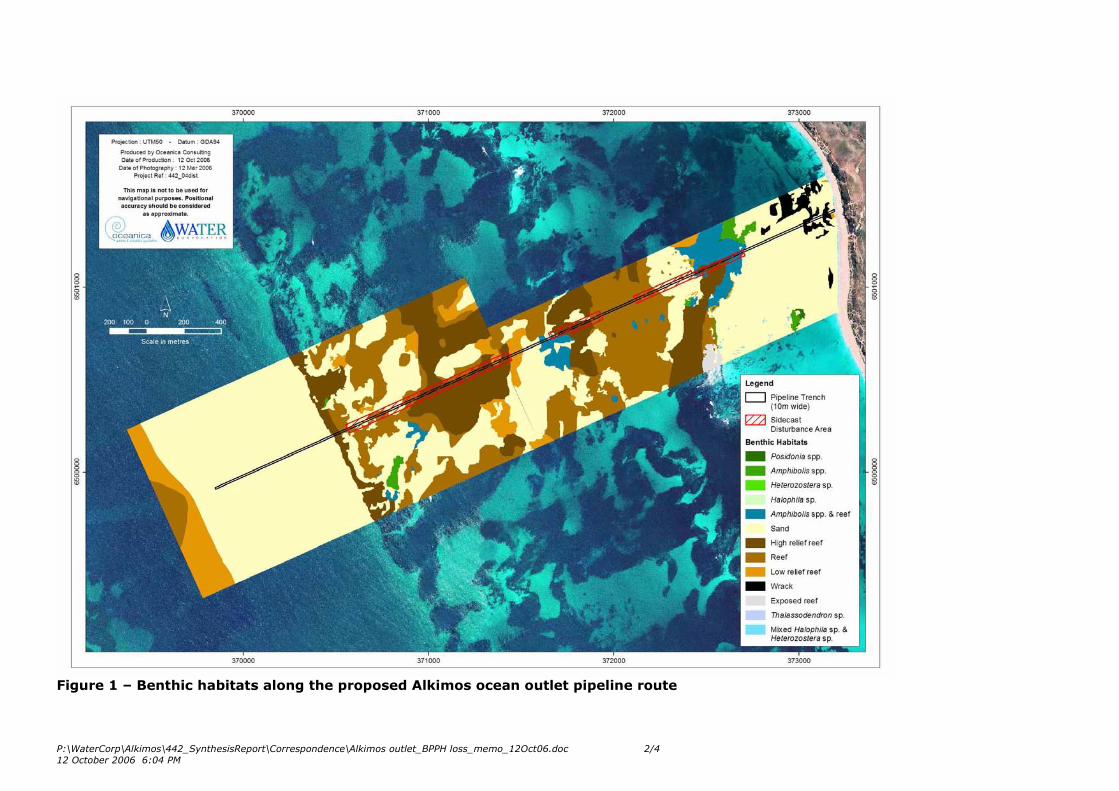
P:\WaterCorp\Alkimos\442_SynthesisReport\Correspondence\Alkimos outlet_BPPH loss_memo_12Oct06.doc 2/4
12 October 2006 6:04 PM
Figure 1 – Benthic habitats along the proposed Alkimos ocean outlet pipeline route
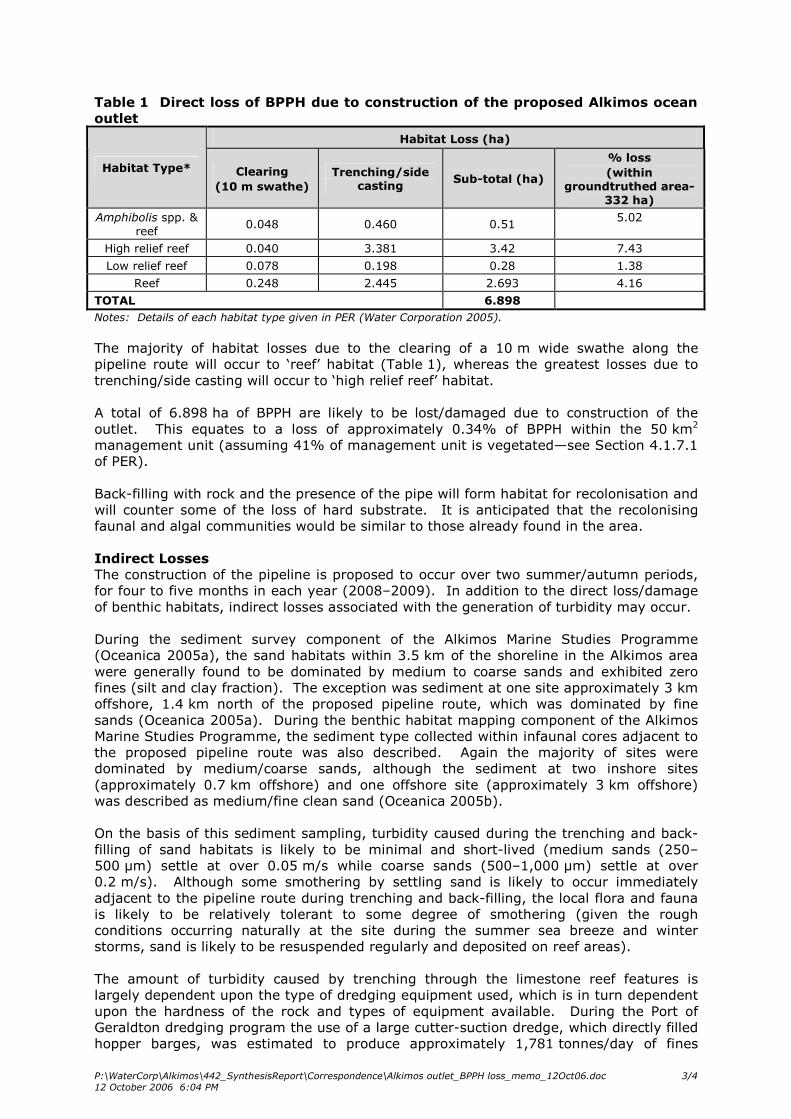
P:\WaterCorp\Alkimos\442_SynthesisReport\Correspondence\Alkimos outlet_BPPH loss_memo_12Oct06.doc 3/4
12 October 2006 6:04 PM
Table 1 Direct loss of BPPH due to construction of the proposed Alkimos ocean
outlet
Habitat Loss (ha)
Habitat Type* Clearing
(10 m swathe)
Trenching/side casting
Sub-total (ha)
% loss
(within groundtruthed area-
332 ha)
Amphibolis spp. &
reef 0.048 0.460 0.51
5.02
High relief reef 0.040 3.381 3.42 7.43
Low relief reef 0.078 0.198 0.28 1.38
Reef 0.248 2.445 2.693 4.16
TOTAL 6.898
Notes: Details of each habitat type given in PER (Water Corporation 2005).
The majority of habitat losses due to the clearing of a 10 m wide swathe along the
pipeline route will occur to ‘reef’ habitat (Table 1), whereas the greatest losses due to
trenching/side casting will occur to ‘high relief reef’ habitat.
A total of 6.898 ha of BPPH are likely to be lost/damaged due to construction of the
outlet. This equates to a loss of approximately 0.34% of BPPH within the 50 km2
management unit (assuming 41% of management unit is vegetated—see Section 4.1.7.1
of PER).
Back-filling with rock and the presence of the pipe will form habitat for recolonisation and
will counter some of the loss of hard substrate. It is anticipated that the recolonising
faunal and algal communities would be similar to those already found in the area.
Indirect Losses
The construction of the pipeline is proposed to occur over two summer/autumn periods,
for four to five months in each year (2008–2009). In addition to the direct loss/damage
of benthic habitats, indirect losses associated with the generation of turbidity may occur.
During the sediment survey component of the Alkimos Marine Studies Programme
(Oceanica 2005a), the sand habitats within 3.5 km of the shoreline in the Alkimos area
were generally found to be dominated by medium to coarse sands and exhibited zero
fines (silt and clay fraction). The exception was sediment at one site approximately 3 km
offshore, 1.4 km north of the proposed pipeline route, which was dominated by fine
sands (Oceanica 2005a). During the benthic habitat mapping component of the Alkimos
Marine Studies Programme, the sediment type collected within infaunal cores adjacent to
the proposed pipeline route was also described. Again the majority of sites were
dominated by medium/coarse sands, although the sediment at two inshore sites
(approximately 0.7 km offshore) and one offshore site (approximately 3 km offshore)
was described as medium/fine clean sand (Oceanica 2005b).
On the basis of this sediment sampling, turbidity caused during the trenching and back-
filling of sand habitats is likely to be minimal and short-lived (medium sands (250–
500 µm) settle at over 0.05 m/s while coarse sands (500–1,000 µm) settle at over
0.2 m/s). Although some smothering by settling sand is likely to occur immediately
adjacent to the pipeline route during trenching and back-filling, the local flora and fauna
is likely to be relatively tolerant to some degree of smothering (given the rough
conditions occurring naturally at the site during the summer sea breeze and winter
storms, sand is likely to be resuspended regularly and deposited on reef areas).
The amount of turbidity caused by trenching through the limestone reef features is
largely dependent upon the type of dredging equipment used, which is in turn dependent
upon the hardness of the rock and types of equipment available. During the Port of
Geraldton dredging program the use of a large cutter-suction dredge, which directly filled
hopper barges, was estimated to produce approximately 1,781 tonnes/day of fines
P:\WaterCorp\Alkimos\442_SynthesisReport\Correspondence\Alkimos outlet_BPPH loss_memo_12Oct06.doc 4/4
12 October 2006 6:04 PM
(< 100 µm) (GEMS 2003). It is anticipated that the use of blasting, followed by back-
hoe dredging to side-cast the rock material, would result in significantly less fines being
produced. However, we understand that the most appropriate construction methodology
to be used at Alkimos will not be determined till the geotechnical works have been
completed.
The majority of the reef habitats present along the pipeline route are algae dominated,
with Amphibolis spp. limited to discrete areas approximately 750 m and 1,750 m
offshore, and small patches of Posidonia spp. seagrasses present inshore (Oceanica
2005b). Even given marked turbidity/smothering impacts, the algal assemblages are
likely to recover rapidly (1–2 years). Therefore, worst-case longer term indirect impacts
are likely to be limited to impacts on the seagrasses Amphibolis spp. and Posidonia spp.
adjacent to the pipeline route where reef is being trenched. Even significant losses of
seagrass/algae in such areas (for example total loss within 100 m of the pipeline) would
only cause the loss of approximately 10 ha (2.5%) of vegetated habitats within the
9.7 km2 mapping area and 0.5% of vegetated habitats within the 50 km2 management
unit (assuming 41% of management unit is vegetated—see Section 4.1.7.1 of PER).
Full potential extent of BPPH losses
As discussed above, direct losses are likely to be well within the cumulative loss
threshold. Indirect losses due to turbidity are more difficult to estimate without knowing
the trenching method to be used. This information will become available following on-
site geotechnical works.
As discussed within the PER (Water Corporation 2005), adverse effects from the
discharge of treated wastewater on the adjacent seagrass and macroalgal communities is
considered unlikely in the light of other studies from Ocean Reef (see PER
Section 4.1.7.2).
It is anticipated that the overall losses/damage to BPPH due to direct (construction) and
indirect (operation) impacts of the proposed ocean outlet are unlikely to exceed the 1%
threshold level.
References
EPA 2004. Guidance for the Assessment of Environmental Factors. Benthic Primary
Producer Habitat Protection for Western Australia’s Marine Environment. No. 29.
Global Environmental Modelling Systems 2003. Geraldton Port Redevelopment – Further
Dredge Plume Turbidity Modelling. Report No. 13/03.
Oceanica 2005a. Alkimos Marine Studies Programme: Sediment Survey. Prepared for
Water Corporation of Western Australia. May 2005. Report No. 439/1.
Oceanica 2005b. Alkimos Marine Studies Programme: Benthic Habitat Mapping and
Infauna Survey. Prepared for Water Corporation of Western Australia. July 2005. Report
No. 438/1.
Water Corporation 2005. Alkimos Wastewater Treatment Plant – Public Environmental
Review. November 2005.
Regards,
Spencer Shute
Coastal Ecologist