Embed Size (px)
Citation preview


ALBION DISTRICT STRUCTURE PLAN
2142 Rep38E ET-09
A L B I O N D I S T R I C T S T R U C T U R E P L A N
As adopted by the City of Swan on 4 February 2009
Prepared by:
Town Planning & Urban Design
Level 2, Suite 5
36 Rowland Street
Subiaco WA 6008
PO Box 796
Subiaco WA 6904
Tel: 9382 1233
Fax: 9382 1127
Project No. 2142 Rep38E ET-09
April 2009

ALBION DISTRICT STRUCTURE PLAN
2142 Rep38E ET-09
A L B I O N D I S T R I C T S T R U C T U R E P L A N P R O J E C T T E A M
Proponents BrookfieldMultiplex Department of Housing
Urban Design & Planning Chappell Lambert Everett
CivilEngineers SinclairKnightMerz
Environmental Consultant Coffey Environments
Hydrologists Jim Davies & Associates
TrafficEngineers SinclairKnightMerz
Landscape Architects EPCAD
Retail Shrapnel Urban Planning
Acoustic Consultants Herring Storer
Acid Sulfate Soils Douglas Partners & Coffey Environments
Community Planning Agata Chmielewski

ALBION DISTRICT STRUCTURE PLAN
2142 Rep38E ET-09
T A B L E O F C O N T E N T S
E X E C U T I V E S U M M A R Y
P A R T O N E - B A C K G R O U N D
1 . 0 I N T R O D U C T I O N
1.1 Background
1.2 Statutory Planning Context
1.2.1 MetropolitanRegionScheme
1.2.2 City of Swan Local Planning Scheme
1.2.2.1 LocalPlanningSchemeNo.17
1.2.2.2 TownPlanningSchemeNo.9-Background
1.2.2.3 DevelopmentContributionPlanArea
1.2.2.4 LocalStructurePlanning
1.3 Sub Regional Planning: A Framework
2 . 0 S I T E C O N T E X T A N D A N A L Y S I S
2.1 Land Ownership
2.2 District and Local Context
2.3 Site Analysis
2.3.1 Previous and Existing Uses
2.3.2 Environmental Background

ALBION DISTRICT STRUCTURE PLAN
2142 Rep38E ET-09
P A R T T W O – D I S T R I C T S T R U C T U R E P L A N
3 . 0 A L B I O N D I S T R I C T S T R U C T U R E P L A N D E S C R I P T I O N
3.1 Development Principles
3.2 Land Use Schedule
4 . 0 E N V I R O N M E N T A L M A N A G E M E N T
4.1 Background
4.2 Local Water Management Strategy
4.2.1 District Water Planning - Background
4.2.2 WaterManagement
4.2.3 Wetlands
4.3 Bushland Management Plans
4.4 Noise Management
4.4.1 Perth Darwin Highway Reservation and Public Purpose Reserve
4.4.2 Henley Brook Avenue
4.5 Parmelia & Dampier Gas Pipelines
4.5.1 Quantitative Risk Assessment
4.5.2 Land Use
4.6 Summary of Aboriginal Heritage Investigations
5 . 0 H O U S I N G S T R A T E G Y
5.1 DemographicProfileandHousingNeeds
5.2 Housing Principles
5.3 Activity Corridor - Transit Oriented Development
5.4 Residential Densities and Housing Types
5.4.1 Low Density - Residential R17.5

ALBION DISTRICT STRUCTURE PLAN
2142 Rep38E ET-09
5.4.2 MediumDensity-ResidentialR30
5.4.3 MediumDensityResidentialR40
5.4.4 MediumDensityResidentialR60
5.5 General Rural Zoned Land South of Park Street
5.6 Lot Yield Estimates
5.7 Aged Persons Accommodation/Independent Living
5.8 Anticipated Lot Release
6 . 0 T R A N S P O R T A N D A C C E S S
6.1 Transport and Access Report
6.1.1 Ultimate Road Network
6.1.2 Interim Road Network
6.1.3 Public Transport, Pedestrians & Cyclists
6.2 Activity Corridor
7 . 0 P U B L I C O P E N S P A C E S T R A T E G Y
7.1 Objectives
7.2 Public Open Space Principles & Distribution
7.3 Structure Plan Public Open Space Strategy & Utility
7.3.1 MultipleUse
7.3.2 Local Active & Passive Open Space
7.3.3 Local Open Space - Drainage
7.3.4 Wetlands
7.3.5 Conservation
7.3.6 StLeonardsMultipleUse
7.3.7 Bush Forever and Parks and Recreation
7.3.8 Neighbourhood Parks

ALBION DISTRICT STRUCTURE PLAN
2142 Rep38E ET-09
7.4 Public Open Space Schedule
7.5 Ongoing Open Space Planning
8 . 0 E D U C A T I O N
8.1 Overview
8.2 School Sites
8.2.1 North East Primary School (LSP3)
8.2.2 North West Primary School (LSP1)
8.2.3 K-12 Educational Precinct (LSP 2)
9 . 0 C O M M E R C I A L
9.1 Albion Centres Strategy
9.1.1 Large Neighbourhood Centre (Town Centre)
9.1.2 Local Centres
9.1.3 Implementation
9.2 Local Employment
1 0 . 0 C O M M U N I T Y A N D E C O N O M I C D E V E L O P M E N T
1 1 . 0 S E R V I C I N G A N D I N F R A S T R U C T U R E
11.1 Sewerage
11.2 Water Supply
11.3 Gas
11.4 Electricity
11.5 Telecommunications

ALBION DISTRICT STRUCTURE PLAN
2142 Rep38E ET-09
L I S T O F F I G U R E S
Figure 1: Location Plan
Figure 2: Albion Land Ownership Plan
Figure3: MetropolitanRegionSchemeZoning
Figure 4: Bush Forever Sites
Figure 5: City of Swan Local Planning Scheme No.17
Figure 6: Swan Urban Growth Corridor - Sub Regional Plan
Figure 7: Albion Local Structure Plan areas
Figure 8: Albion District Structure Plan
Figure 9: Indicative Residential Density Codings
Figure 10: Yield Precinct Plan
Figure 11: Albion Public Open Space Strategy
Figure 12: Albion District Servicing Strategy

ALBION DISTRICT STRUCTURE PLAN
2142 Rep38E ET-09
T A B L E S
Table 1: Local Planning Scheme 17 Clause 5A.1.6.1 - Details required to be contained within a District Structure Plan
Table 2: Local Planning Scheme Clause 5A - Additional Details required under Schedule 4 - “SpecialUse-Albion”zone
Table 3: Lots and Land Ownership within the Structure Plan Area
Table 4: Land Use Schedule
Table 5: High Pressure Gas Pipeline Conditional Area
Table 6: Lot Yield Estimates
Table 7: Public Open Space Schedule

ALBION DISTRICT STRUCTURE PLAN
2142 Rep38E ET-09
A P P E N D I C E S
Appendix 1: Environmental Protection Authority - Advice regarding Town Planning Scheme 17, Schedule 4 Provisions
Appendix 2: Albion Planning & Reporting Framework
Appendix3: LocalWaterManagementStrategy
Appendix4: BushlandManagementPlan–PossibleThreatenedEcologicalCommunity
Appendix5: BushlandManagementPlan–BushForeverSite200
Appendix 6: Acoustic Assessment Report
Appendix 7: a. Transport and Access Report
b. Transport Assessment Checklist
Appendix 8: Commercial Centres Strategy
Appendix 9: Albion School Sites meeting notes - 31 October 2007
Appendix 10: Albion District Structure Plan Community & Economic Development Plan

ALBION DISTRICT STRUCTURE PLAN 1
2142 Rep38E ET-09
E X E C U T I V E S U M M A R Y
The Albion District Structure Plan has been commissioned by Brookfield Multiplex and theDepartment of Housing for approval pursuant to the provisions of Clause 5A and Schedule 4 ‘SpecialUse-Albion’zoneoftheCityofSwanLocalPlanningSchemeNo.17.TheAlbionDistrictStructure Plan area covers approximately 504ha in Henley Brook adjoining Whiteman Park, zoned‘SpecialUse-Albion’.Albionwillultimatelyincorporate:
• Approximately 5,500 residential lots;
• A Town Centre (large neighbourhood centre) of approximately 10,000m2 Net Leaseable Area (NLA);
• Three local centres;
• Three primary schools;
• High School;
• Educational support facility;
• Integrated public open space network;
• RetentionofsignificantwetlandandBushForevervegetation;and
• A regionally connected transport system.
Albion District Structure Plan has been lodged as a complete package with all required details pursuant to the requirements of Local Planning Scheme 17 and the City of Swan Urban Growth Policies, including:
1. LocalWaterManagementStrategy(incorporatingtheAcidSulfateSoilManagementPlan);
2. BushlandManagementPlans;
3. NoiseManagementPlan;
4. Transport and Access Report;
5. Commercial Centres Strategy; and
6. Community and Economic Development Plan.
Local Structure Plans within the District Structure Plan area will be prepared and approved prior to subdivision, setting out more detailed land use information in accordance with the District Structure Plan. The purpose of the District Structure Plan is to provide land use framework objectives,andaddresskeyissues,withfinaldesigndetailtoberesolvedatLocalStructurePlanstage.

ALBION DISTRICT STRUCTURE PLAN 2
2142 Rep38E ET-09
PART 1 - BACKGROUND
1 . 0 I N T R O D U C T I O N
1.1 Background
The Albion District Structure Plan has been commissioned by the Department of Housing and BrookfieldMultiplexforapprovalpursuanttotheprovisionsofClause5AandSchedule4‘SpecialUse–Albion’ zoneof theCityof SwanLocalPlanningSchemeNo17,whereanapprovedDistrict Structure Plan and Local Structure Plan are required.
The Albion District Structure Plan area covers approximately 504ha in Henley Brook adjoining Whiteman Park to the west and the Swan Valley to the east (refer Fig.1 and 2).
The purpose of the Structure Plan is to guide land use and development within the subject area, providing a framework for future Local Structure Planning and subdivision applications. This report provides a detailed description of the Albion District Structure Plan, including the statutory context, land use framework, environmental management requirements and ongoing reporting framework.
The following documents are lodged as a detail of the Albion District Structure Plan pursuant to the requirements of Local Planning Scheme No.17 and the City of Swan Urban Growth Policies:
1. LocalWaterManagementStrategy(incorporatingtheAcidSulfateSoilManagementPlan);
2. BushlandManagementPlans;
3. NoiseManagementPlan;
4. Transport and Access Report;
5. Commercial Centres Strategy; and
6. Community and Economic Development Plan
Thefinancialassessment reportwillbepreparedand lodgedaspartof theLocal StructurePlans when the necessary detail is available, in particular with regard to local open space provision and local infrastructure requirements.
1.2 Statutory Planning Context
1.2.1 MetropolitanRegionScheme
The Albion District Structure Plan area is generally zoned ‘Urban’ under the MetropolitanRegionScheme(MRS) (referFig3).Pursuant to theNorthEastCorridorStructurePlan(1994)theWesternAustralianPlanningCommissionliftedthedefermentofthe‘Urban’zoneovertheStructure Plan area in 1998. Youle Dean Road and Henley Brook Avenue, and associated road

ALBION DISTRICT STRUCTURE PLAN 3
2142 Rep38E ET-09
PART 1 - BACKGROUND
widenings,areReservedasan‘OtherRegionalRoad’undertheMRS(referFig.3).ThefuturePerth Darwin Highway alignment, adjoining the western boundary of the Structure Plan area, is Reserved as ‘Primary Regional’ Road. There is a strip of ‘Public Purposes’ Reserve adjoining the Primary Regional Road Reservation that is outside the Structure Plan area owned by the Western Australian Planning Commission (WAPC). It is understood that this Reservation is to allow for future light rail.
Approximately 60 ha adjoining the southern boundary is Reserved for ‘Parks and Recreation’, which generally corresponds to the location of Bush Forever Site 200 (refer Fig.4).
1.2.2 City of Swan Town Planning Scheme
1.2.2.1 LocalPlanningSchemeNo.17
TheAlbionDistrictStructurePlanareaiszoned‘SpecialUse-Albion’underPlanningSchemeNo.17 (refer Fig.5).
Schedule4 ‘SpecialUse–Albion’ requires theapprovalofaDistrictStructurePlanover thezonedarea.ThisReportcomprisestheDistrictStructurePlanfor thepurposesofSchedule4.Subsequent to the approval of a District Structure Plan, Local Structure Plans are to be approved over precincts within the Structure Plan area.
Schedule 4 of Local Planning Scheme No.17 sets out an environmental reporting hierarchy to be incorporated as a detail of the District and Local Structure Planning, refer Appendix Two. Section 1.2.2.2 below explains the background to these provisions.
Schedule 4 ‘Special Use - Albion’ sets out the following objectives for the site to be considered when preparing a proposed District or Local Structure Plan:
“a) Toconsideranddemonstrateintegrationwiththebroaderdistrictcontext;
b) TodeveloptheEstateinamannerthatprotects,conservesandenhancesthenaturalenvironmentandculturalassetsandtoinvestigateandmanageimpacts;
c) Toprovide for thedevelopmentofa functionalandcohesivecommunityconsistentwithorderlyandproperplanningandintheinterestoftheamenityoftheEstate;
d) To encourage variety in the range of lot sizes and dwelling types within the Estate,consistentwithacohesiveandattractivebuiltenvironment;
e) ToenhancetheEstatewiththeprovisionofopenspaceandrecreationnetworksandfacilities with particular attention being given to the timely provision of appropriatecommunityservices;
f) Tomakeprovision for school sitesandotherappropriateeducational facilitieswithintheEstatedesignedtoencouragetheirmanagementanduseasaresourceforlocalcommunities;

ALBION DISTRICT STRUCTURE PLAN 4
2142 Rep38E ET-09
PART 1 - BACKGROUND
g) ToprovideappropriateretailandcommercialfacilitiestoservicetheneedsofresidentsoftheEstateandwithaviewtotheintegrationofretailareaswithothercommercialandbusinessareasandwithsocialservicessoastomaximiseconvenience;
h) Toprovideretailandcommercialcentres,businessparksandserviceareastosatisfytheneedforsuchserviceswithintheEstateandtoprovidelocalemploymentopportunities,and;
i) Toemploystrategiesanddesignsaimedatoptimisingaccessibilitytolocalcentresbytheuseofcomprehensivemovementnetworksandbyothermeanswhichwillfacilitateconnection with public transport and arterial road links to Midland, Perth and otherpartsoftheMetropolitanRegion.”
Pursuant to Clause 5A.1.6 of Local Planning Scheme No.17 a District Structure Plan is required to includeanumberofdetails.TableTwoidentifieseachrequirementandwhereitisaddressedin the Albion District Structure Plan report.
TABLE ONE: Local Planning Scheme 17 Clause 5A.1.6.1 - Details required to be contained within a District Structure Plan
Requirement Addressed within this report(a) a map showing the area to which the proposed structure
plan is to apply;Figures 11 and 8 and Table 1
(b) a site analysis map showing the characteristics of the site including -
(i) landform, topography and land capability;
(ii) conservation and environmental values including bushland, wetlands, damp lands, streams and water courses, foreshore reserves and any environmental policy areas;
(iii) hydro geological conditions, including approximate depth to water table;
(iv) sites and features of Aboriginal and European heritage value;
Appendix 3 - Local Water ManagementStrategy.Appendix 4 & 5 - Bushland ManagementPlans.
Section 4.6 - Summary of Aboriginal Heritage Investigations
(c) a context analysis map of the immediate surrounds to the site including -(i) the pattern of neighbourhoods, and existing and
planned neighbourhood, town and regional centres;
(ii) transport routes, including freeways, arterial routes and neighbourhood connector alignments, public transport routes, strategic cycle routes, bus stops and rail stations;
(iii) existing and future land use;
Sections 1.3, Figure 6 and Appendix 7

ALBION DISTRICT STRUCTURE PLAN �
2142 Rep38E ET-09
PART 1 - BACKGROUND
Requirement Addressed within this report(d) for district structure plans, a map showing proposals for -
(i) the pattern of neighbourhoods around town and neighbourhood centres;
Figure 8 and Section 9.0
(ii) arterial routes and neighbourhood connector streets; Figure 8 and Appendix 7(iii) the protection of natural features such as water
courses and vegetation;Appendix 3, 4 and 5
(iv) major open spaces and parklands; Figure 12 and Section 7.0(v) major public transport routes and facilities; Section 6.1.3 and Appendix 7(vi) the pattern and disposition of land uses; and Figure 8(vii) schools and community facilities Figure 8 and Section 8.0
(f) a written report to explain the mapping and to address the following -(i) the planning framework for the structure plan
including any applicable regional or district structure plans, and any policies, strategies and scheme provisions which apply to the land, and any environmental conditions which apply under the Scheme;
Section 1.0
(ii) the site analysis including reference to the matters listed in clause 5A.1.6.1 (b) above, and, in particular, thesignificanceoftheconservation,environmentaland heritage values of the site;
Section 2.0
(iii) the context analysis including reference to the matters listed in clause 5A.1.6.1 (c) above;
Section 1.3
(iv) how planning for the structure plan area is to be integrated with the surrounding land;
Section 1.3 and Figure 6
(v) the design rationale for the proposed pattern of subdivision, land use and development;
Part Two
(vi)trafficmanagementandsafety; Appendix 7(vii) parkland provision and management; Figure 12 and Section 7.0(viii) urban water management Appendix 3(ix) proposals for public utilities including sewerage,
water supply, drainage, gas, electricity and communication services;
Section 12.0
(x) the proposed method of implementation including any cost sharing arrangements and details of any staging of subdivision and development; and
Sections 5.7 and 1.2.2.3
(xi)fireriskmanagement To be completed at LSP pursuant to Schedule 4 of LPS 17

ALBION DISTRICT STRUCTURE PLAN �
2142 Rep38E ET-09
PART 1 - BACKGROUND
In addition to the details listed in Clause 5A.1.6 there are a number of additional environmental management plans required as part of a District Structure Plan, pursuant to Schedule 4 ‘Special Use-Albion’.TableTwoidentifieseachrequireddetailofSchedule4andwhereitisincludedin this report.
TABLE TWO: Additional Details required under Schedule 4 - “Special Use - Albion” zone, pursuant to Clause 5A of Local Planning Scheme 17.
Requirement Addressed within this report4.1.1 Strategic Acid Sulphate Soils
ManagementPlanAppendix3(containedwithintheLWMS)-LocalWaterManagementStrategy
4.1.2LocalWaterManagementStrategy Appendix3-LocalWaterManagementStrategy4.1.3NoiseManagementPlan Appendix 6 - Acoustic Assessment4.1.4 Quantitative Risk Assessment Refer Section 5.5 4.1.5BushlandManagementPlans Appendix 4 - Bushland Management Plan,
Possible Threatened Ecological Community & Appendix5-BushlandManagementPlan,BushForever Site 200
1.2.2.2 TownPlanningSchemeNo.9-Background
TheAlbionDistrictStructurePlanareawaszoned‘Rural’undertheCityofSwanTownPlanningSchemeNo.9.Council initiatedAmendment 364 to TownPlanning SchemeNo9 to rezonethe site from ‘Rural’ to ‘Special Use - Albion’ in 1999. The City forwarded the Amendment to theEnvironmentalProtectionAuthority(EPA),whoissuedfinalinstructionsforthepreparationof an Environmental Review in October 1999. An Environmental Review was prepared by the proponent (Department for Housing & Works) in conjunction with the Department for Environment and Conservation (DEC) and the City of Swan, which was to be advertised concurrently with Amendment 364 to Town Planning Scheme No.9.
ImportantlythisdocumentwascompletedinMay2006tothesatisfactionoftheCityofSwanand DEC, addressing the environmental issues as identified by the EPA and establishing acomprehensive environmental management plan framework to be set out in the ‘Special Use Zone-Albion’provisionsunderTownPlanningSchemeNo.9.
During the preparation of the Environmental Review documents the City of Swan progressed Local Planning SchemeNo.17 to final approval, superseding Town Planning SchemeNo.9.Amendment 364 and the associated Environmental Review document, while in a form satisfactory to the City of Swan and DEC, was not advertised for public comment due to the progress and adoption of Local Planning Scheme 17 into which the Amendment No.364 provisionswereincluded.AppendixOneconfirmsthattheEnvironmentalProtectionAuthorityconsiders the Schedule 4 provisions of Local Planning Scheme No.17 adequately address the environmental issues.

ALBION DISTRICT STRUCTURE PLAN �
2142 Rep38E ET-09
PART 1 - BACKGROUND
1.2.2.3 DevelopmentContributionPlanArea
The Albion District Structure Plan area is shown as Development Contribution Area 1 under Schedule 13 of Local Planning Scheme No.17, to ensure equitable distribution of development costs amongst stakeholders. West Swan and Caversham are shown as separate Development Contribution Areas.
In accordance with Clause 5A.2.6 and Schedule 13 the Development Contribution Plan provisions will be incorporated as an amendment to the Town Planning Scheme or Albion District Structure Plan. In accordance with Clause 5A.2.7.3 subdivision or development may be supported prior to the Development Contribution Plan Provisions being finalised wherealternative arrangements for contributions are in place.
1.2.2.4 LocalStructurePlanning
In accordance with Clause 5A.1.5.2 of LPS17 a Structure Plan can be prepared for all or part of a Structure Plan area, allowing for preparation of Local Structure Plans over portions of the areas indicated in Figure 7. The Local Structure Plan boundaries will be finally determinedbased on drainage, servicing and land ownership considerations. Figure 7 sets out indicative boundaries of three Local Structure Plan areas that have been used as the basis for land use schedule calculations in this report.
1.3 Sub Regional Planning: A Framework
The Swan Urban Growth Corridor is a critical development front to accommodate the growth of thePerthMetropolitanRegion.TheCorridor,encompassingAlbion,WestSwanandCaversham,is expected to ultimately accommodate 12 500 dwellings and approximately 33 000 residents.
The City of Swan, Department for Planning & Infrastructure, landowners and relevant government agencies have jointly prepared a Sub Regional Plan for the City of Swan Urban Growth Corridor (refer Fig.6).
The Swan Urban Growth Corridor Sub-Regional Structure Plan (February 2009) and associated report has been adopted by the City of Swan and the WAPC and forms a non-statutory framework for planning for Albion, West Swan and Caversham. The Albion District Structure Plan is consistent with the Sub Regional Planning outcomes.
The key outcomes reached as a result of the Sub Regional Planning process, relevant to Albion, are:
A Sub Regional Transport Infrastructure Staging Report was prepared through a workshop processandworkundertakenbySinclairKnightMerz. Thiswork identifiedkey regionaland district road requirements and staging. Subsequent more detailed work has been undertaken as part of the preparation of the District Structure Plan. Refer Section 6 of this Report for further detail.
•
ALBION DISTRICT STRUCTURE PLAN 8
2142 Rep38E ET-09
PART 1 - BACKGROUND
Centre locationsandsizeswereagreedaspartoftheSubRegionalPlanningprocess.Within Albion there is a Town Centre (Large Neighbourhood Centre) and three Local Centres. The Town Centre will include: retail; office; mixed business; community andresidential uses. The District Structure Plan is consistent with these outcomes. Refer Section 9.0 of this Report for further detail.
The location of the Activity Corridor was agreed, connecting Albion, West Swan and Caversham (refer Fig.6). Within Albion the Activity Corridor generally corresponds with the Partridge Street alignment. This corridor will allow for bus services, mixed use and medium to high density residential development. Refer Section 6.2 of this Report.
Employment generation in the study area is to be considered in the context of its location aspartofthecatchmenttoanemploymentrichcorridor,whichincludes,Midland,PerthAirport, SwanValley, Ellenbrook,MalagaandHazelmere. Employment self sufficiencywithin Albion is approximately 21%, provided through homebased business, mixed business, office, retail andcommunity uses. Refer Section 9.2of this Report for furtherdetail.
In accordance with the City’s Urban Growth Policies and Liveable Neighbourhoods (October 2007) densities over the sub regional planning area are required to be 22 dwelling unitspersitehectare.Mediumtohighdensitiesaretobefocussedaroundservicesandamenities. The Albion District Structure Plan is consistent with this. Refer Section 5.0 of this Report for further detail.
School site sizes and catchments were agreed as part of the sub regional planningprocess. Refer Section 8.0 of this Report for further detail.
The outcomes of the Sub Regional planning process provide a framework for district planning outcomes.
•
•
•
•
•

ALBION DISTRICT STRUCTURE PLAN 9
2142 Rep38E ET-09
PART 1 - BACKGROUND
2 . 0 S I T E C O N T E X T A N D A N A L Y S I S
2.1 Land Ownership
BrookfieldMultiplexand theDepartment forHousing&Worksareworkingco-operatively inprogression of the District and Local Structure Planning. The proponents have met with all landowners in the District Structure Plan area and each landowner has been provided with a copy of this District Structure Plan. Pursuant to Clause 5A.1.8.1 (b) (i) of Local Planning Scheme 17 further consultation will be undertaken with landowners as part of the advertising process. Table 3 summarises lot and land ownership in the District Structure Plan Area:

ALBION DISTRICT STRUCTURE PLAN 10
2142 Rep38E ET-09
PART 1 - BACKGROUND
TABLE 3 – LOTS AND LAND OWNERSHIP WITHIN THE DISTRICT STRUCTURE PLAN AREA
Lot Plan/Diagram
CT (Vol/Folio) Address Owner Total Area (ha)^^
Area WithinStructure Plan
308 P4560-308 1368/417 Lot 308 Park Street,Whiteman
Multiplex Henley Brook Landowner Pty Ltd 20.2798 18.2937
309 P4560-309 1596/810 311 Park St, Whiteman Multiplex Henley Brook Landowner Pty Ltd 20.3607 18.3639
310 P4560-310 1834/185 264 Woolcott Avenue, Whiteman
Housing Authority 20.5479 20.5479
311 P4560-311 1644/954 No Street Address Available Multiplex Henley Brook Landowner Pty Ltd 20.2798 20.2798
345 P4560-354 1401/812 178 Woollcott Avenue,Henley Brook
Vincent Nominees Pty Ltd ** 20.2090 20.2090
346 P4560-346 1404/359 226 Woollcott Avenue, Henley Brook
City of Bayswater ** 20.2722 20.2722
P4560-347 1415/683 City of Bayswater 20.2672 20.26721389/783 City of Bayswater
Emgekay Investments Pty LtdMinx Pty Ltd
349 P4560-349 1368/413 255 Park Street, Henley Brook
ANZ Nominees Ltd ** (WRF) 20.2874 18.2393
350 P4560-350 1368/412 225 Park Street, Henley Brook
ANZ Nominees Ltd ** (WRF) 20.2773 18.2534
351 P4560-351 2055/270 Lot 351 Park Street,Henley Brook
Batson & McGill Pty Ltd 15.8757 8.3286
352 P4560-352 2189/144 Lot 352 Murray Road,Henley Brook
Housing Authority 19.6880 17.2560
353 P4560-353 2189/145 Lot 353 Murray Road, Henley Brook
Housing Authority 19.5362 19.4524
354 P4560-354 2189/146 Lot 354 Murray Road,Henley Brook
Housing Authority 19.5969 19.5969
355 P4560-355 292/41A Lot 355 Murray Road, Henley Brook
Housing Authority 19.6804 19.5041
800 P53666-800 2654-348 No Street Address Available Housing Authority 109.8019 109.8019
801 P53666-801 2654-349 No Street Address Available Western Australian Planning Commission 62.1898 0.0000
802 P53666-802 2654-350 No Street Address Available Western Australian Planning Commission 67.7336 0.0000
803 P53666-803 2654-351 No Street Address Available Western Australian Planning Commission 0.0110 0.0110
804 P53666-804 2654-352 No Street Address Available Western Australian Planning Commission 10.5936 3.5782
10 D33233-10 1410/95 111 Woollcott Avenue,Henley Brook
Housing Authority ** 33.0502 30.2414
15* D74426-15 1731/385 No Street Address Available Belswan (Henley Brook) Pty Ltd 17.4578 15.1155
16 D59865-16 2045/259 47 Partridge St, Whiteman Multiplex Henley Brook Landowner Pty Ltd 22.1976 22.1976
17 D59866-17 1869/176 243 Woollcott Avenue,Henley Brook
Multiplex Henley Brook Landowner Pty Ltd 12.2045 12.2045
19 D83113-19 2103/662 Lot 19 Woollcott Avenue,Henley Brook
P & N Landreach Pty Ltd 3.5864 3.5864
20 D91765-20 2103/661 Lot 20 Woollcott Avenue,Henley Brook
Giuseppe Bellini **Sandra Bellini **
10.7625 10.7625
101 D65712-101 1687/368 104 Harrow Street, West Swan
Epic Energy (WA) Nominees Pty Ltd of care of Allens Arthur Robinson
0.6885 0.0000
94 P22611-94 2134/985 No Street Address Available Western Australian Planning Commission 10.0578 0.0000
95 P22611-95 2134/986 No Street Address Available Western Australian Planning Commission 3.4457 3.4457
33 P4560 1680/54 No Street Address Available Shire of Swan 3.0883 0.4944
Partridge N/A N/A Partridge Street Mainroads N/A 4.1119Woolcott N/A N/A Woolcott Street Mainroads N/A 6.0523
Youle Dean N/A N/A Youle Dean Road Mainroads N/A 3.1889Lord N/A N/A Lord Street Mainroads N/A 2.2218
TOTAL 664.2898 504.1368
** Affected by Gas Pipeline Easement ^^ Areas as per Certificate of title * Lord Street extension land area and applicable road widenings deducted.
347
348 18.258420.2621285 Park Street, Henley Brook
1368/414P4560-348
254 Woolcott Avenue, Henley Brook

ALBION DISTRICT STRUCTURE PLAN 11
2142 Rep38E ET-09
PART 1 - BACKGROUND
2.2 District and Local Context
The Albion District Structure Plan area comprises 504ha, approximately 15km north east of the centreofPerth,5.5kmsouthoftheEllenbrookRegionalCentreand5.5kmnorthoftheMidlandStrategic Regional Centre (refer Fig.1).
The existing Lord Street (future Perth Darwin Highway Alignment) adjoins the western boundary of the site and Park Street adjoins the northern boundary (refer Fig.1). Whiteman Park, Reserved for‘ParksandRecreation’undertheMRS,adjoinsthewesternsideofLordStreet.Theexistingentrance to Whiteman Park is located at the intersection of Lord Street and Youle Dean Road.
The future Henley Brook Avenue forms the eastern boundary of the Structure Plan area and is Reservedasan‘OtherRegionalRoad’undertheMRS.TheeasternedgeoftheHenleyBrookAvenue alignment is the boundary of the Swan Valley Planning Act Area, the Structure Plan area is wholly outside of the Swan Valley Planning Act Area. To the east of Henley Brook Avenue istheestablishedHenleyBrookruralresidentialcommunity,withthelandzoned‘Rural’undertheMRS.ThelandnorthoftheStructurePlanareaadjoiningParkStreetisalsozoned‘Rural’undertheMRS.
As discussed in Section 1.3, Albion forms part of the Swan Urban Growth Corridor (refer Fig.6).
2.3 Site Analysis
2.3.1 Previous and Existing Uses
The District Structure Plan area north of Youle Dean Road is mostly parkland cleared and has beenusedpredominatelyforagriculturallanduses,includinggrazingofcattleandhorses.
The former poultry farm located on Lot 350 has now ceased operation. The landowner of Lot 350 will remediate the site in accordance with the outcomes of a Detailed Site Investigation. Reporting is required pursuant to Schedule 4 at Local Structure Plan stage, refer Appendix Two.
The area south of Youle Dean Road is known as the former Caversham Airbase, previously used by the Federal Department of Defence. The site contains three disused gravel runways andhasrecentlybeenusedforgrazing.TheAirbaseand‘D’trackwithintheBushForeversite(owned by WAPC) is used by the Vintage Sports Car Club. Department for Housing & Works is continuingtoliaisewiththisstakeholdergroupaspartoftherefinementofplanningdetail.
The Parmelia and Dampier Gas Pipelines run through the Structure Plan Area and are shown as easements on the affected titles (refer Fig 2). The Gas Pipelines are currently within private land holdings and are signposted accordingly.
The Structure PlanAreadoes not includeany sites included in theCity of SwanMunicipalInventory.

ALBION DISTRICT STRUCTURE PLAN 12
2142 Rep38E ET-09
PART 1 - BACKGROUND
2.3.2 Environmental Background
The main soil type within the Structure Plan Area is Bassendean Sands which primarily consists ofpalegreyquartzsand, fromthesurfacetoadepthof0.8mto7.5m. TheGuildfordClayformation occurs east of the site, with these areas containing sandy clay. Friable, iron-oxide cemented silty sand (colloquially known as coffee rock) occurs in the north east corner of the site at depths between 0.8m and 4.8m, peaty sands occur in wetland areas.
The site topography in the north and north east corner generally consists of sand dunes on elongatedeastwestalignmentsup to500mwide. The remainderof the site is typically flatpalusplain and sumplands.
Generallythe‘Urban’zonedportionofthesiteissubstantiallyclearedanddegradedfollowingmanyyearsofagriculturaluseandisnotworthyofconservation,asidefromidentifiedwetlandandcreek lineareas. The ‘ParksandRecreation’ Reserveover Lot 801 is identifiedas BushForever Site 200.
There are no Conservation Category Wetlands on the site requiring protection. There is a Resource Enhancement Dampland (Wetland 104) located over Lots 351 and 352 and a portion of Resource Enhancement Sumpland (Wetland 127) within Lot 346 which are proposed to beretainedandrehabilitated(referFig.11andSection4.2).Thesewetlandsaresignificantlydegradedduetograzingovermanyyears.
The existing drains that traverse the site are a combination of natural drainage lines and excavated drains typically constructed in the middle part of the last century. Generally existing artificialdrainagelinesarebeingretainedforhydrologicalpurposes.
StLeonardsCreekisaseasonallyflowingwatercourseaugmentedbyartificialdrainageflows.The vegetation adjoining the Creek is of varying width, with the majority only 4m wide and substantially degraded. St Leonards Creek is to be retained with a 30 metre buffer from the winterhighwaterlevel,referLocalWaterManagementStrategy-AppendixThree.ThecoreofSt Leonards Creek is generally contained within Lot 33 (except for the north eastern leg), and is owned by the City of Swan in fee simple.
ApossibleThreatenedEcologicalCommunity(TEC)hasbeenidentifiedoveraportionofLots350, 353 and 345 with a total area of approximately 3.04 hectares. Analysis of vegetation in this area of Eucalyptus-Banksia woodlands showed some similarities to FCT20a, Banksiaattenuate woodland over species of rich dense shrublands, which is listed as being Endangered at a State level but is not scheduled under the Environmental ProtectionandBiodiversityConservationAct1999. Subsequent studies have indicated that it is unlikely that this area is a TEC. The City of Swan and Department of Environment and Conservation have advised that the possible TEC is to be retained as Public Open Space.
ALBION DISTRICT STRUCTURE PLAN 13
2142 Rep38E ET-09
PART 2 - DISTRICT STRUCTURE PLAN
3 . 0 A L B I O N D I S T R I C T S T R U C T U R E P L A N D E S C R I P T I O N
3.1 Development Principles
The key development principles of the Albion District Structure Plan are to:
1. Provide a framework for urban land uses within the District Structure Plan area that integrates with the Sub Regional context;
2. Respond to the social and economic needs of the community in a timely way;
3. Provide a framework for future Local Structure Planning and subdivision, allowing for refinementofdetailandrecognitionofprevioususes;
4. Provide for a variety of housing choice through a range of densities, predominately at an R30 density with higher codings (up to R60) within and around the neighbourhood centre and other nodes;
5. Define a robust road network reflecting and accommodating public and privatetransport priorities, responding to the Sub Regional transport network;
6. A main street based Town Centre, supported by local centres;
7. Provide integrated Primary and High School sites that meet the needs of the catchment;
8. An integrated open space, conservation and drainage network, balancing environmental, recreational and drainage objectives;
9. Provide for sustainable land use and lot design that responds to solar orientation principles as well as Crime Prevention through Environmental Design;
10. Encourage local employment within the neighbourhood and local centres, as well as through home based businesses; and
11. Reflectandintegratethedevelopmentareawithsurroundinglanduses.
ALBION DISTRICT STRUCTURE PLAN 14
2142 Rep38E ET-09
PART 2 - DISTRICT STRUCTURE PLAN
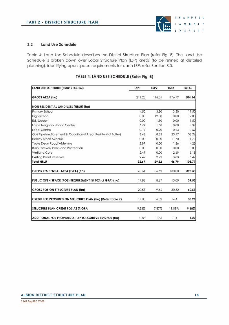
3.2 Land Use Schedule
Table 4: Land Use Schedule describes the District Structure Plan (refer Fig. 8). The Land Use Schedule is broken down over Local Structure Plan (LSP) areas (to be refined at detailedplanning), identifying open space requirements for each LSP, refer Section 8.0.
TABLE 4: LAND USE SCHEDULE (Refer Fig. 8)
LAND USE SCHEDULE (Plan: 2142-26i) LSP1 LSP2 LSP3 TOTAL
GROSS AREA (ha) 211.28 116.01 176.79 504.07
NON RESIDENTIAL LAND USES (NRLU) (ha)Primary School 4.50 3.50 3.50 11.50High School 0.00 12.00 0.00 12.00Ed. Support 0.00 1.50 0.00 1.50Large Neighbourhood Centre 6.74 1.58 0.00 8.32Local Centre 0.19 0.20 0.23 0.62Gas Pipeline Easement & Conditional Area (Residential Buffer) 6.46 8.32 23.47 38.26Henley Brook Avenue 0.00 0.00 11.70 11.70Youle Dean Road Widening 2.87 0.00 1.36 4.23Bush Forever/ Parks and Recreation 0.00 0.00 0.00 0.00Wetland Core 2.49 0.00 2.69 5.18Existing Road Reserves 9.42 2.22 3.83 15.47Total NRLU 32.67 29.32 46.79 108.77
GROSS RESIDENTIAL AREA (GRA) (ha) 178.61 86.69 130.00 395.30
PUBLIC OPEN SPACE (POS) REQUIREMENT (@ 10% of GRA) (ha) 17.86 8.67 13.00 39.53
GROSS POS ON STRUCTURE PLAN (ha) 20.53 9.66 30.32 60.51
CREDIT POS PROVIDED ON STRUCTURE PLAN (ha) (Refer Table 7) 17.03 6.82 14.41 38.26
STRUCTURE PLAN CREDIT POS AS % GRA 9.53% 7.87% 11.08% 9.68%
ADDITIONAL POS PROVIDED AT LSP TO ACHIEVE 10% POS (ha) 0.83 1.85 -1.41 1.27
504.14

ALBION DISTRICT STRUCTURE PLAN 1�
2142 Rep38E ET-09
PART 2 - DISTRICT STRUCTURE PLAN
4 . 0 E N V I R O N M E N T A L M A N A G E M E N T
4.1 Background
A comprehensive environmental reporting framework for the Albion District Structure Plan area issetoutundertheSchedule4‘SpecialUse–Albion’provisionsofLocalPlanningSchemeNo17, Appendix Two provides a summary of this reporting framework.
In accordance with the provisions of Schedule 4 the following environmental reporting has been prepared and lodged with the Albion District Structure Plan:
1. LocalWaterManagementStrategy(referAppendixThree);
2. AcidSulfateSoilsManagementPlan(incorporated in theLocalWaterManagementStrategy, refer Appendix Three);
3. Bushland Management Plan – Possible Threatened Ecological Community (referAppendix Four);
4. BushlandManagementPlan–BushForever(referAppendixFive);and
5. NoiseManagementPlan(referAppendixSix).
TheAlbionDistrictStructurePlanreflectstheoutcomesandrequirementsoftheseenvironmentalmanagement plans. The following provides a summary of the key recommendations and implications of these environmental management plans.
4.2 Local Water Management Strategy
ALocalWaterManagementStrategy(LWMS)hasbeenpreparedfortheDistrictStructurePlanarea,inaccordancewiththe‘SpecialUse–Albion’zoneprovisions,referAppendixThree.Thefollowing provides a summary of this Report.
4.2.1 District Water Planning - Background
Water management is a key consideration to development of Albion. The North East Corridor Drainage Strategy (GB Hill, 1995) prepared for Water Authority of WA as part of the North East Corridor Structure Plan, provides a regional framework for water management associated with urban development. A review of that Strategy was recently completed and published as the NorthEastCorridorUrbanWaterManagementStrategy(GHD,2007).GHD(2007)recommendsthatDistrictandLocalWaterManagementStrategiesbepreparedconsistentwithit.Furtherit states that the highest priority is the Henley Brook-West Swan-Caversham District Water ManagementPlan(DWMP),whichiscurrentlybeingpreparedbyGHDConsultants.
ALBION DISTRICT STRUCTURE PLAN 1�
2142 Rep38E ET-09
PART 2 - DISTRICT STRUCTURE PLAN
The Strategy further notes that should local structure planning proceed before the completion oftheDWMP,theproponentshouldberequiredtoprepareaLocalWaterManagementPlanthataddressestheissuesthatwouldotherwisehavebeenincludedintheDWMP.
The Department of Water advised on 30 April 2007 that drainage and water management shouldbeconsistentwiththeNorthEastCorridor(Regional)UrbanWaterManagementStrategy2007.
It is also important to note that Local Planning Scheme No.17, Schedule 4 ‘Special Use - Albion’ zoneprovisionsstatethat:
a) IntheabsenceofaDistrictWaterManagementStrategy(DWMS),theLWMSmustincludeinformationaddressingthefollowing,whichwouldnormallybecontainedinaDWMS-
(i)Committobestpracticeplanning,designandconstruction;
(ii) Refine land use scenario and identify major constraints;
(iii) Identify water sources for drinking and other uses, consistent with fit-for-purpose water usestrategyuse;
(iv) Refine conceptual stormwater management plan; and
(v) Identifyissuestobeaddressedatlaterstages.
These statutory provisions, as prepared in conjunction with the Environmental Protection Authority (refer Appendix 1), as well as the North East Corridor (Regional) Urban Water ManagementStrategy2007,allowfortheprogressionofaLWMSintheabsenceofaDistrictWaterManagementStrategyPlan.Accordingly theAlbionLWMSpresentsbothdistrictandlocal level drainage information consistent with these documents.
Schedule 4 of Local Planning Scheme No.17 sets out a statutory hierarchy of water management reporting,whichisconsistentwiththeplanningprocess.TheLWMSsetsoutdrainageprinciplesin accordance with Schedule 4. The open space and drainage areas shown on the DSP are indicative only. Consistent with Schedule 4 detailed modelling to determine exact drainage and open space areas will be completed at Local Structure Plan stage as part of an Urban WaterManagementPlan,referFig.8,note5.
4.2.2 WaterManagement
TheLWMSisbasedonhydrologicaldatacollectedsince2001.
The Albion study area extends over three existing surface water catchments namely Horse Swamp, St Leonards Creek and Wandoo Creek catchments. St Leonards Creek and Wandoo Creek drain to the east and discharge into the Swan River. Horse Swamp catchment drains to
ALBION DISTRICT STRUCTURE PLAN 1�
2142 Rep38E ET-09
PART 2 - DISTRICT STRUCTURE PLAN
the west and provides runoff to Whiteman Park and Bennett Brook. These existing surface water flowswillbemaintainedatthesamepeakeventvolumespostdevelopment.
The LWMS describes the existing surface water and shallow water regime and presents aconcept design of water management post-development to maintain that regime consistent with Water Sensitive Urban Design.
Thisincludesinfiltrationofstormwaterwherepossibleandtheincorporationofsurfacewaterflow paths in swales within multiple use corridors together with flood attenuation storage.DesignatedopenspaceareasontheStructurePlanaresufficienttoaccommodatedrainagerequirements.
For nutrient management, a programme of source control measures is described consistent with the latest Department of Water approach to urban water management.
TheLWMSincludesastrategicAcidSulphateSoilinvestigationwhichconcludesthattheissuecan be managed at a level consistent with typical developments on the Swan Coastal Plain in similar geographical settings.
A programme of ongoing hydrological monitoring is described to be carried out to assist with drainageinfrastructurelayoutandrefinement.
4.2.3 Wetlands
TherearenoConservationCategoryWetlandswithintheStructurePlanarea.SeveralMultipleUse and Resource Enhancement Category Wetlands, generally in poor condition as a result of manyyearsofgrazing,havebeenidentifiedonsite(referAppendixThree).
Implementation of the Structure Plan will result in the following changes in terms of wetlands:
The retention of Resource Enhancement Dampland (104) (Lots 352 and 351) and Resource Enhancement Sumpland (127) (Lot 346) and their associated buffers, serving conservation, recreation and drainage functions;
The retention of St Leonards Creek;
The construction of an ephemeral watercourse system primarily for drainage and nutrient management within multiple use corridors, and;
Themodificationorfilling/drainingofsignificantlydegradedMultipleUseandResourceEnhancement wetlands.

ALBION DISTRICT STRUCTURE PLAN 18
2142 Rep38E ET-09
PART 2 - DISTRICT STRUCTURE PLAN
TheareassurroundingWetlands104and127aresignificantlydegradedasaresultofmanyyearsofgrazing.Thewidthofthebufferstothesewetlandsandtheirtreatmentwillberefinedduring the preparation ofWetlandManagement Plans at Local Structure Plan stage, withconsideration for reduced buffer widths and a commitment to rehabilitate degraded buffer areas.Anindicative50metrevegetatedwetlandbufferhasbeenidentifiedontheStructurePlan for Wetlands 104 and 127.
A30mvegetationbufferzone(measuredfromthewinterhighwaterlevel)willberehabilitatedon either side of St Leonards Creek. This buffer is also consistent with the Environmental Protection Authority’s(1997)recommendedbufferwidthof30mforseasonallyflowingwatercourses.
Passive recreational pursuits, such as walking, bird watching, picnicking and nature studies are considered acceptable in most wetland areas and their buffers. Controlled public access is recommended to prevent deterioration of conservation values and to assist with establishment of regenerative processes.
WetlandManagementPlanswillbepreparedaspartoftherelevantLocalStructurePlansinaccordance with Schedule 4 of Local Planning Scheme No.17.
4.3 Bushland Management Plans
The Structure Plan area has generally been cleared/parkland cleared, with vegetation degradedasaresultofmanyyearsofgrazing.Theremainingvegetationareastoberetained,in addition to Wetlands 104 and 127 outlined above, are the Bush Forever Site 200 and the possible Threatened Ecological Community (TEC).
BushlandManagementPlanshavebeenpreparedfortheBushForeverSite200(theportionwithin the Structure Plan area) and the possible TEC, refer Appendices 4 and 5. The following provides a summary of these reports.
Bush Forever Site 200, adjoins the southern boundary and has been transferred to WAPC (refer Fig. 2). The portion of Bush Forever Site 200 east of Henley Brook Avenue is not directly adjoining theStructurePlanareaandisnotincludedintheBushlandManagementPlan.Thevegetationcondition of the Bush Forever Site has been mapped as being in ‘Good’ to ‘Degraded’ using the Bush Forever Rating Scale.
PossibleTEC(FCT20a),comprisingapproximately3ha,hasbeenidentifiedoveraportionofLots350, 353 and 345. Given its degraded state several studies have indicated that it is unlikely to be TEC on the Structure Plan. The City of Swan and Department of Environment and Conservation have advised that the possible TEC is be retained in public open space.
ALBION DISTRICT STRUCTURE PLAN 19
2142 Rep38E ET-09
PART 2 - DISTRICT STRUCTURE PLAN
TheBushlandManagementPlansoutlinetheproposedtreatmentofthesetwoconservationareas as well as implementation of the plans, management and future monitoring requirements.
Public access to conservation areas will be limited to passive recreation in a manner that will protect their environmental attributes and functions.
TheprimaryissuesthatareaddressedintheManagementPlansare:
Protecting native vegetation during construction with temporary fencing and subsequent long term protection with permanent fencing;
Rubbish removal on a regular basis;
Rehabilitation and enhancement using locally native species;
Weed management using a combination of mechanical, physical and chemical methods;
Maintenanceofpotentialfaunalinkages;
Stormwater and nutrient management using structural and non-structural methods;
Unauthorised pedestrian and vehicle access using physical barriers and delineated pathways where necessary, and;
Dieback control using appropriate hygiene practices.
These issues are addressed through a range of structural (eg fencing, drainage etc) and non-structural (eg education) best management practices.
4.4 Noise Management
4.4.1 Perth Darwin Highway Reservation and Public Purpose Reserve
The Perth Darwin Highway Reservation adjoins the western boundary of the District Structure Planareaandisseparatedbya43.5mwideMRSPublicPurposeReserve.ThetimingofthePerthDarwinHighwayconstructionisunknownandisnotontheMainRoadsWesternAustraliatenyear plan. It is therefore very likely that Albion could be fully developed prior to commencement of construction works for the Perth Darwin Highway. Given the lack of certainty regarding the timeframe for construction the District Structure Plan acknowledges future impacts and accommodates noise amelioration options.
Infrastructure agencies are currently reviewing the potential construction of a rail service within theMRSPublicPurposeReserve.Additionalinformationinrelationtothisinfrastructure,availableat the time of planning, will be considered as part of Local Structure Plans.

ALBION DISTRICT STRUCTURE PLAN 20
2142 Rep38E ET-09
PART 2 - DISTRICT STRUCTURE PLAN
Given the lack of certainty as to provision, design and location any impacts from the possible future rail service are to be addressed by the relevant infrastructure agency at the time of construction (possibly 2030) through a noise mitigation strategy, in accordance with the Draft State Planning Policy. At the time of construction the infrastructure agency will be required to implement appropriate measures and treatments to ensure impacts on the existing residential development are minimised in accordance with the Draft State Planning Policy: Road and Rail Transport Noise.
HerringStorerAcousticshavecompletedaNoiseManagementPlanaddressingtheimpactsof the future Perth Darwin Highway and possible future rail, refer Appendix Six pursuant to the requirements of Local Planning Scheme No.17. The following provides a summary of this Report.
The objectives of the study were:
To determine noise that would be received at residences within the Structure Plan area from vehicles travelling on the proposed Perth Darwin Highway and from the possible future rail;
Assess the predicted noise levels for compliance with the appropriate criteria, and;
If exceedances are predicted, investigate possible noise amelioration options for compliance with the Western Australian Planning Commission conditions.
Based on Western Australian Planning Commission criteria, noise received by residences within the subdivision from vehicles travelling along the Perth Darwin Highway will need to comply with the following external criteria:
Time PeriodExternal Noise Exposure Level1 Criteria (dB)
Exposure Level 1 (Target)
Exposure Level 2 Exposure Level 3
Day 6.00am - 10.00pm
Less than LAeq 55 LAeq 55-60 Above LAeq 60
Night 10.00pm - 6.00am
Less than LAeq 50 LAeq 50-55 Above LAeq 55
Additional criteria for railways
Less than LAmax 75 LAmax 75-80 Above LAmax 80
Note 1: Noise levels is to be determined at a point 1 metre from the edge of the site or building facade that is the most exposedtotrafficnoise,andataheightof1.5metrefromthegroundlevelatthatpoint.Noiseassessmentsshouldgenerallyreflecttheimpactofanyfuturegrowthinroadandrailtraffic,basedona20yearforecastperiod.
Noise receivedat residences locatedadjacent to thePerth-DarwinHighway,and theMRSPublic Purpose Reserve in the year 2036 (a reasonable estimate of full development of the corridor)mayexceedtheMainRoadsWesternAustraliaNoiseLevelObjectivesby4dB(A).

ALBION DISTRICT STRUCTURE PLAN 21
2142 Rep38E ET-09
PART 2 - DISTRICT STRUCTURE PLAN
To comply with the required criteria there are several noise amelioration options which include:
Construct a 1.8 metre high barrier along the boundary of the public purpose reserve, and locate and/or protect the outdoor living area such that they achieve compliance with theLAeq(Day)noiselevelof55db(A).QuietHouseDesignisrequiredforthefirstrowofhouses and general guidelines for Quiet House Design are included in Appendix D of the Acoustic Assessment Report contained in Appendix 6.
Construct a 3.4 metre high barrier along the boundary of the public purpose reserve. In this case there would be no restrictions to the location of the outdoor living area and no requirement for application of Quiet House Design.
NoisereceivedfrompossiblefuturepassengertrainsrequirescompliancewithLA(Max)noiselevel of 75 db(A) criteria. Residences backing on to the public purpose reserve can achieve compliance with the construction of a 2.4 metre high barrier. In accordance with the Draft SPP: Road and Rail Transport, the noise mitigation strategy, associated with any future rail, shall be prepared and implemented by the relevant infrastructure agency.
All landowners adjoining theMRS Public Purpose Reserve haveconfirmed their preferencefor a 1.8m high barrier along this boundary and the application of Quiet House Design as requiredbythenoisemodellingforthefirstrowofhouses.Further interfacedetailandnoiseameriotationmechanismsshallbeconfirmedaspartofLocalStructurePlanning.Earlydesignworkhas indicatedthat lotswillgenerallybackontotheMRSPublicPurposeReserve,tobeconfirmedatLocalStructurePlanstage.
4.4.2 Henley Brook Avenue
NoisegeneratedbytrafficonHenleyBrookAvenueaffectingtheDSPareawillbeconsideredat Local Structure Plan stage, in accordance with Western Australian Planning Commission Policy. Noise impacts on existing rural land to the east of Henley Brook Avenue, in accordance with the WAPC Policy, is to be considered by the City of Swan/Department for Planning and Infrastructure in the design and construction of the road.
4.5 Parmelia & Dampier Gas Pipelines
The Parmelia and Dampier Gas Pipelines run through the Albion District Structure Plan area in anorth–southdirection.Thegaspipelinesarewithinprivatelandholdingsandareshownaseasements on the affected titles (refer Fig.2).
•
•

ALBION DISTRICT STRUCTURE PLAN 22
2142 Rep38E ET-09
PART 2 - DISTRICT STRUCTURE PLAN
4.5.1 Quantitative Risk Assessment
Schedule 4 ‘Special Use – Albion’ provisions require the preparation of aQuantitative RiskAssessment (QRA) for the Gas Pipelines within the Structure Plan area. The WAPC Planning Bulletin No.87 (October2007) for ‘HighPressureGasTransmissionPipelines in thePerthMetropolitanRegion’ constitutes a QRA in accordance with Clause 4.1.4 of Schedule 4, ‘Special Use - Albion’ zone.
If at Local Structure Plan stage a proponent seeks to vary the land uses/setbacks to the gas pipelinesfromthosespecifiedinthePlanningBulletin,aseparateQRAisrequiredforthesubjectareatosupportthemodifications.
The Planning Bulletin details appropriate land uses above and adjoining gas pipelines as well as the Conditional Area (measured perpendicular to the edge of the pipeline easement). Setbacks for residential and sensitive uses (Conditional Area) contained within the Planning Bulletin, and shown on the Albion District Structure Plan, are contained in Table 5. Sensitive land uses are activities that result in the gathering of a large number of people on a regular basis, and include uses such as schools, aged care, retail and district open space.
TABLE 5 - Width of the High Pressure Gas Pipeline setback distances at 90° to the edge of the pipeline corridor/easements (extract from Planning Bulletin 87)
Pipeline Nature of DevelopmentSensitive Residential Industrial/ Commercial
DBNGP2betweenMuchea(MLV116)and Kwinana (KJN)
90m 0m 0m
Parmelia Gas Pipeline north of Caversham
80m 70m 60m
DBNGP corridor and Parmelia Gas Pipeline easement when adjoining betweenMucheaandBaldivis.
110m 75m 60m
4.5.2 Land Use
Presently the gas pipeline easement and Conditional Area is wholly contained on privately owned land, is appropriately sign posted and the relevant authorities have access to the land.
TherearethreekeylandusesspecificallyproposedforportionsoftheConditionalAreaontheStructure Plan, in accordance with the QRA:

ALBION DISTRICT STRUCTURE PLAN 23
2142 Rep38E ET-09
PART 2 - DISTRICT STRUCTURE PLAN
1. Road crossings perpendicular to the easement;
2. Drainage, wetland and empheral water course system north of Woollcott Avenue, which is part of the overall drainage network, and;
3. Bush Forever Site 200 south of Youle Dean Road, Reserved for ‘Parks and Recreation’ undertheMRSandalreadytransferredtoWAPC.
Alternate land use options have been identified for the balance of the Conditional Areaunder the Structure Plan, in accordance with the QRA. The City of Swan has indicated that it is not prepared to accept vesting of public open space as issues remain outstanding with the pipeline custodians regarding the management and maintenance. The City’s position is that the prohibitions to its use and maintenance would be to the detriment of future communities.
1. Large residential lots –Lotsextendingoverthebufferandeasementareawithabuildingenvelopeoutsideoftherequiredbuffers.Lotsizescouldbebetween2000m2–5000m2 with the buffer/easement area part of the private open space and appropriately sign posted and accessible.
2. Large rural-residential lots–Lotsextendingoverthebufferandeasementareawithabuildingenvelopeoutsideoftherequiredbuffers.Lotsizescouldbeover5hectares,with the buffer/easement area part of the private open space and appropriately signposted and accessible. Land use permissibility within these lots (if proposed) is to be determinedaspartofthezoningsundertheLocalStructurePlan.
3. Communal open space for a strata scheme–Agroupeddwellingdevelopmentcouldbe located outside of the required buffers, with the buffer and easement area forming communal open space.
Land uses and developments within the gas pipeline easement and buffer area will be determined by land owners / proponents at Local Structure Plan stage, in accordance with the QRA, or other approved QRA, and in consultation with relevant authorities.
The principles for land use in the gas pipeline easement and conditional area outlined above are as follows:
City of Swan is not prepared to accept vesting of Public Open Space;
The gas pipeline easement and buffer to be retained in private ownership;
There are a number of land use options for land being retained in private ownership as outlined in Section 4.5.2; and
Detailed land use proposals will be provided at Local Structure Plan stage.
For the purposes of the District Structure Plan the gas pipeline easement and residential land use buffer have been treated as a deduction from the Gross Subdivisional Area and does not constitute part of the public open space calculation.
•
•
•
•

ALBION DISTRICT STRUCTURE PLAN 24
2142 Rep38E ET-09
PART 2 - DISTRICT STRUCTURE PLAN
4.6 Summary of Aboriginal Heritage Investigations
Aboriginal cultural heritage surveys (1994 and 1997) have been completed in the Albion District Structure Plan area. These surveys consisted of an archaeological survey and consultation with indigenous representatives.
Pursuant to the 1994 Cultural Heritage Survey A Request for Consent under Section 18 of the Aboriginal Heritage Act 1972 was lodged in 1994 for the development of Lots 352, 353, 354, 355,359and10onMurrayRoadandLot310onWoollcottAvenue,HenleyBrook followingconsultation with indigenous representatives. This outlined four requests that asked for:
Consent to use the land along a tributary of St Leonard’s Creek for urban development;
Assistance or guidance for the use of Aboriginal names for streets;
Assistance or guidance for the wording of a plaque to be placed in the proposed development and;
Guidance with respect to involving Aboriginal people in the planting of trees and shrubs alongStLeonard’sCreek(W.G.MartinickandAssociates,1994).
Thiswasapprovedby theMinister forAboriginalAffairs;Housingwith thecondition that theclearing works be monitored by an archaeologist and if any sites were found, a Section 18 application must be lodged due to limitations in the original archaeological survey (Prince, 1994).
The second Aboriginal and Cultural Heritage survey was conducted in the Albion District Structure Plan area with an extensive site search for artefacts in 1997 (Ecoscape, 2006). During thisarchaeologicalstudy,onearchaeologicalsiteof lowsignificancewasdiscoveredwithinthe District Structure Plan area on Lot 351, near Park Street. An application will be made under the Aboriginal Heritage Act 1972 at Local Structure Plan stage if disturbance to the site is proposed.
Schedule 4, Clause 5.2.4 of Local Planning Scheme No. 17 requires the preparation of a Cultural HeritageManagementPlanatLocalStructurePlanstage.
•
•
•
•
ALBION DISTRICT STRUCTURE PLAN 2�
2142 Rep38E ET-09
PART 2 - DISTRICT STRUCTURE PLAN
5 . 0 H O U S I N G S T R A T E G Y
5.1 DemographicProfileandHousingNeeds
The Western Australian Housing & Urban Research Institute (HURIWA) has completed ‘An Assessment of Housing, Socio-economic and Sustainability Demands with reference to the futuresettlementofAlbion’inMarch2006.Thekeyfindingsandrecommendationsofthisstudyform the basis of the Albion Housing Strategy.
HURIWAidentifiedthefollowingkeypopulationandhousingtrendswithintheCityofSwan:
1. Householdsizehasdeclinedfrom2.85to2.68personsperhousehold,representingadecline in the traditional family.
2. The post-family household aged 40-64 (without children) is forming at a faster rate than households with children.
3. 90%ofhousingintheCityisdetacheddwellings,6%semidetached,2%flats,units,andapartments.
Thefollowingkeyfindingsrelatingtohousingneeds/demandwithintheCityofSwanwereidentifiedbyHURIWA:
1. Despite changing household structure there is still demand for detached housing due to privacy, mobility and choice with a preference for lots between 500-800m².
2. 40% of the population are willing to reside in medium density housing, particularly the 18 -19 and 65+ age cohorts.
3. Financial and affordability imperatives will continue to increase demand for small lots.
4. Providing a range of housing at differing densities will have market appeal and contributes to a range of age groups and family types in new residential development.
5. Grouped dwelling and multiple dwelling sites are important for dwelling diversity.
6. Housing diversity is important to avoid Albion being a “transition suburb”.
HURIWAidentifiedashortageintheavailabilityofagedcarewithintheCityofSwan,withallexisting aged persons accommodation full and demand expected to double in the coming decade.To“ageinplace”arangeofpropertysizesandmixofhousingtypesisrequired.

ALBION DISTRICT STRUCTURE PLAN 2�
2142 Rep38E ET-09
PART 2 - DISTRICT STRUCTURE PLAN
5.2 Housing Principles
The population of Albion is estimated at 14,700 based on a household occupancy of 2.68 persons per household (based on HURIWA 2005 analysis) and on expected yield of approximately 5,500 lots.
Albion will ultimately comprise a range of residential densities, housing types and tenures in accordance with the City of Swan Neighbourhood Planning Policy. The detail, including R-Codings,willbeclarifiedthroughboththeLocalStructurePlanandsubdivisionprocess.
Thehousingprinciples forAlbion,basedon thefindingsof theHURIWAResearchReport, toguide future Local Structure Planning and subdivision are:
Providediversityinhousingchoice,lotsizesandtenure;
Higher density within 400 metres of the Town Centre, Activity Corridor and select open space sites;
Opportunities for aged persons/independent living accommodation within 400 metres of the Town Centre, Activity Corridor and select open space sites;
Promoting mixed use development around and within the Town Centre, including home based business;
Housing layout and urban form to respond to public transport routes, incorporating Transit Oriented Development Principles;
Environmentally sustainable design approaches in terms of solar orientation of lots, and;
Provide larger lots and appropriate land use controls adjoining Park Street allowing for a transition of residential densities.
5.3 Activity Corridor - Transit Oriented Development
The Sub Regional planning process identified a north-south Activity Corridor generallycorresponding with the Partridge Street alignment in the Albion District Structure Plan area, refer Sections 1.3 and 6.2. The Public Transport Authority (PTA) supported the provision of a high frequency bus route along this alignment, particularly given that the provision of a rail service is uncertain. While PTA has supported a bus route along the Activity Corridor the timing of these services is uncertain.
InfrastructureagenciesarereviewingthepotentialconstructionofarailservicewithintheMRSPublic Purpose Reserve. Additional information in relation to this infrastructure, available at the time of planning, will be considered as part of Local Structure Plans.

ALBION DISTRICT STRUCTURE PLAN 2�
2142 Rep38E ET-09
PART 2 - DISTRICT STRUCTURE PLAN
ItisimportantthattheurbandesignadjoiningtheCorridorisrobust,allowingforintensificationandchangingurbanusesovertime.ImplementingTODprinciplesforbusroutesisdifficultasthe permanence of the service is compromised, although some TOD principles can still be implemented, as acknowledged in WAPC DC Policy 1.6 (Clause 6.2).
Consistent with WAPC DC Policy 1.6 and Liveable Neighbourhoods (October 2007) the following design objectives will be applied along the Activity Corridor and in the Town Centre Precinct:
The street pattern designed to encourage walkability and facilitate pedestrian and cyclist access to transit facilities;
Adiversityoflotsizesmatchedwitharobuststreetlayoutallowingforchangingusesandintensification;
Maximisingresidentialdensitieswithintheprecinct,giventhecurrentcontextaswellasallowing for further increases in density over time;
Other non-residential uses are likely to be significant generators of transport tripsaccessible to transit facilities and should be facilitated in the Town Centre precinct; and
Streetscapes, landscaping and the public domain designed to encourage public transport use, including the provision of footpaths and shade.
MoredetaileddesignandimplementationoftheseprincipleswillbecarriedoutaspartoftheLocal Structure Plan and preparation of Detailed Area Plans where relevant.
5.4 Residential Densities and Housing Types
The location and layout of R-Code boundaries will be determined at Local Structure Plan stage following detailed subdivision design. Figure 9 sets out indicative residential density codings, consistent with the principles outlined above.
The following provides a summary of location criteria and development control for residential land uses within the District Structure Plan area, providing a framework for the designation of R-Codings at Local Structure Plan stage. This section and Figure 9 provides a guide for Local Structure Planning but does not preclude other density responses within the Structure Plan area.

ALBION DISTRICT STRUCTURE PLAN 28
2142 Rep38E ET-09
PART 2 - DISTRICT STRUCTURE PLAN
5.4.1 Low Density - Residential R17.5
The following is a summary of the provisions and location criteria for residential development coded R17.5.
Residential Density Coding: Residential R17.5
Dwelling Types: Single
Development Controls: Residential Design Codes
Local Planning Scheme and Council Policies
Location Criteria:
Located adjoining Henley Brook Avenue to provide transition to larger Special Rural lots east of Henley Brook Avenue.
Lotsizesof500m²orgreater(asperRCodes)
5.4.2 MediumDensity-ResidentialR30
The following is a summary of the provisions and location criteria for residential development coded R30.
Residential Density Coding: Residential R30
Dwelling Types: Single and grouped dwellings
Development Controls: DetailedAreaPlans(dependantonlotsizeanddesign,priortofinalsubdivisionapproval)
Residential Design Codes
Local Planning Scheme and Council Policies
Location Criteria:
Residential R30 will be the base coding over the Structure Plan area allowing for the provision of traditional lots (ranging from 450m2 to 600m2) and cottage lots (ranging from 280m2 to 360m2); and
Located to enhance passive surveillance of public spaces.

ALBION DISTRICT STRUCTURE PLAN 29
2142 Rep38E ET-09
PART 2 - DISTRICT STRUCTURE PLAN
5.4.3 MediumDensityResidentialR40
The following is a summary of the provisions and location criteria for residential development coded R40.
Residential Density Coding: Residential R40
Dwelling Types: Single, grouped and multiple dwellings
Development Controls: DetailedAreaPlans(dependantonlotsizeanddesign,followingsubdivision approval)
Residential Design Codes
Local Planning Scheme and Council PoliciesLocation Criteria:
Generally surrounding areas of high amenity, such as open space;
Located so as to maximise access to and use of services and facilities such as schools, commercial centres and public transport routes (TOD precinct), and;
Located to enhance passive surveillance of public spaces.
Typicallylotsvaryinginsizefrom200m²to440m².
5.4.4 MediumDensityResidentialR60
The following is a summary of the provisions and location criteria for residential development coded R60.
Residential Density Coding: Residential R60
Dwelling Types: Single, grouped and multiple dwellings, aged persons accommodation / independent living
Development Controls: Detailed Area Plans (following subdivision approval)
Residential Design Codes
Local Planning Scheme and Council PoliciesLocation Criteria:
Located surrounding and within the Neighbourhood and Local Centres and in close proximity to the future rail station, incorporating TOD principles;
Generally R60 development will be located within 400m of the Town Centre;
Generally adjoining areas of high amenity, such as open space; and
Located to enhance passive surveillance of public spaces.
Singlelotsvaryinginsizefrom160m²to360m²orlargersitesforgrouped/multipledwellings.
ALBION DISTRICT STRUCTURE PLAN 30
2142 Rep38E ET-09
PART 2 - DISTRICT STRUCTURE PLAN
5.5 General Rural Zoned Land South of Park Street
ThegeneralruralzonedlandsouthofParkStreetandoutsidetheDistrictStructurePlanarea,allowsforatransitionoflotsizesandlandusesbetweenthe‘SpecialRural’landnorthofParkStreetandtheDistrictStructurePlanarea.Landownersoftheselotswillneedtoresolvelotsizeandlanduseissuesseparately,viaamendmentstoLPS17andpotentiallytheMRS.
5.6 Lot Yield Estimates
TheCityofSwanadoptedaNeighbourhoodPlanningPolicy,inMay2006.ThisPolicy,consistentwith Liveable Neighbourhoods (October 2007), sets out a residential density target of 22 dwellings/nett hectare averaged over an entire Structure Plan area and 30 dwelling units/nett hectare within 400m of an existing or planned Regional or District Centre or key public transport node (note: nett hectare, also referred to as ‘site hectare’ under Liveable Neighbourhoods (October 2007), excludes roads, lanes, open space and other non residential land uses and is the pure residential area). Liveable Neighbourhoods (October 2007) states that as a guide a minimum residential density target of 30 to 40 dwellings per site hectare is suggested.
Based on the Yield Precinct Plan (refer Fig.10) and the Indicative Residential Densities (refer Fig.9) lot yield estimates have been calculated for the Albion District Structure Plan area, refer Table 6.
Table 6 estimates a total dwelling unit yield of 24 dwelling units per site hectare over the entire Structure Plan area and 32 dwelling units per site hectare directly adjoining the Centre, exceeding the density targets set out under the Neighbourhood Planning Policy and Liveable Neighbourhoods (October 2007). These densities and yields are indicative only and will be refinedanddevelopedaspartofLocalStructurePlanningandsubdivisiondesign.

ALBION DISTRICT STRUCTURE PLAN 31
2142 Rep38E ET-09
PART 2 - DISTRICT STRUCTURE PLAN
TABLE 6: LOT YIELD ESTIMATES (refer Fig.10)
Table6Assumptions/Notes:
• Lotyieldestimatesarebasedonthe indicativeResidentialDensitiesPlanandwillbesubject to change following detailed subdivision design.
• NettResidentialAreaexcludesnon-residentiallandusesandopenspace,andcompriseslotsandroads.
• SiteAreaispureresidentialarea,excludingroadsandlanes.
• ResidentialR30isthebasecoding.70%oftheR30areaisassumedtobetraditionallots,450m²-600m2averagelotsize,with32.5%oftheNettResidentialAreabeingroadarea.Theremaining30%oftheR30areaisassumedtobecottagelots,360m2averagelotsize,with35%oftheNettResidentialAreabeingroadarea.
• ResidentialR40areashaveanaveragelotsizeof300m2with35%oftheNettResidentialAreabeingroadarea.
• ResidentialR60areashaveanaveragelotsizeof280m2with35%oftheNettResidentialAreabeingroadarea.
Cell Dwelling Unit Dwelling Unit Yield Yield Estimate Per Site Hectare
LSP1A 16.14 290 17.97B 13.67 270 19.75C 44.97 1045 23.24D 12.83 295 22.99E 16.74 546 32.62F 16.82 405 24.08SUB TOTAL 121.17 2851 23.53LSP2G 15.45 506 32.75H 8.2 270 32.93I 21.39 493 23.05J 8.03 170 21.17SUB TOTAL 53.07 1439 27.12LSP3K 9.37 217 23.16L 19.05 422 22.15M 16.95 397 23.42N 11.42 229 20.05SUB TOTAL 56.79 1265 22.28TOTAL 231.03 5555 24.04* Indicative only and subject to detailed design
Estimated Site Area (ha) *
TABLE6_LotYield_Mar09

ALBION DISTRICT STRUCTURE PLAN 32
2142 Rep38E ET-09
PART 2 - DISTRICT STRUCTURE PLAN
5.7 Aged Persons Accommodation/Independent Living
In accordance with the outcomes of the HURIWA Study aged persons accommodation (over 55) could be provided in the Structure Plan area. To ensure the design of the aged person’s accommodation integrates with the surrounding urban fabric the following principles apply in the preparation of Detailed Area Plans:
• Located so as to maximise access to and use of services and facilities such as commercial centres and public transport routes;
• Development to address and survey surrounding public streets, with visually permeable fencing and major openings addressing the street;
• Development integrated with surrounding land uses, including pedestrian access and permeability; and
• Any community/shared facilities to address the primary street.
Detailed Area Plans will be required to be prepared for aged persons/ independent living sites in accordance with these principles at subdivision stage.
5.8 Anticipated Lot Release
There is potential for lot releases in the vicinity of 400 - 500 per annum based on two active development fronts within the District Structure Plan area. Land release is programmed to commenceJanuary2009.Thisisbasedon,atinitialstages,BrookfieldMultiplexandDepartmentof Housing releasing on average between 250 and 300 lots combined per annum on an ongoing basis. Other landowners’ development fronts are likely to meet the balance of this estimated lot release.

ALBION DISTRICT STRUCTURE PLAN 33
2142 Rep38E ET-09
PART 2 - DISTRICT STRUCTURE PLAN
6 . 0 T R A N S P O R T A N D A C C E S S
6.1 Transport and Access Report
SinclairKnightMerzhavepreparedatrafficanalysisfortheAlbionDistrictStructurePlan,referTransportandAccessReport,AppendixSeven.Thefollowingisasummaryofthekeyfindingsand recommendations of this Report, which are consistent with the outcomes of the Sub Regional planning process.
The Transport and Access Report addresses the strategic transport aspects of land use and transport integration for Albion, in line with the following key objectives:
• To integrate with the district context;
• To assess the proposed internal transport networks with respect to accessibility and safety for all modes: vehicles, public transport, pedestrians and cyclists;
• To assess the level of transport integration between the Structure Plan area and the surrounding land uses, and;
• Todeterminethe impactsofthetrafficgeneratedbytheStructurePlanareaonthesurrounding land uses and transport networks.
The Albion District Structure Plan road network has been considered at both interim and ultimate time frames.
6.1.1 Ultimate Road Network
The proposed ultimate road network for Albion is compatible with Sub Regional planning outcomes. The key features of theultimate road network are described below:
The current Lord Street alignment will generally become the alignment for the Perth Darwin Highway adjoining the Structure Plan area, which is reserved as a ‘Primary RegionalRoad’undertheMRS.AccesstothePerth-DarwinHighwayfromtheStructurePlan area will be provided at Youle-Dean Road via a grade-separated access, in accordancewiththeMRSreservation.
The future Henley Brook Avenue alignment forms the eastern boundary of the Structure Plan areaand is reservedas an ‘Other Regional Road’ under theMRS. Itwill be afour lane dual carriageway with an operating speed of 60kph connecting through to Gnangara Road (in the north) and Reid Highway (in the south).

ALBION DISTRICT STRUCTURE PLAN 34
2142 Rep38E ET-09
PART 2 - DISTRICT STRUCTURE PLAN
Partridge Street (future Lord Street deviation) will become the alignment for a north south Integrator Arterial B, providing for district movements externally to Ellenbrook and Caversham. Partridge Street will be an Activity Corridor, serving as a public transport route with adjoining mixed uses and a range of residential densities, refer Section 6.2.
Youle-DeanRoadisan‘OtherRegionalRoad’undertheMRSconnectingPerthDarwinHighway and Henley Brook Avenue and is an Integrator Arterial B. Youle-Dean Road will be four lane dual carriageway, with an operating speed of 60 kph. The Youle-Dean Reserve width is subject to possible review and will be considered as part of street lot layout designs in Local Structure Plans.
ParkStreetandWoollcottAvenuewouldbeupgradedtostandardsspecifiedbyCityof Swan, with an operating speed of 50 kph.
6.1.2 Interim Road Network
ThetimingofconstructionofthePerthDarwinHighwayisunknownandisnotontheMainRoadsWestern Australia ten year program. It is therefore likely that Albion could be fully developed prior to the commencement of the Perth Darwin Highway.
An interim road network is proposed until the construction of the Perth Darwin Highway, which could potentially be 10 to 20 years.
The main differences between the interim and ultimate road network are:
Lord Street will either (a) be retained on its existing alignment and widened to four trafficlanes(withanoperatingspeedof70kph),or(b)beconstructedasafourlanedual carriageway on the ultimate alignment of the Perth Darwin Highway.
Partridge Street (Lord Street deviation) will become a north-south Integrator Arterial B through Albion from Lord Street (south of Park Street). Partridge Street will be built as a two-lane lane distributor with an operating speed of 50-60kph.
The current road connections to Lord Street will be retained with an additional connection at Woollcott Street and south of Park Street, improving permeability.

ALBION DISTRICT STRUCTURE PLAN 3�
2142 Rep38E ET-09
PART 2 - DISTRICT STRUCTURE PLAN
6.1.3 Public Transport, Pedestrians & Cyclists
Public transport within Albion will include:
A bus transit system to serve Albion focussed on the Activity Corridor; and
Possible future connection to a rail system within the Perth Darwin Highway reserve, in the longer term.
The Albion District Structure Plan maximises pedestrian and cyclist connections to the local and regionalpedestrian/cyclenetwork. Thepedestrian/cyclenetworkwill provide for efficientaccess to activity nodes such as the Town Centre, schools, as well as public open space and public transport stops. The plan proposes to accommodate on-street cycle lanes and off-street shared paths on all Neighbourhood Connectors and Integrator Arterials.
6.2 Activity Corridor
Partridge Street / Lord Streetdeviationwill formpart of anActivityCorridor as identified inNetwork City, and consistent with the Sub Regional planning outcomes.
NetworkCity identifiesanActivityCorridor throughAlbion,with theEllenbrookandMidlandCentres acting as an anchor at each end. Activity Corridors are ‘connectionsbetweenactivitycentresthatprovideexcellent,highfrequencypublictransporttosupportthelandusesthatwilloccuralongtheactivitycorridorsandactivitycentres.Activitycorridorsarenotdesignedto be high-speed through traffic routes’ (Network City 2004:14).
The key principles of the Activity Corridor are:
EllenbrookandMidlandcentresactingasanchorsateachend;
A high frequency public transport route, which is the basis for the corridor;
Focus on higher density housing, retail, entertainment and other high activity, people oriented uses adjoining the Corridor, with particular focus on a walkable catchment surrounding the Town Centre and public transport;
Development to front onto, address and survey the Corridor;
Road design to encourage multi-modal transport, public transport, pedestrians and cyclists (refer indicative road cross section within the Transport & Access Report);
Town Centre developed in accordance with main street principles, and;

ALBION DISTRICT STRUCTURE PLAN 3�
2142 Rep38E ET-09
PART 2 - DISTRICT STRUCTURE PLAN
Mediumtohighdensityresidential/mixedusedevelopmentclusteredwithin400mofatransit stop or public transport route and layout based on accessibility principles (refer Section 6.3).
Further refinementand implementationof theActivityCorridorconceptwilloccurat LocalStructure Plan, subdivision and Detailed Area Plan stage.

ALBION DISTRICT STRUCTURE PLAN 3�
2142 Rep38E ET-09
PART 2 - DISTRICT STRUCTURE PLAN
7 . 0 P U B L I C O P E N S P A C E S T R A T E G Y
7.1 Objectives
It is the intent of the Structure Plan to ensure the provision of a wide range of well located open space types, diverse recreational opportunities, vegetation preservation and the sharing of facilities and spaces. Key public open space objectives are;
Provide for a diversity of active, passive and natural open space areas;
Locate open space to enhance walkability and create diverse circuit walks ;
Protect vegetation within Public Open Space and other spaces wherever desirable and practical;
Establish a strong vegetation framework that will mature to create shade and visual amenity within the urban area;
Integration of an active recreation facility with the High School, Primary School and Educational Support Facility;
IntegratejuniorplayingfieldswiththePrimarySchools;
Help facilitate the practical sharing of open spaces;
Provide a range of passive open neighbourhood parks which provide an appropriate level of amenity;
Accommodate the requirements of Bush Forever;
Provide good connectivity and linkage too and thru open spaces;
Ensure no resident is more than 450 metres from an open space; and
Fully integrate drainage into the open space to promote best practice water sensitive urban design nutrient management and passive irrigation.
7.2 Public Open Space Principles and Distribution
The following outlines the principles of public open space provision and distribution within the Structure Plan area:
Public open space will be provided at a rate of 10% of the Gross Subdivisional Area across the Structure Plan area;

ALBION DISTRICT STRUCTURE PLAN 38
2142 Rep38E ET-09
PART 2 - DISTRICT STRUCTURE PLAN
Public open space will be provided at a rate of 10% of the Gross Subdivisional Area within each Local Structure Plan area;
All lots will be within 450 metres of public open space;
Public open space (particularly neighbourhood parks) will be distributed as evenly as possible across different land owners within Local Structure Plan areas (subject to conservation, recreation and drainage requirements); and
Equitable provision of open space for district purposes will be managed through the provisions of the DCP.
To ensure equitable distribution of public open space cash in lieu will be paid to the City of Swan by land owners who under provide public open space and will be reallocated to land owners who have over provided, in accordance with WAPC Policy DC 2.3 Public Open Space in Residential Areas.
The public open space distribution and identification of landowners under/over providingpublic open space will be determined at Local Structure Plan stage as this requires a detailed subdivision layout to determine the exact area and location of Neighbourhood Parks and other open space types.
7.3 Structure Plan Public Open Space Strategy & Utility
At District Structure Plan level the Public Open Space Strategy sets out the indicative location of the following core types of public open space; active, passive and natural areas, which are required to be provided for conservation, drainage or recreation purposes (refer Fig.11):
Open Space required for bushland and wetland retentionasidentifiedintheBushlandManagementPlansandLocalWaterManagementStrategy.Thefollowingpublicopenspace categories as shown on Figure 11 are relevant:
- (Possible) Conservation; - StLeonardsCreekMultipleUse;- Wetland Core, and;- Wetland Buffers.
Open Space required for drainage as identified in the Local Water ManagementStrategy. The following public open space categories as shown on Figure 11 are relevant:
- MultipleUse,and;- LocalOpenSpace–Drainage.
Local Open Space co-located with Schools as agreed with the Department for Education and Training. The following categories of open space as shown on Figure 11 are relevant:
- Local Active Open Space.

ALBION DISTRICT STRUCTURE PLAN 39
2142 Rep38E ET-09
PART 2 - DISTRICT STRUCTURE PLAN
These open space categories make up the core provision of open space in the Structure Plan area. Within LSP areas 1 and 2 these open space types do not constitute 10% of the LSP Gross Subdivisional Area. The balance of the 10% open space requirement will be provided via NeighbourhoodParks,showindicativelyontheOpenSpaceStrategy.Thelocation,sizeandconfigurationofNeighbourhoodParkswillbedeterminedatLocalStructurePlanstageandwill comprise the balance of the required 10% public open space. The exact location and configurationofNeighbourhoodParksisdependentonthesubdivisiondesign.
Schedule 4 of Local Planning Scheme No.17 sets out a hierarchy of water management reporting,whichisconsistentwiththeplanningprocess.TheLWMSsetsoutdrainageprinciplesin accordance with Schedule 4. The open space and drainage areas shown on the DSP are indicative only. Consistent with the Schedule detailed modelling to determine exact drainage areaswillbecompletedatLocalStructurePlanstageaspartofanUrbanWaterManagementPlan, refer Figure 8, note 5.
The key design principles, utility, functions and applicable open space credits for each category of open space included within the Structure Plan Open Space Strategy (refer Fig.11) are summarised below. Credits are consistent with the principles of WAPC Policy DC 2.3 Public Open Space in Residential Areas and Liveable Neighbourhoods (October 2007). Each open space type has been coded consistently with Fig.11 and Table Five.
The Albion District Structure Plan provides a framework for public open space credits, consistent with the existing policy requirements. As mentioned above it is important to note that the detail of the open space function, landscape treatment and drainage design will be provided at LocalStructurePlanstage.PublicopenspacecreditswillbeconfirmedatLocalStructurePlanstage in accordance with this detail and the policy requirements. Levels of embellishment will be commensurate with the open space area’s importance and function in the hierarchy.
7.3.1 MultipleUse(MU)
Multipleusecorridorswill serveadrainageand recreation function,providingopportunitiesfor passive recreation via walk trails, informal play and seating areas. Planting of structural vegetation will be predominately mixes of native species. Existing vegetation will be retained where possible. Multiple use corridors provide for drainage through landscaped drainageswales/basins,formingdrainagechannels(referLocalWaterManagementStrategy).
Given their high passive recreation and amenity utility multiple use corridors have been credited at 100%.

ALBION DISTRICT STRUCTURE PLAN 40
2142 Rep38E ET-09
PART 2 - DISTRICT STRUCTURE PLAN
7.3.2 Local Active and Passive Open Space (LA/LP)
Local active open space areas are located adjoining school sites and will serve an active recreation function for schools and the community with a particular emphasis on junior sports and training facilities. The location, area and distribution of these has been discussed with Department for Education and Training. The local open space areas co-located with the primary schoolswillbeapproximately3hectares,flatandfreeofencumbrances.Theopenspaceco-located with the High School, Primary School and Educational Support will be approximately 5hectares,flatandfreeofencumbrances.Allotheractiveopenspacewillbeaminimumof2.6ha and rectangular in shape.
Given their utility local active open space areas have been credited at 100%. Detailed landscape plans are required at Local Structure Plan stage to demonstrate useability of active open space areas.
7.3.3 LocalOpenSpace–Drainage(D)
Local open space – drainageareas predominately serve a drainage function (refer LocalWaterManagementStrategy).Theseareaswillincludelandscapeddrainageswalesorbasins,designed as an integral component of the landscape, serving an aesthetic and passive recreation function. The local open spaces will include incidental seating and associated park elements and consequently have been credited at 25%.
7.3.4 Wetlands (W/WB)
Wetland 104 (Resource Enhancement Dampland) and the northern intact portion of Wetland 127 (Resource Enhancement Sumpland) will be retained (refer Local Water ManagementStrategy). There are no Conservation Category Wetlands within the Structure Plan area which require retention. The wetland core has been treated as a deduction from the Gross Area and does not form part of the credited public open space contribution.
An interim 50 metre buffer has been shown to Wetlands 104 and 127 for Structure Planning purposes. The wetland buffers will be determined at Local Structure Plan stage in accordance with the Draft Guidance Statement 33 Environmental Guidance for Planning and Development (EPA, 2005) and the Draft Guideline for Determination of Wetland Buffer Requirements (WAPC, 2005) (refer LocalWaterManagement Strategy). Theexistingbuffers to thesewetlandsaresignificantlydegradedandhavebeenused for grazingpurposes formany years.Wetlandbuffers (width to be determined) will be rehabilitated and serve a passive recreation function with paths and seating areas (refer Appendix Three), as well as perform a drainage function. Wetland buffers have been credited at 50%.

ALBION DISTRICT STRUCTURE PLAN 41
2142 Rep38E ET-09
PART 2 - DISTRICT STRUCTURE PLAN
7.3.5 Conservation (C)
Vegetationsurveyworkhas identifiedthepotential foraThreatenedEcologicalCommunity(TEC)offloristiccommunitytype(FCT)20a(Banksiaattenutatawoodlandoverspeciesofrichdense shrublands) partially on Lots 350, 345 and 353 with a total area of approximately 3.04 hectares, refer Appendix Four. Given its degraded state several studies have indicated that it is unlikely to be TEC on the Structure Plan. The City of Swan and Department of Environment have advised that the possible TEC shall be retained in public open space.
The (possible) conservation area could serve a passive recreation function, with pathways, seating and interpretive signage. The (possible) conservation area will form part of the integrated open space system with St Leonards Creek and Local Open Space and accordingly has been credited at 50%.
7.3.6 StLeonardsMultipleUse(StL)
St Leonards Creek is an existing drainage line that will be retained and rehabilitated to serve arecreationanddrainagefunction(referLocalWaterManagementStrategy).StLeonardscreek will be retained with a 30 metre buffer (measured from the winter high water level). A managed interface to St Leonards Creek is encouraged, including roads and paths as well as integrated and controlled built form.
St Leonards Creek will be integrated with the (possible) conservation area and local active open space adjoining the Primary School to form an integrated open space network with a connected path system. Public Open Space design will incorporate devices such as cut off swales and drains, dwarf retaining structures and plant species selection to ensure effective nutrient management from the local active open space protecting the integrity of St Leonards Creek,referSection9.5.4oftheLWMS(Appendix3).TheStLeonardsCreekbuffer(excludingLot 33) is credited at 30%.
7.3.7 Bush Forever and Parks and Recreation (BF/P&R)
Bush Forever Site 200 adjoins the southern boundary of the District Structure Plan area, outside of the DSP area. The Bush Forever site has been transferred to the WAPC and does not form part of the credited public open space. Despite this, the Bush Forever Site will serve important passive recreation and conservation functions where managed access and interpretation can provideavaluablepublicamenity,referBushlandManagementPlan.
Thereisa10.17haportionoflandreservedforParksandRecreationundertheMRS,notincludedas part of Bush Forever Site 200, between the existing Lord Street alignment and the Perth Darwin Highway Reservation owned by the Western Australian Planning Commission (Lot 94). This land is outside the District Structure Plan area and does not form part of the credited public open space.

ALBION DISTRICT STRUCTURE PLAN 42
2142 Rep38E ET-09
PART 2 - DISTRICT STRUCTURE PLAN
7.3.8 Neighbourhood Parks
Neighbourhood Parks will comprise the balance of the 10% public open space provision. The size, location and orientation of Neighbourhood Parkswill be confirmed followingdetaileddesign as they are dependant on the subdivision layout.
The key design and utility objectives of Neighbourhood Parks are:
To provide local open space for surrounding residents;
Serve an informal kick-about and playground function;
Perform a passive recreation function;
Serve an integrated drainage function where required via open, shallow, landscaped swales (water sensitive urban design), and;
Generally low maintenance in design with native plant species selection.
Give their high utility Neighbourhood Parks will be credited at 100%.
7.4 Public Open Space Schedule
Consistent with the public open space strategy outlined above and Figure 11, Table 5 sets out the Albion Structure Plan Public Open Space Schedule. The Schedule outlines public open space provision for each of the indicative Local Structure Plan areas as shown on the District StructurePlanundertheabovementionedopenspacecategories.TheSchedulealsoidentifiesthe public open space shortfall and surplus for each indicative Local Structure Plan area. Where ashortfallhasbeenidentified(LSP1&2)theadditionalpublicopenspacetobeprovidedasNeighbourhoodParksatLocalStructurePlanstagehasbeenidentified.

ALBION DISTRICT STRUCTURE PLAN 43
2142 Rep38E ET-09
PART 2 - DISTRICT STRUCTURE PLAN
TABLE 7: PUBLIC OPEN SPACE SCHEDULE (refer Fig.11)
ALBION DISTIRICT STRUCTURE PLAN PUBLIC OPEN SPACE SCHEDULE
(Plan 2142-30g)
Category Local Structure Plan Area Location Gross Area (ha) Contribution Rate Credit Area (ha)LA1a 3.10 3.10LP1b 2.48 2.48LP1c 2.71 2.71
(LA/LP) Total LSP1 8.29 8.29LSP2 LA2 5.87 5.87Total LSP2 5.87 5.87LSP3 LA3 3.16 3.16Total LSP3 3.16 3.16SUB TOTAL 17.32 17.32
MU1 1.22 1.22MU2 4.04 4.04MU3 1.50 1.50MU4 0.89 0.89
Total LSP1 7.65 7.65MU5 1.90 1.90MU6 2.90 2.90
Total LSP3 4.80 4.80SUB TOTAL 12.45 12.45LSP3 11.30 3.39SUB TOTAL 11.30 3.39LSP3 C1 3.00 1.50SUB TOTAL 3.00 1.50LSP1 WB1a 1.58 50% 0.79Total LSP1 1.58 0.79LSP 3 WB2 3.12 50% 1.56Total LSP3 3.12 1.56SUB TOTAL 4.70 2.35LSP1 W1a 1.59 0.00Total LSP1 1 59 0% 0 00
LSP3
Wetland Core (W)
Wetland Buffer (WB)
St Leonards Multiple Use (S )
30%
LocalActive/PassiveOpen Space
Conservation (C)50%
LSP1 100%
Multiple Use (MU)
100%LSP1
Total LSP1 1.59 0% 0.00W1b 0.91 0.00W2 2.69 0.00
Total LSP3 3.60 0.00SUB TOTAL 5.19 0.00LSP1 D1 1.20 0.30Total LSP1 1.20 0.30
D2 1.30 0.32D3 0.97 25% 0.24D4 1.52 0.38
Total LSP2 3.79 0.95SUB TOTAL 4.99 1.25
TOTAL POS LSP1 20.31 17.03POS LSP1 (% of GSA refer Table 4) 11.37% 9.53%ADDITIONAL POS PROVIDED AT LSP to 10% (Neighbourhood Parks) 0.83TOTAL POS LSP2 9.66 6.82POS LSP2 (% of GSA refer Table 4) 11.14% 7.86%ADDITIONAL POS PROVIDED AT LSP to 10% (Neighbourhood Parks) 1.85TOTAL POS LSP3 28.98 14.41POS LSP3 (% of GSA refer Table 4) 22.29% 11.08%ADDITIONAL POS PROVIDED AT LSP to 10% (Neighbourhood Parks) -1.41TOTAL AREA 58.95 38.26POS % of GSA 14.74% 9.68%
2142-30f
LSP3
Notes: 1. Accreditation to a particular space is subject to detailed design and landscape concept plans at Local Structure Plan stage, demonstrating its function and usability for recreational purposes to the satisfaction of the City and WAPC. 2. 100% credit will be accepted forMultipleUseopenspaceswhere inundation was not experienced more regularly than 1 in 5 years (as per R26 of Liveable Neighbourhoods), serves a connection function and is fully usable for a recreation function to the satisfaction of the City and WAPC. Otherwise up to 50% credit will be accepted where inundation was experienced more regularly than 1 in 5 years.
Local Open Space/ Drainage (D)
LSP2

ALBION DISTRICT STRUCTURE PLAN 44
2142 Rep38E ET-09
PART 2 - DISTRICT STRUCTURE PLAN
7.5 Ongoing Public Open Space Planning
The following additional Public Open Space information will be provided at Local Structure Plan stage, to be approved by the City of Swan:
Location and distribution of neighbourhood parks, in accordance with the principles outlined in Section 7.2;
Preliminary landscape design concepts, setting out key design features and principles (where development is proposed);
Landscapemanagementregimeandassetschedule(toberefinedfollowingdetaileddesign at development application stage, where development is proposed), and;
Whole of life maintenance costings for all open space areas within the Local Structure Plan area (where development is proposed).

ALBION DISTRICT STRUCTURE PLAN 4�
2142 Rep38E ET-09
PART 2 - DISTRICT STRUCTURE PLAN
8 . 0 E D U C A T I O N
8.1 Overview
A number of discussions have been held with the Department for Education and Training (DET) regarding the provision and distribution of school sites within the Albion District Structure Plan area and their relationship to the Sub Regional area (refer Appendix 9). A Schools Position Paper was prepared by City of Swan in conjunction with DET as part of the Sub Regional planning process.Thenumber,locationandcatchmentsfortheschoolshasbeendefinedaspartofthisprocess and these discussions and position paper form the basis for this section.
8.2 School Sites
In accordance with WAPC Policy DC 2.4 School Sites the estimated single residential lot yield of approximately 5 500 lots within the Structure Plan area requires the provision of three Primary Schools. Each Primary School has been located centrally to the Local Structure Plan area which form logical catchments.
Primary School sites have been co-located with Public Open Space, allowing for junior ovals to be shared school and community active open space facilities. Detailed landscape designs shall be prepared at Local Structure Plan stage for co-located public open space pursuant to Section 7.5. In addition to this Primary Schools are adjoining and/or in close proximity to the Centres, allowing for the creation of integrated, walkable catchments.
As required by DET, at least three road frontages will be provided to all primary school sites. All school sites and open space are located outside the gas pipeline sensitive land use buffer.
The following provides a more detailed discussion with regard to the background to the School sites.
8.2.1 North East Primary School (LSP3)
A 3.5ha primary school site is provided in the north east area of the District Structure Plan adjoining 3.0ha of shared public open space. This primary school is central to its catchment andadjoiningStLeonardsCreek.FurtherinformationisprovidedinSection9.5.4oftheLWMSdemonstrating how the interface will be managed to avoid nutrient export into St Leonards Creek and integrate the open spaces adding recreational value as well as efficiencies inmanagement and maintenance.
Accessibility to this primary school is enhanced through an Access Street connection across StLeonardsCreek.ThedetailsofthiscrossingareoutlinedinSection9.5.4oftheLWMS.Roadfrontage is provided at the eastern and western boundaries of the open space as well as to the north of St Leonards Creek.

ALBION DISTRICT STRUCTURE PLAN 4�
2142 Rep38E ET-09
PART 2 - DISTRICT STRUCTURE PLAN
Therearesignificantadvantagesinlocatingtheprimaryschoolinthislocation/configuration,including that it is:
Located central to the LSP3 catchment, both north and south of St Leonards Creek;
Accessible via a connection across St Leonards Creek;
Outside the gas pipeline sensitive land use buffer area;
Over one land ownership;
The configuration and site size requirements can be easily accommodated arounddrainage and road reservation constraints;
Thereareefficiencies in landusebyco-locatingtheopenspaceandprimaryschool;and
It is co-located with the local centre, allowing for the creation of an integrated, walkable catchment.
8.2.2 North West Primary School (LSP1)
The north west primary school is located central to the LSP1 catchment. The DET have supported the location of this primary school as shown on the District Structure Plan. DET have required that this school site not be located directly adjoining the Activity Corridor given anticipated trafficvolumes.DETandCityofSwanrequiredthatthisprimaryschoolbe4.5hawith3haco-located open space given it is serving a larger catchment to the other primary schools.
8.2.3 K-12 Educational Precinct (LSP2)
One High School site is required to be provided in the District Structure Plan area. DET have indicated that this will serve the Albion and West Swan catchments north of Reid Highway. Consequently the High School has been located south of and adjoining Youle Dean Road, within easy access of Henley Brook Avenue and Lord Street to serve the southern portion of the catchment.
TheHighSchoolsitewillbepartofanintegratedK–12complexwithatotalareaof22hectares,including a Primary School (3.5 hectares), an Educational Support facility (1.5 hectares) and High School (12 hectares), the only one of its kind in the North-East Corridor. This integrated facility includes 5 hectares of shared use public open space for junior and senior ovals, for use by the High School, Educational Support, Primary School and community.
ThedetailedlayoutofthisprecinctwillberefinedwithDETandCityofSwanatLocalStructurePlan stage.
•
•
•
•
•
•
•

ALBION DISTRICT STRUCTURE PLAN 4�
2142 Rep38E ET-09
PART 2 - DISTRICT STRUCTURE PLAN
Importantly the DET have advised that the areas for the school sites shown on the Structure Plan and outlined above are based on the following assumptions:
The Public Open Space being a regular shape;
The Public Open Space being located to directly adjoin the High School and Primary School; and
The Primary School having road frontage on three sides.
•
•
•

ALBION DISTRICT STRUCTURE PLAN 48
2142 Rep38E ET-09
PART 2 - DISTRICT STRUCTURE PLAN
9 . 0 C O M M E R C I A L
9.1 Albion Centres Strategy
Shrapnel Urban Planning have prepared a Centres Strategy for the Albion District Structure Plan,referAppendixEight.ThefollowingsummarisesthekeyfindingsoftheCentresStrategyand the implications for the Structure Plan.
TheCityof Swan’sCommercial Strategy identifiesone LargeNeighbourhoodCentre (retailfloorspace6000m²-14500m²NLA)andtwoLocalCentres(ofupto300m²NLAretailfloorspace)in the Albion District Structure Plan area. The City’s Strategy notes that the siting of centres is indicative only and will need to be determined as part of detailed Structure Planning for the locality.
Based on the estimated single lot yield of approximately 5 500 lots with an expected population of approximately 15 000 people within the District Structure Plan area, retail modelling has demonstrateddemandandsufficientcatchmentforoneLargeNeighbourhoodCentreof10000m2 Net Leaseable Area (NLA) and three Local Centres.
AtLocalStructurePlanstage,SpecialUsezoneprovisionsmaybeincluded,detailingpermissibleuses within the Albion Large Neighbourhood Centre and Local Centres to enable mixed-use and reflect permissible uses as per Appendix 1 of WAPC SPP 2.2 Gnangara GroundwaterProtection.
9.1.1 Large Neighbourhood Centre (Town Centre)
The Albion District Structure Plan has one centrally located Large Neighbourhood Centre of 10 000m2 NLA, referred to as the Albion Town Centre, at the intersection of Youle Dean Road and Partridge Street, with the bulk on the northern side of Youle Dean Road, corresponding to the location of the bulk of the catchment.
The Town Centre has been located to integrate with surrounding high density residential development (Residential R60 to R80), aged persons accommodation and open space. The Town Centre frames Partridge Street as an Activity Corridor, potentially accommodating future high frequency bus routes, as well as capitalising on exposure from Youle Dean Road.
The following is an indication of the composition of the Albion Town Centre (preliminary only):
Two supermarkets of 6 000 m2 NLA;
Various Specialty Shops 3 000 m2 NLA;
Fast Food, Restaurants etc 1 000 m2 NLA;

ALBION DISTRICT STRUCTURE PLAN 49
2142 Rep38E ET-09
PART 2 - DISTRICT STRUCTURE PLAN
As well as other non-retail uses such as small showrooms (pool supplies, lighting etc), localoffices,medical,dental,childcare,healthclub,smallpub/tavern,residentialandlive/work accommodation.
Thetotalretailfloorspaceof10000m²NLAiscomplementedandsupportedbyanestimated17000m²NLAofshowrooms,officeandotherTownCentreuses,referAppendix8b.
Opportunities exist for the creation of a lively main street retail core focussed on Partridge Street, with provision for some car-orientated mixed business development fronting Youle Dean Road. The planning for the centre will also enable a relatively smooth transition from a predominately commercial to residential environment.
The planning objectives for the Large Neighbourhood Centre are:
Mainstreetbasedcentrewithusesaddressingpublicspaces;
Mixed use centre potentially accommodating retail, office, community, residential,aged persons/independent living and home based business opportunities;
Reflecttransitorienteddevelopmentprinciples,referSection5.3;
To integrate higher density housing within the centre;
Integrate the centre with the surrounding urban fabric through the location of compatible uses as well as pedestrian and cyclist permeability;
To create quality built form, landscape and streetscapes within the centre;
Treatment of the Activity Corridor to provide an integrated, pedestrian friendly environment;
Permeable internal road layout;
To integrate community facilities and privately provided social and community services (ie child care, leisure facilities); and
Car parking distributed so as to not detract from the amenity of the centre and on street parking where possible.
9.1.2 Local Centres
Three indicative local centres are proposed within the Albion District Structure Plan and the CentresareclassifiedasSmall toMediumLocalCentresundertheCity’sLocalCommercialStrategy,withamaximumretailfloorspaceofbetween300m2 - 520m² NLA each. In accordance with the Commercial Centre’s Strategy, the provision of these centres is dependent on future market conditions.

ALBION DISTRICT STRUCTURE PLAN �0
2142 Rep38E ET-09
PART 2 - DISTRICT STRUCTURE PLAN
9.1.3 Implementation
Planningforthecentreswillberefined,inconsultationwiththeCityofSwan,atLocalStructurePlan and subdivision stage.
Design Guidelines and Detailed Area Plans will be prepared for the centres in conjunction with the City prior to creation of the lots (as a condition of subdivision approval) and will include details of:
Land use precincts and commercial mix;
Built form guidelines;
Ancillary features and landscaping eg. Seating, lighting, bike parking;
Integration with community facilities (either public or private);
Carparkingandtrafficmanagement,and;
Integration of mixed use residential.
Based on growth estimates for the Albion District Structure Plan area it is expected that approximately 5 000m2 NLA of the Town Centre will be developed by 2016 and the balance complete by 2021. Approximately 450m2 NLA of the Local Centres is expected to be developed by 2016 with the balance complete by 2021.
9.2 Local Employment
Providing a Large Neighbourhood Centre as well as three local centres the Albion District Structure Plan presents an opportunity to contribute to the objectives of sustainable development through the facilitation of local employment. The role and function of the Albion District Structure Plan area is as a catchment area support for the major centres in the Corridor, includingMidland,Morley,Ellenbrook,SwanValley,PerthAirport,Malaga,Bassendean,MidlandandHazelmere,AshfieldandMuchea.
Based on modelling by Shrapnel Urban Planning, refer Appendix Eight, it is estimated that the Albion District Structure Plan will directly create approximately 1936 jobs, excluding construction jobs at establishment phase. Based on an anticipated population of approximately 15 000 peopletheemploymentselfsufficiencyratiois21%.Inadditiontothistheexpectedpopulationof 15 000 people will also boost local expenditure, creating growth and additional employment opportunities.
The HURIWA Research Report identifies employment opportunities in wholesale and retailtrade, aged cared facilities, heath facilities and home based business using hard and soft infrastructure near neighbourhood and local centres. It is also important to strengthen public transport links to existing employment areas and identify niche markets that could be exploited for new employment generation.
The HURIWA Research Report recommends that Albion be “broadband ready” to encourage the establishment of home based business.

ALBION DISTRICT STRUCTURE PLAN �1
2142 Rep38E ET-09
PART 2 - DISTRICT STRUCTURE PLAN
1 0 . 0 C O M M U N I T Y A N D E C O N O M I C D E V E L O P M E N T
The City of Swan Community & Economic Planning Policy requires the preparation of a Community & Economic Development Plan (CEDP). Clause 3.6 of the Policy sets out the requirements for the CEDP. The Albion CEDP is contained in Appendix 10.
The CEDP is based on the City of Swan Urban Growth Corridor - Sub Regional Planning and Community Facilities Analysis (December 2007). The key outcomes of this analysis was the requirement for the following community infrastructure in the Albion District Structure Plan area:
5000m² multi-purpose facility site in the Town Centre;
3000 - 4000m² multi-purpose facility site in the north east local centre (LSP3); and
The City of Swan standards require a Pavillion within the K-12 Education Precinct, local active open space adjoining the north west and local active open space adjoining north east primary schools.
The City of Swan have proposed to fund this infrastructure through the Development Contribution Plan, which will be advertised to all landowners for comment.
TheDistrictCommunityandEconomicDevelopmentprovidesaframeworkforrefinementofdetail at local Structure Plan stage. A Local Community Economic Development Plan will be prepared by each land owner at Local Structure Plan stage when more detail and input from landowners is available.
•
•
•

ALBION DISTRICT STRUCTURE PLAN �2
2142 Rep38E ET-09
PART 2 - DISTRICT STRUCTURE PLAN
1 1 . 0 S E R V I C I N G A N D I N F R A S T R U C T U R E
11.1 Sewerage
The Water Corporation sewerage catchment strategy allows for the construction of four Waste Water Pump Stations (WWPS) and associated rising mains within the Structure Plan boundaries: one located generally in the centre of the north west quadrant; one to the south east of the north east quadrant; one generally to the central eastern side of the southern quadrant; and one adjacent to, and to the south east of, the intersection of Youle-Dean Road and Lord Street, see Figure 12.
ApumpstationisproposedbythedeveloperonLot309.Thisiscurrentlybeingfinalisedinliaisonwith the Water Corporation. The pump station was previously located on Lot 347 in accordance with the endorsed Water Corporation Servicing Strategy. For the purposes of Local Structure PlanningandSubdivision,thefinallocationofallpumpstationswillbeendorsedbytheWaterCorporation. A site area of 20 m x 20 m with a 50 metre buffer is required from the proposed WWPS.
The sewerageWWPSandassociatedpressuremains (PM)areacapitalworks item for theWaterCorporationprovidedtheyareconstructedinthefinalpositionasagreedbytheWaterCorporation, and as such the costs are funded by the Developer and reimbursed by the Water Corporation as the project develops.
It is likely that a tankering agreement will also need to be set in place with the Water Corporation as a preliminary measure to achieve clearance for a Stage 1, due to the time frame required to gaindesignapprovalsandundertakecivilconstructionoftheWWPSandPMinfrastructure.
11.2 Water Supply
The Water Corporation has confirmed that the development can be supplied via theconstruction of a 250mm water main from Gnangara Road southwards along the existing Lord Street reserve, eastwards along Park Road, and then southwards into the development, as shown on Figure 12. This temporary water main would be at the cost of the developer.
Further discussions will be held with the Water Corporation to discuss the possibility of constructing the ultimate 400/500mm ND water main south along the existing Lord Street, east along Park Road, and then south into the development landholding that will service the ultimate development. Should this be agreed by the Water Corporation, it would be prefunded by the developer and reimbursed over the agreed period of the Customer Constructed Works Agreement (normally expected to be 5 years.
The Water Corporation will want to ensure that capital works funding is prioritised in areas that are frontal, or will be utilising the capacity of the infrastructure in an economic timeframe. Further discussions will be held with the Water Corporation regarding funding of the infrastructure at subdivisional stage.

ALBION DISTRICT STRUCTURE PLAN �3
2142 Rep38E ET-09
PART 2 - DISTRICT STRUCTURE PLAN
11.3 Gas
Gas is not an essential service, and as such will not be required as part of the Western Australian Planning Commission conditions of subdivision. It is recommended however, that gas be provided so that the development is “fully serviced”.
Alinta Gas has advised that the developers would need to pay for the construction of the 2.6 km of infrastructure to bring the service from Gnangara Road to the boundary of the development at a cost in the order of $2 million to ensure the supply of gas to the development. The route is likely to follow the eastern side of the Lord Street reserve, along Park Road and then southwards into the development as shown on Figure 12. The cost of the internal reticulation to the lots is presently funded by Alinta (primarily since it is not an essential service), and is installed by the civil contractor, under an agreement with Alinta, at the same time as the other services during the staged construction.
Gas is currently being considered as an item in the Infrastructure Strategy for Development Contributions.
WestNetEnergyManagementTeammodellinghasidentifiedthenecessaryconnectionforahigh pressure steel main from a point close to the junction of Pinaster Parade and Woodlake Boulevard in Ellenbrook to a point close to the northern edge of the development site.
11.4 Electricity
WesternPowerhasconfirmedthatthereisaservicingstrategytoprovidepowertotheHenleyBrook Structure Plan as per the Sub Regional Structure Plan (February 2009). Over head 132kV powerlinesexistalongMarshallRoad,LordStreet,andalongWoollcottAvenue.
It is proposed to upgrade the Western Power infrastructure in a 2 staged upgrade process providingfora132kVoverheadpowerlinerunningnorth–southfromGnangaraRoadtotheGuildford terminal to the south, along the western side of Lord Street reserve, crossing Lord Street just north of the Bushforever site. Where it crosses the Bush Forever site the 132kv power linewouldcontinuesouthwardsalongtheeasternsideoftheLordStreet/MRSPublicPurposeCorridor to the proposed West Swan substation just north of Reid Highway.

ALBION DISTRICT STRUCTURE PLAN �4
2142 Rep38E ET-09
PART 2 - DISTRICT STRUCTURE PLAN
An option of locating the 132kv north south transmission line within Whiteman Park is currently being explored, consistent with the recommendations of the Swan Sub Regional Structure Plan for the Swan Urban Growth Corridor. Should this alternative not be supported by the Western Australian Planning Commission and Whiteman Park Board there are alternatives within the Albion District Structure Plan area. The substation is proposed to be located within Lot 10 adjoining Woollcott Avenue, as previously supported by Western Power. The 132kv north south transmission line is proposed to be located on Partridge Street/Activity Corridor. Any easement requirements associated with the transmission line will be determined as part of detailed design at Local Structure Plan and subdivision stage in liaison with the relevant authorities.
The 132kV overhead power line needs to be located within an 18 metre wide corridor to provide a 9 metre buffer to adjoining development. There is an existing 132 kV overhead power line on the 2.7m alignment along the southern side of Woollcott Avenue that heads eastwards to the existing Northam terminal. This line will need to be upgraded to new concrete poles as part of the ultimate Western Power infrastructure planning. It is proposed that this line be constructed using running post design such that the power cables over hang the road pavement. The running post design is a standard design by Western Power, and is commonly used for the purpose of reducing buffer requirements for such infrastructure.
It is expected that at its existing 2.7 m alignment the power line insulator (to which the setback is measured), using the running post design, will be a distance of approximately 4.2 metres to the front boundary of an adjoining lot to the south. Therefore, with a 9 metre required buffer requirement, a minimum setback requirement of 4.8 metres will be prescribed for any development on lots adjoining Woollcott Road to the south. This buffer distance is demonstrated on the Figure 12. To ensure that all development on lots adjoining Woollcott Avenue meet the required buffer distance, Detailed Area Plans will be prepared over all lots affected by the 132 kV power transmission line buffer.
Provided that the development is considered “frontal”, Western Power has a headworks reimbursement policy that reimburses the cost of HV infrastructure to the developer, at the Western Power internal rates. The reimbursement is calculated and is included as part of the Power Agreement quotation that is provided by Western Power at the time of the Conformance (approval) of the detailed design drawings.
11.5 Telecommunications
It is understood that the exchange on Gnangara Road and the continued expansion of the Ellenbrook exchange will mean that telecommunication services will be available in a timely manner. The telecommunication services are proposed to be brought southwards from Gnangara Road along the eastern side of Lord Street reserve as shown on Figure 12.
ProvisionofMATVfacilitieswillbedeterminedbyindividualownersatLocalStructurePlanandSubdivision stages and shall be provided in accordance with Clause 3.18 of the City of Swan Community and Economic Planning Policy (Policy No.1 Pol-C-105). BrookfieldMultiplex hasentered a servicing agreement with Telstra to provide high speed telecommunications to its developments on a national basis.