Embed Size (px)
Citation preview
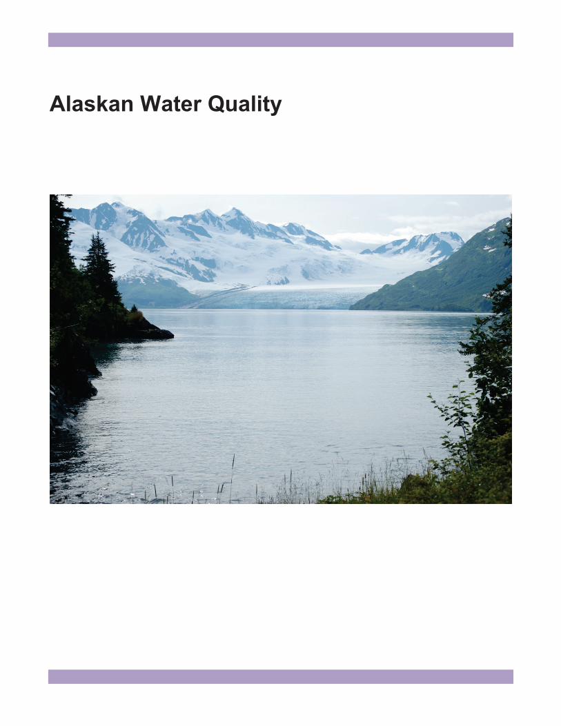
Alaskan Water Quality
Use of Pore Water as Part of Contaminated Sites Management: Case Studies in Kotzebue and Fairbanks, Alaska
James Fish Abstract Pore water is generally defined as water between grains of sediment, but it can have its origin as either surface water or groundwater. For contaminated sites management in Alaska, pore water is often more specifically defined as saturated zone water in the subsurface that is hydrologically connected to surface water. It can serve as a transport mechanism between contaminated groundwater and surface water bodies and thus can be both an ecological and human health exposure pathway to contaminants. In addition to soil and groundwater sampling and analyses for site assessments, pore water sampling is being used at two contaminated sites under management by the Alaska Department of Environmental Conservation’s Contaminated Site Program to evaluate contaminant exposure pathways and regulatory compliance. In Kotzebue, pore water data indicate that contaminant plumes originating from subsurface soils and groundwater and containing diesel-range organic petroleum hydrocarbons (DRO) and benzene, toluene, ethylbenzene, and xylene (BTEX) compounds are reaching both Kotzebue Sound and Kotzebue Lagoon. In Fairbanks, subsurface chlorinated solvents from a former dry cleaner are migrating to the Chena River, causing an apparent water quality violation. This presentation will present data on the two case studies that use pore water to understand exposure pathways as part of risk evaluation and regulatory compliance for contaminated site management. Keywords: pore water, hyporheic zone, contaminated sites, groundwater–surface water interface Fish is an environmental program specialist with the Alaska Department of Environmental Conservation, Fairbanks, AK 99709. Email: [email protected].
Introduction Assessment of a contaminated site typically involves delineation of soil and groundwater contamination. Contaminated groundwater is often delineated to identify a source and a leading edge of a contaminant plume following predominant groundwater flow direction and gradient. Accordingly, a groundwater cleanup point of compliance is normally placed downgradient of the leading edge of a contaminant plume to meet Alaska Department of Environmental Conservation (ADEC) groundwater cleanup levels (see Table C of 18 AAC 75.345; Alaska Department of Environmental Conservation 2008 b) and to ensure the protection of surface water or sediments (see 18 AAC 70; Alaska Department of Environmental Conservation 2009). In cases where contaminated groundwater potentially meets surface water, consideration must also be given to surface water quality criteria and standards as part of contaminated sites management. Groundwater discharge to surface water is often subsurface flow within hyporheic, hypolentic, or subtidal zones (Conant 2000, U.S. Environmental Protection Agency 2008, Environment Agency 2009). It is governed by advective flow and is under strong influence of geomorphology, fluvial (or tidal) processes, and subsurface strata permeability (Conant 2000, Environment Agency 2009). Contaminants in groundwater that discharges into surface water may ultimately be diluted by large volumes of receiving waters or by continuous fluvial processes, masking their exposure potential (e.g., being sediment-bound or bioaccumulating in organisms). The groundwater–surface water interface (GSI), generally defined as the location in the saturated zone containing a mixture of both surface water and groundwater (e.g., hyporheic flow), can be a “sentinel” monitoring location to assess contaminated groundwater movement into surface water bodies (Conant 2000, U.S. Environmental Protection Agency 2008, Environment Agency 2009). Depending on collection method, pore water may represent a snapshot of groundwater–surface water

exchange or a time-integrated average of predominant subsurface flow (Kalbus et al. 2006). The proportion of groundwater to surface water may also change seasonally depending on location and aquifer characteristics. Prior to establishing a point of compliance for contaminated groundwater cleanup or monitoring, pore water data is often useful to assess GSI dynamics that may affect the fate and transport of contaminants in the subsurface, as well as to evaluate contaminant exposure pathways to human and ecological receptors. The presence of contaminants in pore water has been problematic for regulatory agencies not only because pore water is not exclusively groundwater, but also because it does not fulfill the regulatory definition of surface water nor qualify as a surface water point of compliance (i.e., just below the water surface). It is, however, included in sediments regulated under water quality standards (Alaska Department of Environmental Conservation 2009). ADEC recently used pore water data to demonstrate migration of petroleum contaminants to Kotzebue Sound and Kotzebue Lagoon and chlorinated solvents to the Chena River in Fairbanks, resulting in an updated policy and interdivisional cooperative approach to assessing contaminant fate and transport associated with contaminated sites and impaired water bodies (Alaska Department of Environmental Conservation 2011). Kotzebue Area-Wide ADEC began work in 2008 to understand area-wide contamination and exposure risks in Kotzebue at both the city and airport locations. Widespread (>10 hectares) petroleum contamination in groundwater exists beneath the city from fuel releases near the Kotzebue Elementary School and former hospital, dating back to the 1970s or earlier. Such large-scale soil and groundwater contamination resulted from releases of approximately 100,000 to 200,000 gallons of heating fuel oil spilled over a period of many years, assumed to be largely from an underground fuel transfer pipeline near the school and former hospital (Janzen and Kane 1987). During the late 1980s, more than 50 monitoring wells and two fuel recovery systems were installed in the area of the fuel releases. Although approximately 40,000 gallons of fuel were reportedly recovered by 1986 (Janzen and Kane 1987), contamination continues to persist in the subsurface. Hydrocarbon sheens observed on Kotzebue Sound have been reported periodically to ADEC, suggesting
contaminant migration from groundwater to surface water. During summer 2010, the Alaska Department of Transportation and Public Facilities began installing approximately 4,400 linear feet of a sheet pile seawall and making substantial roadway improvements to expand Shore Avenue (a roadway that parallels the shore of Kotzebue Sound). The effects of the seawall installation on groundwater discharge dynamics and contaminant transport are unknown. Multiple contaminated sites are also located along the paved apron of the Ralph Wien Memorial Airport in Kotzebue. Fuel tank upgrades begun in the mid 1990s at the airport revealed petroleum contamination in groundwater that remains today. Little is known about the prevailing hydrogeological conditions and groundwater dynamics or about the fate and transport of subsurface contamination at the airport. Pore water data was used to assess potentially complete exposure pathways that remain from historic citywide fuel releases, as well as exposure pathways that may exist at the airport, and to better understand the risks to human health and ecological receptors. Pore water was also used to establish baseline information of groundwater–surface water interactions and contaminant migration into both Kotzebue Sound and Kotzebue Lagoon. Wendell Avenue, Fairbanks Historical releases of tetrachloroethene (PCE) from former dry cleaning operations have occurred at 314 Wendell Avenue in Fairbanks, likely as onsite spills and solvent disposal to wood stave underground sewer lines. Two sewer lines exit the building on either side and connect to a sewer main under Wendell Avenue. The greatest soil contaminant concentrations have been found just west of the building, beneath the driveway, and as well as near a known splintered sewer line in this area. Site investigations also suggests there is significant contamination underneath the building itself and in a smaller source zone near the sewer line east of the building. Releases and disposal have created two vadose zone source areas of PCE-contaminated soil, as well as a groundwater plume containing chlorinated solvents that extends downgradient in a northwesterly direction towards the Chena River. Soil contamination, at concentrations above ADEC soil cleanup levels for chlorinated solvents, extends from the ground surface to the water table at approximately 8 to 10 feet below ground surface (bgs), with greatest contaminants levels at 2 to 4 feet bgs (Oasis Environmental 2009, 2010).
The primary contaminants of concern in both soil and groundwater are PCE, trichloroethylene (TCE), cis-1, 2-dichloroethylene (cis-DCE), and trans-1, 2-dichloroethylene (trans-DCE). Vinyl chloride (VC) has not been detected in soil or groundwater, but chlorinated ethanes are also present in the subsurface. Site characterization activities identified the primary contaminant exposure pathways as inhalation (of outdoor air and indoor air via vapor intrusion), subsurface soil contact and ingestion, groundwater contact and ingestion, and possibly sediment and surface water contact and ingestion (Oasis Environmental 2009, 2010). A subslab depressurization (SSD) system is currently installed within the building at 314 Wendell Ave. to mitigate vapor intrusion and remediate soil contamination beneath the building by creating a vacuum-induced negative pressure beneath the foundation slab. A soil vapor extraction (SVE) system is currently under construction to address shallow soil contamination through volatilization and vapor removal from the two known source zones exterior to the building. In both systems, a series of extraction wells installed in the source areas draw chlorinated solvent vapors from the soil pore spaces and exhaust them to the atmosphere. The intent of this vadose zone treatment is to remove soil contamination, thereby limiting vapor intrusion risks and contaminant migration to the underlying groundwater table. A series of monitoring wells installed downgradient of the source zones are used to monitor groundwater geochemistry and contaminant distributions. Geochemical data collected from 2008 to the present indicate seasonally reduced groundwater conditions, under the prevailing influence of the regional Tanana aquifer, with predominant groundwater flow towards the west-northwest. High river stage events in the Chena River are known to reverse the groundwater gradient in locations adjacent to the river (Hinzman et al. 2000). This phenomenon has been observed at the Wendell Avenue site at least twice per year (i.e., spring and late summer). The seasonal recharge of Chena River surface water into the Tanana River aquifer potentially creates periods of aerobic conditions in groundwater (i.e., dissolved oxygen 2 mg/L). Contaminant data from groundwater indicates PCE undergoes microbial reductive dechlorination to TCE and cis-DCE/trans-DCE. These contaminants are generally found in greater concentrations than PCE downgradient along the groundwater plume towards the Chena River. VC has not been detected in groundwater. Accordingly, molecular biological information (qPCR with 16s rDNA) indicates the presence of indigenous anaerobic chlororespiring
microorganisms in groundwater (i.e., Dehalococcoides spp.). However, reverse transcriptase polymerase chain reaction analyses (RT-qPCR) have indicated a low transcriptional expression (and in some wells an absence) of the reductive dehalogenase gene vcrA, encoding for the enzyme vinyl chloride reductase. Thus, groundwater contaminants as partially degraded daughter products of PCE biodegradation may discharge into the Chena River. Pore water was collected from the banks of the Chena River to investigate contaminant migration into the river and the viability of the sediment and surface water contact and ingestion exposure pathways. Methods Drive point sampling (as described for PushPoint samplers; Lewis 2007) was used to collect pore water during October 2008 and May 2010 from the shore of Kotzebue Sound near the vicinity of the large historic fuel spill (across from the elementary school), along Shore Avenue (location of the seawall project), and from airport property (along Kotzebue Sound and Kotzebue Lagoon). Drive points (AMS screened disposable stainless steel Anchor Point tips fitted to 3/16-inch Teflon tubing; AMS, Inc., American Falls, ID, http://www.ams-samplers.com/) were hand-driven using a hollow tube implant drive and fence post hammer. Drive points were developed as mini-groundwater wells, using low-flow groundwater sampling methods (Puls and Barcelona 1996). At Wendell Avenue in Fairbanks, samplers made of a stainless steel well screen enclosed in Colorado sandpack and housed within a slotted 6-inch section of PVC pipe were used to collect pore water. Samplers were buried below the water line in hand-dug holes on the banks of the Chena River and allowed to equilibrate in situ overnight prior to being purged and sampled following low-flow sampling procedures referenced above. Pore water samples from Kotzebue were analyzed for diesel-range organic petroleum hydrocarbons (DRO) by Alaska Method AK 102 and for benzene, toluene, ethylbenzene, and xylene (BTEX) compounds and polynuclear aromatic hydrocarbons (PAHs) by U.S. Environmental Protection Agency (U.S. EPA) Method 8260C. Total aromatic hydrocarbons (TAH) and total aqueous hydrocarbons (TAqH) were calculated following Alaska Water Quality Standards (Alaska Department of Environmental Conservation 2009). Pore water samples from Wendell Avenue were analyzed for PCE, TCE, cis-DCE, trans-DCE, and VC
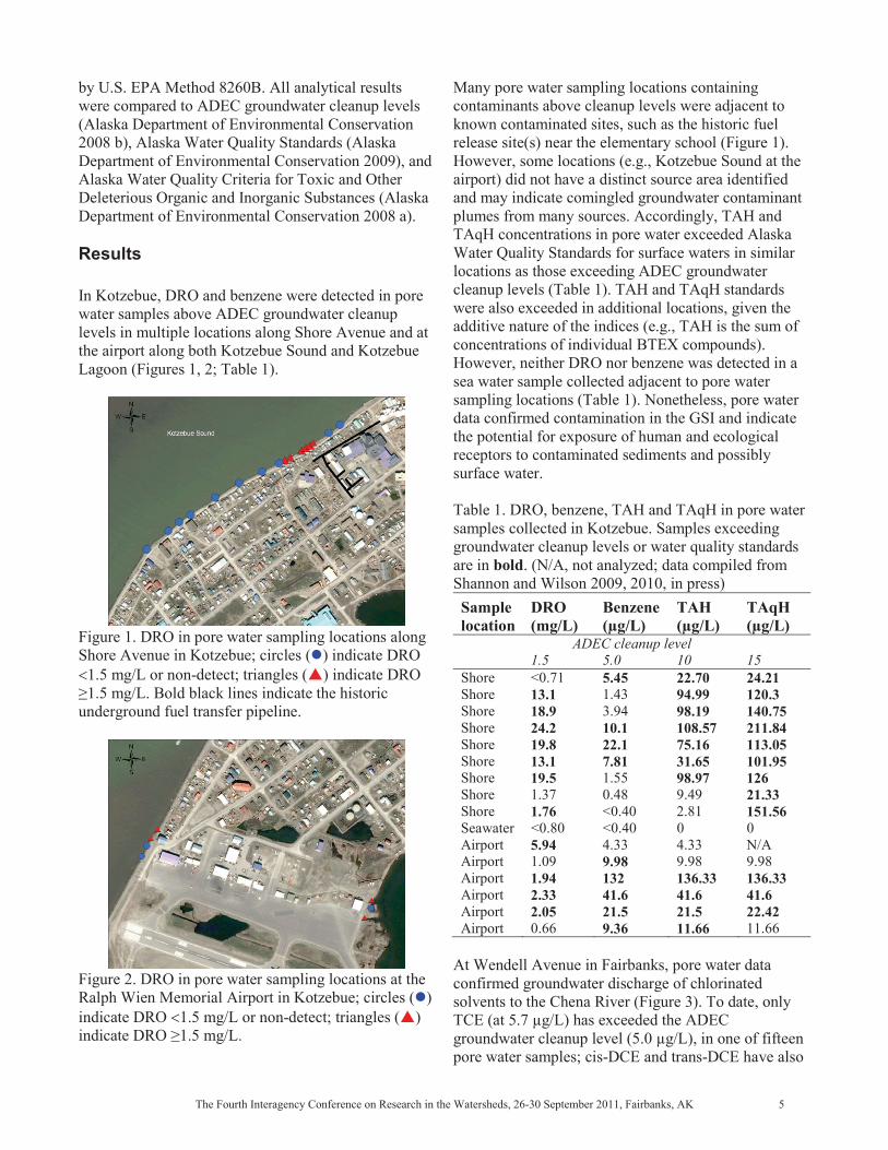
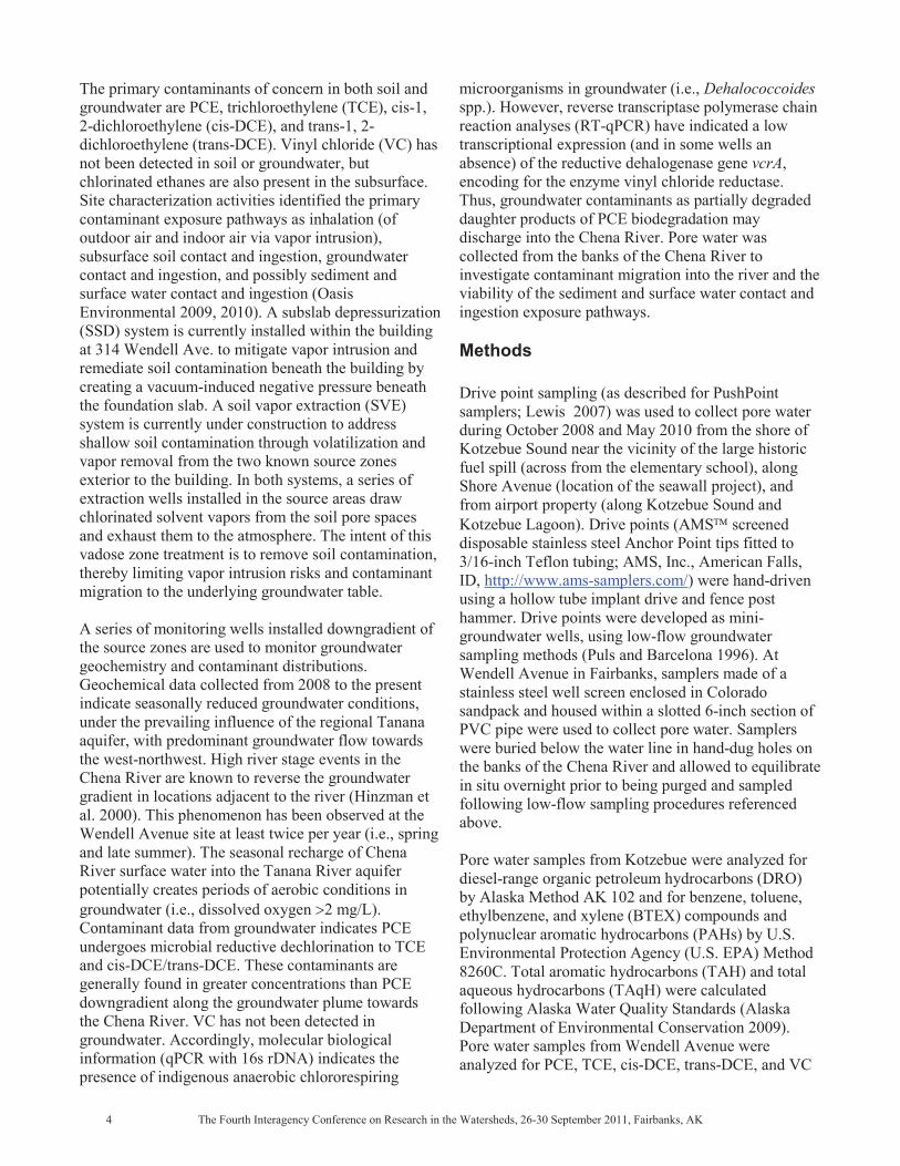
by U.S. EPA Method 8260B. All analytical results were compared to ADEC groundwater cleanup levels (Alaska Department of Environmental Conservation 2008 b), Alaska Water Quality Standards (Alaska Department of Environmental Conservation 2009), and Alaska Water Quality Criteria for Toxic and Other Deleterious Organic and Inorganic Substances (Alaska Department of Environmental Conservation 2008 a). Results In Kotzebue, DRO and benzene were detected in pore water samples above ADEC groundwater cleanup levels in multiple locations along Shore Avenue and at the airport along both Kotzebue Sound and Kotzebue Lagoon (Figures 1, 2; Table 1).
Figure 1. DRO in pore water sampling locations along Shore Avenue in Kotzebue; circles ( ) indicate DRO
1.5 mg/L or non-detect; triangles ( ) indicate DRO L. Bold black lines indicate the historic
underground fuel transfer pipeline.
Figure 2. DRO in pore water sampling locations at the Ralph Wien Memorial Airport in Kotzebue; circles ( ) indicate DRO 1.5 mg/L or non-detect; triangles ( )
Many pore water sampling locations containing contaminants above cleanup levels were adjacent to known contaminated sites, such as the historic fuel release site(s) near the elementary school (Figure 1). However, some locations (e.g., Kotzebue Sound at the airport) did not have a distinct source area identified and may indicate comingled groundwater contaminant plumes from many sources. Accordingly, TAH and TAqH concentrations in pore water exceeded Alaska Water Quality Standards for surface waters in similar locations as those exceeding ADEC groundwater cleanup levels (Table 1). TAH and TAqH standards were also exceeded in additional locations, given the additive nature of the indices (e.g., TAH is the sum of concentrations of individual BTEX compounds). However, neither DRO nor benzene was detected in a sea water sample collected adjacent to pore water sampling locations (Table 1). Nonetheless, pore water data confirmed contamination in the GSI and indicate the potential for exposure of human and ecological receptors to contaminated sediments and possibly surface water. Table 1. DRO, benzene, TAH and TAqH in pore water samples collected in Kotzebue. Samples exceeding groundwater cleanup levels or water quality standards are in bold. (N/A, not analyzed; data compiled from Shannon and Wilson 2009, 2010, in press) Sample location
DRO (mg/L)
Benzene (μg/L)
TAH (μg/L)
TAqH (μg/L)
1.5 ADEC cleanup level
5.0 10 15 Shore Shore Shore Shore Shore Shore Shore Shore Shore Seawater Airport AirportAirport Airport Airport Airport
<0.71 13.1 18.9 24.219.813.119.5 1.37 1.76 <0.80 5.94
1.09 1.942.332.05
0.66
5.451.43 3.94
10.1 22.1 7.81
1.55 0.48 <0.40<0.40 4.339.98
132 41.6 21.5
9.36
22.70 94.9998.19108.57 75.16 31.65 98.979.49
2.81 0
4.33 9.98136.33 41.6 21.5
11.66
24.21 120.3 140.75
211.84 113.05 101.95
126 21.33 151.56 0 N/A
9.98 136.33 41.6 22.42 11.66
At Wendell Avenue in Fairbanks, pore water data confirmed groundwater discharge of chlorinated solvents to the Chena River (Figure 3). To date, only TCE (at 5.7 μg/L) has exceeded the ADEC groundwater cleanup level (5.0 μg/L), in one of fifteen pore water samples; cis-DCE and trans-DCE have also

been detected, but below cleanup levels. VC has not been detected in pore water. TCE in pore water also exceeded Alaska Water Quality Criteria for Toxics and Other Deleterious Organic and Inorganic Substances, based on drinking water standards (5.0 μg/L; Alaska Department of Environmental Conservation 2008 a).
Figure 3. Locations of monitoring wells ( ) at Wendell Avenue, Fairbanks, and pore water samples ( ) collected October 2010. TCE in pore water-3 ( ) was 5.7 μg/L. Arrow ( ) points to monitoring well in source area at former dry cleaner (building east).
Pore water results are consistent with groundwater investigations that suggest some level of microbial reductive dechlorination of PCE occurs in groundwater downgradient from contaminant source areas at Wendell Avenue, resulting in TCE that exceeds ADEC groundwater cleanup levels. As in Kotzebue, pore water data indicates contaminants are reaching surface water, completing dermal contact and ingestion exposure pathways for surface water and potentially for sediments as well. Ecological receptors (e.g., aquatic life) are also likely at risk for contaminant exposure. For example, areas of groundwater discharge through river bottom sediments (upwelling locations) are often preferred fish spawning habitats and are common in alluvial rivers of Alaska (Durst 2000). While there is currently no Alaska aquatic life criterion for TCE, discharge of groundwater containing TCE or other chlorinated contaminants may render aquatic organisms as ecological receptors to contaminant exposure. Conclusions
Management of contaminated sites by ADEC includes an evaluation of risks to both human health and ecological receptors, usually depicted as a conceptual site model (CSM). A CSM describes how people and
biota may come into contact with contaminants at a location. Specifically, a CSM identifies exposure pathways, both current and future ways humans and biota may be exposed to contaminants; migration routes, or mechanisms of contaminant transport (through soil, groundwater, biota, etc.); and potential receptors, be they humans, plants, or other animals (Alaska Department of Environmental Conservation 2010). In contrast to a risk assessment, a CSM does not quantify risk but rather identifies real or potential opportunities for contaminant exposure and aides managers in mitigating or minimizing exposure across completed (or viable) pathways. A CSM is required by Alaska statutes for all contaminated sites overseen by ADEC (Alaska Department of Environmental Conservation 2008 b). Pore water data were used to develop a more complete CSM for area-wide contaminated locations in Kotzebue and for a contaminated former dry cleaner in Fairbanks. Results from pore water sampling demonstrate open exposure pathways where contaminants are reaching surface waters, thus creating exposure pathways to both human and ecological receptors. Progress towards remedial action is being made at each site. In Kotzebue, responsible parties are being engaged to address further site characterization and cleanup requirements, and data is being collected from monitoring wells at the airport to understand groundwater dynamics and contaminant migration. At Wendell Avenue, a remedial system is operating to address soil contamination and vapor intrusion mitigation. Future remedial action may also include groundwater treatment (e.g., substrate addition) to encourage further reductive dechlorination or cometabolic/direct oxidation of chlorinated contaminants. Additional monitoring and remedial efforts at both sites may also include continued use of pore water to monitor discharge of contaminated groundwater to surface waters. Future pore water data may come from sentinel monitoring wells located near surface water bodies (e.g., Kotzebue Sound) to capture hyporheic exchange within the GSI. Such monitoring can be used to evaluate whether or not exposure pathways remain viable and serve as points of compliance for cleanup actions. Pore water data, although not exclusively surface water, may also be useful for classifying surface waters as impaired water bodies.

Acknowledgments The author appreciates the reviews of Janice Wiegers and Sally Schlichting and technical assistance from Tamara Cardona-Marek and Sonja Benson. References Alaska Department of Environmental Conservation. 2008a. Alaska water quality criteria manual for toxic and other deleterious organic and inorganic substances (amended December 12, 2008). State Department of Alaska, Department of Environmental Conservation. Alaska Department of Environmental Conservation. 2008b. 18 AAC 75, Oil and other hazardous substances pollution control (amended October 9, 2008). Alaska Administrative Code of Regulations, Title 18, Chapter 75. Alaska Department of Environmental Conservation. 2009. 18 AAC 70, Alaska water quality standards (amended September 19, 2009): Alaska Administrative Code of Regulations, Title 18, Chapter 70. Alaska Department of Environmental Conservation. 2010. Policy guidance on developing conceptual site models (October, 2010). State Department of Alaska, Department of Environmental Conservation, Division of Spill Prevention and Response, Contaminated Sites Program. Available at: http://www.dec.state.ak.us/spar/csp/guidance/FINAL%20CSM%20Guidance%20Master%20Nov%202010.pdf. Alaska Department of Environmental Conservation. 2011. Regulatory approach to managing contamination in hydrologically connected groundwater and surface water (updated April 13, 2011). State Department of Alaska, Department of Environmental Conservation, Technical Memorandum 01-005. Conant, Jr., B. 2000. Ground-water plume behavior near the ground-water/surface water interface of a river. In Proceedings of the Ground-Water/Surface-Water Interactions Workshop, Denver, January 1999, pp. 23–30. U.S. Environmental Protection Agency, EPA/542/R-00/007. Durst, J.D. 2000. Fish Use of Upwellings: An Annotated Bibliography. In Martha Welbourn Freeman, ed. Region III Forest Resources and Practices Riparian Management Annotated Bibliography, pp. 93–102. Report to the Alaska Board of Forestry by the Region III Science/Technical Committee. Alaska Department of Fish and Game, Alaska Department of Natural Resources. Available at:
http://forestry.alaska.gov/pdfs/RIIIBiblioCover.pdf and http://forestry.alaska.gov/pdfs/6LitFish-Upwellings8-11.pdf. Environment Agency. 2009. The hyporheic handbook: A handbook on the groundwater–surface water interface and hyporheic zone for environmental managers. Environment Agency, Bristol, UK, Science Report SC050070. Hinzman, L.D., M. Wegner, and M. Lilly. 2000. Hydrologic investigations of groundwater and surface-water interactions in subarctic Alaska. Nordic Hydrology 31(4/5): 339–356. Janzen, J.H., and D.L. Kane. 1987. The underground oil spill at Kotzebue, Alaska: Unknown cause, elusive cure. In Proceedings of the 10th International Oil Spill Conference, Baltimore, MD, 1987. [Sponsored by] U.S. Environmental Protection Agency, U.S. Coast Guard, American Petroleum Institute. Abstract available at: http://www.iosc.org/papers_posters/ 02258.pdf Kalbus, E., R. Reinstorf, and M. Schirmer. 2006. Measuring methods for groundwater–surface water interactions: A review. Hydrology and Earth Systems Science 10:873–877. Lewis, Bobby. 2007. Pore water sampling. U.S. Environmental Protection Agency, Science and Ecosystem Support Division Operating Procedure, SESDPROC-513-R0. Available at: http://www.epa.gov/region4/sesd/fbqstp/Porewater-Sampling.pdf; Oasis Environmental. 2009. Release investigation, Wendell Avenue. OASIS Environmental, Inc., Anchorage, AK. Prepared for the Alaska Department of Environmental Conservation, Contract NTP - 18-9028-13-70. Oasis Environmental. 2010. Additional characterization, Wendell Avenue. OASIS Environmental, Inc., Anchorage, AK. Prepared for the Alaska Department of Environmental Conservation, Contract NTP -18-4002-11-003. Puls, R.W., and M.J. Barcelona. 1996. Low-flow (minimal drawdown) ground-water sampling procedures. U.S. Environmental Protection Agency, Ground Water Issue, EPA/540/S-95/504. Shannon and Wilson, Inc. 2009. Pore water sampling report: Ralph Wien Memorial Airport, Kotzebue,
Alaska. Prepared for the Alaska Department of Environmental Conservation, Contract NTP -1890281489. Shannon and Wilson. Inc. 2010. Site characterization report: Kotzebue city oil spill, Kotzebue, Alaska, ADEC File Number 410.38.008. Prepared for the Alaska Department of Environmental Conservation, Contract NTP – 1890281489. Shannon and Wilson, Inc. in press. Pore water, monitoring well installation, and building survey: Kotzebue, Alaska. Prepared for the Alaska Department of Environmental Conservation, Contract NTP – 18400212009. U.S. Environmental Protection Agency. 2008. Evaluating ground-water/surface-water transition zones in ecological risk assessments. U.S. Environmental Protection Agency, ECO Update/Ground Water Forum Issue Paper, EPA-540-R-06-072, Publication 9285.6-17.

Application of Updated Approaches for the Reclamation of Placer-Mined Lands in the Harrison Creek Watershed near Central, Alaska
Hans R. Arnett, Patrick L. McMahon, P.E. Abstract In 2004, the Bureau of Land Management (BLM) embarked upon a project to reclaim portions of approximately 11 miles of abandoned placer-mined land in the Harrison Creek valley near Central, Alaska. Placer-mined land reclamation efforts performed up to that time generally had been accepted to be inadequate in restoring disturbed valley ecosystems. Historically, reclamation efforts have focused on attempts to design stable stream channels. During the first Phase of the Harrison Creek Reclamation Project, the BLM contracted with USKH Inc. to develop updated placer-mined land reclamation approaches with applications towards the reclamation of Harrison Creek. Work under this phase included performing literature reviews and field investigations and conducting interviews with parties experienced in placer-mined valley reclamation. The information gathered under these tasks was used to develop a reclamation study that (a) summarizes major issues involved in placer-mined stream valley reclamation; (b) provides an assessment and review of past and current reclamation practices, approaches, and techniques; (c)1presents recommendations regarding the field assessment of stream channel and valley stability and the recovery potential in previously reclaimed valleys; and (d) outlines the resulting recommended updated reclamation approaches with particular respect to the reclamation of Harrison Creek. Updated reclamation approaches were developed to meet the following goal: Perform reclamation activities that promote and accelerate the steady long-term
Arnett is the senior hydrologist for USKH Inc. Email: [email protected]. McMahon is a water resources engineer at USKH and a PhD student at the University of Tennessee. Email: [email protected].
recovery of instream, riparian, and terrestrial ecosystems in a placer-mined valley. As outlined in the study, this goal can be accomplished using the following five general reclamation approaches:
1. Remove sources of excessive sediment introduction into the stream,
2. Construct floodplains, 3. Promote natural revegetation processes, 4. Supply adjustable channels that will trend
toward dynamic equilibrium, and 5. Remove mining-related structures,
infrastructure, and waste. The updated reclamation approaches were applied to the development of design plans for the Phase I reclamation of a portion of the Harrison Creek valley, with construction in 2006. Lessons learned from the 2006 reclamation design and construction were applied to the Phase II and III designs that were constructed in 2009. Further design and construction refinements were made to the Phase IV reclamation design, based on lessons learned from the Phase II and III design and construction efforts. The construction of the Phase IV reclamation design was completed in autumn 2010. Keywords: placer mining, stream reclamation, updated approaches, Bureau of Land Management, Harrison Creek Introduction In 2004, the Bureau of Land Management (BLM) embarked upon a project to reclaim portions of approximately 11 miles of abandoned placer-mined land in the Harrison Creek valley near Central, Alaska. Placer-mined land reclamation efforts performed up to that time generally had been accepted to be inadequate in restoring disturbed valley ecosystems. This paper provides a brief overview of placer mining and its
effects, past reclamation approaches, the development of updated reclamation approaches, and the application of those new approaches to the reclamation of approximately 2.7 miles of the Harrison Creek valley. Background The following sections provide brief discussions on the placer mining process and its effects, as well as on previously used reclamation approaches. For a thorough discussion of these topics the reader is referred to Arnett (2005). The Placer Mining Process Placer mining consists of the removal of layers of overlying non-gold-bearing materials in order to access and process gold-bearing black sands that have been concentrated near the underlying bedrock surface. Non-gold-bearing materials include vegetation, soil, and alluvial gravels, known collectively as overburden. In earlier periods of mining, no provisions were made for collecting or controlling sediments washed from overburden or gold-bearing gravels, and the sediments were allowed to wash downstream. Hydraulic mining methods, although relatively uncommon today, were once widely used as a means to strip off overburden materials. High-pressure jets from water cannons (also known as monitors or hydraulic giants) washed overlying gravel deposits away, exposing the gold-bearing materials. The water cannons would also be used to move gold-bearing gravels to the sluice box, wash the gravels through the sluice box, and then remove the tailings (non-gold-bearing gravels) from the site. The relatively recent promulgation of government regulations regarding water quality standards and reclamation requirements has changed the way that placer mining is conducted. Current regulations require the stockpiling of stripped vegetation, soil, and overburden and the controlling of sedimentation by routing process water through settling ponds that remove finer particles through the settling of suspended sediments before the water is discharged to the adjacent stream. In modern placer mining, mechanical means are used almost exclusively to prepare and work the mine site. Heavy earth-moving equipment such as bulldozers, front-end loaders, scrapers, or excavators are used to remove and stockpile organic material, soil, and
overburden and to construct infrastructure such as access roads and settling ponds. Placer mining has taken place periodically within the Harrison Creek drainage since 1895. Large stretches of the drainage were abandoned after the completion of mining and left in an unreclaimed condition. Effects of Placer Mining Environmental effects of past placer mining can be summarized in the following general categories: water quality reduction, stream channel and floodplain instabilities, vegetation loss and slow revegetation rates, habitat loss, topographic disturbance and aesthetic degradation effects, groundwater changes, loss of permafrost, and enhanced aufeis formation. The persistent reduction of downstream water quality is the most commonly noted environmental effect associated with placer-mined lands, the two most important components of which are increased levels of turbidity and high sediment concentrations. Unstable stream channels are a common characteristic of both abandoned and reclaimed placer-mined lands. Many factors contribute to the instability of stream channels in placer-mined watersheds. These factors fall under the following categories: changes in the longitudinal profile of the valley, lack of adequately sized floodplains, changes in sediment textures and composition, changes in the amount and type of vegetation present, changes in stream hydrology and sediment transport characteristics, and the extension of instabilities upstream and downstream of mined areas. Rates of natural revegetation on sites disturbed by placer mining are extremely slow. Some placer mine spoils have little or no vegetative cover 50 or more years after the last episode of mining. The two most commonly noted limiting factors are the loss of moisture-retaining fines and the lack of water for plant growth. The characteristic instabilities and degraded water quality of stream channels in placer-mined valleys contribute to the loss and degradation of instream habitat for fish and invertebrates. The loss of floodplains and floodplain vegetation reduces terrestrial habitat within riparian corridors. Abandoned placer mine sites are also characterized by the presence of large, randomly placed, coarse-grained, and sparsely vegetated spoils piles. These spoils can make it difficult or impossible to restore the pre-mining

topography of a valley and can also result in an unnatural and barren-looking landscape. Fine-grained sediments deposited on stream beds in placer-mined drainages reduce the hydraulic contact between the surface water and groundwater of the stream, which can result in higher specific conductance and significantly lower dissolved oxygen concentrations in the groundwater of mined streams. The higher specific conductance and lowered dissolved oxygen concentrations can have negative effects on fish eggs in spawning gravels, and the reduction of hydraulic contact can leave the stream perched above the groundwater table. In many Interior Alaska drainages with climax vegetation communities, underlying permafrost may help stabilize smaller stream channels by limiting stream bank erosion. This stabilizing factor is lost when vegetation is stripped from the surface and the underlying permafrost melts. Placer mining can increase the formation of aufeis (icings) in drainages. Deposits of aufeis can completely fill channels and in some cases can completely cover valley bottoms. Spring breakup floodwaters perched on top of thick, widespread aufeis deposits can cause erosion of areas well away from the active stream channel. Aufeis deposits can persist well into the summer, which can significantly reduce the growing season on underlying surfaces. Previously Used Reclamation Approaches and Goals Government regulations requiring placer miners to reclaim mine sites have been in place for less than 35 years. Because it is a relatively new subject, well-established approaches for the successful reclamation of placer-mined lands do not exist. There is a general consensus among experts in placer-mined land reclamation in Alaska that the reclamation approaches implemented to date have been generally inadequate, whether performed by placer miners or with sponsorship from government agencies. Any discussion of the success or failure of placer-mined land reclamation efforts must address the specific goals of reclamation. Most stated reclamation goals include some variation on the desire to return natural processes and habitats to the disturbed site within some undetermined length of time and to minimize sediment discharge and protect against riparian erosion. Associated with these general goals of reclamation is the frequently stated assumption that
successful reclamation of a site can be achieved through the construction of a stable channel. The idea is that if a stable channel is provided, then normal alluvial, floodplain, and revegetation processes will be encouraged, water quality will improve, and riparian and instream habitats will gradually return to a natural state. Most placer mine reclamation approaches developed to date have addressed the construction of a stable channel as a primary goal. As previously noted, however, post-reclamation stream channels are frequently unstable. A stable channel is normally defined as a channel with a stable dimension, pattern, and profile that maintains channel features over time and neither degrades or aggrades. It is a commonly stated reclamation goal to design and construct a stable channel with a natural stream pattern, cross-sectional geometry, longitudinal profile, and the sediment transport characteristics of the original stream. The fact that stable channel design approaches do not appear to work has driven efforts to further refine these approaches. This continued focus on channel stability and design, however, has distracted attention from the larger issue of valley and floodplain stability. It is unlikely that any channel can become stable in an unstable valley. Furthermore, the idea that a newly constructed stable channel can be designed and constructed in a recently placer-mined area ignores the critical role that floodplain vegetation plays in the stability of channels and the time scale of vegetation recovery in placer-mined valleys. Based on the literature review, site visits, and interviews conducted during the course of this study, it has been concluded that failed attempts to design and construct stable channels within recently placer-mined valleys have been based on unrealistic reclamation goals. These attempts have failed largely because of an inability to predict the long-term equilibrium condition toward which a particular stream channel is heading. Given the profound adverse effects of placer mining on valleys, streams in placer-mined valleys will probably trend toward equilibrium conditions that are different from pre-mining conditions. It may be that channels in dynamic equilibrium in reclaimed valleys will be wider, shallower, less sinuous, and steeper in gradient and will display a braided or split channel pattern more commonly than streams in otherwise similar unmined basins.

Updated Approaches for the Reclamation of Placer-Mined Lands Updated approaches for the reclamation of placer-mined lands have been developed to meet the following goal: Perform reclamation activities that promote and accelerate the steady long-term recovery of instream, riparian, and terrestrial ecosystems in a placer-mined valley. This goal can be met by providing stable valleys and floodplains that are conducive to natural processes of revegetation, as well as adjustable channels that are trending toward a long-term dynamic equilibrium. Reclamation efforts should be aimed toward producing a revegetated valley that contains an adjustable, dynamically stable channel with gradually improving water quality characteristics, flowing within a vegetated floodplain between stable, revegetated valley walls. This end result will be accomplished by the reconfiguration of the placer-mined valley in order to promote and accelerate natural recovery processes. Because of the time scale of these recovery processes and the inability to understand precisely where these processes are heading, it should be accepted that more than one episode of reclamation construction may be required to adjust valley slopes, floodplains, and channels in order to promote the steady long-term recovery of ecosystems. The desire to perform a one-time reclamation project that leaves in place a stable reconstructed channel is understandable but unrealistic. Because the reclamation of placer-mined valleys is a relatively recent occurrence, and because natural recovery rates are so slow, the final configuration of a fully recovered, reclaimed valley is unknown. The time scales of natural recovery processes in Interior Alaskan basins are such that parties involved in the reclamation of a particular site are unlikely to see the eventual full recovery of that site in their lifetimes. Floodplain construction and the promotion of natural revegetation are the two most important components of the approaches developed in this study. As the valley tends toward the development of a stable, well-vegetated floodplain, long-term gradual improvements in channel stability and water quality will occur. Because the equilibrium form of channels in reclaimed placer-mined valleys is not clearly understood, channels should be designed and constructed or modified to assure adjustability. Adjustability will allow channels to attain a state of dynamic equilibrium and respond to changes and perturbations occurring
within the basin such as upstream mining effects. Non-biodegradable erosion control and energy dissipation structures such as riprap revetments or drop structures should be avoided since they will adversely affect long-term adjustability. It is assumed that as the channel adjusts over time, natural instream habitat will gradually be created and improved. Given the nature of changes to the system induced by placer mining, however, the stream may never reproduce the instream habitat conditions that existed prior to mining. If instream habitat structures are desired, they should not be constructed or placed so that they inhibit the adjustability of the channel. Furthermore, habitat structures should not be placed in a channel until vegetation has established on the adjacent floodplain. The presence of floodplain vegetation will be an indicator that some degree of channel and floodplain stability has been achieved and, therefore, that instream habitat structures will have some chance of success. Updated approaches have been developed for the eventual reclamation of abandoned placer-mined lands in the Harrison Creek valley; however, they are also anticipated to be useful for the reclamation of either abandoned or recently mined lands throughout much of Alaska. The approaches have been developed so that they can be implemented by placer miners in a cost-effective manner and therefore do not require engineering and design efforts beyond those normally required of a miner for obtaining approval of a reclamation plan. The steady long-term recovery of instream, riparian, and terrestrial ecosystems within a placer-mined valley can best be accomplished using the following five general approaches:
1. Remove sources of excessive sediment introduction into the stream,
2. Construct floodplains, 3. Promote natural revegetation processes, 4. Supply adjustable channels that will trend
toward dynamic equilibrium, and 5. Remove mining-related structures,
infrastructure, and waste. Application of Updated Approaches in the Harrison Creek Watershed The updated approaches described above were applied to the design of four phases of reclamation construction
projects in the Harrison Creek valley. Phase I construction was completed in 2006, Phases II and III were completed in 2009, and Phase IV was completed in 2010. The Phase I design resulted in the reclamation of three valley segments totaling 1.46 miles. Phase II resulted in the reclamation of a 0.40-mile segment of the valley. Phase III comprised two segments of valley reclamation totaling 0.33 miles. Phase IV also comprised two segments of valley reclamation, totaling 0.49 miles. In total, 2.68 miles of the Harrison Creek valley have been reclaimed since 2006. By designing and constructing the project in phases, it has been possible to apply lessons learned in earlier phases to the design and construction of later phases. The design process for Phase I was carried out using the approaches outlined in the previous section. The grading portion of the design specified a general recontouring of the valley to eliminate channel division and existing steep, sparsely vegetated spoils piles; to provide adequate flood plain width; and to provide surface hydraulic connectivity between the valley walls and the valley floor. The design also included provisions for preserving small areas covered by thick vegetation within the construction limits. The design concept and process leaned heavily on the use of photogrammetric contour data, aerial photographs, and hydraulic modeling of the proposed channel and floodplain. Finally, at the direction of the BLM, the design was developed to allow construction with the use of only large bulldozers for earth moving. Construction of Phase I was completed in 2006. A site visit was made in the summer of the following year to select areas for future reclamation and to review the finished product with BLM representative Rodd Moretz, who had performed the construction inspection for the project. Observations made during this site visit indicated that the Phase I reclamation was largely a success. Colonization by pioneering vegetation was noted on most recontoured surfaces, and the valley appeared to be moving toward a more natural condition. There were a number of lessons learned during the 2007 site visit. First, because it had not been possible to inspect all of the proposed reclamation areas prior to commencement of the Phase I design effort, there was misinterpretation of portions of the aerial photography and contour data. Misinterpretation of the preexisting edge of the channel resulted in the floodplain being constructed too low in some locations, causing channel braids to form in the constructed floodplain. The lesson learned is that it is essential that a site visit be
performed prior to the completion of design in order to assure proper interpretation of aerial photography and mapping and to assure that design elevations are correct for constructed floodplains. A second lesson learned was that future phases of work need to include the clear establishment of an access road through the site that keeps recreational vehicles off newly created floodplain surfaces. The third lesson learned from the Phase I reclamation efforts was that attention needs to be paid to how recontoured surfaces tie in to preexisting surfaces, particularly valley walls, so that closed depressions are not formed and avenues are not provided for overbank flows to bypass the reclaimed portion of the valley. Old settling ponds turned out to be too soft to be adequately reclaimed, since heavy construction equipment became mired while trying to push fill into the ponds. Other lessons learned during the Phase I reclamation efforts were that the preservation of small areas of well-established vegetation within the construction limits unnecessarily complicates the reclamation efforts, and that the spreading of cleared, grubbed, and stockpiled vegetation and topsoil onto recently constructed surfaces speeds the rate of natural revegetation. However, the amending or mixing of this material into the upper portion of the newly created surfaces is not recommended. Designs were produced for Phases II and III of the Harrison Creek Reclamation project that incorporated the lessons learned during Phase I construction. The design concept for the two phases was established entirely during the course of the 2007 site visit, eliminating any potential for misinterpretation of photographic or contour data. Design floodplain elevations were based on ordinary high water marks surveyed in the field rather than hydraulic modeling. Equipment needs were assessed in the field based on the demonstrated strengths and limitations of construction efforts made using only large bulldozers for Phase I. The access road was specifically included in the design and placed along the valley margin, well away from the new floodplain. The intent of the design was specified more carefully on the plans in order to improve the tie in with the existing topography and valley walls. Areas of existing vegetation within the construction limits were specified to be salvaged and spread onto the finished surface. Following the completion of Phase II and III construction in 2009, another site visit was made in coordination with BLM representative Rodd Moretz,

who had also done the construction inspection on Phases II and III. Like the 2007 site visit, sites were selected for future reclamation, design concepts were developed in the field, and lessons learned were discussed. Because the lessons learned from the Phase I efforts had been applied to the designs of Phases II and III, the elevation of constructed floodplains were properly specified in the designs, and the reclaimed valley sections better addressed the routing of hillside drainage to the stream and the tie-ins of newly constructed surfaces to preexisting topography. An inspection of the Phase I construction sites showed good natural revegetation occurring on all surfaces, particularly floodplains. Application of lessons learned from Phase I also resulted in a more efficient construction process under Phases II and III. A review of the Phase I, II, and III sites shows that constructed floodplains are quicker to revegetate than constructed slopes, and that the surfaces that revegetate the fastest are those on which salvaged vegetative material has been spread. Lessons learned from the Phase II and III construction efforts included the need to place additional design emphasis on the placement of post-construction recreational vehicle access and the accommodation of hillside drainage to prevent creation of impassable mud holes on new access roads. Future phases should allow for a wider road corridor to allow recreational vehicle drivers to negotiate around hazards during wet periods. The issue of swell in mining spoils became an issue for the balancing of cuts and fills in some areas of the Phase II and III construction. The design called for abandoned bypass channels to be filled with mining spoils excavated from floodplain construction and for the flattening of tall spoils piles. The significant swell associated with placer mining spoils (with increase in volume up to 30 percent more than in situ materials) meant that material volumes were greatly reduced once spoils piles were moved. The end result was that in some cases there were not enough spoils available to adequately fill the abandoned bypass channels. This change in volume needs to be taken into account when material is to be taken from one area to fill a low spot in another area. The lessons from the Phase II and III construction were applied to the Phase IV design, constructed in 2010.
Summary Previous efforts to reclaim placer mined valleys generally have been inadequate. An updated reclamation approach has been developed, based on extensive literature reviews, field investigations, and interviews. This approach was applied over the course of three design and construction sequences within the Harrison Creek valley, allowing the lessons learned from each effort to refine the reclamation design and construction methods of each subsequent phase. The resulting reclaimed 2.68 miles of Harrison Creek Valley show good signs for full recovery through natural processes. Acknowledgments The authors appreciate the review by Lance Mearig, P.E. and Jon Houghton, Ph.D. References Arnett, H.A. 2005. Harrison Creek Reclamation: Phase I—An Overview of Issues and Approaches for the Reclamation of Placer-Mined Lands. Prepared for Bureau of Land Management, Northern Field Office.

Developing a Long-Term Aquatic Monitoring Network in a Complex Watershed of the Alaskan Arctic Coastal Plain
M.S. Whitman, C.D. Arp, B. Jones, W. Morris, G. Grosse, F. Urban, R. Kemnitz Abstract The Arctic Coastal Plain (ACP) of northern Alaska consists of an extremely low gradient, lake-rich landscape that is characterized by a complex network of aquatic habitats and surface features strongly influenced by permafrost dynamics. Much is unknown about the form, function, and ecological conditions in this unique hydrologic setting. Amplified climate change and landscape responses in the Arctic further complicate the capacity to separate natural variability from land use effects that may occur with petroleum development. A comprehensive, multi-disciplinary review and analysis of recent studies and initial inventory and monitoring in the Fish Creek watershed on the ACP provided guidance to develop a framework for future aquatic monitoring and integrated research. The result is an established network of stream and lake sites for physical, chemical, and biological data collection that is intended to be sustainable over a long-term period and contribute to understanding Arctic aquatic ecology in the context of climate change and assist science-based land management decisions. Keywords: Arctic coastal plain, fish, lakes, permafrost, streams, watershed monitoring
Whitman is a fish biologist and Kemnitz is a hydrologist, both with the Bureau of Land Management, Fairbanks, AK 99712. Arp is a research assistant professor of hydrology and Grosse is a research assistant professor of permafrost science, both with the University of Alaska–Fairbanks, Fairbanks, AK 99775. Jones is a research geographer with the U.S. Geological Survey, Anchorage, AK 99508. Morris is a habitat biologist with the Alaska Department of Fish and Game, Division of Habitat, Fairbanks, AK 99701. Urban is a geologist with the U.S. Geological Survey, Lakewood, CO 80225. Email: [email protected].
Introduction Watershed responses to climate change in the Arctic are of increasing interest for managing land use and forecasting affects on fish and wildlife. Greater snow and rain precipitation coupled with increased winter sublimation and summer evapotranspiration (Serreze et al. 2003, Richter-Menge et al. 2008) make projecting annual and seasonal water balance uncertain. In areas of continuous permafrost, such as northern Alaska’s Arctic Coastal Plain (ACP), the dynamic hydrologic cycle is constrained near or at the surface, causing expansive, complex, and intermittently connected surface water drainage networks. For example, lakes expand and coalesce in some areas and drain in others (Smith et al. 2005, Jones et al. 2009, Marsh et al. 2009). Similarly, the duration and timing of stream-lake connectivity has been shown to be shifting in opposite directions in various Arctic regions (Woo and Guan 2006, Lesack and Marsh 2007). Permafrost warming and thermokarst erosion play a critical role in such drainage network response to climate change with water availability and temperature acting as important feedbacks (McNamara et al. 1999, Lawrence and Slater 2005). Despite the anticipation of continuing hydro-climatological shifts, few watersheds on the ACP in Alaska have long-term comprehensive environmental monitoring, accentuating the need to establish sustainable watershed observatories in this region. The Fish Creek watershed (4,676 km2) in the northeast National Petroleum Reserve - Alaska (NPR-A; Figure 1) is representative of the hydrologically complex ACP, characterized by deep continuous permafrost with a shallow active layer, a high density of thermokarst lakes, drained thermokarst lake basins (DTLB), low-order beaded streams along thermally degraded ice wedges, and higher-order alluvial channels that flow into the Beaufort Sea. These
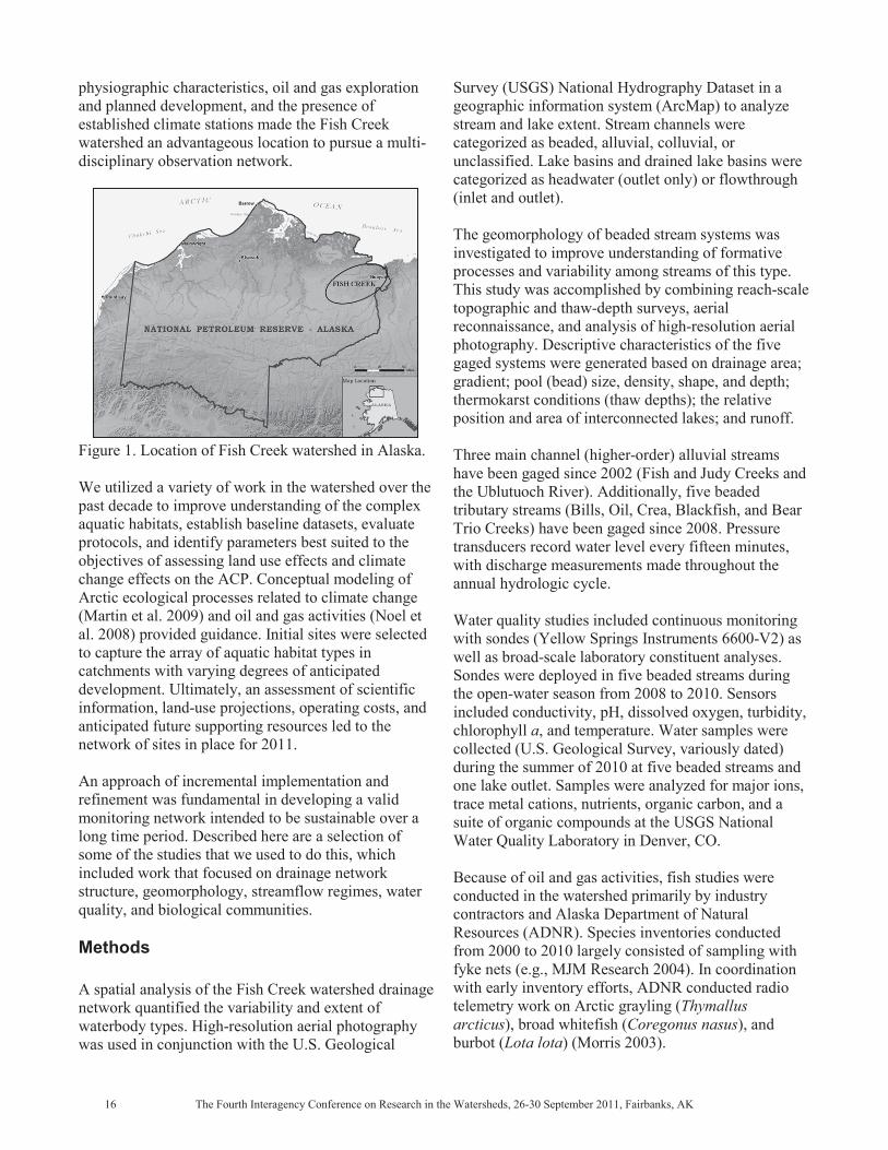
physiographic characteristics, oil and gas exploration and planned development, and the presence of established climate stations made the Fish Creek watershed an advantageous location to pursue a multi-disciplinary observation network.
Figure 1. Location of Fish Creek watershed in Alaska. We utilized a variety of work in the watershed over the past decade to improve understanding of the complex aquatic habitats, establish baseline datasets, evaluate protocols, and identify parameters best suited to the objectives of assessing land use effects and climate change effects on the ACP. Conceptual modeling of Arctic ecological processes related to climate change (Martin et al. 2009) and oil and gas activities (Noel et al. 2008) provided guidance. Initial sites were selected to capture the array of aquatic habitat types in catchments with varying degrees of anticipated development. Ultimately, an assessment of scientific information, land-use projections, operating costs, and anticipated future supporting resources led to the network of sites in place for 2011. An approach of incremental implementation and refinement was fundamental in developing a valid monitoring network intended to be sustainable over a long time period. Described here are a selection of some of the studies that we used to do this, which included work that focused on drainage network structure, geomorphology, streamflow regimes, water quality, and biological communities. Methods
A spatial analysis of the Fish Creek watershed drainage network quantified the variability and extent of waterbody types. High-resolution aerial photography was used in conjunction with the U.S. Geological
Survey (USGS) National Hydrography Dataset in a geographic information system (ArcMap) to analyze stream and lake extent. Stream channels were categorized as beaded, alluvial, colluvial, or unclassified. Lake basins and drained lake basins were categorized as headwater (outlet only) or flowthrough (inlet and outlet). The geomorphology of beaded stream systems was investigated to improve understanding of formative processes and variability among streams of this type. This study was accomplished by combining reach-scale topographic and thaw-depth surveys, aerial reconnaissance, and analysis of high-resolution aerial photography. Descriptive characteristics of the five gaged systems were generated based on drainage area; gradient; pool (bead) size, density, shape, and depth; thermokarst conditions (thaw depths); the relative position and area of interconnected lakes; and runoff. Three main channel (higher-order) alluvial streams have been gaged since 2002 (Fish and Judy Creeks and the Ublutuoch River). Additionally, five beaded tributary streams (Bills, Oil, Crea, Blackfish, and Bear Trio Creeks) have been gaged since 2008. Pressure transducers record water level every fifteen minutes, with discharge measurements made throughout the annual hydrologic cycle. Water quality studies included continuous monitoring with sondes (Yellow Springs Instruments 6600-V2) as well as broad-scale laboratory constituent analyses. Sondes were deployed in five beaded streams during the open-water season from 2008 to 2010. Sensors included conductivity, pH, dissolved oxygen, turbidity, chlorophyll a, and temperature. Water samples were collected (U.S. Geological Survey, variously dated) during the summer of 2010 at five beaded streams and one lake outlet. Samples were analyzed for major ions, trace metal cations, nutrients, organic carbon, and a suite of organic compounds at the USGS National Water Quality Laboratory in Denver, CO. Because of oil and gas activities, fish studies were conducted in the watershed primarily by industry contractors and Alaska Department of Natural Resources (ADNR). Species inventories conducted from 2000 to 2010 largely consisted of sampling with fyke nets (e.g., MJM Research 2004). In coordination with early inventory efforts, ADNR conducted radio telemetry work on Arctic grayling (Thymallus arcticus), broad whitefish (Coregonus nasus), and burbot (Lota lota) (Morris 2003).
Macroinvertebrate samples were collected from streams in 2006 and 2010. A Petite Ponar dredge was used to collect three subsamples from the streambed at study sites (Burton and Pitt 2001). Each subsample was rinsed through a 500-μm mesh sieve, composited into a single sample, and preserved with 95 percent ethanol. A D-frame kick net (500-μm mesh) was used to collect three subsamples from emergent vegetation (adapted from U.S. Environmental Protection Agency 1997). A sweep sampling technique was utilized with each subsample consisting of approximately three 1-m sweeps. Subsamples were composited for each site and preserved with 95 percent ethanol. Samples were processed at the Bureau of Land Management–Utah State University National Aquatic Monitoring Center. Phytoplankton was collected for chlorophyll a analysis by pumping stream water through a 0.7-μm glass fiber filter and adding MgCO3 to prevent degradation of chlorophyll (Moulton et al. 2002). Different quantities
L) were filtered during 2004, 2006, 2009, and 2010 to help determine the minimum volume required for acceptable detection limits during laboratory processing. Three samples were collected at each location and frozen until they were processed at Alaska Department of Fish and Game, Division of Habitat in Fairbanks, AK, or Analytica, Inc., in Juneau, AK. Results The spatial analysis of the Fish Creek watershed drainage network showed a channel drainage density of 0.48 km/km2 and lake surface area of 17 percent, with much of the remaining land surface covered by DTLB. Alluvial and beaded channels each account for about 44 percent of the total stream length in the watershed, and lake basins cover 18 percent of the linear drainage distance (Table 1). Most beaded streams initiate from thermokarst lakes (61 percent) or DTLBs (29 percent). Approximately 53 percent of beaded streams terminate in alluvial channels, while others terminate in oxbow lakes, thermokarst lakes, or fluvial transition zones. Evaluation of beaded stream geomorphology revealed that about half have coalesced or irregular pools indicative of older channels with greater thermokarst degradation, while the others have distinct pools or a series of connected thaw pits that likely denote younger or slowly developing channels. Channels with more coalesced beads had lower gradients and occurred in catchments with lower lake area extent. In the five gaged beaded stream systems, there was considerable
Table 1. Drainage network classification for Fish Creek watershed.
Class Percent class Subclass
Percent subclass
Length (km)
Stream channels 77.4 -- -- 2,345 Beaded 44.0 1,031Colluvial 2.0 47Alluvial 44.7 1,048Unclassified 9.3 219
Lake basins 18.4 -- -- 557 Headwater 26.9 150 Flowthrough 73.1 407
Drained lake basins 4.2 -- -- 129 Headwater 60.2 78Flowthrough 39.8 51
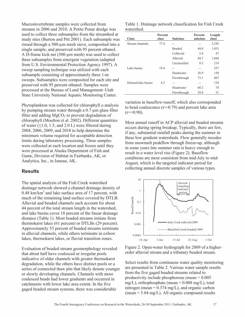
variation in baseflow-runoff, which also corresponded to bead coalescence (r=-0.79) and percent lake area (r=+0.90). Most annual runoff in ACP alluvial and beaded streams occurs during spring breakup. Typically, there are few, if any, substantial rainfall peaks during the summer in these low gradient watersheds. Flow generally recedes from snowmelt peakflow through freeze-up, although in some years late summer rain is heavy enough to result in a water level rise (Figure 2). Baseflow conditions are most consistent from mid-July to mid-August, which is the targeted indicator period for collecting annual discrete samples of various types.
Figure 2. Open-water hydrograph for 2009 of a higher-order alluvial stream and a tributary beaded stream. Select results from continuous water quality monitoring are presented in Table 2. Various water sample results from the five gaged beaded streams related to productivity include phosphorous (mean = 0.005 mg/L), orthophosphate (mean = 0.008 mg/L), total nitrogen (mean = 0.374 mg/L), and organic carbon (mean = 5.84 mg/L). All organic compound results
0.0001
0.001
0.01
0.1
1
10
24-Apr 3-Jun 13-Jul 22-Aug 1-Oct
Runo
ff (m
m/d
)
Judy Creek (alluvial) 2009
Blackfish Creek (beaded) 2009
discretesamplingindicatorperiod

were less than reportable values, except for a detection of trichloromethane at 0.2 μg/L in the sample and the replicate from Oil Creek. Table 2. Select results for continuously monitored water quality parameters (June 14 to August 26, 2010).
Site 1Temp
(oC) Turb2 (NTU)
SC3 (μS/cm)
Chl a4 (RFU)
Minimum–Maximum Blackfish Creek 3.4–17.7 –1.9 68–149 –1.90 Crea Creek 2.8–18.6 –6.5 76–160 –3.60 Bear Trio Creek 2.2–17.8 0.3–15.8 78–177 –2.00 Oil Creek 2.0–19.2 –7.4 98–261 –2.00 Bills Creek 3.0–18.9 –3.2 87–201 –2.10 1Temperature (±0.15), 2Turbidity (±0.3), 3Specific conductivity (±1.0), 4Chlorophyl a (relative fluorescence units, ±0.1%) A total of 16 fish species have been captured in the watershed, with Arctic grayling, broad whitefish, least cisco (Coregonus sardinella), and ninespine stickleback (Pungitius pungitius) being most prevalent. Dolly Varden (Salvelinus malma) and Pacific salmon (chum, pink, chinook, and sockeye) (Oncorhynchus spp.) are only found occasionally. Other species include humpback whitefish (Coregonus pidschian), Arctic cisco (Coregonus autumnalis), round whitefish (Prosopium cylindraceum), burbot, lake trout (Salvelinus namaycush), Alaska blackfish (Dallia pectoralis), and slimy sculpin (Cottus cognatus). Notably, species detection at a given location often varied greatly. Telemetry helped explain the variability of fish presence, with Arctic grayling, burbot, and broad whitefish making frequent movements among multiple habitats (Figure 3).
Figure 3. Simplified diagram of typical broad whitefish seasonal movements (adapted from Morris 2003). Macroinvertebrate community richness was significantly different between emergent vegetation and streambeds at the genus (p<0.001) and family (p<0.001) level (Figure 4), with emergent vegetation being the richest habitat. This habitat also had higher
diversity (p<0.01). Chironomidae dominated streambeds, while emergent vegetation communities were dominated by Valvatidae, Chironomidae, and Limnephilidae.
Figure 4. Mean macroinvertebrate richness (±1 standard deviation) for emergent vegetation and streambeds (2006).
L of filtered stream water did not contain enough absolute chlorophyll a in the extraction solution to satisfy a minimum reporting limit (MRL) based on a detection level of 0.1 mg/m3 (Figure 5). Filtering either 1.5 or 2.0 L largely resulted in valid samples, with only a small proportion being <MRL. However, samples collected by filtering 2.0 L of water were substantially more difficult to collect in the field because of filter clogging. Among the valid samples, the mean summer chlorophyll a concentration for Fish Creek watershed streams is 1.58 mg/m3.
Figure 5. Mean chlorophyll a concentrations (±1 standard deviation) for phytoplankton samples at different volumes.
Large Lakes & Small Tundra Channels/Lakes
Main Channel Habitats
Main Channel Habitats
Main Channel Habitats
Coastal Spawning/Wintering Areas
Local Spawning/Wintering Areas
Mid-SummerMovements
FallMigration
FallMigration
SpringMigration
SpringMigration
0
4
8
12
16
20
Mac
roin
verte
brat
e Ric
hnes
s
Emergent VegetationStreambed
n = 11
Genus Family
0
1
2
3
4
0.5 1.0 1.5 2.0 2.5
Calc
ulat
ed C
hlor
ophy
ll a
(mg /
m3
)
Volume of Water Filtered (L)
n = 25<MRL = 5
n = 0<MRL = 27
n = 64<MRL = 4
Method Reporting Limit (MRL) detection level = 0.1 mg/m3 absolute chlorophyll a in sample

Table 3. Number of fixed monitoring sites where annual data is intended to be collected.
Aquatic habitat Total sites WL1 D2 T3 SC4 pH DO5 Turb6
Chl a trend7
Chl lab8
a Nutr9 OC10 MI11 12 Zoop Fish AL13
Alluvial stream 3 3 3 3 2 2 2 2 2 3 2 2 2 -- -- -- Beaded stream 5 5 5 5 5 5 5 5 5 5 5 5 5 5 1 5 Headwater lake 4 4 -- 4 1 1 1 -- 1 4 1 1 4 4 -- -- Flowthrough lake 3 3 -- 3 1 1 1 -- 1 3 1 1 3 3 -- --
1Water level, 2Discharge, 3Temperature, 4Specific conductivity, 5Dissolved oxygen, 6Turbidity, 7Chlorophyll a probe, 8Chlorophyll a sample, 9Nutrients, 10Organic carbon, 11Macroinvertebrates, 12Zooplankton, 13Active layer depth Conclusions The drainage network classification, geomorphology analysis, and streamflow monitoring collectively contributed to insights regarding watershed-scale hydrologic behavior, waterbody connectivity, and formative processes, concepts principle to evaluating potential ecosystem shifts related to climate change or land use effects. The initiation of most beaded streams from thermokarst lakes or DTLBs suggests that lakes are the dominant control on initial channel formation and evolution. The strong correlation of beaded stream baseflow runoff with bead coalescence and percent lake area indicates that proportionally higher lake area results in higher water yield in the short term and is indicative of older or more developed drainage networks in the long term. The classification of waterbodies also guided site refinement to make the network more representative of the hydrological processes occurring in ACP watersheds. Water quality parameters monitored in situ showed that beaded streams generally have low productivity and low suspended sediment loads throughout the summer season based on relative fluorescence and turbidity values. Higher turbidity values observed at Bear Trio Creek were attributed to unstable banks in the upper catchment that were identified as the origin of the sediment inputs. Among all parameters, upper temperature limits are likely the primary constraining factor for fish suitability in beaded streams. Future water quality monitoring will largely involve tracking parameters by instrumentation, with expanded efforts to evaluate alluvial stream sites. Water sampling will vary based on yearly resources, although a set of priority constituents most relevant to climate change projections was selected for annual monitoring and includes nutrients and organic carbon. While fish community is utilized in many regions as an indicator of stream health (Simon 1998), it is not a suitable option on the ACP because of high spatial and temporal variability. The best strategy for evaluating ecological relationships involving Arctic fish is focused
research within the scope of the monitoring framework. Other biological studies provided baseline data and helped identify sampling best suited to ACP aquatic habitats. For example, long-term macroinvertebrate sampling will focus on emergent vegetation. Richest-habitat targeting is a well-founded option for monitoring (Karr and Chu 1999) and is more cost effective than multi-habitat sampling. The strategy of the Fish Creek watershed aquatic monitoring program from 2011forward includes maintaining a set of fixed sites (Table 3), establishing an intensive sampling study catchment, and continuing integrated research. The fixed-site network includes streams and lakes characteristic of the primary habitat types in the watershed. Parameters not monitored continuously at those locations will be collected during a baseflow indicator period, which is a sound monitoring program approach (Karr and Chu 1999). More frequent sampling to investigate temporal trends will occur in the intensive sampling catchment, Crea Creek. As integrated research is an essential component of an effective monitoring program (Mulder et al. 1999), this will continue in Crea Creek and, as resources allow, at a greater spatial extent throughout the watershed. Acknowledgments The authors appreciate the reviews of Tim Sundlov (BLM–Alaska) and Tim Brabets (USGS Alaska Science Center). References Burton, Jr., G.A., and R. Pitt. 2001. Stormwater Effects Handbook: A Toolbox for Watershed Managers, Scientists, and Engineers. Lewis Publishers, Boca Raton, FL. Jones, B.M, C.D. Arp, K.M. Hinkel, R.A. Beck, J.A. Schmutz, and B. Winston. 2009. Arctic lake physical processes and regimes with implications for winter water availability and management in the National

Petroleum Reserve Alaska. Environmental Management 43:1071–1084. Karr, J.R., and E.W. Chu. 1999. Restoring Life in Running Waters: Better Biological Monitoring. Island Press, Covelo, CA. Lawrence, D., and A. Slater. 2005. A projection of severe near-surface permafrost degradation during the 21st century. Geophysical Research Letters 32(L24401):5. Lesack, L., and P. Marsh. 2007. Lengthening plus shortening of river-to-lake connection times in the Mackenzie River Delta respectively via two global change mechanisms along the Arctic Coast. Geophysical Research Letters 34(L23404):1–6. Marsh, P., M. Russell, S. Pohl, H. Haywood, and C. Onclin. 2009. Changes in thaw lake drainage in the Western Canadian Arctic from 1950 to 2000. Hydrological Processes 23:145–158. Martin, P.D., J.L. Jenkins, F.J. Adams, M.T. Jorgenson, A.C. Matz, D.C. Payer, P.E. Reynolds, A.C. Tidwell, and J.R. Zelenak. 2009. Wildlife Response to Environmental Arctic Change: Predicting Future Habitats of Arctic Alaska. Report of the WildREACH Workshop, 17–18 November 2008, Fairbanks, AK. U.S. Fish and Wildlife Service. McNamara, J., D. Kane, and L. Hinzman. 1999. An analysis of an Arctic channel network using a digital elevation model. Geomorphology 29:339–353. MJM Research. 2004. Baseline surveys of fish habitats in eastern NPR-A, 2001–2003. Report prepared for ConocoPhillips, Alaska, Inc., Anchorage, AK, and Anadarko Petroleum Corporation, The Woodlands, TX. Morris, W. 2003. Seasonal movements and habitat use of Arctic grayling (Thymallus arcticus), burbot (Lota lota), and broad whitefish (Coregonus nasus) within the Fish Creek drainage of the National Petroleum Reserve–Alaska, 2001–2002. Alaska Department of Natural Resources, Office of Habitat Management and Permitting, Technical Report No. 03-02. Moulton, II, S.R., J.G. Kennen, R.M. Goldstein, and J.A. Hambrook. 2002. Revised protocols for sampling algal, invertebrate, and fish communities as part of the National Water-Quality Assessment Program. U.S. Geological Survey Open-File Report 02-150.
Mulder, B.S., B.R. Noon, T.A. Spies, M.G. Raphael, C.J. Palmer, A.R. Olsen, G.H. Reeves, and H.H. Welsh. 1999. The strategy and design of the effectiveness monitoring program for the Northwest Forest Plan. U.S. Department of Agriculture, Forest Service, Pacific Northwest Research Station, General Technical Report PNW-GTR-437. Noel, L.E., L.L. Moulton, M.S. Whitman, and L. Bontrager. 2008. NPR-A fisheries monitoring implementation plan. Prepared by ENTRIX for U.S. Department of the Interior, Bureau of Land Management, Arctic Field Office, Fairbanks, AK. Richter-Menge, J., and 45 others. 2008. Arctic Report Card. National Oceanic and Atmospheric Administration. pp. 1–29. Serreze, M., D. Bromwich, M. Clark, A. Etringer, T. Zhang, and R. Lammers. 2003. Large-scale hydro-climatology of the terrestrial Arctic drainage system. Journal of Geophysical Research 108(D2, 8160):1–28. Simon, T.P. 1998. Assessing the sustainability and biological integrity of water resources using fish communities. CRC Press, Boca Raton, FL. Smith, L., Y. Sheng, G. MacDonald, and L. Hinzman. 2005. Disappearing arctic lakes. Science 308(3), DOI:10.1126/science.1108142. U.S. Environmental Protection Agency. 1997. Field and laboratory methods for macroinvertebrate and habitat assessment of low gradient nontidal streams. U.S. Environmental Protection Agency, Region 3, Environmental Services Division, Mid-Atlantic Coastal Streams Workgroup, Wheeling, WV. U.S. Geological Survey. [Variously dated]. National field manual for the collection of water-quality data. U.S. Geological Survey Techniques of Water-Resources Investigations, Book 9. [online] URL: http://pubs.water.usgs.gov/twri9A. Accessed 23 May 2011. Woo, M., and X. Guan. 2006. Hydrological connectivity and seasonal storage change of tundra ponds in a polar oasis environment. Canadian High Arctic: Permafrost and Periglacial Processes 17:309–323.

Monitoring Water Quality in Alaskan National Parks: Development and Application of RIVPACS Empirical Models for the Assessment of Ecological Condition T. Simmons, J.D. Ostermiller Abstract Historically, assessment of water quality focused on chemical measures, and this is still the case for nearly all water quality programs in U.S. national parks. Over the last 20 years, however, the emphasis at the State and Federal level has shifted to biological measures of water quality, with the goal of assessing the ecological integrity of aquatic ecosystems. Because benthic macroinvertebrates are ubiquitous in aquatic environments, occur at high densities, are relatively inexpensive to collect, and respond sensitively to environmental stressors, most biological assessment programs rely on these organisms as indicators of ecosystem condition. The River Invertebrate Prediction and Classification System (RIVPACS) is a robust biological assessment tool that uses natural environmental gradients to predict the species composition of benthic macroinvertebrates that would be expected to occur in the absence of anthropogenic stress. Deviations from the expected species composition then constitute a measure of biological impairment. We used macroinvertebrate and environmental data from 66 streams in Denali National Park and Preserve and Wrangell–St. Elias National Park and Preserve to develop and test a preliminary RIVPACS model for these parks. We will discuss the development of this model and its application as a tool for the contemporary biological assessment of water quality in streams and rivers in Alaskan national parks. We will also discuss the potential of using this approach to detect the ongoing effects of climate change in otherwise pristine streams and rivers.
Simmons is an aquatic ecologist with the U.S. Department of the Interior, National Park Service, 4175 Geist Road, Fairbanks AK 99709. Ostermiller is an aquatic ecologist with Ostermiller Consulting Services, 146 W. Center St., Logan UT 84321. Email: [email protected], [email protected].