Embed Size (px)
Citation preview


Airports in Cities and RegionsResearch and Practise


Ute Knippenberger, Alex Wall (eds.)
Airports in Cities and RegionsResearch and Practise
1st International Colloqium on Airports and Spatial DevelopmentKarlsruhe, 9th – 10th July 2009
Impressum
Karlsruher Institut für Technologie (KIT)KIT Scientific PublishingStraße am Forum 2D-76131 Karlsruhewww.uvka.de
KIT – Universität des Landes Baden-Württemberg und nationalesForschungszentrum in der Helmholtz-Gemeinschaft
Diese Veröffentlichung ist im Internet unter folgender Creative Commons-Lizenz publiziert: http://creativecommons.org/licenses/by-nc-nd/3.0/de/
KIT Scientific Publishing 2010 Print on Demand
ISBN 978-3-86644-506-2
5 5
Foreword The economic impact of airports as providers of regional and national prosperity is
often juxtaposed to the negative externalities such as noise emissions and ecological
impacts. New aspects may extend this dichotomy: airports have undergone a
development from pure infrastructural nodes to multifunctional service locations.
Using concepts such as “Airport City” or “Aerotropolis”, airport management
companies have fostered this development for different reasons. At the same time
the agglomeration patterns of certain industries have changed through the relative
success of air freight. Airports as nodes to the global economy can therefore be seen
as users and producers of new forms of spatial centralities. In contrast, this
functional and urban evolution is often not reflected in planning procedures.
The consequences of this development with respect to regional and urban
structures near airports were the focus of the colloquium “From Airport City to
Airport Region? - 1st International Colloquium on Airports and Spatial
Development” held in July 2009 at the University of Karlsruhe. In a time of
continued development and transformation of transportation infrastructure, the
colloquium set the focus on the interrelation between airports and their region. In
four thematic blocks, papers and presentations addressed questions such as: how
can airports be perceived as part of the urban structure, which economic effects
foster spatial development, and which policy approaches exist to tackle the various
conflicts in the airport-region relationship.
The present publication contains written elaborations of most presentations and
additional contributions of researchers who could not attend the event, but have
kindly agreed to contribute. Since the colloquium was in English, this publication is
English based. However the possibility was given for participants to deliver their
contribution in German.
We would like to thank Alva Huffer, student assistant, who put everything
together, the KIT publishers for their support, and of course all contributors for
submiting their research to this first compilation of research and practise
questioning the relationship between airports, regional development and urban
planning.
Ute Knippenberger, Alex Wall
6
Content Prelude 9Airport and City: An ambiguous relationship Thomas Sieverts
Research and case studies
Looking in all the wrong places? 15Catalytic effects in the context of product cycle theory Stephen J. Appold and John D. Kasarda
Feeder airport city 31A spatial model to foster equitable regional planning Vasanth K. Bhat
Forecasting night flight movements at airports 43A methodological approach Christian Blank and Tina Wagner
New office space at international hub airports 57Evolving urban patterns at Amsterdam and Frankfurt/M. Sven C. M. Conventz
The planning of airport regions and National Aviation Policy 69Issues and challenges in Australia 2008-2009 Robert Freestone and Douglas Baker
The Luxembourg air freight-hub 85Market niche development, supply chain-insertion, global positionality Markus Hesse
Global transfer points 95International airports and the future of cities and regions Sven Kesselring
Airport-region governance 101Conundrums of airports and regional coherence Ute Knippenberger
Defining the Airea 113Evaluating urban output and forms of interaction between airport and region Johanna Schlaack
The interrelationships of airport and spatial development 127Zurich Airport – Experiences from a test planning process Bernd Scholl
7 7
Subjective appraisal of aircraft noise 137From decibel measurements to effective noise management Pere Suau-Sanchez
Southeast Florida in the age of aviation 143Three international airports in the coastal metropolis Alex Wall
Practise and policy approaches
Managing airport cities 153Benchmark Study 2008 Stephanie Betz
Airport city 159Approaching an already existent phenomenon Peter Buchholz
Airports’ catalytic effects 167Describing a knowledge gap Benjamin Buser and Jochen Flinner
From airport city to airport corridor 173Airport and city, sustainability and economy Maurits Schaafsma
A dialogue forum 181Development of the area around Berlin-Brandenburg International Airport Sabine Sperling
Frankfurt Airport City 187Hub for a future world Thomas Uber

8
9
Prelude Airport and City: An ambiguous relationship
Thomas Sieverts
1 The fundamental dilemma: Will air-traffic shrink or will it grow? Thinking about the relation between airport and city, one immediately falls into a
fundamental dilemma: Will air-traffic drastically shrink in future, because of
possible damages of the atmosphere, rising prizes and shortage of fuel? Or will air-
traffic, on the contrary, drastically grow because of new inventions in the field of
emission free-air-technology? This fundamental uncertainty cannot be avoided.
Under this condition I shall try to develop two contrasting perspectives. In the first
perspective – assuming drastic shrinkage of air-traffic – I shall try to compare the
history of the infrastructure ‘airport’ with historically older infrastructure-systems,
like the water-transport, the highway-system and the railways, looking for a basic
pattern of comparable development. In the second perspective – assuming a new
emission free-air-technology leading to a drastic growth of air-traffic – I shall try to
speculate about a new, futuristic conception of an airport-city-system, which could
open promising new potentials concerning global development and global
government. In the conclusions I shall accept the fundamental uncertainty. Under
this condition I shall try to formulate general recommendations for the small slice of
time between the facts of history and the futuristic speculation over a time to come.
2 The typical process in the development of transport-infrastructure from servant to master
Cities have always developed in a mutual interplay with their infrastructures: We
speak of port-cities, highway-cities, railway-cities and now airport-cities. In each of
these cases the development of the specific traffic-infrastructures over time proves a
comparative pattern: They all transformed from a modest, but crucial servant to the
city to become a dominant master of city-development, contributing to the city’s
wealth, but also accompanied with many negative side-effects. In other words: They
transformed from a ‘maker’ to a ‘breaker’ of the city. Just a few illustrative examples:
Thomas Sieverts
10
The simple ‘landing’ at the shore of sea or river became the monster of the big
(container) port, which separates the city from the water. The multi-functional
highway, serving the marketplace, became the mono-functional freeway, forming a
big barrier in the city and separating the parts of the city from each other.
The railways, starting as a kind of ‘street-car’, became the space-consuming,
impenetrable system, occupying with its rail-fields huge monofunctional areas in the
city, breaking it into pieces. The airport, starting as an open meadow and a lightly
constructed hangar, developed to the huge “machineries” we have today, in form of
self-isolating systems, confronting the city and dominating it not only with large
fenced-in areas, but also with heavy noise.
3 The basic paradox of decay, opening up unique new potentials But this typical transformation from a modest servant and maker to an imperial
master and breaker of the city is not the end of the story: each of these
infrastructures of the city had a ‘peak’ and then lost in meaning. The port left the city
and moved to the sea, the freeway in the city and its functions have been
translocated to the edge, the railways drastically reduced the rail fields in the city
and moved them outside. Inner-city airports like Berlin-Tempelhof closed down. But
what will happen to the present airports outside the city?
History proved: The process of servant and maker to master and breaker and
eventual loss of meaning in the city with a translocation to other locations had
generally paradox consequences: The heavy burden became a unique potential! Just
a few examples:
The Hafen-City in Hamburg on a former port-area, the inner-city development in
Ulm on a given-up highway, the Europa-City in Frankfurt on a former rail-field, the
new city- and park-development on the area of the former airport “Tempelhof” in
Berlin. Due to their very nature, each of these areas has an excellent accessibility and
a big centrality. This is also applicable to big airports: Especially the large “Hubs”
have at present the highest national, even continent-wide centrality. Take Frankfurt-
airport: ICE- IC- and Regional-Trains in combination with a Freeway-junction of
European importance forms a point of extremely high centrality in addition to its
high accessibilities. It has the highest number of public parking spaces in the region.
Its ‘technical’ centrality is higher than the city of Frankfurt.
So the prospects for city-development after the era of aviation, seen exclusively in
spatial dimensions, seem not to be bad at all!
Prelude
11 11
4 A speculation about potential spatial consequences of an emission-free air-traffic
In the contrasting perspective I assume a new, emission-free air-technology. I shall
not try to speculate about its probability, but at least yesterday there was a short
notice in the papers, that within this year there will be an airplane with
‘Brennstoffzellen’. Instead I shall use this perhaps futuristic assumption as a basis
for a contrasting scenario of a global city-network, consisting of extended airports,
connected by frequent airlines
An emission-free air-technology would lead most probably to a new enormous
growth of air-traffic and more frequent air-connections. This could lead to a general
‘shrinking’ of the globe, measured in travel-time, which in turn would unify the globe
economically and culturally. The simple basic idea behind the conception of a new
global-city-network would induce the shift of the respective national borders to the
outer edges of the extended airport and give the extended airport itself the status of
nationally independent global unit, connected to other airports of the same status,
administered i.e. by the United Nations. The extended airport would be a kind of
‘township’ of a legally and politically unified global city. The global centrality of this
global-city-network would reach the whole globe: It would be the natural site for
global players, even for a global government. There might be ca. seven to ten ‘hubs’
on the globe, reachable for the population by air-traffic in up to two hours. The
virtual population of that ‘global-agglo’ would comprise several hundred million
people!
If this kind of an economically and culturally unified, globally decentralised global
city would be realised, than the different time-zones in the different ‘townships’ in
different continents, leading to severe jet-lags, would be become a serious problem.
Former students of mine proposed in a design for a new airport a new type of
building ‘containing’ the local time of other parts of the globe, so that one could
gradually adapt to one’s own bio rhythm. This is just an example of how such a new
kind of global city might lead to new problems but also to new solutions. At any rate,
an emission-free air-traffic would start a new Kondratieff-circle, and nobody can
know what this will mean for the future.
5 Final remarks If we accept the uncertainty of the present situation concerning the future of air-
transportation, we should try to keep open both options – shrinking and growth of
air-traffic. As I have tried to line out, both options promise a profitable and
interesting future for the city.

Thomas Sieverts
12
The options of a radical shrinking of air-traffic should motivate us to transform the
present airport gradually into a normal part of the city’s fabric. This could mean:
Gradually building up a truly urban context, connecting the airport also with
pedestrian- and bicycle-connections and finding a new balance with the historic
town-centre.
The option of growth of an emission-free air-traffic opens up fantastic new
perspectives of a truly global city-network. I reckon we should think about this
supposed futuristic option in more depth and we should develop it in detail. This
option is less a question of urban form but a matter of imagination, politics and
courage!
Prof. Thomas Sieverts is Professor emeritus of TU Darmstadt
Buschstraße 20 53113 Bonn
13
Research and Case Studies Appold and Kasarda
Bhat Blank and Wagner
Conventz Freestone and Baker
Hesse Kesselring
Knippenberger Schlaack
Scholl Suau-Sanchez
Wall

14
15
Looking in all the wrong places? Catalytic effects in the context of product cycle theory
Stephen J. Appold and John D. Kasarda
The costs and benefits of commercial aviation have become a central focus of public and policy concern. Environmentalists have long maintained that economic externalities such as noise and greenhouse gas impacts are insufficiently incorporated into policy decisions. Consequently, refined measures of such costs have been developed. The measurement of benefits has not improved. In this chapter, we maintain that the economic benefit of aviation is incorrectly measured; the net gains from aviation-enabled trade are the proper measure. These benefits are more easily visible in selected non-core urban regions than in the largest world cities. Further, airport cities have their strongest economic benefit when they facilitate regional, rather than global, economic linkages.
1 Introduction
The economic impact of airports and airport cities on regions is of increasing public
and policy interest due to the large capital investments entailed in airport
construction and expansion, the possibly inadequately costly environmental impact,
and the negative externalities surrounding airports. Policy decisions require that
investments meet basic benefit-cost criteria. While prior experience with airports
suggests that, on average, these criteria so far likely have been met, other types of
infrastructure investments appear to systematically not meet such criteria
(Flyvbjerg, Bruzelius, and Rothengatter, 2003). The increasing volume of air traffic,
rising construction costs, the possibility of diminishing returns from additional
airport capacity, and the increasing concern over climate change and oil
conservation all contribute to the demand for valid and reliable measures of
economic impact.
In this chapter, we maintain that researchers and policy makers have been looking
for the economic impact of commercial aviation, airports, and airport cities in all the
wrong places. We outline three areas in which current practice is often misplaced.
First, the economic impact of aviation is often measured by its costs, rather than its
Stephen J. Appold and John D. Kasarda
16
benefits. Second, the economic impact of aviation is often thought to be
concentrated in the largest and most important world cities. Third, global linkages
are often thought to be the primary drivers of airport cities. We contend that each of
those points needs correction or qualification, advance alternative arguments, and
present evidence that support our arguments.
We contend that the root of the measurement problems in an inadequate link
between airport studies and mainstream social science, especially economic trade
theory and urban and regional development theory. Policy makers, in Germany and
elsewhere, have asked that the theory and measurement gap be narrowed (Pfähler,
2001). In debates surrounding the possible expansion of Heathrow and of Schiphol,
critics and some policy makers have stated that several of the commonly used
measures of economic impact are inadequate to support public decision-making
(Boon, Davidson, Faber, Nelissen, and van de Vreede, 2008; Boon and Wit, 2005).
We hope to narrow that gap.
2 Measuring the economic impact of commercial aviation
Trade economists build on Paul Samuelson’s “iceberg” analogy to capture the total
effects of transportation and other logistics costs. Products being shipped are like
icebergs that melt in transit. Some products melt more quickly than others and
some forms of transportation are associated with greater melting. Much potentially
rewarding trade does not occur because the entire product melts in transit.
Ironically, in aviation impact studies, the metaphorical melting is counted as a
gain. The greater the melting – that is, the greater the loss of product value – the
higher the measured economic impact in terms of airline and airport employees,
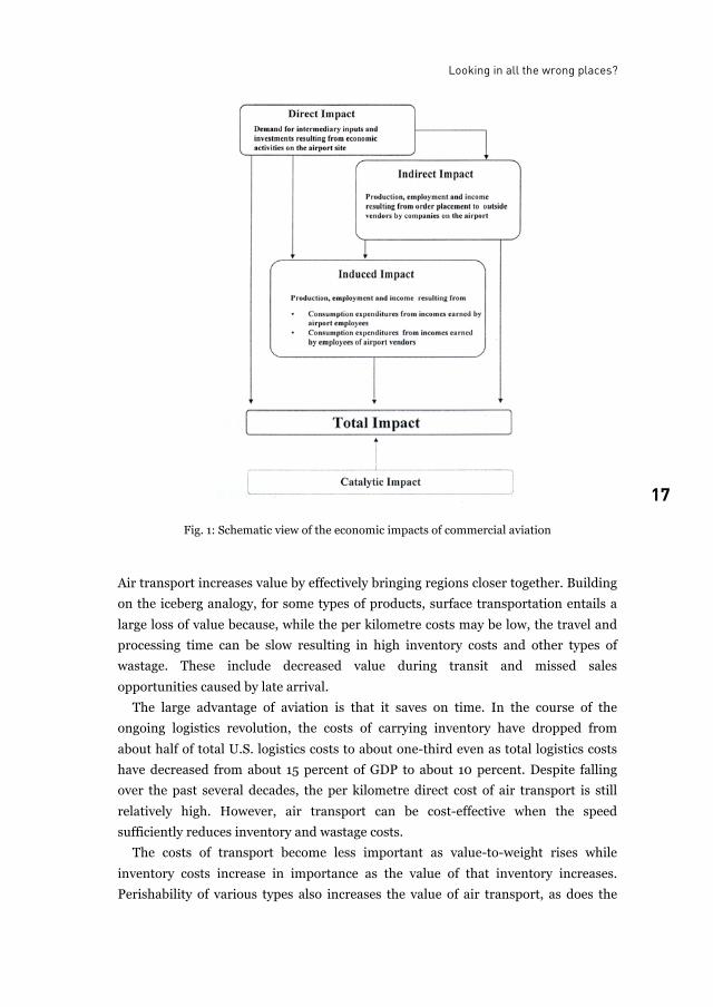
payroll, consumer spending, and related measures. These costs are schematized in
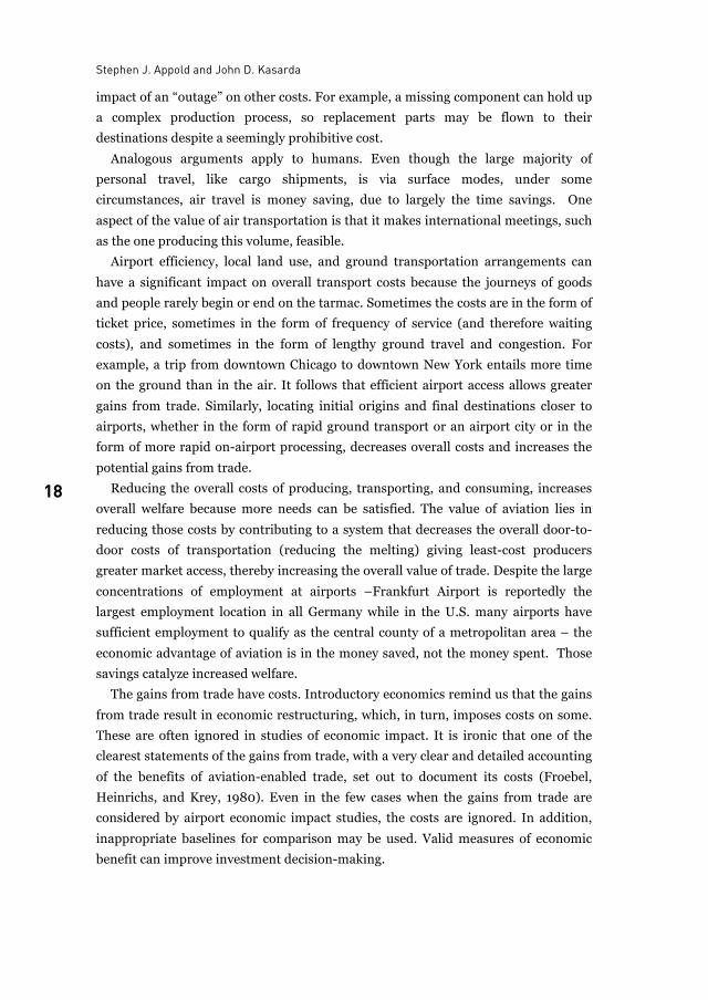
Figure 1. The positive impacts of trade are hidden in the “catalytic effects” at the
bottom of the figure.
Catalytic effects form the bridge between aviation studies and economic theory.
The catalytic effects of commercial aviation are the net gains from trade, which are
facilitated by aviation. The gains are connected to the products shipped by air, the
products shipped by surface but coordinated, in part, via air, the services shipped by
air, including tourism and many forms of business services, and possibly visits to
friends and family. Catalytic effects are usually given short shrift in aviation
literature but these are the impacts that regional and national governments should
and do care about. Unfortunately, they are poorly measured. Often, they are not
even discussed.
Looking in all the wrong places?
17 17
Fig. 1: Schematic view of the economic impacts of commercial aviation
Air transport increases value by effectively bringing regions closer together. Building
on the iceberg analogy, for some types of products, surface transportation entails a
large loss of value because, while the per kilometre costs may be low, the travel and
processing time can be slow resulting in high inventory costs and other types of
wastage. These include decreased value during transit and missed sales
opportunities caused by late arrival.
The large advantage of aviation is that it saves on time. In the course of the
ongoing logistics revolution, the costs of carrying inventory have dropped from
about half of total U.S. logistics costs to about one-third even as total logistics costs
have decreased from about 15 percent of GDP to about 10 percent. Despite falling
over the past several decades, the per kilometre direct cost of air transport is still
relatively high. However, air transport can be cost-effective when the speed
sufficiently reduces inventory and wastage costs.
The costs of transport become less important as value-to-weight rises while
inventory costs increase in importance as the value of that inventory increases.
Perishability of various types also increases the value of air transport, as does the
Stephen J. Appold and John D. Kasarda
18
impact of an “outage” on other costs. For example, a missing component can hold up
a complex production process, so replacement parts may be flown to their
destinations despite a seemingly prohibitive cost.
Analogous arguments apply to humans. Even though the large majority of
personal travel, like cargo shipments, is via surface modes, under some
circumstances, air travel is money saving, due to largely the time savings. One
aspect of the value of air transportation is that it makes international meetings, such
as the one producing this volume, feasible.
Airport efficiency, local land use, and ground transportation arrangements can
have a significant impact on overall transport costs because the journeys of goods
and people rarely begin or end on the tarmac. Sometimes the costs are in the form of
ticket price, sometimes in the form of frequency of service (and therefore waiting
costs), and sometimes in the form of lengthy ground travel and congestion. For
example, a trip from downtown Chicago to downtown New York entails more time
on the ground than in the air. It follows that efficient airport access allows greater
gains from trade. Similarly, locating initial origins and final destinations closer to
airports, whether in the form of rapid ground transport or an airport city or in the
form of more rapid on-airport processing, decreases overall costs and increases the
potential gains from trade.
Reducing the overall costs of producing, transporting, and consuming, increases
overall welfare because more needs can be satisfied. The value of aviation lies in
reducing those costs by contributing to a system that decreases the overall door-to-
door costs of transportation (reducing the melting) giving least-cost producers
greater market access, thereby increasing the overall value of trade. Despite the large
concentrations of employment at airports –Frankfurt Airport is reportedly the
largest employment location in all Germany while in the U.S. many airports have
sufficient employment to qualify as the central county of a metropolitan area – the
economic advantage of aviation is in the money saved, not the money spent. Those
savings catalyze increased welfare.
The gains from trade have costs. Introductory economics remind us that the gains
from trade result in economic restructuring, which, in turn, imposes costs on some.
These are often ignored in studies of economic impact. It is ironic that one of the
clearest statements of the gains from trade, with a very clear and detailed accounting
of the benefits of aviation-enabled trade, set out to document its costs (Froebel,
Heinrichs, and Krey, 1980). Even in the few cases when the gains from trade are
considered by airport economic impact studies, the costs are ignored. In addition,
inappropriate baselines for comparison may be used. Valid measures of economic
benefit can improve investment decision-making.
Looking in all the wrong places?
19 19
3 The market geography of the new service sector
By bringing places closer together through reducing overall transportation and
logistics costs, aviation has enlarged the geographic scope of markets firms can
serve. One consequence of the enlargement of market areas has been the rise of
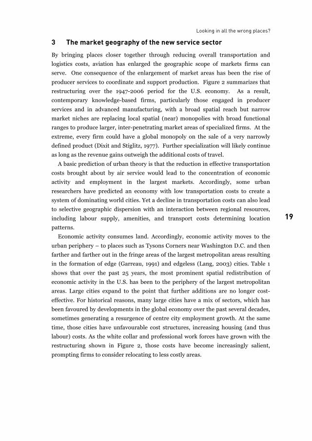
producer services to coordinate and support production. Figure 2 summarizes that
restructuring over the 1947-2006 period for the U.S. economy. As a result,
contemporary knowledge-based firms, particularly those engaged in producer
services and in advanced manufacturing, with a broad spatial reach but narrow
market niches are replacing local spatial (near) monopolies with broad functional
ranges to produce larger, inter-penetrating market areas of specialized firms. At the
extreme, every firm could have a global monopoly on the sale of a very narrowly
defined product (Dixit and Stiglitz, 1977). Further specialization will likely continue
as long as the revenue gains outweigh the additional costs of travel.
A basic prediction of urban theory is that the reduction in effective transportation
costs brought about by air service would lead to the concentration of economic
activity and employment in the largest markets. Accordingly, some urban
researchers have predicted an economy with low transportation costs to create a
system of dominating world cities. Yet a decline in transportation costs can also lead
to selective geographic dispersion with an interaction between regional resources,
including labour supply, amenities, and transport costs determining location
patterns.
Economic activity consumes land. Accordingly, economic activity moves to the
urban periphery – to places such as Tysons Corners near Washington D.C. and then
farther and farther out in the fringe areas of the largest metropolitan areas resulting
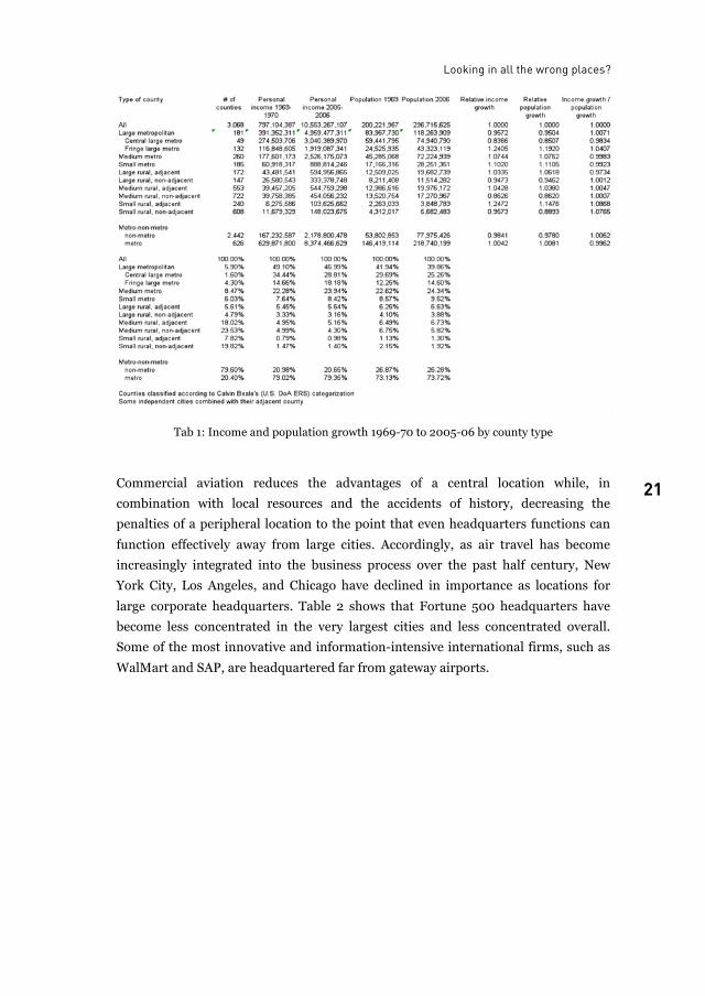
in the formation of edge (Garreau, 1991) and edgeless (Lang, 2003) cities. Table 1
shows that over the past 25 years, the most prominent spatial redistribution of
economic activity in the U.S. has been to the periphery of the largest metropolitan
areas. Large cities expand to the point that further additions are no longer cost-
effective. For historical reasons, many large cities have a mix of sectors, which has
been favoured by developments in the global economy over the past several decades,
sometimes generating a resurgence of centre city employment growth. At the same
time, those cities have unfavourable cost structures, increasing housing (and thus
labour) costs. As the white collar and professional work forces have grown with the
restructuring shown in Figure 2, those costs have become increasingly salient,
prompting firms to consider relocating to less costly areas.
Stephen J. Appold and John D. Kasarda
20
Fig. 2: Sectoral distribution of value-added in the U.S. economy, 1947-2006
Organizational design as well as transport costs impact geographic redistribution.
As work processes become routinised and institutionalized, a geographical spin-off
may become feasible. Locations distant from the largest cities may offer sufficient
labour cost advantages to justify the increased travel required for coordination and
management. Low-skill economic activities were among the first to relocate from
core regions. Rail, road, and water were critical catalysts for the peripheralisation of
goods production (Hoover and Vernon, 1959; Vernon, 1966).
As progressively more highly-skilled activities have been routinised and the work
processes institutionalized, air transport has become central in the movement of
high-skill office functions, such as research and development, and headquarters
away from the largest cities leading to cost savings without sacrificing
communication and contact. Today, a manager from, IBM’s New York headquarters
can catch a morning flight to Raleigh-Durham, meet with executives, and then
return to New York for an early afternoon meeting. Initial investigations suggest that
someone who only needed to meet with his or her New York-based superior every
two weeks or so, might prefer living in a less-costly, amenity-rich area many hundred
miles away and flying in for an occasional day trip to living in New York. Of course,
while affordable air fare is a key aspect of such decisions, so are other factors, such
as the depth of the local labour market, the cost of living, and amenities.
Looking in all the wrong places?
21 21
Tab 1: Income and population growth 1969-70 to 2005-06 by county type
Commercial aviation reduces the advantages of a central location while, in
combination with local resources and the accidents of history, decreasing the
penalties of a peripheral location to the point that even headquarters functions can
function effectively away from large cities. Accordingly, as air travel has become
increasingly integrated into the business process over the past half century, New
York City, Los Angeles, and Chicago have declined in importance as locations for
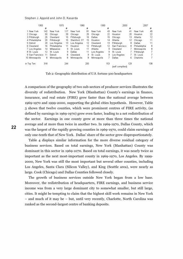
large corporate headquarters. Table 2 shows that Fortune 500 headquarters have
become less concentrated in the very largest cities and less concentrated overall.
Some of the most innovative and information-intensive international firms, such as
WalMart and SAP, are headquartered far from gateway airports.
Stephen J. Appold and John D. Kasarda
22
Tab 2: Geographic distribution of U.S. fortune 500 headquarters
A comparison of the geography of two sub-sectors of producer services illustrates the
diversity of redistribution. New York (Manhattan) County’s earnings in finance,
insurance, and real estate (FIRE) grew faster than the national average between
1969-1970 and 1999-2000, supporting the global cities hypothesis. However, Table
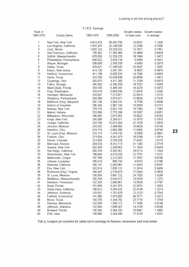
3 shows that twelve counties, which were prominent centres of FIRE activity, (as
defined by earnings in 1969-1970) grew even faster, leading to a net redistribution of
the sector. Earnings in one county grew at more than three times the national
average and at more than twice in another two. In 1969-1970, Dallas County, which
was the largest of the rapidly growing counties in 1969-1970, could claim earnings of
only one-tenth that of New York. Dallas’ share of the sector grew disproportionately.
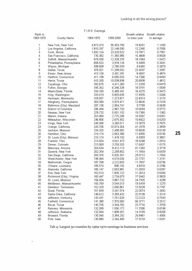
Table 4 displays similar information for the more diverse residual category of
business services. Based on total earnings, New York (Manhattan) County was
dominant in this sector in 1969-1070. Based on total earnings, it was nearly twice as
important as the next most-important county in 1969-1970, Los Angeles. By 1999-
2000, New York was still the most important but several other counties, including
Los Angeles, Santa Clara (Silicon Valley), and King (Seattle area), were nearly as
large. Cook (Chicago) and Dallas Counties followed closely.
The growth of business services outside New York began from a low base.
Moreover, the redistribution of headquarters, FIRE earnings, and business service
income was from a very large dominant city to somewhat smaller, but still large,
cities. It might be tempting to claim that the highest skill work remains in New York
– and much of it may be – but, until very recently, Charlotte, North Carolina was
ranked as the second-largest centre of banking deposits.
Looking in all the wrong places?
23 23
Tab 3: Largest 50 counties by 1969-1970 earnings in finance, insurance and real estate
Stephen J. Appold and John D. Kasarda
24
Specialization requires frequent contact across long distances, whether engineers are
being ferried aboard the “nerd birds” that connect distant high technology clusters or
investment bankers are speeding between appointments in far-flung financial
centres or IT consultants are commuting on early Monday and late Thursday flights.
In the process, cities shift from being central places to being open spaces. The
restructured economy has undoubtedly benefited the largest cities but selected
second-tier cities and high-amenity areas have benefitted more.
4 Regionalization and the rise of airport cities
Airport cities are sometimes seen as a product of globalization. Commercial aviation
certainly has been a tremendous aid to the globalization process. Conversely,
globalization may be responsible for the rise of airport cities in greenfield
development. However, it is not clear that immediate airport proximity is a salient
factor in firm location decisions in mature cities when inter-continental trips are
common. Japanese firms and seconded Japanese nationals in New York,
concentrating in the area of the metropolitan region farthest from JFK Airport, have
generally let residential amenities outweigh airport access in making location
decisions.
Direct access may be a salient location factor when an airport area location has a
significant impact on the length of a trip by eliminating or reducing the need for
overnight stays. Consequently, airport cities may offer their most significant
competitive advantages in Europe and North America when business flights average
an hour or two in length. Simulations of market reachability on single-day trips,
shown in Figure 3, suggest that airport cities can amplify the impact of the benefit of
commercial aviation in such cases. Naturally, the costs of reaching customers
increase with distance, so only some of the non-local business opportunities are
viable but, at moderate flight distances, a location near an airport can significantly
increase a firm’s market size
Looking in all the wrong places?
25 25
Tab 4: Largest 50 counties by 1969-1970 earnings in business services
.
Stephen J. Appold and John D. Kasarda
26
Fig. 3: Simulation of potential costs of a sales call using automobile and air transport
The simulations also suggest that the benefit of an airport city location to a small
number of firms is low. The market access benefit increases markedly when distant
customers are located near their respective airports. Ironically, the benefit of
locating in a particular airport city depends critically on the growth of distant airport
cities, as central places become open spaces.
A comparison of the local point of origin of frequent fliers for two airports in the
San Francisco region corroborates the role of regional, rather than global, air
linkages in creating dense agglomerations around airports. Figure 4 shows the
regional geographic origins of frequent fliers at San Francisco International Airport
(SFO). The larger the circle, the more frequently the respondent had used SFO over
the previous year. SFO serves many distant, often international, destinations and
draws frequent fliers from a large geographic catchment area. Corresponding data
for San Jose Airport (SJC), which serves mainly regional destinations, is shown in
Figure 5. Fliers, especially frequent fliers, are so tightly packed around SJC that they
obscure its location. Airport cities matter more for shorter trips than longer trips
because the ground portion of the trip is a greater proportion of the total travel, as
suggested by the New York-Chicago example above.
Looking all the wrong places?
27 27
5 Conclusion In summary, aviation researchers have been looking in all the wrong places in
attempting to measure the economic impact of commercial aviation and of airports.
First, commonly used indicators of economic impact measure the costs of trade
rather than net gains from trade. These could match if economies of scale and the
nature of competition were simpler but it is likely that much of the benefit of airports
is hidden in what economists term a “consumer surplus.” The size of the consumer
surplus is unknown but probably significant. This implies that the long-run demand
for aviation may be less price sensitive than the short-run effects.
Second, aviation researchers look to global cities, rather than further down the
urban hierarchy, possibly even at selected “spokes” in aviation network instead of at
core hub cities to see the strongest effect of aviation. To be sure, air transport has
benefited some large core cities but it has advantaged some formerly remote cities
even more. Amsterdam, London, and New York were centres of the world system
before air travel was prevalent, or even possible (Wallerstein, 1974). Air transport
has a “flattening” effect.
Fig. 4: Origins of passengers flying through
SFO
Fig. 5: Origins of passengers flying through
SJC
Stephen J. Appold and John D. Kasarda
28
Third, aviation researchers look at globalization rather than regionalization.
Globalization and global air flows are clearly important, yet most air-enabled trade
and travel is within intra-continental regions. The growth of mega-regions, linked in
part by air throughout a continent, appears to be much more important in the
growth of airport cities in Europe and North America than globalization. While there
are some who might fly from Asia for a brief few-hour meeting in Europe before
flying on to North America, even for most frequent fliers, the extra hour or so to
reach a downtown hotel after a long flight is not especially salient. On the other
hand, if there is a chance to make it back home in the evening, then the time savings
could be critical.
List of figures
Fig. 1: Schematic view of the economic impacts of commercial aviation......................................... 17Fig. 2: Sectoral distribution of value-added in the U.S. economy, 1947-2006 ................................20Fig. 3: Simulation of potential costs of a sales call using automobile and air transport .................26Fig. 4: Origins of passengers flying through SFO .............................................................................27Fig. 5: Origins of passengers flying through SJC..............................................................................27
List of tables
Tab 1: Income and population growth 1969-70 to 2005-06 by county type....................................21Tab 2: Geographic distribution of U.S. fortune 500 headquarters ..................................................22Tab 3: Largest 50 counties by 1969-1970 earnings in finance, insurance and real estate...............23Tab 4: Largest 50 counties by 1969-1970 earnings in business services .........................................25
References
B. Boon, M. Davidson, J. Faber, D. Nelissen, and G. van de Vreede. The economics of Heathrow
expansion. Delft: CE Consulting, February
(http://www.ce.nl/publicatie/the_economics_of_heathrow_expansion/742). 2008.
B. Boon and R. Wit. The contribution of aviation to the economy: Assessment of arguments put
forward. Delft: CE Consulting, October (http://www.norunway.com/BWstudy.pdf).
2005.
A. K. Dixit and J. E. Stiglitz. Monopolistic Competition and Optimum Product Diversity.
American Economic Review 67: 297-308. 1977.
B. Flyvbjerg, N. Bruzelius, and W. Rothengatter. Megaprojects and risk: an anatomy of
ambition. Cambridge: Cambridge University Press. 2003.
F. Froebel, F., J. Heinrichs and O. Krey. The New International Division of Labour. Cambridge,
UK: Cambridge University Press. 1980.
J. Garreau. Edge city: life on the new frontier. New York: Doubleday, 1991.
Looking in all the wrong places?
29 29
E. M. Hoover and R. Vernon. Anatomy of a metropolis: the changing distribution of people and
jobs within the New York metropolitan region. Cambridge: Harvard University Press.
1959.
R. Lang. Edgeless cities: exploring the elusive metropolis. Washington, D.C.: Brookings
Institution Press. 2003.
W. Pfähler (ed.). Regional input-output analysis: conceptual issues, airport case studies and
extensions. Baden-Baden: Nomos. 2001.
R. Vernon. International Investment and International Trade in the Product Cycle. The
Quarterly Journal of Economics 80: 190-207. 1966.
I. M. Wallerstein. The modern world-system. New York: Academic Press. 1974.
Stephen J. Appold is Research Assistant Professor of Strategy and Entrepreneurship at the
University of North Carolina, Kenan Institute of Private Enterprise, 27707, Chapel Hill, NC, USA E-mail: [email protected]
Dr. John D. Kasarda is Director of Kenan Institute of Private Enterprise and Kenan Distinguished Professor of
Strategy and Entrepreneurship at the University of North Carolina, Kenan Institute of Private Enterprise, 27707, Chapel Hill, NC, USA

30
31
Feeder airport city A spatial model to foster equitable regional planning
Vasanth K. Bhat
1 Introduction Over the last decade there has been a substantial rise in air traffic in India. With the
growth of the proverbial “Middle Class” in India, and also with the entry of the
private sector into aviation, there is a huge potential to provide air accessibility, to
tier II and tier III cities in India. Hitherto most of the airports were planned and
executed in Metropolitan cities and tier I cities, and people living in tier II and tier
III cities had to commute to the nearest Metro or tier I city to take a flight to their
destination.
On the other hand there is an imbalance in the regional planning scenario in
India. Most of the tier II and tier III cities are devoid of proper social infrastructure,
which makes them less attractive to the middle class. Consequently there is a
constant out-migration of young ambitious educated professionals from tier II and
tier III cities into Metro and tier I cities, which provide them with means to enrich
their living comforts. In addition immigration of population from the rural areas
into the large urban conglomerates deteriorate the situation in Indian Metros.
To curb the tendency of out-migration from tier II and tier III cities into Metros, it
is imperative that these cities be made as attractive as metros for the ambitious
upwardly mobile youth of today. In this regard this paper proposes the setting up of
“Feeder Airport Cities” in the vicinity of tier II and tier III cities. The setting up of
“Feeder Airport Cities” to acquire equitable regional planning, will in turn induce
equitable economic growth in all the regions of India, and act as counter magnets to
arrest the uncontrolled growth of Metros and tier I cities in the Indian context.
A gaze into the crystal ball says that just as seaports in the 18th century, railroads
in the 19th century and highways in the 20th century spawned the growth of cities
and towns, airports will spawn urban growth in the 21st century. Once the air
connectivity through India’s 1800 odd tier II and tier III cities becomes reality, it
would lay the foundation of truly inclusive growth, rendering geographical distances
meaningless and making the tier II and tier III cities equally attractive for the young
and the ambitious.
Vasanth K. Bhat
32
1.1 Definition
By “Feeder Airport City”, I mean airport cities set up in tier II & tier III cities which
act as feeder airports for the use of low cost airlines and budget airlines, which cater
to the travel demands of the middle class in tier II and tier III cities in India. The
Feeder Airport Cities could be self contained entities which bear all the basic
Infrastructure and conveniences that are essential for the independent economic
survival and prosperity of an Airport City, but in a much smaller economic scale, just
enough to cater to the demands of a localized population.
The Feeder Airports could serve as a feeder to the main airports located in metros
and tier I cities on a “Hub & Spoke” concept. The advantage of this setup is that the
congregation of traffic, cargo and passenger, into the hub airport justifies the huge
investment made into it, while the feeder airports, which are much smaller (with
lower investment), handle the secondary traffic. Financially, this has turned out to
be the most viable model.
1.2 Proposed model
The setting up of “Feeder Airport Cities”, in the outskirts of tier II cities, with their
own social and physical infrastructure, employment opportunities, business centres
etc. would act as catalysts of change. Besides reducing passenger and freight travel
time, the economic benefits of the aviation industry’s ability to move inland, and
take advantage of lower land cost and labour would not only ensure higher
profitability return on capital, but also ensure equitable regional planning in terms
of increasing the attractiveness of small towns. Such counter-magnets would divert
the attraction of metros and tier I cities, thus helping to decongest the metros and
tier I cities.
2 Growth pole concept as applied to “Mini-Aerotropolis” The concept of Mini-Aerotropolis is very well corroborated by the growth poles
theory, which propounds that economic development, or growth, is not uniform over
an entire region, but instead takes place around a specific pole. This pole is often
characterized by a key industry around which linked industries develop, mainly
through direct and indirect effects. In the case of the Mini-Aerotropolis, the key
Feeder Airport along with its peripheral activities in itself acts as the “Key industry”
which spawns economic growth in the region surrounding it. The creation of this key
industry implies the expansion of output, employment, related investments, as well
as new technologies and new industrial sectors. Because of scale and agglomeration
Feeder airport city
33 33
economies near the growth pole, regional development is unbalanced.
Transportation, especially transport terminals, can play a significant role in such a
process. The more dependent or related an activity is to transportation, the more
likely it is for a relationship to be established and to thrive.
Perroux1 and other writers on Growth Pole tried to base the concept on the notion
of external economies, agglomeration and linkages. It was believed that beneficial
“spread effects” from growth poles would eventually induce development in the
remaining peripheral areas, and that they would have a significant relay function in
the process of innovation diffusion through the urban hierarchy. The neoclassical
regional growth model primarily focuses on the long-run potential growth path of
the economies. Corresponding to this is the ‘Circular and Cumulative Growth Model’
enunciated by Gunnar Myrdal and expanded by Allen Prede. This model advocates a
regional growth approach, which is sought to be “self equilibrating”. It is envisaged
to be applied in proposing the “Mini-Aerotropolis” in which the Feeder Airport
forms the fulcrum or pole, which facilitates economic growth in a region.
Furthermore, it is assumed that a system of interconnected Aerotropolises, with
varied means of basic economic activity, like agriculture, fisheries, tourism, etc.
would be interdependent on each other and thereby help in expansion of their
economic activities, thus creating a multiplier effect, which would lead to equitable
growth of the economy throughout the length and breadth of the country.
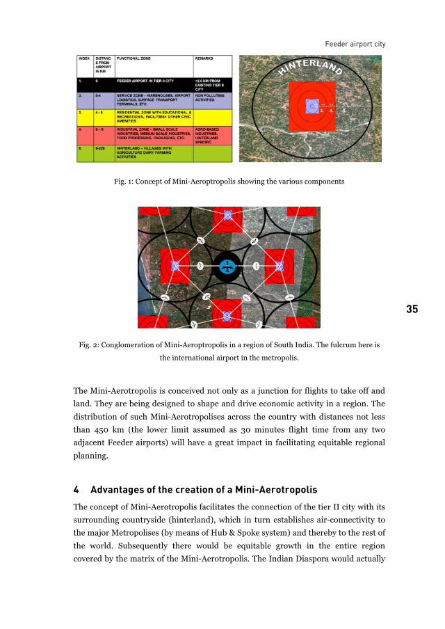
3 Feeder airport city as a Mini-Aerotropolis: The new paradigm Picture a dot and four circles around it, each larger than the preceding one. The dot
is the Feeder airport, the innermost circle, within 0 to 4.0 km from the airport, will
house businesses and facilities that feed the airport and feed off it—like trade zones,
warehouses and logistics hubs. The middle circle, 4.0 to 6.0 km in radius will have
residential quarters for people who work in the two inner and outer circles, including
civic amenities, like educational institutions, places of worship, etc. for additional
necessities. The next outer circle from 6.0 to 8.0 km radius will house companies,
medium scale industries like the agro-based industry, which are in consonance with
activates in the region surrounding the Feeder Airport, like the food processing
industry, canning industry, etc. The outer Circle with a diameter of up to 225 km
forms the hinterland to the Feeder Airport. These hinterlands could be
predominantly agricultural, fisheries (as in coastal areas), tourism based as in
regions with heritage buildings, religious/pilgrimage centres, nature endowed
1 http://www.siliconindia.com/magazine
Vasanth K. Bhat
34
regions etc. These outer circles are tangential to each other and hence cover the
entire geographical area of India.
Citing an example of Karnataka, a Federal state in south India, Hassan a tier II
city is close to the world heritage sites of Belur, Halebid, Bellary, also a tier II city
close to the heritage sites of Hampi, Ihole, Pattadkal, which attract international
tourists. Mangalore a tier II City is close to the fishing harbour of Malpe and also is
an educational and pilgrimage centre. This model applied to the country as a whole
would further stimulate economic growth across the country, especially in the
traditionally backward areas of the states of Bihar and Uttar Pradesh in North-India.
Given the huge land requirement and project cost, it is imperative to locate the
Feeder Airports in the outskirts of non-metro cities and towns, preferably in
wastelands or unfertile lands not fit for cultivation. The Feeder Airports thus located
will trigger a reverse flow of businesses from cities to towns, and spread the fruits of
economic success, across regions and people.
Hence, it is proposed that the “Dot” – the centre of this circle, where the Feeder
Airport is located will be situated at least about 10 km away from the tier II
city/town. This distance is important in order to preserve the original identity of the
city/town, its cultural heritage, its existing land-use patterns, property ownership
patterns, etc.
In terms of size, the airport is dwarfed by everything around it. Yet, it is the
primary reason the three circles along with the fourth outer circle being the
hinterland, can create a bustling, self-contained ecosystem. The essence of this
thought is to place the airport in the middle and build everything around it rather
than shunt an airport to the periphery of the city.
The Feeder Airport City – or the “Mini- Aerotropolis” is a concept the makers or
renovators of Airports in tier II towns in India can resort to in order to fulfil the
Government’s stated objective of “equitable distribution of wealth” in all regions of
India. This could be the guiding principle in the location of airports in Tier II cities
like Mangalore, Hubli, Nagpur, Durgapur, Kochi, Hassan, etc.
Based on my above arguments, I coin the term “MINI-AEROTROPOLIS” for the
Feeder Airport City, which besides the three outer circles, comprises the fourth
extreme circle, with a wide radius of say 225 km. Encompassing the entire region
benefiting from the Feeder Airport, i.e. the Hinterland. This is envisaged to be
multiplied many times over in the perspective of a large country like India, so as to
achieve equitable economic growth of the regions covered by the Feeder Airports.
Feeder airport city
35 35
Fig. 1: Concept of Mini-Aeroptropolis showing the various components
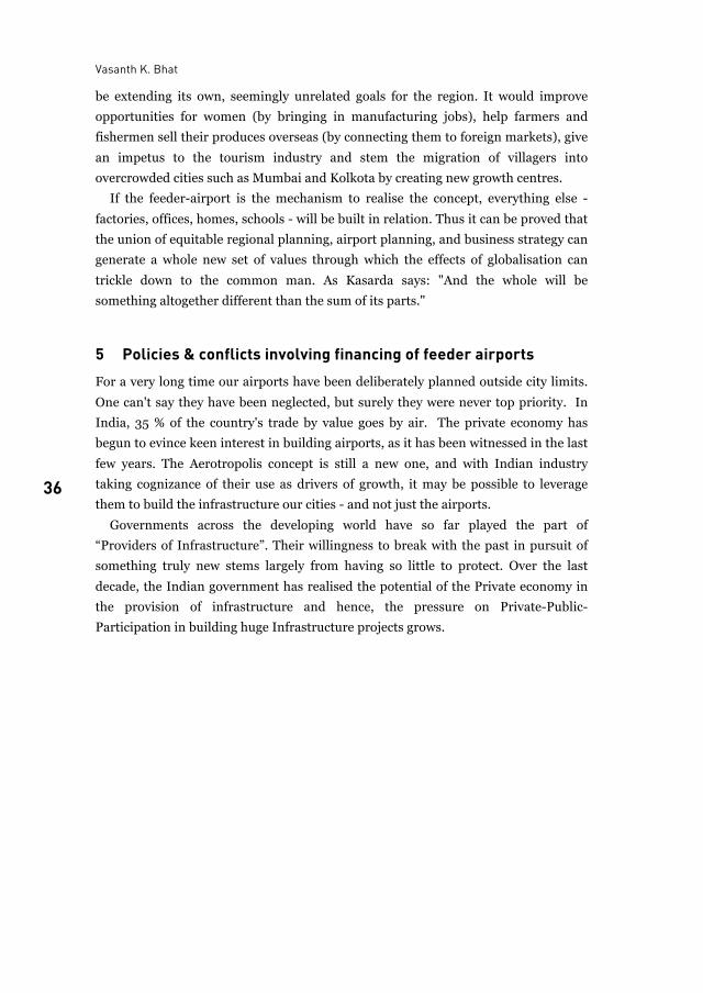
Fig. 2: Conglomeration of Mini-Aeroptropolis in a region of South India. The fulcrum here is
the international airport in the metropolis.
The Mini-Aerotropolis is conceived not only as a junction for flights to take off and
land. They are being designed to shape and drive economic activity in a region. The
distribution of such Mini-Aerotropolises across the country with distances not less
than 450 km (the lower limit assumed as 30 minutes flight time from any two
adjacent Feeder airports) will have a great impact in facilitating equitable regional
planning.
4 Advantages of the creation of a Mini-Aerotropolis The concept of Mini-Aerotropolis facilitates the connection of the tier II city with its
surrounding countryside (hinterland), which in turn establishes air-connectivity to
the major Metropolises (by means of Hub & Spoke system) and thereby to the rest of
the world. Subsequently there would be equitable growth in the entire region
covered by the matrix of the Mini-Aerotropolis. The Indian Diaspora would actually
Vasanth K. Bhat
36
be extending its own, seemingly unrelated goals for the region. It would improve
opportunities for women (by bringing in manufacturing jobs), help farmers and
fishermen sell their produces overseas (by connecting them to foreign markets), give
an impetus to the tourism industry and stem the migration of villagers into
overcrowded cities such as Mumbai and Kolkota by creating new growth centres.
If the feeder-airport is the mechanism to realise the concept, everything else -
factories, offices, homes, schools - will be built in relation. Thus it can be proved that
the union of equitable regional planning, airport planning, and business strategy can
generate a whole new set of values through which the effects of globalisation can
trickle down to the common man. As Kasarda says: "And the whole will be
something altogether different than the sum of its parts."
5 Policies & conflicts involving financing of feeder airports For a very long time our airports have been deliberately planned outside city limits.
One can't say they have been neglected, but surely they were never top priority. In
India, 35 % of the country's trade by value goes by air. The private economy has
begun to evince keen interest in building airports, as it has been witnessed in the last
few years. The Aerotropolis concept is still a new one, and with Indian industry
taking cognizance of their use as drivers of growth, it may be possible to leverage
them to build the infrastructure our cities - and not just the airports.
Governments across the developing world have so far played the part of
“Providers of Infrastructure”. Their willingness to break with the past in pursuit of
something truly new stems largely from having so little to protect. Over the last
decade, the Indian government has realised the potential of the Private economy in
the provision of infrastructure and hence, the pressure on Private-Public-
Participation in building huge Infrastructure projects grows.
Feeder airport city
37 37
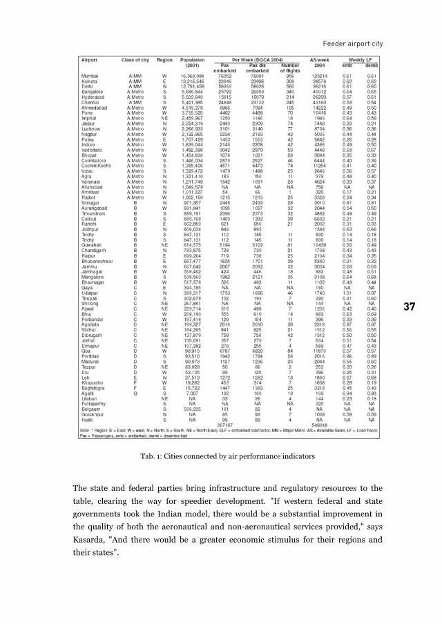
Tab. 1: Cities connected by air performance indicators
The state and federal parties bring infrastructure and regulatory resources to the
table, clearing the way for speedier development. "If western federal and state
governments took the Indian model, there would be a substantial improvement in
the quality of both the aeronautical and non-aeronautical services provided," says
Kasarda, "And there would be a greater economic stimulus for their regions and
their states”.
Vasanth K. Bhat
38
The private-sector model generates the greatest returns not only to the travelling
public and the cargo businesses, but it generates the highest quality services with an
emphasis on the non-aeronautical. To quote a few examples of the intense interest
shown by private investors in investing in Feeder Airport projects, real estate and
infrastructure firms like Super Airport Infrastructure, General Aviation Airfield and
Infrastructure, Anant Raj Industries, Adarsh Prime Projects and Aero Ports and
Infrastructure Projects Pvt. Ltd. have submitted proposals to the government to
build airports at various remote parts of the country. These include Karaikal in
Puducherry, Paladi Ramsinghpur in Rajasthan, Banaswad in Pune and Pernem in
Goa.
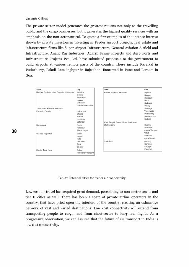
Tab. 2: Potential cities for feeder air connectivity
Low cost air travel has acquired great demand, percolating to non-metro towns and
tier II cities as well. There has been a spate of private airline operators in the
country, that have pried open the interiors of the country, creating an exhaustive
network of vast and varied destinations. Low cost connectivity will extend from
transporting people to cargo, and from short-sector to long-haul flights. As a
progressive observation, we can assume that the future of air transport in India is
low cost connectivity.
Feeder airport city
39 39
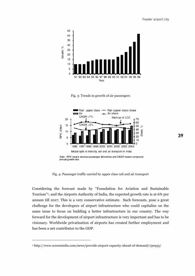
Fig. 3: Trends in growth of air passengers
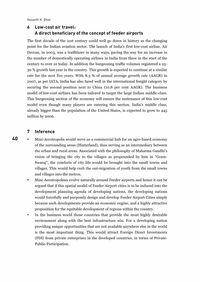
Fig. 4: Passenger traffic carried by upper class rail and air transport
Considering the forecast made by “Foundation for Aviation and Sustainable
Tourism”2, and the Airports Authority of India, the expected growth rate is at 6% per
annum till 2017. This is a very conservative estimate. Such forecasts, pose a great
challenge for the developers of airport infrastructure who could capitalise on the
same issue to focus on building a better infrastructure in our country. The way
forward for the development of airport infrastructure is very important and has to be
visionary. Worldwide privatisation of airports has created further employment and
has been a net contributor to the GDP.
2 http://www.screenindia.com/news/provide-airport-capacity-ahead-of-demand/130935/
Vasanth K. Bhat
40
6 Low-cost air travel: A direct beneficiary of the concept of feeder airports The first decade of the 21st century could well go down in history as the changing
point for the Indian aviation sector. The launch of India's first low-cost airline, Air
Deccan, in 2003, was a trailblazer in many ways, paving the way for an increase in
the number of domestically operating airlines in India from three in the start of the
century to over 10 today. In addition the burgeoning traffic volumes registered a 25-
30 % growth last year in the country. This growth is expected to continue at a similar
rate for the next five years. With 8.3 % of annual average growth rate (AAGR) in
2007, as per IATA, India has also fared well in the international freight category by
securing the second position next to China (10.8 per cent AAGR). The business
model of low-cost airlines has been tailored to target the large Indian middle-class.
This burgeoning section of the economy will ensure the sustenance of this low-cost
model even though many players are entering this section. India’s middle class,
already bigger than the population of the United States, is expected to grow to 445
million by 2006.
7 Inference • Mini-Aerotropolis would serve as a commercial hub for an agro-based economy
of the surrounding areas (Hinterland), thus serving as an intermediary between
the urban and rural areas. Associated with the philosophy of Mahatma Gandhi’s
vision of bringing the city to the villages as propounded by him in “Gram-
Swaraj”, the comforts of city life would be brought into the small towns and
villages. This would help curb the out-migration of youth from the small towns
and villages into the metros.
• Mini-Aerotropolises evolve naturally around Feeder airports and hence it can be
argued that if this spatial model of Feeder Airport cities is to be induced into the
development planning agenda of developing nations, the developing nations
would forcefully and purposely design and develop Feeder Airport Cities simply
because such developments provide an economic engine, and a highly attractive
proposition for the equitable development of regions within the country.
• In the business world those countries that provide the most highly desirable
environment along with the best infrastructure win. For a developing nation
providing unique opportunities that are not available anywhere else in the world
is the most important thing. This would attract Foreign Direct Investments
(FDI) from private enterprises in the developed countries, in terms of Private-
Public-Participation.
Feeder airport city
41 41
• Once the air connectivity through India’s Aerotropolises becomes reality, it
would lay the foundation for a truly inclusive economic growth along the length
and breadth of the country, rendering geographical distances meaningless.
• Besides reducing passenger and freight travel times, the economic benefits of
the spatial distribution of airport infrastructure would leverage lower land costs
and labour. This would not only ensure higher profitability and return of capital
for the private investor, but also ensure that the benefits of industrialisation
pass down to every region of India.
• The information technology and bio-technology industry would not need to
hinge their businesses around metros any more, and would have better access to
the intellectual capital in and around the tier II and tier III towns of India.
• Due to the emergence of Mini-Aerotropolises, India’s manufacturing and
farming sectors, outsourcing and tourism sectors, export markets, etc. would
have multiple benefits as goods and services would move faster via the cargo
and logistic hubs to domestic and international destinations.
List of figures
Fig. 1: Concept of Mini-Aeroptropolis showing the various components ....................................... 35Fig. 2: Conglomeration of Mini-Aeroptropolis in a region of South India. The fulcrum here is
the international airport in the metropolis.......................................................................... 35Fig. 3: Trends in growth of air passengers ....................................................................................... 39Fig. 4: Passenger traffic carried by upper class rail and air transport............................................. 39
List of tables
Tab. 1: Cities connected by air performance indicators ................................................................... 37Tab. 2: Potential cities for feeder air connectivity............................................................................ 38
References
K. Bhargava. Status of India's Airports. Aerodrome India. 2005. Show Special Publication
brought out by Indian Aviation. December 7, 2005.
R. E. Caves and D. G. Gosling. Strategic Airport Planning. Pergamon, 1999.
Census of India 1991. www.censusindia.net. 2001.
DGCA. http://www.dgca.nic.in/.
Indian Aviation. January/ February: 80. 2007.
J. D. Kasarda. The Aerotropolis. www.aerlines.nl. November 14, 2006.
B. Kodanda. Feeder and Short Haul Air Transport Systems: Current Issues Related to
Infrastructure Development for Sustainability of Civil Aviation Growth in India - Paper
presented at the Twenty-first National Convention of Aerospace Engineers, Kanpur.
November, 2007.
Vasanth K. Bhat
42
B. Kodanda, S. Chandra and K. Y. Narayan. Market Potential for Feeder Airline Operations in
India. Special Publication SP 0309, NAL. April, 2003.
K. Y. Narayan and B. Kodanda. Feeder Airline Operations in India – Present and Future.
Presented at Aerodrome India 2005: First International Exhibition and Seminar on
Airport Security and Infrastructure. Proceedings, Bangalore. December, 2005.
Dr. J. P. Rodrigue. Developing strategies for the modern international airport. Alan Williams,
Ashgate pub. Dept. of Global Studies & Geography, Hofstra University.
Prof. Vasanth K. Bhat is Professor at the Department of Architecture,
Dayananda Sagar College of Engineering, KS Layout, Bangalore 560078. India
43
Forecasting night flight movements at airports A methodological approach
Christian Blank and Tina Wagner
Air traffic forecasts are a crucial part of the approval procedures for airport extensions. Opponents often contest them, mainly because no different development scenarios are considered. The recent airport extension procedures in Germany revealed a growing concern over health impacts of flights during night time. This is reflected in a trend towards night flight restrictions at airports between 10 pm and 6 am. In this context a methodology for the estimation of future night flight movements at a specific airport has been developed. It builds on a detailed analysis of past and current patterns of night activities in relevant air traffic segments (such as cargo, mail, charter, low cost or long-haul routes) and on the general air traffic forecast.
1 Introduction In case of airport extensions in Germany the state departments are responsible for
the statutory approval-procedures. These procedures always contain an air traffic
forecast, provided by the airports’ operator. The forecast horizon is at least 15 years.
The opponents of airport extensions mostly criticize the forecasts results as well as
its methodology and bring it to court. Main critics are dealing with the fact, that
these forecasts do not consider scenarios of potential developments such as higher
fuel rates. For the approval-procedures only “one” estimation for the total number of
flight movements at the forecast horizon is required. This is mainly due to the fact
that all impact studies are based on the expected number of flight movements.
Preparing court hearings and justifying the planning approval notice, the state
departments often assign an independent institute with the quality assurance of
these forecasts. Having experience in this field we strongly recommend using the
scenario technique for air traffic forecasts because it leads to a better acceptance of
the forecast itself and the planning procedures. In consequence, the necessity of
further forecasts will be less likely.
Christian Blank and Tina Wagner
44
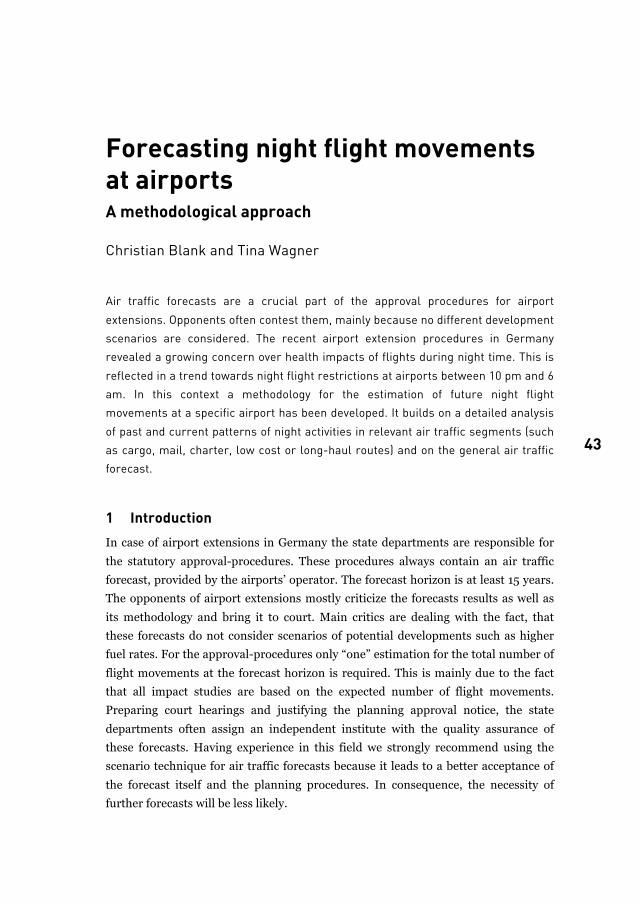
The recent airport extension procedures in Germany, particularly in Berlin, Leipzig,
Frankfurt and Munich, revealed a growing concern over the health impacts of night
flight movements and in consequence a trend towards a strict regulation of night
flights. Flight restrictions during night time target the reduction of noise impact of
taking off and landing aircrafts. There is a variety of such night flight restrictions,
which is illustrated for some significant European airports in Figure 1. The overview
points out that in Germany as well as in Europe there is no common standard of
night flight restrictions. Between 10 pm and 6 am the restrictions at the selected
airports differ in takeoff- and landing-time regulations. In dependency of considered
time slices there are curfews and / or movement quotas.
Fig. 1: Survey of night flight restrictions in Europe
Considering this framework, forecasts of future demand for flight movements and
more often, specifically for night flight movements are necessary in order to assess
the impact of night flight regulations on airlines. While general air transport
forecasts predict the number of flight movements at the forecast horizon, the
forecast of night flight movements additionally demands the estimation of their
future diurnal distribution. The forecast of future night flights at single airports is a
relatively new field of research. A review of the state of the art shows that there is no
best practice for a demand forecast of night flights.
Forecasting night flight movements at airports
45 45
The paper gives an overview of the methodology used to forecast the night flights of
two German hub airports in section 2. In section 3, the relevance of night-time
flights for different air traffic segments is illustrated and discussed based on
empirical analyses. Assumptions regarding the changing future demand to depart
and land at night time are presented in section 4. Next, the forecast methodology is
applied to a virtual hub airport (section 5). Finally, strategies for airports and
airlines to avoid landing and takeoff activities during night times are briefly
discussed in section 6. In section 7, conclusions are drawn and further research
questions are raised.
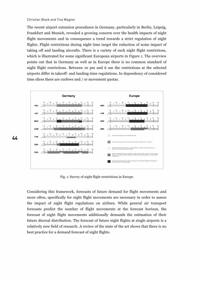
2 Methodology As mentioned above, there is no standardised method to forecast night flight
movements at airports. Generally, traffic forecasts combine quantitative analysis of
traffic structures and their determining factors in a reference year and project the
structures found into the future, taking into consideration possible structural
changes. The overall methodology we applied to forecast the demand for night flight
movements at a specific airport is illustrated in Figure 2.
Fig. 2: Methodological framework
Christian Blank and Tina Wagner
46
The methodology is based on two main analysis steps:
• A detailed quantitative analysis of current (i.e. reference year of the forecast)
and past patterns of night flight movements at the respective airport and
comparable airports, if possible.
• A qualitative and quantitative analysis of the general trends in aviation business
and historic trends of the specific airport
Based on the analysis, assumptions regarding the future demand to take off and land
at night time are developed (central forecasting issues), with regard to the expected
overall and airport specific growth and possible night operation restrictions.
The general idea of the forecast is that the demand for night flight movements is
highly dependent on the air traffic segment considered. For example, low cost
passenger traffic shows a higher share of daily flight movements operating at night
time than domestic passenger traffic. The segmentation (i.e. the share of total flight
movements that belongs to the aviation segments defined) applied for a forecast
depends on the airport considered. At regional airports like Hamburg-Lübeck or
Frankfurt-Hahn mainly low cost or tourist carriers operate and only few
intercontinental destinations are offered. Other airports like traditional carriers
serve the main hubs Frankfurt and Munich those focus on their intercontinental
connections. Some airports like Cologne or Leipzig focus on cargo transport that has
particular requirements for night operations. In section 3 segments for the forecast
of future demand for night flight movements at Frankfurt airport are listed and the
relevance and reasons for night flight movements of the segments are summarized.
If the segments considered for a specific airport grow at different paces, which is
likely, the overall demand of night flight movements will be affected. Higher growth
rates expected for cargo traffic than for passenger traffic will result in a greater share
of cargo jet movements at the forecast horizon. Besides the segmentation, the
demand for night flight movements of a specific segment might also change until the
forecast horizon. This can result from airline competition, for example if aircraft
operating hours are extended, a phenomenon that could be observed for many low
cost and tourist carriers in the past years. It can also be due to changing importance
of intercontinental connections that need late departures or early landings at the
airport considered.
Starting point of the estimation of night flight movements at a specific airport is a
forecast of total flight movements for the forecast horizon. Simple forecasts can be
based on trend projection; more sophisticated forecasts are based on complex
transport models. The number of total flight movements is disaggregated into air
traffic segments with different demands for night flight movements. These segments
are defined by type of traffic (i.e. passenger traffic, cargo and general aviation) and
destination (i.e. domestic, continental and intercontinental). Usually, the general
Forecasting night flight movements at airports
47 47
segmentation into passenger, cargo and general aviation is known from the total
flight movement forecast and can be adopted. However, a finer segmentation will be
necessary for most airports.
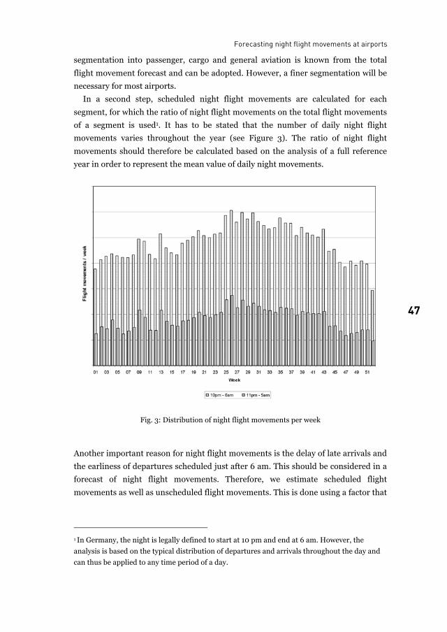
In a second step, scheduled night flight movements are calculated for each
segment, for which the ratio of night flight movements on the total flight movements
of a segment is used1. It has to be stated that the number of daily night flight
movements varies throughout the year (see Figure 3). The ratio of night flight
movements should therefore be calculated based on the analysis of a full reference
year in order to represent the mean value of daily night movements.
Fig. 3: Distribution of night flight movements per week
Another important reason for night flight movements is the delay of late arrivals and
the earliness of departures scheduled just after 6 am. This should be considered in a
forecast of night flight movements. Therefore, we estimate scheduled flight
movements as well as unscheduled flight movements. This is done using a factor that
1 In Germany, the night is legally defined to start at 10 pm and end at 6 am. However, the
analysis is based on the typical distribution of departures and arrivals throughout the day and
can thus be applied to any time period of a day.
Christian Blank and Tina Wagner
48
reflects the relation of unscheduled and scheduled flight movements during the
night.
While the analysis of current night flight movements at the airport considered is
straightforward, as detailed flight movement databases are maintained by the airport
operators, assumptions need to be made regarding the future segmentation, the
future night relevance of the segments as well as the future development of delay and
earliness issues. Both the analysis of the flight movement database and possible
assumptions regarding the future demand to depart and land at night are discussed
in more detail below.
3 Reasons for night flight movements The analyses presented in this section were performed for the German airports
Frankfurt and Munich. The selected figures illustrate relevant issues for the forecast.
It has to be stated at this point that the analysis of current night movements and
their interpretation has to acknowledge existing night movement restrictions, which
can be done by comparing night flight movements of different airports. In this paper,
we will not discuss this issue in depth.
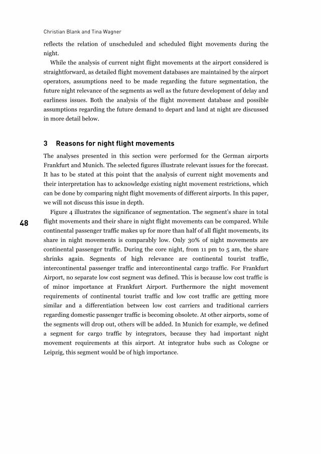
Figure 4 illustrates the significance of segmentation. The segment’s share in total
flight movements and their share in night flight movements can be compared. While
continental passenger traffic makes up for more than half of all flight movements, its
share in night movements is comparably low. Only 30% of night movements are
continental passenger traffic. During the core night, from 11 pm to 5 am, the share
shrinks again. Segments of high relevance are continental tourist traffic,
intercontinental passenger traffic and intercontinental cargo traffic. For Frankfurt
Airport, no separate low cost segment was defined. This is because low cost traffic is
of minor importance at Frankfurt Airport. Furthermore the night movement
requirements of continental tourist traffic and low cost traffic are getting more
similar and a differentiation between low cost carriers and traditional carriers
regarding domestic passenger traffic is becoming obsolete. At other airports, some of
the segments will drop out, others will be added. In Munich for example, we defined
a segment for cargo traffic by integrators, because they had important night
movement requirements at this airport. At integrator hubs such as Cologne or
Leipzig, this segment would be of high importance.
Forecasting night flight movements at airports
49 49
Fig. 4: Segmentation of air traffic at Frankfurt Airport
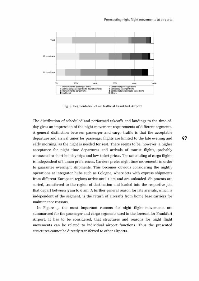
The distribution of scheduled and performed takeoffs and landings to the time-of-
day gives an impression of the night movement requirements of different segments.
A general distinction between passenger and cargo traffic is that the acceptable
departure and arrival times for passenger flights are limited to the late evening and
early morning, as the night is needed for rest. There seems to be, however, a higher
acceptance for night time departures and arrivals of tourist flights, probably
connected to short holiday trips and low-ticket prices. The scheduling of cargo flights
is independent of human preferences. Carriers prefer night time movements in order
to guarantee overnight shipments. This becomes obvious considering the nightly
operations at integrator hubs such as Cologne, where jets with express shipments
from different European regions arrive until 1 am and are unloaded. Shipments are
sorted, transferred to the region of destination and loaded into the respective jets
that depart between 3 am to 6 am. A further general reason for late arrivals, which is
independent of the segment, is the return of aircrafts from home base carriers for
maintenance reasons.
In Figure 5, the most important reasons for night flight movements are
summarized for the passenger and cargo segments used in the forecast for Frankfurt
Airport. It has to be considered, that structures and reasons for night flight
movements can be related to individual airport functions. Thus the presented
structures cannot be directly transferred to other airports.
Christian Blank and Tina Wagner
50
Fig. 5: Diurnal distribution of takeoffs and landings for different air traffic segments
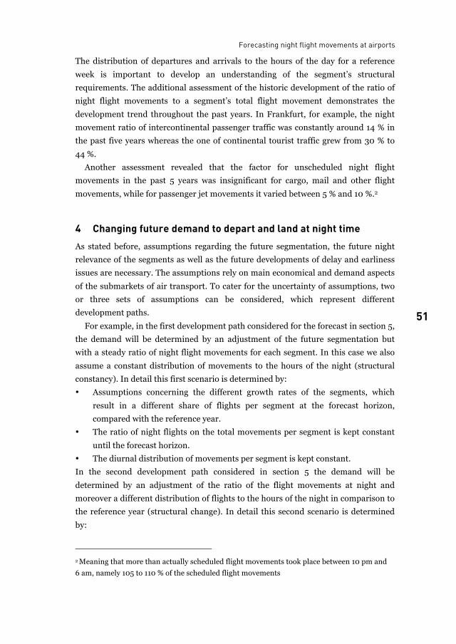
Forecasting night flight movements at airports
51 51
The distribution of departures and arrivals to the hours of the day for a reference
week is important to develop an understanding of the segment’s structural
requirements. The additional assessment of the historic development of the ratio of
night flight movements to a segment’s total flight movement demonstrates the
development trend throughout the past years. In Frankfurt, for example, the night
movement ratio of intercontinental passenger traffic was constantly around 14 % in
the past five years whereas the one of continental tourist traffic grew from 30 % to
44 %.
Another assessment revealed that the factor for unscheduled night flight
movements in the past 5 years was insignificant for cargo, mail and other flight
movements, while for passenger jet movements it varied between 5 % and 10 %.2
4 Changing future demand to depart and land at night time As stated before, assumptions regarding the future segmentation, the future night
relevance of the segments as well as the future developments of delay and earliness
issues are necessary. The assumptions rely on main economical and demand aspects
of the submarkets of air transport. To cater for the uncertainty of assumptions, two
or three sets of assumptions can be considered, which represent different
development paths.
For example, in the first development path considered for the forecast in section 5,
the demand will be determined by an adjustment of the future segmentation but
with a steady ratio of night flight movements for each segment. In this case we also
assume a constant distribution of movements to the hours of the night (structural
constancy). In detail this first scenario is determined by:
• Assumptions concerning the different growth rates of the segments, which
result in a different share of flights per segment at the forecast horizon,
compared with the reference year.
• The ratio of night flights on the total movements per segment is kept constant
until the forecast horizon.
• The diurnal distribution of movements per segment is kept constant.
In the second development path considered in section 5 the demand will be
determined by an adjustment of the ratio of the flight movements at night and
moreover a different distribution of flights to the hours of the night in comparison to
the reference year (structural change). In detail this second scenario is determined
by:
2 Meaning that more than actually scheduled flight movements took place between 10 pm and
6 am, namely 105 to 110 % of the scheduled flight movements
Christian Blank and Tina Wagner
52
• Assumptions concerning the different growth rates of the segments, which
result in a different share of flights per segment at the forecast horizon,
compared with the reference year (the segmentation is identical for both
scenarios).
• The ratio of night flight movements compared to the total flights per segment
will grow until the forecast horizon. This concerns the following segments:
• Intercontinental passenger traffic: Traffic to regions with high night flight
requirements (Asia, South Africa) grows above average. For example late
departures in Germany enable early arrivals in Asia. In the opposite direction
late departures from Asia or South Africa lead to early arrivals in Germany.
• Slight increase in aircraft operation time due to competition with low cost and
tourist carriers. However the optimization is limited by the preferences of
business passengers for certain arrival and departure times.
• Increasing importance of express over night shipments lead to a growing
demand of late and night time connections. Increasing late night Integrator
flights feeding into the Integrator hubs.
The specific ratio of night flights per hour of the night will change at the forecast
horizon, compared to the observed initial situation for the following segments:
• Intercontinental passenger traffic
• Continental passenger traffic (traditional carriers)
• Continental passenger traffic (tourist carriers)
5 Forecast for a hub airport Figure 6 summarizes the assumptions and results for the night flight movement
forecast of a virtual hub airport1. This virtual hub will manage a number of 600,000
flight movements at the forecast horizon 2020. The movements are allocated to
segments and sub-segments, as shown in Figure 6. The next step is to assume the
ratio of flight movements within the time slice from 10 pm to 6 pm and from 11 pm
to 5 am and to calculate the flight movements per night. Then, the delay-factor for
each segment is set and flight movements are calculated accordingly. The span of
assumptions related to the ratio of single flight segments is displayed in Figure 6 by
using the letter A and B. As mentioned in section 4, we named the different
development paths: Structural constancy and structural change. Future demand for
night flights at the virtual hub airport in case of structural constancy (structural
1 Because of the ongoing plan-approval procedure regarding the extension of Frankfurt Airport,
we changed the actual numbers and factors of the forecast for Frankfurt Airport to plausible
values of a virtual hub airport.
Forecasting night flight movements at airports
53 53
change) is calculated to 65 (76) movements per night between 11 pm and 5 am.
About 13 (13) additional movements will take place because of time schedule
divergence.
Fig. 6: Overview of the development paths
It becomes obvious, that night flight restrictions like the one designed for Frankfurt
only allowing 17 scheduled flight movements on average per night will have a serious
impact on airline operations. In the next section, some possible reactions of airlines
to night flight restrictions and their limitations are briefly discussed.
6 Possible reactions to night curfews and their limitations There are three possible reactions to night flight restrictions at airports:
• Relocating flight movements
• Rescheduling flight movements
• Cancelling flight movements
Christian Blank and Tina Wagner
54
Relocating flight movements to other airports requires an adequate infrastructure,
compatibility to the local night flight regulation, free slot capacity and an acceptable
landside connection to the final transport destination. There are a couple of
consequences of relocations for the airports, the airlines, regional and local actors,
passengers and cargo-runtime. In respect to the impacts of airlines there is a
difference between home and non home base carriers.
Carriers that have to relocate flight movements away from their home base cannot
use their own service infrastructure any more. As a consequence, they also have to
relocate maintenance capacity to the new airport. Moreover the crew has to stay at a
hotel instead of their home base and on the next day the daily rotation has to start
with a ferry flight to the main origin. All this generates additional costs.
Non home base carriers generally could relocate flights because they are not
bound to the airport. They easily could make new maintenance contracts without
many additional costs. In case of a night flight restriction at a hub airport night
flights might be cancelled instead of relocated, because flights that are bundled in a
hub and spoke system are obsolete, if they don’t reach the hub. In general, it is not
economical to relocate transfer passengers or transfer belly freight to other airports.
Rescheduling flight movements from the core night time to early or late daytime is
another possibility to avoid night flight movements. But initially the feasibility of
rescheduling depends on the availability of corresponding slots at the origin and
destination airports.
Rescheduling, however, is not feasible for all segments of air transport. Especially
line operating passenger airlines, integrators and night airmail operators are
integrated in hub and spoke networks. Rescheduling a single flight, which is
integrated in a balanced and optimized network, means that passengers or cargo
might miss the best connection. Therefore the overall transportation time would
increase. In consequence particularly premium passengers and senders of time-
sensitive cargo goods would decide for alternative airlines/airports. If, consequently
the capacity load factor declines, the price per passenger / per tonne needs to be
increased to make the flight profitable for the airline. Considering the competition in
the air transport market, the airlines cannot overprice without running the risk of
loosing passengers or cargo. If the revenue on flight operations declines the break-
even point, the cancellation of this service might become necessary.
7 Conclusions With ongoing air traffic growth and subsequent airport extensions, night flight
restrictions, which aim at reducing noise impacts of airports, are getting more
popular. In this context, forecasting night flight movements, evaluating the external
Forecasting night flight movements at airports
55 55
costs of night flights and assessing the importance of night flights for airlines emerge
as research fields.
In general, no best practice exists to forecast the future demand of night flight
movements. Thus we developed a straightforward methodology to forecast night
flights at a specific airport presented in this paper. It builds on a detailed analysis of
past and current patterns of night activities of relevant air traffic segments,
assumptions regarding the future importance of night movements and a general air
traffic forecast. A limitation of this approach is that the patterns of night movements
at an airport are usually already influenced by existing restrictions. This has to be
considered if such patterns are projected onto the future.
The analysis reveals that different air traffic segments require more night flight
movements than others. Reasons for night flights are diverse, ranging from
competition driven extension of aircraft operation hours to the demand driven
operations at night for cargo and intercontinental passenger traffic. In this context, it
is difficult to judge, which night flights are “essential”; certainly different perceptions
arise. Every scheduled flight that generates revenue might be essential for airlines.
People living close to the airport will certainly judge in a different way. In addition,
there are several constraints on rescheduling night flights or relocating them to other
airports.
In order to acquire an unbiased basis for the regulation of night flights, both the
external costs and the economic significance for airlines of night flight movements
need to be studied in more detail. Furthermore, possible relocation / rescheduling
strategies need to be assessed. To cater for competition issues, it might even be
necessary to tackle the issue of night flight regulation not only in the context of plan-
approval procedures for specific airports but also on a national or even global level.
List of figures
Fig. 1: Survey of night flight restrictions in Europe ......................................................................... 44Fig. 2: Methodological framework.................................................................................................... 45Fig. 3: Distribution of night flight movements per week ................................................................. 47Fig. 4: Segmentation of air traffic at Frankfurt Airport ................................................................... 49Fig. 5: Diurnal distribution of takeoffs and landings for different air traffic segments.................. 50Fig. 6: Overview of the development paths ...................................................................................... 53
References
This paper is based on consulting work of our Institute in the context of the airport extensions of Frankfurt and Munich airports. The related reports are unpublished and therefore, no references are given.

Christian Blank and Tina Wagner
56
Chrsitian Blank is an urban and transport planner and researcher at
Institute for Transport Planning and Logistics, Hamburg University of Technology (TUHH) D-21071 Hamburg, Germany
E-mail: [email protected]
Dr. Tina Wagner is a transport planner and civil engineer at
Hamburg Ministry of Urban Development and Environment Infrastructure Development Directorate
57 57
New office space at international hub airports Evolving urban patterns at Amsterdam and Frankfurt/M.
Sven C. M. Conventz
In recent years, international (hub-)airports like Amsterdam or Frankfurt have become vital nuclei of spatial development. One indicator are real estate market key numbers in general and office market key numbers in particular. Airport retailing has been analyzed in-depth so far. In contrast, the growing segment of airport office space has not been widely examined to date. That is to say, it is unclear whether office space can already be considered as a real estate submarket or not. Moreover it is uncertain if office space at airports should be perceived as an additional part of a local office market or as a competitive submarket.
This paper analyzes office space at airports by considering factors such as success, shortcomings, limiting factors, the spatial relationship to other locations as well as the future potential of such locations. Therefore, a methodologically mixed approach of different techniques such as desk and field research was chosen.
1 The past as prologue Technical developments have a deep impact on spatial patterns. Like in the 18th, 19th
and 20th century, rapid advances in transportation technologies such as railroads,
automobiles and airplanes largely define the 21st century. Each of these
transportation modes has strongly influenced the economy and has led to a specific
urban-locational pattern (Marshall, 2003). The last decades of the past century have
witnessed an amazing growth in the transportation industry mostly driven by the so
called globalization, causing tremendous impacts on the built environment. This
especially applies to airports. Hence, they are both consequence and driver of that
process. Additionally, the effects and development processes induced by airports
have often contributed to rewriting the metropolitan geography.
Sven C. M. Conventz
58
1.1 Impacts on the metropolitan geography
Today, most cities are not self-sufficient anymore but rather part of a metropolitan
area with several cities and emerging sub centres. Traditionally, the nucleus of an
urban area is the Central Business District (CBD) with its high concentration of
commercial land uses. Usually, it is the city’s most accessible area (Gregory et al.
2009: 75). Over the past decades, however, peripheral areas and nearby regional
centres have grown much faster than the central cities. Fundamental changes in
transportation technologies and telematics have established a new relationship
between central cities, metropolitan regions and other elements of the urban system.
One new spatial appearance within the contemporary urban and regional spatial
structure is the emergence of new and decentralized clusters of urban activities close
to areas of high accessibility. This trend is particularly evident in the US metropolis
whereas in Europe it is to a greater or lesser extent a new spatial phenomenon with
the airport as its most prominent representative and strongest engine (Kunzmann,
2001: 216; Garreau, 1991).
2 The morphogenesis of airports Many airports around the world – formerly planned as mechanistic-functional
solitaires in the city’s periphery – have gone through a transformation process from
small terminal facilities with planned arrival and departure halls into complex,
technical, commercial, urban and regional poles. Forced through new general
conditions within the international aviation industry, airport operators have to open
new business segments in order to realize additional non-aviation revenues to
supplement the traditional core business (e.g. ramp-handling, landing-fees…etc). In
this context, airports have started to concentrate their engagement not only on
supplying the core aeronautical infrastructure and services but also on the
development of the so called non-aviation sector where commercial facilities and
services play a key factor in terms of future growth (Ringbeck et al. 2006 / Deimler
et al. 2004).
The airport’s morphogenesis from an originally infrastructure facility to a more
and more urban-like entity entails not only an increase regarding the structural
elements but also an expansion in respect of customer groups (Warschun, 2007:
235). In addition to the intensification of airport retailing, the re-examination of the
airport’s strategic alignment includes the airport’s repositioning as real estate
developer. This applies in particular to office developments at the airport’s platform
and the bordering surroundings.
A second driving force that promotes the airports’ transformation into fully
functional city-like entities is the integration of airports into the high-speed rail
New office space at international hub airports
59 59
networks. Thus, airports have become multimodal interchanges integrating two hub
functions. While the airport is the hub on the airside, the airport’s train station
covers this function on the landside. This newly defined intermodality and
connectivity on the intersection of a local, regional and international scale facilitates
growth in passenger streams by using the location as conference and leisure
destination and finally by providing a place of work characterized by its high
accessibility for employees (Güller & Güller, 2003:125 / Harriehausen, 2009).
3 Case studies In the following the new office locational patterns around two international hub-
airports, namely Amsterdam-Schiphol and Frankfurt Rhein-Main, will be analyzed.
The analysis will be guided by the following research questions:
• Which stage have office-related developments reached and what are the
underlying forces?
• What are the factors of success and what are the limiting factors of the
development?
• Are these developments already to be considered as an office real estate
submarket and what is its spatial relationship to the total market?
3.1 The case of Amsterdam-Schiphol
The Randstad office market is the largest and most sophisticated office market in the
Netherlands. Within this market area, Schiphol is – in conjunction with the South
Axis (Zuidas) - considered the absolute prime office site. In the Amsterdam office
market1, tcontrary to what one might assume, it is not Amsterdam’s city centre that
is the most expensive office location. With an upper price limit of approximately 390
€/m², the current prime rent of the whole Netherlands is realized at Schiphol-Centre
followed by the South Axis with 375 €/m² and De Omval with 360 €/m². In
comparison to this, the city centre and the IJ Oevers come up with prime rental
values of around 300 respectively 295 €/m²(DTZ Zadelhoff, 2009).
The current office stock at Schiphol-Centre comprises nearly 195.700 m².
Prominent examples of office buildings at Schiphol Centre are the Schiphol World
Trade Centre, the Triport- or the Outlook Building (Schiphol Group, 2009). Due to a
number of completions and developments in the pipeline for the short term (e.g.
“The Outlook, phase 2”), the stock will grow by another 8 – 15 percent over the next
years (Jones Lang Lasalle, 2009: 11).
1 The analysis for Amsterdam follows the office market view according to DTZ Zadelfoff. All
stated prices are yearly rents per square meter.
Sven C. M. Conventz
60
From an international perspective, the corridor Schiphol – Zuidas is perceived as an
international top location within an otherwise modestly priced Dutch office market.
Nevertheless, one has to understand that the Dutch prime locations are moderate in
size, market dynamics and rents in comparison to other European top locations such
as London or Paris. This especially applies to Schiphol-Centre, which is classified as
small and relatively undynamic by experts (Jones Lang Lasalle, 2009: 16).
Apart from the office property related activities at Schiphol-Centre, ambitious and
high-end office developments have also taken place at other locations in the airport’s
vicinity. This particularly includes business sites in the municipality of
Haarlemmermeer where the airport is actually located. As examples, Schiphol (East,
South and Rijk), Hoofddrop Beukenhorst (East, West and South) or De Hoek can be
mentioned. Here, a diverse office market with differently specialized subzones and a
broad spectrum of rental ranges as well as office space occupiers has emerged. The
rents in the first half of 2009 ranged between 90 €/m² in Hoofddorp and 220 €/m²
as maximum in Beukenhorst South (DTZ Zadelhoff, 2009). The last years have
shown that internationally oriented companies offering higher business services
have favoured these locations. The demand is specifically attracted from industries
such as finance, consultancy, IT & telecommunications, retail, community and social
services, traffic and transportation or healthcare (cf. Amsterdam Airport Area,
2009). Hence, the demand is generated from companies that are not directly linked
to the aviation-business. In order to heighten the business estate’s attractiveness,
considerable efforts have been made notably in the field of business infrastructure
(e.g. hotels, conference facilities, gyms… etc.) and design qualities (e.g. business
boulevards, ponds… etc.). In addition to a further densification of office uses at
Schiphol-Centre, new office sites are planned at Beukenhorst and Schiphol-Elzenhof.
The latter is probably one of the most ambitious office projects in the nearer
surroundings of Schiphol Airport featuring an office area of roughly 200.000 m²
(SADC, 2009).
3.2 The case of Frankfurt Rhein-Main
Frankfurt is continental Europe’s leading financial centre and one of Germany’s
most important office centres. The city harbors more financial institutions than any
other continental European city. In addition to this, an array of companies offering
services related to the finance industry is located in the Rhein-Main metropolitan
area (DEGI, 2008: 72).
Within this office market,2 the airport has become an
expensive submarket over the last years. The City centre, including the subzones
2 The analysis for Frankfurt follows the office market view according to BNP Paribas Real
Estate (formerly Atisreal).
New office space at international hub airports
61 61
Bankenviertel, Westend, Innenstadt and Hauptbahnhof, is the most preferred and
most expensive area of the whole market. In the first half of 2009, the absolute
prime rent of 420 €/m² was achieved in Westend and Bankenviertel. In contrast to
this, the prime rents of 180 €/m² realized in the office cities such as Eschborn and
Niederrad were more than 50 % below the prime rental value of the overall market.
The airport again – located in the periphery approximately 6 minutes southwest of
Niederrad and 15 minutes south of Frankfurt’s CBD by public transit - records a top
rent of about 300 €/m² (BNP Paribas Real Estate, 2009). Recently, contractual
agreements with maximum rents of 408 €/m² have been registered (Schiner, 2009).
Thus, despite its peripheral location, the airport largely approximates the inner
cities’ prime rents.
The dynamic real estate and infrastructural developments as well as the increase
in letting successes have contributed to the airport’s emergence as an attractive
office location. Since the year 2005, the airport has been gradually introduced as a
new office submarket into the market inquiry of most real estate companies with
BNP Paribas Real Estate leading the way. Currently, 366.000 m² of office stock is
available only on the airport grounds. Including the whole submarket, it comes up to
more than 576.000 m² gross floor area (Stadt Frankfurt 2003). The demand for
office space is generated by industries such as human resources, traffic and
transportation, administration, finance and consultancies, healthcare as well as IT
and telecommunication (Conventz, 2008).
Today's office locations are the Frankfurt Airport Centre (FAC) I and II, Cargo
City South, Air Cargo Center / Airbizz and Cargo City North, all being localized on
the airport’s premises. In addition, there are office sites in close spatial linkage to the
airport either already existing or being in the implementation phase. Such locations
are for example the Main Airport Center (MAC), the AirRail-Center and Gateway
Gardens. Furthermore, there is office space projected at the Mönchhof Area and at
the Airport Office Centre (Fraport AG, 2009).
New office real estate developments will add a substantial contribution to the
revenues of Fraport, the owner and operator of the airport. According to Fraport, the
need of airport office space due to the airport expansion is expected to increase from
currently around 500.000 m² to approximately 650.000 m² in the year 2015. Office
stock that is out of date or not in line with the market requirements will thus be
taken out of the market (Hommerich 2006). Consequently, the current office stock
will decrease by the year 2015. At the same time, modern office estates will gradually
substitute this stock. These construction activities reflect the market’s high
dynamics.
Sven C. M. Conventz
62
3.3 Intermediate results
Structural changes in the world economy have promoted the new valorisation and
perception of airports and their hinterland. Office real estate developments and key
numbers are indicators of these changes. In this regard, the economy’s globalizing
process has an impact on both the demand as well as on the supply side. For the
demand side, time has turned the fundamental business performance variable.
Flexibility has become crucial especially for those companies that can be assigned to
the so called mobile industries. Such industries are generally marked by their
integration into international networks, their desk sharing practice, low transaction
costs, their high need of frequent (face-to face) contacts to clients and their time
sensitive working environment.
Airports as representatives of the supply side have been forced to rethink their
strategic alignment in order to face the consequences of globalization such as
liberalization and deregulation. One approach has been the consequent
repositioning of airports as real estate developers. Other underlying drivers
advancing airport office projects are the opening towards other protagonists (e.g.
property occupiers, developers, investors…etc.) as well as an intensified planning on
the part of different actor groups. This general framework has hauled the evolvement
of new office submarkets around airports. While in Amsterdam the developmental
status has made considerable progress due to the airports’ early opening of airport
premises to office real estate projects, Frankfurt is in its start-up period. Here, the
submarket is characterized by a manageable amount of singular office buildings and
an already differentiated supply of office space (Conventz 2008).
4 Assessment and perception
4.1 The submarket’s factors of success
The location’s success arises from an array of different factors. The biggest locational
advantage is owed to the multimodal transportation links. Multimodality guarantees
accessibility while the airport’s integration into the airline’s network establishes the
city’s respectively the region’s connectivity with the world. This in turn implies for
example a higher flexibility in terms of rescheduling business appointments and a
broader choice concerning the mode of transportation.
An increased construction activity accompanied by a simultaneously growing
number of high-quality facilities (e.g. hotels, meeting and conference facilities) has
formulated a new multifunctional dimension of office space offering modern
specifications. This spatial concentration of different business facilities at the airport
New office space at international hub airports
63 63
and the close vicinity to locations with a strong international orientation helps
business travellers to reduce time consuming journeys and to avoid costs of
overnight stays.
The office supply itself is characterized by sophisticated architectural office
buildings with Class A office space. Although both cities dispose of relatively high
rates of vacant office space, there is a scarcity of high quality properties especially in
the prime submarkets. The new offer of office space at airports compensates this
deficit.
Moreover, airports are the spatial manifestation of the “hyper global” (Koolhaas,
1995: 1251). They represent mobility and flexibility. This kind of unique selling
proposition helps to underpin the self-image of many companies as globally
operating enterprises.
4.2 Limiting factors and shortcomings
Beside the advantages described above, there are also numerous limiting factors and
shortcomings that have to be addressed. The biggest stumbling block could arise
from the high lease prices. That applies especially to Frankfurt. In contrast to
Amsterdam, cheaper leasing options of high quality and easily accessible office space
are available in the immediate surroundings of Frankfurt’s airport (e.g. Niederrad).
Other impediments could result from the location itself, which is perceived as
isolated particularly in Frankfurt as well as from the extreme noise pollution.
According to some experts, a “certain robustness is required” on the part of the
employees. Beside this “stress test for employees”, the locations are not able to exist
autarkically due to the currently not fully developed infrastructure (Conventz,
2008). In this context, the supply of food for employees for example during lunch
break was frequently mentioned. Presently, the locations only provide an offer of
food at prices that correspond to the airports high- leveled prices.
Beyond this, the still insufficient urban design qualities (e.g. landscape architecture,
public space…etc.) have been criticized. Airports were originally designed with the
passenger in mind. Consequently, the airport’s environment is still primarily
adjusted to the passenger’s necessities.
Finally, the car accessibility during peak traffic periods and the critical situation
regarding parking lots as well as the parking fees are seen as problematic (Conventz,
2008).
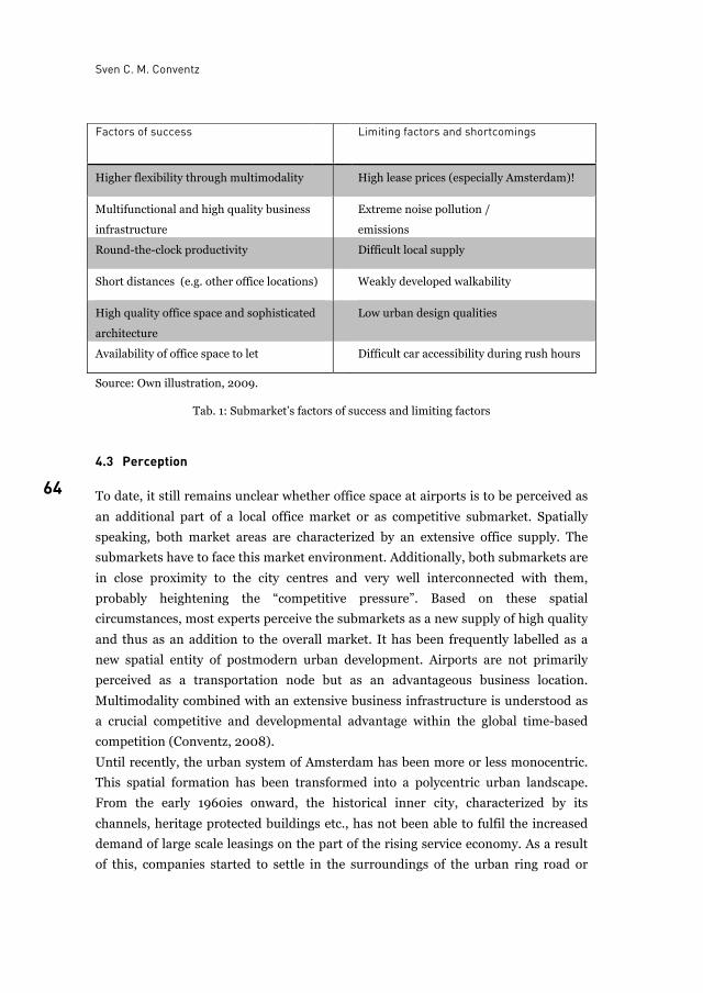
Sven C. M. Conventz
64
Source: Own illustration, 2009.
Tab. 1: Submarket’s factors of success and limiting factors
4.3 Perception
To date, it still remains unclear whether office space at airports is to be perceived as
an additional part of a local office market or as competitive submarket. Spatially
speaking, both market areas are characterized by an extensive office supply. The
submarkets have to face this market environment. Additionally, both submarkets are
in close proximity to the city centres and very well interconnected with them,
probably heightening the “competitive pressure”. Based on these spatial
circumstances, most experts perceive the submarkets as a new supply of high quality
and thus as an addition to the overall market. It has been frequently labelled as a
new spatial entity of postmodern urban development. Airports are not primarily
perceived as a transportation node but as an advantageous business location.
Multimodality combined with an extensive business infrastructure is understood as
a crucial competitive and developmental advantage within the global time-based
competition (Conventz, 2008).
Until recently, the urban system of Amsterdam has been more or less monocentric.
This spatial formation has been transformed into a polycentric urban landscape.
From the early 1960ies onward, the historical inner city, characterized by its
channels, heritage protected buildings etc., has not been able to fulfil the increased
demand of large scale leasings on the part of the rising service economy. As a result
of this, companies started to settle in the surroundings of the urban ring road or
Factors of success Limiting factors and shortcomings
Higher flexibility through multimodality High lease prices (especially Amsterdam)!
Multifunctional and high quality business
infrastructure
Extreme noise pollution /
emissions
Round-the-clock productivity Difficult local supply
Short distances (e.g. other office locations) Weakly developed walkability
High quality office space and sophisticated
architecture
Low urban design qualities
Availability of office space to let Difficult car accessibility during rush hours
New office space at international hub airports
65 65
sometimes further away. This relocation has been intensified by the city centre’s
accessibility problems. Under this spatial condition, the relationship is consistently
positively perceived (Salet, Majoor, 2005 / Conventz, 2008).
In Frankfurt, the risk of a competitive situation between an office submarket at
the airport and the total market is assessed as relatively low especially under the
assumption of ongoing investments in the inner city. Instead, a division of labour
between the locations of the inner city areas and the airport is expected. While the
traditional districts will still accommodate for example banking and other finance
industry related services, the airport will be chiefly in demand among mobile
industries (Conventz, 2008).
Another reason for the positive perception of office space at Amsterdam-Schiphol
and Frankfurt Rhein-Main results from the scarcity of high quality properties in the
city’s prime submarkets. The new offer has a share in compensating this deficit.
In contrast to this, only a minority of experts observes a competitive relationship
to more “traditional” business locations for example within the core cities or the
suburban office locations such as Zuidas or Niederrad (Conventz, 2008).
5 Summary and concluding remarks Airports have been transformed into urban-like entities. The centralization of
activities formerly localized in the CBD and the emergence of office markets around
international (hub) airports indicate the airport’s morphogenesis. The results of the
analysis clarify that the enormous success of new offices at airports or their
surroundings is based on intelligent, comprehensive and innovative strategies on the
part of different protagonists. This kind of unique locational quality is exactly
tailored to the needs of the so called mobile industries. An increase in lettings and
the tenant groups’ willingness to pay top rental prices reflect this circumstance and
the demand for such locations. Thus, hub-airports have become essential for the
future successes in attracting companies and for the economic success in general.
For the future it is expected that prospective improvements of the design quality will
further contribute to fostering office submarkets at airports.
List of tables
Tab. 1: Submarket’s factors of success and limiting factors............................................................. 64
Sven C. M. Conventz
66
References
Amsterdam Airport Area. Office Locations. Retrieved April 24, 2009 from the Amsterdam
Airport Area Web Site: www.aaarea.nl. 2009.
BNP Paribas Real Estate. City Report Frankfurt. 2009.
S. Conventz. Näher bei der Welt – Büroteilmärkte an internationalen Hub-Airports. Das
Beispiel Frankfurt Rhein-Main im Vergleich zu Amsterdam-Schiphol. The University of
Bayreuth, Diploma thesis (unpublished). 2008.
M. Deimler, R. Love, D. Stelter. Airports, Dawn of a New Era. Preparing for the industry’s
biggest shake-ups. Retrieved May 29, 2007 from the Boston Consulting Web Site:
www.bcg.com/publications/files/BCGAirportsDawnNewEra.pdf. 2004.
Deutsche Gesellschaft für Immobilienfonds (DEGI). Neue Perspektiven. Marktreport
Deutschland 2008. 2008.
DTZ Zadelhoff. The Netherlands, a national picture. Fact sheets office and industrial property
market, mid 2009. 2009.
Fraport AG. Flächenentwicklung. Retrieved August 8, 2007 from the Fraport AG Web Site:
http://www.frankfurt-
airport.de/cms/default/rubrik/24/24603.flaechenentwicklung.html. 2009
J. Garreau. Edge City: Life on the new frontier. 1991.
D. Gergory, R. Johnston, G. Pratt, M. J. Watts, S. Whatmore. The Dictionary of Human
Geography. 2009.
M. Güller, M. Güller. From Airport to Airport City. 2003.
C. Harriehausen. Hochgeschwindigkeit hat ihren Preis. Frankfurter Allgemeine
Sonntagszeitung. 2009.
C. Hommerich. Chancen für die Airport City? Fraport AG (Presentation). 2006.
Jones Lang Lasalle. Dutch Office Market Outlook 2009. Randstad Core Market. 2009.
J. Kasarda. Shopping in the airport city and the aerotropolis. New retail destination in the
aviation century. 2008.
Knight Frank. Amsterdam Office Market Report. 2008.
R. Koolhaas. Harvard Project on the City. Harvard Design School Guide to Shopping. 2001.
R. Koolhaas. S, M, L, XL. 1995.
K. R. Kunzmann. Welche Zukünfte für Suburbia? Acht Inseln im Archipel der Stadtregion. In:
K. Brake, J. S. Dangschat, G. Herfert (Hrsg.). Suburbanisierung in Deutschland.
Aktuelle Tendenzen. 2001.
A. Marshall. The Future of Transportation. Will the Auto and Airplane Reign Supreme? In:
Planning. The Magazin of the American Planning Association. 2003.
M. Oechsle. Erweiterungen von Geschäftsfeldern im Non-Aviation-Bereich an europäischen
Flughäfen unter besonderer Berücksichtigung des Standorts München. 2005.
J. Ringbeck, R. Hauser, M. Franke, E Clayton. „Aero“ – Dynamik im Europäischen
Flughafensektor. Neuausrichtung wegen veränderter Nachfrage und Kostendruck
erforderlich. Retrieved May 29, 2007 from the Booz Allen Hamilton Web Site:
http://www.dfld.de/Downloads/050531_BoozAllen_Aero-Dynamik.pdf. 2006.
Schiphol Area Development Company (S.A.D.C.). Office Location Elzenhof. Retrieved April 24,
2009 from the S.A.D.C. Web Site: http://www.sadc.nl. 2009.
Schiphol Group. Property Locator. Retrieved July 27, 2009 from the Schiphol Group Web Site:
http://www.schipholgroup.nl/Business/SchipholRealEstate..htm. 2009.

New office space at international hub airports
67 67
Stadt Frankfurt. Büroflächenentwicklung in Frankfurt am Main. Untersuchung zur
Entwicklung des Büroflächenmarktes 2002 – 2012. Juli 2003.
W. Salet, S. Majoor. Amsterdam Zuidas. European Space. 2005.
S. Schiner. Ärzte können am Flughafen bald durchstarten. Retrieved July 30, 2009 from the
Ärzte Zeitung Web Site: www.aerztezeitung.de. 2009.
M. Warschun. Verkehrsknotenpunkte – Handelsstandorte der Zukunft. In: Handel im Fokus.
2007.
Sven C. M. Conventz is a geographer and researcher at
Institute of Urban and Regional Planning, Department of Civil Engineering Geo- and Environmental Sciences, 76131 Karlsruhe, Germany
E-mail: [email protected]

68
69
The planning of airport regions and National Aviation Policy Issues and challenges in Australia 2008-2009
Robert Freestone and Douglas Baker
The planning of airports has long been contentious because of their localisation of negative impacts. The globalisation, commercialisation and deregulation of the aviation industry has unleashed powerful new economic forces both on and off-airport. Over the last two decades, many airports have evolved into airport cities located at the heart of the wider aerotropolis region. This shifts the appropriate scale of planning analysis towards broader regional concerns. However, governments have been slow to respond and airport planning usually remains poorly integrated with local, city and regional planning imperatives. The Australian experience exemplifies the divide. The privatization of major Australian airports from 1996 has seen billions of dollars spent on new airside and landside infrastructure but with little oversight from local and state authorities because the ultimate authority for on-airport development is the Federal Minister for Transport. Consequently, there have been growing tensions in many major airport regions between the private airport lessee and the broader community, exacerbated by both the building of highly conspicuous non-aeronautical developments and growing airport area congestion. This paper examines the urban planning content of Australia’s National Aviation Policy Review (2008-09) with reference to current and potential opportunities for all-of-region collaboration in the planning process.
1 Introduction The modern airport presents an almost insoluble planning conundrum in its
concatenation of benefits and costs over different geographic scales and particularly
its juxtaposition of localised disbenefits with more diffuse regional benefits (Short,
2004). While issues of noise, amenity, air quality and public safety have traditionally
dominated airport planning, discourse, responding to the broader planning impacts
of airports on property and economic development is generally less well advanced.
Yet this wider airport region is now recognised as an increasingly unsettled space
Robert Freestone and Douglas Baker
70
caught ‘‘in the crossfire of different ambitions“ (Güller and Güller, 2003, 144) and is
posing considerable challenges for regional planning governance (de Jong 2008;
Prins, 2008; Schaafsma et al, 2008).
This paper briefly surveys Australian manifestations of these challenges through
the lens of the National Aviation Policy Review conducted in 2008-09. It reports a
review and analysis of those submissions to a major government “Green Paper“
released late in 2008 relating specifically to airport planning and infrastructure
issues. The aim of the analysis is to recover the main types and sources of opinion on
contentious planning matters, including recognition of the idea of the airport region
as a planning construct, to point the way toward constructive resolution of conflicts
over airport development.
2 From airport city to airport region The attention given to place-specific contestation about airport expansion, site
selection and facilities development belies the reality of much more pervasive area
planning issues across all world regions. The fundamental problem is the divide
between airport and city planning. Both have grown in sophistication and
complexity through the years, yet the ways in which they interrelate are frequently
crude to non-existent. The historical reasons often lie in the national interest stake in
and control of airports, and correspondingly, their narrow conceptualisation as
specialised transportation centres requiring approaches set apart from more
everyday planning concerns. This divide is no longer sustainable since it inhibits the
optimal and equitable interdependent development of both airport and region.
In a globalised world, airports have become key infrastructural hubs in dynamic
city region economies. They are of particular interest to the private sector which has
helped transform them into mixed use activity precincts servicing both airport
employees and wider regional needs beyond just the travelling public. This is the
“airport city“ phenomenon, defined by Güller and Güller (2003, 70) as “the more or
less dense cluster of operational, airport-related activities, plus other commercial
and business concerns, on and around the airport platform“. The larger frame of
reference is what Kramer termed in 1990 the “airport formation“, exceeding the
spatial boundaries of the airport and stitching together a varied mix of airport-
bounded, airport-using and airport-susceptible activities (van den Berg et al., 1996).
These represent archetypal new economic spaces driven by the trans-national
relational geography of the network society. They almost invariably have developed
across a fragmented institutional landscape characterised by complex structures of
interests and coalitions - private, public, local, regional and interregional, national
The planning of airport regions and National Aviation Policy
71 71
and international - with differing values, interests, resources and authority (Salet
and Thornley, 2007).
A range of airport-related land use problems has arisen within the airport “frame“
area, including:
• lack of alignment between airport, city and regional planning;
• lack of integrated forward-looking spatial planning and joint-agreements;
• lack of coordination between different levels of government and other
stakeholders;
• blighted conditions where small-scale older uses have been disenfranchised
from wider improvement coalitions;
• competition, conflict and confusion between local authorities over development
philosophies and planning controls;
• equitable financing of infrastructure provision;
• traffic congestion at airports stimulated by airport-related commercial activity;
• uncertainty regarding optimal character of on- and near-airport commercial
development; and
• resistance from ’high street‘ traders and local municipalities to expansion of
retailing at airports.
Effective governance is hampered by two main factors: one, the conflict between
different sets of laws and policy objectives governing air and land, and two,
governments routinely being forced to compromise between proponents of action
exaggerating benefits and critics overstating costs of airport and airport-related
development (Appold et al., 2008). The outcome is almost invariably “mixed spatial-
economic results” in which “the relation between the airport and the wider urban
fabric of the city-region is underdeveloped” (van Wiljk, 2007, 16). Even Kasarda, the
main advocate of the “aerotropolis” model of urban form, concedes that most
development to date has been spontaneous and haphazard resulting in airport area
congestion and environmental problems – a long way short of the synergistic ideal of
integrated airport, urban and regional, and business site planning (Kasarda, 2001).
The capturing of benefits from airport and related development suggests the
desirability of a regional policy approach (Green, 2007). However, there are no ideal
models because of vast cultural differences in planning systems, land ownership,
development models and infrastructure provision. The Schiphol area is known for
innovative approaches to inter-stakeholder planning. However, its development and
governance has only evolved through “trial and error“ and still embodies more
universal tensions between national, regional, local and airport goals in relation to
economic growth, international competitiveness, accessibility versus amenity, and
the optimum balance between commercial and public interests (Appold et al., 2008).
For some critics it remains a region in turmoil with a “patchwork quilt“ of
Robert Freestone and Douglas Baker
72
governance, suggesting rather too much putative planning coordination (De Jong et
al., 2008). As a consequence, for here and elsewhere, more relational (actor-
oriented) and less territorial approaches to airport region planning have been
advanced (De Jong, 2008). Drawing on collaborative planning theory, the solution is
thought to rest in better methods of organizing connectivity (Salet and Thornley,
2007).
3 The Australian scene The need for the better articulation of spatial governance structures is similarly
apparent in Australian airport settings, but has rarely been explicitly addressed in
policy terms. An explanation may well lie in various factors including 1) the tripartite
structure of government (national, state, local) which creates little space for robust
regional and sub-regional strategies, 2) a concentration in the political arena on
“across the fence“ issues between airports and surrounding jurisdictions, and 3) the
continuing skew in public debate toward noise as the dominant airport planning
concern.
Most major capital city, general aviation and regional airports previously run by
the Federal Airports Corporation were privatised in 1996. This policy direction was
in line with the broader economic philosophy of neo-liberalism, evident elsewhere in
the global aviation industry with moves towards de-regulation and corporatisation
(Hooper et al., 2000). Over the last 13 years the basic provisions of the Airports Act
1996 have remained intact. Under the Australian Constitution, federal law prevails
for airport land to the exclusion of state and territory laws. Hence, a unique planning
approvals system was created. Key requirements are preparation of master plans for
twenty-year planning horizons every five years, major development plans for any
proposed work costing more than $20 million, and designation of building
comptrollers for approval of minor development. Formal public exhibition
requirements are stipulated. Both master and major development plans must now
address ‘consistency’ (or lack of) with local and state planning schemes, a provision
that does inject some acknowledgment of the external planning environment.
However, development and plan approval rests with the Commonwealth (federal)
Government in Canberra and specifically the Minister for Infrastructure, Transport,
Regional Development and Local Government. Parallel processes have been put in
place for the drafting of airport environmental strategies also updatable for five year
planning horizons. These also require the concurrence and ongoing scrutiny of a
separate Minister administering the federal Environmental Protection and
Biodiversity Conservation (EPBC) Act 1999.
The planning of airport regions and National Aviation Policy
73 73
Highly visible commercial development at airports over the last decade along with
the great increase in airport passenger and freight traffic promoted both by
deregulation of the airlines and globalisation have raised a variety of planning
challenges and problems which have been aired extensively through the courts,
popular media, inter-governmental dealings, and various public forums. Much of
this tension stimulated the federal government’s National Aviation Policy Review
initiated by the new Rudd Labor Government after its election in late 2007. This
policy review provides an opportunity to more systematically survey the nature and
extent of pertinent issues in the Australian sphere.
4 The National Aviation Policy Review The rationale for the National Aviation Policy Review reflected the need to stock take
a range of challenging circumstances, both global and local, in the aviation
environment. Urban planning issues took their place alongside other concerns
including customer and community protection, industry training, liberalisation of
airline policy, emissions and climate change, public safety, and security. The Federal
Department of Infrastructure, Transport, Regional Development and Local
Government (DITRDLG) has carriage of the Review. In the British Westminster
tradition, the Review produced an Issues Paper (April 2008) and a Green Paper
outlining preliminary proposals (December 2008) en route to a White Paper in the
last months of 2009.
The Issues Paper noted that although there had been “unprecedented investment
by private airport operators”, investment decisions must meet not only industry
needs but also allow “for proper consideration of developments and appropriate
recognition of the impacts on local communities” (Australian Government, 2008a).
The Paper posed questions such as ‘are airport planning and development
mechanisms working effectively?’ and ‘how can we improve consultation?’ It
attracted nearly 300 submissions. The main planning issues raised are summarised
in Table 1 and capture in outline the tranche of concerns which have been raised by
local and state governments, community organisations, and business groups who
comment on the scale of on-airport commercial development unregulated by normal
state planning controls since the late 1990s.
Robert Freestone and Douglas Baker
74
State and local government: • Lack of effective integration between federal, state and local planning regimes
• Local communities having to meet off site infrastructure costs to support airport expansion in the absence of mandatory developer contributions • Competitive advantage gained by airports conducting non-aviation based activities over commercial rivals that are subject to jurisdictional planning controls
• Master Plans and Major Development Plans lack specific detail and accompanying traffic and similar studies required for developments of a similar scale proposed for land outside airports. • Poor consultation with local communities over development proposals, especially for developments worth less than $20m
• Concern about lack of developer contributions (required by state law) to upgrade community infrastructure in response to increased activity and employment Airports: • The airports supported continuation of the ‘light-handed’ regulatory regime
• Complications and delays caused by operation of the interaction between the Airports Act and the Environment Planning and Biodiversity Conservation Act • Greater coordination of off-airport land use planning to prevent residential creep and high-rise encroachment on airspace
Airlines and operators: • Aeronautical requirements of airports and airlines should take precedence over non-aeronautical developments of airports.
Tab. 1: Planning issues raised in submissions to the Australian Government’s National Aviation Review Issues Paper released in April 2008
The Green Paper subsequently outlined a general blueprint for the aviation industry
(Australian Government, 2008b). The spread and depth of concerns overall aired in
submissions is more or less comparable between the two documents. The topic of
airport infrastructure, most directly denoting content relevant to airports and their
development, attracted the lion’s share of submissions (181 or 86% of the total) as
summarised in Figure 1.
Managing airport cities
75 75
Fig. 1: Concern about airport infrastructure and other issues in submissions to the Australian
Government’s Aviation Green Paper released in December 2008
The planning issues raised in the Green Paper submissions were categorised into 16
specific topics derived from both the contents of the Green Paper and the recording
of other airport planning issues raised in the submissions themselves. The discourse
was analysed by recording, for each submission, positions or judgements on issues
raised, arguments and proposals on issues, and emotional or rhetorical phrases
used. Each submission was also classified according to participant type and the main
airport discussed. The resulting database was sorted by participant, issue, and
airport to identify competing discourses and potential discourse coalitions. Table 2
outlines the 16 specific issues identified in order of importance and conveying the
broad canvas of opinion on planning-related matters.
Robert Freestone and Douglas Baker
76
Regional Airports: including significance of regional airports to regional development, international access to regional airports, desirability and cost of security measures, and funding programs for regional and remote airports (83). Planning Around Airports: including risk-based planning of off-airport development to allow for airport operation & growth, public safety zones around airports, planning under flight paths and to manage noise exposure, and general planning of airport regions (but not off-airport infrastructure planning) (70). Airport-Related Noise Mitigation: including desirability and operation of curfews, noise-insulation programs and industry funding for noise mitigation and compensation (65).
Airport Community Consultation: including desirability of establishing airport community consultation groups, compositions, roles and responsibilities, and procedural matters (64). Government Responsibilities in Airport Planning: including desirability of Commonwealth control over airport planning, jurisdiction over non-aeronautical development on airport land, intergovernmental coordination for airport-related development and Local Government control of smaller airports (64). Non-Aeronautical Uses at Airports: including potential impacts on aeronautical uses, desirability or need for non-aeronautical uses, and competition with similar uses outside airports (55). Airport Investment and Growth: Including impacts on investment from global financial crisis, oil depletion, and proposed regulatory changes, significance of non-aeronautical revenues to investment, desirability of airport investment/growth & alternatives to airport investments (54).
Airport-Related Noise Information Tools: including adequacy of Australian Noise Exposure Forecasts as planning information tools, web-based flight path information tools, the Transport Noise Information Package and providing noise exposure advice to home-buyers (53).
Off-Airport Transport and Community Infrastructure: including extent of airport impacts on surrounding infrastructure, infrastructure funding responsibilities and integrating planning of on- and off-airport infrastructure (53). Airport Master Planning: including accuracy and transparency of master plans, level of detail in master plans, and desirability of proposed changes to master planning including precinct plans (51).
Airport Planning Advisory Panels: including desirability of establishing panels, composition, roles and responsibilities, and funding (43).
Second Sydney Airport (SSA) and Sydney Airport Capacity: including desirability of second Sydney airport, alternatives to a second Sydney airport and possible locations (42). General Aviation at Airports: including significance of and provision for General Aviation (GA) at airports, noise from GA activities, location of GA airports (40).
Airport Development Control: including review of major development plan triggers, call-in power for sensitive developments and prohibition of incompatible uses on airport land (38). Airport Pricing: including desirability of more extensive price monitoring, price monitoring of airport car parking, and proposed ‘show cause’ process for pricing misbehaviour (31). Airport-Related Noise and Health Impacts: including health impacts of aviation noise, studies of health impacts, and use of health risk assessment for airport developments (14).
Tab. 2: A categorisation of airport planning issues raised in submissions to the Australian Government’s Green Paper on Aviation Policy, ranked ordered by the number of substantive
mentions in submissions (in parentheses)
The planning of airport regions and National Aviation Policy
77 77
Major airport planning issue
Business submissions
Community submissions
Government submissions
Regional Airports 1 13 1
Planning around Airports 2 9 2
Noise Mitigation 7 1 6
Community Consultation 10 2 10
Government responsibilities
4 5 4
Non-aeronautical uses 12 12 3
Airport Investment and Growth
3 4 13
Noise information 13 3 7
Off-Airport infrastructure 14 10 5
Airport Master Planning 8 8 9
Airport Planning Advisory Panels
5 15 8
Second Sydney Airport 9 11 12
General Aviation Airports 15 6 14
Airport Development Control
11 14 11
Airport Pricing 6 16 15
Noise and Health Impacts 16 7 16
Tab. 3: Major planning issues responses to the Australian Government’s Aviation Green Paper as ranked in submissions from the business, community and government sectors
Table 3 elaborates by showing the airport-related issues most frequently mentioned
overall and their varying significance according to three broad stakeholder groups:
business (including the airports), government (state and local) and community
interests. Regional airport concerns topped the list with 83 mentions, aided by a
letter writing campaign organised by Tourism Tropical North Queensland that
accounted for more than two dozen identical submissions. Regional airport
concerns, also mentioned by local councils responsible for managing regional
airports, included positive recognition of the role, which airports can play in regional
development. Airport pricing was primarily a concern for the business sector,
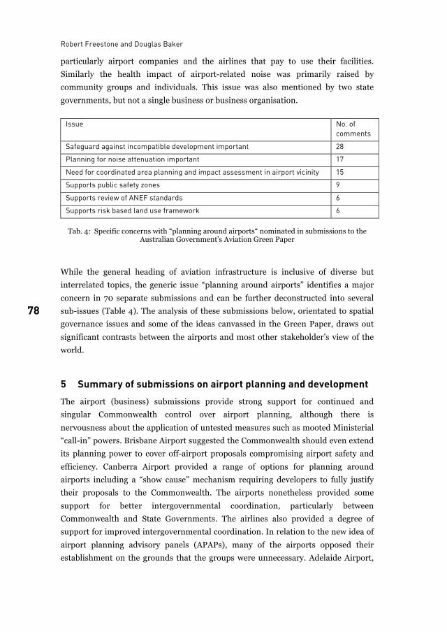
Robert Freestone and Douglas Baker
78
particularly airport companies and the airlines that pay to use their facilities.
Similarly the health impact of airport-related noise was primarily raised by
community groups and individuals. This issue was also mentioned by two state
governments, but not a single business or business organisation.
Issue No. of
comments
Safeguard against incompatible development important 28
Planning for noise attenuation important 17
Need for coordinated area planning and impact assessment in airport vicinity 15
Supports public safety zones 9
Supports review of ANEF standards 6
Supports risk based land use framework 6
Tab. 4: Specific concerns with “planning around airports“ nominated in submissions to the Australian Government’s Aviation Green Paper
While the general heading of aviation infrastructure is inclusive of diverse but
interrelated topics, the generic issue “planning around airports” identifies a major
concern in 70 separate submissions and can be further deconstructed into several
sub-issues (Table 4). The analysis of these submissions below, orientated to spatial
governance issues and some of the ideas canvassed in the Green Paper, draws out
significant contrasts between the airports and most other stakeholder’s view of the
world.
5 Summary of submissions on airport planning and development The airport (business) submissions provide strong support for continued and
singular Commonwealth control over airport planning, although there is
nervousness about the application of untested measures such as mooted Ministerial
“call-in” powers. Brisbane Airport suggested the Commonwealth should even extend
its planning power to cover off-airport proposals compromising airport safety and
efficiency. Canberra Airport provided a range of options for planning around
airports including a “show cause” mechanism requiring developers to fully justify
their proposals to the Commonwealth. The airports nonetheless provided some
support for better intergovernmental coordination, particularly between
Commonwealth and State Governments. The airlines also provided a degree of
support for improved intergovernmental coordination. In relation to the new idea of
airport planning advisory panels (APAPs), many of the airports opposed their
establishment on the grounds that the groups were unnecessary. Adelaide Airport,
The planning of airport regions and National Aviation Policy
79 79
with an effective consultative committee mechanism already in place, argued that
introducing APAPs carried the “very real risk” of conflict and confusion. Another
said that they might foster “uncertainty”. Other airport operators, such as
Bankstown and Australian Pacific Airports (Melbourne and Launceston), also
expressed concern, arguing that membership must be independent of local and
indeed State Governments. The Australian Airports Association argued there must
be “safeguards” against airport critics in any consultative process. Perth warned of
the danger of community consultation groups being “hijacked”.
The property industry, government and community submissions were strongly,
but not unanimously, opposed to continued sole Commonwealth airport planning
control, particularly in relation to commercial developments characterising the
evolution towards the ‘airport city’ model. The Shopping Centre Council argued that
“the most equitable approach” was for non-aeronautical developments to comply
with state and local planning regulations. Some government submissions indicated
that if planning approval role were to stay with the Commonwealth, non-
aeronautical developments should at least be tested against state and local
requirements for consistency. In relation to the idea of a “national land-use planning
regime” for airport-related noise, the Western Australian Government said it
opposed any shifting of off-airport planning responsibility to the Commonwealth.
Almost all of the property industry, government and community submissions,
however, supported the proposed APAPs. State government submissions generally
said state representatives should be on the panels, while local government
submissions predictably proposed council membership. In relation to
complementary community consultation groups, state and local governments were
supportive but warned of problems already evident with existing ad hoc airport
groups. The community group submissions were remarkably even less enthusiastic
for the same reason. While most supported improved community consultation, they
were highly critical of existing airport community consultation groups and processes.
6 Recognising the airport region Only a relatively small number of submissions explicitly commended integrated
airport area development as a desirable policy direction (Table 4). The strongest
endorsements came from local government interests, of which three are
representative. The Australian Mayoral Aviation Council said that “no airport exists
only within the boundary fence” and that planning processes need to better
coordinate conflicting objectives of airports and surrounding communities. The
Australian Local Government Association maintained that “airports in urban areas
are major generators of employment & traffic and therefore must be properly
Robert Freestone and Douglas Baker
80
integrated into local and city wide plans”. Thirdly, Brisbane City Council specifically
wanted a “well-balanced framework to enable an effective and sustainable
integration of Brisbane Airport with the urban fabric of Brisbane City and the
(South-East Queensland) region”. The most expansive view of airport related land
use planning beyond noise considerations was offered by a national business lobby
group, The Urban Taskforce, in arguing that “growth, commerce and industry must
not be unrealistically restricted near airports and it is the role of planning to
facilitate the right type of development”.
This issue of rationalised spatial governance, which goes to the heart of a more
synergistic model of planning at the airport-city interface, is barely touched upon.
The issue is nowhere explicitly canvassed within the Policy Review, perhaps partly
because of the inherited notion that the federal government should avoid
involvement in state and local land use planning issues except where operational
matters are concerned. As a result, the Green Paper largely treats airports in a rather
traditional fashion as entities disconnected from the broader metropolitan and
regional fabric, despite emphasizing their importance for economic development
and their potential disbenefits in environmental amenity terms. Beyond the airport
boundary, the formal interest conveyed by the Green Paper narrows very sharply to
noise, building height, and flight paths. In this sense it conveys an unbalanced or at
least incomplete vision. The primary concern is fixated on preventing
incompatibility rather than more pro-actively promoting compatibility.
7 Conclusion Schaafsma (2008, 78) comments that airport regions “are a new reality, often still
overlooked by planners and policy makers”. The recent Australian experience
confirms that this observation and many of the same planning issues evident
overseas surface albeit within a distinctive governance regime for major airports
created by the combination of privatisation and light-handed national regulation.
Australia’s National Aviation Review nevertheless foreshadows greater public
scrutiny of airport development, particularly non-aeronautical proposals. However,
submissions to the Green Paper of December 2008 as a sampling of national opinion
on airport planning issues indicate two distinct discourses across which a
rapprochement needs to be mediated.
On the one hand, airport business interests generally believe that existing airport
planning is effective and they are uneasy at any major policy changes, especially
given the major financial commitments which they have made under the
privatisation arrangements embodied in the Airports Act 1996. They want a
regulatory framework that provides investor certainty, support continued
The planning of airport regions and National Aviation Policy
81 81
Commonwealth control, but do see some merit in better integration of on- and off-
airport planning. They argue for state and local governments to accept their fair
share of responsibility for land-use and transport planning, and emphasise that off-
airport planning must be improved to ensure safe and efficient airport operations.
On the other hand, the property industry, state and local governments, and
communities believe existing airport planning is inadequate. They want a regulatory
regime that is fair and consistent with state planning laws. They can see some merit
in better integration of off- and on-airport planning to increase safety for airports
and nearby residents. However, they want new airport planning and consultation
measures to reduce the risks from airport developments and noise. They argue such
measures are necessary to increase certainty for surrounding businesses and
communities.
The challenge ahead for Australian aviation policy-makers will be to promote
constructive collaboration in planning for sustainable airport regions. The new
consultative mechanisms and augmented information requirements floated in the
Green Paper effectively signposted the formal recommendations in the climatic
White Paper released in December 2009 (Australian Government. 2009). More
information-sharing protocols and greater scrutiny of airport land use decision-
making, particularly with regard to commercial developments, will be put in place in
the wake of the National Aviation Review. However, no augmented statutory role for
state or local governments in federal airports will eventuate; oversight for airport
infrastructure development will stay firmly with the Commonwealth Government,
and in particular the relevant Minister. The “black hole“ remains the airport
environs. What is missing is the coherent vision for the future of the airport and the
region that can come from a more synoptic perspective within which the airport “can
take ... the role of a uniting rather than a dividing force” (Knippenberger, 2006, 9).
Although holistic airport area strategies have not emerged as a major topic of
deliberation though the National Aviation Review, they nonetheless constitute one
procedural innovation which could provide a more effective framework for
integrating the host of economic, environmental and social considerations, including
the realisation and rationalisation of area development potential, involved in the
better planning of airport regions.
List of figures
Fig. 1: Concern about airport infrastructure and other issues in submissions to the Australian Government’s Aviation Green Paper released in December 2008 ..................................... 75
Robert Freestone and Douglas Baker
82
List of tables
Tab. 1: Planning issues raised in submissions to the Australian Government’s National Aviation Review Issues Paper released in April 2008 ........................................................................74
Tab. 2: A categorisation of airport planning issues raised in submissions to the Australian Government’s Green Paper on Aviation Policy, ranked ordered by the number of substantive mentions in submissions (in parentheses) .......................................................76
Tab. 3: Major planning issues responses to the Australian Government’s Aviation Green Paper as ranked in submissions from the business, community and government sectors ...........77
Tab. 4: Specific concerns with “planning around airports“ nominated in submissions to the Australian Government’s Aviation Green Paper ..................................................................78
References
S. Appold et al. TUD-deelrapport Fase 2: ten behoeve van de Commissie Ruimtelijke
Ontwikkwling Luchthavens. TU Delft. 2008.
Australian Government. Towards a National Aviation Policy Statement. Issues Paper.
Canberra: Department of Infrastructure, Transport, Regional Development and Local
Government. 2008a.
Australian Government. National Aviation Policy Green Paper: Flight Path to the Future.
Canberra: Department of Infrastructure, Transport, Regional Development and Local
Government. 2008b.
Australian Government. National Aviation Policy White Paper: Flight Path to the Future.
Canberra: Department of Infrastructure, Transport, Regional Development and Local
Government. 2009.
J. Kasarda. From Airport City to Aerotropolis. Airport World 6(4): 42-45. August-September,
2001.
B. De Jong, P. Suau-Sanchez and M. Dross. The underestimated airport region: Reflecting on
planning policies in the airport regions of Amsterdam, Barcelona and Munich. Aerlines
e-zone dition 41: 1-5. 2008.
B. De Jong. Glocal Complexity and Airport Planning: Towards a more relational planning
approach. In: D. de Jong, B. Kaashoek & W-J Zondag (eds) Blue Skies or Storm Clouds?
Essays on Public Policy and Air Transport (Aerlines Magazine Foundation): 65-71.
2008.
R. K. Green. Airports and Economic Development. Real Estate Economics 35: 91-112. 2007.
P. Hooper, R. Cain, and S. White. The privatisation of Australia’s airports. Transportation
Research, Part E 36: 181-204. 2000.
U. Knippenberger. The hard factor: towards an integrated regional policy for airport
development at Frankfurt Rhine-Main airport. European Journal of Planning Online.
www.Planum.net. 2006.
M. Prins. Landing an Airport? Airport Development and Strategic Land use Planning in the EU.
Aerlines e-zone dition 43: 1-5. 2008.
W. Salet and A. Thornley. Institutional Influences on the Integration of Multilevel Governance
and Spatial Policy in European City-regions. Journal of Planning Education and
Research, 27: 188-198. 2007.
The planning of airport regions and National Aviation Policy
83 83
M. Schaafsma. Accessing Global City Regions. The Airport as a City. In: A. Thierstein and A.
Förster, (eds) The Image and the Region - Making Mega-City Regions Visible! Baden:
Lars Müller Publishers: 69-81. 2008.
M. Schaafsma, J. Amkreutz and M. Guller. Airport and City. Airport Corridors: Drivers of
economic development. Amsterdam: Schiphol Real Estate. 2008.
J. R. Short. Global Metropolitan: Globalizing cities in a capitalist world. London: Routledge.
2004.
L. van den Berg, H.A. Van Klink and P.M.J. Pol. Airports as centres of economic growth.
Transport Reviews 16(1): 55-65. 1996.
M. van Wiljk. Airports as Cityports in the City-region. Nederlands Geographical Studies 53,
Utrecht. 2007.
The paper reports on one facet of a major research project 2007-2011 entitled ‘The Airport Metropolis: Managing the Interfaces’ headquartered at the Queensland University of Technology and supported by the Australian Research Council. We acknowledge the research assistance of Peggy James in the analysis of submissions to the ‘Green Paper’
Prof. Robert Freestone is Professor in the Planning and Urban Development Program
University of New South Wales, Sydney, Australia E-mail: [email protected]
Prof. Douglas Baker is Professor at the School of Urban Development
Queensland University of Technology, Brisbane, Australia Email: [email protected]

84
85
The Luxembourg air freight-hub Market niche development, supply chain-insertion, global positionality
Markus Hesse
The Luxembourg airport hosts the fifth largest air freight-hub in Europe, which has been steadily developing over the last four decades. Ten percent of the world’s B747-400 freighter fleet is being operated here. A total of 3,245 people are employed in two cargo-centres as well ascarriers and freight forwarders. Three issues seem to be of interest in this particular case: first, the somehow accidental historical trajectory that started in the late 1960s/early 1970s, based on specific circum-stances in the regulatory environment, a niche position relative to major competitors in Western Europe and the successful insertion of firms (and thus the place) in global value chains and distribution networks. Second, as a result of the establishment of this specific network-place, it has gained an important relative position in the urban system that exceeds the significance of the material place by far (city and region comprising about 120,000 inhabitants, the country overall 480,000). Third, the Luxembourgish government has dedicated the logistics sector a focal point of its future economic development policy. Against this background, the paper critically discusses the potential for maintaining this position, given the volatility and vertical rather than horizontal structure of the global air freight chain that might not easily fit for cluster-policies focusing on regional impact. Places such as Luxembourg are neither airport city nor airport region, but intermediate in the very sense of this term. They are thus facing the risk of becoming victimized by changing corporate value chain-strategies.
1 Introduction This paper examines the case of Luxembourg as an air freight-hub in the context of
its economic geography, particularly regarding the ability of the place to become part
of global commodity chains. The capital of the Grand Duchy is situated in central
Western Europe and comprises a population of less than 90,000. Given that it is a
relatively small city, it is characterised by an extraordinary degree of regional and
Markus Hesse
86
international connectivity. By focusing on air freight logistics, the paper aims at
reconstructing the rise of Luxembourg airport to the fifth largest air freight-hub in
Europe. The more recent logistics performance of the place indicates that the city
gained its current status not only from banks and European institutions (and here
due to massive tax advantages), but also from becoming a node in global networks.
The contents of this paper are fourfold: After expressing the aim of the paper and
my argument, I will shortly put the issue of the paper into theoretical context, mainly
consisting of globalisation, commodity chains and the related role certain cities may
play. I will then present a case study on Luxembourg and air freight. Finally, I will
discuss these findings in the light of my argument.
What is my argument? First, Luxembourg became part of the global commodity-
circuit thanks to successful chain-insertion and based on strategic positioning.
Following a historical trajectory of airport and air traffic development, it is not only
the firms that achieve a certain competitive position in the global logistics
network/air freight commodity chain, but it is the place, understood as the complex
interplay of location, infrastructure, market niche-development and corporate
strategy, after all supported by increasing government intervention. However, the
advantage of Luxembourg might be limited, and there are certain challenges for the
government regarding the economic success and the sustainability of the cluster.
The empirical basis of the paper comes from ongoing research on Luxembourg as
a city within networks, subject to comparison alongside in Antwerp in Belgium. In
addition to statistical data assessment, several expert interviews have been held with
key corporate and government players during the first half of 2009, which this paper
draws upon.
2 Theoretical underpinnings Theoretical corridors that are being addressed include globalisation and global
production networks (Coe et al. 2004), the concept of the global commodity chain
(Bair, 2005) and the ways certain actors – and in this case places as well – can
become “inserted” into the chain. In order to conceptualise the related role of cities, I
will make particular reference to Sheppard’s notion of “positionality” (Sheppard,
2002).
A starting point is my contention that research on global commodity (or value)
chains has become increasingly popular, yet often omits physical issues such as
infrastructure, accessibility, land etc. – if you want “place” as a whole –, compared to
its focus on governance and institutions. However, as it is strikingly evident, the
significance of cities for flows (and vice versa) is fundamental. Along the historical
path of urbanisation, this relationship has changed dramatically. Being a central
The Luxembourg air freight-hub
87 87
place in the very sense of the word, cities have later specialised in organising flows:
as a gateway city, connecting foreland and hinterland, and as an intermediate city,
focusing on connecting other places, rather than being central on its own (cf. Hesse,
2008).
My question is to what degree cities, in particular the city of Luxembourg, are
involved in the management of commodity chains. Regarding port-city relationships,
Hall/Robbins (2007) have conceptualised different forms of chain involvement (see
Figure 1). Insertion means that it provides agents in supply chains with access to
critical resources such as technology, markets, capital, knowledge and expertise.
Once agents integrate activities within the supply chains, they aim at reducing
overall costs and providing services more efficiently. This is often done through
vertical and horizontal integration, in order to effectively extend control over the
chain. Dominance is the ability or power to extract value from localized (logistics)
activities on a sustained basis, e.g. by assuring control over scarce resources or
assets, or by further exploiting economies of scale. The traditional seaport can be
considered the prototypical case of dominance, at least of integration, whereas the
modern hub appears to be only loosely coupled to creating value. I will return to this
point later on.
Fig. 1: Supply chain insertion, integration, dominance (after Hall/Robbins 2007).
3 The Luxembourg air freight-sector The city of Luxembourg is the capital of the Grand Duchy and hosts about 90,000
inhabitants (120,000 in the region) and more than 140,000 jobs. The relatively
small size of the city is compensated for by an increasing “stretch” of job holders
Markus Hesse
88
beyond the borders.According to a recent study, the significance of metropolitan
jobs in Luxembourg appears to be rather unique (Sohn/Walther 2008).
“Metropolitan jobs” mainly include corporate services firms (comparable to the
FIRE-sector as in the U.S.) and comprise about 45 % of the labour force just in the
city of Luxembourg. This workforce developed quite dynamically in recent years.
What composes the quasi-metropolitan status of Luxembourg? Unlike the usual
cases, it is neither derived from mere size, the number of corporate headquarter
functions on site (albeit there are plenty of global firm offices represented) nor from
gateway-functions. Rather, it is the international significance of the city, as it is
indicated by the share of migrants in the city’s population (about 40 %) and by the
strong banking- and financial services-sector that was attracted to be located here by
a favourable fiscal environment. Also, European institutions have massively
reinforced the internationalisation of Luxembourg. The city can thus be considered
subject to processes of “metropolisation”, not necessarily being a metropolitan
region as such. Consequently, these processes contribute to the “city-ness” rather
than “town-ness” appeal of the city. Not surprisingly Luxembourg is posted in the
GaWC-classification of world city-formation at the Delta-level “Di”, indicating
relatively strong evidence for world city formation. It thus compares to cities such as
Dublin, Helsinki, Lyon or Vienna – cities that are far bigger …
Regarding the airport: Luxembourg-Findel hosts the fifth-largest air freight-hub
in Europe, handling freight since the late 1960s/early 1970s. Findel is the home base
of the largest ‘freight only’-air carrier worldwide, operating ten percent of the global
fleet of B747-400F airplanes. Based on this trajectory, the Luxembourgish
Government aims at supporting the development of a logistics “cluster”, besides the
airport also in road and intermodal affairs.
The spatial setting of Luxembourg as an airport-location is characterised by major
competitors surrounding, particularly Paris-CDG, Frankfurt and Amsterdam, also
London-LHR (see Figure 2). The former U.S.-airbase Hahn, not included in the map,
is being used by air freight companies as well. Luxembourg took off as an air traffic-
and air freight-locale almost accidentally, thanks to the supply of infrastructure (i.e.
due to the runway of 2.8 km, later on extended to 4 km) and its favoured location in
the heart of Western Europe. A second issue from the very beginning were specific
conditions of non-regulation, i.e. the offer of certain “Freedoms of the Air” that made
slots and foreign market access possible. Also, an early model of developing
Luxembourg as a “hub” for passenger travel failed, which shifted attention further
towards freight.
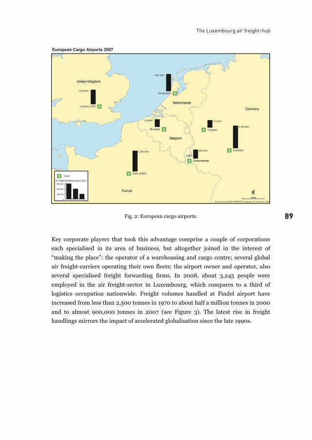
The Luxembourg air freight-hub
89 89 Fig. 2: European cargo airports.
Key corporate players that took this advantage comprise a couple of corporations
each specialised in its area of business, but altogether joined in the interest of
“making the place”: the operator of a warehousing and cargo centre; several global
air freight-carriers operating their own fleets; the airport owner and operator, also
several specialised freight forwarding firms. In 2008, about 3,245 people were
employed in the air freight-sector in Luxembourg, which compares to a third of
logistics occupation nationwide. Freight volumes handled at Findel airport have
increased from less than 2,500 tonnes in 1970 to about half a million tonnes in 2000
and to almost 900,000 tonnes in 2007 (see Figure 3). The latest rise in freight
handlings mirrors the impact of accelerated globalisation since the late 1990s.
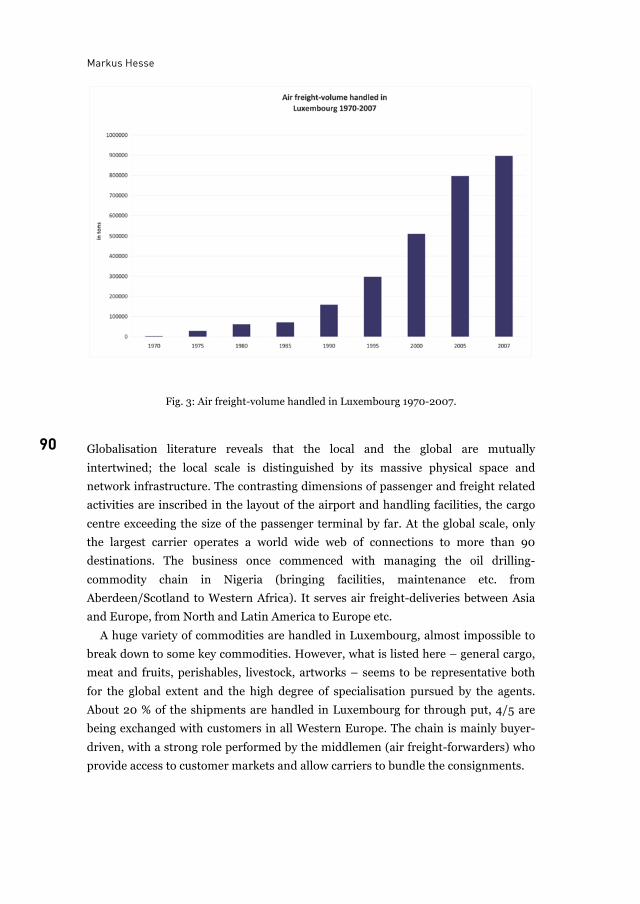
Markus Hesse
90
Fig. 3: Air freight-volume handled in Luxembourg 1970-2007.
Globalisation literature reveals that the local and the global are mutually
intertwined; the local scale is distinguished by its massive physical space and
network infrastructure. The contrasting dimensions of passenger and freight related
activities are inscribed in the layout of the airport and handling facilities, the cargo
centre exceeding the size of the passenger terminal by far. At the global scale, only
the largest carrier operates a world wide web of connections to more than 90
destinations. The business once commenced with managing the oil drilling-
commodity chain in Nigeria (bringing facilities, maintenance etc. from
Aberdeen/Scotland to Western Africa). It serves air freight-deliveries between Asia
and Europe, from North and Latin America to Europe etc.
A huge variety of commodities are handled in Luxembourg, almost impossible to
break down to some key commodities. However, what is listed here – general cargo,
meat and fruits, perishables, livestock, artworks – seems to be representative both
for the global extent and the high degree of specialisation pursued by the agents.
About 20 % of the shipments are handled in Luxembourg for through put, 4/5 are
being exchanged with customers in all Western Europe. The chain is mainly buyer-
driven, with a strong role performed by the middlemen (air freight-forwarders) who
provide access to customer markets and allow carriers to bundle the consignments.
The Luxembourg air freight-hub
91 91
4 Discussion: Why Luxembourg? How about place and chain? Luxembourg gained its current position regarding air freight almost accidentally,
based on specific circumstances in the regulatory environment, a niche position
relative to major competitors in Western Europe and the successful insertion of
firms (and thus the place) in the global commodity chain. Insofar, this adds to the
city’s portfolio: being a somehow central place for Europe, and an off-shore place for
the financial economy. Among the different modes of chain-involvement, I suggest it
is the case of insertion, rather than integration or even dominance. Insertion
renders the city, functioning as a hub and being intermediate, neither central nor
even gateway.
It is confirmed by interviewees that politics initially played a role in placing
Luxembourg on the air freight map, yet remained absent for a long time, even
though the state had been in favour of these developments (as a shareholder, by
offering tax incentives and a business-friendly climate, with direct access to decision
makers). However, only recently the government is strongly supporting logistics as a
matter of cluster development and promotes a related profile.
Regarding corporate management, time-space relations are essential for the
success of the firms (and thus the place), in different regards. First, a sophisticated
system of aircraft-turnover is being practiced, in order to achieve best possible load
factors etc., and also to cope with constraints such as landing restrictions after
midnight, flight delays etc. Second, the cargo-centre is operated in a 24/7 mode.
Third, an average freight load of about 120 tons of commodities can be un- or
reloaded within 2 hrs, thanks to the layout of the cargo-centre and the short door-to-
door distance (200 m) between aircraft and lorry.
The issue of time-space-management leads us to positionality. In the words of
Eric Sheppard (2002, 324): “Defining the status of […] cities by their position within
transnational networks, rather than by place-bound characteristics like size,
corporate headquarters, or dominant economic activities, one can see that the role
and trajectory of such cities is bound up with their positionality.” Luxembourg
appears prototypical for being well positioned related to the commodity chain:
• locally by providing plenty of space and direct access to infrastructure;
• regionally by being situated in the heart of Western Europe;
• globally by being placed in between different time-zones.
5 Conclusion Two points. First, there are certain threats or challenges for the commodity chain-
business and thus for the place to remain inserted:
Markus Hesse
92
• Peak oil and climate change may have the potential to work as a major
constraint to the business in the near future, since almost half of the operating
costs of air freight-carriers may account for fuel costs.
• The logistics business appears to be extremely fluid, volatile. Chains are not
stable but contested, subject to increasing competition. Mere insertion implies
the risk of losing a competitive advantage under changing framework
conditions.
• The vertical instead of horizontal management of the chain may hinder the
potential to establish a full-fledged regional cluster that is desired by economic
development.
• Finally, hubs tend to depend upon the routing & scheduling decisions made by
major shipping companies, which leaves them situated at the very end of the
power chain. There is the risk of a further de-centralisation of the air freight-
carrier network away from Luxembourg to other places in Southern Europe, as
it was observed in one case in 2008.
Second, the question is whether Luxembourg may represent a case of an “airport-
city” or “airport-region”? Answering this question is highly depending on what we
understand as a “city” or a “region”. According to a relational understanding of place
developed in human geography, globalisation includes “variegated processes of
spatial stretching and territorial perforation”. These processes “add up to the
displacement of … nested territorial formations … by a world of heterogeneous
spatial arrangements in terms of geographical shape, reach, influence and duration.”
(Amin 2004, 33)
In this emerging new order, spatial configurations and boundaries are no longer
territorial – at least not necessarily. Based on this point of view, Luxembourg is far
from being considered an “airport-city” or “-region”. Rather, this place is part of
economic networks that are stretching across the global scale, making accessibility
and flexibility the determinants of spatial development, and not the other way
around.
List of figures
Fig. 1: Supply chain insertion, integration, dominance....................................................................87Fig. 2: European cargo airports.........................................................................................................89Fig. 3: Air freight-volume handled in Luxembourg 1970-2007. ......................................................90
The Luxembourg air freight-hub
93 93
References
A. Amin. Regions Unbound. Towards a new politics of place. Geografisker Annaler 86 B (1): 33-
44. 2004.
J. Bair. Global Capitalism and Commodity Chains: Looking Back, Going Forward. Competition
and Change 9: 153-80. 2005.
N. Coe, M. Hess, H. Yeung, P. Dicken, J. Henderson. Globalizing regional development: a
global production networks perspective. Transactions of the Institute of British
Geographers 29: 468-84. 2004.
P. V. Hall, and G. Robbins. Which link, in which chain? Inserting Durban into global
automotive supply chains. In: J. Wang, D. Olivier, T. Notteboom, B. Slack (eds) Ports,
Cities, and Global Supply Chains: 221-31. Aldershot: Ashgate. 2007.
M. Hesse. The City as a Terminal. Logistics and Freight Transport in an Urban Context.
Aldershot: Ashgate. 2008.
E. Sheppard. The Spaces and Times of Globalization: Place, Scale, Networks, and Positionality.
Economic Geography 78 (3): 307-30. 2002.
C. Sohn, and O. Walther. Métropolisation et intégration transfrontalière: le paradoxe
luxembourgeois. Espace & Sociétés Nr. 134. 2008.
Prof. Dr. Markus Hesse is Professor of Urban Studies
University of Luxembourg, Geography and Spatial Planning Research Centre, L-7201 Walferdange, Luxembourg
E-mail: [email protected]

94
95
Global transfer points International airports and the future of cities and regions
Sven Kesselring
Airports are powerful institutions and infrastructures defining and shaping the relations and connectivities of a world of flows and mobilities. They are ‘glocal infrastructures’, built interfaces on the thresholds of territorial and global scales. The talk of fundamental airport dependencies signals a new wave in the transport-driven modernisation of society and the economy. Political controversies over the whys and wherefores of giant airports rage in the very centre of the ‘mobile risk society’, not on the periphery. At few other social “loci” do the local and the global interface so tangibly as at the great transfer points of international air traffic in London, Paris, Frankfurt, Amsterdam, or Madrid. This, it has been noted, has fundamentally changed the character of mobility politics and mobility policies. It has brought about and it propels ‘glocalisation’ and global interdependencies.
1 The structural transformation of mobility We are in the midst of a new transformation of spatial mobility. A dramatic increase
in the importance of ‘aeromobilities’ (Cwerner, Kesselring, Urry 2009), the airplane
and air travel accompanies the continuing economic and social importance of the
automobile and automobility. To be sure, the airplane is not as ubiquitous a part of
daily life as the automobile but the dependence of modern life on the accessibility,
reliability and convenience of globally interconnected air transport and the constant
deliveries of goods transported by airplanes continues to rise.
Air travel and international airports are emblematic of the globalisation and
cosmopolitisation of modern life. Interdependence, interconnectedness and
complexity are increasing in all economic, social and political realms. Ever more
products, semi-finished and finished goods, perishables and durables, not to
mention human beings, are transported by airplane. And yet the social sciences are
slow in calling attention to the degree to which transnationalisation, globalisation
and cosmopolitisation are being driven by the revolution in mobility technology and
the aeromobilities systems in particular.
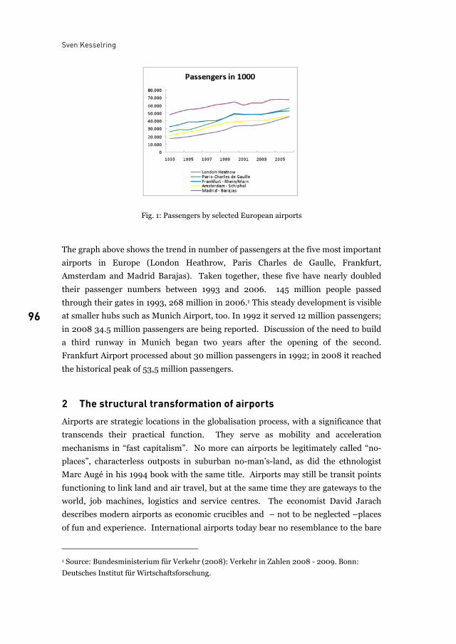
Sven Kesselring
96
Fig. 1: Passengers by selected European airports
The graph above shows the trend in number of passengers at the five most important
airports in Europe (London Heathrow, Paris Charles de Gaulle, Frankfurt,
Amsterdam and Madrid Barajas). Taken together, these five have nearly doubled
their passenger numbers between 1993 and 2006. 145 million people passed
through their gates in 1993, 268 million in 2006.1 This steady development is visible
at smaller hubs such as Munich Airport, too. In 1992 it served 12 million passengers;
in 2008 34.5 million passengers are being reported. Discussion of the need to build
a third runway in Munich began two years after the opening of the second.
Frankfurt Airport processed about 30 million passengers in 1992; in 2008 it reached
the historical peak of 53,5 million passengers.
2 The structural transformation of airports Airports are strategic locations in the globalisation process, with a significance that
transcends their practical function. They serve as mobility and acceleration
mechanisms in “fast capitalism”. No more can airports be legitimately called “no-
places”, characterless outposts in suburban no-man’s-land, as did the ethnologist
Marc Augé in his 1994 book with the same title. Airports may still be transit points
functioning to link land and air travel, but at the same time they are gateways to the
world, job machines, logistics and service centres. The economist David Jarach
describes modern airports as economic crucibles and – not to be neglected –places
of fun and experience. International airports today bear no resemblance to the bare
1 Source: Bundesministerium für Verkehr (2008): Verkehr in Zahlen 2008 - 2009. Bonn:
Deutsches Institut für Wirtschaftsforschung.
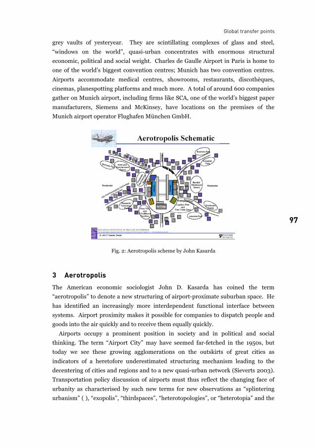
Global transfer points
97 97
grey vaults of yesteryear. They are scintillating complexes of glass and steel,
“windows on the world”, quasi-urban concentrates with enormous structural
economic, political and social weight. Charles de Gaulle Airport in Paris is home to
one of the world’s biggest convention centres; Munich has two convention centres.
Airports accommodate medical centres, showrooms, restaurants, discothèques,
cinemas, planespotting platforms and much more. A total of around 600 companies
gather on Munich airport, including firms like SCA, one of the world’s biggest paper
manufacturers, Siemens and McKinsey, have locations on the premises of the
Munich airport operator Flughafen München GmbH.
Fig. 2: Aerotropolis scheme by John Kasarda
3 Aerotropolis The American economic sociologist John D. Kasarda has coined the term
“aerotropolis” to denote a new structuring of airport-proximate suburban space. He
has identified an increasingly more interdependent functional interface between systems. Airport proximity makes it possible for companies to dispatch people and
goods into the air quickly and to receive them equally quickly. Airports occupy a prominent position in society and in political and social
thinking. The term “Airport City” may have seemed far-fetched in the 1950s, but
today we see these growing agglomerations on the outskirts of great cities as
indicators of a heretofore underestimated structuring mechanism leading to the
decentering of cities and regions and to a new quasi-urban network (Sieverts 2003).
Transportation policy discussion of airports must thus reflect the changing face of
urbanity as characterised by such new terms for new observations as “splintering
urbanism” ( ), “exopolis”, “thirdspaces”, “heterotopologies”, or “heterotopia” and the
Sven Kesselring
98
urbanism” ( ), “exopolis”, “thirdspaces”, “heterotopologies”, or “heterotopia” and the
“100 mile city”. Airports are part of an increasingly amorphous urban or quasi-urban
architecture of geographical space in which the boundary between the centre and the
periphery has become fluid.
4 Airports as embedded boundaries in the nation state Airport policy is also social policy that transcends the nation state. The creation of a
“European monotopia”, a common European domain with minimised geographic
and social resistances to mobility, is prominent on the agenda of the European
Union. This political project includes the creation of “open skies” in which
individuals can move relatively freely.
The 9/11 attack on the World Trade Center in New York dramatically changed the
world sense of security, with airports now seen as security risks. Without land
boundaries within the European monotopia, European airports represent a
boundary embedded in the nation state, which is defended and secured by complex
security and control assemblages (Salter 2008) to sort and detect.
EU airport security requirements have become much stricter since 9/11. The new
EU norm for airport security requires architectural changes to separate so-called
“clean flows” from “unclean flows”. The identification of “unclean persons” is
supposed to transform a diffuse risk situation into a clearly definable one.
Airports have become a greater presence in the public consciousness of political,
economic and social issues. With increasing global economic interdependence, the
geostrategic and geopolitical relevance of airports has increased, with flow
management and boundary management becoming transport and mobility policy
issues.
The cosmopolitanization of Europe (Beck, Grande 2004) depends primarily on
whether people and ideas can come together, how and when. Cosmopolitism is the
cultural side of globalisation. The more possible human relationships, interactions
and social networks become across great distances, the more ordinary and part of
everyday life and culture they get. This sounds so easy and banal. But in fact, the
omnipresence of aeromobilities in modern lives is accompanied by a profound and
deep going transformation of the social and the culture of social integration, social
connectivity and intimacy. Physical proximity is the prerequisite for the
confrontation with difference, whether positive or negative in outcome. If difference
and heterogeneity become mere risk potentials, the idea of an open society and an
open European monotopia is called into question. In this sense airports and air
travel raise fundamental questions and problems for societies, cities and regions.
Airports are not only economic factors or technologies to overcome space. They are
Global transfer points
99 99
mobility machines which indirectly impact and shape social life and regional and
local identities and cultures.
The issue as to whether open skies also mean an open society will (also) be
decided at the point where the local and the global meet, at airports. But perhaps
the exact opposite will be the case. Perhaps what happens at airports, where the real
and paranoid fears of the post-9/11 world culminate, foreshadows what awaits the
larger mobile society. Will these fears cause global capitalism to renege on its
promise to create an open society of free mobility?
References
M. Augé. Orte und Nicht-Orte. Vorüberlegungen zu einer Ethnologie der Einsamkeit. Frankfurt
am Main: S. Fischer. 1994.
U. Beck and E. Grande. Das kosmopolitische Europa. Gesellschaft und Politik in der Zweiten
Moderne. Frankfurt am Main: Suhrkamp. 2004.
S. C. Werner, S. Kesselring and J. Urry. Aeromobilities. London, New York N.Y.: Routledge.
2009.
M. B. Salter. The Global Airport. Managing Space, Speed, and Security. Politics at the airport.
Minneapolis: University of Minnesota Press: 1–28. 2008
T. Sieverts. Cities without cities. An interpretation of the Zwischenstadt. English language ed.
London, New York: Spon Press. 2003.
List of figures
Fig. 1: Passengers by selected European airports ............................................................................ 96Fig. 2: Aerotropolis scheme by John Kasarda.................................................................................. 97
Dr. Sven Kesselring is sociologist and researcher at the
TU München, mobil.TUM –project group mobility & transport, 80333 München, Germany E-mail: [email protected]

100
101
Airport-region governance Conundrums of airports and regional coherence
Ute Knippenberger
While noise impact and security constraints have been acknowledged topics of the airport-region relationship, the results of current land-use development in airport regions and the consequences for planning policy are yet under-researched. The following contribution represents part of my ongoing PhD-research. Using the example of the “Airport City” in Frankfurt Rhine-Main, in the PhD the aim is to explain the actual form of governance in the airport region. Part of the question here is what causes the lack of coherence in landside planning and how far the governance structures in the individual region contribute to this. Understanding airports as components of the socio-technical system air-transport contextualizes the research question. I will argue that this system collides with the spatial planning system, and that the collision illuminates general shortcomings in achieving regional coherence. As a conclusion it will be argued that collective mediation on the one hand and compensatory measures on the other are possible approaches of governance to tackle the complex issue. However, it is important that people need to know that time and effort put in will be rewarded with an amendment of airport-region governance. I will argue, that the individual and general preconditions of the airport-region relation have to be analysed thoroughly. They determine the applicability of certain forms of governance. The argument will be underpinned by some findings at the example of Frankfurt Rhine-Main.
1 The spatial transformation of airports The transformation of airports towards multifunctional places is, in terms of spatial
planning, a relatively new phenomenon. Even if airports have always hosted a
limited set of services such as hotels, conference space and retail, the development of
the past 15 years marks a tipping-point: the discovery of the airport as a real-estate
asset, the “Airport City”. The market deregulation and the resulting competition are
the main drivers for this (Burghouwt and Huys, 2003). Airports have reacted to this
development by strategically expanding non-aviation service as a new source of
Ute Knippenberger
102
revenue (see fig. 1). Still we see many nuances in the conceptual implementation of
non-aviation concepts (Jarach, 2001), resulting in large hub-airports showing the
most substantial approaches.
Fig. 1: Schematic diagram of the strategy using airports as a source of revenue
At the same time we are faced with a partial rearrangement of space in general,
resulting in stronger centralities of metropolitan areas, also called the global city
development (Sassen, 1991). Airports, especially hubs, are entangled with these
agglomeration processes as drivers and beneficiaries of new centralities, with spatial
impacts beyond the airport fence. Thus we can understand airport cities as a
commercial product as well as an agglomeration process (see fig. 2).
Fig. 2: Schematic diagram of the agglomeration process of airport cities
The regulative environment surrounding airport operation, development and
enlargement is very complex. Privatization and market liberalisation have resulted in
different organizational forms of airport management and its relation to the
regulatory institutions. New methods of moderation and negotiation arose in the
massive conflicts between airports and their neighbours, which the conventional
Airport-region governance
103 103
procedures have not been able to cope with. The forms of negotiation and the
temporal horizon of the planning procedures are put into question. The conflicts
arising around the airport can also be seen as a conflict between groups who see
themselves as excluded from the benefits of globalization, but receiving its negative
externalities, and those participating in and welcoming the development (Kesselring,
2007).
Additionally the functional diversification of airports enlarges the scope of
regulation and puts further questions onto the applicability of the instruments.
Privatized airports as the obtainers of the national interest “accessibility by air” are
altering into highly diversified firms with strong real-estate departments. Thus they
become actors in a different field than actually perceived by politicians and society.
The conventional procedures seem incapable to develop a satisfying approach to this
new complexity. Considerations regarding the regulation and governance of the
“new airport” have to be accompanied by thoroughly elaborated analyses of the
governance structures.
Regardless of this, airports are still viewed in a rather sectoral way, the approval
procedures are mainly based on its infrastructural function. The impact on the
surrounding is focused on negative externalities opposed to the positive economic
effects. If we consider the studies done by the Airport Region Conference (Berthon
and Brigand 2001) we see a process of change here, in the sense that planners are
reflecting on the transformation of the airport. However the question how to deal
with the airport in an urban planning context remains open. This mainly emanates
from two aspects: the logic of the technical system air-traffic and the conundrum of
regional planning implementation.
2 Airports as components of large technical systems Following the arguments of Hughes and Mayntz, air-traffic can be understood as a
large technical system or a societal subsystem. These are characterised by an own
institutional framework, their own knowledge base, as well as norms and standards
(Hughes, 1987, Hughes/Mayntz 1988, Mayntz 1995 and Mayntz, 2009). The
hypothesis is for Mayntz that these systems and the societies they are connected with
show congruence in their evolution. Large technical systems (LTS) are especially
characterised by their physical presence. Whether electricity, water supplies or
transport: the LTS forms physical representations in the presence of nodes and
networks. Airports can therefore be understood as physical components of the LTS
air traffic. Their importance for nation building in a spatial sense of
infrastructuralisation is reflected in the approval process.
Ute Knippenberger
104
This also characterises the situation in Germany, where the planning of
infrastructures is subject to a specific legal procedure, exceptional from other
planning procedures. The sectoral procedure called Planfeststellungsverfahren has
been installed due to the national importance of infrastructure. It bundles together
all other procedures and is characterised by far-ranging interventions such as
possible expropriation of land. Regarding building development on the airport site
the sectoral plan encompasses any building activity and no zoning or urban planning
will apply.
The preferential treatment for infrastructure is justified with public interest in air
traffic. It is exactly this normative conception, inherent in the logic of the LTS, which
makes it so hard to deal with a diversified airport and its management as an actor. In
the actual extension procedure in Frankfurt the enactment labelled all commercial
uses on the airport site as “serving the public interest” (Hessisches Ministerium für
Wirtschaft, Verkehr und Landesentwicklung, 2007). Whether retail concessions or
logistics, the commercialisation of the airport site is argued to be necessary to
cushion the negative consequences of competition within the aviation industry. The
strategy can be detected at most airports, whether public or private. Zhang and
Zhang (2003) present findings that a public airport allowed to gain revenues from
concessions is more likely to increase overall welfare compared to a privately owned
one, but also compared to a public airport with restrictions to commercial revenue.
Over the last two decades, concession revenues have grown faster than aeronautical
revenue and have become a main revenue source. It is therefore hardly manageable
to draw a line on the airport between the procedures for aeronautical and non-
aeronautical development, especially since they are spatially entangled.
3 Rhine-Main: a functional “Airport Region”? The illustrated transformation now poses questions as to what we actually mean by
an airport. However, when speaking of an airport region relation the question arises:
what consitutes a region? Here we face a central problem of regional planning: the
administrative boundaries and institutional responsibilities rarely correspond to the
functional constitution of the region, whereas the airport catchment area often does.
Fürst (2005) argues that the term region applies also to a functional interaction of
flows by people, goods and money. This functional region is usually incongruent
with the administrative boundaries that exist in regions. He argues the governance
of regions being either territorial or functional. Especially in polycentric regions the
overlay of functional interactions is complex. If we take commuting patterns in
Germany as an example, in monocentric regions like Hamburg or Munich, most
commuters travel from the suburbs to the centres. Polycentric regions like Frankfurt
Airport-region governance
105 105
still show a significant flow of commuters into the main centre, but smaller centres
also attract. Disperse regions like the Ruhrgebiet are lacking a hierarchical pattern of
commuter-workplace interaction (Spiekermann, 1997).
When speaking of a functional “Airport Region”, we can consider some basic
numbers for landside access of different groups. Generally a hub-airport has a
catchment area of maximum 120 Minutes for international flight costumers. More
relevant, but also difficult to discover is the travel-time distance important for firms
of different branches, studies from Munich estimate the maximum travel time for
business passengers around 80 Minutes (STMWIVT, 2007). To distinguish its effect
from general agglomeration advantages seems almost impossible in the complicated
process of location decision. Though evidence for a location decision due to airport
vicinity is hard to isolate, some findings can be interrelated. As Appold and Kasarda
state in this publication, the ground access and the interconnectedness of the same
however is one criterion.
Considering findings about the internationalisation in Rhine-Main and the
location of internationalised firms on the micro- and meso level, we see some
evidence for this. Hoppe (2005) showed that on a meso (regional) level we see a
location of internationalized firms on the North-South Axis along the A5 (Autobahn)
that connects the airport with Frankfurt and its Western suburbs, supporting
Schaafsma’s (see p. 177) idea of an airport corridor. Also within the city level, we can
detect a locational concentration in a quarter best accessible from this axis in
Frankfurt, besides the clustering of banks in the CBD. However considering the
supply side, these locations are offering a lot of space and were developed as office
parks. But compared to other locations in the eastern part, whose land-accessibility
to the airport is less convenient, at least a tendency of internationalised firms to be
located in good interconnectivity to the airport can be assumed. This correlates
insofar with the office rental prices on a micro- and meso-level, as the airport itself
has climbed second behind the inner city and the banking district (NAI apollo,
2008). However, prices are also high in good accessible locations without
interconnectivity to the airport. And on a macro-level the Frankfurt region shows a
clear overall agglomeration tendency, stretching in an 80 km radius around
Frankfurt and the airport, where prospering and less prospering places can be most
distinguished by their land accessibility.
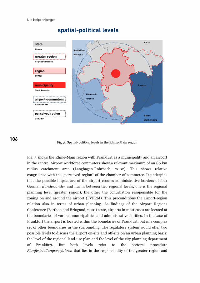
Ute Knippenberger
106 Fig. 3: Spatial-political levels in the Rhine-Main region
Fig. 3 shows the Rhine-Main region with Frankfurt as a municipality and an airport
in the centre. Airport workforce commuters show a relevant maximum of an 80 km
radius catchment area (Langhagen-Rohrbach, 2002). This shows relative
congruence with the „perceived region“ of the chamber of commerce. It underpins
that the possible impact are of the airport crosses administrative borders of four
German Bundesländer and lies in between two regional levels, one is the regional
planning level (greater region), the other the conurbation resoponsible for the
zoning on and around the airport (PVFRM). This preconditions the airport-region
relation also in terms of urban planning. As findings of the Airport Regions
Conference (Berthon and Bringand, 2001) state, airports in most cases are located at
the boundaries of various municipalities and administrative entities. In the case of
Frankfurt the airport is located within the boundaries of Frankfurt, but in a complex
set of other boundaries in the surrounding. The regulatory system would offer two
possible levels to discuss the airport on-site and off-site on an urban planning basis:
the level of the regional land-use plan and the level of the city planning department
of Frankfurt. But both levels refer to the sectoral procedure
Planfeststellungsverfahren that lies in the responsibility of the greater region and
Airport-region governance
107 107
the state. An additional mediation process Regionales Dialogforum accompanying
the sectoral procedure was focused on noise and environmental impacts. The
regional plan does consider the airport in terms of landside traffic, but planners have
to rely on the status quo of the approval. Any transformations happening later are
approved by the building department of Frankfurt. Therefore the main regulators
responsible for the airport planning are the state department of Hesse and the city of
Frankfurt. Ironically these two public actors are at the same time the main
shareholders of FRA, and they also form a stable, historic growth coalition.
Analysing the attitude of these actors towards non-aviation development at the
airport it shows that the arguments of the Fraport management are assumed. The
Planfeststellungsbeschluß of December 2007 states that public interest and the
interest of the airport management are congruent. At the same time the mayor of
Frankfurt discusses the “Airport City” as a tool to sustain the city’s competitiveness.
Still no overall concept exists, what exactly this new location means for the planning
system of Frankfurt or how exactly it could contribute to amend it (Speer & Partner,
2009). Rather the topic is negotiated confidently between the heads of both
organisations.
Whether general agglomeration procedures or an agglomeration process fuelled
by exceptional accessibility by air, we can consider this agglomeration a functional
region in the sense mentioned above. Consulting the administrative boundaries we
see a fragmented body with many municipalities and regional levels that do not
correspond to the functional interrelation. On a macro level we even see that the
functional region crosses state boundaries. Many approaches have been made to
strengthen regional planning and coordination, but have mostly failed due to a
consolidated system of local tax competition and a competitive attitude between the
municipalities. In a strong system of land-use and airport regulation we are faced
with a complex systems that blurs out the development on and off site of the airport.
But where should a planning approach towards an integration of the airport assess?
4 Governance of an airport region? Which instruments could foster a coherent development of an airport region, making
use of the benefits of the spatial strategy and process it induces? A master plan of an
airport region could encompass the complete set of criteria such as land-use,
agglomeration drivers, noise impact and health questions with the demands of a
successful airport operation for cargo and passengers. Reality shows that the
discussion is dominated by antagonisms and historical conflicts reduced to noise vs.
economy and that spatial effects remain underrepresented. At the same time we
understand, that the focus on noise is connected with non-acoustical factors of
Ute Knippenberger
108
conflict perception that can be influenced by trust in the airport-region-relation (see
Suau-Sanchez in this publication p. 139). Regardless of the regulatory regime at
many airports negotiation structures are developed to tackle the local conflicts.
Schimank and Werle (2000) argue that the tendency towards a mix of governance
forms is rooted in the accelerating complexity and interweaving of societal issues.
Looking at the airport-region relation it is almost impossible to define boundaries of
the complex functional interaction between the two. It is an example of what Beck
(1986) calls delimitation or non-finalisation of processes in modern societies.
Thinking of airport development, the term non-finalisation might also apply.
Therefore mediation can be a tool to be combined with the general procedures. The
work of Geis (2003; 2005) provides further insight into opportunities and
constraints of mediation in airport regions.
Another approach responds to the location concurrence between municipalities in
airport regions: In Rhine-Main some municipalities have recently claimed to receive
shares from the tax revenues generated by the airport operation in favour of
Frankfurt, because the noise contours prevent them from further housing
development (Offenbach Post, 2009). How can a satisfying approach for an airport
region be developed to benefit from the growth without giving up quality of living?
Since the negative impacts are definitive, a pareto optimality will hardly be achieved
in airport regions, and in general it does not represent a practical criterion of legal
consideration (Eidenmüller, 2005). In order to adapt to the changing circumstances
of the infrastructure Bickenbach et al. (2007) suggest an incorporation of
compensatory measures and a flexible model of approval. It is therefore applicable
since spatial conflicts encompass specific criteria: They are dynamic processes and
are the result of opposing interests, focused on the same object (Reuber, 1999).
Compensation can lead to an efficient political coordination. As a welfare-
theoretical, normative approach, which offers compensation for those disadvantaged
by the negotiated solution, the Kaldor-optimum or Kaldor-Hicks-criterion (Scharpf,
1993); Sager, 2008) is useful. It indicates that an outcome of coordination is efficient
if the gains are sufficient to compensate the negative externalities.
The applicability of this approach might also influence the planning situation:
The misfit between the spatial impact and the administrative boundaries is a
potential source of conflict, since it excludes compensation measures. A general
shortcoming of the administrative region is the spatial mismatch between taxation
and planning perimeter. A compensatory regional planning system could also create
incentives for municipalities to develop less land and leave more open space, making
models as airport corridors more realistic. In any case, an airport region cannot be
thought without solving some of the conundrums of regional planning.
Airport-region governance
109 109
5 Conclusions The Frankfurt example shows that the situation of any airport is special. The airport
is located in a polycentric region within the boundaries of the high-order centre
Frankfurt. Compared to Amsterdam Schiphol, also an airport in a polycentric region
with a strong high-order centre, AMS is within the boundaries of the small
community Haarlemmermeer. In Germany’s federal system municipal tax
competition exists, motivating the municipalities to develop space for office and
housing, in the Netherlands this is not the case (Wijk, 2007). Also compared to the
other German hub, Munich, differences in the governance of the airport and the
region can be distinguished. This means we need a deeper understanding of how the
individual situation of the airport-region relation influences the airport-region
governance to develop a coherent regional approach. It shows how many variables
might influence the landscape. Path dependencies of conflicts and technical
irreversibilities, as well as oppositional or growth coalitions influence the urban
planning issue. Further issues are ownership structure of the airport, local tax
distribution system and the general level of regional coherence.
In the diversity of interests and actors, forms of collective negotiation could be
more successful than hierarchical steering and law enforcement. These forms of
coordination can enhance trust and therefore the acceptance of airport development.
Still they have to be worked out carefully in terms of constitution and
implementation power. People need to know that time and effort put in will be
rewarded in that sense that the negotiated outcome will become a consistent part of
the airport-region governance. Compensatory measures should be part of the
process, though they are hard to implement. Even if these forms of coordination
seem to raise more transaction costs than law enforcement, regarding the
complicated and long procedures at airports in Europe the tendency to collective
negotiation is given and showing successes (Berthon and Brigand, 2001; Halpern,
2003). The airport-region relation must be worked out carefully and with a strong
focus on “managing the interfaces” (Baker, 2008).
List of figures
Fig. 1: Schematic diagram of the strategy using airports as a source of revenue ............................ 102Fig. 2: Schematic diagram of the agglomeration process of airport cities ...................................... 102Fig. 3: Spatial-political levels in the Rhine-Main region ................................................................. 106
Ute Knippenberger
110
References
D. Baker. The Challenge for the Airport City to be a Catalyst for Development: Managing the
Interfaces. In: Proceedings ACED Conference and Exhibition Airports – Catalyst for
Economic Development, 14-15 Oct 2008, Kuala Lumpur. 2008
U. Beck. Risikogesellschaft : auf dem Weg in eine andere Moderne. Frankfurt am Main:
Suhrkamp. 1986
E. Berthon, F. Bringand. Airport City and Regional Embeddedness - THEME 2.3. In: COFAR –
Common Options for Airport Regions. Paris: Airport Regions Conference. 2001.
F. Bickenbach et. al. Ausbau der Flughafeninfrastruktur. Berlin; Heidelberg: Springer. 2007.
G. Burghouwt, M. Huys. Deregulation and the Consequences for Airport Planning in Europe.
In: DISP. 154: ETH Zurich. 2003.
H. Eidenmüller. Effizienz als Rechtsprinzip. Tübingen: Mohr Siebeck. 2005.
D. Fürst. Steuerung auf regionaler Ebene versus Regional Governance. In: Informationen zur
Raumentwicklung 9/10(Urban Governance): 649-656. 2005.
A. Geis. Umstritten, aber wirkungsvoll: die Frankfurter Flughafen-Mediation. Frankfurt am
Main. 2003.
A. Geis. Regieren mit Mediation. Wiesbaden: VS Verlag für Sozialwissenscahften, 2005.
Hessisches Ministerium für Wirtschaft, Verkehr und Landesentwicklung.
Planfeststellungsbeschluss für den Ausbau des Verkehrsflughafen Frankfurt Main.
Wiesbaden. 2007.
M. L. Hoppe. Die Bedeutung ökonomischer Globalisierung in der
Agglomerationsraumentwicklung – das Beispiel der Agglomeration Frankfurt am Main.
Doctoral Thesis, Universität Marburg. Retrieved 4 September 2008 from:
http://archiv.ub.uni-marburg.de/diss/z2006/0297/). 2005.
T. Hughes. The Evolution of Large Technological Systems. In: W. E. Bijker; T. P. Hughes; T. J.
Pinch (ed.). The social construction of technological systems : new directions in the
sociology and history of technology. Cambridge, Mass [etc.]: MIT Press. 1987.
D. Jarach. The evolution of airport management practices: towards a multi-point, multi-
service, marketing-driven firm. In: Journal of Air Transport Management. 7 (2): 119-
125. 2001.
S. Kesselring. Globaler Verkehr - Flugverkehr. In: Handbuch Verkehrspolitik. Wiesbaden: VS
Verlag für Sozialwissenschaften. 2007.
C. Langhagen-Rohrbach. Entwicklung der Sozial- und Wirtschaftsstruktur in den umliegenden
Gemeinden des Flughafens Frankfurt. KSR36 - Heft 5 Institut für Kulturgeographie,
Stadt- und Regionalforschung. Johann Wolfgang Goethe-Universität: Frankfurt am
Main. 2002.
R. Mayntz. Governance Theory als fortentwickelte Steuerungstheorie? MPIfG Working Paper
04/1. 2004.
R. Mayntz. Über Governance: Institutionen und Prozesse politischer Regelung. Frankfurt am
Main, New York: Campus. 2009.
R. Mayntz, F. W. Scharpf. Gesellschaftliche Selbstregelung und politische Steuerung. Frankfurt
am Main, New York: Campus. 1995.
NAI apollo real estate AG & Co. KG. Büromarktbericht Frankfurt am Main (Q1/2008).
Frankfurt am Main. 2008.
Airport-region governance
111 111
Offenbach Post. FAG-Stadtverordnetenfraktion stellt Antrag zur Flughafen-Gewerbesteuer. In:
Offenbach Post. 6. August, 2009.
P. Reuber. Raumbezogene politische Konflikte geographische Konfliktforschung am Beispiel
von Gemeindegebietsreformen. Stuttgart: Steiner. 1999.
F. Sager. Institutionelle Bedingungen kollektiver Handlungsfähigkeit im urbanen Raum: Eine
QCA von siebzehn europäischen Entscheidungsfällen. In: Zeitschrift für Vergleichende
Politikwissenschaft 2(1): 44-69. 2008.
S. Sassen. The global city : New York, London, Tokyo. Princeton N.J.: Princeton University
Press. 1991.
F. Scharpf, Fritz. Games in hierarchies and networks: analytical and empirical approaches to
the study of governance institutions. Frankfurt am Main, Boulder Colo.: Campus
Verlag, Westview Press. 1993.
A. Speer & Partner, AS&P. Frankfurt für Alle. Studie im Auftrag der Stadt Frankfurt am Main.
2009. Available at: http://www.frankfurt-fuer-alle.de.
K. Spiekermann. Berufspendler - Die Trennung von Wohn- und Arbeitsort. In: Institut für
Länderkunde (Hg.): Atlas Bundesrepublik Deutschland - Pilotband Leipzig: 92-93.
1997.
STMWIVT Bayerisches Staatsministerium für Wirtschaft, I. Entwicklungskonzept für das
weitere Umland des Flughafens München. Endbericht, Bestandsanalyse Wirtschaft,
München. 2007. Available at:
http://www.stmwivt.bayern.de/pdf/verkehr/flughafenumland/Flughafenkonzept_3_3
_Bestandsanalyse_Wirtschaft.pdf.
R. Werle and U. Schimank. Gesellschaftliche Komplexität und kollektive Handlungsfähigkeit.
Einleitung. Frankfurt am Main: Campus. 2000.
M. van Wijk. Airports as Cityports in the City-region. Doctoral thesis. Universiteit Utrecht:
Nederlandse Geografische Studies. 2007. Available: http://igitur-
archive.library.uu.nl/dissertations/2007-0129-200300/UUindex.html (25.11.2009)
A. Zhang and Y. Zhang. Airport charges and capacity expansion: effects of concessions and
privatization. In: Journal of Urban Economics 53(1): 54-75. 2003.
Ute Knippenberger is architect and teaches urban design at the KIT, 76131 Karlsuhe, Germany
E-mail: [email protected]

112
113
Defining the Airea Evaluating urban output and forms of interaction between airport and region
Johanna Schlaack
In the discourse on the worldwide emerging phenomenon of airport related growth, often labelled as Airport City development, differing concepts can be distinguished. In the following I will explore the terrain of urban output where the interaction of metropolitan region and airport becomes tangible and I will propose a new concept to define this space: the Airea. The Airea is often characterised by immense pressure for development and a significantly higher investment activity compared to the rest of the metropolitan region. But how exactly do the spatial configurations within the Airea function and how could the quality of urban design, architecture and open space furthermore be evaluated and improved in research and practice? Is there a specific typology of airport agglomerations or even a typology of interaction in the Airea? This article presents a framework for analysis of the function, interaction and integration of the airport area and provides first research outcomes in terms of a typology of the conceptualised Airea. Case studies are hereby the Denver region including the Denver International Airport (DIA) and the Berlin region including the future Berlin Brandenburg International Airport (BBI).
1 Introduction Although many Western cities have faced depression and shrinkage, over the past
two decades until the present day a trend of continuous growth can be observed
around airports that produced an enormous urban output. However, these new
forms of growth often take place in the absence of overarching planning concepts
and with little to no participation of communal and regional stakeholders. Despite
the potential of becoming an integrated development hub in the metropolitan region
the insufficient cooperation of planners, public institutions, airport authorities and
private investors results in the well known image of today’s airport areas: faceless
business parks sprawling alongside traffic corridors and unstructured suburban
residential areas.
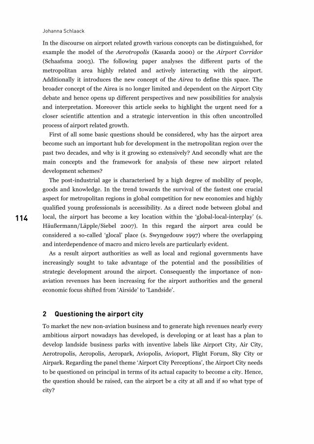
Johanna Schlaack
114
In the discourse on airport related growth various concepts can be distinguished, for
example the model of the Aerotropolis (Kasarda 2000) or the Airport Corridor
(Schaafsma 2003). The following paper analyses the different parts of the
metropolitan area highly related and actively interacting with the airport.
Additionally it introduces the new concept of the Airea to define this space. The
broader concept of the Airea is no longer limited and dependent on the Airport City
debate and hence opens up different perspectives and new possibilities for analysis
and interpretation. Moreover this article seeks to highlight the urgent need for a
closer scientific attention and a strategic intervention in this often uncontrolled
process of airport related growth.
First of all some basic questions should be considered, why has the airport area
become such an important hub for development in the metropolitan region over the
past two decades, and why is it growing so extensively? And secondly what are the
main concepts and the framework for analysis of these new airport related
development schemes?
The post-industrial age is characterised by a high degree of mobility of people,
goods and knowledge. In the trend towards the survival of the fastest one crucial
aspect for metropolitan regions in global competition for new economies and highly
qualified young professionals is accessibility. As a direct node between global and
local, the airport has become a key location within the ‘global-local-interplay’ (s.
Häußermann/Läpple/Siebel 2007). In this regard the airport area could be
considered a so-called ‘glocal’ place (s. Swyngedouw 1997) where the overlapping
and interdependence of macro and micro levels are particularly evident.
As a result airport authorities as well as local and regional governments have
increasingly sought to take advantage of the potential and the possibilities of
strategic development around the airport. Consequently the importance of non-
aviation revenues has been increasing for the airport authorities and the general
economic focus shifted from ‘Airside’ to ‘Landside’.
2 Questioning the airport city To market the new non-aviation business and to generate high revenues nearly every
ambitious airport nowadays has developed, is developing or at least has a plan to
develop landside business parks with inventive labels like Airport City, Air City,
Aerotropolis, Aeropolis, Aeropark, Aviopolis, Avioport, Flight Forum, Sky City or
Airpark. Regarding the panel theme ‘Airport City Perceptions’, the Airport City needs
to be questioned on principal in terms of its actual capacity to become a city. Hence,
the question should be raised, can the airport be a city at all and if so what type of
city?
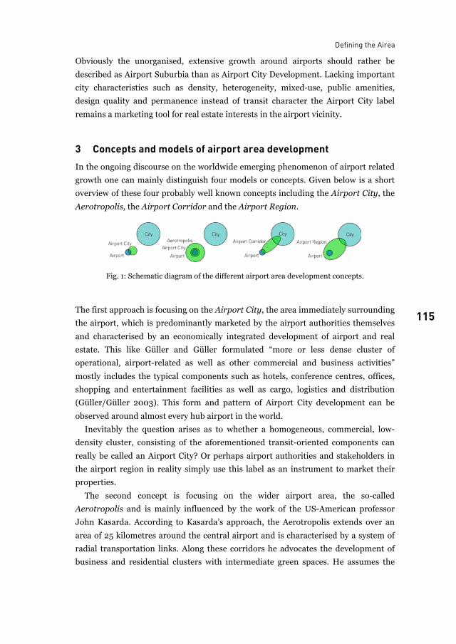
Defining the Airea
115 115
Obviously the unorganised, extensive growth around airports should rather be
described as Airport Suburbia than as Airport City Development. Lacking important
city characteristics such as density, heterogeneity, mixed-use, public amenities,
design quality and permanence instead of transit character the Airport City label
remains a marketing tool for real estate interests in the airport vicinity.
3 Concepts and models of airport area development In the ongoing discourse on the worldwide emerging phenomenon of airport related
growth one can mainly distinguish four models or concepts. Given below is a short
overview of these four probably well known concepts including the Airport City, the
Aerotropolis, the Airport Corridor and the Airport Region.
Fig. 1: Schematic diagram of the different airport area development concepts.
The first approach is focusing on the Airport City, the area immediately surrounding
the airport, which is predominantly marketed by the airport authorities themselves
and characterised by an economically integrated development of airport and real
estate. This like Güller and Güller formulated “more or less dense cluster of
operational, airport-related as well as other commercial and business activities”
mostly includes the typical components such as hotels, conference centres, offices,
shopping and entertainment facilities as well as cargo, logistics and distribution
(Güller/Güller 2003). This form and pattern of Airport City development can be
observed around almost every hub airport in the world.
Inevitably the question arises as to whether a homogeneous, commercial, low-
density cluster, consisting of the aforementioned transit-oriented components can
really be called an Airport City? Or perhaps airport authorities and stakeholders in
the airport region in reality simply use this label as an instrument to market their
properties.
The second concept is focusing on the wider airport area, the so-called
Aerotropolis and is mainly influenced by the work of the US-American professor
John Kasarda. According to Kasarda’s approach, the Aerotropolis extends over an
area of 25 kilometres around the central airport and is characterised by a system of
radial transportation links. Along these corridors he advocates the development of
business and residential clusters with intermediate green spaces. He assumes the
Johanna Schlaack
116
conceptualised Aerotropolis is comparable in dimension to the North American
metropolitan areas and hence consists of an airport city core and circumjacent
aviation-oriented suburban clusters (Kasarda 2000).
But does the direct analogy of dimension and configuration of the US-American
metropolis in comparison with the emerging Aerotropolis that Kasarda suggests,
help analyse or sustainably improve or in any way influence the development
processes around airports in this context? Instead of coherent development and
sustainable land use this model for airport growth obviously paves the way for
further unorganised extensive development and urban sprawl in the manner of US-
planning practice fifty years ago by using the same outdated commuter-oriented
principles (s. Charles 2007).
The third concept is focusing on the Airport Corridor, which emerges in the area
linking the airport with the centre of the metropolitan region. The Airport Corridor
concept, for example advocated by the Schiphol Group, is often characterised by a
strategically public-planned infrastructural spine to the inner city and by a
functionally integrated development of rail or road infrastructure and real estate.
This development often takes place in the form of a joint venture between airport
authorities, private developers and public institutions (Schaafsma 2003).
On the one hand the concept of the Airport Corridor provides the potential to
sustainably integrate the airport area as a hub for development in the polycentric
metropolitan region and to enable a balance of economic benefits for the involved
municipalities, communities and other stakeholders. On the other hand the central
longitudinal infrastructural connection to the city could also become a barrier for
crosswise development and hence fuel further fragmented linear development.
The last overarching concept is the Airport Region that is also included in the
conference theme ‘From Airport City to Airport Region’. The commonly used term
Airport Region, from my perspective, instead of describing a status quo is rather a
shared political planning vision, which implies a self-conscious functional,
infrastructural and governmental complex woven territory stretching out around a
centrally positioned airport.
In order to primarily foster those regional visions an objective, integrated research
approach is first needed to analyse and describe the status quo of airport related
development in regard to the metropolitan region. Therefore the approach of the
Airea as an open tool kit and research method has a particular relevance for regional
science and urban planning.
In contrast the other abovementioned concepts are not fully delivering an open
analytical research approach and all have a certain connotation or refer to a
particular scale, complexity or actual spatial form which could be misleading. The
term Airport City implicitly refers to the city, a complex urban centre, which tries to
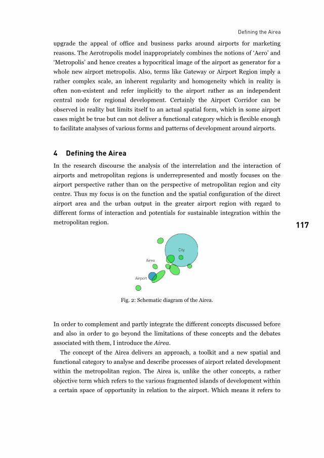
Defining the Airea
117 117
upgrade the appeal of office and business parks around airports for marketing
reasons. The Aerotropolis model inappropriately combines the notions of ‘Aero’ and
‘Metropolis’ and hence creates a hypocritical image of the airport as generator for a
whole new airport metropolis. Also, terms like Gateway or Airport Region imply a
rather complex scale, an inherent regularity and homogeneity which in reality is
often non-existent and refer implicitly to the airport rather as an independent
central node for regional development. Certainly the Airport Corridor can be
observed in reality but limits itself to an actual spatial form, which in some airport
cases might be true but can not deliver a functional category which is flexible enough
to facilitate analyses of various forms and patterns of development around airports.
4 Defining the Airea In the research discourse the analysis of the interrelation and the interaction of
airports and metropolitan regions is underrepresented and mostly focuses on the
airport perspective rather than on the perspective of metropolitan region and city
centre. Thus my focus is on the function and the spatial configuration of the direct
airport area and the urban output in the greater airport region with regard to
different forms of interaction and potentials for sustainable integration within the
metropolitan region.
Fig. 2: Schematic diagram of the Airea.
In order to complement and partly integrate the different concepts discussed before
and also in order to go beyond the limitations of these concepts and the debates
associated with them, I introduce the Airea.
The concept of the Airea delivers an approach, a toolkit and a new spatial and
functional category to analyse and describe processes of airport related development
within the metropolitan region. The Airea is, unlike the other concepts, a rather
objective term which refers to the various fragmented islands of development within
a certain space of opportunity in relation to the airport. Which means it refers to
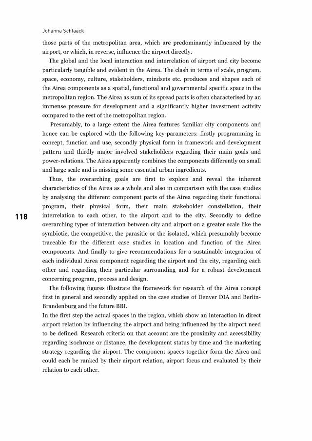
Johanna Schlaack
118
those parts of the metropolitan area, which are predominantly influenced by the
airport, or which, in reverse, influence the airport directly.
The global and the local interaction and interrelation of airport and city become
particularly tangible and evident in the Airea. The clash in terms of scale, program,
space, economy, culture, stakeholders, mindsets etc. produces and shapes each of
the Airea components as a spatial, functional and governmental specific space in the
metropolitan region. The Airea as sum of its spread parts is often characterised by an
immense pressure for development and a significantly higher investment activity
compared to the rest of the metropolitan region.
Presumably, to a large extent the Airea features familiar city components and
hence can be explored with the following key-parameters: firstly programming in
concept, function and use, secondly physical form in framework and development
pattern and thirdly major involved stakeholders regarding their main goals and
power-relations. The Airea apparently combines the components differently on small
and large scale and is missing some essential urban ingredients.
Thus, the overarching goals are first to explore and reveal the inherent
characteristics of the Airea as a whole and also in comparison with the case studies
by analysing the different component parts of the Airea regarding their functional
program, their physical form, their main stakeholder constellation, their
interrelation to each other, to the airport and to the city. Secondly to define
overarching types of interaction between city and airport on a greater scale like the
symbiotic, the competitive, the parasitic or the isolated, which presumably become
traceable for the different case studies in location and function of the Airea
components. And finally to give recommendations for a sustainable integration of
each individual Airea component regarding the airport and the city, regarding each
other and regarding their particular surrounding and for a robust development
concerning program, process and design.
The following figures illustrate the framework for research of the Airea concept
first in general and secondly applied on the case studies of Denver DIA and Berlin-
Brandenburg and the future BBI.
In the first step the actual spaces in the region, which show an interaction in direct
airport relation by influencing the airport and being influenced by the airport need
to be defined. Research criteria on that account are the proximity and accessibility
regarding isochrone or distance, the development status by time and the marketing
strategy regarding the airport. The component spaces together form the Airea and
could each be ranked by their airport relation, airport focus and evaluated by their
relation to each other.
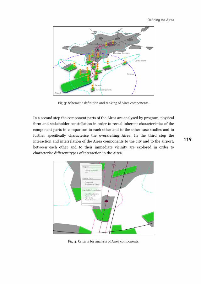
Defining the Airea
119 119
Fig. 3: Schematic definition and ranking of Airea components.
In a second step the component parts of the Airea are analysed by program, physical
form and stakeholder constellation in order to reveal inherent characteristics of the
component parts in comparison to each other and to the other case studies and to
further specifically characterise the overarching Airea. In the third step the
interaction and interrelation of the Airea components to the city and to the airport,
between each other and to their immediate vicinity are explored in order to
characterise different types of interaction in the Airea.
Fig. 4: Criteria for analysis of Airea components.
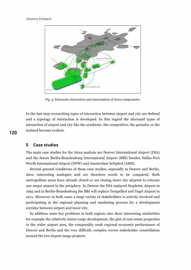
Johanna Schlaack
120
Fig. 5: Schematic interaction and interrelation of Airea components.
In the last step overarching types of interaction between airport and city are defined
and a typology of interaction is developed. In this regard the aforesaid types of
interaction of airport and city like the symbiotic, the competitive, the parasitic or the
isolated become evident.
5 Case studies The main case studies for the Airea analysis are Denver International Airport (DIA)
and the future Berlin-Brandenburg International Airport (BBI) besides Dallas-Fort
Worth International Airport (DFW) and Amsterdam Schiphol (AMS).
Several general conditions of these case studies, especially in Denver and Berlin,
show interesting analogies and are therefore worth to be compared. Both
metropolitan areas have already closed or are closing inner city airports to relocate
one major airport in the periphery. In Denver the DIA replaced Stapleton Airport in
1995 and in Berlin-Brandenburg the BBI will replace Tempelhof and Tegel Airport in
2011. Moreover in both cases a large variety of stakeholders is actively involved and
participating in the regional planning and marketing process for a development
corridor between airport and inner city.
In addition some key problems in both regions also show interesting similarities
for example the relatively minor cargo development, the glut of real estate properties
in the wider airport area, the comparably weak regional economic performance of
Denver and Berlin and the very difficult, complex woven stakeholder constellation
around the two airport mega-projects.
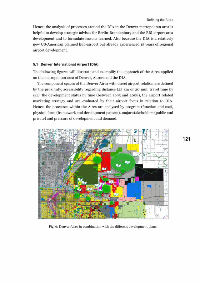
Defining the Airea
121 121
Hence, the analysis of processes around the DIA in the Denver metropolitan area is
helpful to develop strategic advises for Berlin-Brandenburg and the BBI airport area
development and to formulate lessons learned. Also because the DIA is a relatively
new US-American planned hub-airport but already experienced 15 years of regional
airport development.
5.1 Denver International Airport (DIA)
The following figures will illustrate and exemplify the approach of the Airea applied
on the metropolitan area of Denver, Aurora and the DIA.
The component spaces of the Denver Airea with direct airport relation are defined
by the proximity, accessibility regarding distance (25 km or 20 min. travel time by
car), the development status by time (between 1995 and 2008), the airport related
marketing strategy and are evaluated by their airport focus in relation to DIA.
Hence, the processes within the Airea are analysed by program (function and use),
physical form (framework and development pattern), major stakeholders (public and
private) and pressure of development and demand.
Fig. 6: Denver Airea in combination with the different development plans.
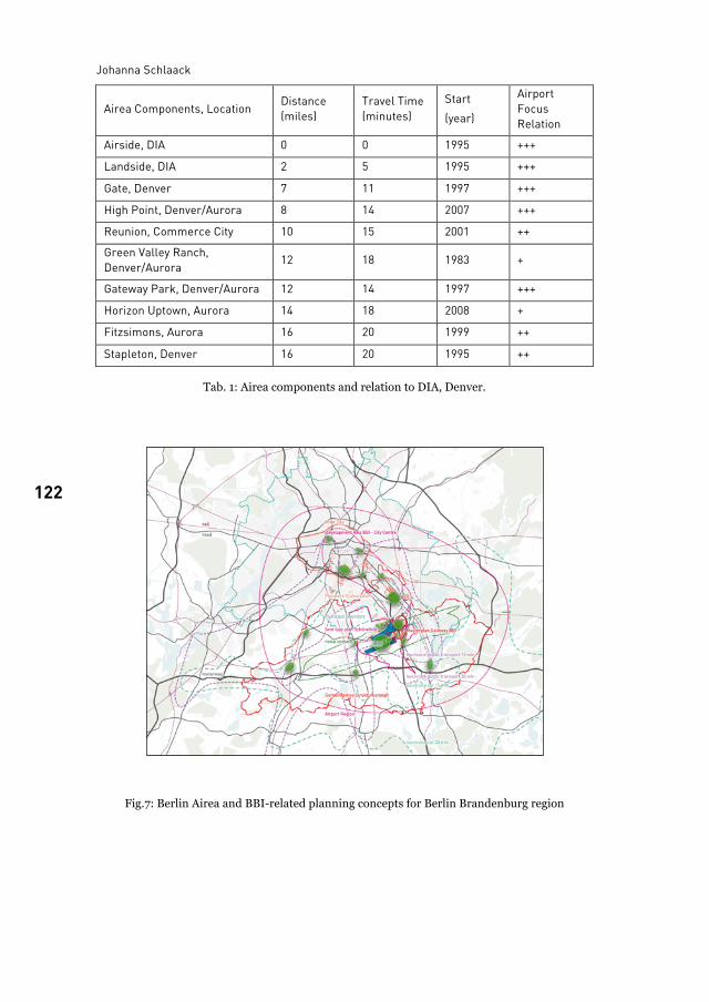
Johanna Schlaack
122
Airea Components, Location Distance (miles)
Travel Time (minutes)
Start (year)
Airport Focus Relation
Airside, DIA 0 0 1995 +++
Landside, DIA 2 5 1995 +++
Gate, Denver 7 11 1997 +++
High Point, Denver/Aurora 8 14 2007 +++
Reunion, Commerce City 10 15 2001 ++
Green Valley Ranch, Denver/Aurora 12 18 1983 +
Gateway Park, Denver/Aurora 12 14 1997 +++
Horizon Uptown, Aurora 14 18 2008 +
Fitzsimons, Aurora 16 20 1999 ++
Stapleton, Denver 16 20 1995 ++
Tab. 1: Airea components and relation to DIA, Denver.
Fig.7: Berlin Airea and BBI-related planning concepts for Berlin Brandenburg region
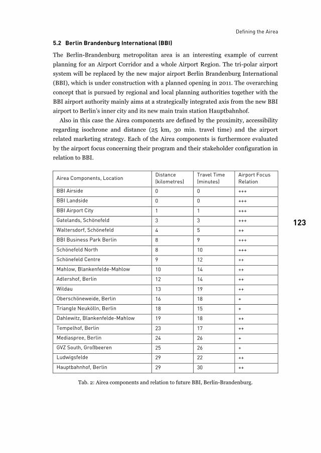
Defining the Airea
123 123
5.2 Berlin Brandenburg International (BBI)
The Berlin-Brandenburg metropolitan area is an interesting example of current
planning for an Airport Corridor and a whole Airport Region. The tri-polar airport
system will be replaced by the new major airport Berlin Brandenburg International
(BBI), which is under construction with a planned opening in 2011. The overarching
concept that is pursued by regional and local planning authorities together with the
BBI airport authority mainly aims at a strategically integrated axis from the new BBI
airport to Berlin’s inner city and its new main train station Hauptbahnhof.
Also in this case the Airea components are defined by the proximity, accessibility
regarding isochrone and distance (25 km, 30 min. travel time) and the airport
related marketing strategy. Each of the Airea components is furthermore evaluated
by the airport focus concerning their program and their stakeholder configuration in
relation to BBI.
Airea Components, Location Distance (kilometres)
Travel Time (minutes)
Airport Focus Relation
BBI Airside 0 0 +++
BBI Landside 0 0 +++
BBI Airport City 1 1 +++
Gatelands, Schönefeld 3 3 +++
Waltersdorf, Schönefeld 4 5 ++
BBI Business Park Berlin 8 9 +++
Schönefeld North 8 10 +++
Schönefeld Centre 9 12 ++
Mahlow, Blankenfelde-Mahlow 10 14 ++
Adlershof, Berlin 12 14 ++
Wildau 13 19 ++
Oberschöneweide, Berlin 16 18 +
Triangle Neukölln, Berlin 18 15 +
Dahlewitz, Blankenfelde-Mahlow 19 18 ++
Tempelhof, Berlin 23 17 ++
Mediaspree, Berlin 24 26 +
GVZ South, Großbeeren 25 26 +
Ludwigsfelde 29 22 ++
Hauptbahnhof, Berlin 29 30 ++
Tab. 2: Airea components and relation to future BBI, Berlin-Brandenburg.
Johanna Schlaack
124
6 Conclusion The Airea approach applied on the two case studies of Berlin and Denver depicts the
plain status quo of airport related development, a heterogenic configuration of
spread islands within the wider metropolitan area. All islands together form the
Airea of the particular region and each of the Airea components is defined and
analysed with the aforementioned criteria. The pursued regional planning strategy of
an Airport Corridor in Denver and Berlin becomes roughly tangible.
In a nutshell the key aspects and the framework for research of the Airea are:
• Defining the Airea (proximity/accessibility, development status, airport
relation/focus)
• Analysing and comparing the Airea components among each other and with the
different case studies (program, physical form, stakeholder constellation)
• Characterising and specifying the Airea (typology)
• Exploring the interrelation in the Airea and defining different overarching types
of interaction between airport and city
• Developing strategic advice first for a sustainable integration of the Airea
components regarding the airport and the city, regarding each other and
regarding their particular surrounding and secondly for a robust development
concerning program, process and design
Employing the Airea as an objective and open approach, toolkit and new spatial and
functional category will help to further explore and describe processes of airport
related development within metropolitan regions. Finally the overarching challenge
for research and practice will be to create and implement strategic planning
concepts, which aim at a functional and infrastructural integration of the Airea as
development hub within the wider metropolitan region, and which enable a more
sustainable and robust development around airports in the future.
List of figures
Fig. 1: Schematic diagram of the different airport area development concepts. ............................. 115Fig. 2: Schematic diagram of the Airea. ............................................................................................ 117Fig. 3: Schematic definition and ranking of Airea components. ...................................................... 119Fig. 4: Criteria for analysis of Airea components. ............................................................................ 119Fig. 5: Schematic interaction and interrelation of Airea components. ............................................ 120Fig. 6: Denver Airea in combination with the different development plans.................................... 121Fig.7: Berlin Airea and BBI-related planning concepts for Berlin Brandenburg region ................. 122

Defining the Airea
125 125
List of tables
Tab. 1: Airea components and relation to DIA, Denver. .................................................................. 122Tab. 2: Airea components and relation to future BBI, Berlin-Brandenburg................................... 123
References
M. B. Charles, P. Barnes, N. Ryan and J. Clayton. Airport futures. Towards a critique of the
Aerotropolis model. In: Futures 39: 1009-1028. 2007.
DIA Business Partnership. The Economic Impact of the Denver International Airport District.
Northeast Region of the Denver Metropolitan Area. Denver. 2005.
Gemeinsame Landesplanung Berlin-Brandenburg. Planungsatlas Flughafenumfeld Berlin
Brandenburg International, Ministerium für Infrastruktur und Raumordnung
Brandenburg. Berlin. 2008.
M. Güller and M. Güller. From airport to airport city. Barcelona: Editorial Gustavo Gili. 2003.
H. Häußermann, D. Läpple and W. Siebel. Stadtpolitik. Frankfurt am Main: Suhrkamp. 2007.
J. D. Kasarda. Aerotropolis. Airport-Driven Urban Development. ULI on the Future. Cities in
the 21th Century, Washington D.C.: 32-41. 2000.
M. Schaafsma. Airports and Cities in Networks. DISP 154: 28-36. 2003
M. Schaafsma, J. Amkreutz and M. Güller. Airports and city. Airport Corridors. Drivers of
economic development. Amsterdam: Schiphol Real Estate. 2008.
E. Swyngedouw. Neither Global nor Local: ‘Glocalization’ and the Politics of Scale. K. R. Cox.
Spaces of Globalization. Reasserting the Power of the Local. New York: Guilford Press:
137-166. 1997.
Johanna Schlaack Transatlantic Graduate Research Program Berlin – New York, Center for Metropolitan Studies
TU Berlin, 10587 Berlin, Germany E-mail: [email protected]

126
127 127
The interrelationships of airport and spatial development Zurich Airport – Experiences from a test planning process
Bernd Scholl
Airport development in densely populated regions presents a major challenge to all parties involved. Spatial planning especially is called upon to deliver integrative solutions for future spatial and airport development through innovative planning processes. Using the region around Zurich Airport as an example, one such process is presented and conclusions concerning future processes are drawn from it. In particular, technological advances in noise reduction at the source and improved arrival and departure procedures are opening new possibilities. An important condi-tion for the acceptance of solutions by those affected by air traffic problems is inter-disciplinary cooperation between airport regions, airport operators and aircraft manufacturers, scientists, and experts from spatial planning and politics.
1 Introduction The starting point of this report on the interrelationships of airport and spatial de-
velopment is a set of hypotheses on the future development of major traffic airports
in densely populated regions, mainly in Europe. Using the development of the Zurich
Airport as an example, spatially important conflicts, central problems and questions
and possible perspectives will be pointed out. The case study makes it clear that
spatial planning is being called upon to proactively engage with the development of
high-density traffic airports. In particular, technological advances in aircraft manu-
facture to reduce noise emissions as well as innovative landing and take-off proce-
dures open new perspectives to mitigate the central conflicts in airport and spatial
development, if not actually solve them.
2 Main hypotheses Five hypotheses should help to structure this complex topic. The example of the
Zurich Airport later on in this article illustrates these hypotheses.
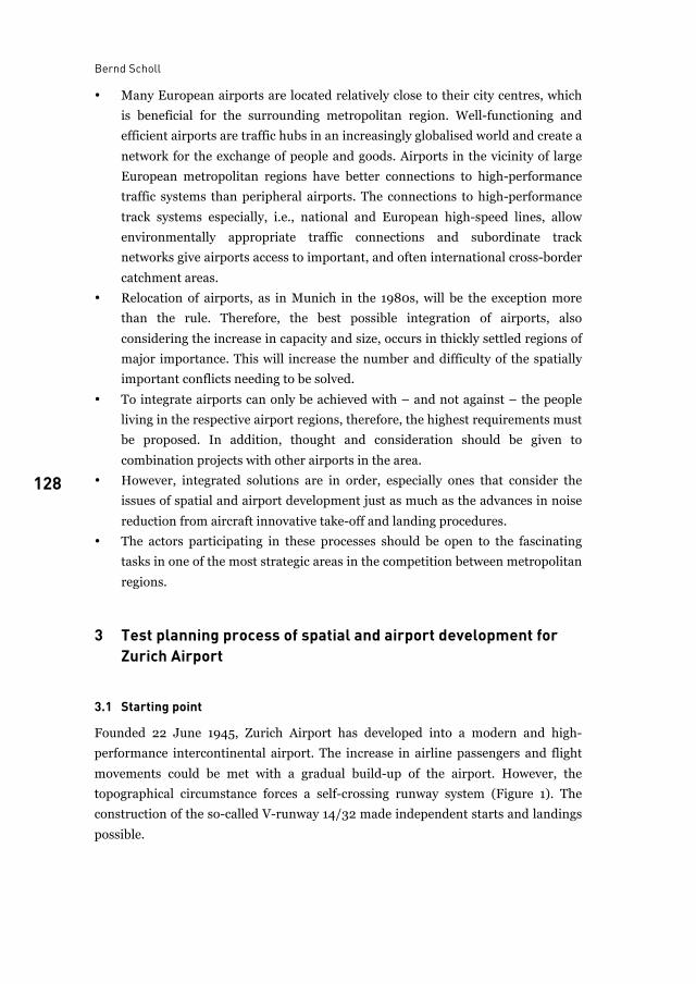
Bernd Scholl
128
• Many European airports are located relatively close to their city centres, which
is beneficial for the surrounding metropolitan region. Well-functioning and
efficient airports are traffic hubs in an increasingly globalised world and create a
network for the exchange of people and goods. Airports in the vicinity of large
European metropolitan regions have better connections to high-performance
traffic systems than peripheral airports. The connections to high-performance
track systems especially, i.e., national and European high-speed lines, allow
environmentally appropriate traffic connections and subordinate track
networks give airports access to important, and often international cross-border
catchment areas.
• Relocation of airports, as in Munich in the 1980s, will be the exception more
than the rule. Therefore, the best possible integration of airports, also
considering the increase in capacity and size, occurs in thickly settled regions of
major importance. This will increase the number and difficulty of the spatially
important conflicts needing to be solved.
• To integrate airports can only be achieved with – and not against – the people
living in the respective airport regions, therefore, the highest requirements must
be proposed. In addition, thought and consideration should be given to
combination projects with other airports in the area.
• However, integrated solutions are in order, especially ones that consider the
issues of spatial and airport development just as much as the advances in noise
reduction from aircraft innovative take-off and landing procedures.
• The actors participating in these processes should be open to the fascinating
tasks in one of the most strategic areas in the competition between metropolitan
regions.
3 Test planning process of spatial and airport development for Zurich Airport
3.1 Starting point
Founded 22 June 1945, Zurich Airport has developed into a modern and high-
performance intercontinental airport. The increase in airline passengers and flight
movements could be met with a gradual build-up of the airport. However, the
topographical circumstance forces a self-crossing runway system (Figure 1). The
construction of the so-called V-runway 14/32 made independent starts and landings
possible.
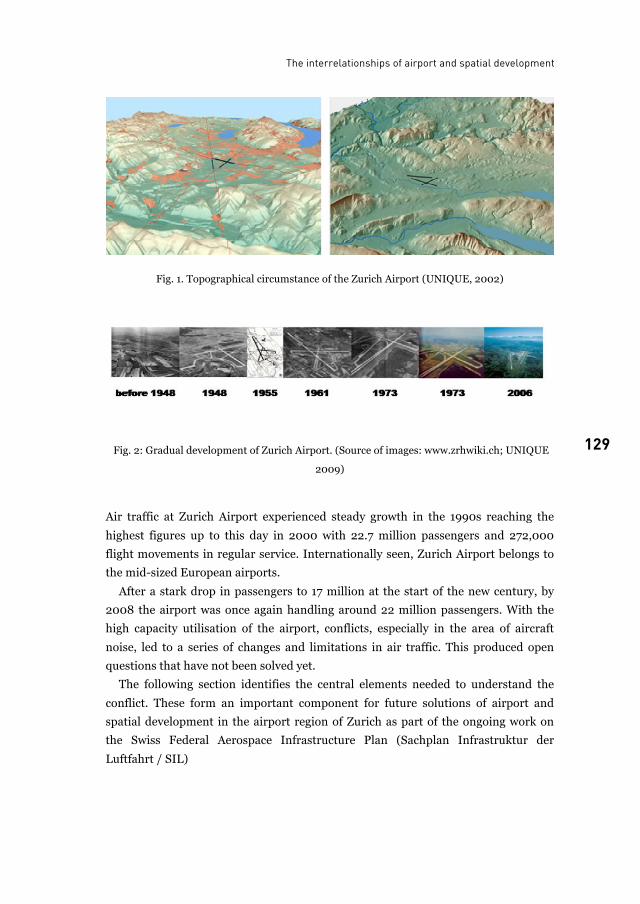
The interrelationships of airport and spatial development
129 129
Fig. 1. Topographical circumstance of the Zurich Airport (UNIQUE, 2002)
Fig. 2: Gradual development of Zurich Airport. (Source of images: www.zrhwiki.ch; UNIQUE
2009)
Air traffic at Zurich Airport experienced steady growth in the 1990s reaching the
highest figures up to this day in 2000 with 22.7 million passengers and 272,000
flight movements in regular service. Internationally seen, Zurich Airport belongs to
the mid-sized European airports.
After a stark drop in passengers to 17 million at the start of the new century, by
2008 the airport was once again handling around 22 million passengers. With the
high capacity utilisation of the airport, conflicts, especially in the area of aircraft
noise, led to a series of changes and limitations in air traffic. This produced open
questions that have not been solved yet.
The following section identifies the central elements needed to understand the
conflict. These form an important component for future solutions of airport and
spatial development in the airport region of Zurich as part of the ongoing work on
the Swiss Federal Aerospace Infrastructure Plan (Sachplan Infrastruktur der
Luftfahrt / SIL)
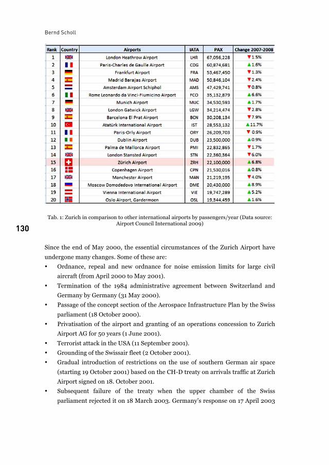
Bernd Scholl
130 Tab. 1: Zurich in comparison to other international airports by passengers/year (Data source:
Airport Council International 2009)
Since the end of May 2000, the essential circumstances of the Zurich Airport have
undergone many changes. Some of these are:
• Ordnance, repeal and new ordnance for noise emission limits for large civil
aircraft (from April 2000 to May 2001).
• Termination of the 1984 administrative agreement between Switzerland and
Germany by Germany (31 May 2000).
• Passage of the concept section of the Aerospace Infrastructure Plan by the Swiss
parliament (18 October 2000).
• Privatisation of the airport and granting of an operations concession to Zurich
Airport AG for 50 years (1 June 2001).
• Terrorist attack in the USA (11 September 2001).
• Grounding of the Swissair fleet (2 October 2001).
• Gradual introduction of restrictions on the use of southern German air space
(starting 19 October 2001) based on the CH-D treaty on arrivals traffic at Zurich
Airport signed on 18. October 2001.
• Subsequent failure of the treaty when the upper chamber of the Swiss
parliament rejected it on 18 March 2003. Germany’s response on 17 April 2003
The interrelationships of airport and spatial development
131 131
was to put a stricter unilateral executive order into force in German air traffic
regulations.
• Discussion of five new operation concepts as part of the SIL coordination
project with a plan for 420,000 flight movements (starting 25.10.2001).
These uncertainties have also considerably increased the spatially significant
conflicts in airport and spatial development. In its position statement on the design
of the cost object bulletin (Objektblatt) for Zurich Airport, part of the Aerospace
Infrastructure Plan of 3 July 2002, the government of the Canton of Zurich,
represented by the Cantonal Building Office, commissioned a special ad hoc project
organisation to work out a long-term perspective. The main conditions were to:
• Assure long term scope of action for the spatial development of the airport
region and for the airport traffic
• Keep the negative effects of air traffic on the population and environment at the
best possible limits for the long term.
• Prepare and present concrete fundamental principles for the Cantonal Planning
Guide (Richtplan) within an appropriate timeframe.
3.2 Project organisation of the test planning process
To manage the requested foundation work, a special ad hoc project organisation was
selected for the test planning process, in the sense of a Wiener Model, which showed
the following characteristics:
• Power of the best argument, practical before formal competence
• Bias-free exploration of long-term perspectives using several teams
• Competition of ideas, simultaneous test planning
• Supervision by independent experts
• Clear role division between work on the fundamentals and policy
• Direct report of results to the executive representatives
The options for the long-term spatial development of the airport region and the
development of the airport infrastructure were surveyed and evaluated, free of
prejudice and uncoupled from politics, by administratively independent external
experts.
• Consideration of the special topographical conditions
• Weather conditions (wind, visibility, temperature)
• Settlement structure according to the canton plan of 1995
• Traffic capacity maximum of 420,000 flight movements per year
• Top capacity of 90 flight movements per hour, i.e., 60 landings and 30 starts or
the reverse (plan values for Zurich Airport (formerly Unique) for the SIL
variations comparison of October 2001)
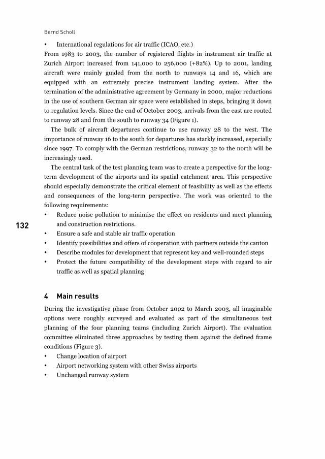
Bernd Scholl
132
• International regulations for air traffic (ICAO, etc.)
From 1983 to 2003, the number of registered flights in instrument air traffic at
Zurich Airport increased from 141,000 to 256,000 (+82%). Up to 2001, landing
aircraft were mainly guided from the north to runways 14 and 16, which are
equipped with an extremely precise instrument landing system. After the
termination of the administrative agreement by Germany in 2000, major reductions
in the use of southern German air space were established in steps, bringing it down
to regulation levels. Since the end of October 2003, arrivals from the east are routed
to runway 28 and from the south to runway 34 (Figure 1).
The bulk of aircraft departures continue to use runway 28 to the west. The
importance of runway 16 to the south for departures has starkly increased, especially
since 1997. To comply with the German restrictions, runway 32 to the north will be
increasingly used.
The central task of the test planning team was to create a perspective for the long-
term development of the airports and its spatial catchment area. This perspective
should especially demonstrate the critical element of feasibility as well as the effects
and consequences of the long-term perspective. The work was oriented to the
following requirements:
• Reduce noise pollution to minimise the effect on residents and meet planning
and construction restrictions.
• Ensure a safe and stable air traffic operation
• Identify possibilities and offers of cooperation with partners outside the canton
• Describe modules for development that represent key and well-rounded steps
• Protect the future compatibility of the development steps with regard to air
traffic as well as spatial planning
4 Main results During the investigative phase from October 2002 to March 2003, all imaginable
options were roughly surveyed and evaluated as part of the simultaneous test
planning of the four planning teams (including Zurich Airport). The evaluation
committee eliminated three approaches by testing them against the defined frame
conditions (Figure 3).
• Change location of airport
• Airport networking system with other Swiss airports
• Unchanged runway system
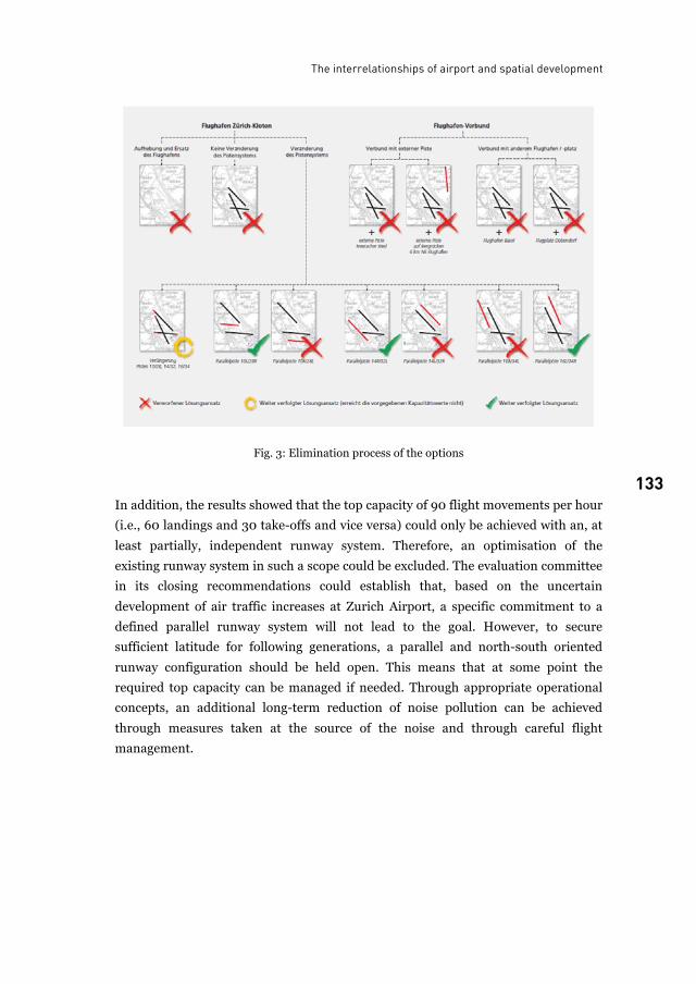
The interrelationships of airport and spatial development
133 133
Fig. 3: Elimination process of the options
In addition, the results showed that the top capacity of 90 flight movements per hour
(i.e., 60 landings and 30 take-offs and vice versa) could only be achieved with an, at
least partially, independent runway system. Therefore, an optimisation of the
existing runway system in such a scope could be excluded. The evaluation committee
in its closing recommendations could establish that, based on the uncertain
development of air traffic increases at Zurich Airport, a specific commitment to a
defined parallel runway system will not lead to the goal. However, to secure
sufficient latitude for following generations, a parallel and north-south oriented
runway configuration should be held open. This means that at some point the
required top capacity can be managed if needed. Through appropriate operational
concepts, an additional long-term reduction of noise pollution can be achieved
through measures taken at the source of the noise and through careful flight
management.
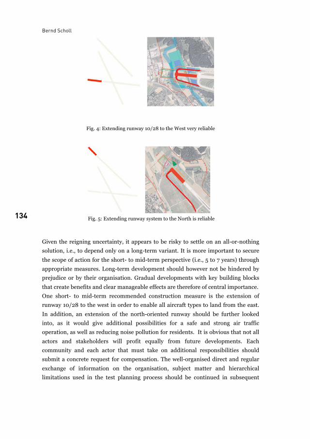
Bernd Scholl
134
Fig. 4: Extending runway 10/28 to the West very reliable
Fig. 5: Extending runway system to the North is reliable
Given the reigning uncertainty, it appears to be risky to settle on an all-or-nothing
solution, i.e., to depend only on a long-term variant. It is more important to secure
the scope of action for the short- to mid-term perspective (i.e., 5 to 7 years) through
appropriate measures. Long-term development should however not be hindered by
prejudice or by their organisation. Gradual developments with key building blocks
that create benefits and clear manageable effects are therefore of central importance.
One short- to mid-term recommended construction measure is the extension of
runway 10/28 to the west in order to enable all aircraft types to land from the east.
In addition, an extension of the north-oriented runway should be further looked
into, as it would give additional possibilities for a safe and strong air traffic
operation, as well as reducing noise pollution for residents. It is obvious that not all
actors and stakeholders will profit equally from future developments. Each
community and each actor that must take on additional responsibilities should
submit a concrete request for compensation. The well-organised direct and regular
exchange of information on the organisation, subject matter and hierarchical
limitations used in the test planning process should be continued in subsequent
The interrelationships of airport and spatial development
135 135
endeavours, especially in view of the complexity of spatial and airport development
in the Zurich region.
In the opinion of the evaluations committee, various possibilities exist to embed
spatial and airport development in larger cross-border interrelationships. This
would allow potential traffic development in the Greater Basel area, the High Rhine
area and the economic region of the Bodensee to improve connections to Zurich
regions, including the airport. In this connection, it was deemed worthwhile to invite
a cross-border expert evaluation of various approaches to infrastructure and spatial
development at an appropriate time in future.
5 Outlook The test planning process using Zurich Airport makes it clear that complex questions
of airport and spatial development can be approached and solved through the use of
compact planning processes. The recommendations that followed from the test
planning process, also discussed in public forums, have led to numerous additional
planning processes. The runway extensions and the option of a parallel runway
system in particular were heatedly discussed. Under the leadership of the Swiss
Federal Office for Civil Aviation, the core elements were confirmed in further
planning processes, especially the runway extensions, which were recommended as a
result of the test planning process. These should strengthen the robustness of the
airport in its operations and above all relieve the densely populated areas around the
airport from aircraft noise. This is possible because the air traffic can be directed
over the less populated areas in all weather situations and independent from the type
of aircraft.
Although specific to the situation of the Zurich Airport, an additional perspective
can nonetheless be mentioned here. This would be the possibility to reduce noise at
its source, meaning the aircraft itself and through improved take-off and landing
procedures, thus reducing the noise at ground level. At Zurich Airport, the number
of flight movements, even after possible runway extensions, is limited by the
topography. It follows that after reaching the maximum number of flight
movements, the reduced noise levels can be passed on to the population and not
compensated by increasing the number of flight movements. Experts estimate the
achievable noise reduction in aircraft alone will be about 10 dB(A) over the span of
the next ten years.
This would halve the effective noise and would considerably relieve the airport
region. Naturally, these possibilities not only affect the Zurich Airport, but also all
major airports around the globe. Because reducing noise at its source is connected to
additional applications, a cooperative effort from the airport regions, airport
Bernd Scholl
136
operators and aircraft manufacturers is required. European aircraft manufacturers
in association with their engine manufacturers have a special responsibility in this
area. In order to recognise the reduction potential for each airport and to develop
measures for the exploitation of this potential, essential work must be prepared. For
actors in this field, this opens challenges.
List of figures
Fig. 1. Topographical circumstance of the Zurich Airport (UNIQUE, 2002) .................................. 129Fig. 2: Gradual development of Zurich Airport. (Source of images: www.zrhwiki.ch; UNIQUE
2009) ..................................................................................................................................... 129Fig. 3: Elimination process of the options ........................................................................................ 133Fig. 4: Extending runway 10/28 to the West very reliable ............................................................... 134Fig. 5: Extending runway system to the North is reliable ................................................................ 134
List of tables
Tab. 1: Zurich in comparison to other international airports by passengers/year (Data source: Airport Council International 2009) .................................................................................... 130
References
Advisory Council for Aeronotics Research in Europe ACARE (2008): European Aeronotics: A
Vision for 2020.
Amt für Raumordnung und Vermessung. Raumentwicklungskonzept für die Flughafenregion
und langfristige Infrastrukturentwicklung des Flughafens Zürich. Kanton Zürich. 2004
Regierungsrat des Kanton Zürich. Beurteilung der Ergebnisse des Projekts RELIEF, Auszug aus
dem Protokoll des Regierungsrates des Kantons Zürch, Sitzung vom 15. Dezember
2004. 2004
K. Freisitzer, J. Maurer. Das Wiener Modell. Erfahrungen mit innovativer Stadtplanung –
Empirische Befunde aus einem Grossprojekt. Compress Verlag, Vienna. 1987 (eds.)
B. Scholl. Test Planning Procedures as a Method for Supporting Decision-Making in Complex
Planning Projects. Department of Building und Enviroment, City of Milan. 2006.
B. Scholl. Die Methode der Testplanung. In: ARL XXX No. xxx: Grundriss der
Raumentwicklung and Raumplanung. Akademie für Raumforschung und
Landesplanung, Hannover. planned for 2010.
Prof. Dr. Bernd Scholl is Professor at ETH Zurich, Spatial Planning and Development Chair
CH-8093 Zürich, Switzerland E-mail: [email protected]
137
Subjective appraisal of aircraft noise From decibel measurements to effective noise management
Pere Suau-Sanchez
It is widely known that aircraft noise emissions over populated areas are a constraint for airport capacity. Traditional noise management focuses on objective noise measurements. However, noise annoyance is a subjective issue. This chapter briefly introduces the importance of subjective elements of noise annoyance and suggests how to incorporate them in noise management schemes.
1 Introduction Air traffic demand has increased greatly during the last decades, implying a doubling
of traffic about every 15 years (de Neufville and Odoni 2003). The 2008 world
financial crisis has had important impacts on demand and airlines operations, but
recent forecasts by the International Air Transport Association (IATA) announce
that by 2011 air traffic growth will be again above 4% (IATA 2008).
Because of air traffic growth and the lack of free land for new airport expansions,
many European airports are in a dead end situation concerning the possibilities of
increasing their capacity. The lack of space for new expansions has been fostered by:
• the growth of the European metropolitan regions and the formation of mega-
city regions
• the lack of successful metropolitan governance, which has made it possible for
some small municipalities surrounding airports to develop residential areas in
zones that should have been protected because of noise or potential noise
exposure
• the fact that most airports did not carry out effective land-banking measures.
Hence, physical constraints impede the expanding capacity to satisfy future demand
(Coleman 1999; Graham and Guyer 1999; Madas and Zografos 2008; de Wit and
Burghouwt 2008). In addition to the difficulty of expanding with new runways, the
noise generated by aircrafts over residential areas makes it impossible to reach the
Pere Suau-Sanchez
138
potential airport capacity. Therefore, we should add the notion of environmental
capacity to the concept of airport capacity (see Upham et al. 2004).
This chapter presents a short summary of an ongoing research about the
importance of incorporating noise annoyance and the subjective appraisal of noise in
airport noise management.
2 Traditional objective and new subjective elements in noise policies
2.1 Traditional noise policies and ICAO’s Balanced Approach
According to the International Civil Aviation Organization (ICAO) aircrafts coming
off the production line today are about 75% quieter than 40 years ago and, also, the
number of people living within 65 dB DNL has decreased about 30% from 2000 to
2006 (ICAO 2007). While major efforts by institutions and the air transportation
industry have traditionally been made on the reduction of aircraft noise at its source,
in 2001 ICAO adopted a new policy to address aircraft noise in another way. It is
referred to as the “Balanced Approach” and it deals with aircraft noise in a more
comprehensive way. The Balanced Approach (ICAO 2001) aims to reduce noise
using four elements:
• reduction of noise at source
• land-use planning and management
• noise abatement operational procedures
• operating restrictions.
The Balanced Approach adds three strategies to the traditional measure of reducing
the noise generated by aircrafts. However, noise abatement operational procedures
and operating restrictions are reactive measures that do not anticipate the noise
problem and can create reductions of airport capacity. On the other hand, land-use
planning is a proactive policy, which can avoid the appearance of noise nuisance, by
rejecting the development of aircraft paths or by choosing the right land-use.
Nonetheless, land-use planning remains a prerogative of local, regional or national
administration – depending on each particular country.
2.2 When sound becomes noise: the subjective appraisal
Sound intensity can be objectively measured. However, annoyance and disturbance
by noise are a subjective issue that is related to the perception and tolerance and
cannot be objectively considered and measured because noise level descriptors are
not able to explain individual levels of noise annoyance (see Stallen 1999; Thomas
Subjective appraisal of aircraft noise
139 139
and Lever 2003; Upham et al., 2004; Bröer 2006; Cidell 2008; Kroesen et al. 2008).
According to Stallen (1999:69), “sound becomes noise because of a particular
appraisal of it. Therefore, understanding noise-induced annoyance requires the
understanding of judgmental, attitudinal and thus social processes”. Consequently
noise annoyance is not only dependent on objective acoustical factors, but also on
many others that are non-acoustical and depend on subjective appraisals. Numerous
studies and surveys demonstrate that non-acoustical aspects are as significant as
purely acoustical variables (Job, 1988; Fields, 1993; Guski, 1999; Baarsma, 2000;
Bröer, 2006; Gordijn et al., 2006; Stallen, 2007a, 2007b; Lieshout et al., 2008;
Kroesen et al., 2008). In fact, only one-third on the variation in noise annoyance can
be explained by acoustical factors (Guski, 1999). In addition, the number of
complaints is often unrelated to the level of annoyance or the number of annoyed
people (Lieshout et al., 2006; Gordijn et al., 2006; Lieshout et al., 2008). ICAO’s
Balanced Approach tackles the objective elements of noise annoyance, but does not
mention the subjective elements.
Stallen’s framework on environmental noise annoyance (Stallen, 1999), based on
the psychological stress theory of Lazarus (1966), reflects that in addition to
perceived noise disturbance, perceived control (e.g. predictability of a noise
situation, accessibility of information and transparency, trust and recognition of
concern, and voice) over the noise emissions is a key aspect for the capacity of coping
with noise. High disturbance and high control may be less annoying than moderate
disturbance and no control. Hence, coping with annoyance is a reappraisal of the
person-environment situation.
In this regard, Bröer (2008) adds the policy factor. He considers that the
dominant policy discourse resonates in people’s everyday perception. Therefore, the
level of annoyance will differ depending on the policy setting; and the kind of
opposition will depend on the policy discourse. If policy treats a situation as
problematic, people will experience it as problematic. Government, industry and
science often force citizens to be alert and react emotionally.
These non-acoustical and subjective factors are not always taken into
consideration nor integrated in the airport management policies. Cidell (2008), for
example, does a critical analysis of noise maps and discovers that airport noise
conflicts are often grounded in different experiences of those who measure the noise
and those who suffer its effects. In this regard, in UK, a study by OMEGA (Hooper
2009) faces the absence of a common language between these two parties. Existing
noise metrics based upon decibel measures are difficult to understand and are not
trusted by the general public. This frustrates any dialogue between airports and their
neighboring communities. The study seeks for new measures that can improve
communication between airports and communities.
Pere Suau-Sanchez
140
3 Including subjective factors in noise management Traditional regulatory policies, based on objective measurements of decibel levels,
do not incorporate the above-mentioned subjective factors. Effective noise
management should include such factors in order to offer benefits to both
neighbouring communities and to airport’s environmental capacity. But, how are
they to be included? In general terms, noise management should have a holistic
perspective and create a policy setting understandable and unambiguous for the
community. If the policy creates unambiguities, it leaves room for a reactive
behaviour of the community.
Although each airport has its own particularities, the dialog between the airport
manager and the community usually takes place in round tables, which were
established once the noise nuisance problem appeared. However, these round tables
usually do not constitute an essential part of the management structure of the
airport, where the decisions are taken, but rather function as satellite elements, as
though they were created in a reactive way. If round tables do not constitute an
essential element of the decision-making process, they can undermine the
community’s trust in the airport and thus become a place for conflict. On these
grounds a reformulation of part of the airport’s management structure is needed to
include subjective factors in noise management. Round tables, where the community
is represented, should become an essential part of the airport management
structure. This does not imply that the community should have the right to fully
decide on the airport’s future or the daily management, but listening, considering
and including the community’s perspectives into airport management is the only way
to build trust between the airport and the community.
Each country has its own airport management system. Some are private owned,
others are public, some include local institutions as shareholders, and others include
regional or national bodies. The management systems vary, but this should not
prevent the presence of all the actors involved in the territorial setting of the airport
at the round table because, currently, governance is complex, fragmented and
influenced by a growing number of public and private actors (Wijk 2007). This
renders the decision-making process much more difficult. Effective noise
management can only be achieved by adapting the decision-making process to a new
reality that is increasingly influenced by informal and networked relationships. The
comprehension of today’s complexity can only be incorporated in airport
management by relating social processes and spatial forms (Healey 2007).
Another important strategy for including subjective factors is to build a new
communicative language between actors, as, for example, the OMEGA study
proposes. Transparency is not enough. The community will not trust the airport if
data, maps and other sources of information provided by the airport are not
Subjective appraisal of aircraft noise
141 141
comprehensible for them. In that case, the use of complex information by the airport
manager could be seen as using technocracy as a defence.
Another important element is how to implement the consensus decisions and how
to guarantee their application. Consequently, the only way to bind the decisions
taken by the parties in the round tables is by a legal agreement.
To conclude, in general terms, reactive strategies should be substituted by a more
proactive environment in which the relationship between the airport and the
neighbouring communities is based on a constant dialogue, instead of the traditional
obscure distrust that dominates such relationships.
References
B. Baarsma. Monetary Valuation of Environmental Goods: Alternatives to Contingent
Valuation Amsterdam: Tinbergen Institute Research Series. 2000.
C. Bröer. Beleid vormt overlast. Hoe beleidsdiscoursen de beleving van geluid bepalen.
Amsterdam: Aksant. 2006.
J. Cidell. Challenging the contours: critical cartography, local knowledge and the public.
Environment and Planning A 40: 1202 – 1218. 2008.
R. J. Coleman. Environmentally sustainable capacity In: Proceedings of the ECAC/EU Dialogue
with the European Air Transport Industry: Airport Capacity-Challenges for the Future:
118 – 125. Salzburg. 1999.
R. de Neufville, and A. Odoni. Airport Systems. Planning, Design, and Management. New York:
McGraw-Hill. 2003.
J. de Wit and G. Burghouwt. Slot allocation and use at hub airports, perspectives for secondary
trading. European. Journal of Transport and Infrastructure Research 8(2): 147 – 164.
2008.
J. Fields. Effect of personal and situational variables on noise annoyance in residential areas.
Journal of the Acoustical Society of America 93: 2753 – 2763. 1993.
H. Gordijn, W. Hornis and R. Aykaç. Geluid rondom luchthavens. Rotterdam: NAi Uitgevers.
2006.
B. Graham and C. Guyer. Environmental sustainability, airport capacity and European air
transport liberalization: irreconcilable goals?. Journal of Transport Geography 7: 165 –
180. 1999.
R. Guski. Personal and social variables as co-determinants of noise annoyance. Noise Health 1:
45 – 56. 1999.
P. Healey. Urban complexity and spatial strategies: towards a relational planning for our times.
London: Routledge. 2007.
P. Hooper, J. Maughan, I. Flindell and K. Hume. OMEGA Community Noise Study. Indices to
enhance understanding & management of community responses to aircraft noise
exposure. Manchester: Manchester Metropolitan University.
ICAO. Environmental Report 2007. Montreal: ICAO. 2007.
ICAO. Guidance on the Balanced Approach to Aircraft Noise Management. (DOC 9829).
Montreal: ICAO. 2001.
Pere Suau-Sanchez
142
R. F. S. Job. Community response to noise: A review of factors influencing the relationship
between noise exposure and reaction. Journal of the Acoustical Society of America
83(3): 991 – 1001. 1988.
IATA. IATA Economic Briefing: The impact of recession on air traffic volumes. Geneva. IATA.
2008.
M. Kroesen, E. J. E. Molin and B. van Wee. Testing a theory of aircraft noise annoyance: A
structural equation analysis. Journal of the Acoustical Society of America 123(6): 4250
– 4260. 2008.
R. S. Lazarus. Psychological stress and the coping process. New York: McGraw-Hill. 1966.
R. B. T. Lieshout, J. Veldhuis and A. B. Dolderman. Klanchtenanalyse Schiphol 2006.
Amsterdam: SEO Economisch Onderzoek. 2008.
R. B. T. Lieshout, J. Veldhuis and P. Balke. Klanchteanalyse Schiphol 2005. Amsterdam: SEO
Economicsh Onderzoek. 2006.
M. A. Madas and K. G. Zografos. Airport capacity vs. demand: Mismatch or mismanagement?,
Transportation Research Part A 42: 203 – 226. 2008.
P. J. Stallen. A theoretical framework for environmental noise annoyance, Noise & Health 3: 69
– 79. 1999.
P. J. Stallen. Evaluating noise in social context: The effect of procedural unfairness on noise
annoyance judgments, Journal of the Acoustical Society of America 122(6): 3483 –
3494. 2007a.
P. J. Stallen. Noise within the social context: Annoyance reduction through fair procedures,
Journal of the Acoustical Society of America 121(4): 2000 – 2010. 2007b.
C. Thomas and L. Martin. Aircraft noise, community relations and stakeholder involvement In:
P. Upham, J. Maughan, D. Raper and C. Thomas (Eds). Towards Sustainable Aviation.
London: Earthscan Publications: 97 – 112. 2003.
P. Upham, C. Thomas, D. Gillingwater and D. Raper. Environmental capacity and airport
operations: current issues and future prospects, Journal of Air Transport Management
9: 145 – 15. 2003.
M. van Wijk. Airports as Cityports in the City-region. Utrecht: Netherlands Geographical
Studies. 2007.
This research was developed in the frame of the Ph.D Program in Geography of the Universitat Autònoma de Barcelona. P. Suau-Sanchez was recipient of a Ph.D fellowship of the Spanish Ministry of Education (AP2006-01686). The work was also supported by the Spanish Ministry of Science and Innovation (Grant SEJ2006-04023).
Pere Suau-Sanchez Department of Geography, Universitat Autònoma de Barcelona, Edifici B – Campus de la UAB
08193 Bellaterra, Spain E-mail: [email protected]
143
Southeast Florida in the age of aviation Three international airports in the coastal metropolis
Alex Wall
This paper is about the structural and spatial significance of the three international airports serving the Southeast Florida coastal metropolis, their part in the regional transportation network, and their potential role in extreme weather events. It represents a preliminary research to be further developed. The information for this article comes from airports authority material available to the public, secondary literature, and from interviews with directors and managers of the three major airports in the region. I use all three airports. The airport-city-region relationship in Florida, especially in the Southeast, is both universal and place specific. On one hand, almost all commercial airports will need to expand their facilities to accommodate growth; while on the other hand, questions of inter-airport synergies, and their value as secure places in extreme weather events are specific. Questions addressed are: What are the potentials of this specific airport system? How do the physical differences between the airports and their market niches influence local and regional development? And finally, in a low lying coastal environment that is densely settled, what are the strategic security advantages that airports might offer in the face of climate change and extreme weather risks?
1 Florida and the Southeast coastal metropolis The state of Florida marks the Southeast boundary of the continental United States.
Climate, flora and fauna in the southern half, which extends into the Northern
Caribbean Sea is progressively sub-tropical. The state population of 18.7 million is
concentrated in two urban clusters and two single cities all of which have
international airports: Tampa-St.Petersburg is on the Gulf Coast; Miami, Fort
Lauderdale and Palm Beach on the southeastern Atlantic Coast; Orlando is in the
middle of the state and Jacksonville is near the northeastern border.
Alex Wall
144
1.1 Aviation culture and economy The aviation culture of Florida is broadly developed and directly tied to the state’s
economy.1 The climate and terrain are ideal for flying, and this was the basis for the
rapid development of training facilities for World War II. Today, 90% of Floridians
live within 30 minutes or less from an airport; there are 19 commercial airports, 6 of
which serve international traffic, and some 112 community airports. There are also
several significant military airports and coast guard stations. Airports contribute
over $96 billion annually to the state’s economy and provide over 1 million jobs with
an annual payroll of $26 billion (Florida Airports, 2007); more than one half of all
jobs in Florida depend each day on aviation. Florida airports are crucial partners to
one of the largest tourist industries in the world. Less well known is that in a large
state, which also has a dispersed rural population, community airports are the base
for important services and support functions (Florida Aviation System Plan, 2007).
These include: disaster relief (search and rescue teams, emergency supply,
evacuation); law enforcement (border patrol, narcotics interdiction, homeland
security); environmental protection (wildlife management, coastal survey, air
sampling), and firefighting.2
Southeast Florida is the sixth largest urban area in the U.S. after NY, Los Angeles,
Chicago, Dallas-Fort Worth and Philadelphia. Unlike those cities, which continue to
spread out, the Everglades National Park and the Atlantic Ocean form a boundary
resulting in a linear city some 150km long by 15 to 30km wide. Railways and
highways structure the more densely built up area along the coastal ridge to the East,
while subdivisions and industrial estates have recently reached the edge of the
Everglades to the West. The population of 5.5 million is centered around the coastal
cities, principally West Palm Beach and Palm Beach in the county of the same name,
Hollywood and Fort Lauderdale in Broward County, and Miami and Miami Beach in
Dade County. Each is served by an international airport: West Palm Beach
International (PBI) serves Palm Beach and Martin Counties; Fort Lauderdale-
Hollywood International (FLL) serves Broward County; and Miami International
Airport (MIA) serves Miami-Dade (and the region). The counties are important here
as the airports are administered by their respective County Commissioners. These
are locally elected officials who resist airport related decisions being made outside of
their offices (Allen, 2009).
1 Many pioneers of aviation, innovations in the design, testing and developmnt of aircraft, and
innovative practices in the commercial airline industry have taken place in Florida. In private
aviation, Florida is home to several „airpark“ communities, which have their own airfields. One
of the best known is Spruce Creek near Daytona Beach. 2 see Florida Aviation System Plan 2007 – Statewide Overview, p 20-22.
Southeast Florida in the age of aviation
145 145
2 Three Market-niche and Place Specific Airports
2.1 PBI and Palm Beach County Palm Beach County has a population of 1.3 million. The basic demographic includes
both a large number of high-income residents and elderly population; there are
numerous retirement communities (Starret, 1997). With 25 gates serving 6 million
passengers in 2008, PBI is a small national airport with some international flights to
Canada and the Bahaman and Caribbean Islands. A large percentage of aircraft
movements are private jets, and there are nationally known flight schools nearby.
The airport is anticipating intensive use by the new generation of VLJs (Very Light
Jets) beginning in 2015. In terms of development potential, despite being
surrounded by the city, there are some 54 Hectares of land available for development
at the edge of the airport. Because of its modest size, PBI is convenient for
automobile access and use. The project to build a public transit line to connect
airport with the shopping and convention centres, the downtown and the beaches all
to the East has fallen victim to the recession. (Allen, 2009)
2.2 FLL and Broward County Fort Lauderdale and Hollywood together have a population of 325,000, with a
county population of 1.75 million. Of the three Southeast Coast Metropolis
international airports, FLL, 8o kilometres to the South of PBI, is a base for low
budget airlines as well as national and international carriers. An expanding cruise
ship industry at nearby Port Everglades is an additional tourist draw. The airport
has a policy of aggressively low landing fees to maintain its competitive position.
Currently with 59 gates serving 22.5 million passengers in 2008, FLL’s 2025 Plan
includes a new runway, terminal extensions with 20 new gates and an office park. A
large site has been reserved and initial planning permission received for an
intermodal transportation centre near the airport entrance. This multi-functional
facility will bring together automobile and bus traffic from the interstate highway
and nearby city, a new light rail connection to the cruise ship port, and a new North-
South rail line linking the airport to nearby cities and the other international
airports. (Gambrill, 2009; Florida Aviation 2007; Broward County, 2004)
2.3 MIA and Miami-Dade County Miami and Miami Beach together have a population of 510,000, with a county
population of 2.5 million. Miami Beach is an internationally known tourist
destination; Miami itself is a provincial American city but a major Latin American
metropolis. City and airport are an “air bridge” between Europe, the U.S. and Latin
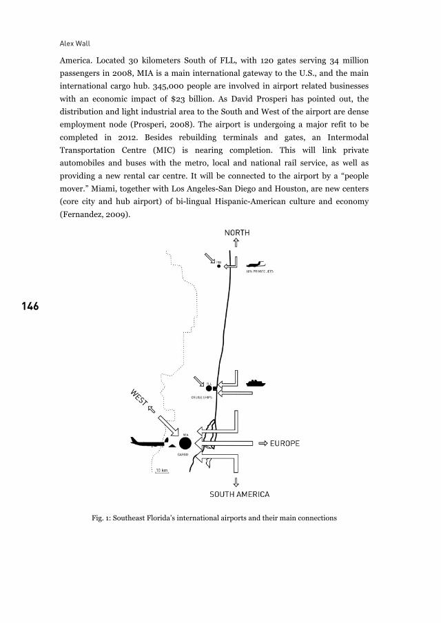
Alex Wall
146
America. Located 30 kilometers South of FLL, with 120 gates serving 34 million
passengers in 2008, MIA is a main international gateway to the U.S., and the main
international cargo hub. 345,000 people are involved in airport related businesses
with an economic impact of $23 billion. As David Prosperi has pointed out, the
distribution and light industrial area to the South and West of the airport are dense
employment node (Prosperi, 2008). The airport is undergoing a major refit to be
completed in 2012. Besides rebuilding terminals and gates, an Intermodal
Transportation Centre (MIC) is nearing completion. This will link private
automobiles and buses with the metro, local and national rail service, as well as
providing a new rental car centre. It will be connected to the airport by a “people
mover.” Miami, together with Los Angeles-San Diego and Houston, are new centers
(core city and hub airport) of bi-lingual Hispanic-American culture and economy
(Fernandez, 2009).
Fig. 1: Southeast Florida’s international airports and their main connections
Southeast Florida in the age of aviation
147 147
3 Sustainability and climate change risk
3.1 Wind, storm surges and coastal flooding Miami is among the top ten cities whose populations are exposed to high winds and
potential flooding caused by storm surges. It is the most exposed city in terms of the
value of property and infrastructure assets exposed to these risks (OECD, 2007). The
problem of coastal flooding and inundation is complex. Not only is there the threat
of flooding of low-lying areas near the ocean, there is also risk due to flooding from
the West as salt water pushes into the Everglades. In addition, any salt water
invasion of the aquifer would push water upwards through the region’s soft
limestone substructure creating flood risks from below.
In Southeast Florida (and all low-lying coastal cities), airports are critical to
emergency response, disaster relief, and other vital services. Yet FEMA (the Federal
Emergency Management Agency) has determined that both FLL and MIA are
located in the coastal flood zone, therefore the defence of the airports against
flooding may be an important theme for the near future.
3.2 Sustainable airports? Environmental problems at airports are ubiquitous, yet intelligent redevelopment
decisions can make airports active protagonists in the quest for sustainable
infrastructure. Noise, one of the most common complaints, can be addressed by
active engagement with local stakeholders, noise abatement procedures, and
strategic land use planning. Aircraft themselves will soon have a new generation of
quieter and more efficient engines, which will lower emissions. The large
impermeable surface of runways and apron areas produces substantial rainwater
runoff, which can be handled by reedbed remediation. Energy required for landing
illumination can be reduced by using LED lighting. Terminal buildings must
function far more efficiently by employing smart building technologies and recycling.
Already one of the terminals at Singapore Airport generates enough energy from its
roof-mounted photovoltaic panels to return energy to the grid (Taylor, 2007). In
North America generally, airports as effective transportation nodes bundling local,
regional and national transportation systems are, compared with Europe,
underdeveloped. The spectacle of hundreds of vehicles circulating over 24 hours a
day at both airside (passengers, maintenance, and baggage and freight handling) and
landside (public and private vehicular access, rental car vans) is primitive and
produces maximum emissions. Electric or alternative fuelled service vehicles, and
intermodal stations serving local and regional traffic need to be established.
Alex Wall
148
3.3 PBI, FLL and MIA In terms of emergency evacuation and disaster relief, PBI is a secure site based on its
elevation of 5,5 meters above sea level. In the case of weather and storm
emergencies, the airport will act as a relief centre. If it is implemented, the planned
tram/bus line to the downtown and beaches will be able to provide an alternative
escape route.
Of our three airports, FLL is the closest to the ocean and the lowest standing at
less than 2,0 meters above sea level, protected only by Dania Beach and the Inter
Coastal Waterway. Thus all new construction must have a first inhabited floor above
6 meters, and be able to withstand a 100-year storm over three days. The new
Intermodal Transportation Centre will play an important role in future security
scenarios.
MIA is aggressively implementing energy and fuel saving strategies. For airplane
movements, the airport has developed “tailored and continuous descent approach
and departure procedures” for reduced fuel burn. All airport vehicles will soon be
compressed gas and electric based; and the lighting system will be transformed to an
LED system. The Miami Intermodal Centre (MIC) will substantially reduce
emissions from the many continuously running rental car buses and vans. The
Miami survival plan has identified the MIC as a key element.
4 Conclusion The sheer number of users, the variety of functions, and the density of development
within and adjoining them ensure that airports accumulate the key conflicts in global
societies.3 Today they are becoming strategic security centers, where information
gathering techniques and body-scanning technologies are perfected and enacted.
In his opening address to the Airports and Regional Development Conference,
Thomas Sieverts pointed out that airports have become intermodal transportation
and logistic centers. They are the logical location for both established firms and
start-ups in many fields, and they are places (if not cities) where the functional
program reflects all social, cultural, and economic activities.
Perhaps in the near future, our three airports, linked by both highways and local
and regional transit lines, will each have a separate intermodal station and people
mover reducing reliance on the private automobile, and thus act as a single
movement system. If we accept the compromise figure of 1,5 meter sea level rise over
the next fifty years, our three airports may be a defended and secure territorial
3 Kesselring, Sven. „Airports in the Mobile Risk Society“ conference paper given at the Airports
and Regional Development Conference, Karlsruhe, 2009.
Southeast Florida in the age of aviation
149 149
system, crucial to the security and economy of a new Southeast Florida city
archipelago.
Notes
Dipl. Ing. Marcus Kopper produced the graphic maps and diagrams. I thank Jerry Allen, Director of Planning, PBI; Carlos Fernandez, Deputy Director, MIA; Mark Gambrill, Airport Development Division, FLL; and Dr. David Prosperi, Florida Atlantic University, School of Urban + Regional Planning. Airport directors and operations managers were asked five questions: 1) Character and market niche: With three international airports within a 190 km stretch of coastal city, what is your profile and competitive advantage? 2) Airport city: International airports are often referred to as airport cities or aerotropli; what will be the outcome of your current development strategies… an airport city? 3) Intermodality: What role will the airport play in future public and private transportation services within the county and Southeast coastal metropolis? 4) Climate change risk and sustainability: What are your goals regarding sustainability, energy use, emissions and transportation? How seriously are you taking sea-level rise? 5) Future design and planning: How are you developing for the future? How is the recession affecting current and future design decisions? For general information and statistics see: State transportation plans. http://www.dot.state.fl.us/aviation State demographic and population. http://edr.state.fl.us/population/popsummary.pdf Southeast Florida 2060. http://www.sfrpc.com/2060htm
References
D. Anes, L. Anderluh, D. Prosperi and B. Sens. Miami International Airport Area: Location,
Transshipment, Location. In: M. Schrenk, V. Popovitch, D. Engelke and P. Elisei. REAL
CORP 008. Proceedings / Tagungsband, Vienna.
Broward County. The Southest Florida Metropolitan Statistical Area in Broward County.
Broward by the Numbers. Planning Services Division. March 2004. No. 20.
Florida Department of Transportation Aviation Office Tallahassee. Wilbur Smith Associates
Florida Airports. Investing in Our Future. 2007. Available:
http://cfaspp.com/documents/FLORIDA_Investing.pdf
State of Florida – Department of Transportation, Tallahassee. De-Haven Smith Assoc., Wilbur
Smith Associates Florida Aviation System Plan 2007. Statewide Overview. 2007.
Available:
http://www.cfaspp.com/Documents/10252007_State_Overview_Final_Draft_Sep_20
07.pdf
Alex Wall
150
S. Mackler. Florida’s Resilient Coasts. A State Policy Framework. Florida Atlantic University:
Fort Lauderdale. 2007. Available:
https://www.communicationsmgr.com/projects/1349/docs/FAUResilientCoasts.pdf
S. Kesselring. Airports in the Mobile Risk Society. Conference paper given at the Airports and
Regional Development Conference, Karlsruhe. 2009.
S. Leatherman. Coastal Collision Course: Sea Level, Hurricanes and Development.
Lab for Coastal Research. Florida International University, Miami. 2007.
OECD Environment Working Paper. Screening Study: Ranking Port Cities with High Exposure
and Vulnerability to Climate Extremes. Interim Analysis: Exposure Estimates.
ENV/WKP/(2007). Nichols, R., Herweijer, C., and Halegatte, S. et al. See:
www.oecd.org/env/working papers, 2007.
D. Prosperi. MIA: Miami International Airport or Miami Innovation Area. In M. Shrenk, V.
Popovitch, D. Engelke, P. and Elisei. REAL CORP 008. Proceedings / Tagungsband,
Vienna.
T. Sieverts. Airports and City: a double-edged relationship. Conference paper given at the
Airports and Regional Development Conference, Karlsruhe. 2009.
B. Starret. Briefing Paper: Southeast Florida Metropolitan Area. Florida Department of
Community Affairs, Tampa. 1997. Prepared for the President’s Council on Sustainable
Development.
M. J. Taylor (Partner, Urban Design and Planning Practice. SOM LLP) in a lecture at the
University of Michigan School of Architecture. 2007. Taylor referred to the Photovoltaic
Power Plant at the new budget airlines terminal at Changi International Airport in
Singapore.
Interviews
J. Allen (Director of Planning, Palm Beach International Airport). Author Interview. 2009.
C. Fernandez (Deputy Director, Miami International Airport). Author email interview. 2009.
M. Gambrill (Director, Airport Development Division, Fort Lauderdale-Hollywood
International Airport). Author Interview. 2009.
Prof. Alex Wall Is professor of urban design at
Karlsruhe Institute of Technology KIT Department for Urban Design and Planning
76128 Karlsruhe [email protected]

151 151
Practise and Policy Approaches Betz
Buchholz Buser and Flinner
Schaafsma Sperling
Uber

152
153 153
Sustainable Airport Region Managing Airport Cities: Benchmark Study 2008
Stephanie Betz
In 2008 ICME Management Consultants conducted a benchmark study about the phenomenon airport city, its conceptual approach and potential success factors. After framing the scope of interview partners, like European hub airports and international Best practice airport, a three-pillar questionnaire has been prepared in order to inquire necessary data, concepts and proceedings. In cooperation with our benchmark partners generic models, development paths and success factors have been derived. Based on the individual success factors profile ICME has designed tailor made airport city approaches for implementation. Furthermore, ICME has currently launched a follow-up study to verify the results of the first one and to refine them if necessary.
1 Challenges for airport operators Permanent change has been characteristic for the aviation industry since its
beginning. Nowadays, these even more intense and profound changes implicate
complex challenges for airport operators. These dynamics mainly arise from global
megatrends, summarised in buzzwords like globalization, increasing life expectancy
or environmentally friendly technologies. However, there are also important drivers
on the local level, as the development of passenger and air cargo traffic figures. They
are the main drivers for strategic planning onsite and hence for investment planning.
In conjunction with the individual airport profile and its range of airlines and
destinations, comprehensive master plans based on capacity calculations are
designed. Needless to say that these plans underlie strict rules and therefore have to
be adapted to the relevant regulatory frameworks, potential regional development
planning, and often the most restrictive, rigid investor requirements on rates of
return. The exemplified pressure to permanent refinement is enforced by
comparatively young ideas like the airport city concept, which was the focus of this
study. Looking ahead this complexity is unlikely to be reduced, on the contrary, it is
rather likely to increase in the future. Vital to this development is a yet more
Stephanie Betz
154
distinctive multi-stakeholder model consisting of shareholders, national, regional
and local authorities, airlines, passengers, residents, etc. The focal point of the
network is the airport and its management, which has to balance the individual
claims and interests against the inevitable dynamics of the system airport as a whole.
Moreover, the degree of competition increases in different dimensions and levels.
Hence, the modern airport is not only competing with other airports and substitute
forms of transportation, but is standing in rivalry to other asset classes for funds.
2 ICME Benchmark Study 2008
2.1 Study design and approach
Best practice airports, European airports like Frankfurt, Munich or Amsterdam and
international best in class airports such as Dubai or Seoul, are the focus of the study.
Contacts to the responsible key players, among them Head of Airport Strategy, Head
of Development, Head of Real Estate have been established and were underfed with
secondary data from annual reports, strategy papers and statements.
A questionnaire compromising the following three parts has been designed:
• Part 1: Overview - This part examined the overall situation of the airport, stages
of the development, etc. (Description, infrastructural connection, strategy)
• Part 2: Interaction within the region – The focal point was the collaboration
with the region and the municipality, communication tools and concepts,
positioning of the airport etc.
• Part 3: Airport City – The third part concentrated on airport city concepts,
individual visions of the airports and the particular city- respectively cluster
elements within the master plans.
The next step was the analysis of the results on strategic, tactical and operational
level.
2.2 Development process of an airport city
The existence of a strategic planning approach towards an airport city is one of the
study’s basic assumptions. Its key drivers are the shareholders’ strategies, which
provide the general framework for the management. If the strategy contains the
implementation of an airport city concept, ICME would recommend at first a
detailed analysis of the airport’s current situation to identify and define the potential
development path. A realistic evaluation of the current and the planned positioning
has to be carried out regarding the appropriate stages of development, which are
shown below.
Managing airport cities
155 155
• Pure Airport; focusing on the infrastructure function of the airport
• Airport Add-on; additional functions for the support of the airport
• Airport Development “Beyond the fence”; rudimentary investment measures for
additional use
• Integrated Airport City; contractual partnership between airport and city
• Aeropolis; Creation of a new, cluster-based city type with airport as a core
In the next step the individual financial situation and the stages of cooperation have
to be designed and implemented for the tailor made airport city solution based on
the success factors profile.
2.3 Results and deductions from the benchmark study
There is no explicit definition and differentiation of the term “Airport City”, although
the phenomenon is the centre of discussion at numerous airports. Fig. 1
demonstrates the integral parts of an airport city, which have been distinguished in
this study.
Subsequently these airport city models have been identified and deducted as a
result of interviews. These varying airport city models range from simple marketing
concepts for non aviation offers as well as the genesis of city districts, where urban
elements merge with parts of the airport.
Furthermore, eight success factors have been identified. The combination plays an
important role in the applicability, practicability and the success of an airport city
concept. These factors are on the one hand of exogenous nature and on the other of
endogenous nature and can therefore be manipulated and optimised to a certain
extent. The fig. 3 discloses these factors and their main determining parameters.
For instance, the framework represents a particularly exogenous element as it is
determined by the political system and the government in charge and independently
from the visions of the airport management. By contrast, the parameters of
leadership are of completely endogenous nature and hence have potential for
alignment with the airport city concept.
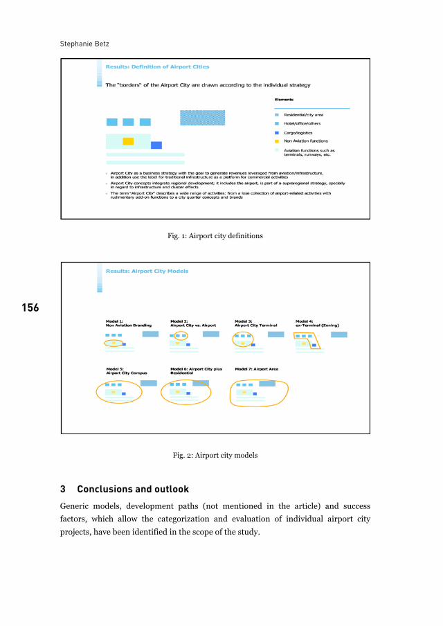
Stephanie Betz
156
Fig. 1: Airport city definitions
Fig. 2: Airport city models
3 Conclusions and outlook Generic models, development paths (not mentioned in the article) and success
factors, which allow the categorization and evaluation of individual airport city
projects, have been identified in the scope of the study.
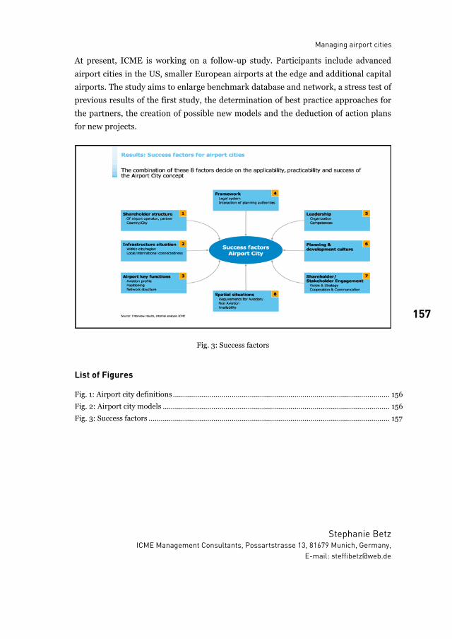
Managing airport cities
157 157
At present, ICME is working on a follow-up study. Participants include advanced
airport cities in the US, smaller European airports at the edge and additional capital
airports. The study aims to enlarge benchmark database and network, a stress test of
previous results of the first study, the determination of best practice approaches for
the partners, the creation of possible new models and the deduction of action plans
for new projects.
Fig. 3: Success factors
List of Figures
Fig. 1: Airport city definitions ........................................................................................................... 156Fig. 2: Airport city models ................................................................................................................ 156Fig. 3: Success factors ....................................................................................................................... 157
Stephanie Betz ICME Management Consultants, Possartstrasse 13, 81679 Munich, Germany,
E-mail: [email protected]

158
159 159
Airport city Approaching an already existent phenomenon
Peter Buchholz
Our topic is „From Airport City to Airport Region?“ All theses contributions are made in order to describe a phenomenon. But we do not have a clue about what we are describing. In order to explain this I will refer to Christopher Columbus. Columbus approached the coastline of Bermuda with his ships and walked onto the beach. The natives asked him how he came over the water, because they could not see the ship. They were incapable to see such a big ship. The wise man was the first who recognised the altered waves on the beach. And he concluded the size of the ships by the waves he saw. Only following his thoughts he could see the unbelievably big ship.
Compare it to the Airport City: The „City“ is then the source of the waves going out of the gravity area. We only use the label „city“ to name the gravity field, because we have not found a name for it yet. But the waves going out of the gravity field encompass the influence field of it. Compare Frankfurt airport with this: Frankfurt is hanging like a spider in a web of intermodal spokes: The net of the motorway, of the railway connections and the international airport net. If commuters are the waves going out of the gravity field, take a distance of 2 hours and you may imagine the area of the Frankfurt Airport Region. Remember Columbus: The airport region already exists, and we are the ones to learn and observe.
1 Einstimmung Nähern wir uns zuerst dem Thema mit einer These: wir haben keine Ahnung von
dem, was wir da beschreiben. Uns in diesen Aspekt zu versetzen nehmen wir die
Geschichte von James Cook oder Christoph Columbus - die Geschichtenerzähler
schreiben sie mal dem einen und mal dem anderen zu. Die Geschichte erzählt, dass
die Seefahrer mit ihrem Schiff eine Insel erreichen und in einer Bucht vor Anker
gehen. Sie lassen die Boote zu Wasser, um an Land zu gehen. Am Strand werden sie
von den Einheimischen empfangen, unter ihnen der Häuptling und der weise
Schamane. Der Häuptling fragt, wo sie herkommen und die Seefahrer deuten auf ihr
Schiff in der Bucht. Doch der Häuptling und sein Stamm können das Schiff nicht
Peter Buchholz
160
sehen. Das Schiff, das so viel größer ist als ihre Boote, das können sie sich nicht
vorstellen. Und weil sie es sich nicht vorstellen können, können sie es nicht sehen.
Erst der Schamane beginnt zu begreifen: die Wellen kommen in veränderter Form
über die Bucht und an den Strand, also muss da draußen etwas sein, etwas bisher
nicht Gesehenes. Er ist der erste, der das Schiff der Seefahrer sehen kann, und
nachdem er es seinem Stamm vermittelt hatte, konnten auch sie sehen.
Es geht darum, etwas sehen zu lernen. Machen Sie sich keine Sorgen, wir sind
dabei in guter Gesellschaft, wir sind zusammen mit Curt Goetz, mit Goethe und
Faust, mit Sokrates. Das Bild der Indianer am Strand erleichtert nur ungemein, sich
von vorgefassten Determinanten zu lösen.
2 Definition und Entgrenzung: Das Zentrum beschreiben statt der Außengrenzen Spätestens seit 1989 haben wir in Europa mit dem Phänomen der Entgrenzung
umzugehen. Erst fielen die innerdeutschen Grenzen, dann – mit Schengen – fielen
die europäischen Grenzen. Spätestens schließlich seit der Finanzkrise ist deutlich,
dass der Flügelschlag eines Schmetterlings in China in Mexiko einen Sturm
verursachen kann. Uns sind – so sehen es andere – mit dem neuen Zeitalter des
Wassermanns die Begrenzungen weggefallen, die Definitionen – im wahrsten Sinne
der Übersetzung.
Es gibt sie noch, die kommunalen und staatlichen Grenzen. Sie dienen heute eher
dazu, Steuern und Rechtssysteme und soziale Organisationsformen zu fassen. Unser
Leben aber richtet sich nicht mehr danach. Das Leben von Familien und Personen,
das Wirken von Unternehmen und Organisationen hat seine eigenen
Wirkungskreise gefunden. Dies meine ich auch im Wortsinne: die Kreise und
Räume, in denen sie und in die hinein sie wirken.
Der Versuch also, für die Airportcity Frankfurt RheinMain eine einheitliche
Definition zu finden ist abhängig von der Beschreibung, welcher Wirkungskreis
gemeint ist – dann können die Kreise gezogen werden. Gegen den Versuch, eine
Airportcity oder eine Airport-Region geografisch zu definieren, setze ich das Bild des
Gravitationsbereiches. Das Bild eines Steines, der ins Wasser fällt und seine
Wirkungen/Auswirkungen/Kreiswellen hat oder das Bild des Wirbelsturms, der
seine Mitte, sein Auge hat. Mich interessiert: was ist das Zentrum und macht seine
Energie aus?
Erinnern sie sich noch an James Cook und Christoph Kolumbus und die Indianer?
Ich komme zurück auf den Titel der Veranstaltung „from Airport city to Arport
region“: dies existiert schon längst und wir sind es, die lernen müssen sie zu sehen.
Airport city
161 161
3 Exkurs Stadtbild Kasarda Erlauben sie mir einen Exkurs zu John Kasarda und zur „aerotropolis“. Kann dieses
Bild uns weiterhelfen? Wie jedes theoretische Modell einer Idealstadt orientiert es
sich an einer zentralen Aufgabe, ich nenne dieses zentrale Thema das Primat. Von
dem Modell der Siedlung Harmony in 1825 über Letchworth 1902, einem Modell aus
1928 bis hin zur Charta von Athen (hier dem Primat der funktional geteilten Stadt)
führt der Weg. Das Modell der Aerotropolis ist eines, in dem der Flughafen das
Primat hat.
Dieses Modell auf Frankfurt RheinMain anzuwenden ist zu kurz gegriffen, und
darauf möchte ich im Folgenden eingehen.
4 Der Begriff „City“ „City“ in seiner ursprünglichen Bezeichnung war der Ort der Banken in London. Der
Begriff wandelte sich in 1944 – Bebauungsplan zum Wiederaufbau von London -
und bezeichnete den Ort der zentralen Geschäfte, der Verwaltung und der Banken.
Soll City jetzt der Ort des Flughafens sein, oder ist es einfach ein Stadtmodell?
Vielleicht bezeichnen wir mit „City“ einfach nur „die Mitte“, nehmen wir dieses Wort
als Label einfach nur um „die Mitte“, das Identität stiftende Element zu bezeichnen.
Dann steht „City“, „die Mitte“ nur für den Ausgangspunkt der Wellen, für das
Gravitationszentrum.
5 Der Kernbereich Der Kernbereich von Frankfurt RheinMain, der Ausgangspunkt dieser Airport
Region ist schnell ausgemacht: vom Frankfurter Kreuz im Osten bis zur Lufthansa-
Basis im Westen, von der B 43 im Norden bis zu der Terminalkette im Süden.
Innerhalb dieses Umgriffes liegen: die Lufthansa Basis, das Air-Rail-Center und
FAC, MAC und Hotel Steigenberger, Gateway Gardens und die vielfältigen
Nutzungen zwischen den Terminals und der BAB 3.
Dazu gehören auch die Straßen. Das sind nun keine Straßen, die einfach zum
Flughafen hinführen. Sie liegen tangential: die 10 Spuren der BAB 3, die 10 Spuren
der BAB 5, die 8 Spuren der B 43. Dazu gehören weiter die S-Bahnen und die
Fernbahnen mit ihren Bahnhöfen. In diesem Fall die Grenzen zu finden ist einfach,
denn dieses Gebilde ist eingezäunt, ja fast gefangen gesetzt zwischen strengstens
geschütztem Wald im Norden und Osten und den eigenen Flugverkehrsflächen im
Westen und im Süden. Die Frage nach dem Zentrum der Gravitation habe ich
beantwortet, doch was macht seine Energie aus?
Peter Buchholz
162
6 Reisen Ich lade sie ein, sich dem Phänomen „Airportcity“ von einer anderen Seite zu
nähern, von der Seite des Reisens und der Beziehung von Raum und Zeit.
Bis ungefähr 1830 waren Raum und Zeit in ihrer Wahrnehmung für den
Menschen identisch. In Europa war die Bewegung durch Raum und Zeit an die
verfügbaren Transportmittel gebunden: das Pferd und die eigenen Füße. 40
Kilometer pro Tag, das war die Normaldistanz. Mit der Eisenbahn änderte sich das
grundlegend und diese – auch gesellschaftliche – Transformation war rund 60 Jahre
später abgeschlossen.
Um die Dimensionen des Wandels von 1830 bis 1890 zu erfassen hier einige
Ergebnisse: nicht nur die Puffer der Eisenbahn waren vereinheitlicht, das
Maßsystem war inzwischen normiert und der Meter war eingeführt. Der Kern aber
war die Zeit, auch sie war einheitlich.
Die ersten Berichte über das Reisen mit der Bahn lassen die Veränderung spüren:
• Die Geschichte wird erzählt von einem Indianer, der am Bahnhof auf der Bank
sitzt. Er ist schon angekommen, aber er wartet noch auf seine Seele, die
nachkommt, den sie braucht längere Zeit.
• Die Mediziner, die vor Geschwindigkeiten von mehr als 40 km/h warnen.
Jenseits solcher Geschwindigkeiten würde man verrückt werden.
• Und schließlich die Reiseberichte, in denen es wörtlich heißt: vor der Zeit bin
ich angekommen.
Die Eisenbahn, oder besser der Waggon, das Abteil, das ist diese neue
Raum/Zeit/Maschine. Der Zugang in diese andere Welt, der Ort des Übergangs, ist
der Bahnhof. Doch Bahnhof als Begriff zu nehmen ist hier zu ungenau, denn mit
Bahnhof umfassen wir alle die Flächen, in der sich dieses Phänomen Eisenbahn
organisiert. Der Übergang von der einen Raum/Zeit in die andere ist lediglich das
Vestibül des Bahnhofes, hier ist der Schnittpunkt.
7 Frankfurt Bahnhofsviertel In Frankfurt am Main wurde im Jahre 1888 der neue Hauptbahnhof eröffnet. Drei
Länderbahnen wurden in diesem neuen Kopfbahnhof zusammengefasst. Drei große
Hallen hatte und hat dieser Bahnhof und in seiner Architektur spiegeln sich die drei
Hallen in drei Bögen, die den Eingang zum Vestibül bilden, den Eingang zu den
Warteräumen und Schalterhallen und schließlich zu den Bahnsteigen. Dieses
Vestibül wurde damals – in 1888 - weit vor die Tore der Stadt Frankfurt gelegt.
Dieses Bild steht für die Wandlung, die vor gut 120 Jahren stattfand.
Airport city
163 163
Das städtebauliche Gebilde, das in der Folge zwischen dem Vestibül und der alten
Stadt entstand, wurde das „Bahnhofsviertel“ genannt. Darauf möchte ich später
noch mal eingehen.
In den 20-er Jahren des 20.Jhd. – also fast 100 Jahre nach der Eisenbahn – kam
als neue Raum/Zeit/Maschine das Flugzeug dazu, und wie die Eisenbahn brauchte
es 60 Jahre bis die Transformation abgeschlossen war. Weil uns die originären
Begriffe fehlen nehmen wir Vorhandenes und formen dies um. Das war schon so
beim Bahn-Hof (was ein wenig erinnert an den umbauten Hof mit den Pferdeställen
auf der einen Seite und den Remisen auf der anderen und einem Tor davor zum
Schutz). Jetzt heißen die Worte Flughafen, Luftschiff, Flugzeug, sogar
Flugzeugbahnhof habe ich gefunden. Und eine interessante neue Wortprägung sei
genannt: sie nennen Baikonur und Guayana und Cape Kennedy „Weltraumbahnhof“
in hilfloser Ermangelung eines eigenen Begriffes. Auch wenn dort nie einer
ankommt, die fliegen doch immer nur weg!
Wie die Bahnhöfe liegen diese Flächen für die Flughäfen zuerst am Rande der
Stadt, für Frankfurt Rebstock, in Berlin Tempelhof. Sie wurden mit der Erweiterung
ihrer Funktionen vor die Stadt verlegt, wie Frankfurt RheinMain, wie Berlin BBI, wie
Paris Charles de Gaulle. Der Schnittpunkt im Übergang dieser neuen
Raum/Zeit/Maschine ist organisiert wie der Bahnhof in seinen Anfängen: im
Übergang liegt das Vestibül mit der Halle für die Ankommenden, der Halle für die
Abgehenden, die Wartesäle.
8 Integration / Desintegration Das Gebilde solch eines Flughafen-Vestibüls kann in eine Stadt integriert werden,
ein Beispiel ist Tempelhof. Der Plan von Speer für die Reichshauptstadt zeigt das
auf: der Südbahnhof, der Flughafen, zentrale Versorgung, Regierung, Park und
Freiraum, der Nordbahnhof.
Die Gegenbewegung zu dieser Integration wird deutlich am Phänomen „Lehrter
Bahnhof“. Lehrte, was ist das? Eine Stadt in NRW, 1800 565 EW, 1900 6.554 EW,
heute 44.000 EW. Der Lehrter Bahnhof in Berlin, heute der Hauptbahnhof genannt.
Berlin hatte zur Zeit der Blüte des Kaiserreiches seine Bahnhöfe und wie damals
noch üblich waren die Eisenbahnstrecken Verbindungen zwischen zwei Hauptorten,
sie begannen an dem einen Hauptort und endeten am anderen jeweils im
Kopfbahnhof. In Berlin bekamen die Bahnhöfe den Namen für das, was am anderen
Ende der Raum/Zeit/Maschine lag: Hamburger Bahnhof für Hamburg, Stettiner
Bahnhof für Stettin, Anhalter Bahnhof für Anhalt mit Leipzig und Dresden,
Potsdamer Bahnhof für Potsdam. Und Lehrter Bahnhof für Lehrte? Lehrter Bahnhof
Peter Buchholz
164
stand für die Verbindung nach Hannover, dem Ort eines damals wichtigen Königs
im Deutschen Reich.
Damals war die Eisenbahn verbunden mit Dreck und Lärm, mit Rauch und
Gestank, und das rund um die Uhr. Der König von Hannover wollte das nicht vor
seinem Schlossportal haben. Also verlegte er die ganzen Infrastruktureinrichtungen
der Bahn nach Lehrte – und in Hannover war dann nur noch ein kleiner feiner
Bahnsteig zum Ein- und Aussteigen. Darum: „Lehrter Bahnhof“.
Mit dem ganzen Flughafen Frankfurt RheinMain und mit seinem Vestibül machen
wir es derzeit genauso: die ganze Provinz will den Lärm und den Gestank nicht
haben und verbannt das Gebilde in den Stadtwald, zieht einen Zaun drum herum,
damit er nicht weglaufen und sich nicht ausbreiten kann, legt drum herum zur
Sicherheit noch Naturschutzgebiete und Bannwälder und isoliert so das Ganze.
9 Die Energie von Airportcity Für die ganze Region Frankfurt RheinMain ist diese Agglomeration im Wald zu
einem Ort geworden, an dem sich die Raum/Zeit/Maschinen miteinander
verknüpfen: nicht nur das Flugzeug, hinzukommen die Bahn mit dem ICE, die Bahn
mit der S-Bahn und das Auto, unsere kleinste individuelle Raum/Zeit/Maschine, die
mit der Autobahn (übrigens als Begriff eine Folgeschöpfung von Eisenbahn) sich
dazugeschlichen hat.
Das Vestibül dafür trägt noch immer die gleichen Funktionen: der Platz für die
Kutschen, der Zugang, die Warteräume, die Schalter und die Steige für Ankunft und
Abfahrt. Inzwischen sind sie nur größer geworden: ein Parkhaus für 12.000
Fahrzeuge, Busbahnhof, eine unzählige Kette von Schaltern, Wartezone,
Ankunftszone, Abfahrtszone. Noch im Vestibül selber besteht die
Umsteigemöglichkeit zwischen den Raum/Zeit/Maschinen Flugzeug – Bahn Auto,
der Fahrgast braucht nicht einmal mehr das Vestibül zu verlassen. Dies ist der Kern
der von uns so benannten Airportcity.
Das Vestibül steht für ein weiteres anderes Phänomen: das Verschwinden des
Zwischenraums. Mit steigender Geschwindigkeit der Raum/Zeit/Maschine – so
schon die Beobachtung nach Einführung der Eisenbahn – verschwindet der
Zwischenraum. Das Gefühl entsteht, dass auf der anderen Seite des Eingangs zum
Vestibül der Zielort liegt: im angenehmsten Fall das Urlaubsziel mit Strand und
blauem Meer. Kurt Tucholsky beschrieb so den Wunsch des Großstädters für das
Idealhaus: vorne die Friedrichstraße und hinten die Ostsee – ohne den
Zwischenraum. In der Astrophysik heißt so etwas ein Wurmloch. Das ist wie ein
Kleiderschrank mit Türen auf beiden Seiten. Durch die eine Türe steigt man ein, in
Airport city
165 165
den Schrank oder in das Vestibül, durch die andere Türe steigt man in einer anderen
Zeit und an einem anderen Ort wieder aus.
Hamburg nannte sich das Tor zur Welt. Die Airportcity ist mehr: sie ist der
Verbindungsort, bei dem auf der einen Seite des Vestibüls die Region RheinMain
steht, auf der anderen Seite alle anderen Orte der Welt. Der Zwischenraum ist nur
eine Frage der Zeit. Dies bildet auch für viele die Faszination des Ortes, an dem bei
Eintritt auf der einen Seite des Vestibüls auf seiner anderen Seite alle Orte der Welt
erreichbar sind.
10 Welche Nutzungen zeichnen den Ort aus? Rudolf Wolters schrieb 1978 über de Entwicklung der Bahnhöfe in Berlin: „Die
Eisenbahnstrecken werden zu Erzeugern von Magnetfeldern, die gewerbliche
Betreibe und Wohnsiedlungen in ihren unmittelbaren Bereich zwingen.“
Im Bahnhofsviertel Frankfurt können wir nachvollziehen, wie dies innerhalb von
fünf Jahren geschah. Noch 1888 ging der Kaiser über ein leeres Feld zwischen der
Stadt und dem Bahnhof, 1914 standen dort Hotels, Büros, Läden, Wohnungen,
Schuhmann-Theater und weitere spezielle Nutzungen. Auf der stadtabgewandten
Seite waren die Transportunternehmen, Zulieferer, Dienstleister, Werkstätten,
Rohstofflager etc. etc. untergebracht. Während noch 1872 der Friede zu Frankfurt im
Hotel Schwanen in der Innenstadt unterschrieben wurde standen die modernen
großen Hotels am Bahnhof.
Das gleiche Phänomen entsteht am neuen Vestibül: Hotels, Büroflächen,
Gastronomie, Läden, Konferenzräume. Theater wird zur Diskothek, Wellness kommt
hinzu und ganz neu universitäre Bildung. Für die Meisten ist es kein Ort zum
Bleiben, es ist ein Ort des Durchgangs: pro Tag 350.000 Fahrzeuge am Frankfurter
Kreuz, 300.000 Reisende am Fernbahnhof, 170.000 Reisende am Flughafen.
11 Relationen Zum Abschluss nehme ich noch bezug auf das Feld der Relationen, der Verhältnisse.
Während das Vestibül des Frankfurter Hauptbahnhofes mit seiner Stadtseite sich
noch in die Stadt integrieren konnte, während das Vestibül des Flughafen Tempelhof
– übrigens das weltgrößte Bauwerk – sich noch in die Struktur der Stadt integrierte,
fällt das mit dem Flughafen Frankfurt RheinMain um Vieles schwerer. Das liegt an
den Dimensionen der Raum/Zeit/Maschinen.
Im Wohnungsbau hat es mich das erste Mal erschrocken, dass – so der Standard
des sozialen Wohnungsbaus – für eine Kinderzimmer 14 m² zur Verfügung stehen,
für den Autostellplatz 25 m². Das symbolisiert den Relationssprung.
Peter Buchholz
166
Das Auto als Gerät wiegt etwa 1 t und bewegt sich mit 100 km/h. Bei der Eisenbahn
wiegt alleine die Lokomotive 80 t und bewegt sich in der Spitze mit 250 km/h. Das
Flugzeug hat Gefährte von 250 t und braucht schon beim Start 250 km/h, um
abzuheben. Das Frankfurter Kreuz hat einen Flächenbedarf der gesamten
Frankfurter Innenstadt, und es passt mindestens sechs mal auf das Rollfeld des
Flughafens.
Auch wenn dieses Vestibül der Raum/Zeit/Maschinen am Flughafen Frankfurt
RheinMain ein Teil der Region ist, so sprengt es mit seinen Dimensionen die
üblichen Größenordnungen der Siedlungsstrukturen. Aus diesem Grunde liegt es
völlig richtig in der Mitte der Airport-Region. In seiner ganz besonderen Ausprägung
ist es ein Element der Region Frankfurt RheinMain, es mag auch aus seiner
Bedeutung im internationalen Vergleich die Region besonders auszeichnen.
Funktional ist die Bezeichnung einer Airport-Region zutreffend, die Bezeichnung
aber als Identität für die Region zu nehmen, vernachlässigt die anderen vielfältigen
Qualitäten der Region.
Das – was ich als Vestibül umschrieben habe – ist das Schiff in der Bucht, das wir
lernen müssen zu sehen. Es ist schon da, schon eine ganze Weile. Gleichgültig wie
wir es nennen, welchen Begriff wir darauf schreiben, in der Region und in den
Kommunen müssen wir planerisch damit umgehen.
Peter Buchholz Gateway Gardens Projektentwicklungsgesellschaft mbH
Myliusstraße 33-37, 60323 Frankfurt am Main E-mail: [email protected]
167
Airports’ catalytic effects Describing a knowledge gap
Benjamin Buser and Jochen Flinner
Alongside the positive accessibility effects of global air traffic there are also negative effects, especially in the surroundings of big airports. In times of airports’ expansion plans, these negative effects are often stressed by the opponents. While negative impacts like aircraft noise are quantitatively already very well analysed, there are still deficits concerning the investigation of economic impacts. This leads to an underestimation of positive economic effects of airports so far. On the occasion of the first international colloquium "Airports and Spatial Development" the authors analysed airport-conditioned added value effects in the airport surrounding. The following pages summarise the essential gist of the lecture presented on this colloquium.
Den positiven Erreichbarkeitseffekten des globalen Luftverkehrs stehen insbesondere im Umfeld von Großflughäfen auch negative Auswirkungen gegen-über. Diese Belastungen sind zweifelsohne vorhanden und werden bei Ausbau-planungen von Flughäfen praktisch immer ins Feld geführt. Während Auswirkungen wie etwa der Fluglärm quantitativ bereits sehr gut analysiert sind, sind im Bereich der Erforschung wirtschaftlicher Auswirkungen von Flughäfen noch Defizite vorhanden, die bislang zu einer Unterbewertung der positiven wirtschaftlichen Effekte führen. Anlässlich des ersten Internationalen Kolloquiums "Airports and Spatial Development" haben sich die Autoren mit der Erfassung und Analyse von flughafenbedingten Wertschöpfungseffekten im Flughafenumland befasst. Die folgenden Ausführungen fassen die wesentlichen Aussagen des im Rahmen des Kolloquiums gehaltenen Vortrages zusammen.
1 Einführung Die ökonomischen Auswirkungen von Flughäfen sind unbestritten und werden seit
vielen Jahren wissenschaftlich untersucht. Dabei konzentrierte man sich lange Zeit
ausschließlich auf die Effekte, die durch die Bereitstellung von Luftverkehrs-
leistungen entstehen. Diese Angebotsseite unterteilt sich klassisch in die direkten,
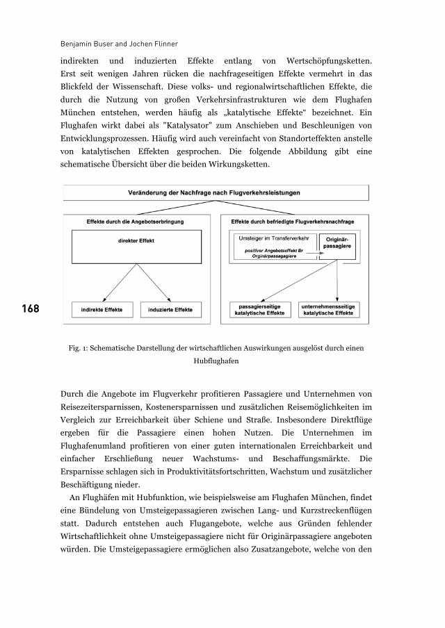
Benjamin Buser and Jochen Flinner
168
indirekten und induzierten Effekte entlang von Wertschöpfungsketten.
Erst seit wenigen Jahren rücken die nachfrageseitigen Effekte vermehrt in das
Blickfeld der Wissenschaft. Diese volks- und regionalwirtschaftlichen Effekte, die
durch die Nutzung von großen Verkehrsinfrastrukturen wie dem Flughafen
München entstehen, werden häufig als „katalytische Effekte“ bezeichnet. Ein
Flughafen wirkt dabei als "Katalysator" zum Anschieben und Beschleunigen von
Entwicklungsprozessen. Häufig wird auch vereinfacht von Standorteffekten anstelle
von katalytischen Effekten gesprochen. Die folgende Abbildung gibt eine
schematische Übersicht über die beiden Wirkungsketten.
Fig. 1: Schematische Darstellung der wirtschaftlichen Auswirkungen ausgelöst durch einen
Hubflughafen
Durch die Angebote im Flugverkehr profitieren Passagiere und Unternehmen von
Reisezeitersparnissen, Kostenersparnissen und zusätzlichen Reisemöglichkeiten im
Vergleich zur Erreichbarkeit über Schiene und Straße. Insbesondere Direktflüge
ergeben für die Passagiere einen hohen Nutzen. Die Unternehmen im
Flughafenumland profitieren von einer guten internationalen Erreichbarkeit und
einfacher Erschließung neuer Wachstums- und Beschaffungsmärkte. Die
Ersparnisse schlagen sich in Produktivitätsfortschritten, Wachstum und zusätzlicher
Beschäftigung nieder.
An Flughäfen mit Hubfunktion, wie beispielsweise am Flughafen München, findet
eine Bündelung von Umsteigepassagieren zwischen Lang- und Kurzstreckenflügen
statt. Dadurch entstehen auch Flugangebote, welche aus Gründen fehlender
Wirtschaftlichkeit ohne Umsteigepassagiere nicht für Originärpassagiere angeboten
würden. Die Umsteigepassagiere ermöglichen also Zusatzangebote, welche von den
Airports’ catalytic effects
169 169
Originärpassagieren und den Unternehmen in der Region als Direktflüge genutzt
werden. Die katalytischen Effekte für das Flughafenumland fallen damit rund um
einen Hubflughafen deutlich höher als an anderen Flughäfen aus.
Der Flughafen München weist beispielsweise bereits heute mit dem bestehenden
2-Bahn-System und seiner Hubfunktion bedeutende katalytische Effekte auf. Mit der
geplanten und derzeit im Genehmigungsverfahren befindlichen Kapazitäts-
erweiterung um eine 3. Start- und Landebahn wird die Hubfunktion des Flughafens
weiter gestärkt. Im Zuge der Stärkung der Hubfunktion wird sich auch die absolute
Anzahl der Originärpassagiere von / nach MUC erhöhen was wiederum zusätzliche
passagier- und unternehmensseitige katalytische Effekte auslösen wird.
2 Forschungsziel und Zwischenergebnisse Das Forschungsziel besteht darin, die für die Erfassung aller katalytischen Effekte
notwendigen methodischen Ansätze zu erarbeiten, um auf diese Weise die
Gesamtheit aller katalytischen Effekte sowie ihren wertmässigen Beitrag an die
regionale Wirtschaftskraft in einer Region zu erfassen.
Im Rahmen des Forschungskolloquiums vom 9./10. Juli 2009 an der TU
Karlsruhe wurden drei Publikationen ausgewählt und hinsichtlich deren Erfassung
katalytischer Effekte analysiert:
• Airports Council International Europe (2004): The social and economic impacts
of airports in Europe, Brüssel.
• Ernst Basler + Partner AG, BulwienGesa AG (2007): Auswirkungen des
Vorhabens 3. Start- und Landebahn auf Wirtschaft und Siedlung im
Flughafenumland, Zürich, München.
• European Center for Aviation Development ECAD GmbH (2008): Katalytische
volks- und regionalwirtschaftliche Effekte des Flughafens München, Darmstadt.
Die Kriterien für die Auswahl der Studien waren die inhaltliche Relevanz für die
Fragestellungen am Flughafen München sowie die Bekanntheit bzw. der Stellenwert
der Publikation in Fachkreisen. In einem zweiten Schritt wurden die Studien bzgl.
des Umgangs mit der Thematik miteinander verglichen, wobei angemerkt werden
muss, dass diese - bezogen auf den Untersuchungszweck - jeweils ganz
unterschiedliche Zielrichtungen verfolgen. Die detaillierten Analyseergebnisse und
Bewertungen zu den drei Publikationen können dem gleichnamigen Vortrag der
Autoren vom 9. Juli 2009 entnommen werden.
Zusammenfassend kann festgestellt werden, dass die Studien zwar verschiedene
Aspekte des katalytischen „Spektrums“ analysieren und teilweise sogar empirisch
bzw. statistisch belegen. Insgesamt bleibt es jedoch bei einer starken Untererfassung
des gesamten denkbaren katalytischen „Spektrums“. Der Versuch, als
Benjamin Buser and Jochen Flinner
170
Gesamtaggregat aller katalytischen Effekte den Beitrag zur regionalen
Wirtschaftskraft und die Wachstumsdynamik zu ermitteln, wird mangels
wissenschaftlicher Durchdringung nicht unternommen.
Die Analyse der genannten Publikationen hat zunächst deutlich gemacht, dass das
Thema eine sehr hohe Komplexität aufweist. Insbesondere wird klar, dass zur
eindeutigen Bestimmung von Ursachen und Wirkungen (Ursache-Wirkungs-
Zusammenhänge) ein Bündel unterschiedlicher methodischer Ansätze zum Einsatz
kommen muss. Auch wenn Einigkeit darüber herrscht, dass internationale
Großflughäfen in Metropolregionen einen deutlichen Nutzenüberhang für das
Flughafenumland herbeiführen, können einzelne katalytische Effekte auch negativ
ausgeprägt sein. Die katalytische Gesamtwirkung für eine Region ergibt sich erst aus
einer Saldierung von positiven und negativen katalytischen Effekten.
Dementsprechend sind die wissenschaftlichen Grundlagen für eine vollständige
Erfassung des gesamten katalytischen „Spektrums“ zu erarbeiten.
3 Forschungsfragen Selbst mit den bereits sehr ausführlichen Untersuchungen für den Flughafen
München lässt sich kein Gesamtbild der katalytischen Effekte erstellen. Die
Ursachen-Wirkungs-Zusammenhänge katalytischer Effekte scheinen zu verschieden,
um eine einheitliche oder zumindest kompatible Methode zu finden. Im Gegensatz
hierzu lassen sich mit etablierten regionalwirtschaftlichen Methoden ein
Flughafenumfeld insgesamt und mit den Angebotseffekten entlang von
Wertschöpfungseffekten auch Teilbereiche des Flughafens sehr gut beschreiben. In
Anlehnung an die mathematische Methode des "induktiven Schließens" ist daher die
Frage zu stellen, ob die Untersuchung des Flughafenumlandes als auch des
Flughafens induktiv der Ermittlung katalytischer Effekte dienlich ist. Ausgehend von
diesem Grundgedanken ergeben sich folgende Forschungsfragen von zentraler
Bedeutung:
• Welche regionalwirtschaftlichen Methoden sind am besten geeignet zur
Erfassung der vergangenen und künftigen Entwicklungsdynamik in einem
Flughafenumland?
• Wie unterscheiden sich Wirtschaftsstruktur und Entwicklungsdynamik im
Umfeld großer Flughäfen in Abhängigkeit und Ausprägung der Hubfunktion?
• Lässt sich eine statistisch signifikante Korrelation zwischen Umlandentwicklung
und Flughafenentwicklung herleiten unter Isolation der relevanten
Entwicklungsfaktoren?
Airports’ catalytic effects
171 171
• Lässt sich eine statistisch signifikante Korrelation zwischen den
Angebotseffekten und den mutmaßlich katalytisch verursachten Entwicklungen
herstellen?
List of figures
Fig. 1: Schematische Darstellung der wirtschaftlichen Auswirkungen ausgelöst durch einen Hubflughafen........................................................................................................................ 168
References
Airports Council International Europe. The social and economic impacts of airports in Europe.
Brüssel. 2004.
Ernst Basler + Partner AG, BulwienGesa AG. Auswirkungen des Vorhabens 3. Start- und
Landebahn auf Wirtschaft und Siedlung im Flughafenumland. Gutachten im Auftrag
der Flughafen München GmbH im Rahmen des Planfeststellungsverfahrens 3. Start-
und Landebahn. Zürich, München. 2007
European Center for Aviation Development ECAD GmbH. Katalytische volks- und
regionalwirtschaftliche Effekte des Flughafens München. Regionalstudie im Rahmen
der Gesamtstudie Katalytische volks- und regionalwirtschaftliche Effekte des
Luftverkehrs in Deutschland. Darmstadt. 2008.
Dr. Benjamin Buser is a consultant at Ernst Basler + Partner AG, 8032 Zürich, Schweiz
E-mail: [email protected]
Jochen Flinner is an economic geographer at Flughafen München GmbH, Nordallee 25
85326 München-Flughafen, E-mail: [email protected]

172
173
From airport city to airport corridor Airport and city, sustainability and economy
Maurits Schaafsma
1 Introduction In the process of globalization, a concentration of internationally oriented urban
activities seems to take place in a limited number of highly competitive ‘global city
regions’. In the Netherlands, Amsterdam has strengthened its position as a centre for
finance, services and head offices at the cost of other cities like Rotterdam and
Eindhoven. These global city regions are increasingly facing a highly dynamic global
competition for economic activities, sports events and cultural facilities. In this
competition their position in the networks of city regions is of great strategic
importance and is strongly supported by the direct destinations their airports offer;
city regions and airports are increasingly tied to each other.
The information infrastructure, air transportation and the global networks of
container liners facilitate globalization, the ‘global shift’ and the information age.
Climate change and scarcity of resources could become strong counter-forces to the
increasing global flows of people and goods. The global interdependency of city
regions however is not likely to decrease and the strategic importance of air traffic
could increase further in spite of climate issues having a negative impact on the
growth of air transport.
Airports and cities face a huge challenge in positioning themselves in the
international competition and do what is within their powers to make the interaction
between airport and city a sustainable one.
2 Network developments The developments in the airline industry and their networks have a direct impact on
the position of cities. Deregulation of air traffic has led to the rise of low cost airlines
and the formation of worldwide alliances of traditional ‘flag carrier’ airlines. The
latter have organized their networks in global ‘hub and spoke’ systems with a central
role for a limited number of hub airports as point of interchange. These hub airports
can offer a truly competitive intercontinental network to their city regions.
Maurits Schaafsma
174
Three global alliances dominate the market: Star Alliance with Lufthansa, United
Airlines, Thai and Singapore Airlines, SkyTeam consisting of Air France KLM, Delta,
China Southern and Korean and OneWorld compromising British Airways,
American Airlines, Cathay Pacific and Quantas.
Each of these airline alliances tends to develop only two major hub airports in
Europe. Frankfurt and Munich are the main hub airports of Star Alliance, London
Heathrow and Madrid of OneWorld. Amsterdam Schiphol and Paris Charles de
Gaulle are the European hubs of SkyTeam.
In this way the network developments of the airlines put a limited number of city
regions in a more central position, offering them a competitive advantage over other
city regions. The interaction between airport and city is however not limited to these
hub airports and their cities.
3 Airport and city Many airports have outgrown their role as just transportation centres. Concepts and
brands like AirportCity, Aerotropolis, Airea and Airport Corridor indicate that they
have become types of urban nodes. Every airport can generate urban development
but the hub airports and some of the other major airports have the most explicit
potential for synergy between commercial landside developments and the networks
of the airlines. Weather airport city development does take place depends also on
factors like the space available on the airport, the location of the airport in the
landside infrastructure networks, the economic structure of the region, the
institutional setting and planning framework. This last factor is particularly
important as can be seen in the differences in developments on the continents. In the
USA airports are local affairs. Local authorities own the airports and invest on the
basis of contracts with the airlines as users. Airlines have a predominantly
operational focus and little incentive for commercial development at the airport. In
Europe airports are more independent companies. Their business models rely more
on revenues from passengers and companies located at the airport. The result is the
airport city, a European invention. Airport authorities are the drivers behind value
creation on their own land.
As air transport is more important and matured earlier in the US than in Europe
(there is little alternative for intercity transportation), the airports generated more
urban development located in the corridor between airport and city. The fact that
edge cities are a more common phenomenon in the US and that in many cases there
is more land available around the airport also stimulated this development. Dallas,
Denver and Washington DC are examples.
From airport city to airport corridor
175 175
In Europe this airport corridor development however is also a familiar phenomenon,
like in Copenhagen, Helsinki and Rome. While in Zurich Glattal and Paris Triangle
de Gonesse redevelopment of fragmented industrial areas between airport and city
into modern corridors is being undertaken.
In Asia in the major global city regions new airports have been built, accompanied
by ambitious airport city and airport corridor projects. National and city
governments have a big direct or indirect role in these plans. Examples are Kuala
Lumpur’s Multi Media Supercorridor, Hong Kong and the huge plans in Seoul
Incheon and Songdo.
These airport cities or aerotropolises do not yet offer a consistent kind of urbanity.
They have become or can become the habitat for the kinetic elite, the global
corporate nomads, the expats, offering the most efficient points of interaction. But
the real challenge is to make them more than just that.
4 Creating Schiphol AirportCity At Schiphol the conditions have been favourable for airport city development: space
is available at the airport, it is located centrally in the densely populated Randstad
area, it is well connected to the road and rail networks and is part of an open
economy. “Creating AirportCities” is Schiphol Group’s motto. The vision is that the
terminal, parking, retail and real estate are seen as spatially and conceptually
integrated. Value is created by developing the land and commercial real estate in
such a way that they also contribute to the role of the airport as a transportation
node. Until now a total of 600,000 m2 of offices (operational and commercial) and
almost one million square meters of industrial real estate have been built at the
airport. Almost 60,000 people have a job here (at companies located on the airport
itself).
The AirportCity that has been developed is not a city in the traditional sense of the
word. Nobody lives here permanently and there is not a direct democratic public
government. But as far as urbanity is rooted in human interaction, the airport adds a
specific milieu to the city region. The market recognises such an advantage and is
willing to pay the highest office rents of the country in WTC Schiphol Airport.
Spatially, Schiphol as a ‘city’ can be defined as an archipelago of areas. It comprises a
‘city centre’ and themed precincts like Aerospace Exchange (Schiphol East) and
Cargo World (Schiphol Southeast).
Most value is created where the integration of activities and the integration of flows
and spaces are best: at Schiphol Centre. The terminal and the railway station come
together in Schiphol Plaza. The Sheraton Hotel, World Trade Centre and Parking 1
are directly connected to Schiphol Plaza and the terminals by a covered passageway.
Maurits Schaafsma
176
Real estate that is connected to this passageway is considered to be part of the core
of the node.
5 From airport city to airport corridor In the late 1980’s the Dutch government chose to give an impulse to the country’s
two ‘main ports’: the port of Rotterdam and Schiphol Airport. They were to be the
cornerstones of the strategy to improve the position of the country in the
internationalizing world. The historical role of the Netherlands as a nation of
international trade and strong international positions of seaports and airports led to
this choice. In this context the Province of North Holland, the city of Amsterdam, the
municipality of Haarlemmermeer and Schiphol Airport decided to co-operate more
closely on the development of a logistic complex around the airport. They founded a
governmental forum (Bestuursforum Schiphol) and the Schiphol Area Development
Company (SADC). The National Investment Bank was invited to participate as well.
This more or less public-private partnership was successful in developing the area
around the airport and attracting logistic facilities and head offices from Asia
(Japan) and North American companies to it. Bestuursforum Schiphol and SADC
still exist but the emphasis of development around the airport shifted from logistics
to services, from goods to people.
The proximity of Schiphol Airport to Amsterdam causes issues of noise and safety
but also turns out to be a great advantage for landside economic development.
Amsterdam decided to develop a new business district in the south of the city, on the
ring road and the ring railway at only 6 kilometres distance from Schiphol Airport.
This Zuidas development started with the construction of a new courthouse and the
Amsterdam World Trade Centre in the 1980’s. Head offices of major companies
along with financial and legal services have been accumulating here since 1990’s. To
quote one of the CEOs: “I spend one third of my time with legal advisors, one third of
my time with banks and one third of my time I travel abroad. So Zuidas is the ideal
location for our company.” The proximity of airport and central business district is
internationally unique and offers chances to improve the competitive power of the
city region.
Schiphol and Zuidas now look into the potential of connecting and integrating
Zuidas and Schiphol as top business locations and as transportation nodes. The
airport and Zuidas serve the same market of the so called high yield (business)
traveller, which is of crucial importance for city. The nodes and the area between
both can be improved as an urban corridor with an international focus. The locations
within the corridor are to be differentiated in quality and density. SADC offers the
governance structure necessary for a coordinated development in this
From airport city to airport corridor
177 177
governmentally complicated situations. With additional infrastructure the
Amsterdam Airport Corridor can distinguish itself as an area with a unique
accessibility profile, with ‘seamless flows’.
6 Challenges Air transportation and airports have matured as businesses. Looking back, four
major airport development stages can be recognized: the first one is the airport as a
basic infrastructure; the second, the airport as a main port, recognizing its economic
role in logistics; the third, the airport as an airport city, shifting from goods to
people, from logistics to services and the fourth the airport corridor, positioning the
airport more broadly in society and the region as well as making it sustainable. The
challenges now are more specifically:
• Synergy: developing the synergy between the interest of the city region, the
airlines and the airport. One of the goals is to improve the position of the city
region within global competition and to work together on making airport and
airport corridor developments sustainable.
• Spatial integration. Airport cities and corridors are mostly spatial enclaves. To
make them more than transit areas and to maintain public support for this kind
of development, airport corridors are to be connected physically and socially to
the direct environment, which is also a matter of sustainability.
• Governance. To obtain results, stakeholders in the market and in the region
have to be involved in the development. Thus development power and (public)
support can be organized. Airport corridors, which are neither city nor region,
are governmentally difficult. Therefore it is crucial that key stakeholders in the
government and the market share the ambition and can participate in its
development.
7 Shared values Traditional planning instruments struggle with the challenges of airport corridors.
Seemingly contradictory developments have to be addressed in a governmentally
fragmented environment. To improve the environmental performance is expensive
and complicated. Michael Porter’s Shared Values principle could help airports with
an increase of support in society (license to operate) by sharing and improving the
economic effects of the airport and by improving the environmental performance.
Porter criticizes companies that develop corporate social responsibility programs
which are not integrated in the core business, (environmental policies and several
kinds of sponsorships for example). Thus corporate social responsibility is a costly,
Maurits Schaafsma
178
constraint and charitable deed with little long term perspective. The challenge is to
turn it into a source of opportunity and innovation and a competitive advantage. He
argues that for a sound long term perspective, both business and society must
benefit from the choices. Improvement in sustainability is complicated and
expensive and will never be achieved when it is not seen as business (Michael E.
Porter and Mark R. Kramer: Strategy and Society: The Link Between Competitive
Advantage and Corporate Social Responsibility. Harvard Business Review.
December, 2006).
So business decisions and social policies could follow the principle of ‘Shared
Value’. Two kinds of corporate responsibility are distinguished: responsive and
strategic.
Responsive corporate responsibility has to do with good citizenship and mitigate
the harm from value chain activities. For airports the regional noise, air quality and
congestion issues belong to this category. The strategic corporate responsibility is to
transform value chain activities in such a way that they benefit society while
reinforcing the company’s strategy.
In Schiphol some initiatives of the recent past can be seen in such a perspective.
Bestuursforum Schiphol, SADC and a possible participation of Schiphol in the
Zuidas might be examples. The airport is actively participating with authorities in
the economic development of the region that is generated by the airport. A next step
might be a scale increase from the airport region to the whole of the metropolitan
region of Amsterdam. A strategic partnership aims at improving the competitive
position of the global city region as a location for business, culture, sports, events,
etc. Success here will directly generate traffic at the airport. Moreover the real estate
and consumer business areas of the airport can find new business opportunities. But
this does not address social or environmental issues yet. Two other initiatives of
Schiphol include social and environmental aims. One initiative is called
theGROUNDS. Schiphol develops a sound barrier against ’ground noise’. This noise
is caused by airplanes that do not fly and legally do not exist in the Netherlands. Yet
Schiphol will invest in this barrier but as part of a sound business case. Therefore the
initiative is taken for an ‘open source’ approach to sustainability. Schiphol wants to
team up with universities, knowledge institutions and private companies in a
‘knowledge cluster’ to develop the innovation power that is necessary to make the
airport sustainable. The ambition is that these parties locate parts of their
organization at the airport to work together on solutions that could be applied to
other airports later. This approach could be extended to the municipality of
Haarlemmermeer, the city of Amsterdam and the water management board. In a
shared values approach the people living around the airport might be more directly
From airport city to airport corridor
179 179
involved in these developments that also include recreational amenities and a
spotters facility.
The second initiative is ‘Schiphol College’. Close to the airport in Amsterdam West
unemployment rates are high. Amsterdam and Schiphol work together in educating
the predominantly immigrant population and thus helping them to get jobs at the
airport where it is difficult to get employees.
With this shared values approach, interpreted as a shared interests approach, the
traditional airport business can be approached differently and new business is
generated in a better relationship with society.
8 Conclusion Airports and the networks of the airlines have become strategic assets for global city
regions in their international competition. Interaction between airport and city has
led to airport cities and airport corridors, signifying that airports have a more
mature position in society. To improve the synergy between airport and city, and to
improve the environmental performance, Michael Porters shared values principle
can be applied.
Maurits Schaafsma is Urban Planner at Schiphol Group
This article reflects his personal ideas on the subject

180
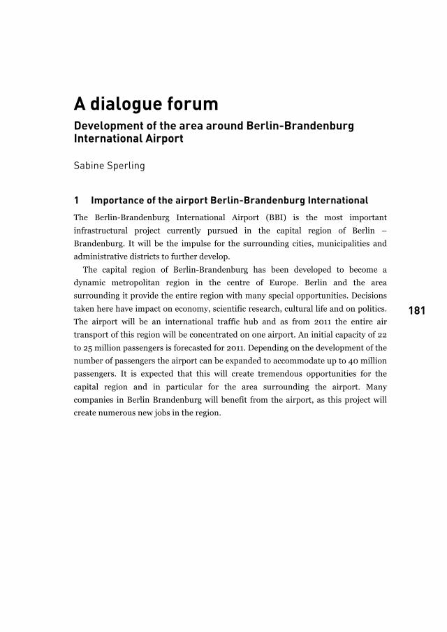
181
A dialogue forum Development of the area around Berlin-Brandenburg International Airport
Sabine Sperling
1 Importance of the airport Berlin-Brandenburg International The Berlin-Brandenburg International Airport (BBI) is the most important
infrastructural project currently pursued in the capital region of Berlin –
Brandenburg. It will be the impulse for the surrounding cities, municipalities and
administrative districts to further develop.
The capital region of Berlin-Brandenburg has been developed to become a
dynamic metropolitan region in the centre of Europe. Berlin and the area
surrounding it provide the entire region with many special opportunities. Decisions
taken here have impact on economy, scientific research, cultural life and on politics.
The airport will be an international traffic hub and as from 2011 the entire air
transport of this region will be concentrated on one airport. An initial capacity of 22
to 25 million passengers is forecasted for 2011. Depending on the development of the
number of passengers the airport can be expanded to accommodate up to 40 million
passengers. It is expected that this will create tremendous opportunities for the
capital region and in particular for the area surrounding the airport. Many
companies in Berlin Brandenburg will benefit from the airport, as this project will
create numerous new jobs in the region.
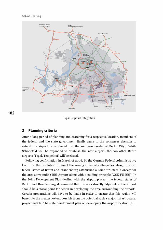
Sabine Sperling
182 Fig.1: Regional integration
2 Planning criteria After a long period of planning and searching for a respective location, members of
the federal and the state government finally came to the consensus decision to
extend the airport in Schönefeld, at the southern border of Berlin City. While
Schönefeld will be expanded to establish the new airport, the two other Berlin
airports (Tegel, Tempelhof) will be closed.
Following confirmation in March of 2006, by the German Federal Administrative
Court, of the resolution to enact the zoning (Planfeststellungsbeschluss), the two
federal states of Berlin and Brandenburg established a Joint Structural Concept for
the area surrounding BBI Airport along with a guiding principle (GSK FU BBI). In
the Joint Development Plan dealing with the airport project, the federal states of
Berlin and Brandenburg determined that the area directly adjacent to the airport
should be a “focal point for action in developing the area surrounding the airport”.
Certain preparations will have to be made in order to ensure that this region will
benefit to the greatest extent possible from the potential such a major infrastructural
project entails. The state development plan on developing the airport location (LEP
A dialogue forum
183 183
FS) ensures the extension of the airport in Schönefeld in terms of state planning. The
planning guarantee involves airport space, transport connections and the restriction
of settlement development and of construction heights in affected areas.
2.1 The dialogue forum
The dialogue process began on March 16th 2006 after the judgement of the Federal
Administrative Court. The two federal States of Berlin and Brandenburg as well as 3
regional planning associations are involved in the planning process,. Furthermore, it
includes the closer sphere of influence of the airport BBI, i.e.12 municipalities in
Brandenburg, 3 boroughs of Berlin and 3 administrative districts in Brandenburg.
The dialogue forum has been accompanied by the Joint Spatial Planning
Department of Berlin and Brandenburg. It is the task of the Joint Spatial Planning
Department of Berlin Brandenburg to support, lead and moderate the institution of a
“Dialogue Forum for the Area Surrounding BBI Airport”.
The dialogue process aimed at the initiation of a permanent cooperation of the
airport with its surrounding municipalities. The affected municipalities of the area
surrounding BBI airport had the opportunity to present their interests and their
needs. Furthermore, it was their aim to prepare a state-crossing development
strategy/ Joint Structural Concept (GSK FU BBI). The results of the Mutual
Structural Concept were achieved in negotiations between all stakeholders.
Because the airport’s expansion has different impacts on the individual
municipalities, the constructive contribution is a significant challenge for each
participant .
The following results of the dialogue process must be emphasised:
• constructive cooperation between all stakeholders in the surrounding areas of
the airport
• a Joint Structural Concept prepared by all parties involved that offers the
municipalities affected by the airport planning improved scopes of planning as
well as a jointly prepared programme of measures for the development in the
area surrounding the airport as a result of the intensified investigations on the
Joint Structural Concept.
The design of the Joint Structural Concept in 2006 was one of the results of the
dialogue process under the guidance of the Joint Spatial Planning Department;
further results were the Joint Declaration on the Dialogue Forum in 2007 and
detailed investigations in 2008.
The guiding principle was developed for the airport region that is determined by its
specific profile. The intention is to ensure that both commercial enterprises and
residential use can evolve in this region.
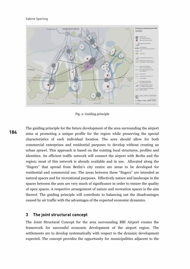
Sabine Sperling
184
Fig. 2: Guiding principle
The guiding principle for the future development of the area surrounding the airport
aims at promoting a unique profile for the region while preserving the special
characteristics of each individual location. The area should allow for both
commercial enterprises and residential purposes to develop without creating an
urban sprawl. This approach is based on the existing local structures, profiles and
identities. An efficient traffic network will connect the airport with Berlin and the
region; most of this network is already available and in use. Allocated along the
“fingers” that spread from Berlin’s city centre are areas to be developed for
residential and commercial use. The areas between these “fingers” are intended as
natural spaces and for recreational purposes. Effectively nature and landscape in the
spaces between the axes are very much of significance in order to ensure the quality
of open spaces. A respective arrangement of nature and recreation spaces is the aim
thereof. The guiding principle will contribute to balancing out the disadvantages
caused by air traffic with the advantages of the expected economic dynamics.
3 The joint structural concept The Joint Structural Concept for the area surrounding BBI Airport creates the
framework for successful economic development of the airport region. The
settlements are to develop systematically with respect to the dynamic development
expected. The concept provides the opportunity for municipalities adjacent to the
A dialogue forum
185 185
large-scale BBI project to enhance their economic profile. Furthermore it enables the
development of attractive residential locations set in a lovely recreational landscape.
Areas already zoned are available for the settlements, whereas other areas have been
designated for the sustainable expansion of existing and future developments.
An efficient traffic network surrounding the airport already exists. This will be
supplemented in the next years. The infrastructure offers an excellent basis for the
economic development of the airport and the adjoining spaces. Beyond the traffic
areas, potential parts for commercial use play an important role. The new
settlements will be concentrated in specific locations; the Structural Concept has
defined 1,330 hectares as potential commercial areas. In the area surrounding the
airport, approximately 450 hectares of land are reserved for residential
development. Furthermore, recreation has an impact on planning in this area.
Wherever municipalities want to develop into attractive residential locations, they
must be sure that the natural space and recreational areas surrounding them are
attractive also.
A planning atlas for the area surrounding the airport provides an overview of the
plans and concepts.
4 Conclusion and outlook While the region will benefit from unique opportunities for development as a result
of the airport expansion, it will also face strains. All the affected municipalities will
have to coordinate their lines of action to ensure their mutual benefits from the
project as well as to secure the BBI Airport’s position in the international
competition with other regions.
It will be of importance to balance out as fairly as possible the advantages and
disadvantages the airport entails between the various stakeholders. From the very
beginning, municipalities supporting and opposing the expansion of the airport have
worked together in the “Dialogue Forum for the Area Surrounding BBI Airport”
under the leadership of the Joint Spatial Planning Department. The mutual objective
aims at developing settlements sustainably, so that they are compatible with the
region and the landscape. With this in mind, it is a prerequisite to overcome the
opposition between the stakeholders in a dialogue designed for the long-term. In
2009, responsibility for the “Dialogue Forum Airport Berlin Brandenburg” was
transferred to the regional authorities. The dialogue forum has made “transparency,
fairness and striving for consensus” to be the principles guiding its actions. The
airport and the municipalities have recognized that they all benefit from the
dialogue. The most important tasks they will have to deal with in future include
general guidance as the Joint Structural Concept is implemented, designing the
Sabine Sperling
186
processes serving to reconcile diverging interests, taking action required in the area
surrounding the airport, and general guidance while the resolution to enact the
zoning (Planfeststellungsbeschluss) for the expansion of the airport is implemented.
The municipalities have established a regional, inter-municipal management
company called BADC, Berlin Brandenburg Area Development Company, to
implement the measures balancing the interests of the various parties involved.
Furthermore, the airport enterprise shows great interest in participating in the
Dialogue Forum to the region’s advantage.
List of figures
Fig.1: Regional integration ................................................................................................................ 182Fig. 2: Guiding principle.................................................................................................................... 184
References
Ministerium für Infrastruktur und Raumordnung. Senatsverwaltung für Stadtentwicklung
Berlin. Party responsible for content Gemeinsame Landesplanung. Gemeinsames
Strukturkonzept FU – BBI. 2007.
Senatsverwaltung für Stadtentwicklung Berlin. Ministerium für Infrastruktur und
Raumordnung. Party responsible for content Gemeinsame Landesplanung. Airside
meets Landside. 2008.
Sabine Sperling Joint planning department Berlin- Brandenburg (GL5)
[email protected] http://gl.berlin-brandenburg.de/bbi/
187
Frankfurt Airport City Hub for a future world
Thomas Uber All over the world airports evolve into airport cities. Parts of the public adore the
apparently new urban development, whereas others abhor it. Airports see Airport
Cities as a new venue for new sources of revenue, such as retailing and real estate
development. But most important, Airport Cities create a new pattern of urban
settlement that is primarily due to full flung globalization.
As an attempt of man to extend his clout far beyond physical reach, stretching out
over the oceans to other continents, globalization began with Columbus. But unless
air traffic had created the current state of regularly scheduled daily connections over
the globe by plane, globalization had not lived up to the very sense of its meaning.
Its meaning as well as its driving forces is mobility: of man, of goods and mostly
important of knowledge. Markets and productive forces that used to be separated by
geography are being put together.
Physical exchange across the boundaries of national economies, i.e. imports and
exports, has always existed ever since borders have been identified. Although
incorporated in a gadget and therefore restricted to the application of a machine,
already then an exchange of expertise had been constituted.
Today conceptual know-how and construction of goods is organized in network-
like structures all over the globe. Value creation depends on virtual exchange of
knowledge in data chains. Physical transport of parts or the completely assembled
good follows suit in supply chains.
Up until yesterday industrial society led to integral concentration of all functions
of production – from devising a product to distribution – at gravitational spots, the
industrial centres like Detroit in the U.S.A. or in Germany the famous Rhine-Ruhr-
Region. Now, a lot of those functions have turned mobile and are being spread all
over the globe to various and variable centres of competence that are intertwined by
data-connection. Therefore the realization of innovative ideas is located in
worldwide networks, of which the substances can easily be changed even on a daily
basis. Value creation takes place in a volatile, virtual, mobile environment.
Following these developments, the settlement pattern of innovating products or
remodelling producing processes has completely changed. Externalizing innovation
Thomas Uber
188
and production in worldwide networks has tremendously invigorated creative
energies. And it turns out that transferring knowledge, transporting goods, and the
travelling of people follow the same logistic lines over the globe.
In consequence, former industrial centres are weakened whereas the hubs of
worldwide mobility gain importance. With globalization and knowledge society, the
spatial distribution of technological knowledge is being reorganized, deviating from
the industrial centres to the poles of mobility (big hubs of air traffic) within the grid
of global network economy.
A virtual space of aggregated knowledge is emerging between airport cities all over
the world, which is comparable to that created by the Nordic League of the Baltic Sea
at the end of medieval age. The Nordic League cannot be sufficiently described as a
cooperation of ports to facilitate the exchange of goods. Perhaps more important was
the effect of accruing knowledge in the ports through the constant flow of commerce,
that triggered innovation, spurred production and augmented the quantity of
merchandise.
A similar development takes place at airport cities and in their vicinity. Real estate
development at the airport has a twofold foundation, primarily based on concrete
and stone at the very site of the airport and secondly based on knowledge that is
being accumulated within the clusters of post industrial technology and application
of science.
Airport cities serve as mobility hubs as well as hubs of knowledge. They enrich
existing clusters, attract additional ones and even serve as temporary places of
instant innovation. Sophisticated knowledge workers have to act within a broader
radius than their fellow forerunners of the industrial centres. They need close access
to an international airport. Furthermore a growing number of top qualified experts
constantly move within the space of global mobility, that is the airport cities, where
they come together in order to contrive new products. In that manner, they adapt to
markets evolving through abridged cycles of product renewal. In order to set the
path for product innovation, designing new products and conceiving their marketing
schemes has to speed up and therefore has to take place within global mobility.
Markets itself are no longer enclosed within irrevocable borders but undergo a
constant change of configuration. Globalization does not create a single global
market but a variety of markets that are even reconfigured by single products.
Narrowly focused target groups replace what used to be broad customer markets.
National economies no longer set the cultural and design framework of product
configuration.
Airport cities therefore have to create new spaces of specifically devised services
that cater directly to the groups of experts who do not leave that realm of knowledge
and mobility other than to take a recreational pause after weeks of constant
Frankfurt Airport City
189 189
travelling and working. Regions around Airport cities are best advised if
reorganizing their spatial patterns catering to the mobility and cultural needs of
these sophisticated clusters. By such means, airport cities give an answer to the
question that Thomas Sieverts posed with the concept of “Zwischenstadt”, the so
called “cities without city”. He called for a new meaning and functional
determination of Zwischenstadt that transcends the characteristics of the former
European city.
Sieverts identified urban sprawl as a consequence of increased mobility that
enabled citizens to live far apart from their workplaces, thus creating a void lacking
urban layout and shape. With global air traffic and the achievement of worldwide
aggregated markets, the Zwischenstadt might experience a new teleology, that will
lead to a new type of city located in the virtual space of mobile knowledge, floating
through worldwide data streams and along the lines of intercontinental air traffic.
Thomas Uber Fraport AG, Communications Department
E-mail: [email protected]