Embed Size (px)
Citation preview
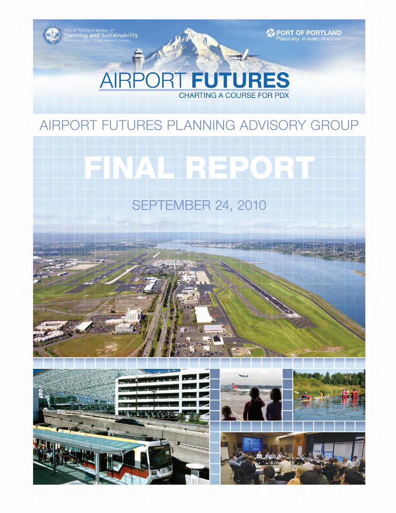
AIRPORT FUTURES PLANNING ADVISORY GROUP
FINAL REPORTSEPTEMBER 24, 2010

September 24, 2010
Portland City Council | Port of Portland Commission | Vancouver City Council
Airport Futures was a collaborative effort between the City of Portland, Port of Portland, and the Portland-Vancouver metropolitan community to create an integrated, long-range development plan for Portland International Airport (PDX). From the fall of 2007 to the spring of 2010, we chaired the diverse, regional, 30-member Airport Futures Planning Advisory Group (PAG) as it developed its recommendations for a PDX Master Plan Update, a City Land Use Plan, and the creation of an ongoing PDX community advisory committee. The work of the PAG and staff was supplemented by extensive public involvement of key stakeholders.
This Report provides a summary of the Airport Futures process and the recommendations, which reinforce Portland’s planning legacy, PDX’s reputation as one of the premier airports in the country, and incorporates principles of sustainability and livability.
After 87 PAG and subcommittee meetings and 131 stakeholder meetings, the PAG encourages you to accept this report, its conclusions and recommendations as a package. The PAG recommends:
1. Port of Portland Commission accept the PDX Master Plan Update and direct staff to submit the Airport Layout Plan to the Federal Aviation Administration for final review and acceptance,
2. Portland City Council adopt the City Land Use Plan,3. Port Commission, Portland City Council, and Vancouver City Council adopt the Intergovernmental
Agreement establishing an ongoing PDX Community Advisory Committee (PDX CAC),4. Port Commission and Portland City Council adopt the Intergovernmental Agreements identifying
transportation and natural resource mitigation, a follow-on noise work group work plan, and sustainability guiding principles and goals to be used to guide the work of the Port, City, and the PDX CAC, and
5. Port and City accept the 14 Additional PAG Recommendations.
The PAG thanks the City of Portland and the Port of Portland for the opportunity to pursue this important work. The process and results are a model for, and example of, the power of collaboration between governmental entities and citizens. The PAG praises the work of City and Port staff for their collaboration with the PAG and other key stakeholders. We also thank the consultants who provided the detailed technical and policy analyses necessary to make well-informed decisions. Finally, the PAG thanks the community for its participation, insights, and feedback throughout the process.
Respectfully Submitted,
Bill Blosser, PAG Chair | Dave Smith, PAG Vice Chair
ii
A
irp
or
t f
ut
ur
es
pl
An
nin
g A
dv
iso
ry
gr
ou
p f
inA
l r
ep
or
t
Executive Summary 1
I Background 5
A) Context � � � � � � � � � � � � � � � � � � � � � � � � � � � � � � � � � � � � � � � � � � � � � � � � � � � � � � � � � � � � � � � � � � � � � � � � � � � � � � � � � � � � � � � 5B) History � � � � � � � � � � � � � � � � � � � � � � � � � � � � � � � � � � � � � � � � � � � � � � � � � � � � � � � � � � � � � � � � � � � � � � � � � � � � � � � � � � � � � � � 6C) Purpose, Principles, Assumptions, and Regulatory Framework � � � � � � � � � � � � � � � � � � � � � � � � � � � � � � � � 7D) Planning Advisory Group � � � � � � � � � � � � � � � � � � � � � � � � � � � � � � � � � � � � � � � � � � � � � � � � � � � � � � � � � � � � � � � � � � � � � 8E) Public Involvement � � � � � � � � � � � � � � � � � � � � � � � � � � � � � � � � � � � � � � � � � � � � � � � � � � � � � � � � � � � � � � � � � � � � � � � � � � � 8F) Timeline � � � � � � � � � � � � � � � � � � � � � � � � � � � � � � � � � � � � � � � � � � � � � � � � � � � � � � � � � � � � � � � � � � � � � � � � � � � � � � � � � � � � 10G) Vision and Values � � � � � � � � � � � � � � � � � � � � � � � � � � � � � � � � � � � � � � � � � � � � � � � � � � � � � � � � � � � � � � � � � � � � � � � � � � � 10H) Collaboration Principles � � � � � � � � � � � � � � � � � � � � � � � � � � � � � � � � � � � � � � � � � � � � � � � � � � � � � � � � � � � � � � � � � � � � � 11I) Staff, Consultants, and Technical Advisory Pool � � � � � � � � � � � � � � � � � � � � � � � � � � � � � � � � � � � � � � � � � � � � � 11J) Subcommittees � � � � � � � � � � � � � � � � � � � � � � � � � � � � � � � � � � � � � � � � � � � � � � � � � � � � � � � � � � � � � � � � � � � � � � � � � � � � � 12
II Sustainability Highlights 13
A) Background � � � � � � � � � � � � � � � � � � � � � � � � � � � � � � � � � � � � � � � � � � � � � � � � � � � � � � � � � � � � � � � � � � � � � � � � � � � � � � � � � 13B) Vision and Values � � � � � � � � � � � � � � � � � � � � � � � � � � � � � � � � � � � � � � � � � � � � � � � � � � � � � � � � � � � � � � � � � � � � � � � � � � � 14C) Hierarchy and Adaptive Management � � � � � � � � � � � � � � � � � � � � � � � � � � � � � � � � � � � � � � � � � � � � � � � � � � � � � � � 15D) Guiding Principles � � � � � � � � � � � � � � � � � � � � � � � � � � � � � � � � � � � � � � � � � � � � � � � � � � � � � � � � � � � � � � � � � � � � � � � � � � 16E) Goals � � � � � � � � � � � � � � � � � � � � � � � � � � � � � � � � � � � � � � � � � � � � � � � � � � � � � � � � � � � � � � � � � � � � � � � � � � � � � � � � � � � � � � � 17F) Planning for a Sustainable Future � � � � � � � � � � � � � � � � � � � � � � � � � � � � � � � � � � � � � � � � � � � � � � � � � � � � � � � � � � � 19
III PDX Master Plan Highlights 21
A) PDX Master Plan Highlights � � � � � � � � � � � � � � � � � � � � � � � � � � � � � � � � � � � � � � � � � � � � � � � � � � � � � � � � � � � � � � � � 21B) Existing Conditions Inventory � � � � � � � � � � � � � � � � � � � � � � � � � � � � � � � � � � � � � � � � � � � � � � � � � � � � � � � � � � � � � � 23C) Forecast — An Innovative and Collaborative Approach � � � � � � � � � � � � � � � � � � � � � � � � � � � � � � � � � � � � � 23D) Facilities Requirements — Sustainability Focus � � � � � � � � � � � � � � � � � � � � � � � � � � � � � � � � � � � � � � � � � � � � � 25E) Sustainability Criteria for Facilities Planning � � � � � � � � � � � � � � � � � � � � � � � � � � � � � � � � � � � � � � � � � � � � � � � � 26F) Centralized Terminal � � � � � � � � � � � � � � � � � � � � � � � � � � � � � � � � � � � � � � � � � � � � � � � � � � � � � � � � � � � � � � � � � � � � � � � 27G) Military � � � � � � � � � � � � � � � � � � � � � � � � � � � � � � � � � � � � � � � � � � � � � � � � � � � � � � � � � � � � � � � � � � � � � � � � � � � � � � � � � � � � 30H) Third Parallel Runway � � � � � � � � � � � � � � � � � � � � � � � � � � � � � � � � � � � � � � � � � � � � � � � � � � � � � � � � � � � � � � � � � � � � � � 30I) Noise � � � � � � � � � � � � � � � � � � � � � � � � � � � � � � � � � � � � � � � � � � � � � � � � � � � � � � � � � � � � � � � � � � � � � � � � � � � � � � � � � � � � � � � 32J) Master Plan Financial Feasibility � � � � � � � � � � � � � � � � � � � � � � � � � � � � � � � � � � � � � � � � � � � � � � � � � � � � � � � � � � � � 33K) Follow-on Studies to this Master Planning Process � � � � � � � � � � � � � � � � � � � � � � � � � � � � � � � � � � � � � � � � � � 37
Contents
iii
IV City of Portland Land Use Plan Highlights 39
A) Overview � � � � � � � � � � � � � � � � � � � � � � � � � � � � � � � � � � � � � � � � � � � � � � � � � � � � � � � � � � � � � � � � � � � � � � � � � � � � � � � � � � � 39B) Comprehensive Plan Amendments � � � � � � � � � � � � � � � � � � � � � � � � � � � � � � � � � � � � � � � � � � � � � � � � � � � � � � � � � � � 41C) PDX Plan District and Other Zoning Code Amendments � � � � � � � � � � � � � � � � � � � � � � � � � � � � � � � � � � � � 43D) Height � � � � � � � � � � � � � � � � � � � � � � � � � � � � � � � � � � � � � � � � � � � � � � � � � � � � � � � � � � � � � � � � � � � � � � � � � � � � � � � � � � � � � � 48E) Noise Overlay Amendments � � � � � � � � � � � � � � � � � � � � � � � � � � � � � � � � � � � � � � � � � � � � � � � � � � � � � � � � � � � � � � � � 48F) Natural Resources � � � � � � � � � � � � � � � � � � � � � � � � � � � � � � � � � � � � � � � � � � � � � � � � � � � � � � � � � � � � � � � � � � � � � � � � � � 48G) Transportation � � � � � � � � � � � � � � � � � � � � � � � � � � � � � � � � � � � � � � � � � � � � � � � � � � � � � � � � � � � � � � � � � � � � � � � � � � � � � � 50H) Economic Development � � � � � � � � � � � � � � � � � � � � � � � � � � � � � � � � � � � � � � � � � � � � � � � � � � � � � � � � � � � � � � � � � � � � � 51
V Relationship between City Land Use Plan and Future PDX Master Plans 53
VI PDX Community Advisory Committee Highlights 55
VII Additional Recommendations, Intergovernmental Agreements, and Lessons Learned Highlights
57
A) Additional PAG Recommendations � � � � � � � � � � � � � � � � � � � � � � � � � � � � � � � � � � � � � � � � � � � � � � � � � � � � � � � � � 57B) Intergovernmental Agreements � � � � � � � � � � � � � � � � � � � � � � � � � � � � � � � � � � � � � � � � � � � � � � � � � � � � � � � � � � � � � � 58C) Process Evaluation Results and Lessons Learned � � � � � � � � � � � � � � � � � � � � � � � � � � � � � � � � � � � � � � � � � � � � 58
VIII Conclusion and Recommendations 59
Appendices Table of Contents 61
iv
A
irp
or
t f
ut
ur
es
pl
An
nin
g A
dv
iso
ry
gr
ou
p f
inA
l r
ep
or
t
10th Percentile Forecast: The 10th percentile is the 10 percent likelihood that the growth in air travel demand will be below the forecast.
50th Percentile Forecast: The 50th percentile is the 50 percent likelihood that the growth in air travel demand will be below the forecast.
90th Percentile Forecast: The 90th percentile is the 90 percent likelihood that the growth in air travel demand will be below the forecast.
ALP (Airport Layout Plan): A plan, required by the Federal Aviation Administration, showing current and future infrastructure and facilities at the airport.
Airport Plan District: A zoning code tool the City of Portland uses to apply area-specific regulations. The Airport Plan District replaces the previous Conditional Use Master Plan for Portland International Airport (PDX).
CNAC (Citizen Noise Advisory Committee): A group, created by the Port of Portland, that advises the Port on airport noise impacts to the community.
CUMP (Conditional Use Master Plan): A City of Portland requirement for uses in the City that is allowed, but with conditions. Completion of a master plan that documents the airport’s current and proposed development and land uses allows a use to continue for a period of 10 years. A CUMP for the airport was previously required by the City, before the adoption of the Airport Futures Plan District.
DNL (Day/Night average Level): A measurement of noise, averaged over a 24-hour period.
ESEE (Environmental, Social, Economic, and Energy Analysis): An analysis required by Oregon land use law of the relative environmental, social, economic and energy impacts of a decision to allow, limit, or prohibit development in an inventoried natural resource area.
FAA: Federal Aviation Administration
IGA: Intergovernmental Agreement
LUP (Land Use Plan): The component of Airport Futures adopted by the City of Portland, which includes amendments to the Comprehensive Plan, amendments to the Zoning Code and Zoning Maps, and three intergovernmental agreements.
MAP (Million Annual Passengers): A unit of measurement of air travel demand.
MP (Master Plan): A facilities plan that identifies current and projected facilities needs at PDX.
NA (Number Above): A measurement of noise that identifies the number of aircraft overflight events throughout a given time period.
Noise Contour: A map polygon that depicts the average Day/Night Level (DNL) of noise of a given geography.
NRI (Natural Resource Inventory): An inventory of natural resources in and around the airport that includes various habitat types and landscape features and the relative quality of those features.
NWG (Beyond 65 DNL Noise Work Group): A limited-duration group, created by the Planning Advisory Group, that advises the City and Port on strategies to address noise beyond the 65 Day/Night average Level (DNL).
Operation: An aircraft takeoff or landing.
PAG (Planning Advisory Committee): A group, created by the City of Portland and Port of Portland, that provided advice and policy direction throughout the Airport Futures process.
Planning Activity Levels (PALs): A unit used to represent future levels of aviation activity at which key airport improvements will be necessary. The use of PALs allows for facilities planning that is realistically tied to milestone activity levels as they occur, rather than arbitrary years.
PDX: The three letter code for Portland International Airport.
PDX CAC: The PDX Community Advisory Committee, a group sponsored by the Port of Portland, City of Portland, and City of Vancouver to provide ongoing feedback on the operation and development of PDX.
TA (Time Above): A measurement of noise of the duration of an aircraft overflight event.
TSA (Transportation Security Administration): The federal agency charged with providing for secure air travel.
WHMP (Wildlife Hazard Management Plan): The Port of Portland’s plan for managing wildlife that pose a risk to safe aircraft operations.
Glossary of key terms
v
A
irp
or
t f
ut
ur
es
pl
An
nin
g A
dv
iso
ry
gr
ou
p f
inA
l re
po
rt
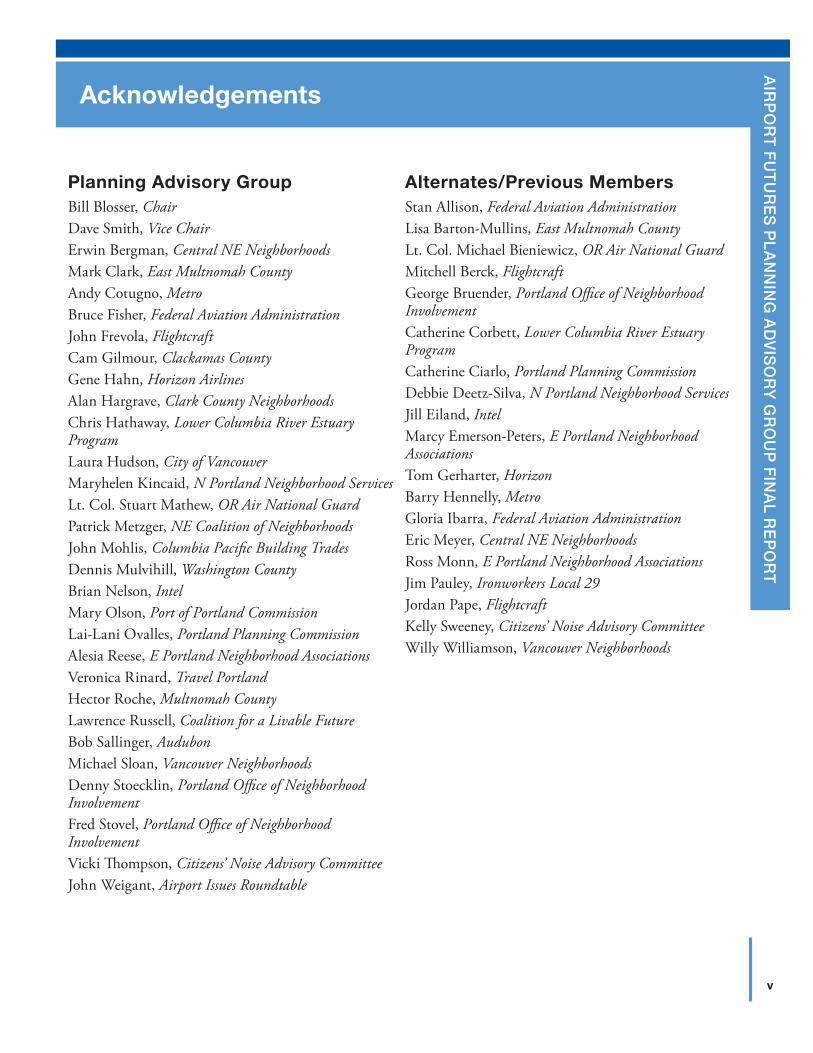
Planning Advisory GroupBill Blosser, ChairDave Smith, Vice ChairErwin Bergman, Central NE NeighborhoodsMark Clark, East Multnomah CountyAndy Cotugno, MetroBruce Fisher, Federal Aviation AdministrationJohn Frevola, FlightcraftCam Gilmour, Clackamas CountyGene Hahn, Horizon AirlinesAlan Hargrave, Clark County NeighborhoodsChris Hathaway, Lower Columbia River Estuary ProgramLaura Hudson, City of VancouverMaryhelen Kincaid, N Portland Neighborhood ServicesLt. Col. Stuart Mathew, OR Air National GuardPatrick Metzger, NE Coalition of NeighborhoodsJohn Mohlis, Columbia Pacific Building TradesDennis Mulvihill, Washington CountyBrian Nelson, IntelMary Olson, Port of Portland CommissionLai-Lani Ovalles, Portland Planning CommissionAlesia Reese, E Portland Neighborhood AssociationsVeronica Rinard, Travel PortlandHector Roche, Multnomah CountyLawrence Russell, Coalition for a Livable FutureBob Sallinger, AudubonMichael Sloan, Vancouver NeighborhoodsDenny Stoecklin, Portland Office of Neighborhood InvolvementFred Stovel, Portland Office of Neighborhood InvolvementVicki Thompson, Citizens’ Noise Advisory CommitteeJohn Weigant, Airport Issues Roundtable
Alternates/Previous MembersStan Allison, Federal Aviation AdministrationLisa Barton-Mullins, East Multnomah CountyLt. Col. Michael Bieniewicz, OR Air National GuardMitchell Berck, FlightcraftGeorge Bruender, Portland Office of Neighborhood InvolvementCatherine Corbett, Lower Columbia River Estuary ProgramCatherine Ciarlo, Portland Planning CommissionDebbie Deetz-Silva, N Portland Neighborhood ServicesJill Eiland, IntelMarcy Emerson-Peters, E Portland Neighborhood AssociationsTom Gerharter, HorizonBarry Hennelly, MetroGloria Ibarra, Federal Aviation AdministrationEric Meyer, Central NE NeighborhoodsRoss Monn, E Portland Neighborhood AssociationsJim Pauley, Ironworkers Local 29Jordan Pape, FlightcraftKelly Sweeney, Citizens’ Noise Advisory CommitteeWilly Williamson, Vancouver Neighborhoods
Acknowledgements
vi
A
ck
NO
wLE
DG
EMEN
TSACKnoWledgeMents
Project ConsultantsJoe Barden, HNTBCF Booth, Jacobs ConsultancyMelissa Eagan, Institute for Conflict ManagementGeoffrey Gosling, Aviation System ConsultingEric Hovee, Hovee and AssociatesSam Imperati, Institute for Conflict ManagementCameron Modjeski, Jacobs ConsultancyLinda Perry, Jacobs ConsultancyKelly Rodgers, DEAAlan Snook, DKSAndrew Stryker, Parsons Brinckerhoff
For more information, please contact:
City of portlandJay SugnetPortland Bureau of Planning and Sustainability1900 SW 4th Avenue, Suite 7100Portland, Oregon [email protected]
port of portlandChristopher B. CorichPort of Portland7200 NE Airport WayPortland, OR [email protected]
Project websitewww.pdxairportfutures.com
How to read this document
for a high-level overview of the process and key recommendations, please read the Executive Summary. for more detail, please read the body of the report. to review actual language, please go to the Appendices Table of Contents where you will find hyperlinks to the relevant documents.
City of PortlandJay Sugnet, Project ManagerKathryn BeaumontMindy BrooksJacob BrostoffBronwyn BuckleSylvia CateStacey CastleberryKim FreemanJohn GrayDouglas HardyDavid HelzerNancy HendricksonJamie JeffreyMark RaggettJessica Richman
Port of PortlandChris Corich, Project ManagerNick AtwellDebbie BishopRenee DowlinJason GatelyLise GlancyDana GreenMisti JohnsonScott KingSean LoughranShannon McArthurMaureen MinisterPhil RalstonJason SchwartzChris WhiteIan Whitlock
1
A
irp
or
t f
ut
ur
es
pl
An
nin
g A
dv
iso
ry
gr
ou
p f
inA
l re
po
rt
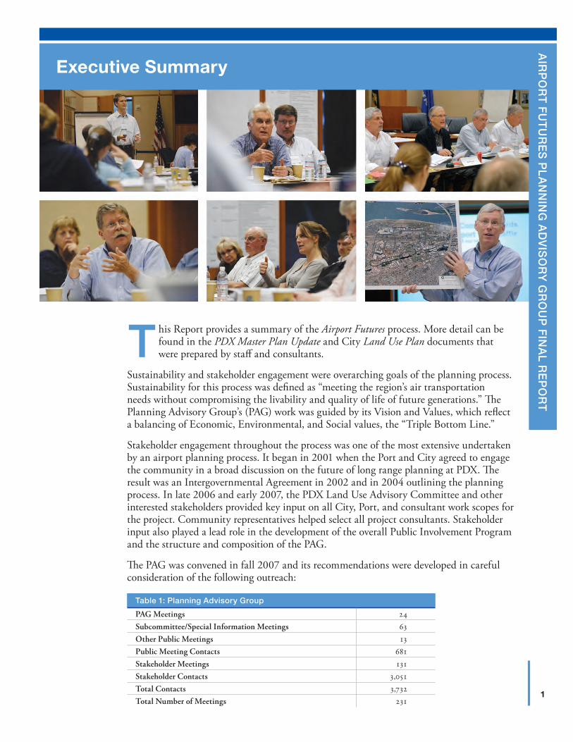
Executive Summary
This Report provides a summary of the Airport Futures process. More detail can be found in the PDX Master Plan Update and City Land Use Plan documents that were prepared by staff and consultants.
Sustainability and stakeholder engagement were overarching goals of the planning process. Sustainability for this process was defined as “meeting the region’s air transportation needs without compromising the livability and quality of life of future generations.” The Planning Advisory Group’s (PAG) work was guided by its Vision and Values, which reflect a balancing of Economic, Environmental, and Social values, the “Triple Bottom Line.”
Stakeholder engagement throughout the process was one of the most extensive undertaken by an airport planning process. It began in 2001 when the Port and City agreed to engage the community in a broad discussion on the future of long range planning at PDX. The result was an Intergovernmental Agreement in 2002 and in 2004 outlining the planning process. In late 2006 and early 2007, the PDX Land Use Advisory Committee and other interested stakeholders provided key input on all City, Port, and consultant work scopes for the project. Community representatives helped select all project consultants. Stakeholder input also played a lead role in the development of the overall Public Involvement Program and the structure and composition of the PAG.
The PAG was convened in fall 2007 and its recommendations were developed in careful consideration of the following outreach:
table 1: planning Advisory group
PAG Meetings 24Subcommittee/Special Information Meetings 63Other Public Meetings 13Public Meeting Contacts 681Stakeholder Meetings 131Stakeholder Contacts 3,051Total Contacts 3,732Total Number of Meetings 231
2
E
xEc
UTI
VE
SU
MM
AR
YAirport futures plAnning Advisory group finAl report
pAg and stakeholder input influenced the planning process at every phase. A summary of the pAg’s work follows:
Project Goal Setting and Issue Identification
� Created Vision and Values statement for project with triple bottom line sustainability focus
� Agreed on project assumptions and follow-up needed
� Agreed on Collaboration Principles to guide PAG process
� Provided input into the design of a 1,208 sample public survey by Riley Research to identify general attitudes about satisfaction with PDX, airport usage and behaviors, sustainability, and quality of life issues affecting residents
Sustainability
� Used Vision and Values statement at outset to guide the process
� Recommended Sustainability Map/Good Ideas
� Applied Airport Facility Planning Criteria to airport development alternatives
� Developed Sustainability Guiding Principles and Goals to measure and track progress, including the goal to become the most sustainable airport in the world
PDX Master Plan
� Inventory � Clarified role of PDX within the region � Expanded scope of inventory beyond Port property
� Airport Demand Forecast � Proposed probabilistic forecast methodology � Established peer review process � Identified key issues and trends � Addressed high-speed rail and climate change among other issues
� Facility Requirements through 2035 � Agreed to use the mid-point (50 percent probability) forecast for planning
purposes � Applied new and emerging technologies to maximize the use of existing facilities � Determined that third parallel runway and satellite concourse not required
during planning period and that forecasted needs can be met without major construction
3
E
xEcU
TIVE
SU
MM
AR
YsepteMber 24, 2010
� Facilities Alternatives � Developed Sustainability Facility Planning Criteria � Tested key facilities for ability to accommodate demand ranging from the high to
the low forecast � Retained multiple options for key facilities such as parking, rental cars and
terminal curb � Assumed centralized terminal concept for all future development � Validated that Terminal Expansion East is the preferred long-term concept for
future terminal development of current terminal � Analyzed third parallel runway according to sustainability criteria � Shortened Third Runway Reserve from 11,925 feet to 8,500 feet
� Noise Analysis — Recommended extensive analysis of alternative noise metrics for multiple forecast and operational scenarios
� Master Plan Financial Feasibility — Reviewed and approved a recommendation to adopt the Port’s PDX Financial Plan
City Land Use Plan
� Identified Study Area boundaries
� Defined existing conditions and regulatory framework
� Identified Plan District as the preferred regulatory tool
� Identified needed amendments to the Noise and Height overlay zones
� Identified traffic mitigation projects
� Updated the natural resource protection program
� Endorsed mitigation and enhancement proposals for PDX
� Created appropriate development review thresholds for PDX projects
� Prohibited development of a third parallel runway and a decentralized terminal
PDX Community Advisory Committee
� Developed framework and draft work plan for ongoing PDX community advisory committee with continued sustainability focus
� Added City of Vancouver as sponsor
� Identified Sustainability Commission, multi-modal interest and Maywood Park as potential representatives
� Proposed conflict resolution process for advisory committees
� Shared lessons learned for effective community engagement
4
E
xEc
UTI
VE
SU
MM
AR
YAirport futures plAnning Advisory group finAl report
Intergovernmental Agreements
Proposed development of three intergovernmental agreements to formalize commitments related to the PDX CAC, transportation, natural resources, noise, and sustainability.
Additional PAG Recommendations
Identified additional recommendations to supplement those included in the PDX Master Plan, City Land Use Plan, and intergovernmental agreements.
Conclusions and Recommendation
The details of the PAG’s deliberations were captured in Meeting Notes found in Appendix A,1 and Stakeholder Comments, found in Appendix B.2
the pAg recommends that the portland City Council, port of portland Commission, and vancouver City Council accept this report, its conclusions and recommendations as a package. the pAg recommends:
1. The Port of Portland Commission accept the PDX Master Plan Update and direct staff to submit the Airport Layout Plan to the Federal Aviation Administration for final review and acceptance,
2. The Portland City Council adopt the City Land Use Plan,3. The Port Commission, Portland City Council, and Vancouver City Council adopt
the Intergovernmental Agreement establishing an ongoing PDX Community Advisory Committee (PDX CAC),
4. Both the Port Commission and Portland City Council adopt the Intergovernmental Agreements identifying transportation and natural resource mitigation, follow-on noise work group, and sustainability guiding principles and goals to be used to guide the work of the Port, City, and the PDX CAC, and
5. The Port and City accept the 14 Additional PAG Recommendations found on pages 57–58.
1 www.pdxairportfutures.com/Documents.aspx
2 www.pdxairportfutures.com/Documents/PDX_AF_Otrch_Cmnts.pdf
5
A
irp
or
t f
ut
ur
es
pl
An
nin
g A
dv
iso
ry
gr
ou
p f
inA
l re
po
rt
Background
A) Context
Portland International Airport (PDX) is located within the 11,000-acre Columbia Corridor industrial area and the 32,700-acre Columbia Slough Watershed. The Columbia Corridor is a regionally significant industrial area within a watershed
characterized by a rich diversity of wildlife habitat.
The Columbia Corridor was largely created from filled floodplain following the construction of dikes along the Columbia River. Prior to development, this area was a diverse mosaic of habitat types including floodplains, wetlands, sloughs, bottomland hardwood forests and grasslands which supported a rich diversity of fish and wildlife populations. Today, much of this habitat has been lost, filled, fragmented and degraded. Restoration of this habitat and better integration of the built and natural environments is critical to protecting and restoring fish and wildlife populations including federally listed salmonids and more than 150 species of native birds.
PDX occupies approximately 3,200 acres and is distinguished as Oregon’s hub location for air transportation. PDX is centrally located in the Portland-Vancouver metropolitan region and sandwiched between the Columbia River to the north and the Columbia Slough to the south.
PDX and its immediate surroundings accommodate a variety of industrial and commercial uses, including office, hotel, and retail uses, with recent development focused in the Cascade Station/Portland International Center area. The airport industrial area has scattered single-dwelling residential properties located to the immediate south, east, and west. Areas to the south of Columbia Boulevard are established single-dwelling residential neighborhoods, with nodes of higher density housing and commercial uses along major thoroughfares.
I
Map 1: example study Area boundaries with neighborhoods
Orchards
OREGONWASHINGTON
MaywoodPark
US 30
COLUMBIA
162N
D
SR-501
ST
LOMBARD
ST
ST
BLVD
BLVD
SANDY
ST SANDY
BLVD
I-84
102 N
D
LEWIS & CLARK HWY
34TH ST
164T
H
1S
T
ST
FRU
IT V
ALL
EY
PRESCOTT
HW
Y9 9
W
ST
HALSEY
MILL PLAIN
FOURTH PLAIN
BLVD
HWY 500
138T
H A
V
18TH
AND
RE
SEN
I-5
RD
Smith
BybeeLake
Lake
Government Island
Forest Park
Willam
ette
River
Columbia
Hayden Island
River
Portland
Airport
International
SauvieIsland
WAY
AIRPORT
MARINEDR
Vancouver
I-5
SKYLINE
BLVD
82N
D
FREMONT
M.L
.K.
BLV
D
CORNELL RD 122N
D
AVE
I-205
SR-14
33R
D
ST
AirfieldPearson
KENTON
UNIVERSITY PARK
WOODLAWN
OVERLOOK CULLY
HUMBOLDT
WILKES
SABINALAMEDA
HOLLYWOOD
IRVINGTON
KING
BOISE
MADISONSOUTH
WOODLANDRUSSELL
ROSEWAY
GRANT PARKELIOT
CATHEDRALPARK
NORTHWEST INDUSTRIAL
SULLIVAN'SGULCH
UNCLAIMED
UNCLAIMED
FOREST PARK
LINNTON
BRIDGETON
NORTHWEST HEIGHTS
NORTHWEST
SUMNER
PORTSMOUTH
VERNON
ARBORLODGE
HAYDEN ISLAND
CONCORDIA
PIEDMONT
SUNDERLAND
BEAUMONT-WILSHIRE
ROSE CITY PARK
PARKROSE
PARKROSEHEIGHTS
ARGAY
PARK
ST. JOHNS
FOREST PARK
UNCLAIMED
EAST COLUMBIA
UNCLAIMED
EAST OLDEVERGREEN
HIGHWAY
FISHERSCREEK
VILLAGE ATFISHERSLANDING
FAIRWAY/164TH
AVENUE
CASCADESOUTHEAST
BELLAVISTA
WILDWOOD
NORTHFIELD
FISHERSLANDING
EAST
OLDEVERGREEN
HIGHWAY
RIVERIDGERIVERVIEW CASCADE
HIGHLANDS
MOUNTAINVIEW
BENNINGTONFATHER
BLANCHETPARK ELLSWORTH
SPRINGS
EVERGREEN HIGHLANDS
COLUMBIA WAY
HEARTHWOOD
AIRPORTGREENDUBOIS
PARKVANCOUVER
HEIGHTS
EDGEWOODPARK
SOUTHCLIFF
NORTHCREST
HUDSONS BAY
NORTHWOOD
COUNTRYSIDEWOODS
FIRSTPLACENORTH
HEARTH-WOOD
NORTHGARRISONHEIGHTS
MARRION
FORESTRIDGE
ESTHERSHORT FIRCREST
HARNEYHEIGHTS
CIMARRONBURTONRIDGE
CENTRALPARK
BURTONEVERGREEN
ARNADAHOUGH
LANDOVER-SHARMELMEADOW
HOMES
FOURTHPLAIN
VILLAGE
CARTERPARK
BAGLEYDOWNS
PARKWAYEAST
PARKSIDEIMAGE
SHUMWAY
ROSEVILLAGE OAKBROOK
OGDEN
LINCOLN
KEVANNAPARK
BURNTBRIDGECREEK
VANMALL
NORTHIMAGE
WESTMINNEHAHA
NORTHWEST
Legend
Airport Runways/Structures
Primary Land Use Study Area Boundary
Secondary Land Use Study Area Boundary
Neighborhood Boundary
Shared Neighborhood Area (Portland)
0 6,000
Feet
6
I
BA
ck
GR
OU
ND
Airport futures plAnning Advisory group finAl report
Study area boundaries were developed for land use, transportation, natural resources, and noise. The map above depicts the largest study area boundary for the project (the dotted line).
B) HistoryAviation has a long history in the region. In 1930, the Port constructed Portland’s first municipal airport. It was located on Swan Island, which was created with dredge spoils from the Columbia River. With the introduction of the new DC-3 twin-engine airplane, commercial aviation soon outgrew Swan Island. In 1935, Portland voters approved a $300,000 bond issue to purchase 700 acres east of the city. It took four years, $3 million, and the assistance of the federal Works Progress Administration to complete the Portland-Columbia Airport in 1940. In anticipation of the expected boom in air travel, the Port began construction of a new $6 million passenger terminal complex, dedicated in 1958. At this time, the Port also developed a system of general aviation airports to meet the growing demand in commercial and general aviation. The Port purchased Troutdale Airport in 1942 and assumed operations at Hillsboro Airport in 1966. By the 1970s, activity at Portland-Columbia Airport, now officially known as Portland International Airport, was once again outgrowing its facilities. In 1977, an 11,000 foot-long runway was constructed to accommodate fully loaded wide body jets, the size of the terminal building was doubled, and a new air cargo complex opened. The number of airlines serving PDX increased and international airline service was established.
In the early 1990s, PDX began experiencing double-digit percentage increases in passengers, the result of a strong economy, low fuel prices, and the arrival of low-cost carriers like Southwest Airlines. To accommodate this growth, the Port completed a $100 million expansion of Concourses D and E, and embarked on an ambitious program of terminal, parking, and access improvements. By 1997, PDX accommodated service by 21
7
I
BA
ck
GR
OU
ND
septeMber 24, 2010
passenger airlines and 12 all-cargo carriers, significantly increasing the scope of its national and international service, as it became an important regional hub and Pacific Rim gateway.
In response to rapid growth in the mid 1990s, the Port began a new PDX Master Plan update. The Plan identified the potential need for a third parallel runway based on forecasted growth. Adoption of the plan was delayed, for the most part, by public concern over the third runway. The Port convened the Regional Air Transportation Demand Task Force, organized by Portland Institute of Metropolitan Studies, to review the underlying forecast and identify alternatives not considered in the Master Plan. The Port Commission accepted the plan in October 2000, along with the recommendations of the Task Force.
After the economic downturn of 1998, exacerbated by the events of September 11, 2001, PDX experienced a sharp decline in passenger traffic, cargo movement, and aircraft operations. By 2007, PDX slightly exceeded the pre-2001 passenger numbers, but the current recession has dropped passengers back to 1999 levels. Similarly, cargo tonnage dropped to 1992 levels because of cargo industry consolidation and the upward trend of cargo volume transported by truck. In response to lower passenger numbers and higher fuel costs, the airlines increased aircraft load factors (i.e., no more empty middle seats on the plane) and moved towards bigger airplanes. As a result, aircraft operations at PDX declined from a high of 329,000 in 1997 to 227,000 in 2009. More detail on the history and forecasts completed as part of Airport Futures appear in Section III, C.
Airport Futures devoted significant time and effort to developing an aviation demand forecast. Forecasts for passengers, cargo, general aviation, and the military were completed in spring 2008 and subsequently approved by the Planning Advisory Group and the Federal Aviation Administration. Since the time of approval, the economic recession deepened, crude oil prices fluctuated between approximately $40 and $150 a barrel, an international credit crisis occurred, and airlines reduced seating capacity. All these factors continue to affect demand at PDX and other airports. Considering these changing factors, the demand forecasts were reviewed in fall 2009. The Planning Advisory Group concluded that the forecasts are still valid.
C) Purpose, Principles, Assumptions, and Regulatory FrameworkAirport Futures was a collaborative effort between the City of Portland (City), Port of Portland (Port), and the Portland-Vancouver metropolitan community to create an integrated long-range development plan for PDX. In 2001, the Portland City Council and the Port of Portland Commission jointly resolved to replace the current conditional use process with a legislative process to properly address the complex issues of development at PDX.
To formalize this collaborative process, two intergovernmental agreements between the City and Port were developed in 2002, and in 2004, with stakeholder engagement. In late 2006 and early 2007, the PDX Land Use Advisory Committee and other interested stakeholders helped further define this planning process, providing input on all project and consultant work scopes and assisting in consultant selection. These stakeholders were instrumental in developing the overall Public Involvement Program and determining the structure and composition of the diverse, 30-member regional Planning Advisory Group (PAG) convened to inform the City-Port planning process in fall 2007. The work of the PAG and staff was supplemented by extensive public involvement of key stakeholders.
8
I
BA
ck
GR
OU
ND
Airport futures plAnning Advisory group finAl report
PDX currently operates as a conditional use in an industrial zone. This requires the Port to submit an application to the City every 10 years for a permit to operate PDX. This process is problematic for the Port, the City, and the community because it is a time consuming and expensive process that does not provide certainty for any of the interested parties. The Airport Futures planning process was guided by three goals:
1. Allow the City to address the complex issues associated with PDX and their potential impacts;
2. Provide the community with a greater opportunity to influence PDX planning and development; and
3. Provide the Port with flexibility to respond to changing circumstances in PDX development.
The PAG began by establishing several project assumptions related to the planning effort. At the conclusion of the PAG, staff and PAG revisited this document and updated it to reflect what was accomplished and what recommendations the PAG will offer to the Port and City. Several of these assumptions formed the basis for Additional PAG Recommendations as noted in Section VII A.
The City’s Land Use Plan and the Port’s PDX Master Plan fit within a planning and policy framework that includes federal, state, regional, and local policy, as well as adopted City plans and regulations. Planning for the Airport Futures project must be consistent with the City of Portland’s adopted plans and policies, which must in turn be consistent with regional plans and policies, and state and federal regulations and policies.
D) Planning Advisory GroupAt the center of this planning effort was a 30-member Planning Advisory Group (PAG), which included representatives from neighborhood, business, government, and environmental interests. Over the three year planning process, the PAG met 24 times as a full committee and over 63 times in five special focus subcommittees to provide input to Port and City staff. Project staff and consultants designed interactive formats for all meetings to ensure a balanced and fair discussion of issues, and allow all perspectives to be heard. The public was invited to attend and offer comment at all meetings, and participation in subcommittees was open to the public.
A Coordinating Committee comprised of the PAG chair, vice-chair, active subcommittee chairs, project managers and the facilitator met in advance of each PAG meeting to develop agendas and provide general process guidance. A list of PAG members and alternates can be found in the Acknowledgments.1
E) Public InvolvementPublic engagement was a key feature of the Airport Futures planning effort since the inception of the project in 2001. In addition to the PAG and subcommittee work, Airport Futures staff engaged in extensive outreach efforts to key stakeholders through meetings, open houses, electronic project updates, website, surveys, and other tools. Pursuant to the 2001 City-Port agreement, the goal of the public involvement program was to provide a mechanism for open, honest, and transparent communication. Public involvement was
1 www.pdxairportfutures.com/PlningAdvsryTeam.aspx
9
I
BA
ck
GR
OU
ND
septeMber 24, 2010
designed to ensure an opportunity for early input to the PAG and City and Port staff on policies as well as input at key milestones/decision points. One hundred and thirty-one stakeholder outreach meetings were held over the three-year project period with 3,732 stakeholder contacts.
At the outset of the formal planning effort in 2007, the Port and City commissioned Riley Research to conduct a regional survey to gain a better understanding of residents’ perceptions of PDX. The goal of the research was to explore current satisfaction with the airport, airport usage and behaviors, sustainability options, and quality of life issues affecting residents. Residents were reached using a random-sample telephone survey, conducted among 1,208 residents of Multnomah, Clackamas and Washington counties in Oregon and Clark County in Washington. The survey gave special focus to Portland and Vancouver residents in the areas closest to PDX. The survey helped provide the foundation for the sustainability and quality of life discussion identified in the PAG’s Vision and Values. The research results can be found in Appendix C, Riley Research.2
At each phase of the planning process, public meetings/open houses were held in both Washington and Oregon. Thirteen public meetings/open houses were held with 681 conversations with the public taking place at these forums. These public meetings included an overview of the Airport Futures project as well as updates on other airport and neighborhood developments. Feedback from this outreach was shared with the PAG in advance of decision-making.
The following chart provides an overview of the public engagement effort. It began with full public participation in writing the City-Port agreements that initiated and defined the process.
Chart 1: public engagement
Public Input
Public Input
Pu
blic In
pu
tPu
blic
Inp
ut
Subcommittees
Land Use Plan
PDX Master Plan
PlanningAdvisory
Groupand
ProjectStaff
Pre-Project AgreementsPlanning Workand Outreach
Technical AdvisoryPool
PortlandPlanning
Commission
PortlandCity
Council
PortCommission
FederalAviation
Administration
2 www.pdxairportfutures.com/Documents/PDX_Airport_Ftrs_Fall07RileyResearchSurveyRsltSum.pdf
10
I
BA
ck
GR
OU
ND
Airport futures plAnning Advisory group finAl report
To support the PAG and interested stakeholders, staff developed and maintained a joint website (www.pdxairportfutures.com) to provide information on project status, notice of all meetings, meeting agendas, meeting notes, and document postings. Prior to every meeting, electronic notifications were sent to registered website visitors notifying them of upcoming meetings. Media releases were circulated in advance of each meeting. At each phase, stakeholders were given the opportunity to respond to electronic and written surveys.
F) TimelineStaff and the PAG followed a phased approach to the planning process which critically explored issues associated with the PDX Master Plan, City Land Use Plan, and ongoing public involvement in an open and transparent fashion. The process is outlined in the diagram below.
Chart 2: timeline
PlanningAdvisory Group
Public Meetings
VancouverCity Council
Port of PortlandCommission
PortlandCity Council
Portland PlanningCommission
TOU
R
1 2 3 4 5a 5b 12 13 14 15166 7 8 9 10 11 18 19 21 22 232017
Forecasts
Forecast Hearing
Forecast Briefing Hearing
Forecast Briefing Briefing
Alternatives Hearing
2007 2008 2009 2010
Forecasting
Facility Requirementsand City Early Proposal
City and PortAdoption
Kick-off &Goal Setting
Airport Layout Alternativeand City Land Use Plan
G) Vision and ValuesOne of the first actions by the PAG was to unanimously adopt a Vision for the plan and to articulate a set of Values to be used to guide planning efforts. The Vision established a triple-bottom line definition of sustainability focused on the economy, environment, and social equity. Sustainability was an overarching goal of the project, and the PAG believes that it is important to meet the region’s aviation needs without compromising the livability and quality of life of future generations. The Vision and Values statement identified 19 values and recognized that a balancing of competing values would be needed.
11
I
BA
ck
GR
OU
ND
septeMber 24, 2010
H) Collaboration PrinciplesThe PAG adopted a set of Collaboration Principles on December 18, 2007. It can be found in Appendix D.3 It contains the agreements of the participants in the Airport Futures process. It should be read in conjunction with the pre-process City-Port agreements found in Appendix E,4 and the Public Involvement Program found in Appendix F.5 The PAG made decisions by “consensus.” Consensus decision-making allows PAG members to distinguish underlying values, interests, and concerns with a goal of developing widely accepted solutions. Consensus does not mean 100 percent agreement on each part of every issue, but rather support for a decision “taken as a whole.” This means that a member may vote to support a consensus proposal even though they would prefer to have it modified in some manner in order to give it their full support. Consensus is a process of “give and take,” of finding common ground and developing creative solutions in a way that all interests can support. Consensus is reached if all members at the table support an idea or say, “I can live with that.”
I) Staff, Consultants, and Technical Advisory PoolThe planning and analysis that supported the PAG’s work and recommendations was provided by a core team of City of Portland and Port of Portland staff, and outside consultants. Staff and the consultants, with the guidance of the Coordinating Committee, planned and executed the scheduled work tasks. Staff and the consultants researched and prepared materials for PAG consideration. The usual process was for these drafts to be vetted by a subcommittee that worked on the issue over one or more meetings. That subcommittee regularly reported to the PAG with a recommendation. The staff and consultants presented the subcommittee recommendation to the PAG; there were opportunities for public comment; and the PAG deliberated. When necessary, staff and the consultants came back to a subsequent PAG meeting with next generation concepts that were responsive to the PAG’s input. Ultimately, the PAG was asked to make a recommendation.
To solicit input and address questions on technical issues at key milestones and at any point in the planning process, the City and Port project team convened and met regularly with a City-Port Interagency Squad and Technical Advisory Pool (TAP). The Interagency Squad included technical staff from City bureaus, and Port operating and support divisions. The TAP was comprised of a pool of organizations and agencies with specialized expertise available to the PAG, subcommittees, project staff, and the community. The TAP addressed specific technical questions and did not deliberate on broader policy issues.
A list of Staff, Consultants and Technical Advisory Pool members can be found in Appendix G.6
3 www.pdxairportfutures.com/Documents/PDX_Airport_Ftrs_ClbrtnPrnFnl.pdf
4 www.pdxairportfutures.com/Documents/PDX_Airport_Ftrs_CPIntergovAgrmnt.pdf
5 www.pdxairportfutures.com/Documents/PDX_Airport_Ftrs_PblcInvlv.pdf
6 www.pdxairportfutures.com/MeetTeam.aspx
12
I
BA
ck
GR
OU
ND
Airport futures plAnning Advisory group finAl report
J) SubcommitteesSubcommittees of the PAG helped inform the planning process on specific subject areas requiring more analysis and input.
table 2: subcommittees of the planning Advisory group
Subcommittee Charge
1forecastDennis Mulvihill, Chair
Assist the Port Aviation Consultant and City Peer Review Consultant in reviewing the methodology, assumptions, and scenarios, which formed the basis of the aviation forecasts.
2Master plan AlternativesSean Loughran, Chair
Worked with staff and the Consultant to determine the future facilities required to accommodate the forecast aviation demand, evaluated the alternatives for meeting the requirements, and identified the preferred PDX development plan.
3land use and transportationFred Stovel, Chair
Provided input, information, and feedback on: The City’s early land use regulatory alternatives; the transportation model and transportation impact analysis; and the proposed land use plan.
4sustainabilityCam Gilmour, Chair
Worked with staff and the Consultant to develop and refine the sustainability framework for the Airport Futures project.
5public involvementHector Roche, Chair
Worked closely with Airport Futures staff to implement the Public Involvement Plan and create the scope of work for the ongoing PDX Advisory Committee.
At times, the various subcommittees met jointly on topics that spanned several committees and made joint recommendations to the PAG. In addition, special interest meetings were convened on topics such as Noise, Climate Change, PAG Recommendations, and Report Writing, etc. to assist the PAG in understanding and framing issues.
13
A
irp
or
t f
ut
ur
es
pl
An
nin
g A
dv
iso
ry
gr
ou
p f
inA
l re
po
rt
Sustainability HighlightsII
A) Background
the full sustainability report is found in Appendix H. it includes the full text of the recommended sustainability guiding principles and Key sustainability goals with footnotes.
The 2001 City-Port agreement outlined a work plan to develop a PDX Master Plan and a City Land Use Plan, and to assess impacts related to noise, transportation, natural resources, economic development, sustainability, and the overall livability
and quality-of-life needs of the region. While most of the areas of focus are common to such planning processes, the focus on long-term sustainability is relatively new.
Seeing an opportunity for leadership, the PAG developed a Vision and Values statement focused on sustainability and recommended that “PDX become the most sustainable airport in the world.” As the PAG studied sustainability, it discovered that the Port and City are already “ahead of the curve,” with both agencies cutting waste and pollution, embracing clean energy, and taking other steps needed to achieve this goal. PDX staff is also a member of a 20-member international work group to develop sustainability assessment tools for airports. While PDX may lead US airports in achieving sustainability, to be “best in the world” will require extraordinary effort.
Sustainability is an overarching goal of this project. Sustainability for Airport Futures was defined as, “meeting the region’s air transportation needs without compromising the livability and quality-of-life needs of future generations. In this planning process, we will transparently explore and make recommendations that fairly, realistically, and optimally balance our values and goals.” A “triple bottom line” approach was adopted, to balance economic, environmental, and social equity, seeking the “sweet spot” at the intersection of our values and goals. Not only must these issues be balanced among themselves, they must be balanced between present and future generations. To ensure the quality of life of future
14
II
SU
STA
INA
BIL
ITY
HIG
HLI
GH
TSAirport futures plAnning Advisory group finAl report
generations is not compromised by ours, greater conservation of resources and reduction of pollution by our generation will likely be required.
B) Vision and ValuesThe PAG’s adopted Vision and Values follows:
Chart 3: planning Advisory group vision and values
Our vision is a PDX Master Plan and a City of Portland Land Use Plan that:
1. Allows the City to address the complex issues associated with PDX and their potential impacts,
2. Provides the Community with a greater opportunity to influence airport planning and development, and
3. Provides the Port with flexibility to respond to changing circumstances in airport development�
Sustainability is an overarching goal of this project� Sustainability means meeting the Region’s air transportation needs without compromising the livability and quality of life for future generations� In this planning process, we will transparently explore and make recommendations that fairly, realistically, and optimally balance the following values and goals:
economic1. Meet PDX passenger and
cargo transportation needs of the region;
2. Ensure economic feasibility of Master Plan and Land Use Plan;
3. Integrate PDX better into regional multi-modal transportation system and support transportation funding;
4. Maintain and enhance reputation of PDX as a premier airport;
5. Minimize congestion in and around airport; and
6. Support role of PDX in bi-state regional economy�
environmental1. Avoid/minimize/mitigate*
aircraft noise on surrounding residential neighborhoods;
2. Avoid/minimize/mitigate* greenhouse gas emissions and prepare to adapt to climate change;
3. Avoid/minimize/mitigate* impacts on local and regional air quality;
4. Avoid/minimize/mitigate* water quality impacts to adjacent water bodies and wetlands; and
5. Protect and restore resources, wildlife habitat, and wildlife populations�
social1. Address community impacts
and concerns about PDX growth;
2. Avoid/minimize/mitigate* PDX impacts on neighborhood livability;
3. Avoid/minimize/mitigate* traffic impacts in and around airport;
4. Consider regional growth in broader context of Oregon and Washington;
5. Protect human health;
6. Provide jobs for local residents;
7. Provide safe flying experience; and
8. Support goals and economic viability of the neighborhoods�
In doing so, our recommendations will:
1. Balance and sustain economic, environmental, and social interests;
2. Integrate other local and regional planning efforts into Airport Futures planning and vice versa;
3. Provide long-term public involvement process with opportunities for meaningful public engagement and a voice in aviation development; and
4. Provide system to measure and track success and share results with public�
* Avoid/minimize/mitigate means: First, avoid; if not, minimize and mitigate impacts�
15
II
SU
STA
INA
BILIT
Y H
IGH
LIGH
TSsepteMber 24, 2010
The Vision and Values statement was significant in that it reinforced the need for the City of Portland to be able to address the complex issues associated with PDX; for the community to have an opportunity to influence planning and development at PDX; and finally to give the Port the flexibility to respond to changing circumstances in PDX development. At the conclusion of this process, the PAG believes that the package being put forth for adoption meets those principles.
The image below provides the PAG-approved, sustainability hierarchy ranging from Vision and Values to Adaptive Management and divides the pyramid between Strategic and Tactical.
To guide the process of achieving sustainability, the following Hierarchy and Adaptive Management, Guiding Principles, Goals, and Planning for a Sustainable Future approaches are recommended by the PAG.
C) Hierarchy and Adaptive ManagementAirport Futures Vision and Values recognize the long-term, critical interconnection between economic development, environmental stewardship, and social equity. “The Port of Portland and City of Portland will use the following Guiding Principles as they work towards assuring PDX and the Airport Plan District (See Section IV, C) become the most sustainable in the world.”
The Guiding Principles should be read in conjunction with the adopted Vision and Values, and considered alongside the Sustainability Pyramid and Process Overview graphics. The concepts will be implemented in the future as depicted below.
Chart 4: sustainability pyramid and process overview
PAG DirectionResearch— External— Internal Input— Existing ProgramsResearch— Forecast, Inventory,
Facility Requirements, Centralized Terminal Concept Viability
— Screening Decision Making Methods
— Criteria and Metrics— Idea BucketResearch— Global, National, State,
Regional, Local— Airport Boundary Study— Area— Time— Need
Strategic— Vision and Values— Guiding Principles— GoalsTactical— Strategies— Measuring Progress
(Metrics and Benchmarking)
PlanningStrategiesInitiatives— Energy— Water— Asset Management— Contracts and
Procurements— Human Resources— Cultural and Heritage— Economy— Air QualityProjects
PDX CAC— Goal
Review/Refinement— Potential Involvement
with Other Committees— Measure ProgressCoordinate— Federal— State— Region— Portland— Vancouver
Adaptive Management
Understand Evaluate Implement Monitor
Vision& Values
GuidingPrinciples
Goals
Strategies, Initiatives & Projects
Adaptive Management
Str
ateg
ic (P
AG
)Ta
cti
cal (
PD
X C
AC
)
16
II
SU
STA
INA
BIL
ITY
HIG
HLI
GH
TSAirport futures plAnning Advisory group finAl report
D) Guiding Principles
Consistent with the pyramid diagram, the following guiding principles are recommended by the pAg.
1. Generational Fairness and the Triple Bottom Line: Sustainability is not a choice because the world’s resources are finite, calling for their most prudent and conservative consumption. The essence of sustainability is to find a balance between the economic, environmental, and social equity of current and future generations. As the world shifts its emphasis from quantity to quality growth, we need to ensure the resources we consume and the pollution we generate are understood, considered, and balanced with future quality of life needs when making community planning, development, and governance decisions.
2. Community: Engage and involve our entire community and encourage our citizens to take responsibility for their individual actions to reduce resource use, production of pollution and waste. This requires collaboratively developing solutions that remove barriers and build upon existing private and public efforts to ensure efficient, timely, and complementary results.
3. Measure Progress: Establish and track clear, measurable goals, both short and long term, that are linked to those of our governmental partners (e.g., 2009 City of Portland and Multnomah County Climate Action Plan), do not default to regulatory minimums, and take responsibility for our proportional share of the problems and solutions without regulatory prompting.
4. Stay Ahead of the Curve: Supplement traditional regulatory approaches by taking voluntary actions with incentive-based and performance-oriented systems.
5. Balance: Explore alternative strategies to achieve objectives when current goals cannot be reconciled with future needs. Decisions should be made in consideration of their individual and cumulative economic, environmental and social impacts, and whether they substantially benefit or harm the health of the region for future generations.
6. Economy: Maintain and enhance PDX as a world class airport that meets the passenger and cargo transportation needs of the region and supports the role of PDX and the surrounding area in the bi-state regional economy.
7. Reduce, Reuse, and Recycle: Use resources (e.g., fossil fuel-derived energy) efficiently and reduce demand, rather than first looking to expand capacity. Commit to the maximum use of existing facilities. Consider alternative methods of managing demand, including the application of emerging technologies, before building new facilities. Prefer options that reduce pollution and waste.
8. Avoid, minimize, mitigate and restore impacts to natural resources: Where natural resources in special habitat areas or protection areas will be adversely impacted, apply the principles of avoid, minimize, mitigate and restore to ensure we fully mitigate for impacts and contribute to the overall net improvement of wildlife habitat quality, quantity and connectivity within the Columbia Slough Watershed.
9. Continuous Learning and Education: Emphasize on-going learning and adaptive management to inform and improve the process continually, consider future generations, and educate the public about goals and what was learned.
10. Equity: Ensure commitment to equity so impacts and the costs of protecting our resources do not burden unfairly any one geographic, socioeconomic, ethnic, or generational group, particularly those that are disadvantaged.
17
II
SU
STA
INA
BILIT
Y H
IGH
LIGH
TSsepteMber 24, 2010
11. Leadership Now: Accelerate, support, and implement innovative programs, projects, and initiatives to maintain and increase our collective leadership in sustainability, including encouraging our partners to use sustainability practices.
12. Accountability: Using a project management approach, report at least annually on our results, lessons learned, plan adjustments, and future endeavors to our stakeholders, including PDX Community Advisory Committee.
E) Goals
to support these guiding principles, the pAg recommends the following strategic goals, which are intended to give guidance to the port, City, and ongoing pdX Community Advisory Committee. these goals are not assumed to be an all-inclusive list. instead, they are intended as a starting point, setting the direction for the detailed tactical work that is expected to generate goals, objectives, and targets that are specific, time-based, and measurable.
1. PDX-controlled airport operations will achieve carbon neutrality by 2035.1 As part of this, PDX will adopt a Climate Action Plan in coordination with the City of Portland by 2011.2
2. Consistent with the Wildlife Hazard Management Plan, PDX Master Plan, and City Land Use Plan, the Port will fully mitigate for impacts and contribute to overall net improvement of wildlife habitat quality, quantity, and connectivity within the Columbia Slough Watershed.
3. Consistent with the Wildlife Hazard Management Plan, the Port will achieve the equivalent of the City of Portland’s target of 15 percent canopy cover on industrial lands, either by on-site tree plantings or support for compensatory offsite tree plantings where on-site planting is not practicable.
4. PDX will achieve net zero waste by 2035.3
5. PDX will eliminate or minimize toxic substances used and hazardous waste generated in the operation of PDX.4
1 By “carbon neutrality” we mean achieving net zero carbon emissions by balancing a measured amount of carbon released with an equivalent amount sequestered or offset. The term carbon neutrality is used to reflect the fact that it is not just carbon dioxide (CO2) that is driving climate change, but also encompasses other greenhouse gases, namely: methane (CH4), nitrous oxide (N2O), hydrofluorocarbons (HFC), perfluorocarbons (PFC), and sulphur hexafluoride (SF6). It is not assumed that PDX would have zero carbon emissions. The State Goal is to reduce greenhouse gases to 75 percent below 1990 levels by 2050, arrest growth by 2010, and be 10 percent below 1990 levels by 2020. The Port’s 2009-10 Target is to reduce Port direct and indirect greenhouse gas emissions 15 percent below 1990 levels by 2020. The Port has identified an additional target of reducing diesel particulate matter from Port-controlled operations by 25 percent from 2000 baseline levels by 2015.
2 As part of this plan, PDX will develop a Sustainable Choices website by 2012 to guide passengers on how they can participate in reducing their air travel carbon footprint, including providing carbon offsets to passengers.
3 PDX uses the One Planet Living definition of “zero waste” to mean no more than 2 percent of construction or normal operational wastes would go to landfills. (See separate goal for toxic and hazardous wastes)
4 Details on how this will be accomplished will be worked out during implementation of the master plan. In general, implementing will involve developing a plan to annually:
■ Evaluate current and new technologies that can achieve further reductions of toxic chemicals and hazardous waste;
■ Review and updating process and personnel procedures involving hazardous materials use and hazardous waste generation; and
■ Train employees about how they can help the facility reduce its toxics use and hazardous waste generated.
18
II
SU
STA
INA
BIL
ITY
HIG
HLI
GH
TSAirport futures plAnning Advisory group finAl report
6. The City of Portland, City of Vancouver, and Port of Portland will appoint an advisory group to help PDX achieve continuous improvement in its public involvement and sustainability efforts.5 Stakeholders in PDX planning, operations and improvements will be valued participants in Port and City decision making.
7. PDX will expand and diversify passenger and employee transportation options, achieve the highest transit mode split in the nation and manage transportation demand to preserve mobility for all modes within the PDX area.6
8. By 2035, PDX will achieve indoor air quality measurements 30 percent better than current ASHRAE 62.1-2004 standards.7
9. PDX will obtain 100 percent of operating power for PDX-controlled facilities from renewable sources and will achieve in-building energy efficiency levels of 45 W/M28 by 2035.
10. PDX will give preference to doing business with firms that have implemented Health Safety Environmental Management Systems under ISO 14001,9 with the goal of having 75 percent of them compliant by 2035.
11. PDX will participate in the US Dark Sky Initiative10 to limit light pollution to the extent that this is allowed by FAA regulations.
12. By 2010, PDX will provide 5 hours of sustainability education and awareness training annually to its employees, will encourage all companies operating at PDX to do the same, and will provide sustainability education and awareness information to passengers.
13. PDX will maintain its viability and its part in the regional economy by:a. Maintaining an airport master plan that can be effectively phased to balance
operating and capital costs in a way that keeps PDX cost competitive and maximizes the use of existing infrastructure.
b. Making PDX investment decisions based on achieving lowest life-cycle costs.c. Preserving and enhancing opportunities for airport-dependent and airport-related
businesses in and around PDX.d. Preserving the significant transport and warehousing job base in the vicinity of
PDX.14. PDX will adopt an environmental management system, underpinned by measurable
sustainability goals, and subject them to annual or biennial public reporting and auditing by an independent third party beginning in 2011.
5 A key focus of the ongoing PDX Community Advisory Committee is sustainability and that group will consider creating subcommittee’s in the future on a case by case basis.
6 Traffic count data for the airport area is currently collected on a regular basis as is light rail ridership for passengers and employees. In addition, the Port conducts annual terminal user surveys that provide information on passenger transportation choices. The 2007 base year passenger LRT ridership is approximately 6.5 percent. PDX would need to double that number to be in the range of the best transit mode split in the nation. The Port does not have complete control over numerous aspects of the transportation system and will need to work cooperatively with other transportation service providers, airport tenants and area businesses to achieve these goals.
7 ASHRAE 62.1-2004 are standards for ventilation for acceptable indoor air quality promulgated by the American Society of Heating, Refrigerating, and Air-Conditioning Engineers.
8 45 W/M2 is a metric for energy consumption in a building measured in watts per square meter.
9 ISO 14001 is a standard developed by the International Standards Organization (ISO) for environmental management systems applicable to any business, regardless of size, location, or income. The aim of the standard is to reduce the environmental footprint of a business and to decrease the pollution and waste a business produces.
10 US and international Dark Sky initiatives seek to reduce light pollution by promoting more efficient lighting systems that reduce glare and protect nighttime darkness.
19
II
SU
STA
INA
BILIT
Y H
IGH
LIGH
TSsepteMber 24, 2010
15. The Port will comply with all local, state and federal air quality mandates and will continue to measure impacts on the local environment and develop annual goals and benchmarks for continuous improvement, above-and-beyond regulatory requirements.
16. The Port will comply with all local, state and federal water quality mandates and will continue to measure impacts on the local environment and develop annual goals and benchmarks for continuous improvement, above-and-beyond regulatory requirements.
F) Planning for a Sustainable FutureThe PAG concluded that from a sustainability perspective, it was prudent to consider levels of activity that are both greater and less than the mid-point (50th percentile demand forecasts) when developing the Master Plan Update. (See Forecast Section for more detail.) The consideration of additional activity levels is particularly important for the City’s long-term land use planning for land adjacent to PDX.
Accordingly, although the majority of the planning work was based on the 50th percentile or “most likely” demand forecasts, key facilities were evaluated to determine their ability to accommodate demand ranging from the 90th percentile to the 10th percentile. The purpose of this analysis was to ensure that options remain open and the plan has sufficient flexibility to respond to an ever-changing region, economy, and aviation industry.
The planning team was urged to determine if there are decisions that might be made differently to maintain flexibility for the future. An important part of sustainability is not making decisions that will leave future stakeholders with no choices or with only very expensive or impractical choices. All participants in the planning process were mindful that conditions change in the dynamic aviation industry. Further, the participants recognized that this will not be the last Master Plan Update undertaken by the Port, and the City’s Land Use Plan will need to be updated if circumstances change significantly. (See Section V for a discussion of the relationship between the Master Plan and Land Use planning processes.)
A key focus of the PDX CAC will be the sustainable development and operation of PDX. On a regular basis, the committee should evaluate the City of Portland’s and the Port of Portland’s progress in meeting the sustainability principles and goals adopted by the PAG.

20
21
A
irp
or
t f
ut
ur
es
pl
An
nin
g A
dv
iso
ry
gr
ou
p f
inA
l re
po
rt
PDX Master Plan HighlightsIII
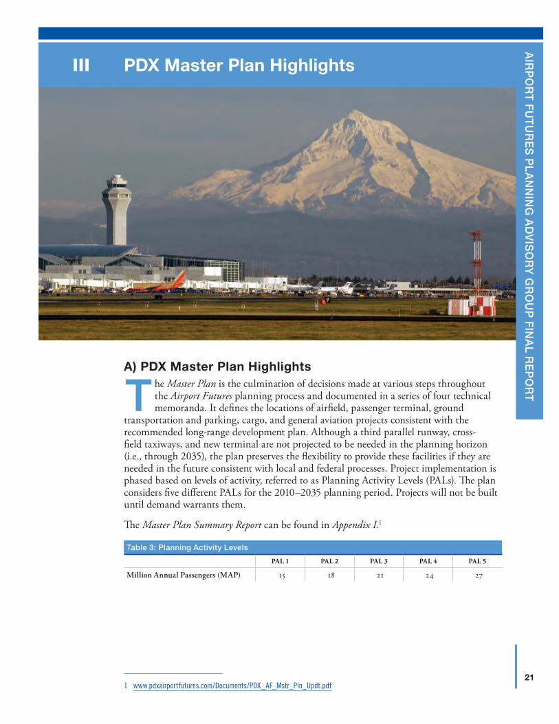
A) PDX Master Plan Highlights
The Master Plan is the culmination of decisions made at various steps throughout the Airport Futures planning process and documented in a series of four technical memoranda. It defines the locations of airfield, passenger terminal, ground
transportation and parking, cargo, and general aviation projects consistent with the recommended long-range development plan. Although a third parallel runway, cross-field taxiways, and new terminal are not projected to be needed in the planning horizon (i.e., through 2035), the plan preserves the flexibility to provide these facilities if they are needed in the future consistent with local and federal processes. Project implementation is phased based on levels of activity, referred to as Planning Activity Levels (PALs). The plan considers five different PALs for the 2010–2035 planning period. Projects will not be built until demand warrants them.
The Master Plan Summary Report can be found in Appendix I.1
table 3: planning Activity levels
PAL 1 PAL 2 PAL 3 PAL 4 PAL 5
Million Annual Passengers (MAP) 15 18 21 24 27
1 www.pdxairportfutures.com/Documents/PDX_AF_Mstr_Pln_Updt.pdf
22
III
P
Dx
MA
STE
R P
LAN
HIG
HLI
GH
TSAirport futures plAnning Advisory group finAl report
A summary of the major features of the Master Plan follows:
Airfield
� Reserve the area required for a third parallel runway, if needed and approved.
� Reserve the area required for cross-field connector taxiways, if needed and approved.
passenger terminal
� Reserve the area required to accommodate Terminal Expansion East (TEE) (i.e., build-out of existing terminal). The Centralized development concept recommended by the PAG anticipates that for activity beyond PAL 5, this terminal expansion will be required.
� Continuously modify passenger security screening areas within the terminal, as dictated by the Transportation Security Administration.
� Increase terminal gate productivity by constructing additional off gate aircraft parking to the north of NE Airport Way to accommodate aircraft that remain at PDX overnight (PALs 1–3).
� Further increase terminal gate productivity by constructing additional off gate aircraft parking to the west of Runway 3-21 to accommodate aircraft that remain at the Airport overnight (PALs 4 and 5).
on-Airport ground transportation and parking
� Provide additional capacity at selected roadway intersections (PALs 1–5).
� Increase the productivity of existing rental car facilities by providing low-cost, at grade service facilities (PALs 1–3).
� Provide additional lanes to the on-airport roadway system (PALs 1–4).
� Construct grade-separated interchange at the intersection of NE Airport Way and NE 82nd Ave (PAL 2).
� Provide additional structured parking (PALs 2–5).
� Reorganize the commercial vehicle area to increase capacity of the deplaning curbside and roadway (PAL 3).
Air Cargo
� Improve undeveloped parcels or redevelop existing facilities within AirTrans Cargo Center (PALs 1–3).
� Provide additional cargo facilities in the Southwest Quadrant or other nearby locations that may be available (PALs 4 and 5).
general Aviation
� Preserve land to expand general aviation facilities adjacent to the existing area.
� Preserve land to accommodate all general aviation facilities, which ultimately may be relocated.
support
� Provide additional aircraft, fuel system capacity (PALs 1–5).
23
III
PD
x MA
STER
PLA
N H
IGH
LIGH
TSsepteMber 24, 2010
B) Existing Conditions InventoryThe inventory technical memorandum is found in the PDX Master Plan Summary Report. It provides an assessment of existing conditions related to the role of PDX within the region, its current operations and facilities, and surrounding land uses and activities.
Unique to this Master Plan Update, and consistent with the overall Airport Futures planning process and the focus on sustainability, the Airport Futures inventory process considered multiple study areas that extend beyond PDX properties. The study areas reflect the PAG’s interest in capturing both the operation of PDX as well as the area most directly influenced by the operation of PDX. Subject areas receiving special focus in the inventory included natural resources, economic development, and transportation. The understanding developed in the inventory process proved an essential foundation for evaluating future needs and actions in both the Master Plan and City Land Use Plan.
C) Forecast — An Innovative and Collaborative ApproachForecast demand for passengers, air cargo, and aircraft operations at PDX was a key element of the long-range plan and, therefore of great importance to the PAG. Given the considerable uncertainty associated with the aviation industry and the economy, an innovative forecasting approach was employed. The approach bridged the gap between complex statistical modeling techniques and the need for the stakeholders to influence key model inputs and understand the resulting outputs.
The forecast process included:
� Coordinating with the PAG, PAG Forecast Subcommittee, FAA, and the City’s peer reviewer,
� Reviewing the 2000 PDX Master Plan and FAA forecasts,
� Identifying key issues and trends affecting future aviation demand at PDX,
� Preparing supplemental analyses to address stakeholder input, and
� Developing appropriate statistical models and probabilistic demand forecast.
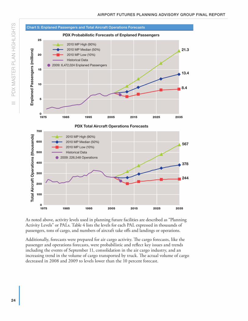
A probabilistic forecast, not commonly done in airport master planning, expresses future activity in terms of the probabilities that a given activity level will happen in a given future year. The following graph indicates the future levels of passenger activity that can be expected at PDX with probabilities ranging from 10 percent to 90 percent. The long-range plan is based on the 50th percentile forecasts but has the flexibility to accommodate the 90th percentile forecasts. The 90th percentile forecast combines forecast drivers in such a way that there is less than 10 percent probability that activity levels will be greater than this curve. Similarly, there is less than 10 percent probability that activity levels will be below the 10th percentile curve.
24
III
P
Dx
MA
STE
R P
LAN
HIG
HLI
GH
TSAirport futures plAnning Advisory group finAl report
Chart 5: enplaned passengers and total Aircraft operations forecasts
PDX Probabilistic Forecasts of Enplaned PassengersE
npla
ned
Pas
seng
ers
(mill
ions
)
2009: 6,472,024 Enplaned Passengers
2010 MP High (90%)
2010 MP Median (50%)
2010 MP Low (10%)
Historical Data
19750
5
10
15
20
25
1985 1995 2005 2015 2025 2035
8.4
13.4
21.3
PDX Total Aircraft Operations Forecasts
Tota
l Air
craf
t O
per
atio
ns (t
hous
and
s) 2010 MP High (90%)
2010 MP Median (50%)
2010 MP Low (10%)
Historical Data
2009: 226,548 Operations
19750
300
200
100
400
500
600
700
1985 1995 2005 2015 2025 2035
244
378
567
As noted above, activity levels used in planning future facilities are described as “Planning Activity Levels” or PALs. Table 4 lists the levels for each PAL expressed in thousands of passengers, tons of cargo, and numbers of aircraft take offs and landings or operations.
Additionally, forecasts were prepared for air cargo activity. The cargo forecasts, like the passenger and operations forecasts, were probabilistic and reflect key issues and trends including the events of September 11, consolidation in the air cargo industry, and an increasing trend in the volume of cargo transported by truck. The actual volume of cargo decreased in 2008 and 2009 to levels lower than the 10 percent forecast.
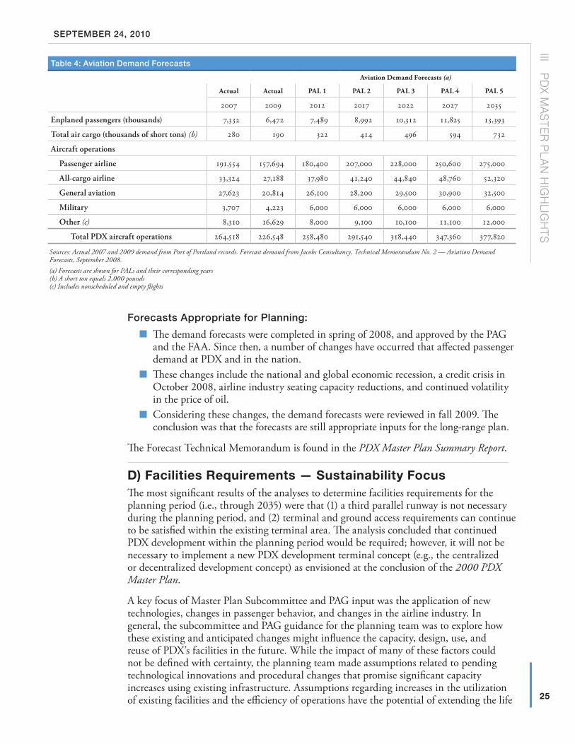
25
III
PD
x MA
STER
PLA
N H
IGH
LIGH
TSsepteMber 24, 2010
forecasts Appropriate for planning:
� The demand forecasts were completed in spring of 2008, and approved by the PAG and the FAA. Since then, a number of changes have occurred that affected passenger demand at PDX and in the nation.
� These changes include the national and global economic recession, a credit crisis in October 2008, airline industry seating capacity reductions, and continued volatility in the price of oil.
� Considering these changes, the demand forecasts were reviewed in fall 2009. The conclusion was that the forecasts are still appropriate inputs for the long-range plan.
The Forecast Technical Memorandum is found in the PDX Master Plan Summary Report.
D) Facilities Requirements — Sustainability FocusThe most significant results of the analyses to determine facilities requirements for the planning period (i.e., through 2035) were that (1) a third parallel runway is not necessary during the planning period, and (2) terminal and ground access requirements can continue to be satisfied within the existing terminal area. The analysis concluded that continued PDX development within the planning period would be required; however, it will not be necessary to implement a new PDX development terminal concept (e.g., the centralized or decentralized development concept) as envisioned at the conclusion of the 2000 PDX Master Plan.
A key focus of Master Plan Subcommittee and PAG input was the application of new technologies, changes in passenger behavior, and changes in the airline industry. In general, the subcommittee and PAG guidance for the planning team was to explore how these existing and anticipated changes might influence the capacity, design, use, and reuse of PDX’s facilities in the future. While the impact of many of these factors could not be defined with certainty, the planning team made assumptions related to pending technological innovations and procedural changes that promise significant capacity increases using existing infrastructure. Assumptions regarding increases in the utilization of existing facilities and the efficiency of operations have the potential of extending the life
table 4: Aviation demand forecasts
Aviation Demand Forecasts (a)
Actual Actual PAL 1 PAL 2 PAL 3 PAL 4 PAL 5
2007 2009 2012 2017 2022 2027 2035
Enplaned passengers (thousands) 7,332 6,472 7,489 8,992 10,312 11,825 13,393
Total air cargo (thousands of short tons) (b) 280 190 322 414 496 594 732
Aircraft operations
Passenger airline 191,554 157,694 180,400 207,000 228,000 250,600 275,000
All-cargo airline 33,324 27,188 37,980 41,240 44,840 48,760 52,320
General aviation 27,623 20,814 26,100 28,200 29,500 30,900 32,500
Military 3,707 4,223 6,000 6,000 6,000 6,000 6,000
Other (c) 8,310 16,629 8,000 9,100 10,100 11,100 12,000
Total PDX aircraft operations 264,518 226,548 258,480 291,540 318,440 347,360 377,820
Sources: Actual 2007 and 2009 demand from Port of Portland records. Forecast demand from Jacobs Consultancy, Technical Memorandum No. 2 — Aviation Demand Forecasts, September 2008.(a) Forecasts are shown for PALs and their corresponding years(b) A short ton equals 2,000 pounds(c) Includes nonscheduled and empty flights
26
III
P
Dx
MA
STE
R P
LAN
HIG
HLI
GH
TSAirport futures plAnning Advisory group finAl report
of facilities and ultimately postponing the development of new facilities. Like the forecast, these assumptions were a key influence in the alternatives analysis and final master plan. Some key areas influenced by this work include:
� Aircraft capacity increases (size and load factors)
� Examination of potential benefits of future air traffic control and aircraft navigation technology
� Development of common use vs. exclusive ticket counters and holdrooms
� Electronic or “E”-ticketing
� Reduced wait times at curbside on terminal roadways
� Increased efficiency in passenger security screening — faster processing rates
� Increased utilization rates for cargo processing and warehouse space
E) Sustainability Criteria for Facilities PlanningThe approach employed to ensure that the alternatives reflect the PAG’s Vision and Values and the overall commitment to sustainability was to carefully evaluate the alternatives against criteria that were developed with the Master Plan Alternatives/Sustainability Subcommittee and PAG.
The sustainability criteria for facilities planning were as follows:
� Preserve Flexibility/Options � Multi-modal — preserve/enhance premium MAX light rail access to terminal � Adaptability — preserve the ability to respond to changes in requirements/
emerging technologies (i.e., mode split changes, smaller cars, alternative fuels, new multi-party modes, changes in passenger processing)
� Minimize impacts to natural resources, air quality, water quality, and reduce greenhouse gas emissions
� Maximize land use efficiencies � Cluster like uses/dependent uses � Where possible, use a compact development form � Prioritize redevelopment over new development
� Maximize operational efficiencies � Maximize shared/common use opportunities � Where possible substitute operational solutions (i.e., demand management) for
new facilities � Minimize congestion � Customer service — simplify passenger wayfinding, minimize mode changes and
travel distances within the terminal environment � Maximize the utilization of existing facilities
� Maximize Effective Phasing � Minimize construction impacts to public � Reasonable increments of expansion � Financially feasibility
� Comply with FAA airport design criteria (e.g., height restrictions, tower line-of-sight, aircraft movement)
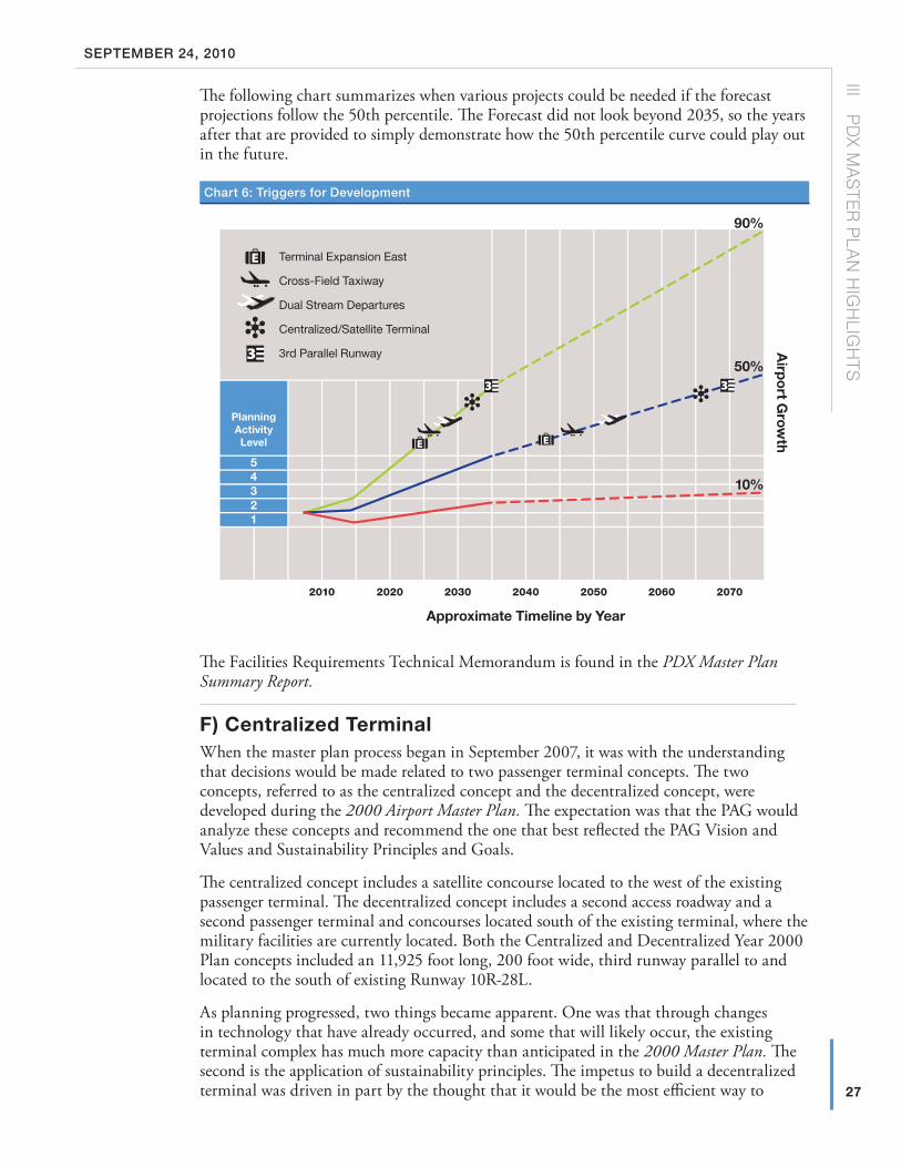
27
III
PD
x MA
STER
PLA
N H
IGH
LIGH
TSsepteMber 24, 2010
The following chart summarizes when various projects could be needed if the forecast projections follow the 50th percentile. The Forecast did not look beyond 2035, so the years after that are provided to simply demonstrate how the 50th percentile curve could play out in the future.
Chart 6: triggers for development
Airp
ort G
rowth
Terminal Expansion East
Cross-Field Taxiway
Dual Stream Departures
Centralized/Satellite Terminal
3rd Parallel Runway
Approximate Timeline by Year
90%
50%
10%
54321
2010 2020 2030 2040 2050 2060 2070
PlanningActivityLevel
The Facilities Requirements Technical Memorandum is found in the PDX Master Plan Summary Report.
F) Centralized TerminalWhen the master plan process began in September 2007, it was with the understanding that decisions would be made related to two passenger terminal concepts. The two concepts, referred to as the centralized concept and the decentralized concept, were developed during the 2000 Airport Master Plan. The expectation was that the PAG would analyze these concepts and recommend the one that best reflected the PAG Vision and Values and Sustainability Principles and Goals.
The centralized concept includes a satellite concourse located to the west of the existing passenger terminal. The decentralized concept includes a second access roadway and a second passenger terminal and concourses located south of the existing terminal, where the military facilities are currently located. Both the Centralized and Decentralized Year 2000 Plan concepts included an 11,925 foot long, 200 foot wide, third runway parallel to and located to the south of existing Runway 10R-28L.
As planning progressed, two things became apparent. One was that through changes in technology that have already occurred, and some that will likely occur, the existing terminal complex has much more capacity than anticipated in the 2000 Master Plan. The second is the application of sustainability principles. The impetus to build a decentralized terminal was driven in part by the thought that it would be the most efficient way to
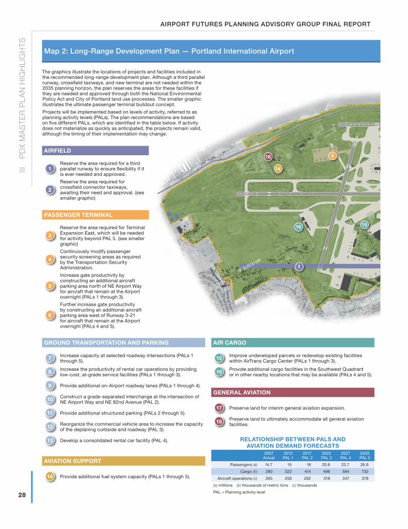
28 R10L
28 L10R
21
3
NE AIRPORT WAY
NE MARINE DRIVE
COLUMBIA RIVER
NE ALDERWOOD RD.
NE 82nd AVEN
UE
I-20
5
NE ELROD DR.
NE CORNFOOT RD.
NE AIR
TRAN
S WAY
1
6
1516
18
14
28
III
P
Dx
MA
STE
R P
LAN
HIG
HLI
GH
TSAirport futures plAnning Advisory group finAl report
The graphics illustrate the locations of projects and facilities included in the recommended long-range development plan. Although a third parallel runway, crossfield taxiways, and new terminal are not needed within the 2035 planning horizon, the plan reserves the areas for these facilities if they are needed and approved through both the National Environmental Policy Act and City of Portland land use processes. The smaller graphic illustrates the ultimate passenger terminal buildout concept.
Projects will be implemented based on levels of activity, referred to as planning activity levels (PALs). The plan recommendations are based on five different PALs, which are identified in the table below. If activity does not materialize as quickly as anticipated, the projects remain valid, although the timing of their implementation may change.
GRounD TRAnSPoRTATIon AnD PARkInG
7 Increase capacity at selected roadway intersections (PALs 1 through 5).
8 Increase the productivity of rental car operations by providing low-cost, at-grade service facilities (PALs 1 through 3).
9 Provide additional on-Airport roadway lanes (PALs 1 through 4).
10 Construct a grade-separated interchange at the intersection of NE Airport Way and NE 82nd Avenue (PAL 2).
11 Provide additional structured parking (PALs 2 through 5).
12 Reorganize the commercial vehicle area to increase the capacity of the deplaning curbside and roadway (PAL 3).
13 Develop a consolidated rental car facility (PAL 4).
AVIATIon SuPPoRT
14 Provide additional fuel system capacity (PALs 1 through 5).
AIR CARGo
15 Improve undeveloped parcels or redevelop existing facilities within AirTrans Cargo Center (PALs 1 through 3).
16 Provide additional cargo facilities in the Southwest Quadrant or in other nearby locations that may be available (PALs 4 and 5).
GEnERAl AVIATIon
17 Preserve land for interim general aviation expansion.
18 Preserve land to ultimately accommodate all general aviation facilities.
RElATIonSHIP BETWEEn PAlS AnD AVIATIon DEMAnD FoRECASTS
2007 Actual
2012 PAL 1
2017 PAL 2
2022 PAL 3
2027 PAL 4
2035 PAL 5
Passengers (a) 14.7 15 18 20.6 23.7 26.8
Cargo (b) 280 322 414 496 594 732
Aircraft operations (c) 265 258 292 318 347 378
(a) millions (b) thousands of metric tons (c) thousands
PAL = Planning activity level
AIRFIElD
1Reserve the area required for a third parallel runway to ensure flexibility if it is ever needed and approved.
2
Reserve the area required for crossfield connector taxiways, awaiting their need and approval. (see smaller graphic)
PASSEnGER TERMInAl
3
Reserve the area required for Terminal Expansion East, which will be needed for activity beyond PAL 5. (see smaller graphic)
4
Continuously modify passenger security screening areas as required by the Transportation Security Administration.
5
Increase gate productivity by constructing an additional aircraft parking area north of NE Airport Way for aircraft that remain at the Airport overnight (PALs 1 through 3).
6
Further increase gate productivity by constructing an additional aircraft parking area west of Runway 3-21 for aircraft that remain at the Airport overnight (PALs 4 and 5).
Map 2: long-range development plan — portland international Airport
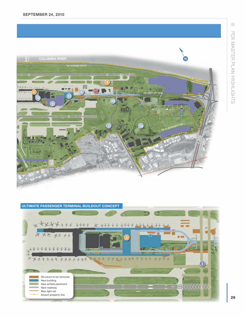
2
3
Structure to be removedNew buildingNew airfield pavementNew roadwayMax light railAirport property line
28 R10L
28 L10R
21
3
NE AIRPORT WAY
NE MARINE DRIVE
COLUMBIA RIVER
NE ALDERWOOD RD.N
E 82nd AVENU
E
I-20
5
NE ELROD DR.
NE CORNFOOT RD.
NE AIR
TRAN
S WAY
n
7
8
9
10
1112
13
5
4 17
29
III
PD
x MA
STER
PLA
N H
IGH
LIGH
TSsepteMber 24, 2010
ulTIMATE PASSEnGER TERMInAl BuIlDouT ConCEPT
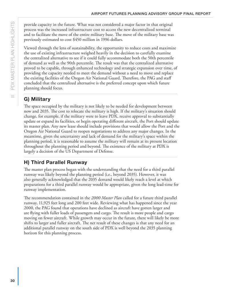
30
III
P
Dx
MA
STE
R P
LAN
HIG
HLI
GH
TSAirport futures plAnning Advisory group finAl report
provide capacity in the future. What was not considered a major factor in that original process was the increased infrastructure cost to access the new decentralized terminal and to facilitate the move of the entire military base. The move of the military base was previously estimated to cost $450 million in 1996 dollars.
Viewed through the lens of sustainability, the opportunity to reduce costs and maximize the use of existing infrastructure weighed heavily in the decision to carefully examine the centralized alternative to see if it could fully accommodate both the 50th percentile of demand as well as the 90th percentile. The result was that the centralized alternative proved to be capable, through enhanced technology and strategic expansion over time, of providing the capacity needed to meet the demand without a need to move and replace the existing facilities of the Oregon Air National Guard. Therefore, the PAG and staff concluded that the centralized alternative is the preferred concept upon which future planning should focus.
G) MilitaryThe space occupied by the military is not likely to be needed for development between now and 2035. The cost to relocate the military is high. If the military’s situation should change, for example, if the military were to leave PDX, receive approval to substantially update or expand its facilities, or begin operating different aircraft, the Port should update its master plan. Any new lease should include provisions that would allow the Port and the Oregon Air National Guard to reopen negotiations to address any major changes. In the meantime, given the uncertainty and lack of demand for the military’s space within the planning period, it is reasonable to assume the military will remain at its present location throughout the planning period and beyond. The existence of the military at PDX is largely a decision of the US Department of Defense.
H) Third Parallel RunwayThe master plan process began with the understanding that the need for a third parallel runway was likely beyond the planning period (i.e., beyond 2035). However, it was also generally acknowledged that the 2035 demand would likely reach a level at which preparations for a third parallel runway would be appropriate, given the long lead-time for runway implementation.
The recommendation contained in the 2000 Master Plan called for a future third parallel runway, 11,925 feet long and 200 feet wide. Reviewing what has happened since the year 2000, the PAG found that operations have declined as aircraft have gotten larger and are flying with fuller loads of passengers and cargo. The result is more people and cargo moving on fewer aircraft. While growth may occur in the future, there will likely be more shifts to larger and fuller aircraft. The net result of these changes is that any need for an additional parallel runway on the south side of PDX is well beyond the 2035 planning horizon for this planning process.
31
III
PD
x MA
STER
PLA
N H
IGH
LIGH
TSsepteMber 24, 2010
The advisory group also reviewed and endorsed a recommendation by staff that the conceptual runway be shorter and narrower. The runway will be shown as 8,500 feet long and 150 feet wide in recognition of current standards and the fact that the north parallel runway has been extended to just over 9,800 feet which negates the need for such a long runway on the south side of PDX.
The benefits of shortening the future third parallel runway (reducing cost, minimizing environmental impacts, and maximizing land use efficiency) offset any projected loss of operational capability. The runway’s primary use would be for aircraft arrivals and virtually all aircraft could be accommodated.
As a result, the Port believes it is a prudent policy to preserve the options for a future third runway; thus, the Airport Layout Plan (ALP) shows a place for a third parallel runway, but in a shorter configuration than in the 2000 Master Plan (8,500 feet rather than 11,925 feet long). From the City of Portland standpoint, the runway is so far into the future, that at the present time, it will not be shown or approved on land use plans for PDX.
If conditions change which justify the runway, a legislative plan amendment will be required to amend the Airport Plan District to allow it to be built. Any such runway will be subject to Federal review under the National Environmental Policy Act (NEPA). The following note is provided on the ALP:
Conceptual Third Runway Reserve: While a third parallel runway has not been identified as a required facility for the planning period ending in 2035, it is depicted so that potential future development of a third parallel runway is not precluded by other airport development.
� Acceptance of this ALP by the FAA does not in any way constitute a commitment on the part of the United States to participate in any development depicted therein nor does it indicate that the proposed development is environmentally acceptable in accordance with the appropriate public laws.
� A third parallel runway is not currently a permitted development in the City of Portland’s Airport Plan District. Construction of the third parallel runway would require a legislative amendment to the Airport Plan District to make it a permitted development.
� The need for a third parallel runway as well as other alternatives related to expanding capacity will be the subject of further evaluation in future master plans, including the potentially connected actions of a new terminal and a new third parallel runway.
� A new terminal and/or a new third parallel runway will require an Environmental Impact Statement (EIS) consistent with the National Environmental Policy Act. The EIS will be managed by the FAA. The EIS process will make a determination as to whether the terminal development and the third parallel runway are connected actions.
� The width and length of the Conceptual Third Runway Reserve reflects facility planning criteria including the desire to preserve flexibility/options, minimize impacts, maximize land use efficiencies, maximize operational efficiencies, maximize effective phasing, and comply with FAA airport design criteria.
� If the third parallel runway is ever needed, it is anticipated that Runway 3-21 (existing crosswind runway) would be converted to a taxiway.
32
III
P
Dx
MA
STE
R P
LAN
HIG
HLI
GH
TSAirport futures plAnning Advisory group finAl report
Additionally, the PAG recommends an amendment to the City’s Comprehensive Plan to include a section specific to PDX in the Public Facilities Goal (Goal 11). Many of the goals and policies developed through the Airport Futures planning process are captured in amendments, which include a map of PDX facilities based on the 50th percentile aviation forecast (see Map 4 — City of Portland Comprehensive Plan Map: PDX Facilities).
There is also a reference in the Goal language regarding the necessary legislative process to add a third parallel runway in the City’s Comprehensive Plan, if ever proposed. The Plan District in Title 33 (Zoning Code) includes a provision that specifically prohibits the development of any additional runways at PDX.
I) noiseThe Noise Technical Memorandum is found in Appendix C of the PDX Master Plan Summary Report.
An extensive analysis of aircraft noise exposure was prepared for this Master Plan Update using both traditional noise measuring metrics such as the Day Night Level (DNL) and non-traditional metrics such as the time an area would experience noise levels above a given level (Time Above (TA)) and the number of operations (Number Above (NA)) at a given noise level. The key conclusions from the noise exposure analysis for PDX are:
� Increasing numbers of annual aircraft operations would result in larger DNL noise exposure contours.
� Removing jet aircraft departure restrictions would change the location of noise exposure, and thus, the shape of the contours based on all metrics.
� Adding a third parallel runway would change the location of noise exposure, and thus, the shape of all contours.
� The existing 1990 noise contour (used as the basis for the City noise overlay) is larger than the majority of the 65 DNL contours for future noise scenarios at higher activity levels, including levels with a third parallel runway.
Although the Airport Futures PAG recommends leaving the City’s noise overlay boundary where it is today for acoustic certification, easements and noise disclosures statements, the group supports:
1. A new noise overlay extending out from the current 1990 65 DNL to include land within the 2035 50th Percentile Forecast 55 DNL contour should be adopted for the limited purpose of noise disclosure for new residential development and redevelopment (no easements or other provisions of the existing noise overlay — only disclosure) The figure on the following pages illustrates the area creating a new overlay zone which extends to the 2035 50th Percentile Forecast 55 DNL noise contour from the existing 1990 65 DNL contour.
2. The disclosure should state that the dwelling unit is in an area subject to aircraft overflight by jets and other aircraft arriving and departing PDX and that some people may be impacted by the aircraft noise. A copy of the current disclosure statement is available on the City’s website.2
3. The Port and City should convene a limited duration Noise Work Group (NWG) to Address Noise Outside the 65 DNL. The PAG recognizes that aircraft noise impacts residences beyond the 65 DNL contour. As a result, the Port and the City commit to exploring ideas related to noise mitigation beyond the 65 DNL threshold of
2 www.portlandonline.com/bds/index.cfm?c=45494&a=219419
33
III
PD
x MA
STER
PLA
N H
IGH
LIGH
TSsepteMber 24, 2010
significance defined by the FAA, US Environmental Protection Agency, and Oregon Department of Environmental Quality. The PAG believes that thoroughly exploring these ideas (e.g., disclosure, easements, and potential types of mitigation beyond the existing noise overlay) deserves more time and attention, than can be given within the Airport Futures planning process.
The limited term Noise Work Group was convened in December 2009 to make recommendations for new and creative approaches to aircraft noise impacts to the Citizen Noise Advisory Committee for follow on study and follow up. A report on the work of the group will be made to the Portland City Council, Vancouver City Council, Port Commission, and the PDX Citizens Advisory Committee. It is anticipated that the time required for the group to conclude the substantive work as outlined in the work plan will be six months to a year. The group will report back to the PAG for as long as the PAG exists and to the future PDX Community Advisory Committee, the Port Commission, Portland City Council, and Vancouver City Council in the future.
The Noise Work Group (NWG) Report developed through a collaborative effort of the Port, City, PAG, CNAC, and other interested stakeholders is found in Appendix J.3
J) Master Plan Financial FeasibilityA master plan financial capacity analysis was completed to address:
� Feasibility of funding proposed projects � Primary focus was on the funding of near-term projects (3–5 years, through
Planning Activity Level 2 or 18 MAP) � Less focus on medium and long-term projects because of uncertainty (in both
funding and needs)
� Regulatory, legal, and competitive factors � FAA restricts use of PDX revenue � Airline use agreement sets rates and charges structure � Bond sales establish binding financial covenants � Competitive airport marketplace influences financing decisions
The financial analysis developed estimates for all projects identified for the 2010–2035 planning period. Consistent with the PAG forecast recommendation, the 50th percentile forecast was used to derive a rough estimate of project timing.
The existing airfield and passenger terminal area will continue to satisfy the aviation demand forecast through the planning period with operational and technological enhancements; however, continued investment in airport facilities outside the existing terminal envelope will be required. Examples of these investment decisions that will need to be made during the planning period include:
� A grade-separated interchange at the intersection of NE 82nd Ave and NE Airport Way
� An appropriate site for additional automobile parking
� An appropriate location for additional general aviation facilities
3 www.pdxairportfutures.com/Documents/Beyond_65_DNL_Noise_Work_Group_Scope.pdf
Beaverton
Gresham
Camas
WoodVillage
FairviewTroutdale
MaywoodPark
23R
D A
VE
19TH
AV
E
ST
DR
BLVD
AV
E
ST
33R
D
VIST
A
RD
AV
E24
2ND
162N
DA
VE
AV
E
COLUMBIA
GR
AND
112T
H A
VE
BLV
D
112T
H A
VE
18TH ST
HO
GA
N
BR
OA
DW
AY
CANYON
Forest Park US 30
RD
HWY 8
ST
YEON AVE
MA
RTI
NLU
THE
RK
ING
JR.
BLV
D
FREEWAY
US 26
BANFIE LD
V
D
I-5
HWY 500
BLVD
Portland
International
Airport
AIRPORT
WAY
HWY 14
HW
Y 5
00
ST12
2ND
AV
E
MARINE
DR
DIVISION
I-205
I-84
Powell
ton
I-405
HW
Y
LOM
BAR
D ST
LOMBARD
ST
COLUMBIA
99W
NORTH P
ORTLAND R
D
BLVD
WILLAMETTE BLVD
143R
D A
VE
RD
JENKINS
RD
RD
RD
KAISER
KA
NE
RD
NEW
BERRY
RD
RD
REEDER
RD
SAUVIE ISLAN
D R
D
GILLIHAN
LOO
P
MAC
A RTHUR BLVD
EVER GREEN BLVD
LIE
SS
ER R
D
RD
ELL
SW
OR
TH
FRU
IT V
ALL
EY
RD
ST
MA
IN
FOURTH PLAIN
BLVD
MILLPLAIN
FOURTHPLAIN
BLVD
ST J
OH
NS
RD
1 62N
D A
VE
164T
H
AV
E
AN
DR
ES
ON
WAY
39TH ST
FT VANCOUVER
MILL PLAIN BLVD
137T
H A
V13
8TH
AV
E
192N
D A
VE
LAKE RD
1ST ST
28TH ST
ROBER
TS
EAS
TM
AN
PK
WY
AV
E1 4
8TH
POWELL
ST
AV
E
102 N
D
BLVD
223R
D
HALSEY
AV
E
AV
E18
2 ND
THOMPSONRD
DR
BROADWAY
CORNELL
RD
FER
RY
RD
BARNES
R
D
COR NELL RD
BURNSIDE RD
BLVD
ER
ST
BURNSIDE ST
STARK ST
GLISAN ST
WALKER
RD
D
158T
H A
VE
CEDA
R
HILLS
MARINE DR
SR-501
MCGILLIVRAY BLVD
SR-14
6TH AVE
34TH ST
20TH ST
192N
D A
V
PA
RK
ER
ST
232N
D
AV
LEADBETTER RD
AV
e
KILLINGSWORTH
SUNSED
ST
ST
HOLGATE
BELMONT
STARK
HALSEY
BLVD
SANDY
POWELL
DIVISION
RD
PATTON
HAWTHORNE BLVD
20TH
AV
E
17TH
AV
E
39TH
AVE
33R
D
NA
I TO
PKW
Y
AV
E
FREMONT
ST
ST
GOING ST PRESCOTT
LOMBARD
GREELEY
AVE
42N
DA
VE
AV
E
AV
E82
ND
76TH
AV
E
BLVDCU
LLY
BLVD
SANDY
BLVD
US 30
BRO
ADW
AY4T
H
RD
SKYLINE Willamette River
Columbia River
ette
Riv
er
STKILLINGSWORTH
Bybee Lake
Smith Lake
BLVD
12TH
AV
E
Vancouver
Legend
Existing Noise (x) Overlay Zone
2035 50th Percentile 55 DNL and higher
Airport Runways/Structures
City Boundary
Water features
0 7,000
Feet
September 9, 200934
III
P
Dx
MA
STE
R P
LAN
HIG
HLI
GH
TSAirport futures plAnning Advisory group finAl report
Map 3: City of portland noise impact overlay
Beaverton
Gresham
Camas
WoodVillage
FairviewTroutdale
MaywoodPark
23R
D A
VE
19TH
AV
E
ST
DR
BLVD
AV
E
ST
33R
D
VIST
A
RD
AV
E24
2ND
162N
DA
VE
AV
E
COLUMBIA
GR
AND
112T
H A
VE
BLV
D
112T
H A
VE
18TH ST
HO
GA
N
BR
OA
DW
AY
CANYON
Forest Park US 30
RD
HWY 8
ST
YEON AVE
MA
RTI
NLU
THE
RK
ING
JR.
BLV
D
FREEWAY
US 26
BANFIE LD
V
D
I-5
HWY 500
BLVD
Portland
International
Airport
AIRPORT
WAY
HWY 14
HW
Y 5
00
ST
122N
DA
VE
MARINE
DR
DIVISION
I-205
I-84
Powell
ton
I-405
HW
Y
LOM
BAR
D ST
LOMBARD
ST
COLUMBIA
99W
NORTH P
ORTLAND R
D
BLVD
WILLAMETTE BLVD
143R
D A
VE
RD
JENKINS
RD
RD
RD
KAISER
KA
NE
RD
NEW
BERRY
RD
RD
REEDER
RD
SAUVIE ISLAN
D R
D
GILLIHAN
LOO
P
MAC
A RTHUR BLVD
EVER GREEN BLVD
LIE
SS
ER R
D
RD
ELL
SW
OR
TH
FRU
IT V
ALL
EY
RD
ST
MA
IN
FOURTH PLAIN
BLVD
MILLPLAIN
FOURTHPLAIN
BLVD
ST J
OH
NS
RD
1 62N
D A
VE
164T
H
AV
E
AN
DR
ES
ON
WAY
39TH ST
FT VANCOUVER
MILL PLAIN BLVD
137T
H A
V13
8TH
AV
E
192N
D A
VE
LAKE RD
1ST ST
28TH ST
ROBER
TS
EAS
TM
AN
PK
WY
AV
E1 4
8TH
POWELL
ST
AV
E
102 N
D
BLVD
223R
D
HALSEY
AV
E
AV
E18
2 ND
THOMPSONRD
DR
BROADWAY
CORNELL
RD
FER
RY
RD
BARNES
R
D
COR NELL RD
BURNSIDE RD
BLVD
ER
ST
BURNSIDE ST
STARK ST
GLISAN ST
WALKER
RD
D
158T
H A
VE
CEDA
R
HILLS
MARINE DR
SR-501
MCGILLIVRAY BLVD
SR-14
6TH AVE
34TH ST
20TH ST
192N
D A
V
PA
RK
ER
ST
232N
D
AV
LEADBETTER RD
AV
e
KILLINGSWORTH
SUNSED
ST
ST
HOLGATE
BELMONT
STARK
HALSEY
BLVD
SANDY
POWELL
DIVISION
RD
PATTON
HAWTHORNE BLVD
20TH
AV
E
17TH
AV
E
39TH
AVE
33R
D
NA
I TO
PKW
Y
AV
E
FREMONT
ST
ST
GOING ST PRESCOTT
LOMBARD
GREELEY
AVE
42N
DA
VE
AV
E
AV
E82
ND
76TH
AV
E
BLVD
CULL
Y
BLVD
SANDY
BLVD
US 30
BRO
ADW
AY4T
H
RD
SKYLINE Willamette River
Columbia River
ette
Riv
er
STKILLINGSWORTH
Bybee Lake
Smith Lake
BLVD
12TH
AV
E
Vancouver
35
III
PD
x MA
STER
PLA
N H
IGH
LIGH
TSsepteMber 24, 2010
36
III
P
Dx
MA
STE
R P
LAN
HIG
HLI
GH
TSAirport futures plAnning Advisory group finAl report
These types of investment decisions have long-term implications related to the phasing and cost of other PDX improvements and the ability to maintain future flexibility. PDX development will be driven by numerous objectives including those related to project timing and financing. Project timing is related to demand—projects will be implemented only when justified by demand.
table 5: Master plan Cip — estimated Cost by functional element
Functional Elements Estimated Cost (Millions 2008 $) Distribution
Passenger Terminal $43.6 3.8%
Parking and Curbside $646.3 55.7%
Rental Cars $221.6 19.1%
Roadways $7.9 0.7%
Key Intersections $124.1 10.7%
Air Cargo $113.8 9.8%
GA $2.1 0.2%
Total $1,159.4 100.0%
The funding plan is based on sound business principles and a financial strategy that is traditional, conservative and proven at PDX. This strategy has resulted in PDX being one of only seven airports in the country with an AA– bond rating. The cornerstones of the Port’s approach to financing PDX improvements include:
� Manage Debt � Remain within debt capacity � Meet bond covenants for debt service � Generate acceptable levels of net income � Preserve financing capacity for future capital expenditures
� Maintain competitive rates and charges for the airlines and passengers
� Use “pay-as-you-go” funding to reduce borrowing
� Issue airport revenue bonds to bridge funding gaps
The master plan financial capacity analysis included estimating project costs for the planning period, incorporating those costs into the Port’s financial model and evaluating the Port’s ability to fund projects according to the phasing required by the 50th percentile forecast and the Port’s financial objectives. The PAG accepted the Port’s conclusion that it has the financial capacity to fund the recommended improvements and continue to meet its financial objectives.
The PDX Master Plan Financial Feasibility Report is found in Section 6.3 of Appendix I: PDX Master Plan Summary Report.
37
III
PD
x MA
STER
PLA
N H
IGH
LIGH
TSsepteMber 24, 2010
k) Follow-on Studies to this Master Planning ProcessThe 2000 PDX Master Plan recommended several Follow-on Studies to further test assumptions, monitor progress, and plan for the future. Those studies were done before, or as part of, Airport Futures. The result was alternatives, strategies, and recommended projects for development through 2035. Equally important, the process resulted in the identification of future Follow-on Studies necessary to address issues raised by staff, consultants, and the PAG. Those studies encompass specific facilities and issues ranging from aircraft parking to connectivity between PDX and a future regional high-speed rail system. As a result, the PAG recommends the following Follow-on Studies:
1. Passenger Terminal Master PlanStudy the terminal in its entirety, develop a comprehensive strategy, and plan to reconfigure level 1 and the mezzanine, thus avoiding a piecemeal approach to improvements.
2. Terminal Expansion East (TEE) Project DefinitionComplete a sufficient amount of preliminary design for TEE and its related facilities to understand and document the concept of operation for TEE and major related facilities.
3. North Side Properties Redevelopment StudyDefine how the land envelope for the north side properties will be impacted by adjacent short- and long-term develop ment.
4. P4 Parking Garage DefinitionDefine the utility of the P4 site as a construction staging area, recommend whether this utility is sufficiently great to justify delaying develop ment of the site until after the P3 site is developed, illustrate the area available for development, determine the size and layout of the garage and possible uses, and develop a P4 access/egress plan.
5. All-Cargo Development StudyDetermine if the existing aircraft maintenance hangar should be converted for use as a cargo warehouse, demolished and replaced with a new cargo warehouse, or retained as is; identify the site or sites AirTrans Cargo Center for all-cargo development; and prepare plans illustrating the incremental all-cargo development potential of the sites remaining in the AirTrans Cargo Center and the actions required to complete the development.
6. Gate Management and Operations StudyDocument the amount of ground service equipment associated with airline passenger aircraft currently at PDX by owner/operator, where that equipment is stored and staged, how it is managed, and current management issues, along with impacts in the future by increased gate utilization through increased common use.
7. Concourse A Improvements StudyIdentify alternatives for increasing passenger comfort and convenience in Concourse A, and determine the timing of the improvements to ensure minimal inconvenience to customers and the tenant.
8. Concourse E Regional Airline Holdroom Improvements StudyIdentify alternatives for increasing passenger comfort and convenience in the holdroom to a level equivalent to that provided at other holdrooms, and determine the timing of the improvements to ensure minimal inconvenience to customers and SkyWest Airlines.
38
III
P
Dx
MA
STE
R P
LAN
HIG
HLI
GH
TSAirport futures plAnning Advisory group finAl report
9. Aircraft Rescue and Firefighting Facility Siting StudyIdentify and evaluate alter natives for meeting the new requirements and recommend the preferred alternative.
10. 82nd Ave Grade-Separated Interchange Project DefinitionIdentify the preferred design concept for the interchange, extent of PDX property required, and the impacts on existing facilities and land parcels as well as the timing of those impacts.
11. High Speed Rail StudyConfirm the region’s expecta tions and plans for high-speed rail service and facilities, define the range of policy and facilities issues that must be resolved to integrate air transportation at PDX with high-speed rail transportation, identify a range of potential PDX-related policy and facilities alternatives, and prepare a preliminary long-range plan for integrating air and high-speed rail transportation.
12. Remain Overnight Aircraft (RON) Parking Ramp Design StudyConfirm the preferred location and phasing for supplemental RON aircraft parking.
13. Commercial Vehicle Roadway Redevelopment StudyDevelop detailed plans showing how the space to be vacated by the rental cars will be used by commercial vehicles, and how the space vacated by the commercial vehicles will be used for supplemental deplaning curbside and roadway lanes.
14. Enplaning Roadway StudyDetermine the feasibility of widening the enplaning level departure and approach roadways to permit the addition of one departure lane and one approach lane. Identify other alternatives for resolving the deficiency, including operating at a lower level of service. Recommend the preferred alternative.
The Follow-on Studies information is found in Section 9 of Appendix I: PDX Master Plan Summary Report.
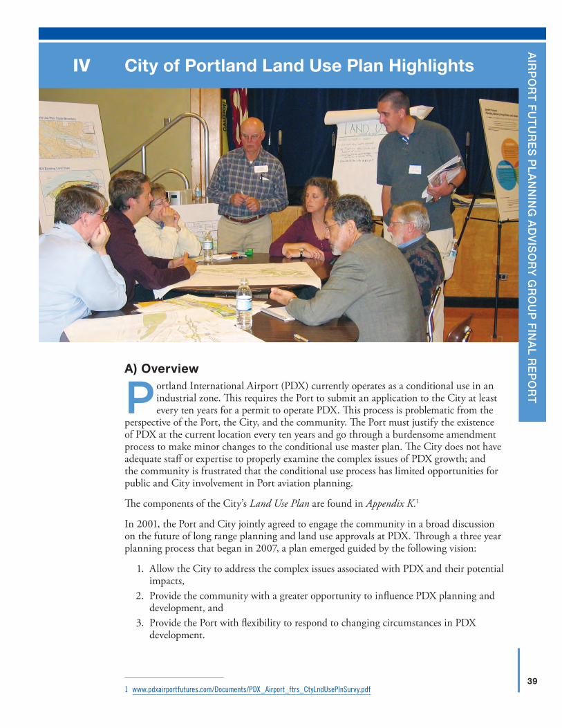
39
A
irp
or
t f
ut
ur
es
pl
An
nin
g A
dv
iso
ry
gr
ou
p f
inA
l re
po
rt
City of Portland land use Plan HighlightsIV
A) overview
Portland International Airport (PDX) currently operates as a conditional use in an industrial zone. This requires the Port to submit an application to the City at least every ten years for a permit to operate PDX. This process is problematic from the
perspective of the Port, the City, and the community. The Port must justify the existence of PDX at the current location every ten years and go through a burdensome amendment process to make minor changes to the conditional use master plan. The City does not have adequate staff or expertise to properly examine the complex issues of PDX growth; and the community is frustrated that the conditional use process has limited opportunities for public and City involvement in Port aviation planning.
The components of the City’s Land Use Plan are found in Appendix K.1
In 2001, the Port and City jointly agreed to engage the community in a broad discussion on the future of long range planning and land use approvals at PDX. Through a three year planning process that began in 2007, a plan emerged guided by the following vision:
1. Allow the City to address the complex issues associated with PDX and their potential impacts,
2. Provide the community with a greater opportunity to influence PDX planning and development, and
3. Provide the Port with flexibility to respond to changing circumstances in PDX development.
1 www.pdxairportfutures.com/Documents/PDX_Airport_ftrs_CtyLndUsePlnSurvy.pdf
40
IV
c
ITY
OF
PO
RTL
AN
D L
AN
D U
SE
PLA
N H
IGH
LIG
HTS
Airport futures plAnning Advisory group finAl report
The Airport Futures planning process was organized around these three principles. The primary outcomes of the process are summarized as follows:
1. Recognizing the importance of PDX to the bi-state regional economy, the plan provides the Port with certainty that PDX will continue to operate as an allowed use in the current location along with the flexibility of configuring PDX facilities to be responsive to future needs,
2. Recognizing the potential impacts of growth (e.g., natural resources, traffic, and noise), the plan provides mitigation of impacts and assurances to the community that significant new PDX development (e.g., a third parallel runway, decentralized terminal configuration) will involve a significant planning process and Portland City Council approval, and
3. Recognizing that planning is a continuous process, the plan provides an ongoing and highly collaborative public involvement process to address future issues associated with operating an airport in an urban area.
The Airport Futures Land Use Plan consists of three major parts: Amendments to the City’s Comprehensive Plan, amendments to the City’s Zoning Code, and intergovernmental agreements between the City and Port. The City’s Zoning Code (Title 33, Planning and Zoning) regulates the development and use of land and water within the City. Through these regulations, the Zoning Code implements the Comprehensive Plan, which is the City’s primary policy document. The Comprehensive Plan and the Zoning Code fit within a statewide planning structure. Finally, the City-Port intergovernmental agreements provide a necessary bridge between the Port’s PDX Master Plan and the City’s Land Use Plan. The agreements memorialize the City-Port partnership and discussion from the Airport Futures planning process, as well as issues not appropriate for City code.
Highlights of the City’s Land Use Plan include:
Comprehensive Plan Amendments
� Changes four airport-related goal elements of the Plan to strengthen the importance of partnerships, investments, and regulations to achieve City goals and objectives.
plan district and other Zoning Code Amendments
� Changes PDX to an allowed use in an industrial zone
� Prohibits a third parallel runway
� Prohibits a decentralized terminal
� Specifies reviews based on the potential impacts to the community
Height
� Clarifies regulations to improve safety and coordination
� Applies regulations to the recently annexed areas of East Portland and East Hayden Island
noise overlay Amendments
� Keeps the current noise overlay
� Expands the requirement for noise disclosure out to the 2035 55 DNL noise contour
� Creates a limited duration noise work group to address noise impacts outside the 65 DNL
41
IV
c
ITY
OF P
OR
TLAN
D LA
ND
US
E P
LAN
HIG
HLIG
HTS
septeMber 24, 2010
natural resources
� Updates the City’s Natural Resources Program in compliance with Statewide Planning Goal 5 and Metro’s Title 13
� Identifies required mitigation for future impacts to resources
� Allows for conversion of habitats to address wildlife hazards
� Outlines an overall enhancement strategy for the City and Port
transportation
� Identifies transportation mitigation projects based on PDX growth
� Creates a City review for all future transportation impact analyses
� Tests numerous strategies to increase transit mode split, which would reduce auto trips
� Addresses community concerns regarding cut-through traffic
economic development
� Inventories what is there today, market potential, and site and infrastructure needs
� Identifies strategic opportunities today and for the future.
The City’s Land Use Plan is implemented through Comprehensive Plan amendments, Zoning Code and Zoning Map Amendments, and agreements with the Port of Portland. Background reports on natural resources and transportation are adopted to support the Land Use Plan. The following is a summary of each component of the plan.
For information on the regulatory implementation of the plan, consult the Zoning Code amendments. These amendments are the regulations that govern the development and use of lands in and around PDX. They include noise regulations, height regulations, natural resource regulations, the Airport Plan District regulations (including a change to allow airport uses by right in the IG2 zone), and miscellaneous other Zoning Code changes. Of note are prohibitions of a decentralized terminal and of a third parallel runway. In order to develop either, a new legislative planning process, including hearings at Portland Planning Commission and City Council, and the opportunity to appeal any decision to the State, would be required. Although the Bureau of Planning and Sustainability promulgates amendments to the Zoning Code, the Bureau of Development Services (BDS) implements the Zoning Code. The entire Zoning Code can be found online.2
The following is an introduction to the Comprehensive Plan, and Zoning Code amendments found in Appendix K, including the new Portland International Airport Plan District.
B) Comprehensive Plan AmendmentsThe proposed amendments are the policy foundation for the plan and form the policy basis for the Zoning Code amendments and intergovernmental agreements, which implement the plan. The amendments fall into three categories: Partnerships, investments, and regulations. The amendments address the issues covered by the Airport Futures project that are currently missing from the Comprehensive Plan. The following City Comprehensive Plan Goals have changes proposed:
2 www.portlandonline.com/zoningcode
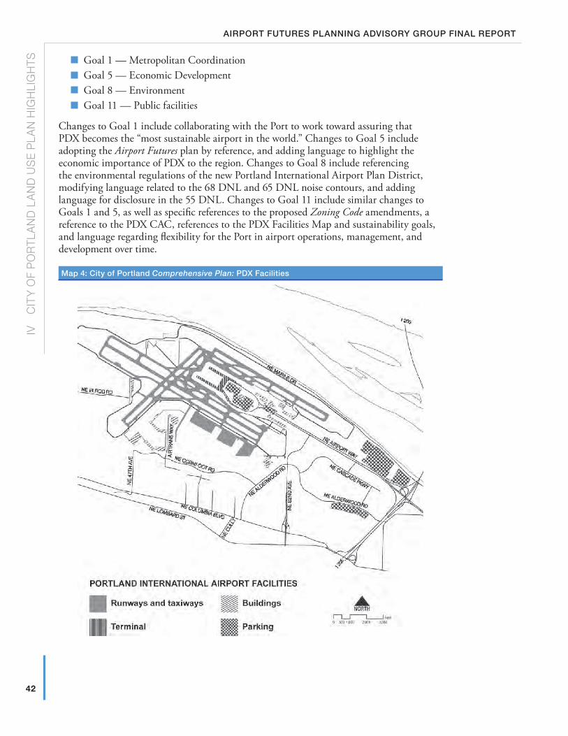
42
IV
c
ITY
OF
PO
RTL
AN
D L
AN
D U
SE
PLA
N H
IGH
LIG
HTS
Airport futures plAnning Advisory group finAl report
� Goal 1 — Metropolitan Coordination
� Goal 5 — Economic Development
� Goal 8 — Environment
� Goal 11 — Public facilities
Changes to Goal 1 include collaborating with the Port to work toward assuring that PDX becomes the “most sustainable airport in the world.” Changes to Goal 5 include adopting the Airport Futures plan by reference, and adding language to highlight the economic importance of PDX to the region. Changes to Goal 8 include referencing the environmental regulations of the new Portland International Airport Plan District, modifying language related to the 68 DNL and 65 DNL noise contours, and adding language for disclosure in the 55 DNL. Changes to Goal 11 include similar changes to Goals 1 and 5, as well as specific references to the proposed Zoning Code amendments, a reference to the PDX CAC, references to the PDX Facilities Map and sustainability goals, and language regarding flexibility for the Port in airport operations, management, and development over time.
Map 4: City of portland Comprehensive Plan: pdX facilities
43
IV
c
ITY
OF P
OR
TLAN
D LA
ND
US
E P
LAN
HIG
HLIG
HTS
septeMber 24, 2010
C) PDX Plan District and other Zoning Code AmendmentsThe Plan District is one of the regulatory tools created to implement the Airport Futures Land Use Plan by addressing the economic, environmental, and social equity aspects of growth and development at PDX. PDX is a unique land use within the City and requires tailored regulations to address wildlife hazards and impacts to transportation and natural resources. The plan district provides flexibility to the Port of Portland — owner of PDX — to respond to a constantly changing aviation industry, while addressing the broader community impacts of operating an airport in an urban environment.
Highlights include:
� PDX and customary PDX uses allowed by right within the Airport Subdistrict
� Hotel uses allowed by right on industrially-zoned land within the Airport Subdistrict
� Development inside the security fence is not regulated (e.g., taxiways, lighting equipment, etc.), except for third parallel runway which is prohibited
� Prohibition of decentralized terminal
� Identified review of transportation impacts based on passenger levels
� Identified review of adequacy of public services for new development/uses in the Southwest Quadrant
� Simplified landscaping requirements that comply with the PDX Wildlife Hazard Management Plan
� Pedestrian standards for Retail and Office uses
� Requirement for mailed notice to go to neighborhood associations, coalitions and PDX CAC when major new development is proposed
� Revisions to Type III Land Use Review posting notice requirements to better serve PDX users
� Archaeological resource protection provisions as required by state law
� Requirement that all road crossings of water bodies in the Middle Columbia Slough subdistrict be by bridge
� Required natural resource enhancement standards as a part of major development/redevelopment
� Tailored environmental regulations for usual and customary drainage district practices
� Tailored environmental regulations for usual and customary wildlife hazard management practices
� Special development standards for development near natural resources, including habitat conversion
� Rezoning of two areas from Employment (EG2) to Industrial (IG2), to make zoning consistent throughout Plan District
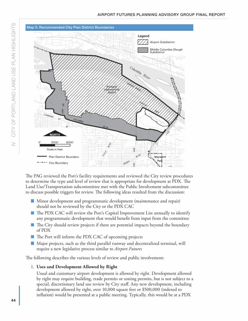
44
IV
c
ITY
OF
PO
RTL
AN
D L
AN
D U
SE
PLA
N H
IGH
LIG
HTS
Airport futures plAnning Advisory group finAl report
Map 5: recommended City plan district boundaries
The PAG reviewed the Port’s facility requirements and reviewed the City review procedures to determine the type and level of review that is appropriate for development at PDX. The Land Use/Transportation subcommittee met with the Public Involvement subcommittee to discuss possible triggers for review. The following ideas resulted from the discussion:
� Minor development and programmatic development (maintenance and repair) should not be reviewed by the City or the PDX CAC
� The PDX CAC will review the Port’s Capital Improvement List annually to identify any programmatic development that would benefit from input from the committee
� The City should review projects if there are potential impacts beyond the boundary of PDX
� The Port will inform the PDX CAC of upcoming projects
� Major projects, such as the third parallel runway and decentralized terminal, will require a new legislative process similar to Airport Futures
The following describes the various levels of review and public involvement:
1. Uses and Development Allowed by RightUsual and customary airport development is allowed by right. Development allowed by right may require building, trade permits or zoning permits, but is not subject to a special, discretionary land use review by City staff. Any new development, including development allowed by right, over 10,000 square feet or $500,000 (indexed to inflation) would be presented at a public meeting. Typically, this would be at a PDX
45
IV
c
ITY
OF P
OR
TLAN
D LA
ND
US
E P
LAN
HIG
HLIG
HTS
septeMber 24, 2010
CAC meeting. All adjacent neighborhood associations and district coalitions would get notice of the meeting details where the project would be presented.Examples include equipment storage, federal facilities related to airport operations, terminal and parking expansions, interior remodels, operation and maintenance projects, and technology projects.
2. Type 1 — Administrative Review with Notice — decision by City StaffType I reviews are the lowest level of City land use review. They typically involve a review with limited discretion and are approved by City staff if the applicant can meet a list of approval criteria. In this case, staff is charged with checking that all required criteria are met. Adjacent neighborhoods and property owners are notified of the proposal and given the opportunity to identify issues or concerns. Proposals may be approved, approved with conditions, or denied. The decision can be appealed to the State Land Use Board of Appeals (LUBA).Examples of Type 1 decisions include development in the environmental zones such as property line adjustments, natural resource enhancement activities, and public recreational trails, rest points, viewpoints, and interpretative facilities.
3. Type II — Administrative Review with Notice — decision by City staffType II reviews are mid level reviews that involve a staff decision based on approval criteria in the Zoning Code. These reviews require some level of discretion by City staff. Adjacent neighborhoods and property owners are notified of the proposal and given the opportunity to identify issues or concerns. Staff reviews all the material and makes the final decision. Proposals may be approved, approved with conditions, or denied. The decision can be appealed to the City Hearings Officer, and then to LUBA.Examples of Type II decisions include certain kinds of environmental reviews, such as roads, driveways, walkways; public safety facilities; environmental zone boundary modifications; and development within the environmental transition area.
4. Type III — Quasi-judicial Review with Notice — decision by City Hearings OfficerType III procedures receive the highest level of review by the City. Type III procedures involve applicants proposing a specific project that is conditionally allowed by the Zoning Code. Type III reviews require a pre-application conference, to which neighbors are invited, before formal review can begin. After application is made, City staff reviews the proposal against specific approval criteria. Adjacent neighborhoods and property owners are notified of the proposal and given an opportunity to identify issues or concerns. Planning staff then review all materials and typically make a recommendation to the City Hearings Officer as part of a formal public hearing. The Hearings Officer then makes a decision, based on criteria established in the Zoning Code, to do one of three things: Approve the project, approve the project with conditions, or deny the project. The decision can be appealed to City Council. The current Conditional Use Master Plan process is a Type III.Examples of Type III decisions include Southwest Quadrant development, new development, or uses in the resource area of the environmental protection zone; and transportation impact review triggered by increase in passenger activity of 6 MAP or more.
5. Legislative Plan Amendment — decision by City CouncilA Legislative Plan Amendment is the highest local review procedure. Legislative reviews require an in-depth public process, a hearing before the Planning Commission, and a final hearing and decision by City Council.Examples of legislative plan amendments include a new third parallel runway, a change to a decentralized terminal from the current centralized terminal, a fundamental shift from the current PDX Master Plan, or adding land into Plan District.
Beaverton
Gresham
Camas
WoodVillage
FairviewTroutdale
MaywoodPark
23R
D A
VE
19TH
AV
E
ST
DR
BLVD
AV
E
ST
33R
D
VIST
A
RD
AV
E24
2ND
162N
DA
VE
AV
E
COLUMBIA
GR
AND
112T
H A
VE
BLV
D
112T
H A
VE
18TH ST
HO
GA
N
BR
OA
DW
AY
CANYON
Forest Park US 30
RD
HWY 8
ST
YEON AVE
MA
RTI
NLU
THE
RK
ING
JR.
BLV
D
FREEWAY
US 26
BANFIE LD
V
D
I-5
HWY 500
BLVD
Portland
International
Airport
AIRPORT
WAY
HWY 14
HW
Y 5
00
ST12
2ND
AV
E
MARINE
DR
DIVISION
I-205
I-84
Powell
ton
I-405
HW
Y
LOM
BAR
D ST
LOMBARD
ST
COLUMBIA
99W
NORTH P
ORTLAND R
D
BLVD
WILLAMETTE BLVD
143R
D A
VE
RD
JENKINS
RD
RD
RD
KAISER
KA
NE
RD
NEW
BERRY
RD
RD
REEDER
RD
SAUVIE ISLAN
D R
D
GILLIHAN
LOO
P
MAC
A RTHUR BLVD
EVER GREEN BLVD
LIE
SS
ER R
D
RD
ELL
SW
OR
TH
FRU
IT V
ALL
EY
RD
ST
MA
IN
FOURTH PLAIN
BLVD
MILLPLAIN
FOURTHPLAIN
BLVD
ST J
OH
NS
RD
1 62N
D A
VE
164T
H
AV
E
AN
DR
ES
ON
WAY
39TH ST
FT VANCOUVER
MILL PLAIN BLVD
137T
H A
V13
8TH
AV
E
192N
D A
VE
LAKE RD
1ST ST
28TH ST
ROBER
TS
EAS
TM
AN
PK
WY
AV
E1 4
8TH
POWELL
ST
AV
E
102 N
D
BLVD
223R
D
HALSEY
AV
E
AV
E18
2 ND
THOMPSONRD
DR
BROADWAY
CORNELL
RD
FER
RY
RD
BARNES
R
D
COR NELL RD
BURNSIDE RD
BLVD
ER
ST
BURNSIDE ST
STARK ST
GLISAN ST
WALKER
RD
D
158T
H A
VE
CEDA
R
HILLS
MARINE DR
SR-501
MCGILLIVRAY BLVD
SR-14
6TH AVE
34TH ST
20TH ST
192N
D A
V
PA
RK
ER
ST
232N
D
AV
LEADBETTER RD
AV
e
KILLINGSWORTH
SUNSED
ST
ST
HOLGATE
BELMONT
STARK
HALSEY
BLVD
SANDY
POWELL
DIVISION
RD
PATTON
HAWTHORNE BLVD
20TH
AV
E
17TH
AV
E
39TH
AVE
33R
D
NA
I TO
PKW
Y
AV
E
FREMONT
ST
ST
GOING ST PRESCOTT
LOMBARD
GREELEY
AVE
42N
DA
VE
AV
E
AV
E82
ND
76TH
AV
E
BLVDCU
LLY
BLVD
SANDY
BLVD
US 30
BRO
ADW
AY4T
H
RD
SKYLINE Willamette River
Columbia River
ette
Riv
er
STKILLINGSWORTH
Bybee Lake
Smith Lake
BLVD
12TH
AV
E
Vancouver
Legend
Existing Aircraft Landing [h] Overlay Zone
Proposed Update/Addition to [h] Overlay Zone
Current Aircraft Landing Isoline Layer
Airport Runways/Structures
City Boundary
Water features
0 7,000
Feet
September 9, 200946
IV
c
ITY
OF
PO
RTL
AN
D L
AN
D U
SE
PLA
N H
IGH
LIG
HTS
Airport futures plAnning Advisory group finAl report
Map 6: proposed update of City of portland Height overlay
Beaverton
Gresham
Camas
WoodVillage
FairviewTroutdale
MaywoodPark
23R
D A
VE
19TH
AV
E
ST
DR
BLVD
AV
E
ST
33R
D
VIST
A
RD
AV
E24
2ND
162N
DA
VE
AV
E
COLUMBIA
GR
AND
112T
H A
VE
BLV
D
112T
H A
VE
18TH ST
HO
GA
N
BR
OA
DW
AY
CANYON
Forest Park US 30
RD
HWY 8
ST
YEON AVE
MA
RTI
NLU
THE
RK
ING
JR.
BLV
D
FREEWAY
US 26
BANFIE LD
V
D
I-5
HWY 500
BLVD
Portland
International
Airport
AIRPORT
WAY
HWY 14
HW
Y 5
00
ST
122N
DA
VE
MARINE
DR
DIVISION
I-205
I-84
Powell
ton
I-405
HW
Y
LOM
BAR
D ST
LOMBARD
ST
COLUMBIA
99W
NORTH P
ORTLAND R
D
BLVD
WILLAMETTE BLVD
143R
D A
VE
RD
JENKINS
RD
RD
RD
KAISER
KA
NE
RD
NEW
BERRY
RD
RD
REEDER
RD
SAUVIE ISLAN
D R
D
GILLIHAN
LOO
P
MAC
A RTHUR BLVD
EVER GREEN BLVD
LIE
SS
ER R
D
RD
ELL
SW
OR
TH
FRU
IT V
ALL
EY
RD
ST
MA
IN
FOURTH PLAIN
BLVD
MILLPLAIN
FOURTHPLAIN
BLVD
ST J
OH
NS
RD
1 62N
D A
VE
164T
H
AV
E
AN
DR
ES
ON
WAY
39TH ST
FT VANCOUVER
MILL PLAIN BLVD
137T
H A
V13
8TH
AV
E
192N
D A
VE
LAKE RD
1ST ST
28TH ST
ROBER
TS
EAS
TM
AN
PK
WY
AV
E1 4
8TH
POWELL
ST
AV
E
102 N
D
BLVD
223R
D
HALSEY
AV
E
AV
E18
2 ND
THOMPSONRD
DR
BROADWAY
CORNELL
RD
FER
RY
RD
BARNES
R
D
COR NELL RD
BURNSIDE RD
BLVD
ER
ST
BURNSIDE ST
STARK ST
GLISAN ST
WALKER
RD
D
158T
H A
VE
CEDA
R
HILLS
MARINE DR
SR-501
MCGILLIVRAY BLVD
SR-14
6TH AVE
34TH ST
20TH ST
192N
D A
V
PA
RK
ER
ST
232N
D
AV
LEADBETTER RD
AV
e
KILLINGSWORTH
SUNSED
ST
ST
HOLGATE
BELMONT
STARK
HALSEY
BLVD
SANDY
POWELL
DIVISION
RD
PATTON
HAWTHORNE BLVD
20TH
AV
E
17TH
AV
E
39TH
AVE
33R
D
NA
I TO
PKW
Y
AV
E
FREMONT
ST
ST
GOING ST PRESCOTT
LOMBARD
GREELEY
AVE
42N
DA
VE
AV
E
AV
E82
ND
76TH
AV
E
BLVD
CULL
Y
BLVD
SANDY
BLVD
US 30
BRO
ADW
AY4T
H
RD
SKYLINE Willamette River
Columbia River
ette
Riv
er
STKILLINGSWORTH
Bybee Lake
Smith Lake
BLVD
12TH
AV
E
Vancouver
47
IV
c
ITY
OF P
OR
TLAN
D LA
ND
US
E P
LAN
HIG
HLIG
HTS
septeMber 24, 2010
48
IV
c
ITY
OF
PO
RTL
AN
D L
AN
D U
SE
PLA
N H
IGH
LIG
HTS
Airport futures plAnning Advisory group finAl report
D) HeightThe PAG recommends minor amendments to the City’s Aircraft Landing Overlay Zone. This overlay provides safer operating conditions for aircraft near PDX by limiting the height of structures and construction equipment. The administration and structure of these regulations are amended to improve clarity for building permit applicants in the area and improve City and Port coordination with the FAA to improve safety. All structures and construction equipment within the Aircraft Landing Overlay Zone are subject to the height limits shown on the Aircraft Landing Overlay Zone Map. When the base zone height limit is more restrictive than the Aircraft Landing Overlay Zone height limit, the base zone limit applies. In Residential and Commercial zones, structures for allowed uses in those zones are regulated by the base zone height limits rather than the height limits of the overlay.
Finally, the height overlay was not applied to areas recently annexed into the City. Specifically, East Portland and East Hayden Island were annexed since the time when the height overlay was first applied. These code provisions will now be applied to areas shown in purple on Map 6.
E) noise overlay AmendmentsThe PAG recommends leaving the City noise overlay boundary where it is today for acoustic certification, easements and noise disclosures, and recommends the following additional elements:
1. A new noise overlay extending out from the current 1990 65 DNL to include land within the 2035 50th Percentile Forecast 55 DNL contour should be adopted for the limited purpose of noise disclosure for new development (no easements or other provisions of the existing noise overlay — just disclosure).
2. The disclosure should state that the home is in an area subject to aircraft overflight by jets and other aircraft arriving and departing PDX and that some people may be bothered by the aircraft flying overhead. A copy of the current disclosure statement is available on the City’s website.3
Additionally, the PAG recommends the creation of a limited duration Noise Work Group (NWG) to address noise outside the 65 DNL (See Report Section III, I.).
F) natural ResourcesAs part of the Airport Futures project, the City updated its existing Environmental Program for the airport area. The program update is needed for City compliance with Metro Titles 3 and 13 and contributes towards compliance with the Clean Water Act and the Endangered Species Act. In addition, the PAG recommends a package of natural resources enhancements consistent with the following PAG’s guiding principles: (1) Avoid and minimize development impacts, (2) mitigate unavoidable impacts, and (3) contribute to the overall improvement of Columbia Slough Watershed health.
regulatory requirements
The City’s existing Environmental Program includes inventories of natural resources and application of environmental conservation and protection overlay zones to specific resources. The Environmental Program has been applied to different parts of the City over the past 20 years including the Columbia Slough in 1989.
3 www.portlandonline.com/bds/index.cfm?c=45494&a=219419
49
IV
c
ITY
OF P
OR
TLAN
D LA
ND
US
E P
LAN
HIG
HLIG
HTS
septeMber 24, 2010
Updating the City’s Environmental Program is a three-step process:
Step 1: Update the Natural Resources Inventory — Data, information and maps of key natural resource features and attributes such as waterway condition, banks, flood area, water quality, vegetation, wetlands, wildlife habitat, etc. are compiled. The methodology is based on Metro’s approach to inventory riparian corridors and wildlife habitat across the region as part of Title 13 Nature in Neighborhoods. The Draft Natural Resources Inventory Project Report provides a context for the inventory, presents the scientific basis, and describes the project approach and methodology.
The Middle Columbia Corridor/Airport Natural Resources Inventory is found in the City Land Use Plan Summary Report; Appendix K.
Step 2: Evaluate the tradeoffs between different levels of resource management — The tradeoffs of allowing, limiting, or prohibiting development within the inventoried natural resource areas were evaluated through an environmental, social, environmental, and energy (ESEE) analysis. The analysis concluded with recommendations regarding under what circumstances development and land uses within natural resources areas should be strictly limited (protection overlay zone), limited (conservation overlay zone) or allowed (no overlay zone). The City does not typically implement the “prohibit” option. Other City regulations and non-regulatory approaches were also considered.
The Middle Columbia Corridor/Airport Natural Resources ESEE Analysis is found in the City Land Use Plan Summary Report; Appendix K.
Step 3: Adopt the updated inventory and apply the Environmental Program — Based on the results of steps 1 and 2, environmental overlay zones were refined and other program tools established to manage natural resources.
The program components include an update to the environmental overlay maps, Zoning Code amendments, and an Intergovernmental Agreement with the Port of Portland to address specific airport properties.
Environmental Zones
The updated environmental overlay zones generally apply to natural resources that provide a relatively high or medium amount of ecosystem function. The Airport Plan District code includes additional specific provisions intended to encourage habitat conversions that meet both the goals of improving watershed health and reducing habitat that attracts wildlife species of concern. City and Port staff and the PAG identified future desired conditions of existing natural resource areas that will meet both goals by encouraging:
� Conversion of herbaceous wetlands to native scrub-shrub or forested wetlands,
� Conversion of forest and woodland habitat to different native plant assemblages, and
� Reconfiguration of drainageway banks (i.e., benching) to improve flow, increase water storage and provide habitat.
The Airport Plan District supports restoration of riparian corridor functions and wildlife habitat by requiring removal of paved surfaces and planting of native vegetation within environmental overlay zones. These restoration activities would be required as part of new development or redevelopment on sites that have an environmental overlay zone applied to a portion of the site.
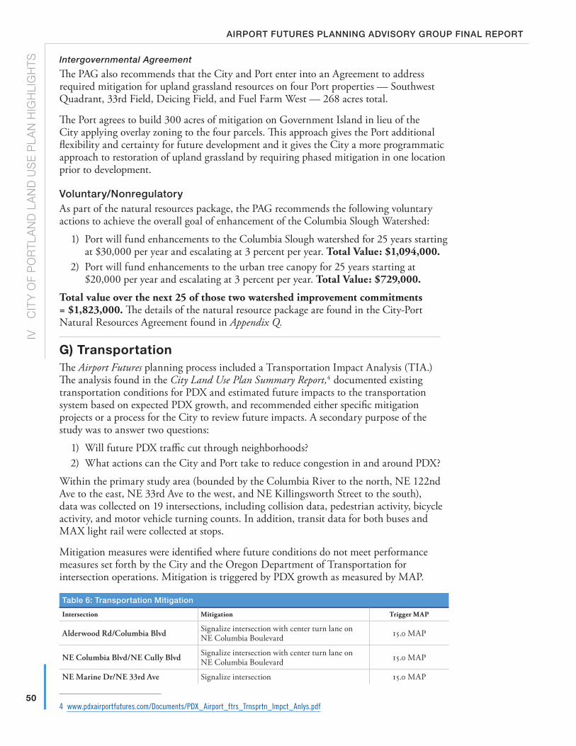
50
IV
c
ITY
OF
PO
RTL
AN
D L
AN
D U
SE
PLA
N H
IGH
LIG
HTS
Airport futures plAnning Advisory group finAl report
Intergovernmental Agreement
The PAG also recommends that the City and Port enter into an Agreement to address required mitigation for upland grassland resources on four Port properties — Southwest Quadrant, 33rd Field, Deicing Field, and Fuel Farm West — 268 acres total.
The Port agrees to build 300 acres of mitigation on Government Island in lieu of the City applying overlay zoning to the four parcels. This approach gives the Port additional flexibility and certainty for future development and it gives the City a more programmatic approach to restoration of upland grassland by requiring phased mitigation in one location prior to development.
voluntary/nonregulatoryAs part of the natural resources package, the PAG recommends the following voluntary actions to achieve the overall goal of enhancement of the Columbia Slough Watershed:
1) Port will fund enhancements to the Columbia Slough watershed for 25 years starting at $30,000 per year and escalating at 3 percent per year. Total Value: $1,094,000.
2) Port will fund enhancements to the urban tree canopy for 25 years starting at $20,000 per year and escalating at 3 percent per year. Total Value: $729,000.
Total value over the next 25 of those two watershed improvement commitments = $1,823,000. The details of the natural resource package are found in the City-Port Natural Resources Agreement found in Appendix Q.
G) TransportationThe Airport Futures planning process included a Transportation Impact Analysis (TIA.) The analysis found in the City Land Use Plan Summary Report,4 documented existing transportation conditions for PDX and estimated future impacts to the transportation system based on expected PDX growth, and recommended either specific mitigation projects or a process for the City to review future impacts. A secondary purpose of the study was to answer two questions:
1) Will future PDX traffic cut through neighborhoods?2) What actions can the City and Port take to reduce congestion in and around PDX?
Within the primary study area (bounded by the Columbia River to the north, NE 122nd Ave to the east, NE 33rd Ave to the west, and NE Killingsworth Street to the south), data was collected on 19 intersections, including collision data, pedestrian activity, bicycle activity, and motor vehicle turning counts. In addition, transit data for both buses and MAX light rail were collected at stops.
Mitigation measures were identified where future conditions do not meet performance measures set forth by the City and the Oregon Department of Transportation for intersection operations. Mitigation is triggered by PDX growth as measured by MAP.
table 6: transportation Mitigation
Intersection Mitigation Trigger MAP
Alderwood Rd/Columbia Blvd Signalize intersection with center turn lane on NE Columbia Boulevard 15.0 MAP
NE Columbia Blvd/NE Cully Blvd Signalize intersection with center turn lane on NE Columbia Boulevard 15.0 MAP
NE Marine Dr/NE 33rd Ave Signalize intersection 15.0 MAP
4 www.pdxairportfutures.com/Documents/PDX_Airport_ftrs_Trnsprtn_Impct_Anlys.pdf
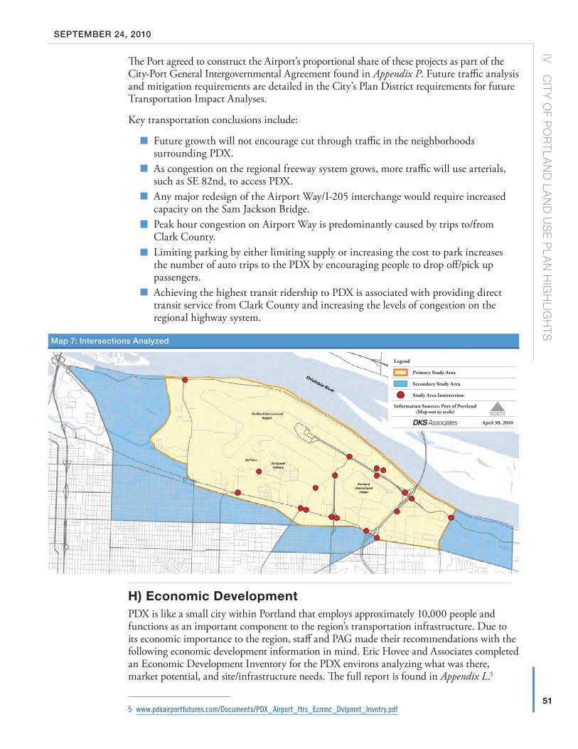
51
IV
c
ITY
OF P
OR
TLAN
D LA
ND
US
E P
LAN
HIG
HLIG
HTS
septeMber 24, 2010
The Port agreed to construct the Airport’s proportional share of these projects as part of the City-Port General Intergovernmental Agreement found in Appendix P. Future traffic analysis and mitigation requirements are detailed in the City’s Plan District requirements for future Transportation Impact Analyses.
Key transportation conclusions include:
� Future growth will not encourage cut through traffic in the neighborhoods surrounding PDX.
� As congestion on the regional freeway system grows, more traffic will use arterials, such as SE 82nd, to access PDX.
� Any major redesign of the Airport Way/I-205 interchange would require increased capacity on the Sam Jackson Bridge.
� Peak hour congestion on Airport Way is predominantly caused by trips to/from Clark County.
� Limiting parking by either limiting supply or increasing the cost to park increases the number of auto trips to the PDX by encouraging people to drop off/pick up passengers.
� Achieving the highest transit ridership to PDX is associated with providing direct transit service from Clark County and increasing the levels of congestion on the regional highway system.
H) Economic DevelopmentPDX is like a small city within Portland that employs approximately 10,000 people and functions as an important component to the region’s transportation infrastructure. Due to its economic importance to the region, staff and PAG made their recommendations with the following economic development information in mind. Eric Hovee and Associates completed an Economic Development Inventory for the PDX environs analyzing what was there, market potential, and site/infrastructure needs. The full report is found in Appendix L.5
5 www.pdxairportfutures.com/Documents/PDX_Airport_ftrs_Ecnmc_Dvlpmnt_Invntry.pdf
Map 7: intersections Analyzed
Legend
Primary Study Area
Secondary Study Area
Study Area Intersection
Information Sources: Port of Portland (Map not to scale)
April 30, 2010
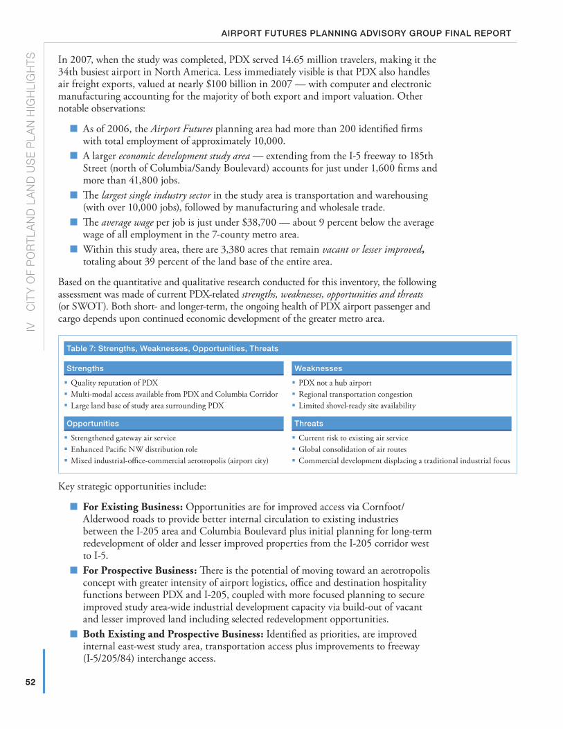
52
IV
c
ITY
OF
PO
RTL
AN
D L
AN
D U
SE
PLA
N H
IGH
LIG
HTS
Airport futures plAnning Advisory group finAl report
In 2007, when the study was completed, PDX served 14.65 million travelers, making it the 34th busiest airport in North America. Less immediately visible is that PDX also handles air freight exports, valued at nearly $100 billion in 2007 — with computer and electronic manufacturing accounting for the majority of both export and import valuation. Other notable observations:
� As of 2006, the Airport Futures planning area had more than 200 identified firms with total employment of approximately 10,000.
� A larger economic development study area — extending from the I-5 freeway to 185th Street (north of Columbia/Sandy Boulevard) accounts for just under 1,600 firms and more than 41,800 jobs.
� The largest single industry sector in the study area is transportation and warehousing (with over 10,000 jobs), followed by manufacturing and wholesale trade.
� The average wage per job is just under $38,700 — about 9 percent below the average wage of all employment in the 7-county metro area.
� Within this study area, there are 3,380 acres that remain vacant or lesser improved, totaling about 39 percent of the land base of the entire area.
Based on the quantitative and qualitative research conducted for this inventory, the following assessment was made of current PDX-related strengths, weaknesses, opportunities and threats (or SWOT). Both short- and longer-term, the ongoing health of PDX airport passenger and cargo depends upon continued economic development of the greater metro area.
table 7: strengths, Weaknesses, opportunities, threats
strengths Weaknesses
� Quality reputation of PDX � Multi-modal access available from PDX and Columbia Corridor � Large land base of study area surrounding PDX
� PDX not a hub airport � Regional transportation congestion � Limited shovel-ready site availability
opportunities threats
� Strengthened gateway air service � Enhanced Pacific NW distribution role � Mixed industrial-office-commercial aerotropolis (airport city)
� Current risk to existing air service � Global consolidation of air routes � Commercial development displacing a traditional industrial focus
Key strategic opportunities include:
� For Existing Business: Opportunities are for improved access via Cornfoot/Alderwood roads to provide better internal circulation to existing industries between the I-205 area and Columbia Boulevard plus initial planning for long-term redevelopment of older and lesser improved properties from the I-205 corridor west to I-5.
� For Prospective Business: There is the potential of moving toward an aerotropolis concept with greater intensity of airport logistics, office and destination hospitality functions between PDX and I-205, coupled with more focused planning to secure improved study area-wide industrial development capacity via build-out of vacant and lesser improved land including selected redevelopment opportunities.
� Both Existing and Prospective Business: Identified as priorities, are improved internal east-west study area, transportation access plus improvements to freeway (I-5/205/84) interchange access.
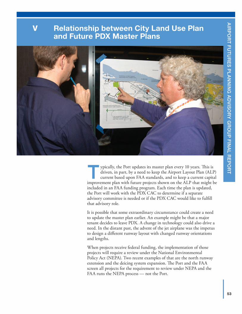
53
A
irp
or
t f
ut
ur
es
pl
An
nin
g A
dv
iso
ry
gr
ou
p f
inA
l re
po
rt
Relationship between City land use Plan and Future PDX Master Plans
V
Typically, the Port updates its master plan every 10 years. This is driven, in part, by a need to keep the Airport Layout Plan (ALP) current based upon FAA standards, and to keep a current capital
improvement plan with future projects shown on the ALP that might be included in an FAA funding program. Each time the plan is updated, the Port will work with the PDX CAC to determine if a separate advisory committee is needed or if the PDX CAC would like to fulfill that advisory role.
It is possible that some extraordinary circumstance could create a need to update the master plan earlier. An example might be that a major tenant decides to leave PDX. A change in technology could also drive a need. In the distant past, the advent of the jet airplane was the impetus to design a different runway layout with changed runway orientations and lengths.
When projects receive federal funding, the implementation of those projects will require a review under the National Environmental Policy Act (NEPA). Two recent examples of that are the north runway extension and the deicing system expansion. The Port and the FAA screen all projects for the requirement to review under NEPA and the FAA runs the NEPA process — not the Port.
54
V
R
ELAT
ION
SH
IP B
ET
wEE
N c
ITY
LA
ND
US
E P
LAN
AN
D F
UTU
RE
PD
x M
AS
TER
PLA
NS
Airport futures plAnning Advisory group finAl report
The circumstances in which revisions to the City’s Land Use Plan may occur vary depending on the significance of the amendments. Minor amendments (e.g., changing the dollar threshold for notice) could be accomplished through the City’s regulatory improvement process. Major changes that do not change the basic structure of the current plan could be accomplished through a relatively minor legislative process of 6–8 months with a narrowly defined scope of work. Finally, any significant, controversial changes would require a full review of the Land Use Plan in concert with a PDX Master Plan Update, similar to Airport Futures. At any point in time, the Portland City Council could decide to do any of the above, or something different.
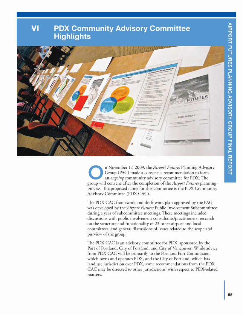
55
A
irp
or
t f
ut
ur
es
pl
An
nin
g A
dv
iso
ry
gr
ou
p f
inA
l re
po
rtOn November 17, 2009, the Airport Futures Planning Advisory
Group (PAG) made a consensus recommendation to form an ongoing community advisory committee for PDX. The
group will convene after the completion of the Airport Futures planning process. The proposed name for this committee is the PDX Community Advisory Committee (PDX CAC).
The PDX CAC framework and draft work plan approved by the PAG was developed by the Airport Futures Public Involvement Subcommittee during a year of subcommittee meetings. These meetings included discussions with public involvement consultants/practitioners, research on the structure and functionality of 23 other airport and local committees, and general discussions of issues related to the scope and purview of the group.
The PDX CAC is an advisory committee for PDX, sponsored by the Port of Portland, City of Portland, and City of Vancouver. While advice from PDX CAC will be primarily to the Port and Port Commission, which owns and operates PDX, and the City of Portland, which has land use jurisdiction over PDX, some recommendations from the PDX CAC may be directed to other jurisdictions’ with respect to PDX-related matters.
PDX Community Advisory Committee Highlights
VI
56
V
I P
Dx
cO
MM
UN
ITY
AD
VIS
OR
Y c
OM
MIT
TEE
HIG
HLI
GH
TSAirport futures plAnning Advisory group finAl report
The PDX CAC was created in recognition that PDX is a regional transportation asset. The PDX CAC will be comprised of up to 20 voting members and 10 ex officio members representing diverse, bi-state, regional interests and meet quarterly with meetings added or deleted based on the PDX CAC’s work plan. The PDX CAC is structured to support collaboration with other standing airport and regional committees with shared interests.
PDX CAC’s mission will be to:
� Support meaningful and collaborative public dialogue and engagement on PDX-related planning and development;
� Provide an opportunity for the community to provide recommendations on PDX-related issues to the Port, the City of Portland and other jurisdictions/organizations in the region; and
� Raise public knowledge about PDX and impacted communities.
A key focus of the committee will be to work towards assuring that PDX and the Airport Plan District become the most sustainable in the world in recognition of the long-term, critical interconnection between economic development, environmental stewardship, and social equity.
Appointments to PDX CAC will be made by interest organizations with confirmation by sponsors based on appointing criteria, which will be established by the sponsors. Terms will be staggered to ensure continuity. A Chair and Vice Chair will lead the committee with the assistance of a facilitator in the first year. PDX CAC will conduct annual evaluations, develop annual work plans, and share an annual report on its accomplishments with sponsors and appointing interests.
The framework, membership composition, and draft work plan for the PDX CAC recommended by the PAG is included in the City of Portland, City of Vancouver, and Port of Portland PDX CAC intergovernmental agreement found in Appendix O.
The PDX CAC Report is found in Appendix M.1
1 www.pdxairportfutures.com/Documents/PDX_Airport_ftrs__Cmnty_Advsry_Cmte_Rprt.pdf
57
A
irp
or
t f
ut
ur
es
pl
An
nin
g A
dv
iso
ry
gr
ou
p f
inA
l re
po
rt
Additional Recommendations, Intergovernmental Agreements, and lessons learned Highlights
VII
A) Additional PAG Recommendations
Throughout the process, issues have been explored by the PAG and the following are additional conclusions and recommendations that flowed from the PAG revisiting the Project Assumptions found in Appendix N.1
1. The City and Port should participate in the study of high-speed rail in the Pacific Northwest. Once an alignment is determined, the Port should initiate a Follow-on Study to address connecting PDX to high-speed rail.
2. The City and Port should continue to collaborate with the military in planning for PDX facilities, managing aircraft noise, managing wildlife issues, and engaging the community to better understand the evolving mission of the military at PDX. Should the status of the military change, the Port should initiate a Follow-on Study to evaluate reuse/redevelopment of the site or a portion of the site for other airport uses. The City and Port should revisit the status of the military in future master plans. The existence of the military at PDX is largely a decision of the US Department of Defense.
3. The Port should continue to manage PDX as one part of a system of airports serving the cargo needs of the region. The Port should continue to monitor trends in the cargo industry in an effort to identify any changes in requirements that might shift cargo to other Oregon or Washington airports. The Port should continue to apply site development standards, lease terms/rates, ramp management agreements, and other tools that help increase the efficiency of cargo development in a way that extends the life of AirTrans Center as the primary cargo and aircraft maintenance area at PDX.
4. PDX should remain the primary commercial airport serving the needs of the region and the Port and City should work together to maintain its viability. The Port and City should continue to coordinate with Oregon and Washington aviation departments to better articulate and coordinate PDX’s role and the role of Port reliever airports as part of a statewide (if not Pacific Northwest-wide) system of airports. The Port should continue to support investment of Connect Oregon and other funding to help develop capacity at other airports. The Port should update the PDX CAC on Connect Oregon or other investments in regional airports on an annual basis.
5. Consistent with the PAG’s Vision and Values and Guiding Principles, the City and Port should preclude neither future generations from, nor obligate future generations to building a third parallel runway or decentralized terminal. The 2010 Master Plan should depict a conceptual reserve area for both to minimize future conflicts so that future development in the area reflects an awareness of those potential future uses. While the City Land Use Plan for PDX should prohibit the development of a future third parallel runway, the PAG acknowledges that a future City Council decision could allow either a third parallel runway or decentralized terminal after a thorough, regional planning process. The Port and City should revisit the need for a third parallel runway and major facilities in future master plans.
1 www.pdxairportfutures.com/Documents/PDX_AF_Prjc_Asmptns_Cnclsns_Rcmndtns.pdf
58
VII
AD
DIT
ION
AL
REc
OM
MEN
DAT
ION
S, I
NTE
RG
OV
ERN
MEN
TAL
AG
REE
MEN
TS, A
ND
LES
SO
NS
LE
AR
NED
HIG
HLI
GH
TSAirport futures plAnning Advisory group finAl report
6. Consistent with the 2010 PDX Master Plan, the Port should plan to meet future facility requirements based on the assumption that a centralized terminal concept versus the decentralized concept is the long-term preferred option for future development of PDX.
7. The City and Port should continue to track international, national, state and local policy on climate change and continue to integrate climate change in their planning and development decisions. Because climate change (greenhouse gas emissions) is one of PAG’s key sustainability goals, the Port should annually report to the PDX CAC regarding emissions inventory, objectives, and targets related to climate change.
8. The City and Port should encourage multi-modal transportation to and from PDX.9. The Port should continue to work to minimize impacts to air quality and water resources
associated with the operation and development of PDX. Because water quality is one of PAG’s key sustainability goals, the Port should annually report to the PDX CAC regarding objective, targets and measures related to climate change.
10. The Port and City should manage the Airport Plan District to improve access and circulation for freight, enhance the Pacific Northwest distribution role, and enhance the area as a mixed industrial-office-commercial aerotropolis role.
11. The Port and City should consider creative and proactive approaches to sustainability based on a triple-bottom line.
12. The Port, City, and community should work collaboratively, wherever possible, on a legislative agenda and community enhancement concepts related to aircraft noise impacts.
13. The Port and City should continue to support implementation of the PDX Fly Quiet Program and other recommendations from the Part 150 Noise Compatibility Study, and work to ensure good communication and coordination on noise abatement efforts among the City and Port noise programs, PDX Citizen Noise Advisory Committee, PDX CAC, and broader community.
14. The PDX CAC should review the City Land Use Plan and PDX Master Plan every five years and consider hosting a forum to update the community on airport plans.
B) Intergovernmental AgreementsSeveral of the PAG recommendations and City-Port agreements that flow from the PAG recommendations are best memorialized and implemented by way of intergovernmental agreements. They are:
1. The Port, Portland, and Vancouver PDX CAC Intergovernmental Agreement is found in Appendix O.2 It creates the PDX Citizen Advisory Committee
2. The Port and Portland General Intergovernmental Agreement is found in Appendix P.3 It implements the PDX Master Plan and the City’s Land Use Plan covering topics like: third runway, terminal alternatives, transportation mitigation, sustainability, and noise
3. The Port and City Intergovernmental Agreement on Natural Resources is found in Appendix Q.
C) Process Evaluation Results and lessons learnedAt the conclusion of the process, the PAG conducted an evaluation of the process to establish lessons learned for the future. That evaluation and lessons learned are found in Appendix R.
2 www.pdxairportfutures.com/Documents/PDX_Airport_ftrs_Cmnty_Advsry_Cmte_IGA.pdf
3 www.pdxairportfutures.com/Documents/PDX_Airport_ftrs_Ongng_Agrmnts_Rltd_Arprt_Ftrs_IGA.pdf
59
A
irp
or
t f
ut
ur
es
pl
An
nin
g A
dv
iso
ry
gr
ou
p f
inA
l re
po
rt
Conclusion and RecommendationsVIII
A t the PAG’s last meeting on May 25, 2010, the members were polled as to the contents of this report, the PDX Master Plan, the Airport Layout Plan, the City Land Use Plan, and the intergovernmental agreements associated with the above. The
question asked was, “Taken as a whole, and based upon staff’s commitment to make the final products consistent, do you support the Airport Futures overall package and recommend its transmittal to decision-makers for approval?”
The PAG’s Collaboration Principles define the 1-2-3 voting protocol as follows:
In “Consensus Voting,” the Chair, Vice Chair or the facilitator will articulate the proposal. Each PAG member will then vote “one,” “two,” or “three,” reflecting the following:
“One” indicates full support for the proposal as stated.
“Two” indicates that the participant agrees with the proposal as stated, but would prefer to have it modified in some manner in order to give it full support. Nevertheless, the member will support the consensus even if his/her suggested modifications are not supported by the rest of the group because the proposal is worthy of general support, as written.
“Three” indicates refusal to support the proposal as stated.
In May 2010, the PAG unanimously supported the Airport Futures overall package and recommended its transmittal to decision-makers with all members voting “one.” Members were given the opportunity to provide additional information to the decision-makers and that information is provided in Appendix S.
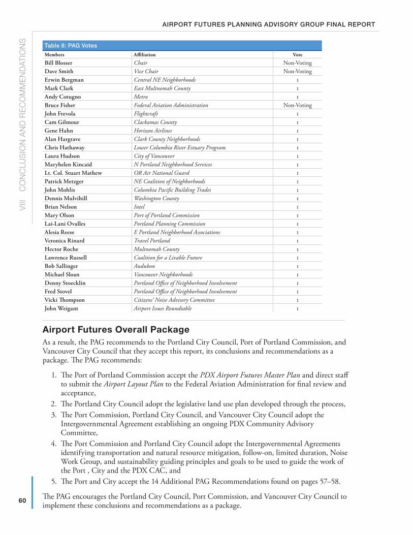
60
V
III
cO
Nc
LUS
ION
AN
D R
EcO
MM
END
ATIO
NS
Airport futures plAnning Advisory group finAl report
table 8: pAg votes
Members Affiliation Vote
Bill Blosser Chair Non-VotingDave Smith Vice Chair Non-VotingErwin Bergman Central NE Neighborhoods 1Mark Clark East Multnomah County 1Andy Cotugno Metro 1Bruce Fisher Federal Aviation Administration Non-VotingJohn Frevola Flightcraft 1Cam Gilmour Clackamas County 1Gene Hahn Horizon Airlines 1Alan Hargrave Clark County Neighborhoods 1Chris Hathaway Lower Columbia River Estuary Program 1Laura Hudson City of Vancouver 1Maryhelen Kincaid N Portland Neighborhood Services 1Lt. Col. Stuart Mathew OR Air National Guard 1Patrick Metzger NE Coalition of Neighborhoods 1John Mohlis Columbia Pacific Building Trades 1Dennis Mulvihill Washington County 1Brian Nelson Intel 1Mary Olson Port of Portland Commission 1Lai-Lani Ovalles Portland Planning Commission 1Alesia Reese E Portland Neighborhood Associations 1Veronica Rinard Travel Portland 1Hector Roche Multnomah County 1Lawrence Russell Coalition for a Livable Future 1Bob Sallinger Audubon 1Michael Sloan Vancouver Neighborhoods 1Denny Stoecklin Portland Office of Neighborhood Involvement 1Fred Stovel Portland Office of Neighborhood Involvement 1Vicki Thompson Citizens’ Noise Advisory Committee 1John Weigant Airport Issues Roundtable 1
Airport Futures overall PackageAs a result, the PAG recommends to the Portland City Council, Port of Portland Commission, and Vancouver City Council that they accept this report, its conclusions and recommendations as a package. The PAG recommends:
1. The Port of Portland Commission accept the PDX Airport Futures Master Plan and direct staff to submit the Airport Layout Plan to the Federal Aviation Administration for final review and acceptance,
2. The Portland City Council adopt the legislative land use plan developed through the process,3. The Port Commission, Portland City Council, and Vancouver City Council adopt the
Intergovernmental Agreement establishing an ongoing PDX Community Advisory Committee,
4. The Port Commission and Portland City Council adopt the Intergovernmental Agreements identifying transportation and natural resource mitigation, follow-on, limited duration, Noise Work Group, and sustainability guiding principles and goals to be used to guide the work of the Port , City and the PDX CAC, and
5. The Port and City accept the 14 Additional PAG Recommendations found on pages 57–58.
The PAG encourages the Portland City Council, Port Commission, and Vancouver City Council to implement these conclusions and recommendations as a package.
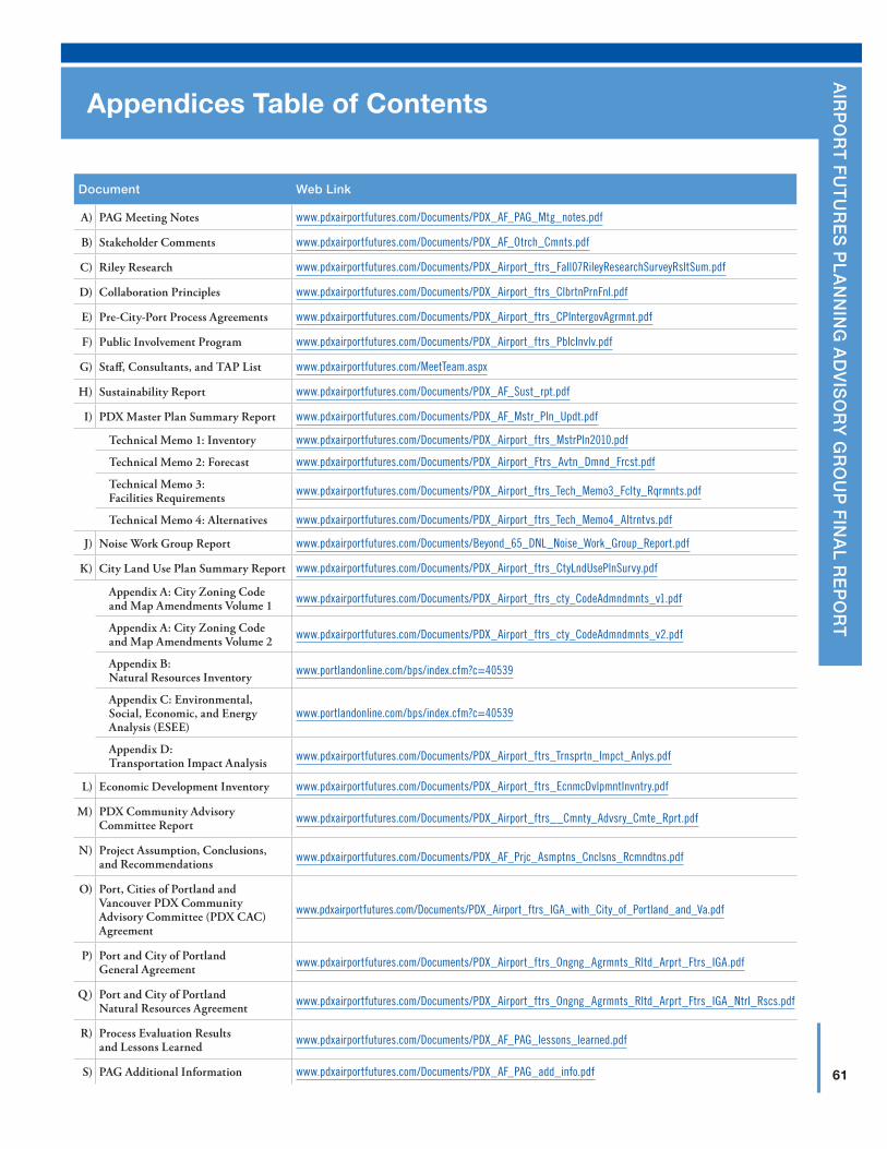
61
A
irp
or
t f
ut
ur
es
pl
An
nin
g A
dv
iso
ry
gr
ou
p f
inA
l re
po
rt
Appendices Table of Contents
document Web link
A) PAG Meeting Notes www.pdxairportfutures.com/Documents/PDX_AF_PAG_Mtg_notes.pdf
B) Stakeholder Comments www.pdxairportfutures.com/Documents/PDX_AF_Otrch_Cmnts.pdf
C) Riley Research www.pdxairportfutures.com/Documents/PDX_Airport_ftrs_Fall07RileyResearchSurveyRsltSum.pdf
D) Collaboration Principles www.pdxairportfutures.com/Documents/PDX_Airport_ftrs_ClbrtnPrnFnl.pdf
E) Pre-City-Port Process Agreements www.pdxairportfutures.com/Documents/PDX_Airport_ftrs_CPIntergovAgrmnt.pdf
F) Public Involvement Program www.pdxairportfutures.com/Documents/PDX_Airport_ftrs_PblcInvlv.pdf
G) Staff, Consultants, and TAP List www.pdxairportfutures.com/MeetTeam.aspx
H) Sustainability Report www.pdxairportfutures.com/Documents/PDX_AF_Sust_rpt.pdf
I) PDX Master Plan Summary Report www.pdxairportfutures.com/Documents/PDX_AF_Mstr_Pln_Updt.pdf
Technical Memo 1: Inventory www.pdxairportfutures.com/Documents/PDX_Airport_ftrs_MstrPln2010.pdf
Technical Memo 2: Forecast www.pdxairportfutures.com/Documents/PDX_Airport_Ftrs_Avtn_Dmnd_Frcst.pdf
Technical Memo 3: Facilities Requirements www.pdxairportfutures.com/Documents/PDX_Airport_ftrs_Tech_Memo3_Fclty_Rqrmnts.pdf
Technical Memo 4: Alternatives www.pdxairportfutures.com/Documents/PDX_Airport_ftrs_Tech_Memo4_Altrntvs.pdf
J) Noise Work Group Report www.pdxairportfutures.com/Documents/Beyond_65_DNL_Noise_Work_Group_Report.pdf
K) City Land Use Plan Summary Report www.pdxairportfutures.com/Documents/PDX_Airport_ftrs_CtyLndUsePlnSurvy.pdf
Appendix A: City Zoning Code and Map Amendments Volume 1 www.pdxairportfutures.com/Documents/PDX_Airport_ftrs_cty_CodeAdmndmnts_v1.pdf
Appendix A: City Zoning Code and Map Amendments Volume 2 www.pdxairportfutures.com/Documents/PDX_Airport_ftrs_cty_CodeAdmndmnts_v2.pdf
Appendix B: Natural Resources Inventory www.portlandonline.com/bps/index.cfm?c=40539
Appendix C: Environmental, Social, Economic, and Energy Analysis (ESEE)
www.portlandonline.com/bps/index.cfm?c=40539
Appendix D: Transportation Impact Analysis www.pdxairportfutures.com/Documents/PDX_Airport_ftrs_Trnsprtn_Impct_Anlys.pdf
L) Economic Development Inventory www.pdxairportfutures.com/Documents/PDX_Airport_ftrs_EcnmcDvlpmntInvntry.pdf
M) PDX Community Advisory Committee Report www.pdxairportfutures.com/Documents/PDX_Airport_ftrs__Cmnty_Advsry_Cmte_Rprt.pdf
N) Project Assumption, Conclusions, and Recommendations www.pdxairportfutures.com/Documents/PDX_AF_Prjc_Asmptns_Cnclsns_Rcmndtns.pdf
O) Port, Cities of Portland and Vancouver PDX Community Advisory Committee (PDX CAC) Agreement
www.pdxairportfutures.com/Documents/PDX_Airport_ftrs_IGA_with_City_of_Portland_and_Va.pdf
P) Port and City of Portland General Agreement www.pdxairportfutures.com/Documents/PDX_Airport_ftrs_Ongng_Agrmnts_Rltd_Arprt_Ftrs_IGA.pdf
Q) Port and City of Portland Natural Resources Agreement www.pdxairportfutures.com/Documents/PDX_Airport_ftrs_Ongng_Agrmnts_Rltd_Arprt_Ftrs_IGA_Ntrl_Rscs.pdf
R) Process Evaluation Results and Lessons Learned www.pdxairportfutures.com/Documents/PDX_AF_PAG_lessons_learned.pdf
S) PAG Additional Information www.pdxairportfutures.com/Documents/PDX_AF_PAG_add_info.pdf

62