Embed Size (px)
Citation preview

Content developed by the GEO Architecture Implementation Pilot Licensed under a Creative Commons Attribution 3.0 License
AIP-3 Use Cases Engineering Report
GEOSS Architecture Implementation Pilot, Phase 3
Version 1.0

GEO Architecture Implementation Pilot, Phase 3 Version: <1.0> Use Cases Engineering Report Date: <02/08/11>
Page 2
Revision History
Version Date Editor and Content providers
Comments
0.1 <12/4/10> Josh Lieberman, Nadine Alameh
Outline and original content
1.0 <2/08/11> Josh Lieberman Complete draft
Document Contact Information
If you have questions or comments regarding this document, you can contact: Name Organization Contact Information
Nadine Alameh OGC [email protected]
George Percivall OGC [email protected]
Josh Lieberman OGC IP Team [email protected]

GEO Architecture Implementation Pilot, Phase 3 Version: <1.0> Use Cases Engineering Report Date: <02/08/11>
Page 3
Table of Contents 1. Introduction 4
1.1 Scope of this document 4 1.2 GEOSS AIP 4
2. Definition and Role of the Transverse Technology Use Cases in GEOSS 4 2.1 Conceptual Overview: Role of Use Cases in Sharing Data and Making Decisions. 5 2.2 Categories and General Descriptions 6 2.3 Actor Descriptions 7 2.4 Use Case Summaries 7 2.5 Use Case Utilization and Specialization Instances in AIP-3 Scenarios 9 2.6 Use Case Template 9
3. Registration and Harvesting Use Cases 10 3.1 UC1: Register Resources 10 3.2 UC10: Register New Interoperability Arrangements 12 3.3 Harvest & Query via Clearinghouse 14
4. Clients and Portals Use Cases 16 4.1 Search for Resources 16 4.2 Present Reachable Services and Alerts 17 4.3 Exploit Data Visually and Analytically 18
5. Deployment and Access Use Cases 20 5.1 Deploy Resources 20 5.2 Interact with Services 22
6. Workflow Use Cases 23
7. Service Testing Use Cases 27
8. References 28
Appendix A: Templates 28 Use Case Template 28
GEO Architecture Implementation Pilot, Phase 3 Version: <1.0> Use Cases Engineering Report Date: <02/08/11>
Page 4
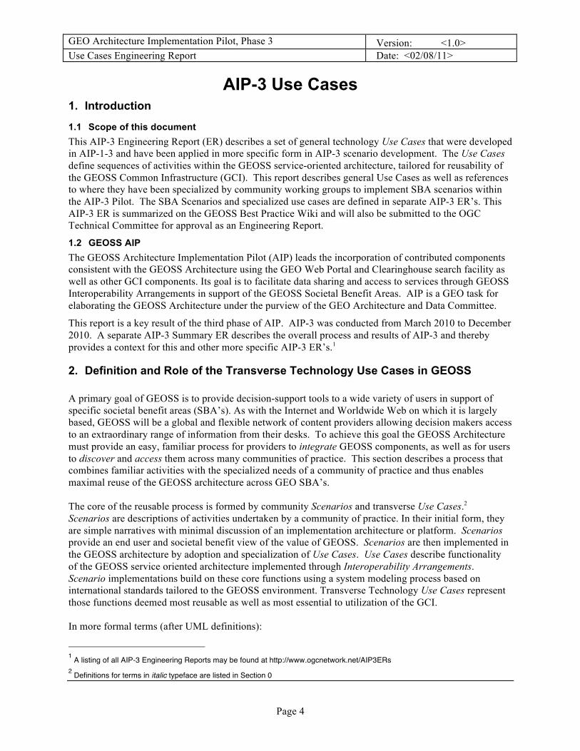
AIP-3 Use Cases 1. Introduction
1.1 Scope of this document This AIP-3 Engineering Report (ER) describes a set of general technology Use Cases that were developed in AIP-1-3 and have been applied in more specific form in AIP-3 scenario development. The Use Cases define sequences of activities within the GEOSS service-oriented architecture, tailored for reusability of the GEOSS Common Infrastructure (GCI). This report describes general Use Cases as well as references to where they have been specialized by community working groups to implement SBA scenarios within the AIP-3 Pilot. The SBA Scenarios and specialized use cases are defined in separate AIP-3 ER’s. This AIP-3 ER is summarized on the GEOSS Best Practice Wiki and will also be submitted to the OGC Technical Committee for approval as an Engineering Report.
1.2 GEOSS AIP The GEOSS Architecture Implementation Pilot (AIP) leads the incorporation of contributed components consistent with the GEOSS Architecture using the GEO Web Portal and Clearinghouse search facility as well as other GCI components. Its goal is to facilitate data sharing and access to services through GEOSS Interoperability Arrangements in support of the GEOSS Societal Benefit Areas. AIP is a GEO task for elaborating the GEOSS Architecture under the purview of the GEO Architecture and Data Committee.
This report is a key result of the third phase of AIP. AIP-3 was conducted from March 2010 to December 2010. A separate AIP-3 Summary ER describes the overall process and results of AIP-3 and thereby provides a context for this and other more specific AIP-3 ER’s.1
2. Definition and Role of the Transverse Technology Use Cases in GEOSS A primary goal of GEOSS is to provide decision-support tools to a wide variety of users in support of specific societal benefit areas (SBA’s). As with the Internet and Worldwide Web on which it is largely based, GEOSS will be a global and flexible network of content providers allowing decision makers access to an extraordinary range of information from their desks. To achieve this goal the GEOSS Architecture must provide an easy, familiar process for providers to integrate GEOSS components, as well as for users to discover and access them across many communities of practice. This section describes a process that combines familiar activities with the specialized needs of a community of practice and thus enables maximal reuse of the GEOSS architecture across GEO SBA’s. The core of the reusable process is formed by community Scenarios and transverse Use Cases.2 Scenarios are descriptions of activities undertaken by a community of practice. In their initial form, they are simple narratives with minimal discussion of an implementation architecture or platform. Scenarios provide an end user and societal benefit view of the value of GEOSS. Scenarios are then implemented in the GEOSS architecture by adoption and specialization of Use Cases. Use Cases describe functionality of the GEOSS service oriented architecture implemented through Interoperability Arrangements. Scenario implementations build on these core functions using a system modeling process based on international standards tailored to the GEOSS environment. Transverse Technology Use Cases represent those functions deemed most reusable as well as most essential to utilization of the GCI. In more formal terms (after UML definitions):
1 A listing of all AIP-3 Engineering Reports may be found at http://www.ogcnetwork.net/AIP3ERs 2 Definitions for terms in italic typeface are listed in Section 0

GEO Architecture Implementation Pilot, Phase 3 Version: <1.0> Use Cases Engineering Report Date: <02/08/11>
Page 5
• A Use Case is the specification of a set of actions performed by a subject system, which yields an
observable result of value for one or more Actors or other stakeholders of the system.
• Each Use Case specifies a unit of useful functionality that the subject provides to its users (i.e., a specific way of interacting with the subject).
• AIP defines both Generalized Use cases and Specialized Use Cases. A generalized use case specifies actions of value to GEOSS in general. A specialized use case adapts a generalized use case to a specific community scenario’s needs. For example, the Search for Resources generalized use case may be adapted in a particular scenario as a Search for Regional Drought Index Service specialized use case.
• Use cases for AIP focus on services and interoperability arrangements.
• An Actor specifies a role played by a user or any other system that interacts with the use case subject. (The term “role” is used informally here and does not necessarily imply a particular technical definition found elsewhere) [UML]
• Actors may represent roles played by human users, external systems, or other subjects. [UML]
• Actors are external to the particular subject of the use case. [UML paraphrased]
2.1 Conceptual Overview: Role of Use Cases in Sharing Data and Making Decisions. The identification of key generalized use cases has been informed to some degree by the concept of End-to-end Discovery and Access (EDA). GEOSS and GCI are most successful to the extent that they connect people – providers to users, providers to processors, processors to decision makers, decision makers to stakeholders. Each connection is a dialogue matching up requirements with resources. Of special interest in GEOSS are those connections that are unanticipated, those which are not pre-existing and may not have easily occurred without the intermediation of GEOSS. Within GEOSS, each of these potential connections is mediated by a chain of service-oriented mechanisms, not only the familiar publish, find, bind mechanisms, but also additional mechanisms which are both more primary, such as vocabulary matching, and more derivative, such as data quality negotiation. As with any chain, each link is essential to the overall integrity of a connection. Reusable use cases have been developed and continue to be refined in part to help GEOSS communities to build complete chains, by identifying and supporting productive activities which fit well together one to the other and result in successful communication between GEOSS participants. Figure 1 depicts representative components of an EDA chain and illustrates some of the use cases relevant to completing the connection between GEOSS providers and users. Various use cases supplement the initial deployment and search for resources by providing for syntactic and semantic interoperability as well as helping to develop forms of trust necessary for effective data sharing and decision making. Other use cases not shown in the diagram, such as registering interoperability arrangements and best practices or forming and executing processing services, contribute as well.

GEO Architecture Implementation Pilot, Phase 3 Version: <1.0> Use Cases Engineering Report Date: <02/08/11>
Page 6
Figure1. Components of EDA (end-to-end discovery and access) chains. GEOSS Actors
are shown at top, representative use cases in brackets, and EDA concepts in bold.
Use Cases Overview
2.2 Categories and General Descriptions Figure 2 provides an overview of the primary Transverse Engineering Use Cases, color-coded by category:
• Registration and Harvesting • Clients and Portals • Deployment and Access • Workflow and Processing • Service Testing
For purposes of clarity, only two of the actors included in the use cases are shown, GEOSS User and GEOSS Provider. The use cases are generally aligned according to which actor plays the principal role in that use case. Use cases in the middle column focus more on systems or operators as actors.

GEO Architecture Implementation Pilot, Phase 3 Version: <1.0> Use Cases Engineering Report Date: <02/08/11>
Page 7
Figure 2. Categorized Transverse Engineering Use Cases and Principal Actors
2.3 Actor Descriptions Table 1 lists and describes the actors defined for AIP-3 use cases.
Table 1 – AIP-3 Actor Descriptions
Actor Description Role Type GEOSS User Discovers, consumes, and exploits GEOSS resources Principal GEOSS Provider Deploys, describes, registers GEOSS resources Principal GEOSS
Integrator Builds, configures, registers applications to work with GEOSS services
Secondary
GCI Operator Operates GCI components, reviews and approves registrations Administrative
2.4 Use Case Summaries Table 1 provides a summary description of each of the use cases, grouped by category. It also lists the actors that participate in each use case.
Table 2 – AIP-3 Use Case Summaries
Use Case Title Actors Registration and Harvesting Use Cases

GEO Architecture Implementation Pilot, Phase 3 Version: <1.0> Use Cases Engineering Report Date: <02/08/11>
Page 8
1. Register Resources
Register resources in GEOSS Components and Services Registry (CSR) or (CSR-registered) Community Catalog
# GEOSS Provider # GCI Operator # Community Catalog Provider
10. Register New Interoperability Arrangements
Register in the GEOSS Standards and Interoperability Registry (SIR) new and recommended interoperability arrangements) as well as utilized standards.
# GEOSS Provider # GCI Operator
3. Harvest & Query via Clearinghouse
This use case describes the steps for harvesting and/or querying service or content metadata from community catalogs or services via a GEOSS Clearinghouse
# GEOSS Provider # GCI Operator # Community Catalog Provider
15. Share Best Practices
Share Best Practices for participating in GEOSS and addressing SBA’s in the Best Practices Wiki (BPW)
# GEOSS User # GEOSS Integrator # GEOSS Provider
Clients and Portals Use Cases 4. Search for
Resources Steps for portals and application clients to support the GEOSS user in searching for resources of interest via the GEOSS Clearinghouse or Community Catalogs
# GEOSS User # GEOSS Integrator
5. Present Services and Alerts
Present GEOSS User with services and alerts as returned per the user’s search criteria
# GEOSS User # GEOSS Integrator # GEOSS Provider # GCI Operator
7. Exploit Data Visually and Analytically
Steps for exploitation in Client Applications of datasets served through Web Services and online protocols as used within GEOSS.
# GEOSS User # GEOSS Integrator
Deployment and Access Use Cases 2. Deploy Resources Deploy Resources for use in GEOSS # GEOSS Provider
6. Interact with
Services Interact with Services # GEOSS User
# GEOSS Integrator Service Testing Use Cases
9. Test Services Service Provider tests its service using a proper Test tool discovered in the GEOSS CSR.
# GEOSS Provider # GCI Operator # Standards Authority
Processing Use Cases 8. Construct
Processing Service
Design, implement, compose (if composite), deploy, and publish a processing service
# GEOSS Integrator # GEOSS Provider
11. Execute Processing Service
Discover, bind, and/or orchestrate a processing service, to produce new derivative data resources
# GEOSS Integrator # GEOSS User # GEOSS Provider
Semantic Use Cases 12. Perform
semantic mediation
Register, mediate, and map between disparate vocabularies used to describe GEOS resources.
# GEOSS Integrator # GEOSS Provider # GCI Operator
13. Conduct Utilize mediated vocabularies to extend #GEOSS User

GEO Architecture Implementation Pilot, Phase 3 Version: <1.0> Use Cases Engineering Report Date: <02/08/11>
Page 9
semantic search GEOSS search queries across disparate domains or communities.
#GEOSS Integrator
Network Use Cases 14. Develop data sharing network
Discover GEOSS resources, establish federation “contract” between them to assemble and publish a larger-scale system resource.
#GEOSS Provider #GEOSS Integrator
2.5 Use Case Utilization and Specialization Instances in AIP-3 Scenarios Table 3 references and describes where and how the transverse use cases were incorporated and/or specialized in AIP-3 scenarios.
Table 3 – AIP-3 Scenario - Use Case References
Use Case Used in Scenarios Specialized in Scenarios 1. Register resources 2. Deploy resources 3. Harvest & query via
Clearinghouse
4. Search for resources 5. Present services and
alerts
6. Interact with services 7. Exploit data visually
and analytically
8. Construct & deploy processing / workflow service
9. Test services 10. Register
interoperability arrangement
11. Execute processing service
12. Perform semantic mediation
13. Conduct semantic search
14. Develop data sharing network
15. Share best practices
2.6 Use Case Template The template used for presenting use cases is included at the end of this report in Appendix A.
GEO Architecture Implementation Pilot, Phase 3 Version: <1.0> Use Cases Engineering Report Date: <02/08/11>
Page 10
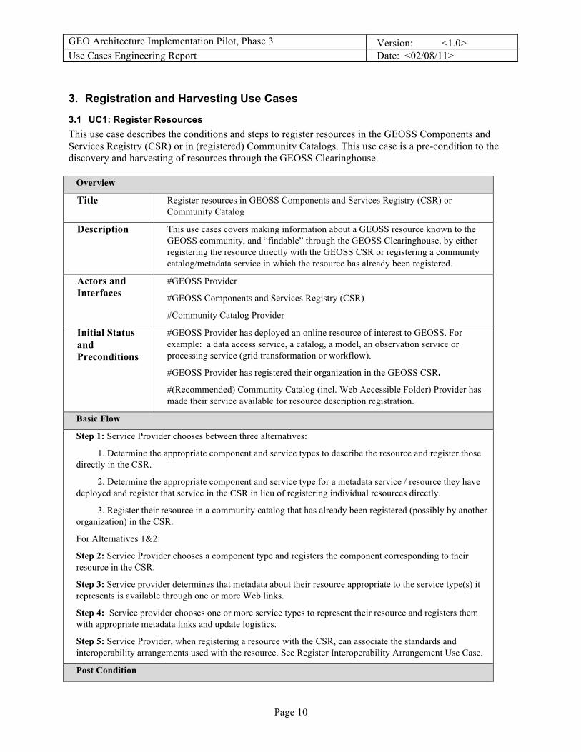
3. Registration and Harvesting Use Cases
3.1 UC1: Register Resources This use case describes the conditions and steps to register resources in the GEOSS Components and Services Registry (CSR) or in (registered) Community Catalogs. This use case is a pre-condition to the discovery and harvesting of resources through the GEOSS Clearinghouse.
Overview
Title Register resources in GEOSS Components and Services Registry (CSR) or Community Catalog
Description This use cases covers making information about a GEOSS resource known to the GEOSS community, and “findable” through the GEOSS Clearinghouse, by either registering the resource directly with the GEOSS CSR or registering a community catalog/metadata service in which the resource has already been registered.
Actors and Interfaces
#GEOSS Provider
#GEOSS Components and Services Registry (CSR)
#Community Catalog Provider
Initial Status and Preconditions
#GEOSS Provider has deployed an online resource of interest to GEOSS. For example: a data access service, a catalog, a model, an observation service or processing service (grid transformation or workflow).
#GEOSS Provider has registered their organization in the GEOSS CSR.
#(Recommended) Community Catalog (incl. Web Accessible Folder) Provider has made their service available for resource description registration.
Basic Flow
Step 1: Service Provider chooses between three alternatives:
1. Determine the appropriate component and service types to describe the resource and register those directly in the CSR.
2. Determine the appropriate component and service type for a metadata service / resource they have deployed and register that service in the CSR in lieu of registering individual resources directly.
3. Register their resource in a community catalog that has already been registered (possibly by another organization) in the CSR.
For Alternatives 1&2:
Step 2: Service Provider chooses a component type and registers the component corresponding to their resource in the CSR.
Step 3: Service provider determines that metadata about their resource appropriate to the service type(s) it represents is available through one or more Web links.
Step 4: Service provider chooses one or more service types to represent their resource and registers them with appropriate metadata links and update logistics.
Step 5: Service Provider, when registering a resource with the CSR, can associate the standards and interoperability arrangements used with the resource. See Register Interoperability Arrangement Use Case.
Post Condition

GEO Architecture Implementation Pilot, Phase 3 Version: <1.0> Use Cases Engineering Report Date: <02/08/11>
Page 11
The provided resource description or metadata holdings can be queried by a Clearinghouse and found by GEOSS users searching for useful resources.

GEO Architecture Implementation Pilot, Phase 3 Version: <1.0> Use Cases Engineering Report Date: <02/08/11>
Page 12
3.2 UC10: Register New Interoperability Arrangements This use case describes the steps for adding references to standards or special interoperability arrangements in the GEOSS Standards and Interoperability Registry (SIR). This use case is jointly developed with the GEOSS Standards and Interoperability Forum (SIF).
Overview
Title Register, in the GEOSS Standards and Interoperability Registry (SIR), new and recommended interoperability arrangements) as well as utilized standards.
Description This use case covers the action of closing the loop on interoperability practices and arrangements (standard and otherwise) that have been implemented for GEOSS. The arrangements are registered and moderated in the SIR both to provide more information on what has been implemented, and to provide other GEOSS participants with an arrangement choice for registering their own resources.
Actors and Interfaces
#GEOSS Provider
#GEOSS Components and Services Registry (CSR)
#GEOSS Standards and Interoperability Registry (SIR)
#SIF (Standards and Interoperability Forum) Moderator
Initial Status and Preconditions
#GEOSS Provider has deployed an online resource of interest to GEOSS. For example: a data access service, a catalog, a model, an observation service or process (grid transformation or workflow).
#GEOSS Provider may have registered their resource to the GEOSS Components and Services Registry or to a community catalog / metadata service which is itself registered with GEOSS.
#GEOSS Provider wishes to register, for wider recognition and re-use, a particular interoperability arrangement that is implemented by their resource.
Basic Flow
Step 1: Service Provider develops or locates a description or specification of the chosen interoperability arrangement.
Step 2: Service Provider publishes the new document to a Web accessible location or obtains an online link to an existing document.
Step 3: If the Service Provider is registering the service with the CSR, continue with Step 5.
Step 4: If the Service Provider is registering the interoperability arrangement with the SIR, continue with Step 6.
Step 5: Service Provider logs in, registering if necessary, at the CSR. While registering the service, Service Provider will request to also register the interoperability arrangement, which will result in the SIR entry form being made available at the CSR. Continue with Step 7.
Step 6: Service Provider logs in, registering if necessary, at the SIR.
Step 7: Service Provider will choose to submit a new interoperability arrangement, providing:
1. Name (concise version of official title)
2. Version
3. Title

GEO Architecture Implementation Pilot, Phase 3 Version: <1.0> Use Cases Engineering Report Date: <02/08/11>
Page 13
4. Description
5. Author
6. Publisher
7. Primary Taxonomy Category
8. Secondary Taxonomy Categories
9. URL for the published document
10. URN for the published document
11. Type (Standard or Special Interoperability Arrangement)
12. Comments
13. Contact Details
Step 8: SIF evaluates the submission by Service Provider.
Step 9: If SIF approves submission, it will be accepted into the SIR. Continue with Step 11.
Step 10: If SIF does not approve submission, Service Provider will be contacted.
Step 11: DONE.
Post Condition
A new interoperability arrangement is available in the GEOSS SIR for all GEOSS participants. If it was registered via service registration it will be referenced by the Service Provider's service registration record. If it was registered at the SIR, then Service Provider will need to update the service record at the CSR to reflect its association with the registered interoperability arrangement.
Alternative Flow(s)
Alternative Step 7: Service Provider registers the interoperability arrangement at the SIR
7a. CSR obtains an updated list of GEOSS SIR entries. 7b. Service Provider registers or updates their service at the CSR. 7c. Service Provider chooses the new interoperability arrangement from the SIR entries within the GEOSS CSR client in order to properly characterize their resource. 7d. Continue with Step 11. Alternative Step 10: Service Provider is contacted by SIF to discussion interoperability arrangement submitted. 10a. SIF works with the Service Provider to refine the interoperability arrangement and its documentation or to choose a better alternative arrangement. 10b. Service Provider submits updated interoperability arrangement. 10c. Continue with Step 8.

GEO Architecture Implementation Pilot, Phase 3 Version: <1.0> Use Cases Engineering Report Date: <02/08/11>
Page 14
3.3 UC3: Harvest & Query via Clearinghouse This use case describes the steps for harvesting and/or querying service or content metadata from community catalogs or services via a Clearinghouse.
Overview
Title Harvest and Query Metadata via GEOSS Clearinghouse
Description This use case describes the steps for harvesting and/or querying service or content metadata from community catalogs or services via a GEOSS Clearinghouse.
Actors and Interfaces
# Service Provider
# GEOSS Common Infrastructure Registry
# GEOSS Clearinghouse
# Client Application
Initial Status and Preconditions
# Service Provider has deployed an online resource of interest to GEOSS. For example: a data access service, a catalog, a model, an observation service or a process (grid transformation or workflow) or information resource. The resource may also be a service client (online browser client generator or downloadable software component).
# Service Provider has published online resource description metadata by registering their service either with the GEOSS CSR "or" in a metadata service (e.g. Community Catalog, Web Accessible Folder) which in turn has been registered in the GEOSS CSR.
Basic Flow
Step 1: GEOSS Clearinghouse queries GEOSS CSR for registered components and services.
Step 2: GEOSS Clearinghouse extracts from the CSR response the harvest policies and online metadata service links for CSR registered resources.
Step 3: For resources that are metadata services or provided metadata links, GEOSS Clearinghouse harvests all or part of the available metadata holdings (recommended).
1. The community catalog permits harvesting and holds less than 10000 records. GEOSS Clearinghouse harvests all of the holdings and periodically updates them according to the registered frequency of change.
2. The community catalog / metadata service does not permit bulk harvesting and/or holds more than 10000 records. GEOSS Clearinghouse harvests collection records (aggregate summary) as criteria for dynamically cascading queries to the Clearinghouse from users to the service
Step 4: For resources that are other than metadata services, GEOSS Clearinghouse harvests the service getCapabilities or equivalent resource description and any additional metadata references provided therein. The Clearinghouse assembles as complete as possible a set of discovery metadata records from this information according to its familiarity with that particular service type.
Post Condition
The GEOSS Clearinghouse is prepared to accept and process resource discovery queries from client applications.
GEO Architecture Implementation Pilot, Phase 3 Version: <1.0> Use Cases Engineering Report Date: <02/08/11>
Page 15
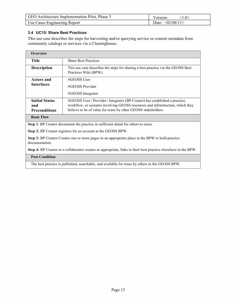
3.4 UC15: Share Best Practices This use case describes the steps for harvesting and/or querying service or content metadata from community catalogs or services via a Clearinghouse.
Overview
Title Share Best Practices
Description This use case describes the steps for sharing a best practice via the GEOSS Best Practices Wiki (BPW).
Actors and Interfaces
#GEOSS User
#GEOSS Provider
#GEOSS Integrator
Initial Status and Preconditions
#GEOSS User | Provider | Integrator (BP Creator) has established a practice, workflow, or scenario involving GEOSS resources and infrastructure, which they believe to be of value for reuse by other GEOSS stakeholders.
Basic Flow
Step 1: BP Creator documents the practice in sufficient detail for others to reuse.
Step 2: BP Creator registers for an account at the GEOSS BPW.
Step 3: BP Creator Creates one or more pages in an appropriate place in the BPW to hold practice documentation.
Step 4: BP Creator or a collaborator creates as appropriate, links to their best practice elsewhere in the BPW.
Post Condition
The best practice is published, searchable, and available for reuse by others in the GEOSS BPW.

GEO Architecture Implementation Pilot, Phase 3 Version: <1.0> Use Cases Engineering Report Date: <02/08/11>
Page 16
4. Clients and Portals Use Cases
4.1 UC4: Search for Resources This use case describes the conditions and steps for portals and application clients to support the GEOSS user in searching for resources of interest via the GEOSS Clearinghouses or Community Catalogs. This use case is a pre-condition to the Present Reachable Services and Alerts use case.
Overview
Title Search for Resources via GEOSS Clearinghouse(s) or Community Catalog(s)
Description This use case describes the conditions and steps for portals and application clients to support the GEOSS user in searching for resources of interest via the GEOSS Clearinghouse(s) or Community Catalog(s).
Actors and Interfaces
# GEOSS User
# Client Application (GEO Portal, Community Portal, Desktop Application, Portlet, etc)
# GEOSS Clearinghouse
# Community Catalog
Initial Status and Preconditions
# GEOSS User is looking for information of value to task at hand
# Client Application has been developed and is available for use
# Resources’ metadata has been successfully harvested in GEOSS Clearinghouses (either directly or via registration in a Community Catalog)
Basic Flow
Step 1: Client Application requests capabilities of catalogs of interest (GEOSS Clearinghouse and/or Community Catalogs) to determine the protocol needed to search for resources (e.g CSW 2.0.2 or Z39.50) and the queryable elements of each as needed. Alternatively, the Client Application knows a-priori the protocol needed to interact with catalog(s)/clearinghouse(s) of interest
Step 2: Client Application presents GEOSS User with search criteria based on queryable properties of selected catalogs
- Simple keyword search and area of interest/bbox search
- Advanced search parameters such as organization, catalogs to be searched, societal benefit areas, resource type, etc
- More specific earth-observation criteria such as sensor row/path, collection, subsetting/ordering and/or delivery mechanisms, etc
- Value-added and/or domain/community specific search capabilities such as thesaurus matching, cluster matching, etc
Step 3: Based on user selections, Client Application constructs query to each selected catalog and the ResultSet is returned and presented to the user with application-specific options (such as total number of results, basic information about each result, grouping of results, etc)
Step 4: GEOSS User selects resources of interest for evaluation and/or use.
Post Condition
The Client Application has retrieved the necessary metadata to present the GEOSS User with information

GEO Architecture Implementation Pilot, Phase 3 Version: <1.0> Use Cases Engineering Report Date: <02/08/11>
Page 17
on discovered resources matching the search criteria for further evaluation and/or use.
4.2 UC5: Present Reachable Services and Alerts This use case describes the conditions and the steps for portals and application clients to present the GEOSS User with the reachable services and alerts as returned by the GEOSS Clearinghouse(s) and/or Community Catalog(s) per the user’s search criteria.
Overview
Title Present GEOSS User with Reachable Services and Alerts
Description This use case describes the conditions and steps for portals and application clients to present the GEOSS User with the reachable services and alerts as returned by the GEOSS Clearinghouse(s) and/or Community Catalog(s) per the user’s search criteria.
Actors and Interfaces
#GEOSS User
# Client Application designed to support the presentation of the selected services and/or alerts of interest (including GEO Portal, Community Portal, Desktop Application, Portlet, etc)- Note that a GEO Portal may act as a client only to a reduced set of services.
#GEOSS Providers
Initial Status and Preconditions
# GEOSS User has discovered and/or selected services or alerts of interest
# Client has established reachability of discovered registered services or alerts (e.g. Client has established that the services of interest are running and responding to requests)
# Client can support the presentation of the selected services or alerts of interest
Basic Flow
For OGC Services
Step 1: Client issues GetCapabilities request to receive further metadata about the service
Step 2: Depending on the type of service, the Client presents the GEOSS User with more information on the service offerings such as layers, features, coverages, sensor parameters, portrayal rules, etc served by the selected service
Step 3: The GEOSS User can choose to get additional information about each offering (if available via DescribeFeature, DescribeCoverage, DescribeSensor, etc)
For Alert Services
Step 1: The GEOSS User is presented with subscription options (e.g. frequency of alerts, geographic extent, etc)
Step 2: The GEOSS User can choose subscription options
Step 4: After selection of resources, Client provides options for downloading/exploring resources (files, documents, websites), displaying alerts, viewing resources in the case of OGC Web Services, and/or executing processing service requests.
Post Condition
The Client Application has an information representation for the GEOSS User to use for interacting with
GEO Architecture Implementation Pilot, Phase 3 Version: <1.0> Use Cases Engineering Report Date: <02/08/11>
Page 18
reachable services and alerts of interest.
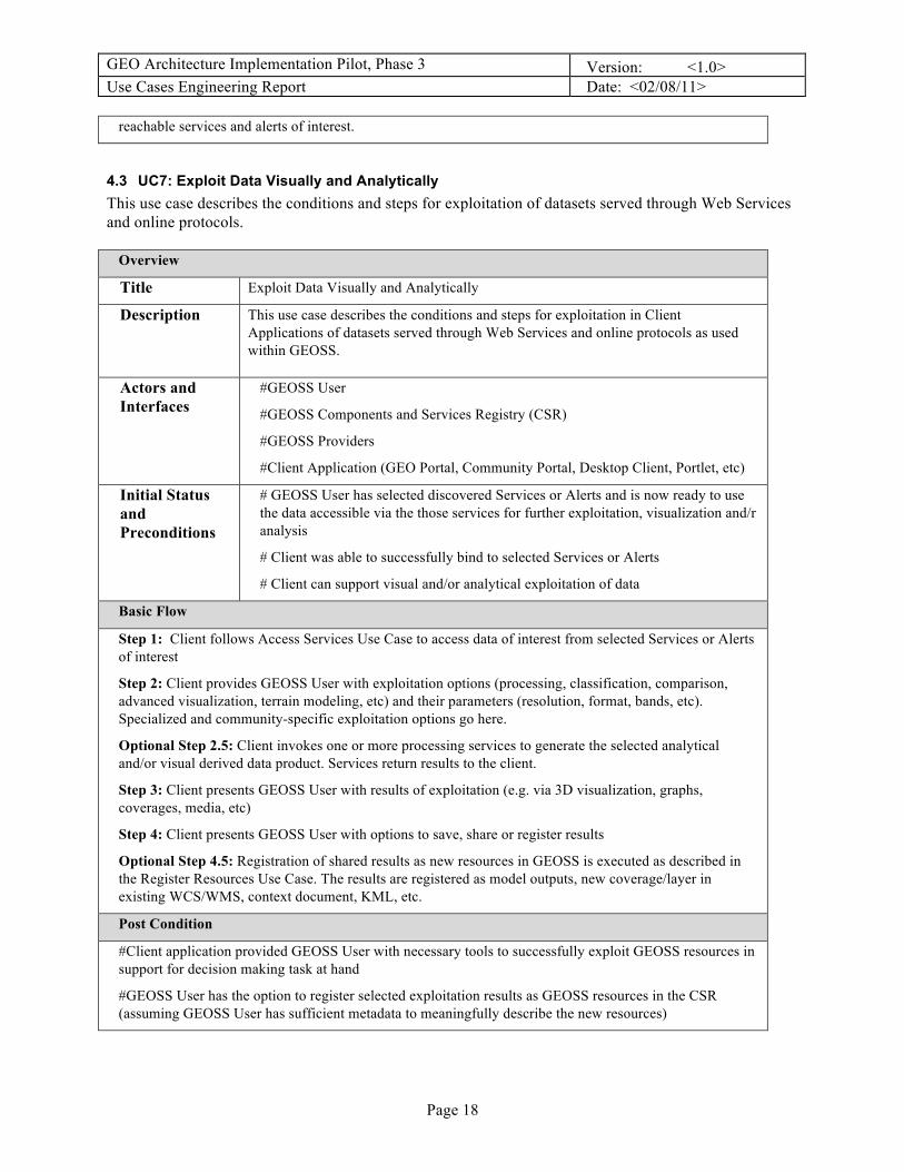
4.3 UC7: Exploit Data Visually and Analytically This use case describes the conditions and steps for exploitation of datasets served through Web Services and online protocols.
Overview
Title Exploit Data Visually and Analytically
Description This use case describes the conditions and steps for exploitation in Client Applications of datasets served through Web Services and online protocols as used within GEOSS.
Actors and Interfaces
#GEOSS User
#GEOSS Components and Services Registry (CSR)
#GEOSS Providers
#Client Application (GEO Portal, Community Portal, Desktop Client, Portlet, etc)
Initial Status and Preconditions
# GEOSS User has selected discovered Services or Alerts and is now ready to use the data accessible via the those services for further exploitation, visualization and/r analysis
# Client was able to successfully bind to selected Services or Alerts
# Client can support visual and/or analytical exploitation of data
Basic Flow
Step 1: Client follows Access Services Use Case to access data of interest from selected Services or Alerts of interest
Step 2: Client provides GEOSS User with exploitation options (processing, classification, comparison, advanced visualization, terrain modeling, etc) and their parameters (resolution, format, bands, etc). Specialized and community-specific exploitation options go here.
Optional Step 2.5: Client invokes one or more processing services to generate the selected analytical and/or visual derived data product. Services return results to the client.
Step 3: Client presents GEOSS User with results of exploitation (e.g. via 3D visualization, graphs, coverages, media, etc)
Step 4: Client presents GEOSS User with options to save, share or register results
Optional Step 4.5: Registration of shared results as new resources in GEOSS is executed as described in the Register Resources Use Case. The results are registered as model outputs, new coverage/layer in existing WCS/WMS, context document, KML, etc.
Post Condition
#Client application provided GEOSS User with necessary tools to successfully exploit GEOSS resources in support for decision making task at hand
#GEOSS User has the option to register selected exploitation results as GEOSS resources in the CSR (assuming GEOSS User has sufficient metadata to meaningfully describe the new resources)

GEO Architecture Implementation Pilot, Phase 3 Version: <1.0> Use Cases Engineering Report Date: <02/08/11>
Page 19

GEO Architecture Implementation Pilot, Phase 3 Version: <1.0> Use Cases Engineering Report Date: <02/08/11>
Page 20
5. Deployment and Access Use Cases
5.1 UC2: Deploy Resources This use case describes the conditions and steps to configure and deploy a component with associated service interfaces, in order to make a resource accessible and usable within GEOSS. This use case is a precondition to the Interact with Services Use Case.
Overview
Title Deploy Resources for use in GEOSS
Description This use case identifies many of the aspects that are, or should be, common to all or multiple Web Services interface Implementation Specifications. It refers notably to the OGC Web Services Common document, OGC Web Map Service (WMS), Web Feature Service (WFS), and Web Coverage Service (WCS), but shall encompass as well OpenDAP and W3C W*S. Web Services common aspects include: service operation request and response encoding; and parameters included in operation requests and responses.
This use case also deals with best practices for readying the service for registration in the GEOSS CSR, ensuring proper service discovery, retrieval, and testing by the GEOSS communities of practice.
Actors and Interfaces
# GEOSS Provider
#GEOSS Integrators and/or #GEOSS Operator
# GEOSS Components and Services Registry (CSR)
Initial Status and Preconditions
# GEOSS Provider has a resource of interest for GEOSS. For example: a model, an observation or another process (grid transformation, workflow...)
Basic Flow
Step 1: #GEOSS Provider identifies then implements the best available Web Service standard (OGC, W3C...) to make its resource available on GEOSS (based on best practices for that type of data, plus availability and familiarity of software tools)
Step 2: #GEOSS Provider consults with #GEOSS Integrators and #GEOSS Operators and reviews the GEOSS Common Record elements in order to provide metadata elements for the provided resource which maximize the chances of #GEOSS Users being able to discover it through the GEOSS Clearinghouse
Step 3: #GEOSS Provider configures or validates all the information about its Resource Component and Service interface as provided in the service Capabilities document and other relevant metadata:
- Service Type, Version, Title and Abstract, Supported Languages
- Contact information (service provider POC)
- Supported service operations request and response encodings
- Contents: layer names and titles, phenomena, feature types, etc.
- Domains of validity (dimensions, units, range, scales, reference systems)
Step 4: #GEOSS Provider is ready to register the Component and associated Service interfaces to the GEOSS CSR (as described in the Register Resources Use Case). Metadata about the service (ISO 19139) is generated automatically from the service. Typically, additional information (e.g. metadata not found in the getCapabilities) also needs to be added to improve end-to-end discovery and access (EDA) performance.

GEO Architecture Implementation Pilot, Phase 3 Version: <1.0> Use Cases Engineering Report Date: <02/08/11>
Page 21
Post Condition
# The following information about a Resource and Service is available for registration (ideally, each piece of information is associated with a Uniform Resource Identifier URI)
- Service getCapabilities URL or other service information document
- Resource Component type and metadata
- Service type (WMS, WCS, SPS, etc)
- Type of procedure (model, sensor/platform, etc)
- Input (e.g. phenomena, configuration variables, etc)
- Output (e.g. phenomena, file, etc)
GEO Architecture Implementation Pilot, Phase 3 Version: <1.0> Use Cases Engineering Report Date: <02/08/11>
Page 22
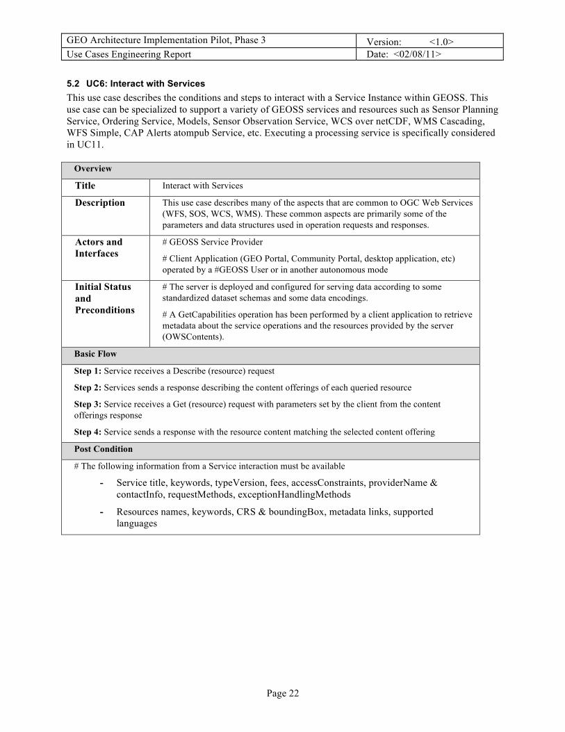
5.2 UC6: Interact with Services This use case describes the conditions and steps to interact with a Service Instance within GEOSS. This use case can be specialized to support a variety of GEOSS services and resources such as Sensor Planning Service, Ordering Service, Models, Sensor Observation Service, WCS over netCDF, WMS Cascading, WFS Simple, CAP Alerts atompub Service, etc. Executing a processing service is specifically considered in UC11.
Overview
Title Interact with Services
Description This use case describes many of the aspects that are common to OGC Web Services (WFS, SOS, WCS, WMS). These common aspects are primarily some of the parameters and data structures used in operation requests and responses.
Actors and Interfaces
# GEOSS Service Provider
# Client Application (GEO Portal, Community Portal, desktop application, etc) operated by a #GEOSS User or in another autonomous mode
Initial Status and Preconditions
# The server is deployed and configured for serving data according to some standardized dataset schemas and some data encodings.
# A GetCapabilities operation has been performed by a client application to retrieve metadata about the service operations and the resources provided by the server (OWSContents).
Basic Flow
Step 1: Service receives a Describe (resource) request
Step 2: Services sends a response describing the content offerings of each queried resource
Step 3: Service receives a Get (resource) request with parameters set by the client from the content offerings response
Step 4: Service sends a response with the resource content matching the selected content offering
Post Condition
# The following information from a Service interaction must be available
- Service title, keywords, typeVersion, fees, accessConstraints, providerName & contactInfo, requestMethods, exceptionHandlingMethods
- Resources names, keywords, CRS & boundingBox, metadata links, supported languages

GEO Architecture Implementation Pilot, Phase 3 Version: <1.0> Use Cases Engineering Report Date: <02/08/11>
Page 23
6. Workflow Use Cases The workflow use cases describe the conditions and steps to configure, deploy, and execute processing services, either atomic or composed from multiple processes. More specific information on configuring, constructing, deploying and using BPEL workflows is available in the GEOSS AIP-2 Workflow and Processing Engineering Report.
6.1 UC8: Construct Processing Service This use case describes the conditions and steps to create a processing and/or workflow service within GEOSS.
Overview
Title Construct Processing Service***
Description This use case aims at capturing the alternative approaches to design, deploy and execute a workflow. The workflow can be described in Business Execution Language (BPEL), Sensor Markup Language (SensorML), or any other script language.
Actors and Interfaces
# GEOSS Provider
# GEOSS Integrator
# Client Application
Initial Status and Preconditions
# Data: data or observations from sensors are available in rudimentary format and projection. Further processing is required to generate useful information for decision-makers
# Algorithms: Algorithms are available as Processing Services
# Web Services: Web Services to be used in the workflow are available and compliant with GEOSS interoperability arrangements
Basic Flow
Step 1: #GEOSS Provider and/or Integrator deploys one or more Web Processing Services
designs the Web Processing Service using a BPEL designer. The workflow can embed the steps to inject the results into standard, persistent storage services through their transaction capabilities (e.g. WCS-T or WFS-T)
Step 2: GEOSS Integrator deploys the workflow into a BPEL engine. The workflow can be registered as a GEOSS resource following the Use Case Register Resources
Step 3: Client Application executes the workflow via the Web Processing Service interface
Post Condition
# Data is served through geospatial web services using GEOSS interoperability arrangements
# A composite service (or workflow) is available as a Web Processing Service and can be executed
6.2 UC11: Execute Processing Service This use case describes the conditions and steps to create a processing and/or workflow service within GEOSS.

GEO Architecture Implementation Pilot, Phase 3 Version: <1.0> Use Cases Engineering Report Date: <02/08/11>
Page 24
Overview
Title Execute Processing Service***
Description This use case aims at capturing the alternative approaches to design, deploy and execute a workflow. The workflow can be described in Business Execution Language (BPEL), Sensor Markup Language (SensorML), or any other script language.
Actors and Interfaces
# GEOSS Integrator
# Client Application
# Service Provider
Initial Status and Preconditions
# Data: data or observations from sensors are available in rudimentary format and projection. Further processing is required to generate useful information for decision-makers
# Algorithms: Algorithms are available as geospatial Web Processing Processes that can be re-used in different workflows
# Web Services: Web Services to be used in the workflow are available and compliant with GEOSS interoperability arrangements
Basic Flow
Step 1: GEOSS Integrator designs the Web Processing Service using a BPEL designer. The workflow can embed the steps to inject the results into standard, persistent storage services through their transaction capabilities (e.g. WCS-T or WFS-T)
Step 2: GEOSS Integrator deploys the workflow into a BPEL engine. The workflow can be registered as a GEOSS resource following the Use Case Register Resources
Step 3: Client Application executes the workflow via the Web Processing Service interface
Post Condition
# Data is served through geospatial web services using GEOSS interoperability arrangements
# A composite service (or workflow) is available as a Web Processing Service and can be executed
7. Semantic Use Cases The semantic use cases describe the conditions and steps to set up and utilize semantic matching and mediation within GEOSS.
7.1 UC12: Perform Semantic Mediation This use case describes the conditions and steps to create a processing and/or workflow service within GEOSS.
Overview
Title Perform Semantic Mediation***
Description This use case aims at capturing the alternative approaches to design, deploy and execute a workflow. The workflow can be described in Business Execution Language (BPEL), Sensor Markup Language (SensorML), or any other script language.

GEO Architecture Implementation Pilot, Phase 3 Version: <1.0> Use Cases Engineering Report Date: <02/08/11>
Page 25
Actors and Interfaces
# GEOSS Integrator
# Client Application
# Service Provider
Initial Status and Preconditions
# Data: data or observations from sensors are available in rudimentary format and projection. Further processing is required to generate useful information for decision-makers
# Algorithms: Algorithms are available as geospatial Web Processing Processes that can be re-used in different workflows
# Web Services: Web Services to be used in the workflow are available and compliant with GEOSS interoperability arrangements
Basic Flow
Step 1: GEOSS Integrator designs the Web Processing Service using a BPEL designer. The workflow can embed the steps to inject the results into standard, persistent storage services through their transaction capabilities (e.g. WCS-T or WFS-T)
Step 2: GEOSS Integrator deploys the workflow into a BPEL engine. The workflow can be registered as a GEOSS resource following the Use Case Register Resources
Step 3: Client Application executes the workflow via the Web Processing Service interface
Post Condition
# Data is served through geospatial web services using GEOSS interoperability arrangements
# A composite service (or workflow) is available as a Web Processing Service and can be executed
7.2 UC13: Conduct Semantic Search This use case describes the conditions and steps to perform a semantic search within GEOSS.
Overview
Title Construct Processing Service***
Description This use case aims at capturing the alternative approaches to design, deploy and execute a workflow. The workflow can be described in Business Execution Language (BPEL), Sensor Markup Language (SensorML), or any other script language.
Actors and Interfaces
# GEOSS Integrator
# Client Application
# Service Provider
Initial Status and Preconditions
# Data: data or observations from sensors are available in rudimentary format and projection. Further processing is required to generate useful information for decision-makers
# Algorithms: Algorithms are available as geospatial Web Processing Processes that can be re-used in different workflows
# Web Services: Web Services to be used in the workflow are available and compliant with GEOSS interoperability arrangements

GEO Architecture Implementation Pilot, Phase 3 Version: <1.0> Use Cases Engineering Report Date: <02/08/11>
Page 26
Basic Flow
Step 1: GEOSS Integrator designs the Web Processing Service using a BPEL designer. The workflow can embed the steps to inject the results into standard, persistent storage services through their transaction capabilities (e.g. WCS-T or WFS-T)
Step 2: GEOSS Integrator deploys the workflow into a BPEL engine. The workflow can be registered as a GEOSS resource following the Use Case Register Resources
Step 3: Client Application executes the workflow via the Web Processing Service interface
Post Condition
# Data is served through geospatial web services using GEOSS interoperability arrangements
# A composite service (or workflow) is available as a Web Processing Service and can be executed
8. Network Use Cases The Network Use Cases describe the conditions and steps to expand and elaborate data sharing federations within GEOSS.
8.1 UC14: Develop Data Sharing Network This use case describes the conditions and steps to test services deployed and registered through GEOSS
Overview
Title Develop Data Sharing Network***
Description Service Provider tests its service using a proper Test tool discovered in the GEOSS CSR.
Actors and Interfaces
# GEOSS Service Provider
# GEOSS CSR
# Test Facility/Tool
# GEOSS Relevant Standards Authority
Initial Status and Preconditions
# The Test Facility shall be registered in GEOSS and shall be available
# The Service Provider shall make available the Service to be tested through a URL
Basic Flow
Step 1: Service Provider puts the Service to be tested on a reachable and available server
Step 2: Service Provider accesses the GEOSS CSR to search for a Test Facility/Tool matching the type of Service to be tested (e.g. WMS Service)
Step 3: Service Provider browses the search results and checks the details of registered Test Facilities/Tools. Optionally, the Service Provider can access the instructions on how to use Test Facilities/Tools of interest
Step 4: Service Provider selects and accesses a Test Facility/Tool and if necessary (and/or not previously done), the Service Provider registers in the Test Environment as a Service Provider
Step 5: Service Provider logs into the Test Environment
Step 6: For a WMS, the Service Provider fills the WMS form for the GetCapabilities request, providing the
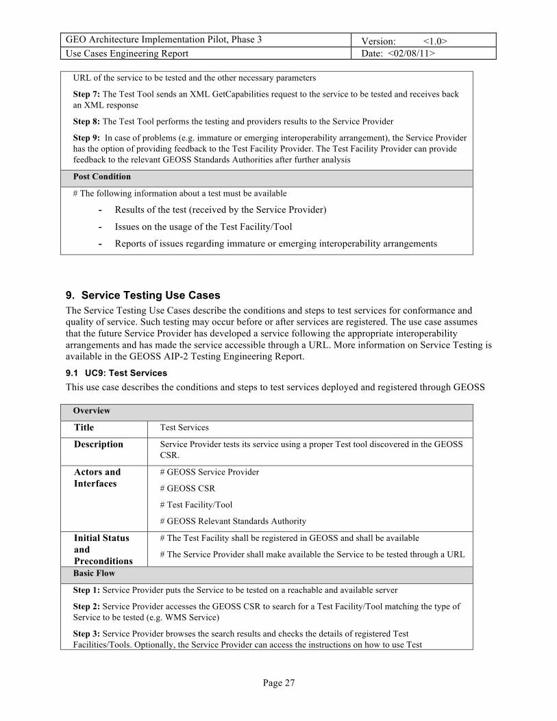
GEO Architecture Implementation Pilot, Phase 3 Version: <1.0> Use Cases Engineering Report Date: <02/08/11>
Page 27
URL of the service to be tested and the other necessary parameters
Step 7: The Test Tool sends an XML GetCapabilities request to the service to be tested and receives back an XML response
Step 8: The Test Tool performs the testing and providers results to the Service Provider
Step 9: In case of problems (e.g. immature or emerging interoperability arrangement), the Service Provider has the option of providing feedback to the Test Facility Provider. The Test Facility Provider can provide feedback to the relevant GEOSS Standards Authorities after further analysis
Post Condition
# The following information about a test must be available
- Results of the test (received by the Service Provider)
- Issues on the usage of the Test Facility/Tool
- Reports of issues regarding immature or emerging interoperability arrangements
9. Service Testing Use Cases The Service Testing Use Cases describe the conditions and steps to test services for conformance and quality of service. Such testing may occur before or after services are registered. The use case assumes that the future Service Provider has developed a service following the appropriate interoperability arrangements and has made the service accessible through a URL. More information on Service Testing is available in the GEOSS AIP-2 Testing Engineering Report.
9.1 UC9: Test Services This use case describes the conditions and steps to test services deployed and registered through GEOSS
Overview
Title Test Services
Description Service Provider tests its service using a proper Test tool discovered in the GEOSS CSR.
Actors and Interfaces
# GEOSS Service Provider
# GEOSS CSR
# Test Facility/Tool
# GEOSS Relevant Standards Authority
Initial Status and Preconditions
# The Test Facility shall be registered in GEOSS and shall be available
# The Service Provider shall make available the Service to be tested through a URL
Basic Flow
Step 1: Service Provider puts the Service to be tested on a reachable and available server
Step 2: Service Provider accesses the GEOSS CSR to search for a Test Facility/Tool matching the type of Service to be tested (e.g. WMS Service)
Step 3: Service Provider browses the search results and checks the details of registered Test Facilities/Tools. Optionally, the Service Provider can access the instructions on how to use Test

GEO Architecture Implementation Pilot, Phase 3 Version: <1.0> Use Cases Engineering Report Date: <02/08/11>
Page 28
Facilities/Tools of interest
Step 4: Service Provider selects and accesses a Test Facility/Tool and if necessary (and/or not previously done), the Service Provider registers in the Test Environment as a Service Provider
Step 5: Service Provider logs into the Test Environment
Step 6: For a WMS, the Service Provider fills the WMS form for the GetCapabilities request, providing the URL of the service to be tested and the other necessary parameters
Step 7: The Test Tool sends an XML GetCapabilities request to the service to be tested and receives back an XML response
Step 8: The Test Tool performs the testing and providers results to the Service Provider
Step 9: In case of problems (e.g. immature or emerging interoperability arrangement), the Service Provider has the option of providing feedback to the Test Facility Provider. The Test Facility Provider can provide feedback to the relevant GEOSS Standards Authorities after further analysis
Post Condition
# The following information about a test must be available
- Results of the test (received by the Service Provider)
- Issues on the usage of the Test Facility/Tool
- Reports of issues regarding immature or emerging interoperability arrangements
10. References
Appendix A: Templates
Use Case Template
Overview
Title [Title of the basic flow use case]
Description [Short description of the basic flow]
Actors and Interfaces
[Identifies the Actors and Interfaces to components and services that participate in the use case]
Initial Status and Preconditions
[A pre-condition (of a use case) is the state of the system that must be present prior to a use case being performed]
Basic Flow
STEP 1: …
STEP 2: …
Post Condition
[A post-condition (of a use case) is a list of possible states the system can be in immediately after

GEO Architecture Implementation Pilot, Phase 3 Version: <1.0> Use Cases Engineering Report Date: <02/08/11>
Page 29
a use case has finished]
Alternative Flow(s)
[Alternative flows are described here if needed]

GEO Architecture Implementation Pilot, Phase 3 Version: <1.0> Use Cases Engineering Report Date: <02/08/11>
Page 30