1
AI-based evaluation of the SDGs: the case of crop detection with earth observation data Natalia Efremova, Dennis West, Dmitry Zausaev CCR, SBS, University of Oxford, UK; DeepPlanet, Harwell, UK [email protected]; [email protected]; [email protected] Problem Statement Problem: The framework of the seventeen sustainable development goals is a challenge for developers and researchers applying AI. Solution: AI and earth observations (EO) can provide reliable and disaggre- gated data for better monitoring of the sustainable development goals (SDGs). We present an overview of SDG targets, which can be effec- tively measured with AI tools. We identify indicators with the most significant contribution from the AI and EO (Tier 2 and 3) and describe an application of state-of-the-art ML to one of the indicators. Model: We describe an application of U-net with SE blocks for efficient seg- mentation of satellite imagery for crop detection. Results: We demonstrate how AI can be more effectively applied in solutions di- rectly contributing towards specific SDGs and propose further research on an AI-based evaluative infrastructure for SDGs. Model Architecture Architecture: Green boxes correspond to multi-channel feature maps. Dif- ferent operations are denoted with coloured arrows. The structure of SE blocks is depicted in the bottom-left corner of the figure (all SE blocks share the same structure). The places where the SE blocks are inserted in the model are depicted with the dotted arrows. Segmentation Input/Output: Segmentation results on the training set: (a) input image; (b) generated segmentation mask (white: predicted polygons, black: background). Results Results: Predicted segmentation of vineyards overlayed with input image. Prediction accuracy ARCH IS N MF DICE Unet96X2048X4 96 4 2048 0.81 Unet96X1024X4 96 4 1024 0.73 Unet96X512X4 96 4 512 0.61 Unet96X256X4 96 4 256 0.32 Unet192X1024X5 192 5 1024 0.54 Unet96X1024X5 96 5 1024 0.66 Unet48X1024X4 48 4 1024 0.31 Unet96X1024X4-SE 96 4 1024 0.75 Unet96X512X4-SE 96 4 512 0.65 Unet96X256X4-SE 96 4 256 0.35 IS: Input Size N: Number of downsample/upsample stages MF: Max filters on lower block DICE: Measure of overlap - Trained only with 400 images. - Accuracy on test set 89%. Conclusions The proposed model can be used to evaluate indicator 2.4.1 ”Propor- tion of agricultural area under productive and sustainable agricul- ture”. This task could be decomposed into several sub-tasks: segmentation of satellite imagery to detect crops, which are currently growing in the re- gion; detection of potentially more efficient crops in terms of scarce resource consumption; estimation of the amount of nutrients in the soil; detection of soil moisture and salinity and crop yield prediction. The focus of this research is on the segmentation sub-task. References [1 ] O. Ronneberger, P. Fischer, and T. Brox. U-net: Convolutional networks for biomedical image segmentation. MICCAI, 2015. [2 ] J. Hu, L. Shen, S. Albanie, G. Sun, and E. Wu. Squeeze-and-excitation networks. CVPR, 2018. [3 ] F. Milletari, N. Navab, and S. Ahmadi. Vnet: Fully convolutional neural networks for volu- metric medical image segmentation. Fourth International Conference on 3D Vision, IEEE, 2016. [4 ] United Nations. A world that counts: Mobilising the data revolution for sustainable develop- ment, 2014. [5 ] DANE. Applying earth observation data to monitor sdgs in colombia: towards integration of national statistics and earth observations for SDG monitoring in Colombia. IAEG-SDGs Working Group on Geospatial Information, 2017.

AI-based evaluation of the SDGs: the case of crop ... · AI-based evaluation of the SDGs: the case of crop detection with earth observation data Natalia Efremova, Dennis West, Dmitry

  • Upload
    others

  • View
    5

  • Download
    0

Embed Size (px)

Citation preview

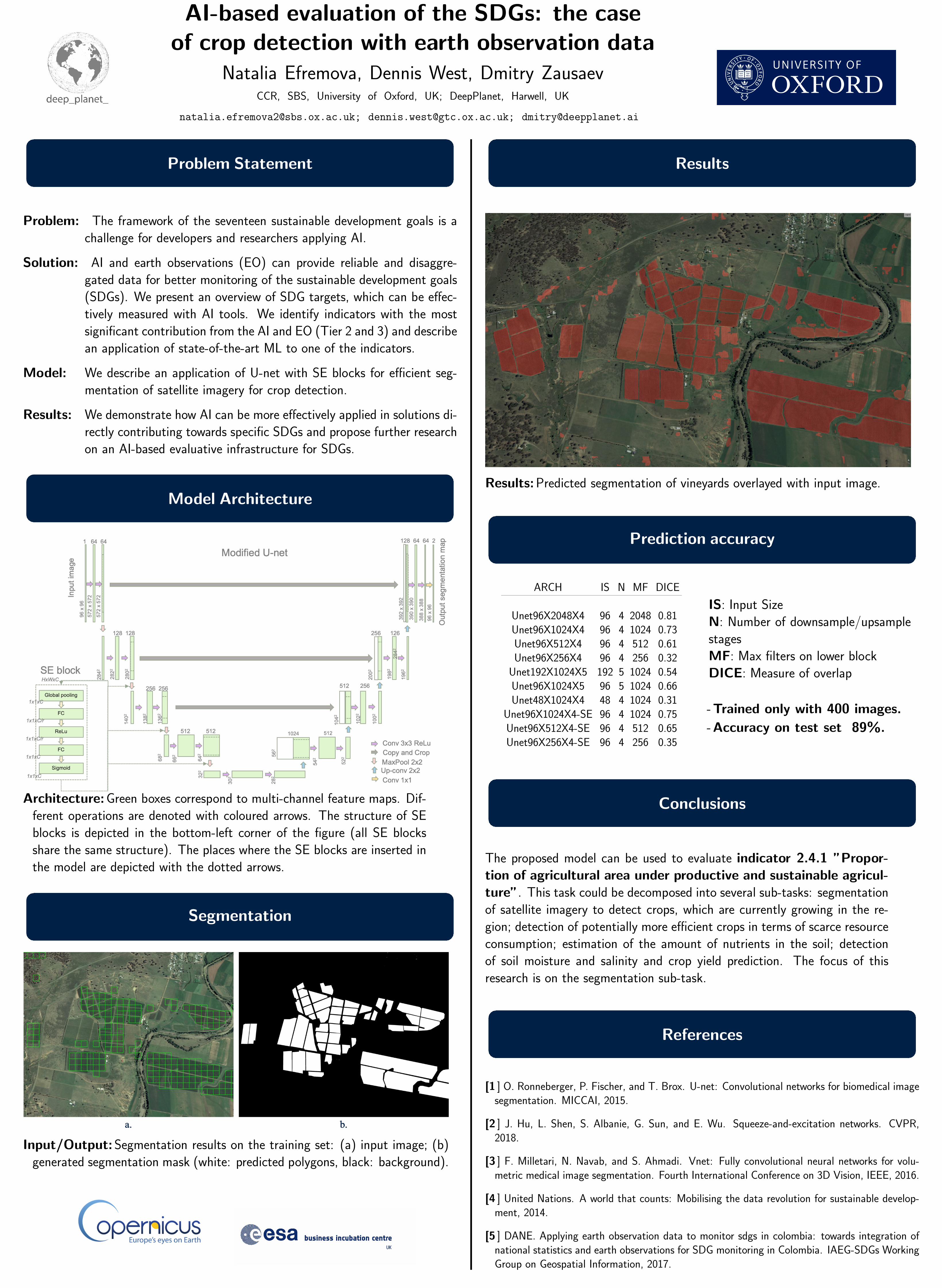
AI-based evaluation of the SDGs: the caseof crop detection with earth observation data

Natalia Efremova, Dennis West, Dmitry ZausaevCCR, SBS, University of Oxford, UK; DeepPlanet, Harwell, UK

[email protected]; [email protected]; [email protected]

Problem Statement

Problem: The framework of the seventeen sustainable development goals is achallenge for developers and researchers applying AI.

Solution: AI and earth observations (EO) can provide reliable and disaggre-gated data for better monitoring of the sustainable development goals(SDGs). We present an overview of SDG targets, which can be effec-tively measured with AI tools. We identify indicators with the mostsignificant contribution from the AI and EO (Tier 2 and 3) and describean application of state-of-the-art ML to one of the indicators.

Model: We describe an application of U-net with SE blocks for efficient seg-mentation of satellite imagery for crop detection.

Results: We demonstrate how AI can be more effectively applied in solutions di-rectly contributing towards specific SDGs and propose further researchon an AI-based evaluative infrastructure for SDGs.

Model Architecture

Architecture:Green boxes correspond to multi-channel feature maps. Dif-ferent operations are denoted with coloured arrows. The structure of SEblocks is depicted in the bottom-left corner of the figure (all SE blocksshare the same structure). The places where the SE blocks are inserted inthe model are depicted with the dotted arrows.

Segmentation

Input/Output:Segmentation results on the training set: (a) input image; (b)generated segmentation mask (white: predicted polygons, black: background).

Results

Results:Predicted segmentation of vineyards overlayed with input image.

Prediction accuracy

ARCH IS N MF DICE

Unet96X2048X4 96 4 2048 0.81Unet96X1024X4 96 4 1024 0.73Unet96X512X4 96 4 512 0.61Unet96X256X4 96 4 256 0.32

Unet192X1024X5 192 5 1024 0.54Unet96X1024X5 96 5 1024 0.66Unet48X1024X4 48 4 1024 0.31

Unet96X1024X4-SE 96 4 1024 0.75Unet96X512X4-SE 96 4 512 0.65Unet96X256X4-SE 96 4 256 0.35

IS: Input SizeN: Number of downsample/upsamplestagesMF: Max filters on lower blockDICE: Measure of overlap

-Trained only with 400 images.

-Accuracy on test set 89%.

Conclusions

The proposed model can be used to evaluate indicator 2.4.1 ”Propor-tion of agricultural area under productive and sustainable agricul-ture”. This task could be decomposed into several sub-tasks: segmentationof satellite imagery to detect crops, which are currently growing in the re-gion; detection of potentially more efficient crops in terms of scarce resourceconsumption; estimation of the amount of nutrients in the soil; detectionof soil moisture and salinity and crop yield prediction. The focus of thisresearch is on the segmentation sub-task.

References

[1 ] O. Ronneberger, P. Fischer, and T. Brox. U-net: Convolutional networks for biomedical imagesegmentation. MICCAI, 2015.

[2 ] J. Hu, L. Shen, S. Albanie, G. Sun, and E. Wu. Squeeze-and-excitation networks. CVPR,2018.

[3 ] F. Milletari, N. Navab, and S. Ahmadi. Vnet: Fully convolutional neural networks for volu-metric medical image segmentation. Fourth International Conference on 3D Vision, IEEE, 2016.

[4 ] United Nations. A world that counts: Mobilising the data revolution for sustainable develop-ment, 2014.

[5 ] DANE. Applying earth observation data to monitor sdgs in colombia: towards integration ofnational statistics and earth observations for SDG monitoring in Colombia. IAEG-SDGs WorkingGroup on Geospatial Information, 2017.