Embed Size (px)
Citation preview
Eyre Peninsula Community Mine to Port Consultative Committee, April 2014 Page 1
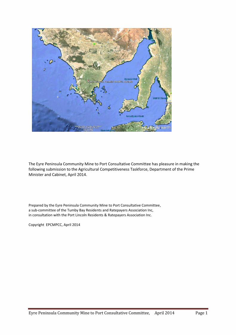
The Eyre Peninsula Community Mine to Port Consultative Committee has pleasure in making the following submission to the Agricultural Competitiveness Taskforce, Department of the Prime Minister and Cabinet, April 2014.
Prepared by the Eyre Peninsula Community Mine to Port Consultative Committee, a sub-committee of the Tumby Bay Residents and Ratepayers Association Inc, in consultation with the Port Lincoln Residents & Ratepayers Association Inc. Copyright EPCMPCC, April 2014
Eyre Peninsula Community Mine to Port Consultative Committee, April 2014 Page 2
SUBMISSION TO:
DEVELOPING AN AGRICULTURAL COMPETITIVENESS WHITE PAPER:
The Eyre Peninsula Community Mine to Port Consultative Committee has pleasure in making the following submission to the Agricultural Competitiveness Taskforce, Department of the Prime Minister and Cabinet, April 2014.
Our comments will be directed towards the confounders, ie the issues which reduce productivity and competitiveness and appear to only rate an incidental mention in the paper.
The submission takes the form of three case studies that illustrate factors against competitiveness in agriculture arising from mining activities in agricultural land, in our situation, south of the Goyder Line.
In South Australia, as in many other parts of Australia, agricultural land is under threat from mining.
This paper will address the situation on Eyre Peninsula and Yorke Peninsula through three case studies. However, additional case studies could well be presented with the impact of mining on the Mid North (the Braemar Project) and unconventional gas exploration in the South East of the State.
The commonality in these case studies is the potential destruction of prime agricultural land (and hence the associated industry); the potential contamination of the land through fugitive dust; compaction of saline soils thereby altering the environmental water flows, especially where these flows are saline, and the potential destruction or contamination of ground water supplies.
The submission has the following structure:
(1) A summary of the key issues from the Case Studies
(2) A context statement
(3) The case studies:
Case Study 1. Mining in the Wudinna/Warramboo District with its associated transport corridor and proposed port.
Case Study 2. Mining in the Lincoln Uplands/Koppio Region of Lower Eyre Peninsula and a proposed new port.
Case Study 3. Mining on Yorke Peninsula, in the vicinity of Ardrossan.
(4) Concluding statement
Eyre Peninsula Community Mine to Port Consultative Committee, April 2014 Page 3
EXECUTIVE SUMMARY
KEY ISSUES ARISING FROM CASE STUDY ONE:
1. In the worst case scenario, ie all rank 1 targets are converted to active mines, the potential exists for approximately 50 kilometres of mines could be opened up with the corresponding loss of agricultural land.
2. There is the potential for a significant impact upon ground water through dewatering and or contamination due to the nature of the ore body (especially if it contains Uranium, Cadmium, Arsenic and Chromium (VI).
3. Fugitive dust is a significant issue with potential contamination of agricultural land from the activities within the mine footprint as well as from the transport corridor.
Unresolved issues include contamination of pastures; grain, wool meat (via digestion of contaminated pastures) and rain water catchments.
4. Significant disruption to existing farming practices through property acquisitions (some of which may be compulsory acquisitions) and through inappropriate alignment of the transport corridor (noting this will become private property).
5. Potential inefficiencies created by property acquisition (making farms smaller).
6. Social, economic and environmental issues do not receive the in depth research required in order for the community to make informed comments/decisions on he pros and cons of mining in agricultural land. The debate is one sided, all for the mining company in the hope that significant economic benefit is achieved. 7. Where are the Productivity Commission investigations into such proposals?
KEY ISSUES ARISING FROM CASE STUDY TWO:
1. The potential destruction of prime highly sustainable agricultural land through mines of a total
length around 11-14 kilometres, approximately 1.5 kilometres wide and 400-600 metres deep.
2. The extent of mining tenements over agricultural land on Eyre Peninsula being of the order of 94%
with an estimated 425000 hectares under tenement on Lower Eyre Peninsula and rising monthly.
3. The potential for significant destruction or contamination of the ground water system upon which
Eyre Peninsula depends, noting that farms in the Koppio area depend upon ground water and
surface run off as there is no reticulated supply.
4. The potential for significant destruction/contamination of environmental ground water.
5. The potential for contamination of pastures; grain; wool; meat (through the food chain) and rain
water by fugitive dust. The contaminats being not only the iron oxides but potentially heavy metals
(arsenic, cadmium and chromium (VI)) and possibly uranium (or other radioactive products) given
the knowledge that these exist in the area.
Eyre Peninsula Community Mine to Port Consultative Committee, April 2014 Page 4
6. The potential health impacts of infrasound generated by the mining and processing activities
proposed to be undertaken on a 24/7 basis.
7. The economic impacts through property purchases associated with the proposed activities.
8. The economic impact of price lowering due to the proximity of the mining activities or
infrastructure associated with said activities. This devaluation would also be reflected in the ability
of Councils to raise funds through rates, other than through rate increases to the ratepayers, noting
that the actual mine is exempt from local rates. The Community therefore pays.
9. The social and economic impact of about 1000 or so fly in fly out employees accommodated in a
'village' about 2 kilometres from the small township of Tumby Bay, population around 1200.
KEY ISSUES ARISING FROM CASE STUDY THREE:
The collective wisdom of some 266 respondents to the public enquiry as well as the Grain Producers' response can be found on: http://www.pir.sa.gov.au/minerals/mines__and__developing_projects/developing_projects/rex_minerals_hillside_copper_mine_submissions
Eyre Peninsula Community Mine to Port Consultative Committee, April 2014 Page 5
CONTEXT
This paper has been developed in the context of the Issues Paper, with a specific focus upon the
following:
"A vibrant, innovative and competitive agriculture sector will create jobs, encourage investment and
help build stronger rural and regional communities, and, in turn, a stronger Australia. The
Government’s overarching objective is to assist the farm sector become more competitive,
profitable and sustainable. This will be achieved through maintaining and enhancing the natural
resource base on which our rural industries rely; delivering scientific and economic research,
programmes and services to help deal with the challenges faced by agricultural and food industries;
addressing issues relating to the integrity of Australia’s food supply chain; safeguarding the integrity
of Australia’s animal and plant health; upholding biosecurity, export certification and food safety
standards; and improving trading opportunities for Australian agriculture and food industries."
"global food production and the scope to raise supply is being affected by urban expansion,
competition for land from other sectors (such as mining), depletion of groundwater reserves,"
"Australian agriculture will need to expand significantly to take advantage of new opportunities.
Agricultural production could increase through:
increasing output from existing land and water resources, which will be mainly driven by
increasing yields through productivity growth;
transitioning to more intensive production systems in existing areas, including through
additional water supplies and new dam and irrigation infrastructure; and
converting previously undeveloped sites to agriculture, particularly in northern Australia,
through development of water and other infrastructure."
" Regional Community Issues
A vibrant, growing agriculture sector is important for many regional communities, but that does not
necessarily mean that all small rural towns will grow. In recent decades, population growth has been
concentrated in coastal cities. Many small rural townships with an agricultural base are experiencing
population declines while some large inland cities and peri-urban areas have been growing.
Improved productivity in the agricultural sector and long term farm consolidation have been a
source of reduced population in some areas. Improved transport has also meant that farms source
their inputs from further afield, which can also affect the viability of local communities. Larger
regional centres benefit from diversification of economic activity and support movement from urban
areas by ‘tree changers’ looking for a rural lifestyle but with city amenities (Bureau of Infrastructure,
Transport and Regional Economics 2011). This concentration of population in larger regional centres
may generate enough scale to justify services that were previously only available in capital cities,
improving access to services for farming communities.
Eyre Peninsula Community Mine to Port Consultative Committee, April 2014 Page 6
The ability of regional communities to deal with changing population and employment patterns
depends on a number of factors. Regional communities face pressures across a number of
dimensions, including natural disasters (such as droughts and flooding) and shifting economic
conditions (such as loss or addition of a major employer or changing tourist numbers). It is important
to understand the key factors which help regional communities adapt to these pressures, which may
include the strength of social networks, local leadership, diversity of income and access to
resources."
ISSUE: FOOD SECURITY; FINANCIAL & COMMUNITY IMPACTS
Given that agricultural production is undertaken on about 4 to 5% of continental Australia, the issue of food security and the factors affecting food security is a critical issue for the Government to deal with.
Whilst the issues outlined in the section are important, our comments will be directed towards the confounders, ie the issues which reduce productivity and competitiveness and appear to only rate an incidental mention in the paper.
In South Australia, as in many other parts of Australia, agricultural land is under threat from mining.
This paper will address the situation on Eyre Peninsula and Yorke Peninsula through three case studies. However, additional case studies could well be presented with the impact of mining on the Mid North (the Braemar Project) and unconventional gas exploration in the South East of the State.
The commonality in these case studies is the potential destruction of prime agricultural land (and hence the associated industry); the potential contamination of the land through fugitive dust; compaction of saline soils thereby altering the environmental water flows, especially where these flows are saline, and the potential destruction or contamination of ground water supplies.
In each case significant tracks of agricultural land used for sustainable farming will be replaced by short term, unsustainable mining ventures.
Case Study 1. Mining in the Wudinna/Warramboo District with its associated transport corridor and proposed new port.
Case Study 2. Mining in the Lincoln Uplands/Koppio Region of Lower Eyre Peninsula and a proposed new port.
Case Study 3. Mining on Yorke Peninsula, in the vicinity of Ardrossan.
Eyre Peninsula Community Mine to Port Consultative Committee, April 2014 Page 7
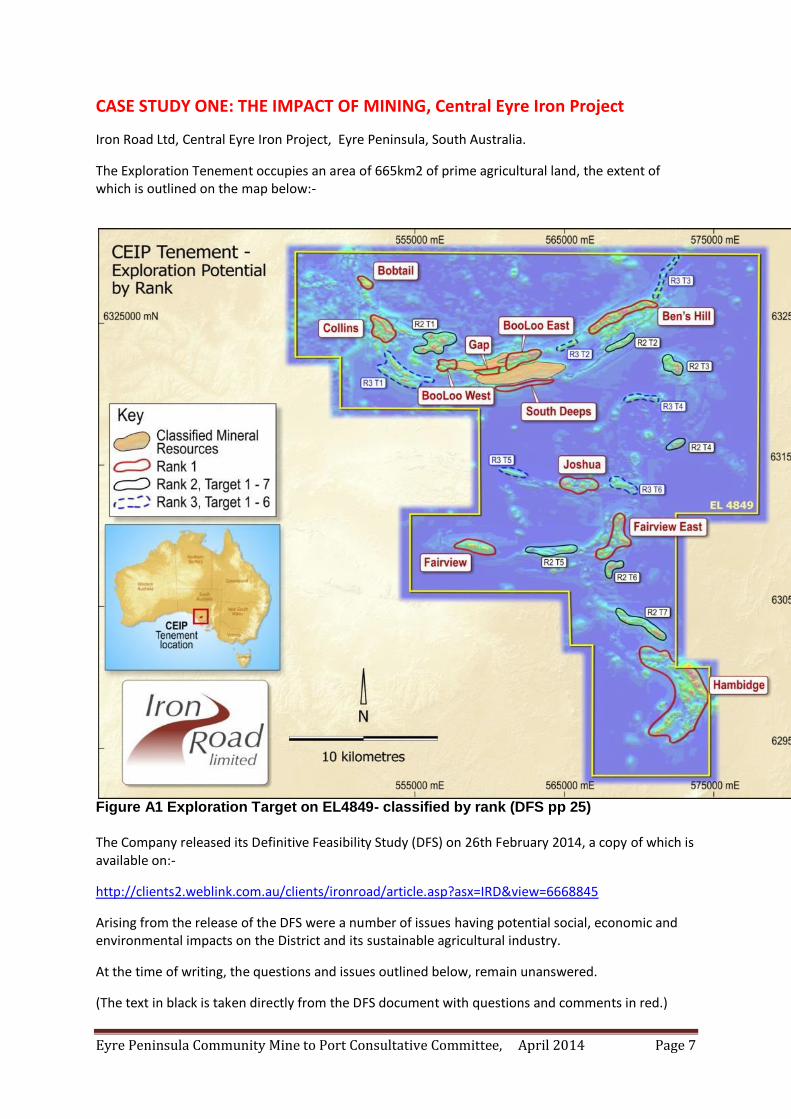
CASE STUDY ONE: THE IMPACT OF MINING, Central Eyre Iron Project
Iron Road Ltd, Central Eyre Iron Project, Eyre Peninsula, South Australia.
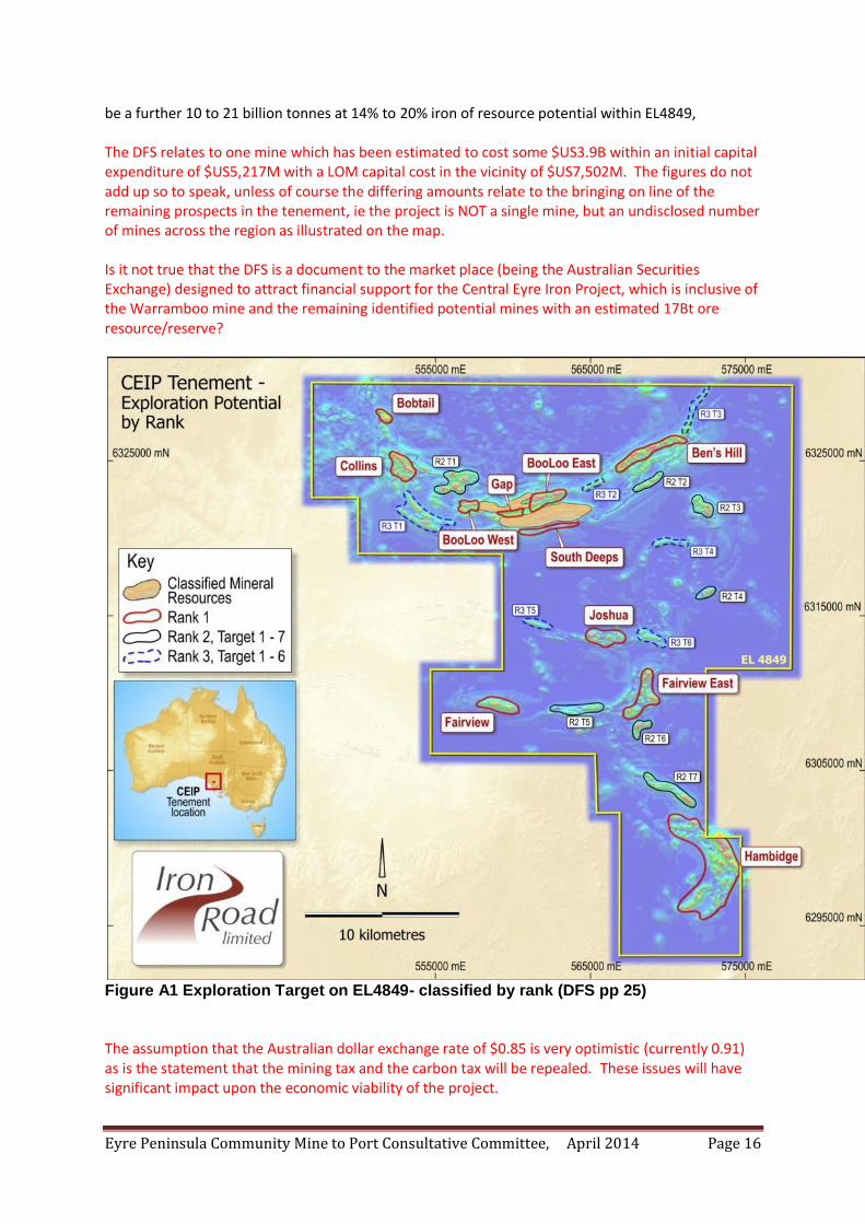
The Exploration Tenement occupies an area of 665km2 of prime agricultural land, the extent of which is outlined on the map below:-
Figure A1 Exploration Target on EL4849- classified by rank (DFS pp 25) The Company released its Definitive Feasibility Study (DFS) on 26th February 2014, a copy of which is available on:-
http://clients2.weblink.com.au/clients/ironroad/article.asp?asx=IRD&view=6668845
Arising from the release of the DFS were a number of issues having potential social, economic and environmental impacts on the District and its sustainable agricultural industry.
At the time of writing, the questions and issues outlined below, remain unanswered.
(The text in black is taken directly from the DFS document with questions and comments in red.)
Eyre Peninsula Community Mine to Port Consultative Committee, April 2014 Page 8
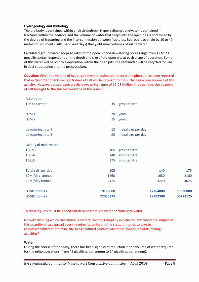
Hydrogeology and Hydrology The ore body is contained within gneissic bedrock. Hyper saline groundwater is contained in fractures within the bedrock and the volume of water that seeps into the open pits is controlled by the degree of fracturing and the interconnection between fractures. Bedrock is overlain by 10 to 40 metres of sediments (silts, sand and clays) that yield small volumes of saline water. Calculated groundwater seepage rates to the open pit and dewatering bores range from 12 to 23 megalitres/day, dependent on the depth and size of the open pits at each stage of operation. Some of this water will be lost to evaporation within the open pits; the remainder will be recycled for use in dust suppression and the process plant. Question: Given the volume of hyper saline water estimated to enter the pit(s), it has been reported that in the order of 400+million tonnes of salt will be brought to the surface as a consequence of this activity. However, based upon a daily dewatering figure of 12-23 Million litres per day, the quantity of salt brought to the surface would be of the order :
Assumption
TDS sea water 35 gms per litre
LOM 1 20 years
LOM 2 25 years
dewatering rate 1 12 megalitres per day
dewatering rate 2 23 megalitres per day
salinity of mine water
TDS x3 105 gms per litre
TDSx4 140 gms per litre
TDSx5 175 gms per litre
Total salt per day 105 140 175
12Ml/day tonnes 1260 1680 2100
23Ml/day tonnes 2415 3220 4025
LOM1 tonnes 9198000 12264000 15330000
LOM2 tonnes 22036875 29382500 36728125
To these figures must be added salt derived from sea water or from bore water. Notwithstanding which calculation is correct, will the Company explain the environmental impact of this quantity of salt spread over the mine footprint and the steps it intends to take to restore/rehabilitate the mine site to agricultural productivity at the conclusion of its mining activities? Water During the course of the study, there has been significant reduction in the volume of water required for the mine operations (from 45 gigalitres per annum to 14 gigalitres per annum).
Eyre Peninsula Community Mine to Port Consultative Committee, April 2014 Page 9
Water supply investigations along the utilities corridor identified a high yielding saline aquifer located west of Kielpa, 56 kilometres from the mine site. Studies are continuing to verify the capacity of this aquifer with a view to meeting the entire CEIP water demand with saline groundwater, supplemented by water recovered from open pit dewatering. Question: What is the regional hydrological impact of (a) dewatering the Warramboo pits to the extent of 12-23 million litres per day and (b) the proposed extraction of water from the proposed Kielpa bore field? What is the impact of dewatering at Warramboo and Kielpa in terms of water required to sustain the environment? Notwithstanding the fact that the proposed Kielpa bore field is extracting saline water, what is the long term economic impact of reducing the water reserves that may become available for agricultural or human use due to advances in solar distillation technologies that could be applied to this water reserve? This is the future generational impact of what is being proposed to quote 'benefit the short term aspirations of the mining company'. Port Facilities The Cape Hardy bulk commodities port is planned to have an initial capacity of 70 million tonnes per annum with the main export wharf capable of handling Panamax and Capesize vessels. Two shipping berths for bulk iron ore carriers will be serviced by a travelling/slewing ship loader. Heavy-lift ships and geared Handymax vessels will be accommodated in the inner harbour. The port precinct includes 1,100 hectares of land to enable future expansion and to offer export solutions to third parties for a range of commodities. The inner harbour may be used for the import and export of low-volume high-value cargoes, including the import of machinery, cement and fertiliser and the export of copper concentrates, grain and other containerised cargoes. The port site concentrate handling system consists of a receivals (in loading) circuit and an out loading circuit. The in loading circuit is designed to receive concentrate from the rail system via a bottom discharge dumper. Question: Nowhere in the DFS is reference drawn to the mining of copper at Warramboo. Furthermore, no reference has been made to the toxicity of copper in sea water, especially in light of the fact that Cape Hardy is on the migratory path of the Southern Wright Whale, a totally protected species. Are we to assume one of the undisclosed outputs from the mine is copper? Question: Given the quantities of fuel likely to be consumed, does the proposed port have the capacity to receive and store fuel? Question: It is noted that the ore will be transported from the mine in covered bottom dump wagons. Are the wagons sealed to prevent the escape of fugitive dust? Are the wagons decontaminated (cleaned) before leaving the port facility on the return to the mine? Question: Fugitive dust is of significant concern. The DFS is very short on information relating to the potential risks associated with fugitive dust contamination, indeed, the JORC statement on the environment failed to mention the potential risks due to contaminated pastures, cereal grain, wool, meat and rain water, not to mention potential health risks to humans. Is it a matter of convenience
Eyre Peninsula Community Mine to Port Consultative Committee, April 2014 Page 10
to overlook the accumulative impact of the 4% free silica contained in the final ore concentrate and the health effect of continued exposure over a significant period of time? Is it a matter of convenience to not make scientifically supported (including independent peer review) of all chemical analytical results pertaining to the presence or otherwise of heavy metals (Chromium (VI); Cadmium; Arsenic; Uranium and other radioactive substances (Thorium, Strontium [87], Radon) that are known to occur in deposits of this nature in the Gawler Craton and or the Paleochannels known also to exist within the region? Question: It is noted that the proposed port is listed as an export port for copper concentrate. This the first occasion that the export of copper has been raised, therefore what are the environmental impacts of copper in the proposed project? Firstly what risk assessment has been undertaken to determine the impact of copper (at levels greater than those considered to be trace levels for the purpose of agriculture) on the farming community both in and around the proposed mine, the corridor and at Cape Hardy, especially in the context of copper toxicity in sea water and the very probable environmental damage arising? Where does the copper come from? Workforce
Construction During construction the CEIP is expected to have a nominal peak workforce of approximately 1,950 people. Operations CEIP operations are expected to directly employ approximately 700 people. The mine, rail and port will run on a continuous 24/7 basis. Most employees will be engaged on continuous shift rosters, although there will be a smaller number employed on a day shift only basis or a normal five day working week. Iron Road will seek to employ a large portion of its operational labour force locally and from regional centres near the mine and port. Additional personnel will be sourced from Adelaide. As a result, the workforce is expected to be a mixture of residential, drive-in, drive-out (DIDO) and fly-in, fly-out (FIFO). Comment: The demographic probability of this occurring is remote. If one examines the workforce profile for the Hillside Mine (Ardrossan) it is obvious that the greater proportion of the workforce will be sources on a fly-in fly-out basis. In addition employees taken from the local districts will place current employers in an untenable position due principally their inability to match the salaries on offer from the mining company. This comment would apply equally to local Councils and their ability to retain the services of heavy machinery operators and truck drivers in particular. The employment 'carrot' is not as one expects! Construction Camps The CEIP will utilise two construction camps to house the construction workforce over the Project’s duration. A camp of approximately 1,300 rooms will be located within the mine site footprint east of Warramboo and a camp facility containing approximately 650 rooms will be located within the Port precinct at Cape Hardy. Both construction camps will be modular constructions and provide serviced facilities including kitchen/dining facilities, wet messes, administration buildings and recreational facilities. Question: Given that both of these facilities are included in the Major Project Development application and therefore come under the auspices of the Minister and Planning SA for ultimate approval, what financial liability has the District Council of Wudinna in the meeting of Council
Eyre Peninsula Community Mine to Port Consultative Committee, April 2014 Page 11
controlled infrastructure (roads, water and waste water) to service these camps, or will the Company totally finance this aspect of the development? Accommodation Village The CEIP long-term operations village, to be situated in Wudinna, will house approximately 250 to 300 employees. The village will feature a modular built central hub with single and double room housing, reception and dining facilities. The village will be landscaped with native plants and winding pathways, creating a modern yet welcoming ‘home-away-from-home’ facility for the CEIP workforce. This facility is included in the major development application and hence all approvals pertaining to the village will be the province of the Minister and Planning SA. Question: What financial liabilities has the Wudinna District Council in meeting Council controlled infrastructure (roads, water, waste water etc) connections to the village boundary, noting every other aspect of the village is the province of Planning SA and the developer, given that there is (in the absence of evidence to the contrary) no memoranda of understanding or Deeds of Agreement between Council and the Company on these matters? The rate payers are at this point in time exposed to unknown liabilities. Local Roads The District Councils of Cleve, Tumby Bay and Wudinna are being consulted on possible road modifications required in their respective areas and some have submitted estimates for proposed upgrades and alterations. Question: Given the proposed development ant the volume of heavy trucking required has the Company entered into any Memoranda of Understandings (as a precursor to formal Deeds of Agreements) with the various Councils concerned with respect to the construction (fit for purpose), maintenance and rehabilitation of the said roads over the life of the project(s)? It is understood that most of the identified roads are not of a suitable standard to cater for the anticipated heavy loads. Has the Company sought application of the Transport Division (DPTI) for assessment of these roads to ensure that they are capable of safely handling the proposed traffic? Regulatory Approvals The proposed mine at Warramboo will be subject to both a Mining Lease and a Program for Environmental Protection and Rehabilitation pursuant to the Mining Act, 1971. Lodgement of the Mining Lease application to the State Government for assessment is anticipated during Q3, 2014. The infrastructure components of the CEIP such as the port, rail, power and a long term accommodation village at Wudinna will be subject to a Development Approval under the Development Act 1993. The expected assessment level for the Development Approval is an Environmental Impact Statement, the highest level of assessment for developments in South Australia. The initial Development Application is scheduled for submission to the State Government during Q1, 2014. Referrals under the Federal Government’s Environmental Protection and Biodiversity Conservation Act 1999 will be submitted during Q1, 2014 to determine if further assessment is required. A range of other State and Federal Government approvals will be sought during 2014. Note: It should be recognised that NO approvals exist at this point in time.
Eyre Peninsula Community Mine to Port Consultative Committee, April 2014 Page 12
The DFS is in fact a speculative document and is very much subject to the receipt of the above approvals. Environment and Community Environmental and social impact studies, including baseline technical surveys and meetings with community groups and government agencies have ensured that Iron Road understands the potential benefits and impacts of the CEIP. Note: It should be recognised that no environmental or social impact statement have been released therefore the content of these studies HAS NOT BEEN SUBJECTED to any PUBLIC or third party scrutiny. No clearly defined statement as to the impacts, social or economic, have been released to the public, hence the veracity of these reports remain subject to review. ‘JORC Code 2012 Table 1’ Section 2 Reporting of Exploration Results Sampling Techniques: Samples were also analysed for As, Sn, Ba, Sr, Cl, Ni, V, Co, Zn, Cr, Pb, Zr and Cu It is noted that uranium, thorium and other radioactive elements were not included in the analytical work, therefore the following questions remain unanswered: Given the known presence of uranium, thorium and other radioactive materials in the Gawler Craton bedrock and associated Paleochannels in the district, why are these substances precluded from any analytical results? Given the inclusion of Lead [Pb] in the analytical data, which isotope of lead was reported on, given that lead is the end product of various decay sequences for radioactive elements? Was it Pb 214; Pb 211; Pb 210; Pb 209; Pb 207 or Pb 206? Was lead therefore used as a marker for the presence of uranium? What was the concentration of the lead in ppm? Given that strontium was reported in the analytical result, what isotopic form of strontium was identified? If it were Sr87 (the radioactive isotope) was this used to determine the geologic age of the deposit using the Sr87/Rb87 dating procedures? If not, what was the concentration of the strontium sample in ppm? It is noted that the analytical work sought to determine the presence of arsenic and chromium. That being the case, what was the concentration of arsenic in ppm? With respect to the chromium, was the sample tested for hexavalent chromium (Cr(VI)? If so, what were the concentrations in ppm? It is noted that no mention in the analytical work was made of the presence or otherwise of cadmium.
Eyre Peninsula Community Mine to Port Consultative Committee, April 2014 Page 13
Given that Boron is an issue for the agricultural industry, why wasn't an analysis for the determination of existence and concentration of boron in the samples undertaken? The issue being, if boron rich soil/overburden is brought to the surface as a consequence of mining and this material drifts onto neighbouring properties, agricultural yields could well be affected. It is noted that samples were analysed for the presence of copper. What concentrations of copper occurred in the samples in ppm? Environmental factors or assumptions
Assumptions made regarding possible waste and process residue disposal options. It is always necessary as part of the process of determining reasonable prospects for eventual economic extraction to consider the potential environmental impacts of the mining and processing operation.
While at this stage the determination of potential environmental impacts, particularly for a greenfields project, may not always be well advanced, the status of early consideration of these potential environmental impacts should be reported. Where these aspects have not been considered this should be reported with an explanation of the environmental assumptions made.
No environmental assumptions have been considered in the estimation Comment: As alluded to earlier in this response, the issue of the presence of radioactive material is of considerable concern, given that the MLP is proposed for the mining of iron ore and does not include the mining of radioactive material. It is therefore assumed that if said materials are present then the disposal plan is for this material to be deposited on the waste rock heap. That being the case (and clearly in the lack of evidence to the contrary) the material will be exposed to wind and water migration. Wind will result in the transportation of the material into neighbouring farming properties potentially contaminating pastures, grain, and through the food chain meat. Rain will potentially leach the material from the waste dumps into the underlying and surrounding environment. The issue of radon gas which is a characteristic of mining deposits such as that proposed is not dealt with. The environmental impact of significant quantities of diesel fumes and particulates emanating from the mine is not dealt with. The real issue of fugitive dust which contains not only iron ore dust but potentially significant quantities of free silica as a consequence of the mining process is of a major concern. Added to this is the issue of fugitive dust arising from the transportation of the refined ore from the mine to the proposed port some 145 kilometres through prime agricultural land. The processed ore is reported to contain up to 4% silica and a non disclosed amount of other material, some of which may well be heavy metals. The inference is that there are no environmental impacts from dust. It is claimed that some 12 to 23 megalitres of water will be removed from the mine as a consequence of the dewatering process and that this water will be primarily used to control dust and other components of the process. It has been conceded that this water is hyper saline and one estimate is in the order of 400 million tonnes. A calculation based upon the dewatering rate would
Eyre Peninsula Community Mine to Port Consultative Committee, April 2014 Page 14
suggest a lower figure, but none less significant in its environmental impact. The inference being that this does not constitute an environmental impact! As mentioned previously, the dewatering of the mine and the drawing of water from the proposed Kielpa bore field has an hitherto unknown regional impact both for water security and the environmental impact of such large scale dewatering. Environmental
The status of studies of potential environmental impacts of the mining and processing operation. Details of waste rock characterisation and the consideration of potential sites, status of design options considered and, where applicable, the status of approvals for process residue storage and waste dumps should be reported.
Iron Road will require approval under the Mining Act (1971) which includes the approval of a Mining Lease Proposal (MLP) and a comprehensive Program for Environment Protection and Rehabilitation (PEPR).
All baseline environmental surveys have been completed. The preliminary impact assessment did not categorise any potential Project impacts as 'High'. Detailed impact assessments are on-going in areas including air quality, groundwater, surface water, flora, fauna, noise, social, visual, and heritage.
It is expected that all predicted impacts may be adequately mitigated and/or managed and that the MLP and PEPR will be subsequently approved by the State Government.
Note: In addition to the previous comments, the report fails to acknowledge the presence of protected species in the proposed project area (the Mallee Fowl and the Southern Right Whale). The report fails to acknowledge the health impact of the proposal. The report indicates the need to prepare a PEPR, but in the absence of evidence to the contrary, this document to date is not for public knowledge. In short, the environmental performance criteria for which compliance is required is contained in a non disclosed document. The environmental and economic impact of the transport corridor appears not to have been included in any risk assessment pertaining to this disclosure document. The rehabilitation of the mine footprint and hole at the end of life, given the quantity of salt deposited on the footprint, is a significant undeclared environmental risk, given the expectation that the land will be returned to current use, ie agricultural land.
Eyre Peninsula Community Mine to Port Consultative Committee, April 2014 Page 15
Economics: Continuing with the JORC disclosure requirements.
The estimated LOM capital costs for the Project are $7,502M and are summarised below. o Initial capital $5,217M o Sustaining capital $1,815M o Mine closure $ 470M
Economic
The inputs to the economic analysis to produce the net present value (NPV) in the study, the source and confidence of these economic inputs including estimated inflation, discount rate, etc.
NPV ranges and sensitivity to variations in the significant assumptions and inputs.
The financial evaluation undertaken as part of the DFS indicated a post-tax net present value (NPV) at a 12.5% discount rate of $444M and an internal rate of return (IRR) of 13.9%.
The key financial parameters were:- o Discount rate 12.5% o Tax rate 30.0% o Royalties (Year 1 - 5) 1.5% (Year 5 - 20) 3.5% o Start of construction Oct 2014 o Construction period 4 years o Life of mine 20 years o Initial capital expenditure $5,217M o Sustaining capital (LOM) $1,815M o Mine closure $ 470M o Operating cost $71.60/dmt o Product price (LOM average) $158dmt
Sensitivity analysis indicated that a 10% change in product price, operating cost and capital cost resulted in the following impact on the pre-tax NPV:-
o Product price ±180% o Operating expenditure ± 92% o Capital expenditure ± 79%
Comment: The benefit to the State through royalties is zero for the first 4 years (the life of the current parliament) and a concessional rate for the next 5 years presumably based upon an official agreement (Memorandum of Understanding or Deed of Agreement) with the State Government. Given that no formal assessment processes have commenced or applications lodged, the start timeline is non-achievable, and yet "Iron Road has no reason to believe that the necessary Government approvals will be received within the timeframes anticipated in the DFS"? Comment: Much has been said with respect to the economics of the Warramboo mine, note singular mine. Yet the DFS continues with respect to providing what is irrelevant information pertaining to the potential ore reserves for the remainder of the tenement as quoted hereunder. It is noted that the life of the mine varies from 25 years (page 3 of release) and 20 years in the JORC statement., but The CEIP offers a potential operating life in excess of 25 years.
Based on regional exploration work completed to date and increased ore body knowledge, there is
an estimated to
Eyre Peninsula Community Mine to Port Consultative Committee, April 2014 Page 16
be a further 10 to 21 billion tonnes at 14% to 20% iron of resource potential within EL4849, The DFS relates to one mine which has been estimated to cost some $US3.9B within an initial capital expenditure of $US5,217M with a LOM capital cost in the vicinity of $US7,502M. The figures do not add up so to speak, unless of course the differing amounts relate to the bringing on line of the remaining prospects in the tenement, ie the project is NOT a single mine, but an undisclosed number of mines across the region as illustrated on the map. Is it not true that the DFS is a document to the market place (being the Australian Securities Exchange) designed to attract financial support for the Central Eyre Iron Project, which is inclusive of the Warramboo mine and the remaining identified potential mines with an estimated 17Bt ore resource/reserve?
Figure A1 Exploration Target on EL4849- classified by rank (DFS pp 25) The assumption that the Australian dollar exchange rate of $0.85 is very optimistic (currently 0.91) as is the statement that the mining tax and the carbon tax will be repealed. These issues will have significant impact upon the economic viability of the project.
Eyre Peninsula Community Mine to Port Consultative Committee, April 2014 Page 17
Social
The status of agreements with key stakeholders and matters leading to social licence to operate.
A baseline social impacts and benefits study has been completed and results discussed with stakeholders.
Various Community Consultative Committees have been formed for the purpose of consultation, information and feedback.
Community engagement events and public meetings are regularly held to keep communities informed.
Comment: That being the case, why is the company NOT conducting public meetings in the township of Tumby Bay, given that a significant component of the project resides within the District Council of Tumby Bay and potentially impacts on the ratepayers of the District. With respect to the community consultative committees, the question of community representation given that the Company invited certain members to the table, versus a truly independent community based (elected) committee without formal members being employees of the mining company needs to be examined in detail. Experience has shown the current committees to be an avenue for the company to provide its point of view, not for a robust debate of the merits or otherwise of the proposals. Other
To the extent relevant, the impact of the following on the project and/or on the estimation and classification of the Ore Reserves:
o Any identified material naturally occurring risks. o The status of material legal agreements and marketing arrangements. o The status of governmental agreements and approvals critical to the viability of the
project, such as mineral tenement status, and government and statutory approvals. There must be reasonable grounds to expect that all necessary Government approvals will be received within the timeframes anticipated in the Pre-Feasibility or Feasibility study. Highlight and discuss the materiality of any unresolved matter that is dependent on a third party on which extraction of the reserve is contingent.
o No significant (high) naturally occurring risks were identified during a whole of project risk assessment.
o Iron Road Limited has not yet entered into any formal marketing arrangement for the sale of iron concentrates and is currently progressing this area.
o The Exploration Licence is in good standing with all legal obligations met. Regular meetings with state and federal Government agencies occur for the purposes of discussing required approvals and facilitating meetings with other stakeholders.
o A Mining Lease and Program for Environmental Protection and Rehabilitation (PEPR) must be approved before the reserve can be extracted and are dependent on the approval of the Minister for Mineral Resources.
o Iron Road has no reason to believe that the necessary Government approvals will be received within the timeframes anticipated in the DFS.
Comment: As mentioned previously there are at least four naturally occurring risks which the Company has failed to recognise:
a) the habitat of the protected Mallee Fowl, b) the habitat of the Southern Right Whale,
Eyre Peninsula Community Mine to Port Consultative Committee, April 2014 Page 18
c) the presence of radioactive materials and or heavy metals, d) Regional ground water impacts.
REGIONAL COMMUNITY IMPACTS:
I appreciate the fact that this is early days in the project’s development and that there are significant hurdles yet to be jumped, but experience has shown that transparency/disclosure is not necessarily what mining companies are cognisant of. It is understood that the Company has sought Development Approval (August 2013) through Section 46 of the Development Act for associated infrastructure and that this application has been gazetted in the South Australian Government Gazette. That being the case, all development proposals identified in the Gazette Notice will be subject to the Development Commission Assessment process under the control of the Minister for Planning and the Department of Planning and not the local government authority. The Government will no doubt require the Company to undertake a full Environmental Impact Statement (EIS) or a Public Environmental report (PER) at the very least. Both of these assessments enable the public to comment on the proposal. If past experience is followed, Council will be asked to comment on the documentation via a formal communication from the Minister or his/her delegate. Short of the Council’s comments, all development decisions will be the province of the Minister. Given that it rare that final approval will be given first off, the usual practice is to grant Provisional Development Authority subject to conditions. With respect to the road network, the Provisional Development Authority will most likely contain Reserved Matters related to the requirement of the Company to enter into Deeds of Agreement with not only the Wudinna District Council, but also Cleve and Tumby Bay District Councils, where appropriate. As you are no doubt aware, these agreements are legally binding for the life of the project (Agreement) and are enforceable at law. They are expensive to generate and manage. Therein it is of both significance and relevance to have adequate responses to:
Has Council entered into any Memorandum of Understanding with the Company in respect to the development of such documents and the cost sharing arrangements that may be involved?
Has Council sought legal advice in advance of the process to fully appreciate what is involved and the long term impact upon Council and therefore the ratepayers?
One of the obvious questions relates to what happens to the road network at the end of the project?
What are the terms and conditions of the handover where Council resumes control of the roads?
Whilst talking about roads and the proposed network, one is lead to ask:
What are the engineering characteristics of the roads under consideration, i.e. who designs and certifies the roads to take the loads likely to be required to service the mine? (These are not internal roads with the mine site, but the roads that connect the mine to the outside. The internal road network is clearly the responsibility of the Company).
Eyre Peninsula Community Mine to Port Consultative Committee, April 2014 Page 19
What are the consequences of the new road network, i.e. new roads outside of the mine site, for Council?
What are the consequences and additional costs for emergency services (ambulance, CFS, SES) in accessing the community via the new road network?
What is the cost to the agricultural industry of the new road network with respect to grain deliveries and other freight requirements?
What, if any, is the impact of the new road network on School Bus routes?
What impact does the creation of the new road network have on the existing water reticulation system and thus the ability of the CFS to access water for fire fighting?
What impact does the creation of the new road network have on existing underground communication cabling?
In discussions with the Company and the determination of estimated costs to alter/upgrade the network, were the aforementioned issues taken into consideration?
Who bears the cost when to alter/upgrade the road network the changes affect property owners?
Has Council sought preliminary legal advice in advance of these processes to fully understand the implications and the possible costs (hence costs to the ratepayers)?
As previously mentioned, the Government will control the approval processes including those involved with the accommodation villages.
What Memorandum of Understanding has Council entered into or contemplated with respect to the provision of Council services to the boundary of the proposed accommodation development site, for example, what unfunded liability will Council (and the ratepayers) face in the provision of access to the Community Waste Water Management Scheme or to the provision of suitable roadway access to the village?
Once the village is occupied, what is the rating regime to be applied?
Given that the now declared mining lease is of the order of 100km2, what is the impact on the capital value of all properties in the immediate location of the mine and its transport corridor?
Experience in other places indicates the capital value of affected properties is lowered.
Given the potential for a significant decrease in rate revenue, what is the Community expectation about a rate rise to offset the loss of revenue associated with the cost of mining?
Given also that the project will be controlled by the State Government, what is the likelihood of Council owned property being compulsory acquired (Section 78 of the Development Act) to facilitate the advancement of the project?
What Council property is at risk?
What is the financial impact on ability of Council to borrow funds in light of the potential loss of Council assets and a reduction in rate revenue as a consequence of the mining project?
It is noted that a mining lease is not a rateable entity.
What is the potential rate revenue loss associated with the mining lease? It is also noted that the fees associated with the assessment of a development will not be paid to Council, but to the State Government. There is also no return of royalties gained by Government to Local Government at this point in time. The question therefore is:
What is the economic benefit to Council of the mining proposal?
Eyre Peninsula Community Mine to Port Consultative Committee, April 2014 Page 20
The Social Licence to Operate. The Company claims in the DFS that the baseline social licence study is complete and it has several committees with which it is consulting. One needs to question the veracity of this statement, given the very limited representation of the CEIP Community Consultative Committee that is limited to Wudinna and the immediate vicinity of the mine. There is no formal community representation on the CCC from communities affected by the transport corridor or other Council areas. The volunteers on the committee are not representative of the affected communities. The existence of a Social Licence to Operate across the whole project, I would suggest is non-existent. The Mining Lease (yet to be confirmed by a formal application and assessment) is reported to be recently reduced for the Warramboo component of CEIP. Not-with-standing this reduction in area:
What is Council’s position to the statement that some 400+ Million tonnes of existing salt which will be supplemented by an additional 13 Million tonnes if sea water is used and or 6 Million tonnes if bore water from Kielpa is used, is likely to be deposited on the surface of the lease over the life of the mine?
What position does Council take on the fact that this quantity of salt now on the surface and available to be transferred by wind and rain to neighbouring agricultural properties and roadways with potentially significant economic consequences?
Is this consistent with Council's Environmental policies as laid out in its Development Plan? Given the disclosure of the quantity of water to be removed from the aquifer (as declared in the Definitive Feasibility Study,[DFS]), it has been claimed that the dewatering of the mine would have 'absolutely no impact upon Polda', but no peer assessed scientific regional hydrological study has been produced to substantiate this claim:
What is Council’s position on the dewatering of the said aquifer and the potential impact upon the environment as a consequence not just in the confines of the mining lease, but the environment beyond the mine boundaries?
In accepting the stated dewatering rates of 12 and 23 Million litres per day for the life of the mine of 25 year, the net quantity of water removed is 109,500 Million litres to 209,875 Million litres. To this must be added the quantity of groundwater which will fill the hole following cessation of mining activities at the Murphy South site. This creating the 6.5km+ long by an average width of 500 metres (allowing for the battered/walls and slope of the hole) and 600 metre deep artificial lake with unknown water quality but due to existing salinity would be up to 5 times the salinity of seawater. This volume of groundwater equates to approximately 1,950 gigalitres or roughly 3.9 Sydney Harbours (Sydharbs) but with a salinity as high as could be obtained from 19.5 Sydharbs. THIS WATER HAS TO COME FROM SOMEWHERE! What is being ignored is the regional picture. There is an approved mine at Wilgerup where dewatering will occur; the proposed mine at Warramboo and the proposed bore field at Kielpa. In addition, there is renewed interest in the Lock Coal Field and surrounding area, the tenement of Lincoln Minerals Ltd adjacent to the CEIP to the West and Centrex Metals Ltd to the South East, not to mention the prospect of undeclared multiple mines associated with the CEIP given the declaration to the Australian Securities Exchange (ASX) of:
The project cost being $7.2 Billion not the $3.9 Billion or $4.5 Billion currently suggested.
The declared exploration reserves of a further 17 Billion tonne of ore.
Eyre Peninsula Community Mine to Port Consultative Committee, April 2014 Page 21
The public/community has an absolute right to question the nature of the deposit. It is a known fact that that Paleochannels exist in the area (a channel which is suspected of containing Uranium or other radioactive substances). It is also known that similar geological deposits in the Gawler Craton have concentrations of Uranium within the ore bodies. It is also known that mining bedrock of the nature identified can produce Radon. On this basis, it is reasonable for the public to ask the appropriate questions. Hence:
Why was analytical work reportedly not undertaken to conclusively prove the non-existence of Uranium or its isotopes?
Why was no work reportedly undertaken to disprove the presence or other wise of radon?
What is the significance of identifying the presence of Strontium and Lead in the assay results presented to the DFS, noting that there are radioactive isotopes of Strontium and Lead?
Was the lead identified in the analysis presented, the isotopic form of lead at the end point of the decay of Uranium i.e. was the lead a marker for the presence of Uranium?
The DFS also raised the issue of exporting Copper from Cape Hardy.
Where does the Copper come from?
What is the concentration of the Copper in the ore body?
How is the ore to be processed to generate a product for export?
What is the chemical nature of the Copper product?
What are the environmental impacts of excess Copper in fugitive dust or accidental spills in the loading of the product at Cape Hardy, noting the known toxicity of Copper to cereal crops and the marine environments?
The Uranium debate is critical to the approval process. It is also critical in terms of contamination of grain, pastures and livestock. The presence of Uranium, it is understood, also affects the ability of people to obtain insurance. This is not scaremongering, but good due diligence and answers are an essential feature at this stage of the development process. The DFS commentary continues with “there are no significant concentrations of heavy metals....” but no mention of the fact that ‘heavy metals ‘ is usually associated with the presence of Cadmium, Arsenic and Chromium (VI).
What are the concentration of the Arsenic, Cadmium and hexavalent Chromium in the ‘mined’ rock?
Whilst there is no mention made in reference to where these heavy metal products, where will they end up in the total operation of the mine?
Do they reside in the waste rock dump and therefore subject to wind and water migration into the environment?
This is a significant question as these compounds are known carcinogens; hence the issue becomes a Public Health issue as well as an issue to be managed under Occupational Health and Safety legislation. The point being made here is that the question of the exact composition of the material that is likely to emanate from the proposed mine (fugitive dust) needs to be clearly identified, given the potential health risks associated with fugitive dust and especially in this case where the mine is proposed to be of some 6.5 kilometres in length. The potential exists for a considerable area to be contaminated by dust. The dust from the mine is not as it was reported “as the same as that which a farmer generates through ploughing”, hence the need for accurate disclosure.
Eyre Peninsula Community Mine to Port Consultative Committee, April 2014 Page 22
In addition to being satisfied with the composition of the dust emanating from the mines and associated activities (spoil heaps, tailing dams...), the issue of fumes and particulates arising from diesel based machinery also needs to be considered, given the anticipated numbers of vehicles in a relatively confined space. It is recognised that diesel fumes and particulates are known carcinogens. It is recognised that the Company has refined its mining and processing reducing its dependency upon diesel somewhat, but the question still arises. Given Council’s environmental policies as stated in the Development Plan:
What are Council’s view on the potential impact of dust contamination and other particulates on the communities it represents?
What is its view on the potential economic cost to the agricultural industry in the Council area of contamination of grain, pasture and wool?
What is the composition of the ore to a depth of 600 metres, noting that the mine was described by Mr Stock as being 6.5 kilometres long, 600 metres deep?(Port Lincoln Times, 11 Mar 2014, pp4)
It is noted in the DFS that the rail wagons transporting ore will be covered. Covered does not imply sealed to prevent fugitive dust. Environmental Issues. Given that no formal assessment processes have taken place at this point in time, one can but await the arrival of an Environmental Impact Statement; a Mining Lease Application and an EPBC referral in order that all environmental, social and economic issues are addresses from the mine to the port. Not-with-standing these assessment, Council should have on file a copy of the Company’s PEPR document(s) pertaining to their environmental performance criteria as demanded by DMITRE at the time of granting of the Exploration Licence (or licences which implies more than one PEPR) given that Council has given approval to drilling activities on Council controlled land.
Does Council have a copy of the document(s)? The Transport Corridor. The exact location of the transport corridor has yet to be released, but it is known that the corridor will cross a number of salt creeks and salt pans. The problem arising here is one of compaction. Compaction of the ground under the rail line will result in a significant disruption to the normal environmental flow of groundwater (high in salts). The Mining enterprise. It would appear that there are two versions of what constitutes the Central Eyre Iron Project, one being provided to the media and Council, the other to the Australian Securities Exchange (ASX). The ASX version details the total project with respect to the tenement as a whole and not just the area surrounding Warramboo. It is understood that the ASX version is for the purpose of satisfying the rules of the ASX and to attract investors. The ASX version is that which is compliant with the rules of the Exchange and therefore can be taken as the true state of play because of its share price sensitivity. That being the case:
What is the true extent of the CEIP proposal involving the total reserve resource of some 17 Billion tonne in addition to that identified at Warramboo?
Eyre Peninsula Community Mine to Port Consultative Committee, April 2014 Page 23
If this is the big picture there will not be one hole of 6.5 kilometres, but potentially up to 52+kilometres of holes across the tenement.
What therefore is the actual impact of the venture over the whole 660 km2 tenement?
What is the environmental and economic impact of the big picture for the agricultural industry of the district?
What is the economic impact on the Wudinna District Council in this context?
Where is the Productivity Commission enquiry into the impact taken over the 25 years of the Warramboo proposition and thence over the whole tenement?
The even Bigger Picture. Whilst there is no evidence to suggest any development is likely in the short term by Lincoln Minerals Ltd, this company has the Exploration Licence for the adjacent tenement to the west of Iron Road and there is a high probability that the ore deposits continue to the west. Lincoln Minerals has expressed support for the Iron Road project and the infrastructure that it may bring to the area. The question now arises:
What are the potential economic and environmental impacts of this potential development? Add to this the small tenement to the South east of the Iron Road tenement held by Centrex Metals. Furthermore, it should be recognised that most of the land around the Iron Road tenement is held by other exploration companies. The question therefore remains:
What is Council’s position on preserving the agricultural industry in the District, or is its position one of overseeing the destruction of the agricultural industry and the resultant network of very large holes in the ground and huge overburden dumps?
To gain an insight into the environmental blight the Warramboo mine will create, one only has to imagine the transposition of the Iron Duke Mine onto the proposed site and doubling the size. Workforce Issues. One of the most contentious issues in these projects concerns jobs. We are currently being bombarded in the press with this project will create 1,950 construction jobs and 700 permanent jobs. Mr Stock goes on to claim the multiplier effect of this work force is “for every job that’s on site, there’s another three somewhere else, he said, “So if there’s 700 on site, that’s 2400 jobs.” (Port Lincoln Times 11 Mar 2014 pp4) What is not said is that the 2,400 jobs are not in the Wudinna District, but anywhere in Australia. On closer examination of the claims, one should ask for a listing of the workforce profile, i.e. how many heavy machine operators, how many diesel mechanics etc..., in short a detailed listing of positions available and the qualifications required to fill those positions. This list is then married up against the available supply of labour in the district (and then neighbouring districts to say a travel time of no more than 2 hours each way) that qualifies according to the requirements listed. The balance will be fly-in fly-out employees and this will, no doubt, constitute the greatest percentage.
Eyre Peninsula Community Mine to Port Consultative Committee, April 2014 Page 24
This list then needs to be broken down even further to those who qualify and who are already in employment. This is critical to the debate because of the potential wage differentiation that may well lure the existing workforce to the mines, thereby depleting the workforce that supported existing businesses. The economic impact of this is simply, the current employers will be required to match salaries in order to retain their workforce and services Experience in other places suggests this is the reality. Indeed in one instance in Queensland, MacDonald’s Restaurant was forced to employ staff on a fly-in fly-out basis in order to operate. The ultimate consequence of this scenario is:
What is the impact on local pricing, given the potential of employers to match mining salaries?
If the answer is for significant increases in prices or to go out of business, then what percentage of the current community will be able to remain and afford the buy goods?
So here we are back at needing a full productivity commission report on the impact of mining on the region to be able to identify the requirements to manage the future of the existing community. Without that information the current community will predictably be displaced and replaced by the new transient workforce. Remembering that equal to the ‘positive employment calculation’ there is the ‘negative employment calculation’. For every existing job in the local community there are three flow-on jobs. For each existing job displaced due to prices/business closure then another three jobs will also be lost. Maybe the answer is that mining and agriculture cannot co-exist. The next question on the workforce is:
Does the Company have a drug and alcohol free work policy?
Does the Company have a testing regime to match? Water, water everywhere, but not a drop to drink. An apt introduction to the issue of water and the implications the proposed development will have on underground water. The DFS indicates dewatering of the mine to be some 12-23 Million litres per day on a continuous basis. It is also claimed that the majority of this water will be used in the various processes of the mine, supplemented by water from a bore field or desalination of sea water. It is obvious that water of any type (salinity) is a precious commodity on Eyre Peninsula given that the Peninsula is not served by a major desalination plant or connection to the River Murray pipeline network. It is also becoming more cost effective as technology advances to desalinate saline water, not necessarily with huge reverse osmosis desalination plants, but via solar distillation which is economic on a small scale (farm-size) enterprise or even household use as is the case in some European countries. The risk, however, is the dewatering occurring as a result of a mining enterprise, removes this water from future potential use for stock or human consumption, thereby further impacting upon rural industry and or community interests.
Eyre Peninsula Community Mine to Port Consultative Committee, April 2014 Page 25
The demand for a comprehensive regional hydrological study of all waters impacted by the mining proposal should be foremost in Council’s mind. These reserves are finite reserves. They will run out unless managed correctly.
KEY ISSUES ARISING IN THIS STUDY:
1. In the worst case scenario, ie all rank 1 targets are converted to active mines, the potential exists for approximately 50 kilometres of mines could be opened up with the corresponding loss of agricultural land.
2. There is the potential for a significant impact upon ground water through dewatering and or contamination due to the nature of the ore body (especially if it contains Uranium, Cadmium, Arsenic and Chromium (VI).
3. Fugitive dust is a significant issue with potential contamination of agricultural land from the activities within the mine footprint as well as from the transport corridor.
Unresolved issues include contamination of pastures; grain, wool meat (via digestion of contaminated pastures) and rain water catchments.
4. Significant disruption to existing farming practices through property acquisitions (some of which may be compulsory acquisitions) and through inappropriate alignment of the transport corridor (noting this will become private property).
5. Potential inefficiencies created by property acquisition (making farms smaller).
6. Social, economic and environmental issues do not receive the in depth research required in order for the community to make informed comments/decisions on he pros and cons of mining in agricultural land. The debate is one sided, all for the mining company in the hope that significant economic benefit is achieved. 7. Where are the Productivity Commission investigations into such proposals?
Eyre Peninsula Community Mine to Port Consultative Committee, April 2014 Page 26
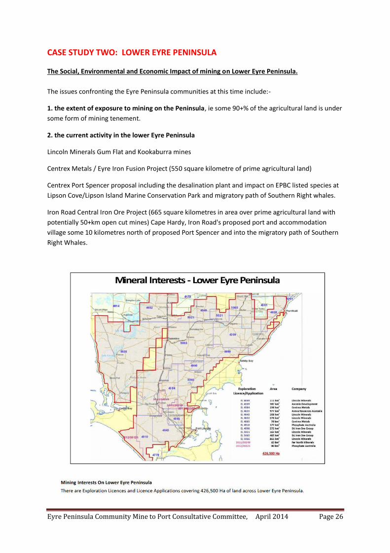
CASE STUDY TWO: LOWER EYRE PENINSULA The Social, Environmental and Economic Impact of mining on Lower Eyre Peninsula.
The issues confronting the Eyre Peninsula communities at this time include:-
1. the extent of exposure to mining on the Peninsula, ie some 90+% of the agricultural land is under
some form of mining tenement.
2. the current activity in the lower Eyre Peninsula
Lincoln Minerals Gum Flat and Kookaburra mines
Centrex Metals / Eyre Iron Fusion Project (550 square kilometre of prime agricultural land)
Centrex Port Spencer proposal including the desalination plant and impact on EPBC listed species at
Lipson Cove/Lipson Island Marine Conservation Park and migratory path of Southern Right whales.
Iron Road Central Iron Ore Project (665 square kilometres in area over prime agricultural land with
potentially 50+km open cut mines) Cape Hardy, Iron Road's proposed port and accommodation
village some 10 kilometres north of proposed Port Spencer and into the migratory path of Southern
Right Whales.
Eyre Peninsula Community Mine to Port Consultative Committee, April 2014 Page 27
3. Impacts on the environment include:
Potential destruction of the ground water due to dewatering of mines undertaken in the knowledge
that the only supply of potable water to the Peninsula is from the Prescribed Wells in the Region and
that some of the activity is actually planned to be undertaken in these areas.
The only surface water on the Peninsula is the Tod Reservoir. Whilst this water is of a quality not
suitable for human consumption, (our understanding is - the water is suitable for human
consumption and the inflows are annually equal to a useable potable resource but due to the
accumulation of chemicals, of which dry land salinity and evaporation generated residual salts are
but a lesser problem, which have been allowed to increase as deposits upon and into the ground
level mud and sediments. Such that the concentration of those toxic chemical waste pollutants place
the potable resource at risk if it is agitated and thereupon included into the potable volume or
seasonal overflows/discharges to the sea for the environmental stability of the downstream Tod
River. The decontamination of the reservoir is a responsibility of SA Water. That SA Water has
sought to not expend its finances to maintain the reservoir, in lieu of potable water from the Uley
Basin, is the primary reason why the annual Tod Reservoir catchment is not able (safe) to be used for
human consumption and why the flushing/removal of the now high level of chemical material would
pollute the environment if flushed to the sea. It is an environmental threat that SA Water is
obviously seeking to ignore.) the Government is planning to spend $14.8M to upgrade the facility
with the view that a mining company can have access to the water for an onsite desalination plant at
its graphite mine. It should be noted that no approval to mine has been granted and no
environmental assessment been undertaken. More-over in the absence of the environmental
assessment, no information is available as to the impact the proposed mine would have on ground
water, given that the mine is located in the Tod Reservoir water protection zone.
The environmental impact of the destruction of the head waters of the Tod has not been assessed,
but this area is one of the significant areas for mining in the Koppio Hills. What is also ignored is the
impact dewatering would have on the recently listed Eyre Peninsula Blue Gum habitat.
No regional hydrological impact study has been undertaken. Any potential impact outside of the
magic line that describes the Prescribed Wells is ignored by SA Water.
The granting of water allocations to mining companies is a major issue. Centrex has been granted
1.25 gigalitre of potable water for the construction phase of the proposed Port Spencer. This water
comes from the Prescribed Wells (Uley/Wanilla Basin), despite a previous commitment from the
then Minister Maywald (2008 WAP) that mining companies were to find their own water supply.
What has not been declared is where the water will come from to support the additional
accommodation villages at Tumby Bay (1000+) and Wudinna (1000+) as well as the proposed
construction camp (600) at Cape Hardy.
The impact on the Gulf with three additional ports being proposed, Lucky Bay, Cape Hardy and Port
Spencer all of which are located within the migratory path of the Southern Right Whales as well as
other listed species, such as leafy sea dragon (at Lucky Bay). Two of these proposed port will have
desalination plants associated with them.
Eyre Peninsula Community Mine to Port Consultative Committee, April 2014 Page 28
4. Fugitive dust and other contamination issues:
Contamination of prime agricultural land as a consequence of fugitive dust is an issue the companies
do not wish to acknowledge. What is also not being declared is the actual chemical composition of
the fugitive dust. What it is not is 100% pure product. There is high probability that the dust will
contain free silica as well as small concentrations of heavy metals, normally associated with these
types of deposits. In addition to these contaminants, the dust will also contain various
concentrations of diesel fumes and particulates (with the concentration being dependent upon the
actual location of the mine and the number of machines being deployed). These fumes and
particulates are carcinogenic.
Fugitive dust contamination of grain on the stalk, pastures, wool and household rainwater collection
need also to be addressed, but to date are not recognised.
Then there is the issue of what actually goes onto the waste material dumps and its susceptibility to
leaching into the ground water.
It has been suggested that saline ground water will be used for dust suppression in the Warramboo
mine(s). On the other hand, the company claims that their rehabilitation processes will enable the
land to be reused for agriculture once rehabilitated. It should be recognised that sea water contains
35000 tonne of salt per gigalitre. Some of the saline water in this area is up to 10 times more saline
that sea water. Rehabilitation of a salt wasteland for agricultural purposes, I think not!
5. Then there is the talk of great economic benefit for the regions.
No cost benefit analyses are ever tendered to support this hypothesis, and it is more remote when
one considers that the majority of the employees will be FIFO. No financial modelling is available as
to the actual cost to the community, ie the ratepayers of having these industries appear on their
doorstep.
The destruction of a viable, sustainable agricultural industry in the long term is not considered to be
an issue by Government. More-over, the destruction of increasing percentages of agriculture land by
mining does not rate consideration, despite the fact we have only 4% of the State under agricultural
production. Once this is gone, that is it. No more food bowl.
And the benefit to the community, zero if not a negative return due to increases in rates, potential
increases in crime and other social problems and loss of lifestyle brought about by the huge increase
in transient population in the District.
6. What of the human cost? This issue is mostly swept under the carpet.
Example 1: The acquisition of a neighbour's property for mine #1 and yours is next.
Example 2: We have worked for a lifetime to gain our financial security and now that we are ready
to invest in a new house on the property, legal advice has been obtained to say we should not go
down that path because we would not be compensated for this capital expenditure as we knew the
possibility of a future acquisition by the miner.
Eyre Peninsula Community Mine to Port Consultative Committee, April 2014 Page 29
Example 3: Our property has been identified on the potential transport corridor. The acquisition of
this section of land could occur under Section 78 of the Development Act, ie compulsory acquisition
at a value much less than market value. The company is now making an offer to purchase the
section, but what is the economic impact to my business and to the ultimate value of my property
should I wish to sell in the future?
Example 4: My property has been identified by a company through which a pipeline (or pipelines)
are proposed to be laid. This has been done and published without my knowledge and as a
consequence a third party financial interest now exists over my property, an interest I am required
to declare to my financial institution. The consequences of this action could be foreclosure of a loan
if the lending agency deems the risk to be significant. Result, financial ruin for the land holder.
Example 5: Mental health issues arise even with those who had no previous history.
Stress within families where for example one brother has mining over their land and the other
doesn’t. Then what happens to the family business when brother is forced off the land.
Exploration has impacts on succession planning. Guilt felt at not being able to pass the family farm
onto the next generation.
Exploration has impacts on structure of farm as to whether or not you invest in machinery or if you
put it off.
Fear of what happens next as if you want to be a farmer it doesn’t matter where you go your land
can be explored.
Emotional tie to the land never being acknowledged.
Time taken to get legal advice.
Time taken away from your family due to research on what your best options are.
The Fusion Project (Centrex Metals Ltd).
Project Fusion is a magnetite exploration lease across a number of tenements located in the Lincoln Uplands/Koppio region of Lower Eyre Peninsula. A significant portion of the prospect covers the Tod Reservoir Water Protection Zone. The Tod Reservoir is the only surface water storage facility on Eyre Peninsula, but is no longer in use due to salinity and other contamination issues. Project Fusion covers some 550km2 prime agricultural land, some of which is a 20+inch rainfall area that forms part of the Tod Reservoir catchment zone as well as providing significant recharge facility to the groundwater in the area and beyond. A significant proportion of the project area covers agricultural land that is dependent upon ground water as no reticulated water system is available. The area is the habitat to the now EPBC listed Eyre Peninsula Blue Gum and native orchid.
Eyre Peninsula Community Mine to Port Consultative Committee, April 2014 Page 30
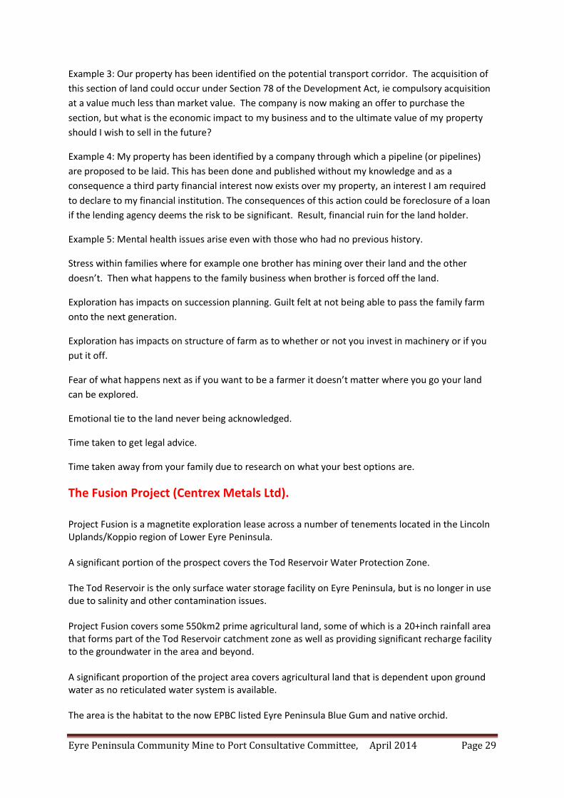
The public perception for this proposal was three mines in the Koppio Hills. This turned out to be
four mines in the EPBC referral, but actually, Fusion Project is an area of some 550 square
kilometres containing significant number of potential mines, a situation that the Company has
recently re-describe correctly through the ASX (Fusion Project map 2).
Furthermore, the company describe Fusion Project as not being part of a larger proposal to the
EPBC. Again, with reference to the ASX and the company's reporting processes, Fusion Project is
part of the Company's interests on Eyre Peninsula which includes Wilgerup, Carrow
Bungalow mines and the proposed Port Spencer.
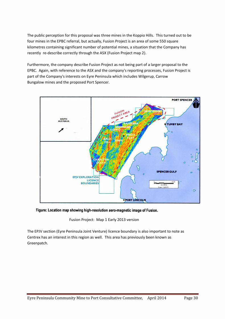
Fusion Project: Map 1 Early 2013 version
The EPJV section (Eyre Peninsula Joint Venture) licence boundary is also important to note as
Centrex has an interest in this region as well. This area has previously been known as
Greenpatch.
Eyre Peninsula Community Mine to Port Consultative Committee, April 2014 Page 31
Fusion Project: Map 2 September 2013.
There are still discrepancies between this map and the original and that which has been declared
in the various ASX and company reports.
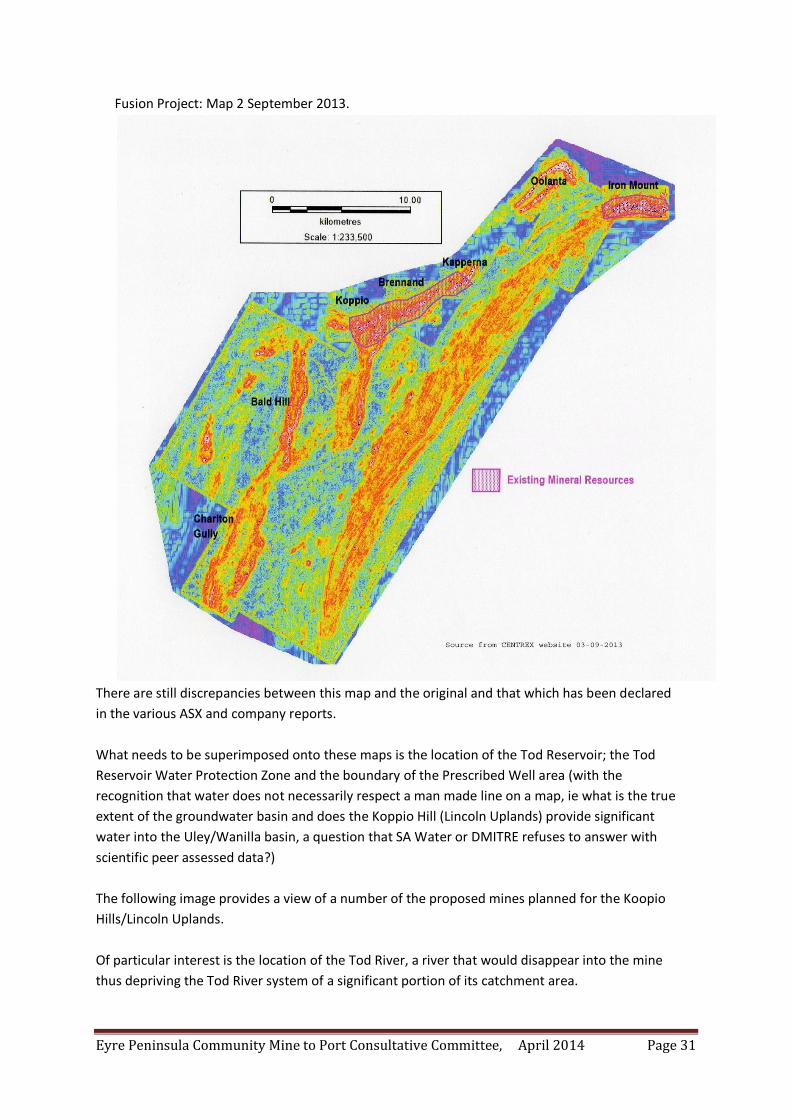
What needs to be superimposed onto these maps is the location of the Tod Reservoir; the Tod
Reservoir Water Protection Zone and the boundary of the Prescribed Well area (with the
recognition that water does not necessarily respect a man made line on a map, ie what is the true
extent of the groundwater basin and does the Koppio Hill (Lincoln Uplands) provide significant
water into the Uley/Wanilla basin, a question that SA Water or DMITRE refuses to answer with
scientific peer assessed data?)
The following image provides a view of a number of the proposed mines planned for the Koopio
Hills/Lincoln Uplands.
Of particular interest is the location of the Tod River, a river that would disappear into the mine
thus depriving the Tod River system of a significant portion of its catchment area.
Eyre Peninsula Community Mine to Port Consultative Committee, April 2014 Page 32
Eyre Peninsula Community Mine to Port Consultative Committee, April 2014 Page 33
Financial Security:
One of the hidden impacts of this Project has been the originally undisclosed third party
financial interest created by the Company when it lodged its EPBC referral in May 2013
(namely 2013/6919), in which it identified over 300 properties through which the pipelines
from the processing plant at Koppio to the proposed Port Spencer may travel. It is
acknowledged that only one route would ultimately be identified, but at this point in time
three routes have been identified, hence the 300+ properties.
Unfortunately these properties were identified and published in the referral without the
knowledge or consent of the individual owners concerned, a situation that still exists today.
The little known impact of this hidden declaration is that any mortgage holder is obliged by
law to notify their lender of any party who has an interest in the property. The financial
impact may be nothing; a reduction of the length of the loan; an increase in the interest rate
payable or, at worst, foreclosure of the loan, depending upon the risk assessment undertaken
by the lending agency.
Financial security in these circumstances is somewhat problematic.
The risk is not only applied to the land owner (agricultural entities) but also to local
government as some Council property has been identified and thereby to the community at
large.
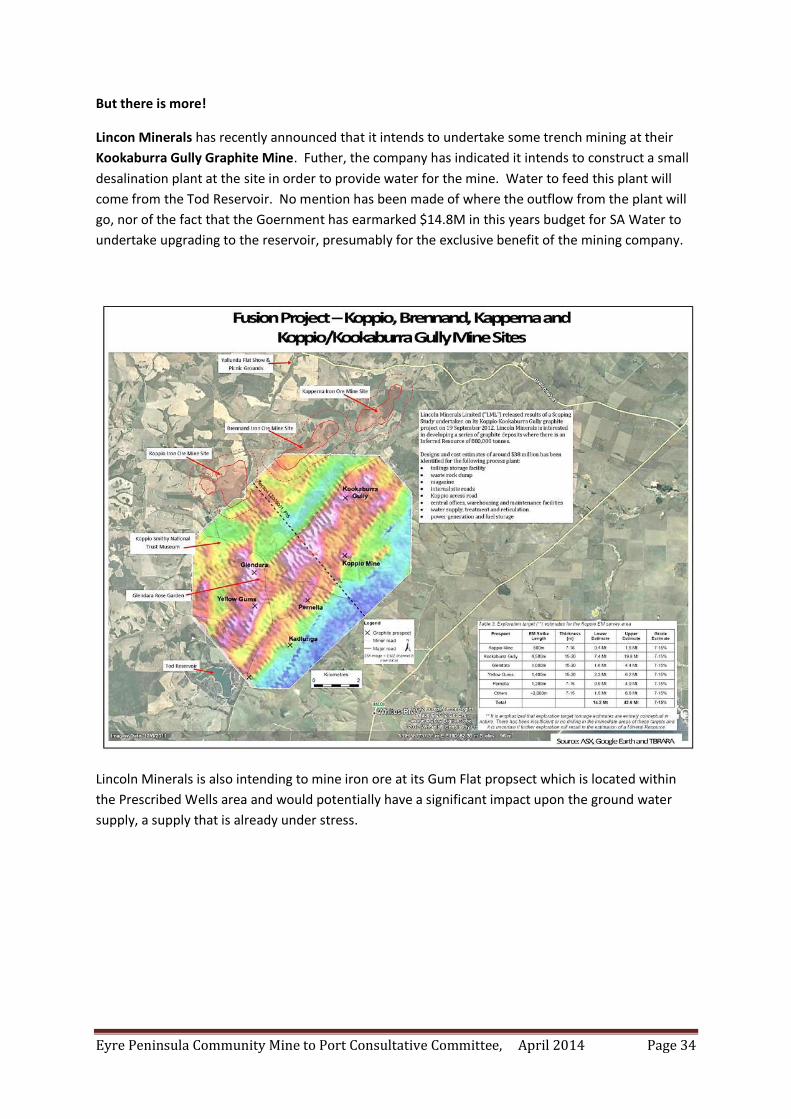
Eyre Peninsula Community Mine to Port Consultative Committee, April 2014 Page 34
But there is more!
Lincon Minerals has recently announced that it intends to undertake some trench mining at their
Kookaburra Gully Graphite Mine. Futher, the company has indicated it intends to construct a small
desalination plant at the site in order to provide water for the mine. Water to feed this plant will
come from the Tod Reservoir. No mention has been made of where the outflow from the plant will
go, nor of the fact that the Goernment has earmarked $14.8M in this years budget for SA Water to
undertake upgrading to the reservoir, presumably for the exclusive benefit of the mining company.
Lincoln Minerals is also intending to mine iron ore at its Gum Flat propsect which is located within
the Prescribed Wells area and would potentially have a significant impact upon the ground water
supply, a supply that is already under stress.
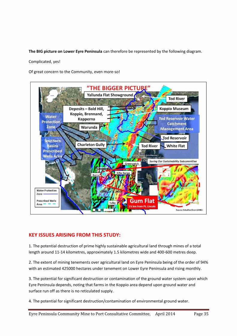
Eyre Peninsula Community Mine to Port Consultative Committee, April 2014 Page 35
The BIG picture on Lower Eyre Peninsula can therefore be represented by the following diagram.
Complicated, yes!
Of great concern to the Community, even more-so!
KEY ISSUES ARISING FROM THIS STUDY:
1. The potential destruction of prime highly sustainable agricultural land through mines of a total
length around 11-14 kilometres, approximately 1.5 kilometres wide and 400-600 metres deep.
2. The extent of mining tenements over agricultural land on Eyre Peninsula being of the order of 94%
with an estimated 425000 hectares under tenement on Lower Eyre Peninsula and rising monthly.
3. The potential for significant destruction or contamination of the ground water system upon which
Eyre Peninsula depends, noting that farms in the Koppio area depend upon ground water and
surface run off as there is no reticulated supply.
4. The potential for significant destruction/contamination of environmental ground water.
Eyre Peninsula Community Mine to Port Consultative Committee, April 2014 Page 36
5. The potential for contamination of pastures; grain; wool; meat (through the food chain) and rain
water by fugitive dust. The contaminats being not only the iron oxides but potentially heavy metals
(arsenic, cadmium and chromium (VI)) and possibly uranium (or other radioactive products) given
the knowledge that these exist in the area.
6. The potential health impacts of infrasound generated by the mining and processing activities
proposed to be undertaken on a 24/7 basis.
7. The economic impacts through property purchases associated with the proposed activities.
8. The economic impact of price lowering due to the proximity of the mining activities or
infrastructure associated with said activities. This devaluation would also be reflected in the ability
of Councils to raise funds through rates, other than through rate increases to the ratepayers, noting
that the actual mine is exempt from local rates. The Community therefore pays.
9. The social and economic impact of about 1000 or so fly in fly out employees accommodated in a
'village' about 2 kilometres from the small township of Tumby Bay, population around 1200.
Eyre Peninsula Community Mine to Port Consultative Committee, April 2014 Page 37
CASE STUDY THREE: REX MINERALS, HILLSIDE MINE, ARDROSSAN, Yorke Peninsula The Rex Minerals' Hillside Mine project is located just south of the township of Ardrossan on Yorke Peninsula, a world recognised barley growing area. The tenements the Company hold are 4514 (24km2); 5055 (1262km2) and 5056 (416km2) totalling 1702 km2 of Yorke Peninsula, as shown on the map. The proposed Hillside mine occupies but a small portion of the combined tenement area, but that is somewhat misleading, in that the Company proposes to expand the number of mine sites to around 50 across the tenement, feeding ore back to the processing plant at Hillside. The environmental implications of this proposal are impossible to ignore given its location to the sea (a declared Marine Park and known fish nursery); the size of the open cut mine; the prospect of cutting through a number of aquifers; the mountain of overburden and the potential contamination routes given the nature of the ore body being mined. One of the known contaminants is uranium. It has been identified that in at least one area the concentration of uranium ore is in the vicinity of 10000ppm. This material will be brought to the surface and dumped on the overburden thereby exposing it to migration through wind and rain. The next major concern is contamination due to excess copper both in the soil and through potential spills in the sea. The toxicity of copper in soil and in sea water is well documented. For a detailed agricultural impact statement, I would refer you to the submission by the Mr Darren Arney, CEO, Grain Producers SA Ltd in response to the public submissions called for by the Government Rex Minerals Hillside Copper Mine: Mining Lease and Management Plan, August 2013. The introduction to the Grain Producers' response begins:- "The objection to this Proposal is NOT to the concept of mining what natural resources there may be within South Australia, BUT to the location of open-cut mining within a region of intensive agriculture where a long established, successful, and ever improving and developing industry is already renowned and entrenched. To call this proposal "development" is to make mockery of the word, since the activities of an open-cut mine, and the building of a mountain of overburden and impurities amongst an area of advanced, intensive, and world renowned grain production, will adversely affect the industry that is already thriving. If it is the wish of the State Government to develop agricultural land, and, in particular, the fertile and reliable region of Yorke Peninsula, then its attention might be drawn to road infrastructure, and investment in agricultural research to at least enable grains production to stay ahead of its international competitors. If it is the wish of the State Government to extract royalties or wealth from the 5% of the land mass of SA that is suitable for grains production, then it might consider what revenue has been extracted over the 130 years that farming land on Yorke Peninsula has produced grain and food for Australian and international consumption, and that this resource has been sustainable and constant, and has been enhanced by careful and caring management. And in 130 years' time, it will still produce grains and food, and provide revenue and reward. A report from Deloitte Access Economics in early October 2013 identified Agribusiness in the five
"super-growth" sectors of the next 2O years. The demand for protein based food from Asia's middle classes was cited as a significant growth area, and this is a demand that SA, AND Yorke Peninsula, grain producers can develop and fulfil. The environmental implications of this mining project are impossible to ignore."
Eyre Peninsula Community Mine to Port Consultative Committee, April 2014 Page 38
(Grain Producers SA Ltd as recommended by its Agricultural Security and Priority Committee.
Public submission to the Hillside Mining Lease, November 2013)
The collective wisdom of some 266 respondents to the public enquiry as well as the Grain Producers' response can be found on: http://www.pir.sa.gov.au/minerals/mines__and__developing_projects/developing_projects/rex_minerals_hillside_copper_mine_submissions The social, economic and environmental impact of mining in agricultural areas is aptly described by the submissions above. The concerns expressed throughout these submissions are in line with those outlined in the previous two case studies.
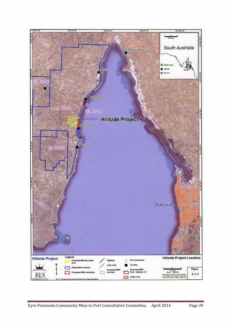
Eyre Peninsula Community Mine to Port Consultative Committee, April 2014 Page 39
Eyre Peninsula Community Mine to Port Consultative Committee, April 2014 Page 40
CONCLUDING REMARKS The Committee would take this opportunity to commend the Government in undertaking this enquiry and the seeking of information pertaining to factors affecting competitiveness in agriculture. Our response has focussed on the real issues of the impact of mining in agricultural areas with specific reference to Eyre Peninsula and Yorke Peninsula, both well recognised highly productive agriculturally sustainable areas in South Australia. Whilst some might argue the case for mining on the grounds that it may provide certain infrastructure, the against such activities in agricultural areas has not been put forward or heard. The communities represented on Lowe Eyre Peninsula have significant concerns as clearly
sustainable agriculture is under threat of destruction on a significant scale through mining.
Complicating this debate is also the potential destruction of ground water supplies not only for
human consumption but also to support a viable livestock industry and the unique ecology on the
Peninsula.
These comments are provided for your consideration in developing the White Paper.
The Community would appreciate person contact from members of the Taskforce should future
consultation programs evolve.
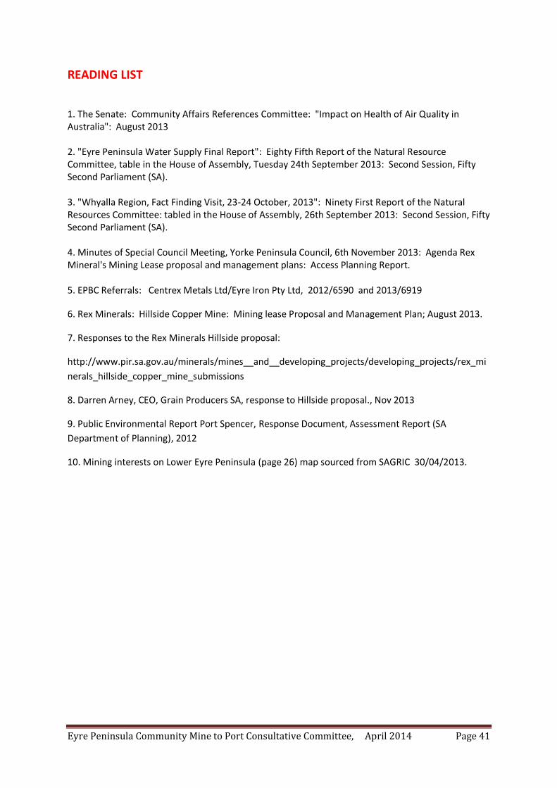
Eyre Peninsula Community Mine to Port Consultative Committee, April 2014 Page 41
READING LIST 1. The Senate: Community Affairs References Committee: "Impact on Health of Air Quality in Australia": August 2013 2. "Eyre Peninsula Water Supply Final Report": Eighty Fifth Report of the Natural Resource Committee, table in the House of Assembly, Tuesday 24th September 2013: Second Session, Fifty Second Parliament (SA). 3. "Whyalla Region, Fact Finding Visit, 23-24 October, 2013": Ninety First Report of the Natural Resources Committee: tabled in the House of Assembly, 26th September 2013: Second Session, Fifty Second Parliament (SA). 4. Minutes of Special Council Meeting, Yorke Peninsula Council, 6th November 2013: Agenda Rex Mineral's Mining Lease proposal and management plans: Access Planning Report. 5. EPBC Referrals: Centrex Metals Ltd/Eyre Iron Pty Ltd, 2012/6590 and 2013/6919
6. Rex Minerals: Hillside Copper Mine: Mining lease Proposal and Management Plan; August 2013.
7. Responses to the Rex Minerals Hillside proposal:
http://www.pir.sa.gov.au/minerals/mines__and__developing_projects/developing_projects/rex_mi
nerals_hillside_copper_mine_submissions
8. Darren Arney, CEO, Grain Producers SA, response to Hillside proposal., Nov 2013
9. Public Environmental Report Port Spencer, Response Document, Assessment Report (SA
Department of Planning), 2012
10. Mining interests on Lower Eyre Peninsula (page 26) map sourced from SAGRIC 30/04/2013.


![Deborah Eyre[1]](https://img.pdfslide.us/doc/110x75/55254e884a795953498b4af7/deborah-eyre1.jpg)