Embed Size (px)
Citation preview
1
AGREEMENT
BETWEEN MONTANA RESOURCES, LLP AND
THE STATE OF MONTANA THROUGH THE
NATURAL RESOURCE DAMAGE PROGRAM
REGARDING ACCESS AND PLACEMENT OF PARROT TAILINGS
This Access Agreement between Montana Resources, LLP (“MR”) and the State of
Montana through the Natural Resource Damage Program (“State”) Regarding Access and
Placement of Parrot Tailings (“Access Agreement”) is made this __ day of December, 2016.
RECITALS
WHEREAS, in December 2012 the Butte Natural Resource Damage Restoration Council
and the State of Montana Natural Resource Damage Program (“NRDP”) issued the Final Butte
Area One Restoration Plan (“BAO Plan”); and
WHEREAS, the BAO Plan calls for, in part, the removal of certain historic mine wastes,
including Parrot Tailings (“Parrot Tailings” - as defined below); and
WHEREAS, at the direction of Governor Bullock and pursuant to the BAO Plan, the State,
through NRDP, began planning for removal of the Parrot Tailings; and
WHEREAS, the State has determined that the Parrot Tailings and its related overburden
and slag would be Bevill exempt, and not hazardous waste, if managed or disposed as wastes and
has provided MR written assurances of that determination; and
WHEREAS, the State has evaluated several locations for placement of the removed Parrot
Tailings and determined that a location on certain property owned by MR is cost-effective and low
risk; and
WHEREAS, MR is willing to provide the State access to its mine property for the
limited purpose of transporting and placing Parrot Tailings at a designated stockpile location
(“Stockpile Location”) in the manner described herein; and
WHEREAS, the State has selected the means and methods for removing and
transporting the Parrot Tailings; and
WHEREAS, recognizing the community interest in the removal of the Parrot Tailings, MR,
in cooperation with Atlantic Richfield Company, is willing to construct the Stockpile Location on
MR Property and take responsibility for removing the Parrot Tailings from the Stockpile Location
to an active mining area of MR’s mine property with MR’s labor and equipment at no cost to the
State, thereby resulting in a potential project cost-savings to the State; and
13
2
WHEREAS, MR will apply for a revision to its Montana Metal Mine Reclamation Act
permit in order to include its responsibility for the Parrot Tailings in an active mining area of MR’s
mine property; and
WHEREAS, in part based on MR’s request, the State has stated its intention to allocate
$400,000 towards BAO Plan stream restoration projects in Blacktail Creek or Silver Bow Creek
between Montana Street and the Butte Treatment Lagoons; and
WHEREAS, in part based on MR’s request, the State has stated its intention to, directly or
indirectly, provide Butte Silver Bow $200,000, which can be used for a replacement ballfield; and
WHEREAS, a revised draft BAO Parrot Amendment for Parrot Tailings Waste Removal
(“Parrot Amendment”) will become final once approved by the Governor; and
WHEREAS, the State has requested that MR assist the State by allowing the State’s
contractor to take the construction dewatering water (“Construction Dewatering Water” - as
defined below) to MR in the manner described herein for incorporation into MR’s process circuit;
and
WHEREAS, the State has determined that the Construction Dewatering Water is not
hazardous waste or would be Bevill exempt if managed or disposed as a waste and has provided
MR written assurances of that determination; and
WHEREAS, the State has provided assurances to MR in a letter dated August 30, 2016,
regarding water rights related to the Construction Dewatering Water, which letter speaks for itself;
and
WHEREAS, recognizing the benefits to the community, MR is willing to take
responsibility for incorporating Construction Dewatering Water into its process circuit, once
approved in the minor revision.
NOW THEREFORE, for good consideration the receipt and sufficiency of which is hereby
acknowledged, the State and MR agree as follows:
AGREEMENT
A. DEFINITIONS. For purposes of this Access Agreement, the following terms shall have
the meanings set forth below:
“Contractor” shall mean those contractors that are selected by the State to haul, place, and
manage Parrot Tailings on MR Property, construct, maintain, and remove infrastructure,
and convey Construction Dewatering Water to the Mine Permitted Area.
3
“Construction Dewatering Water” shall mean the water encountered during excavation of
the Parrot Tailings not exceeding a flow rate of 100gpm and a volume of 144,000gpd and
delivered to MR in the manner described herein.
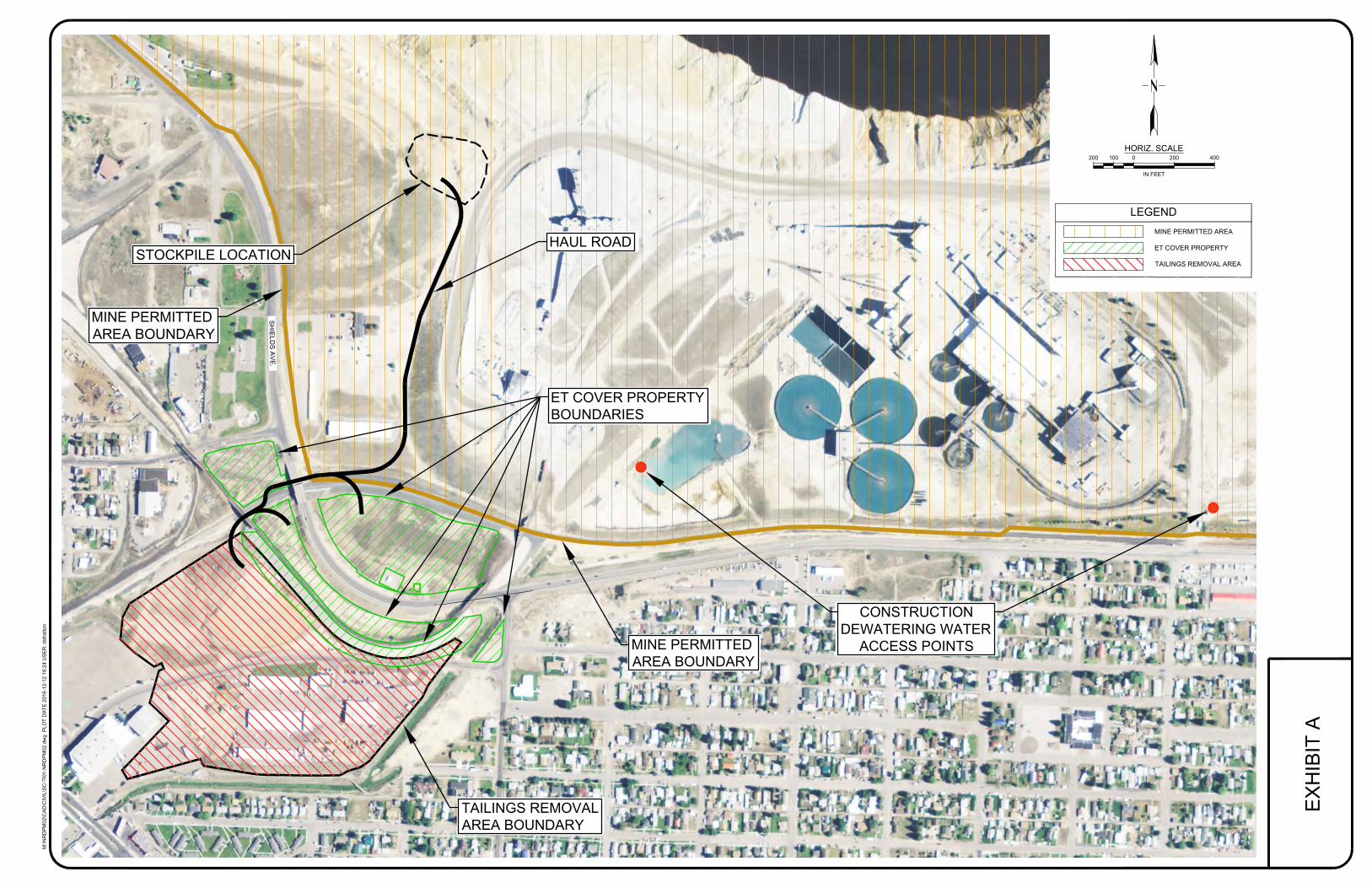
“Construction Dewatering Water Access Points” shall mean the access points identified at
the emergency pond location and clear-water ditch location on Exhibit A used by the
Contractor and/or Subcontractor to deliver the Construction Dewatering Water.
“ET Cover Property” shall mean the property identified by the State for placement of
overburden, slag, and cover material. The ET Cover Property is depicted on the attached
Exhibit A.
“Mine Permitted Area” solely for the purposes of this Access Agreement shall mean the
geographic area permitted to MR for mining activity pursuant to the Metal Mine
Reclamation Act and the property owned by MR, north of the BNSF right of way and east
of Shields Avenue. A portion of the boundary is depicted on Exhibit A.
“MMRA Permits” shall mean MR’s Montana Metal Mine Reclamation Act permits
#00030, 00030A, 00108, and 00041, as amended.
“MR Property” shall mean the haul road and Stockpile Location within the Mine Permitted
Area as depicted on Exhibit A.
“Parrot Tailings” shall mean the products or byproducts of hard rock mining, placer
mining, and smelting operations from the location identified in the Parrot Amendment,
including but not limited to, mine tailings, waste rock, and contaminated organic clay as
determined by the State. Native soils mixed with or contaminated by tailings are
considered impacted soils and are classified as tailings. Overburden mixed with or
contaminated by tailings are considered impacted soils and are classified as tailings, and
shall be limited to 350,000 bank cubic yards. “Parrot Tailings” does not include debris,
garbage, petroleum-contaminated soil, asbestos, or any hazardous waste.
“State” shall mean the State of Montana and its departments, agencies, instrumentalities,
officials, and employees. The State will be acting by and through NRDP under this Access
Agreement for the activities described in the Transport and Placement Specifications.
“Stockpile Location” shall mean the location on the MR Property identified as the
Stockpile Location in Exhibit A.
“Subcontractor” shall mean those subcontractors that are selected by the Contractor and
approved by the State, if required, to haul, place, and manage Parrot Tailings on MR
Property, construct, maintain, and remove infrastructure, and convey Construction
Dewatering Water to the Mine Permitted Area.
4
“Transport and Placement Specifications” shall mean the description of the location and
manner by which the State shall construct and maintain a haul road and transport Parrot
Tailings across MR Property to the Stockpile Location, deliver Construction Dewatering
Water across the Mine Permitted Area to the Construction Dewatering Water Access
Points, remove the haul road and remove any construction dewatering conveyance
structures. The Transport and Placement Specifications may be modified at any time by
agreement of MR and the State. The Transport and Placement Specifications are attached
as Exhibit B and are part of this Access Agreement.
“Tailings Removal Area” shall mean the area depicted as such on the attached Exhibit A.
B. ACCESS FOR TRANSPORT, AND PLACEMENT OF PARROT TAILINGS AND
CONVEYANCE OF CONSTRUCTION DEWATERING WATER.
1. Mine Permitted Area. On the terms and subject to the conditions set forth in this
Access Agreement, MR agrees to provide the State and its Contractor(s) and
Subcontractor(s) access to enter upon the Mine Permitted Area at their own risk,
relying upon means and methods selected solely by the State, in order to: (i)
construct, maintain, and remove a haul road in the manner and location as set forth
in the Transport and Placement Specifications; (ii) transport and place up to
350,000 bank cubic yards of Parrot Tailings at the Stockpile Location on MR
Property in the manner and location as set forth in the Transport and Placement
Specifications; and (iii) convey the Construction Dewatering Water to the
Construction Dewatering Water Access Points, in the manner and location as set
forth in the Transport and Placement Specifications.
2. Requirements of Access.
(a) Obligations to MR. At all times the State and its Contractor(s) and
Subcontractor(s) shall conduct all activities on the Mine Permitted Area,
under this Access Agreement in a manner that does not: (i) result in any
direct or indirect impacts on MR’s operations or obligations; (ii) cause
injury to persons or damage to MR property; (iii) interfere with MR’s
operations or obligations; and (iv) impede MR’s mining, milling,
remediation or reclamation activities in the Mine Permitted Area.
(b) Notifications. The State shall provide MR’s Designated Contact(s) written
notification when: (i) the activities for which access is provided in
Paragraph B have been completed; and (ii) the activities for which access is
provided in Paragraph B will be in abeyance for a period of ninety (90) days
or more.
5
C. CONDITIONS PRIOR TO ACCESS.
1. Parrot Tailings Determination. Prior to entry onto the Mine Permitted Area the
State shall provide a letter to MR that contains the State’s determination that the
Parrot Tailings and its related overburden, slag, and Construction Dewatering
Water would be Bevill exempt, and not hazardous waste, if managed or disposed
as wastes. The letter shall be addressed and delivered to:
Mark Thompson
Manager of Environmental Affairs
Montana Resources, LLP
600 Shields Avenue
Butte, MT 59701
2. Minor Revision Approved. Prior to entry onto the Mine Permitted Area, MR shall
have received State approval of the revision to its Montana Metal Mine
Reclamation Act permit (for responsibility for the Parrot Tailings in an active
mining area of MR’s mine property) with such terms and conditions acceptable to
MR.
D. MR RESPONSIBILITIES. MR and the State acknowledge that the Stockpile Location
will be part of a site that is under Montana Metal Mine Reclamation Act authority. MR
agrees to take responsibility for the Parrot Tailings at the Stockpile Location and
Construction Dewatering Water delivered to the Construction Dewatering Access Points
pursuant to its MMRA Permits and consistent with the terms of this Access Agreement, as
outlined below:
1. Construction of Stockpile Location. Following written notice from the State that
Parrot Tailings will be placed at the Stockpile Location within thirty (30) days, MR
agrees, at its cost, to construct the Stockpile Location in the location shown on
Exhibit A and in the size and manner detailed in MR’s December 2016 Application
for Revision to Operating Permits. MR shall be responsible for necessary
infrastructure protection, including the Belmont Storm Drain, existing water line,
and the existing storm grate located within the Stockpile Location area.
2. Transport of Parrot Tailings from Stockpile Location and Placement of Parrot
Tailings in Active Mine Area. MR agrees, at its cost, to load the Parrot Tailings
from the Stockpile Location and transport them to an active mining area within its
Mine Permitted Area. MR’s work at the Stockpile Location shall occur only during
MR’s night shift (during the hours of 7:00 pm to 7:00 am). MR agrees to conduct
its loading and transport at and from the Stockpile Location so that there is
sufficient capacity for Contractor’s offloading and placement of Parrot Tailings. In
the event that the State believes that there is or will be insufficient capacity at the
Stockpile Location, it will contact MR and request that MR load and transport
6
Parrot Tailings from the Stockpile Location and MR will promptly respond and
thereafter provide sufficient capacity.
3. Maintenance of Stockpile Location. Any Best Management Practices (BMPs) or
infrastructure protection (Belmont Storm Drain, existing water line, existing storm
grate) necessary within the Stockpile Location shall be the responsibility of MR.
MR agrees to be responsible for all maintenance of the Stockpile Location other
than any dust control and snow removal necessary for State transport and placement
of the Parrot Tailings at the Stockpile Location which shall be the responsibility of
the State. Except as necessary for administrative or coordination purposes, MR’s
entry onto the Stockpile Location shall occur between 7:00 pm and 7:00 am.
4. MR’s Responsibility for Parrot Tailings Consistent with its MMRA Permits. MR
agrees that upon the State’s placement of the Parrot Tailings at the Stockpile
Location in the manner described herein, MR shall take responsibility for the Parrot
Tailings pursuant to its MMRA Permits, including, but not limited to, any
applicable reclamation and monitoring requirements.
5. Stockpile Location Removal. Within one hundred and sixty (160) days of the
completion of the State’s transport and placement of Parrot Tailings at the Stockpile
Location, or by October 1, 2022, whichever occurs first, MR shall at its sole cost
complete removal and relocation of the Parrot Tailings from the Stockpile Location
in a manner consistent with its MMRA Permits.
E. TERM. This Access Agreement will be effective upon: (1) signature by both MR and the
State; and (2) completion of Paragraph C.2. This Access Agreement will terminate
automatically on July 1, 2017, unless: (1) the State secures access to the ET Cover Property
and Tailings Removal Area from Butte-Silver Bow satisfactory to the State; and (2) the
State issues the notice to MR referenced in Paragraph D.1. This Access Agreement will,
unless terminated, continue until the earlier of notification from the State of the completion
of the activities for which access is provided in Paragraph B or October 1, 2022.
F. TERMINATION AND SUSPENSION. This Access Agreement may be terminated or
suspended before October 1, 2022, by mutual agreement of the parties, or as provided in
this Paragraph F:
1. Violations. If MR believes the State is in violation, or will be in violation, of
any of the terms and conditions of this Access Agreement, including without
limitation the Transport and Placement Specifications, MR may provide the State
with a written notice that the State is in violation or will be in violation of this
Access Agreement and specifying the term(s) or condition(s) that MR believes
the State has violated or will violate. Thereafter the State shall have thirty (30)
days within which to cure the defect identified by MR or to otherwise
7
satisfactorily resolve the matter. If the State is unable to cure within that time
MR may terminate this Access Agreement on written notice to the State.
2. Emergencies. MR may immediately suspend access on a temporary basis due to
an emergency situation. The temporary suspension shall be made by contacting the
State’s Designated Contact(s). In such case, MR and the State shall confer to
resolve the emergency situation as soon as possible so that the State can resume
access. In this Paragraph F “emergency situation” refers to flooding, sloughing,
fires, accidents, and other similar circumstances or conditions affecting MR’s
operations on the Mine Permitted Area as determined by MR.
3. Suspension of MR Operations. If MR operations are suspended prior to October
1, 2022, and MR concludes that the conditions of the suspension are incompatible
with this Access Agreement, MR may provide notice to the State that access under
this Access Agreement shall terminate within ninety (90) days. In the event that
MR resumes MR Operations following a suspension prior to October 1, 2022, MR
shall provide notification to the State and access shall be restored and continue
through the term of this Access Agreement.
4. Temporary Suspension by State. If during the term of this Access Agreement the
activities for which access has been provided in Paragraph B will be in abeyance
for a period of ninety (90) days or longer, the State shall provide written notification
to MR’s Designated Contact(s) identifying the beginning and ending dates of the
abeyance and access shall be temporarily suspended during that time period. If the
State requires access to the Mine Permitted Area for planning or monitoring during
the temporary suspension, the State shall contact MR’s Designated Contact(s) via
email identifying the personnel and locations for which access is requested and the
parties shall arrange a mutually acceptable time.
G. REMOVAL OF IMPROVEMENTS. Within one hundred and twenty (120) days of the
State’s completion of placement of Parrot Tailings at the Stockpile Location or by October
1, 2022, whichever occurs first, the State, unless otherwise requested in writing by MR,
shall at its sole cost, remove all roads, infrastructure, and any improvements it has installed
related to the construction of the haul road on MR Property and the Construction
Dewatering Water Access Points on the Mine Permitted Area and shall return the haul road
on MR Property and the Construction Dewatering Water Access Points to the condition
they were in prior to the State’s activities.
H. COSTS. All costs related to or arising from the work and presence or activities of the
State, its Contractor(s) and Subcontractor(s) on the Mine Permitted Area associated with
this Access Agreement, shall be borne by the State at no cost to MR, including without
limitation, any fines or penalties imposed or sought to be imposed upon MR related to the
activities of the Contractor(s) and Subcontractor(s), costs for damages to property or
injuries to persons, and other costs, including litigation costs, associated with third-party
8
challenges to the State’s determination that the Parrot Tailings or the Construction
Dewatering Water are not hazardous wastes, the transport to and placement of the Parrot
Tailings at the Stockpile Location, and any costs incurred as a result of EPA or MDEQ
requirements that are over and above those costs which MR would otherwise incur if the
Parrot Tailings were not transported to and placed in the Stockpile Location.
I. RECORDS. The State shall maintain records of: (i) the volume of all Parrot Tailings
transported across MR Property and placed at the Stockpile Location; (ii) the amount, date
and location of all Construction Dewatering Water delivered to the Construction
Dewatering Access Points; (iii) the vehicle miles traveled by the State, Contractor(s) and
Subcontractor(s) on the Mine Permitted Area; and (iv) all documentation associated with
storm water management and discharge, including requirements of a general permit for
storm water discharge related to construction activity on the Mine Permitted Area, and
shall on a monthly basis for (i) and (ii) and annual basis for (iii) and (iv), provide records
of such to MR. Without limitation on the foregoing, upon request from MR, the State, at
its cost, shall provide MR with copies or splits of all information, data, tests, samples and
surveys obtained by the State or its Contractor(s) or and Subcontractor(s) that pertain to
this Access Agreement. MR will maintain records of the volume and location of all Parrot
Tailings transported from the Stockpile Location, and shall provide records of such to the
Montana Department of Environmental Quality.
J. COORDINATION OF ACTIVITIES. The Designated Contacts shall coordinate as
necessary during construction, hauling, and placement of the Parrot Tailings and the
Construction Dewatering Water. The State shall provide MR’s Designated Contact(s)
notice at least seventy two (72) hours prior to commencing activities which directly involve
the Mine Permitted Area.
K. CONTRACTOR AND SUBCONTRACTOR INSURANCE REQUIREMENTS. The
State shall require, as part of its contract with Contractor(s), that Contractor(s) shall procure
and maintain insurance coverage for Contractor(s) and Subcontractor(s) activities on the
Mine Permitted Area, as detailed in this Paragraph K. Contractor(s) and Subcontractor(s)
access to the Mine Permitted Area, is conditioned upon Contractor(s)’ procurement and
maintenance of insurance coverage as detailed in this Paragraph K for the entire term that
Contractor(s) or Subcontractor(s) will be accessing the Mine Permitted Area under this
Access Agreement.
1. Contractor Insurance. Contractor coverage shall be at least as broad as:
a. Commercial General Liability (CGL): Insurance Services Office Form CG
00 01 covering CGL on an “occurrence” basis, including products and
completed operations, property damage, bodily injury and personal &
advertising injury, with limits no less than $10,000,000 per occurrence and
$20,000,000 in the aggregate.
9
b. Automobile Liability: Automobile insurance (including owned, non-
owned, and hired vehicles) with a combined single limit for bodily injury,
death, and property damage of not less than $2,000,000 per occurrence.
c. Workers’ Compensation insurance as required by the State of Montana,
with Statutory Limits, and Employers’ Liability insurance with a limit of no
less than $1,000,000 per accident for bodily injury or disease.
d. Contractor’s Pollution Legal Liability with limits no less than $5,000,000
per occurrence or claim, and $10,000,000 policy aggregate.
2. Deductibles and Self-Insured Retentions. The Contractor shall cause the insurer to
eliminate any deductibles or self-insured retentions as respects MR, and its
members, managers, partners, officers, agents and employees.
3. Other Insurance Provisions. The insurance policies specified above are to contain,
or be endorsed to contain, the following provisions:
a. MR, and its members, managers, partners, officers, agents and employees
shall be identified as additional insureds on the CGL policy with respect to
liability arising out of activities on the Mine Permitted Area performed by
or on behalf of the Contractor including materials, parts, or equipment
furnished in connection with such work or operations and automobiles
owned, leased, hired, or borrowed by or on behalf of the Contractor.
General liability coverage can be provided in the form of an endorsement
to the Contractor's insurance (at least as broad as ISO Form CG 20 10, CG
11 85 or both CG 20 10 and CG 20 37 forms if later revisions used).
b. Each insurance policy required by this clause shall provide that coverage
shall not be canceled, except with notice to the State and MR.
c. Each insurance policy required by this clause shall include separation of
insured language.
d. Each insurance policy required by this clause shall provide that the
Contractor’s insurance is primary and any insurance or self-insurance
maintained by the State and MR, is considered excess and noncontributory
with respect to any and all claims and demands made against the State or
MR.
e. Each insurance policy shall contain an Owners Interest Coverage
endorsement in favor of the State and MR.
f. Each insurance policy shall provide that the Contractor agrees to waive
rights of subrogation which any insurer of Contractor may acquire from
10
Contractor by virtue of the payment of any loss. The Contractor shall obtain
any endorsement that may be necessary to affect this waiver of subrogation.
The Workers' Compensation policy shall be endorsed with a waiver of
subrogation in favor of the State and MR for all work performed by the
Contractor, its employees, agents, and subcontractors.
4. Acceptability of Insurers. Insurance is to be placed with insurers with a current
A.M. Best rating of no less than A.
5. Subcontractors. Subcontractor access to the Mine Permitted Area, is conditioned
upon Subcontractor’s procurement and maintenance of the insurance coverages
enumerated in this Paragraph K.
6. Verification of Coverage. Prior to Contractor’s and Subcontractor’s entry onto the
Mine Permitted Area the State shall provide evidence to MR that each Contractor
and Subcontractor meets the insurance requirements. For each Contractor and
Subcontractor the State shall provide MR with original certificates and amendatory
endorsements, or copies of the applicable insurance language, effecting coverage
required by this Access Agreement. All certificates and endorsements are to be
received by MR before Contractor and Subcontractor entry onto the Mine Permitted
Area. Each Contractor and Subcontractor shall provide renewal certificates of
insurance to MR thirty (30) days prior to the expiration date of insurance policies.
The certificate must indicate its coverage of the Contractor or Subcontractor
presence on the Mine Permitted Area and must indicate that it is maintained for the
duration of the activities on the Mine Permitted Area. For each Contractor and
Subcontractor MR shall have the right to require the State to provide complete,
certified copies of all required insurance policies, including endorsements, required
by these specifications, at any time.
L. CONTRACTOR INDEMNIFICATION. As part of its contract(s) with Contractor(s),
the State shall require, that to the extent allowed by law, Contractor(s) shall release, defend,
indemnify and hold harmless MR, and its members, managers, partners, officers, agents
and employees from and against any and all actions, losses, damages, expense, suits, claims
demands or liability of any character whatsoever arising out of or in any way related to the
presence of Contractor(s), and its Subcontractor(s), on the Mine Permitted Area including
without limitation those brought or asserted for injuries to, or death of, any person or
persons, or damages to property, and fines, penalties or charges imposed or sought to be
imposed upon MR, its members, managers, partners, officers, agents and employees arising
out of or in any way the failure of Contractor(s), or its Subcontractor(s), to comply with
any state, federal or local law, rule or regulation (including without limitation, the Federal
Mine Safety and Health Act of 1977, as amended, and all rules and regulations promulgated
pursuant thereto). Prior to each Contractor(s)’ or Subcontractor(s)’ entry onto the Mine
Permitted Area the State shall provide MR evidence of each Contractor(s)’ promise to
release, defend, indemnify, and hold harmless MR consistent with this Paragraph.

11
M. STATE EMPLOYEE ACCESS. State employee access to the Mine Permitted Area,
under this Access Agreement is solely for the purposes of observing, overseeing and
managing the work of Contractor(s) and Subcontractor(s) on the Mine Permitted Area.
State employee access to the Mine Permitted Area under this Access Agreement is
conditioned upon the State purchasing and maintaining excess insurance coverage for any
of its employees accessing the Mine Permitted Area under this Access Agreement in the
following types and amounts: property damage, bodily injury and personal & advertising
injury, with limits no less than $2,000,000 per occurrence and $4,000,000 in the aggregate.
N. LAWS, RULES, AND REGULATIONS. The State acknowledges that certain activities
for which access is being provided will occur within an active mining area. The State and
its Contractor(s) and Subcontractor(s) and State employees entering onto the Mine
Permitted Area shall comply with all applicable laws, rules, regulations, ordinances, and
requirements of federal, state, county, city or town and department, bureaus, and
authorities, including, without limitation, the Federal Mine Safety and Health Act of 1977,
as amended. The State and its Contractor(s) and Subcontractor(s) shall take all actions
necessary to conduct all activities in accordance with all applicable permits and
government approvals with respect to their activities on the Mine Permitted Area, and MR
shall have no responsibility or liability for any failure on the part of the State or its
Contractor(s) or Subcontractor(s) to do the same.
O. CONSTRUCTION DEWATERING WATER. MR agrees to allow the Contractor(s)
and Subcontractor(s) to provide MR with Construction Dewatering Water in the manner
set forth in the Transport and Placement Specifications.
P. MR SITE-SPECIFIC SAFETY LIMITATIONS. Without limitation on the
requirements of Paragraph N, above, and the Transport and Placement Specifications, the
State and its Contractor(s) and Subcontractor(s) shall comply with all MR site-specific
health and safety limitations that are identified to the State by MR prior to the Effective
Date of this Access Agreement.
Q. RELEASE AND COVENANT NOT TO SUE.
1. State Release and Covenant Not to Sue. The State releases and covenants not to sue or
take administrative action against MR, its members, managers, employees, officers,
partners, and their shareholders, and officers and directors, for costs of removal or remedial
actions and damages related to or arising from the Tailings Removal Area and ET Cover
Property and groundwater in the vicinity of the Tailings Removal Area and ET Cover
Property, including Shields Avenue, and any and all matters related to liability, damages,
or costs associated with the: (i) State’s determination that the Parrot Tailings are Bevill
exempt materials; and (ii) presence of the Parrot Tailings and any associated media on MR
Property; the ET cover materials, overburden, and slag on the ET Cover Property; and the
Construction Dewatering Water on the Construction Dewatering Water Access Points.
This release and covenant not to sue, is not part of an administrative settlement that
provides contribution rights to MR or any other entity. Provided, however, that nothing
12
herein waives, releases or limits any other claims that the State may have. This release and
covenant not to sue shall not become effective until the date the State issues the notice
referenced in Paragraph D.1.
2. MR Release and Covenant Not to Sue. (1) MR releases and covenants not to sue the State,
its departments, agencies, officials and employees to (i) recover any of the costs it incurs
to fulfill MR’s responsibilities and obligations under Paragraph D; and (ii) seek
remediation or removal or costs of remediation or removal of the Parrot Tailings or any
Construction Dewatering Water from the Mine Permitted Area after the State’s placement
at the Stockpile Location or the Construction Dewatering Water Access Points. Provided,
however, that nothing herein waives, releases or limits any other claims that MR may have,
including those related to the State’s determination that the Parrot Tailings would be Bevill
exempt if managed or disposed as wastes. (2) MR releases and covenants not to sue
Contractors and Subcontractors under CERCLA for costs MR incurs following the State’s
placement of the Parrot Tailings at the Stockpile Location or the delivery of Construction
Dewatering Water to the Construction Dewatering Water Access Points. Provided
however, that nothing herein waives, releases or limits any other claims that MR may have
against Contractors or Subcontractors.
R. DESIGNATED CONTACTS. The designated contacts of the parties for purposes of this
Access Agreement are set forth below. Either party may change its contact(s) on written
notice to the other party.
For MR:
Mark Thompson
Manager of Environmental Affairs Montana Resources, LLP
600 Shields Avenue
Butte, MT 59701
Phone: (406) 496-3211
Cell: (406) 533-5817
Email: [email protected]
Pete Steilman
CMSP Safety Manager
Montana Resources, LLP
600 Shields Avenue
Butte, MT 59701
Phone: (406) 496-3237
Cell: (406) 490-9725
Email: [email protected]
Mike McGivern
13
Vice President Human Resources
Montana Resources, LLP
600 Shields Avenue
Butte, MT 59701
Phone: (406) 496-3207
Cell: (406) 498-2642
Email: [email protected]
Rebecca L. Summerville, Esq.
Datsopoulos, MacDonald & Lind, PC
201 West Main – Suite 201
Central Square Building
Missoula, MT 59802
Phone: (406) 728-0810
Email: [email protected]
For the State:
Jim Ford
Environmental Science Specialist
Montana Department of Justice
Natural Resource Damage Program
1720 9th Avenue
P.O. Box 201425
Helena, MT 59620-1425
Phone: (406) 444-4034
Email: [email protected]
Pat Cunneen
Phone: (406) 498-7584
Email: [email protected]
Harley R. Harris
Supervising Assistant Attorney General
Montana Department of Justice
Natural Resource Damage Program
1720 9th Avenue
P.O. Box 201425
Helena, MT 59620-1425
Phone: (406) 444-0226
Email: [email protected]
14
S. EFFECT ON NONPARTIES. Except as otherwise provided in Paragraph Q, nothing in
this Access Agreement shall be construed to provide MR or any entity contribution rights,
or create any rights in, or grant any cause of action to, any person not a party to this Access
Agreement. The State and MR expressly reserve any and all rights (including, without
limitation, any right to contribution), defenses, claims, demands, and causes of action
which each party may have with respect to any matter, transaction, or occurrence relating
in any way to the matters addressed in this Access Agreement against any person not a
party hereto.
T. NO PRECEDENT. This Access Agreement pertains only to the unique and specific
circumstances pertaining to the Parrot Tailings. The parties do not intend for this Access
Agreement to be used as precedent or as an admission against interest in any circumstance
other than implementation and enforcement of this Access Agreement.
U. MODIFICATION. MR and the State may mutually agree to modify this Access
Agreement.
V. DISPUTES. If a dispute arises between the parties concerning this Access Agreement,
the parties agree to seek to informally resolve the matter prior to submitting the dispute to
a third party or court for determination.
W. GOVERNING LAW AND VENUE. This Access Agreement shall be governed by the
laws of the state of Montana. Venue for any judicial proceeding to resolve a dispute under
this Access Agreement shall be in Silver Bow County, Montana.
X. NEGATION OF AGENCY RELATIONSHIP. This Access Agreement shall not be
construed to create, either expressly or by implication, the relationship of agency or
partnership between MR and the State. Neither party (including such party's agents,
employees or Contractors or Subcontractors) is authorized to act on behalf of the other
party in any manner relating to the subject matter of this Access Agreement. Neither party
shall be liable for the acts, errors or omissions of the members, managers, partners, officers,
agents or employees of the other party entered into, committed or performed with respect
to or in the performance of this Access Agreement.
Y. STATE AUTHORITIES. Subject to the State’s commitments under this Access
Agreement, the State retains all of its respective authorities and rights, including access
and enforcement authorities related thereto, under CERCLA, CECRA, RCRA, the
Montana Mine Reclamation Act, and any other applicable federal or state statute or
regulation.
Z. SIGNATORIES. The undersigned representatives of the State and MR each certify that
he or she is fully authorized to enter into the terms and conditions of this Access Agreement
and to execute and legally bind such party to this document.
EX
HIB
IT
A
0 200200 400100
HORIZ. SCALE
IN FEET
M:\N
RD
PM
02
\C
AD
\C
IV
IL
\S
C-T
I0
1-N
RD
PM
02
.d
wg
P
LO
T D
AT
E 2
01
6-1
2-1
2 1
6:2
4 U
SE
R: d
stra
tto
n
CONSTRUCTION
DEWATERING WATER
ACCESS POINTS
ET COVER PROPERTY
BOUNDARIES
STOCKPILE LOCATION
HAUL ROAD
TAILINGS REMOVAL
AREA BOUNDARY
MINE PERMITTED
AREA BOUNDARY
MINE PERMITTED
AREA BOUNDARY
LEGEND
MINE PERMITTED AREA
ET COVER PROPERTY
TAILINGS REMOVAL AREA
SH
IE
LD
S A
VE
.
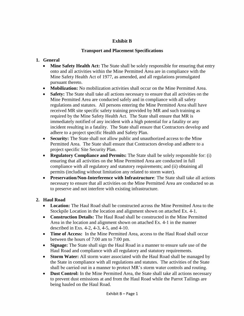
Exhibit B – Page 1
Exhibit B
Transport and Placement Specifications
1. General
Mine Safety Health Act: The State shall be solely responsible for ensuring that entry
onto and all activities within the Mine Permitted Area are in compliance with the
Mine Safety Health Act of 1977, as amended, and all regulations promulgated
pursuant thereto.
Mobilization: No mobilization activities shall occur on the Mine Permitted Area.
Safety: The State shall take all actions necessary to ensure that all activities on the
Mine Permitted Area are conducted safely and in compliance with all safety
regulations and statutes. All persons entering the Mine Permitted Area shall have
received MR site specific safety training provided by MR and such training as
required by the Mine Safety Health Act. The State shall ensure that MR is
immediately notified of any incident with a high potential for a fatality or any
incident resulting in a fatality. The State shall ensure that Contractors develop and
adhere to a project specific Health and Safety Plan.
Security: The State shall not allow public and unauthorized access to the Mine
Permitted Area. The State shall ensure that Contractors develop and adhere to a
project specific Site Security Plan.
Regulatory Compliance and Permits: The State shall be solely responsible for: (i)
ensuring that all activities on the Mine Permitted Area are conducted in full
compliance with all regulatory and statutory requirements; and (ii) obtaining all
permits (including without limitation any related to storm water).
Preservation/Non-Interference with Infrastructure: The State shall take all actions
necessary to ensure that all activities on the Mine Permitted Area are conducted so as
to preserve and not interfere with existing infrastructure.
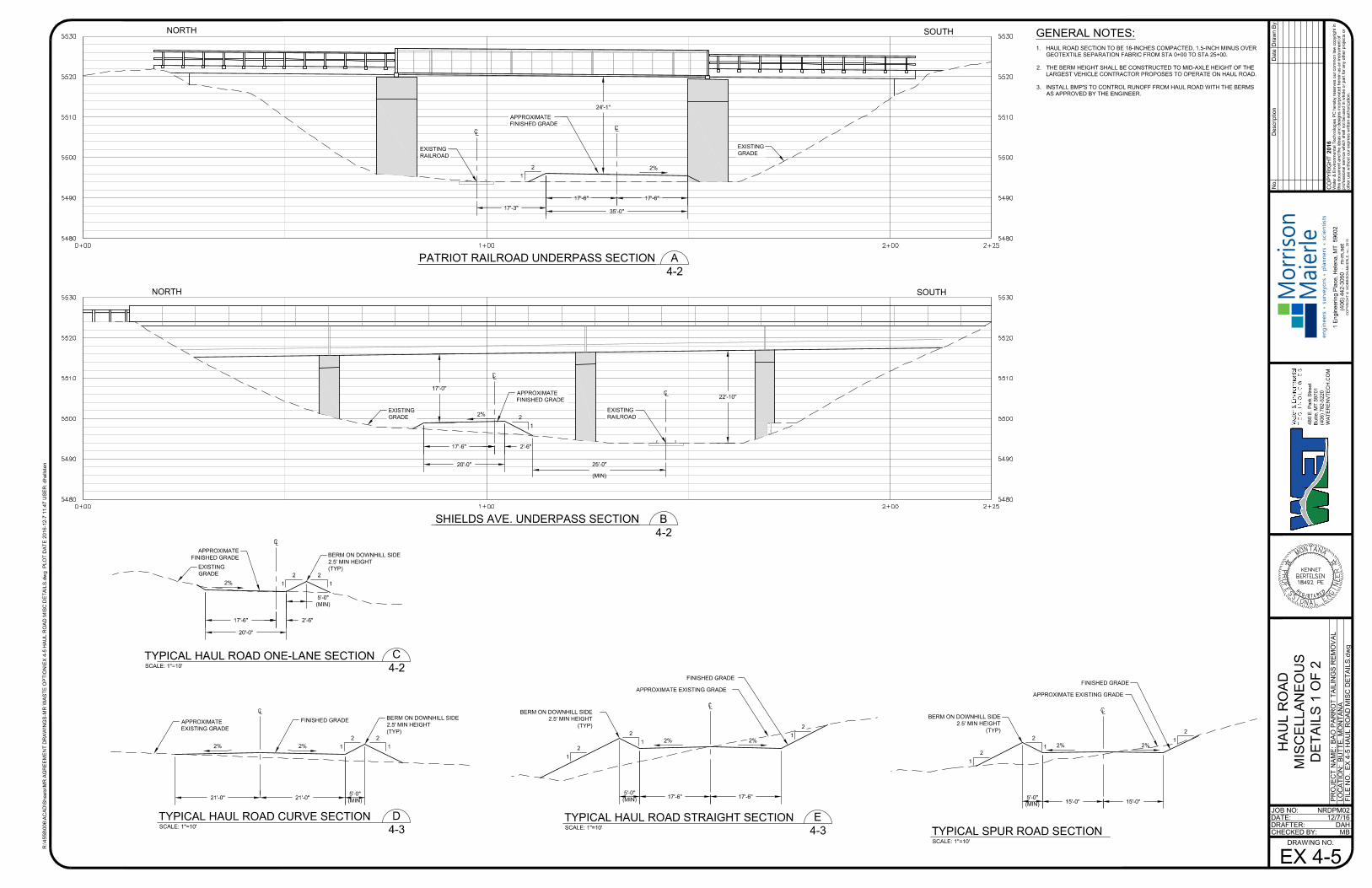
2. Haul Road
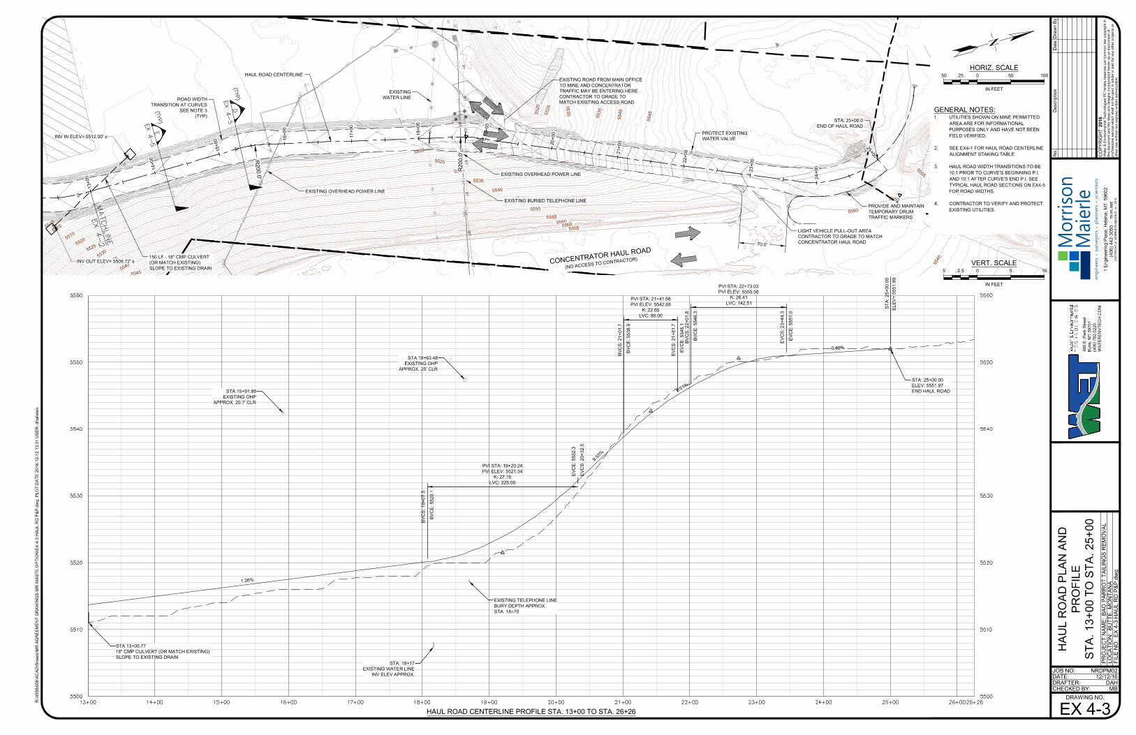
Location: The Haul Road shall be constructed across the Mine Permitted Area to the
Stockpile Location in the location and alignment shown on attached Ex. 4-1.
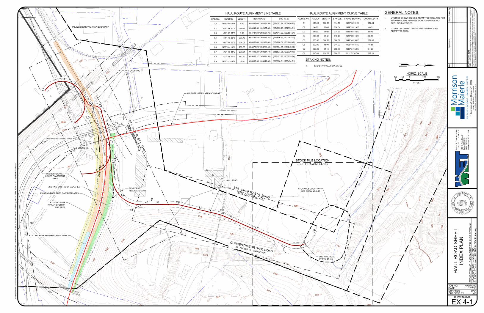
Construction Details: The Haul Road shall be constructed in the Mine Permitted
Area in the location and alignment shown on attached Ex. 4-1 in the manner
described in Exs. 4-2, 4-3, 4-5, and 4-10.
Time of Access: In the Mine Permitted Area, access to the Haul Road shall occur
between the hours of 7:00 am to 7:00 pm.
Signage: The State shall sign the Haul Road in a manner to ensure safe use of the
Haul Road and compliance with all regulatory and statutory requirements.
Storm Water: All storm water associated with the Haul Road shall be managed by
the State in compliance with all regulations and statutes. The activities of the State
shall be carried out in a manner to protect MR’s storm water controls and routing.
Dust Control: In the Mine Permitted Area, the State shall take all actions necessary
to prevent dust emissions at and from the Haul Road while the Parrot Tailings are
being hauled on the Haul Road.
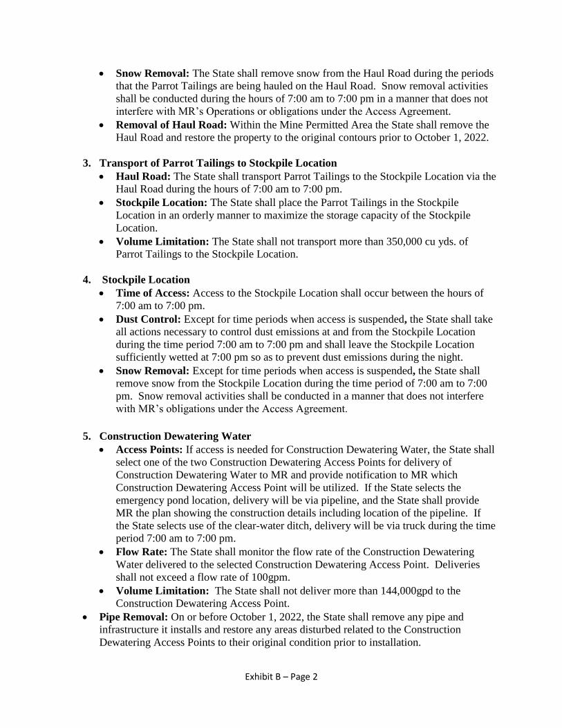
Exhibit B – Page 2
Snow Removal: The State shall remove snow from the Haul Road during the periods
that the Parrot Tailings are being hauled on the Haul Road. Snow removal activities
shall be conducted during the hours of 7:00 am to 7:00 pm in a manner that does not
interfere with MR’s Operations or obligations under the Access Agreement.
Removal of Haul Road: Within the Mine Permitted Area the State shall remove the
Haul Road and restore the property to the original contours prior to October 1, 2022.
3. Transport of Parrot Tailings to Stockpile Location
Haul Road: The State shall transport Parrot Tailings to the Stockpile Location via the
Haul Road during the hours of 7:00 am to 7:00 pm.
Stockpile Location: The State shall place the Parrot Tailings in the Stockpile
Location in an orderly manner to maximize the storage capacity of the Stockpile
Location.
Volume Limitation: The State shall not transport more than 350,000 cu yds. of
Parrot Tailings to the Stockpile Location.
4. Stockpile Location
Time of Access: Access to the Stockpile Location shall occur between the hours of
7:00 am to 7:00 pm.
Dust Control: Except for time periods when access is suspended, the State shall take
all actions necessary to control dust emissions at and from the Stockpile Location
during the time period 7:00 am to 7:00 pm and shall leave the Stockpile Location
sufficiently wetted at 7:00 pm so as to prevent dust emissions during the night.
Snow Removal: Except for time periods when access is suspended, the State shall
remove snow from the Stockpile Location during the time period of 7:00 am to 7:00
pm. Snow removal activities shall be conducted in a manner that does not interfere
with MR’s obligations under the Access Agreement.
5. Construction Dewatering Water
Access Points: If access is needed for Construction Dewatering Water, the State shall
select one of the two Construction Dewatering Access Points for delivery of
Construction Dewatering Water to MR and provide notification to MR which
Construction Dewatering Access Point will be utilized. If the State selects the
emergency pond location, delivery will be via pipeline, and the State shall provide
MR the plan showing the construction details including location of the pipeline. If
the State selects use of the clear-water ditch, delivery will be via truck during the time
period 7:00 am to 7:00 pm.
Flow Rate: The State shall monitor the flow rate of the Construction Dewatering
Water delivered to the selected Construction Dewatering Access Point. Deliveries
shall not exceed a flow rate of 100gpm.
Volume Limitation: The State shall not deliver more than 144,000gpd to the
Construction Dewatering Access Point.
Pipe Removal: On or before October 1, 2022, the State shall remove any pipe and
infrastructure it installs and restore any areas disturbed related to the Construction
Dewatering Access Points to their original condition prior to installation.
O
O
O
O
XX
X
X
X
X
X
X
X
X
O
O
O
O
O
O
O
O
O
O
O
O
O
O
O
O
O
O
O
O
O
O
O
O
B
P
B
P
SD
SD
SD
SD
SD
SD
SD
SD
SD
SD
SD
SD
SD
SD
S
D
S
D
S
D
S
D
S
D
S
D
S
D
SD
S
D
S
D
S
D
S
D
S
D
S
D
S
D
S
D
S
D
S
D
S
D
S
D
S
D
S
D
S
D
S
D
S
D
B
T
B
T
B
T
B
T
B
T
B
T
B
T
B
T
B
T
B
T
O
W
W
W
W
W
W
W
W
W
W
W
W
W
W
W
W
WW
W
W
W
W
W
W
W
W
W
W
W
W
W
W
W
W
W
W
W
BP
BP
BP
W
WW
W
W
W
W
W
O
H
P
O
H
P
O
H
P
O
H
P
O
H
P
O
H
P
OHP
WV
O
H
P
O
H
P
O
H
P
B
P
O
H
P
O
O
X
X
X
X
X
X
X
X
X
X
X
X
X
X
XX
X
X
X
X
X
X
X
X
X
X
X
X
X
X
X
X
X
X
X
X
X
X
X
X
O
O
O
O
O
O
O
O
O
O
O
O
O
O
O
N
G
N
G
N
G
N
G
N
G
N
G
NG
NG
NG
N
G
O
H
P
O
H
P
O
H
P
O
H
P
O
H
P
O
H
P
O
H
P
O
H
P
O
H
P
O
H
P
O
H
P
O
H
P
B
T
B
T
B
T
B
T
B
T
B
T
B
T
B
T
B
T
B
T
B
T
BT
B
T
BT
O
H
P
O
H
P
O
H
P
N
G
N
G
N
G
N
G
N
G
N
G
N
G
N
G
N
G
N
G
N
G
N
G
N
G
N
G
N
G
N
G
N
G
S
D
S
D
E
F
F
E
F
F
E
F
F
E
F
F
O
H
P
O
H
P
O
H
P
O
H
P
O
H
P
O
H
P
O
H
P
O
H
P
O
H
P
O
H
P
O
H
P
O
H
P
O
H
P
O
H
P
O
H
P
O
H
P
O
H
P
O
H
P
O
H
P
O
H
P
O
H
P
O
H
P
O
H
P
O
H
P
O
H
P
O
H
P
O
H
P
O
H
P
O
H
P
O
H
P
O
H
P
O
H
P
O
H
P
O
H
P
O
H
P
O
H
P
O
H
P
O
H
P
S
T
A
.
0
+
0
0
T
O
S
T
A
.
1
3
+
0
0
(
S
E
E
D
R
A
W
I
N
G
4
-
2
)
S
T
A
. 1
3
+
0
0
T
O
S
T
A
. 2
5
+
0
0
(
S
E
E
D
R
A
W
IN
G
4
-
3
)
STOCK PILE LOCATION
(SEE DRAWING 4-10)
O
EXISTING BNSF BRES CAP/ BERM AREA
TAILINGS REMOVAL AREA BOUNDARY
RAIL CROSSING
RAIL CROSSING
EXISTING BNSF ROCK CAP AREA
EXISTING BNSF SEDIMENT BASIN AREA
EXISTING BNSF
RIPRAP DITCH OR
CAP AREA
EXISTING RETAINING WALL
S
H
IE
L
D
S
A
V
E
.
5
5
0
0
5
5
2
5
5500
5
5
0
0
5500
5
5
0
0
5
5
0
0
5
5
2
5
5
5
2
5
5
5
5
0
5
5
2
5
5
5
5
0
5550
5525
5
5
5
0
5
5
2
5
5
5
0
0
5550
5525
5525
5550
5
5
5
0
5
3
5
0
5
3
7
5
5400
5
4
2
5
5
4
5
0
5475
5
4
7
5
5
5
0
0
5
5
5
0
5
5
5
0
5
5
5
0
5
5
7
5
5
5
2
5
5
5
0
0
5
4
7
5
5
4
5
0
5425
5575
5
5
2
5
STOCKPILE LOCATION
SEE DRAWING 4-10
TEMPORARY
FENCE AND GATE
C
O
N
C
E
N
T
R
A
T
O
R
H
A
U
L
R
O
A
D
(N
O
A
C
C
E
S
S
T
O
C
O
N
T
R
A
C
T
O
R
)
END HAUL ROAD
AT STA. 25+00
OVERBURDEN/ ET
COVER PLACEMENT
AREA
L
4
L5
L6
L
7
L3
L
9
L
8
L
2
L
1
C
2
C
4
C6
C
7
C
5
C
3
C
8
C1
MINE PERMITTED AREA BOUNDARY
HAUL ROAD
HAUL ROUTE ALIGNMENT LINE TABLE
LINE NO.
L1
L2
L3
L4
L5
L6
L7
L8
L9
BEARING
N55° 40' 53"W
N58° 54' 36"E
N00° 52' 01"E
N75° 15' 25"E
N85° 41' 13"E
N00° 20' 14"W
N13° 41' 41"E
N23° 28' 15"E
N66° 31' 45"W
LENGTH
1.00
88.50
9.89
203.70
238.09
233.55
278.61
487.30
14.38
BEGIN (N, E)
(654396.68,1202451.54)
(654649.58,1202457.83)
(654737.34,1202557.79)
(654794.83,1202595.21)
(654852.69,1202828.06)
(655071.20,1203250.43)
(655353.28,1203254.74)
(655656.27,1203331.56)
(656300.58,1203447.80)
END (N, E)
(654397.24,1202450.72)
(654695.28,1202533.61)
(654747.23,1202557.94)
(654846.67,1202792.20)
(654870.59,1203065.48)
(655304.75,1203249.06)
(655623.96,1203320.70)
(656103.25,1203525.64)
(656306.31,1203434.61)
HAUL ROUTE ALIGNMENT CURVE TABLE
CURVE NO.
C1
C2
C3
C4
C5
C6
C7
C8
RADIUS
150.00
50.00
50.00
200.00
200.00
200.00
200.00
150.00
LENGTH
300.00
50.65
64.92
36.41
300.28
48.98
34.13
235.62
Δ ANGLE
114.59
058.04
074.39
010.43
086.02
014.03
009.78
090.00
CHORD BEARING
N01° 36' 51"E
N29° 53' 19"E
N38° 03' 43"E
N80° 28' 19"E
N42° 40' 30"E
N06° 40' 44"E
N18° 34' 58"E
N21° 31' 45"W
CHORD LENTH
252.44
48.51
60.45
36.36
272.86
48.86
34.08
212.13
JOB NO:
DATE:
DRAFTER:
CHECKED BY:
R:\4
55
8\0
06
\A
CA
D\S
he
ets\M
R A
GR
EE
ME
NT
D
RA
WIN
GS
-M
R W
AS
TE
O
PT
IO
N\E
X 4
-1
H
AU
L R
D S
HT
IN
DE
X P
LA
N.d
wg
P
LO
T D
AT
E 2
01
6-1
2-7
1
1:3
5 U
SE
R: d
ha
llste
n
DRAWING NO.
PR
OJE
CT
N
AM
E:
LO
CA
TIO
N:
FILE
N
O.
2016
CO
PY
RIG
HT
No.
Water &
E
nvironm
ental T
echnologies P
C hereby reserves our com
mon law
copyright in
this docum
ent and the ideas and designs incorporated herein as an instrum
ent of
professional service w
hich shall not be used in w
hole or part for any other projects or
other use w
ithout our express w
ritten authorization.
BA
O P
AR
RO
T T
AILIN
GS
R
EM
OV
AL
BU
TT
E, M
ON
TA
NA
EX
4-1 H
AU
L R
D S
HT
IN
DE
X P
LA
N.dw
g
12/7/16
MB
Draw
n B
yD
ate
Description
DAH
NRDPM02
1 E
ngineering P
lace, H
elena, M
T 59602
(406) 442-3050 m
-m
.net
CO
PY
RIG
HT
©
M
OR
RIS
ON
-M
AIE
RL
E, IN
C., 2
01
5
en
gin
ee
rs su
rve
yo
rs p
lan
ne
rs scie
ntists
Mo
rriso
n
Maierle
48
0 E
. P
ark S
tre
et
Bu
tte
, M
T 5
97
01
(4
06
) 7
82
-5
22
0
WA
TE
RE
NV
TE
CH
.C
OM
HA
UL R
OA
D S
HE
ET
IN
DE
X P
LA
N
EX 4-1
0 100100 20050
HORIZ. SCALE
IN FEET
GENERAL NOTES:
1. UTILITIES SHOWN ON MINE PERMITTED AREA ARE FOR
INFORMATIONAL PURPOSES ONLY AND HAVE NOT
BEEN FIELD VERIFIED.
2. UTILIZE LEFT HAND TRAFFIC PATTERN ON MINE
PERMITTED AREA.
STAKING NOTES:
1. END STAKING AT STA. 25+00.
X
X
X
X
X
X
X
X
X
X
X
X
X
X
X
X
X
X
X
X
X
X
X
X
X
X
O
O
O
O
O
O
O
O
O
O
OHP
OHP
OHP
OHP
OHP
OHP
OHP
OHP
OHP
O
H
P
O
H
P
B
T
B
T
B
T
BT
BT
B
T
B
T
B
T
B
T
BT
NG
NG
NG
N
G
N
G
NG
N
G
N
G
NG
NG
N
G
N
G
NG
N
G
N
G
N
G
N
G
N
G
OHP
OHP
OHP
OHP
OHP
OHP
OHP
OHP
OHP
O
H
P
O
H
P
OHP
OHP
OHP
OHP
OHP
OH
P
OH
P
OH
P
OH
P
O
H
P
TAILINGS
REMOVAL AREA
BOUNDARY
S
H
IE
L
D
S
A
V
E
N
U
E
5
4
9
5
5
4
9
5
5
5
0
0
5
5
0
0
5
5
0
5
5
5
0
5
5
5
1
0
5
5
1
0
5
5
1
5
5
5
1
5
5
5
2
0
5
5
2
0
5525
5495
5495
5500
5
5
0
0
5
5
0
5
5505
5
5
1
0
5510
5
5
1
5
5515
5520
5
5
2
0
5
4
9
0
5
4
9
0
5
4
9
5
5
4
9
5
5
5
0
0
5
5
0
5
5
5
1
0
5
5
0
0
5490
5
5
0
0
5
5
1
0
5
5
1
0
5
5
1
5
5
5
2
0
5
5
2
5
5530
5
5
3
5
O
O
O
O
INV OUT ELEV= 5495.67' ±
INV IN ELEV= 5497.18' ±
EXISTING BNSF BRES
CAP/ BERM AREA
OVERBURDEN/
ET COVER
PLACEMENT
AREA
OVERBURDEN/
ET COVER
PLACEMENT
AREA
RAIL CROSSING
STA: 4+30.6
N: 654727.87
E: 1202556.74
SEE DRAWING 4-4
FOR DETAILS
EXISTING BNSF BRES ROCK
CAP AREA
EXISTING BNSF
BRES RIPRAP DITCH
OR CAP AREA
EXISTING RETAINING WALL
EXISTING STORMWATER DITCH
250 LF - 18" CMP CULVERT
MATCH EXISTING GRADE
0
+
0
0
1+
00
2
+
0
0
3+
00
4
+
0
0
5+
00
6
+
0
0
7
+
0
0
8
+
0
0
9
+
0
0
1
0
+
0
0
1
1
+
0
0
1
2
+
0
0
1
3
+
0
0
1
4
+
0
0
REMOVE EXISTING GATE
(LOCATION APPROXIMATE)
TEMPORARY FENCE WITH GATE
EXISTING SHIELDS AVE.
BRIDGE CROSSING
R
5
0
'
R
5
0
'
R
2
0
0
'
R200'
EXISTING RAILROAD
BRIDGE CROSSING
STA: 5+15.0
BEGIN 100' TRANSITION
TO SINGLE LANE TRAFFIC
STA: 6+15.0
END 100' TRANSITION
TO SINGLE LANE TRAFFIC
STA: 12+09.8
END 100' TRANSITION
TO DOUBLE LANE TRAFFIC
STA: 11+09.8
BEGIN 100' TRANSITION
TO DOUBLE LANE TRAFFIC
ROAD WIDTH
TRANSITION AT CURVES
SEE NOTE 3 (TYP)
R
1
5
0
'
HAUL ROAD CENTERLINE
MINE PERMITTED AREA BOUNDARY
HAUL ROAD CENTERLINE PROFILE STA. 0+00 TO STA. 13+00
ST
A: -0+
00.00
ELE
V=
5495.92
ST
A: 2+
01.27
ELE
V=
5495.50
ST
A: 3+
95.35
ELE
V=
5495.50
ST
A: 4+
25.35
ELE
V=
5494.00
ST
A: 4+
66.07
ELE
V=
5495.54
PVI STA: 11+78.10
PVI ELEV: 5512.17
K: 33.71
LVC: 185.00
BV
CS
: 10+
85.7
BV
CE
: 5505.9
EV
CS
: 1
2+
70
.7
EV
CE
: 5513.3
PVI STA: 9+82.31
PVI ELEV: 5498.95
K: 29.57
LVC: 180.00
BV
CS
: 8+
92.2
BV
CE
: 5498.4
EV
CS
: 10+
72.2
EV
CE
: 5505.0
STA: 2+20.31
EXISTING FENCE
STA: 0+98.97
EXISTING OHP
ST
A: 1+
66
EX
ST
G
AS
LIN
E
EX
ST
T
ELE
PH
ON
E LIN
E
ST
A. 4+
66
STA 4+30.35
EXISTING RAILROAD CROSSING
STA: 10+23.41
EXISTING CHAIN LINK FENCE
STA 10+45.84
18" CMP CULVERT
MATCH EXISTING GRADE
STA 6+19.79
ELEV=5515.87
EXISTING SHIELDS AVE BRIDGE
LP
MR
LP
ST
A: 2+
26
MR
ST
A: 0+
94
STA 2+96.07
ELEV=5520.09
EXISTING RAILROAD BRIDGE
ST
A: 7+
69
MIN
E P
ER
MIT
TE
D A
RE
A B
OU
ND
AR
Y
LP
6
.
7
5
%
0.6
6%
-0.21%
0.00%
-
5
.
0
0
%
5
.
0
0
%
18"
JOB NO:
DATE:
DRAFTER:
CHECKED BY:
R:\4
55
8\0
06
\A
CA
D\S
he
ets\M
R A
GR
EE
ME
NT
D
RA
WIN
GS
-M
R W
AS
TE
O
PT
IO
N\E
X 4
-2
H
AU
L R
D P
&P
.d
wg P
LO
T D
AT
E 2
01
6-1
2-7
1
1:4
1 U
SE
R: d
ha
llste
n
DRAWING NO.
PR
OJE
CT
N
AM
E:
LO
CA
TIO
N:
FILE
N
O.
2016
CO
PY
RIG
HT
No.
Water &
E
nvironm
ental T
echnologies P
C hereby reserves our com
mon law
copyright in
this docum
ent and the ideas and designs incorporated herein as an instrum
ent of
professional service w
hich shall not be used in w
hole or part for any other projects or
other use w
ithout our express w
ritten authorization.
BA
O P
AR
RO
T T
AILIN
GS
R
EM
OV
AL
BU
TT
E, M
ON
TA
NA
EX
4-2 H
AU
L R
D P
&P
.dw
g
12/7/16
MB
Draw
n B
yD
ate
Description
DAH
NRDPM02
1 E
ngineering P
lace, H
elena, M
T 59602
(406) 442-3050 m
-m
.net
CO
PY
RIG
HT
©
M
OR
RIS
ON
-M
AIE
RL
E, IN
C., 2
01
5
en
gin
ee
rs su
rve
yo
rs p
lan
ne
rs scie
ntists
Mo
rriso
n
Maierle
48
0 E
. P
ark S
tre
et
Bu
tte
, M
T 5
97
01
(4
06
) 7
82
-5
22
0
WA
TE
RE
NV
TE
CH
.C
OM
HA
UL R
OA
D P
LA
N A
ND
PR
OF
ILE
ST
A. 0+
00 T
O S
TA
. 13+
00
EX 4-2
0 5050 10025
HORIZ. SCALE
IN FEET
0 55 102.5
VERT. SCALE
IN FEET
GENERAL NOTES:
1. UTILITIES SHOWN ON MINE PERMITTED AREA
ARE FOR INFORMATIONAL PURPOSES ONLY
AND HAVE NOT BEEN FIELD VERIFIED.
2. SEE EX4-1 FOR HAUL ROUTE CENTERLINE
ALIGNMENT STAKING TABLE.
3. HAUL ROAD WIDTH TRANSITIONS TO BE 10:1
PRIOR TO CURVE'S BEGINNING P.I. AND 10:1
AFTER CURVE'S END P.I. SEE TYPICAL HAUL
ROAD SECTIONS ON EX4-5 FOR ROAD WIDTHS.
B
P
B
P
B
P
B
P
S
D
S
D
SD
SD
SD
SD
SD
S
D
S
D
BT
BT
BT
BT
BT
BT
BT
BT
BT
B
T
BT
BT
BT
BT
BT
BT
BT
BT
BT
W
W
W
W
W
W
W
W
W
W
W
W
W
W
W
W
W
W
W
W
W
W
O
H
P
O
H
P
O
H
P
O
H
P
O
H
P
O
H
P
OH
P
OH
P
OH
P
OH
P
OH
P
OH
P
O
H
P
W
V
BP
5
5
1
0
5
5
1
0
5
5
1
5
5
5
2
0
5
5
2
5
5
5
3
0
5
5
3
5
5
5
4
0
5
5
4
5
5
5
5
0
5
5
2
0
5
5
2
5
5530
5535
5540
5
5
4
5
5550
5555
5555
5560
5
5
6
0
5
5
2
0
5
5
2
5
5530
5
5
3
5
5540
5
5
4
5
5
5
4
5
5
5
4
5
5
5
4
5
5550
5550
5550
5
5
5
0
5555
5555
5
5
5
5
5
5
5
5
5
5
6
0
5
5
6
0
5
5
6
5
5
5
6
5
1
3
+
0
0
1
4
+
0
0
1
5
+
0
0
16+
00
17+
00
18+
00
19+
00
20+
00
21+
00
22+
00
23+
00
24+
00
2
5
+
0
0INV OUT ELEV= 5509.72' ±
INV IN ELEV= 5512.00' ±
70.0
'
HAUL ROAD CENTERLINE
EXISTING OVERHEAD POWER LINE
EXISTING OVERHEAD POWER LINE
LIGHT VEHICLE PULL-OUT AREA
CONTRACTOR TO GRADE TO MATCH
CONCENTRATOR HAUL ROAD
1
3
+
0
0
1
4
+
0
0
1
5
+
0
0
16+
00
17+
00
18+
00
19+
00
20+
00
21+
00
22+
00
23+
00
24+
00
2
5
+
0
0
EXISTING ROAD FROM MAIN OFFICE
TO MINE AND CONCENTRATOR
TRAFFIC MAY BE ENTERING HERE
CONTRACTOR TO GRADE TO
MATCH EXISTING ACCESS ROAD
R
200.0'
R200.0'
PROTECT EXISTING
WATER VALVE
ROAD WIDTH
TRANSITION AT CURVES
SEE NOTE 3
(TYP)
EXISTING BURIED TELEPHONE LINE
EXISTING
WATER LINE
150 LF - 18" CMP CULVERT
(OR MATCH EXISTING)
SLOPE TO EXISTING DRAIN
PROVIDE AND MAINTAIN
TEMPORARY DRUM
TRAFFIC MARKERS
CO
NC
EN
TR
AT
O
R H
AU
L R
O
AD
(N
O
AC
CE
SS
TO
CO
NT
RA
CT
O
R)
STA: 25+00.0
END OF HAUL ROAD
HAUL ROAD CENTERLINE PROFILE STA. 13+00 TO STA. 26+26
1.26%
9
.
5
5
%
6
.
0
1
%
0.62%
ST
A: 25+
00.00
ELE
V=
5551.99
PVI STA: 21+41.68
PVI ELEV: 5542.68
K: 22.65
LVC: 80.00
BV
CS
: 21+
01.7
BV
CE
: 5538.9
EV
CS
: 21+
81.7
EV
CE
: 5545.1
PVI STA: 22+73.03
PVI ELEV: 5550.58
K: 26.41
LVC: 142.51
BV
CS
: 22+
01.8
BV
CE
: 5546.3
EV
CS
: 23+
44.3
EV
CE
: 5551.0
PVI STA: 19+20.24
PVI ELEV: 5521.54
K: 27.16
LVC: 225.00
BV
CS
: 18+
07.5
BV
CE
: 5520.1
EV
CS
: 20+
32.5
EV
CE
: 5532.3
STA 15+91.88
EXISTING OHP
APPROX. 20.7' CLR
STA 18+63.48
EXISTING OHP
APPROX. 25' CLR
STA 13+00.77
18" CMP CULVERT (OR MATCH EXISTING)
SLOPE TO EXISTING DRAIN
STA: 18+17
EXISTING WATER LINE
INV ELEV APPROX.
EXISTING TELEPHONE LINE
BURY DEPTH APPROX.
STA. 18+70
STA: 25+00.00
ELEV: 5551.97
END HAUL ROAD
JOB NO:
DATE:
DRAFTER:
CHECKED BY:
R:\4
55
8\0
06
\A
CA
D\S
he
ets\M
R A
GR
EE
ME
NT
D
RA
WIN
GS
-M
R W
AS
TE
O
PT
IO
N\E
X 4
-3
H
AU
L R
D P
&P
.d
wg P
LO
T D
AT
E 2
01
6-1
2-1
2 1
3:3
1 U
SE
R: d
ha
llste
n
DRAWING NO.
PR
OJE
CT
N
AM
E:
LO
CA
TIO
N:
FILE
N
O.
2016
CO
PY
RIG
HT
No.
Water &
E
nvironm
ental T
echnologies P
C hereby reserves our com
mon law
copyright in
this docum
ent and the ideas and designs incorporated herein as an instrum
ent of
professional service w
hich shall not be used in w
hole or part for any other projects or
other use w
ithout our express w
ritten authorization.
BA
O P
AR
RO
T T
AILIN
GS
R
EM
OV
AL
BU
TT
E, M
ON
TA
NA
EX
4-3 H
AU
L R
D P
&P
.dw
g
12/12/16
MB
Draw
n B
yD
ate
Description
DAH
NRDPM02
1 E
ngineering P
lace, H
elena, M
T 59602
(406) 442-3050 m
-m
.net
CO
PY
RIG
HT
©
M
OR
RIS
ON
-M
AIE
RL
E, IN
C., 2
01
5
en
gin
ee
rs su
rve
yo
rs p
lan
ne
rs scie
ntists
Mo
rriso
n
Maierle
48
0 E
. P
ark S
tre
et
Bu
tte
, M
T 5
97
01
(4
06
) 7
82
-5
22
0
WA
TE
RE
NV
TE
CH
.C
OM
HA
UL R
OA
D P
LA
N A
ND
PR
OF
ILE
ST
A. 13+
00 T
O S
TA
. 25+
00
EX 4-3
0 5050 10025
HORIZ. SCALE
IN FEET
0 55 102.5
VERT. SCALE
IN FEET
GENERAL NOTES:
1. UTILITIES SHOWN ON MINE PERMITTED
AREA ARE FOR INFORMATIONAL
PURPOSES ONLY AND HAVE NOT BEEN
FIELD VERIFIED.
2. SEE EX4-1 FOR HAUL ROAD CENTERLINE
ALIGNMENT STAKING TABLE.
3. HAUL ROAD WIDTH TRANSITIONS TO BE
10:1 PRIOR TO CURVE'S BEGINNING P.I.
AND 10:1 AFTER CURVE'S END P.I. SEE
TYPICAL HAUL ROAD SECTIONS ON EX4-5
FOR ROAD WIDTHS.
4. CONTRACTOR TO VERIFY AND PROTECT
EXISTING UTILITIES.
PATRIOT RAILROAD UNDERPASS SECTION
17'-3"
35'-0"
17'-6" 17'-6"
2%
EXISTING
GRADE
APPROXIMATE
FINISHED GRADE
EXISTING
RAILROAD
24'-1"
NORTH
SOUTH
2
1
2%2%
2
1
2
1
BERM ON DOWNHILL SIDE
2.5' MIN HEIGHT
(TYP)
21'-0" 21'-0"
5'-0"
(MIN)
FINISHED GRADE
APPROXIMATE
EXISTING GRADE
2% 2%
2
1
2
1
BERM ON DOWNHILL SIDE
2.5' MIN HEIGHT
(TYP)
5'-0"
(MIN)
17'-6" 17'-6"
2
1
FINISHED GRADE
APPROXIMATE EXISTING GRADE
SHIELDS AVE. UNDERPASS SECTION
NORTHSOUTH
25'-0"
(MIN)
20'-0"
2'-6"17'-6"
2%
EXISTING
GRADE
EXISTING
RAILROAD
APPROXIMATE
FINISHED GRADE
22'-10"
17'-0"
2
1
2% 2%
2
1
2
1
BERM ON DOWNHILL SIDE
2.5' MIN HEIGHT
(TYP)
5'-0"
(MIN)
15'-0" 15'-0"
2
1
FINISHED GRADE
APPROXIMATE EXISTING GRADE
20'-0"
2'-6"17'-6"
2%
EXISTING
GRADE
APPROXIMATE
FINISHED GRADE
2
1
2
1
BERM ON DOWNHILL SIDE
2.5' MIN HEIGHT
(TYP)
5'-0"
(MIN)
JOB NO:
DATE:
DRAFTER:
CHECKED BY:
R:\4
55
8\0
06
\A
CA
D\S
he
ets\M
R A
GR
EE
ME
NT
D
RA
WIN
GS
-M
R W
AS
TE
O
PT
IO
N\E
X 4
-5
H
AU
L R
OA
D M
IS
C D
ET
AIL
S.d
wg P
LO
T D
AT
E 2
01
6-1
2-7
1
1:4
7 U
SE
R: d
ha
llste
n
DRAWING NO.
PR
OJE
CT
N
AM
E:
LO
CA
TIO
N:
FILE
N
O.
2016
CO
PY
RIG
HT
No.
Water &
E
nvironm
ental T
echnologies P
C hereby reserves our com
mon law
copyright in
this docum
ent and the ideas and designs incorporated herein as an instrum
ent of
professional service w
hich shall not be used in w
hole or part for any other projects or
other use w
ithout our express w
ritten authorization.
BA
O P
AR
RO
T T
AILIN
GS
R
EM
OV
AL
BU
TT
E, M
ON
TA
NA
EX
4-5 H
AU
L R
OA
D M
IS
C D
ET
AILS
.dw
g
12/7/16
MB
Draw
n B
yD
ate
Description
DAH
NRDPM02
1 E
ngineering P
lace, H
elena, M
T 59602
(406) 442-3050 m
-m
.net
CO
PY
RIG
HT
©
M
OR
RIS
ON
-M
AIE
RL
E, IN
C., 2
01
5
en
gin
ee
rs su
rve
yo
rs p
lan
ne
rs scie
ntists
Mo
rriso
n
Maierle
48
0 E
. P
ark S
tre
et
Bu
tte
, M
T 5
97
01
(4
06
) 7
82
-5
22
0
WA
TE
RE
NV
TE
CH
.C
OM
HA
UL R
OA
D
MIS
CE
LLA
NE
OU
S
DE
TA
ILS
1 O
F 2
EX 4-5
TYPICAL HAUL ROAD CURVE SECTIOND
4-3
SCALE: 1"=10'
A
4-2
TYPICAL HAUL ROAD STRAIGHT SECTIONE
4-3
SCALE: 1"=10'
B
4-2
GENERAL NOTES:
1. HAUL ROAD SECTION TO BE 18-INCHES COMPACTED, 1.5-INCH MINUS OVER
GEOTEXTILE SEPARATION FABRIC FROM STA 0+00 TO STA 25+00.
2. THE BERM HEIGHT SHALL BE CONSTRUCTED TO MID-AXLE HEIGHT OF THE
LARGEST VEHICLE CONTRACTOR PROPOSES TO OPERATE ON HAUL ROAD.
3. INSTALL BMP'S TO CONTROL RUNOFF FROM HAUL ROAD WITH THE BERMS
AS APPROVED BY THE ENGINEER.
TYPICAL SPUR ROAD SECTION
SCALE: 1"=10'
TYPICAL HAUL ROAD ONE-LANE SECTION
C
4-2
SCALE: 1"=10'
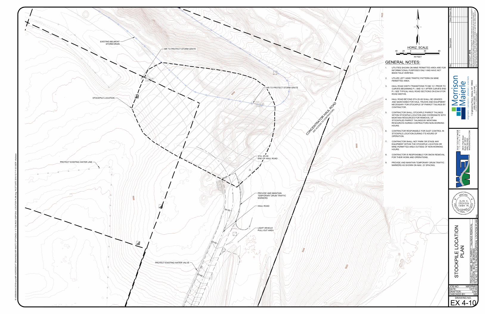
O
O
O
O
O
O
O
O
O
O
O
O
S
D
S
D
S
D
S
D
S
D
S
D
S
D
S
D
S
D
S
D
S
D
S
D
S
D
S
D
S
D
S
D
S
D
S
D
S
D
SD
S
D
S
D
S
D
S
D
S
D
S
D
S
D
S
D
S
D
S
D
S
D
S
D
S
D
S
D
W
W
W
W
W
W
W
W
W
W
W
W
W
W
W
W
W
W
W
W
W
WV
2
1
+
0
0
2
2
+
0
0
2
3
+
0
0
2
4
+
0
0
2
5
+
0
0
5
5
5
0
5
5
2
5
5550
5525
5
5
2
5
5550
5
5
5
0
C
O
N
C
E
N
T
R
A
T
O
R
H
A
U
L
R
O
A
D
(
N
O
A
C
C
E
S
S
T
O
C
O
N
T
R
A
C
T
O
R
)
STOCKPILE LOCATION
HAUL ROAD
STA. 25+00
END OF HAUL ROAD
MR TO PROTECT STORM GRATE
MR TO PROTECT STORM GRATE
PROVIDE AND MAINTAIN
TEMPORARY DRUM TRAFFIC
MARKERS
LIGHT VEHICLE
PULL-OUT AREA
PROTECT EXISTING WATER VALVE
PROTECT EXISTING WATER LINE
EXISTING BELMONT
STORM DRAIN
JOB NO:
DATE:
DRAFTER:
CHECKED BY:
R:\4
55
8\0
06
\A
CA
D\S
he
ets\M
R A
GR
EE
ME
NT
D
RA
WIN
GS
-M
R W
AS
TE
O
PT
IO
N\E
X 4
-1
0 T
AIL
IN
GS
D
IS
PO
SA
L L
OC
AT
IO
N P
LA
N.d
wg
P
LO
T D
AT
E 2
01
6-1
2-7
1
1:3
2 U
SE
R: d
ha
llste
n
DRAWING NO.
PR
OJE
CT
N
AM
E:
LO
CA
TIO
N:
FILE
N
O.
2016
CO
PY
RIG
HT
No.
Water &
E
nvironm
ental T
echnologies P
C hereby reserves our com
mon law
copyright in
this docum
ent and the ideas and designs incorporated herein as an instrum
ent of
professional service w
hich shall not be used in w
hole or part for any other projects or
other use w
ithout our express w
ritten authorization.
BA
O P
AR
RO
T T
AILIN
GS
R
EM
OV
AL
BU
TT
E, M
ON
TA
NA
EX
4-10 T
AILIN
GS
D
IS
PO
SA
L LO
CA
TIO
N P
LA
N.dw
g
12/7/16
MB
Draw
n B
yD
ate
Description
DAH
NRDPM02
1 E
ngineering P
lace, H
elena, M
T 59602
(406) 442-3050 m
-m
.net
CO
PY
RIG
HT
©
M
OR
RIS
ON
-M
AIE
RL
E, IN
C., 2
01
5
en
gin
ee
rs su
rve
yo
rs p
lan
ne
rs scie
ntists
Mo
rriso
n
Maierle
48
0 E
. P
ark S
tre
et
Bu
tte
, M
T 5
97
01
(4
06
) 7
82
-5
22
0
WA
TE
RE
NV
TE
CH
.C
OM
ST
OC
KP
ILE
LO
CA
TIO
N
PLA
N
EX 4-10
0 4040 8020
HORIZ. SCALE
IN FEET
GENERAL NOTES:
1. UTILITIES SHOWN ON MINE PERMITTED AREA ARE FOR
INFORMATIONAL PURPOSES ONLY AND HAVE NOT
BEEN FIELD VERIFIED.
2. UTILIZE LEFT HAND TRAFFIC PATTERN ON MINE
PERMITTED AREA.
3. HAUL ROAD WIDTH TRANSITIONS TO BE 10:1 PRIOR TO
CURVE'S BEGINNING P.I. AND 10:1 AFTER CURVE'S END
P.I. SEE TYPICAL HAUL ROAD SECTIONS ON EX4-5 FOR
ROAD WIDTHS.
4. HAUL ROAD BEYOND STA 25+00 SHALL BE GRADED
AND MAINTAINED FOR HAUL TRUCKS AND EQUIPMENT
NECESSARY FOR STOCKPILE OF PARROT TAILINGS BY
CONTRACTOR.
5. CONTRACTOR SHALL STOCKPILE PARROT TAILINGS
WITHIN STOCKPILE LOCATION AND COORDINATE WITH
MONTANA RESOURCES FOR REMOVAL OF
STOCKPILED PARROT TAILINGS BY MONTANA
RESOURCES DURING CONTRACTORS NON-WORKING
HOURS.
6. CONTRACTOR RESPONSIBLE FOR DUST CONTROL IN
STOCKPILE LOCATION DURING IT'S HOURS OF
OPERATION.
7. CONTRACTOR SHALL NOT PARK OR STAGE ANY
EQUIPMENT WITHIN THE STOCKPILE LOCATION OR
MINE PERMITTED AREA OUTSIDE OF NON-WORKING
HOURS.
8. CONTRACTOR IS RESPONSIBLE FOR SNOW REMOVAL
FOR THEIR WORK AND OPERATIONS.
9. PROVIDE AND MAINTAIN TEMPORARY DRUM TRAFFIC
MARKERS AS SHOWN ON MAX. 25' SPACING.