Embed Size (px)
Citation preview

AERONAUTICAL INFORMATION
PUBLICATION
COOK ISLANDS


GEN 0.1 - 1AIP — Cook Islands
E Government of Cook Islands
GEN 0.1 PREFACE
1 PROVISION OF THE AIP — COOK ISLANDS
1.1 General
1.1.1 Provision of the AIP — Cook Islands is the responsibility of theCook Islands Airport Authority under delegation from the Ministry ofTransport, Cook Islands. It is published by Aeropath, an AIS providercontracted by CAA of New Zealand, under Rule Part 175 to provide theAIP service containing information relevant to operations within theCook Sector and the Rarotonga CTR/CTA of the Auckland Oceanic FIR.For operations within the Auckland Oceanic FIR, operators should referto the AIP New Zealand.
2 PUBLISHING AUTHORITY
2.1 Authority
Secretary for TransportMinistry of TransportPO Box 61RarotongaCOOK ISLANDS
TEL (682) 28 810FAX (682) 28 816Email [email protected] www.transport.gov.ck
AFTN NCRGYAYX
Effective: 13 SEP 18
GEN 0.1 - 2 AIP — Cook Islands
E Government of Cook Islands
2.2 Publisher
AeropathPO Box 294Wellington 6140NEW ZEALAND
TEL (64) 4 471 1899FAX Nil
TELEX NilAFTN Nil
email [email protected] www.nzais.co.nz
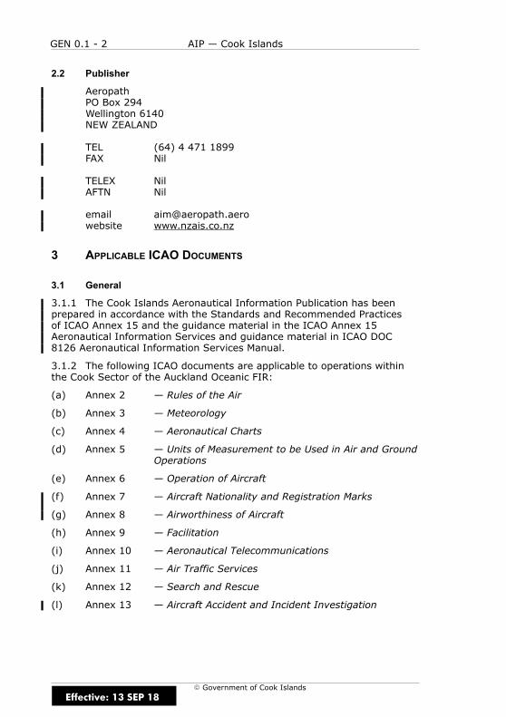
3 APPLICABLE ICAO DOCUMENTS
3.1 General
3.1.1 The Cook Islands Aeronautical Information Publication has beenprepared in accordance with the Standards and Recommended Practicesof ICAO Annex 15 and the guidance material in the ICAO Annex 15Aeronautical Information Services and guidance material in ICAO DOC8126 Aeronautical Information Services Manual.
3.1.2 The following ICAO documents are applicable to operations withinthe Cook Sector of the Auckland Oceanic FIR:
(a) Annex 2 — Rules of the Air
(b) Annex 3 — Meteorology
(c) Annex 4 — Aeronautical Charts
(d) Annex 5 — Units of Measurement to be Used in Air and GroundOperations
(e) Annex 6 — Operation of Aircraft
(f) Annex 7 — Aircraft Nationality and Registration Marks
(g) Annex 8 — Airworthiness of Aircraft
(h) Annex 9 — Facilitation
(i) Annex 10 — Aeronautical Telecommunications
(j) Annex 11 — Air Traffic Services
(k) Annex 12 — Search and Rescue
(l) Annex 13 — Aircraft Accident and Incident Investigation
Effective: 13 SEP 18
GEN 0.1 - 3AIP — Cook Islands
E Government of Cook Islands
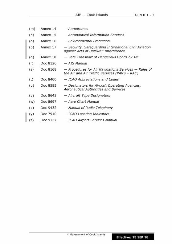
(m) Annex 14 — Aerodromes
(n) Annex 15 — Aeronautical Information Services
(o) Annex 16 — Environmental Protection
(p) Annex 17 — Security, Safeguarding International Civil Aviationagainst Acts of Unlawful Interference
(q) Annex 18 — Safe Transport of Dangerous Goods by Air
(r) Doc 8126 — AIS Manual
(s) Doc 8168 — Procedures for Air Navigations Services — Rules ofthe Air and Air Traffic Services (PANS – RAC)
(t) Doc 8400 — ICAO Abbreviations and Codes
(u) Doc 8585 — Designators for Aircraft Operating Agencies,Aeronautical Authorities and Services
(v) Doc 8643 — Aircraft Type Designators
(w) Doc 8697 — Aero Chart Manual
(x) Doc 9432 — Manual of Radio Telephony
(y) Doc 7910 — ICAO Location Indicators
(z) Doc 9137 — ICAO Airport Services Manual
Effective: 13 SEP 18
GEN 0.1 - 4 AIP — Cook Islands
E Government of Cook Islands
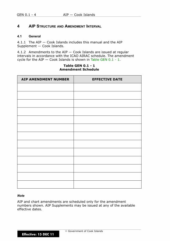
4 AIP STRUCTURE AND AMENDMENT INTERVAL
4.1 General
4.1.1 The AIP — Cook Islands includes this manual and the AIPSupplement — Cook Islands.
4.1.2 Amendments to the AIP — Cook Islands are issued at regularintervals in accordance with the ICAO AIRAC schedule. The amendmentcycle for the AIP — Cook Islands is shown in Table GEN 0.1 - 1.
Table GEN 0.1 - 1Amendment Schedule
AIP AMENDMENT NUMBER EFFECTIVE DATE
Note
AIP and chart amendments are scheduled only for the amendmentnumbers shown. AIP Supplements may be issued at any of the availableeffective dates.
Effective: 15 DEC 11
GEN 0.1 - 5AIP — Cook Islands
E Government of Cook Islands
4.2 Amendments
4.2.1 Amendments to the AIP — Cook Islands are issued as replacementpages, or in the case of Enroute Charts, as replacement charts.
4.3 Amendment Bulletin
4.3.1 A Bulletin will be issued with each amendment to the AIP — CookIslands providing a summary of significant changes.
4.4 Annotation of Amendments
4.4.1 Changes to text or new information in the AIP — Cook Islands areidentified by a vertical black line (revision bar) in the margin. Deletions areidentified by a “D”. Changes in the Checklist of AIP Pages are identified bya grey shading. Changes to charts are indicated by a note in the rightmargin of the charts, giving the previous effective date and changes fromthe previous edition.
4.5 Nil Amendment Notification
4.5.1 In the event of there being no changes effective at a scheduledeffective date, a “NIL Amendment” notification will be issued by NOTAM.
5 NOTIFICATION OF ERRORS AND OMISSIONS
5.1 General
5.1.1 Errors, omissions and suggestions for improvement of the AIP —Cook Islands, AIP Supplement — Cook Islands, and Enroute Charts shouldbe notified immediately to:
Secretary for TransportMinistry of TransportPO Box 61RarotongaCOOK ISLANDS
TEL (682) 28 810FAX (682) 28 816
AFTN NCRGYAYX
Effective: 15 DEC 11

GEN 0.1 - 6 AIP — Cook Islands
E Government of Cook Islands
IntentionallyBlank
Effective: 15 DEC 11

GEN 0.2 - 1AIP — Cook Islands
E Government of Cook Islands
GEN 0.2 RECORD OF AIP AMENDMENTS
1 AIP AMENDMENT DATES
1.1 General
1.1.1 Table GEN 0.2 - 1 lists AIP Amendments to the AIP — Cook Islands.
Table GEN 0.2 - 1Record of Amendments
AMENDMENTNUMBER
EFFECTIVEDATE
DATEINSERTED INSERTED BY
1 2 APR 15 INCORPORATED
2 30 APR 15 INCORPORATED
3 23 JUL 15 INCORPORATED
4 17 SEP 15 INCORPORATED
5 12 NOV 15 INCORPORATED
6 31 MAR 16 INCORPORATED
7 15 SEP 16 INCORPORATED
8 25 MAY 17 INCORPORATED
9 19 JUL 18 INCORPORATED
10 13 SEP 18 INCORPORATED
Effective: 15 DEC 11

GEN 0.2 - 2 AIP — Cook Islands
E Government of Cook Islands
IntentionallyBlank
Effective: 15 DEC 11
GEN 0.3 - 1AIP — Cook Islands
E Government of Cook Islands
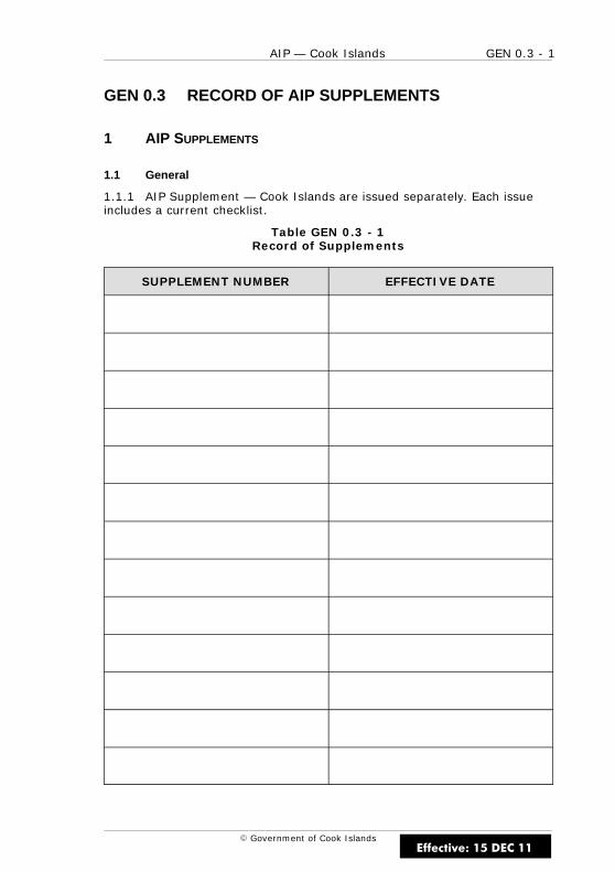
GEN 0.3 RECORD OF AIP SUPPLEMENTS
1 AIP SUPPLEMENTS
1.1 General
1.1.1 AIP Supplement — Cook Islands are issued separately. Each issueincludes a current checklist.
Table GEN 0.3 - 1Record of Supplements
SUPPLEMENT NUMBER EFFECTIVE DATE
Effective: 15 DEC 11

GEN 0.3 - 2 AIP — Cook Islands
E Government of Cook Islands
IntentionallyBlank
Effective: 15 DEC 11
GEN 0.4 - 1AIP — Cook Islands
E Government of Cook Islands
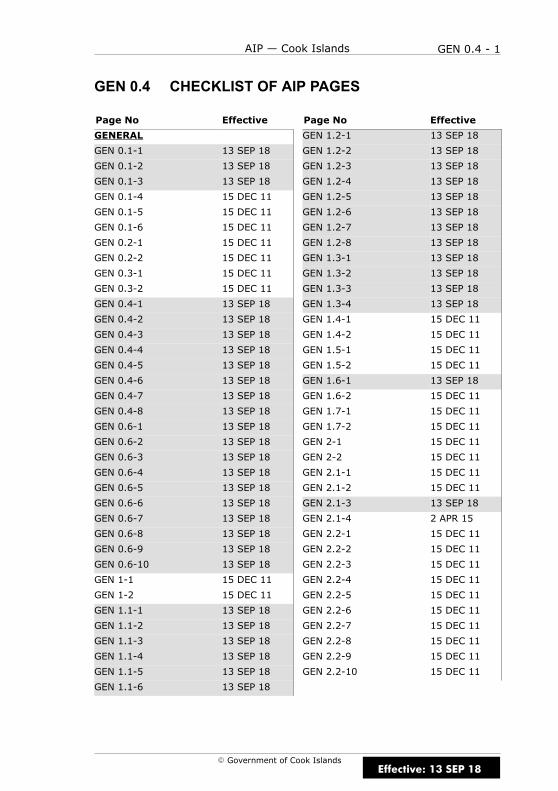
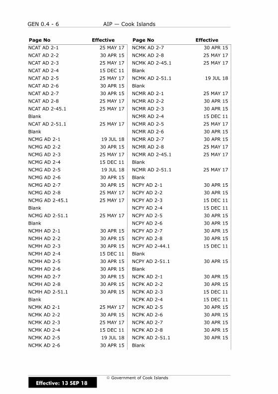
GEN 0.4 CHECKLIST OF AIP PAGES
Page No Effective Page No Effective
GENERAL
GEN 0.1-1 13 SEP 18
GEN 0.1-2 13 SEP 18
GEN 0.1-3 13 SEP 18
GEN 0.1-4 15 DEC 11
GEN 0.1-5 15 DEC 11
GEN 0.1-6 15 DEC 11
GEN 0.2-1 15 DEC 11
GEN 0.2-2 15 DEC 11
GEN 0.3-1 15 DEC 11
GEN 0.3-2 15 DEC 11
GEN 0.4-1 13 SEP 18
GEN 0.4-2 13 SEP 18
GEN 0.4-3 13 SEP 18
GEN 0.4-4 13 SEP 18
GEN 0.4-5 13 SEP 18
GEN 0.4-6 13 SEP 18
GEN 0.4-7 13 SEP 18
GEN 0.4-8 13 SEP 18
GEN 0.6-1 13 SEP 18
GEN 0.6-2 13 SEP 18
GEN 0.6-3 13 SEP 18
GEN 0.6-4 13 SEP 18
GEN 0.6-5 13 SEP 18
GEN 0.6-6 13 SEP 18
GEN 0.6-7 13 SEP 18
GEN 0.6-8 13 SEP 18
GEN 0.6-9 13 SEP 18
GEN 0.6-10 13 SEP 18
GEN 1-1 15 DEC 11
GEN 1-2 15 DEC 11
GEN 1.1-1 13 SEP 18
GEN 1.1-2 13 SEP 18
GEN 1.1-3 13 SEP 18
GEN 1.1-4 13 SEP 18
GEN 1.1-5 13 SEP 18
GEN 1.1-6 13 SEP 18
GEN 1.2-1 13 SEP 18
GEN 1.2-2 13 SEP 18
GEN 1.2-3 13 SEP 18
GEN 1.2-4 13 SEP 18
GEN 1.2-5 13 SEP 18
GEN 1.2-6 13 SEP 18
GEN 1.2-7 13 SEP 18
GEN 1.2-8 13 SEP 18
GEN 1.3-1 13 SEP 18
GEN 1.3-2 13 SEP 18
GEN 1.3-3 13 SEP 18
GEN 1.3-4 13 SEP 18
GEN 1.4-1 15 DEC 11
GEN 1.4-2 15 DEC 11
GEN 1.5-1 15 DEC 11
GEN 1.5-2 15 DEC 11
GEN 1.6-1 13 SEP 18
GEN 1.6-2 15 DEC 11
GEN 1.7-1 15 DEC 11
GEN 1.7-2 15 DEC 11
GEN 2-1 15 DEC 11
GEN 2-2 15 DEC 11
GEN 2.1-1 15 DEC 11
GEN 2.1-2 15 DEC 11
GEN 2.1-3 13 SEP 18
GEN 2.1-4 2 APR 15
GEN 2.2-1 15 DEC 11
GEN 2.2-2 15 DEC 11
GEN 2.2-3 15 DEC 11
GEN 2.2-4 15 DEC 11
GEN 2.2-5 15 DEC 11
GEN 2.2-6 15 DEC 11
GEN 2.2-7 15 DEC 11
GEN 2.2-8 15 DEC 11
GEN 2.2-9 15 DEC 11
GEN 2.2-10 15 DEC 11
Effective: 13 SEP 18

GEN 0.4 - 2 AIP — Cook Islands
E Government of Cook Islands
Page No Effective Page No Effective
GEN 2.2-11 15 DEC 11
GEN 2.2-12 15 DEC 11
GEN 2.2-13 2 APR 15
GEN 2.2-14 15 DEC 11
GEN 2.2-15 15 DEC 11
GEN 2.2-16 15 DEC 11
GEN 2.2-17 15 DEC 11
GEN 2.2-18 15 DEC 11
GEN 2.2-19 15 DEC 11
GEN 2.2-20 15 DEC 11
GEN 2.2-21 15 DEC 11
GEN 2.2-22 15 DEC 11
GEN 2.2-23 15 DEC 11
GEN 2.2-24 15 DEC 11
GEN 2.2-25 31 MAR 16
GEN 2.2-26 15 DEC 11
GEN 2.2-27 15 DEC 11
GEN 2.2-28 15 DEC 11
GEN 2.3-1 15 DEC 11
GEN 2.3-2 15 DEC 11
GEN 2.3-3 15 DEC 11
GEN 2.3-4 15 DEC 11
GEN 2.3-5 15 DEC 11
GEN 2.3-6 15 DEC 11
GEN 2.3-7 15 DEC 11
GEN 2.3-8 15 DEC 11
GEN 2.3-9 15 DEC 11
GEN 2.3-10 15 DEC 11
GEN 2.4-1 15 DEC 11
GEN 2.4-2 15 DEC 11
GEN 2.5-1 2 APR 15
GEN 2.5-2 2 APR 15
GEN 2.6-1 15 DEC 11
GEN 2.6-2 15 DEC 11
GEN 2.7-1 15 DEC 11
GEN 2.7-2 15 DEC 11
GEN 3-1 15 DEC 11
GEN 3-2 15 DEC 11
GEN 3.1-1 15 DEC 11
GEN 3.1-2 15 DEC 11
GEN 3.1-3 15 DEC 11
GEN 3.1-4 15 DEC 11
GEN 3.1-5 15 DEC 11
GEN 3.1-6 15 DEC 11
GEN 3.2-1 15 DEC 11
GEN 3.2-2 15 DEC 11
GEN 3.3-1 15 DEC 11
GEN 3.3-2 15 DEC 11
GEN 3.3-3 15 DEC 11
GEN 3.3-4 15 DEC 11
GEN 3.3-5 15 DEC 11
GEN 3.3-6 15 DEC 11
GEN 3.4-1 15 DEC 11
GEN 3.4-2 15 DEC 11
GEN 3.4-3 15 DEC 11
GEN 3.4-4 15 DEC 11
GEN 3.4-5 15 DEC 11
GEN 3.4-6 15 DEC 11
GEN 3.5-1 15 DEC 11
GEN 3.5-2 15 DEC 11
GEN 3.5-3 15 DEC 11
GEN 3.5-4 15 DEC 11
GEN 3.5-5 15 DEC 11
GEN 3.5-6 15 DEC 11
GEN 3.5-7 15 DEC 11
GEN 3.5-8 15 DEC 11
GEN 3.6-1 15 DEC 11
GEN 3.6-2 15 DEC 11
GEN 3.6-3 15 DEC 11
GEN 3.6-4 15 DEC 11
GEN 3.6-5 15 DEC 11
GEN 3.6-6 15 DEC 11
GEN 3.6-7 15 DEC 11
GEN 3.6-8 15 DEC 11
GEN 3.6-9 15 DEC 11
GEN 3.6-10 15 DEC 11
GEN 3.6-11 15 DEC 11
GEN 3.6-12 15 DEC 11
GEN 3.6-13 15 DEC 11
GEN 3.6-14 15 DEC 11
Effective: 13 SEP 18
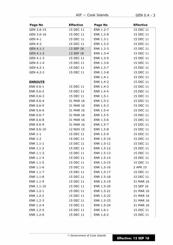
GEN 0.4 - 3AIP — Cook Islands
E Government of Cook Islands
Page No Effective Page No Effective
GEN 3.6-15 15 DEC 11
GEN 3.6-16 15 DEC 11
GEN 4-1 15 DEC 11
GEN 4-2 15 DEC 11
GEN 4.1-1 13 SEP 18
GEN 4.1-2 13 SEP 18
GEN 4.1-3 15 DEC 11
GEN 4.1-4 15 DEC 11
GEN 4.2-1 15 DEC 11
GEN 4.2-2 15 DEC 11
ENROUTE
ENR 0.6-1 15 DEC 11
ENR 0.6-2 15 DEC 11
ENR 0.6-3 15 DEC 11
ENR 0.6-4 31 MAR 16
ENR 0.6-5 31 MAR 16
ENR 0.6-6 31 MAR 16
ENR 0.6-7 31 MAR 16
ENR 0.6-8 31 MAR 16
ENR 0.6-9 31 MAR 16
ENR 0.6-10 12 NOV 15
ENR 1-1 15 DEC 11
ENR 1-2 15 DEC 11
ENR 1.1-1 15 DEC 11
ENR 1.1-2 15 DEC 11
ENR 1.1-3 15 DEC 11
ENR 1.1-4 15 DEC 11
ENR 1.1-5 15 DEC 11
ENR 1.1-6 15 DEC 11
ENR 1.1-7 15 DEC 11
ENR 1.1-8 15 DEC 11
ENR 1.1-9 15 DEC 11
ENR 1.1-10 15 DEC 11
ENR 1.2-1 15 DEC 11
ENR 1.2-2 15 DEC 11
ENR 1.2-3 15 DEC 11
ENR 1.2-4 15 DEC 11
ENR 1.2-5 15 DEC 11
ENR 1.2-6 15 DEC 11
ENR 1.2-7 15 DEC 11
ENR 1.2-8 15 DEC 11
ENR 1.3-1 15 DEC 11
ENR 1.3-2 15 DEC 11
ENR 1.3-3 15 DEC 11
ENR 1.3-4 15 DEC 11
ENR 1.3-5 15 DEC 11
ENR 1.3-6 15 DEC 11
ENR 1.3-7 15 DEC 11
ENR 1.3-8 15 DEC 11
ENR 1.4-1 15 DEC 11
ENR 1.4-2 15 DEC 11
ENR 1.4-3 15 DEC 11
ENR 1.4-4 15 DEC 11
ENR 1.5-1 15 DEC 11
ENR 1.5-2 15 DEC 11
ENR 1.5-3 15 DEC 11
ENR 1.5-4 15 DEC 11
ENR 1.5-5 15 DEC 11
ENR 1.5-6 15 DEC 11
ENR 1.5-7 15 DEC 11
ENR 1.5-8 15 DEC 11
ENR 1.5-9 15 DEC 11
ENR 1.5-10 15 DEC 11
ENR 1.5-11 15 DEC 11
ENR 1.5-12 15 DEC 11
ENR 1.5-13 15 DEC 11
ENR 1.5-14 15 DEC 11
ENR 1.5-15 15 DEC 11
ENR 1.5-16 2 APR 15
ENR 1.5-17 15 DEC 11
ENR 1.5-18 15 DEC 11
ENR 1.5-19 31 MAR 16
ENR 1.5-20 15 SEP 16
ENR 1.5-21 31 MAR 16
ENR 1.5-22 31 MAR 16
ENR 1.5-23 31 MAR 16
ENR 1.5-24 31 MAR 16
ENR 1.6-1 15 DEC 11
ENR 1.6-2 15 DEC 11
Effective: 13 SEP 18
GEN 0.4 - 4 AIP — Cook Islands
E Government of Cook Islands
Page No Effective Page No Effective
ENR 1.7-1 2 APR 15
ENR 1.7-2 2 APR 15
ENR 1.7-3 2 APR 15
ENR 1.7-4 2 APR 15
ENR 1.7-5 2 APR 15
ENR 1.7-6 15 DEC 11
ENR 1.8-1 15 DEC 11
ENR 1.8-2 15 DEC 11
ENR 1.9-1 15 DEC 11
ENR 1.9-2 15 DEC 11
ENR 1.10-1 15 DEC 11
ENR 1.10-2 15 DEC 11
ENR 1.10-3 15 DEC 11
ENR 1.10-4 15 DEC 11
ENR 1.10-5 15 DEC 11
ENR 1.10-6 15 DEC 11
ENR 1.10-7 15 DEC 11
ENR 1.10-8 15 DEC 11
ENR 1.10-9 15 DEC 11
ENR 1.10-10 15 DEC 11
ENR 1.10-11 15 DEC 11
ENR 1.10-12 15 DEC 11
ENR 1.10-13 15 DEC 11
ENR 1.10-14 15 DEC 11
ENR 1.10-15 15 DEC 11
ENR 1.10-16 15 DEC 11
ENR 1.10-17 15 DEC 11
ENR 1.10-18 15 DEC 11
ENR 1.11-1 15 DEC 11
ENR 1.11-2 15 DEC 11
ENR 1.12-1 15 DEC 11
ENR 1.12-2 15 DEC 11
ENR 1.12-3 15 DEC 11
ENR 1.12-4 15 DEC 11
ENR 1.13-1 15 DEC 11
ENR 1.13-2 15 DEC 11
ENR 1.14-1 15 DEC 11
ENR 1.14-2 15 DEC 11
ENR 1.15-1 12 NOV 15
ENR 1.15-2 12 NOV 15
ENR 1.15-3 12 NOV 15
ENR 1.15-4 12 NOV 15
ENR 1.15-5 12 NOV 15
ENR 1.15-6 12 NOV 15
ENR 1.15-7 12 NOV 15
ENR 1.15-8 12 NOV 15
ENR 1.15-9 12 NOV 15
ENR 1.15-10 12 NOV 15
ENR 1.15-11 12 NOV 15
ENR 1.15-12 12 NOV 15
ENR 1.15-13 12 NOV 15
ENR 1.15-14 12 NOV 15
ENR 2-1 15 DEC 11
ENR 2-2 15 DEC 11
ENR 2.1-1 2 APR 15
ENR 2.1-2 2 APR 15
ENR 2.1-3 2 APR 15
ENR 2.1-4 2 APR 15
ENR 2.1-5 30 APR 15
ENR 2.1-6 2 APR 15
ENR 2.2-1 15 DEC 11
ENR 2.2-2 15 DEC 11
ENR 3-1 15 DEC 11
ENR 3-2 15 DEC 11
ENR 3.1-1 15 DEC 11
ENR 3.1-2 15 DEC 11
ENR 3.2-1 15 DEC 11
ENR 3.2-2 15 DEC 11
ENR 3.3-1 15 DEC 11
ENR 3.3-2 15 DEC 11
ENR 3.4-1 15 DEC 11
ENR 3.4-2 15 DEC 11
ENR 3.5-1 15 DEC 11
ENR 3.5-2 15 DEC 11
ENR 3.6-1 15 DEC 11
ENR 3.6-2 15 DEC 11
ENR 4-1 15 DEC 11
ENR 4-2 15 DEC 11
ENR 4.1-1 2 APR 15
ENR 4.1-2 15 DEC 11
Effective: 13 SEP 18
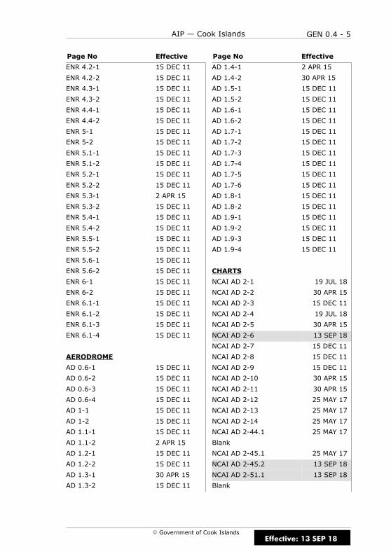
GEN 0.4 - 5AIP — Cook Islands
E Government of Cook Islands
Page No Effective Page No Effective
ENR 4.2-1 15 DEC 11
ENR 4.2-2 15 DEC 11
ENR 4.3-1 15 DEC 11
ENR 4.3-2 15 DEC 11
ENR 4.4-1 15 DEC 11
ENR 4.4-2 15 DEC 11
ENR 5-1 15 DEC 11
ENR 5-2 15 DEC 11
ENR 5.1-1 15 DEC 11
ENR 5.1-2 15 DEC 11
ENR 5.2-1 15 DEC 11
ENR 5.2-2 15 DEC 11
ENR 5.3-1 2 APR 15
ENR 5.3-2 15 DEC 11
ENR 5.4-1 15 DEC 11
ENR 5.4-2 15 DEC 11
ENR 5.5-1 15 DEC 11
ENR 5.5-2 15 DEC 11
ENR 5.6-1 15 DEC 11
ENR 5.6-2 15 DEC 11
ENR 6-1 15 DEC 11
ENR 6-2 15 DEC 11
ENR 6.1-1 15 DEC 11
ENR 6.1-2 15 DEC 11
ENR 6.1-3 15 DEC 11
ENR 6.1-4 15 DEC 11
AERODROME
AD 0.6-1 15 DEC 11
AD 0.6-2 15 DEC 11
AD 0.6-3 15 DEC 11
AD 0.6-4 15 DEC 11
AD 1-1 15 DEC 11
AD 1-2 15 DEC 11
AD 1.1-1 15 DEC 11
AD 1.1-2 2 APR 15
AD 1.2-1 15 DEC 11
AD 1.2-2 15 DEC 11
AD 1.3-1 30 APR 15
AD 1.3-2 15 DEC 11
AD 1.4-1 2 APR 15
AD 1.4-2 30 APR 15
AD 1.5-1 15 DEC 11
AD 1.5-2 15 DEC 11
AD 1.6-1 15 DEC 11
AD 1.6-2 15 DEC 11
AD 1.7-1 15 DEC 11
AD 1.7-2 15 DEC 11
AD 1.7-3 15 DEC 11
AD 1.7-4 15 DEC 11
AD 1.7-5 15 DEC 11
AD 1.7-6 15 DEC 11
AD 1.8-1 15 DEC 11
AD 1.8-2 15 DEC 11
AD 1.9-1 15 DEC 11
AD 1.9-2 15 DEC 11
AD 1.9-3 15 DEC 11
AD 1.9-4 15 DEC 11
CHARTS
NCAI AD 2-1 19 JUL 18
NCAI AD 2-2 30 APR 15
NCAI AD 2-3 15 DEC 11
NCAI AD 2-4 19 JUL 18
NCAI AD 2-5 30 APR 15
NCAI AD 2-6 13 SEP 18
NCAI AD 2-7 15 DEC 11
NCAI AD 2-8 15 DEC 11
NCAI AD 2-9 15 DEC 11
NCAI AD 2-10 30 APR 15
NCAI AD 2-11 30 APR 15
NCAI AD 2-12 25 MAY 17
NCAI AD 2-13 25 MAY 17
NCAI AD 2-14 25 MAY 17
NCAI AD 2-44.1 25 MAY 17
Blank
NCAI AD 2-45.1 25 MAY 17
NCAI AD 2-45.2 13 SEP 18
NCAI AD 2-51.1 13 SEP 18
Blank
Effective: 13 SEP 18
GEN 0.4 - 6 AIP — Cook Islands
E Government of Cook Islands
Page No Effective Page No Effective
NCAT AD 2-1 25 MAY 17
NCAT AD 2-2 30 APR 15
NCAT AD 2-3 25 MAY 17
NCAT AD 2-4 15 DEC 11
NCAT AD 2-5 25 MAY 17
NCAT AD 2-6 30 APR 15
NCAT AD 2-7 30 APR 15
NCAT AD 2-8 25 MAY 17
NCAT AD 2-45.1 25 MAY 17
Blank
NCAT AD 2-51.1 25 MAY 17
Blank
NCMG AD 2-1 19 JUL 18
NCMG AD 2-2 30 APR 15
NCMG AD 2-3 25 MAY 17
NCMG AD 2-4 15 DEC 11
NCMG AD 2-5 19 JUL 18
NCMG AD 2-6 30 APR 15
NCMG AD 2-7 30 APR 15
NCMG AD 2-8 25 MAY 17
NCMG AD 2-45.1 25 MAY 17
Blank
NCMG AD 2-51.1 25 MAY 17
Blank
NCMH AD 2-1 30 APR 15
NCMH AD 2-2 30 APR 15
NCMH AD 2-3 30 APR 15
NCMH AD 2-4 15 DEC 11
NCMH AD 2-5 30 APR 15
NCMH AD 2-6 30 APR 15
NCMH AD 2-7 30 APR 15
NCMH AD 2-8 30 APR 15
NCMH AD 2-51.1 30 APR 15
Blank
NCMK AD 2-1 25 MAY 17
NCMK AD 2-2 30 APR 15
NCMK AD 2-3 25 MAY 17
NCMK AD 2-4 15 DEC 11
NCMK AD 2-5 19 JUL 18
NCMK AD 2-6 30 APR 15
NCMK AD 2-7 30 APR 15
NCMK AD 2-8 25 MAY 17
NCMK AD 2-45.1 25 MAY 17
Blank
NCMK AD 2-51.1 19 JUL 18
Blank
NCMR AD 2-1 25 MAY 17
NCMR AD 2-2 30 APR 15
NCMR AD 2-3 30 APR 15
NCMR AD 2-4 15 DEC 11
NCMR AD 2-5 25 MAY 17
NCMR AD 2-6 30 APR 15
NCMR AD 2-7 30 APR 15
NCMR AD 2-8 25 MAY 17
NCMR AD 2-45.1 25 MAY 17
Blank
NCMR AD 2-51.1 25 MAY 17
Blank
NCPY AD 2-1 30 APR 15
NCPY AD 2-2 30 APR 15
NCPY AD 2-3 15 DEC 11
NCPY AD 2-4 15 DEC 11
NCPY AD 2-5 30 APR 15
NCPY AD 2-6 30 APR 15
NCPY AD 2-7 30 APR 15
NCPY AD 2-8 30 APR 15
NCPY AD 2-44.1 15 DEC 11
Blank
NCPY AD 2-51.1 30 APR 15
Blank
NCPK AD 2-1 30 APR 15
NCPK AD 2-2 30 APR 15
NCPK AD 2-3 15 DEC 11
NCPK AD 2-4 15 DEC 11
NCPK AD 2-5 30 APR 15
NCPK AD 2-6 30 APR 15
NCPK AD 2-7 30 APR 15
NCPK AD 2-8 30 APR 15
NCPK AD 2-51.1 30 APR 15
Blank
Effective: 13 SEP 18
GEN 0.4 - 7AIP — Cook Islands
E Government of Cook Islands
Page No Effective Page No Effective
NCRG AD 2-1 19 JUL 18
NCRG AD 2-2 30 APR 15
NCRG AD 2-3 15 DEC 11
NCRG AD 2-4 19 JUL 18
NCRG AD 2-5 15 DEC 11
NCRG AD 2-6 15 DEC 11
NCRG AD 2-7 19 JUL 18
NCRG AD 2-8 13 SEP 18
NCRG AD 2-9 2 APR 15
NCRG AD 2-10 2 APR 15
NCRG AD 2-11 2 APR 15
NCRG AD 2-12 19 JUL 18
NCRG AD 2-13 2 APR 15
NCRG AD 2-14 15 DEC 11
NCRG AD 2-15 15 DEC 11
NCRG AD 2-16 13 SEP 18
NCRG AD 2-33.1 13 SEP 18
NCRG AD 2-33.2 13 SEP 18
NCRG AD 2-41.1 17 SEP 15
NCRG AD 2-41.2 2 APR 15
NCRG AD 2-43.1 13 SEP 18
NCRG AD 2-43.2 13 SEP 18
NCRG AD 2-43.3 13 SEP 18
Blank
NCRG AD 2-44.1 13 SEP 18
Blank
NCRG AD 2-45.1 19 JUL 18
NCRG AD 2-45.2 19 JUL 18
NCRG AD 2-45.3 19 JUL 18
NCRG AD 2-45.4 19 JUL 18
NCRG AD 2-45.5 19 JUL 18
NCRG AD 2-45.6 19 JUL 18
NCRG AD 2-51.1 13 SEP 18
NCRG AD 2-53.1 13 SEP 18
NCRG AD 2-62.1 13 SEP 18
Blank
Effective: 13 SEP 18
GEN 0.4 - 8 AIP — Cook Islands
E Government of Cook IslandsEffective: 13 SEP 18
IntentionallyBlank
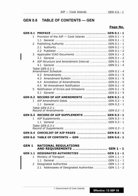
GEN 0.6 - 1AIP — Cook Islands
E Government of Cook Islands
GEN 0.5
GEN 0.6 TABLE OF CONTENTS — GEN
Page No.
GEN 0.1 PREFACE GEN 0.1 - 1. . . . . . . . . . . . . . . . . . . . . . . . . . . . . . . . . . . . . . . . .1 Provision of the AIP — Cook Islands GEN 0.1 - 1. . . . . . . . . . . . . . . .1.1 General GEN 0.1 - 1. . . . . . . . . . . . . . . . . . . . . . . . . . . . . . . . . . . . . . .
2 Publishing Authority GEN 0.1 - 1. . . . . . . . . . . . . . . . . . . . . . . . . . . . . . . .2.1 Authority GEN 0.1 - 1. . . . . . . . . . . . . . . . . . . . . . . . . . . . . . . . . . . . . .2.2 Publisher GEN 0.1 - 2. . . . . . . . . . . . . . . . . . . . . . . . . . . . . . . . . . . . . .
3 Applicable ICAO Documents GEN 0.1 - 2. . . . . . . . . . . . . . . . . . . . . . . .3.1 General GEN 0.1 - 2. . . . . . . . . . . . . . . . . . . . . . . . . . . . . . . . . . . . . . .
4 AIP Structure and Amendment Interval GEN 0.1 - 4. . . . . . . . . . . . .4.1 General GEN 0.1 - 4. . . . . . . . . . . . . . . . . . . . . . . . . . . . . . . . . . . . . . .
Table GEN 0.1-1Amendment Schedule GEN 0.1 - 4. . . . . . . . . . . . . . . . . . . . . . . . . . . . . . . . . .4.2 Amendments GEN 0.1 - 5. . . . . . . . . . . . . . . . . . . . . . . . . . . . . . . . . .4.3 Amendment Bulletin GEN 0.1 - 5. . . . . . . . . . . . . . . . . . . . . . . . . . .4.4 Annotation of Amendments GEN 0.1 - 5. . . . . . . . . . . . . . . . . . . .4.5 Nil Amendment Notification GEN 0.1 - 5. . . . . . . . . . . . . . . . . . . .
5 Notification of Errors and Omissions GEN 0.1 - 5. . . . . . . . . . . . . . . .5.1 General GEN 0.1 - 5. . . . . . . . . . . . . . . . . . . . . . . . . . . . . . . . . . . . . . .
GEN 0.2 RECORD OF AIP AMENDMENTS GEN 0.2 - 1. . . . . . . . . . . . . . . . .1 AIP Amendment Dates GEN 0.2 - 1. . . . . . . . . . . . . . . . . . . . . . . . . . . . .1.1 General GEN 0.2 - 1. . . . . . . . . . . . . . . . . . . . . . . . . . . . . . . . . . . . . . .
Table GEN 0.2-1Record of Amendments GEN 0.2 - 1. . . . . . . . . . . . . . . . . . . . . . . . . . . . . . . .
GEN 0.3 RECORD OF AIP SUPPLEMENTS GEN 0.3 - 1. . . . . . . . . . . . . . . . .1 AIP Supplements GEN 0.3 - 1. . . . . . . . . . . . . . . . . . . . . . . . . . . . . . . . . . .1.1 General GEN 0.3 - 1. . . . . . . . . . . . . . . . . . . . . . . . . . . . . . . . . . . . . . .
Table GEN 0.3-1Record of Supplements GEN 0.3 - 1. . . . . . . . . . . . . . . . . . . . . . . . . . . . . . . .
GEN 0.4 CHECKLIST OF AIP PAGES GEN 0.4 - 1. . . . . . . . . . . . . . . . . . . . . .
GEN 0.6 TABLE OF CONTENTS — GEN GEN 0.6 - 1. . . . . . . . . . . . . . . . . . . .
GEN 1 NATIONAL REGULATIONSAND REQUIREMENTS GEN 1 - 1. . . . . . . . . . . . . . . . . . . . . . .
GEN 1.1 DESIGNATED AUTHORITIES GEN 1.1 - 1. . . . . . . . . . . . . . . . . . . .1 Ministry of Transport GEN 1.1 - 1. . . . . . . . . . . . . . . . . . . . . . . . . . . . . . .1.1 General GEN 1.1 - 1. . . . . . . . . . . . . . . . . . . . . . . . . . . . . . . . . . . . . . .
2 Designated Authorities GEN 1.1 - 2. . . . . . . . . . . . . . . . . . . . . . . . . . . . .2.1 Addressees of Designated Authorities GEN 1.1 - 2. . . . . . . . . .
Effective: 13 SEP 18
GEN 0.6 - 2 AIP — Cook Islands
E Government of Cook Islands
Page No.
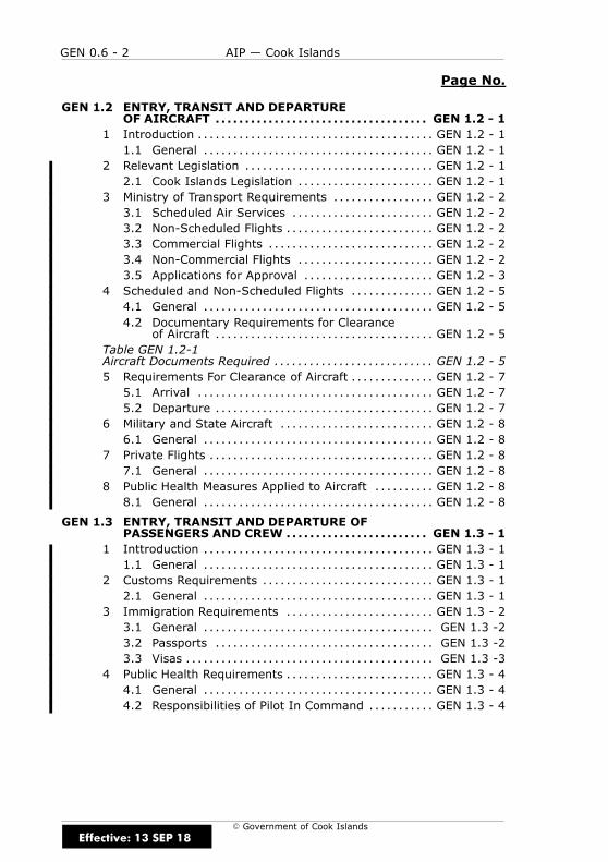
GEN 1.2 ENTRY, TRANSIT AND DEPARTUREOF AIRCRAFT GEN 1.2 - 1. . . . . . . . . . . . . . . . . . . . . . . . . . . . . . . . . . . .
1 Introduction GEN 1.2 - 1. . . . . . . . . . . . . . . . . . . . . . . . . . . . . . . . . . . . . . . .1.1 General GEN 1.2 - 1. . . . . . . . . . . . . . . . . . . . . . . . . . . . . . . . . . . . . . .
2 Relevant Legislation GEN 1.2 - 1. . . . . . . . . . . . . . . . . . . . . . . . . . . . . . . .2.1 Cook Islands Legislation GEN 1.2 - 1. . . . . . . . . . . . . . . . . . . . . . .
3 Ministry of Transport Requirements GEN 1.2 - 2. . . . . . . . . . . . . . . . .3.1 Scheduled Air Services GEN 1.2 - 2. . . . . . . . . . . . . . . . . . . . . . . .3.2 Non-Scheduled Flights GEN 1.2 - 2. . . . . . . . . . . . . . . . . . . . . . . . .3.3 Commercial Flights GEN 1.2 - 2. . . . . . . . . . . . . . . . . . . . . . . . . . . .3.4 Non-Commercial Flights GEN 1.2 - 2. . . . . . . . . . . . . . . . . . . . . . .3.5 Applications for Approval GEN 1.2 - 3. . . . . . . . . . . . . . . . . . . . . .
4 Scheduled and Non-Scheduled Flights GEN 1.2 - 5. . . . . . . . . . . . . .4.1 General GEN 1.2 - 5. . . . . . . . . . . . . . . . . . . . . . . . . . . . . . . . . . . . . . .4.2 Documentary Requirements for Clearance
of Aircraft GEN 1.2 - 5. . . . . . . . . . . . . . . . . . . . . . . . . . . . . . . . . . . . .Table GEN 1.2-1Aircraft Documents Required GEN 1.2 - 5. . . . . . . . . . . . . . . . . . . . . . . . . . .5 Requirements For Clearance of Aircraft GEN 1.2 - 7. . . . . . . . . . . . . .5.1 Arrival GEN 1.2 - 7. . . . . . . . . . . . . . . . . . . . . . . . . . . . . . . . . . . . . . . .5.2 Departure GEN 1.2 - 7. . . . . . . . . . . . . . . . . . . . . . . . . . . . . . . . . . . . .
6 Military and State Aircraft GEN 1.2 - 8. . . . . . . . . . . . . . . . . . . . . . . . . .6.1 General GEN 1.2 - 8. . . . . . . . . . . . . . . . . . . . . . . . . . . . . . . . . . . . . . .
7 Private Flights GEN 1.2 - 8. . . . . . . . . . . . . . . . . . . . . . . . . . . . . . . . . . . . . .7.1 General GEN 1.2 - 8. . . . . . . . . . . . . . . . . . . . . . . . . . . . . . . . . . . . . . .
8 Public Health Measures Applied to Aircraft GEN 1.2 - 8. . . . . . . . . .8.1 General GEN 1.2 - 8. . . . . . . . . . . . . . . . . . . . . . . . . . . . . . . . . . . . . . .
GEN 1.3 ENTRY, TRANSIT AND DEPARTURE OFPASSENGERS AND CREW GEN 1.3 - 1. . . . . . . . . . . . . . . . . . . . . . . .
1 Inttroduction GEN 1.3 - 1. . . . . . . . . . . . . . . . . . . . . . . . . . . . . . . . . . . . . . .1.1 General GEN 1.3 - 1. . . . . . . . . . . . . . . . . . . . . . . . . . . . . . . . . . . . . . .
2 Customs Requirements GEN 1.3 - 1. . . . . . . . . . . . . . . . . . . . . . . . . . . . .2.1 General GEN 1.3 - 1. . . . . . . . . . . . . . . . . . . . . . . . . . . . . . . . . . . . . . .
3 Immigration Requirements GEN 1.3 - 2. . . . . . . . . . . . . . . . . . . . . . . . .3.1 General GEN 1.3 -2. . . . . . . . . . . . . . . . . . . . . . . . . . . . . . . . . . . . . . .3.2 Passports GEN 1.3 -2. . . . . . . . . . . . . . . . . . . . . . . . . . . . . . . . . . . . .3.3 Visas GEN 1.3 -3. . . . . . . . . . . . . . . . . . . . . . . . . . . . . . . . . . . . . . . . . .
4 Public Health Requirements GEN 1.3 - 4. . . . . . . . . . . . . . . . . . . . . . . . .4.1 General GEN 1.3 - 4. . . . . . . . . . . . . . . . . . . . . . . . . . . . . . . . . . . . . . .4.2 Responsibilities of Pilot In Command GEN 1.3 - 4. . . . . . . . . . .
Effective: 13 SEP 18
GEN 0.6 - 3AIP — Cook Islands
E Government of Cook Islands
Page No.
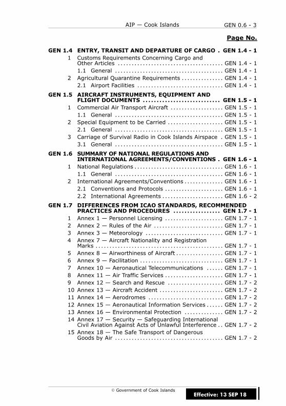
GEN 1.4 ENTRY, TRANSIT AND DEPARTURE OF CARGO GEN 1.4 - 1.1 Customs Requirements Concerning Cargo andOther Articles GEN 1.4 - 1. . . . . . . . . . . . . . . . . . . . . . . . . . . . . . . . . . . . . .1.1 General GEN 1.4 - 1. . . . . . . . . . . . . . . . . . . . . . . . . . . . . . . . . . . . . . .
2 Agricultural Quarantine Requirements GEN 1.4 - 1. . . . . . . . . . . . . . .2.1 Airport Facilities GEN 1.4 - 1. . . . . . . . . . . . . . . . . . . . . . . . . . . . . . .
GEN 1.5 AIRCRAFT INSTRUMENTS, EQUIPMENT ANDFLIGHT DOCUMENTS GEN 1.5 - 1. . . . . . . . . . . . . . . . . . . . . . . . . . . .
1 Commercial Air Transport Aircraft GEN 1.5 - 1. . . . . . . . . . . . . . . . . . .1.1 General GEN 1.5 - 1. . . . . . . . . . . . . . . . . . . . . . . . . . . . . . . . . . . . . . .
2 Special Equipment to be Carried GEN 1.5 - 1. . . . . . . . . . . . . . . . . . . .2.1 General GEN 1.5 - 1. . . . . . . . . . . . . . . . . . . . . . . . . . . . . . . . . . . . . . .
3 Carriage of Survival Radio in Cook Islands Airspace GEN 1.5 - 1.3.1 General GEN 1.5 - 1. . . . . . . . . . . . . . . . . . . . . . . . . . . . . . . . . . . . . . .
GEN 1.6 SUMMARY OF NATIONAL REGULATIONS ANDINTERNATIONAL AGREEMENTS/CONVENTIONS GEN 1.6 - 1.
1 National Regulations GEN 1.6 - 1. . . . . . . . . . . . . . . . . . . . . . . . . . . . . . . .1.1 General GEN 1.6 - 1. . . . . . . . . . . . . . . . . . . . . . . . . . . . . . . . . . . . . . .
2 International Agreements/Conventions GEN 1.6 - 1. . . . . . . . . . . . . .2.1 Conventions and Protocols GEN 1.6 - 1. . . . . . . . . . . . . . . . . . . . .2.2 International Agreements GEN 1.6 - 2. . . . . . . . . . . . . . . . . . . . . .
GEN 1.7 DIFFERENCES FROM ICAO STANDARDS, RECOMMENDEDPRACTICES AND PROCEDURES GEN 1.7 - 1. . . . . . . . . . . . . . . . .
1 Annex 1 — Personnel Licensing GEN 1.7 - 1. . . . . . . . . . . . . . . . . . . . .2 Annex 2 — Rules of the Air GEN 1.7 - 1. . . . . . . . . . . . . . . . . . . . . . . . .3 Annex 3 — Meteorology GEN 1.7 - 1. . . . . . . . . . . . . . . . . . . . . . . . . . . .4 Annex 7 — Aircraft Nationality and RegistrationMarks GEN 1.7 - 1. . . . . . . . . . . . . . . . . . . . . . . . . . . . . . . . . . . . . . . . . . . . . .
5 Annex 8 — Airworthiness of Aircraft GEN 1.7 - 1. . . . . . . . . . . . . . . . .6 Annex 9 — Facilitation GEN 1.7 - 1. . . . . . . . . . . . . . . . . . . . . . . . . . . . . .7 Annex 10 — Aeronautical Telecommunications GEN 1.7 - 1. . . . . .8 Annex 11 — Air Traffic Services GEN 1.7 - 1. . . . . . . . . . . . . . . . . . . . .9 Annex 12 — Search and Rescue GEN 1.7 - 2. . . . . . . . . . . . . . . . . . . .10 Annex 13 — Aircraft Accident GEN 1.7 - 2. . . . . . . . . . . . . . . . . . . . . . .11 Annex 14 — Aerodromes GEN 1.7 - 2. . . . . . . . . . . . . . . . . . . . . . . . . . .12 Annex 15 — Aeronautical Information Services GEN 1.7 - 2. . . . . .13 Annex 16 — Environmental Protection GEN 1.7 - 2. . . . . . . . . . . . . .14 Annex 17 — Security — Safeguarding InternationalCivil Aviation Against Acts of Unlawful Interference GEN 1.7 - 2. .
15 Annex 18 — The Safe Transport of DangerousGoods by Air GEN 1.7 - 2. . . . . . . . . . . . . . . . . . . . . . . . . . . . . . . . . . . . . . .
Effective: 13 SEP 18

GEN 0.6 - 4 AIP — Cook Islands
E Government of Cook Islands
GEN 2 TABLES AND CODES GEN 2 - 1. . . . . . . . . . . . . . . . . . . . . . . .
GEN 2.1 MEASURING SYSTEM, AIRCRAFTMARKINGS, HOLIDAYS GEN 2.1 - 1. . . . . . . . . . . . . . . . . . . . . . . . . .
1 Units of Measurement GEN 2.1 - 1. . . . . . . . . . . . . . . . . . . . . . . . . . . . . .1.1 General GEN 2.1 - 1. . . . . . . . . . . . . . . . . . . . . . . . . . . . . . . . . . . . . . .
Table GEN 2.1-1Units of Measurement GEN 2.1 - 1. . . . . . . . . . . . . . . . . . . . . . . . . . . . . . . . . .2 Time System GEN 2.1 - 2. . . . . . . . . . . . . . . . . . . . . . . . . . . . . . . . . . . . . . .2.1 General GEN 2.1 - 2. . . . . . . . . . . . . . . . . . . . . . . . . . . . . . . . . . . . . . .2.2 Time Signals GEN 2.1 - 2. . . . . . . . . . . . . . . . . . . . . . . . . . . . . . . . . .
3 Geodetic Reference Datum GEN 2.1 - 2. . . . . . . . . . . . . . . . . . . . . . . . .3.1 Name/Designation of Datum GEN 2.1 - 2. . . . . . . . . . . . . . . . . . .3.2 Area of Application GEN 2.1 - 2. . . . . . . . . . . . . . . . . . . . . . . . . . . .3.3 Use of an Asterisk to Identify Published
Geographical Coordinates GEN 2.1 - 2. . . . . . . . . . . . . . . . . . . . . .4 Aircraft Nationality and Registration Marks GEN 2.1 - 3. . . . . . . . . .4.1 General GEN 2.1 - 3. . . . . . . . . . . . . . . . . . . . . . . . . . . . . . . . . . . . . . .
5 Public Holidays GEN 2.1 - 3. . . . . . . . . . . . . . . . . . . . . . . . . . . . . . . . . . . . .5.1 General GEN 2.1 - 3. . . . . . . . . . . . . . . . . . . . . . . . . . . . . . . . . . . . . . .
Table GEN 2.1-2Public Holidays GEN 2.1 - 3. . . . . . . . . . . . . . . . . . . . . . . . . . . . . . . . . . . . . . . .
GEN 2.2 ABBREVIATIONS USED IN AIS PUBLICATIONS GEN 2.2 - 1. .1 Introduction GEN 2.2 - 1. . . . . . . . . . . . . . . . . . . . . . . . . . . . . . . . . . . . . . . .1.1 General GEN 2.2 - 1. . . . . . . . . . . . . . . . . . . . . . . . . . . . . . . . . . . . . . .
GEN 2.3 CHART SYMBOLS GEN 2.3 - 1. . . . . . . . . . . . . . . . . . . . . . . . . . . . . . . .1 Introduction GEN 2.3 - 1. . . . . . . . . . . . . . . . . . . . . . . . . . . . . . . . . . . . . . . .1.1 General GEN 2.3 - 1. . . . . . . . . . . . . . . . . . . . . . . . . . . . . . . . . . . . . . .
Figure GEN 2.3-1Aerodrome Chart Symbols GEN 2.3 - 2. . . . . . . . . . . . . . . . . . . . . . . . . . . . .Figure GEN 2.3-2Aerodrome Chart Symbols GEN 2.3 - 3. . . . . . . . . . . . . . . . . . . . . . . . . . . . .Figure GEN 2.3-3Airspace and Navigation Chart Symbols GEN 2.3 - 4. . . . . . . . . . . . . . . .Figure GEN 2.3-4Instrument Chart Symbols GEN 2.3 - 5. . . . . . . . . . . . . . . . . . . . . . . . . . . . .Figure GEN 2.3-5Instrument Chart Symbols GEN 2.3 - 6. . . . . . . . . . . . . . . . . . . . . . . . . . . . .Figure GEN 2.3-6Instrument Chart Symbols GEN 2.3 - 7. . . . . . . . . . . . . . . . . . . . . . . . . . . . .Figure GEN 2.3-7Instrument Chart Symbols GEN 2.3 - 8. . . . . . . . . . . . . . . . . . . . . . . . . . . . .Figure GEN 2.3-8Instrument Chart Symbols GEN 2.3 - 9. . . . . . . . . . . . . . . . . . . . . . . . . . . . .Figure GEN 2.3-9Ground Based Aid Approach GEN 2.3 - 10. . . . . . . . . . . . . . . . . . . . . . . . . .
Effective: 13 SEP 18
GEN 0.6 - 5AIP — Cook Islands
E Government of Cook Islands
Page No.
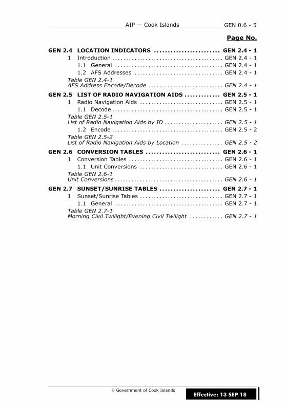
GEN 2.4 LOCATION INDICATORS GEN 2.4 - 1. . . . . . . . . . . . . . . . . . . . . . . .1 Introduction GEN 2.4 - 1. . . . . . . . . . . . . . . . . . . . . . . . . . . . . . . . . . . . . . . .1.1 General GEN 2.4 - 1. . . . . . . . . . . . . . . . . . . . . . . . . . . . . . . . . . . . . . .1.2 AFS Addresses GEN 2.4 - 1. . . . . . . . . . . . . . . . . . . . . . . . . . . . . . . .
Table GEN 2.4-1AFS Address Encode/Decode GEN 2.4 - 1. . . . . . . . . . . . . . . . . . . . . . . . . . .
GEN 2.5 LIST OF RADIO NAVIGATION AIDS GEN 2.5 - 1. . . . . . . . . . . . .1 Radio Navigation Aids GEN 2.5 - 1. . . . . . . . . . . . . . . . . . . . . . . . . . . . . .1.1 Decode GEN 2.5 - 1. . . . . . . . . . . . . . . . . . . . . . . . . . . . . . . . . . . . . . . .
Table GEN 2.5-1List of Radio Navigation Aids by ID GEN 2.5 - 1. . . . . . . . . . . . . . . . . . . . .1.2 Encode GEN 2.5 - 2. . . . . . . . . . . . . . . . . . . . . . . . . . . . . . . . . . . . . . . .
Table GEN 2.5-2List of Radio Navigation Aids by Location GEN 2.5 - 2. . . . . . . . . . . . . . .
GEN 2.6 CONVERSION TABLES GEN 2.6 - 1. . . . . . . . . . . . . . . . . . . . . . . . . . .1 Conversion Tables GEN 2.6 - 1. . . . . . . . . . . . . . . . . . . . . . . . . . . . . . . . . .1.1 Unit Conversions GEN 2.6 - 1. . . . . . . . . . . . . . . . . . . . . . . . . . . . . .
Table GEN 2.6-1Unit Conversions GEN 2.6 - 1. . . . . . . . . . . . . . . . . . . . . . . . . . . . . . . . . . . . . . .
GEN 2.7 SUNSET/SUNRISE TABLES GEN 2.7 - 1. . . . . . . . . . . . . . . . . . . . . .1 Sunset/Sunrise Tables GEN 2.7 - 1. . . . . . . . . . . . . . . . . . . . . . . . . . . . . .1.1 General GEN 2.7 - 1. . . . . . . . . . . . . . . . . . . . . . . . . . . . . . . . . . . . . . .
Table GEN 2.7-1Morning Civil Twilight/Evening Civil Twilight GEN 2.7 - 1. . . . . . . . . . . .
Effective: 13 SEP 18
GEN 0.6 - 6 AIP — Cook Islands
E Government of Cook Islands
Page No.
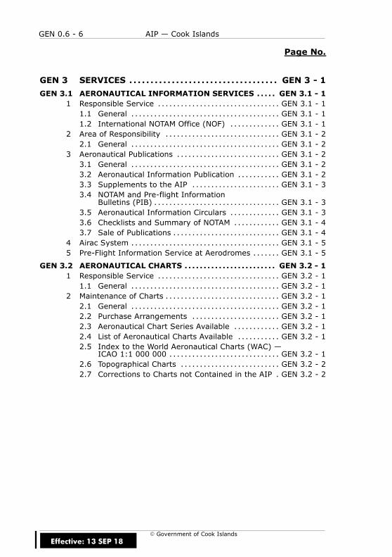
GEN 3 SERVICES GEN 3 - 1. . . . . . . . . . . . . . . . . . . . . . . . . . . . . . . . . . .
GEN 3.1 AERONAUTICAL INFORMATION SERVICES GEN 3.1 - 1. . . . .1 Responsible Service GEN 3.1 - 1. . . . . . . . . . . . . . . . . . . . . . . . . . . . . . . .1.1 General GEN 3.1 - 1. . . . . . . . . . . . . . . . . . . . . . . . . . . . . . . . . . . . . . .1.2 International NOTAM Office (NOF) GEN 3.1 - 1. . . . . . . . . . . . .
2 Area of Responsibility GEN 3.1 - 2. . . . . . . . . . . . . . . . . . . . . . . . . . . . . .2.1 General GEN 3.1 - 2. . . . . . . . . . . . . . . . . . . . . . . . . . . . . . . . . . . . . . .
3 Aeronautical Publications GEN 3.1 - 2. . . . . . . . . . . . . . . . . . . . . . . . . . .3.1 General GEN 3.1 - 2. . . . . . . . . . . . . . . . . . . . . . . . . . . . . . . . . . . . . . .3.2 Aeronautical Information Publication GEN 3.1 - 2. . . . . . . . . . .3.3 Supplements to the AIP GEN 3.1 - 3. . . . . . . . . . . . . . . . . . . . . . .3.4 NOTAM and Pre-flight Information
Bulletins (PIB) GEN 3.1 - 3. . . . . . . . . . . . . . . . . . . . . . . . . . . . . . . . .3.5 Aeronautical Information Circulars GEN 3.1 - 3. . . . . . . . . . . . .3.6 Checklists and Summary of NOTAM GEN 3.1 - 4. . . . . . . . . . . .3.7 Sale of Publications GEN 3.1 - 4. . . . . . . . . . . . . . . . . . . . . . . . . . . .
4 Airac System GEN 3.1 - 5. . . . . . . . . . . . . . . . . . . . . . . . . . . . . . . . . . . . . . .5 Pre-Flight Information Service at Aerodromes GEN 3.1 - 5. . . . . . .
GEN 3.2 AERONAUTICAL CHARTS GEN 3.2 - 1. . . . . . . . . . . . . . . . . . . . . . . .1 Responsible Service GEN 3.2 - 1. . . . . . . . . . . . . . . . . . . . . . . . . . . . . . . .1.1 General GEN 3.2 - 1. . . . . . . . . . . . . . . . . . . . . . . . . . . . . . . . . . . . . . .
2 Maintenance of Charts GEN 3.2 - 1. . . . . . . . . . . . . . . . . . . . . . . . . . . . . .2.1 General GEN 3.2 - 1. . . . . . . . . . . . . . . . . . . . . . . . . . . . . . . . . . . . . . .2.2 Purchase Arrangements GEN 3.2 - 1. . . . . . . . . . . . . . . . . . . . . . .2.3 Aeronautical Chart Series Available GEN 3.2 - 1. . . . . . . . . . . .2.4 List of Aeronautical Charts Available GEN 3.2 - 1. . . . . . . . . . .2.5 Index to the World Aeronautical Charts (WAC) —
ICAO 1:1 000 000 GEN 3.2 - 1. . . . . . . . . . . . . . . . . . . . . . . . . . . . .2.6 Topographical Charts GEN 3.2 - 2. . . . . . . . . . . . . . . . . . . . . . . . . .2.7 Corrections to Charts not Contained in the AIP GEN 3.2 - 2.
Effective: 13 SEP 18

GEN 0.6 - 7AIP — Cook Islands
E Government of Cook Islands
Page No.
GEN 3.3 AIR TRAFFIC SERVICES GEN 3.3 - 1. . . . . . . . . . . . . . . . . . . . . . . . .1 Responsible Service GEN 3.3 - 1. . . . . . . . . . . . . . . . . . . . . . . . . . . . . . . .1.1 General GEN 3.3 - 1. . . . . . . . . . . . . . . . . . . . . . . . . . . . . . . . . . . . . . .
2 Area of Responsibility GEN 3.3 - 1. . . . . . . . . . . . . . . . . . . . . . . . . . . . . .2.1 General GEN 3.3 - 1. . . . . . . . . . . . . . . . . . . . . . . . . . . . . . . . . . . . . . .
3 Types of Services GEN 3.3 - 1. . . . . . . . . . . . . . . . . . . . . . . . . . . . . . . . . . .3.1 General GEN 3.3 - 1. . . . . . . . . . . . . . . . . . . . . . . . . . . . . . . . . . . . . . .
4 Co-ordination Between the Operators and ATS GEN 3.3 - 2. . . . . .4.1 General GEN 3.3 - 2. . . . . . . . . . . . . . . . . . . . . . . . . . . . . . . . . . . . . . .
5 ATS Units Address List GEN 3.3 - 2. . . . . . . . . . . . . . . . . . . . . . . . . . . . . .5.1 General GEN 3.3 - 2. . . . . . . . . . . . . . . . . . . . . . . . . . . . . . . . . . . . . . .
Table GEN 3.3-1ATS Unit Contact Addresses GEN 3.3 - 2. . . . . . . . . . . . . . . . . . . . . . . . . . . .6 Minimum Flight Altitude GEN 3.3 - 3. . . . . . . . . . . . . . . . . . . . . . . . . . . .6.1 Minimum Safe Altitude GEN 3.3 - 3. . . . . . . . . . . . . . . . . . . . . . . .6.2 Minimum Reception Altitude and Minimum
Enroute Altitude GEN 3.3 - 3. . . . . . . . . . . . . . . . . . . . . . . . . . . . . . .6.3 Minimum Flight Altitude GEN 3.3 - 4. . . . . . . . . . . . . . . . . . . . . . .
Figure GEN 3.3-1Minimum Flight Altitude GEN 3.3 - 4. . . . . . . . . . . . . . . . . . . . . . . . . . . . . . . .6.4 Climb to MFA GEN 3.3 - 5. . . . . . . . . . . . . . . . . . . . . . . . . . . . . . . . . .6.5 Descent Below MFA GEN 3.3 - 5. . . . . . . . . . . . . . . . . . . . . . . . . . . .6.6 Emergency Descent Below MFA GEN 3.3 - 5. . . . . . . . . . . . . . . .
GEN 3.4 COMMUNICATION SERVICES GEN 3.4 - 1. . . . . . . . . . . . . . . . . . .1 Responsible Service GEN 3.4 - 1. . . . . . . . . . . . . . . . . . . . . . . . . . . . . . . .1.1 General GEN 3.4 - 1. . . . . . . . . . . . . . . . . . . . . . . . . . . . . . . . . . . . . . .
2 Area of Responsibility GEN 3.4 - 2. . . . . . . . . . . . . . . . . . . . . . . . . . . . . .2.1 General GEN 3.4 - 2. . . . . . . . . . . . . . . . . . . . . . . . . . . . . . . . . . . . . . .
3 Types of Service GEN 3.4 - 2. . . . . . . . . . . . . . . . . . . . . . . . . . . . . . . . . . . .3.1 Radio Navigation Services GEN 3.4 - 2. . . . . . . . . . . . . . . . . . . . .3.2 Mobile/Fixed Service GEN 3.4 - 2. . . . . . . . . . . . . . . . . . . . . . . . . .3.3 Broadcasting Service GEN 3.4 - 3. . . . . . . . . . . . . . . . . . . . . . . . . .3.4 Language Used GEN 3.4 - 3. . . . . . . . . . . . . . . . . . . . . . . . . . . . . . . .3.5 Where Detailed Information can be Obtained GEN 3.4 - 3. . .3.6 Hours of Service GEN 3.4 - 3. . . . . . . . . . . . . . . . . . . . . . . . . . . . . . .3.7 Extended Service GEN 3.4 - 4. . . . . . . . . . . . . . . . . . . . . . . . . . . . . .
4 Requirements and Conditions GEN 3.4 - 4. . . . . . . . . . . . . . . . . . . . . . .4.1 General GEN 3.4 - 4. . . . . . . . . . . . . . . . . . . . . . . . . . . . . . . . . . . . . . .
5 AFTN Circuits GEN 3.4 - 5. . . . . . . . . . . . . . . . . . . . . . . . . . . . . . . . . . . . . . .5.1 General GEN 3.4 - 5. . . . . . . . . . . . . . . . . . . . . . . . . . . . . . . . . . . . . . .
Figure GEN 3.4-1AFTN Circuits GEN 3.4 - 5. . . . . . . . . . . . . . . . . . . . . . . . . . . . . . . . . . . . . . . . . .
Effective: 13 SEP 18
GEN 0.6 - 8 AIP — Cook Islands
E Government of Cook Islands
Page No.
6 ATS Speech Circuits GEN 3.4 - 6. . . . . . . . . . . . . . . . . . . . . . . . . . . . . . . .6.1 General GEN 3.4 - 6. . . . . . . . . . . . . . . . . . . . . . . . . . . . . . . . . . . . . . .
Figure GEN 3.4-2AFTN Speech Circuits GEN 3.4 - 6. . . . . . . . . . . . . . . . . . . . . . . . . . . . . . . . . .
GEN 3.5 METEOROLOGICAL SERVICES GEN 3.5 - 1. . . . . . . . . . . . . . . . . . .1 Responsible Service GEN 3.5 - 1. . . . . . . . . . . . . . . . . . . . . . . . . . . . . . . .1.1 General GEN 3.5 - 1. . . . . . . . . . . . . . . . . . . . . . . . . . . . . . . . . . . . . . .
2 Area of Responsibility GEN 3.5 - 1. . . . . . . . . . . . . . . . . . . . . . . . . . . . . .2.1 General GEN 3.5 - 1. . . . . . . . . . . . . . . . . . . . . . . . . . . . . . . . . . . . . . .
3 Meteorological Observations and Reports GEN 3.5 - 2. . . . . . . . . . . .3.1 Description of Observation System GEN 3.5 - 2. . . . . . . . . . . . .
Table GEN 3.5-1Meteorological Observations and Reports GEN 3.5 - 5. . . . . . . . . . . . . . .4 Types of Services GEN 3.5 - 6. . . . . . . . . . . . . . . . . . . . . . . . . . . . . . . . . . .4.1 General GEN 3.5 - 6. . . . . . . . . . . . . . . . . . . . . . . . . . . . . . . . . . . . . . .
5 Notification Required From Operators GEN 3.5 - 6. . . . . . . . . . . . . . .5.1 General GEN 3.5 - 6. . . . . . . . . . . . . . . . . . . . . . . . . . . . . . . . . . . . . . .
6 Aircraft Reports GEN 3.5 - 7. . . . . . . . . . . . . . . . . . . . . . . . . . . . . . . . . . . .6.1 General GEN 3.5 - 7. . . . . . . . . . . . . . . . . . . . . . . . . . . . . . . . . . . . . . .
7 Volmet Service GEN 3.5 - 7. . . . . . . . . . . . . . . . . . . . . . . . . . . . . . . . . . . . .7.1 General GEN 3.5 - 7. . . . . . . . . . . . . . . . . . . . . . . . . . . . . . . . . . . . . . .
8 Sigmet Service GEN 3.5 - 7. . . . . . . . . . . . . . . . . . . . . . . . . . . . . . . . . . . . .8.1 General GEN 3.5 - 7. . . . . . . . . . . . . . . . . . . . . . . . . . . . . . . . . . . . . . .
9 Other Automated Meteorological Services GEN 3.5 - 7. . . . . . . . . . .9.1 General GEN 3.5 - 7. . . . . . . . . . . . . . . . . . . . . . . . . . . . . . . . . . . . . . .
GEN 3.6 SEARCH AND RESCUE GEN 3.6 - 1. . . . . . . . . . . . . . . . . . . . . . . . . . .1 Responsible Services GEN 3.6 - 1. . . . . . . . . . . . . . . . . . . . . . . . . . . . . . .1.1 General GEN 3.6 - 1. . . . . . . . . . . . . . . . . . . . . . . . . . . . . . . . . . . . . . .
2 Area of Responsibility GEN 3.6 - 1. . . . . . . . . . . . . . . . . . . . . . . . . . . . . .2.1 General GEN 3.6 - 1. . . . . . . . . . . . . . . . . . . . . . . . . . . . . . . . . . . . . . .
3 Types of Service GEN 3.6 - 1. . . . . . . . . . . . . . . . . . . . . . . . . . . . . . . . . . . .3.1 General GEN 3.6 - 1. . . . . . . . . . . . . . . . . . . . . . . . . . . . . . . . . . . . . . .3.2 Search and Rescue Units GEN 3.6 - 2. . . . . . . . . . . . . . . . . . . . . .
Table GEN 3.6-1Search and Rescue Units GEN 3.6 - 2. . . . . . . . . . . . . . . . . . . . . . . . . . . . . . .4 SAR Agreements GEN 3.6 - 2. . . . . . . . . . . . . . . . . . . . . . . . . . . . . . . . . . .4.1 General GEN 3.6 - 2. . . . . . . . . . . . . . . . . . . . . . . . . . . . . . . . . . . . . . .
5 Conditions of Availability GEN 3.6 - 2. . . . . . . . . . . . . . . . . . . . . . . . . . . .5.1 General GEN 3.6 - 2. . . . . . . . . . . . . . . . . . . . . . . . . . . . . . . . . . . . . . .
Effective: 13 SEP 18
GEN 0.6 - 9AIP — Cook Islands
E Government of Cook Islands
Page No.
6 Procedures and Signals Used GEN 3.6 - 3. . . . . . . . . . . . . . . . . . . . . . .6.1 Procedures and Signals Used by Aircraft GEN 3.6 - 3. . . . . . .6.2 Communications GEN 3.6 - 3. . . . . . . . . . . . . . . . . . . . . . . . . . . . . . .6.3 Procedures for an Aircraft Requiring
SAR Escort GEN 3.6 - 3. . . . . . . . . . . . . . . . . . . . . . . . . . . . . . . . . . . .6.4 RTF Procedures GEN 3.6 - 4. . . . . . . . . . . . . . . . . . . . . . . . . . . . . . . .6.5 RTF Distress Communications GEN 3.6 - 4. . . . . . . . . . . . . . . . . .6.6 Imposition of Silence GEN 3.6 - 6. . . . . . . . . . . . . . . . . . . . . . . . . .6.7 Action by all Other Stations GEN 3.6 - 6. . . . . . . . . . . . . . . . . . . .6.8 Termination of Distress Communication
and of Silence GEN 3.6 - 6. . . . . . . . . . . . . . . . . . . . . . . . . . . . . . . . .6.9 RTF Urgency Communication GEN 3.6 - 7. . . . . . . . . . . . . . . . . . .6.10 Action by all Other Stations GEN 3.6 - 8. . . . . . . . . . . . . . . . . . . .6.11 Procedures for a Pilot-in-Command
Observing a Distress Incident GEN 3.6 - 8. . . . . . . . . . . . . . . . . .6.12 Procedures for a Pilot-in-Command
Intercepting a Distress Message GEN 3.6 - 9. . . . . . . . . . . . . . .6.13 Non-Radio Distress and Urgency Signals GEN 3.6 - 9. . . . . . .
Table GEN 3.6-2Ground/Air Visual Signal Codes GEN 3.6 - 10. . . . . . . . . . . . . . . . . . . . . . .6.14 Procedure for Directing a Surface Craft to
a Distress Incident GEN 3.6 - 11. . . . . . . . . . . . . . . . . . . . . . . . . . .6.15 Current Maritime Signalling Procedures GEN 3.6 - 12. . . . . . .6.16 Procedure to Signify that Assistance from a
Surface Craft is no Longer Required GEN 3.6 - 12. . . . . . . . . . .7 Visual Inspections by ATS Unit GEN 3.6 - 12. . . . . . . . . . . . . . . . . . . . .7.1 General GEN 3.6 - 12. . . . . . . . . . . . . . . . . . . . . . . . . . . . . . . . . . . . . .
8 Emergency Locator Transmitters (ELT) GEN 3.6 - 13. . . . . . . . . . . . .8.1 General GEN 3.6 - 13. . . . . . . . . . . . . . . . . . . . . . . . . . . . . . . . . . . . . .8.2 Emergency Activation GEN 3.6 - 13. . . . . . . . . . . . . . . . . . . . . . . .8.3 Emergency Location Transmitter Reporting
Procedures GEN 3.6 - 13. . . . . . . . . . . . . . . . . . . . . . . . . . . . . . . . . . .8.4 ELT Testing GEN 3.6 - 14. . . . . . . . . . . . . . . . . . . . . . . . . . . . . . . . . . .8.5 Inadvertent Activation GEN 3.6 - 14. . . . . . . . . . . . . . . . . . . . . . . .
9 Aerodrome Emergencies GEN 3.6 - 15. . . . . . . . . . . . . . . . . . . . . . . . . . .9.1 Aerodrome Emergency Plan GEN 3.6 - 15. . . . . . . . . . . . . . . . . .9.2 Procedures to Activate Aerodrome Emergency
Services GEN 3.6 - 16. . . . . . . . . . . . . . . . . . . . . . . . . . . . . . . . . . . . . .
Effective: 13 SEP 18
GEN 0.6 - 10 AIP — Cook Islands
E Government of Cook Islands
Page No.
GEN 4 CHARGES FOR AERODROMES/HELIPORTSAND AIR NAVIGATION SERVICES GEN 4 - 1. . . . . . . . . .
GEN 4.1 AERODROME CHARGES GEN 4.1 - 1. . . . . . . . . . . . . . . . . . . . . . . . . .1 Aerodrome Charges GEN 4.1 - 1. . . . . . . . . . . . . . . . . . . . . . . . . . . . . . . .1.1 General GEN 4.1 - 1. . . . . . . . . . . . . . . . . . . . . . . . . . . . . . . . . . . . . . .1.2 Landing Charges GEN 4.1 - 1. . . . . . . . . . . . . . . . . . . . . . . . . . . . . .
Table GEN 4.1-1Landing Charges GEN 4.1 - 1. . . . . . . . . . . . . . . . . . . . . . . . . . . . . . . . . . . . . . .2 Exemptions and Reductions GEN 4.1 - 2. . . . . . . . . . . . . . . . . . . . . . . . .2.1 Exemptions GEN 4.1 - 2. . . . . . . . . . . . . . . . . . . . . . . . . . . . . . . . . . .2.2 Reductions GEN 4.1 - 2. . . . . . . . . . . . . . . . . . . . . . . . . . . . . . . . . . . .2.3 Surcharges GEN 4.1 - 2. . . . . . . . . . . . . . . . . . . . . . . . . . . . . . . . . . . .2.4 Cargo GEN 4.1 - 2. . . . . . . . . . . . . . . . . . . . . . . . . . . . . . . . . . . . . . . . .
3 Methods of Payment GEN 4.1 - 2. . . . . . . . . . . . . . . . . . . . . . . . . . . . . . . .3.1 General GEN 4.1 - 2. . . . . . . . . . . . . . . . . . . . . . . . . . . . . . . . . . . . . . .
GEN 4.2 AIR NAVIGATION CHARGES GEN 4.2 - 1. . . . . . . . . . . . . . . . . . . .1 Charges GEN 4.2 - 1. . . . . . . . . . . . . . . . . . . . . . . . . . . . . . . . . . . . . . . . . . . .1.1 General GEN 4.2 - 1. . . . . . . . . . . . . . . . . . . . . . . . . . . . . . . . . . . . . . .
2 Exemptions/Reductions GEN 4.2 - 1. . . . . . . . . . . . . . . . . . . . . . . . . . . . .2.1 General GEN 4.2 - 1. . . . . . . . . . . . . . . . . . . . . . . . . . . . . . . . . . . . . . .
3 Methods of Payment GEN 4.2 - 1. . . . . . . . . . . . . . . . . . . . . . . . . . . . . . . .3.1 General GEN 4.2 - 1. . . . . . . . . . . . . . . . . . . . . . . . . . . . . . . . . . . . . . .
Effective: 13 SEP 18
GEN 1 - 1AIP — Cook Islands
E Government of Cook Islands
GEN 1 NATIONAL REGULATIONS ANDREQUIREMENTS
Effective: 15 DEC 11

GEN 1 - 2 AIP — Cook Islands
E Government of Cook IslandsEffective: 15 DEC 11
GEN 1.1 - 1AIP — Cook Islands
E Government of Cook Islands
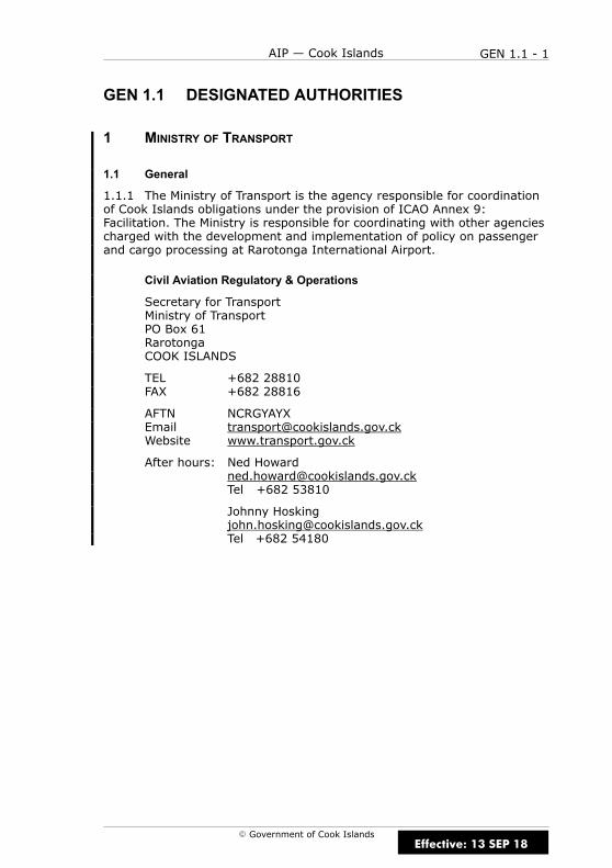
GEN 1.1 DESIGNATED AUTHORITIES
1 MINISTRY OF TRANSPORT
1.1 General
1.1.1 The Ministry of Transport is the agency responsible for coordinationof Cook Islands obligations under the provision of ICAO Annex 9:Facilitation. The Ministry is responsible for coordinating with other agenciescharged with the development and implementation of policy on passengerand cargo processing at Rarotonga International Airport.
Civil Aviation Regulatory & Operations
Secretary for TransportMinistry of TransportPO Box 61RarotongaCOOK ISLANDS
TEL +682 28810FAX +682 28816
AFTN NCRGYAYXEmail [email protected] www.transport.gov.ck
After hours: Ned [email protected] +682 53810
Johnny [email protected] +682 54180
Effective: 13 SEP 18
GEN 1.1 - 2 AIP — Cook Islands
E Government of Cook Islands
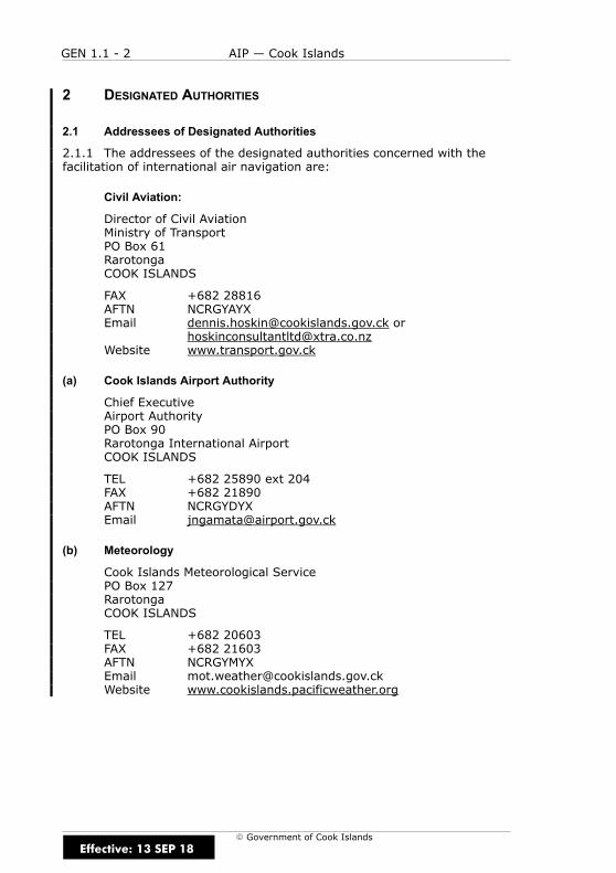
2 DESIGNATED AUTHORITIES
2.1 Addressees of Designated Authorities
2.1.1 The addressees of the designated authorities concerned with thefacilitation of international air navigation are:
Civil Aviation:
Director of Civil AviationMinistry of TransportPO Box 61RarotongaCOOK ISLANDS
FAX +682 28816AFTN NCRGYAYXEmail [email protected] or
[email protected] www.transport.gov.ck
(a) Cook Islands Airport Authority
Chief ExecutiveAirport AuthorityPO Box 90Rarotonga International AirportCOOK ISLANDS
TEL +682 25890 ext 204FAX +682 21890AFTN NCRGYDYXEmail [email protected]
(b) Meteorology
Cook Islands Meteorological ServicePO Box 127RarotongaCOOK ISLANDS
TEL +682 20603FAX +682 21603AFTN NCRGYMYXEmail [email protected] www.cookislands.pacificweather.org
Effective: 13 SEP 18
GEN 1.1 - 3AIP — Cook Islands
E Government of Cook Islands
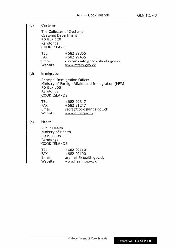
(c) Customs
The Collector of CustomsCustoms DepartmentPO Box 120RarotongaCOOK ISLANDS
TEL +682 29365FAX +682 29465Email [email protected] www.mfem.gov.ck
(d) Immigration
Principal Immigration OfficerMinistry of Foreign Affairs and Immigration (MFAI)PO Box 105RarotongaCOOK ISLANDS
TEL +682 29347FAX +682 21247Email [email protected] www.mfai.gov.ck
(e) Health
Public HealthMinistry of HealthPO Box 109RarotongaCOOK ISLANDS
TEL +682 29110FAX +682 29100Email [email protected] www.health.gov.ck
Effective: 13 SEP 18
GEN 1.1 - 4 AIP — Cook Islands
E Government of Cook Islands
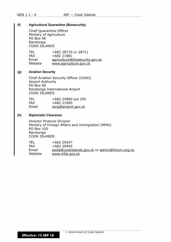
(f) Agricultural Quarantine (Biosecurity)
Chief Quarantine OfficerMinistry of AgriculturePO Box 96RarotongaCOOK ISLANDS
TEL +682 28710 or 28711FAX +682 21881Email [email protected] www.agriculture.gov.ck
(g) Aviation Security
Chief Aviation Security Officer (CASO)Airport AuthorityPO Box 90Rarotonga International AirportCOOK ISLANDS
TEL +682 25890 ext 205FAX +682 21890Email [email protected]
(h) Diplomatic Clearance
Director Protocol DivisionMinistry of Foreign Affairs and Immigration (MFAI)PO Box 105RarotongaCOOK ISLANDS
TEL +682 29347FAX +682 29465Email [email protected] or [email protected] www.mfai.gov.ck
Effective: 13 SEP 18
GEN 1.1 - 5AIP — Cook Islands
E Government of Cook Islands
(i) Enroute and Aerodrome Charges
Director of CorporateAirport AuthorityPO Box 90Rarotonga International AirportCOOK ISLANDS
TEL +682 25890FAX +682 21890AFTN NCRGYDYXEmail [email protected]
(j) Aircraft Accidents Investigation
The Secretary for Transport*Ministry of TransportPO Box 61RarotongaCOOK ISLANDS
TEL +682 28810FAX +682 28816Email [email protected] or
*The Minister of Transport must appoint a Chief AccidentInvestigator when this is recommended by the Secretary forTransport.
The functions of the Chief Accident Investigator are defined in theCivil Aviation Act 2002.
Effective: 13 SEP 18

GEN 1.1 - 6 AIP — Cook Islands
E Government of Cook Islands
IntentionallyBlank
Effective: 13 SEP 18
GEN 1.2 - 1AIP — Cook Islands
E Government of Cook Islands
GEN 1.2 ENTRY, TRANSIT AND DEPARTURE OFAIRCRAFT
1 INTRODUCTION
1.1 General
1.1.1 International flights into, from, or in transit through the CookIslands territory is subject to the current Cook Islands Civil Aviation Act2002 and Air Services Act 1984 and associated Rules and Regulationsrelating to civil aviation. These regulations correspond in all essentials tothe Standards and Recommended Practices contained in Annex 9 to theConvention on International Civil Aviation. The information contained inthis section does not replace, amend or change in any manner, thecurrent regulations of the designated authorities that are of concern tointernational air travel.
1.1.2 Aircraft flying into or departing from Cook Islands territory shallmake their first landing at, or final departure from Rarotonga InternationalAirport.
1.1.3 With the exception to the above, Aitutaki airport may be used as aport of entry and departure for light to medium wake turbulence categoryaircraft that are in compliance with Aitutaki Pavement ClassificationNumber (PCN) requirements. Aircraft exceeding this may not be permittedto land and will require specific approval from the Cook Islands AirportAuthority. Refer Para 3.5.3 for request approval requirements.
2 RELEVANT LEGISLATION
2.1 Cook Islands Legislation
2.1.1 The primary customs, immigration, quarantine, agriculture andhealth legislation is listed as below:
(a) Customs Revenue and Border Protection Act, associated Regulationsand Explanatory Notes 2012
(b) Entry, Residence and Departure Act 1971–1972 and associatedamendments
(c) Biosecurity Act 2008 and associated quarantine regulations
(d) Public Health Act 2004
(e) Plant Act 1973 and Animal Act 1975
(f) Te Pakau Aroa Act 2005
(g) Departure Tax Act 2012
Effective: 13 SEP 18
D
GEN 1.2 - 2 AIP — Cook Islands
E Government of Cook Islands
3 MINISTRY OF TRANSPORT REQUIREMENTS
3.1 Scheduled Air Services
3.1.1 International airlines serving the Cook Islands on a scheduled basisare required to hold an International Air Service Licence.
3.2 Non-Scheduled Flights
3.2.1 Non-scheduled flights are all international flights other thanscheduled air services, and include charter, ferry, medivac/retrieval andprivate flights.
3.3 Commercial Flights
3.3.1 Commercial non-scheduled flights transiting Cook Islands territory,and not landing at Rarotonga International airport do not requireauthorization by the Director of Civil Aviation. Advance notice is required.An international flight plan will be accepted as advance notice.
3.4 Non-Commercial Flights
3.4.1 Operators of civil aircraft registered in States party to theConvention on International Civil Aviation desiring to make non-scheduledflights in transit across Cook Islands territory are only required to giveadvance notice. An international flight plan will be accepted as adequatenotice. If the flight is to land at Rarotonga International airport fornon-commercial purposes, this requires authorization from the Director ofCivil Aviation.
Effective: 13 SEP 18

GEN 1.2 - 3AIP — Cook Islands
E Government of Cook Islands
3.5 Applications for Approval
3.5.1 Applications for non-scheduled commercial flights, which must befrom the operator (not the charterer) may be made directly to the Ministryof Transport. If, however the aircraft is not registered in a State party tothe ICAO Convention, the application should be submitted through theaviation authority of the State of Registry.
3.5.2 Application and notice of flights should be addressed to:
Director of Civil AviationMinistry of TransportPO Box 61RarotongaCOOK ISLANDS
Tel +682 28810Fax +682 28816Email [email protected] or
Note: The Ministry of Transport does not have AFTN or SITA links;however, messages received from via the Cook Islands AirportAuthority will be directed onwards to the Ministry.
After hours:Ned Howard mobile: +682 53810Johnny Hosking mobile: +682 54180Tai Cummings mobile: +682 52271
3.5.3 Request for permission for approval to land at RarotongaInternational airport or Aitutaki airport shall be requested at least14 working days prior to departure. In order to avoid delays andinconvenience, flight applications should be made not less than 5working days before a flight.
Note: Refer to Para 1.1.3 for Aitutaki requirements.
Effective: 13 SEP 18
GEN 1.2 - 4 AIP — Cook Islands
E Government of Cook Islands
3.5.4 The following shall be supplied with flight applications:
(a) Name, address, telephone and fax numbers and internet address(if available) of the operator
(b) Type and registration marks of the aircraft
(c) Name, address and business of charterer
(d) Proposed date and place of origin of flight
(e) Routes including dates and times of arrival and departure
(f) Number of passengers and/or nature of freight
(g) Purpose of flight
(h) Aircraft take-off weight and type pressure
(i) Refuelling details and time required
(j) Details of third party insurance cover for flights over or within theCook Islands
Faxed copies of:
(a) Certificate of airworthiness
(b) Pilot’s aviation licence and validating medical certificate
3.5.5 A response should be expected between 1–7 days after the requesthas been received. For planning purposes, this can be expedited providedthe urgency is indicated. Any changes to the proposed itinerary must benotified.
3.5.6 Prior approval for the flight must be obtained before the flight canproceed.
3.5.7 Emergency flights are exempted from the 14 day requirement inseeking approval; however, this does not preclude the aircraft operatorfrom providing the necessary information to the above authority at theearliest opportunity.
Effective: 13 SEP 18

GEN 1.2 - 5AIP — Cook Islands
E Government of Cook Islands
4 SCHEDULED AND NON-SCHEDULED FLIGHTS
4.1 General
4.1.1 All passengers, mail, cargo and crew of any overseas aircraftshall be subject mutatis mutandis to all applicable general or speciallocal regulations dealing with the entry, transit and departure of persons,introduction, transit or exportation of goods, quarantine and healthmeasures, immigration, passports, visas and travel documents.
4.2 Documentary Requirements for Clearance of Aircraft
4.2.1 It is necessary that the aircraft documents shown in TableGEN 1.2 – 1 be submitted by airline operators for clearance on entry anddeparture of their aircraft to and from the Cook Islands. All documentslisted in Table GEN 1.2 – 1 must follow the ICAO standard format as setforth in the relevant appendices to ICAO Annex 9 and are acceptable whenfurnished in English in legible handwriting. No visas are required inconnection with such documents.
4.2.2 All documents are to be submitted to Customs as soon aspracticable.
Table GEN 1.2 - 1Aircraft Documents Required
REQUIRED BY GENERALDECLARATION
PASSENGERMANIFEST
CARGOMANIFEST
CUSTOMS 1 1* 1
AGRICULTURE/QUARANTINE 1 Nil Nil
IMMIGRATION Nil Nil Nil
* Arrivals only
Notes
4.2.3 One copy of the General Declaration is endorsed and returned byCustoms, signifying clearance.
4.2.4 If no passengers are embarking (disembarking) and no articles areladen (unladen), no aircraft documents except copies of the GeneralDeclaration need be submitted to the appropriate Customs authorities.
4.2.5 For all aircraft in excess of 22,700kg, a local handling agent must becontacted to facilitate both the arrival and departure. This requirement is inline with the Airport Authority’s policy on apron management.
Effective: 13 SEP 18
GEN 1.2 - 6 AIP — Cook Islands
E Government of Cook Islands
4.2.6 Contact for local agents are:
(a) Air Rarotonga LtdPO Box 79RarotongaCOOK ISLANDS
TEL +682 20845FAX +682 23288Email [email protected] or
(b) Air New Zealand LtdPO Box 65RarotongaCOOK ISLANDS
TEL +682 26300FAX +682 23300Email [email protected] or
4.2.7 However, no such permission is required for flights that fall into thefollowing category:
(a) Overflights by civil aircraft that have the nationality of the ICAOcontracting state, provided that the requirements of the ICAOconvention on International Civil Aviation are complied with.
(b) When Rarotonga International airport is nominated in an IFR flightplan as the alternate aerodrome in accordance with CAR Part 91.405and prior notice of diversion has been received by ATC.
(c) The Ministry of Transport and the applicable Airport Authority hasbeen notified 10 days prior to nomination of aerodrome as analternate.
Effective: 13 SEP 18

GEN 1.2 - 7AIP — Cook Islands
E Government of Cook Islands
5 REQUIREMENTS FOR CLEARANCE OF AIRCRAFT
5.1 Arrival
5.1.1 On opening the aircraft doors the pilot in command or theirdesignated representatives, must present disinsection documents for anyarrival disinsection. Aircraft with non-complying disinsection certificatesor that have not been disinsected will be disinsected on arrival withpassengers and crew on board.
5.1.2 On arrival, the pilot in command (or operator) of the aircraft mustdeliver to Customs an inward report accompanied by such supportingdocuments that may be required.
5.1.3 The aircraft may be examined for risk goods or unwantedorganisms. Where pests or unwanted organisms are found on board,an inspector may direct the aircraft to be disinsected or fumigated.
5.1.4 All garbage and food trolleys removed from the aircraft must goto an MPI approved transitional facility for sorting, cleaning and wastedestruction.
5.2 Departure
5.2.1 Unless otherwise approved by Customs, the pilot in command of anaircraft which has as its destination a point outside of Rarotonga mustdepart from an approved Customs place with a certificate of clearance inthe prescribed form. Before any certificate of clearance is granted, the pilotin command must deliver to customs an outward report accompanied byany required supporting documents.
Effective: 13 SEP 18
GEN 1.2 - 8 AIP — Cook Islands
E Government of Cook Islands
6 MILITARY AND STATE AIRCRAFT
6.1 General
6.1.1 Foreign military and State aircraft as defined by the Convention willrequire diplomatic clearance from the Ministry of Foreign Affairs andImmigration. Application for permission should be made through diplomaticchannels giving a minimum of 7 full working days’ notice:
Ministry of Foreign Affairs and Immigration (MFAI)PO Box 105RarotongaCOOK ISLANDS
TEL +682 29347FAX +682 29465Email [email protected]
7 PRIVATE FLIGHTS
7.1 General
7.1.1 Refer to section 3.1.
8 PUBLIC HEALTH MEASURES APPLIED TO AIRCRAFT
8.1 General
8.1.1 All arriving flights will be subject to insecticide spraying.
Effective: 13 SEP 18
GEN 1.3 - 1AIP — Cook Islands
E Government of Cook Islands
GEN 1.3 ENTRY, TRANSIT AND DEPARTURE OFPASSENGERS AND CREW
1 INTRODUCTION
1.1 General
1.1.1 All passengers entering the Cook Islands are required to presentan acceptable passport or certificate of identity and complete a PassengerArrival Card (one per person).
1.1.2 The information sought on the Arrival Card is for Customs,Immigration and Quarantine purposes.
1.1.3 Exceptions to the requirement to present an arrival card are madefrom time to time by way of regulations. Current exemptions are formembers of the armed forces arriving on board military aircraft and for thecrew of those aircraft and members of the crew of any commercial aircraftwho are temporarily exempt from the requirement to hold a permit.
1.1.4 Persons leaving the Cook Islands are no longer required to fill in aDeparture card.
2 CUSTOMS REQUIREMENTS
2.1 General
2.1.1 The following customs requirements are applicable:
(a) baggage or articles belonging to disembarking passengers and creware immediately released except for those selected by Customsauthorities for inspection;
(b) no Customs formalities are normally required on departure;
(c) duty free concessions are as per customs passenger declarationform; and
(d) detailed information on the export of currency can be obtainedfrom:
Collector of CustomsCustoms DeptPO Box 120RarotongaCOOK ISLANDS
Tel +682 29365Fax +682 29465Email: www.mfem.gov.ck/customs
Effective: 13 SEP 18
GEN 1.3 - 2 AIP — Cook Islands
E Government of Cook Islands
3 IMMIGRATION REQUIREMENTS
3.1 General
3.1.1 No documents are required for passengers and crew arriving anddeparting on the same aircraft in transit or transferring to another flightat the same airport. These persons are not authorized to move outsidethe international airport transit area on special authorization from theauthorities concerned.
3.1.2 Intending immigrants are referred to the:
(a) Principal Immigration OfficerMinistry of Foreign Affairs and ImmigrationPO Box 105RarotongaCOOK ISLANDS
TEL +682 29347FAX +682 21247Email [email protected]
(b) The Cook Islands ConsulateAucklandNEW ZEALANDEmail [email protected]
3.2 Passports
3.2.1 Persons entering or leaving the Cook Islands must hold a passportvalid on arrival for a period of at least six months except:
(a) aircraft crew members declared on the general declaration form;
(b) Cook Islanders holding an official certificate of identity (limitedonly to Cook Islanders travelling between the Cook Islands andNew Zealand).
Effective: 13 SEP 18

GEN 1.3 - 3AIP — Cook Islands
E Government of Cook Islands
3.3 Visas
3.3.1 Is an endorsement in a passport that allows the passport bearer totravel to the Cook Islands for the purpose of visiting. Visas are requiredexcept for:
(a) Bonafide visitors who intend to leave the Cook Islands within 31days after arrival provided they hold tickets with reserved seats anddocuments for onward travel;
(b) Cook Islanders;
(c) Permanent residents of the Cook Islands;
(d) Any child (born in or out of lawful wedlock) of a permanentresident;
(e) Persons who are descendants of indigenous Cook Islands Maori;
(f) Members of the Armed forces who enter the Cook Islands, is in theCook Islands or leaves the Cook Islands in the performance of hisduties;
(g) HM Services personnel;
(h) Persons accredited to the Cook Islands government or to thegovernment of New Zealand or under the authority of any otherGovernment;
(i) Diplomatic representatives, United Nations or South PacificCommission representatives;
(j) Citizens of New Zealand;
(k) Any person for the time being entitled to Diplomatic Privilegesand Immunities underPart I or Part II of Diplomatic Privileges andImmunities Act 1968 or the Consular Privileges and ImmunitiesAct 1971 (special exemption endorsements are placed in the traveldocuments of these passengers to enable them to be readilyidentified).
3.3.2 Visas may be issued by:
(a) Principal Immigration Officer
(b) the Offices of the Cook Islands Consul in Auckland, New Zealand.
3.3.3 Applications for visas should be made in writing at least one monthbefore departure and must include proof of accommodation, maintenancein the Cook Islands and return or onwards tickets.
Effective: 13 SEP 18

GEN 1.3 - 4 AIP — Cook Islands
E Government of Cook Islands
4 PUBLIC HEALTH REQUIREMENTS
4.1 General
4.1.1 Disembarking passengers are not required to present vaccinationcertificates except when coming directly from an area infected with cholera,plague, typhoid or recurrent fever, and includes the following countries:
(a) Bangladesh
(b) India
(c) Myanmar (Burma)
(d) Philippines
(e) Thailand
(f) Vietnam
4.1.2 A yellow fever vaccination certificate is required from travellers afterleaving or transiting infected areas within the last 6 days.
4.1.3 If a person identified with a notifiable disease has travelled on anaircraft within the period of communicability, the public health officer mayneed to identity and trace passengers and crew members to preventongoing transmission and quarantine provisions may be necessary.
4.1.4 All foreign aircraft are subject to health quarantine.
4.1.5 On departure, no health formalities are required.
4.2 Responsibilities of Pilot In Command
4.2.1 The pilot in command of an aircraft arriving into Rarotonga mustnotify the airline agent at least 15 minutes before landing, if:
(a) ill persons are on board suffering from diarrhea, vomiting (notmotion sickness) or abnormal temperature and a skin rash; or
(b) there is any other condition that may lead to the spread of disease.
Effective: 13 SEP 18

GEN 1.4 - 1AIP — Cook Islands
E Government of Cook Islands
GEN 1.4 ENTRY, TRANSIT AND DEPARTURE OF CARGO
1 CUSTOMS REQUIREMENTS CONCERNING CARGO AND OTHER ARTICLES
1.1 General
1.1.1 The following Customs requirements are applicable:
(a) outwards clearance and eventually the payment of fees are requiredfor local goods for exportation. Payments are made through theCustoms Department;
(b) no clearance documents are required with respect to goods retainedon board a transit aircraft, or cargo simply being trans-shipped fromone flight to another at the same airport under Customs supervision.
2 AGRICULTURAL QUARANTINE REQUIREMENTS
2.1 Airport Facilities
2.1.1 The Ministry of Agriculture administers the Plant Act 1973 and theAnimal Act 1975.
2.1.2 There are restrictions on importation of plant materials, liveanimals, meat, and meat products.
2.1.3 The Ministry of Agriculture should be contacted for advice regardingimportation of the above mentioned items and any other fruit andvegetables.
(a) The Ministry of AgriculturePO Box 96RarotongaCOOK ISLANDS
TEL (682) 28 711FAX (682) 21 881email [email protected]
Effective: 15 DEC 11

GEN 1.4 - 2 AIP — Cook Islands
E Government of Cook Islands
IntentionallyBlank
Effective: 15 DEC 11
GEN 1.5 - 1AIP — Cook Islands
E Government of Cook Islands
GEN 1.5 AIRCRAFT INSTRUMENTS, EQUIPMENT ANDFLIGHT DOCUMENTS
1 COMMERCIAL AIR TRANSPORT AIRCRAFT
1.1 General
1.1.1 Commercial air transport aircraft operating in the Cook Islands mustadhere to the provisions of ICAO Annex 6 — Operation of Aircraft, Part I —International Commercial Air Transport — Aeroplanes, Chapter 6(Aeroplane Instruments, Equipment and Flight Documents) and Chapter 7(Aeroplane Communication and Navigation Equipment), and to the CookIslands Civil Aviation Rules.
2 SPECIAL EQUIPMENT TO BE CARRIED
2.1 General
2.1.1 Special operational requirements for equipment to be carried onaircraft operating in the Cook Islands may be found in CAR Part 91,subpart F.
3 CARRIAGE OF SURVIVAL RADIO IN COOK ISLANDS AIRSPACE
3.1 General
3.1.1 Aircraft shall be equipped with survival radio equipment, operatingon VHF in accordance with the relevant provisions of ICAO Annex 10,stowed so as to facilitate its ready use in an emergency. The equipmentshall be portable, not dependent for operation upon the aircraft’s powersupply, and capable of being operated away from the aircraft by unskilledpersons.
3.1.2 Aircraft shall also be equipped with signalling devices and survivalequipment including means of sustaining life.
Effective: 15 DEC 11

GEN 1.5 - 2 AIP — Cook Islands
E Government of Cook Islands
IntentionallyBlank
Effective: 15 DEC 11
GEN 1.6 - 1AIP — Cook Islands
E Government of Cook Islands
GEN 1.6 SUMMARY OF NATIONAL REGULATIONS ANDINTERNATIONAL AGREEMENTS/CONVENTIONS
1 NATIONAL REGULATIONS
1.1 General
1.1.1 Following is a list of civil aviation legislation and air navigationregulations in force in the Cook Islands. It is essential that anyone engagedin air operations be acquainted with the relevant regulations. Refer toMinistry of Transport — Cook Islands for procurement details.
(a) Civil Aviation Act 2002
(b) Air Services Act 1984
(c) Aviation Security Act 2008
(d) New Zealand Civil Aviation Act 1990
(e) New Zealand Civil Aviation Rules and Amendments
(f) Transport Accident Investigation Commission Act 1990
(g) Airport Authority Act 1985 and associated amendments
2 INTERNATIONAL AGREEMENTS/CONVENTIONS
2.1 Conventions and Protocols
2.1.1 The following international agreements, conventions and protocolson civil aviation have been ratified or signed by the Cook IslandsGovernment.
(a) Chicago Convention on International Civil Aviation 1944;
(b) Tokyo Convention on Offences and Certain Other Acts Committed onBoard Aircraft 1963;
(c) Hague Convention for the Suppression of Unlawful Seizure ofAircraft 1970;
(d) Montreal Supplementary Protocol for the Suppression of UnlawfulActs Against the Saftey of Civil Aviation 1970;
(e) Montreal Convention for the Suppression of Unlawful Acts Againstthe Saftey of Civil Aviation 1971;
(f) Acceded to the convention of the WMO 1995.
Effective: 13 SEP 18
GEN 1.6 - 2 AIP — Cook Islands
E Government of Cook Islands
2.2 International Agreements
2.2.1 The following countries have Bilateral Air Service Agreements withthe Cook Islands:
(a) Fiji;
(b) (Open Skies) 2000;
(c) New Zealand (Open Skies ) 2001;
(d) Tonga (Open Skies) 2001;
(e) Samoa (Open Skies) 2001.
2.2.2 The following lists other international agreements with the CookIslands:
(a) contracting state of ICAO adhered to (1986)
(b) air transport agreement with Chile (1992)
Effective: 15 DEC 11

GEN 1.7 - 1AIP — Cook Islands
E Government of Cook Islands
GEN 1.7 DIFFERENCES FROM ICAO STANDARDS,RECOMMENDED PRACTICES ANDPROCEDURES
1 ANNEX 1 — PERSONNEL LICENSING
1.1 Nil
2 ANNEX 2 — RULES OF THE AIR
2.1 Nil
3 ANNEX 3 — METEOROLOGY
3.1 Nil
4 ANNEX 7 — AIRCRAFT NATIONALITY AND REGISTRATION MARKS
4.1 Nil
5 ANNEX 8 — AIRWORTHINESS OF AIRCRAFT
5.1 Nil
6 ANNEX 9 — FACILITATION
6.1 Nil
7 ANNEX 10 — AERONAUTICAL TELECOMMUNICATIONS
7.1 Nil
8 ANNEX 11 — AIR TRAFFIC SERVICES
8.1 Nil
Effective: 15 DEC 11

GEN 1.7 - 2 AIP — Cook Islands
E Government of Cook Islands
9 ANNEX 12 — SEARCH AND RESCUE
9.1 Nil
10 ANNEX 13 — AIRCRAFT ACCIDENT
10.1 Nil
11 ANNEX 14 — AERODROMES
11.1 Nil
12 ANNEX 15 — AERONAUTICAL INFORMATION SERVICES
12.1 Nil
13 ANNEX 16 — ENVIRONMENTAL PROTECTION
13.1 Nil
14 ANNEX 17 — SECURITY — SAFEGUARDING INTERNATIONAL CIVIL
AVIATION AGAINST ACTS OF UNLAWFUL INTERFERENCE
14.1 Nil
15 ANNEX 18 — THE SAFE TRANSPORT OF DANGEROUS GOODS BY AIR
15.1 Nil
Effective: 15 DEC 11
GEN 2 - 1AIP — Cook Islands
E Government of Cook Islands
GEN 2 TABLES AND CODES
Effective: 15 DEC 11

GEN 2 - 2 AIP — Cook Islands
E Government of Cook IslandsEffective: 15 DEC 11
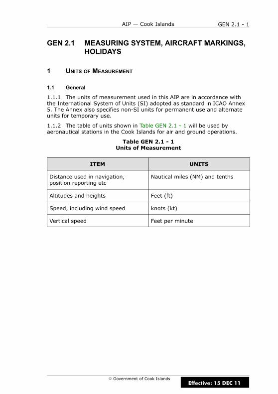
GEN 2.1 - 1AIP — Cook Islands
E Government of Cook Islands
GEN 2.1 MEASURING SYSTEM, AIRCRAFT MARKINGS,HOLIDAYS
1 UNITS OF MEASUREMENT
1.1 General
1.1.1 The units of measurement used in this AIP are in accordance withthe International System of Units (SI) adopted as standard in ICAO Annex5. The Annex also specifies non-SI units for permanent use and alternateunits for temporary use.
1.1.2 The table of units shown in Table GEN 2.1 - 1 will be used byaeronautical stations in the Cook Islands for air and ground operations.
Table GEN 2.1 - 1Units of Measurement
ITEM UNITS
Distance used in navigation,position reporting etc
Nautical miles (NM) and tenths
Altitudes and heights Feet (ft)
Speed, including wind speed knots (kt)
Vertical speed Feet per minute
Effective: 15 DEC 11
GEN 2.1 - 2 AIP — Cook Islands
E Government of Cook Islands
2 TIME SYSTEM
2.1 General
2.1.1 Co-ordinated Universal Time (UTC) is used by air navigation servicesand in publications issued by the Aeronautical Information Service.Reporting of time is expressed to the nearest minute, e.g. 22:45:40 isreported as 2246.
2.1.2 Date and time is expressed as a six figure group of day, hours andminutes, e.g. 4th February 2001, 4.35pm UTC is expressed as 041635.However, in NOTAM and preflight information bulletins, a ten figure groupof year, month, day, hours and minutes is used, e.g. 0102041635.
2.1.3 Local time in the Cook Islands is UTC – 10 hours.
2.2 Time Signals
2.2.1 There are no stations transmitting time signals in the Cook Islands.
2.2.2 Station WWVH at Kauai, Hawaii (female voice), and WWV at FortCollins, Colorado (male voice), transmit time pips continuously on 2.5, 5,10, 15, and 20 MHz, with self-explanatory voice announcements everyminute.
3 GEODETIC REFERENCE DATUM
3.1 Name/Designation of Datum
3.1.1 World Geodetic System 1984 datum (WGS 84) is used.
3.2 Area of Application
3.2.1 The World Geodetic System 1984 datum (WGS 84) applies to allcharts and data within the Cook Sector of the Auckland Oceanic FIR.
3.3 Use of an Asterisk to Identify Published Geographical Coordinates
3.3.1 WGS 84 positions based on source data that does not meet thesurvey accuracies recommended in ICAO Annex 14 are annotated with anasterisk (*).
Effective: 15 DEC 11

GEN 2.1 - 3AIP — Cook Islands
E Government of Cook Islands
4 AIRCRAFT NATIONALITY AND REGISTRATION MARKS
4.1 General
4.1.1 The nationality mark for aircraft registered in the Cook Islands is E5.The nationality mark is followed by a hyphen and a registration markconsisting of three letters in roman characters followed by one or morenumbers, e.g. E5-FTS.
5 PUBLIC HOLIDAYS
5.1 General
5.1.1 Public holidays for the Cook Islands are as listed in Table GEN 2.1 - 2.
Table GEN 2.1 - 2Public Holidays
EVENT 2018 2019 2020
New Year’s Day Monday 1 January Tuesday 1 January Wednesday 1 January
Day AfterNew Year’s Day
Tuesday 2 January Wednesday 2 January Thursday 2 January
Good Friday Friday 30 March Friday 19 April Friday 10 April
Easter Monday Monday 2 April Monday 22 April Monday 13 April
ANZAC Day Wednesday 25 April Thursday 25 April Saturday 25 April
Queen’s BirthdayObserved
Monday 4 June Monday 3 June Monday 1 June
Ra O Te Ui ArikiDay
Friday 6 July Friday 5 July Friday 4 July
Constitution DayObserved
Monday 6 August Monday 5 August Monday 4 August
NationalGospel Day
Thursday 25October
Friday 25 OctoberSaturday 25 Octoberbut observed onMonday 27 October
Christmas Day Tuesday25 December
Wednesday25 December
Friday25 December
Boxing Day Wednesday26 December
Thursday26 December
Saturday26 December butobserved on Monday28 December
Effective: 13 SEP 18
GEN 2.1 - 4 AIP — Cook Islands
E Government of Cook Islands
Notes
Where these dates fall on a weekend day, a holiday will be observed on thenext available weekday except for ANZAC Day.
Effective: 2 APR 15
GEN 2.2 - 1AIP — Cook Islands
E Government of Cook Islands
GEN 2.2 ABBREVIATIONS USED IN AIS PUBLICATIONS
1 INTRODUCTION
1.1 General
1.1.1 The abbreviations used in the AIP are generally in accordance withthose listed in ICAO Procedures for Air Navigation Services, ICAOAbbreviations and Codes PANS-ABC (Doc 8400).
1.1.2 Abbreviations are correct in the use of upper and/or lower casewhere there is an applicable international standard, such as for units ofmeasurement (ICAO ANNEX 5). Upper case is always used incommunications on the aeronautical fixed service, such as transmission onthe international AFTN.
1.1.3 Abbreviations followed by a # are to be transmitted as spokenwords when using radiotelephony.
A
A AmberA/A Air-to-airAAL Above aerodrome levelABM AbeamABN Aerodrome beaconABT AboutABV AboveAC AltocumulusACAS Airborne collision avoidance systemACC Area control centre or area controlACCID Notification of an aircraft accidentACFT AircraftACK AcknowledgeACL Altimeter check locationACN Aircraft classification numberACP Acceptance (message type designator)ACPT Accept or acceptedACT Active or activated or activityAD AerodromeADA Advisory areaADDN Addition or additionalADF Automatic direction-finding equipmentADIZ # Air defence identification zone (pronounced “AYDIZ”)ADJ AdjacentADR Advisory routeADS Automatic dependent surveillanceADSU Automatic dependent surveillance unitADVS Advisory serviceADZ Advise
Effective: 15 DEC 11
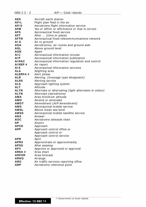
GEN 2.2 - 2 AIP — Cook Islands
E Government of Cook Islands
AES Aircraft earth stationAFIL Flight plan filed in the airAFIS Aerodrome flight information serviceAFM Yes or affirm or affirmative or that is correctAFS Aeronautical fixed serviceAFT After ... (time or place)AFTN Aeronautical fixed telecommunications networkA/G Air to groundAGA Aerodromes, air routes and ground aidsAGL Above ground levelAGN AgainAIC Aeronautical information circularAIP Aeronautical information publicationAIRAC Aeronautical information regulation and controlAIREP # Air reportAIS Aeronautical information servicesALA Alighting areaALERFA # Alert phaseALR Alerting (message type designator)ALRS Alerting serviceALS Approach lighting systemALT AltitudeALTN Alternate or alternating (light alternates in colour)ALTN Alternate (aerodrome)AMA Area minimum altitudeAMD Amend or amendedAMDT Amendment (AIP Amendment)AMS Aeronautical mobile serviceAMSL Above mean sea levelAMSS Aeronautical mobile satellite serviceANS AnswerAOC Aerodrome obstacle chartAP AirportAPCH ApproachAPP Approach control office or
Approach control orApproach control service
APR AprilAPRX Approximate or approximatelyAPSG After passingAPV Approve or approved or approvalAREA # Area chartARFOR Area forecastARNG ArrangeARO Air traffic services reporting officeARP Aerodrome reference point
Effective: 15 DEC 11
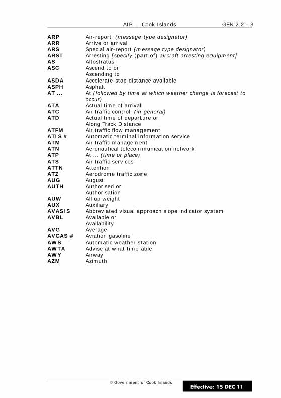
GEN 2.2 - 3AIP — Cook Islands
E Government of Cook Islands
ARP Air-report (message type designator)ARR Arrive or arrivalARS Special air-report (message type designator)ARST Arresting [specify (part of) aircraft arresting equipment]AS AltostratusASC Ascend to or
Ascending toASDA Accelerate-stop distance availableASPH AsphaltAT ... At (followed by time at which weather change is forecast to
occur)ATA Actual time of arrivalATC Air traffic control (in general)ATD Actual time of departure or
Along Track DistanceATFM Air traffic flow managementATIS # Automatic terminal information serviceATM Air traffic managementATN Aeronautical telecommunication networkATP At ... (time or place)ATS Air traffic servicesATTN AttentionATZ Aerodrome traffic zoneAUG AugustAUTH Authorised or
AuthorisationAUW All up weightAUX AuxiliaryAVASIS Abbreviated visual approach slope indicator systemAVBL Available or
AvailabilityAVG AverageAVGAS # Aviation gasolineAWS Automatic weather stationAWTA Advise at what time ableAWY AirwayAZM Azimuth
Effective: 15 DEC 11
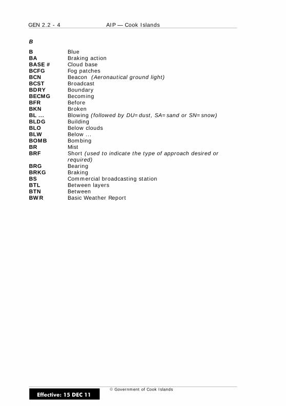
GEN 2.2 - 4 AIP — Cook Islands
E Government of Cook Islands
B
B BlueBA Braking actionBASE # Cloud baseBCFG Fog patchesBCN Beacon (Aeronautical ground light)BCST BroadcastBDRY BoundaryBECMG BecomingBFR BeforeBKN BrokenBL ... Blowing (followed by DU=dust, SA=sand or SN=snow)BLDG BuildingBLO Below cloudsBLW Below ...BOMB BombingBR MistBRF Short (used to indicate the type of approach desired or
required)BRG BearingBRKG BrakingBS Commercial broadcasting stationBTL Between layersBTN BetweenBWR Basic Weather Report
Effective: 15 DEC 11

GEN 2.2 - 5AIP — Cook Islands
E Government of Cook Islands
C
C Degrees Celsius (Centigrade)CASO # Civil Aviation Safety Order (pronounced “KAYSO”)CAT CategoryCAT Clear air turbulenceCAVOK # Visibility, cloud and present weather better than prescribed
values or conditions (pronounced “CAVOKAY”)CB # Cumulonimbus (pronounced “SEEBEE”)CC CirrocumulusCd Candela(s)CDN Co-ordination (message type designator)CF Change frequency to or
Course Fix (used with GPS approaches — often equivalent toIF)
CGL Circling guidance light(s)CH ChannelCHG Modification (message type designator)CI CirrusCIT Near or over large town(s)CIV CivilCK CheckCL CentrelineCLA Clear type of ice formationCLBR CalibrationCLD CloudCLG CallingCLR Cleared or
Cleared to ... orClearance
CLSD Close orClosed orClosing
CM CentimetreCMB Climb to or
Climbing toCMPL Completion or
Completed orComplete
CNL Cancel orCancelled
CNS Communications, navigation and surveillanceCONS ContinuousCOM CommunicationsCONC ConcreteCOND Condition(s)
Effective: 15 DEC 11
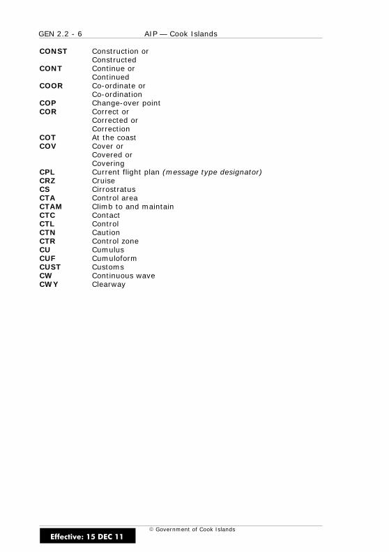
GEN 2.2 - 6 AIP — Cook Islands
E Government of Cook Islands
CONST Construction orConstructed
CONT Continue orContinued
COOR Co-ordinate orCo-ordination
COP Change-over pointCOR Correct or
Corrected orCorrection
COT At the coastCOV Cover or
Covered orCovering
CPL Current flight plan (message type designator)CRZ CruiseCS CirrostratusCTA Control areaCTAM Climb to and maintainCTC ContactCTL ControlCTN CautionCTR Control zoneCU CumulusCUF CumuloformCUST CustomsCW Continuous waveCWY Clearway
Effective: 15 DEC 11
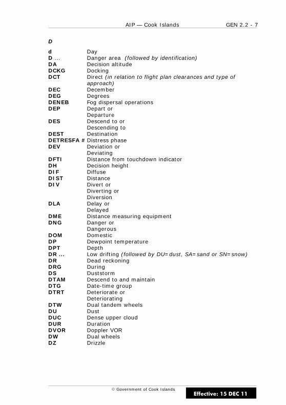
GEN 2.2 - 7AIP — Cook Islands
E Government of Cook Islands
D
d DayD ... Danger area (followed by identification)DA Decision altitudeDCKG DockingDCT Direct (in relation to flight plan clearances and type of
approach)DEC DecemberDEG DegreesDENEB Fog dispersal operationsDEP Depart or
DepartureDES Descend to or
Descending toDEST DestinationDETRESFA #Distress phaseDEV Deviation or
DeviatingDFTI Distance from touchdown indicatorDH Decision heightDIF DiffuseDIST DistanceDIV Divert or
Diverting orDiversion
DLA Delay orDelayed
DME Distance measuring equipmentDNG Danger or
DangerousDOM DomesticDP Dewpoint temperatureDPT DepthDR ... Low drifting (followed by DU=dust, SA=sand or SN=snow)DR Dead reckoningDRG DuringDS DuststormDTAM Descend to and maintainDTG Date-time groupDTRT Deteriorate or
DeterioratingDTW Dual tandem wheelsDU DustDUC Dense upper cloudDUR DurationDVOR Doppler VORDW Dual wheelsDZ Drizzle
Effective: 15 DEC 11
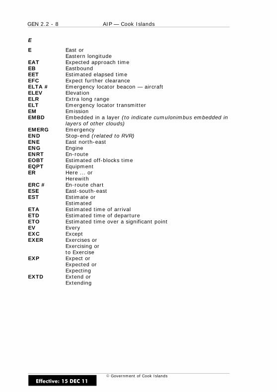
GEN 2.2 - 8 AIP — Cook Islands
E Government of Cook Islands
E
E East orEastern longitude
EAT Expected approach timeEB EastboundEET Estimated elapsed timeEFC Expect further clearanceELTA # Emergency locator beacon — aircraftELEV ElevationELR Extra long rangeELT Emergency locator transmitterEM EmissionEMBD Embedded in a layer (to indicate cumulonimbus embedded in
layers of other clouds)EMERG EmergencyEND Stop-end (related to RVR)ENE East north-eastENG EngineENRT En-routeEOBT Estimated off-blocks timeEQPT EquipmentER Here ... or
HerewithERC # En-route chartESE East-south-eastEST Estimate or
EstimatedETA Estimated time of arrivalETD Estimated time of departureETO Estimated time over a significant pointEV EveryEXC ExceptEXER Exercises or
Exercising orto Exercise
EXP Expect orExpected orExpecting
EXTD Extend orExtending
Effective: 15 DEC 11

GEN 2.2 - 9AIP — Cook Islands
E Government of Cook Islands
F
F FixedFAC FacilitiesFAF Final approach fixFAL Facilitation of international air transportFAP Final approach pointFATO Final approach and take-off areaFAX Facsimile transmissionFBL Light (used to indicate the intensity of weather phenomena,
interference or static reports, e.g. FBL RA=light rain).FC Funnel cloudFCST ForecastFCT Friction coefficientFEB FebruaryFG FogFIC Flight information centreFIR Flight information regionFIS Flight information serviceFISA Automated flight information serviceFL Flight levelFLD FieldFLG FlashingFLR FlaresFLT FlightFLTCK Flight checkFLUC Fluctuating or
Fluctuation orFluctuated
FLW Follow(s) orFollowing
FLY Fly orFlying
FM ... From (followed by time weather change is forecast to begin)FM FromFMU Flow management unitFNA Final approachFPL Filed flight plan (message type designator)FPM Feet per minuteFPR Flight plan routeFR Fuel remainingFREQ FrequencyFRI FridayFRNG FiringFRONT # Front (relating to weather)FRQ FrequentFSL Full stop landingFSS Flight service stationFST Firstft Foot or Feet (dimensional unit)FU SmokeFZ Freezing drizzleFZFG Freezing fogFZRA Freezing rain
Effective: 15 DEC 11
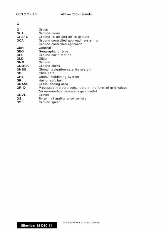
GEN 2.2 - 10 AIP — Cook Islands
E Government of Cook Islands
G
G GreenG/A Ground-to-airG/A/G Ground-to-air and air-to-groundGCA Ground controlled approach system or
Ground controlled approachGEN GeneralGEO Geographic or trueGES Ground earth stationGLD GliderGND GroundGNDCK Ground checkGNSS Global navigation satellite systemGP Glide pathGPS Global Positioning SystemGR Hail or soft hailGRASS Grass landing areaGRID Processed meteorological data in the form of grid values
(in aeronautical meteorological code)GRVL GravelGS Small hail and/or snow pelletsGS Ground speed
Effective: 15 DEC 11
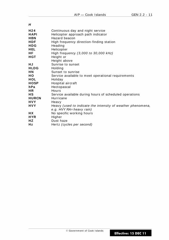
GEN 2.2 - 11AIP — Cook Islands
E Government of Cook Islands
H
H24 Continuous day and night serviceHAPI Helicopter approach path indicatorHBN Hazard beaconHDF High frequency direction-finding stationHDG HeadingHEL HelicopterHF High frequency (3,000 to 30,000 kHz)HGT Height or
Height aboveHJ Sunrise to sunsetHLDG HoldingHN Sunset to sunriseHO Service available to meet operational requirementsHOL HolidayHOSP Hospital aircrafthPa HectopascalHR HoursHS Service available during hours of scheduled operationsHURCN HurricaneHVY HeavyHVY Heavy (used to indicate the intensity of weather phenomena,
e.g. HVY RA=heavy rain)HX No specific working hoursHYR HigherHZ Dust hazeHz Hertz (cycles per second)
Effective: 15 DEC 11

GEN 2.2 - 12 AIP — Cook Islands
E Government of Cook Islands
I
IAC Instrument approach chartIAF Initial approach fixIAO In and out of cloudsIAR InterSection of air routesIAS Indicated air speedIBN Identification beaconIC Diamond dust (very small ice crystals in suspension)ICAO International Civil Aviation OrganisationICE IcingID Identifier or
IdentifyIDENT # IdentificationIF Intermediate approach fixIFF Identification friend/foeIFR Instrument flight rulesIGA International general aviationILS Instrument landing systemIM Inner markerIMC Instrument meteorological conditionsIMG ImmigrationIMPR Improve or improvingIMT Immediate or
ImmediatelyINA Initial approachINBD InboundINC In cloudINCERFA # Uncertainty phaseINFO # InformationINOP InoperativeINP If not possibleINPR In progressINS Inertial navigation systemINSTL Install or
Installed orInstallation
INSTR InstrumentINT InterSectionINTL InternationalINTRG InterrogatorINTRP Interrupt or
Interruption orInterrupted
INTSF Intensify orIntensifying
INTST IntensityIR Ice on runwayISA International standard atmosphereISOL Isolated
Effective: 15 DEC 11
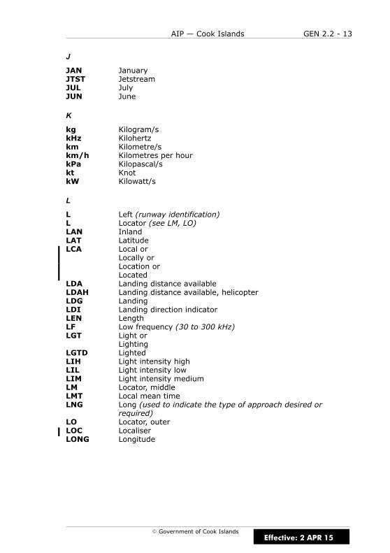
GEN 2.2 - 13AIP — Cook Islands
E Government of Cook Islands
J
JAN JanuaryJTST JetstreamJUL JulyJUN June
K
kg Kilogram/skHz Kilohertzkm Kilometre/skm/h Kilometres per hourkPa Kilopascal/skt KnotkW Kilowatt/s
L
L Left (runway identification)L Locator (see LM, LO)LAN InlandLAT LatitudeLCA Local or
Locally orLocation orLocated
LDA Landing distance availableLDAH Landing distance available, helicopterLDG LandingLDI Landing direction indicatorLEN LengthLF Low frequency (30 to 300 kHz)LGT Light or
LightingLGTD LightedLIH Light intensity highLIL Light intensity lowLIM Light intensity mediumLM Locator, middleLMT Local mean timeLNG Long (used to indicate the type of approach desired or
required)LO Locator, outerLOC LocaliserLONG Longitude
Effective: 2 APR 15

GEN 2.2 - 14 AIP — Cook Islands
E Government of Cook Islands
LORAN # Long range air navigation systemLRG Long rangeLSQ Line squallLTD LimitedLV Light and variable (wind)LVE Leave or
LeavingLVL LevelLYR Layer or
Layered
M
M Mach number (followed by figures)m Metres (preceded by figures)MAA Maximum authorised altitudeMAG Magnetic (preceded by figures)MAINT MaintenanceMAP Aeronautical maps and chartsMAPt Missed approach pointMAR MarchMAR At seaMAX MaximumMAY MayMCA Minimum crossing altitudeMCW Modulated continuous waveMDA Minimum descent altitudeMDF Medium frequency direction-finding stationMDH Minimum descent heightMEA Minimum en-route altitudeMEHT Minimum eye height over threshold
(for visual approach slope indicator systems)MET # Meteorological or
MeteorologyMETAR # Aviation routine weather report
(in aeronautical meteorological code)MF Medium frequency (300 to 3,000 kHz)MHz MegahertzMID Mid-point (related to RVR)MIFG Shallow fogMIL Militarymin Minute/sMKR Marker radio beaconMLS Microwave landing systemMM Middle markerMNM MinimumMNPS Minimum navigation performance specificationsMNT Monitor or
Monitoring orMonitored
Effective: 15 DEC 11
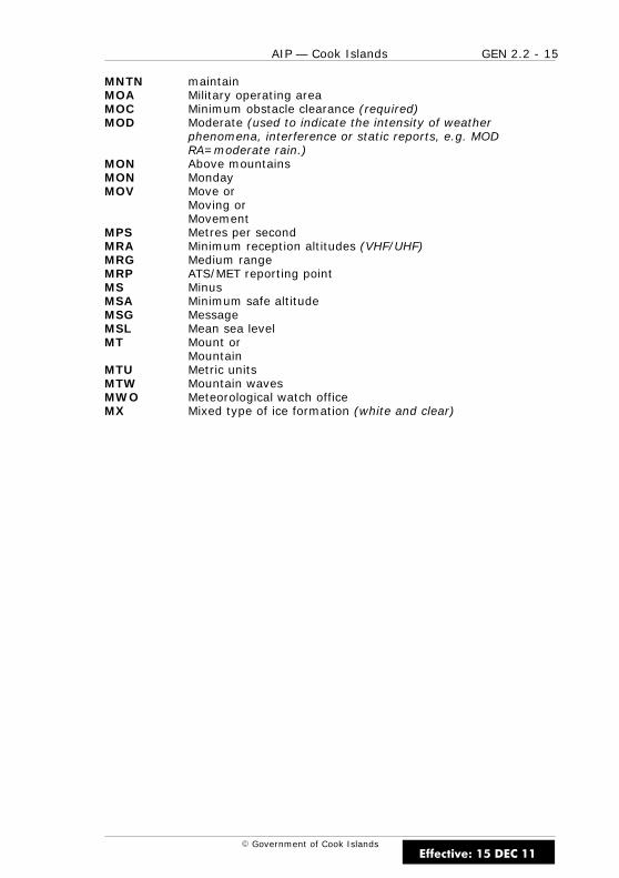
GEN 2.2 - 15AIP — Cook Islands
E Government of Cook Islands
MNTN maintainMOA Military operating areaMOC Minimum obstacle clearance (required)MOD Moderate (used to indicate the intensity of weather
phenomena, interference or static reports, e.g. MODRA=moderate rain.)
MON Above mountainsMON MondayMOV Move or
Moving orMovement
MPS Metres per secondMRA Minimum reception altitudes (VHF/UHF)MRG Medium rangeMRP ATS/MET reporting pointMS MinusMSA Minimum safe altitudeMSG MessageMSL Mean sea levelMT Mount or
MountainMTU Metric unitsMTW Mountain wavesMWO Meteorological watch officeMX Mixed type of ice formation (white and clear)
Effective: 15 DEC 11
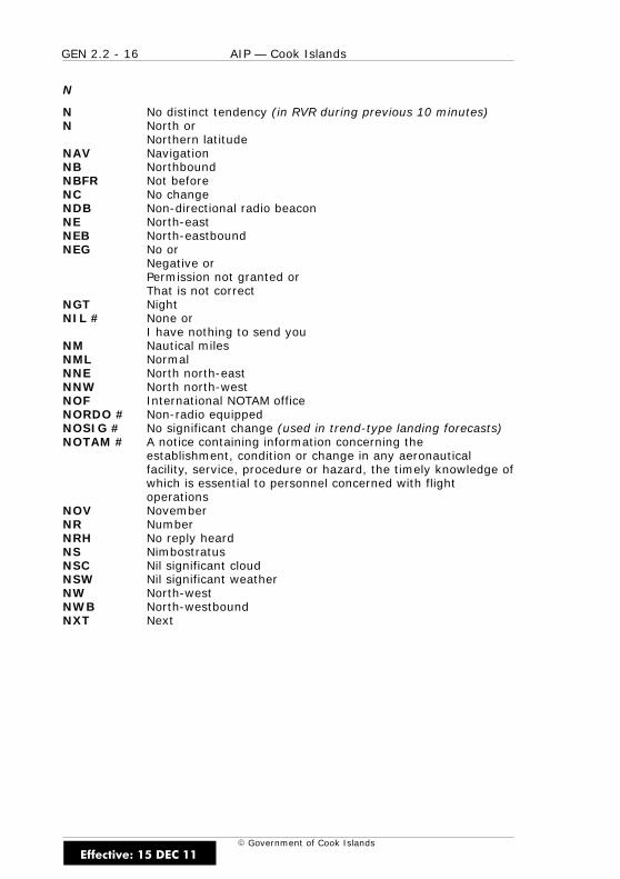
GEN 2.2 - 16 AIP — Cook Islands
E Government of Cook Islands
N
N No distinct tendency (in RVR during previous 10 minutes)N North or
Northern latitudeNAV NavigationNB NorthboundNBFR Not beforeNC No changeNDB Non-directional radio beaconNE North-eastNEB North-eastboundNEG No or
Negative orPermission not granted orThat is not correct
NGT NightNIL # None or
I have nothing to send youNM Nautical milesNML NormalNNE North north-eastNNW North north-westNOF International NOTAM officeNORDO # Non-radio equippedNOSIG # No significant change (used in trend-type landing forecasts)NOTAM # A notice containing information concerning the
establishment, condition or change in any aeronauticalfacility, service, procedure or hazard, the timely knowledge ofwhich is essential to personnel concerned with flightoperations
NOV NovemberNR NumberNRH No reply heardNS NimbostratusNSC Nil significant cloudNSW Nil significant weatherNW North-westNWB North-westboundNXT Next
Effective: 15 DEC 11
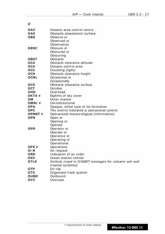
GEN 2.2 - 17AIP — Cook Islands
E Government of Cook Islands
O
OAC Oceanic area control centreOAS Obstacle assessment surfaceOBS Observe or
Observed orObservation
OBSC Obscure orObscured orObscuring
OBST ObstacleOCA Obstacle clearance altitudeOCA Oceanic control areaOCC Occulting (light)OCH Obstacle clearance heightOCNL Occasional or
OccasionallyOCS Obstacle clearance surfaceOCT OctoberOHD OverheadOKTA # Eighths of sky coverOM Outer markerOMNI # OmnidirectionalOPA Opaque, white type of ice formationOPC The control indicated is operational controlOPMET # Operational meteorological (information)OPN Open or
Opening orOpened
OPR Operator orOperate orOperative orOperating orOperational
OPS # OperationsO/R On requestORD Indication of an orderOSV Ocean station vehicleOTLK Outlook (used in SIGMET messages for volcanic ash and
tropical cyclones)OTP On topOTS Organised track systemOUBD OutboundOVC Overcast
Effective: 15 DEC 11
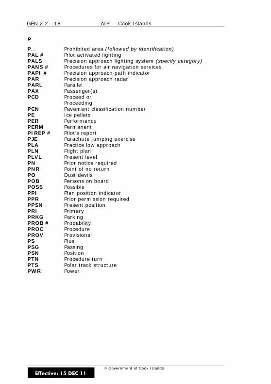
GEN 2.2 - 18 AIP — Cook Islands
E Government of Cook Islands
P
P... Prohibited area (followed by identification)PAL # Pilot activated lightingPALS Precision approach lighting system (specify category)PANS # Procedures for air navigation servicesPAPI # Precision approach path indicatorPAR Precision approach radarPARL ParallelPAX Passenger(s)PCD Proceed or
ProceedingPCN Pavement classification numberPE Ice pelletsPER PerformancePERM PermanentPIREP # Pilot’s reportPJE Parachute jumping exercisePLA Practice low approachPLN Flight planPLVL Present levelPN Prior notice requiredPNR Point of no returnPO Dust devilsPOB Persons on boardPOSS PossiblePPI Plan position indicatorPPR Prior permission requiredPPSN Present positionPRI PrimaryPRKG ParkingPROB # ProbabilityPROC ProcedurePROV ProvisionalPS PlusPSG PassingPSN PositionPTN Procedure turnPTS Polar track structurePWR Power
Effective: 15 DEC 11
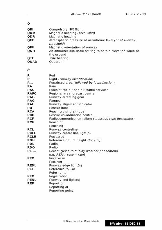
GEN 2.2 - 19AIP — Cook Islands
E Government of Cook Islands
Q
QBI Compulsory IFR flightQDM Magnetic heading (zero wind)QDR Magnetic headingQFE Atmospheric pressure at aerodrome level (or at runway
threshold)QFU Magnetic orientation of runwayQNH An altimeter sub-scale setting to obtain elevation when on
the groundQTE True bearingQUAD Quadrant
R
R RedR Right (runway identification)R... Restricted area (followed by identification)RA RainRAC Rules of the air and air traffic servicesRAFC Regional area forecast centreRAG Runway arresting gearRAG RaggedRAI Runway alignment indicatorRB Rescue boatRCA Reach cruising altitudeRCC Rescue co-ordination centreRCF Radiocommunication failure (message type designator)RCH Reach or
ReachingRCL Runway centrelineRCLL Runway centre line light(s)RCLR ReclearedRDH Reference datum height (for ILS)RDL RadialRDO RadioRE ... Recent (used to qualify weather phenomena,
e.g. RERA=recent rain)REC Receive or
ReceiverREDL Runway edge light(s)REF Reference to...or
Refer to....REG RegistrationRENL Runway end light(s)REP Report or
Reporting orReporting point
Effective: 15 DEC 11
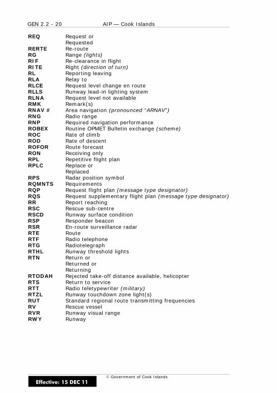
GEN 2.2 - 20 AIP — Cook Islands
E Government of Cook Islands
REQ Request orRequested
RERTE Re-routeRG Range (lights)RIF Re-clearance in flightRITE Right (direction of turn)RL Reporting leavingRLA Relay toRLCE Request level change en routeRLLS Runway lead-in lighting systemRLNA Request level not availableRMK Remark(s)RNAV # Area navigation (pronounced “ARNAV”)RNG Radio rangeRNP Required navigation performanceROBEX Routine OPMET Bulletin exchange (scheme)ROC Rate of climbROD Rate of descentROFOR Route forecastRON Receiving onlyRPL Repetitive flight planRPLC Replace or
ReplacedRPS Radar position symbolRQMNTS RequirementsRQP Request flight plan (message type designator)RQS Request supplementary flight plan (message type designator)RR Report reachingRSC Rescue sub-centreRSCD Runway surface conditionRSP Responder beaconRSR En-route surveillance radarRTE RouteRTF Radio telephoneRTG RadiotelegraphRTHL Runway threshold lightsRTN Return or
Returned orReturning
RTODAH Rejected take-off distance available, helicopterRTS Return to serviceRTT Radio teletypewriter (military)RTZL Runway touchdown zone light(s)RUT Standard regional route transmitting frequenciesRV Rescue vesselRVR Runway visual rangeRWY Runway
Effective: 15 DEC 11
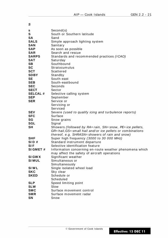
GEN 2.2 - 21AIP — Cook Islands
E Government of Cook Islands
S
s Second(s)S South or Southern latitudeSA SandSALS Simple approach lighting systemSAN SanitarySAP As soon as possibleSAR Search and rescueSARPS Standards and recommended practices (ICAO)SAT SaturdaySB SouthboundSC StratocumulusSCT ScatteredSDBY StandbySE South-eastSEB South-eastboundSEC SecondsSECT SectorSELCAL # Selective calling systemSEP SeptemberSER Service or
Servicing orServiced
SEV Severe (used to qualify icing and turbulence reports)SFC SurfaceSG Snow grainsSGL SignalSH Showers (followed by RA=rain, SN=snow, PE=ice pellets,
GR=hail,GS=small hail and/or ice pellets or combinationsthereof, e.g. SHRASN=showers of rain and snow)
SHF Super high frequency (3000 to 30 000 MHz)SID # Standard instrument departureSIF Selective identification featureSIGMET # Information concerning en-route weather phenomena which
may affect the safety of aircraft operationsSIGWX Significant weatherSIMUL Simultaneous or
SimultaneouslySIWL Single isolated wheel loadSKC Sky clearSKED Schedule or
ScheduledSLP Speed limiting pointSLW SlowSMC Surface movement controlSMR Surface movement radarSN Snow
Effective: 15 DEC 11
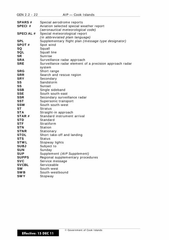
GEN 2.2 - 22 AIP — Cook Islands
E Government of Cook Islands
SPARS # Special aerodrome reportsSPECI # Aviation selected special weather report
(aeronautical meteorological code)SPECIAL # Special meteorological report
(in abbreviated plain language)SPL Supplementary flight plan (message type designator)SPOT # Spot windSQ SquallSQL Squall lineSR SunriseSRA Surveillance radar approachSRE Surveillance radar element of a precision approach radar
systemSRG Short rangeSRR Search and rescue regionSRY SecondarySS SandstormSS SunsetSSB Single sidebandSSE South south-eastSSR Secondary surveillance radarSST Supersonic transportSSW South south-westST StratusSTA Straight-in approachSTAR # Standard instrument arrivalSTD StandardSTF StratiformSTN StationSTNR StationarySTOL Short take-off and landingSTS StatusSTWL Stopway lightsSUBJ Subject toSUN SundaySUP Supplement (AIP Supplement)SUPPS Regional supplementary proceduresSVC Service messageSVCBL ServiceableSW South-westSWB South-westboundSWY Stopway
Effective: 15 DEC 11

GEN 2.2 - 23AIP — Cook Islands
E Government of Cook Islands
T
T TemperatureTA Transition altitudeTACAN # UHF tactical air navigation aidTAF # Aerodrome forecastTAIL # TailwindTAR Terminal area surveillance radarTAS True air speedTAX Taxiing or
TaxiTC Tropical cycloneTCU Towering cumulusTDO TornadoTDZ Touchdown zoneTECR Technical reasonTEL TelephoneTEMPO Temporary or
TemporarilyTEND Trend forecastTFC TrafficTGL Touch-and-go landingTGS Taxiing guidance systemTHR ThresholdTHRU ThroughTHU ThursdayTIL # UntilTIP Until past ... (place)TKOF Take-offTL ... Till (followed by the time by which weather change is
forecast to end)TLOF Touchdown and lift-off areaTMA Terminal control areaTNA Turn altitudeTNH Turn heightTO To...(place)TOC Top of climbTODA Take-off distance availableTODAH Take-off distance available, helicopterTOP # Cloud topTORA Take-off run availableTP Turning pointTR TrackTRA Temporary reserved airspaceTRANS Transmits or TransmitterTRL Transition levelTROP Tropopause
Effective: 15 DEC 11
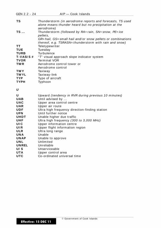
GEN 2.2 - 24 AIP — Cook Islands
E Government of Cook Islands
TS Thunderstorm (in aerodrome reports and forecasts, TS usedalone means thunder heard but no precipitation at theaerodrome)
TS ... Thunderstorm (followed by RA=rain, SN=snow, PE=icepellets,GR=hail, GS=small hail and/or snow pellets or combinationsthereof, e.g. TSRASN=thunderstorm with rain and snow)
TT TeletypewriterTUE TuesdayTURB TurbulenceT-VASIS # “T” visual approach slope indicator systemTVOR Terminal VORTWR Aerodrome control tower or
Aerodrome controlTWY TaxiwayTWYL Taxiway-linkTYP Type of aircraftTYPH Typhoon
U
U Upward (tendency in RVR during previous 10 minutes)UAB Until advised by ...UAC Upper area control centreUAR Upper air routeUDF Ultra high frequency direction-finding stationUFN Until further noticeUHDT Unable higher due trafficUHF Ultra high frequency (300 to 3,000 MHz)UIC Upper information centreUIR Upper flight information regionULR Ultra long rangeUNA UnableUNAP Unable to approveUNL UnlimitedUNREL UnreliableU/S UnserviceableUTA Upper control areaUTC Co-ordinated universal time
Effective: 15 DEC 11
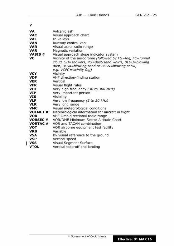
GEN 2.2 - 25AIP — Cook Islands
E Government of Cook Islands
V
VA Volcanic ashVAC Visual approach chartVAL In valleysVAN Runway control vanVAR Visual-aural radio rangeVAR Magnetic variationVASIS # Visual approach slope indicator systemVC Vicinity of the aerodrome (followed by FG=fog, FC=funnel
cloud, SH=showers, PO=dust/sand whirls, BLDU=blowingdust, BLSA=blowing sand or BLSN=blowing snow,e.g. VCFG=vicinity fog)
VCY VicinityVDF VHF direction-finding stationVER VerticalVFR Visual flight rulesVHF Very high frequency (30 to 300 MHz)VIP Very important personVIS VisibilityVLF Very low frequency (3 to 30 kHz)VLR Very long rangeVMC Visual meteorological conditionsVOLMET # Meteorological information for aircraft in flightVOR VHF Omnidirectional radio rangeVORSEC # VOR/DME Minimum Sector Altitude ChartVORTAC # VOR and TACAN combinationVOT VOR airborne equipment test facilityVRB VariableVSA By visual reference to the groundVSP Vertical speedVSS Visual Segment SurfaceVTOL Vertical take-off and landing
Effective: 31 MAR 16
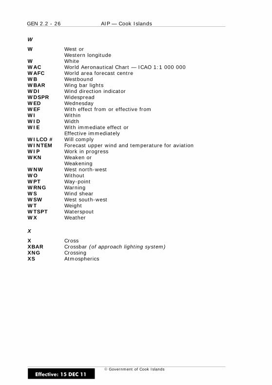
GEN 2.2 - 26 AIP — Cook Islands
E Government of Cook Islands
W
W West orWestern longitude
W WhiteWAC World Aeronautical Chart — ICAO 1:1 000 000WAFC World area forecast centreWB WestboundWBAR Wing bar lightsWDI Wind direction indicatorWDSPR WidespreadWED WednesdayWEF With effect from or effective fromWI WithinWID WidthWIE With immediate effect or
Effective immediatelyWILCO # Will complyWINTEM Forecast upper wind and temperature for aviationWIP Work in progressWKN Weaken or
WeakeningWNW West north-westWO WithoutWPT Way-pointWRNG WarningWS Wind shearWSW West south-westWT WeightWTSPT WaterspoutWX Weather
X
X CrossXBAR Crossbar (of approach lighting system)XNG CrossingXS Atmospherics
Effective: 15 DEC 11
GEN 2.2 - 27AIP — Cook Islands
E Government of Cook Islands
Y
Y YellowYCZ Yellow caution zone (runway lighting)YR Your
Z
Z Co-ordinated universal time
Effective: 15 DEC 11

GEN 2.2 - 28 AIP — Cook Islands
E Government of Cook Islands
IntentionallyBlank
Effective: 15 DEC 11

GEN 2.3 - 1AIP — Cook Islands
E Government of Cook Islands
GEN 2.3 CHART SYMBOLS
1 INTRODUCTION
1.1 General
1.1.1 Symbols for enroute charts are shown in the chart legend of theAuckland Oceanic FIR/Nadi FIR enroute chart.
Effective: 15 DEC 11
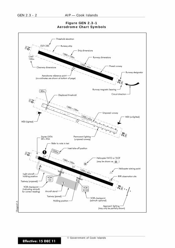
GEN 2.3 - 2 AIP — Cook Islands
E Government of Cook Islands
Figure GEN 2.3-1Aerodrome Chart Symbols
Effective: 15 DEC 11

GEN 2.3 - 3AIP — Cook Islands
E Government of Cook Islands
Figure GEN 2.3-2Aerodrome Chart Symbols
Effective: 15 DEC 11
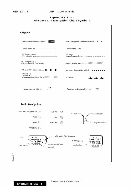
GEN 2.3 - 4 AIP — Cook Islands
E Government of Cook Islands
Figure GEN 2.3-3Airspace and Navigation Chart Symbols
Effective: 15 DEC 11

GEN 2.3 - 5AIP — Cook Islands
E Government of Cook Islands
Figure GEN 2.3-4Instrument Chart Symbols
Effective: 15 DEC 11
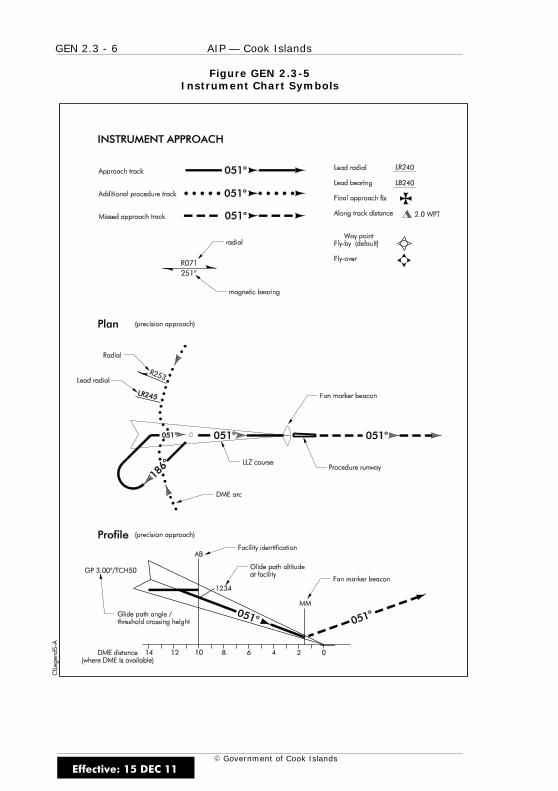
GEN 2.3 - 6 AIP — Cook Islands
E Government of Cook Islands
Figure GEN 2.3-5Instrument Chart Symbols
Effective: 15 DEC 11
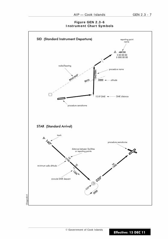
GEN 2.3 - 7AIP — Cook Islands
E Government of Cook Islands
Figure GEN 2.3-6Instrument Chart Symbols
Effective: 15 DEC 11
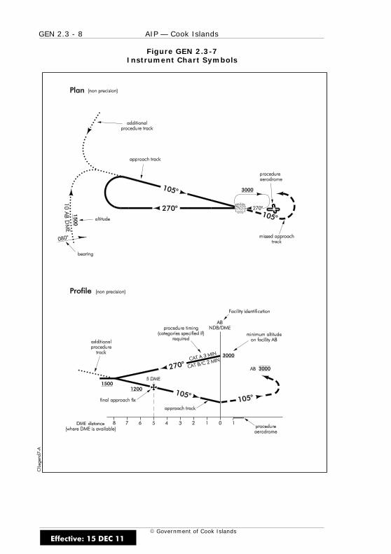
GEN 2.3 - 8 AIP — Cook Islands
E Government of Cook Islands
Figure GEN 2.3-7Instrument Chart Symbols
Effective: 15 DEC 11

GEN 2.3 - 9AIP — Cook Islands
E Government of Cook Islands
Figure GEN 2.3-8Instrument Chart Symbols
Effective: 15 DEC 11

GEN 2.3 - 10 AIP — Cook Islands
E Government of Cook Islands
Figure GEN 2.3-9Ground Based Aid Approach
Effective: 15 DEC 11

GEN 2.4 - 1AIP — Cook Islands
E Government of Cook Islands
GEN 2.4 LOCATION INDICATORS
1 INTRODUCTION
1.1 General
1.1.1 The location indicators marked with an asterisk (*) cannot be usedin the address component of AFS messages.
1.2 AFS Addresses
1.2.1 Table GEN 2.4 - 1 list AFS addresss by station name.
Table GEN 2.4 - 1AFS Address Encode/Decode
ENCODE DECODE
NAME LOCATION INDICATOR NAME
Aitutaki NCAI* NCAI* Aitutaki
Atiu NCAT* NCAT* Atiu
Mangaia NCMG* NCMG* Mangaia
Manuae NCMN* NCMN* Manuae
Mauke NCMK* NCMK* Mauke
Mitiaro NCMR* NCMR* Mitiaro
Nassau NCNS* NCNS* Nassau
Palmerston NCPM* NCPM* Palmerston
Penrhyn NCPY* NCPY* Penrhyn
Pukapuka NCPK* NCPK* Pukapuka
Rakahanga NCRK* NCRK* Rakahanga
Rarotonga INTL NCRG NCRG Rarotonga INTL
Suwarrow NCSW* NCSW* Suwarrow
Effective: 15 DEC 11

GEN 2.4 - 2 AIP — Cook Islands
E Government of Cook Islands
IntentionallyBlank
Effective: 15 DEC 11
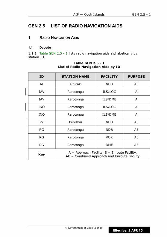
GEN 2.5 - 1AIP — Cook Islands
E Government of Cook Islands
GEN 2.5 LIST OF RADIO NAVIGATION AIDS
1 RADIO NAVIGATION AIDS
1.1 Decode
1.1.1 Table GEN 2.5 - 1 lists radio navigation aids alphabetically bystation ID.
Table GEN 2.5 - 1List of Radio Navigation Aids by ID
ID STATION NAME FACILITY PURPOSE
AI Aitutaki NDB AE
IAV Rarotonga ILS/LOC A
IAV Rarotonga ILS/DME A
INO Rarotonga ILS/LOC A
INO Rarotonga ILS/DME A
PY Penrhyn NDB AE
RG Rarotonga NDB AE
RG Rarotonga VOR AE
RG Rarotonga DME AE
Key A = Approach Facility, E = Enroute Facility,AE = Combined Approach and Enroute Facility
Effective: 2 APR 15
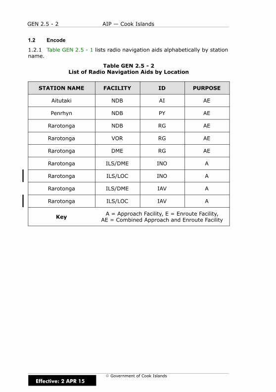
GEN 2.5 - 2 AIP — Cook Islands
E Government of Cook Islands
1.2 Encode
1.2.1 Table GEN 2.5 - 1 lists radio navigation aids alphabetically by stationname.
Table GEN 2.5 - 2List of Radio Navigation Aids by Location
STATION NAME FACILITY ID PURPOSE
Aitutaki NDB AI AE
Penrhyn NDB PY AE
Rarotonga NDB RG AE
Rarotonga VOR RG AE
Rarotonga DME RG AE
Rarotonga ILS/DME INO A
Rarotonga ILS/LOC INO A
Rarotonga ILS/DME IAV A
Rarotonga ILS/LOC IAV A
Key A = Approach Facility, E = Enroute Facility,AE = Combined Approach and Enroute Facility
Effective: 2 APR 15
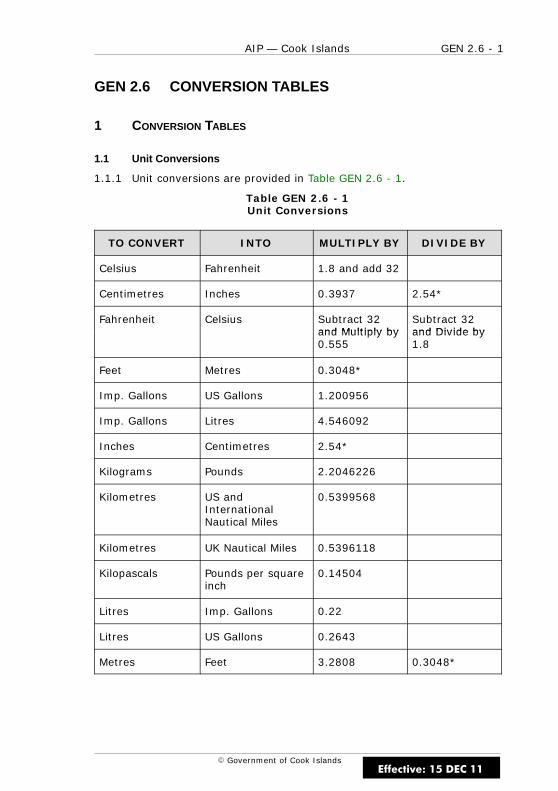
GEN 2.6 - 1AIP — Cook Islands
E Government of Cook Islands
GEN 2.6 CONVERSION TABLES
1 CONVERSION TABLES
1.1 Unit Conversions
1.1.1 Unit conversions are provided in Table GEN 2.6 - 1.
Table GEN 2.6 - 1Unit Conversions
TO CONVERT INTO MULTIPLY BY DIVIDE BY
Celsius Fahrenheit 1.8 and add 32
Centimetres Inches 0.3937 2.54*
Fahrenheit Celsius Subtract 32and Multiply by
Subtract 32and Divide byand Multiply by
0.555and Divide by1.8
Feet Metres 0.3048*
Imp. Gallons US Gallons 1.200956
Imp. Gallons Litres 4.546092
Inches Centimetres 2.54*
Kilograms Pounds 2.2046226
Kilometres US andInternationalNautical Miles
0.5399568
Kilometres UK Nautical Miles 0.5396118
Kilopascals Pounds per squareinch
0.14504
Litres Imp. Gallons 0.22
Litres US Gallons 0.2643
Metres Feet 3.2808 0.3048*
Effective: 15 DEC 11
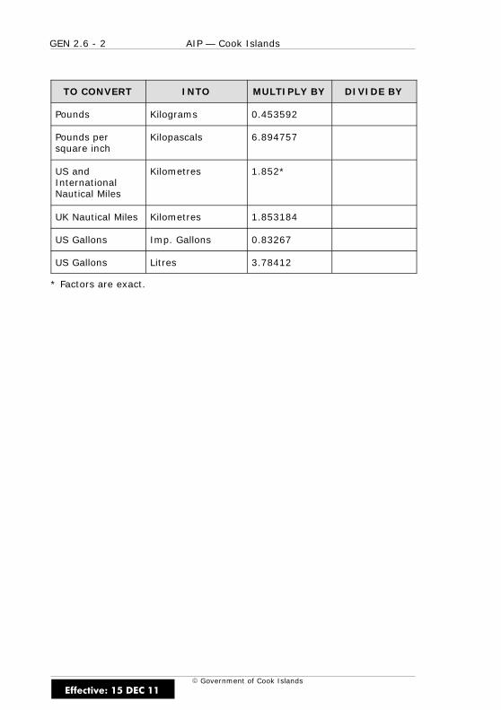
GEN 2.6 - 2 AIP — Cook Islands
E Government of Cook Islands
TO CONVERT INTO MULTIPLY BY DIVIDE BY
Pounds Kilograms 0.453592
Pounds persquare inch
Kilopascals 6.894757
US andInternationalNautical Miles
Kilometres 1.852*
UK Nautical Miles Kilometres 1.853184
US Gallons Imp. Gallons 0.83267
US Gallons Litres 3.78412
* Factors are exact.
Effective: 15 DEC 11

GEN 2.7 - 1AIP — Cook Islands
E Government of Cook Islands
GEN 2.7 SUNSET/SUNRISE TABLES
1 SUNSET/SUNRISE TABLES
1.1 General
1.1.1 Table GEN 2.7 - 1 lists the beginning and end of civil twilight inAitutaki, Penrhyn and Rarotonga.
1.1.2 The times listed in Table GEN 2.7 - 1 are given in LST (LocalStandard Time) and UTC (Universal Time Coordinate).
Table GEN 2.7 - 1Morning Civil Twilight/Evening Civil Twilight
LOCATIONMCT JAN JAN JAN JAN FEB FEB FEB FEB MAR MAR MAR MARLOCATIONECT
JAN7
JAN14
JAN21
JAN28
FEB7
FEB14
FEB21
FEB28
MAR7
MAR14
MAR21
MAR28
LST 0545 0549 0554 0600 0605 0608 0612 0615 0617 0619 0621 0623
AITUTAKIUTC 1545 1549 1554 1600 1605 1608 1612 1615 1617 1619 1621 1623
AITUTAKILST 1946 1947 1946 1944 1941 1938 1933 1928 1923 1918 1911 1905
UTC 0546 0547 0546 0544 0541 0538 0533 0528 0523 0518 0511 0505
LST 0558 0601 0603 0607 0611 0612 0614 0615 0615 0615 0615 0615
PENRHYNUTC 1558 1601 1603 1607 1611 1612 1614 1615 1615 1615 1615 1615
PENRHYNLST 1920 1921 1922 1923 1921 1920 1916 1914 1912 1907 1904 1900
UTC 0520 0521 0522 0523 0521 0520 0516 0514 0512 0507 0504 0500
LST 0540 0544 0549 0556 0601 0605 0610 0613 0615 0618 0621 0623
UTC 1540 1544 1549 1556 1604 1605 1610 1613 1615 1618 1621 1623RAROTONGA
LST 1951 1952 1951 1948 1945 1941 1935 1930 1924 1918 1911 1905
UTC 0551 0552 0551 0548 0545 0541 0535 0530 0524 0518 0511 0505
LOCATIONMCT APR APR APR APR MAY MAY MAY MAY JUN JUN JUN JUNLOCATIONECT
APR7
APR14
APR21
APR28
MAY7
MAY14
MAY21
MAY28
JUN7
JUN14
JUN21
JUN28
LST 0626 0626 0628 0630 0633 0635 0637 0640 0643 0645 0647 0648
AITUTAKIUTC 1626 1626 1628 1630 1633 1635 1637 1640 1643 1645 1647 1648
AITUTAKILST 1857 1852 1848 1843 1838 1835 1834 1833 1832 1833 1835 1836
UTC 0457 0452 0448 0443 0438 0435 0434 0433 0432 0433 0435 0436
LST 0614 0613 0613 0614 0614 0615 0616 0617 0619 0621 0623 0624
PENRHYNUTC 1614 1613 1613 1614 1614 1615 1616 1617 1619 1621 1623 1623
PENRHYNLST 1854 1851 1848 1845 1843 1841 1841 1841 1842 1842 1845 1846
UTC 0454 0451 0448 0445 0443 0441 0441 0441 0442 0442 0445 0446
LST 0626 0628 0630 0632 0636 0638 0641 0644 0647 0649 0651 0652
UTC 1626 1628 1630 1632 1636 1638 1641 1644 1647 1649 1651 1652RAROTONGA
LST 1857 1850 1845 1841 1835 1832 1830 1829 1828 1829 1831 1832
UTC 0457 0450 0445 0441 0435 0452 0430 0429 0428 0429 0431 0432
Effective: 15 DEC 11
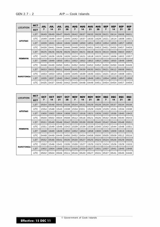
GEN 2.7 - 2 AIP — Cook Islands
E Government of Cook Islands
LOCATIONMCT JUL JUL JUL JUL AUG AUG AUG AUG SEP SEP SEP SEPLOCATIONECT
JUL7
JUL14
JUL21
JUL28
AUG7
AUG14
AUG21
AUG28
SEP7
SEP14
SEP21
SEP28
LST 0649 0649 0647 0645 0642 0637 0633 0628 0621 0614 0608 0601
AITUTAKIUTC 1649 1649 1647 1645 1642 1637 1633 1628 1621 1614 1608 1601
AITUTAKILST 1839 1841 1844 1846 1848 1850 1851 1853 1854 1855 1857 1859
UTC 0439 0441 0444 0446 0448 0450 0451 0453 0451 0455 0457 0459
LST 0625 0626 0626 0626 0624 0621 0618 0615 0610 0606 0602 0557
PENRHYNUTC 1625 1626 1626 1626 1624 1621 1618 1615 1610 1606 1602 1557
PENRHYNLST 1848 1849 1850 1851 1852 1852 1852 1852 1850 1850 1849 1849
UTC 0448 0449 0450 0451 0452 0452 0452 0452 0450 0450 0449 0449
LST 0653 0653 0651 0649 0645 0639 0635 0631 0621 0612 0608 0601
O O GUTC 1653 1653 1651 1649 1645 1639 1635 1631 1621 1614 1608 1601
RAROTONGALST 1835 1837 1840 1842 1845 1848 1849 1851 1854 1855 1857 1859
UTC 0435 0437 0440 0442 0445 0448 0449 0451 0454 0454 0457 0459
LOCATIONMCT OCT OCT OCT OCT NOV NOV NOV NOV DEC DEC DEC DECLOCATIONECT
OCT7
OCT14
OCT21
OCT28
NOV7
NOV14
NOV21
NOV28
DEC7
DEC14
DEC21
DEC28
LST 0554 0548 0543 0538 0534 0531 0529 0528 0529 0537 0534 0538
AITUTAKIUTC 1554 1548 1543 1538 1534 1531 1529 1528 1529 1531 1534 1538
AITUTAKILST 1900 1902 1904 1908 1912 1916 1921 1926 1932 1936 1940 1943
UTC 0500 0502 0504 0508 0512 0516 0521 0526 0532 0536 0540 0543
LST 0551 0549 0546 0542 0539 0539 0539 0540 0542 0544 0548 0551
PENRHYNUTC 1551 1549 1546 1542 1539 1539 1539 1540 1542 1544 1548 1551
PENRHYNLST 1848 1849 1849 1850 1852 1854 1858 1900 1905 1909 1913 1916
UTC 0448 0449 0449 0450 0452 0454 0458 0500 0505 0509 0512 0516
LST 0552 0546 0541 0535 0530 0527 0525 0523 0524 0526 0529 0533
O O GUTC 1552 1546 1541 1535 1530 1527 1525 1523 1524 1526 1529 1533
RAROTONGALST 1902 1904 1906 1911 1916 1920 1927 1931 1937 1941 1945 1948
UTC 0502 0504 0506 0511 0516 0520 0527 0531 0537 0541 0545 0448
Effective: 15 DEC 11

GEN 3 - 1AIP — Cook Islands
E Government of Cook Islands
GEN 3 SERVICES
Effective: 15 DEC 11

GEN 3 - 2 AIP — Cook Islands
E Government of Cook IslandsEffective: 15 DEC 11
GEN 3.1 - 1AIP — Cook Islands
E Government of Cook Islands
GEN 3.1 AERONAUTICAL INFORMATION SERVICES
1 RESPONSIBLE SERVICE
1.1 General
1.1.1 The Aeronautical Information Service ensures the flow ofinformation necessary for the safety, regularity and efficiency ofinternational and domestic air navigation within the area of itsresponsibility as indicated in GEN 2.1.1. It consists of:
AIS Briefing OfficeCook Islands Airport AuthorityRarotonga International AirportCOOK ISLANDS
TEL (682) 25 890 ext 213FAX (682) 21 890AFTN NCRGZPZXOPS Hours HS
1.1.2 Preflight aeronautical information and flight planning service isavailable at the offices of the Cook Islands Airport Authority, TerminalBuilding, Rarotonga International Airport.
1.2 International NOTAM Office (NOF)
1.2.1 NOTAM for the Cook Islands are promulgated by the ChristchurchNOF.
Christchurch NOTAM Office
International NOTAM officeAirways New Zealand LtdPO Box 14-131Christchurch AirportChristchurchNEW ZEALAND
TEL (64) 3 358 1688FAX (64) 3 358 9192
AFTN NZCHYNYX
1.2.2 The service is provided in accordance with the provisions containedin ICAO Annex 15 — Aeronautical Information Services.
1.2.3 NOTAM may be requested from the AIS Briefing Office andChristchurch Notam Office, New Zealand.
Effective: 15 DEC 11
GEN 3.1 - 2 AIP — Cook Islands
E Government of Cook Islands
2 AREA OF RESPONSIBILITY
2.1 General
2.1.1 The Aeronautical Information Service is responsible for the collectionand dissemination of information for the entire territory of the Cook Islandsand for the airspace encompassed by the Cook Sector of the AucklandOceanic FIR.
3 AERONAUTICAL PUBLICATIONS
3.1 General
3.1.1 The aeronautical information is provided in the form of theIntegrated Aeronautical Information Package consisting of the followingelements:
(a) Aeronautical Information Publication (AIP — Cook Islands)
(b) Amendment service to the AIP (AIP AMDT — Cook Islands)
(c) AIP Supplement (AIP SUP — Cook Islands)
(d) NOTAM
(e) Aeronautical Information Circulars (AIC)
(f) Checklists and summaries
3.2 Aeronautical Information Publication
3.2.1 The AIP — Cook Islands consists of this manual and is published inloose leaf form for use in international and domestic operations.
3.2.2 AIRAC AIP amendments are published to incorporate permanentamendments to the AIP — Cook Islands. A Bulletin is published with eachAIRAC AIP amendment, listing a summary of significant changes. AIRACAIP amendments are issued as scheduled in Table GEN 0.1 - 1.
3.2.3 A revised Checklist of Effective Pages and Charts is issued with eachAIRAC AIP amendment.
Effective: 15 DEC 11

GEN 3.1 - 3AIP — Cook Islands
E Government of Cook Islands
3.3 Supplements to the AIP
3.3.1 The AIP Supplement — Cook Islands is published for temporarychanges of long duration (3 months and longer) and information of shortterm duration which consists of extensive text and/or graphics. AIPSupplements may be issued on any of the available AIRAC dates.
3.3.2 The AIP Supplement — Cook Islands is issued as a separatedocument, with each edition entirely replacing the previous edition. Achecklist of current AIP Supplements is published on the front page of theAIP Supplement document.
3.4 NOTAM and Pre-flight Information Bulletins (PIB)
3.4.1 The AIS Briefing Office will provide, on request, customisedpre-flight information bulletins for regular air transport operations.Pre-flight Information bulletins for itinerant operations may be requestedfrom:
AIS Briefing OfficeCook Islands Airport AuthorityRarotonga International AirportCOOK ISLANDS
TEL (682) 25 890 ext 213FAX (682) 21 890AFTN NCRGZPZXOPS Hours HS
3.4.2 A Pre-flight Information Bulletin (PIB) request must be made 2hours prior to take-off.
3.5 Aeronautical Information Circulars
3.5.1 AICs are originated whenever it is desirable to promulgate:
(a) a long term forecast of any major change in legislation, regulations,procedures or facilities;
(b) information of a purely explanatory or advisory nature likely toaffect flight safety;
(c) information or notification of an explanatory or advisory natureconcerning technical, legislative or purely administrative matters.
3.5.2 Each AIC is numbered consecutively on a calendar year basis. Achecklist of AIC currently in force is issued as an AIC in January each yearand the serial number 1 is reserved for this.
Effective: 15 DEC 11
GEN 3.1 - 4 AIP — Cook Islands
E Government of Cook Islands
3.6 Checklists and Summary of NOTAM
3.6.1 A summary of current NOTAM is produced at the beginning of eachmonth by the Christchurch Intl NOTAM Office.
3.7 Sale of Publications
3.7.1 The AIP — Cook Islands, AIP Supplement — Cook Islands areavailable from Airways New Zealand.
3.7.2 Copies of these documents and enroute charts are available fromAirways New Zealand at the address below. Prices are available on request.
Airways New Zealand LimitedPO Box 294Wellington 6140NEW ZEALAND
TEL (64) 4 471 1899FAX (64) 4 471 5813
TELEX NilAFTN NZHQYOYX
email [email protected] www.airways.co.nz
Effective: 15 DEC 11

GEN 3.1 - 5AIP — Cook Islands
E Government of Cook Islands
4 AIRAC SYSTEM
4.1 Amendments to the AIP — Cook Islands are published in accordancewith the ICAO AIRAC schedule. The AIRAC schedule is established toensure coordination between adjacent states for the implementation ofchanges, and to ensure information is available to interested organisations(e.g. airline flight operations) in sufficient time to assess and implementchanges relevant to their operation.
4.1.1 Amendments may be published on any scheduled date. The schedulehas an interval of 28 days starting from and including 10 January 1991.States are not required to publish on every available date, but should ensurethat any changes are coordinated with available dates. The scheduledpublication dates for AIP — Cook Islands are listed in Table GEN 0.1 - 1.
4.1.2 To allow interested organisations sufficient time to assess andimplement changes, amendments are distributed to users at least 28 daysbefore the effective date. In the case of changes that are likely to havesignificant operational impact, amendments should be distributed to usersat least 56 days before the effective date.
5 PRE-FLIGHT INFORMATION SERVICE AT AERODROMES
5.1 Pre-flight briefing at Rarotonga INTL is provided by priorarrangement by the:
AIS Briefing OfficeCook Islands Airport AuthorityRarotonga International AirportCOOK ISLANDS
TEL (682) 25 890 ext 213FAX (682) 21 890AFTN NCRGZPZX
5.1.1 Pre-flight briefings at all other national airports will be availablefrom the applicable ATS Unit.
Effective: 15 DEC 11

GEN 3.1 - 6 AIP — Cook Islands
E Government of Cook Islands
IntentionallyBlank
Effective: 15 DEC 11
GEN 3.2 - 1AIP — Cook Islands
E Government of Cook Islands
GEN 3.2 AERONAUTICAL CHARTS
1 RESPONSIBLE SERVICE
1.1 General
1.1.1 Ministry of Transport Cook Islands is responsible for the provision ofaeronautical charts. Aeronautical charts are published by Airways NewZealand.
2 MAINTENANCE OF CHARTS
2.1 General
2.1.1 Aeronautical charts are maintained by Airways New Zealand.Amendments to aeronautical charts are published as per NZAIP AIRACcycle.
2.2 Purchase Arrangements
2.2.1 Refer to GEN 3.1. paragraph 3.7.
2.3 Aeronautical Chart Series Available
2.3.1 The following charts series are published in the AIP — Cook Islands:
(a) Aerodrome Chart — ICAO
(b) Instrument Approach Chart — ICAO
(c) Enroute Chart — ICAO
2.4 List of Aeronautical Charts Available
2.4.1 The following charts series are available:
(a) Enroute Chart — Auckland Oceanic FIR/Nadi FIR
2.5 Index to the World Aeronautical Charts (WAC) — ICAO 1:1 000 000
2.5.1 Nil published.
Effective: 15 DEC 11
GEN 3.2 - 2 AIP — Cook Islands
E Government of Cook Islands
2.6 Topographical Charts
2.6.1 Aeronautical Topographical Charts are not published.
2.7 Corrections to Charts not Contained in the AIP
2.7.1 Reserved
Effective: 15 DEC 11

GEN 3.3 - 1AIP — Cook Islands
E Government of Cook Islands
GEN 3.3 AIR TRAFFIC SERVICES
1 RESPONSIBLE SERVICE
1.1 General
1.1.1 Cook Islands Airport Authority is the responsible authority for theprovision of air traffic services within the area indicated under GEN 3.3.paragraph 2.1.1.
1.1.2 The services are provided in accordance with the provisionscontained in the following ICAO documents:
(a) Annex 2 — Rules of the Air
(b) Annex 11 — Air Traffic Services
(c) Doc 4444 — Procedures for Air Navigation Services — Rules of theAir and Air Traffic Services (PANS – RAC)
(d) Doc 8168 — Procedures for Air Navigation Services — AircraftOperations (PANS – OPS)
(e) Doc 7030 — Regional Supplementary Procedures
1.1.3 Differences to these provisions are detailed in GEN 1.7.
2 AREA OF RESPONSIBILITY
2.1 General
2.1.1 Air traffic services are provided in the Cook Sector of the AucklandOceanic FIR.
3 TYPES OF SERVICES
3.1 General
3.1.1 The following types of services are provided:
(a) Flight Information Service (FIS) and Alerting Service (ALRS)
(b) Approach Control (APP)
3.1.2 The following types of services are provided at aerodromes:
(a) Aerodrome Control (TWR)
Effective: 15 DEC 11

GEN 3.3 - 2 AIP — Cook Islands
E Government of Cook Islands
4 CO-ORDINATION BETWEEN THE OPERATORS AND ATS
4.1 General
4.1.1 Co-ordination between the operator and air traffic services iseffected in accordance with 2.15 of ICAO Annex 11 and 2.1.1.4 and 2.1.1.5of Part VIII of the Procedures for Air Navigation Services — Rules of the Airand Air Traffic Services (Doc 4444, PANS – RAC).
5 ATS UNITS ADDRESS LIST
5.1 General
5.1.1 Table GEN 3.3 - 1 lists the contact addresses for all ATS units in theCook Islands.
Table GEN 3.3 - 1ATS Unit Contact Addresses
UNITNAME
POSTALADDRESS
TELEPHONE FAX TELEX AFSADDRESS
RarotongaATS
Cook IslandsAirport
AuthorityPO Box 90Rarotonga
COOKISLANDS
(682) 25 890ext 202
orext 213
(682) 21 890 Nil NCRGZPZX
Effective: 15 DEC 11

GEN 3.3 - 3AIP — Cook Islands
E Government of Cook Islands
6 MINIMUM FLIGHT ALTITUDE
6.1 Minimum Safe Altitude
6.1.1 The route minimum safe altitude (MSA) is found by identifying thecontrolling obstacle within the total area of the navigational tolerance,based on the type and coverage of the navigation facilities, plus a 5NMbuffer. Within this area the MSA is the lowest altitude, rounded up to thenext 100ft, which provides an obstacle clearance of at least 1,000ft.
6.1.2 Set heading and minimum crossing altitudes are based on a 1.6%(100ft/NM) gradient while maintaining enroute terrain clearances.
6.1.3 Route MSA are shown on each sector of enroute charts for domesticroutes. These provide the basis for establishing the minimum cruisingaltitude for the direction of flight. The requirements for subsequent sectorsshould be anticipated by crossing the facility or reporting point at or abovea cruising level that is not below the MSA for the next sector. Greaterobstacle clearances may be needed in adverse weather conditions or whennavigational guidance is inadequate.
6.2 Minimum Reception Altitude and Minimum Enroute Altitude
6.2.1 Where an acceptable navigational signal coverage is a requirementfor a sector to be flown, a minimum reception altitude (MRA) or minimumenroute altitude (MEA) will be published.
6.2.2 For a VOR route, the published MRA will ensure adequate signalstrength for accurate navigation. Although some low sensitivity VORreceivers may not display a warning at altitudes below the published MRA,the altitude or flight level for IFR flights using VOR as the primary means ofnavigation must be at or above the published MRA.
6.2.3 The published MEA for an NDB route will ensure acceptablenavigational signal coverage for the sector to be flown. Where an MEA ispublished, IFR flights using NDB as the primary means of navigation, mustbe at or above the published MEA.
Effective: 15 DEC 11

GEN 3.3 - 4 AIP — Cook Islands
E Government of Cook Islands
6.3 Minimum Flight Altitude
6.3.1 As shown in Figure GEN 3.3 - 1, the minimum flight altitude (MFA)for an IFR route sector will be the higher of the following:
(a) Route minimum safe altitude (MSA);
(b) Minimum reception altitude (MRA) for a VOR sector;
(c) Minimum enroute altitude (MEA) for an NDB sector;
(d) Danger or restricted area upper limit plus 1,000ft.
Figure GEN 3.3 -1Minimum Flight Altitude
MSA
MFA
Danger orrestricted area
Departureaerodrome
Arrivalaerodrome
A B
A = minimum net climb gradient 3.3% (200ft/NM) or departureclimb gradient if higherB = optimum descent gradient 5.0% (300ft/NM)
6.3.2 The requirements of the IFR table of crusing levels must then betaken into account.
6.3.3 Where the next route sector MFA is higher, that sector must not beentered below the higher level unless there is a promulgated crossingaltitude.
6.3.4 Aircraft with approved enroute area navigation equipment are notrequired to comply with MRA and MEA restrictions.
Effective: 15 DEC 11

GEN 3.3 - 5AIP — Cook Islands
E Government of Cook Islands
6.4 Climb to MFA
6.4.1 To ensure obstacle clearance, aircraft on departure are required toclimb to MSA at the promulgated minimum net climb gradient appropriateto the departure procedure being flown. Unless a more restrictiverequirement is published, once above MSA, aircraft may continue to climbat a minimum net climb gradient of not less then 3.3% (200ft/NM) to MFA.
6.5 Descent Below MFA
6.5.1 Descent below MFA prior to arrival may only be commenced in thefollowing circumstances:
(a) In accordance with published DME steps, or
(b) Prior to the first DME step when:
(i) A positive fix has been established by an unambiguous DMEreadout for at least 15 seconds, or by the use of an off-trackVOR or NDB provided the angle of intersection is 45° orgreater, and
(ii) A positive tracking indication has been received by navigationequipment for at least 15 seconds, and
(iii) During descent, aircraft navigation equipment is activelymonitored to ensure continuity of guidance.
(iv) Descent is restricted to the higher of MSA or danger orrestricted area upper limit plus buffer, and based on anoptimum descent gradient of 5% (300ft/NM) to the first DMEstep.
6.5.2 Within 10NM of the aid or fix from which it is intended to conduct aninstrument approach, descent is limited to the higher of minimum holdingaltitude, procedure commencement altitude or MSA.
Note
Outside controlled airspace the IFR table of cruising levels applies.
6.6 Emergency Descent Below MFA
6.6.1 Where an enroute emergency necessitates a descent below MEA orMRA, pilots should be aware that the navigational tolerance used to definethe MSA may not be valid if the utilisation of the primary means ofnavigation can be continued. A decision to continue to divert to anotherroute must consider the accuracy of navigation prior to the emergency.
Effective: 15 DEC 11

GEN 3.3 - 6 AIP — Cook Islands
E Government of Cook Islands
IntentionallyBlank
Effective: 15 DEC 11

GEN 3.4 - 1AIP — Cook Islands
E Government of Cook Islands
GEN 3.4 COMMUNICATION SERVICES
1 RESPONSIBLE SERVICE
1.1 General
1.1.1 The responsible service for the provision of telecommunication andnavigation facility services in the Cook Islands is the Cook Islands AirportAuthority.
1.1.2 Aeronautical telecommunication services for ATS and the CookIslands air navigation service are administered by the Cook Islands AirportAuthority. The following services are provided:
(a) Radio Navigation
Cook Islands Airport AuthorityPO Box 90NIKAORarotongaCOOK ISLANDS
TEL (682) 25 890FAX (682) 21 890
AFTN NCRGYFYX
(b) Communications
Cook Islands Airport AuthorityPO Box 90NIKAORarotongaCOOK ISLANDS
TEL (682) 25 890FAX (682) 21 890
AFTN NCRGYFYX
Effective: 15 DEC 11

GEN 3.4 - 2 AIP — Cook Islands
E Government of Cook Islands
1.1.3 The service is provided in accordance with the provisions containedin the following ICAO documents:
(a) Annex 10 — Aeronautical Telecommunications
(b) Doc 8400 — Procedures for Air Navigation Services — ICAOAbbreviations and Codes (PANS – ABC)
(c) Doc 8585 — Designators for Aircraft Operating Agencies,Aeronautical Authorities and Services
(d) Doc 7030 — Regional Supplementary Procedures
(e) Doc 7910 — Location Indicators
2 AREA OF RESPONSIBILITY
2.1 General
2.1.1 Communication services are provided for the Cook Sector of theAuckland FIR.
3 TYPES OF SERVICE
3.1 Radio Navigation Services
3.1.1 The following types of radio aids to navigation are available:
(a) LF/MF non-directional beacon (NDB)
(b) VHF omnidirectional radio range (VOR)
(c) Distance measuring equipment (DME)
(d) Instrument Landing System (ILS)
3.2 Mobile/Fixed Service
Mobile Service
3.2.1 Air–ground communications in Cook Islands airspace are conductedby radiotelephony (RTF) in the VHF and HF bands. Frequencies andservices are published in Table ENR 2.1 - 1.
3.2.2 VHF is the primary frequency band for all operations with HF beingused when outside VHF coverage.
Effective: 15 DEC 11
GEN 3.4 - 3AIP — Cook Islands
E Government of Cook Islands
Fixed service
3.2.3 The messages to be transmitted over the Aeronautical Fixed Service(AFS) are accepted only if:
(a) they satisfy the requirements of ICAO Annex 10, Vol. II, Chapter 3,3.3
(b) they are prepared in the form specified in ICAO Annex 10
(c) the text of an individual message does not exceed 200 groups
3.2.4 General aircraft operating agency messages are only accepted fortransmission to countries that have agreed to accept Class “B” traffic.
Telephone facilities
3.2.5 Except at the larger aerodromes, telephone facilities for use bypilots at aerodromes in the Cook Islands are generally not available.
3.3 Broadcasting Service
3.3.1 Nil.
3.4 Language Used
3.4.1 English.
3.5 Where Detailed Information can be Obtained
3.5.1 Details of the various facilities available for enroute traffic can befound in Part 2 (ENR).
3.5.2 Details of the facilities available at the individual aerodromes can befound in the relevant Sections of Part 3 (AD). In cases where a facility isserving both enroute traffic and aerodromes, details are given in therelevant sections of Part 2 (ENR) and Part 3 (AD).
3.6 Hours of Service
3.6.1 The hours of service for aeronautical ground services are publishedin the AIP Supplement — Cook Islands or by NOTAM.
Effective: 15 DEC 11
GEN 3.4 - 4 AIP — Cook Islands
E Government of Cook Islands
3.7 Extended Service
3.7.1 Extended service may be provided by an aeronautical groundservices unit (ATS or RFFS) as an extension to its promulgated hours ofservice either by opening watch earlier or by closing watch later.
3.7.2 Extended service is normally provided only in the following cases:
(a) disrupted regular air transport flights (domestic and international);
(b) approved special air transport flights;
(c) disaster relief flights;
(d) medivac flights;
(e) visiting overseas military and state flights.
Note
The majority of ground services staff do not have telephones and transportmay not be available. Once a unit has closed watch it is generally notpossible to recall staff to duty and services cannot be provided before thenext promulgated opening watch time. Staff may also be affected by dutytime limitations. Provided sufficient notice is given, all reasonable effortswill be made to accommodate requests, but there may be occasions whenextended service cannot be provided.
4 REQUIREMENTS AND CONDITIONS
4.1 General
4.1.1 Communication services are available during published hours or byprior arrangement only.
Effective: 15 DEC 11
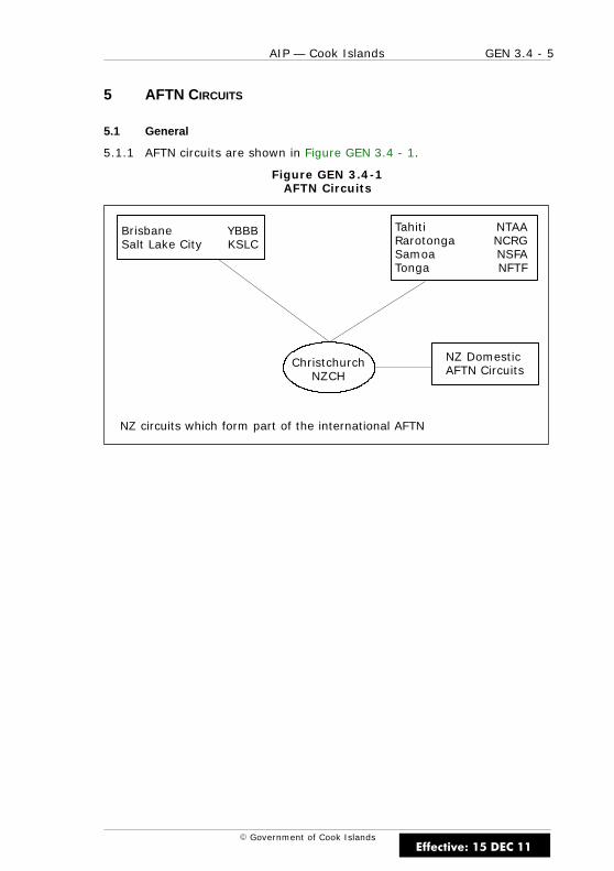
GEN 3.4 - 5AIP — Cook Islands
E Government of Cook Islands
5 AFTN CIRCUITS
5.1 General
5.1.1 AFTN circuits are shown in Figure GEN 3.4 - 1.
Figure GEN 3.4-1AFTN Circuits
Brisbane YBBBSalt Lake City KSLC
Tahiti NTAARarotonga NCRGSamoa NSFATonga NFTF
ChristchurchNZCH
NZ DomesticAFTN Circuits
NZ circuits which form part of the international AFTN
Effective: 15 DEC 11

GEN 3.4 - 6 AIP — Cook Islands
E Government of Cook Islands
6 ATS SPEECH CIRCUITS
6.1 General
6.1.1 ATS speech circuits are shown in Figure GEN 3.4 - 2.
Figure GEN 3.4-2ATS Speech Circuits
BrisbaneNadiOakland
NZ Domestic VoiceSwitch CommunicationsSystem
Auckland
RarotongaSamoaTahitiTongaMcMurdo
NZ circuits which form part of the international ATS speech network
Telephone Circuits
Effective: 15 DEC 11
GEN 3.5 - 1AIP — Cook Islands
E Government of Cook Islands
GEN 3.5 METEOROLOGICAL SERVICES
1 RESPONSIBLE SERVICE
1.1 General
1.1.1 A meteorological office is located at Rarotonga International Airport.
1.1.2 The meteorological services for civil aviation are provided by theCook Island Meteorological Service.
Meteorological ServicePO Box 127RarotongaCOOK ISLANDS
TEL (682) 20 603FAX (682) 21 603
AFTN NCRGYMYX
email [email protected]
1.1.3 The service is provided in accordance with the provisions containedin the following ICAO documents:
(a) Annex 3 — Meteorological Service for Cook Sector of the AucklandFIR
(b) Doc 7030 — Regional Supplementary Procedures
(c) Differences to these provisions are detailed in GEN 1.7.
2 AREA OF RESPONSIBILITY
2.1 General
2.1.1 Meteorological services are provided for the Cook Sector of theAuckland FIR.
Effective: 15 DEC 11

GEN 3.5 - 2 AIP — Cook Islands
E Government of Cook Islands
3 METEOROLOGICAL OBSERVATIONS AND REPORTS
3.1 Description of Observation System
Surface Wind
3.1.1 Surface wind measurements for domestic aerodrome weatherreports are made at varying distances from the runway, sometimes greaterthan one nautical mile.
3.1.2 In the aerodrome weather reports the surface wind direction isgiven in degrees relative to geographic North (true) and speed in knots.
Visibility
3.1.3 When the visibility is 5km or less it shall be expressed in metres andin increments of 100 metres. When it is more than 5km but less than 10kmthe units will be kilometres, and when it is 10km or more it shall be givenas 10km except when the conditions for use of CAVOK apply.
Present Weather
3.1.4 Present weather is reported as follows:
(a) Precipitation
(i) DZ Drizzle
(ii) RA Rain
(iii) GR Hail
(b) Obscurations
(i) FG Fog (Reported when visibility is less than 1000mexcept when qualified by ‘MI’ or ‘VC’)
(ii) BR Mist (Reported when visibility is at least 1000m butnot more than 3000m)
(c) Obscurations (lithometeors)
3.1.5 The following should be used only when the obscuration consistspredominantly of lithometeors and the visibility is 3000m or less.
(i) HZ Haze
(ii) FU Smoke
(iii) VA Volcanic Ash
Effective: 15 DEC 11

GEN 3.5 - 3AIP — Cook Islands
E Government of Cook Islands
(d) Other Phenomena
(i) SQ Squall
(ii) FC Funnel Cloud (Tornado or Waterspout)
Present Weather
3.1.6 The characteristics of the present weather phenomena are indicatedas follows:
(a) Characteristics
(i) TS Thunderstorm
(ii) SH Shower
(iii) MI Shallow (less than 2m above ground)
(iv) BC Patches (fog patches or aerodrome partially coveredby fog)
Relative Intensity or Proximity of Present Weather
3.1.7 The relative intensity or, as appropriate, the proximity to theaerodrome of the present weather phenomena is indicated as follows:
(a) Relative Intensity or Proximity
(i) FBL – Light
(ii) MOD Moderate
(iii) HVY + Heavy
(iv) VC Vicinity
Effective: 15 DEC 11
GEN 3.5 - 4 AIP — Cook Islands
E Government of Cook Islands
Cloud
3.1.8 Cloud amount is reported using the abbreviations “FEW” (1 – 2oktas), “SCT” (3 – 4 oktas), “BKN” (5 – 7 oktas) or “OVC” (8 oktas). Ifthere are no clouds and the abbreviation “CAVOK” is not appropriate, theabbreviation “SKC” may be used. When several layers or masses of cloudare observed, their amount and height are reported as follows:
(a) the lowest layer or mass, regardless of amount as FEW, SCT, BKN orOVC;
(b) the next layer or mass, covering more than 2/8 as SCT, BKN, orOVC as appropriate;
(c) the next higher layer or mass, covering more than 4/8 as BKN orOVC as appropriate;
(d) CB whenever observed and not reported in the layers above.
CAVOK
3.1.9 The term “CAVOK” (KAV-OH-KAY) may replace the information onvisibility, present weather and cloud amount, type and height when thefollowing simultaneous conditions exist at the time of observation:
(a) Visibility — 10km or more
(b) Cloud — no cloud below 5,000ft and no cumulonimbus
(c) Weather — no precipitation and no thunderstorm
Air Temperature and Dew Point Temperature
3.1.10 Air temperature and dew point temperature if required will be givenin whole degrees Celsius.
Pressure Values
3.1.11 Pressure values are given in hectopascals, and rounded down to thenearest lower whole hectopascal. For example QNH 9956 hPa is given as“QNH 995”.
Effective: 15 DEC 11
GEN 3.5 - 5AIP — Cook Islands
E Government of Cook Islands
Extra Information
3.1.12 Visibility and cloud height are estimated by meteorological staff, butwhen additional information or advice is necessary for landing or take-offpurposes, complementary meteorological information may be supplied bythe appropriate ATS staff and passed by radio.
Units of Measurement
3.1.13 The units of measurement for meteorological purposes are inaccordance with ICAO Annex 5.
Table GEN 3.5 - 1Meteorological Observations and Reports
NAME OFSTATION/LOCATION
INDICATOR
TYPE & FREQ OFOBSERVATION/
AUTOMATICOBSERVINGEQUIPMENT
TYPES OF METREPORTS &
SUPPLEMENTARYINFORMATION
INCLUDED
OBSERVATIONSYSTEM & SITES
HOURSOF
OPERATION
CLIMATOLOGICALINFORMATION
RarotongaNCRG
Every 3 hours
SynopticReportsMETARSPECI
Marval H24 Yes
AitutakiNCAI
Every 3 hours SynopticReports
AWS H24 Yes
MangaiaNCMG
Every 3 hours SynopticReports
AWS H24 Yes
MaukeNCMK
Every 3 hours SynopticReports
AWS H24 Yes
ManihikiNCMH
Every 3 hours SynopticReports
AWS H24 Yes
PenrhynNCPY
Every 3 hours SynopticReports
AWS H24 Yes
PukapukaNCPK
Every 3 hours SynopticReports
AWS H24 Yes
Effective: 15 DEC 11

GEN 3.5 - 6 AIP — Cook Islands
E Government of Cook Islands
4 TYPES OF SERVICES
4.1 General
4.1.1 The main meteorological office is situated at Rarotonga InternationalAirport.
4.1.2 A daily Area Forecast (ARFOR) is provided by the office for the CookIslands area.
4.1.3 Route Forecasts (ROFOR) and Terminal Area Forecasts (TAF) areprovided by the Meteorological Office if prior request has been received.
4.1.4 Documentation is available for domestic and international flights atthe Meteorological Office at Rarotonga International Airport.
5 NOTIFICATION REQUIRED FROM OPERATORS
5.1 General
5.1.1 Requests for forecasts, briefing, flight documentation and any othermeteorological information or any changes in existing meteorologicalreports shall notify, sufficiently in advance (ref ICAO Annex 3, 2.3 ) themeteorological office. The minimum amount of advance notice requiredshall be 24 hours for domestic operations and intercontinental flights.
5.1.2 TAF and daily international aerodrome forecast are available fromthe Meteorological Office at Rarotonga International Airport.
5.1.3 It should be understood that the specific value of any of theelements given in a forecast is necessarily approximate. Accordingly, thevalue of the element in question should be interpreted as representing themost probable mean of a range of values which the element may assumeduring the period of the forecast concerned. Similarly, when the time of theoccurrence or change of an element is given in a forecast the time shouldbe interpreted as representing the most probable mean of a range oftimes.
Effective: 15 DEC 11
GEN 3.5 - 7AIP — Cook Islands
E Government of Cook Islands
6 AIRCRAFT REPORTS
6.1 General
6.1.1 Special observation (AIREP SPECIAL) shall be made by all aircraftoperating on ATS routes and addressed to the Meteorological Office atRarotonga, or New Zealand Meteorological Office via appropriate ATS Unit.
6.1.2 Observations shall be made by all aircraft as soon as it is praticable,of meteorological conditions encountered during climb-out or approachphases of flight, not previously reported to the pilot-in-command, which intheir opinion are likely to affect the safety of other aircraft operations.
6.1.3 Pilots should notify Air Traffic Services immediately of anyphenomenon which indicates that a volcanic eruption is developing.
7 VOLMET SERVICE
7.1 General
7.1.1 Nil
8 SIGMET SERVICE
8.1 General
8.1.1 Is provided by the Fiji Meteorological Service.
9 OTHER AUTOMATED METEOROLOGICAL SERVICES
9.1 General
9.1.1 Nil
Effective: 15 DEC 11

GEN 3.5 - 8 AIP — Cook Islands
E Government of Cook Islands
IntentionallyBlank
Effective: 15 DEC 11
GEN 3.6 - 1AIP — Cook Islands
E Government of Cook Islands
GEN 3.6 SEARCH AND RESCUE
1 RESPONSIBLE SERVICES
1.1 General
1.1.1 The search and rescue service in the Cook Islands provided by NewZealand is co-ordinated by the Rescue Coordination Centre (RCC) inWellington, which is responsible for the provision of search and rescueservice in the New Zealand Search and Rescue Region (SRR).
Rescue Co-ordination Centre
RCC LOCATION TELEPHONE AREA OFRESPONSIBILITY
WELLINGTON LOWER HUTT 64-4-577 8030 New Zealand SRR
1.1.2 The organisation of the service is based on the utilisation of civil andmilitary facilities. The military facilities are based in New Zealand and NewCaledonia and occasionally in Fiji.
1.1.3 The service is provided in accordance with the provisions containedin ICAO Annex 12 — Search and Rescue.
2 AREA OF RESPONSIBILITY
2.1 General
2.1.1 The RCC is responsible for SAR operations within the New ZealandSRR.
3 TYPES OF SERVICE
3.1 General
3.1.1 Details of all rescue units are given in Table GEN 3.6 - 1.
Effective: 15 DEC 11
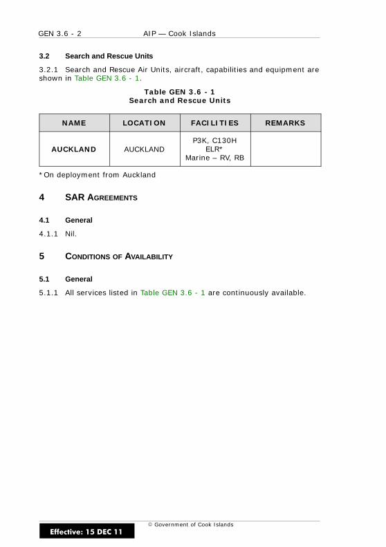
GEN 3.6 - 2 AIP — Cook Islands
E Government of Cook Islands
3.2 Search and Rescue Units
3.2.1 Search and Rescue Air Units, aircraft, capabilities and equipment areshown in Table GEN 3.6 - 1.
Table GEN 3.6 - 1Search and Rescue Units
NAME LOCATION FACILITIES REMARKS
AUCKLAND AUCKLANDP3K, C130H
ELR*Marine – RV, RB
*On deployment from Auckland
4 SAR AGREEMENTS
4.1 General
4.1.1 Nil.
5 CONDITIONS OF AVAILABILITY
5.1 General
5.1.1 All services listed in Table GEN 3.6 - 1 are continuously available.
Effective: 15 DEC 11
GEN 3.6 - 3AIP — Cook Islands
E Government of Cook Islands
6 PROCEDURES AND SIGNALS USED
6.1 Procedures and Signals Used by Aircraft
6.1.1 Procedures for pilots-in-command observing an accident orintercepting a distress call and/or message are outlined in ICAO Annex 12,Chapter 5.
6.2 Communications
6.2.1 Transmission and reception of distress messages within the NewZealand Search and Rescue Region are handled in accordance with ICAOAnnex 10, Volume II, Chapter 5, paragraph 5.3.
6.2.2 For communications during search and rescue operations, the codesand abbreviations published in ICAO Abbreviations and Codes (Doc 8400)are used.
6.2.3 The carriage of an emergency location transmitter (ELT) ismandatory within the Cook Islands. For this reason, in accordance withICAO Standards and Recommended Practices, aircraft are required tocontinuously guard the international emergency frequency 121.5 MHz. Thisrequirement does not apply when aircraft are carrying out communicationson other VHF channels, or when airborne equipment limitations or cockpitduties do not permit simultaneous guarding of two or more channels.
6.2.4 The frequency 121.5 MHz is guarded continuously by Faleolo ATS.
6.3 Procedures for an Aircraft Requiring SAR Escort
6.3.1 If the pilot-in-command of an aircraft, while flying over water or asparsely inhabited area, has any reason to believe that the operatingefficiency of the aircraft is impaired, the appropriate Air Traffic Servicesunit should be notified so that the RCC is forewarned should the positiondeteriorate. If, at this stage or later, the pilot-in-command considers itadvisable, interception and escort by a search and rescue aircraft may berequested.
6.3.2 Disparity in speeds and normal altitudes between some aircraft andSAR aircraft may not permit continuous escort in the accepted sense. TheSAR aircraft may turn back along the intended track of the aircraftrequiring escort before the interception, so that the latter is catching upwith the former. It is most important that radiotelephony (RTF) contact isestablished between the two aircraft as early as possible and maintainedthroughout the operation.
Effective: 15 DEC 11
GEN 3.6 - 4 AIP — Cook Islands
E Government of Cook Islands
6.4 RTF Procedures
General
6.4.1 Distress and urgency traffic shall comprise all RTF messages relatingto the distress or urgency condition respectively. Distress and urgencyconditions are defined as follows:
Distress
6.4.2 A condition of being threatened by serious and/or imminent dangerand of requiring immediate assistance.
Urgency
6.4.3 A condition concerning the safety of an aircraft or other vehicle, orof some person on board or within sight, but which does not requireimmediate assistance.
6.4.4 The RTF distress signal MAYDAY or the urgency signal PAN PAN,preferably spoken three times, shall be used at the commencement of thefirst distress or urgency communication respectively. The signals should, ifit is considered necessary, be used at the commencement of anysubsequent communication.
6.4.5 In cases of distress or urgency communications, in general, thetransmissions by RTF should be made slowly and distinctly, each wordbeing clearly pronounced to facilitate transcription.
6.5 RTF Distress Communications
Action by the Aircraft in Distress
6.5.1 In addition to being preceded by the distress signal MAYDAY thedistress message shall:
(a) be on the air–ground frequency in use at the time; and
(b) consist of as many as possible of the following elements spokendistinctly and, if possible, in the following order:
(i) name of the station addressed (time and circumstancespermitting)
(ii) identification of the aircraft
(iii) nature of the distress condition
(iv) intention of the pilot-in-command
(v) present position, heading and height
Effective: 15 DEC 11

GEN 3.6 - 5AIP — Cook Islands
E Government of Cook Islands
Notes
If insufficient time exists for transmission of the entire message, priority isto be given to present position.
The above provisions may be supplemented by the following measures:
(a) Transmitting the distress message on the emergency frequency121.5 MHz or another aeronautical mobile frequency likely to beheard in the area.
(b) Transmitting the distress message on the maritime mobile servicesRTF calling frequencies.
(c) Broadcasting the distress message, if time and circumstances makethis course preferable.
(d) Using any means at the pilot’s disposal to attract attention andmake known the distress condition.
(e) Any other station taking any means at its disposal to assist anaircraft in distress.
(f) Any variation on the elements listed in items (a) to (e) when thetransmitting station is not itself in distress, provided that suchcircumstances are clearly stated in the distress message.
The station addressed will normally be that station communicating with theaircraft or in whose area the aircraft is operating.
Effective: 15 DEC 11
GEN 3.6 - 6 AIP — Cook Islands
E Government of Cook Islands
6.6 Imposition of Silence
6.6.1 The station in distress, or the station in control of distress traffic,shall be permitted to impose silence either on all stations of the mobileservice in the area or on any station which interferes with the distresstraffic. It shall address these instructions to “all stations” or to one stationonly, according to the circumstances. In either case it shall use:
(a) STOP TRANSMITTING
(b) the RTF distress signal MAYDAY
Note
The use of the above signals shall be reserved for the station in distressand for the station controlling distress traffic.
6.7 Action by all Other Stations
6.7.1 Distress communications have absolute priority over all othercommunications and a station aware of them shall not transmit on thefrequency concerned unless:
(a) The distress is cancelled or the distress traffic is terminated;
(b) All distress traffic has been transferred to other frequencies;
(c) The station controlling communications gives permission; or
(d) It has itself to render assistance.
6.7.2 Any station which has knowledge of distress traffic, and whichcannot itself assist the station in distress, shall nevertheless continuelistening to such traffic until it is evident that assistance is being provided.
6.8 Termination of Distress Communication and of Silence
6.8.1 When an aircraft is no longer in distress it shall transmit a messagecancelling the distress condition. The distress communication and silenceconditions shall be terminated by transmitting a message, including thewords “DISTRESS TRAFFIC ENDED”, on the frequency or frequencies beingused for the distress traffic. This message shall be originated only by thestation controlling communications when it is authorised to do so by theappropriate authority.
Effective: 15 DEC 11
GEN 3.6 - 7AIP — Cook Islands
E Government of Cook Islands
6.9 RTF Urgency Communication
Action by an Aircraft Reporting an Urgency Condition
6.9.1 In addition to being preceded by the urgency signal PAN PAN theurgency signal shall:
(a) be on the air–ground frequency in use at the time; and
(b) consist of as many as required of the following elements spokendistinctly and, if possible, in the following order:
(i) name of the station addressed
(ii) identification of the aircraft
(iii) nature of the urgency condition
(iv) intention of the pilot-in-command
(v) present position, heading and height
(vi) any other useful information
Notes
The above provisions may be supplemented by the following measures:
(a) Transmitting the urgency message on the emergency frequency121.5 MHz or another aeronautical mobile frequency, if considerednecessary or desirable.
(b) Transmitting the urgency message on the maritime mobile serviceRTF calling frequencies.
(c) Broadcasting the urgency message, if time and circumstances makethis course preferable.
(d) Any variation on the elements listed in items (b) (i) to (vi) when thetransmitting station is not itself in an urgency condition, providedthat such circumstances are clearly stated in the ugency message.
The station addressed will normally be that station communicating with theaircraft or in whose area the aircraft is operating.
Effective: 15 DEC 11
GEN 3.6 - 8 AIP — Cook Islands
E Government of Cook Islands
6.10 Action by all Other Stations
6.10.1 Urgency communications have priority over all other communicationsexcept distress. All stations shall take care not to interfere with transmissionsof urgency traffic.
6.11 Procedures for a Pilot-in-Command Observing a Distress Incident
6.11.1 When a pilot-in-command observes that either another aircraft or asurface craft is in distress, unless the pilot is unable, or, in thecircumstances of the case, considers it unreasonable or unnecessary, theyshall:
(a) Keep the craft in distress in sight until no longer necessary or untilno longer able to remain in the vicinity of the distress craft.
(b) If position is not known with certainty, take such action as willfacilitate the determination of it.
(c) Report to the RCC or aeronautical station as much of the followinginformation as is possible:
(i) type of aircraft in distress, its identification and condition
(ii) its position, expressed in geographical coordinates or indistance and true bearing from a distinctive landmark
(iii) time of observation (in UTC)
(iv) number of persons observed
(v) whether the persons have been seen to abandon the craft indistress
(vi) number of persons observed to be afloat, and
(vii) apparent physical condition of survivors
(d) Act as instructed by the RCC.
6.11.2 If the pilot-in-command of the first aircraft to reach the place of theaccident is unable to establish communication with an aeronautical station,that pilot should take charge of the activities of all other aircraft that arriveuntil handing control over to the aircraft best able to provide communication.
Effective: 15 DEC 11

GEN 3.6 - 9AIP — Cook Islands
E Government of Cook Islands
6.12 Procedures for a Pilot-in-Command Intercepting a Distress Message
6.12.1 Whenever a distress message is intercepted on radio by apilot-in-command of an aircraft, other than a search aircraft, the pilotshall:
(a) If possible take a bearing on the transmission
(b) Listen out and if no acknowledgement is heard, acknowledge receiptand relay the message to the appropriate aeronautical station byany means available
(c) If necessary, exercise control of communications until theaeronautical station is able to take control
(d) Plot the position of the craft in distress if given
(e) At the pilot’s discretion, while awaiting instructions, proceed to theposition given in the distress message
6.13 Non-Radio Distress and Urgency Signals
6.13.1 In a distress situation, if radio is not available, any of the followingdistress signals may be used as an alternative means of obtainingassistance:
(a) Rockets or shells throwing red lights, fired one at a time or at shortintervals.
(b) A parachute flare showing a red light.
6.13.2 In an urgency situation, if radio is not available, the followingurgency signals may be used as an alternative:
(a) a succession of green pyrotechnic lights, or
(b) a succession of green flashes with signal apparatus.
6.13.3 In addition to the above, the following signals used either togetheror separately, mean that an aircraft wishes to notify difficulties whichcompel it to land without requiring immediate assistance:
(a) the repeated switching on and off of the landing lights, or
(b) the repeated switching on and off of the navigation lights, or
(c) a succession of white pyrotechnic lights.
6.13.4 If a forced landing has been made, every effort should be made toattract attention using the “Ground – Air Visual Signal Code” shown inTable GEN 3.6 - 2.
Effective: 15 DEC 11

GEN 3.6 - 10 AIP — Cook Islands
E Government of Cook Islands
Table GEN 3.6 - 2Ground/Air Visual Signal Codes
NO MESSAGE CODESYMBOL
1 Require assistance V2 Require medical assistance X3 No or negative N4 Yes or affirmative Y5 Proceeding in this direction
Instructions for use
(a) Make signals not less than 8ft (2.5m).
(b) Take care to lay out signals exactly as shown.
(c) Provide as much colour contrast as possible between signals andbackground.
(d) Make every effort to attract attention by other means such as radio,flares, smoke, reflected light.
Effective: 15 DEC 11
GEN 3.6 - 11AIP — Cook Islands
E Government of Cook Islands
6.14 Procedure for Directing a Surface Craft to a Distress Incident
6.14.1 When it is necessary for a pilot-in-command to direct surface craftto the place where an aircraft or a surface craft is in distress, the pilotshould do so by transmitting precise instructions by any means available.If such precise instructions cannot be transmitted, they should be givenby carrying out the following procedure:
(a) Circle the surface craft at least once;
(b) Cross the projected course of the surface craft close ahead at lowaltitude;
(i) rocking the aircraft, or
(ii) opening and closing the throttle, or
(iii) changing the propeller pitch.
(c) Head in the direction in which the surface craft is to be directed.
(d) Repeat these procedures until the surface craft acknowledges.
Note
Due to the high noise level on board surface craft, sound signals may beless effective than the visual signals and are regarded as an alternativemeans of attracting attention.
Effective: 15 DEC 11
GEN 3.6 - 12 AIP — Cook Islands
E Government of Cook Islands
6.15 Current Maritime Signalling Procedures
6.15.1 For acknowleding receipt of signals:
(a) Hoisting of the “Code Pennant” (vertical red and white stripes) closeup (meaning understood)
(b) Flashing of a succession of “T’s” by signal lamp in the Morse Code
(c) Changing of heading
6.15.2 For indicating inability to comply:
(a) Hoisting of the international flag “N” (blue/white checks, 16squares)
(b) Flashing a sucession of “N’s” in the Morse Code
6.16 Procedure to Signify that Assistance from a Surface Craft is No LongerRequired
6.16.1 When assistance of a surface craft is no longer required an aircraftshould cross the wake of the surface craft close astern at low altitude:
(a) rocking the aircraft, or
(b) opening and closing the throttle, or
(c) changing the propeller pitch
Note
Due to the high noise level on board surface craft, sound signals may beless effective than the visual signals and are regarded as alternative meansof attracting attention.
7 VISUAL INSPECTIONS BY ATS UNIT
7.1 General
7.1.1 In certain situations the pilot in an emergency may request an ATSunit to conduct a visual inspection of the aircraft in-flight, e.g. undercarriagemalfunction. Where available, ATS units will seek assistance from theoperator’s engineering staff or its handling agents for expert advice to thepilot. In the absence of such assistance ATS personnel will report their visualobservations to the pilot. Such reports are for information only and do notconstitute authoritative advice in any form whatsoever.
Effective: 15 DEC 11
GEN 3.6 - 13AIP — Cook Islands
E Government of Cook Islands
8 EMERGENCY LOCATOR TRANSMITTERS (ELT)
8.1 General
8.1.1 The essence of a successful search and rescue operation is thespeed with which it can be accomplished. It must be presumed that in eachincident there are survivors who need help and whose chances of survivaldiminish with every passing minute. Emergency location beacons facilitaterapid location of a distress incident by day and night and their carriage iscompulsory in Cook Islands registered aircraft. These electronic, batteryoperated transmitters emit a distinctive downward swept audio tone on121.5 MHz, 243 MHz or 406 MHz, depending on whether they are anEmergency Location Transmitter — Aircraft (ELT) or an Emergency PositionIndicating Radio Beacon (EPIRB).
8.2 Emergency Activation
8.2.1 To prevent valuable air search time being wasted it is imperativethat:
(a) Any emergency beacon that is not automatically activated isswitched on as soon as possible after any emergency and left onuntil rescue. THE SWITCHING ON AND OFF OF ANY BEACON MAYWELL VOID A RADIO SEARCH PROCEDURE.
(b) In the event of all survivors leaving the crash scene the emergencybeacon must be carried with them. The prime objective of thesearch is for the survivors, not the wreckage.
8.3 Emergency Location Transmitter Reporting Procedures
8.3.1 On receiving an ELT signal, a pilot shall report the followinginformation to the nearest ATS unit:
(a) aircraft position and time the signal was first heard
(b) aircraft position and time the signal was last heard
(c) aircraft position at maximum signal strength
(d) aircraft level, strength and frequency of emergency signal(121.5 MHz/243 MHz)
Effective: 15 DEC 11
GEN 3.6 - 14 AIP — Cook Islands
E Government of Cook Islands
8.4 ELT Testing
8.4.1 Operational testing of beacons should, if possible, be carried outonly in shielded areas under controlled conditions. False signals on thedistress frequencies can interfere with actual distress transmissions as wellas decrease the degree of urgency that should be attached to such signals.Aircraft operational testing is authorised on 121.5 MHz or 243 MHz asfollows:
(a) Tests should be no longer than three audio sweeps.
(b) Tests shall be conducted ONLY within the time period made up ofthe first five minutes after every hour. Emergency tests outside ofthis time shall be coordinated with the nearest ATS unit. AirborneELT tests are NOT permitted.
8.5 Inadvertent Activation
8.5.1 Inadvertent activation of emergency locator beacons has occurredon numerous occasions in the Cook Islands. It can occur as a result ofaerobatics, hard landings or accidental activation during aircraft servicing.To prevent transmissions due to inadvertent activation pilots-in-commandshall:
(a) prior to engine shut down at the end of each flight, tune the aircraftreceiver to 121.5 MHz (or 243 MHz if applicable) and listen for ELTsignals; and
(b) if an ELT is heard, check the aircraft’s beacon to determine whetherit is the one in operation. If it is found that it has been activated,switch off immediately and report the occurrence to the nearest ATSunit.
Note
Maintenance may be required before an automatic activation is returned tothe armed position.
Reminders to ensure that the ELTA is switched off at the end of flightsshould be placed on the checklist or placards. Use of other effectivereminders is encouraged.
To prevent inadvertent activation, batteries must be removed before abeacon is dispatched for maintenance.
Any case where inadvertent activation of an emergency location beacon isdetected must be reported immediately to the nearest ATS unit in orderthat any SAR action, commenced as a result of the beacon transmissions,may be terminated.
Effective: 15 DEC 11

GEN 3.6 - 15AIP — Cook Islands
E Government of Cook Islands
9 AERODROME EMERGENCIES
9.1 Aerodrome Emergency Plan
9.1.1 The object of an Aerodrome Emergency Plan is to prepare anaerodrome to cope with an emergency occurring on or within the vicinity ofthe aerodrome. The plan sets out the procedures for coordinating theresponse of different aerodrome services and those agencies in thesurrounding community that could be of assistance in an emergency.
9.1.2 Examples of the type of emergencies are:
(a) aircraft malfunctions
(b) sabotage, including bomb threats
(c) unlawfully seized aircraft
(d) dangerous goods occurrences
(e) building fires and natural disasters
9.1.3 An Aerodrome Emergency Plan exists at Rarotonga InternationalAirport.
Effective: 15 DEC 11
GEN 3.6 - 16 AIP — Cook Islands
E Government of Cook Islands
9.2 Procedures to Activate Aerodrome Emergency Services
9.2.1 The ATS unit on the aerodrome is responsible for alerting theemergency services, following a request from a pilot or when an aircraft isconsidered to be in any of the following emergency phases:
Local Standby Phase
9.2.2 When an aircraft approaching the aerodrome is known, or issuspected, to have developed some defect, but the trouble is not such aswould normally prevent effecting a safe landing.
9.2.3 Declaration of the LOCAL STANDBY PHASE will bring theaerodrome-based emergency services to a state of readiness but, ingeneral, although off-aerodrome components may be notified, they willremain at their posts.
Full Emergency Phase
9.2.4 When an aircraft approaching the airport is, or is suspected to be, insuch trouble that there is danger of an accident.
9.2.5 Declaration of the FULL EMERGENCY PHASE will bring all facilities,both on the aerodrome and in the city or community, such as medical andambulance services, Police and Fire Services, to a rendezvous point on theaerodrome. It will also alert the hospital to prepare for possible receptionof injured and for road traffic control to be instituted along the routebetween the city and aerodrome to clear the way for emergency vehicles.
Aircraft Accident Phase
9.2.6 AIRCRAFT ACCIDENT ON AIRPORT or AIRCRAFT ACCIDENT OFFAIRPORT when an aircraft accident has occurred on or in the vicinity of theairport.
9.2.7 Declaration of the AIRCRAFT ACCIDENT PHASE will bring all facilitiesinto immediate action.
9.2.8 When an emergency occurs in-flight and adequate communicationsexist, the pilot-in-command is responsible for advising the ATS unitaccordingly and for nominating the desired state of readiness of theaerodrome emergency services.
9.2.9 If adequate communications with aircraft do not exist, the ATSspecialist will assess the situation and bring the aerodrome emergencyservices to the state of readiness considered appropriate.
Effective: 15 DEC 11
GEN 4 - 1AIP — Cook Islands
E Government of Cook Islands
GEN 4 CHARGES FOR AERODROMES/HELIPORTS AND AIRNAVIGATION SERVICES
Effective: 15 DEC 11

GEN 4 - 2 AIP — Cook Islands
E Government of Cook IslandsEffective: 15 DEC 11
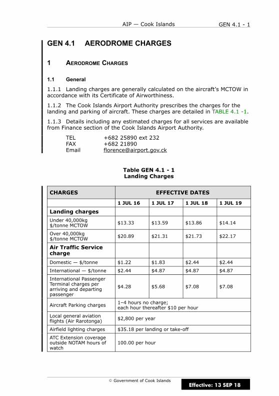
GEN 4.1 - 1AIP — Cook Islands
E Government of Cook Islands
GEN 4.1 AERODROME CHARGES
1 AERODROME CHARGES
1.1 General
1.1.1 Landing charges are generally calculated on the aircraft’s MCTOW inaccordance with its Certificate of Airworthiness.
1.1.2 The Cook Islands Airport Authority prescribes the charges for thelanding and parking of aircraft. These charges are detailed in TABLE 4.1 -1.
1.1.3 Details including any estimated charges for all services are availablefrom Finance section of the Cook Islands Airport Authority.
TEL +682 25890 ext 232FAX +682 21890Email [email protected]
Table GEN 4.1 - 1Landing Charges
CHARGES EFFECTIVE DATES
1 JUL 16 1 JUL 17 1 JUL 18 1 JUL 19
Landing charges
Under 40,000kg$/tonne MCTOW $13.33 $13.59 $13.86 $14.14
Over 40,000kg$/tonne MCTOW $20.89 $21.31 $21.73 $22.17
Air Traffic Servicecharge
Domestic — $/tonne $1.22 $1.83 $2.44 $2.44
International — $/tonne $2.44 $4.87 $4.87 $4.87
International PassengerTerminal charges perarriving and departingpassenger
$4.28 $5.68 $7.08 $7.08
Aircraft Parking charges 1–4 hours no charge;each hour thereafter $10 per hour
Local general aviationflights (Air Rarotonga) $2,800 per year
Airfield lighting charges $35.18 per landing or take-off
ATC Extension coverageoutside NOTAM hours ofwatch
100.00 per hour
Effective: 13 SEP 18
GEN 4.1 - 2 AIP — Cook Islands
E Government of Cook Islands
2 EXEMPTIONS AND REDUCTIONS
2.1 Exemptions
2.1.1 The following are exempt from the passenger service charge:
(a) Diplomatic aircraft;
(b) Test or training flights;
(c) Aircraft engaged in flights of a humanitarian nature, includingsearch and rescue flights;
(d) Emergency landings.
2.2 Reductions
2.2.1 Nil.
2.3 Surcharges
2.3.1 Nil.
2.4 Cargo
2.4.1 Nil.
3 METHODS OF PAYMENT
3.1 General
3.1.1 Cash payments should be made before departure for non-scheduledaircraft at the main office of the Cook Islands Airport Authority.
Effective: 13 SEP 18
GEN 4.2 - 1AIP — Cook Islands
E Government of Cook Islands
GEN 4.2 AIR NAVIGATION CHARGES
1 CHARGES
1.1 General
1.1.1 Nil.
2 EXEMPTIONS/REDUCTIONS
2.1 General
2.1.1 Nil.
3 METHODS OF PAYMENT
3.1 General
3.1.1 Nil.
Effective: 15 DEC 11

GEN 4.2 - 2 AIP — Cook Islands
E Government of Cook Islands
IntentionallyBlank
Effective: 15 DEC 11
ENR 0.6 - 1AIP — Cook Islands
E Government of Cook Islands
ENR 0ENR 0.1ENR 0.2ENR 0.3ENR 0.4ENR 0.5
ENR 0.6 TABLE OF CONTENTS — ENR
Page No.
ENR 0.6 TABLE OF CONTENTS — ENR ENR 0.6 - 1. . . . . . . . . . . . . . . . . . . .
ENR 1 GENERAL RULES AND PROCEDURES ENR 1 - 1. . . . . . .
ENR 1.1 GENERAL RULES AND PROCEDURES ENR 1.1 - 1. . . . . . . . . . . .1 General Rules ENR 1.1 - 1. . . . . . . . . . . . . . . . . . . . . . . . . . . . . . . . . . . . . .1.1 Introduction ENR 1.1 - 1. . . . . . . . . . . . . . . . . . . . . . . . . . . . . . . . . . .
2 ATC Separation ENR 1.1 - 1. . . . . . . . . . . . . . . . . . . . . . . . . . . . . . . . . . . . .2.1 Provision of ATC Separation ENR 1.1 - 1. . . . . . . . . . . . . . . . . . . .2.2 Vertical Separation ENR 1.1 - 3. . . . . . . . . . . . . . . . . . . . . . . . . . . .2.3 Horizontal Separation ENR 1.1 - 3. . . . . . . . . . . . . . . . . . . . . . . . . .2.4 Longitudinal Separation ENR 1.1 - 4. . . . . . . . . . . . . . . . . . . . . . . .2.5 Lateral Separation. ENR 1.1 - 4. . . . . . . . . . . . . . . . . . . . . . . . . . . .2.6 Geographical Separation ENR 1.1 - 5. . . . . . . . . . . . . . . . . . . . . . .2.7 Use of DME for Separation Purposes ENR 1.1 - 5. . . . . . . . . . .
3 Reduction in Separation Minima ENR 1.1 - 5. . . . . . . . . . . . . . . . . . . . .3.1 Flights Maintaining Own Separation in VMC in
Class D Airspace ENR 1.1 - 5. . . . . . . . . . . . . . . . . . . . . . . . . . . . . . .3.2 Visual Separation ENR 1.1 - 6. . . . . . . . . . . . . . . . . . . . . . . . . . . . . .3.3 Composite Visual Separation ENR 1.1 - 7. . . . . . . . . . . . . . . . . . .
4 Priorities ENR 1.1 - 8. . . . . . . . . . . . . . . . . . . . . . . . . . . . . . . . . . . . . . . . . . .4.1 General ENR 1.1 - 8. . . . . . . . . . . . . . . . . . . . . . . . . . . . . . . . . . . . . . .
5 Minimum Flight Altitudes ENR 1.1 - 10. . . . . . . . . . . . . . . . . . . . . . . . . .5.1 VFR ENR 1.1 - 10. . . . . . . . . . . . . . . . . . . . . . . . . . . . . . . . . . . . . . . . . .5.2 IFR ENR 1.1 - 10. . . . . . . . . . . . . . . . . . . . . . . . . . . . . . . . . . . . . . . . . .
ENR 1.2 VISUAL FLIGHT RULES ENR 1.2 - 1. . . . . . . . . . . . . . . . . . . . . . . . . .1 General ENR 1.2 - 1. . . . . . . . . . . . . . . . . . . . . . . . . . . . . . . . . . . . . . . . . . . .1.1 Pilot Responsibilities ENR 1.2 - 1. . . . . . . . . . . . . . . . . . . . . . . . . . .1.2 Limitations ENR 1.2 - 1. . . . . . . . . . . . . . . . . . . . . . . . . . . . . . . . . . . .1.3 Air Traffic Control Service ENR 1.2 - 1. . . . . . . . . . . . . . . . . . . . . .1.4 Change of Flight Rules ENR 1.2 - 1. . . . . . . . . . . . . . . . . . . . . . . . .1.5 Parachute Operations ENR 1.2 - 1. . . . . . . . . . . . . . . . . . . . . . . . . .
2 Position and Altitude Reporting Requirements ENR 1.2 - 2. . . . . . .2.1 VFR Flights Entering Class D Airspace, With
ATC in Attendance ENR 1.2 - 2. . . . . . . . . . . . . . . . . . . . . . . . . . . . .2.2 VFR Flights Entering an Aerodrome Traffic
Circuit ENR 1.2 - 2. . . . . . . . . . . . . . . . . . . . . . . . . . . . . . . . . . . . . . . . .2.3 Frequency Changes ENR 1.2 - 2. . . . . . . . . . . . . . . . . . . . . . . . . . .
Effective: 15 DEC 11
ENR 0.6 - 2 AIP — Cook Islands
E Government of Cook Islands
Page No.
3 Clearance From Cloud and Visibility Requirements ENR 1.2 - 3. . .3.1 General ENR 1.2 - 3. . . . . . . . . . . . . . . . . . . . . . . . . . . . . . . . . . . . . . .
Table ENR 1.2-1VFR Meteorological Minima ENR 1.2 - 3. . . . . . . . . . . . . . . . . . . . . . . . . . . . .4 Position and Altitude Reporting Requirements ENR 1.2 - 5. . . . . . .4.1 General ENR 1.2 - 5. . . . . . . . . . . . . . . . . . . . . . . . . . . . . . . . . . . . . . .4.2 Enroute VFR Flights ENR 1.2 - 5. . . . . . . . . . . . . . . . . . . . . . . . . . .
5 Aerodrome MET Minima for Operations in CTR ENR 1.2 - 6. . . . . . .5.1 General ENR 1.2 - 6. . . . . . . . . . . . . . . . . . . . . . . . . . . . . . . . . . . . . . .5.2 MET Minima for Operation as VFR Flight
by Night ENR 1.2 - 6. . . . . . . . . . . . . . . . . . . . . . . . . . . . . . . . . . . . . .6 Special VFR Flights (SVFR) ENR 1.2 - 7. . . . . . . . . . . . . . . . . . . . . . . . .6.1 Aerodrome Meteorological Minima ENR 1.2 - 7. . . . . . . . . . . . .
Table ENR 1.2-2VFR Aerodrome Meteorological Minima ENR 1.2 - 7. . . . . . . . . . . . . . . . .6.2 General ENR 1.2 - 7. . . . . . . . . . . . . . . . . . . . . . . . . . . . . . . . . . . . . . .
ENR 1.3 INSTRUMENT FLIGHT RULES ENR 1.3 - 1. . . . . . . . . . . . . . . . . . .1 Rules applicable to all IFR flights ENR 1.3 - 1. . . . . . . . . . . . . . . . . . . .1.1 Classification of IFR Flights ENR 1.3 - 1. . . . . . . . . . . . . . . . . . . .1.2 Responsibility of Pilot-in-Command ENR 1.3 - 1. . . . . . . . . . . .1.3 Routing to Avoid Hazardous MET Conditions ENR 1.3 - 2. . . .1.4 Aircraft Equipment ENR 1.3 - 2. . . . . . . . . . . . . . . . . . . . . . . . . . . .1.5 Change from IFR Flight to VFR Flight ENR 1.3 - 2. . . . . . . . . . .
2 Rules Applicable to IFR Flights Within ControlledAirspace ENR 1.3 - 3. . . . . . . . . . . . . . . . . . . . . . . . . . . . . . . . . . . . . . . . . . .2.1 General ENR 1.3 - 3. . . . . . . . . . . . . . . . . . . . . . . . . . . . . . . . . . . . . . .
3 Rules Applicable to IFR Flights Outside ControlledAirspace ENR 1.3 - 3. . . . . . . . . . . . . . . . . . . . . . . . . . . . . . . . . . . . . . . . . . .3.1 Cruising Levels ENR 1.3 - 3. . . . . . . . . . . . . . . . . . . . . . . . . . . . . . . .
4 Communications, Position Reports and TrafficInformation Outside Controlled Airspace ENR 1.3 - 4. . . . . . . . . . . .4.1 General ENR 1.3 - 4. . . . . . . . . . . . . . . . . . . . . . . . . . . . . . . . . . . . . . .4.2 Position Reports ENR 1.3 - 4. . . . . . . . . . . . . . . . . . . . . . . . . . . . . . .4.3 Position Reporting at AFIS Aerodromes ENR 1.3 - 5. . . . . . . . .4.4 Position and Altitude Reporting — IFR Flights
Entering an Aerodrome Traffic Circuit atUnattended Aerodromes ENR 1.3 - 5. . . . . . . . . . . . . . . . . . . . . . .
4.5 Separation of IFR Flights OutsideControlled Airspace ENR 1.3 - 5. . . . . . . . . . . . . . . . . . . . . . . . . . . .
4.6 Position and Altitude Reporting Enroute ENR 1.3 - 6. . . . . . . .
Effective: 15 DEC 11
ENR 0.6 - 3AIP — Cook Islands
E Government of Cook Islands
Page No.
ENR 1.4 ATS AIRSPACE CLASSIFICATION ENR 1.4 - 1. . . . . . . . . . . . . . .1 Classification of Airspaces ENR 1.4 - 1. . . . . . . . . . . . . . . . . . . . . . . . . .1.1 General ENR 1.4 - 1. . . . . . . . . . . . . . . . . . . . . . . . . . . . . . . . . . . . . . .1.2 Class C — CTA ENR 1.4 - 1. . . . . . . . . . . . . . . . . . . . . . . . . . . . . . . . .1.3 Class D — CTR ENR 1.4 - 1. . . . . . . . . . . . . . . . . . . . . . . . . . . . . . . .1.4 Class G — Uncontrolled Airspace ENR 1.4 - 1. . . . . . . . . . . . . . .
Table ENR 1.4-1Airspace Classification Table ENR 1.4 - 3. . . . . . . . . . . . . . . . . . . . . . . . . . .
ENR 1.5 HOLDING, APPROACH AND DEPARTUREPROCEDURES ENR 1.5 - 1. . . . . . . . . . . . . . . . . . . . . . . . . . . . . . . . . . . .
1 Holding ENR 1.5 - 1. . . . . . . . . . . . . . . . . . . . . . . . . . . . . . . . . . . . . . . . . . . .1.1 General ENR 1.5 - 1. . . . . . . . . . . . . . . . . . . . . . . . . . . . . . . . . . . . . . .
Table ENR 1.5-1Maximum IAS for Holding Patterns ENR 1.5 - 2. . . . . . . . . . . . . . . . . . . . .2 Standard Holding Pattern ENR 1.5 - 3. . . . . . . . . . . . . . . . . . . . . . . . . . .2.1 General ENR 1.5 - 3. . . . . . . . . . . . . . . . . . . . . . . . . . . . . . . . . . . . . . .
Figure ENR 1.5-1Standard Holding Pattern ENR 1.5 - 3. . . . . . . . . . . . . . . . . . . . . . . . . . . . . .2.2 Entry Procedures ENR 1.5 - 4. . . . . . . . . . . . . . . . . . . . . . . . . . . . . .
Figure ENR 1.5-2Holding Pattern Entry Sectors ENR 1.5 - 4. . . . . . . . . . . . . . . . . . . . . . . . . .2.3 Holding Procedures and Time — Still Air
Conditions ENR 1.5 - 6. . . . . . . . . . . . . . . . . . . . . . . . . . . . . . . . . . . . .2.4 Holding Procedures and Timing — Wind Effect ENR 1.5 - 6. .2.5 Holding Procedures and Timing — Departing
the Pattern ENR 1.5 - 6. . . . . . . . . . . . . . . . . . . . . . . . . . . . . . . . . . . .2.6 Obstacle Clearance — Holding Area ENR 1.5 - 7. . . . . . . . . . . .2.7 Obstacle Clearance — Buffer Area ENR 1.5 - 7. . . . . . . . . . . . .2.8 Obstacle Clearance — Minimum Holding
Altitude ENR 1.5 - 7. . . . . . . . . . . . . . . . . . . . . . . . . . . . . . . . . . . . . . .2.9 Precautionary Holding ENR 1.5 - 8. . . . . . . . . . . . . . . . . . . . . . . . .
3 Arriving flights ENR 1.5 - 9. . . . . . . . . . . . . . . . . . . . . . . . . . . . . . . . . . . . .3.1 General ENR 1.5 - 9. . . . . . . . . . . . . . . . . . . . . . . . . . . . . . . . . . . . . . .3.2 Aircraft Speed Restrictions ENR 1.5 - 9. . . . . . . . . . . . . . . . . . . . .
4 Approach Procedures ENR 1.5 - 10. . . . . . . . . . . . . . . . . . . . . . . . . . . . . .4.1 The Instrument Approach Procedure ENR 1.5 - 10. . . . . . . . . .4.2 Instrument Approach Fixes ENR 1.5 - 10. . . . . . . . . . . . . . . . . . .4.3 Instrument Approach Segments ENR 1.5 - 10. . . . . . . . . . . . . .
Figure ENR 1.5-3Tear-drop Approach Segments ENR 1.5 - 11. . . . . . . . . . . . . . . . . . . . . . . .4.4 Procedure Speeds ENR 1.5 - 12. . . . . . . . . . . . . . . . . . . . . . . . . . . .
Table ENR 1.5-2Speeds for Procedure Calculations ENR 1.5 - 12. . . . . . . . . . . . . . . . . . . . .4.5 Minima ENR 1.5 - 13. . . . . . . . . . . . . . . . . . . . . . . . . . . . . . . . . . . . . . .
Effective: 15 DEC 11
ENR 0.6 - 4 AIP — Cook Islands
E Government of Cook Islands
Page No.
4.6 Application of Minima ENR 1.5 - 14. . . . . . . . . . . . . . . . . . . . . . . . .4.7 Aircraft Approach Categories ENR 1.5 - 15. . . . . . . . . . . . . . . . . .
Table ENR 1.5-3Aircraft Category ENR 1.5 - 15. . . . . . . . . . . . . . . . . . . . . . . . . . . . . . . . . . . . .4.8 Landing minima format ENR 1.5 - 16. . . . . . . . . . . . . . . . . . . . . . .4.9 Instrument Approach Procedure Timing ENR 1.5 - 16. . . . . . .
Table ENR 1.5-4Instrument Approach Procedure — Timing Adjustment ENR 1.5 - 16.4.10 Position Reporting During Instrument Approach
at a Controlled Aerodrome ENR 1.5 - 17. . . . . . . . . . . . . . . . . . . .4.11 Visual Approach — Controlled Airspace ENR 1.5 - 17. . . . . . . .4.12 Visual Approach — Uncontrolled Airspace ENR 1.5 - 18. . . . .4.13 Visual Reference — Descent Below Minimum
Altitude or Minimum Descent Altitude ENR 1.5 - 19. . . . . . . . .4.14 Visual Segment Surface (VSS) ENR 1.5 - 19. . . . . . . . . . . . . . . .4.15 Unattended Aerodromes — QNH Source ENR 1.5 - 19. . . . . . .4.16 IFR Arrival Procedures — Unattended
Aerodromes ENR 1.5 - 20. . . . . . . . . . . . . . . . . . . . . . . . . . . . . . . . . .4.17 RNAV/Baro-VNAV Approach Procedures ENR 1.5 - 21. . . . . . .
5 Departing Flights ENR 1.5 - 22. . . . . . . . . . . . . . . . . . . . . . . . . . . . . . . . . .5.1 General ENR 1.5 - 22. . . . . . . . . . . . . . . . . . . . . . . . . . . . . . . . . . . . . .5.2 Standard Instrument Departure (SID) ENR 1.5 - 23. . . . . . . .5.3 IFR Alternate Aerodrome Minima ENR 1.5 - 23. . . . . . . . . . . . . .
ENR 1.6 RADAR SERVICES AND PROCEDURES ENR 1.6 - 1. . . . . . . . . . .1 Services ENR 1.6 - 1. . . . . . . . . . . . . . . . . . . . . . . . . . . . . . . . . . . . . . . . . . .1.1 General ENR 1.6 - 1. . . . . . . . . . . . . . . . . . . . . . . . . . . . . . . . . . . . . . .
ENR 1.7 ALTIMETER SETTING PROCEDURES ENR 1.7 - 1. . . . . . . . . . . .1 Introduction ENR 1.7 - 1. . . . . . . . . . . . . . . . . . . . . . . . . . . . . . . . . . . . . . . .1.1 General ENR 1.7 - 1. . . . . . . . . . . . . . . . . . . . . . . . . . . . . . . . . . . . . . .
2 Basic Altimeter Setting Procedures ENR 1.7 - 1. . . . . . . . . . . . . . . . . .2.1 General ENR 1.7 - 1. . . . . . . . . . . . . . . . . . . . . . . . . . . . . . . . . . . . . . .
Table ENR 1.7-1Flight Level and Altimeter Indications ENR 1.7 - 2. . . . . . . . . . . . . . . . . .2.2 Take-off and Climb ENR 1.7 - 3. . . . . . . . . . . . . . . . . . . . . . . . . . . .2.3 Vertical Separation — Enroute ENR 1.7 - 3. . . . . . . . . . . . . . . . .2.4 Approach and Landing ENR 1.7 - 3. . . . . . . . . . . . . . . . . . . . . . . . .2.5 QFE Altimeter Settings ENR 1.7 - 3. . . . . . . . . . . . . . . . . . . . . . . .2.6 Missed Approach ENR 1.7 - 3. . . . . . . . . . . . . . . . . . . . . . . . . . . . . .
3 Description of Area QNH Zones ENR 1.7 - 4. . . . . . . . . . . . . . . . . . . . .3.1 General ENR 1.7 - 4. . . . . . . . . . . . . . . . . . . . . . . . . . . . . . . . . . . . . . .
Table ENR 1.7-2Area QNH Zones ENR 1.7 - 4. . . . . . . . . . . . . . . . . . . . . . . . . . . . . . . . . . . . . . .
Effective: 31 MAR 16
ENR 0.6 - 5AIP — Cook Islands
E Government of Cook Islands
Page No.
4 Procedures Applicable to Operators(Including Pilots) ENR 1.7 - 4. . . . . . . . . . . . . . . . . . . . . . . . . . . . . . . . . . .4.1 Flight Planning ENR 1.7 - 4. . . . . . . . . . . . . . . . . . . . . . . . . . . . . . . .
5 Table of Cruising Levels ENR 1.7 - 5. . . . . . . . . . . . . . . . . . . . . . . . . . . . .5.1 General ENR 1.7 - 5. . . . . . . . . . . . . . . . . . . . . . . . . . . . . . . . . . . . . . .
Table ENR 1.7-3Table of Cruising Levels ENR 1.7 - 5. . . . . . . . . . . . . . . . . . . . . . . . . . . . . . . .
ENR 1.8 REGIONAL SUPPLEMENTARY PROCEDURES ENR 1.8 - 1. . . .1 Introduction ENR 1.8 - 1. . . . . . . . . . . . . . . . . . . . . . . . . . . . . . . . . . . . . . . .1.1 General ENR 1.8 - 1. . . . . . . . . . . . . . . . . . . . . . . . . . . . . . . . . . . . . . .
ENR 1.9 AIR TRAFFIC FLOW MANAGEMENT (ATFM) ENR 1.9 - 1. . . . .1 Introduction ENR 1.9 - 1. . . . . . . . . . . . . . . . . . . . . . . . . . . . . . . . . . . . . . . .1.1 General ENR 1.9 - 1. . . . . . . . . . . . . . . . . . . . . . . . . . . . . . . . . . . . . . .
ENR 1.10 FLIGHT PLANNING (RESTRICTION, LIMITATIONOR ADVISORY INFORMATION) ENR 1.10 - 1. . . . . . . . . . . . . . . .
1 Procedures for the Submission of a Flight Plan ENR 1.10 - 1. . . . .1.1 General ENR 1.10 - 1. . . . . . . . . . . . . . . . . . . . . . . . . . . . . . . . . . . . . .1.2 Time of Submission ENR 1.10 - 1. . . . . . . . . . . . . . . . . . . . . . . . . . .1.3 Place of Submission ENR 1.10 - 1. . . . . . . . . . . . . . . . . . . . . . . . . .1.4 Contents and Form of a Flight Plan ENR 1.10 - 1. . . . . . . . . . . .1.5 Adherence to ATS Route Structure ENR 1.10 - 1. . . . . . . . . . . .1.6 Completing the ICAO Flight Plan Form ENR 1.10 - 2. . . . . . . .
2 Repetitive Flight Plan System ENR 1.10 - 15. . . . . . . . . . . . . . . . . . . .2.1 General ENR 1.10 - 15. . . . . . . . . . . . . . . . . . . . . . . . . . . . . . . . . . . .
3 Changes to the Submitted Flight Plan ENR 1.10 - 15. . . . . . . . . . . .3.1 General ENR 1.10 - 15. . . . . . . . . . . . . . . . . . . . . . . . . . . . . . . . . . . .
4 Arrival Report (Terminating a Flight Plan) ENR 1.10 - 17. . . . . . . .4.1 General ENR 1.10 - 17. . . . . . . . . . . . . . . . . . . . . . . . . . . . . . . . . . . .
ENR 1.11 ADDRESSING OF FLIGHT PLAN MESSAGES ENR 1.11 - 1. . . .1 General ENR 1.11 - 1. . . . . . . . . . . . . . . . . . . . . . . . . . . . . . . . . . . . . . . . . . .1.1 Flight Movement Messages ENR 1.11 - 1. . . . . . . . . . . . . . . . . . .
Table ENR 1.11-1Flight Movement Messages ENR 1.11 - 1. . . . . . . . . . . . . . . . . . . . . . . . . . . .
ENR 1.12 INTERCEPTION OF CIVIL AIRCRAFT ENR 1.12 - 1. . . . . . . . . . .1 Visual Signals For Use by Intercepting andIntercepted Aircraft ENR 1.12 - 1. . . . . . . . . . . . . . . . . . . . . . . . . . . . . . .1.1 General ENR 1.12 - 1. . . . . . . . . . . . . . . . . . . . . . . . . . . . . . . . . . . . . .
2 Signals Initiated by Intercepting Aircraft andResponses by Intercepted Aircraft ENR 1.12 - 2. . . . . . . . . . . . . . . . .2.1 General ENR 1.12 - 2. . . . . . . . . . . . . . . . . . . . . . . . . . . . . . . . . . . . . .
Table ENR 1.12-1Signals Initiated by Intercepting Aircraft andResponses by Intercepted Aircraft ENR 1.12 - 2. . . . . . . . . . . . . . . . . . . . .
Effective: 31 MAR 16
ENR 0.6 - 6 AIP — Cook Islands
E Government of Cook Islands
Page No.
ENR 1.13 UNLAWFUL INTERFERENCE ENR 1.13 - 1. . . . . . . . . . . . . . . . . . . .1 General ENR 1.13 - 1. . . . . . . . . . . . . . . . . . . . . . . . . . . . . . . . . . . . . . . . . . .1.1 Introduction ENR 1.13 - 1. . . . . . . . . . . . . . . . . . . . . . . . . . . . . . . . . .
2 Procedures ENR 1.13 - 1. . . . . . . . . . . . . . . . . . . . . . . . . . . . . . . . . . . . . . . .2.1 Introduction ENR 1.13 - 1. . . . . . . . . . . . . . . . . . . . . . . . . . . . . . . . . .
ENR 1.14 AIR TRAFFIC INCIDENTS ENR 1.14 - 1. . . . . . . . . . . . . . . . . . . . . .1 Air Safety Incidents ENR 1.14 - 1. . . . . . . . . . . . . . . . . . . . . . . . . . . . . . .1.1 General ENR 1.14 - 1. . . . . . . . . . . . . . . . . . . . . . . . . . . . . . . . . . . . . .
2 Aviation Safety Report ENR 1.14 - 1. . . . . . . . . . . . . . . . . . . . . . . . . . . . .2.1 General ENR 1.14 - 1. . . . . . . . . . . . . . . . . . . . . . . . . . . . . . . . . . . . . .
3 Facility Malfunction Reporting ENR 1.14 - 2. . . . . . . . . . . . . . . . . . . . . .3.1 General ENR 1.14 - 2. . . . . . . . . . . . . . . . . . . . . . . . . . . . . . . . . . . . . .
ENR 1.15 EMERGENCY PROCEDURES ENR 1.15 - 1. . . . . . . . . . . . . . . . . . . . .1 Distress ENR 1.15 - 1. . . . . . . . . . . . . . . . . . . . . . . . . . . . . . . . . . . . . . . . . . .1.1 Definition ENR 1.15 - 1. . . . . . . . . . . . . . . . . . . . . . . . . . . . . . . . . . . .1.2 Transmission of MAYDAY Message ENR 1.15 - 1. . . . . . . . . . . . .1.3 Content of MAYDAY Message ENR 1.15 - 1. . . . . . . . . . . . . . . . . .
2 Urgency ENR 1.15 - 2. . . . . . . . . . . . . . . . . . . . . . . . . . . . . . . . . . . . . . . . . . .2.1 Definition ENR 1.15 - 2. . . . . . . . . . . . . . . . . . . . . . . . . . . . . . . . . . . .2.2 Transmission of PAN PAN Message ENR 1.15 - 2. . . . . . . . . . . .2.3 Content of PAN PAN Message ENR 1.15 - 2. . . . . . . . . . . . . . . . .
3 Communications Failure ENR 1.15 - 3. . . . . . . . . . . . . . . . . . . . . . . . . . .3.1 ATS Communications Failure ENR 1.15 - 3. . . . . . . . . . . . . . . . . .3.2 IFR Communications Failure — General ENR 1.15 - 3. . . . . . .3.3 IFR Communications Failure — VMC and
Certain of Maintaining VMC ENR 1.15 - 3. . . . . . . . . . . . . . . . . . .3.4 IFR Communications Failure — IMC or
Uncertain of Maintaining VMC ENR 1.15 - 4. . . . . . . . . . . . . . . . .4 VFR Communications Failure ENR 1.15 - 6. . . . . . . . . . . . . . . . . . . . . . .4.1 ATS Communications Failure ENR 1.15 - 6. . . . . . . . . . . . . . . . . .4.2 VFR Communications Failure ENR 1.15 - 6. . . . . . . . . . . . . . . . . .
5 Speechless Tecnique Using UnmodulatedTransmission ENR 1.15 - 7. . . . . . . . . . . . . . . . . . . . . . . . . . . . . . . . . . . . . .5.1 General ENR 1.15 - 7. . . . . . . . . . . . . . . . . . . . . . . . . . . . . . . . . . . . . .
6 Aerodrome Emergencies ENR 1.15 - 8. . . . . . . . . . . . . . . . . . . . . . . . . . .6.1 Aerodrome Emergency Plan ENR 1.15 - 8. . . . . . . . . . . . . . . . . .6.2 Procedures to Activate Aerodrome
Emergency Services ENR 1.15 - 8. . . . . . . . . . . . . . . . . . . . . . . . . .
Effective: 31 MAR 16

ENR 0.6 - 7AIP — Cook Islands
E Government of Cook Islands
Page No.
7 Traffic Information Broadcasts By Aircraft(TIBA) ENR 1.15 - 9. . . . . . . . . . . . . . . . . . . . . . . . . . . . . . . . . . . . . . . . . . . .7.1 General ENR 1.15 - 9. . . . . . . . . . . . . . . . . . . . . . . . . . . . . . . . . . . . . .7.2 Degradation of the ATS System ENR 1.15 - 9. . . . . . . . . . . . . . .7.3 Introduction and Applicability of TIBA ENR 1.15 - 9. . . . . . . . .7.4 VHF RTF Frequency to be Used for TIBA ENR 1.15 - 10. . . . .7.5 TIBA Listening Watch ENR 1.15 - 10. . . . . . . . . . . . . . . . . . . . . . .7.6 Timing of TIBA ENR 1.15 - 10. . . . . . . . . . . . . . . . . . . . . . . . . . . . .7.7 Content of TIBA ENR 1.15 - 10. . . . . . . . . . . . . . . . . . . . . . . . . . . .7.8 Acknowledgement of TIBA ENR 1.15 - 10. . . . . . . . . . . . . . . . . .7.9 Changes of Cruising Level Under TIBA ENR 1.15 - 11. . . . . .7.10 Collision Avoidance Under TIBA ENR 1.15 - 11. . . . . . . . . . . . .7.11 Normal Position Reporting Procedures
Under TIBA ENR 1.15 - 11. . . . . . . . . . . . . . . . . . . . . . . . . . . . . . . .Table ENR 1.15-1Information Required in TIBA ENR 1.15-12. . . . . . . . . . . . . . . . . . . . . . . . .
ENR 2 AIR TRAFFIC SERVICES AIRSPACE ENR 2 - 1. . . . . . . .
ENR 2.1 CTR, TMA, CTA ENR 2.1 - 1. . . . . . . . . . . . . . . . . . . . . . . . . . . . . . . . . . .1 Area of Responsibility ENR 2.1 - 1. . . . . . . . . . . . . . . . . . . . . . . . . . . . . .1.1 General ENR 2.1 - 1. . . . . . . . . . . . . . . . . . . . . . . . . . . . . . . . . . . . . . .
Table ENR 2.1-1Air Traffic Services and Airspace ENR 2.1 - 2. . . . . . . . . . . . . . . . . . . . . . .2 Air Traffic Services ENR 2.1 - 4. . . . . . . . . . . . . . . . . . . . . . . . . . . . . . . . .2.1 General ENR 2.1 - 4. . . . . . . . . . . . . . . . . . . . . . . . . . . . . . . . . . . . . . .
3 Service Provided ENR 2.1 - 4. . . . . . . . . . . . . . . . . . . . . . . . . . . . . . . . . . .3.1 General ENR 2.1 - 4. . . . . . . . . . . . . . . . . . . . . . . . . . . . . . . . . . . . . . .3.2 Air Traffic Control (ATC) ENR 2.1 - 5. . . . . . . . . . . . . . . . . . . . . . . .3.3 Flight Information Service ENR 2.1 - 5. . . . . . . . . . . . . . . . . . . . .3.4 Aerodrome Flight Information Service ENR 2.1 - 6. . . . . . . . . .
ENR 2.2 OTHER REGULATED AIRSPACE ENR 2.2 - 1. . . . . . . . . . . . . . . . . .1 Other Airspace ENR 2.2 - 1. . . . . . . . . . . . . . . . . . . . . . . . . . . . . . . . . . . . .1.1 General ENR 2.2 - 1. . . . . . . . . . . . . . . . . . . . . . . . . . . . . . . . . . . . . . .
ENR 3 ATS ROUTES ENR 3 - 1. . . . . . . . . . . . . . . . . . . . . . . . . . . . . . . .
ENR 3.1 LOWER ATS ROUTES ENR 3.1 - 1. . . . . . . . . . . . . . . . . . . . . . . . . . . .1 Introduction ENR 3.1 - 1. . . . . . . . . . . . . . . . . . . . . . . . . . . . . . . . . . . . . . . .1.1 General ENR 3.1 - 1. . . . . . . . . . . . . . . . . . . . . . . . . . . . . . . . . . . . . . .1.2 Reporting Points ENR 3.1 - 1. . . . . . . . . . . . . . . . . . . . . . . . . . . . . . .1.3 Adherence to Track ENR 3.1 - 1. . . . . . . . . . . . . . . . . . . . . . . . . . . .
Effective: 31 MAR 16
ENR 0.6 - 8 AIP — Cook Islands
E Government of Cook Islands
Page No.
ENR 3.2 UPPER ATS ROUTES ENR 3.2 - 1. . . . . . . . . . . . . . . . . . . . . . . . . . . . .1 Introduction ENR 3.2 - 1. . . . . . . . . . . . . . . . . . . . . . . . . . . . . . . . . . . . . . . .1.1 General ENR 3.2 - 1. . . . . . . . . . . . . . . . . . . . . . . . . . . . . . . . . . . . . . .1.2 Reporting Points ENR 3.2 - 1. . . . . . . . . . . . . . . . . . . . . . . . . . . . . . .1.3 Adherence to Track ENR 3.2 - 1. . . . . . . . . . . . . . . . . . . . . . . . . . . .
ENR 3.3 AREA NAVIGATION ROUTES ENR 3.3 - 1. . . . . . . . . . . . . . . . . . . .1 Introduction ENR 3.3 - 1. . . . . . . . . . . . . . . . . . . . . . . . . . . . . . . . . . . . . . . .1.1 General ENR 3.3 - 1. . . . . . . . . . . . . . . . . . . . . . . . . . . . . . . . . . . . . . .
ENR 3.4 HELICOPTER ROUTES ENR 3.4 - 1. . . . . . . . . . . . . . . . . . . . . . . . . . .1 Introduction ENR 3.4 - 1. . . . . . . . . . . . . . . . . . . . . . . . . . . . . . . . . . . . . . . .1.1 General ENR 3.4 - 1. . . . . . . . . . . . . . . . . . . . . . . . . . . . . . . . . . . . . . .
ENR 3.5 OTHER ROUTES ENR 3.5 - 1. . . . . . . . . . . . . . . . . . . . . . . . . . . . . . . . . .1 Introduction ENR 3.5 - 1. . . . . . . . . . . . . . . . . . . . . . . . . . . . . . . . . . . . . . . .1.1 General ENR 3.5 - 1. . . . . . . . . . . . . . . . . . . . . . . . . . . . . . . . . . . . . . .
ENR 3.6 ENROUTE HOLDING ENR 3.6 - 1. . . . . . . . . . . . . . . . . . . . . . . . . . . . .1 Introduction ENR 3.6 - 1. . . . . . . . . . . . . . . . . . . . . . . . . . . . . . . . . . . . . . . .1.1 General ENR 3.6 - 1. . . . . . . . . . . . . . . . . . . . . . . . . . . . . . . . . . . . . . .
ENR 4 RADIO NAVIGATION AIDS/SYSTEMS ENR 4 - 1. . . . . .
ENR 4.1 RADIO NAVIGATION AIDS — ENROUTE ENR 4.1 - 1. . . . . . . .1 Radio Navigation Aids ENR 4.1 - 1. . . . . . . . . . . . . . . . . . . . . . . . . . . . . .1.1 General ENR 4.1 - 1. . . . . . . . . . . . . . . . . . . . . . . . . . . . . . . . . . . . . . .
Table ENR 4.1-1Radio Navigation Aids — Enroute ENR 4.1 - 1. . . . . . . . . . . . . . . . . . . . . . .
ENR 4.2 SPECIAL NAVIGATION SYSTEMS ENR 4.2 - 1. . . . . . . . . . . . . . .1 Introduction ENR 4.2 - 1. . . . . . . . . . . . . . . . . . . . . . . . . . . . . . . . . . . . . . . .1.1 General ENR 4.2 - 1. . . . . . . . . . . . . . . . . . . . . . . . . . . . . . . . . . . . . . .
ENR 4.3 NAME-CODE DESIGNATORS FORSIGNIFICANT POINTS ENR 4.3 - 1. . . . . . . . . . . . . . . . . . . . . . . . . . .
1 Introduction ENR 4.3 - 1. . . . . . . . . . . . . . . . . . . . . . . . . . . . . . . . . . . . . . . .1.1 General ENR 4.3 - 1. . . . . . . . . . . . . . . . . . . . . . . . . . . . . . . . . . . . . . .
ENR 4.4 AERONAUTICAL GROUND LIGHTS — ENROUTE ENR 4.4 - 11 Introduction ENR 4.4 - 1. . . . . . . . . . . . . . . . . . . . . . . . . . . . . . . . . . . . . . . .1.1 General ENR 4.4 - 1. . . . . . . . . . . . . . . . . . . . . . . . . . . . . . . . . . . . . . .
Table ENR 4.4-1Aeronautical Ground Lights — Enroute ENR 4.4 - 1. . . . . . . . . . . . . . . . .
Effective: 31 MAR 16

ENR 0.6 - 9AIP — Cook Islands
E Government of Cook Islands
Page No.
ENR 5 NAVIGATION WARNINGS ENR 5 - 1. . . . . . . . . . . . . . . . . .
ENR 5.1 PROHIBITED, RESTRICTED ANDDANGER AREAS ENR 5.1 - 1. . . . . . . . . . . . . . . . . . . . . . . . . . . . . . . . .
1 Definitions ENR 5.1 - 1. . . . . . . . . . . . . . . . . . . . . . . . . . . . . . . . . . . . . . . . .1.1 General ENR 5.1 - 1. . . . . . . . . . . . . . . . . . . . . . . . . . . . . . . . . . . . . . .1.2 Prohibited Area ENR 5.1 - 1. . . . . . . . . . . . . . . . . . . . . . . . . . . . . . . .1.3 Restricted Area ENR 5.1 - 1. . . . . . . . . . . . . . . . . . . . . . . . . . . . . . . .1.4 Danger Area ENR 5.1 - 2. . . . . . . . . . . . . . . . . . . . . . . . . . . . . . . . . .1.5 Zone Identification ENR 5.1 - 2. . . . . . . . . . . . . . . . . . . . . . . . . . . .1.6 Designated Prohibited, Restricted and Danger
Areas ENR 5.1 - 2. . . . . . . . . . . . . . . . . . . . . . . . . . . . . . . . . . . . . . . . .
ENR 5.2 MILITARY EXERCISE AND TRAINING AREAS ENR 5.2 - 1. . .1 Introduction ENR 5.2 - 1. . . . . . . . . . . . . . . . . . . . . . . . . . . . . . . . . . . . . . . .1.1 General ENR 5.2 - 1. . . . . . . . . . . . . . . . . . . . . . . . . . . . . . . . . . . . . . .
ENR 5.3 OTHER ACTIVITIES OF A DANGEROUSNATURE ENR 5.3 - 1. . . . . . . . . . . . . . . . . . . . . . . . . . . . . . . . . . . . . . . . . .
1 Low Flying Zones ENR 5.3 - 1. . . . . . . . . . . . . . . . . . . . . . . . . . . . . . . . . . .Table ENR 5.3-1 ENR 5.3 - 1. . . . . . . . . . . . . . . . . . . . . . . . . . . . . . . . . . . .
ENR 5.4 AIR NAVIGATION OBSTACLES — ENROUTE ENR 5.4 - 1. . . .1 Introduction ENR 5.4 - 1. . . . . . . . . . . . . . . . . . . . . . . . . . . . . . . . . . . . . . . .1.1 General ENR 5.4 - 1. . . . . . . . . . . . . . . . . . . . . . . . . . . . . . . . . . . . . . .
ENR 5.5 AERIAL SPORTING AND RECREATIONALACTIVITES ENR 5.5 - 1. . . . . . . . . . . . . . . . . . . . . . . . . . . . . . . . . . . . . . .
1 Introduction ENR 5.5 - 1. . . . . . . . . . . . . . . . . . . . . . . . . . . . . . . . . . . . . . . .1.1 General ENR 5.5 - 1. . . . . . . . . . . . . . . . . . . . . . . . . . . . . . . . . . . . . . .
ENR 5.6 BIRD MIGRATION AND AREAS WITHSENSITIVE FAUNA ENR 5.6 - 1. . . . . . . . . . . . . . . . . . . . . . . . . . . . . .
1 Introduction ENR 5.6 - 1. . . . . . . . . . . . . . . . . . . . . . . . . . . . . . . . . . . . . . . .1.1 General ENR 5.6 - 1. . . . . . . . . . . . . . . . . . . . . . . . . . . . . . . . . . . . . . .
ENR 6 ENROUTE CHARTS ENR 6 - 1. . . . . . . . . . . . . . . . . . . . . . . . . .
ENR 6.1 ENROUTE CHARTS ENR 6.1 - 1. . . . . . . . . . . . . . . . . . . . . . . . . . . . . . .1 Introduction ENR 6.1 - 1. . . . . . . . . . . . . . . . . . . . . . . . . . . . . . . . . . . . . . . .1.1 General ENR 6.1 - 1. . . . . . . . . . . . . . . . . . . . . . . . . . . . . . . . . . . . . . .Domestic Enroute Chart South ENR 6.1 - 3. . . . . . . . . . . . . . . . . . . . . .Domestic Enroute Chart North ENR 6.1 - 4. . . . . . . . . . . . . . . . . . . . . .
Effective: 31 MAR 16

ENR 0.6 - 10 AIP — Cook Islands
E Government of Cook Islands
IntentionallyBlank
Effective: 12 NOV 15

ENR 1 - 1AIP — Cook Islands
E Government of Cook Islands
ENR 1 GENERAL RULES ANDPROCEDURES
Effective: 15 DEC 11

ENR 1 - 2 AIP — Cook Islands
E Government of Cook IslandsEffective: 15 DEC 11
ENR 1.1 - 1AIP — Cook Islands
E Government of Cook Islands
ENR 1.1 GENERAL RULES AND PROCEDURES
1 GENERAL RULES
1.1 Introduction
1.1.1 The air traffic rules and procedures applicable to air traffic in CookIslands territory conform to Annexes 2 and 11 to the Convention onInternational Civil Aviation and to those portions of the Procedures for AirNavigation Services — Rules of the Air and Air Traffic Services applicable toaircraft and of the Regional Supplementary Procedures applicable to thePAC region, except for the differences noted in GEN 1.7.
2 ATC SEPARATION
2.1 Provision of ATC Separation
2.1.1 Separation IS provided;
(a) between IFR flights in class D airspace (Except that separation is notprovided by day in class D airspace when flights have been clearedto climb or descend subject to maintaining own separation in VMC);
(b) between IFR and SVFR flights;
(c) between IFR and VFR flights by night in class D airspace;
(d) between SVFR flights when the flight visibility is reported to be lessthan 5km; and
(e) between flights in the aerodrome traffic circuit at controlledaerodromes.
2.1.2 Separation IS NOT provided;
(a) between IFR flights in class G airspace;
(b) between IFR and VFR flights in class G airspace;
(c) between IFR and VFR flights by day in class D airspace. (Trafficinformation concerning VFR flights will, however, be passed to IFRflights;
(d) between SVFR flights in class C airspace when the flight visibility isreported to be 5km or greater; and
(e) between VFR flights except when in the aerodrome traffic circuit atcontrolled aerodromes.
Effective: 15 DEC 11
ENR 1.1 - 2 AIP — Cook Islands
E Government of Cook Islands
Note
Flights operating outside controlled airspace are considered separated fromflights within controlled airspace, except that flights entering or leavingcontrolled airspace shall be provided with separation from flights operatingwithin controlled airspace while they are within an area of conflict.
The separation standards detailed in the following paragraphs are theminimum and may be increased, at the request of the pilot or by ATC, ifconsidered necessary in the interests of safety.
In Class C airspace and in other circumstances as applicable, trafficinformation is passed when it is known that the relevant flights are or willbe in such proximity as to be significant to each other. The provision oftraffic information is not intended to relieve the pilot of the responsibility ofcontinued vigilance to see and avoid other aircraft, but is intended to helpvisual surveillance by drawing attention to possible traffic.
Following the passing of traffic information, pilots may request trafficavoidance advice. The provision of traffic avoidance advice is intended toassist pilots but does not absolve them of the responsibility to avoidcollision with other aircraft.
Effective: 15 DEC 11
ENR 1.1 - 3AIP — Cook Islands
E Government of Cook Islands
2.2 Vertical Separation
2.2.1 Vertical separation is achieved by requiring aircraft to fly at differentlevels separated by the following minima:
2.2.2 Below FL245
(a) 1,000ft, except between any two aircraft operating at 4500ft orbelow within controlled airspace, if both aircraft are either Medium(M) or Low (L) wake turbulence category and the lower aircraft isVFR or SVFR.
2.2.3 At or above FL290
(a) 2,000ft*
(b) When climbing or descending, unless ATC has specified aclimb/descent rate and/or time or place of commencement, pilotsmust initiate climb or descent promptly on acknowledgement of theclearance or advise ATC so that separation from other traffic will notbe compromised. The change of level must be made at an optimumrate consistent with the normal operating performance andconfiguration characteristics of the aircraft to 1,000ft above/belowthe assigned level, then reduced as appropriate until assigned levelis reached. At other times in climb or descent, pilots must adviseATC if they wish to level off at an interim level or substantiallychange the rate of climb or descent.
Note
* Reduced vertical separation minima (RVSM) applies between FL290 andFL410 in the Auckland Oceanic FIR. For further information on verticalseparation within the Auckland Oceanic FIR, refer to the AIP — NewZealand.
2.3 Horizontal Separation
2.3.1 Horizontal separation may consist of:
(a) longitudinal separation
(b) lateral separation
Effective: 15 DEC 11
ENR 1.1 - 4 AIP — Cook Islands
E Government of Cook Islands
2.4 Longitudinal Separation
2.4.1 Longitudinal separation of aircraft is applied so that the spacingbetween the estimated positions of the aircraft concerned is never lessthan the prescribed minimum. This minimum will be expressed as adistance or time.
2.4.2 Longitudinal separation is achieved by requiring aircraft to depart ata specified time; to lose time to arrive over a specified location at aspecified time; or to hold at a specified location until a specified time.
2.5 Lateral Separation
2.5.1 Aircraft are considered to be laterally separated provided theirpositions along track are outside an area known as the area of conflict. Thearea of conflict is established by applying the navigation tolerance for thenavigation aid being used for track guidance plus a buffer area, to the twotracks. The point at which the buffer areas cease to overlap is termed thelateral separation point and is normally expressed as a distance from aDME station.
2.5.2 If DME is not available, entry to, or exit from an area of conflict maybe determined by the passage of an aircraft over:
(a) a point beyond the lateral separation point determined by a radionavigation aid; or
(b) a point beyond the lateral separation point determined by visualreference. (Applicable only to an aircraft leaving an area of conflictby day in MET conditions suitable for flight by visual reference at thecleared level.)
2.5.3 When two aircraft will enter an area of conflict, action will be takenby ATC in sufficient time to ensure that vertical or longitudinal separationexists before the second aircraft passes the lateral separation point on itsroute. Should doubt exist that an aircraft can reach its assigned altitudebefore lateral separation is lost, the pilot-in-command must confirm his/herability to meet the terms of his/her clearance.
Effective: 15 DEC 11

ENR 1.1 - 5AIP — Cook Islands
E Government of Cook Islands
2.6 Geographical Separation
2.6.1 Nil.
2.7 Use of DME for Separation Purposes
2.7.1 ATC use of DME to establish or maintain horizontal separation isnormally subject to the following:
(a) direct controller/pilot communication speech maintained;
(b) aircraft using same DME station; and
(c) DME station used for separation is on flight track.
3 REDUCTION IN SEPARATION MINIMA
3.1 Flights Maintaining Own Separation in VMC in Class D Airspace
3.1.1 When requested by the pilot, a controlled flight being operated invisual meteorological conditions (VMC) during the hours of daylight may becleared to fly subject to maintaining own separation and remaining in VMC.
3.1.2 When a controlled flight is so cleared, the following will apply:
(a) the clearance will be for a specified portion of the flight during climbor descent;
(b) if there is a possibility that flight under VMC may becomeimpracticable, an IFR flight will be provided with alternativeinstructions to be complied with in the event that flight in VMCcannot be maintained for the term of the clearance;
(c) on observing that conditions are deteriorating and considering thatoperation in VMC will become impossible, the pilot of an IFR flightmust inform ATC before entering IMC and proceed in accordancewith the alternate instructions given;
(d) essential traffic information will be passed to all affected flights;
(e) pilots of all flights which will be essential traffic must agree with theapplication of the procedure;
(f) the flights concerned must be on the same ATC frequency.
Effective: 15 DEC 11
ENR 1.1 - 6 AIP — Cook Islands
E Government of Cook Islands
3.1.3 A clearance will be withheld where it is considered that other flightsmay be adversely affected or an orderly flow of traffic prejudiced.
3.1.4 The provision of vertical or horizontal separation by ATC is notapplicable in respect of any specified portion of a flight cleared subject tomaintaining own separation and remaining in VMC. It is the responsibilityof the flight so cleared to ensure, that for the duration of the clearance, itis not operated in such proximity to other flights as to create a collisionhazard.
3.2 Visual Separation
3.2.1 Standard vertical or horizontal separation may be reduced in thevicinity of aerodromes if:
(a) adequate separation can be provided by the aerodrome controllerwhen each aircraft is continuously visible to this controller; or
(b) each aircraft is continuously visible to the pilot of the other aircraftconcerned and the pilots thereof report that they can maintain theirown separation; or
(c) in the case of one aircraft following another, the pilot of thesucceeding aircraft reports that the other aircraft is in sight andseparation can be maintained.
3.2.2 The acceptance of a clearance to “maintain own visual separationfrom” or to “follow” another aircraft is an acknowledgement that the pilotwill keep the other aircraft continuously in sight and maintain adequateseparation from that aircraft. When instructed to “maintain own visualseparation from” or “to follow” another aircraft, the pilot is required topromptly advise ATC if there is a possibility of visual contact not beingmaintained, if visual contact is lost or if responsibility for the separationcannot be accepted for any reason.
Effective: 15 DEC 11
ENR 1.1 - 7AIP — Cook Islands
E Government of Cook Islands
3.3 Composite Visual Separation
3.3.1 Composite visual separation is the application of visual separationby an aerodrome controller in circumstances where only one aircraft isvisible to the controller but both the position and the track of a conflictingaircraft are known and the application of geographical separation is notpracticable.
3.3.2 Aerodrome control may use composite visual separation to separatean aircraft which is within the aerodrome traffic circuit, from another whichis joining or leaving the aerodrome traffic circuit or transitting a controlzone, clear of the aerodrome traffic circuit, but not in sight provided:
(a) the route and intentions of the aircraft which is not in sight areknown and its position can be confirmed by radar or other means;
(b) instructions, when required, are issued to the aircraft in sight whichwill ensure that adequate separation is maintained.
3.3.3 The term adequate separation in this instance means the spacingrequired to maintain the safe operation of aircraft or to achieve runwayseparation without the need for sudden and violent manoeuvres.
Effective: 15 DEC 11
ENR 1.1 - 8 AIP — Cook Islands
E Government of Cook Islands
4 PRIORITIES
4.1 General
4.1.1 Provided that safety is not jeopardised, traffic priorities shall beapplied in the following order:
(a) An aircraft known or believed to be in an emergency situation,including unlawful interference.
(b) A multi-engined aircraft which has had an engine failure, whether ornot an emergency has been declared.
(c) An aircraft with radio communication failure.
(d) An aircraft on an urgent mercy or ambulance flight, or any aircraftcarrying sick or injured persons requiring urgent medical attention.
(e) An aircraft involved in Search and Rescue or a National Disasteremergency shall be given priority as necessary.
(f) An aircraft transporting visiting Heads of State, Heads ofGovernment, or other dignitaries visiting Cook Islands, or, whenrequested by the pilot, aircraft engaged in the transport of thePresident or Prime Minister.
(g) A landing aircraft shall generally have priority over a departingaircraft.
(h) Aircraft landing or taking off shall have priority over aircraft taxiing.
(i) An aircraft which is first able to use the manoeuvring area ordesired airspace in the normal course of its operation shall be givenpriority, except:
(i) where a more orderly traffic flow or a significant economicbenefit for a number of other aircraft would result bydeferring this priority;
(ii) where a significantly greater economic penalty to anotheraircraft would result, e.g. by permitting a light aircraft tooperate ahead of a large jet aircraft;
(iii) as a general principle, aircraft in the climb phase should begiven preference for routing against arriving aircraft ofsimilar type which are operating at lower power settings witha lesser fuel penalty relating to additional track mileage;
Effective: 15 DEC 11
ENR 1.1 - 9AIP — Cook Islands
E Government of Cook Islands
(iv) flights requiring to operate in other than the normal patternfor operational rather than training reasons should be giventhe same priority as other flights, unless this introduces acomplex traffic situation when approval to operate will bedeferred;
(v) aircraft operating in the traffic pattern in general use shall begiven priority over training aircraft desiring to operate inconflicting patterns;
(vi) where a training instrument approach has been approved,normal priority shall be given to the aircraft from the time itcommences final approach;
(vii) where prior arrangement has been made for flight inspectionchecks and a priority has been predetermined.
Notes
Application of priorities includes priority for landing or take-off, use ofairspace and required cruising levels.
Information concerning subparagraphs (d), (e), and (f) should wherepossible, be included in Section 8 of the International Flight Plan form.
Effective: 15 DEC 11
ENR 1.1 - 10 AIP — Cook Islands
E Government of Cook Islands
5 MINIMUM FLIGHT ALTITUDES
5.1 VFR
5.1.1 Except when necessary for take-off or landing, or except bypermission from the appropriate authority, a VFR flight shall not be flown:
(a) over the congested areas of cities, towns or settlements or over anopen air assembly of persons at a height less than 1000ft above thehighest obstacle within a radius of 2000ft from the aircraft;
(b) above active or normally active volcanoes at a height less than2,000ft;
(c) elsewhere other than as specified above, at a height less than 500ftabove the ground or water.
5.2 IFR
5.2.1 Except when necessary for take-off or landing, or except whenspecifically authorised by the appropriate authority, an IFR flight shall beflown:
(a) over high terrain, in mountainous or volcanic areas, at an altitudewhich is at least 2,000ft above the highest obstacle within 5NM ofthe estimated position of the aircraft;
(b) elsewhere at an altitude which is at least 1,000ft above the highestobstacle located within 5NM of the estimated position of the aircraft.
Note
The estimated position of aircraft will take account of the navigationalaccuracy which can be achieved on the relevant route segment, taking intoconsideration the navigational information available to the pilot.
Effective: 15 DEC 11

ENR 1.2 - 1AIP — Cook Islands
E Government of Cook Islands
ENR 1.2 VISUAL FLIGHT RULES
1 GENERAL
1.1 Pilot Responsibilities
1.1.1 It is the responsibility of the pilot to take all possible measures toensure the avoidance of collision with other aircraft, even when conductingthe flight in accordance with an ATC clearance.
1.2 Limitations
1.2.1 Unless authorised by the appropriate ATS authority, VFR flights shallnot be operated:
(a) above FL240
(b) at transonic and supersonic speeds
1.3 Air Traffic Control Service
1.3.1 VFR flights shall comply with the requirements of section 3.6 ofICAO Annex 2:
(a) when operated within Class D airspace,
(b) when forming part of the aerodrome traffic circuit at controlledaerodromes, or
(c) when operated as Special VFR flights.
1.4 Change of Flight Rules
1.4.1 An aircraft operated in accordance with the visual flight rules whichwishes to change to compliance with the instrument flight rules shall:
(a) if a flight plan was submitted, communicate the necessary changesto be effected to its current flight plan, or
(b) when so required by section 3.3 of ICAO Annex 2, submit a flightplan to the appropriate air traffic services unit and obtain aclearance prior to proceeding IFR when in controlled airspace.
1.5 Parachute Operations
1.5.1 Parachute operations within Cook Islands must be co-ordinated withthe ATS office located in the Control Tower.
Effective: 15 DEC 11

ENR 1.2 - 2 AIP — Cook Islands
E Government of Cook Islands
2 POSITION AND ALTITUDE REPORTING REQUIREMENTS
2.1 VFR Flights Entering Class D Airspace, With ATC in Attendance
2.1.1 Prior to entry, all VFR flights must establish RTF communication withthe appropriate ATC unit, reporting position, intended route, height anddestination. The flight must not enter until an ATC clearance is obtainedand then must be conducted in accordance with such clearance.
2.2 VFR Flights Entering an Aerodrome Traffic Circuit
2.2.1 Aircraft shall:
(a) observe other aerodrome traffic for the purposes of avoiding acollision;
(b) unless otherwise authorised by ATC, conform with the aerodrometraffic circuit formed by other aircraft;
(c) perform a left-hand aerodrome traffic circuit when approaching for alanding and take-off unless;
(i) otherwise authorised by ATC; or
(ii) a right-hand aerodrome traffic circuit has been prescribed foraerodrome operations under Part 93.
2.3 Frequency Changes
2.3.1 When establishing contact and no position report is required, pilotsmust pass level details, giving the altitude or FL (state climbing ordescending if not in level flight).
Effective: 15 DEC 11

ENR 1.2 - 3AIP — Cook Islands
E Government of Cook Islands
3 CLEARANCE FROM CLOUD AND VISIBILITY REQUIREMENTS
3.1 General
3.1.1 Except when operating as a Special VFR flight, VFR flights shall beconducted so that the aircraft is flown in conditions of visibility anddistance from clouds equal to or greater than those specified in Table ENR1.2 - 1.
Table ENR 1.2 - 1VFR Meteorological Minima
AIRSPACE CLASS
D G
Above at or below
3,000ft AMSL or 1,000ft aboveterrain, whichever is higher
FLIGHTVISIBILITY
8km at or above 10,000ft AMSL5km below 10,000ft AMSL 2km
DISTANCEFROM CLOUD
A) HORIZONTAL
B) VERTICAL
2km
1,000ft
2km
1,000ft
Clear of cloudsand in sight of
ground or water
3.1.2 Except that helicopters may operate with a flight visibility below1,500m, clear of clouds and in sight of the ground or water, if manoeuvredat a speed that will give adequate opportunity to observe other traffic orany obstructions in time to avoid collision.
Effective: 15 DEC 11
ENR 1.2 - 4 AIP — Cook Islands
E Government of Cook Islands
3.1.3 Except where otherwise indicated in air traffic control clearances orspecified by the appropriate ATS authority, VFR flights in level cruisingflight when operated above 3,000ft from the ground or water, or a higherdatum as specified by the appropriate ATS authority, shall be conducted atan altitude or flight level appropriate to the track as specified in the tablesof cruising levels.
3.1.4 Except when a clearance is obtained from an air traffic control unitto operate as a Special VFR flight, VFR flights shall not take off or land atan aerodrome within a control zone, or enter the aerodrome traffic zone ortraffic circuit:
(a) when the ceiling is less than 1,500ft, or
(b) when the ground visibility is less than 5km.
3.1.5 VFR flights between ECT and MCT shall be conducted so that theaircraft is flown in conditions of ground visibility and distance from cloudequal to or greater than 16km and 3,000ft respectively; except that an ATCunit may authorise night training operations by radio equipped aircraftwithin the aerodrome traffic circuit to approved minima which shall not beless than ground visibility 5km and ceiling 1,500ft.
Effective: 15 DEC 11
ENR 1.2 - 5AIP — Cook Islands
E Government of Cook Islands
4 POSITION AND ALTITUDE REPORTING REQUIREMENTS
4.1 General
4.1.1 Position reports are used by ATS to permit the passing of flight ortraffic information when necessary, to assist in the sequencing of traffic atcontrolled aerodromes and for SAR alerting purposes.
4.2 Enroute VFR Flights
4.2.1 VFR flights must maintain a listening watch on the appropriatefrequency and must report position at intervals not exceeding 30 minutes.In the event of an aircraft being unable to establish contact within thestipulated period a position report is to be passed as soon as practicable.
4.2.2 Enroute position reports from aircraft operating VFR are to containthe following elements (as appropriate):
(a) Identification
(i) radiotelephony callsign.
(b) Position
(i) in relation to a significant geographical feature.
(c) Time
(i) in minutes past the hour.
(d) Level
(i) altitude or FL (state climbing or descending if not levelflight).
(e) ETA
(i) at destination or next landing point as appropriate.
(f) Route
(i) to next significant position.
(g) Request clearance
(i) to enter or transit class D airspace, if applicable.
Effective: 15 DEC 11
ENR 1.2 - 6 AIP — Cook Islands
E Government of Cook Islands
5 AERODROME MET MINIMA FOR OPERATIONS IN CTR
5.1 General
5.1.1 Except when an ATC clearance is obtained to operate as a SpecialVFR flight, VFR flights must not take-off from or land at an aerodromewithin a CTR/C:
(a) when the ceiling is less than 1,500ft; or
(b) when the ground visibility is less than 5km.
5.2 MET Minima for Operation as VFR Flight by Night
5.2.1 Cloud ceiling 3,000ft and ground visibility 16km, except that an ATCunit may authorise night training operations by radio equipped aircraftwithin the aerodrome traffic circuit down to an approved minima whichshall not be less than cloud ceiling 1,500ft and ground visibility 5km.
Effective: 15 DEC 11
ENR 1.2 - 7AIP — Cook Islands
E Government of Cook Islands
6 SPECIAL VFR FLIGHTS (SVFR)
6.1 Aerodrome Meteorological Minima
6.1.1 Meteorological minima for SVFR flights are shown inTable ENR 1.2 - 2.
Table ENR 1.2 - 2VFR Aerodrome Meteorological Minima
DAY
Ceiling at least 600ft
Visibility 1,500m
Distance from cloud Clear of cloud and in sight ofground or water
6.2 General
6.2.1 When traffic permits, an ATC unit may authorise an aircraft tooperate in a CTR Class D as a SVFR flight provided that the flight isconducted clear of cloud, beneath a ceiling of 600ft, with a flight visibilityof not less than 1,500m by day only and in accordance with the ATCclearance.
6.2.2 The pilot-in-command of an aircraft authorised to operate as a SVFRflight shall comply with instructions issued by the ATC unit.
6.2.3 Authorisation to operate as a SVFR flight does not absolve the pilotfrom compliance with the Civil Aviation Rules regarding minimum safeheights.
Effective: 15 DEC 11

ENR 1.2 - 8 AIP — Cook Islands
E Government of Cook Islands
IntentionallyBlank
Effective: 15 DEC 11

ENR 1.3 - 1AIP — Cook Islands
E Government of Cook Islands
ENR 1.3 INSTRUMENT FLIGHT RULES
1 RULES APPLICABLE TO ALL IFR FLIGHTS
1.1 Classification of IFR Flights
1.1.1 Flights to be classified as IFR flights are as follows:
(a) flights in instrument MET conditions;
(b) flights by night;
(c) flights to points more than 100NM from land;
(d) flights for which an IFR flight plan has been submitted; and
(e) such other flights as may be prescribed by the Director of CivilAviation.
1.2 Responsibility of Pilot-in-Command
1.2.1 The Ministry of Transport — Cook Islands, holds thepilot-in-command directly responsible for the avoidance of collision withother aircraft when flying in visual MET conditions while under IFR eventhough the flight is being conducted in accordance with ATC clearance.
Effective: 15 DEC 11
ENR 1.3 - 2 AIP — Cook Islands
E Government of Cook Islands
1.3 Routing to Avoid Hazardous MET Conditions
1.3.1 When ATC is aware that hazardous MET conditions exist along theroute or flight path of the aircraft, the pilot will be warned of suchconditions and, where possible in controlled airspace, ATC will offer thepilot alternative routing to avoid such conditions.
1.3.2 When alternative routing is not available, or the pilot elects toproceed through the conditions, increased separation may be provided byATC.
1.3.3 In class D airspace the pilot of an aircraft wishing to detour aroundadverse weather must obtain clearance from ATC. This is necessary toensure that horizontal separation is not infringed.
1.4 Aircraft Equipment
1.4.1 Aircraft shall be equipped with suitable instruments and withnavigation equipment appropriate to the route to be flown.
1.5 Change from IFR Flight to VFR Flight
1.5.1 An aircraft electing to change the conduct of its flight fromcompliance with the instrument flight rules to compliance with the visualflight rules shall, if a flight plan was submitted, notify the appropriate airtraffic services unit specifically that the IFR flight is cancelled by using thephrase “CANCELLING IFR FLIGHT”, and communicate the changes to bemade to its current flight plan.
1.5.2 When an aircraft operating under the instrument flight rules is flownin or encounters visual meteorological conditions, it shall not cancel its IFRflight unless it is anticipated, that the flight will be continued for areasonable period of time in uninterrupted visual meteorological conditions.
1.5.3 Within the Cook Islands Sector of the Auckland Oceanic FIR, flightsmust be conducted in accordance with the instrument flight rules (even ifnot operating in instrument meteorological conditions), when operatingmore than 100NM seawards from the shoreline in controlled airspace.
Effective: 15 DEC 11

ENR 1.3 - 3AIP — Cook Islands
E Government of Cook Islands
2 RULES APPLICABLE TO IFR FLIGHTS WITHIN CONTROLLED AIRSPACE
2.1 General
2.1.1 IFR flights shall comply with the provisions of 3.6 of ICAO Annex 2to the Convention on International Civil Aviation when operated incontrolled airspace.
2.1.2 An IFR flight operating in level cruising flight in controlled airspaceshall be flown at a cruising level, or, if authorised to employ cruise climbtechniques, between two levels or above a level, selected from:
(a) the tables of cruising levels in Table ENR 1.7 - 3 or
(b) a modified table of cruising levels, when so prescribed in accordancewith Appendix 3 of ICAO Annex 2 for flight above FL410,
except that the correlation of levels to track prescribed therein shall notapply whenever otherwise indicated in air traffic control clearances orspecified by the appropriate ATS authority in the Aeronautical InformationPublication (AIP).
3 RULES APPLICABLE TO IFR FLIGHTS OUTSIDE CONTROLLED AIRSPACE
3.1 Cruising Levels
3.1.1 An IFR flight operating in level cruising flight outside of controlledairspace shall be flown at a cruising level appropriate to its track asspecified in:
(a) the tables of cruising levels in Table ENR 1.7 - 3, except whenotherwise specified by the appropriate ATS authority for flight at orbelow 3,000ft above mean sea level; or
(b) a modified table of cruising levels, when so prescribed in accordancewith Appendix 3 of ICAO Annex 2 for flight above FL410.
Note
This provision does not preclude the use of cruise climb techniques byaircraft in supersonic flight.
Effective: 15 DEC 11
ENR 1.3 - 4 AIP — Cook Islands
E Government of Cook Islands
4 COMMUNICATIONS, POSITION REPORTS AND TRAFFIC
INFORMATION OUTSIDE CONTROLLED AIRSPACE
4.1 General
4.1.1 An IFR flight operating outside controlled airspace but within or intoareas, or along routes, designated by the appropriate ATS authority shallmaintain a listening watch on the appropriate radio frequency and establishtwo-way communications, as necessary, with the air traffic services unitproviding flight information service.
4.2 Position Reports
4.2.1 The pilot of an IFR flight operating outside controlled airspace isrequired to:
(a) maintain a listening watch on the appropriate radio frequency; and
(b) establish two-way communication as necessary with the ATS unitproviding flight information; and
(c) report:
(i) taxiing at unattended aerodromes.
(ii) departure time as soon as practicable after departure froman unattended aerodrome.
(iii) position enroute at intervals not exceeding 30 minutes.
(iv) when changing level.
(v) prior to entering controlled airspace.
(vi) prior to commencing an instrument approach at anunattended aerodrome
(vii) joining the aerodrome traffic circuit at an unattendedaerodrome
(viii) after landing at unattended aerodromes.
Effective: 15 DEC 11
ENR 1.3 - 5AIP — Cook Islands
E Government of Cook Islands
4.3 Position Reporting at AFIS Aerodromes
4.3.1 There are no aerodromes with AFIS in the Cook Islands.
4.4 Position and Altitude Reporting — IFR Flights Entering anAerodrome Traffic Circuit at Unattended Aerodromes
4.4.1 IFR flights are not permitted to enter an uncontrolled aerodrometraffic circuit in the Cook Islands.
4.5 Separation of IFR Flights Outside Controlled Airspace
4.5.1 When a flight is being conducted under IFR outside controlledairspace, the pilot-in-command is responsible for maintaining separationfrom other traffic.
4.5.2 To assist pilots in providing their own separation from other traffic,the appropriate ATS unit will, in addition to passing collision hazardinformation as part of a FIS, on request from the pilot pass information onthe movement of other IFR flights in the area:
(a) prior to departure
(b) prior to level change
(c) prior to vacating controlled airspace
(d) enroute as required
(e) prior to commencing an instrument approach.
4.5.3 The phrase “NO REPORTED IFR TRAFFIC” will be used when no IFRflights are known to be in the area.
4.5.4 Pilots departing from unattended aerodromes may obtain trafficinformation from Rarotonga ATS.
4.5.5 Information on the movement of other IFR flights will includeinformation on IFR flights operating in the vicinity of the track of theaircraft concerned at the same level or at level through which the aircraftwill pass.
Effective: 15 DEC 11
ENR 1.3 - 6 AIP — Cook Islands
E Government of Cook Islands
4.6 Position and Altitude Reporting Enroute
Domestic IFR flights.
4.6.1 Pilots must report position:
(a) when over each designated compulsory reporting point, or if theroute is not defined by reporting points, at intervals not exceeding30 minutes;
(b) prior to entry into controlled airspace;
(c) at other times when so requested by ATS.
4.6.2 In addition, pilots must report reaching and leaving assigned levels(selected levels if outside controlled airspace).
4.6.3 Position reports must contain the following information in the orderlisted:
(a) Identification
(i) report radio callsign shown in the flight plan.
(b) Position
(i) use the identification of the navigation aid or name ofreporting point over which the report is being made; or
(ii) report DME distance from the ATC nominated navigation aid;or
(iii) prefix the name of the reporting point by the word “abeam”when not immediately overheard the reporting point; or
(iv) report bearing and distance from a significant geographicalfeature or navigation aid; or
(v) if the position cannot be defined as above, report position inlatitude and longitude.
(c) Time
(i) Reporting time in minutes past the hour. The time reportedmust be the actual time of the aircraft at the position and notthe time of transmission.
Effective: 15 DEC 11

ENR 1.3 - 7AIP — Cook Islands
E Government of Cook Islands
(d) Flight Level or Altitude
(i) Report FL or altitude to the nearest 100ft. In addition, ifclimbing or descending report “CLIMBING TO” or“DESCENDING TO” as appropriate and the level the aircraftis climbing or descending to.
(e) Next Position and Time Over
(i) State the position at which the next report will be made andestimated time over the position in minutes past the hour.
(f) ETA
(i) When the route is outside controlled airspace and not definedby designated reporting points, include ETA at the aerodromeof first intended landing, expressed in hours and minutes.
Effective: 15 DEC 11

ENR 1.3 - 8 AIP — Cook Islands
E Government of Cook Islands
IntentionallyBlank
Effective: 15 DEC 11
ENR 1.4 - 1AIP — Cook Islands
E Government of Cook Islands
ENR 1.4 ATS AIRSPACE CLASSIFICATION
1 CLASSIFICATION OF AIRSPACES
1.1 General
1.1.1 ATS airspaces in Cook Islands Sector of the Auckland Oceanic FIRare classified and designated in accordance with the following:
1.2 Class C — CTA
1.2.1 IFR and VFR flights are permitted and all flights are subject to airtraffic control service. IFR flights are separated from other IFR flights andfrom VFR flights. Separation is provided between SVFR flights when theflight visibility is reported to be less than 5km. VFR flights are separatedfrom IFR flights and receive traffic information in respect of other VFRflights.
1.3 Class D — CTR
1.3.1 IFR and VFR flights are permitted and all flights are subject to airtraffic control service. IFR flights are separated from other IFR flights, IFRfrom SVFR flights, and between SVFR flights when the reported visibility isless than 5km. Traffic information is provided to IFR flights about VFRflights and to VFR flights about IFR flights and other VFR flights. Trafficavoidance advice is provided to IFR and VFR flights on request.
1.4 Class G — Uncontrolled Airspace
1.4.1 IFR and VFR flights are permitted and receive flight informationservice if requested.
1.4.2 The requirements for the flights within each class of airspace are asshown in Table ENR 1.4 - 1.
Effective: 15 DEC 11

ENR 1.4 - 2 AIP — Cook Islands
E Government of Cook Islands
IntentionallyBlank
Effective: 15 DEC 11
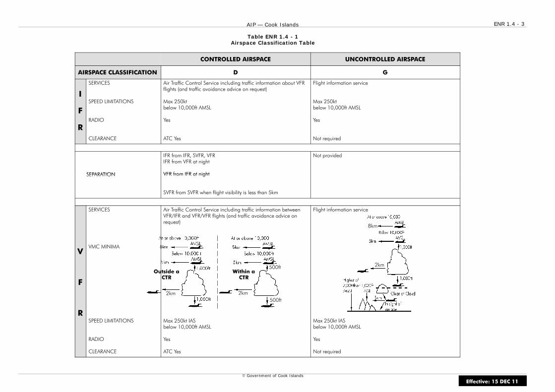
2km 2km500ft
500ftOutside a
CTRWithin a
CTR
ENR 1.4 - 3AIP — Cook Islands
E Government of Cook Islands
Table ENR 1.4 - 1Airspace Classification Table
CONTROLLED AIRSPACE UNCONTROLLED AIRSPACE
AIRSPACE CLASSIFICATION D G
I
F
R
SERVICES
SPEED LIMITATIONS
RADIO
CLEARANCE
Air Traffic Control Service including traffic information about VFRflights (and traffic avoidance advice on request)
Max 250ktbelow 10,000ft AMSL
Yes
ATC Yes
Flight information service
Max 250ktbelow 10,000ft AMSL
Yes
Not required
SEPARATION
IFR from IFR, SVFR, VFRIFR from VFR at night
VFR from IFR at night
Not provided
SEPARATION VFR from IFR at night
SVFR from SVFR when flight visibility is less than 5km
V
F
R
SERVICES
VMC MINIMA
SPEED LIMITATIONS
RADIO
CLEARANCE
Air Traffic Control Service including traffic information betweenVFR/IFR and VFR/VFR flights (and traffic avoidance advice onrequest)
Max 250kt IASbelow 10,000ft AMSL
Yes
ATC Yes
Flight information service
Max 250kt IASbelow 10,000ft AMSL
Yes
Not required
8km
2km
Effective: 15 DEC 11

ENR 1.4 - 4 AIP — Cook Islands
E Government of Cook Islands
Intentionally Blank
Effective: 15 DEC 11

ENR 1.5 - 1AIP — Cook Islands
E Government of Cook Islands
ENR 1.5 HOLDING, APPROACH AND DEPARTUREPROCEDURES
1 HOLDING
1.1 General
1.1.1 The holding, approach and departure procedures in use are basedon those contained in the latest edition of ICAO Doc 8168 — Procedures forAir Navigation Services — Aircraft Operations (PANS-OPS).
1.1.2 The holding and approach procedures in use have been based onthe values and factors contained in Parts III and IV of Vol. I of thePANS-OPS. Holding speeds are shown in Table ENR 1.5 - 1.
Effective: 15 DEC 11
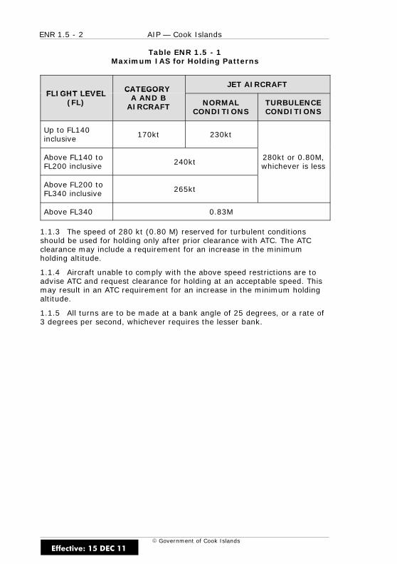
ENR 1.5 - 2 AIP — Cook Islands
E Government of Cook Islands
Table ENR 1.5 - 1Maximum IAS for Holding Patterns
FLIGHT LEVEL CATEGORYJET AIRCRAFT
FLIGHT LEVEL(FL)
CATEGORYA AND B
AIRCRAFT NORMALCONDITIONS
TURBULENCECONDITIONS
Up to FL140inclusive 170kt 230kt
Above FL140 toFL200 inclusive 240kt 280kt or 0.80M,
whichever is less
Above FL200 toFL340 inclusive 265kt
Above FL340 0.83M
1.1.3 The speed of 280 kt (0.80 M) reserved for turbulent conditionsshould be used for holding only after prior clearance with ATC. The ATCclearance may include a requirement for an increase in the minimumholding altitude.
1.1.4 Aircraft unable to comply with the above speed restrictions are toadvise ATC and request clearance for holding at an acceptable speed. Thismay result in an ATC requirement for an increase in the minimum holdingaltitude.
1.1.5 All turns are to be made at a bank angle of 25 degrees, or a rate of3 degrees per second, whichever requires the lesser bank.
Effective: 15 DEC 11

ENR 1.5 - 3AIP — Cook Islands
E Government of Cook Islands
2 STANDARD HOLDING PATTERN
2.1 General
2.1.1 Outbound timing begins at the end of turn or abeam the fix,whichever occurs later.
2.1.2 All procedures depict tracks and pilots should attempt to maintainthe track by making allowance for known wind by applying corrections bothto heading and timing during entry and while flying in the holding pattern.
2.1.3 If the outbound leg length is based on a DME distance the outboundleg terminates as soon as the limiting DME distance is attained. Thestandard holding pattern is shown in Figure ENR 1.5 - 1.
Figure ENR 1.5 - 1Standard Holding Pattern
Effective: 15 DEC 11
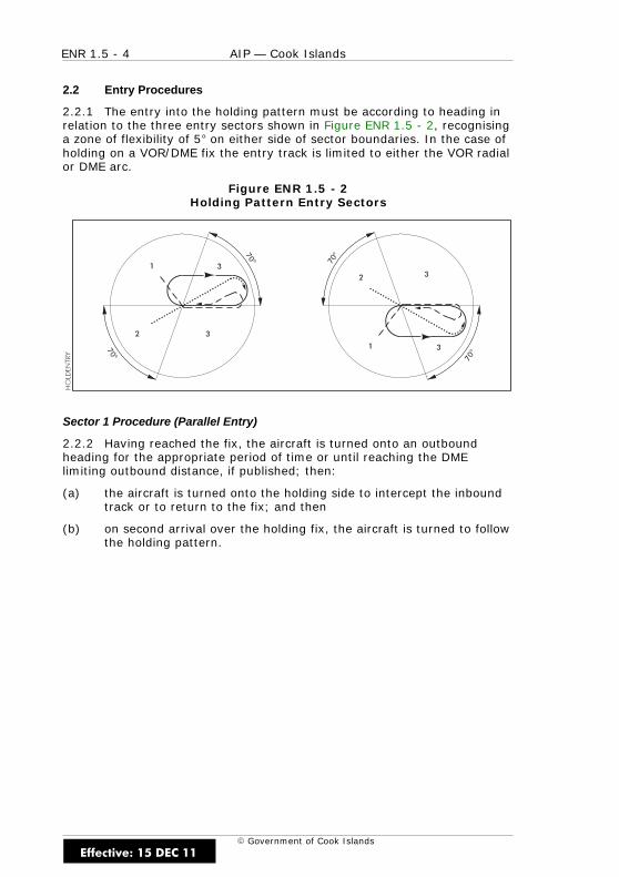
ENR 1.5 - 4 AIP — Cook Islands
E Government of Cook Islands
2.2 Entry Procedures
2.2.1 The entry into the holding pattern must be according to heading inrelation to the three entry sectors shown in Figure ENR 1.5 - 2, recognisinga zone of flexibility of 5 on either side of sector boundaries. In the case ofholding on a VOR/DME fix the entry track is limited to either the VOR radialor DME arc.
Figure ENR 1.5 - 2Holding Pattern Entry Sectors
Sector 1 Procedure (Parallel Entry)
2.2.2 Having reached the fix, the aircraft is turned onto an outboundheading for the appropriate period of time or until reaching the DMElimiting outbound distance, if published; then:
(a) the aircraft is turned onto the holding side to intercept the inboundtrack or to return to the fix; and then
(b) on second arrival over the holding fix, the aircraft is turned to followthe holding pattern.
Effective: 15 DEC 11

ENR 1.5 - 5AIP — Cook Islands
E Government of Cook Islands
Sector 2 Procedure (Offset Entry)
2.2.3 Having reached the fix, the aircraft is turned onto a heading tomake good a track making an angle of 30 from the reciprocal of theinbound track on the holding side; then:
(a) the aircraft will fly outbound:
(i) for the appropriate period of time, or
(ii) until the appropriate limiting DME distance is attained, wheredistance is specified; then
(b) the aircraft is turned to intercept the inbound holding track; then
(c) on second arrival over the holding fix, the aircraft is turned to followthe holding pattern.
Sector 3 Procedure (Direct Entry)
2.2.4 Having reached the fix the aircraft is turned to follow the holdingpattern.
DME Arc Entry
2.2.5 Having reached the fix the aircraft is required to enter the holdingpattern in accordance with either the Sector 1 or Sector 3 entry procedure.
Time/Distance Outbound (Sector 1 and 2 Procedures)
2.2.6 The still time for flying the outbound entry heading should notexceed one minute if at FL140 or below, or one and a half minutes if aboveFL140. Where DME is available, the length of the outbound leg may bespecified and flown in terms of distance instead of time.
Effective: 15 DEC 11

ENR 1.5 - 6 AIP — Cook Islands
E Government of Cook Islands
2.3 Holding Procedures and Time — Still Air Conditions
2.3.1 Having entered the holding pattern, on the second and subsequentarrivals over the fix the aircraft is turned to fly the outbound track.
(a) Continue outbound:
(i) For one minute if at FL140 or below or for one and a halfminutes if above FL140, or
(ii) until the appropriate limiting DME distance is attained, wheredistance is specified; then
(b) turn so as to realign the aircraft on the inbound track.
2.4 Holding Procedures and Timing — Wind Effect
2.4.1 Due allowance must be made by the pilot in heading and timing tocompensate for the effects of wind to ensure the inbound track is regainedbefore passing the holding fix inbound. In making these corrections full useshould be made of the indications available from the aid and estimated orknown wind. The limiting DME distance always terminates the outboundleg.
2.5 Holding Procedures and Timing — Departing the Pattern
2.5.1 When clearance is received specifying the time of departure fromthe holding point, the pilot should adjust the pattern within the limits of theestablished holding procedure in order to leave the holding point at thetime specified.
Effective: 15 DEC 11
ENR 1.5 - 7AIP — Cook Islands
E Government of Cook Islands
2.6 Obstacle Clearance — Holding Area
2.6.1 The holding area includes the basic holding area and the entry area:
(a) The basic holding area at any particular altitude is the airspacerequired at the altitude to encompass a standard holding patternbased on the allowances for the aircraft speed, wind effect, timingerrors, holding fix characteristics, etc.
(b) The entry area includes the airspace required to accommodate thespecified entry procedures.
2.7 Obstacle Clearance — Buffer Area
2.7.1 The buffer area is the area extending 5NM beyond the boundary ofthe holding area within which the height and nature of obstacles are takeninto consideration when determining the minimum holding altitude usablein the holding pattern associated with the holding area.
2.8 Obstacle Clearance — Minimum Holding Altitude
2.8.1 The minimum permissible holding altitude will be based initially on aclearance of at least 1,000ft above obstacles in the holding area. Theminimum value is increased over areas designated as mountainous terrain.
Effective: 15 DEC 11
ENR 1.5 - 8 AIP — Cook Islands
E Government of Cook Islands
2.9 Precautionary Holding
Phraseology and Procedures
2.9.1 To facilitate the provision of procedurally conflict-free flight paths,precautionary holding instructions may be issued to enroute and arrivingflights.
2.9.2 The following phraseology and procedures will be used for domesticoperations (standard holding instructions will be issued to internationalflights).
Phraseology
2.9.3 Examples:
(a) “Descend to FL130 precautionary hold Sea Horse”
(b) “Maintain 7,000ft precautionary hold 25 DME”
Procedure
2.9.4 The precautionary hold:
(a) May be cancelled prior to the aircraft reaching the designatedholding point: “Cancel hold 25 DME”
(b) If not cancelled, will mean the aircraft must join the designatedpattern with an expected onward clearance time/expected approachtime of ATA over the REP plus five minutes.
2.9.5 Onward clearance will be given within the five minutes or a newclearance will be issued.
Note
Although the hold may often be cancelled prior to reaching the aid,cancellation must not be anticipated and normal preparatory action to jointhe holding pattern must be taken.
Effective: 15 DEC 11

ENR 1.5 - 9AIP — Cook Islands
E Government of Cook Islands
3 ARRIVING FLIGHTS
3.1 General
3.1.1 Traffic above FL245 entering the Cook Islands Sector of theAuckland Oceanic FIR arriving at Rarotonga can expect descent clearancewhen traffic permits to FL250 from Auckland Oceanic on HF/VHF. Contactinstructions will be passed on HF prior to FL250.
3.1.2 Traffic below FL245 entering the Cook Islands Sector of theAuckland Oceanic FIR from adjacent airspace, will be advised by ATS on HFcontact instructions prior to the boundary. Rarotonga will provide air trafficservices below FL245 outside controlled airspace within the Cook IslandsSector of the Auckland Oceanic FIR during hours of watch. AucklandOceanic will be responsible for the provision of air traffic services at anytime when Rarotonga Tower is off watch.
3.1.3 To facilitate the provision of procedurally conflict-free flight paths,precautionary holding instructions may be issued to enroute and arrivingflights.
3.1.4 The precautionary hold instruction may be cancelled prior to theaircraft reaching the designated holding point; however, cancellation mustnot be anticipated and normal preparatory action to join the holdingpattern must be taken. If not cancelled, the aircraft must join thedesignated holding pattern with an expected onward clearance time of ATAover the REP plus 5 minutes.
3.1.5 Onward clearance will be given within 5 minutes of ATA over the REPor a new onward clearance time will be issued.
3.1.6 ATC will advise the pilot of an IFR flight the ATC preferred type ofapproach.
3.1.7 Pilots should advise ATC as soon as possible if the nominatedapproach is not acceptable and advise their intentions.
3.2 Aircraft Speed Restrictions
3.2.1 In order to facilitate the control of aircraft, general speedrestrictions are applied in the vicinity of aerodromes and during proceduralmanoeuvres. Such restrictions are applied to conserve airspace, improveseparation and facilitate procedural arrivals and departures.
3.2.2 Aircraft speed shall not exceed 250kt IAS below 10,000ft AMSL.
Effective: 15 DEC 11

ENR 1.5 - 10 AIP — Cook Islands
E Government of Cook Islands
4 APPROACH PROCEDURES
4.1 The Instrument Approach Procedure
4.1.1 This term is used to describe a series of predetermined manoeuvresfor the orderly transfer of an aircraft under instrument flight conditionsfrom the arrival segment of the approach to a landing, or to a point fromwhich a landing can be made.
4.2 Instrument Approach Fixes
4.2.1 Where positive fixes are available on an instrument approachprocedure, either by DME, NDB, VOR or Marker, they may be designated toidentify the segment to be commenced. These are:
(a) initial approach fix (IAF)
(b) intermediate approach fix (IF)
(c) final approach fix (FAF) or final approach point
(d) missed approach point (MAPt)
4.3 Instrument Approach Segments
4.3.1 An instrument approach procedure may be divided into five separatesegments as detailed below. Depending on the type of procedure, all of thefirst three segments need not necessarily be established.
Arrival Segment
4.3.2 That segment of an instrument approach procedure that connectsthe enroute phase to an initial approach fix. An arrival segment mayconsist of published arrival routes.
Initial Approach Segment
4.3.3 That segment of an instrument approach procedure between theinitial approach fix and the intermediate approach fix or where applicablethe final approach fix or point. (The final approach point is the intersectionof the normal glide path and the minimum altitude specified for theprevious segment). The initial approach segment includes any DME arc orreversal procedure.
Effective: 15 DEC 11
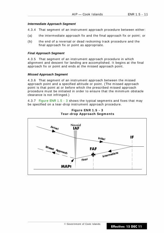
ENR 1.5 - 11AIP — Cook Islands
E Government of Cook Islands
Intermediate Approach Segment
4.3.4 That segment of an instrument approach procedure between either:
(a) the intermediate approach fix and the final approach fix or point; or
(b) the end of a reversal or dead reckoning track procedure and thefinal approach fix or point as appropriate.
Final Approach Segment
4.3.5 That segment of an instrument approach procedure in whichalignment and descent for landing are accomplished. It begins at the finalapproach fix or point and ends at the missed approach point.
Missed Approach Segment
4.3.6 That segment of an instrument approach between the missedapproach point and a specified altitude or point. (The missed approachpoint is that point at or before which the prescribed missed approachprocedure must be initiated in order to ensure that the minimum obstacleclearance is not infringed.)
4.3.7 Figure ENR 1.5 - 3 shows the typical segments and fixes that maybe specified on a tear-drop instrument approach procedure.
Figure ENR 1.5 - 3Tear-drop Approach Segments
Navaid
MAPt
FAF
IF
IAF
Effective: 15 DEC 11
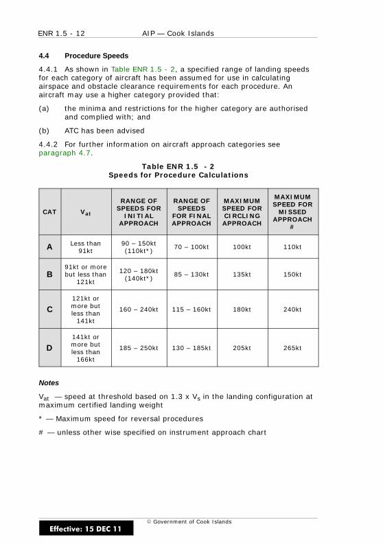
ENR 1.5 - 12 AIP — Cook Islands
E Government of Cook Islands
4.4 Procedure Speeds
4.4.1 As shown in Table ENR 1.5 - 2, a specified range of landing speedsfor each category of aircraft has been assumed for use in calculatingairspace and obstacle clearance requirements for each procedure. Anaircraft may use a higher category provided that:
(a) the minima and restrictions for the higher category are authorisedand complied with; and
(b) ATC has been advised
4.4.2 For further information on aircraft approach categories seeparagraph 4.7.
Table ENR 1.5 - 2Speeds for Procedure Calculations
CAT Vat
RANGE OFSPEEDS FOR
INITIALAPPROACH
RANGE OFSPEEDS
FOR FINALAPPROACH
MAXIMUMSPEED FORCIRCLING
APPROACH
MAXIMUMSPEED FOR
MISSEDAPPROACH
#
A Less than91kt
90 – 150kt(110kt*)
70 – 100kt 100kt 110kt
B91kt or morebut less than
121kt
120 – 180kt(140kt*)
85 – 130kt 135kt 150kt
C121kt ormore butless than
141kt
160 – 240kt 115 – 160kt 180kt 240kt
D141kt ormore butless than
166kt
185 – 250kt 130 – 185kt 205kt 265kt
Notes
Vat — speed at threshold based on 1.3 x Vs in the landing configuration atmaximum certified landing weight
* — Maximum speed for reversal procedures
# — unless other wise specified on instrument approach chart
Effective: 15 DEC 11
ENR 1.5 - 13AIP — Cook Islands
E Government of Cook Islands
4.5 Minima
Non-Precision Approach
4.5.1 Straight-in and circling minimum descent altitude (MDA) is aspecified altitude below which descent may not be made without visualreference. When visual reference has been established on a circlingapproach, descent below MDA is at the discretion of the pilot provided that:
(a) visual reference can be maintained throughout the circlingapproach; and
(b) the landing threshold or approach lights or other markingidentifiable with the approach end of the runway are visible; and
(c) the required obstacle clearance can be maintained to a positionfrom where the remaining flight path distance to the intendedtouch-down point will allow a constant rate of descent.
4.5.2 MDA ensures compliance with the required obstacle clearancecriteria and where applicable it includes a margin based on operationalconsiderations of ground and airborne equipment characteristics, aircraftperformance, meteorological conditions, aerodrome characteristics, locationof guidance aids relative to the runway and mountainous terrain. Operatorsmay wish to increase the MDA to account for pilot qualifications andexperience.
Note
For a straight-in approach, the angle formed by the final approach track onthe runway centreline may be as much as 30 degrees.
Effective: 15 DEC 11
ENR 1.5 - 14 AIP — Cook Islands
E Government of Cook Islands
Precision Approach
4.5.3 Decision altitude (DA) is a specified altitude in the precisionapproach at which a missed approach must be initiated if the requiredvisual reference to continue the approach has not been established.
4.5.4 The required visual reference means that section of the visual aids,or of the approach area, which should have been in view for sufficient timefor the pilot to have made an assessment of the aircraft position and rateof change of position in relation to the desired flight path.
4.5.5 Decision altitude ensures compliance with the appropriate obstacleclearance criteria and where applicable, includes a margin based onoperational considerations of ground and airborne equipmentcharacteristics, aircraft performance, meteorological conditions, aerodromecharacteristics and altimetry. Operators may wish to increase the DA toaccount for pilot qualifications and experience.
4.6 Application of Minima
Minimum Descent Altitude (MDA)
4.6.1 If at MDA any element of the aerodrome meteorological minima isbelow that prescribed, the pilot is to maintain MDA until not later than thedesignated missed approach point is reached and then initiate the missedapproach procedure.
Decision Altitude (DA)
4.6.2 If at DA the required visual reference to continue the approach hasnot been established, the pilot must initiate the missed approach procedureimmediately.
Effective: 15 DEC 11
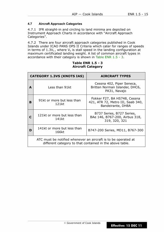
ENR 1.5 - 15AIP — Cook Islands
E Government of Cook Islands
4.7 Aircraft Approach Categories
4.7.1 IFR straight-in and circling to land minima are depicted onInstrument Approach Charts in accordance with “Aircraft ApproachCategories”.
4.7.2 There are four aircraft approach categories published in CookIslands under ICAO PANS OPS II Criteria which cater for ranges of speedsin terms of 1.3VS , where VS is stall speed in the landing configuration atmaximum certificated landing weight. A list of common aircraft types inaccordance with their category is shown in Table ENR 1.5 - 3.
Table ENR 1.5 - 3Aircraft Category
CATEGORY 1.3VS (KNOTS IAS) AIRCRAFT TYPES
A Less than 91ktCessna 402, Piper Seneca,
Britten Norman Islander, DHC6,PA31, Navajo
B 91kt or more but less than121kt
Fokker F27, BA HS748, Cessna421, ATR 72, Metro III, Saab 340,
Bandeirante, DH8A
C 121kt or more but less than141kt
B737 Series, B727 Series,BAe 146, B767-200, Airbus 318,
319, 320, 321
D 141kt or more but less than166kt B747-200 Series, MD11, B767-300
ATC must be notified whenever an aircraft is to be operated atdifferent category to that contained in the above table.
Effective: 15 DEC 11
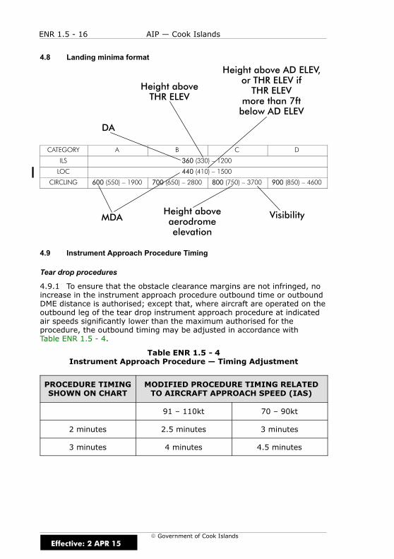
Height aboveTHR ELEV
DA
Height above AD ELEV,or THR ELEV ifTHR ELEV
more than 7ftbelow AD ELEV
VisibilityHeight aboveaerodromeelevation
MDA
ENR 1.5 - 16 AIP — Cook Islands
E Government of Cook Islands
4.8 Landing minima format
CATEGORY A B C D
ILS 360 (330) – 1200
LOC 440 (410) – 1500
CIRCLING 600 (550) – 1900 700 (650) – 2800 800 (750) – 3700 900 (850) – 4600
4.9 Instrument Approach Procedure Timing
Tear drop procedures
4.9.1 To ensure that the obstacle clearance margins are not infringed, noincrease in the instrument approach procedure outbound time or outboundDME distance is authorised; except that, where aircraft are operated on theoutbound leg of the tear drop instrument approach procedure at indicatedair speeds significantly lower than the maximum authorised for theprocedure, the outbound timing may be adjusted in accordance withTable ENR 1.5 - 4.
Table ENR 1.5 - 4Instrument Approach Procedure — Timing Adjustment
PROCEDURE TIMINGSHOWN ON CHART
MODIFIED PROCEDURE TIMING RELATEDTO AIRCRAFT APPROACH SPEED (IAS)
91 – 110kt 70 – 90kt
2 minutes 2.5 minutes 3 minutes
3 minutes 4 minutes 4.5 minutes
Effective: 2 APR 15
ENR 1.5 - 17AIP — Cook Islands
E Government of Cook Islands
4.9.2 Outbound time or DME distance may be shortened, provided thatthe wind velocity at the relevant altitudes has been confirmed by animmediately preceding instrument approach to the effect that minimumaltitude may be reached at an acceptable descent rate during finalapproach.
4.10 Position Reporting During Instrument Approach at aControlled Aerodrome
4.10.1 Unless otherwise instructed by ATC, aircraft cleared to make aninstrument approach must report:
(a) When overhead the navigation aid prior to commencing reversalturn.
(b) When overhead the navigation aid outbound commencing initialapproach.
(c) When established on DME arc.
(d) When commencing procedure or base turn leading tointermediate/final approach.
(e) When established on Intermediate/final approach
(f) When the ground or water becomes continually visible and flight byinstruments is no longer required (i.e.“Visual”).
(g) When commencing missed approach.
4.11 Visual Approach — Controlled Airspace
4.11.1 IFR flights in controlled airspace may be cleared for visualapproaches provided the pilot:
(a) specifically states “REQUEST VISUAL APPROACH”, and
(b) can maintain visual reference to the terrain, and
(c) the reported ceiling is not below the approved initial approach levelfor the aircraft so cleared; or
(d) the pilot reports, at the initial approach level or at any time duringthe instrument approach procedure, that the meterologicalconditions will permit a visual approach and that there is areasonable assurance that the landing can be accomplished.
4.11.2 An aircraft operating under IFR and making a visual approachremains an IFR flight and is subject to ATC clearances for the purpose ofproviding separation.
Effective: 15 DEC 11
ENR 1.5 - 18 AIP — Cook Islands
E Government of Cook Islands
4.11.3 When cleared by ATC for a visual approach further descent isunrestricted except when a specific restriction or requirement is includedwith the clearance for a visual approach or is included in a subsequentclearance. Any ATC altitude restriction remains in force until specificallycancelled. As well, ATC may require a pilot to position by reference togeographic features.
4.11.4 ATC may nominate a visual approach by day only, when the visibilityis at least 16km and the ceiling is at least 1,000ft above the applicableinstrument approach procedure commencement altitude.
4.11.5 If visual reference to terrain is established before completion of aninstrument approach procedure, the entire procedure must nevertheless beexecuted unless the pilot requests and is cleared for a visual approach.
4.11.6 For a visual approach at night, it is essential that the pilot has therunway lights in sight. Sighting only of the aerodrome beacon, REIL’s,circling guidance lights or approach lights is insufficient.
4.12 Visual Approach — Uncontrolled Airspace
4.12.1 Pilots in uncontrolled airspace may carry out a visual approachprovided the pilot has the aerodrome in sight, can maintain visualreference and:
(a) the ceiling is not below the initial approach level; or
(b) the pilot has reasonable assurance at the initial approach level or atany time during the instrument approach procedure that themeterological conditions will permit a visual approach and landing tobe accomplished.
Effective: 15 DEC 11
ENR 1.5 - 19AIP — Cook Islands
E Government of Cook Islands
4.13 Visual Reference—Descent BelowMinimumAltitude or MinimumDescentAltitude
4.13.1 Pilots carrying out an instrument approach may continue descentbelow minimum altitude, minimum descent altitude or decision altitude,provided:
(a) by day, continuous visual reference with the ground along the flightpath has been established and can be maintained; and
(b) by night, the circling guidance lighting and/or approach lighting andaerodrome lighting is in sight and can be maintained.
(c) the visibility is equal to or greater than that prescribed for theprocedure; and
(d) the aircraft is in a position from which a descent to a landing on theintended runway can be made using normal manoeuvres anddescent rates to the touchdown zone.
4.14 Visual Segment Surface (VSS)
4.14.1 A surface applicable to instrument approach procedures withstraight-in minima only. Its purpose is to protect the visual component ofan instrument flight from the point where the obstacle clearance height isreached until landing.
4.14.2 VSS originates at a point 60m from the landing threshold, atthreshold height, has a slope 1.12° below the promulgated approach angle,and ends where the surface reaches the MDA or DA.
4.14.3 Obstacles less than 15m above the threshold are ignored; higherobstacles penetrating the VSS are to be removed or require an aeronauticalstudy, which may result in an increased approach angle, displacedthreshold, or other acceptable mitigating action.
4.15 Unattended Aerodromes — QNH Source
4.15.1 The MDA for an instrument approach at an aerodrome is calculatedon the assumption that an accurate QNH is available at that aerodrome. Toreflect this, most instrument approach charts are annotated with the QNHinstruction:
“Use (LOCAL) QNH”
Effective: 31 MAR 16
ENR 1.5 - 20 AIP — Cook Islands
E Government of Cook Islands
Use of Remote QNH
4.15.2 If an accurate QNH is not available from an unattended aerodrome,the QNH from another aerodrome may be used, but a correction must bemade to the promulgated MDA as follows:
(a) Add 5ft to the MDA for every 1 NM in excess of 5 NM from thesource of the QNH.
When Use of Remote QNH is Not Authorised
4.15.3 At some aerodromes, because of the non-homogeneous nature ofweather conditions in mountainous terrain, a remote QNH setting must notbe used for determining MDA or DA. At these locations, if the local QNH isnot available, the approach cannot be used. At such aerodromes the QNHinstructions will state:
“Use (LOCAL) QNH only”
4.15.4 Remote QNH is not to be used when flying RNAV (RNP) approaches.If the local QNH is not available, the approach cannot be used. On suchapproaches the QNH instructions will state:
“Use (LOCAL) QNH only”
4.15.5 Remote QNH is not to be used when flying RNAV approaches withbarometric vertical path guidance (Baro-VNAV), that is to LNAV/VNAVminima. The LNAV/VNAV minima entry will be annotated:
“Use of remote QNH NA”.
4.16 IFR Arrival Procedures — Unattended Aerodromes
4.16.1 Pilots carrying out an instrument approach at an aerodrome that isunattended are required to follow the RTF procedures for unattendedaerodromes.
4.16.2 It is important that the minimum altitude is not infringed and flightto the aerodrome is not continued unless the pilot is satisfied thatintegration with circuit traffic operating in flight visibilities down to 1500mcan be achieved. Where traffic confliction is likely, descent in IMC should berestricted to 1200ft above aerodrome elevation.
4.16.3 When a non-DME instrument approach is being carried out at anuncontrolled aerodrome, MDA should be attained as soon as possible afterthe end of base turn, as VFR aircraft may be operating close to the cloudbase in the vicinity of the aerodrome and approach aid.
4.16.4 Pilots of aircraft operating on an IFR flight plan and executing aninstrument approach are reminded that in terminating the instrumentapproach for landing they are initiating visual flight in uncontrolled airspaceand the rules applicable to such operations apply.
Effective: 15 SEP 16

ENR 1.5 - 21AIP — Cook Islands
E Government of Cook Islands
4.17 RNAV/Baro-VNAV Approach Procedures
4.17.1 LNAV/VNAV minima will be shown only in cases where the procedurehas been evaluated using PANS-OPS Baro-VNAV criteria.
4.17.2 Use of LNAV/VNAV minima is authorised only if the aircraft isequipped with an approved navigation system which presents to the pilotcomputed vertical guidance referenced to the promulgated vertical pathangle (VPA).
4.17.3 Use of LNAV/VNAV minima is not authorised using remote QNH.
4.17.4 Published LNAV/VNAV minima will always include a note in theminima box regarding the applicable minimum temperature to which theuse of the minima is authorised. If aerodrome temperature drops below thepublished minimum, LNAV shall apply.
4.17.5 RNAV (RNP) approaches are procedures with vertical guidance andrequire VNAV guidance systems. RNAV (RNP) approaches require specialauthorisation and are only available to approved operators.
4.17.6 Use of RNAV (RNP) minima is not authorised using remote QNH.
4.17.7 Published RNAV (RNP) minima will always include a note regardingthe applicable minimum and maximum temperatures to which theapproach can be used. If the aerodrome temperature is outside thepublished range, the approach cannot be used.
Effective: 31 MAR 16
ENR 1.5 - 22 AIP — Cook Islands
E Government of Cook Islands
5 DEPARTING FLIGHTS
5.1 General
5.1.1 Aircraft departing from Rarotonga for levels above FL245 can expecttheir ATC clearance via Rarotonga Tower prior to start. HF contactinstructions will be passed on by Rarotonga Tower after departure. Duringhours of watch Rarotonga will provide air traffic services below FL245outside controlled airspace within the Cook Islands Sector of the AucklandOceanic FIR.
5.1.2 Detailed instructions with regard to routes, turns, etc. may beissued prior to or after take-off.
5.1.3 Published departure procedures provide routing to avoid most highterrain which may be relatively close to the aerodrome. Where this is notpossible minimum set heading altitudes or visual segments will beprescribed. In emergency circumstances, however, terrain clearance cannotbe guaranteed under all conditions of operation, due to aircraftperformance.
5.1.4 The pilot-in-command must consider the one engine inoperativeclimb performance of the aircraft in relation to the height of terrain overwhich the climb is planned. Where adequate terrain clearance in IMC underthe ambient conditions cannot be ensured it must be determined beforedeparture that, in the event of engine failure prior to reaching MSA, or thelevel acceleration altitude, adequate action can be taken to protect theaircraft. It is expected that this action will normally involve a turn to climbout over the sea until either MSA is reached or approval is granted for are-join for approach and landing.
5.1.5 Departure procedures may consist of:
(a) A standard instrument departure procedure (SID)
(b) Departure climbing above DME steps
(c) By day only, having due regard to prevailing MET conditions, avisual departure maintaining own terrain clearance to route MSA orset heading point and altitude
(d) A specified track
5.1.6 Aircraft are to intercept the specified departure track by the shortestpractical means after take-off, unless otherwise promulgated in theappropriate departure procedure.
5.1.7 Where no departure procedures are promulgated for a route, thepilot-in-command is to ensure that the climb performance of the aircraft isadequate for providing terrain clearance prior to reaching minimum safealtitude.
Effective: 31 MAR 16

ENR 1.5 - 23AIP — Cook Islands
E Government of Cook Islands
5.2 Standard Instrument Departure (SID)
5.2.1 Standard Instrument Departures (SID) are used to standardisedeparture instructions, reduce the possibility of RTF congestion, reduce thechance of error in aircraft routing and provide a positive routing for aircraftsuffering communications failure.
5.2.2 The SID provides in both diagrammatic and narrative form thedirection of turn, headings, track and in some cases altitude requirements.Where tracking to or from a navigation aid is not possible, desired tracksare shown and due allowance for wind is to be made. Aircraft are tocontinue climbing throughout the SID unless otherwise instructed.
5.2.3 SID’s are identified by departure runway, and direction ofdestination.
5.2.4 All departure procedures including SID’s, designed to ICAO PANS-OPS II criteria, portray the minimum net climb gradient to achieve thedesigned obstacle clearance margins for the desired tracks to be flown.
5.2.5 Operators or pilots should establish procedures to ensurecompliance with the SID.The application of a performance margin on thepublished climb requirements is at the operator’s/pilot’s discretion takinginto account the achievable climb performance of the aircraft and themeans of monitoring the gradient achieved.
5.2.6 When it is not possible to nominate a specified SID, ATC will issueany required departure instructions in plain language.
5.3 IFR Alternate Aerodrome Minima
5.3.1 Rarotonga RNAV (GNSS) Instrument approach charts RWY 08/26are available for alternate use. Apply requirements of NZ CAR Part 91.405accordingly.
Effective: 31 MAR 16

ENR 1.5 - 24 AIP — Cook Islands
E Government of Cook Islands
IntentionallyBlank
Effective: 31 MAR 16
ENR 1.6 - 1AIP — Cook Islands
E Government of Cook Islands
ENR 1.6 RADAR SERVICES AND PROCEDURES
1 SERVICES
1.1 General
1.1.1 Nil.
Effective: 15 DEC 11

ENR 1.6 - 2 AIP — Cook Islands
E Government of Cook Islands
IntentionallyBlank
Effective: 15 DEC 11
ENR 1.7 - 1AIP — Cook Islands
E Government of Cook Islands
ENR 1.7 ALTIMETER SETTING PROCEDURES
1 INTRODUCTION
1.1 General
1.1.1 The altimeter setting procedures in use in Cook Islands generallyconform to those contained in ICAO Doc 8168, Vol. I, Part 6 and are givenin full below.
1.1.2 QNH reports and temperature information for use in determiningadequate terrain clearance are provided by the ATS unit (aerodromecontrol tower or flight service station) serving the aerodrome during itshours of watch. QNH values are given in hectopascals, rounded down tothe nearest whole hectopascal.
1.1.3 For altimeter setting procedures within the Auckland Oceanic FIR,refer to AIP — New Zealand.
2 BASIC ALTIMETER SETTING PROCEDURES
2.1 General
2.1.1 The transition altitude in the Cook Sector is 13,000ft, and thetransition level is FL150.
2.1.2 Vertical positioning of aircraft when at or below the transitionaltitude is expressed in terms of altitude, whereas such positioning at orabove the transition level is expressed in terms of flight levels. Whilepassing through the transition layer, vertical positioning is expressed interms of altitude when descending and in terms of flight levels whenascending. Within the Cook Sector of the Auckland Oceanic FIR, thetransition layer between 13,000ft and FL150, can only be used forascending and descending, or for cruising provided the aircraft has ATSapproval.
2.1.3 The transition layer between the transition altitude of 13,000ft andthe transition level of FL150 provides adequate separation between aircraftusing a zone QNH setting and aircraft operating on the standard pressurevalue (1013 hPa) when the QNH is above 980 hPa. However, when a zoneQNH is 980 hPa or lower, the lowest usable flight level above the QNH zoneshall be FL160.
2.1.4 Flight level zero is located at the atmospheric pressure level of1013.2 hPa. Consecutive flight levels are separated by a pressure intervalcorresponding to 500ft in the standard atmosphere.
Effective: 2 APR 15

ENR 1.7 - 2 AIP — Cook Islands
E Government of Cook Islands
2.1.5 Examples of the relationship between flight levels and altimeterindications are given in Table ENR 1.7 - 1.
Table ENR 1.7 - 1Flight Level and Altimeter Indications
FLIGHT LEVEL(NUMBER)
ALTIMETER INDICATION(FT)
10 1,000
15 1,500
20 2,000
50 5,000
100 10,000
150 15,000
200 20,000
2.1.6 A QNH altimeter setting is made available to aircraft in departureinformation prior to start-up.
2.1.7 Aircraft required to maintain vertical position by reference to a QNHaltimeter setting must use the appropriate area QNH for flight at or belowthe transition altitude except that the appropriate aerodrome QNH must beused for:
(a) take-off, landing and flight within an aerodrome traffic circuit;
(b) the intermediate and final approach of an instrument approachprocedure;
(c) flight in a CTR.
2.1.8 Vertical positioning of aircraft during climb is expressed in terms ofaltitudes until reaching the transition altitude above which verticalpositioning is expressed in terms of flight levels.
2.1.9 Within the Cook Sector of the Auckland Oceanic FIR, aircraftoperating at or below the transition altitude must maintain vertical positionby reference to the appropriate zone QNH, except that aircraft taking off oroperating within a CTR must use the appropriate aerodrome QNH.
Effective: 2 APR 15
ENR 1.7 - 3AIP — Cook Islands
E Government of Cook Islands
2.2 Take-off and Climb
2.2.1 Aircraft departing from an aerodrome where no QNH value isavailable are required to set the aerodrome elevation on the altimeter priorto departure and obtain the appropriate altimeter setting as soon aspossible, and in any case, before entering instrument meteorologicalconditions.
2.3 Vertical Separation — Enroute
2.3.1 Vertical separation during enroute flight shall be expressed in termsof flight levels, or in terms of altitudes for aircraft at or below the transitionaltitude in a defined Area QNH Zone.
2.3.2 IFR flights, and VFR flights above 3,000ft, when in level cruisingflight shall be flown at such altitudes or flight levels, corresponding to themagnetic tracks shown in Table ENR 1.7 - 3, so as to provide the requiredterrain clearance.
Note
Some of the lower levels in Table ENR 1.7 - 3 may not be usable due toterrain clearance requirements.
2.4 Approach and Landing
2.4.1 A QNH altimeter setting is made available to inbound flights inarrival information by the unit providing approach control service. A QNHaltimeter setting is also made available in any clearance to enter the trafficcircuit.
2.5 QFE Altimeter Settings
2.5.1 QFE altimeter settings are not available.
2.6 Missed Approach
2.6.1 The relevant portions of 2.1, 2.2 and 2.4 shall be applied in theevent of a missed approach.
Effective: 2 APR 15
ENR 1.7 - 4 AIP — Cook Islands
E Government of Cook Islands
3 DESCRIPTION OF AREA QNH ZONES
3.1 General
3.1.1 There is one Area QNH Zone in the Cook Sector as shown in Table ENR1.7 - 2.
Table ENR 1.7 - 2Area QNH Zones
NAME DESCRIPTION
RAROTONGA
All that airspace within the lateral limits ofthe Rarotonga CTA.
Upper limit: 13,000ft AMSLLower limit: Surface
4 PROCEDURES APPLICABLE TO OPERATORS (INCLUDING PILOTS)
4.1 Flight Planning
4.1.1 The levels at which a flight is to be conducted shall be specified in aflight plan:
(a) in terms of flight levels if the flight is to be conducted at or abovethe transition level, or at any level over the high seas;
(b) in terms of altitudes if the flight is to be conducted within theRarotonga Area QNH Zone; or
(c) as “VFR” if the flight is to be conducted in accordance with thevisual flight rules.
Effective: 2 APR 15
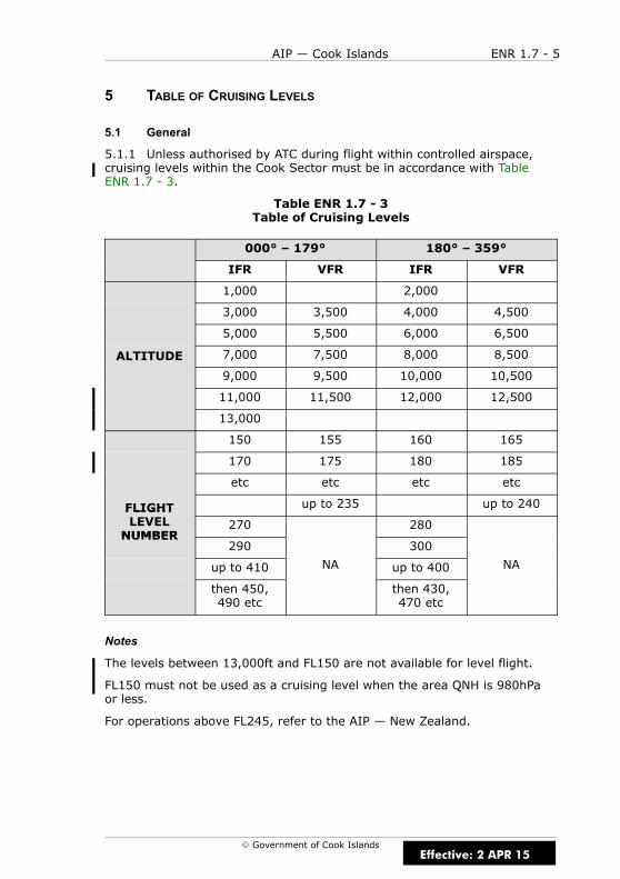
ENR 1.7 - 5AIP — Cook Islands
E Government of Cook Islands
5 TABLE OF CRUISING LEVELS
5.1 General
5.1.1 Unless authorised by ATC during flight within controlled airspace,cruising levels within the Cook Sector must be in accordance with TableENR 1.7 - 3.
Table ENR 1.7 - 3Table of Cruising Levels
000° – 179° 180° – 359°
IFR VFR IFR VFR
1,000 2,000
3,000 3,500 4,000 4,500
5,000 5,500 6,000 6,500
ALTITUDE 7,000 7,500 8,000 8,500
9,000 9,500 10,000 10,500
11,000 11,500 12,000 12,500
13,000
150 155 160 165
170 175 180 185
etc etc etc etc
FLIGHT up to 235 up to 240FLIGHTLEVELNUMBER
270 280NUMBER
290 300
up to 410 NA up to 400 NA
then 450,490 etc
then 430,470 etc
Notes
The levels between 13,000ft and FL150 are not available for level flight.
FL150 must not be used as a cruising level when the area QNH is 980hPaor less.
For operations above FL245, refer to the AIP — New Zealand.
Effective: 2 APR 15

ENR 1.7 - 6 AIP — Cook Islands
E Government of Cook Islands
IntentionallyBlank
Effective: 15 DEC 11

ENR 1.8 - 1AIP — Cook Islands
E Government of Cook Islands
ENR 1.8 REGIONAL SUPPLEMENTARY PROCEDURES
1 INTRODUCTION
1.1 General
1.1.1 Nil.
Effective: 15 DEC 11

ENR 1.8 - 2 AIP — Cook Islands
E Government of Cook Islands
IntentionallyBlank
Effective: 15 DEC 11

ENR 1.9 - 1AIP — Cook Islands
E Government of Cook Islands
ENR 1.9 AIR TRAFFIC FLOW MANAGEMENT (ATFM)
1 INTRODUCTION
1.1 General
1.1.1 Nil.
Effective: 15 DEC 11

ENR 1.9 - 2 AIP — Cook Islands
E Government of Cook Islands
IntentionallyBlank
Effective: 15 DEC 11
ENR 1.10 - 1AIP — Cook Islands
E Government of Cook Islands
ENR 1.10 FLIGHT PLANNING (RESTRICTION, LIMITATIONOR ADVISORY INFORMATION)
1 PROCEDURES FOR THE SUBMISSION OF A FLIGHT PLAN
1.1 General
1.1.1 A flight plan shall be submitted in accordance with ICAO Annex 2,3.3.1, prior to operating:
(a) any IFR flight
(b) any VFR flight (including special VFR and controlled VFR flights) inthe Cook Islands Sector
(c) any flight within an aerodrome traffic circuit when an ATC service isbeing provided.
1.2 Time of Submission
1.2.1 Except for repetitive flight plans, a flight plan shall be submitted atleast 30 minutes prior to departure, taking into account the requirementsof ATS units in the airspace along the route to be flown for timelyinformation.
1.3 Place of Submission
1.3.1 All flight plans shall be submitted to the Rarotonga ATS Unit.
1.3.2 During hours of watch and subject to workload, a flight plan may besubmitted by RTF.
1.4 Contents and Form of a Flight Plan
1.4.1 ICAO Flight Plan forms are available at Rarotonga ATS Unit. Theinstructions for completing those forms shall be followed. For thecompletion of the ICAO Flight Plan Form see section 1.6.
1.4.2 Flight plans concerning international IFR flights along ATS routesneed to include FIR-boundary estimates.
1.4.3 When a flight plan is submitted by telephone or facsimile, thesequence of items in the flight plan shall be strictly followed.
1.5 Adherence to ATS Route Structure
1.5.1 All flight plans shall be submitted for published ATS routes. Wherethis is not possible for the entire flight or any portion thereof, the relevantparts of the instructions for completing a flight plan shall be followed.
Effective: 15 DEC 11
ENR 1.10 - 2 AIP — Cook Islands
E Government of Cook Islands
1.6 Completing the ICAO Flight Plan Form
1.6.1 Adhere to the prescribed formats and manner of specifying data asfollows:
(a) commence inserting data in the first place provided
(b) where excess space is available leave unused spaces blank
(c) insert all clock times in 4 figures UTC
(d) insert all estimated elapsed times in 4 figures (hours and minutes)
(e) areas preceding Item 3 are for ATS use
Instructions for Insertion of Data
1.6.2 Complete Items 7 to 19 as indicated in the following sections.
Note
Item numbers on the form are not consecutive, as they correspond to FieldType numbers in ATS messages.
ITEM 7: AIRCRAFT IDENTIFICATION (MAXIMUM 7 CHARACTERS)
1.6.3 INSERT one of the following aircraft identifications, not exceeding 7characters:
(a) the registration marking of the aircraft (e.g. 5W ABC5, N1234D),when in radiotelephony the call sign to be used by the aircraft willconsist of this identification alone (e.g. 5W ABC5), or preceded bythe ICAO telephony designator for the aircraft operating agency(e.g. AIRFLIGHT 5W ABC5);
OR
(b) the ICAO designator for the aircraft operating agency followed bythe flight identification (AFT12, SAM710) when in radiotelephony thecall sign to be used by the aircraft will consist of the ICAO telephonydesignator for the operating agency followed by the flightidentification (AIRFLIGHT12, SAMOA 710).
Effective: 15 DEC 11
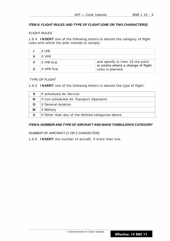
ENR 1.10 - 3AIP — Cook Islands
E Government of Cook Islands
ITEM 8: FLIGHT RULES AND TYPE OF FLIGHT (ONE OR TWO CHARACTERS)
FLIGHT RULES
1.6.4 INSERT one of the following letters to denote the category of flightrules with which the pilot intends to comply:
I if IFR
V if VFR
Y if IFR first and specify in Item 15 the pointor points where a change of flight
Z if VFR firstor points where a change of flightrules is planned.
TYPE OF FLIGHT
1.6.5 INSERT one of the following letters to denote the type of flight:
S if scheduled Air Service
N if non-scheduled Air Transport Operation
G if General Aviation
M if Military
X if Other than any of the defined categories above.
ITEM 9: NUMBER AND TYPE OF AIRCRAFT AND WAKE TURBULENCE CATEGORY
NUMBER OF AIRCRAFT (1 OR 2 CHARACTER)
1.6.6 INSERT the number of aircraft, if more than one.
Effective: 15 DEC 11
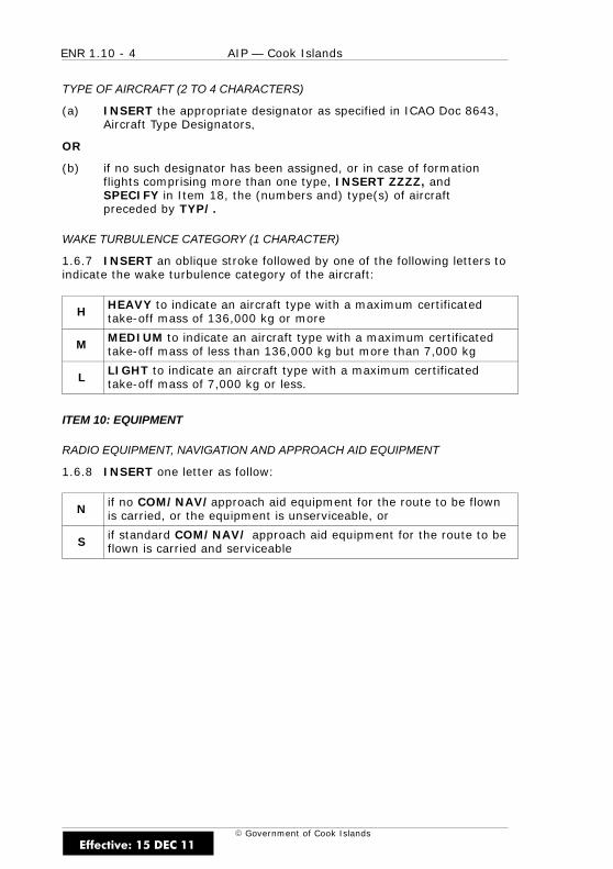
ENR 1.10 - 4 AIP — Cook Islands
E Government of Cook Islands
TYPE OF AIRCRAFT (2 TO 4 CHARACTERS)
(a) INSERT the appropriate designator as specified in ICAO Doc 8643,Aircraft Type Designators,
OR
(b) if no such designator has been assigned, or in case of formationflights comprising more than one type, INSERT ZZZZ, andSPECIFY in Item 18, the (numbers and) type(s) of aircraftpreceded by TYP/.
WAKE TURBULENCE CATEGORY (1 CHARACTER)
1.6.7 INSERT an oblique stroke followed by one of the following letters toindicate the wake turbulence category of the aircraft:
H HEAVY to indicate an aircraft type with a maximum certificatedtake-off mass of 136,000 kg or more
M MEDIUM to indicate an aircraft type with a maximum certificatedtake-off mass of less than 136,000 kg but more than 7,000 kg
L LIGHT to indicate an aircraft type with a maximum certificatedtake-off mass of 7,000 kg or less.
ITEM 10: EQUIPMENT
RADIO EQUIPMENT, NAVIGATION AND APPROACH AID EQUIPMENT
1.6.8 INSERT one letter as follow:
N if no COM/NAV/approach aid equipment for the route to be flownis carried, or the equipment is unserviceable, or
S if standard COM/NAV/ approach aid equipment for the route to beflown is carried and serviceable
Effective: 15 DEC 11

ENR 1.10 - 5AIP — Cook Islands
E Government of Cook Islands
1.6.9 AND/OR INSERT one or more of the following letters to indicatethe COM/NAV/ approach aid equipment available and serviceable:
A LORAN A M Omega
B (Not allocated) O VOR
C LORAN C P Doppler
D DME Q (Not allocated)
E Decca R RNP type certification orRNAV route equipment
F ADF T TACAN
G GMSS (see note U UHF RTF
H HF RTF V VHF RTF
I Inertial Navigation W
J Data link X when prescribed by ATS
K (Not allocated) Y
p b d by
L ILS Z Other equipment carriedL ILS Z Other equipment carried
Notes
For flight planning purposes, standard COM/NAV equipment(s) isconsidered to be VHF RTF, ADF, Transponder Mode A or C, VOR, DME andILS.
If the Z is used, specify in Item 18 the other equipment carried, precededby COM/ and/or NAV/, as appropriate.
If the letter J is used, specify in Item 18 the equipment carried, precededby DAT/ followed by one or more letters as appropriate. Refer to Item 18.
Information on navigation capability is provided to ATC for clearance androuting purposes.
Inclusion of the letter R indicates that an aircraft meets the RNP typeprescribed for the route segment(s), route(s) or area concerned.
Inclusion of the letter G indicates that an aircraft meets the conditions andrequirements for the use of GNSS (GPS or GLONASS) equipment.
Effective: 15 DEC 11
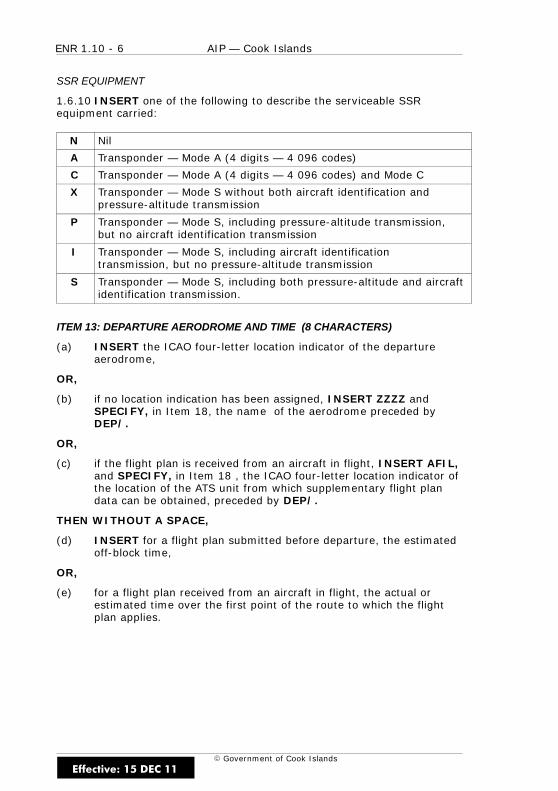
ENR 1.10 - 6 AIP — Cook Islands
E Government of Cook Islands
SSR EQUIPMENT
1.6.10 INSERT one of the following to describe the serviceable SSRequipment carried:
N Nil
A Transponder — Mode A (4 digits — 4 096 codes)
C Transponder — Mode A (4 digits — 4 096 codes) and Mode C
X Transponder — Mode S without both aircraft identification andpressure-altitude transmission
P Transponder — Mode S, including pressure-altitude transmission,but no aircraft identification transmission
I Transponder — Mode S, including aircraft identificationtransmission, but no pressure-altitude transmission
S Transponder — Mode S, including both pressure-altitude and aircraftidentification transmission.
ITEM 13: DEPARTURE AERODROME AND TIME (8 CHARACTERS)
(a) INSERT the ICAO four-letter location indicator of the departureaerodrome,
OR,
(b) if no location indication has been assigned, INSERT ZZZZ andSPECIFY, in Item 18, the name of the aerodrome preceded byDEP/.
OR,
(c) if the flight plan is received from an aircraft in flight, INSERT AFIL,and SPECIFY, in Item 18 , the ICAO four-letter location indicator ofthe location of the ATS unit from which supplementary flight plandata can be obtained, preceded by DEP/.
THEN WITHOUT A SPACE,
(d) INSERT for a flight plan submitted before departure, the estimatedoff-block time,
OR,
(e) for a flight plan received from an aircraft in flight, the actual orestimated time over the first point of the route to which the flightplan applies.
Effective: 15 DEC 11

ENR 1.10 - 7AIP — Cook Islands
E Government of Cook Islands
ITEM 15: ROUTE
1.6.11 INSERT the first cruising speed as in (a)(i) and the flight cruisinglevel as in (d)(i), without a space between them.
THEN,
(a) following the arrow, INSERT the route description as in (i).
(i) CRUISING SPEED (MAXIMUM 5 CHARACTERS)
(b) INSERT the True Air Speed for the first or the whole cruisingportion of the flight, in terms of:
(c) Knots, expressed as N followed by 4 figures (e.g. N0485),
OR (for oceanic flights)
(d) Mach number to the nearest hundreth of unit Mach, expressed as Mfollowed by 3 figures (e.g. M082).
(i) CRUISING LEVEL (MAXIMUM 5 CHARACTERS)
(e) INSERT the planned cruising level for the first or the whole portionof the route to be flown, in terms of:
(f) Flight level, expressed as F followed by 3 figures (e.g. F085; F330),
OR
(g) Altitude in hundreds of feet, expressed as A followed by 3 figures(e.g. A045; A100),
OR
(h) For uncontrolled VFR flights, the letters VFR.
(i) ROUTE (INCLUDING CHANGES OF SPEED, LEVELAND/OR FLIGHT RULES)
Effective: 15 DEC 11

ENR 1.10 - 8 AIP — Cook Islands
E Government of Cook Islands
FLIGHTS ALONG DESIGNATED ATS ROUTES
(a) INSERT, if the departure aerodrome is located on, or connected tothe ATS route, the designator of the first ATS route,
OR,
(b) if the departure aerodrome is not on, or connected to the ATS route,the letters DCT followed by the point of joining the first ATS route,followed by the designator of the ATS route.
OR
(c) all reporting points on the ATS route if there is no ATS routedesignator.
(d) THEN INSERT each point at which either a change of speed orlevel, a change of ATS route, and/or a change of flight rules isplanned.
Note
When a transition is planned between a lower and upper ATS route and theroutes are oriented in the same direction, the point of transition need notbe inserted.
(e) FOLLOWED IN EACH CASE by the designator of the next ATSroute segment, even if the same as the previous one,
OR
(f) by DCT, if the flight to the next point will be outside a designatedroute, unless both points are defined by geographical co-ordinates.
FLIGHT OUTSIDE DESIGNATED ATS ROUTES
(g) INSERT points normally not more than 30 minutes flying time or370km (200NM) apart, including each point at which a change ofspeed or level, a change of track, or a change of flight rules isplanned.
OR
(h) DEFINE the track of flights operating predominantly in an east-westdirection between 70N and 70S by reference to significant pointsformed by the intersections of half or whole degrees of latitude withmeridians spaced at intervals of 10 degrees of longitude. For flightsoperating in areas outside those latitudes the tracks must bedefined by significant points formed by the intersection of parallelsof latitude with meridians normally spaced at 20 degrees oflongitude. The distance between significant points must, as far aspossible, not exceed one hour’s flight time. Additional significantpoints will be established as deemed necessary.
Effective: 15 DEC 11
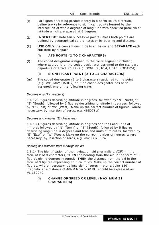
ENR 1.10 - 9AIP — Cook Islands
E Government of Cook Islands
(i) For flights operating predominantly in a north-south direction,define tracks by reference to significant points formed by theintersection of whole degrees of longitude with specified parallels oflatitude which are spaced at 5 degrees.
(j) INSERT DCT between successive points unless both points aredefined by geographical co-ordinates or by bearing and distance.
(k) USE ONLY the conventions in (i) to (i) below and SEPARATE eachsub-item by a space.
(i) ATS ROUTE (2 TO 7 CHARACTERS)
(l) The coded designator assigned to the route segment including,where appropriate, the coded designator assigned to the standarddeparture or arrival route (e.g. BCNI, BI, R14, UB10, KODAP2A).
(i) SIGNIFICANT POINT (2 TO 11 CHARACTERS)
(m) The coded designator (2 to 5 characters) assigned to the point(e.g. WG, MAY, HADDY),or, if no coded designator has beenassigned, one of the following ways:
Degrees only (7 characters)
1.6.12 2 figures describing altitude in degrees, followed by “N” (North)or“S” (South), followed by 3 figures describing longitude in degrees, followedby “E” (East) or “W” (West). Make up the correct number of figures, wherenecessary, by insertion of zeros, e.g. 46S078W.
Degrees and minutes (11 characters)
1.6.13 4 figures describing latitude in degrees and tens and units ofminutes followed by “N” (North) or “S” (South), followed by 5 figuresdescribing longitude in degrees and tens and units of minutes, followed by“E” (East) or “W” (West). Make up the correct number of figures, wherenecessary, by insertion of zeros, e.g. 4620S07805W.
Bearing and distance from a navigation aid
1.6.14 The identification of the navigation aid (normally a VOR), in theform of 2 or 3 characters, THEN the bearing from the aid in the form of 3figures giving degrees magnetic, THEN the distance from the aid in theform of 3 figures expressing nautical miles. Make up the correct number offigures, where necessary, by insertion of zeros — e.g. a point 180magnetic at a distance of 40NM from VOR VLI should be expressed asVLI180040.
(i) CHANGE OF SPEED OR LEVEL (MAXIMUM 21CHARACTERS)
Effective: 15 DEC 11
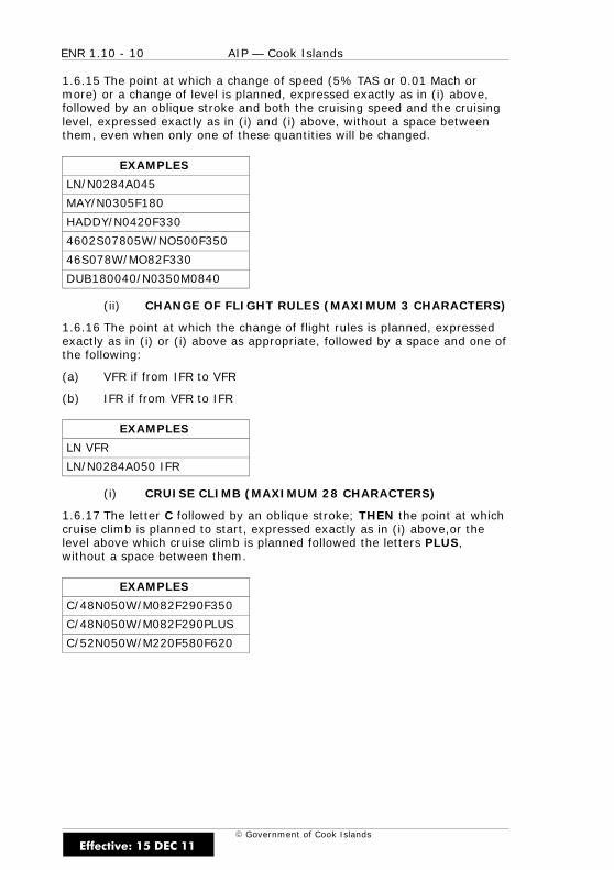
ENR 1.10 - 10 AIP — Cook Islands
E Government of Cook Islands
1.6.15 The point at which a change of speed (5% TAS or 0.01 Mach ormore) or a change of level is planned, expressed exactly as in (i) above,followed by an oblique stroke and both the cruising speed and the cruisinglevel, expressed exactly as in (i) and (i) above, without a space betweenthem, even when only one of these quantities will be changed.
EXAMPLES
LN/N0284A045
MAY/N0305F180
HADDY/N0420F330
4602S07805W/NO500F350
46S078W/MO82F330
DUB180040/N0350M0840
(ii) CHANGE OF FLIGHT RULES (MAXIMUM 3 CHARACTERS)
1.6.16 The point at which the change of flight rules is planned, expressedexactly as in (i) or (i) above as appropriate, followed by a space and one ofthe following:
(a) VFR if from IFR to VFR
(b) IFR if from VFR to IFR
EXAMPLES
LN VFR
LN/N0284A050 IFR
(i) CRUISE CLIMB (MAXIMUM 28 CHARACTERS)
1.6.17 The letter C followed by an oblique stroke; THEN the point at whichcruise climb is planned to start, expressed exactly as in (i) above,or thelevel above which cruise climb is planned followed the letters PLUS,without a space between them.
EXAMPLES
C/48N050W/M082F290F350
C/48N050W/M082F290PLUS
C/52N050W/M220F580F620
Effective: 15 DEC 11
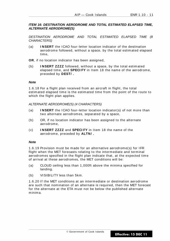
ENR 1.10 - 11AIP — Cook Islands
E Government of Cook Islands
ITEM 16: DESTINATION AERODROME AND TOTAL ESTIMATED ELAPSED TIME,ALTERNATE AERODROME(S)
DESTINATION AERODROME AND TOTAL ESTIMATED ELAPSED TIME (8CHARACTERS)
(a) INSERT the ICAO four-letter location indicator of the destinationaerodrome followed, without a space, by the total estimated elapsedtime,
OR, if no location indicator has been assigned,
(b) INSERT ZZZZ followed, without a space, by the total estimatedelapsed time, and SPECIFY in Item 18 the name of the aerodrome,preceded by DEST/.
Note
1.6.18 For a flight plan received from an aircraft in flight, the totalestimated elapsed time is the estimated time from the point of the route towhich the flight plan applies.
ALTERNATE AERODROME(S) (4 CHARACTERS)
(a) INSERT the ICAO four-letter location indicator(s) of not more thantwo alternate aerodromes, separated by a space,
(b) OR, if no location indicator has been assigned to the alternateaerodrome,
(c) INSERT ZZZZ and SPECIFY in Item 18 the name of theaerodrome, preceded by ALTN/.
Note
1.6.19 Provision must be made for an alternative aerodrome(s) for IFRflight when the MET forecasts relating to the intermediate and terminalaerodromes specified in the flight plan indicate that, at the expected timeof arrival at these aerodromes, the MET conditions will be:
(a) CLOUD ceiling less than 1,000ft above the minima specified forlanding.
(b) VISIBILITY less than 5km.
1.6.20 If the MET conditions at an intermediate or destination aerodromeare such that nomination of an alternate is required, then the MET forecastfor the alternate at the ETA must not be below the published alternateminima.
Effective: 15 DEC 11

ENR 1.10 - 12 AIP — Cook Islands
E Government of Cook Islands
ITEM 18: OTHER INFORMATION
(a) INSERT 0 (zero) if no other information,
OR
(b) any other necessary information in the preferred sequence shownbelow, in the form of the appropriate indicator followed by anoblique stroke and the information to be recorded:
EET/Significant points or FIR boundary designators and accumulatedestimated elapsed times to such points or FIR boundariesEET/ estimated elapsed times to such points or FIR boundaries.e.g. EET/GULAN0204
REG/ The registration markings of the aircraft, if different from theaircraft identification in Item 7.
SEL/ SELCAL code for oceanic flights.
OPR/ Name of the operator, if not obvious from the aircraftidentification in Item 7.
STS/
Reason for special handling by ATS, e.g. STS/HOSP (hospitalaircraft), STS/ONE ENG INOP (one engine inoperative) Fordomestic use, STS/PHOT (photography), and STS/T (IFRtraining), and STS/T4A (IFR training — four approaches) mayalso be used.
TYP/ Type(s) of aircraft, preceded if necessary by number(s) ofaircraft, if ZZZZ is inserted in Item 9.
COM/ any deviation from minimum COM requirements.
NAV/ “AUSEP” if ausep equipped and flight planning into Nadi orSydney OCA.
DEP/
Name of departure aerodrome, if ZZZZ is inserted in Item 13.ICAO four-letter location indicator of the location of the ATS unitfrom which supplementary flight plan data can be obtained, ifAFIL is inserted in Item 13.
DEST/ Name of destination aerodrome, if ZZZZ is inserted in Item 16.
ALTN/ Name of alternate aerodrome(s), if ZZZZ is inserted in Item 16.
RMK/ Any other plain language remarks.
Effective: 15 DEC 11
ENR 1.10 - 13AIP — Cook Islands
E Government of Cook Islands
ITEM 19: SUPPLEMENTARY INFORMATION
ENDURANCE
AFTER E/ INSERT a 4-figure group giving the fuel endurance in hoursand minutes.
PERSONS ON BOARD
AFTER P/ INSERT the total number of persons (passengers and crew)on board if known.
Effective: 15 DEC 11
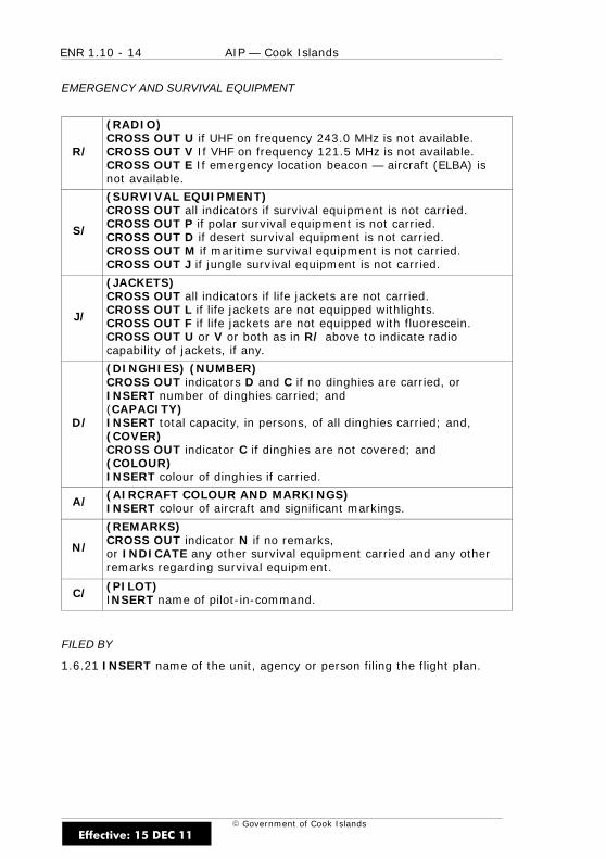
ENR 1.10 - 14 AIP — Cook Islands
E Government of Cook Islands
EMERGENCY AND SURVIVAL EQUIPMENT
R/
(RADIO)CROSS OUT U if UHF on frequency 243.0 MHz is not available.CROSS OUT V If VHF on frequency 121.5 MHz is not available.CROSS OUT E If emergency location beacon — aircraft (ELBA) isnot available.
S/
(SURVIVAL EQUIPMENT)CROSS OUT all indicators if survival equipment is not carried.CROSS OUT P if polar survival equipment is not carried.CROSS OUT D if desert survival equipment is not carried.CROSS OUT M if maritime survival equipment is not carried.CROSS OUT J if jungle survival equipment is not carried.
J/
(JACKETS)CROSS OUT all indicators if life jackets are not carried.CROSS OUT L if life jackets are not equipped withlights.CROSS OUT F if life jackets are not equipped with fluorescein.CROSS OUT U or V or both as in R/ above to indicate radiocapability of jackets, if any.
D/
(DINGHIES) (NUMBER)CROSS OUT indicators D and C if no dinghies are carried, orINSERT number of dinghies carried; and(CAPACITY)INSERT total capacity, in persons, of all dinghies carried; and,(COVER)CROSS OUT indicator C if dinghies are not covered; and(COLOUR)INSERT colour of dinghies if carried.
A/ (AIRCRAFT COLOUR AND MARKINGS)INSERT colour of aircraft and significant markings.
N/
(REMARKS)CROSS OUT indicator N if no remarks,or INDICATE any other survival equipment carried and any otherremarks regarding survival equipment.
C/ (PILOT)INSERT name of pilot-in-command.
FILED BY
1.6.21 INSERT name of the unit, agency or person filing the flight plan.
Effective: 15 DEC 11
ENR 1.10 - 15AIP — Cook Islands
E Government of Cook Islands
2 REPETITIVE FLIGHT PLAN SYSTEM
2.1 General
2.1.1 The procedures concerning the use of Repetitive Flight Plans (RPL)conform to ICAO Doc 7030 and the PANS-RAC, Doc 4444, Appendix 2.
2.1.2 Repetitive flight plan lists relating to flights within Cook Islands shallbe submitted to the Rarotonga ATS Unit — AIS Briefing Unit at least 14days in advance, in duplicate, to the following address:
(Address to be inserted)
2.1.3 Repetitive flight plans shall not be used until the operator has beenadvised by the AIS Unit in writing that the plans are “approved for use”.
3 CHANGES TO THE SUBMITTED FLIGHT PLAN
3.1 General
3.1.1 No deviation may be made from a submitted flight plan without ATSbeing informed. In the case of a controlled flight, the prior approval of ATSmust be obtained for any deviation unless an emergency situation ariseswhich necessitates immediate action by the pilot-in-command. ATS is to benotified of such action as soon as circumstances permit.
3.1.2 In the event of a delay in departure of more than 30 minutes, theATS received the flight plan, ATS must be advised of the new ETD. Thisapplies to all flights for which flight plan data has been submitted andincludes flights operating on repetitive flight plan. If an amended ETD isnot received for a delayed flight, there is a possibility the flight plan maybe automatically cancelled by another ATS unit utilising a flight planningcomputer system, e.g. a flight planned from Cook Islands to New Zealand.
Effective: 15 DEC 11

ENR 1.10 - 16 AIP — Cook Islands
E Government of Cook Islands
3.1.3 Where no ETD is filed for the second or subsequent stage of theflight, pilots are to report arrival to ATS as soon as possible after landing.The next stage of the flight plan will not become active until an ETD ortaxiing report is received. When an ETD has been notified to ATS the pilotshall advise ATS of any delay in departure of more than 30 minutes inorder to avoid initiating SAR action unnecessarily. Where communicationsare known or expected to be difficult and/or ETD is uncertain, a SARTIMEmay be used.
Notes
SARTIME is the time nominated by the pilot for the initiation of alertingaction if a report has not been received by that time.
When a VFR flight plan with intermediate landings has been submitted andcumulative delays are such that the ETA at final destination given in theflight plan will be exceeded by more than 30 minutes, the pilot-in-commandis required to advise ATS and must amend the flight plan accordingly. Inaddition the pilot-in-command must, if practicable, advise ATS whenever theETA shown on the flight plan for any specific route sector is likely to beexceeded by more than 30 minutes.
Whenever a flight, for which a flight plan has been submitted, is cancelled,Rarotonga ATS shall be informed immediately.
When a controlled flight inadvertently deviates from its current flight planthe pilot-in-command must take the following action:
(a) Deviation from track — immediately advise ATS and take action toregain track as soon as practicable and at least by the nextcompulsory reporting point;
(b) Change in ETA at next reporting point, level or radio navigation aidby 3 minutes or more from that previously notified: advise ATS ofrevised ETA as soon as possible.
Effective: 15 DEC 11
ENR 1.10 - 17AIP — Cook Islands
E Government of Cook Islands
4 ARRIVAL REPORT (TERMINATING A FLIGHT PLAN)
4.1 General
4.1.1 A report of arrival shall be made at the earliest possible momentafter landing to Rarotonga Tower ATS by any flight for which a flight planhas been submitted except when the arrival has been acknowledged by thelocal ATS unit. After landing at an aerodrome which is not the destinationaerodrome (diversionary landing), the local ATS unit shall be specificallyinformed accordingly.
4.1.2 In the absence of a local ATS unit at the aerodrome of adiversionary landing, the pilot is responsible for passing the arrival reportto Rarotonga Tower ATS.
4.1.3 Arrival reports shall contain the following elements of information:
(a) aircraft identification
(b) departure aerodrome
(c) destination aerodrome
(d) time of arrival
4.1.4 In the case of diversion, insert the “arrival aerodrome” between“destination aerodrome” and “time of arrival”.
Effective: 15 DEC 11

ENR 1.10 - 18 AIP — Cook Islands
E Government of Cook Islands
IntentionallyBlank
Effective: 15 DEC 11
ENR 1.11 - 1AIP — Cook Islands
E Government of Cook Islands
ENR 1.11 ADDRESSING OF FLIGHT PLAN MESSAGES
1 GENERAL
1.1 Flight Movement Messages
1.1.1 Flight movement messages relating to traffic into or via the CookIslands Sector of the Auckland FIR shall be addressed as shown in TableENR 1.11 - 1 in order to warrant correct relay and delivery.
Note
Flight movement messages in this context comprise flight plan messages,amendment messages relating thereto and flight plan cancellationmessages (refer to ICAO PANS-RAC, Doc 4444, Part VIII, 2.1.1.3).
Table ENR 1.11 - 1Flight Movement Messages
CATEGORY OFFLIGHT
(IFR, VFR orboth)
ROUTE(into or via FIR and/or
TMA)MESSAGE ADDRESS
All flights
Effective: 15 DEC 11

ENR 1.11 - 2 AIP — Cook Islands
E Government of Cook Islands
IntentionallyBlank
Effective: 15 DEC 11
ENR 1.12 - 1AIP — Cook Islands
E Government of Cook Islands
ENR 1.12 INTERCEPTION OF CIVIL AIRCRAFT
1 VISUAL SIGNALS FOR USE BY INTERCEPTING AND INTERCEPTED
AIRCRAFT
1.1 General
1.1.1 The code of visual signals for use by intercepting and interceptedaircraft is in the form of five standard series and a sixth “distress” series.When an intercepting aircraft wishes to lead an intercepted aircraft awayfrom a particular area (such as a prohibited area) and then release it, theFIRST (follow me) and SECOND (you may proceed) series of signals will beused. When an aircraft has been intercepted purely for identificationpurposes, the intercepting aircraft will indicate that the intercepted aircraftis free to proceed by using the SECOND series of signals.
1.1.2 Should an intercepting aircraft require a landing at a designatedaerodrome, or if an intercepting aircraft has come to lead a lost aircraft toan aerodrome it would first signal the FIRST series (follow me). Uponarriving in the vicinity of the aerodrome the intercepting aircraft wouldsignal the THIRD series (land at this aerodrome). Should the interceptedaircraft find, after following the intercepting aircraft to an aerodrome, thatit is of insufficient size or that, to the knowledge of the pilot-in-command,it has insufficient runway strength to support the load which a landingwould impose, the intercepted aircraft will signal the FOURTH (aerodromeis inadequate) or FIFTH (cannot comply) series.
1.1.3 The signals used are shown in Table ENR 1.12 - 1 and Table ENR1.12 - 2.
Effective: 15 DEC 11
ENR 1.12 - 2 AIP — Cook Islands
E Government of Cook Islands
2 SIGNALS INITIATED BY INTERCEPTING AIRCRAFT AND RESPONSES BY
INTERCEPTED AIRCRAFT
2.1 General
2.1.1 Table ENR 1.12 - 1 list the signals initiated by intercepting aircraftand responses by intercepted aircraft.
Table ENR 1.12 - 1Signals Initiated by Intercepting Aircraft and Responses by
Intercepted Aircraft
SERIES INTERCEPTINGAIRCRAFT SIGNALS
MEANING INTERCEPTEDAIRCRAFT RESPONDS
MEANING
1 DAY or NIGHTRocking aircraft andflashing navigationallights at irregularintervals from aposition slightly aboveand ahead of, andnormally to the left of,the interceptedaeroplane (or to theright of an interceptedhelicopter) and, afteracknowledgement, aslow level turn,normally to the left, inthe case of anaeroplane (or to theright in the case of ahelicopter) on to thedesired heading.
You havebeen
intercepted.Follow me.
DAY or NIGHT Rockingaircraft, flashingnavigational lights atirregular intervals andfollowing.
NoteAdditional action requiredto be taken byintercepted aircraft isprescribed in Series 4, 5,and 6.
Understood,will comply.
NotesMeteorological conditions or terrain may require the intercepting aircraft to reverse thepositions and direction of turn given above in Series 1.
If the intercepted aircraft is not able to keep pace with the intercepting aircraft, the latteris expected to fly a series of race-track patterns and to rock the aircraft each time itpasses the intercepted aircraft.
Effective: 15 DEC 11
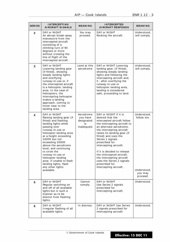
ENR 1.12 - 3AIP — Cook Islands
E Government of Cook Islands
SERIES INTERCEPTINGAIRCRAFT SIGNALS
MEANING INTERCEPTEDAIRCRAFT RESPONDS
MEANING
2 DAY or NIGHTAn abrupt break-awaymanoeuvre from theintercepted aircraftconsisting of aclimbing turn of 90degrees or morewithout crossing theline of flight of theintercepted aircraft.
You mayproceed.
DAY or NIGHTRocking the aircraft.
Understood,will comply.
3 DAY or NIGHTLowering landing gear(if fitted), showingsteady landing lightsand overflyingrunway-in-use or, ifthe intercepted aircraftis a helicopter, landingarea. In the case ofhelicopters, theintercepting helicoptermakes a landingapproach, coming tohover near to thelanding area.
Land at thisaerodrome
DAY or NIGHT Loweringlanding gear, (if fitted),showing steady landinglights and following theintercepting aircraft and,if , after overflying therunway-in-use orhelicopter landing area,landing is consideredsafe, proceeding to land.
Understood,will comply.
4 DAY or NIGHTRaising landing gear (iffitted) and flashinglanding lights whilepassing overrunway-in-use orhelicopter landing areaat a height exceeding1000ft but notexceeding 2000ftabove the aerodromelevel, and continuingto circle therunway-in-use orhelicopter landingarea. If unable to flashlanding lights, flashany other lightsavailable.
Aerodromeyou have
designatedis
inadequate
DAY or NIGHT If it isdesired that theintercepted aircraft followthe intercepting aircraft toan alternate aerodrome,the intercepting aircraftraises its landing gear (iffitted) and uses theSeries 1 signalsprescribed forintercepting aircraft.
If it is decided to releasethe intercepted aircraft,the intercepting aircraftuses the Series 2 signalsprescribed forintercepting aircraft.
Understood,follow me.
Understood,you mayproceed.
5 DAY or NIGHTRegular switching onand off of all availablelights but in such amanner as to bedistinct from flashinglights.
Cannotcomply.
DAY or NIGHTUse Series 2 signalsprescribed forintercepting aircraft.
Understood.
6 DAY or NIGHTIrregular flashing of allavailable lights.
In distress. DAY or NIGHT Use Series2 signals prescribed forintercepting aircraft.
Understood.
Effective: 15 DEC 11

ENR 1.12 - 4 AIP — Cook Islands
E Government of Cook Islands
IntentionallyBlank
Effective: 15 DEC 11
ENR 1.13 - 1AIP — Cook Islands
E Government of Cook Islands
ENR 1.13 UNLAWFUL INTERFERENCE
1 GENERAL
1.1 Introduction
1.1.1 The following procedures are intended for use by aircraft whenunlawful interference occurs and the aircraft is unable to notify an ATS unitof this fact.
2 PROCEDURES
2.1 Introduction
2.1.1 Unless considerations aboard the aircraft dictate otherwise, thepilot-in-command should attempt to continue flying on the assigned trackand at the assigned cruising level at least until notification to an ATS unit ispossible or the aircraft is within radar coverage.
2.1.2 When an aircraft subjected to an act of unlawful interference mustdepart from its assigned track or its assigned cruising level without beingable to make radiotelephony contact with ATS, the pilot-in-commandshould, whenever possible:
(a) attempt to broadcast warnings on the VHF emergency frequencyand other appropriate frequencies, unless considerations aboard theaircraft dictate otherwise. Other equipment such as onboardtransponders, data links, etc. should also be used when it isadvantageous to do so and circumstances permit; and
(b) if no applicable regional procedures have been established, proceedat a level which differs from the cruising levels normally used forIFR flight in the area by 1,000ft if above FL290 or 500ft if belowFL290.
Effective: 15 DEC 11

ENR 1.13 - 2 AIP — Cook Islands
E Government of Cook Islands
IntentionallyBlank
Effective: 15 DEC 11
ENR 1.14 - 1AIP — Cook Islands
E Government of Cook Islands
ENR 1.14 AIR TRAFFIC INCIDENTS
1 AIR SAFETY INCIDENTS
1.1 General
1.1.1 ATS Units will complete Air Safety Incidents report form and forwardto the address as follows:
Secretary for TransportMinistry of TransportPO Box 61RarotongaCOOK ISLANDS
TEL (682) 28 810FAX (682) 28 816
AFTN NCRGYAYX
2 AVIATION SAFETY REPORT
2.1 General
2.1.1 Whenever possible an initial report of an air safety incident of majorsignificance occurring during flight must be transmitted to the ATS unit orto the air–ground control radio station with which the aircraft is incommunication at the time. Such reports are to contain the followinginformation as applicable:
(a) type of incident, i.e. near collision/procedures;
(b) radio callsign of aircraft making the report;
(c) position, heading or route, true airspeed or Mach number;
(d) flight level, altitude or height and aircraft attitude;
(e) IMC or VMC;
(f) time of incident;
(g) description of other aircraft if applicable;
(h) brief details of incident including, when appropriate, sightingdistance and miss distance.
Effective: 15 DEC 11
ENR 1.14 - 2 AIP — Cook Islands
E Government of Cook Islands
2.1.2 The pilot-in-command must, if involved in an incident, submit acompleted aviation safety report to the nearest ATS unit, as soon aspossible but not later than 24 hours after landing to:
(a) confirm an initial report made by radio; or
(b) make an initial report on an incident if it had not been possible toreport it by radio.
2.1.3 The ATS unit receiving the report is responsible for advising otherATS units and/or pilots involved.
2.1.4 The purpose of the air safety incident report is to provideinvestigatory authorities with as much information on an air safety incidentas is possible and to enable them to report back with the least possibledelay to the pilot or operator concerned the result of the investigation ofthe incident and, if appropriate, the remedial action taken.
3 FACILITY MALFUNCTION REPORTING
3.1 General
3.1.1 Facility malfunction reporting is an important component of aviationsafety and, to be effective, requires both prompt action and whole heartedco-operation of all parties. In order that the report may be investigatedthoroughly, it is necessary that relevant details be provided as soon aspossible.
3.1.2 Each pilot-in-command of an aircraft operating IFR must, afterobserving a malfunction of any aeronautical telecommunications facilityforward a report to the Safety Office as soon as possible after landing. Thepilot-in-command should:
(a) Pass brief details of the malfunction to the ATS unit or air–groundstation with which the aircraft is in communication at the time, and
(b) Include the following information:
(i) aircraft type; and
(ii) aircraft registration and, if applicable, the flight number; and
(iii) name of pilot-in-command; and
(iv) name of the operator; and
(v) aircraft position and altitude; and
(vi) phase of flight; and
(vii) facility affected; and
(viii) brief details of the malfunction; and
(ix) effect on the flight.
Effective: 15 DEC 11
ENR 1.15 - 1AIP — Cook Islands
E Government of Cook Islands
ENR 1.15 EMERGENCY PROCEDURES
1 DISTRESS
1.1 Definition
1.1.1 Distress is defined as a condition of being threatened by seriousand/or imminent danger and requiring immediate assistance.
1.2 Transmission of MAYDAY Message
1.2.1 The pilot of an aircraft in distress must transmit on the air–groundfrequency in use at the time of the distress the distress signal MAYDAY(preferably spoken three times), followed by the distress message.
1.2.2 If on an unattended frequency and it is considered that betterassistance can be provided by transferring to another frequency the pilotshould do so, after broadcasting this intention on the original frequency.
1.3 Content of MAYDAY Message
1.3.1 The distress message should consist of as many of the followingelements spoken distinctly and if possible, in the following order:
(a) name of station addressed (time and circumstances permitting);
(b) identification of the aircraft;
(c) nature of the distress condition;
(d) intention of the pilot; and
(e) present position, level (FL or altitude), and heading.
1.3.2 The transmission of an accurate aircraft position may be critical toany subsequent search and/or rescue action.
1.3.3 In addition the pilot should:
(a) activate the ELT;
(b) if the emergency situation is recovered, turn the ELT off and adviseATC or RCCNZ as soon as possible;
(c) if the ELT is turned off and ATC or RCCNZ are not advised as soon aspossible, it will be assumed that the aircraft has crashed and searchplanning will have commenced.
Effective: 12 NOV 15
ENR 1.15 - 2 AIP — Cook Islands
E Government of Cook Islands
2 URGENCY
2.1 Definition
2.1.1 Urgency is defined as a condition concerning the safety of anaircraft, or of some person on board or within sight, but which does notrequire immediate assistance.
2.2 Transmission of PAN PAN Message
2.2.1 The pilot of an aircraft reporting an urgency condition must transmiton the air–ground frequency in use at the time the urgency signal PAN PAN(preferably spoken three times), followed by the urgency message.
2.3 Content of PAN PAN Message
2.3.1 The urgency message should consist of as many of the followingelements spoken distinctly and if possible, in the following order:
(a) name of station addressed;
(b) identification of the aircraft;
(c) nature of the urgency condition;
(d) intention of the pilot;
(e) present position, level (FL or altitude), and heading; and
(f) any other useful information.
Effective: 12 NOV 15
ENR 1.15 - 3AIP — Cook Islands
E Government of Cook Islands
3 COMMUNICATIONS FAILURE
3.1 ATS Communications Failure
3.1.1 In the event of communications failure from ATS, the pilot ofan aircraft should initiate TIBA procedures as detailed in Section 7 ofENR 1.15.
3.2 IFR Communications Failure — General
3.2.1 In the event of an apparent aircraft communication failure, the pilotof the aircraft should adopt the following procedures:
(a) Maintain terrain clearance throughout all procedures.
(b) Try alternate then secondary published ATS frequencies.
(c) Check aircraft communications equipment.
(d) Listen out on interpilot VHF frequency.
(e) Transmit position reports and intentions, assuming the aircrafttransmitter is operating, and prefixing all transmissions with“TRANSMITTING BLIND”.
(f) Turn on landing lights, beacons and strobes when enteringcontrolled airspace or joining the aerodrome traffic circuit.
(g) If a mobile telephone is available in the aircraft, attempt to establishtelephone communications with
Rarotonga Tower (00682) 25896 or (00682) 25890 ext 213 or
Manager Air Traffic Services (00682) 71439.
3.3 IFR Communications Failure — VMC and Certain of Maintaining VMC
3.3.1 If the pilot of the aircraft is in VMC, or encounters VMC after thefailure, and is certain of maintaining VMC:
(a) remain in VMC; and
(b) continue the flight under VFR; and
(c) proceed to a suitable aerodrome and land; and
(d) report arrival by the most expeditious means to the appropriateATS unit.
Effective: 12 NOV 15
ENR 1.15 - 4 AIP — Cook Islands
E Government of Cook Islands
3.4 IFR Communications Failure — IMC or Uncertain of Maintaining VMC
3.4.1 The initial and subsequent actions of the pilot of an aircraft in IMCor uncertain of being able to maintain VMC will depend on the latestinformation available on the:
(a) destination aids;
(b) air traffic/airspace procedures; and
(c) meteorological conditions enroute and at the destination.
3.4.2 The provision of ATC to other flights will be based on theassumption that the pilot of an aircraft with communications difficultieswill, unless strong reasons dictate otherwise, follow the appropriateprocedures specified in paragraphs 3.4.3 to 3.4.9.
3.4.3 The pilot should proceed in accordance with the current flight planas confirmed by the last acknowledged ATC clearance. ATC will assume thatthe aircraft will climb to the:
(a) flight planned level; or
(b) last level requested by the pilot and acknowledged by ATC.
Departure — Level Restriction
3.4.4 The pilot of an IFR aircraft that experiences communications failureon departure should:
(a) Maintain that last assigned level(s) to the points specified, thenclimb to maintain the level(s) in the current flight plan; or
(b) If no points are specified, maintain the last assigned level, orminimum flight altitude if higher, for five minutes, then climb tomaintain the level(s) specified in the current flight plan.
Arrival
3.4.5 On arrival, the pilot of an IFR aircraft experiencing communicationsfailure should:
(a) Track to the destination aid/fix, or if none specified by ATC, theselected aid/fix for the known or forecast RWY; and
(b) If in receipt of an arrival clearance (STAR or equivalent clearance/procedure), track via the clearance; and
(c) Commence descent to the initial approach altitude for the approachprocedure in accordance with the last acknowledged ATC clearanceand then the standard operating procedures (i.e. 3° profile) or flightplan.
Effective: 12 NOV 15
ENR 1.15 - 5AIP — Cook Islands
E Government of Cook Islands
At or Within 25 NM from Destination
3.4.6 At or within 25 NM from destination, the pilot of an IFR aircraftexperiencing communications failure should:
(a) Arrive over the destination/selected aid/fix at the last assigned levelat or as near as possible to the expected approach time given byATC, and commence approach; or
(b) If too high, descend in the aid/fix holding pattern to a levelconvenient for approach; or
(c) If on initial approach at the time of the communications failure butnot cleared for the approach, continue via the procedure andmaintain the last assigned level until established on final approachtrack, then commence approach; or
(d) If too high:
(i) if a holding pattern is established on the final approach track,descend in the holding pattern to a level convenient forapproach; or
(ii) if no holding pattern is established, carry out missedapproach and position for another approach, if specifieddiversion allows.
Diversion
3.4.7 If unable to achieve a landing following an approach, the pilot of anIFR aircraft that experiences communications failure should carry out amissed approach.
3.4.8 A second approach may be made if desired, provided a landing canbe accomplished within 30 minutes of the expected approach time or theETA, whichever is the latter. If this approach is unsuccessful, the aircraftmust divert to the alternate aerodrome.
3.4.9 The pilot of an IFR aircraft that experiences communications failurewhile holding because of the closure of the destination aerodrome shouldhold until the divert time notified to ATC, and then depart for the alternateaerodrome.
Effective: 12 NOV 15
ENR 1.15 - 6 AIP — Cook Islands
E Government of Cook Islands
4 VFR COMMUNICATIONS FAILURE
4.1 ATS Communications Failure
4.1.1 In the event of an ATS communications failure, the pilot of a VFRaircraft in controlled airspace should initiate TIBA procedures as detailed insection 7 of ENR 1.15.
4.2 VFR Communications Failure
4.2.1 In the event of an apparent aircraft communication failure, the pilotof the aircraft should adopt the following procedures:
(a) Maintain terrain clearance throughout all procedures.
(b) Try alternate then secondary published ATS frequencies for thesector or unit you should be in communication with.
(c) Check aircraft communications equipment.
(d) Listen out on interpilot VHF frequency.
(e) Transmit position reports and intentions, assuming the aircrafttransmitter is operating, and prefixing all transmissions with“TRANSMITTING BLIND”.
(f) Turn on landing lights, beacons and strobes when enteringcontrolled airspace or joining the aerodrome traffic circuit.
(g) If a mobile telephone is available in the aircraft, attempt to establishtelephone communications with
Rarotonga Tower (00682) 25896 or (00682) 25890 ext 213 or
Manager Air Traffic Services (00682) 71439.
(h) Approach the aerodrome clear of the final approach areas and carryout a standard joining procedure.
(i) Report your arrival to ATS as soon as possible.
Effective: 12 NOV 15
ENR 1.15 - 7AIP — Cook Islands
E Government of Cook Islands
5 SPEECHLESS TECHNIQUE USING UNMODULATEDTRANSMISSIONS
5.1 General
5.1.1 When a pilot is able to communicate only by unmodulatedtransmissions (e.g. when the transmitter is operative but the microphone isunserviceable), the following technique will be employed by ATS:
(a) when an unmodulated transmission is heard, the ATS operator willrequest the pilot activate the transmitter three times; and
(b) if the pilot complies ATS will frame questions requiring “YES” or“NO” answers to determine if the aircraft:
(i) can continue visually; or
(ii) can execute an instrument approach, or has reached anominated position.
5.1.2 This and any other information required will be obtained byrequiring the pilot to use the following code:
(a) “YES” or “ROGER” activate transmitter once
(b) “NO” activate transmitter twice
(c) “SAY AGAIN” activate transmitter 3 times
(d) “AT NOMINATED POSITION” activate transmitter 4 times
5.1.3 When it is established that the pilot of the aircraft can receivetransmissions, control will be exercised in the normal manner, except thatfrequency changes will not be requested unless there is no alternative.
Effective: 12 NOV 15
ENR 1.15 - 8 AIP — Cook Islands
E Government of Cook Islands
6 AERODROME EMERGENCIES
6.1 Aerodrome Emergency Plan
6.1.1 The object of an aerodrome emergency plan is to prepare anaerodrome to cope with an emergency occurring on, or in the vicinity ofthe aerodrome. The plan sets forth the procedures for coordinating theresponse of different aerodrome services and those agencies in thesurrounding community that could be of assistance in an emergency.
Examples of the types of emergencies are:
(a) Aircraft malfunctions;
(b) Sabotage, including bomb threats;
(c) Unlawfully seized aircraft;
(d) Dangerous goods occurrences; and
(e) Building fires and natural disasters.
6.1.2 An aerodrome emergency plan exists at all aerodromes that haveregular air transport services by aircraft with 30 or more passenger seats.
6.2 Procedures to Activate Aerodrome Emergency Services
6.2.1 The ATS unit on the aerodrome is responsible for alerting theemergency services, following a request from a pilot or when an aircraft isconsidered to be in any of the following emergency phases:
(a) Local Standby Phase: when an aircraft approaching the aerodromeis known, or is suspected, to have developed some defect, but thetrouble is not such as would normally prevent carrying out a safelanding. Declaration of the LOCAL STANDYBY PHASE will bring allaerodrome-based emergency services to a state of readiness but ingeneral, although off-aerodrome components are notified, they willremain at their posts.
(b) Full Emergency Phase: when an aircraft approaching the aerodromeis, or is suspected to be, in such trouble that there is danger of anaccident. Declaration of a FULL EMERGENCY PHASE will bring allfacilities, both on the aerodrome and in the community, such asmedical and ambulance services, police and fire services, to arendezvous point on the aerodrome. It will also alert the hospital toprepare for possible reception of injured, and for road traffic controlto be instituted along the route between the hospital and theaerodrome to clear the way for emergency vehicles.
(c) Aircraft Accident Phase: when an aircraft accident has occurred onor in the vicinity of the airport. Declaration of the AIRCRAFTACCIDENT PHASE will bring all facilities into immediate action.
Effective: 12 NOV 15

ENR 1.15 - 9AIP — Cook Islands
E Government of Cook Islands
6.2.2 When an emergency occurs in flight and adequate communicationsexist, the pilot is responsible for advising the ATS unit accordingly and fornominating the desired state of readiness of the aerodrome emergencyservices. If adequate communications with the aircraft do not exist, theATS unit will assess the situation and bring the aerodrome emergencyservices to the state of readiness considered appropriate.
7 TRAFFIC INFORMATION BROADCASTS BY AIRCRAFT(TIBA)
7.1 General
7.1.1 TIBA are reports and information transmitted by pilots for theinformation of pilots of other aircraft in the vicinity following a significantdisruption to air traffic or telecommunication services.
7.2 Degradation of the ATS system
7.2.1 Pilots will as far as practicable be advised by ATS when the level ofavailable communication is being reduced.
7.2.2 ATS have procedures outlining their response to events that mayeventuate in a loss of communication. If the event (such as an evacuationof the ATSC or other ATS facility) is covered by such procedures ATS will,with due regard to their own safety and the nature of the event, issueinstructions to facilitate a smooth transition to either:
(a) Alternative communications; or
(b) A TIBA environment.
7.3 Introduction and Applicability of TIBA
7.3.1 TIBA will be introduced only when necessary and as a temporarymeasure. If circumstances permit, introduction of TIBA will be by NOTAM.
7.3.2 Pilots of aircraft should initiate TIBA when there is a complete failureof communication from ATC. The broadcast procedures should be applied indesignated airspace where there is:
(a) a need to supplement collision hazard information provided by airtraffic services outside controlled airspace; or
(b) a temporary disruption of normal air traffic services.
Effective: 12 NOV 15
ENR 1.15 - 10 AIP — Cook Islands
E Government of Cook Islands
7.4 VHF RTF Frequency to be used for TIBA
7.4.1 Pilots are to use the Rarotonga ATS frequency of 118.1 MHz.
7.5 TIBA Listening Watch
7.5.1 A listening watch should be maintained on the TIBA frequency 10minutes before entering TIBA airspace until leaving that airspace. For anaircraft taking off from an aerodrome located within the lateral limits ofTIBA airspace, listening watch should start as soon as appropriate prior toor after take-off.
7.5.2 Aircraft within the NZZO FIR should also make position reports to analternative HF station.
7.6 Timing of TIBA
7.6.1 A broadcast should be made:
(a) 10 minutes before entering TIBA airspace or, for a pilot taking offfrom an aerodrome located within the lateral limits of TIBA airspace,as soon as appropriate prior to or after take-off;
(b) 10 minutes prior to, and crossing any reporting point;
(c) at 10 minute intervals between reporting points;
(d) 10 minutes prior to crossing or joining an ATS route;
(e) where possible 2 to 5 minutes before a change in flight level oraltitude;
(f) at the time of a change in flight level or altitude;
(g) when reaching new flight level or altitude; and
(h) at any other time considered necessary by the pilot.
7.7 Content of TIBA
7.7.1 The information to be broadcast in a TIBA is detailed in TableENR 1.15-1.
7.8 Acknowledgement of TIBA
7.8.1 The broadcasts should not be acknowledged unless a potentialcollision risk is perceived.
Effective: 12 NOV 15
ENR 1.15 - 11AIP — Cook Islands
E Government of Cook Islands
7.9 Changes of Cruising Level Under TIBA
7.9.1 Cruising level changes should not be made within the designatedairspace, unless considered necessary by pilots to avoid traffic conflicts, forweather avoidance, or for other valid operational reasons.
7.9.2 When cruising level changes are unavoidable, display all availableaircraft lighting that would improve the visual detection of the aircraft whilechanging levels.
7.10 Collision Avoidance Under TIBA
7.10.1 If, on receipt of a traffic information broadcast from another aircraft,a pilot decides that immediate action is necessary to avoid an imminentcollision risk to their aircraft, and this cannot be achieved in accordancewith the standard right-of-way provisions, the pilot should:
(a) unless an alternative manoeuvre appears more appropriate,immediately descend 500 ft;
(b) display all available aircraft lighting that would improve the visualdetection of the aircraft;
(c) as soon as possible, reply to the broadcast notifying action beingtaken on the appropriate TIBA frequency; and
(d) as soon as practicable, resume normal flight level/altitude, notifyingthe action on the appropriate TIBA frequency.
(e) Response to a system-initiated ACAS Resolution Advisory hasprecedence over the above instructions.
7.11 Normal Position Reporting Procedures Under TIBA
7.11.1 Normal position reporting procedures should be continued at alltimes, regardless of any action taken to initiate or acknowledge a TIBA.
Effective: 12 NOV 15

ENR 1.15 - 12 AIP — Cook Islands
E Government of Cook Islands
Table ENR 1.15-1Information required in TIBA
Content Example
Normal broadcast
ALL STATIONS(necessary to identify a trafficinformation broadcast)
(callsign)
FLIGHT LEVEL/ALTITUDE (number)
(or CLIMBING* TO FLIGHTLEVEL/ALTITUDE (number))
(direction)
(ATS route)(or DIRECT FROM (position) TO(position))
POSITION (position**) AT (time)
ESTIMATING
(next reporting point, or the pointof crossing or joining a designatedATS route) AT (time)
* This applies to an aircraft takingoff from an aerodrome locatedwithin the lateral limits of thedesignated airspace.
** For broadcasts made when theaircraft is not near an ATSsignificant point, the positionshould be given as accurately aspossible and in any case to thenearest 30 minutes of latitude andlongitude.
ALL STATIONS
E5-EFS
13,000 FEET
NORTHBOUND
DIRECT RG TO AI ON THE 347R RGVOR
POSITION 45DME RG
ESTIMATING AI AT 2115
Effective: 12 NOV 15
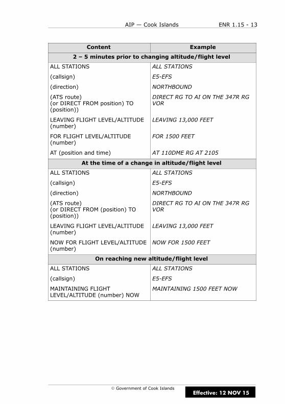
ENR 1.15 - 13AIP — Cook Islands
E Government of Cook Islands
Content Example
2 – 5 minutes prior to changing altitude/flight level
ALL STATIONS
(callsign)
(direction)
(ATS route)(or DIRECT FROM position) TO(position))
LEAVING FLIGHT LEVEL/ALTITUDE(number)
FOR FLIGHT LEVEL/ALTITUDE(number)
AT (position and time)
ALL STATIONS
E5-EFS
NORTHBOUND
DIRECT RG TO AI ON THE 347R RGVOR
LEAVING 13,000 FEET
FOR 1500 FEET
AT 110DME RG AT 2105
At the time of a change in altitude/flight level
ALL STATIONS
(callsign)
(direction)
(ATS route)(or DIRECT FROM (position) TO(position))
LEAVING FLIGHT LEVEL/ALTITUDE(number)
NOW FOR FLIGHT LEVEL/ALTITUDE(number)
ALL STATIONS
E5-EFS
NORTHBOUND
DIRECT RG TO AI ON THE 347R RGVOR
LEAVING 13,000 FEET
NOW FOR 1500 FEET
On reaching new altitude/flight level
ALL STATIONS
(callsign)
MAINTAINING FLIGHTLEVEL/ALTITUDE (number) NOW
ALL STATIONS
E5-EFS
MAINTAINING 1500 FEET NOW
Effective: 12 NOV 15
ENR 1.15 - 14 AIP — Cook Islands
E Government of Cook Islands
IntentionallyBlank
Effective: 12 NOV 15

ENR 2 - 1AIP — Cook Islands
E Government of Cook Islands
ENR 2 AIR TRAFFIC SERVICESAIRSPACE
Effective: 15 DEC 11

ENR 2 - 2 AIP — Cook Islands
E Government of Cook IslandsEffective: 15 DEC 11
ENR 2.1 - 1AIP — Cook Islands
E Government of Cook Islands
ENR 2.1 CTR, TMA, CTA
1 AREA OF RESPONSIBILITY
1.1 General
1.1.1 The area of responsibility for providing air traffic services is theCook Sector of the Auckland Oceanic FIR. The airspace and the servicesavailable within them are shown in Table ENR 2.1-1.
1.1.2 The Rarotonga CTR and TMA are only active during the hours ofservice of Rarotonga ATC. Outside of these hours the entire Cook Sector isClass G and AFIS/FIS is provided. Refer to NOTAM for ATS hours of service.
Effective: 2 APR 15
D
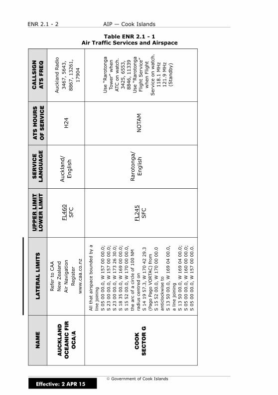
ENR 2.1 - 2 AIP — Cook Islands
E Government of Cook Islands
Table ENR 2.1 - 1Air Traffic Services and Airspace
CALLSIGN
ATSFREQ
AucklandRadio
3467,5643,
8867,13261,
17904
Use“Rarotonga
Tower”when
ATConwatch.
3425,6553,
8846,11339
Use“Rarotonga
FlightService”
whenFlight
Serviceonwatch.
118.1MHz
121.9MHz
(Standby)
ATSHOURS
OFSERVICE
H24
NOTAM
SERVICE
LANGUAGE
Auckland/
English
Rarotonga/
English
UPPERLIM
ITLOWERLIM
IT
FL460
SFC
FL245
SFC
LATERALLIM
ITS
RefertoCAA
NewZealand
AirNavigation
Register
www.caa.co.nz
Allthatairspaceboundedbya
linejoining
S050000.0,W1570000.0;
S230000.0,W1570000.0;
S230000.0,W1732630.0;
S183500.0,W1690000.0;
S155200.0,W1700000.0,
thearcofacircleof100NM
radiuscentredon
S141957.3,W1704229.3
(PagoPagoVORTAC)from
S155200.0,W1700000.0
anticlockwiseto
S135000.0,W1690400.0,
alinejoining
S135000.0,W1690400.0;
S050000.0,W1600000.0;
S050000.0,W1570000.0.
NAME
AUCKLAND
OCEANIC
FIR
OCA/A
COOK
SECTORG
Effective: 2 APR 15
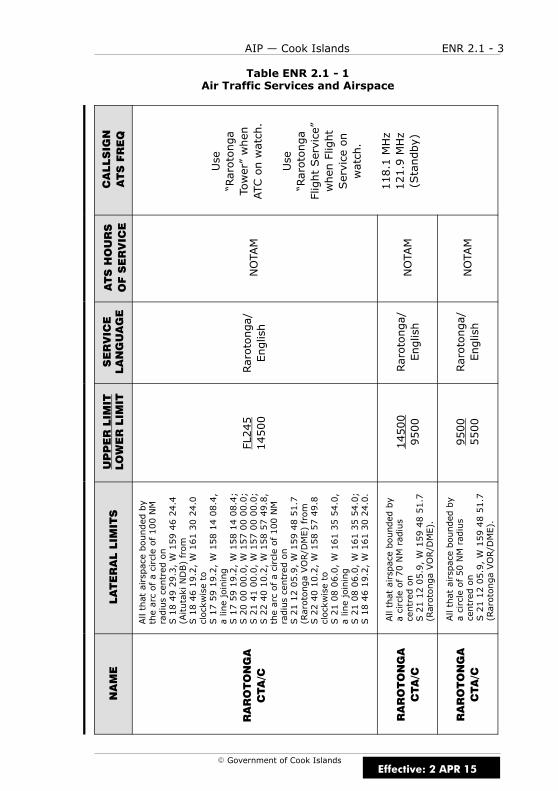
ENR 2.1 - 3AIP — Cook Islands
E Government of Cook Islands
Table ENR 2.1 - 1Air Traffic Services and Airspace
CALLSIGN
ATSFREQ
Use
“Rarotonga
Tower”when
ATConwatch.
Use
“Rarotonga
FlightService”
whenFlight
Serviceon
watch.
118.1MHz
121.9MHz
(Standby)
ATSHOURS
OFSERVICE
NOTAM
NOTAM
NOTAM
SERVICE
LANGUAGE
Rarotonga/
English
Rarotonga/
English
Rarotonga/
English
UPPERLIM
ITLOWERLIM
IT
FL245
14500
14500
9500
9500
5500
LATERALLIM
ITS
Allthatairspaceboundedby
thearcofacircleof100NM
radiuscentredon
S184929.3,W1594624.4
(AitutakiNDB)from
S184619.2,W1613024.0
clockwiseto
S175919.2,W1581408.4,
alinejoining
S175919.2,W1581408.4;
S200000.0,W1570000.0;
S214100.0,W1570000.0;
S224010.2,W1585749.8,
thearcofacircleof100NM
radiuscentredon
S211205.9,W1594851.7
(RarotongaVOR/DME)from
S224010.2,W1585749.8
clockwiseto
S210806.0,W1613554.0,
alinejoining
S210806.0,W1613554.0;
S184619.2,W1613024.0.
Allthatairspaceboundedby
acircleof70NMradius
centredon
S211205.9,W1594851.7
(RarotongaVOR/DME).
Allthatairspaceboundedby
acircleof50NMradius
centredon
S211205.9,W1594851.7
(RarotongaVOR/DME).
NAME
RAROTONGA
CTA/C
RAROTONGA
CTA/C
RAROTONGA
CTA/C
Effective: 2 APR 15

ENR 2.1 - 4 AIP — Cook Islands
E Government of Cook Islands
2 AIR TRAFFIC SERVICES
2.1 General
2.1.1 In general, the air traffic rules and procedures in force and theorganisation of Air Traffic Services are in conformity with ICAO standards,recommended practices and procedures. The differences are given inGEN 1.7.
3 SERVICE PROVIDED
3.1 General
3.1.1 The ATS provided comprises:
(a) Air traffic control service to IFR flights in Class C airspace.
(b) Air traffic control service to VFR flights in Class C airspace.
(c) Air traffic control service to all aerodrome traffic at controlledaerodromes.
(d) Flight Information Service to known flights in Class G airspace.
Note
Air traffic control service is provided for the purpose of preventing collisionsand maintaining an orderly flow of traffic.
(a) FIS for the purpose of giving advice and information useful for thesafe and efficient conduct of flights.
(b) Alerting service to all flights known to ATS for the purpose ofinitiating and/or assisting in search and rescue action.
Effective: 2 APR 15

ENR 2.1 - 5AIP — Cook Islands
E Government of Cook Islands
3.2 Air Traffic Control (ATC)
3.2.1 Air traffic control service comprises:
(a) Approach control service provided by Rarotonga ATS unit during thehours of watch of Rarotonga Tower.
(b) Aerodrome control service during the hours of watch of RarotongaTower.
3.3 Flight Information Service
3.3.1 FIS will be provided whenever practicable to all aircraft known to beaffected by the information.
3.3.2 In the case of aircraft in flight, flight information is normallyconfined to the route being flown.
Notes
FIS does not diminish the responsibilities normally vested in thepilot-in-command of an aircraft, including that for making a final decisionregarding any suggested alteration to flight plan.
Where an ATC unit provides both FIS and ATC service, the provision of ATCservice will take precedence over the provision of FIS whenever theprovision of ATC service so requires.
FIS will include the provision of pertinent:
(a) SIGMET information;
(b) information on changes in the serviceability of radio navigation aids;
(c) information on changes in conditions of aerodromes and associatedfacilities, and any other information likely to affect safety;
(d) Traffic information in:
(i) Class C airspace, between VFR flights, together with trafficavoidance advice on request.
(ii) Class D airspace, to IFR flights with respect to VFR flights,and as far as practicable to VFR flights with respect to IFRand VFR flights.
(iii) Class G airspace, to IFR flights with respect to other IFRflights and as far as practicable to VFR flights with respect toIFR and VFR flights.
(e) weather conditions reported or forecast at departure, destination,and enroute aerodromes.
Effective: 30 APR 15
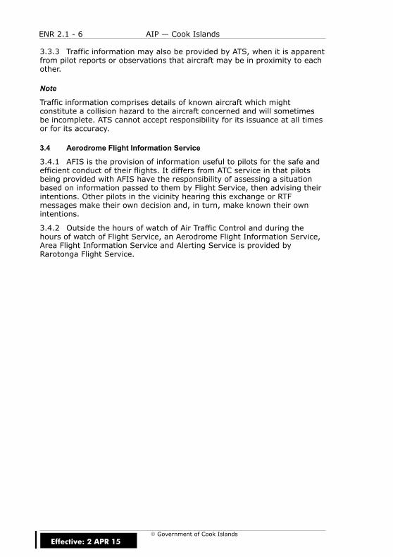
ENR 2.1 - 6 AIP — Cook Islands
E Government of Cook Islands
3.3.3 Traffic information may also be provided by ATS, when it is apparentfrom pilot reports or observations that aircraft may be in proximity to eachother.
Note
Traffic information comprises details of known aircraft which mightconstitute a collision hazard to the aircraft concerned and will sometimesbe incomplete. ATS cannot accept responsibility for its issuance at all timesor for its accuracy.
3.4 Aerodrome Flight Information Service
3.4.1 AFIS is the provision of information useful to pilots for the safe andefficient conduct of their flights. It differs from ATC service in that pilotsbeing provided with AFIS have the responsibility of assessing a situationbased on information passed to them by Flight Service, then advising theirintentions. Other pilots in the vicinity hearing this exchange or RTFmessages make their own decision and, in turn, make known their ownintentions.
3.4.2 Outside the hours of watch of Air Traffic Control and during thehours of watch of Flight Service, an Aerodrome Flight Information Service,Area Flight Information Service and Alerting Service is provided byRarotonga Flight Service.
Effective: 2 APR 15

ENR 2.2 - 1AIP — Cook Islands
E Government of Cook Islands
ENR 2.2 OTHER REGULATED AIRSPACE
1 OTHER AIRSPACE
1.1 General
1.1.1 Nil.
Effective: 15 DEC 11

ENR 2.2 - 2 AIP — Cook Islands
E Government of Cook Islands
IntentionallyBlank
Effective: 15 DEC 11

ENR 3 - 1AIP — Cook Islands
E Government of Cook Islands
ENR 3 ATS ROUTES
Effective: 15 DEC 11

ENR 3 - 2 AIP — Cook Islands
E Government of Cook IslandsEffective: 15 DEC 11

ENR 3.1 - 1AIP — Cook Islands
E Government of Cook Islands
ENR 3.1 LOWER ATS ROUTES
1 INTRODUCTION
1.1 General
1.1.1 Most commonly used routes are depicted on the AIP charts andinclude the following information:
(a) radio facilities defining routes or used to determine reporting points
(b) magnetic tracks, VOR radials and distances
(c) minimum safe altitudes (MSA)
(d) designated reporting points
1.2 Reporting Points
1.2.1 Reporting points are depicted on Enroute Charts.
1.3 Adherence to Track
1.3.1 Adherence to track must be maintained unless otherwise authorisedor directed by ATC, flights must, so far as is practicable:
(a) when on a promulgated route, operate along the centreline of theroute; or
(b) when on any other route, operate directly between the navigationfacilities and/or points defining the route.
1.3.2 If a pilot deviates from the centreline of a route, or if theperformance of the radio navigation facilities are such that accurate trackkeeping may not be possible, the pilot must immediately advise ATS.
1.3.3 Refer to CAA New Zealand Air Navigation Register www.caa.govt.nzfor information on ATS routes and reporting points.
Effective: 15 DEC 11

ENR 3.1 - 2 AIP — Cook Islands
E Government of Cook Islands
IntentionallyBlank
Effective: 15 DEC 11
ENR 3.2 - 1AIP — Cook Islands
E Government of Cook Islands
ENR 3.2 UPPER ATS ROUTES
1 INTRODUCTION
1.1 General
1.1.1 Most commonly used routes are depicted on the AIP charts andinclude the following information:
(a) radio facilities defining routes or used to determine reporting points
(b) magnetic tracks, VOR radials and distances
(c) minimum safe altitudes (MSA)
(d) designated reporting points
1.2 Reporting Points
1.2.1 Reporting points are depicted on Enroute Charts.
1.3 Adherence to Track
1.3.1 Adherence to track must be maintained unless otherwise authorisedor directed by ATC, flights must, so far as is practicable:
(a) when on a promulgated route, operate along the centreline of theroute; or
(b) when on any other route, operate directly between the navigationfacilities and/or points defining the route.
1.3.2 If a pilot deviates from the centreline of a route, or if theperformance of the radio navigation facilities are such that accurate trackkeeping may not be possible, the pilot must immediately advise ATS.
1.3.3 Refer to CAA New Zealand Air Navigation Register www.caa.govt.nzfor information on ATS routes and reporting points.
Effective: 15 DEC 11

ENR 3.2 - 2 AIP — Cook Islands
E Government of Cook Islands
IntentionallyBlank
Effective: 15 DEC 11
ENR 3.3 - 1AIP — Cook Islands
E Government of Cook Islands
ENR 3.3 AREA NAVIGATION ROUTES
1 INTRODUCTION
1.1 General
1.1.1 Nil.
Effective: 15 DEC 11

ENR 3.3 - 2 AIP — Cook Islands
E Government of Cook Islands
IntentionallyBlank
Effective: 15 DEC 11

ENR 3.4 - 1AIP — Cook Islands
E Government of Cook Islands
ENR 3.4 HELICOPTER ROUTES
1 INTRODUCTION
1.1 General
1.1.1 Nil.
Effective: 15 DEC 11

ENR 3.4 - 2 AIP — Cook Islands
E Government of Cook Islands
IntentionallyBlank
Effective: 15 DEC 11

ENR 3.5 - 1AIP — Cook Islands
E Government of Cook Islands
ENR 3.5 OTHER ROUTES
1 INTRODUCTION
1.1 General
1.1.1 Nil.
Effective: 15 DEC 11

ENR 3.5 - 2 AIP — Cook Islands
E Government of Cook Islands
IntentionallyBlank
Effective: 15 DEC 11

ENR 3.6 - 1AIP — Cook Islands
E Government of Cook Islands
ENR 3.6 ENROUTE HOLDING
1 INTRODUCTION
1.1 General
1.1.1 Nil.
Effective: 15 DEC 11

ENR 3.6 - 2 AIP — Cook Islands
E Government of Cook Islands
IntentionallyBlank
Effective: 15 DEC 11
ENR 4 - 1AIP — Cook Islands
E Government of Cook Islands
ENR 4 RADIO NAVIGATIONAIDS/SYSTEMS
Effective: 15 DEC 11

ENR 4 - 2 AIP — Cook Islands
E Government of Cook IslandsEffective: 15 DEC 11

ENR 4.1 - 1AIP — Cook Islands
E Government of Cook Islands
ENR 4.1 RADIO NAVIGATION AIDS — ENROUTE
1 RADIO NAVIGATION AIDS
1.1 General
1.1.1 Table ENR 4.1 - 1 lists the radio navigation aids to be used in enroutenavigation.
Table ENR 4.1 - 1Radio Navigation Aids — Enroute
STATIONNAME
AID IDENT FREQ/CHANNEL
HOURS COORDINATES DMEELEV
REMARKS
AITUTAKI NDB AI 320 H24 S18 49 29.28W159 46 24.36
Ratedcoverage100NM
PENRHYN NDB PY 400 O/R S08 59 38.99W158 02 37.83
Ratedcoverage100NM
VOR RG 113.5 S21 12 05.93W159 48 51.72
UnusableR105 toR160
RAROTONGA DME RG 113.582X H24
S21 12 05.93W159 48 51.72
NIL
NDB RG 352 S21 12 27.95W159 49 16.72
Ratedcoverage250NM
Effective: 2 APR 15

ENR 4.1 - 2 AIP — Cook Islands
E Government of Cook Islands
IntentionallyBlank
Effective: 15 DEC 11

ENR 4.2 - 1AIP — Cook Islands
E Government of Cook Islands
ENR 4.2 SPECIAL NAVIGATION SYSTEMS
1 INTRODUCTION
1.1 General
1.1.1 Nil
Effective: 15 DEC 11

ENR 4.2 - 2 AIP — Cook Islands
E Government of Cook Islands
IntentionallyBlank
Effective: 15 DEC 11

ENR 4.3 - 1AIP — Cook Islands
E Government of Cook Islands
ENR 4.3 NAME–CODE DESIGNATORS FORSIGNIFICANT POINTS
1 INTRODUCTION
1.1 General
1.1.1 Refer to CAA New Zealand Air Navigation Register www.caa.govt.nz
Effective: 15 DEC 11

ENR 4.3 - 2 AIP — Cook Islands
E Government of Cook Islands
IntentionallyBlank
Effective: 15 DEC 11
ENR 4.4 - 1AIP — Cook Islands
E Government of Cook Islands
ENR 4.4 AERONAUTICAL GROUND LIGHTS — ENROUTE
1 INTRODUCTION
1.1 General
1.1.1 Table ENR 4.4 - 1 lists all enroute aeronautical ground lights.
Table ENR 4.4 - 1Aeronautical Ground Lights — Enroute
AERONAUTICAL GROUND LIGHTS — ENROUTE
NR NIL at present
NAME
TYPE
CHARACTERISTICS/CODE
HR
COORDINATES
Effective: 15 DEC 11
ENR 4.4 - 2 AIP — Cook Islands
E Government of Cook Islands
IntentionallyBlank
Effective: 15 DEC 11
ENR 5 - 1AIP — Cook Islands
E Government of Cook Islands
ENR 5 NAVIGATION WARNINGS
Effective: 15 DEC 11
ENR 5 - 2 AIP — Cook Islands
E Government of Cook IslandsEffective: 15 DEC 11
ENR 5.1 - 1AIP — Cook Islands
E Government of Cook Islands
ENR 5.1 PROHIBITED, RESTRICTED AND DANGERAREAS
1 DEFINITIONS
1.1 General
1.1.1 All airspace in which a potential hazard to operations may exist andall areas over which the operation of civil aircraft may, for one reason oranother be restricted either temporarily or permanently, are classifiedaccording to the following three types of area as defined by ICAO.
1.2 Prohibited Area
1.2.1 An airspace of defined dimensions, above the land area orterritorial waters of a state, within which the flight of aircraft is prohibited.This term is used only when the flight of civil aircraft within the designatedairspace is not permitted at any time under any circumstances.
1.3 Restricted Area
1.3.1 An airspace of defined dimensions, above the land area orterritorial waters of a state, within which the flight of aircraft is restricted inaccordance with certain specified conditions. This term is used wheneverthe flight of civil aircraft within the designated airspace is not absolutelyprohibited but may be made only if specified conditions are complied with.Thus, prohibition of flight except at certain specified times leads to thedesignation of the airspace as a “restricted area” as would prohibitionexcept in certain meteorological conditions. Similarly, prohibition of flightunless special permission had been obtained, leads to the designation of arestricted area.
1.3.2 However, conditions of flight imposed as a result of application ofrules of the air and air traffic service practices or procedures (e.g.compliance with minimum safe heights or with rules stemming from theestablishment of controlled airspace) do not constitute conditions callingfor designation as a restricted area.
Effective: 15 DEC 11

ENR 5.1 - 2 AIP — Cook Islands
E Government of Cook Islands
1.4 Danger Area
1.4.1 An airspace of defined dimensions within which activities dangerousto the flight of aircraft may exist at specified times. This term is used onlywhen the potential danger to aircraft has not led to the designation of theairspace as restricted or prohibited.
1.4.2 The effect of the creation of the danger area is to caution operatorsor pilots of aircraft that it is necessary for them to assess the dangers inrelation to their responsibility for the safety of their aircraft.
1.5 Zone Identification
1.5.1 Each area is numbered and a single series of numbers is used for allareas, regardless of type, to ensure that a number is never duplicated.Each area is as small as practicable, and contained within simplegeometrical limits such as circle, square, etc.
1.5.2 The type of area involved is indicated by the letter
(a) “P” — for Prohibited
(b) “R” — for Restricted
(c) “D” — for Danger
1.5.3 preceded by the Nationality designator.
1.5.4 These areas are also shown on charts using the chart symbols.
1.6 Designated Prohibited, Restricted and Danger Areas
1.6.1 There are no permanent designated Prohibited, Restricted or Dangerareas in the Cook Sector of the Auckland Oceanic FIR. Prohibited,Restricted and Danger areas will be designated by NOTAM if required.
Effective: 15 DEC 11

ENR 5.2 - 1AIP — Cook Islands
E Government of Cook Islands
ENR 5.2 MILITARY EXERCISE AND TRAINING AREAS
1 INTRODUCTION
1.1 General
1.1.1 Nil
Effective: 15 DEC 11

ENR 5.2 - 2 AIP — Cook Islands
E Government of Cook Islands
IntentionallyBlank
Effective: 15 DEC 11

ENR 5.3 - 1AIP — Cook Islands
E Government of Cook Islands
ENR 5.3 OTHER ACTIVITIES OF A DANGEROUSNATURE
1 LOW FLYING ZONES
Table ENR 5.3-1Low Flying Zones
NAME LATERALLIMITS
UPPER LIMITLOWER LIMIT
HOURS OFOPERATION USING AGENCY
Titikaveka All that airspacebounded by aline joining
S 21 16 06.0,W 159 44 30.0;
S 21 16 36.0,W 159 44 30.0;
S 21 16 36.0,W 159 46 18.0;
S 21 16 06.0,W 159 48 00.0;
S 21 15 30.0;W 159 48 00.0;
S 21 16 06.0,W 159 45 36.0;
S 21 16 06.0,W 159 44 30.0
500ft AGLSurface
DaylightHours
Air Rarotonga Ltd;PO Box 79,Rarotonga,Cook IslandsTel +682 22888
Effective: 2 APR 15

ENR 5.3 - 2 AIP — Cook Islands
E Government of Cook Islands
IntentionallyBlank
Effective: 15 DEC 11

ENR 5.4 - 1AIP — Cook Islands
E Government of Cook Islands
ENR 5.4 AIR NAVIGATION OBSTACLES — ENROUTE
1 INTRODUCTION
1.1 General
1.1.1 Nil
Effective: 15 DEC 11

ENR 5.4 - 2 AIP — Cook Islands
E Government of Cook Islands
IntentionallyBlank
Effective: 15 DEC 11
ENR 5.5 - 1AIP — Cook Islands
E Government of Cook Islands
ENR 5.5 AERIAL SPORTING AND RECREATIONALACTIVITES
1 INTRODUCTION
1.1 General
1.1.1 Microlight aircraft and parasail operations are possible in the vicinityof Rarotonga International Airport.
Effective: 15 DEC 11

ENR 5.5 - 2 AIP — Cook Islands
E Government of Cook Islands
IntentionallyBlank
Effective: 15 DEC 11
ENR 5.6 - 1AIP — Cook Islands
E Government of Cook Islands
ENR 5.6 BIRD MIGRATION AND AREAS WITHSENSITIVE FAUNA
1 INTRODUCTION
1.1 General
1.1.1 Nil
Effective: 15 DEC 11

ENR 5.6 - 2 AIP — Cook Islands
E Government of Cook Islands
IntentionallyBlank
Effective: 15 DEC 11
ENR 6 - 1AIP — Cook Islands
E Government of Cook Islands
ENR 6 ENROUTE CHARTS
Effective: 15 DEC 11

ENR 6 - 2 AIP — Cook Islands
E Government of Cook IslandsEffective: 15 DEC 11

ENR 6.1 - 1AIP — Cook Islands
E Government of Cook Islands
ENR 6.1 ENROUTE CHARTS
1 INTRODUCTION
1.1 General
1.1.1 Refer to Enroute Chart — Auckland Oceanic FIR.
(a) Cook Islands Domestic Enroute Chart South
(b) Cook Islands Domestic Enroute Chart North
Effective: 15 DEC 11

ENR 6.1 - 2 AIP — Cook Islands
E Government of Cook Islands
IntentionallyBlank
Effective: 15 DEC 11
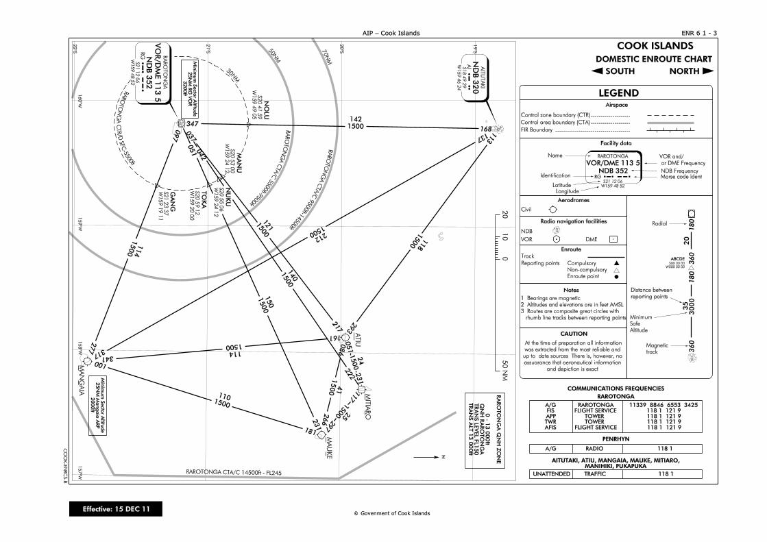
097
051 042
037
277 317
341
001
181
231
266 297
117
231
051
293
217
161
222
086
113
137
168347
NO
LU
S20 4
1 5
9
W1
59
49
05
MA
NU
S20 5
3 0
0
W1
59
24
12
NU
KU
S20 5
5 0
6
W1
59
24
12
TO
KA
S20 5
9 1
2
W1
59
20
00
GA
NG
S21 2
3 3
7
W1
59
19
11
180
3000
35
360
LEGEND
Facility data
Name
Identification
Latitude
Longitude
Airspace
Control zone boundary (CTR)
FIR Boundary
Aerodromes
Enroute
Radio navigation facilities
Reporting points
180
Morse code ident
--------------------
--------------------
--------------------------------------
360
Radial
Distance between
reporting points
Magnetic
track
Minimum
Safe
Altitude
Control area boundary (CTA)
1. Bearings are magnetic
2. Altitudes and elevations are in feet AMSL
3. Routes are composite great circles with
rhumb line tracks between reporting points
Notes
CAUTIO N
NDB Frequency
RARO
TO
NG
A C
TA/C 9500ft-1
4500ft
RAROTO
NG
A C
TA/C 5500ft-9500ft
RAROTO
NG
A C
TR/D SFC-5500ft
RG
VO
R/D
ME
113.5
RA
RO
TO
NG
A
ND
B 3
52
RG
S2
1 1
2 0
6
W1
59
48
52
114
212
121
140
150
118
142
114
110
41
25
24
1500
1500
1500
1500
1500
1500 1500
1500
1500
cc
Civil
NDB
VO R DME
Track
R G
VO R/DM E 113.5
RARO TO NGA
NDB 352RG
S21 12 06
W 159 48 52
VO R and/
or DME Frequency
ABCDES00 00 00
W 000 00 00
20
CO O K ISLANDS
DO M ESTIC ENRO UTE CHART
SO UTH NO RTH
RA
RO
TO
NG
A Q
NH
ZO
NE
0 -
13
00
0ft
QN
H R
AR
OT
ON
GA
TR
AN
S L
EV
EL
FL
15
0T
RA
NS
AL
T 1
3 0
00
ftA
I
ND
B 3
20
AIT
UT
AK
I
AI
S18 4
9 2
9
W159 4
6 2
4
CO M M UNICATIO NS FREQ UENCIES
A/G RARO TO NGA 11339 8846 6553 3425FIS FLIGHT SERVICE 118.1 121.9APP TO W ER 118.1 121.9TW R TO W ER 118.1 121.9AFIS FLIGHT SERVICE 118.1 121.9
RADIO 118.1
UNATTENDED TRAFFIC 118.1
RARO TO NGA
PENRHYN
AITUTAKI, ATIU, M ANGAIA, M AUKE, MITIARO,M ANIHIKI, PUKAPUKA
Min
imum
Secto
r Altitu
de
25N
M M
angaia
AR
P2
00
0ft
20°S
21°S
22°S
19°S
16
0°W
15
9°W
15
8°W
15
7°W RARO TO NGA CTA/C 14500ft - FL245
1500
1500
1500
30N
M
50N
M
70N
M
Compulsory
Non-compulsory
Enroute point
A/G
At the time of preparation all information
was extracted from the most reliable and
up to date sources. There is, however, no
assuarance that aeronautical information
and depiction is exact.
N
Min
imum
Secto
r Altitu
de
25N
M R
G V
OR
32
00
ft
01
02
05
0 N
M
MA
NG
AIA
MA
UKE
MIT
IAR
O
ATIU
CO
OK
-EN
RC
S-B
ENR 6.1 - 3AIP - Cook Islands
Govenm ent of Cook IslandsEffective: 15 DEC 11
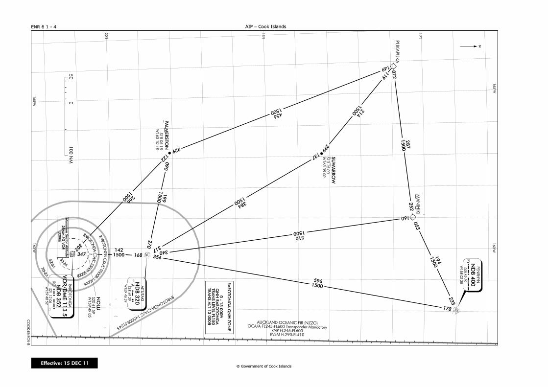
cc
16
0°W
16
5°W
20
°S
15
°S
10
°S
347 168 356
340
317
178
160
137
299
119
090
270
122
302
252
072
053
233
149
329
ND
B 3
52
RG A
I
ND
B 3
20
AIT
UT
AK
I
AI
S18 4
9 2
9
W159 4
6 2
4
PY N
DB
40
0
PE
NR
HY
N
PY
S08 5
9 3
9
W158 0
2 3
8
S1
8 0
5 1
8
W163 1
0 4
8
1421500
5961500
510
1500
384
1500
214
1500
194
1500
287
1500
RAROTO
NGA CTA/C 14500ft-FL245
AUCKLAND O CEANIC FIR (NZZO)O CA/A FL245-FL600 Transponder Mandatory
RNP FL245-FL600RVSM FL290-FL410
RAROTO
NGA C
TA/C 9500ft-14500ft
RAROTO
NGA C
TA/C 55
00ft-9500ft
50N
M
70N
M
30N
M
NO
LU
S2
0 4
1 5
9
W159 4
9 0
5
50
0100 N
M
N
456
1500
RA
RO
TO
NG
A Q
NH
ZO
NE
0 -
13 0
00ft
QN
H R
AR
OT
ON
GA
TR
AN
S L
EV
EL
FL
15
0T
RA
NS
AL
T 1
3 0
00
ft
S1
3 1
5 0
0
W163 0
5 0
0
PU
KA
PU
KA
MA
NIH
IKI
PA
LM
ER
ST
ON
SU
WA
RR
OW
ENR 6.1 - 4
CO
OK
-EN
RC
N-B
AIP - Cook Islands
16
5°W
16
0°W
199
1500 266
1500
RA
RO
TO
NG
A
S2
1 1
2 0
6
W159 4
8 5
2
VO
R/D
ME
113.5
RG
Min
imum
Secto
r Altitu
de
25
NM
RG
VO
R3200ft
Governm ent of Cook IslandsEffective: 15 DEC 11
AD 0.6 - 1AIP — Cook Islands
E Government of Cook Islands
AD 0AD 0.1AD 0.2AD 0.3AD 0.4AD 0.5
AD 0.6 TABLE OF CONTENTS — AD
Page No.
AD 0.6 TABLE OF CONTENTS — AD AD 0.6 - 1. . . . . . . . . . . . . . . . . . . . . . .
AD 1 AERODROMES/HELIPORTS —INTRODUCTION AD 1 - 1. . . . . . . . . . . . . . . . . . . . . . . . . . . . . .
AD 1.1 AERODROME/HELIPORT AVAILABILITY AD 1.1 - 1. . . . . . . . .1 Overall Aerodrome Authority AD 1.1 - 1. . . . . . . . . . . . . . . . . . . . . . . .1.1 General AD 1.1 - 1. . . . . . . . . . . . . . . . . . . . . . . . . . . . . . . . . . . . . . . .
2 General Conditions Under Which Aerodromesare Available AD 1.1 - 1. . . . . . . . . . . . . . . . . . . . . . . . . . . . . . . . . . . . . . . .2.1 Airports of Entry AD 1.1 - 1. . . . . . . . . . . . . . . . . . . . . . . . . . . . . . . .2.2 Use of Aerodromes by Private Pilots AD 1.1 - 2. . . . . . . . . . . . .
AD 1.2 RESCUE AND FIRE FIGHTING SERVICES AD 1.2 - 1. . . . . . . . .1 Rescue and Fire fighting services AD 1.2 - 1. . . . . . . . . . . . . . . . . . . .1.1 General AD 1.2 - 1. . . . . . . . . . . . . . . . . . . . . . . . . . . . . . . . . . . . . . . .
AD 1.3 INDEX TO AERODROMES AND HELIPORTS AD 1.3 - 1. . . . . . .1 Index of Aerodromes and Heliports AD 1.3 - 1. . . . . . . . . . . . . . . . . .1.1 Aerodromes AD 1.3 - 1. . . . . . . . . . . . . . . . . . . . . . . . . . . . . . . . . . . .
Table AD 1.3-1Index to Aerodromes AD 1.3 - 1. . . . . . . . . . . . . . . . . . . . . . . . . . . . . . . . . . .
AD 1.4 GROUPING OF AERODROMES/HELIPORTS AD 1.4 - 1. . . . . . .1 Public and Civil Aerodromes AD 1.4 - 1. . . . . . . . . . . . . . . . . . . . . . . . .1.1 General AD 1.4 - 1. . . . . . . . . . . . . . . . . . . . . . . . . . . . . . . . . . . . . . . .1.2 International Aerodromes AD 1.4 - 1. . . . . . . . . . . . . . . . . . . . . . .1.3 National Aerodromes AD 1.4 - 1. . . . . . . . . . . . . . . . . . . . . . . . . . .1.4 Heliports AD 1.4 - 1. . . . . . . . . . . . . . . . . . . . . . . . . . . . . . . . . . . . . . .1.5 Criteria for Grouping Aerodromes/Heliports
in the Cook Islands AD 1.4 - 2. . . . . . . . . . . . . . . . . . . . . . . . . . . . .
AD 1.5 USE OF DESIGNATED RUNWAYS, STRIPSAND VECTORS AD 1.5 - 1. . . . . . . . . . . . . . . . . . . . . . . . . . . . . . . . . . . . .
1 Use of Runways, Strips and Vectors AD 1.5 - 1. . . . . . . . . . . . . . . . . .1.1 General AD 1.5 - 1. . . . . . . . . . . . . . . . . . . . . . . . . . . . . . . . . . . . . . . .1.2 Runway Vector Selection AD 1.5 - 1. . . . . . . . . . . . . . . . . . . . . . .
Effective: 15 DEC 11
AD 0.6 - 2 AIP — Cook Islands
E Government of Cook Islands
Page No.
AD 1.6 AERODROME CONTROL CLEARANCES AD 1.6 - 1. . . . . . . . . . . . .1 Introduction AD 1.6 - 1. . . . . . . . . . . . . . . . . . . . . . . . . . . . . . . . . . . . . . . . .1.1 General AD 1.6 - 1. . . . . . . . . . . . . . . . . . . . . . . . . . . . . . . . . . . . . . . .
Figure AD 1.6-1Positions for Clearance at Controlled Aerodromes AD 1.6 - 1. . . . . . . .2 Landing Clearances AD 1.6 - 2. . . . . . . . . . . . . . . . . . . . . . . . . . . . . . . . . .2.1 General AD 1.6 - 2. . . . . . . . . . . . . . . . . . . . . . . . . . . . . . . . . . . . . . . .
AD 1.7 AERODROME CONTROL — RUNWAYSEPARATION AD 1.7 - 1. . . . . . . . . . . . . . . . . . . . . . . . . . . . . . . . . . . . . .
1 Introduction AD 1.7 - 1. . . . . . . . . . . . . . . . . . . . . . . . . . . . . . . . . . . . . . . . .1.1 General AD 1.7 - 1. . . . . . . . . . . . . . . . . . . . . . . . . . . . . . . . . . . . . . . .
2 Single Runway AD 1.7 - 1. . . . . . . . . . . . . . . . . . . . . . . . . . . . . . . . . . . . . .2.1 General AD 1.7 - 1. . . . . . . . . . . . . . . . . . . . . . . . . . . . . . . . . . . . . . . .
3 Wake Turbulence AD 1.7 - 2. . . . . . . . . . . . . . . . . . . . . . . . . . . . . . . . . . . .3.1 General AD 1.7 - 2. . . . . . . . . . . . . . . . . . . . . . . . . . . . . . . . . . . . . . . .3.2 Weight Categories AD 1.7 - 2. . . . . . . . . . . . . . . . . . . . . . . . . . . . . .3.3 Wake Turbulence Separation AD 1.7 - 3. . . . . . . . . . . . . . . . . . . .
Table AD 1.7-1Wake Turbulence Separation Minima — ArrivingFlights AD 1.7 - 3. . . . . . . . . . . . . . . . . . . . . . . . . . . . . . . . . . . . . . . . . . . . . . . . . .Table AD 1.7-2Wake Turbulence Separation Minima — DepartingFlights AD 1.7 - 3. . . . . . . . . . . . . . . . . . . . . . . . . . . . . . . . . . . . . . . . . . . . . . . . . .Table AD 1.7-3Wake Turbulence Separation Minima — Arriving andDeparting Flights AD 1.7 - 4. . . . . . . . . . . . . . . . . . . . . . . . . . . . . . . . . . . . . . .
AD 1.8 DEPARTURE FROM THE CIRCUIT AD 1.8 - 1. . . . . . . . . . . . . . . . .1 Introduction AD 1.8 - 1. . . . . . . . . . . . . . . . . . . . . . . . . . . . . . . . . . . . . . . . .1.1 General AD 1.8 - 1. . . . . . . . . . . . . . . . . . . . . . . . . . . . . . . . . . . . . . . .
AD 1.9 AERODROME CIRCUIT PROCEDURES AD 1.9 - 1. . . . . . . . . . . . .1 Circuit Height AD 1.9 - 1. . . . . . . . . . . . . . . . . . . . . . . . . . . . . . . . . . . . . . .1.1 General AD 1.9 - 1. . . . . . . . . . . . . . . . . . . . . . . . . . . . . . . . . . . . . . . .
2 Standard Circuit Joining Procedure AD 1.9 - 1. . . . . . . . . . . . . . . . . . .2.1 General AD 1.9 - 1. . . . . . . . . . . . . . . . . . . . . . . . . . . . . . . . . . . . . . . .
Figure AD 1.9-1Standard Overhead Joining Procedure AD 1.9 - 2. . . . . . . . . . . . . . . . . . .3 Circuit Joining Procedure — Controlled Aerodromes AD 1.9 - 3. .3.1 General AD 1.9 - 3. . . . . . . . . . . . . . . . . . . . . . . . . . . . . . . . . . . . . . . .
4 Circuit Joining Procedures — UncontrolledAerodromes AD 1.9 - 3. . . . . . . . . . . . . . . . . . . . . . . . . . . . . . . . . . . . . . . . .4.1 General AD 1.9 - 3. . . . . . . . . . . . . . . . . . . . . . . . . . . . . . . . . . . . . . . .
Effective: 15 DEC 11

AD 0.6 - 3AIP — Cook Islands
E Government of Cook Islands
Page No.
AERODROMES
NCAI AITUTAKI NCAI AD 2 - 1. . . . . . . . . . . . . . . . . . . . . . . . . . . . . . . . . . . . .
NCAT ATIU NCAT AD 2 - 1. . . . . . . . . . . . . . . . . . . . . . . . . . . . . . . . . . . . . . . . . .
NCMG MANGAIA NCMG AD 2 - 1. . . . . . . . . . . . . . . . . . . . . . . . . . . . . . . . . . . . .
NCMH MANIHIKI NCMH AD 2 - 1. . . . . . . . . . . . . . . . . . . . . . . . . . . . . . . . . . . .
NCMK MAUKE NCMK AD 2 - 1. . . . . . . . . . . . . . . . . . . . . . . . . . . . . . . . . . . . . . . .
NCMR MITIARO NCMR AD 2 - 1. . . . . . . . . . . . . . . . . . . . . . . . . . . . . . . . . . . . . .
NCPY PENRHYN NCPY AD 2 - 1. . . . . . . . . . . . . . . . . . . . . . . . . . . . . . . . . . . . .
NCPK PUKAPUKA NCPK AD 2 - 1. . . . . . . . . . . . . . . . . . . . . . . . . . . . . . . . . . . .
NCRG RAROTONGA NCRG AD 2 - 1. . . . . . . . . . . . . . . . . . . . . . . . . . . . . . . . . .
Effective: 15 DEC 11
AD 0.6 - 4 AIP — Cook Islands
E Government of Cook Islands
IntentionallyBlank
Effective: 15 DEC 11
AD 1 - 1AIP — Cook Islands
E Government of Cook Islands
AD 1 AERODROMES/HELIPORTS —INTRODUCTION
Effective: 15 DEC 11

AD 1 - 2 AIP — Cook Islands
E Government of Cook Islands
IntentionallyBlank
Effective: 15 DEC 11

AD 1.1 - 1AIP — Cook Islands
E Government of Cook Islands
AD 1.1 AERODROME/HELIPORT AVAILABILITY
1 OVERALL AERODROME AUTHORITY
1.1 General
1.1.1 The administration of aerodromes “open to public air traffic” is theresponsibility of The Airport Authority, Cook Islands.
Note
Refer to GEN 1.1 for postal and telegraphic addresses.
1.1.2 An aerodrome shall be said to be “open to public air traffic” when itis open for use by all aircraft having suitable technical characteristics,subject to the provisions in section 2.
2 GENERAL CONDITIONS UNDER WHICH AERODROMES ARE AVAILABLE
2.1 Airports of Entry
2.1.1 Aircraft flying into or departing from Cook Islands territory shallmake their first landing at, or final departure from Rarotonga Internationalairport.
Effective: 15 DEC 11
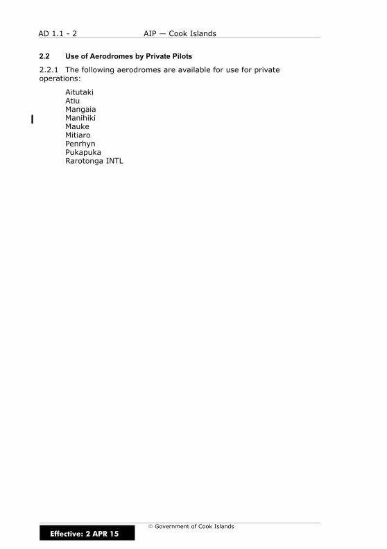
AD 1.1 - 2 AIP — Cook Islands
E Government of Cook Islands
2.2 Use of Aerodromes by Private Pilots
2.2.1 The following aerodromes are available for use for privateoperations:
AitutakiAtiuMangaiaManihikiMaukeMitiaroPenrhynPukapukaRarotonga INTL
Effective: 2 APR 15

AD 1.2 - 1AIP — Cook Islands
E Government of Cook Islands
AD 1.2 RESCUE AND FIRE FIGHTING SERVICES
1 RESCUE AND FIRE FIGHTING SERVICES
1.1 General
1.1.1 Rescue and fire fighting services are provided at RarotongaInternational Airport.
Effective: 15 DEC 11

AD 1.2 - 2 AIP — Cook Islands
E Government of Cook Islands
IntentionallyBlank
Effective: 15 DEC 11
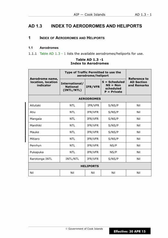
AD 1.3 - 1AIP — Cook Islands
E Government of Cook Islands
AD 1.3 INDEX TO AERODROMES AND HELIPORTS
1 INDEX OF AERODROMES AND HELIPORTS
1.1 Aerodromes
1.1.1 Table AD 1.3 - 1 lists the available aerodromes/heliports for use.
Table AD 1.3 -1Index to Aerodromes
Aerodrome name
Type of Traffic Permitted to use theaerodrome/heliport
Reference toAerodrome name,location, location
indicatorInternational/National(INTL/NTL)
IFR/VFR
S = ScheduledNS = NonscheduledP = Private
Reference toAD Sectionand Remarks
AERODROMES
Aitutaki NTL IFR/VFR S/NS/P Nil
Atiu NTL IFR/VFR S/NS/P Nil
Mangaia NTL IFR/VFR S/NS/P Nil
Manihiki NTL IFR/VFR S/NS/P Nil
Mauke NTL IFR/VFR S/NS/P Nil
Mitiaro NTL IFR/VFR S/NS/P Nil
Penrhyn NTL IFR/VFR NS/P Nil
Pukapuka NTL IFR/VFR NS/P Nil
Rarotonga INTL INTL/NTL IFR/VFR S/NS/P Nil
HELIPORTS
Nil Nil Nil Nil Nil
Effective: 30 APR 15

AD 1.3 - 2 AIP — Cook Islands
E Government of Cook Islands
IntentionallyBlank
Effective: 15 DEC 11
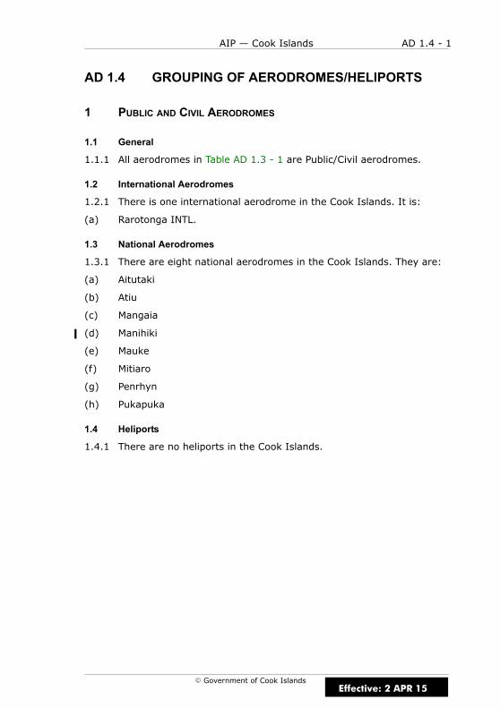
AD 1.4 - 1AIP — Cook Islands
E Government of Cook Islands
AD 1.4 GROUPING OF AERODROMES/HELIPORTS
1 PUBLIC AND CIVIL AERODROMES
1.1 General
1.1.1 All aerodromes in Table AD 1.3 - 1 are Public/Civil aerodromes.
1.2 International Aerodromes
1.2.1 There is one international aerodrome in the Cook Islands. It is:
(a) Rarotonga INTL.
1.3 National Aerodromes
1.3.1 There are eight national aerodromes in the Cook Islands. They are:
(a) Aitutaki
(b) Atiu
(c) Mangaia
(d) Manihiki
(e) Mauke
(f) Mitiaro
(g) Penrhyn
(h) Pukapuka
1.4 Heliports
1.4.1 There are no heliports in the Cook Islands.
Effective: 2 APR 15

AD 1.4 - 2 AIP — Cook Islands
E Government of Cook Islands
1.5 Criteria for Grouping Aerodromes/Heliports in the Cook Islands
1.5.1 The criteria applied by the Cook Islands in groupingaerodromes/heliports for the provision of information in this AIP are asfollows:
Primary/major international aerodrome/heliport
1.5.2 The aerodrome/heliport of entry and departure for international airtraffic, where all formalities concerning Customs, immigration, health,animal and plant quarantine and similar procedures are carried out andwhere air traffic services are available on a regular basis.
Secondary/other international aerodrome/heliport
1.5.3 Another aerodrome/heliport available for the entry or departure ofinternational air traffic, where the formalities concerning Customs,immigration, health and similar procedures and air traffic services aremade available, on a restricted basis, to flights with prior approval only.
National aerodrome/heliport
1.5.4 An aerodrome/heliport available only for domestic air traffic,including those military aerodromes/heliports where civil air trafffic isallowed under certain conditions.
Effective: 30 APR 15

AD 1.5 - 1AIP — Cook Islands
E Government of Cook Islands
AD 1.5 USE OF DESIGNATED RUNWAYS, STRIPSAND VECTORS
1 USE OF RUNWAYS, STRIPS AND VECTORS
1.1 General
1.1.1 At aerodromes where runways, strips and/or vectors are definedand promulgated in the aerodrome charts. Aircraft take-offs and landingsare restricted to those defined runways, strips or vectors. The aerodromecharts depict the location of the runways, strips and vectors.
1.2 Runway Vector Selection
1.2.1 Where aerodrome control is being provided, the designated runwayis that best favouring the wind direction and the take-off lengthrequirements of the majority of the traffic. All aircraft are informed of therunway-in-use by the ATS unit.
Effective: 15 DEC 11

AD 1.5 - 2 AIP — Cook Islands
E Government of Cook Islands
IntentionallyBlank
Effective: 15 DEC 11

AD 1.6 - 1AIP — Cook Islands
E Government of Cook Islands
AD 1.6 AERODROME CONTROL CLEARANCES
1 INTRODUCTION
1.1 General
1.1.1 Figure AD 1.6 - 1 shows the positions where aircraft at controlledaerodromes normally receive aerodrome control clearances, either by radioor light signals.
Figure AD 1.6 - 1Postions for Clearance at Controlled Aerodromes
Runway-in-use
Apron
Take-offclearance
normally issuedhere
Departingtraffic may beheld at holding
point fortake-offclearance
Aircraft initiatescall for departingflight. Runway-in-use informationand taxi clearance
given
Clearance toland normally
issued
Aerodrome control servicenot provided for movementswithin the area designatedby
Effective: 15 DEC 11
AD 1.6 - 2 AIP — Cook Islands
E Government of Cook Islands
2 LANDING CLEARANCES
2.1 General
2.1.1 A landing aircraft is not permitted to cross the threshold of therunway on its final approach until:
(a) a preceding departing aircraft has crossed the end of therunway-in-use or has started a turn; or
(b) all preceding landing aircraft are clear of the runway-in-use.
Notes
It is the responsibility of pilots operating into AFIS or unattendedaerodromes to arrange the flight paths of their aircraft to conform to thesestandards.
At controlled aerodromes the aerodrome controller may issue a qualifiedlanding clearance by day only, to an aircraft on final approach when it isobvious that a preceding landing or departing aircraft will be clear of therunway before the approaching aircraft crosses the threshold.
Examples of qualified landing clearances are as follow :
(a) “737 VACATING RUNWAY RIGHT, XYZ CLEARED TO LAND”
(b) “ISLANDER DEPARTING, XYZ CLEARED TO LAND”
It is the responsibility of the pilot of a landing aircraft to “go around” if heor she considers that the runway separation criteria detailed above cannotbe met. Pilots are reminded of the possibility of wake turbulence whenfollowing another landing or a departing aircraft and of the fact that it maypersist to a varying degree depending on the direction and strength of thesurface wind.
Effective: 15 DEC 11
AD 1.7 - 1AIP — Cook Islands
E Government of Cook Islands
AD 1.7 AERODROME CONTROL — RUNWAYSEPARATION
1 INTRODUCTION
1.1 General
1.1.1 The runway separation standards applied by ATC between aircrafttaking off, between aircraft landing and between aircraft landing and takingoff is outlined below. These standards may be increased if IFR flights areinvolved. When wake turbulence in the landing or take-off path could besignificant, runway separation will be increased by ATC as indicated in 3.
1.1.2 The runway separation minima outlined below will be applied toaircraft landing or taking off, except that these separation minima will notapply to aircraft in formation in respect of other aircraft in the sameformation.
2 SINGLE RUNWAY
2.1 General
2.1.1 An aircraft will not be cleared for take-off until:
(a) a preceding aircraft has crossed the up-wind end of therunway-in-use or has started a turn, except that if both aircraft arebelow 2,300kg MCTOW and the following aircraft is not significantlyfaster than the leading aircraft, separation may be reduced to 610mprovided the leading aircraft is airborne; or
(b) all preceding landing aircraft are clear of the runway-in-use.
2.1.2 A landing aircraft is not permitted to cross the threshold of therunway on final approach until:
(a) a preceding departing aircraft has crossed the up-wind end of therunway-in-use or has started a turn; or
(b) all preceding landing aircraft are clear of the runway-in-use.
Effective: 15 DEC 11
AD 1.7 - 2 AIP — Cook Islands
E Government of Cook Islands
3 WAKE TURBULENCE
3.1 General
3.1.1 Wake turbulence separation is provided by ATC to all aircraft whichmay be affected by wake turbulence, except in the case of IFR aircraftmaking a visual approach or VFR arrivals. In these cases it is the pilot’sresponsibility to provide adequate spacing from the proceeding arriving ordeparting aircraft, and in these circumstances, ATC will make allowance forsuch pilot initiated manoeuvres when sequencing additional followingaircraft. The required spacings are shown in Section 3.3.
3.1.2 Whenever practicable, ATC will advise aircraft of the expectedoccurrence of hazards caused by wake turbulence by issuing a caution tothe pilot, “CAUTION — WAKE TURBULENCE”. It should be noted, however,that the occurrence of wake turbulence hazards cannot be accuratelypredicted, and ATC cannot assume responsibility for issuing such advice atall times, nor its accuracy.
3.2 Weight Categories
3.2.1 For the purposes of assessing wake turbulence separation, aircraftare divided into the following weight categories:
Heavy (H)
3.2.2 All types of aircraft of 136,000kg maximum weight or more.Includes A330, A340, C141, B747 series, B767, MD11 and DC10.
Medium (M)
3.2.3 All types of aircraft of less than 136,000kg maximum weight butmore than 7,000kg. Includes A320, B727, B737 series, F27, BA46, C130,P3, SF34 and SW4.
Light (L)
3.2.4 All types of aircraft of 7,000kg maximum weight or less. IncludesBN2P, C402, C421, NOMA, PA31, E110 and SW3.
3.2.5 For further information on wake turbulence categories refer to ICAODoc 8643 — Aircraft Type Designators.
Effective: 15 DEC 11

AD 1.7 - 3AIP — Cook Islands
E Government of Cook Islands
3.3 Wake Turbulence Separation
3.3.1 The following minimum time separations apply between aircraftusing the same runway or grass strip, or where there is a possibility thatthe projected flight profiles will cross at the same altitude or less than1,000ft below.
Between Arriving Flights
Table AD 1.7 - 1Wake Turbulence Separation Minima — Arriving Flights
LEADING AIRCRAFT FOLLOWINGAIRCRAFT MINIMUM TIME
Heavy Medium,Light
2 minutes,3 minutes
Medium Light 3 minutes
Between Departing Flights
Table AD 1.7 - 2Wake Turbulence Separation Minima — Departing Flights
LEADINGAIRCRAFT
FOLLOWINGAIRCRAFT
DEPARTUREFROM SAME
TAKE-OFFPOSITION
DEPARTUREFROM
INTERMEDIATETAKE-OFFPOSITION
Heavy Medium,Light
2 minutes 3 minutes
Medium Light
2 minutes 3 minutes
Effective: 15 DEC 11
AD 1.7 - 4 AIP — Cook Islands
E Government of Cook Islands
Between Arriving and Departing Flights
3.3.2 The minimum time separations shown in Table AD 1.7 - 1 and TableAD 1.7 - 2 apply between arriving and departing aircraft if the flight path ofthe following aircraft will cross the projected flight path of the leadingaircraft e.g. when an arriving aircraft is operating onto a runway with adisplaced landing threshold.
Table AD 1.7 - 3Wake Turbulence Separation Minima — Arriving and Departing Flights
LEADING AIRCRAFT FOLLOWINGAIRCRAFT
MINIMUM SPACINGAT TIME AIRCRAFTARE AIRBORNE OR
HAVE TOUCHEDDOWN
Heavy arrival Medium departure,Light departure
Medium arrival Light departure2 minutes
Heavy departure Medium arrival,Light arrival
2 minutes
Medium departure Light arrival
Effective: 15 DEC 11
AD 1.7 - 5AIP — Cook Islands
E Government of Cook Islands
Opposite Direction Runway Operations
3.3.3 A minimum of 2 minutes’ separation will be provided between aHeavy aircraft take-off and the departure of a Medium or Light aircraft, orbetween a Medium aircraft take-off and the departure of a Light aircraft,from the opposite direction runway if the projected flight profiles will cross.
3.3.4 A minimum of 2 minutes’ separation will be provided between aHeavy aircraft making a low or missed approach and the departure of aMedium or Light aircraft, or between a Medium aircraft making a low ormissed approach and the departure of a Light aircraft from the oppositedirection runway.
Notes
If a pilot considers the wake turbulence separation standards inadequate,an increased separation may be requested by specifying the spacingrequired.
If ATC considers the wake turbulence separation provided is inadequate orthat it needs to be applied for any situation not covered by a specifiedminimum the pilot will be advised and an appropriate separation applied.
Notwithstanding the above separation standards, if pilots consider that theeffect of wake turbulence can be nullified by ensuring that flight profiles donot cross, they may request and be granted exemption from theseseparations. ATC will advise the category or type of the other aircraft wherethat aircraft is a Heavy aircraft.
Effective: 15 DEC 11

AD 1.7 - 6 AIP — Cook Islands
E Government of Cook Islands
IntentionallyBlank
Effective: 15 DEC 11
AD 1.8 - 1AIP — Cook Islands
E Government of Cook Islands
AD 1.8 DEPARTURE FROM THE CIRCUIT
1 INTRODUCTION
1.1 General
1.1.1 The pilot of a VFR aircraft departing the traffic circuit must make allturns in the direction of the traffic circuit, unless:
(a) otherwise authorised by ATC; or
(b) if at an uncontrolled aerodrome, the pilot is clear of the circuit areaor 1,500ft above the aerodrome.
Effective: 15 DEC 11

AD 1.8 - 2 AIP — Cook Islands
E Government of Cook Islands
IntentionallyBlank
Effective: 15 DEC 11

AD 1.9 - 1AIP — Cook Islands
E Government of Cook Islands
AD 1.9 AERODROME CIRCUIT PROCEDURES
1 CIRCUIT HEIGHT
1.1 General
1.1.1 Unless otherwise specified on the aerodrome chart the circuit heightwill be 1,000ft above the aerodrome elevation.
2 STANDARD CIRCUIT JOINING PROCEDURE
2.1 General
2.1.1 The standard joining procedure is shown in Figure AD 1.9 - 1. Thisprocedure should be followed when a pilot is unfamiliar with the aerodromeor is uncertain of other circuit traffic:
(a) Unless otherwise specified on the appropriate aerodrome chart,approach the aerodrome by descending or climbing to not less than1,500ft above aerodrome elevation or not less than 500ft abovecircuit height if a circuit height other than 1,000ft is specified on thelanding chart, and observe the wind, circuit direction and anyground signals displayed. If the ceiling will not permit flight above1,000ft or other specified circuit height, an aircraft may enter at alower altitude but must avoid passing through the circuit pattern.
(b) Make all subsequent turns in the direction of the traffic circuit.
Effective: 15 DEC 11
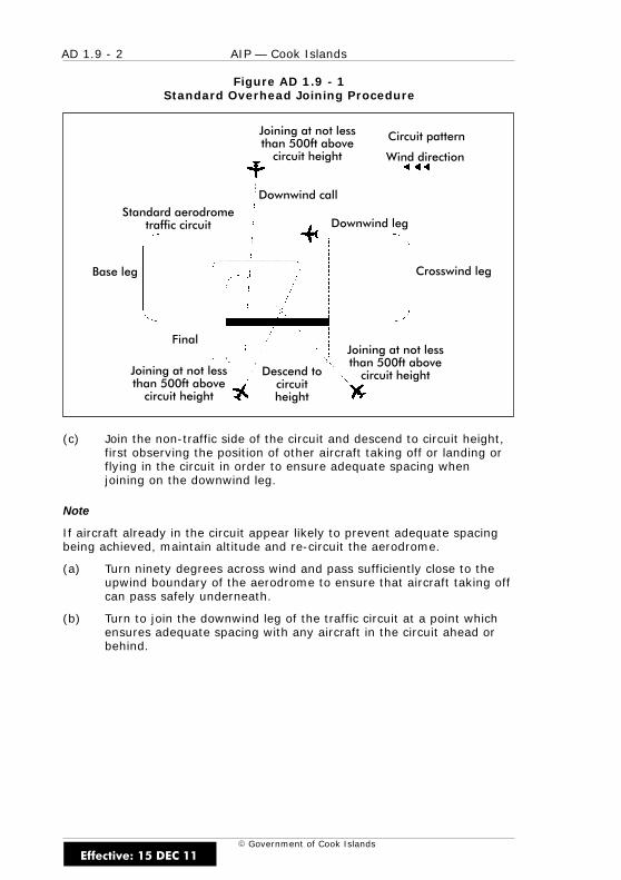
AD 1.9 - 2 AIP — Cook Islands
E Government of Cook Islands
Figure AD 1.9 - 1Standard Overhead Joining Procedure
Downwind call
Downwind leg
Crosswind leg
Standard aerodrometraffic circuit
Base leg
Final
Joining at not lessthan 500ft abovecircuit height
Descend tocircuitheight
Joining at not lessthan 500ft abovecircuit height
Joining at not lessthan 500ft abovecircuit height
Circuit pattern
Wind direction
(c) Join the non-traffic side of the circuit and descend to circuit height,first observing the position of other aircraft taking off or landing orflying in the circuit in order to ensure adequate spacing whenjoining on the downwind leg.
Note
If aircraft already in the circuit appear likely to prevent adequate spacingbeing achieved, maintain altitude and re-circuit the aerodrome.
(a) Turn ninety degrees across wind and pass sufficiently close to theupwind boundary of the aerodrome to ensure that aircraft taking offcan pass safely underneath.
(b) Turn to join the downwind leg of the traffic circuit at a point whichensures adequate spacing with any aircraft in the circuit ahead orbehind.
Effective: 15 DEC 11
AD 1.9 - 3AIP — Cook Islands
E Government of Cook Islands
3 CIRCUIT JOINING PROCEDURE — CONTROLLED AERODROMES
3.1 General
3.1.1 Aircraft intending to land at a controlled aerodrome must join thecircuit in accordance with ATC instructions. The following joiningprocedures may be specified:
(a) by descending to circuit height prior to joining and making either astraight-in approach to the runway-in-use or joining a downwind legor base leg; or
(b) as outlined in the standard circuit joining procedure above.
4 CIRCUIT JOINING PROCEDURES — UNCONTROLLED AERODROMES
4.1 General
4.1.1 The pilot of an aircraft intending to land at an unattendedaerodrome may join the circuit in the way outlined in the circuit joiningprocedure for controlled aerodromes provided that:
(a) the runway-in-use and aerodrome traffic are properly ascertained;and
(b) when making a straight-in approach, or joining a downwind or baseleg, the aircraft is sequenced in such a way as to give priority toother aircraft already established in the circuit or joining inaccordance with the standard circuit joining procedure describedabove; and
(c) when entering or flying within the circuit, all turns are made in thedirection appropriate to the runway-in-use.
Effective: 15 DEC 11

AD 1.9 - 4 AIP — Cook Islands
E Government of Cook Islands
IntentionallyBlank
Effective: 15 DEC 11

NCAI AD 2 - 1AIP — Cook Islands
E Government of Cook Islands
NCAI AD 2.1 AERODROME LOCATION INDICATORAND NAME
NCAI AITUTAKI
NCAI AD 2.2 AERODROME GEOGRAPHICAL ANDADMINISTRATIVE DATA
1 ARP co-ordinates andsite at AD
S 18 49 51.97 W 159 45 50.49ARP site as depicted on NCAI AD 2-51.1
2 Direction and distancefrom city
5km NE of town(North end of Aitutaki Island)
3 Elevation/Referencetemperature
19ft
4 MAG VAR/Annualchange
13°E (2016)
5 AD Administration,address, telephone,telefax, telex, AFS
Licensee: Cook Islands Airport AuthorityPO Box 90RarotongaTel (682) 21890NCRGYDYX
6 Types of trafficpermitted (IFR/VFR)
IFR/VFR
7 Remarks Nil
Effective: 19 JUL 18
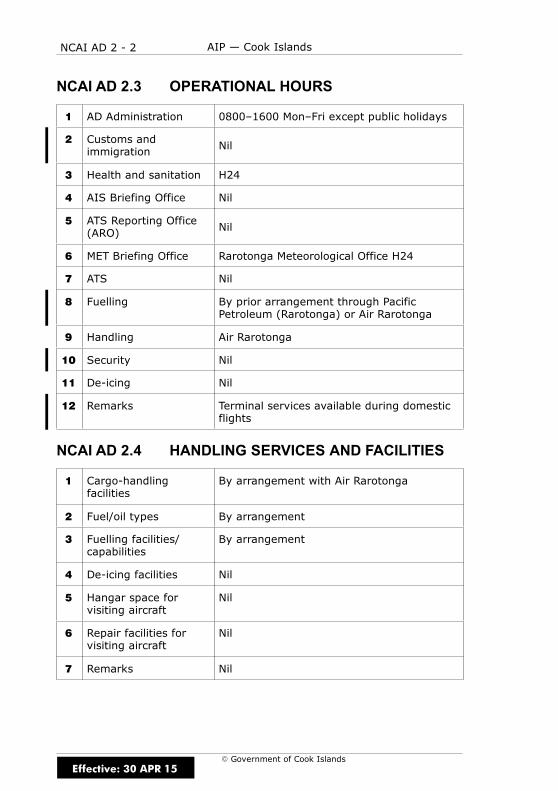
NCAI AD 2 - 2 AIP — Cook Islands
E Government of Cook Islands
NCAI AD 2.3 OPERATIONAL HOURS
1 AD Administration 0800–1600 Mon–Fri except public holidays
2 Customs andimmigration Nil
3 Health and sanitation H24
4 AIS Briefing Office Nil
5 ATS Reporting Office(ARO) Nil
6 MET Briefing Office Rarotonga Meteorological Office H24
7 ATS Nil
8 Fuelling By prior arrangement through PacificPetroleum (Rarotonga) or Air Rarotonga
9 Handling Air Rarotonga
10 Security Nil
11 De-icing Nil
12 Remarks Terminal services available during domesticflights
NCAI AD 2.4 HANDLING SERVICES AND FACILITIES
1 Cargo-handlingfacilities
By arrangement with Air Rarotonga
2 Fuel/oil types By arrangement
3 Fuelling facilities/capabilities
By arrangement
4 De-icing facilities Nil
5 Hangar space forvisiting aircraft
Nil
6 Repair facilities forvisiting aircraft
Nil
7 Remarks Nil
Effective: 30 APR 15

NCAI AD 2 - 3AIP — Cook Islands
E Government of Cook Islands
NCAI AD 2.5 PASSENGER FACILITIES
1 Hotels Accommodation facilities near airport andaround island
2 Restaurants In town and around island
3 Transportation Hotel transfers, rental cars
4 Medical facilities Hospital
5 Bank and Post Office In town
6 Tourist Office In town
7 Remarks Nil
NCAI AD 2.6 RESCUE AND FIRE FIGHTING SERVICES
1 AD Category forfirefighting
Category 4
2 Rescue equipment Portable lighting, bolt cutting equipment,breathing apparatus, medical equipment,communications equipment, portable radios,stretchers
3 Capability for removalof disabled aircraft
For aircraft up to 13000kg: equipmentavailable locally
4 Remarks Nil
NCAI AD 2.7 SEASONAL AVAILABILITY — CLEARING
1 Types of clearingequipment
Nil
2 Clearing priorities Nil
3 Remarks Nil
Effective: 15 DEC 11
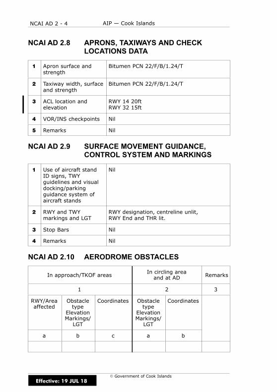
NCAI AD 2 - 4 AIP — Cook Islands
E Government of Cook Islands
NCAI AD 2.8 APRONS, TAXIWAYS AND CHECKLOCATIONS DATA
1 Apron surface andstrength
Bitumen PCN 22/F/B/1.24/T
2 Taxiway width, surfaceand strength
Bitumen PCN 22/F/B/1.24/T
3 ACL location andelevation
RWY 14 20ftRWY 32 15ft
4 VOR/INS checkpoints Nil
5 Remarks Nil
NCAI AD 2.9 SURFACE MOVEMENT GUIDANCE,CONTROL SYSTEM AND MARKINGS
1 Use of aircraft standID signs, TWYguidelines and visualdocking/parkingguidance system ofaircraft stands
Nil
2 RWY and TWYmarkings and LGT
RWY designation, centreline unlit,RWY End and THR lit.
3 Stop Bars Nil
4 Remarks Nil
NCAI AD 2.10 AERODROME OBSTACLES
In approach/TKOF areasIn circling areaand at AD Remarks
1 2 3
RWY/Areaaffected
Obstacletype
ElevationMarkings/LGT
Coordinates Obstacletype
ElevationMarkings/LGT
Coordinates
a b c a b
Effective: 19 JUL 18
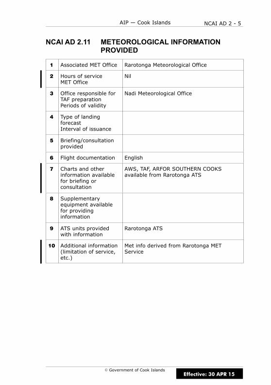
NCAI AD 2 - 5AIP — Cook Islands
E Government of Cook Islands
NCAI AD 2.11 METEOROLOGICAL INFORMATIONPROVIDED
1 Associated MET Office Rarotonga Meteorological Office
2 Hours of serviceMET Office
Nil
3 Office responsible forTAF preparationPeriods of validity
Nadi Meteorological Office
4 Type of landingforecastInterval of issuance
5 Briefing/consultationprovided
6 Flight documentation English
7 Charts and otherinformation availablefor briefing orconsultation
AWS, TAF, ARFOR SOUTHERN COOKSavailable from Rarotonga ATS
8 Supplementaryequipment availablefor providinginformation
9 ATS units providedwith information
Rarotonga ATS
10 Additional information(limitation of service,etc.)
Met info derived from Rarotonga METService
Effective: 30 APR 15
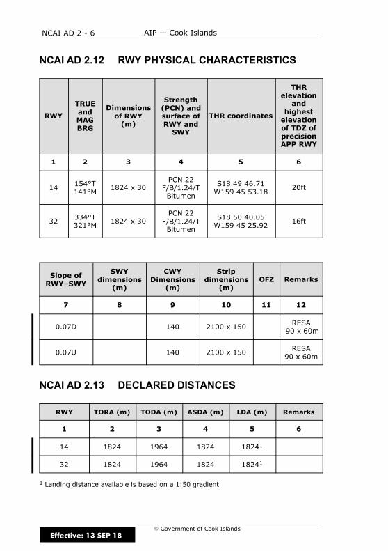
NCAI AD 2 - 6 AIP — Cook Islands
E Government of Cook Islands
NCAI AD 2.12 RWY PHYSICAL CHARACTERISTICS
RWY
TRUEandMAGBRG
Dimensionsof RWY(m)
Strength(PCN) andsurface ofRWY andSWY
THR coordinates
THRelevationand
highestelevationof TDZ ofprecisionAPP RWY
1 2 3 4 5 6
14 154°T141°M
1824 x 30PCN 22F/B/1.24/TBitumen
S18 49 46.71W159 45 53.18
20ft
32 334°T321°M
1824 x 30PCN 22F/B/1.24/TBitumen
S18 50 40.05W159 45 25.92
16ft
Slope ofRWY–SWY
SWYdimensions
(m)
CWYDimensions
(m)
Stripdimensions
(m)OFZ Remarks
7 8 9 10 11 12
0.07D 140 2100 x 150 RESA90 x 60m
0.07U 140 2100 x 150 RESA90 x 60m
NCAI AD 2.13 DECLARED DISTANCES
RWY TORA (m) TODA (m) ASDA (m) LDA (m) Remarks
1 2 3 4 5 6
14 1824 1964 1824 18241
32 1824 1964 1824 18241
1 Landing distance available is based on a 1:50 gradient
Effective: 13 SEP 18
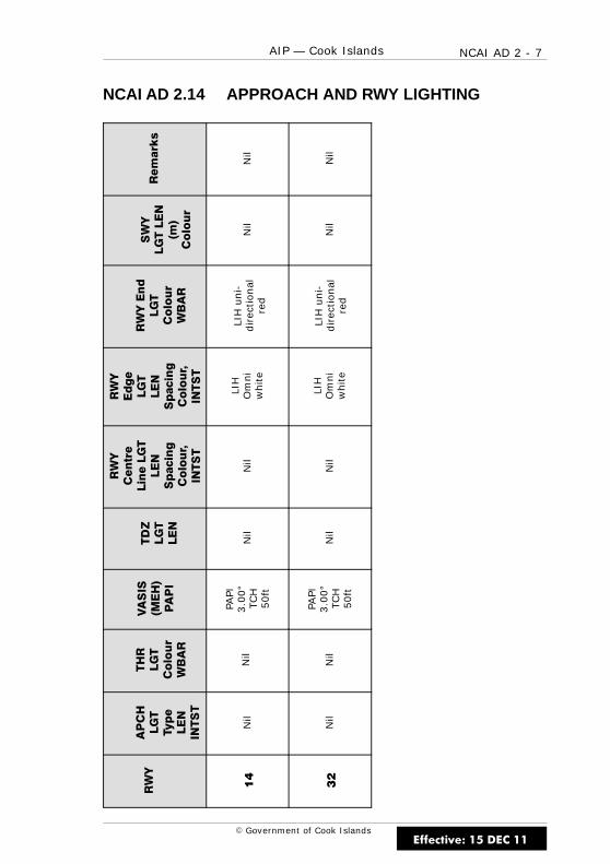
NCAI AD 2 - 7AIP — Cook Islands
E Government of Cook Islands
NCAI AD 2.14 APPROACH AND RWY LIGHTING
Remarks
Nil
Nil
SWY
LGTLEN
(m)
Colour
Nil
Nil
RWYEnd
LGT
Colour
WBAR
LIH
un
i-d
irec
tio
nal
red
LIH
un
i-d
irec
tio
nal
red
RWY
Edge
LGT
LEN
Spacing
Colour,
INTST
LIH
Om
ni
wh
ite
LIH
Om
ni
wh
ite
RWY
Centre
LineLGT
LEN
Spacing
Colour,
INTST
Nil
Nil
TDZ
LGT
LEN
Nil
Nil
VASIS
(MEH)
PAPI
PAPI
3.0
0°
TCH
50
ft
PAPI
3.0
0°
TCH
50
ft
THR
LGT
Colour
WBAR
Nil
Nil
APCH
LGT
Type
LEN
INTST
Nil
Nil
RWY
14
32
Effective: 15 DEC 11
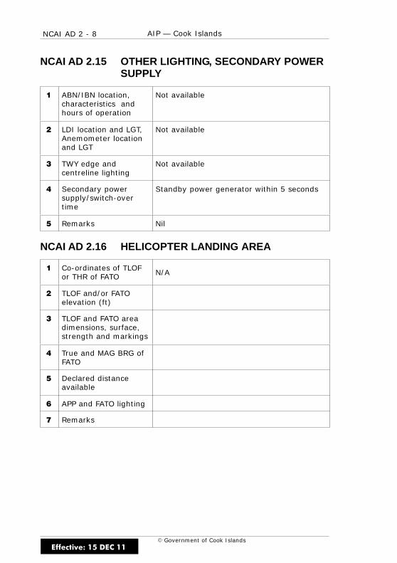
NCAI AD 2 - 8 AIP — Cook Islands
E Government of Cook Islands
NCAI AD 2.15 OTHER LIGHTING, SECONDARY POWERSUPPLY
1 ABN/IBN location,characteristics andhours of operation
Not available
2 LDI location and LGT,Anemometer locationand LGT
Not available
3 TWY edge andcentreline lighting
Not available
4 Secondary powersupply/switch-overtime
Standby power generator within 5 seconds
5 Remarks Nil
NCAI AD 2.16 HELICOPTER LANDING AREA
1 Co-ordinates of TLOFor THR of FATO N/A
2 TLOF and/or FATOelevation (ft)
3 TLOF and FATO areadimensions, surface,strength and markings
4 True and MAG BRG ofFATO
5 Declared distanceavailable
6 APP and FATO lighting
7 Remarks
Effective: 15 DEC 11

NCAI AD 2 - 9AIP — Cook Islands
E Government of Cook Islands
NCAI AD 2.17 ATS AIRSPACE
1 Designation andlateral limits
Nil
2 Vertical limits Nil
3 Airspace classification Nil
4 ATS unit callsign,language(s)
Nil
5 Transition altitude 13000ft
6 Remarks Nil
NCAI AD 2.18 ATS COMMUNICATIONS FACILITIES
ServiceDesignation Callsign Frequency
Hours ofOperation Remarks
FIS Rarotonga3425* 65538846 11339
HS*OR
APP Nil
TWR Nil
AFIS Nil
Effective: 15 DEC 11
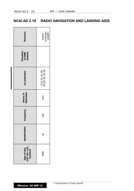
NCAI AD 2 - 10 AIP — Cook Islands
E Government of Cook Islands
NCAI AD 2.19 RADIO NAVIGATION AND LANDING AIDSRem
arks
Rated
coverage:
100NM
Elevation
ofDME
antenna
Co-ordinates
S184929.28
W1594624.36
Hours
of
Operation
H24
Freq
uen
cy
320
Iden
tification
AI
TypeofAid,
CAT(forILS),
Variation
NDB
Effective: 30 APR 15
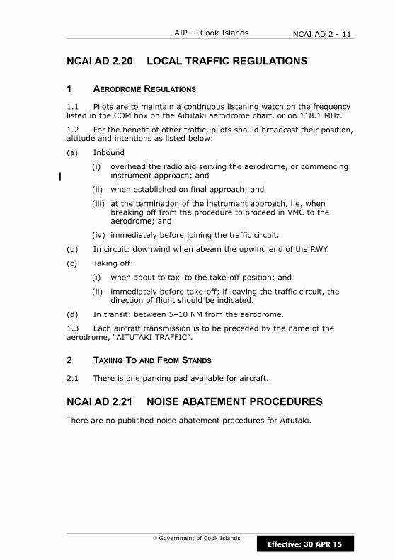
NCAI AD 2 - 11AIP — Cook Islands
E Government of Cook Islands
NCAI AD 2.20 LOCAL TRAFFIC REGULATIONS
1 AERODROME REGULATIONS
1.1 Pilots are to maintain a continuous listening watch on the frequencylisted in the COM box on the Aitutaki aerodrome chart, or on 118.1 MHz.
1.2 For the benefit of other traffic, pilots should broadcast their position,altitude and intentions as listed below:
(a) Inbound
(i) overhead the radio aid serving the aerodrome, or commencinginstrument approach; and
(ii) when established on final approach; and
(iii) at the termination of the instrument approach, i.e. whenbreaking off from the procedure to proceed in VMC to theaerodrome; and
(iv) immediately before joining the traffic circuit.
(b) In circuit: downwind when abeam the upwind end of the RWY.
(c) Taking off:
(i) when about to taxi to the take-off position; and
(ii) immediately before take-off; if leaving the traffic circuit, thedirection of flight should be indicated.
(d) In transit: between 5–10 NM from the aerodrome.
1.3 Each aircraft transmission is to be preceded by the name of theaerodrome, “AITUTAKI TRAFFIC”.
2 TAXIING TO AND FROM STANDS
2.1 There is one parking pad available for aircraft.
NCAI AD 2.21 NOISE ABATEMENT PROCEDURES
There are no published noise abatement procedures for Aitutaki.
Effective: 30 APR 15

NCAI AD 2 - 12 AIP — Cook Islands
E Government of Cook Islands
NCAI AD 2.22 FLIGHT PROCEDURES
1 POSITION AND ALTITUDE REPORTING — LOCAL VFR FLIGHTS
1.1 Pilots of aircraft intending to operate under VFR from Aitutaki arerequired to report departure details after take-off on the nominated HFfrequencies to Rarotonga “TOWER/FLIGHT SERVICE” if intending to proceedto other aerodromes in the vicinity or when requesting clearance to enterClass C airspace.
1.2 When Rarotonga Flight Service is operating Rarotonga CTA Class Cairspace reverts to Class G.
2 POSITION REPORTING ON DEPARTURE
2.1 Pilots are required to make a departure report as soon aspracticable after take-off on the nominated HF frequencies to Rarotonga“TOWER/FLIGHT SERVICE” and must contain the following information:
(a) Identification; radio callsign
(b) Estimated set heading time in minutes past the hour
(c) Phrase “CLIMBING TO” or “REQUEST” followed by altitude or flightlevel;
(d) Next position and time over: or ETA at destination in minutes pastthe hour
2.2 When Rarotonga Flight Service is operating Rarotonga CTA Class Cairspace reverts to Class G.
3 AERODROME TRAFFIC CIRCUIT RULES
3.1 Circuit direction is:
(a) RWY 14 is left-hand
(b) RWY 32 is right-hand
NCAI AD 2.23 ADDITIONAL INFORMATION
Nil
Effective: 25 MAY 17

NCAI AD 2 - 13AIP — Cook Islands
E Government of Cook Islands
NCAI AD 2.24 CHARTS RELATED TO AERODROME
(a) Instrument Approach Charts
AITUTAKI NDB RWY 14 NCAI AD 2-44.1. . . . . . . . . . . . . . . . . . . . . . . .
AITUTAKI RNAV (GNSS) RWY 14 NCAI AD 2-45.1. . . . . . . . . . . . . . .
AITUTAKI RNAV (GNSS) RWY 32 NCAI AD 2-45.2. . . . . . . . . . . . . . .
(b) Aerodrome Charts
AITUTAKI NCAI AD 2-51.1. . . . . . . . . . . . . . . . . . . . . . . . . . . . . . . . . . . . .
Effective: 25 MAY 17

NCAI AD 2 - 14 AIP — Cook Islands
E Government of Cook Islands
IntentionallyBlank
Effective: 25 MAY 17

HOLDING AIIN
BD
AI NDB
50
510 N
M
1
1
2 MINAI
NDB 320
S18 49 29
W159 46 24
10N
MA
IND
B
1
1 AITUTAKI
AI
13
W 159î W 159î
Category BA
NA
DC
NDB
16001600
1600
60
430
300
S 18î
S 18î
S 19î
c
NCAI AD 2 - 44.1
NDB RWY 14c
AITUTAKI
CAT A,B,CELEV 20
RWY 14 THR ELEV 20
Cook Islands- AIP
AITUTAKI
NDB RWY 14
: 118.1UNATTENDED
Government of Cook IslandsEffective: 25 MAY 17
* Circling NA west of RWY 14/32
Circling *
680 2500 - (660)
680 2500 - (660)
680 3600 - (660)
680 3700 - (660)
3
3
3
1
2
0
3
MAX IAS 185 ktBASE TURN
680 2800 - (660)
3
1
CIRCLINGNO
1000
1600, turn LEFT direct to AI NDB 1000: Track 144º to MISSED APCH
Use Aitutaki QNH or remote QNH
1000
1600
25 NM AI
Minimum Sector Altitude
16
16
Changes fro
m 1
5 D
EC 1
1:
Circling restriction,
MN
M S
EC
T A
LT,
minim
a, profile,
misse
d A
PC
H, outb
ound B
RG a
nd M
SA, hold, aero
dro
me ele
vations.
NC
AIN
14-B

IntentionallyBlank
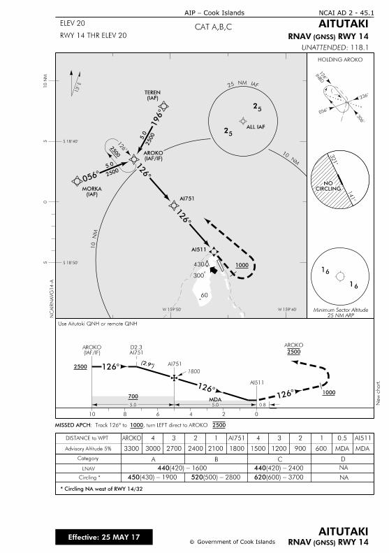
2500
1
3
INBD
2
0
1
13
1
16
6
25 NM ARPMinimum Sector Altitude
3
1
CIRCLINGNO
0
1
2500
5.0
2500
5.0 1
1
2500
0246810
5.0 5.0
700MDA
AI751D2.3
AI751
0.8
1
1AI511
1 1000
(IAF)TEREN
(IAF)MORKA
AI751
AI511
25
FAI MN 52
25
MN
01
MN 0
1
W 159îW 159î
S 18î
S 18î
10 N
M5
05
1000
1800
(2.
ALL IAF
Use Aitutaki QNH or remote QNH
60
300
430
HOLDING AROKO
(IAF/IF)AROKO
(IAF/IF)AROKO
2500
AROKO
25001000, turn LEFT direct to AROKO : Track 126º to MISSED APCH
Category A B C D
NA
NA
0.5
MDA600150018002100240027003000
4
3300
3 2 1 AI751 4 1
MDA
AI511
Advisory Altitude 5%
3
1200 900
2
Circling *
* Circling NA west of RWY 14/32
LNAV
DISTANCE to WPT
440 1600- (420) 440 2400- (420)
450 1900 - (430) 520 2800 - (500) 620 3700 - (600)
AROKO
c
NCAI AD 2 - 45.1
c Government of Cook Islands
CAT A,B,CELEV 20
RWY 14 THR ELEV 20
Cook Islands-AIP
AITUTAKI
New c
hart.
Effective: 25 MAY 17
NC
AIR
NA
VG
14-A
RWY 14 (GNSS) RNAV
RWY 14 (GNSS) RNAV
AITUTAKI
: 118.1UNATTENDED
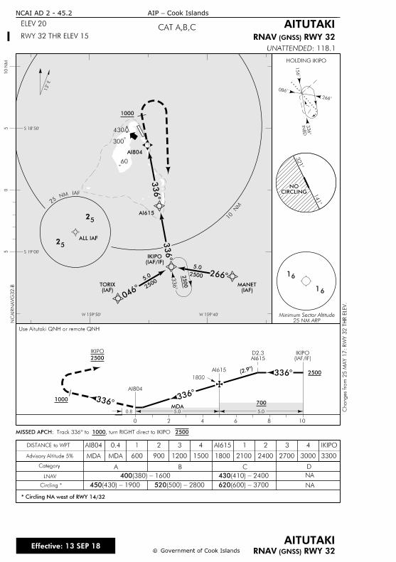
1
INB
D
2
03
13
1
16
6
25 NM ARPMinimum Sector Altitude
3
1
CIRCLINGNO
22500
5.0
2500
0 2 4 6 8 10
5.05.0
700MDA
AI615D2.3
AI615
0.8
3
3
AI804
31000
(IAF)TORIX
(IAF)MANET
AI804
25
25
W 159îW 159î
S 19î
S 18î
10 N
M5
05
1000
1800
2500
5.0
0
3
3
3
2500
1
0
NM
(2.
Use Aitutaki QNH or remote QNH
ALL IAF
300
430
60
HOLDING IKIPO
(IAF/IF)IKIPO
2500
IKIPO
(IAF/IF)IKIPO
25001000, turn RIGHT direct to IKIPO : Track 336º to MISSED APCH
Category A B C D
NA
NA
4
30002700180015001200900600
AI804
MDA
0.4
MDA
1 2 3 4 AI615 3
3300
IKIPO
Advisory Altitude 5%
1
2100 2400
2
Circling *
* Circling NA west of RWY 14/32
LNAV
DISTANCE to WPT
400 1600- (380) 430 2400- (410)
450 1900 - (430) 520 2800 - (500) 620 3700 - (600)
RWY 32 (GNSS) RNAV
c
NCAI AD 2 - 45.2
c Government of Cook Islands
AITUTAKI
CAT A,B,CELEV 20
RWY 32 THR ELEV 15
Cook Islands-AIP
AITUTAKI
Changes fro
m 2
5 M
AY 1
7:
RW
Y 3
2 T
HR E
LE
V.
Effective: 13 SEP 18
NC
AIR
NA
VG
32-B
RWY 32 (GNSS) RNAV
: 118.1UNATTENDED
AI615
FAI MN 52

1
NDB 320
AITUTAKI
AI
114
W159 46 24
S18 49 29
coral surfaceDisused RWY
X
X
RWY 14 - Left hand
RWY 32 - Right hand
NA
CIVIL IFR TAKE-OFF MINIMA
CEILING (ft) and VISIBILITY (m or km) CEILING (ft) and VISIBILITY (m or km)
VFR MINIMA
RWY DAY NIGHT DAY NIGHT
AIR TRANSPORT
ALL OTHER NA
14
32
S18î
S18î
W159î S18î
5 - 1000
1500 - 600
4000 - 800
4000 - 800
NCAI AD 2 - 51.1
ELEV 20
Cook Islands-AIP
AITUTAKI
AERODROME
cc
AITUTAKIS 18 49 52 W 159 45 50
AERODROME
: 118.1UNATTENDEDN
CAIA
D-F
NCAI
Government of Cook IslandsEffective: 13 SEP 18
14114
ELEV 20
321
32
ELEV 15
1824 x 3
0 m
227
430
270
220
155
140 mCWY
140 mCWY
2100 x 1
50 m
2
2
Circuit1.
with reduced strip width available but restricted to daylight operations for aircraft 22,700 kg and below.
Strip width narrows below 150 m in the first 120 m on north eastern side of RWY 14. Full length
Changes fro
m 1
9 J
UL 1
8:
RW
Y 3
2 T
HR E
LE
V, strip width text a
nd C
WY a
dded.

IntentionallyBlank
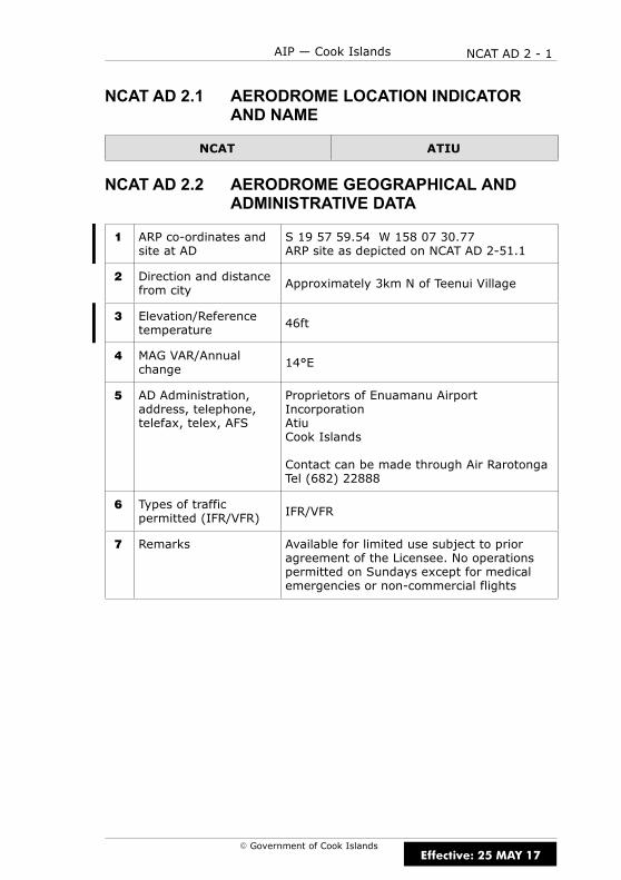
NCAT AD 2 - 1AIP — Cook Islands
E Government of Cook Islands
NCAT AD 2.1 AERODROME LOCATION INDICATORAND NAME
NCAT ATIU
NCAT AD 2.2 AERODROME GEOGRAPHICAL ANDADMINISTRATIVE DATA
1 ARP co-ordinates andsite at AD
S 19 57 59.54 W 158 07 30.77ARP site as depicted on NCAT AD 2-51.1
2 Direction and distancefrom city Approximately 3km N of Teenui Village
3 Elevation/Referencetemperature 46ft
4 MAG VAR/Annualchange 14°E
5 AD Administration,address, telephone,telefax, telex, AFS
Proprietors of Enuamanu AirportIncorporationAtiuCook Islands
Contact can be made through Air RarotongaTel (682) 22888
6 Types of trafficpermitted (IFR/VFR) IFR/VFR
7 Remarks Available for limited use subject to prioragreement of the Licensee. No operationspermitted on Sundays except for medicalemergencies or non-commercial flights
Effective: 25 MAY 17

NCAT AD 2 - 2 AIP — Cook Islands
E Government of Cook Islands
NCAT AD 2.3 OPERATIONAL HOURS
1 AD Administration 0800–1600 Mon–Fri except public holidays
2 Customs andimmigration Nil
3 Health and sanitation Hospital with limited facilities
4 AIS Briefing Office Nil
5 ATS Reporting Office(ARO) Nil
6 MET Briefing Office Nil
7 ATS Nil
8 Fuelling Nil
9 Handling Nil
10 Security Nil
11 De-icing Nil
12 Remarks Atiu is an unattended aerodrome
NCAT AD 2.4 HANDLING SERVICES AND FACILITIES
1 Cargo-handlingfacilities By prior arrangement through Air Rarotonga
2 Fuel/oil types Nil
3 Fuelling facilities/capabilities Nil
4 De-icing facilities Nil
5 Hangar space forvisiting aircraft Nil
6 Repair facilities forvisiting aircraft Nil
7 Remarks Nil
Effective: 30 APR 15

NCAT AD 2 - 3AIP — Cook Islands
E Government of Cook Islands
NCAT AD 2.5 PASSENGER FACILITIES
1 Hotels Accommodation units available in town andaround the island
2 Restaurants Nil
3 Transportation Transfers or by prior arrangement
4 Medical facilities Hospital
5 Bank and Post Office Available in town
6 Tourist Office In town
7 Remarks Nil
NCAT AD 2.6 RESCUE AND FIRE FIGHTING SERVICES
Nil
NCAT AD 2.7 SEASONAL AVAILABILITY — CLEARING
Nil
NCAT AD 2.8 APRONS, TAXIWAYS AND CHECKLOCATIONS DATA
1 Apron surface andstrength TBA
2 Taxiway width, surfaceand strength Nil
3 ACL location andelevation
RWY 09 46ftRWY 27 44ft
4 VOR/INS checkpoints Nil
5 Remarks Nil
Effective: 25 MAY 17
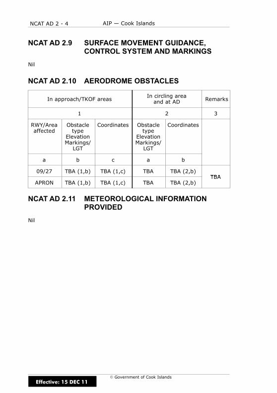
NCAT AD 2 - 4 AIP — Cook Islands
E Government of Cook Islands
NCAT AD 2.9 SURFACE MOVEMENT GUIDANCE,CONTROL SYSTEM AND MARKINGS
Nil
NCAT AD 2.10 AERODROME OBSTACLES
In approach/TKOF areasIn circling areaand at AD Remarks
1 2 3
RWY/Areaaffected
Obstacletype
ElevationMarkings/LGT
Coordinates Obstacletype
ElevationMarkings/LGT
Coordinates
a b c a b
09/27 TBA (1,b) TBA (1,c) TBA TBA (2,b)TBA
APRON TBA (1,b) TBA (1,c) TBA TBA (2,b)TBA
NCAT AD 2.11 METEOROLOGICAL INFORMATIONPROVIDED
Nil
Effective: 15 DEC 11

NCAT AD 2 - 5AIP — Cook Islands
E Government of Cook Islands
NCAT AD 2.12 RWY PHYSICAL CHARACTERISTICS
RWY TRUE BRGDimensions of RWY(m)
Strength(PCN)and
surfaceof RWYand SWY
THRcoordinates
THRelevationand
highestelevationof TDZ ofprecisionAPP RWY
1 2 3 4 5 6
09 101° 1255 x 30ESWL20420kgCoral
S 19 58 00.31W 158 07 32.14
46ft
27 281° 1255 x 30ESWL20420kgCoral
S 19 58 07.82W 158 06 49.73
44ft
Slope ofRWY–SWY
SWYdimensions
(m)
CWYDimensions
(m)
Stripdimensions
(m)OFZ Remarks
7 8 9 10 11 12
1300 x 90
1300 x 90
NCAT AD 2.13 DECLARED DISTANCES
RWY TORA (m) TODA (m) ASDA (m) LDA (m) Remarks
1 2 3 4 5 6
09 1255 1255 1255 1255
27 1255 1255 1255 1255
Effective: 25 MAY 17
NCAT AD 2 - 6 AIP — Cook Islands
E Government of Cook Islands
NCAT AD 2.14 APPROACH AND RWY LIGHTING
Nil
NCAT AD 2.15 OTHER LIGHTING, SECONDARY POWERSUPPLY
Nil
NCAT AD 2.16 HELICOPTER LANDING AREA
Nil
NCAT AD 2.17 ATS AIRSPACE
1 Designation andlateral limits Nil
2 Vertical limits Nil
3 Airspace classification Nil
4 ATS unit callsign,language(s)
Nil
5 Transition altitude 13000ft
6 Remarks Nil
Effective: 30 APR 15
NCAT AD 2 - 7AIP — Cook Islands
E Government of Cook Islands
NCAT AD 2.18 ATS COMMUNICATIONS FACILITIES
Nil
NCAT AD 2.19 RADIO NAVIGATION AND LANDING AIDS
Nil
NCAT AD 2.20 LOCAL TRAFFIC REGULATIONS
1 AERODROME REGULATIONS
1.1 Pilots are to maintain a continuous listening watch on the frequencylisted in the COM box on the aerodrome chart, or on 118.1MHz if there isno such chart.
1.2 For the benefit of other traffic, pilots should broadcast their position,altitude and intentions as listed below:
(a) In circuit: downwind when abeam the upwind end of the RWY.
(b) Established on finals to land.
(c) In transit: between 5–10NM from the aerodrome.
1.3 Each aircraft transmission is to be preceded by the name of theaerodrome, “ATIU TRAFFIC”.
2 TAXIING TO AND FROM STANDS
2.1 There are no taxiing stands or taxi routes. Taxi will be at thediscretion of the pilot.
NCAT AD 2.21 NOISE ABATEMENT PROCEDURES
There are no noise abatement procedures for Atiu.
Effective: 30 APR 15
NCAT AD 2 - 8 AIP — Cook Islands
E Government of Cook Islands
NCAT AD 2.22 FLIGHT PROCEDURES
1 POSITION AND ALTITUDE REPORTING — LOCAL VFR FLIGHTS
1.1 Pilots of aircraft intending to operate under VFR from Atiu arerequired to report departure details after take-off on the nominated HFfrequencies to Rarotonga “TOWER/FLIGHT SERVICE” if intending to proceedto other unattended aerodromes or when requesting clearance to enterClass C airspace.
1.2 When Rarotonga Flight Service is operating Rarotonga CTA Class Cairspace reverts to Class G.
2 POSITION REPORTING ON DEPARTURE
2.1 Pilots are required to make a departure report as soon aspracticable after take-off on the nominated HF frequencies to Rarotonga“TOWER/FS” and must contain the following information in the order listed:
(a) Identification; radio callsign
(b) Estimated set heading time in minutes past the hour
(c) Phrase “CLIMBING TO” or “REQUEST” followed by altitude or flightlevel;
(d) Next position and time over or ETA for destination
2.2 When Rarotonga Flight Service is operating Rarotonga CTA Class Cairspace reverts to Class G.
3 AERODROME TRAFFIC CIRCUIT RULES
3.1 Circuit direction is:
(a) RWY 09 is left-hand
(b) RWY 27 is right-hand
NCAT AD 2.23 ADDITIONAL INFORMATION
Nil
NCAT AD 2.24 CHARTS RELATED TO AERODROME
(a) Instrument Approach Charts
ATIU RNAV (GNSS) RWY 09 NCAT AD 2-45.1. . . . . . . . . . . . . . . . . . .
(b) Aerodrome Charts
ATIU NCAT AD 2-51.1. . . . . . . . . . . . . . . . . . . . . . . . . . . . . . . . . . . . . . . . . .
Effective: 25 MAY 17
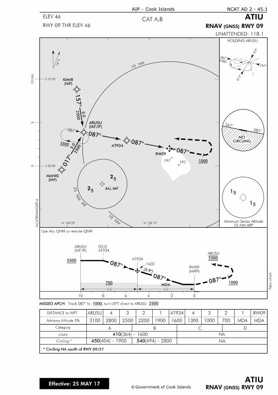
MN 0
1
MN 01
FAI
M
N
52
25 NM ARPMinimum Sector Altitude
1000
0
0
0
2500
0
0
1
2500
5.0
2500
5.0
2
INBD
1
0
0
15
15
RW09
AT934
(IAF)MANIS
(IAF)KIMIR
14
RWY 09 (GNSS)RNAV
RWY 09) (GNSSRNAV
Category A B C D
NA
NACircling *
* Circling NA south of RWY 09/27
LNAV
DISTANCE to WPT
0246810
410 1600- (364)
450 1900 - (404) 540 2800 - (494)
Advisory Altitude 5%
2
0
CIRCLINGNO
c
NCAT AD 2 - 45.1
c Government of Cook Islands
ATIU
CAT A,BELEV 46
RWY 09 THR ELEV 46
ATIU
Effective: 25 MAY 17
Cook Islands-AIP
25
25
5.0 5.0
2500
(MAPt)
RW09
1000
2500
AT934D3.0
(2.
0
00
1600
W 158îW 158î
S 19î
S 20î
50
10 N
M
700
: 118.1UNATTENDED
MDA
(IAF/IF)ARUSU
HOLDING ARUSU
ALL IAF
Use Atiu QNH or remote QNH
1
MDA7001600190022002500
ARUSU
2800
4
3100
3 2 1 AT934 2
MDA
RW094
1300 1000
3
, 1000 2500turn LEFT direct to ARUSU : Track 087î€MISSED APCH
(IAF/IF)ARUSU
ARUSU
NC
ATR
NA
VG
09-A
New c
hart.
197197
AT934

IntentionallyBlank
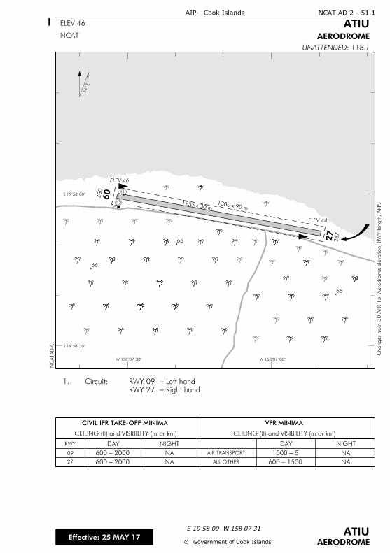
NA
CIVIL IFR TAKE-OFF MINIMA
CEILING (ft) and VISIBILITY (m or km) CEILING (ft) and VISIBILITY (m or km)
VFR MINIMA
RWY DAY NIGHT DAY NIGHT
AIR TRANSPORT
ALL OTHER NA
087
09
267
27
ELEV 46
1300 x 90 m1255 x 30 m
ELEV 44
S 1958'
S 1958'
NCAT AD 2 - 51.1
ELEV 46
AIP - Cook Islands
ATIU
AERODROME
Changes fro
m 3
0 A
PR 1
5:
Aero
dro
me ele
vation,
RW
Y length,
ARP.
NC
ATA
D-C
NCAT
cc Government of Cook Islands
ATIUEffective: 25 MAY 17
S 19 58 00 W 158 07 31
AERODROME
118.1: UNATTENDED
14
2000 - 600
2000 - 600
NA
NA
5 - 1000
1500 - 600
09
27
Right hand-RWY 27
Left hand-RWY 09 Circuit:1.
66
66
66
W 15807 W 15807

IntentionallyBlank
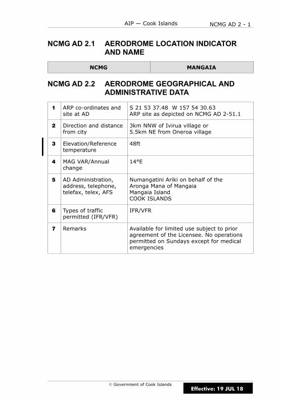
NCMG AD 2 - 1AIP — Cook Islands
E Government of Cook Islands
NCMG AD 2.1 AERODROME LOCATION INDICATORAND NAME
NCMG MANGAIA
NCMG AD 2.2 AERODROME GEOGRAPHICAL ANDADMINISTRATIVE DATA
1 ARP co-ordinates andsite at AD
S 21 53 37.48 W 157 54 30.63ARP site as depicted on NCMG AD 2-51.1
2 Direction and distancefrom city
3km NNW of Ivirua village or5.5km NE from Oneroa village
3 Elevation/Referencetemperature
48ft
4 MAG VAR/Annualchange
14°E
5 AD Administration,address, telephone,telefax, telex, AFS
Numangatini Ariki on behalf of theAronga Mana of MangaiaMangaia IslandCOOK ISLANDS
6 Types of trafficpermitted (IFR/VFR)
IFR/VFR
7 Remarks Available for limited use subject to prioragreement of the Licensee. No operationspermitted on Sundays except for medicalemergencies
Effective: 19 JUL 18

NCMG AD 2 - 2 AIP — Cook Islands
E Government of Cook Islands
NCMG AD 2.3 OPERATIONAL HOURS
1 AD Administration 0800–1600 Mon–Fri except public holidays
2 Customs andimmigration
Nil
3 Health and sanitation Hospital with limited facilities
4 AIS Briefing Office Nil
5 ATS Reporting Office(ARO)
Nil
6 MET Briefing Office Nil
7 ATS Nil
8 Fuelling Nil
9 Handling Air Rarotonga
10 Security Nil
11 De-icing Nil
12 Remarks Mangaia is an unattended aerodrome
NCMG AD 2.4 HANDLING SERVICES AND FACILITIES
1 Cargo-handlingfacilities
Air Rarotonga
2 Fuel/oil types Nil
3 Fuelling facilities/capabilities
Nil
4 De-icing facilities Nil
5 Hangar space forvisiting aircraft
Nil
6 Repair facilities forvisiting aircraft
Nil
7 Remarks Nil
Effective: 30 APR 15
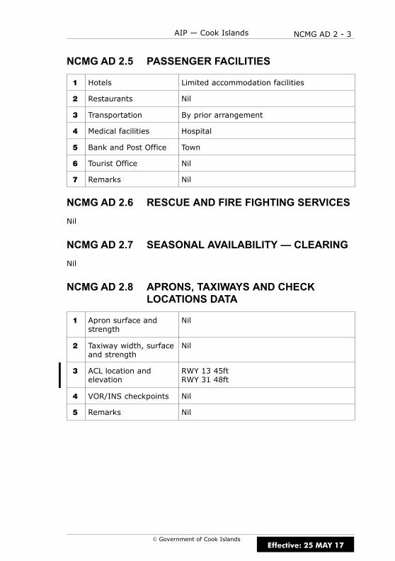
NCMG AD 2 - 3AIP — Cook Islands
E Government of Cook Islands
NCMG AD 2.5 PASSENGER FACILITIES
1 Hotels Limited accommodation facilities
2 Restaurants Nil
3 Transportation By prior arrangement
4 Medical facilities Hospital
5 Bank and Post Office Town
6 Tourist Office Nil
7 Remarks Nil
NCMG AD 2.6 RESCUE AND FIRE FIGHTING SERVICES
Nil
NCMG AD 2.7 SEASONAL AVAILABILITY — CLEARING
Nil
NCMG AD 2.8 APRONS, TAXIWAYS AND CHECKLOCATIONS DATA
1 Apron surface andstrength
Nil
2 Taxiway width, surfaceand strength
Nil
3 ACL location andelevation
RWY 13 45ftRWY 31 48ft
4 VOR/INS checkpoints Nil
5 Remarks Nil
Effective: 25 MAY 17

NCMG AD 2 - 4 AIP — Cook Islands
E Government of Cook Islands
NCMG AD 2.9 SURFACE MOVEMENT GUIDANCE,CONTROL SYSTEM AND MARKINGS
Nil
NCMG AD 2.10 AERODROME OBSTACLES
In approach/TKOF areasIn circling areaand at AD Remarks
1 2 3
RWY/Areaaffected
Obstacletype
ElevationMarkings/LGT
Coordinates Obstacletype
ElevationMarkings/LGT
Coordinates
a b c a b
13/31 TBA (1,b) TBA (1,c) TBA TBA (2,b)TBA
APRON TBA (1,b) TBA (1,c) TBA TBA (2,b)TBA
NCMG AD 2.11 METEOROLOGICAL INFORMATIONPROVIDED
Nil
Effective: 15 DEC 11
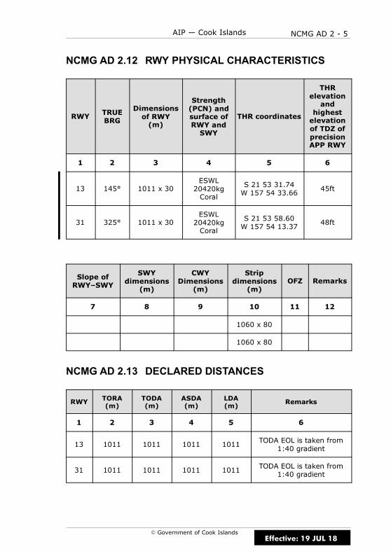
NCMG AD 2 - 5AIP — Cook Islands
E Government of Cook Islands
NCMG AD 2.12 RWY PHYSICAL CHARACTERISTICS
RWY TRUEBRG
Dimensionsof RWY(m)
Strength(PCN) andsurface ofRWY andSWY
THR coordinates
THRelevationand
highestelevationof TDZ ofprecisionAPP RWY
1 2 3 4 5 6
13 145° 1011 x 30ESWL20420kgCoral
S 21 53 31.74W 157 54 33.66
45ft
31 325° 1011 x 30ESWL20420kgCoral
S 21 53 58.60W 157 54 13.37
48ft
Slope ofRWY–SWY
SWYdimensions
(m)
CWYDimensions
(m)
Stripdimensions
(m)OFZ Remarks
7 8 9 10 11 12
1060 x 80
1060 x 80
NCMG AD 2.13 DECLARED DISTANCES
RWY TORA(m)
TODA(m)
ASDA(m)
LDA(m)
Remarks
1 2 3 4 5 6
13 1011 1011 1011 1011 TODA EOL is taken from1:40 gradient
31 1011 1011 1011 1011 TODA EOL is taken from1:40 gradient
Effective: 19 JUL 18

NCMG AD 2 - 6 AIP — Cook Islands
E Government of Cook Islands
NCMG AD 2.14 APPROACH AND RWY LIGHTING
Nil
NCMG AD 2.15 OTHER LIGHTING, SECONDARY POWERSUPPLY
Nil
NCMG AD 2.16 HELICOPTER LANDING AREA
Nil
NCMG AD 2.17 ATS AIRSPACE
1 Designation andlateral limits
Nil
2 Vertical limits Nil
3 Airspace classification Nil
4 ATS unit callsign,language(s)
Nil
5 Transition altitude 13000ft
6 Remarks Nil
Effective: 30 APR 15
NCMG AD 2 - 7AIP — Cook Islands
E Government of Cook Islands
NCMG AD 2.18 ATS COMMUNICATIONS FACILITIES
Nil
NCMG AD 2.19 RADIO NAVIGATION AND LANDING AIDS
Nil
NCMG AD 2.20 LOCAL TRAFFIC REGULATIONS
1 AERODROME REGULATIONS
1.1 Pilots are to maintain a continuous listening watch on the frequencylisted in the COM box on the aerodrome chart, or on 118.1MHz.
1.2 For the benefit of other traffic, pilots should broadcast their position,altitude and intentions as listed below:
(a) In circuit: downwind when abeam the upwind end of the RWY.
(b) Established on finals to land.
(c) In transit: between 5–10NM from the aerodrome.
1.3 Each aircraft transmission is to be preceded by the name of theaerodrome, “MANGAIA TRAFFIC”.
2 TAXIING TO AND FROM STANDS
2.1 There are no taxiing stands or taxi routes. Taxi will be at thediscretion of the pilot.
NCMG AD 2.21 NOISE ABATEMENT PROCEDURES
There are no published noise abatement procedures for Mangaia.
Effective: 30 APR 15
NCMG AD 2 - 8 AIP — Cook Islands
E Government of Cook Islands
NCMG AD 2.22 FLIGHT PROCEDURES
1 POSITION AND ALTITUDE REPORTING — LOCAL VFR FLIGHTS
1.1 Pilots of aircraft intending to operate under VFR from Mangaia arerequired to report departure details after take-off on the nominated HFfrequencies to Rarotonga “TOWER/FLIGHT SERVICE” if intending to proceedto other aerodromes in the vicinity or when requesting clearance to enterClass C airspace.
1.2 When Rarotonga Flight Service is operating Rarotonga CTA Class Cairspace reverts to Class G.
2 POSITION REPORTING ON DEPARTURE
2.1 Pilots are required to make a departure report as soon aspracticable after take-off on the nominated HF frequencies to Rarotonga“TOWER/FLIGHT SERVICE” and must contain the following information:
(a) Identification; radio callsign
(b) Estimated set heading time in minutes past the hour
(c) Phrase “CLIMBING TO” or “REQUEST” followed by altitude or flightlevel;
(d) Next position and time over: or ETA at destination in minutes pastthe hour
2.2 When Rarotonga Flight Service is operating Rarotonga CTA Class Cairspace reverts to Class G.
3 AERODROME TRAFFIC CIRCUIT RULES
3.1 Circuit direction is:
(a) RWY 13 is left-hand
(b) RWY 31 is right-hand
NCMG AD 2.23 ADDITIONAL INFORMATION
TBA
NCMG AD 2.24 CHARTS RELATED TO AERODROME
(a) Instrument Approach Charts
MANGAIA RNAV (GNSS) RWY 13 NCMG AD 2-45.1. . . . . . . . . . . . . . .
(b) Aerodrome Charts
MANGAIA NCMG AD 2-51.1. . . . . . . . . . . . . . . . . . . . . . . . . . . . . . . . . . . . .
Effective: 25 MAY 17
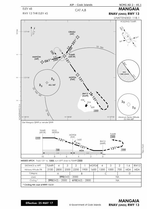
MN
01
MN 01
1
0
2
1
1
1000
14
2500
1
3
INBD
2
0
1
25 NM ARPMinimum Sector Altitude
20
20
c
NCMG AD 2 - 45.1
c Government of Cook Islands
CAT A,BRWY 13 THR ELEV 45
Cook Islands-AIP
MANGAIA
Effective: 25 MAY 17
RWY 13) (GNSSRNAV
RWY 13GNSS) (RNAV
MANGAIA
0246810
5.0 5.0
2500
(MAPt)
RW13
(FAF)MG934
1000
2500
MG934D3.0
(2.
1
1 1
1600
700
ELEV 48
Category A B C D
NA
NA
Advisory Altitude 5%
Circling *
LNAV
DISTANCE to WPT
* Circling NA west of RWY 13/31
590 2000- (542)
590 2000 - (542) 610 2800 - (562)
3
1
CIRCLINGNO
52
25
(IAF)MANOM
(IAF)ORASUS 21î
S 21î
W 158î W 158î W 157î
10 N
M5
05
(FAF)MG934
(MAPt)RW13
25005.0
2500
5.0
MDA
: 118.1UNATTENDED
(IAF/IF)TUMPI
HOLDING TUMPI
ALL IAF
Use Mangaia QNH or remote QNH
(IAF/IF)TUMPI
TUMPI
, turn LEFT direct to TUMPI 1000: Track 131î€MISSED APCH 2500
1.6
MDA7001600190022002500
TUMPI
2800
4
3100
3 2 1 2
MDA
RW134
1300 1000
3MG934
FAI
MN
52
NC
MG
RN
AV
G13-A
New c
hart.
509
554
436

IntentionallyBlank
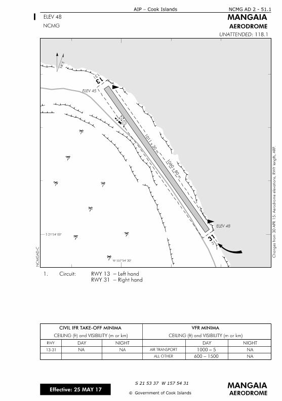
ELEV 45
ELEV 48
NA
1500 - 600
NA 5 - 1000NA
CIVIL IFR TAKE-OFF MINIMA
CEILING (ft) and VISIBILITY (m or km) CEILING (ft) and VISIBILITY (m or km)
VFR MINIMA
RWY
13-31
DAY NIGHT DAY NIGHT
AIR TRANSPORT
ALL OTHER NA
NCMG AD 2 - 51.1
ELEV 48
Cook Islands-AIP
MANGAIA
AERODROME
cc
MANGAIAS 21 53 37 W 157 54 31
AERODROME
: 118.1UNATTENDED
NCMG
Effective: 25 MAY 17Government of Cook Islands
Right hand-RWY 31
Left hand -RWY 13 Circuit:1.
1060 x 8
0 m
1011 x 3
0 m
14
W 15754
S 2154
NC
MG
AD-C
Changes fro
m 3
0 A
PR 1
5:
Aero
dro
me ele
vations, R
WY length,
ARP.
131 13
31131

IntentionallyBlank

NCMH AD 2 - 1AIP — Cook Islands
E Government of Cook Islands
NCMH AD 2.1 AERODROME LOCATION INDICATORAND NAME
NCMH MANIHIKI
NCMH AD 2.2 AERODROME GEOGRAPHICAL ANDADMINISTRATIVE DATA
1 ARP co-ordinates andsite at AD
S10 22 28.10 W161 00 12.08ARP site as depicted on NCMH AD 2-51.1
2 Direction and distancefrom city
APRX 700m E of Tukao
3 Elevation/Referencetemperature
6ft
4 MAG VAR/Annualchange
11°E
5 AD Administration,address, telephone,telefax, telex, AFS
Manihiki Island CouncilManihikiCOOK ISLANDSPh: 43 103 or 43 607
6 Types of trafficpermitted (IFR/VFR)
IFR/VFR
7 Remarks Private flights subject to prior agreement ofthe Licensee. No operations permitted onSundays except for medical emergencies
Effective: 30 APR 15
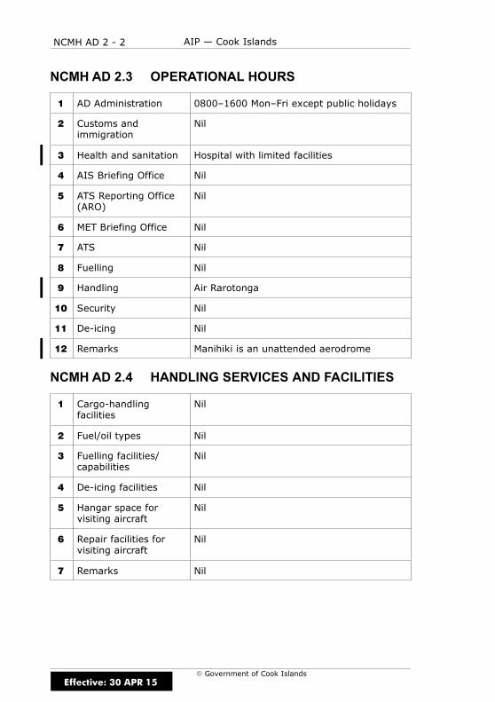
NCMH AD 2 - 2 AIP — Cook Islands
E Government of Cook Islands
NCMH AD 2.3 OPERATIONAL HOURS
1 AD Administration 0800–1600 Mon–Fri except public holidays
2 Customs andimmigration
Nil
3 Health and sanitation Hospital with limited facilities
4 AIS Briefing Office Nil
5 ATS Reporting Office(ARO)
Nil
6 MET Briefing Office Nil
7 ATS Nil
8 Fuelling Nil
9 Handling Air Rarotonga
10 Security Nil
11 De-icing Nil
12 Remarks Manihiki is an unattended aerodrome
NCMH AD 2.4 HANDLING SERVICES AND FACILITIES
1 Cargo-handlingfacilities
Nil
2 Fuel/oil types Nil
3 Fuelling facilities/capabilities
Nil
4 De-icing facilities Nil
5 Hangar space forvisiting aircraft
Nil
6 Repair facilities forvisiting aircraft
Nil
7 Remarks Nil
Effective: 30 APR 15
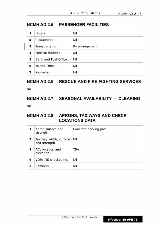
NCMH AD 2 - 3AIP — Cook Islands
E Government of Cook Islands
NCMH AD 2.5 PASSENGER FACILITIES
1 Hotels Nil
2 Restaurants Nil
3 Transportation By arrangement
4 Medical facilities Nil
5 Bank and Post Office Nil
6 Tourist Office Nil
7 Remarks Nil
NCMH AD 2.6 RESCUE AND FIRE FIGHTING SERVICES
Nil
NCMH AD 2.7 SEASONAL AVAILABILITY — CLEARING
Nil
NCMH AD 2.8 APRONS, TAXIWAYS AND CHECKLOCATIONS DATA
1 Apron surface andstrength
Concrete parking pad
2 Taxiway width, surfaceand strength
Nil
3 ACL location andelevation
TBA
4 VOR/INS checkpoints Nil
5 Remarks Nil
Effective: 30 APR 15

NCMH AD 2 - 4 AIP — Cook Islands
E Government of Cook Islands
NCMH AD 2.9 SURFACE MOVEMENT GUIDANCE,CONTROL SYSTEM AND MARKINGS
Nil
NCMH AD 2.10 AERODROME OBSTACLES
In approach/TKOF areasIn circling areaand at AD Remarks
1 2 3
RWY/Areaaffected
Obstacletype
ElevationMarkings/LGT
Coordinates Obstacletype
ElevationMarkings/LGT
Coordinates
a b c a b
14/32 TBA (1,b) TBA (1,c) TBA TBA (2,b)TBA
APRON TBA (1,b) TBA (1,c) TBA TBA (2,b)TBA
NCMH AD 2.11 METEOROLOGICAL INFORMATIONPROVIDED
Nil
Effective: 15 DEC 11
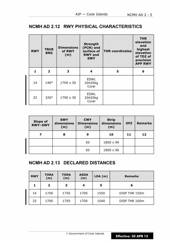
NCMH AD 2 - 5AIP — Cook Islands
E Government of Cook Islands
NCMH AD 2.12 RWY PHYSICAL CHARACTERISTICS
RWY TRUEBRG
Dimensionsof RWY(m)
Strength(PCN) andsurface ofRWY andSWY
THR coordinates
THRelevationand
highestelevationof TDZ ofprecisionAPP RWY
1 2 3 4 5 6
14 146° 1700 x 30ESWL20420kgCoral
32 326° 1700 x 30ESWL20420kgCoral
Slope ofRWY–SWY
SWYdimensions
(m)
CWYDimensions
(m)
Stripdimensions
(m)OFZ Remarks
7 8 9 10 11 12
50 1800 x 90
50 1800 x 90
NCMH AD 2.13 DECLARED DISTANCES
RWY TORA(m)
TODA(m)
ASDA(m)
LDA (m) Remarks
1 2 3 4 5 6
14 1700 1750 1700 1550 DISP THR 150m
32 1700 1750 1700 1540 DISP THR 160m
Effective: 30 APR 15
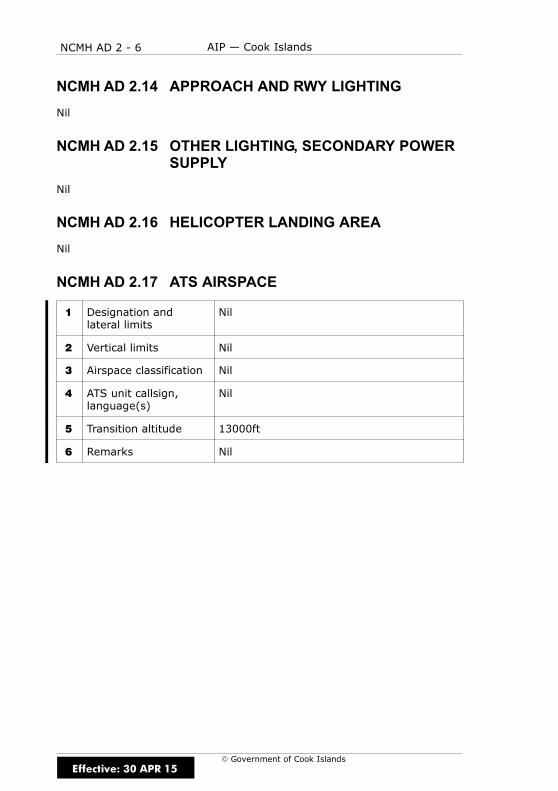
NCMH AD 2 - 6 AIP — Cook Islands
E Government of Cook Islands
NCMH AD 2.14 APPROACH AND RWY LIGHTING
Nil
NCMH AD 2.15 OTHER LIGHTING, SECONDARY POWERSUPPLY
Nil
NCMH AD 2.16 HELICOPTER LANDING AREA
Nil
NCMH AD 2.17 ATS AIRSPACE
1 Designation andlateral limits
Nil
2 Vertical limits Nil
3 Airspace classification Nil
4 ATS unit callsign,language(s)
Nil
5 Transition altitude 13000ft
6 Remarks Nil
Effective: 30 APR 15

NCMH AD 2 - 7AIP — Cook Islands
E Government of Cook Islands
NCMH AD 2.18 ATS COMMUNICATIONS FACILITIES
Nil
NCMH AD 2.19 RADIO NAVIGATION AND LANDING AIDS
Nil
NCMH AD 2.20 LOCAL TRAFFIC REGULATIONS
1 AERODROME REGULATIONS
1.1 Pilots are to maintain a continuous listening watch on the frequencylisted in the COM box on the aerodrome chart, or on 118.1MHz if there isno such chart.
1.2 For the benefit of other traffic, pilots should broadcast their position,altitude and intentions as listed below:
(a) In circuit: downwind when abeam the upwind end of the RWY.
(b) Established on finals to land.
(c) In transit: between 5–10NM from the aerodrome.
1.3 Each aircraft transmission is to be preceded by the name of theaerodrome, “MANIHIKI TRAFFIC”.
2 TAXIING TO AND FROM STANDS
2.1 There are no taxiing stands or taxi routes. Taxi will be at thediscretion of the pilot.
NCMH AD 2.21 NOISE ABATEMENT PROCEDURES
There are no published noise abatement procedures for Manihiki.
Effective: 30 APR 15
NCMH AD 2 - 8 AIP — Cook Islands
E Government of Cook Islands
NCMH AD 2.22 FLIGHT PROCEDURES
1 POSITION AND ALTITUDE REPORTING — LOCAL VFR FLIGHTS
1.1 Pilots of aircraft intending to operate under VFR from Manihiki arerequired to report departure details after take-off on the nominated HFfrequencies to Rarotonga “TOWER/FLIGHT SERVICE” if intending to proceedto other unattended aerodromes in the vicinity.
2 POSITION REPORTING ON DEPARTURE
2.1 Pilots are required to make a departure report as soon as practicableafter take-off on the nominated HF frequencies to Rarotonga“TOWER/FLIGHT SERVICE” and must contain the following information inthe order listed:
(a) Identification; radio callsign
(b) Estimated set heading time in minutes past the hour
(c) Phrase “CLIMBING TO” or “REQUEST” followed by altitude or flightlevel;
(d) Next position and time over or ETA for destination
3 AERODROME TRAFFIC CIRCUIT RULES
3.1 Circuit direction is:
(a) RWY 14 is left-hand
(b) RWY 32 is right-hand
NCMH AD 2.23 ADDITIONAL INFORMATION
Nil
NCMH AD 2.24 CHARTS RELATED TO AERODROME
(a) Aerodrome Charts
MANIHIKI NCMH AD 2-51.1. . . . . . . . . . . . . . . . . . . . . . . . . . . . . . . . . . . . .
Effective: 30 APR 15
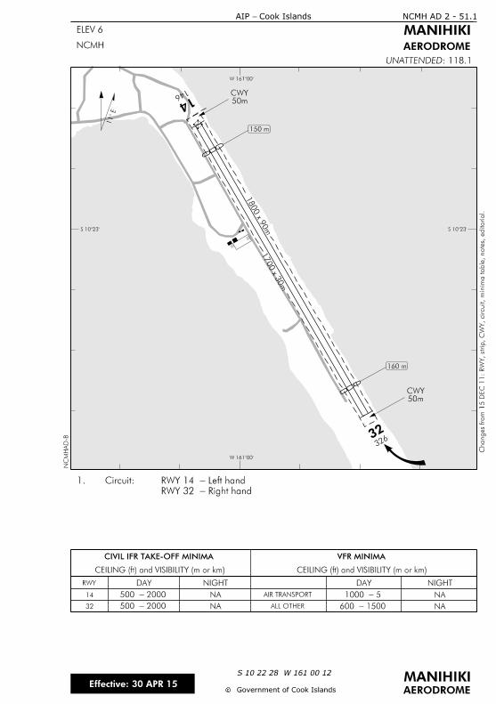
146 14
32632
1700 x 3
0m
1800 x 9
0m
50mCWY
11
NA
CIVIL IFR TAKE-OFF MINIMA
CEILING (ft) and VISIBILITY (m or km) CEILING (ft) and VISIBILITY (m or km)
VFR MINIMA
RWY DAY NIGHT DAY NIGHT
AIR TRANSPORT
ALL OTHER NA
S 10î
W 161î
S 10î
W 161î
NCMH AD 2 - 51.1
ELEV 6
Cook Islands- AIP
MANIHIKI
AERODROME
cc
MANIHIKIS 10 22 28 W 161 00 12
AERODROME
: 118.1UNATTENDEDN
CM
HA
D-B
NCMH
Government of Cook Islands
Changes fro
m 1
5 D
EC 1
1:
RW
Y, strip,
CW
Y, circuit,
minim
a table, notes, e
ditorial.
Right hand-RWY 32
Left hand-RWY 14 Circuit:1.
14 NA
32 NA
50mCWY
2000-500 5-1000
1500-600 2000-500
160 m
150 m
Effective: 30 APR 15

IntentionallyBlank

NCMK AD 2 - 1AIP — Cook Islands
E Government of Cook Islands
NCMK AD 2.1 AERODROME LOCATION INDICATORAND NAME
NCMK MAUKE
NCMK AD 2.2 AERODROME GEOGRAPHICAL ANDADMINISTRATIVE DATA
1 ARP co-ordinates andsite at AD
S 20 08 14.35 W 157 20 37.87ARP site as depicted on NCMK AD 2-51.1
2 Direction and distancefrom city
1.5km NE of town
3 Elevation/Referencetemperature
38ft
4 MAG VAR/Annualchange
14°E
5 AD Administration,address, telephone,telefax, telex, AFS
Mauke Island CouncilMaukeCOOK ISLANDS
Contact can be made through Air RarotongaAgent Tel (682) 22 888
6 Types of trafficpermitted (IFR/VFR)
IFR/VFR
7 Remarks Available for limited use subject to prioragreement of the Licensee. No operationspermitted on Sundays except for medicalemergencies
Effective: 25 MAY 17
NCMK AD 2 - 2 AIP — Cook Islands
E Government of Cook Islands
NCMK AD 2.3 OPERATIONAL HOURS
1 AD Administration 0800–1600 Mon–Fri except public holidays
2 Customs andimmigration
Nil
3 Health and sanitation Hospital with limited facilities
4 AIS Briefing Office Nil
5 ATS Reporting Office(ARO)
Nil
6 MET Briefing Office Nil
7 ATS Nil
8 Fuelling Nil
9 Handling Air Rarotonga
10 Security Nil
11 De-icing Nil
12 Remarks Mauke is an unattended aerodrome
NCMK AD 2.4 HANDLING SERVICES AND FACILITIES
1 Cargo-handlingfacilities
By prior arrangement with Air Rarotonga
2 Fuel/oil types Nil
3 Fuelling facilities/capabilities
Nil
4 De-icing facilities Nil
5 Hangar space forvisiting aircraft
Nil
6 Repair facilities forvisiting aircraft
Nil
7 Remarks Nil
Effective: 30 APR 15
NCMK AD 2 - 3AIP — Cook Islands
E Government of Cook Islands
NCMK AD 2.5 PASSENGER FACILITIES
1 Hotels Accommodation units available near airportand around the island
2 Restaurants Nil
3 Transportation Transfers or by prior arrangement
4 Medical facilities Hospital
5 Bank and Post Office Available in town
6 Tourist Office Nil
7 Remarks Nil
NCMK AD 2.6 RESCUE AND FIRE FIGHTING SERVICES
Nil
NCMK AD 2.7 SEASONAL AVAILABILITY — CLEARING
Nil
NCMK AD 2.8 APRONS, TAXIWAYS AND CHECKLOCATIONS DATA
1 Apron surface andstrength
Compact coral
2 Taxiway width, surfaceand strength
Nil
3 ACL location andelevation
RWY 10 32ftRWY 28 32ft
4 VOR/INS checkpoints Nil
5 Remarks Nil
Effective: 25 MAY 17

NCMK AD 2 - 4 AIP — Cook Islands
E Government of Cook Islands
NCMK AD 2.9 SURFACE MOVEMENT GUIDANCE,CONTROL SYSTEM AND MARKINGS
Nil
NCMK AD 2.10 AERODROME OBSTACLES
In approach/TKOF areasIn circling areaand at AD Remarks
1 2 3
RWY/Areaaffected
Obstacletype
ElevationMarkings/LGT
Coordinates Obstacletype
ElevationMarkings/LGT
Coordinates
a b c a b
10/28 TBA (1,b) TBA (1,c) TBA TBA (2,b)TBA
APRON TBA (1,b) TBA (1,c) TBA TBA (2,b)TBA
NCMK AD 2.11 METEOROLOGICAL INFORMATIONPROVIDED
Nil
Effective: 15 DEC 11
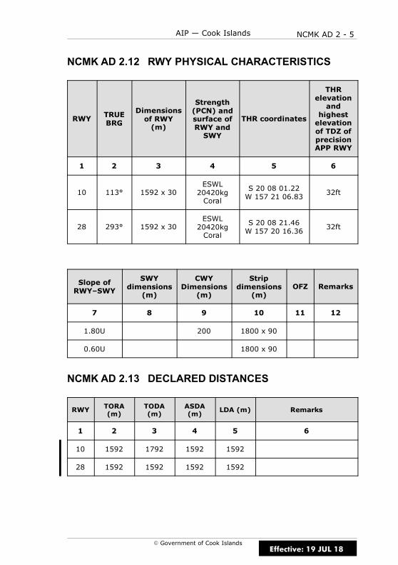
NCMK AD 2 - 5AIP — Cook Islands
E Government of Cook Islands
NCMK AD 2.12 RWY PHYSICAL CHARACTERISTICS
RWY TRUEBRG
Dimensionsof RWY(m)
Strength(PCN) andsurface ofRWY andSWY
THR coordinates
THRelevationand
highestelevationof TDZ ofprecisionAPP RWY
1 2 3 4 5 6
10 113° 1592 x 30ESWL20420kgCoral
S 20 08 01.22W 157 21 06.83
32ft
28 293° 1592 x 30ESWL20420kgCoral
S 20 08 21.46W 157 20 16.36
32ft
Slope ofRWY–SWY
SWYdimensions
(m)
CWYDimensions
(m)
Stripdimensions
(m)OFZ Remarks
7 8 9 10 11 12
1.80U 200 1800 x 90
0.60U 1800 x 90
NCMK AD 2.13 DECLARED DISTANCES
RWY TORA(m)
TODA(m)
ASDA(m)
LDA (m) Remarks
1 2 3 4 5 6
10 1592 1792 1592 1592
28 1592 1592 1592 1592
Effective: 19 JUL 18

NCMK AD 2 - 6 AIP — Cook Islands
E Government of Cook Islands
NCMK AD 2.14 APPROACH AND RWY LIGHTING
Nil
NCMK AD 2.15 OTHER LIGHTING, SECONDARY POWERSUPPLY
Nil
NCMK AD 2.16 HELICOPTER LANDING AREA
Nil
NCMK AD 2.17 ATS AIRSPACE
1 Designation andlateral limits
Nil
2 Vertical limits Nil
3 Airspace classification Nil
4 ATS unit callsign,language(s)
Nil
5 Transition altitude 13000ft
6 Remarks Nil
Effective: 30 APR 15

NCMK AD 2 - 7AIP — Cook Islands
E Government of Cook Islands
NCMK AD 2.18 ATS COMMUNICATIONS FACILITIES
Nil
NCMK AD 2.19 RADIO NAVIGATION AND LANDING AIDS
Nil
NCMK AD 2.20 LOCAL TRAFFIC REGULATIONS
1 AERODROME REGULATIONS
1.1 Pilots are to maintain a continuous listening watch on the frequencylisted in the COM box on the aerodrome chart, or on 118.1MHz if there isno such chart.
1.2 For the benefit of other traffic, pilots should broadcast their position,altitude and intentions as listed below:
(a) In circuit: downwind when abeam the upwind end of the RWY.
(b) Established on finals to land.
(c) In transit: between 5–10NM from the aerodrome.
1.3 Each aircraft transmission is to be preceded by the name of theaerodrome, “MAUKE TRAFFIC”.
2 TAXIING TO AND FROM STANDS
2.1 There are no taxiing stands or taxi routes. Taxi will be at thediscretion of the pilot.
NCMK AD 2.21 NOISE ABATEMENT PROCEDURES
There are no published noise abatement procedures for Mauke.
Effective: 30 APR 15

NCMK AD 2 - 8 AIP — Cook Islands
E Government of Cook Islands
NCMK AD 2.22 FLIGHT PROCEDURES
1 POSITION AND ALTITUDE REPORTING — LOCAL VFR FLIGHTS
1.1 Pilots of aircraft intending to operate under VFR from Mauke arerequired to report departure details after take-off on the nominated HFfrequencies to Rarotonga “TOWER/FLIGHT SERVICE” if intending to proceedto other unattended aerodromes or when requesting clearance to enterClass C airspace.
1.2 When Rarotonga Flight Service is operating Rarotonga CTA Class Cairspace reverts to Class G.
2 POSITION REPORTING ON DEPARTURE
2.1 Pilots are required to make a departure report as soon aspracticable after take-off on the nominated HF frequencies to Rarotonga“TOWER/FLIGHT SERVICE” and must contain the following information:
(a) Identification; radio callsign
(b) Estimated set heading time in minutes past the hour
(c) Phrase “CLIMBING TO” or “REQUEST” followed by altitude or flightlevel;
(d) Next position and time over or ETA for destination
2.2 When Rarotonga Flight Service is operating Rarotonga CTA Class Cairspace reverts to Class G.
3 AERODROME TRAFFIC CIRCUIT RULES
3.1 Circuit direction is:
(a) RWY 10 is left-hand
(b) RWY 28 is right-hand
NCMK AD 2.23 ADDITIONAL INFORMATION
Nil
NCMK AD 2.24 CHARTS RELATED TO AERODROME
(a) Instrument Approach Charts
MAUKE RNAV (GNSS) RWY 10 NCMK AD 2-45.1. . . . . . . . . . . . . . . . .
(b) Aerodrome Charts
MAUKE NCMK AD 2-51.1. . . . . . . . . . . . . . . . . . . . . . . . . . . . . . . . . . . . . . . .
Effective: 25 MAY 17
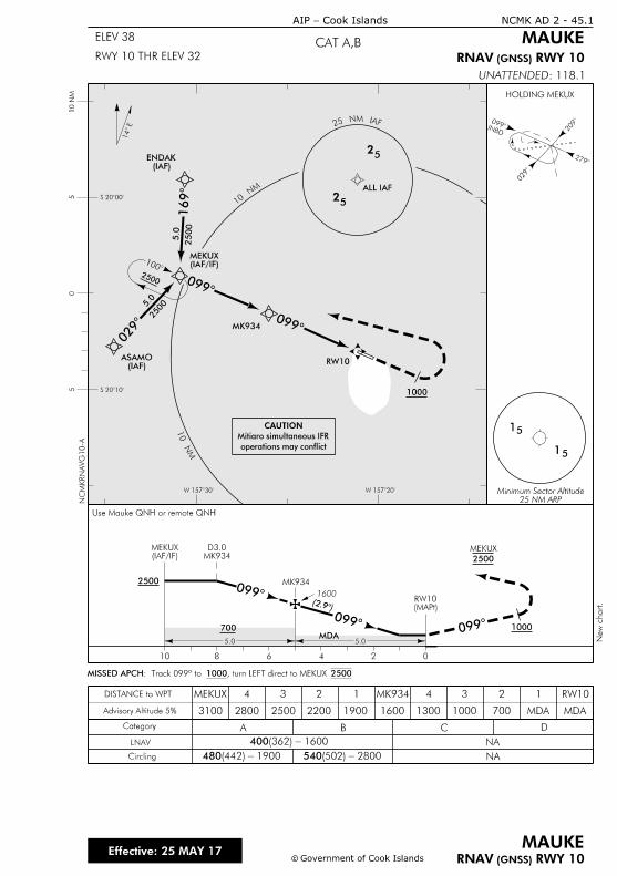
1
15
5
25 NM ARPMinimum Sector Altitude
2500
1
14
2
INBD 2
0
0
cc Government of Cook Islands
Cook Islands-AIP
MAUKERWY 10 (GNSS) RNAV
Effective: 25 MAY 17
NCMK AD 2 - 45.1
MAUKE
RWY 10 (GNSS) RNAV
: 118.1UNATTENDED
CAT A,BELEV 38
RWY 10 THR ELEV 32
1
2500
5.0
0
25005.0
0
0
1000
00
2500
0246810
5.05.0
Category A B C D
NA
NA
LNAV
DISTANCE to WPT
Advisory Altitude 5%
Circling
400 1600- (362)
480 1900 - (442) 540 2800 - (502)
MK934D3.0
(MAPt)RW10
0 1600(2.
700MDA
1000
(IAF)ENDAK
(IAF)ASAMO
S 20î
S 20î
W 157îW 157î
10 N
M5
05
25
FAI MN 52
25
MN
01
MN 01
Use Mauke QNH or remote QNH
(IAF/IF)MEKUX
ALL IAF
(IAF/IF)MEKUX
2500
MEKUX
, turn LEFT direct to MEKUX 1000: Track 099º to MISSED APCH 2500
1
MDA7001600190022002500
MEKUX
2800
4
3100
3 2 1 MK934 2
MDA
RW104
1300 1000
3
operations may conflict
Mitiaro simultaneous IFR
CAUTION
HOLDING MEKUX
NC
MK
RN
AV
G10-A
New c
hart.
MK934
RW10
MK934

IntentionallyBlank

ELEV 32
ELEV 32
1800 x 90 m
1592 x 30 m
200 mCWY
14
NA
1500 - 600
NA 5 - 1000NA
CIVIL IFR TAKE-OFF MINIMA
CEILING (ft) and VISIBILITY (m or km) CEILING (ft) and VISIBILITY (m or km)
VFR MINIMA
RWY
10-28
DAY NIGHT DAY NIGHT
AIR TRANSPORT
ALL OTHER NA
Strip slopes up from both ends.2.
Right hand-RWY 28
Left hand-RWY 10 Circuit:1.
279
28
099
10
ELEV 38
NCMK AD 2 - 51.1
ELEV 38
Cook Islands-AIP
MAUKE
AERODROMENCMK
cc Government of Cook Islands
MAUKEEffective: 19 JUL 18
S 20 08 14 W 157 20 38
AERODROME
: 118.1UNATTENDEDN
CM
KA
D-D
Changes fro
m 2
5 M
AY 1
7:
RW
Y 1
0/2
8 DIS
P T
HRs re
moved.
S 2008
W 15721 W 15720
S 2008

IntentionallyBlank
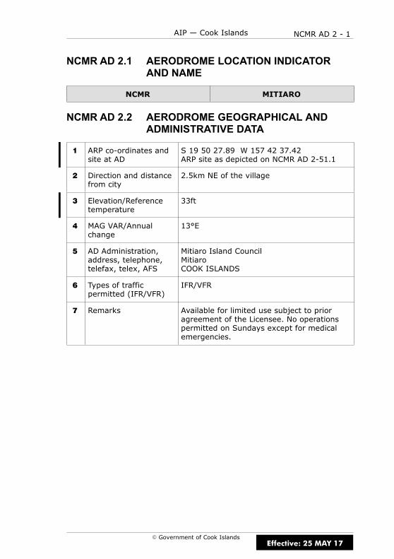
NCMR AD 2 - 1AIP — Cook Islands
E Government of Cook Islands
NCMR AD 2.1 AERODROME LOCATION INDICATORAND NAME
NCMR MITIARO
NCMR AD 2.2 AERODROME GEOGRAPHICAL ANDADMINISTRATIVE DATA
1 ARP co-ordinates andsite at AD
S 19 50 27.89 W 157 42 37.42ARP site as depicted on NCMR AD 2-51.1
2 Direction and distancefrom city
2.5km NE of the village
3 Elevation/Referencetemperature
33ft
4 MAG VAR/Annualchange
13°E
5 AD Administration,address, telephone,telefax, telex, AFS
Mitiaro Island CouncilMitiaroCOOK ISLANDS
6 Types of trafficpermitted (IFR/VFR)
IFR/VFR
7 Remarks Available for limited use subject to prioragreement of the Licensee. No operationspermitted on Sundays except for medicalemergencies.
Effective: 25 MAY 17
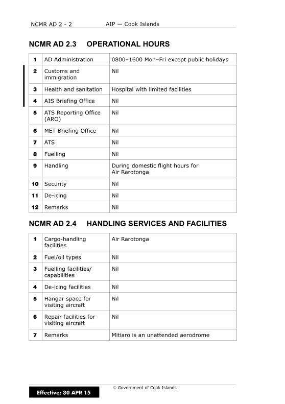
NCMR AD 2 - 2 AIP — Cook Islands
E Government of Cook Islands
NCMR AD 2.3 OPERATIONAL HOURS
1 AD Administration 0800–1600 Mon–Fri except public holidays
2 Customs andimmigration
Nil
3 Health and sanitation Hospital with limited facilities
4 AIS Briefing Office Nil
5 ATS Reporting Office(ARO)
Nil
6 MET Briefing Office Nil
7 ATS Nil
8 Fuelling Nil
9 Handling During domestic flight hours forAir Rarotonga
10 Security Nil
11 De-icing Nil
12 Remarks Nil
NCMR AD 2.4 HANDLING SERVICES AND FACILITIES
1 Cargo-handlingfacilities
Air Rarotonga
2 Fuel/oil types Nil
3 Fuelling facilities/capabilities
Nil
4 De-icing facilities Nil
5 Hangar space forvisiting aircraft
Nil
6 Repair facilities forvisiting aircraft
Nil
7 Remarks Mitiaro is an unattended aerodrome
Effective: 30 APR 15
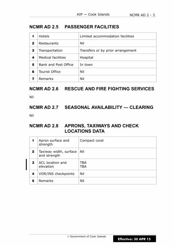
NCMR AD 2 - 3AIP — Cook Islands
E Government of Cook Islands
NCMR AD 2.5 PASSENGER FACILITIES
1 Hotels Limited accommodation facilities
2 Restaurants Nil
3 Transportation Transfers or by prior arrangement
4 Medical facilities Hospital
5 Bank and Post Office In town
6 Tourist Office Nil
7 Remarks Nil
NCMR AD 2.6 RESCUE AND FIRE FIGHTING SERVICES
Nil
NCMR AD 2.7 SEASONAL AVAILABILITY — CLEARING
Nil
NCMR AD 2.8 APRONS, TAXIWAYS AND CHECKLOCATIONS DATA
1 Apron surface andstrength
Compact coral
2 Taxiway width, surfaceand strength
Nil
3 ACL location andelevation
TBATBA
4 VOR/INS checkpoints Nil
5 Remarks Nil
Effective: 30 APR 15

NCMR AD 2 - 4 AIP — Cook Islands
E Government of Cook Islands
NCMR AD 2.9 SURFACE MOVEMENT GUIDANCE,CONTROL SYSTEM AND MARKINGS
Nil
NCMR AD 2.10 AERODROME OBSTACLES
In approach/TKOF areasIn circling areaand at AD Remarks
1 2 3
RWY/Areaaffected
Obstacletype
ElevationMarkings/LGT
Coordinates Obstacletype
ElevationMarkings/LGT
Coordinates
a b c a b
09/27 TBA (1,b) TBA (1,c) TBA TBA (2,b)TBA
APRON TBA (1,b) TBA (1,c) TBA TBA (2,b)TBA
NCMR AD 2.11 METEOROLOGICAL INFORMATIONPROVIDED
Nil
Effective: 15 DEC 11

NCMR AD 2 - 5AIP — Cook Islands
E Government of Cook Islands
NCMR AD 2.12 RWY PHYSICAL CHARACTERISTICS
RWY TRUEBRG
Dimensionsof RWY(m)
Strength(PCN) andsurface ofRWY andSWY
THR coordinates
THRelevationand
highestelevationof TDZ ofprecisionAPP RWY
1 2 3 4 5 6
09 106° 1200 x 30ESWL20420kgCoral
S 19 50 27.53W 157 42 31.38
30ft
27 286° 1200 x 30ESWL20420kgCoral
S 19 50 39.22W157 41 52.02
33ft
Slope ofRWY–SWY
SWYdimensions
(m)
CWYDimensions
(m)
Stripdimensions
(m)OFZ Remarks
7 8 9 10 11 12
1500 x 90
1500 x 90
NCMR AD 2.13 DECLARED DISTANCES
RWY TORA(m)
TODA(m)
ASDA(m)
LDA(m)
Remarks
1 2 3 4 5 6
09 1200 1200 1200 1200
27 1200 1200 1200 1200
Effective: 25 MAY 17
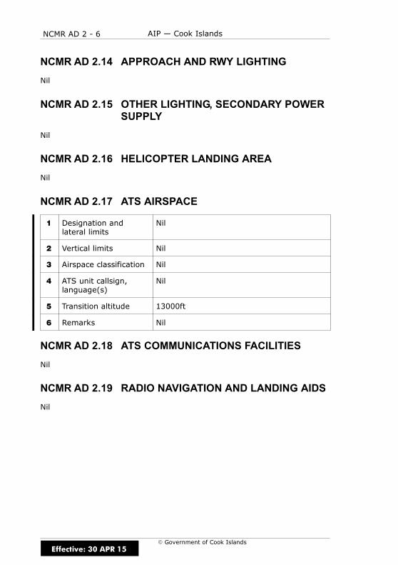
NCMR AD 2 - 6 AIP — Cook Islands
E Government of Cook Islands
NCMR AD 2.14 APPROACH AND RWY LIGHTING
Nil
NCMR AD 2.15 OTHER LIGHTING, SECONDARY POWERSUPPLY
Nil
NCMR AD 2.16 HELICOPTER LANDING AREA
Nil
NCMR AD 2.17 ATS AIRSPACE
1 Designation andlateral limits
Nil
2 Vertical limits Nil
3 Airspace classification Nil
4 ATS unit callsign,language(s)
Nil
5 Transition altitude 13000ft
6 Remarks Nil
NCMR AD 2.18 ATS COMMUNICATIONS FACILITIES
Nil
NCMR AD 2.19 RADIO NAVIGATION AND LANDING AIDS
Nil
Effective: 30 APR 15
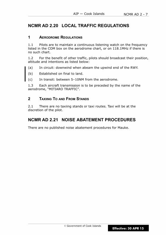
NCMR AD 2 - 7AIP — Cook Islands
E Government of Cook Islands
NCMR AD 2.20 LOCAL TRAFFIC REGULATIONS
1 AERODROME REGULATIONS
1.1 Pilots are to maintain a continuous listening watch on the frequencylisted in the COM box on the aerodrome chart, or on 118.1MHz if there isno such chart.
1.2 For the benefit of other traffic, pilots should broadcast their position,altitude and intentions as listed below:
(a) In circuit: downwind when abeam the upwind end of the RWY.
(b) Established on final to land.
(c) In transit: between 5–10NM from the aerodrome.
1.3 Each aircraft transmission is to be preceded by the name of theaerodrome, “MITIARO TRAFFIC”.
2 TAXIING TO AND FROM STANDS
2.1 There are no taxiing stands or taxi routes. Taxi will be at thediscretion of the pilot.
NCMR AD 2.21 NOISE ABATEMENT PROCEDURES
There are no published noise abatement procedures for Mauke.
Effective: 30 APR 15

NCMR AD 2 - 8 AIP — Cook Islands
E Government of Cook Islands
NCMR AD 2.22 FLIGHT PROCEDURES
1 POSITION AND ALTITUDE REPORTING — LOCAL VFR FLIGHTS
1.1 Pilots of aircraft intending to operate under VFR from Mauke arerequired to report departure details after take-off on the nominated HFfrequencies to Rarotonga “TOWER/FLIGHT SERVICE” if intending to proceedto other unattended aerodromes or when requesting clearance to enterClass C airspace.
1.2 When Rarotonga Flight Service is operating Rarotongs CTA Class Cairspace reverts to Class G.
2 POSITION REPORTING ON DEPARTURE
2.1 Pilots are required to make a departure report as soon aspracticable after take-off on the nominated HF frequencies to Rarotonga“TOWER/FLIGHT SERVICE” and must contain the following information:
(a) Identification; radio callsign
(b) Estimated set heading time in minutes past the hour
(c) Phrase “CLIMBING TO” or “REQUEST” followed by altitude or flightlevel;
(d) Next position and time over or ETA for destination
2.2 When Rarotonga Flight Service is operating Rarotongs CTA Class Cairspace reverts to Class G.
3 AERODROME TRAFFIC CIRCUIT RULES
3.1 Circuit direction is:
(a) RWY 09 is left-hand
(b) RWY 27 is right-hand
NCMR AD 2.23 ADDITIONAL INFORMATION
Nil
NCMR AD 2.24 CHARTS RELATED TO AERODROME
(a) Instrument Approach Charts
MITIARO RNAV (GNSS) RWY 09 NCMR AD 2-45.1. . . . . . . . . . . . . . .
(b) Aerodrome Charts
MITIARO NCMR AD 2-51.1. . . . . . . . . . . . . . . . . . . . . . . . . . . . . . . . . . . . . .
Effective: 25 MAY 17
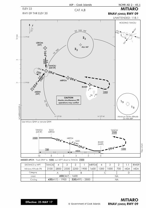
MN
0
1
MN
01
1
15
5
25 NM ARPMinimum Sector Altitude
2500
0
2
INBD
2
0
0
(IAF)LEKOM
(IAF)AKENI
1
0
0
0
2500
5.0
25005.0
1000
00
2500
0246810
5.05.0
MR934D3.0
(MAPt)RW09
0 1600(2.
700MDA
1000
Category A B C D
NA
NA
LNAV
DISTANCE to WPT
Advisory Altitude 5%
Circling
400 1600- (367)
450 1900 - (417) 530 2800 - (497)
cc
CAT A,BELEV 33
RWY 09 THR ELEV 30
Effective: 25 MAY 17
FAI MN 52
25
52
13
: 118.1UNATTENDED
RWY 09 (GNSS) RNAV
Cook Islands-AIP NCMR AD 2 - 45.1
MITIARO
MITIARORWY 09 (GNSS) RNAVGovernment of Cook Islands
W 157îW 157î
S 19î
S 19î
10 N
M5
0
(IAF/IF)TANOU
ALL IAF
HOLDING TANOU
Use Mitiaro QNH or remote QNH
(IAF/IF)TANOU
2500
TANOU
, turn LEFT direct to TANOU 1000: Track 094º to MISSED APCH 2500
1.1
MDA70016001900220025002800
4
3100
3 2 1 MR934 2
MDA
RW094
1300 1000
3TANOU
operations may conflict
Mauke simultaneous IFR
CAUTION
NC
MRR
NA
VG
09-A
New c
hart.
MR934
RW09
MR934
36
39
49

IntentionallyBlank
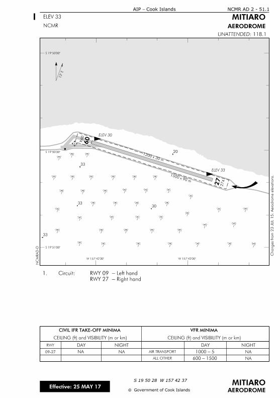
NA
1500 - 600
NA 5 - 1000NA
CIVIL IFR TAKE-OFF MINIMA
CEILING (ft) and VISIBILITY (m or km) CEILING (ft) and VISIBILITY (m or km)
VFR MINIMA
RWY
09-27
DAY NIGHT DAY NIGHT
AIR TRANSPORT
ALL OTHER NA
NCMR AD 2 - 51.1
ELEV 33 MITIARO
AERODROME
cc
MITIAROS 19 50 28 W 157 42 37
AERODROME
: 118.1UNATTENDED
NCMR
Effective: 25 MAY 17Government of Cook Islands
Cook Islands- AIP
1200 x 30 m
1500 x 90 m
ELEV 33
ELEV 30094
09
274
27
13
S 1950
S 1950
S 1951
W 15742W 15742
Right hand-RWY 27
Left hand-RWY 09 Circuit: 1.
NC
MR
AD-D
Changes fro
m 2
3 J
UL 1
5:
Aero
dro
me ele
vations.
20
33
33
33
30

IntentionallyBlank
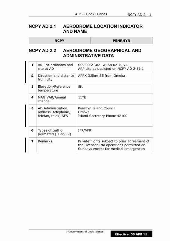
NCPY AD 2 - 1AIP — Cook Islands
E Government of Cook Islands
NCPY AD 2.1 AERODROME LOCATION INDICATORAND NAME
NCPY PENRHYN
NCPY AD 2.2 AERODROME GEOGRAPHICAL ANDADMINISTRATIVE DATA
1 ARP co-ordinates andsite at AD
S09 00 21.82 W158 02 10.74ARP site as depicted on NCPY AD 2-51.1
2 Direction and distancefrom city
APRX 3.5km SE from Omoka
3 Elevation/Referencetemperature
8ft
4 MAG VAR/Annualchange
11°E
5 AD Administration,address, telephone,telefax, telex, AFS
Penrhyn Island CouncilOmokaIsland Secretary Phone 42100
6 Types of trafficpermitted (IFR/VFR)
IFR/VFR
7 Remarks Private flights subject to prior agreement ofthe Licensee. No operations permitted onSundays except for medical emergencies
Effective: 30 APR 15

NCPY AD 2 - 2 AIP — Cook Islands
E Government of Cook Islands
NCPY AD 2.3 OPERATIONAL HOURS
1 AD Administration 0800–1600 Mon–Fri except public holidays
2 Customs andimmigration
Nil
3 Health and sanitation Hospital with limited facilities
4 AIS Briefing Office Nil
5 ATS Reporting Office(ARO)
Nil
6 MET Briefing Office Nil
7 ATS Nil
8 Fuelling Nil
9 Handling By prior arrangement through Air Rarotonga
10 Security Nil
11 De-icing Nil
12 Remarks Nil
NCPY AD 2.4 HANDLING SERVICES AND FACILITIES
1 Cargo-handlingfacilities
By prior arrangement through Air Rarotonga
2 Fuel/oil types Nil
3 Fuelling facilities/capabilities
Nil
4 De-icing facilities Nil
5 Hangar space forvisiting aircraft
Nil
6 Repair facilities forvisiting aircraft
Nil
7 Remarks Nil
Effective: 30 APR 15

NCPY AD 2 - 3AIP — Cook Islands
E Government of Cook Islands
NCPY AD 2.5 PASSENGER FACILITIES
1 Hotels Nil
2 Restaurants Nil
3 Transportation Nil
4 Medical facilities Hospital
5 Bank and Post Office Nil
6 Tourist Office Nil
7 Remarks Nil
NCPY AD 2.6 RESCUE AND FIRE FIGHTING SERVICES
Nil
NCPY AD 2.7 SEASONAL AVAILABILITY — CLEARING
Nil
NCPY AD 2.8 APRONS, TAXIWAYS AND CHECKLOCATIONS DATA
1 Apron surface andstrength
TBA
2 Taxiway width, surfaceand strength
Nil
3 ACL location andelevation
RWY 14 8ftRWY 32 8ft
4 VOR/INS checkpoints Nil
5 Remarks Nil
Effective: 15 DEC 11

NCPY AD 2 - 4 AIP — Cook Islands
E Government of Cook Islands
NCPY AD 2.9 SURFACE MOVEMENT GUIDANCE,CONTROL SYSTEM AND MARKINGS
Nil
NCPY AD 2.10 AERODROME OBSTACLES
In approach/TKOF areasIn circling area
and at AD Remarks
1 2 3
RWY/Areaaffected
Obstacletype
ElevationMarkings/
LGT
Coordinates Obstacletype
ElevationMarkings/
LGT
Coordinates
a b c a b
14/32 TBA (1,b) TBA (1,c) TBA TBA (2,b)TBA
APRON TBA (1,b) TBA (1,c) TBA TBA (2,b)TBA
NCPY AD 2.11 METEOROLOGICAL INFORMATIONPROVIDED
Nil
Effective: 15 DEC 11

NCPY AD 2 - 5AIP — Cook Islands
E Government of Cook Islands
NCPY AD 2.12 RWY PHYSICAL CHARACTERISTICS
RWY TRUEBRG
Dimensionsof RWY(m)
Strength(PCN) andsurface ofRWY andSWY
THR coordinates
THRelevationand
highestelevationof TDZ ofprecisionAPP RWY
1 2 3 4 5 6
14 151° 2212 x 30ESWL20420kgCoral
S 09 00 23.11W 158 02 11.80
8ft
32 331° 2212 x 30ESWL20420kgCoral
S 09 01 26.44W 158 01 37.33
8ft
Slope ofRWY–SWY
SWYdimensions
(m)
CWYDimensions
(m)
Stripdimensions
(m)OFZ Remarks
7 8 9 10 11 12
2295 x 90
2295 x 90
NCPY AD 2.13 DECLARED DISTANCES
RWY TORA(m)
TODA(m)
ASDA(m)
LDA(m)
Remarks
1 2 3 4 5 6
14 2212 2212 2212 2212
32 2212 2212 2212 2212
Effective: 30 APR 15
NCPY AD 2 - 6 AIP — Cook Islands
E Government of Cook Islands
NCPY AD 2.14 APPROACH AND RWY LIGHTING
Nil
NCPY AD 2.15 OTHER LIGHTING, SECONDARY POWERSUPPLY
Nil
NCPY AD 2.16 HELICOPTER LANDING AREA
Nil
NCPY AD 2.17 ATS AIRSPACE
1 Designation andlateral limits
Nil
2 Vertical limits Nil
3 Airspace classification Nil
4 ATS unit callsign,language(s)
Nil
5 Transition altitude 13000ft
6 Remarks Nil
NCPY AD 2.18 ATS COMMUNICATIONS FACILITIES
Nil
Effective: 30 APR 15
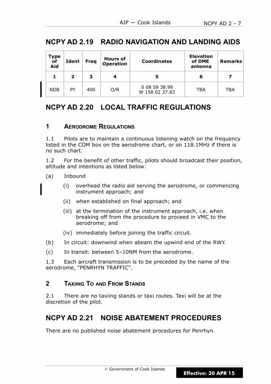
NCPY AD 2 - 7AIP — Cook Islands
E Government of Cook Islands
NCPY AD 2.19 RADIO NAVIGATION AND LANDING AIDS
TypeofAid
Ident Freq Hours ofOperation Coordinates
Elevationof DMEantenna
Remarks
1 2 3 4 5 6 7
NDB PY 400 O/R S 08 59 38.99W 158 02 37.83 TBA TBA
NCPY AD 2.20 LOCAL TRAFFIC REGULATIONS
1 AERODROME REGULATIONS
1.1 Pilots are to maintain a continuous listening watch on the frequencylisted in the COM box on the aerodrome chart, or on 118.1MHz if there isno such chart.
1.2 For the benefit of other traffic, pilots should broadcast their position,altitude and intentions as listed below:
(a) Inbound
(i) overhead the radio aid serving the aerodrome, or commencinginstrument approach; and
(ii) when established on final approach; and
(iii) at the termination of the instrument approach, i.e. whenbreaking off from the procedure to proceed in VMC to theaerodrome; and
(iv) immediately before joining the traffic circuit.
(b) In circuit: downwind when abeam the upwind end of the RWY.
(c) In transit: between 5–10NM from the aerodrome.
1.3 Each aircraft transmission is to be preceded by the name of theaerodrome, “PENRHYN TRAFFIC”.
2 TAXIING TO AND FROM STANDS
2.1 There are no taxiing stands or taxi routes. Taxi will be at thediscretion of the pilot.
NCPY AD 2.21 NOISE ABATEMENT PROCEDURES
There are no published noise abatement procedures for Penrhyn.
Effective: 30 APR 15
NCPY AD 2 - 8 AIP — Cook Islands
E Government of Cook Islands
NCPY AD 2.22 FLIGHT PROCEDURES
1 POSITION AND ALTITUDE REPORTING — LOCAL VFR FLIGHTS
1.1 Pilots of aircraft intending to operate under VFR from Penrhyn arerequired to report departure details after take-off on the nominated HFfrequencies to Rarotonga “TOWER/FLIGHT SERVICE” if intending to proceedto other unattended aerodromes.
2 POSITION REPORTING ON DEPARTURE
2.1 Pilots are required to make a departure report as soon as practicableafter take-off on the nominated HF frequencies to Rarotonga“TOWER/FLIGHT SERVICE” and must contain the following information:
(a) Identification; radio callsign
(b) Estimated set heading time in minutes past the hour
(c) Phrase “CLIMBING TO” or “REQUEST” followed by altitude or flightlevel;
(d) Next position and time over or ETA for destination
3 AERODROME TRAFFIC CIRCUIT RULES
3.1 Circuit direction is:
(a) RWY 14 is left-hand
(b) RWY 32 is right-hand
NCPY AD 2.23 ADDITIONAL INFORMATION
Nil
NCPY AD 2.24 CHARTS RELATED TO AERODROME
(a) Instrument Approach Charts
PENRHYN NDB RWY 14 NCPY AD 2-44.1. . . . . . . . . . . . . . . . . . . . . . . .
(b) Aerodrome Charts
PENRHYN NCPY AD 2-51.1. . . . . . . . . . . . . . . . . . . . . . . . . . . . . . . . . . . . .
Effective: 30 APR 15
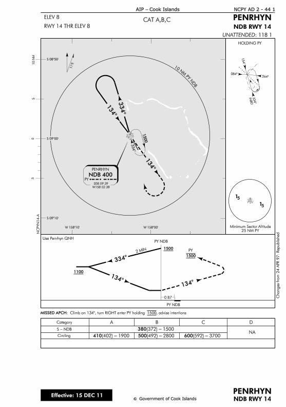
HOLDING PY
INB
D334°
084°
154°
264°
15
334°
PY NDB
PY NDB
1500
334°
PY
NDB 400
S08 59 39
W158 02 38
334°
134°
134°
PENRHYN
Use Penrhyn QNH
15
10N
MPY
ND
B
134°134
°
2 MIN
S 08°50’
W 158°10’
S 09°00’
S 09°10’
W 158°00’
50
510 N
M
0.87
11°E
PY
Minimum Sector Altitude25 NM PY
1500
1100
1500
MISSED APCH: Climb on 134°, turn RIGHT enter PY holding 1500, advise intentions
Category BA
NACircling
DC
380(372) - 1500
410(402) - 1900 500(492) - 2800 600(592) - 3700
S - NDB
c
NCPY AD 2 - 44.1
NDB RWY 14c
PENRHYN
CAT A,B,CELEV 8
RWY 14 THR ELEV 8
AIP - Cook Islands
PENRHYN
NDB RWY 14
NC
PY
N14-A
UNATTENDED: 118.1
Changes fro
m 2
4 A
PR 9
7:
Republish
ed.
Government of Cook IslandsEffective: 15 DEC 11

IntentionallyBlank
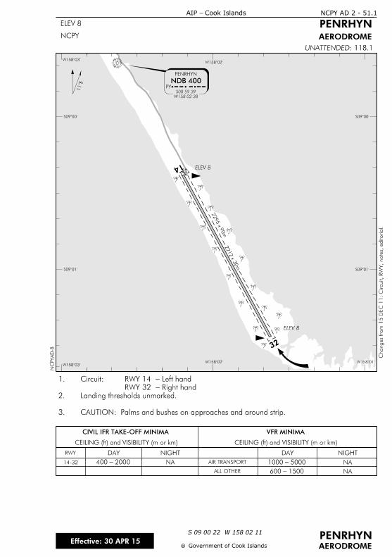
32
14
PY
NDB 400
W158 02 38
S08 59 39
1
PENRHYN
2212 x 3
0m
NA
1500 - 600
NA 5000 - 10002000 - 400
CIVIL IFR TAKE-OFF MINIMA
CEILING (ft) and VISIBILITY (m or km) CEILING (ft) and VISIBILITY (m or km)
VFR MINIMA
RWY
14-32
DAY NIGHT DAY NIGHT
AIR TRANSPORT
ALL OTHER NA
2295 x 9
0m
W158î W158îW158î
S09î
S09î
S09î
S09î
W158îW158î
NCPY AD 2 - 51.1
ELEV 8
Cook Islands- AIP
PENRHYN
AERODROME
cc
PENRHYNS 09 00 22 W 158 02 11
AERODROME
: 118.1UNATTENDEDN
CPY
AD-B
NCPY
Government of Cook Islands
CAUTION: Palms and bushes on approaches and around strip.3.
Landing thresholds unmarked.2.
Right hand-RWY 32
Left hand-RWY 14 Circuit:1.Changes fro
m 1
5 D
EC 1
1:
Circuit,
RW
Y, notes, e
ditorial.
ELEV 8
ELEV 8
Effective: 30 APR 15

IntentionallyBlank
NCPK AD 2 - 1AIP — Cook Islands
E Government of Cook Islands
NCPK AD 2.1 AERODROME LOCATION INDICATORAND NAME
NCPK PUKAPUKA
NCPK AD 2.2 AERODROME GEOGRAPHICAL ANDADMINISTRATIVE DATA
1 ARP co-ordinates andsite at AD
S10 54 55.06 W165 50 43.49ARP site as depicted on NCPK AD 2-51.1
2 Direction and distancefrom city
7km south of main township
3 Elevation/Referencetemperature
15ft
4 MAG VAR/Annualchange
11°E
5 AD Administration,address, telephone,telefax, telex, AFS
Pukapuka Island CouncilPukapukaCOOK ISLANDSTel: 41 044 (Govt Rep)
6 Types of trafficpermitted (IFR/VFR)
IFR/VFR
7 Remarks Private flights subject to prior agreement ofthe Licensee. No operations permitted onSundays except for medical emergencies.
Effective: 30 APR 15

NCPK AD 2 - 2 AIP — Cook Islands
E Government of Cook Islands
NCPK AD 2.3 OPERATIONAL HOURS
1 AD Administration 0800–1600 Mon–Fri except public holidays
2 Customs andimmigration
NA
3 Health and sanitation Hospital with limited facilities
4 AIS Briefing Office Nil
5 ATS Reporting Office(ARO)
Nil
6 MET Briefing Office Nil
7 ATS Nil
8 Fuelling Nil
9 Handling Nil
10 Security Nil
11 De-icing Nil
12 Remarks Nil
NCPK AD 2.4 HANDLING SERVICES AND FACILITIES
1 Cargo-handlingfacilities
Nil
2 Fuel/oil types Nil
3 Fuelling facilities/capabilities
Nil
4 De-icing facilities Nil
5 Hangar space forvisiting aircraft
Nil
6 Repair facilities forvisiting aircraft
Nil
7 Remarks Pukapuka is an unattended aerodrome
Effective: 30 APR 15
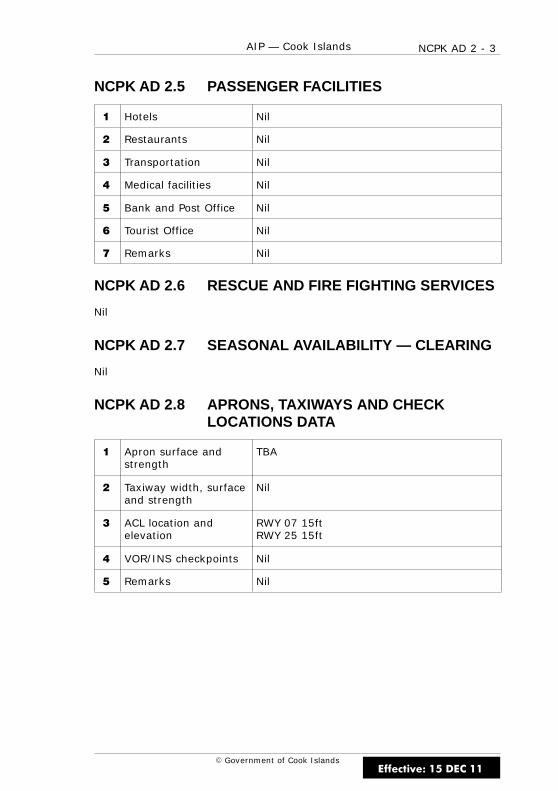
NCPK AD 2 - 3AIP — Cook Islands
E Government of Cook Islands
NCPK AD 2.5 PASSENGER FACILITIES
1 Hotels Nil
2 Restaurants Nil
3 Transportation Nil
4 Medical facilities Nil
5 Bank and Post Office Nil
6 Tourist Office Nil
7 Remarks Nil
NCPK AD 2.6 RESCUE AND FIRE FIGHTING SERVICES
Nil
NCPK AD 2.7 SEASONAL AVAILABILITY — CLEARING
Nil
NCPK AD 2.8 APRONS, TAXIWAYS AND CHECKLOCATIONS DATA
1 Apron surface andstrength
TBA
2 Taxiway width, surfaceand strength
Nil
3 ACL location andelevation
RWY 07 15ftRWY 25 15ft
4 VOR/INS checkpoints Nil
5 Remarks Nil
Effective: 15 DEC 11

NCPK AD 2 - 4 AIP — Cook Islands
E Government of Cook Islands
NCPK AD 2.9 SURFACE MOVEMENT GUIDANCE,CONTROL SYSTEM AND MARKINGS
Nil
NCPK AD 2.10 AERODROME OBSTACLES
In approach/TKOF areasIn circling area
and at AD Remarks
1 2 3
RWY/Areaaffected
Obstacletype
ElevationMarkings/
LGT
Coordinates Obstacletype
ElevationMarkings/
LGT
Coordinates
a b c a b
07/25 TBA (1,b) TBA (1,c) TBA TBA (2,b)TBA
APRON TBA (1,b) TBA (1,c) TBA TBA (2,b)TBA
NCPK AD 2.11 METEOROLOGICAL INFORMATIONPROVIDED
Nil
Effective: 15 DEC 11
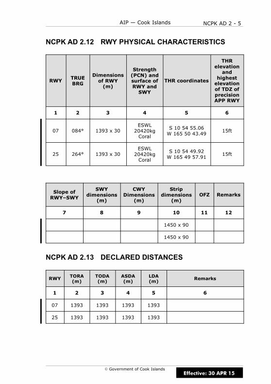
NCPK AD 2 - 5AIP — Cook Islands
E Government of Cook Islands
NCPK AD 2.12 RWY PHYSICAL CHARACTERISTICS
RWY TRUEBRG
Dimensionsof RWY(m)
Strength(PCN) andsurface ofRWY andSWY
THR coordinates
THRelevationand
highestelevationof TDZ ofprecisionAPP RWY
1 2 3 4 5 6
07 084° 1393 x 30ESWL20420kgCoral
S 10 54 55.06W 165 50 43.49
15ft
25 264° 1393 x 30ESWL20420kgCoral
S 10 54 49.92W 165 49 57.91
15ft
Slope ofRWY–SWY
SWYdimensions
(m)
CWYDimensions
(m)
Stripdimensions
(m)OFZ Remarks
7 8 9 10 11 12
1450 x 90
1450 x 90
NCPK AD 2.13 DECLARED DISTANCES
RWY TORA(m)
TODA(m)
ASDA(m)
LDA(m)
Remarks
1 2 3 4 5 6
07 1393 1393 1393 1393
25 1393 1393 1393 1393
Effective: 30 APR 15

NCPK AD 2 - 6 AIP — Cook Islands
E Government of Cook Islands
NCPK AD 2.14 APPROACH AND RWY LIGHTING
Nil
NCPK AD 2.15 OTHER LIGHTING, SECONDARY POWERSUPPLY
Nil
NCPK AD 2.16 HELICOPTER LANDING AREA
Nil
NCPK AD 2.17 ATS AIRSPACE
1 Designation andlateral limits
Nil
2 Vertical limits Nil
3 Airspace classification Nil
4 ATS unit callsign,language(s)
Nil
5 Transition altitude 13000ft
6 Remarks Nil
NCPK AD 2.18 ATS COMMUNICATIONS FACILITIES
Nil
Effective: 30 APR 15

NCPK AD 2 - 7AIP — Cook Islands
E Government of Cook Islands
NCPK AD 2.19 RADIO NAVIGATION AND LANDING AIDS
Nil
NCPK AD 2.20 LOCAL TRAFFIC REGULATIONS
1 AERODROME REGULATIONS
1.1 Pilots are to maintain a continuous listening watch on the frequencylisted in the COM box on the aerodrome chart, or on 118.1MHz if there isno such chart.
1.2 For the benefit of other traffic, pilots should broadcast their position,altitude and intentions as listed below:
(a) In circuit: downwind when abeam the upwind end of the RWY.
(b) Established on finals to land
(c) In transit: between 5–10NM from the aerodrome.
1.3 Each aircraft transmission is to be preceded by the name of theaerodrome, “PUKAPUKA TRAFFIC”.
2 TAXIING TO AND FROM STANDS
2.1 There are no taxiing stands or taxi routes. Taxi will be at thediscretion of the pilot.
NCPK AD 2.21 NOISE ABATEMENT PROCEDURES
There are no published noise abatement procedures for Penrhyn.
Effective: 30 APR 15
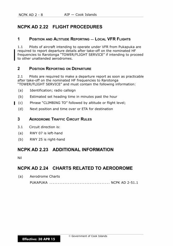
NCPK AD 2 - 8 AIP — Cook Islands
E Government of Cook Islands
NCPK AD 2.22 FLIGHT PROCEDURES
1 POSITION AND ALTITUDE REPORTING — LOCAL VFR FLIGHTS
1.1 Pilots of aircraft intending to operate under VFR from Pukapuka arerequired to report departure details after take-off on the nominated HFfrequencies to Rarotonga “TOWER/FLIGHT SERVICE” if intending to proceedto other unattended aerodromes.
2 POSITION REPORTING ON DEPARTURE
2.1 Pilots are required to make a departure report as soon as practicableafter take-off on the nominated HF frequencies to Rarotonga“TOWER/FLIGHT SERVICE” and must contain the following information:
(a) Identification; radio callsign
(b) Estimated set heading time in minutes past the hour
(c) Phrase “CLIMBING TO” followed by altitude or flight level;
(d) Next position and time over or ETA for destination
3 AERODROME TRAFFIC CIRCUIT RULES
3.1 Circuit direction is:
(a) RWY 07 is left-hand
(b) RWY 25 is right-hand
NCPK AD 2.23 ADDITIONAL INFORMATION
Nil
NCPK AD 2.24 CHARTS RELATED TO AERODROME
(a) Aerodrome Charts
PUKAPUKA NCPK AD 2-51.1. . . . . . . . . . . . . . . . . . . . . . . . . . . . . . . . . . . .
Effective: 30 APR 15
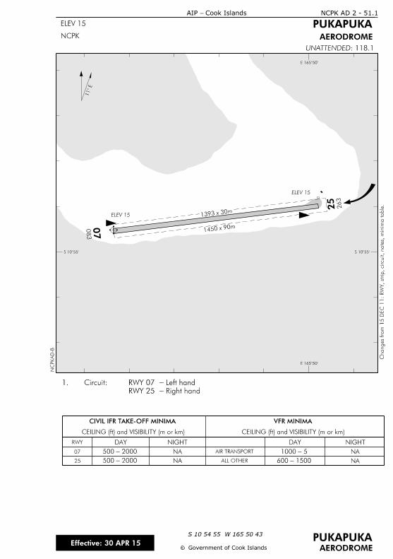
1393 x 30m
1450 x 90m0
83
07
263
25
11
E 165î
S 10î
NCPK AD 2 - 51.1
ELEV 15
Cook Islands- AIP
PUKAPUKA
AERODROME
cc
PUKAPUKAS 10 54 55 W 165 50 43
AERODROME
: 118.1UNATTENDEDN
CPK
AD-B
NCPK
Government of Cook Islands
Right hand-RWY 25
Left hand-RWY 07 Circuit: 1.Changes fro
m 1
5 D
EC 1
1:
RW
Y, strip, circuit, notes, minim
a table.
NA
CIVIL IFR TAKE-OFF MINIMA
CEILING (ft) and VISIBILITY (m or km) CEILING (ft) and VISIBILITY (m or km)
VFR MINIMA
RWY
07
DAY NIGHT DAY NIGHT
AIR TRANSPORT
ALL OTHER NA25
2000 -500
2000 -500
NA
NA
5 -1000
1500 -600
E 165î
S 10î
ELEV 15
ELEV 15
Effective: 30 APR 15

IntentionallyBlank

NCRG AD 2 - 1AIP — Cook Islands
E Government of Cook Islands
NCRG AD 2.1 AERODROME LOCATION INDICATORAND NAME
NCRG RAROTONGA
NCRG AD 2.2 AERODROME GEOGRAPHICAL ANDADMINISTRATIVE DATA
1 ARP co-ordinates andsite at AD
S 21 12 04.52 W 159 47 56.56ARP site as depicted on NCRG AD 2-51.1
2 Direction and distancefrom city
1.75NM W of Avarua township
3 Elevation/Referencetemperature
10ft/29.1°C (February)
4 MAG VAR/Annualchange
13° 54’ E (2016)
5 AD Administration,address, telephone,telefax, telex, AFS
Chief ExecutiveCook Islands Airport AuthorityPO Box 90RarotongaCOOK ISLANDS
Fax: (682) 21 890AFTN: NCRGYDYXemail: [email protected]
6 Types of trafficpermitted (IFR/VFR)
IFR/VFR
7 Remarks Except in an emergency, RarotongaInternational Airport is closed on Sundaysbetween 0930–1200 LT in respect of churchservices.
Effective: 19 JUL 18
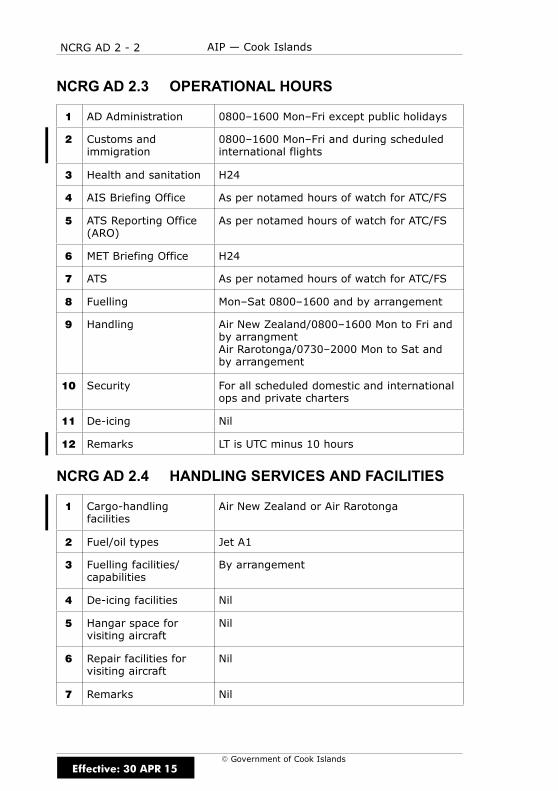
NCRG AD 2 - 2 AIP — Cook Islands
E Government of Cook Islands
NCRG AD 2.3 OPERATIONAL HOURS
1 AD Administration 0800–1600 Mon–Fri except public holidays
2 Customs andimmigration
0800–1600 Mon–Fri and during scheduledinternational flights
3 Health and sanitation H24
4 AIS Briefing Office As per notamed hours of watch for ATC/FS
5 ATS Reporting Office(ARO)
As per notamed hours of watch for ATC/FS
6 MET Briefing Office H24
7 ATS As per notamed hours of watch for ATC/FS
8 Fuelling Mon–Sat 0800–1600 and by arrangement
9 Handling Air New Zealand/0800–1600 Mon to Fri andby arrangmentAir Rarotonga/0730–2000 Mon to Sat andby arrangement
10 Security For all scheduled domestic and internationalops and private charters
11 De-icing Nil
12 Remarks LT is UTC minus 10 hours
NCRG AD 2.4 HANDLING SERVICES AND FACILITIES
1 Cargo-handlingfacilities
Air New Zealand or Air Rarotonga
2 Fuel/oil types Jet A1
3 Fuelling facilities/capabilities
By arrangement
4 De-icing facilities Nil
5 Hangar space forvisiting aircraft
Nil
6 Repair facilities forvisiting aircraft
Nil
7 Remarks Nil
Effective: 30 APR 15

NCRG AD 2 - 3AIP — Cook Islands
E Government of Cook Islands
NCRG AD 2.5 PASSENGER FACILITIES
1 Hotels Hotel/backpacker accommodation nearairport; unlimited around the island
2 Restaurants Situated around the island
3 Transportation Taxis, transfers, rental cars, buses
4 Medical facilities First Aid at airport.Hospital 3km W of airport
5 Bank and Post Office Bank available in Terminal for allinternational flights.ATM machine available in Arrival Terminal
6 Tourist Office In town and 300m W of airport entrance
7 Remarks Nil
NCRG AD 2.6 RESCUE AND FIRE FIGHTING SERVICES
1 AD category for firefighting
Category 8
2 Rescue equipment Four RFS appliances, one marine rescueboat, medical equipment, standbygenerator, stretchers, portable lights,portable pump trailer, boat trailer
3 Capability for removalof disabled aircraft
For aircraft up to 21000kg —improvised equipment available locally
For aircraft up to 21000–150 000kg —salvage kit ex Auckland
For aircraft above 150 000kg —IATA kit ex Sydney, Honolulu or Los Angeles
4 Remarks Nil
Effective: 15 DEC 11
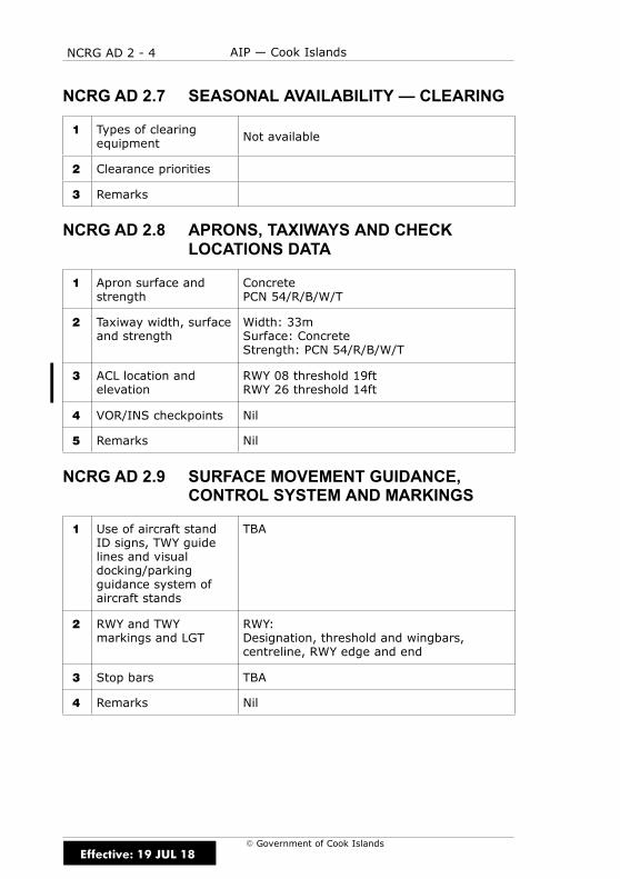
NCRG AD 2 - 4 AIP — Cook Islands
E Government of Cook Islands
NCRG AD 2.7 SEASONAL AVAILABILITY — CLEARING
1 Types of clearingequipment Not available
2 Clearance priorities
3 Remarks
NCRG AD 2.8 APRONS, TAXIWAYS AND CHECKLOCATIONS DATA
1 Apron surface andstrength
ConcretePCN 54/R/B/W/T
2 Taxiway width, surfaceand strength
Width: 33mSurface: ConcreteStrength: PCN 54/R/B/W/T
3 ACL location andelevation
RWY 08 threshold 19ftRWY 26 threshold 14ft
4 VOR/INS checkpoints Nil
5 Remarks Nil
NCRG AD 2.9 SURFACE MOVEMENT GUIDANCE,CONTROL SYSTEM AND MARKINGS
1 Use of aircraft standID signs, TWY guidelines and visualdocking/parkingguidance system ofaircraft stands
TBA
2 RWY and TWYmarkings and LGT
RWY:Designation, threshold and wingbars,centreline, RWY edge and end
3 Stop bars TBA
4 Remarks Nil
Effective: 19 JUL 18

NCRG AD 2 - 5AIP — Cook Islands
E Government of Cook Islands
NCRG AD 2.10 AERODROME OBSTACLES
In approach/TKOF areasIn circling areaand at AD Remarks
1 2 3
RWY/Areaaffected
Obstacletype
ElevationMarkings/LGT
Coordinates Obstacletype
ElevationMarkings/LGT
Coordinates
a b c a b
08/26 TBA (1,b) TBA (1,c) TBA TBA (2,b)TBA
APRON TBA (1,b) TBA (1,c) TBA TBA (2,b)TBA
Effective: 15 DEC 11
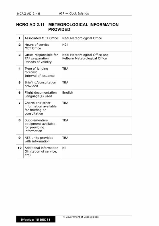
NCRG AD 2 - 6 AIP — Cook Islands
E Government of Cook Islands
NCRG AD 2.11 METEOROLOGICAL INFORMATIONPROVIDED
1 Associated MET Office Nadi Meteorological Office
2 Hours of serviceMET Office
H24
3 Office responsibile forTAF preparationPeriods of validity
Nadi Meteorological Office andKelburn Meteorological Office
4 Type of landingforecastInterval of issuance
TBA
5 Briefing/consultationprovided
TBA
6 Flight documentationLanguage(s) used
English
7 Charts and otherinformation availablefor briefing orconsultation
TBA
8 Supplementaryequipment availablefor providinginformation
TBA
9 ATS units providedwith information
TBA
10 Additional information(limitation of service,etc)
Nil
Effective: 15 DEC 11

NCRG AD 2 - 7AIP — Cook Islands
E Government of Cook Islands
NCRG AD 2.12 RWY PHYSICAL CHARACTERISTICS
RWY TRUEBRG
Dimensionsof RWY(m)
Strength(PCN) andsurface ofRWY andSWY
THR coordinates
THRelevationand
highestelevationof TDZ ofprecisionAPP RWY
1 2 3 4 5 6
08 090° 2329 x 45PCN
54/R/B/W/TConcrete
S 21 12 09.30W 159 48 56.55
19ft
26 270° 2329 x 45PCN
54/R/B/W/TConcrete
S 21 12 09.31W 159 47 43.61
14ft
Slope ofRWY–SWY
SWYdimensions
(m)
CWYDimensions
(m)
Stripdimensions
(m)OFZ Remarks
7 8 9 10 11 12
0.07D 2368 x 213
0.07U 2368 x 213
NCRG AD 2.13 DECLARED DISTANCES
RWY TORA(m)
TODA(m)
ASDA(m)
LDA(m)
Remarks
1 2 3 4 5 6
08 2329 2348 2329 2207
26 2329 2348 2329 2225
Effective: 19 JUL 18

NCRG AD 2 - 8 AIP — Cook Islands
E Government of Cook Islands
NCRG AD 2.14 APPROACH AND RWY LIGHTINGRemarks
Nil
Nil
SWY
LGT
LEN
(m)
Colour
Nil Nil
RWYEnd
LGT
Colour
WBAR
LIH
uni-
directional
red
LIH
uni-
directional
red
RWY
Edge
LGT
LEN
Spacing
Colour,
INTST
Omni-
directional
LIH
white
Omni-
directional
LIH
white
RWY
Centre
LineLGT
LEN
Spacing
Colour,
INTST
LIH
coded
white/red
LIH
coded
white/red
TDZ
LGT
LEN
Nil
Nil
VASIS
(MEH)
PAPI
PAPI*
3°
TCH69ft
PAPI*
3°
TCH68.7ft
THR
LGT
Colour
WBAR
LIH
uni-
directional
green
LIH
uni-
directional
green
APCH
LGT
Type
LEN
INTST
Nil
Nil
RWY
08
26
*Note:BothPAPIsaredouble-sided
Effective: 13 SEP 18

NCRG AD 2 - 9AIP — Cook Islands
E Government of Cook Islands
NCRG AD 2.15 OTHER LIGHTING, SECONDARY POWERSUPPLY
1 ABN/IBN location,characteristics andhours of operation
ABN FLG W 3.75sec
2 LDI location and LGT,Anemometer locationand LGT
TBA
3 TWY edge andcentreline lighting
TBA
4 Secondary powersupply/switch-overtime
Available/15 seconds
5 Remarks TBA
NCRG AD 2.16 HELICOPTER LANDING AREA
1 Co-ordinates of TLOFor THR of FATO
TBA
2 TLOF and/or FATOelevation (ft)
TBA
3 TLOF and FATO areadimensions, surface,strength and markings
TBA
4 True and MAG BRG ofFATO
TBA
5 Declared distanceavailable
TBA
6 APP and FATO lighting TBA
7 Remarks TBA
Effective: 2 APR 15
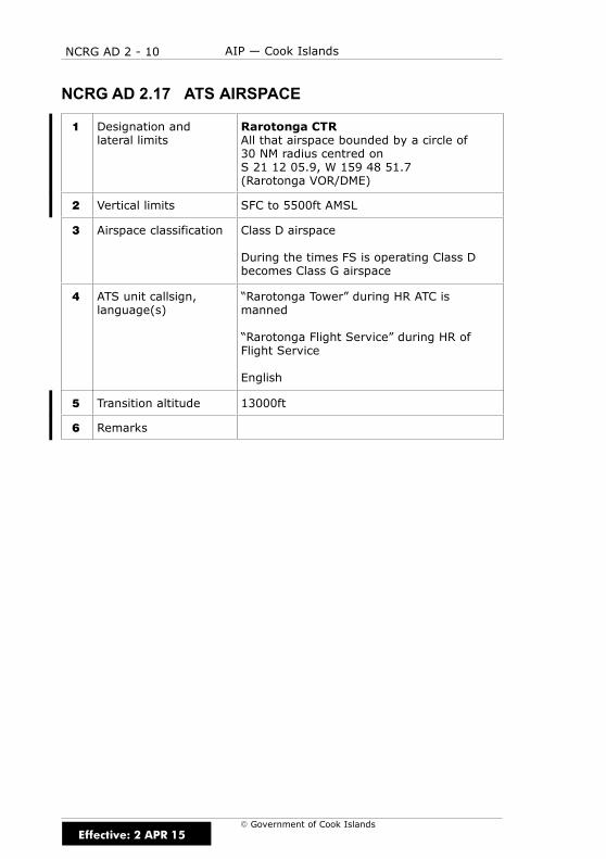
NCRG AD 2 - 10 AIP — Cook Islands
E Government of Cook Islands
NCRG AD 2.17 ATS AIRSPACE
1 Designation andlateral limits
Rarotonga CTRAll that airspace bounded by a circle of30 NM radius centred onS 21 12 05.9, W 159 48 51.7(Rarotonga VOR/DME)
2 Vertical limits SFC to 5500ft AMSL
3 Airspace classification Class D airspace
During the times FS is operating Class Dbecomes Class G airspace
4 ATS unit callsign,language(s)
“Rarotonga Tower” during HR ATC ismanned
“Rarotonga Flight Service” during HR ofFlight Service
English
5 Transition altitude 13000ft
6 Remarks
Effective: 2 APR 15
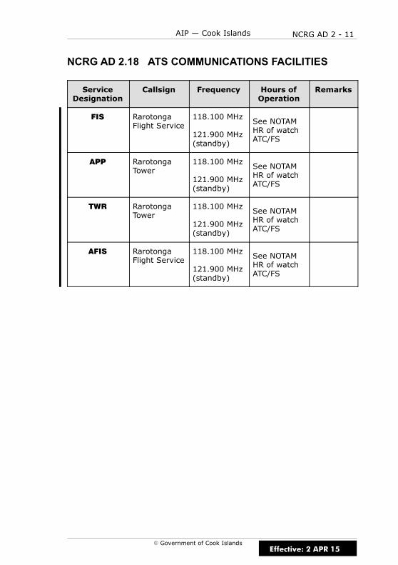
NCRG AD 2 - 11AIP — Cook Islands
E Government of Cook Islands
NCRG AD 2.18 ATS COMMUNICATIONS FACILITIES
ServiceDesignation
Callsign Frequency Hours ofOperation
Remarks
FIS RarotongaFlight Service
118.100 MHz
121.900 MHz(standby)
See NOTAMHR of watchATC/FS
APP RarotongaTower
118.100 MHz
121.900 MHz(standby)
See NOTAMHR of watchATC/FS
TWR RarotongaTower
118.100 MHz
121.900 MHz(standby)
See NOTAMHR of watchATC/FS
AFIS RarotongaFlight Service
118.100 MHz
121.900 MHz(standby)
See NOTAMHR of watchATC/FS
Effective: 2 APR 15

NCRG AD 2 - 12 AIP — Cook Islands
E Government of Cook Islands
NCRG AD 2.19 RADIO NAVIGATION AND LANDING AIDSRem
arks
RWY26
Unusable
beyond10°L
and15°Rof
EXTDCL
RWY08
Unusable
beyond30°R
ofEXTDCL
Rated
coverage
250NM
Unusable
R105toR160
RWY08
Unusable
beyond30°R
ofEXTDCL
RWY26
Unusable
beyond10°L
and15°Rof
EXTDCL
Elevation
ofDME
antenna
TBA
Co-ordinates
S211212.42
W1594753.54
S211212.40
W1594845.50
S211205.55
W1594851.79
S211227.10
W1594917.65
S211205.55
W1594851.79
S211209.44
W1594739.35
S211209.44
W1594901.93
Hours
of
Operation
HO
HO
H24
H24
H24
HO
HO
Freq
uen
cy
335.0
333.8
CH82X
113.5
352kHz
113.5
109.9
110.3
ID
RG
RG
RG
INO
IAV
TypeofAid,
CAT(forILS),
Variation
ILS/GP
ILS/GP
DME
NDB
VOR
ILS/LOC
ILS/LOC
Effective: 19 JUL 18

NCRG AD 2 - 13AIP — Cook Islands
E Government of Cook Islands
NCRG AD 2.19 RADIO NAVIGATION AND LANDING AIDS(CONT)
Rem
arks
RWY08
Unusable
beyond30°R
ofEXTDCL
RWY26
Unusable
beyond10°L
and15°Rof
EXTDCL
Elevation
ofDME
antenna
TBA
TBA
Co-ordinates
S211212.40
W1594845.50
S211212.42
W1594753.54
Hours
of
Operation
HO
HO
Freq
uen
cy
36X
40X
ID
INO
IAV
TypeofAid,
CAT(forILS),
Variation
ILS/DME
ILS/DME
Effective: 2 APR 15

NCRG AD 2 - 14 AIP — Cook Islands
E Government of Cook Islands
NCRG AD 2.20 LOCAL TRAFFIC REGULATIONS
1 AERODROME REGULATIONS
1.1 TBA.
2 TAXIING TO AND FROM STANDS
2.1 Scheduled arriving internationals will be allocated to their stands orparking position by the marshallers. Private internationals will also beallocated to their stands either by marshallers through a local handlingagent or by the TWR.
2.2 Due to apron congestion and in the event of an unscheduleddiversion, aircraft of medium category and higher intending to remain atthe airport for more than a day are requested to carry a towbar to assistpositioning on the apron unless crew are available to relocate aircraft atshort notice.
3 PARKING AREA FOR GENERAL AVIATION
3.1 There are two stands able to accommodate up to wide-bodied B747and smaller aircraft under their own power provided they do not overrunthe stop blocks. There are an additional two new parking pads available toaccommodate domestic aircraft only.
4 PARKING AREA FOR HELICOPTERS
4.1 No specific area is available. Arriving aircraft will be allocated aparking position by the TWR.
5 APRON — TAXIING
5.1 Taxi instruction will be given by ATC or for non-scheduled flightswithout marshalling personnel will be directed to their parking position.
6 TAXIING — LIMITATIONS
6.1 Nil.
7 REMOVAL OF DISABLED AIRCRAFT FROM RUNWAYS
7.1 For aircraft up to 21000kg — improvised equipment available locally.
7.2 For aircraft 21000–150,000kg — salvage kit ex Auckland.
7.3 For aircraft above 150,000kg — IATA kit ex Sydney, Honolulu or LosAngeles.
Effective: 15 DEC 11

NCRG AD 2 - 15AIP — Cook Islands
E Government of Cook Islands
NCRG AD 2.21 NOISE ABATEMENT PROCEDURES
There are no noise abatement procedures for Rarotonga.
NCRG AD 2.22 FLIGHT PROCEDURES
1 POSITION AND ALTITUDE REPORTING — LOCAL VFR FLIGHTS
1.1 Local VFR scenic flights are to follow the normal traffic circuit patternand advise TWR/FS of any manoeuvres/intentions outside of the norm.
2 POSITION REPORTING ON DEPARTURE
2.1 Pilots are required to make a departure report as soon as practicableafter take-off. Departure reports must contain the following info in theorder listed:
(a) Identification; radio callsign
(b) The estimated set heading time in minutes past the hour
(c) The altitude to the nearest 100ft, followed by the phrase “CLIMBINGTO” followed by the cleared altitude or flight level of the initialportion of the flight
(d) Next position and time over in minutes past the hour
3 AERODROME TRAFFIC CIRCUIT RULES
3.1 Unless otherwise authorised by ATC, the circuit direction for:
(a) RWY 08 is left-hand; and
(b) RWY 26 is right-hand
NCRG AD 2.23 ADDITIONAL INFORMATION
TBA
Effective: 15 DEC 11
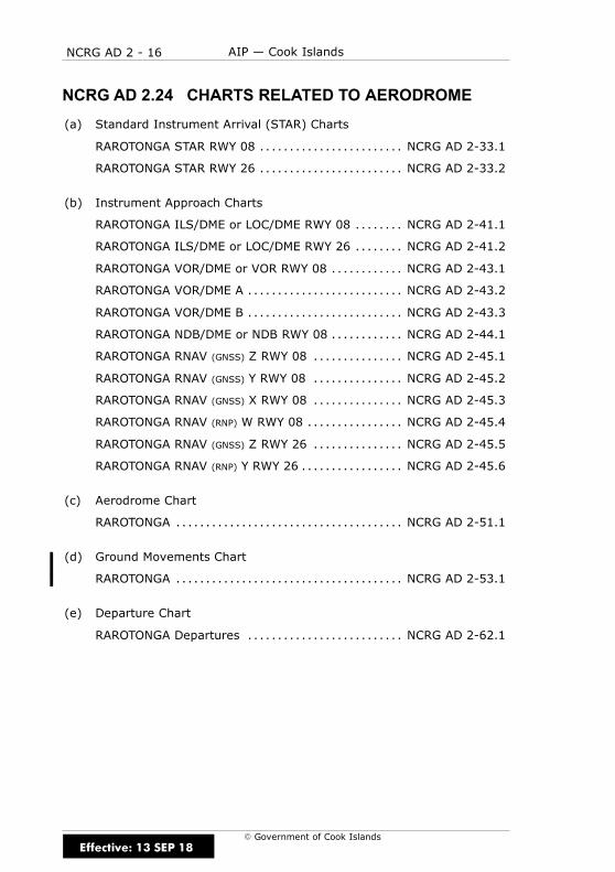
NCRG AD 2 - 16 AIP — Cook Islands
E Government of Cook Islands
NCRG AD 2.24 CHARTS RELATED TO AERODROME
(a) Standard Instrument Arrival (STAR) Charts
RAROTONGA STAR RWY 08 NCRG AD 2-33.1. . . . . . . . . . . . . . . . . . . . . . . .
RAROTONGA STAR RWY 26 NCRG AD 2-33.2. . . . . . . . . . . . . . . . . . . . . . . .
(b) Instrument Approach Charts
RAROTONGA ILS/DME or LOC/DME RWY 08 NCRG AD 2-41.1. . . . . . . .
RAROTONGA ILS/DME or LOC/DME RWY 26 NCRG AD 2-41.2. . . . . . . .
RAROTONGA VOR/DME or VOR RWY 08 NCRG AD 2-43.1. . . . . . . . . . . .
RAROTONGA VOR/DME A NCRG AD 2-43.2. . . . . . . . . . . . . . . . . . . . . . . . . .
RAROTONGA VOR/DME B NCRG AD 2-43.3. . . . . . . . . . . . . . . . . . . . . . . . . .
RAROTONGA NDB/DME or NDB RWY 08 NCRG AD 2-44.1. . . . . . . . . . . .
RAROTONGA RNAV (GNSS) Z RWY 08 NCRG AD 2-45.1. . . . . . . . . . . . . . .
RAROTONGA RNAV (GNSS) Y RWY 08 NCRG AD 2-45.2. . . . . . . . . . . . . . .
RAROTONGA RNAV (GNSS) X RWY 08 NCRG AD 2-45.3. . . . . . . . . . . . . . .
RAROTONGA RNAV (RNP) W RWY 08 NCRG AD 2-45.4. . . . . . . . . . . . . . . .
RAROTONGA RNAV (GNSS) Z RWY 26 NCRG AD 2-45.5. . . . . . . . . . . . . . .
RAROTONGA RNAV (RNP) Y RWY 26 NCRG AD 2-45.6. . . . . . . . . . . . . . . . .
(c) Aerodrome Chart
RAROTONGA NCRG AD 2-51.1. . . . . . . . . . . . . . . . . . . . . . . . . . . . . . . . . . . . . .
(d) Ground Movements Chart
RAROTONGA NCRG AD 2-53.1. . . . . . . . . . . . . . . . . . . . . . . . . . . . . . . . . . . . . .
(e) Departure Chart
RAROTONGA Departures NCRG AD 2-62.1. . . . . . . . . . . . . . . . . . . . . . . . . .
Effective: 13 SEP 18

B596
RAROTONGA
VOR/DME 113.5RG
R346
1700
10
RD
ME
R346
R166
1
0
0
0
0
1
1
R287
R266
R252
R234
R214
R256/0
ALT
ERN
ATIV
E JET R
OUTIN
G
G594
R582
B598
G593
B454
1
EMD GR 03
G
RAROTONGA CTR SFC - 5500
NC
RG
STA
R08-C
c STAR RWY 08c
RAROTONGA
NOLU
W159 49 06
S20 42 00
PAIA
W160 16 30
S20 56 42
LIKU
W160 20 30
S21 07 00
MATA
W160 20 54
S21 14 24
FOLK
W160 18 36
S21 23 30
KIWI
W160 12 36
S21 32 24
TAKI
W160 09 21
S21 35 18
0
R206
L508
1700
33
33
W 160î W 160î
W 159î
S 21î
S 21î
NCRG AD 2 - 33.1
ELEV 19
NCRG
Cook Islands-AIP
RAROTONGA
STAR RWY 08
: 118.1 121.9APPROACH AND AERODROME CONTROL RAROTONGA TOWER
Effective: 13 SEP 18Government of Cook Islands
W159 48 52
S21 12 06
W159 59 36
S21 12 12
Changes fro
m 2 A
PR 1
5:
AD E
LE
V.
Clearance for a STAR does not constitute clearance for instrument approach.
at not less than 10 NM DME.
Descend to MNM 1700 ft to join final approach ILS, LOC/DME, or VOR/DME RWY 08
ALL ARRIVALS
030 N
M5
510
20
25 NM RGMinimum Sector Altitude
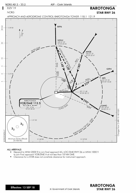
NOLU
ANGE
HITI
GANG
2
2
1
1
1
B596
RAROTONGA
VOR/DME 113.5RG
R075/2
ALT
ERN
ATIV
E JE
T R
OU
TIN
G
R056
R021
R346
R099
1500
1000
RARO
TONG
ACTR
SF
C-5500
10RGD
ME
R350
R040
1
EMD GR 03
NCRG AD 2 - 33.2
ELEV 19 RAROTONGA
STAR RWY 26
: 118.1 121.9APPROACH AND AERODROME CONTROL RAROTONGA TOWER
NCRG
cc
RAROTONGASTAR RWY 26
NC
RG
STA
R26-C
W 159îW 160î
S 20î
S 21î
S 21î
Cook Islands-AIP
G594
Effective: 13 SEP 18Government of Cook Islands
W159 48 52
S21 12 06
Changes fro
m 2 A
PR 1
5:
AD E
LE
V.
W159 38 12
S21 11 48
W159 49 05
S20 41 59
W159 30 41
S20 47 18
W159 18 48
S21 01 33
W159 19 11
S21 23 37
Clearance for a STAR does not constitute clearance for instrument approach.
to join final approach VOR/DME A at not less than 10 NM DME.
Descend to MNM 2000 ft to join final approach ILS, LOC/DME RWY 26 or MNM 1000 ft
ALL ARRIVALS
030 N
M5
510
20
33
33
25 NM RGMinimum Sector Altitude
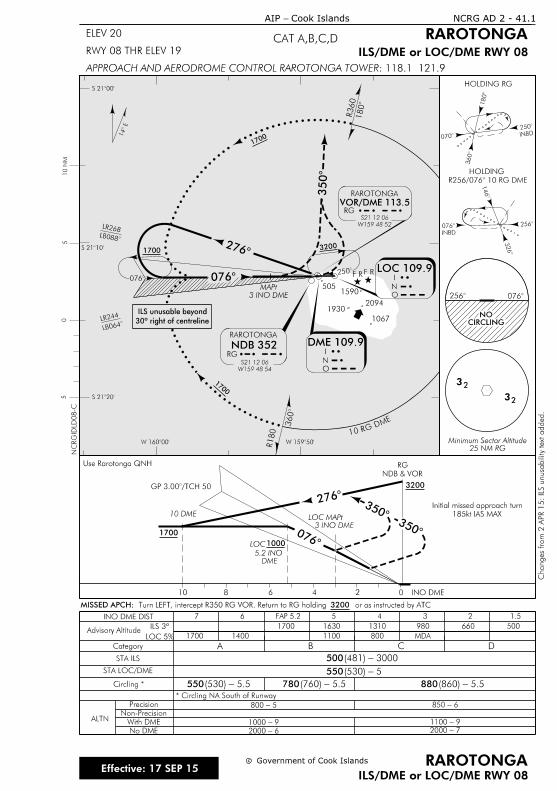
Category A B C D
Circling *
5
246810
Use Rarotonga QNH
0
HOLDING RG
INBD2
3
0
1
32
10 DME
2
INBD
0
3
2
1
INO DME
0
GP 3.00/T
3 INO DME
MAPt
DME
5.2 INO
32
185kt IAS MAX
Initial missed approach turn33
INO DME DIST 7 6 4 3 2 1.5
Advisory AltitudeILS 3º
LOC 5%
1700 1630 1310 980 660 500
1700 1400 1100 800 MDA
STA ILS
STA LOC/DME
* Circling NA South of Runway
Precision
Non-Precision
With DME
No DME
ALTN
500
550
550 780 880
50
W 159î
S 21î
S 21î
5
10RG DME
R360
2
RAROTONGA
VOR/DME 113.5
W159 48 52
S21 12 06
RG
S 21î
10 N
M
R180
LR268
2
0
3
W 160î
0
RAROTONGA
RG
NDB 352
S21 12 06
W159 48 54
I
N
O
DME 109.9I
N
O
1
LB0
3
14
FAP 5.2
NC
RGID
LD08-C
 R256/076 10 R
HOLDING
5-800
9-1000
6-2000
6-850
9-1100
7-2000
1700
1700
1700 3200
1700
1000
3200
c
ILS/DME or LOC/DME RWY 08
c RAROTONGA
RAROTONGA
ILS/DME or LOC/DME RWY 08
CAT A,B,C,D
Cook Islands- AIP
ELEV 20
RWY 08 THR ELEV 19
NCRG AD 2 - 41.1
: 118.1 121.9APPROACH AND AERODROME CONTROL RAROTONGA TOWER
25 NM RGMinimum Sector Altitude
2 0
CIRCLINGNO
Government of Cook Islands
LOC 109.9
LOC
LOC
5.5-(530)
3000-(481)
5-(530)
5.5-(860)
20941930
1067
3 INO DME
MAPt
F RF R
5.5-(760)
NDB & VOR
RG
or as instructed by ATC 3200 Turn LEFT, intercept R350 RG VOR. Return to RG holding MISSED APCH:
5051590
Changes fro
m 2 A
PR 1
5: IL
S u
nusa
bility te
xt a
dded.
30º right of centreline
ILS unusable beyond
LB0
LR244
Effective: 17 SEP 15
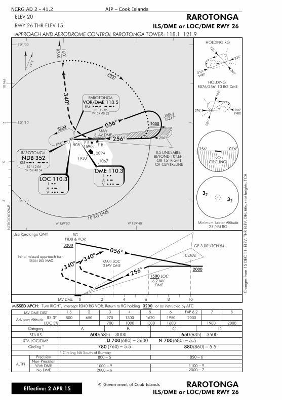
2 4 6 8 10
CIRCLING
NO
0
HOLDING RG
INBD
2
0
0
1
32
INBDï»
¿0
3
2
1
IAV DME
10 DME
0
DME
6.2 IAV
Use Rarotonga QNH
2
185kt IAS MAX
Initial missed approach turn
32
3
3
Category A B C D
Circling *
Advisory AltitudeILS 3º
STA ILS
* Circling NA South of Runway
Precision
Non-Precision
With DME
No DME
ALTN
880
IAV DME DIST 1.5 2 876543
970500 650 1300 1620 1950 2000
700 1000 1300 1600 1900 2000
600 650
50
510 N
M
W 159î
S 21î
10RG DME
R340
0
RAROTONGA
VOR/DME 113.5
W159 48 52
S21 12 06
RG
LR064
0
2 2
RAROTONGA
RG
NDB 352
S21 12 06
W159 48 54
I
A
V
DME 110.3I
A
V
LB2
3
S 21î
S 21î
W 159î
1
OF CENTRELINE
 OR 15
 BEYOND 10î€
ILS UNUSABLE
FAP 6.2
25 NM RGMinimum Sector Altitude
 R076/256 10 R
HOLDING
c
NCRG AD 2 - 41.2
ILS/DME or LOC/DME RWY 26
c RAROTONGA
ELEV 20
RWY 26 THR ELEV 15
RAROTONGA
ILS/DME or LOC/DME RWY 26
: 118.1 121.9APPROACH AND AERODROME CONTROL RAROTONGA TOWER
NC
RGID
LD26-B
14
780
5-800
9-1000
6-2000 7-2000
9-1100
6-850
D 700 N 700
2000
2000
2000
3200
1500
3200
Cook Islands- AIP
3 IAV DME
MAPt
Government of Cook Islands
LOC 110.3
LOC
GP 3.00/TChanges fro
m 1
5 D
EC 1
1:
ELE
V, TH
R E
LE
V,
DH, title, sp
ot heig
hts, TC
H.
LOC 5%
STA LOC/DME
3000-(585) 3500-(635)
3600-(680) 5.5-(680)
5.5-(760) 5.5-(860)
2094
19301067
F RF R
3 IAV DME
MAPt LOC
NDB & VOR
RG
02
or as instructed by ATC 3200 Turn RIGHT, intercept R340 RG VOR. Return to RG holdingMISSED APCH:
5051590
Effective: 2 APR 15
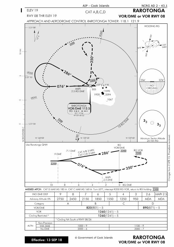
246810
Use Rarotonga QNH
CIRCLING
NO
0
HOLDING RG
INBD2
3
0
1
RG DME
9 DME
0
INO DME DIST
Non-Precision
With DME
No DME
ALTN
CAT A/B 3 MIN
CAT C/D 2 M
IN
50
510 N
M
W 159îW 159î
S 21î
S 21î
10RG
D
ME
R360
2
RAROTONGA
VOR/DME 113.5
W159 48 52
S21 12 06
RG
S 21î
R180
LR244
LR268
0
3
W 160î
14
NC
RG
VD
V08-C
9-1100
7-2000
9-1000
6-2000
2200
2200
2200
3300
c
VOR/DME or VOR RWY 08
c RAROTONGA
RAROTONGA
VOR/DME or VOR RWY 08
CAT A,B,C,DELEV 19
Cook Islands- AIP NCRG AD 2 - 43.1
RWY 08 THR ELEV 19
: 118.1 121.9APPROACH AND AERODROME CONTROL RAROTONGA TOWER
33
33
Government of Cook Islands
Effective: 13 SEP 18
F RF R
1930 2094
1067
2 0
1590505
Changes fro
m 2 A
PR 1
5: Pro
cedure revie
wed.
VOR/DME
RG
3300 CAT D MAX IAS 185 kt. CAT C MAX IAS 160 kt. Turn LEFT, intercept R350 RG VOR, return to RG holding MISSED APCH:
3300
2.5 RG DME
MAPt
2
25 NM RGMinimum Sector Altitude
2.5 DME
MAPt
2
Advisory Altitude 5%
9
2750
8 7 6 5 4 3 2.6 MAPt 2.5
2450 2150 1850 1550 1250 950 MDA MDA
Category BA
VOR/DME
DC
820 5 - (801) 890 5 - (871)
VOR 1260 5 - (1241)
Circling Restricted * 1260 5 - (1241)
* Circling NA South of RWY 08/26
7.1 DME
3
3300
RG VOR
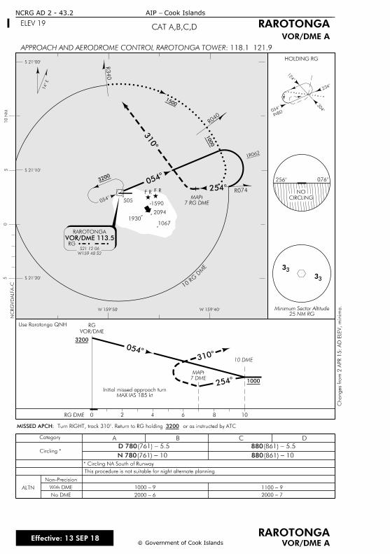
2 4 6 8 10
Use Rarotonga QNH
CIRCLING
NO
0
HOLDING RG
INBD0
3
2
1
3
RG DME
VOR/DME
RG
10 DME
7 DME
MAPt
0
2
3
Category A B C D
Circling *
* Circling NA South of Runway
Non-Precision
With DME
No DME
ALTN
This procedure is not suitable for night alternate planning
880
880
50
W 159îW 159î
S 21î
S 21î5
10RG
D
ME
R340
0
R040
RAROTONGA
VOR/DME 113.5
W159 48 52
S21 12 06
RG
S 21î
7 RG DME
MAPt
10 N
M
0
2
3
R074
LR062
14
c
NCRG AD 2 - 43.2
VOR/DME Ac
RAROTONGA
CAT A,B,C,DELEV 19 RAROTONGA
VOR/DME A
: 118.1 121.9APPROACH AND AERODROME CONTROL RAROTONGA TOWER
NC
RG
VD
ALF
A-C
D 780
N 780
6-2000 7-2000
9-1100 9-1000
3
1500
1000
3200
1000
3200
Cook Islands- AIP
Effective: 13 SEP 18Government of Cook Islands
5.5-(761) 5.5-(861)
10-(761) 10-(861)
F RF R
2094
10671930
2 0
or as instructed by ATC 3200 Turn RIGHT, track 310. Return to RG holMISSED APCH:
5051590
Changes fro
m 2 A
PR 1
5:
AD E
LE
V,
minim
a.
MAX IAS 185 ktInitial missed approach turn
25 NM RGMinimum Sector Altitude
3
3
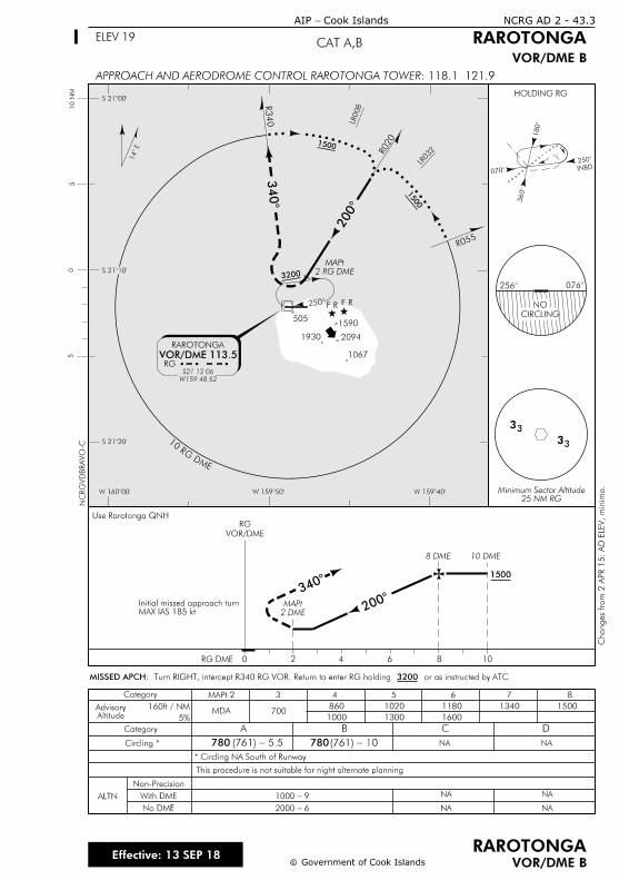
2 4 6 8 10
Use Rarotonga QNH
CIRCLING
NO
0
HOLDING RG
50
W 159îW 159îW 160î
S 21î
S 21î
5
INBD2
3
0
1
3
RG DME
VOR/DME
RG
S 21î
10 DME8 DME
10 N
M
2 DME
MAPt 2
3
3
Category A B C D
Circling *
* Circling NA South of Runway
Non-Precision
With DME
No DME
ALTN
This procedure is not suitable for night alternate planning
780 780
NA
NA
NA NA
NA
NA
R055
10
RGDME
R340
2
LR032
LR008
R020
2
3
RAROTONGA
VOR/DME 113.5
W159 48 52
S21 12 06
RG
2 RG DME
MAPt
Category 3 4 5 6 7 8MAPt 2
MDA 700860 1020 1180 1340 1500
160013001000
160ft / NM
5%AltitudeAdvisory
14
1500
1500
3200
1500
6-2000
9-1000
c
NCRG AD 2 - 43.3
VOR/DME Bc
RAROTONGA
CAT A,BELEV 19
Cook Islands- AIP
RAROTONGA
VOR/DME B
: 118.1 121.9APPROACH AND AERODROME CONTROL RAROTONGA TOWERN
CR
GV
DB
RA
VO-C
Government of Cook IslandsEffective: 13 SEP 18
5.5-(761) 10-(761)
2094
1067
1930
F RF R
2 0
or as instructed by ATC 3200 Turn RIGHT, intercept R340 RG VOR. Return to enter RG holdingMISSED APCH:
1590505
MAX IAS 185 ktInitial missed approach turn
Changes fro
m 2 A
PR 1
5:
AD E
LE
V,
minim
a.
25 NM RGMinimum Sector Altitude
3
3

IntentionallyBlank
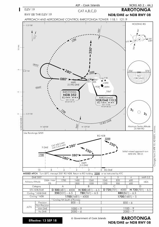
246810
Use Rarotonga QNH
CIRCLING
NO
0
Category A B C D
HOLDING RG
50
5
INBD2
3
0
1
3
5
10 N
M
9 DME 2
0
RG NDB
RG DME
3
3
CAT A/B 3 MIN
CAT C/D 2 MIN
0
3.5 DME
MAPt
3
STA NDB/DME
Circling * NDB/DME
Circling * NDB
* Circling NA South of Runway
ALTN
Precision
Non-Precision
With DME
No DME
880
1700
550 780
1700
W 159î
S 21î
S 21î
10RG DME
1
2
RAROTONGA
VOR/DME 113.5
W159 48 52
S21 12 06
RG
S 21î
3
LB0
LB0
2
0
W 160î
RAROTONGA
RG
NDB 352
S21 12 28
W159 49 17
3.5 RG DME
MAPt
3
DME DIST 9 8 7 6 4 MAPt 3.5
Advisory Altitude220ft / NM
5%MDA
600
600
820
900
1040
1200
1260
1500
1480
1800
1700
NC
RG
ND
N08-C
14
1700
3200
1700
3200
1700
6-2000
9-1000
7-2000
9-1100
6-850 5-800
N 500D 500 D 720 N 720
c
NDB/DME or NDB RWY 08
c RAROTONGA
RAROTONGA
NDB/DME or NDB RWY 08
CAT A,B,C,DELEV 19
RWY 08 THR ELEV 19
NCRG AD 2 - 44.1
: 118.1 121.9APPROACH AND AERODROME CONTROL RAROTONGA TOWER
Cook Islands- AIP
Effective: 13 SEP 18Government of Cook Islands
4000-(481) 6.5-(481) 4000-(701) 6.5-(701)
6.5-(531) 6.5-(761) 6.5-(861)
4000-(1681) 5-(1681)
F RF R
20941930
1067
2 0
or as instructed by ATC 3200  Turn LEFT, intercept 350 RG NDB. Return to RG hoMISSED APCH:
5051590
Changes fro
m 2 A
PR 1
5:
AD E
LE
V,
minim
a.
MAX IAS 185 kt
Initial missed approach turn
25 NM RGMinimum Sector Altitude
3
3

IntentionallyBlank
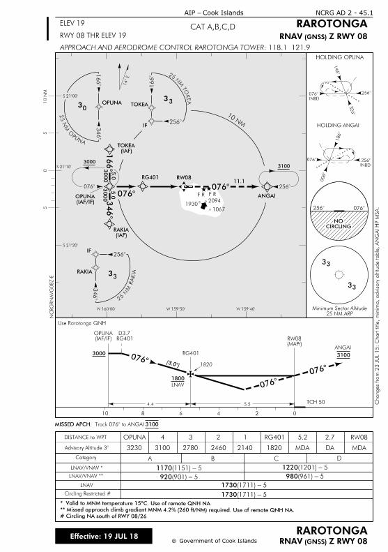
3
0
1
3000
0
RAKIA
2
3
33
IF
OPUNA
3
30
1
TOKEA
2
1
33
IF
33
33
2
INBD
3
1
0
2 0
CIRCLINGNO
AIK
AR
MN
52
AE
KO
T M
N 52
Use Rarotonga QNH
HOLDING OPUNA
2
(IAF)TOKEA
(IAF/IF)OPUNA
(IAF)RAKIA
RW08
0ANGAI
0
INBD
0
1
2
HOLDING ANGAI
11.1
20941930
1067
10 NM
W 160î W 159î W 159î
S 21î
S 21î
S 21î
10 N
M5
05
14
c
NCRG AD 2 - 45.1
c
CAT A,B,C,DELEV 19
RWY 08 THR ELEV 19
Cook Islands- AIP
RAROTONGA
NC
RG
RN
AV
G08Z-E
RAROTONGA
: 118.1 121.9APPROACH AND AERODROME CONTROL RAROTONGA TOWER
ANUP
O M
N 5
2
Effective: 19 JUL 18Government of Cook Islands
F RF R
Z RWY 08 (GNSS) RNAV
Z RWY 08 (GNSS) RNAV
31003000
5.0
3000
5.0
RG401
25 NM ARPMinimum Sector Altitude
3100: Track 076 to AMISSED APCH
0
5.54.4
02468
3000
(IAF/IF)OPUNA
(3. 1820
RG401D3.7
ANGAI
10
TCH 50
LNAV
1800
0
0
3100RG401
(MAPt)RW08
Category A B C D
Advisory Altitude
DISTANCE to WPT
Circling Restricted #
LNAV
LNAV/VNAV *
LNAV/VNAV **
1730 5- (1711)
1730 5- (1711)
# Circling NA south of RWY 08/26
** Missed approach climb gradient MNM 4.2% (260 ft/NM) required. Use of remote QNH NA.
* Valid to MNM temperature 15ºC. Use of remote QNH NA
OPUNA
3230
4 3 2 1 RG401 5.2 2.7 RW08
3100 2780 2460 2140 1820 MDA DA MDA
1170 5- (1151) 1220 5- (1201)
920 5- (901) 980 5- (961)
Changes fro
m 2
3 J
UL 1
5:
Chart title,
minim
a, advisory altitude table,
AN
GAI
HP M
SA.
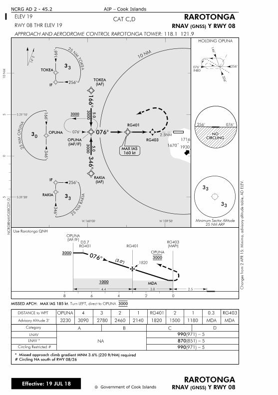
3
0
(IAF)
TOKEA
1
(IAF)
RAKIA
(IAF/IF)
OPUNA
3000
0
RAKIA
2
3
33
IF
OPUNA
3
30
1
TOKEA
2
1
33
IF
33
33
2
INBD
3
1
0
2 0
CIRCLINGNO
AIK
AR
MN
52
AN
UP
O M
N 5
2
AE
KO
T M
N 52
0
3.04.4
02468
2.5NM
3000
(IAF/IF)OPUNA
(MAPt)RG403
2.5
OPUNA
3000
Use Rarotonga QNH
1000 MDA
Category A B C D
NA
1820214024602780
4
3230
3 2 1
MDAAdvisory Altitude
2 1
LNAV
DISTANCE to WPT
(3. 1820
RG401D3.7
OPUNA RG401 RG403
LNAV *
Circling Restricted #
S 21î
S 21î
W 160î W 159î
10 N
M5
05
14
HOLDING OPUNA
1670
1716
1930
10 N
M
MDA
0.3
cc
RAROTONGA Y RWY 08(GNSS)RNAV
RAROTONGA
Y RWY 08(GNSS)RNAV
CAT C,D
NCRG AD 2 - 45.2
ELEV 19
RWY 08 THR ELEV 19
: 118.1 121.9APPROACH AND AERODROME CONTROL RAROTONGA TOWER
Cook Islands- AIP N
CR
GR
NA
VG
08
CD
Y-D
Effective: 19 JUL 18Government of Cook Islands
990 5- (971)
870 5 - (851)
990 5 - (971)
Changes fro
m 2 A
PR 1
5:
Minim
a, advisory altitude table,
AD E
LE
V.
3000
5.0
RG401
RG403
25 NM ARPMinimum Sector Altitude
RG401
3000Turn LEFT, direct to OPUNA MAX IAS 185 kt. : MISSED APCH
11803090 1500
# Circling NA south of RWY 08/26
* Missed approach climb gradient MNM 3.6% (220 ft/NM) required
160 kt
MAX IAS
3000
5.0
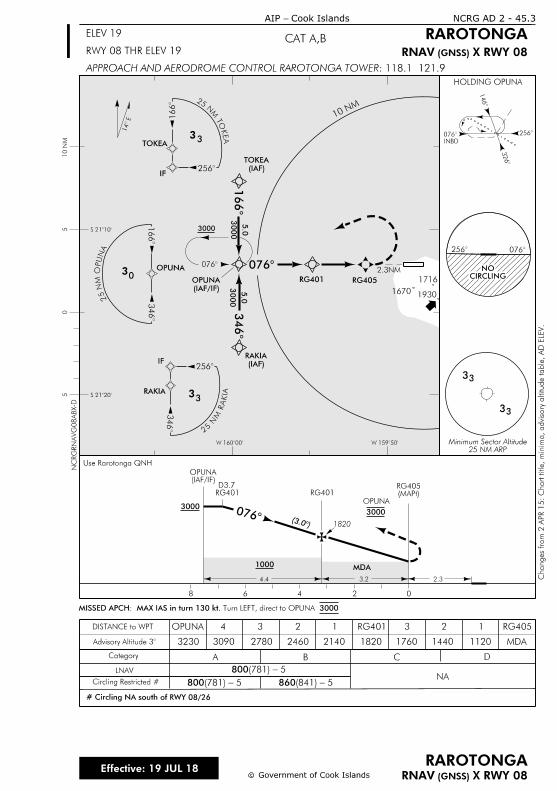
3
0
(IAF)
TOKEA
1
(IAF)
RAKIA
(IAF/IF)
OPUNA
3000
0
RAKIA
2
3
33
IF
OPUNA
3
30
1
TOKEA
21
33
IF
33
33
2
INBD
3
1
0
2 0
CIRCLINGNO
AIK
AR
MN
52
AN
UP
O M
N 5
2
AE
KO
T M
N 52
0
3.24.4
02468
2.3NM
3000
(IAF/IF)OPUNA
(MAPt)RG405
2.3
OPUNA
3000
Use Rarotonga QNH
1000 MDA
Category A B C D
NA
1820214024602780
4
3230
3 2 1
MDAAdvisory Altitude
2
1440 1120
1
LNAV
DISTANCE to WPT
(3. 1820
RG401D3.7
OPUNA RG401 RG405
Circling Restricted #
S 21î
S 21î
W 160î W 159î
10 N
M5
05
14
HOLDING OPUNA
3
1716
1930
10 N
M
NC
RG
RN
AV
G08
AB
X-D
c
NCRG AD 2 - 45.3
c
CAT A,BELEV 19
RWY 08 THR ELEV 19
Cook Islands- AIP
RAROTONGA
RAROTONGA
: 118.1 121.9APPROACH AND AERODROME CONTROL RAROTONGA TOWER
Government of Cook IslandsEffective: 19 JUL 18
800 5- (781)
800 5 - (781) 860 5 - (841)
1670
X RWY 08 (GNSS) RNAV
X RWY 08 (GNSS) RNAV
Changes fro
m 2 A
PR 1
5:
Chart title,
minim
a, advisory altitude table,
AD E
LE
V.
3000
5.0
3000
5.0
RG401
RG401
RG405
3000Turn LEFT, direct to OPUNA MAX IAS in turn 130 kt. : MISSED APCH
25 NM ARPMinimum Sector Altitude
17603090
# Circling NA south of RWY 08/26
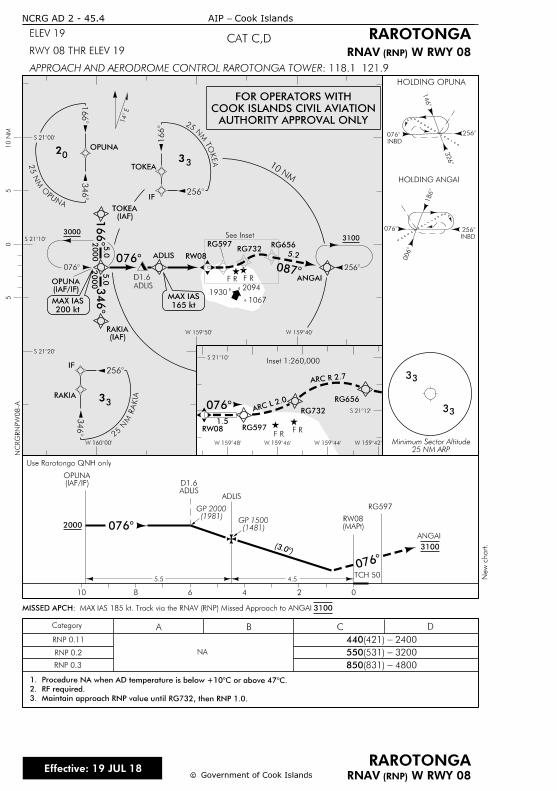
ANUP
O M
N 5
2
RAKIA
2
3
33
IF
OPUNA
3
0
1
TOKEA
2
1
33
IF
AIK
AR
MN
52
AE
KO
T M
N 52
Category A B C D
20941930
1067
10 NM
W 160î
W 159î W 159î
S 21î
S 21î
S 21î
10 N
M5
05
14
F RF R
RNP 0.11
RNP 0.2
RNP 0.3
NA
440 2400- (421)
550 3200- (531)
850 4800- (831)
ADLIS
D1.6
2
31003000
0
(IAF)TOKEA
(IAF)RAKIA
ANGAI
(IAF/IF)OPUNA
S 21î
S 21î
W 159îW 159î W 159îW 159î
See Inset
Inset 1:260,000
RG656
RG732
RG656RG597RG732
RW08 RG597F R
F R
ADLIS
165 kt
MAX IAS
200 kt
MAX IAS
RW08
2
3. Maintain approach RNP value until RG732, then RNP 1.0.
2. RF required.
1. Procedure NA when AD temperature is below +10C or above
NC
RG
RN
PW
08-A
New c
hart.
5.2
0
0
3
1
ARC L 2.
0
ARC R 2.7
0
1.5
2000
5.0
2000
5.0
0
02468
(IAF/IF)OPUNA
(3.
ANGAI
10
0
cc
ELEV 19
RWY 08 THR ELEV 19
Cook Islands- AIP
RAROTONGA
RAROTONGA
: 118.1 121.9APPROACH AND AERODROME CONTROL RAROTONGA TOWER
Effective: 19 JUL 18Government of Cook Islands
CAT C,D
W RWY 08 (RNP)RNAV
W RWY 08 (RNP)RNAV
33
33
2
INBD
3
1
0
HOLDING OPUNA
0
INBD
0
1
2
HOLDING ANGAI
TCH 50
ADLISADLISD1.6
3100
4.55.5
(1481)GP 1500
(MAPt)RW08
25 NM ARPMinimum Sector Altitude
3100: MAX IAS 185 kt. Track via the RNAV (RNP) Missed Approach to ANGAI MISSED APCH
2000
AUTHORITY APPROVAL ONLY
COOK ISLANDS CIVIL AVIATION
FOR OPERATORS WITH
RG597
Use Rarotonga QNH only
NCRG AD 2 - 45.4
(1981)GP 2000
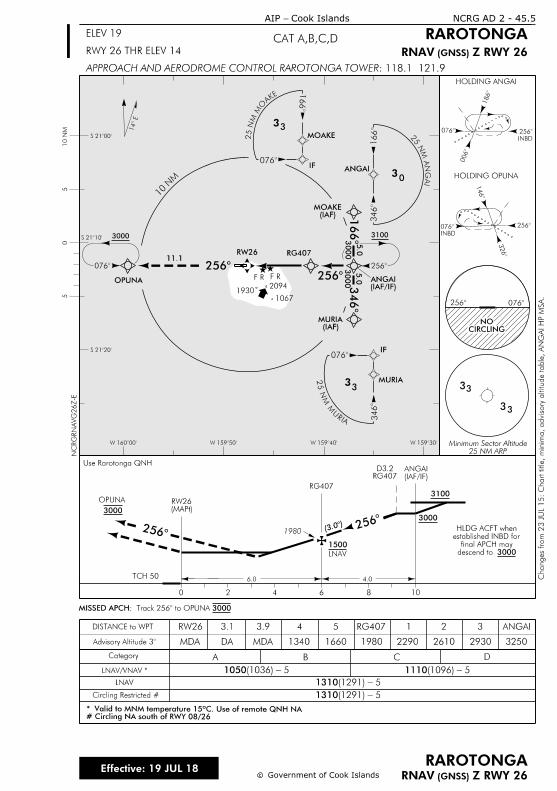
1
3
22
3000
0
3
30
1
ANGAI
MOAKE
0
1
33
IF
MURIA
0
3
33
IF
2
(IAF)MOAKE
(IAF/IF)ANGAI
(IAF)MURIA
EKA
OM
MN
52
IA
GN
A M
N 5
2
AIR
U
M M
N 5
2
11.1
14
0
INBD
0
1
2
HOLDING ANGAI
3
33
3
RW26
OPUNA
HOLDING OPUNA
INBD
0
3
2
1
S 21î
S 21î
S 21î
W 160î W 159î W 159î W 159î
10 N
M5
05
1930
10 N
M
cc
NC
RG
RN
AV
G26Z-E
RAROTONGA
RAROTONGACAT A,B,C,DELEV 19
RWY 26 THR ELEV 14
: 118.1 121.9APPROACH AND AERODROME CONTROL RAROTONGA TOWER
Cook Islands- AIP
Effective: 19 JUL 18Government of Cook Islands
F R F R
2094
10672 0
CIRCLINGNO
Z RWY 26 (GNSS) RNAV
Z RWY 26 (GNSS) RNAV
Changes fro
m 2
3 J
UL 1
5:
Chart title,
minim
a, advisory altitude table,
AN
GAI
HP M
SA.
25 NM ARPMinimum Sector Altitude
NCRG AD 2 - 45.5
3100
RG407
3000
5.0
3000
5.0
2
OPUNA
6.0 4.0
0 2 4 6 8 10
ANGAI(IAF/IF)RG407
D3.2
1980
30003000
Use Rarotonga QNH
Category A B C D
Advisory Altitude
DISTANCE to WPT
LNAV
325029302610198016601340MDAMDA
4 5 1 2 3RW26 3.9 RG407
Circling Restricted #
LNAV/VNAV *
LNAV
1500
ANGAI
TCH 50
3000: Track 256 to OMISSED APCH
DA
2
(3.
1310 5- (1291)
1310 5- (1291)
# Circling NA south of RWY 08/26
* Valid to MNM temperature 15ºC. Use of remote QNH NA
3.1
2290
1110 5- (1096) 1050 5- (1036)
3100RG407
(MAPt)RW26
3000descend to
final APCH may
established INBD for
HLDG ACFT when
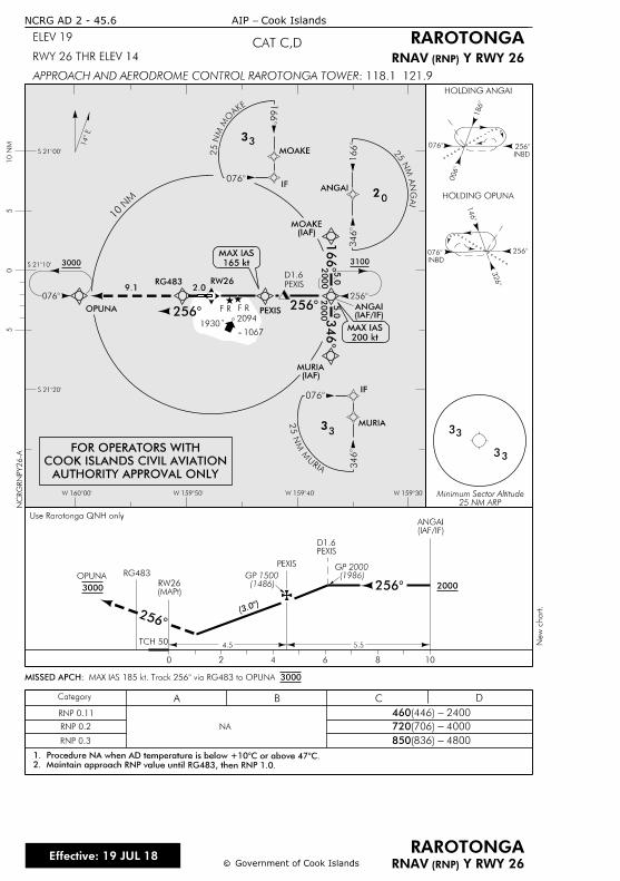
RG483
OPUNA
RW26
(IAF)MURIA
(IAF/IF)ANGAI
(IAF)MOAKE
PEXIS
2
3000
09.1
14
0
INBD
0
1
2
HOLDING ANGAI
3
33
3
2
OPUNA
0 2 4 6 8 10
3000
Category A B C D
HOLDING OPUNA
INBD
0
3
2
1
S 21î
S 21î
S 21î
W 160î W 159î W 159î W 159î
10 N
M5
05
TCH 50
1930
10 N
M
cc
RAROTONGA
RAROTONGAELEV 19
RWY 26 THR ELEV 14
: 118.1 121.9APPROACH AND AERODROME CONTROL RAROTONGA TOWER
NCRG AD 2 - 45.6 Cook Islands- AIP
Effective: 19 JUL 18Government of Cook Islands
F R F R
2094
1067
RNP 0.11
RNP 0.2
RNP 0.3
NA
CAT C,D
25 NM ARPMinimum Sector Altitude
460 2400- (446)
720 4000- (706)
850 4800- (836)
PEXIS
(MAPt)RW26
3000: MAX IAS 185 kt. Track 256 via RG483 to OMISSED APCH
165 kt
MAX IAS
20
1
ANGAI
MOAKE
0
1
33
IF
EKA
OM
MN
52
IA
GN
A M
N 5
2
3
MURIA
0
3
33
IF
AIR
U
M M
N 5
2
2
1
3
2.0
200 kt
MAX IAS
(3.
5.5
PEXISD1.6
(1486)GP 1500
2000
(IAF/IF)ANGAI
2
2
Y RWY 26 (RNP)RNAV
Y RWY 26 (RNP)RNAV
AUTHORITY APPROVAL ONLY
COOK ISLANDS CIVIL AVIATION
FOR OPERATORS WITH
3100
PEXIS
D1.6
4.5
RG483
Use Rarotonga QNH only
2. Maintain approach RNP value until RG483, then RNP 1.0.
1. Procedure NA when AD temperature is below +10C or above
NC
RG
RN
PY26-A
2000
5.0
2000
5.0
New c
hart.
(1986)GP 2000
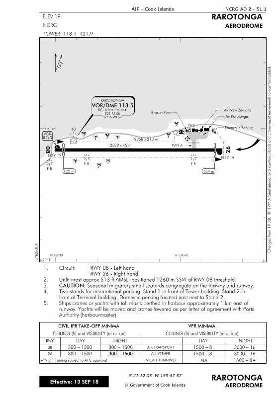
VOR/DME 113.5
2368 x 213 m
RAROTONGA
ELEV 19ELEV 14
26
08
RG
1
40TWR
CIVIL IFR TAKE-OFF MINIMA
CEILING (ft) and VISIBILITY (m or km) CEILING (ft) and VISIBILITY (m or km)
VFR MINIMA
RWY DAY NIGHT DAY NIGHT
AIR TRANSPORT
ALL OTHER
NANIGHT TRAINING
08 1500 - 300
1500 - 300 1500 - 300 1500 - 300
1500 - 300 8 - 1500 16 - 3000
8 - 1500 16 - 3000
Night training subject to ATC approvalª ª8 - 1500
W 159îW 159î
S 21î
S 21î
NCRG AD 2 - 51.1
ELEV 19
Cook Islands- AIP
RAROTONGA
AERODROME
: 118.1 121.9TOWER
NCRG
cc
RAROTONGAS 21 12 05 W 159 47 57
AERODROME
NC
RG
AD-E
26
Government of Cook IslandsEffective: 13 SEP 18
F R
F R F R
W159 48 52
S21 12 06
R243VOR
Air Rarotonga
Air New ZealandRescue Fire
2329 x 45 m
122 m 104 m
Domestic Parking
TWY A
Changes fro
m 1
9 J
UL 1
8:
TW
Y A label added, bird caution, stands and cra
ne/yacht
move
ments to east text a
dded.
Authority (harbourmaster).
runway. Yachts will be moved and cranes lowered as per letter of agreement with Ports
Ships cranes or yachts with tall masts berthed in harbour approximately 1 km east of5.
front of Terminal building. Domestic parking located east next to Stand 2.
Two stands for international parking. Stand 1 in front of Tower building. Stand 2 in4.
Seasonal migratory small seabirds congregate on the taxiway and runway.CAUTION:3.
Unlit mast approx 513 ft AMSL, positioned 1260 m SSW of RWY 08 threshold.2.
RWY 26 - Right hand
RWY 08 - Left handCircuit:1.
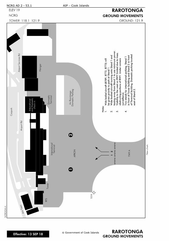
12
Ara Tapu
Airport R
dAirport Services
Rd
Carp
ark
Hangar
Terminal
Do
mestic
Terminal
Intern
ational
To
wer
RFS
TW
Y A
APR
ON
Do
mestic Parkin
gAir R
aroto
nga
12
: 121.9GROUND
check in
and D
omestic
Intern
ational
east of Sta
nd 2.
of
Termin
al buildin
g.
Do
mestic p
arkin
g locate
d
in fro
nt of
To
wer buildin
g a
nd Sta
nd 2 in fro
nt
Tw
o sta
nds for intern
ational parkin
g. Sta
nd 1
4.
surv
eilla
nce.
obstructing p
ortio
ns of
RW
Y.
Under ca
mera
Visibility to the w
est on R
WY limited d
ue to tre
es
3.
taxiing a
way fro
m Sta
nd 1 to use minim
um p
ower.
Wid
e b
odie
d aircraft turnin
g o
nto Sta
nd 1 a
nd
2.
be given priority to p
ark at Sta
nd 1.
(B789,
B772,
B773)
will
Wide b
odie
d aircraft
1.
Notes:
10 ft
NCRG AD 2 - 53.1
ELEV 19
cc Government of Cook Islands RAROTONGA
GROUND MOVEMENTSNCRG
GROUND MOVEMENTS
RAROTONGA
Cook Islands-AIP
: 118.1 121.9TOWER
Effective: 13 SEP 18
NC
RG
GM-A
New c
hart.
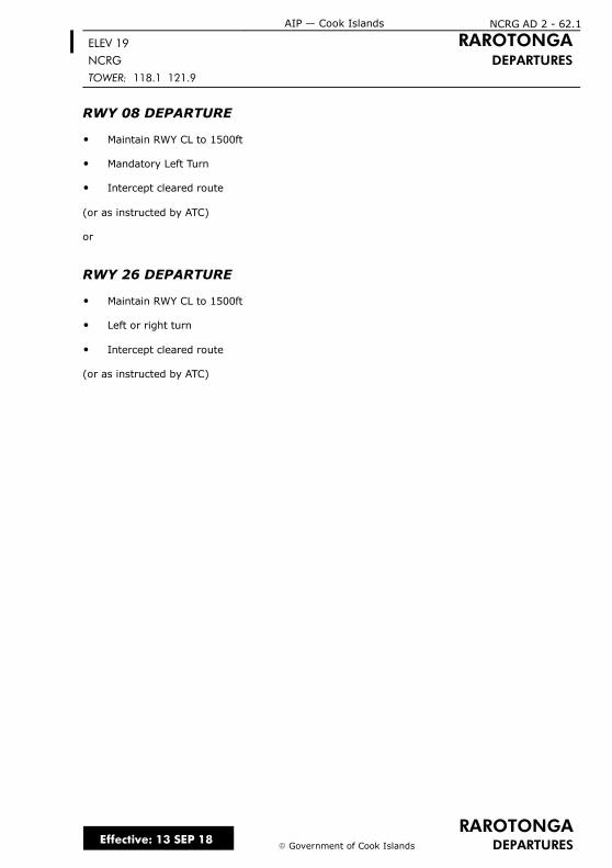
RAROTONGADEPARTURES
ELEV 19 RAROTONGANCRG DEPARTURESTOWER: 118.1 121.9
RWY 08 DEPARTURE
O Maintain RWY CL to 1500ft
O Mandatory Left Turn
O Intercept cleared route
(or as instructed by ATC)
or
RWY 26 DEPARTURE
O Maintain RWY CL to 1500ft
O Left or right turn
O Intercept cleared route
(or as instructed by ATC)
Effective: 13 SEP 18
NCRG AD 2 - 62.1AIP — Cook Islands
E Government of Cook Islands

IntentionallyBlank