Embed Size (px)
Citation preview

ADVICE FROM THE FIELD:
Tools and Techniques for Facilitating a Realistic and Effective Marine Spatial Planning (MSP) Process
Much has been said about the elements of an effective MSP process and the steps needed to develop a plan. However, what do we know about the inner workings of the real-world MSP process? What field-tested tools and techniques have practitioners honed to engage stakeholders, coordinate among agencies, and integrate the best available data?
MARINE SPATIAL PLANNING

- 2 - TOOLS AND TECHNIQUES
To answer these questions, the University of Rhode Island Coastal Resources Center and Rhode Island Sea Grant College Program set out to learn from
recent examples of MSP processes and to share lessons learned with practitioners worldwide. These lessons are based on findings from MSP case studies in Rhode Island, the San Francisco Bay Region, and Washington State, which were developed by interviewing 52 practi-tioners and stakeholders who participated in these MSP processes. Lessons were further honed through discus-sions at the 2015 International Marine Spatial Planning Symposium, as well as with the research team’s MSP Advisory Committee and among the Coastal Resources Center’s experienced staff of MSP and coastal manage-ment practitioners. Practitioners who participated in the Symposium, and who shared their own field-tested advice, agreed that the MSP process is as important as the plan itself – and perhaps even more important.
The lessons learned summarized in this report honor this recognition that process is critical to successful and sustainable implementation. They offer field- tested advice, tools, and techniques about how to facilitate a realistic and effective MSP process. This document presents a short summary of each lesson learned; for an in-depth discussion of each lesson, as well as the cases upon which they are based, please visit www.crc.uri.edu/initiatives_page/msp/
The MSP process, as discussed here, includes major aspects of plan development activities. This includes lessons about setting goals and responding to drivers, working with stakeholders, working with partner agencies and organizations, integrating the best available data, building and sustaining plan leadership, and planning for the implementation process.
MARINE SPATIAL PLANNING - 3 -
LESSON #1. UNDERSTAND WHERE YOU’RE STARTING FROM. History matters, and if there is a history of tension or conflict between groups or no history of collabora-tive multi-sector planning, then planning goals and expectations must be set accordingly. Review and understand what planning efforts worked and didn’t work in the past. Learn from and build on past suc-cesses in order to avoid making the same mistakes.
LESSON #2. APPLY FLEXIBILITY AND ADAPTABILITY TO KEEP YOUR DRIVER COMPELLING.
An effective planning driver — a pressing issue or problem — “stirs the blood” and brings stakeholders to the table. This driver sustains stakeholder engagement through plan development and into implementation. If a driver ceases to be relevant — e.g., if a controversial project is abandoned — then stakeholder participation may decline. If this hap-pens, you must identify another driver that compels stakeholders while still enabling the process to retain focus on planning goals. If there isn’t another driver, consider engaging stakeholders on short-term objectives, such as the development of tangible stand-alone products that they can use.
LESSON #3: STAY AGILE AND ALLOW YOUR PLAN TO RESPOND TO MULTIPLE ISSUES.
A driver can trigger planning but does not need to determine or limit the scope or the problems addressed through a spatial plan. A planning pro-cess that is started to solve one problem but later is adapted to address other problems with little additional effort is often efficient and an effective il-lustration of the benefits of marine spatial planning. This increases your return on investment. Seek out such opportunities where possible, but strive to do so without losing focus on original planning goals.
IN SAN FRANCISCO, a Port Access Route
Study (PARS) began as a response to a
ship collision but resulted in shipping lane
changes that both improved navigation safe-
ty and protected whales from ship strikes.
IN WASHINGTON STATE, an offshore energy
proposal of concern to stakeholders did not
come to fruition, but planners have contin-
ued engaging stakeholders in marine spatial
planning through tangible research and
participatory mapping projects.
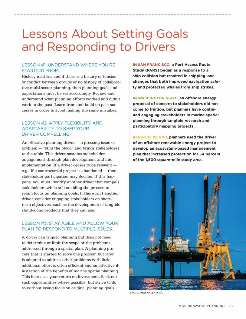
IN RHODE ISLAND, planners used the driver
of an offshore renewable energy project to
develop an ecosystem-based management
plan that increased protection for 54 percent
of the 1,500 square-mile study area.
Lessons About Setting Goals and Responding to Drivers
PHOTO: DEEPWATER WIND

- 4 - TOOLS AND TECHNIQUES
LESSON #4: ENGAGE STAKEHOLDERS INFORMALLY BUT MEANINGFULLY TO BUILD COMMITMENT AND LEGITIMACY.
Engaging stakeholders informally, in addition to the required formal public process, is necessary to develop a realistic and publicly-supported plan. Meaningful informal stakeholder engagement may include using pre-existing committees or conducting workshops and educational activities. The time and resources invested in informal engagement will pay off in strong stake-holder commitment to the final plan.
LESSON #5: ALLOW FOR TIME TO BUILD TRUST.
A foundation of familiarity and trust among stakeholders, and between stakeholders and planning agencies, can facilitate an effective process. However, trust takes time to develop and in some cases has been established long before an MSP process begins. Work proactively to build trust, and allow adequate time for it to develop, especially if there is a history of distrust between key players.
LESSON #6: MANAGE EXPECTATIONS.
Set realistic expectations for your marine spatial plan and help others understand them. Planning is ineffec-tive when stakeholders misunderstand the scope of a planning exercise or the role of a stakeholder advisory group. To manage expectations, outline clear, realistic goals and a meaningful process to achieve them, and have multiple key players communicate these points clearly, consistently and widely.
IN SAN FRANCISCO, the Coast Guard depended on
the local Harbor Safety Committee, which included
representatives from diverse maritime industries
and agencies, as a sounding board and source of
expertise to ensure that plans for the 34th America’s
Cup were realistic and supported by industry.
IN WASHINGTON STATE, plan leaders ensured that
outcomes and concerns that had been raised through
an independent informal stakeholder process led
by the Surfrider Foundation and The Nature Conser-
vancy were also considered and addressed as part of
the formal state-led stakeholder process.
IN RHODE ISLAND, planners organized meetings and
informal discussions between fishermen, experts, and
regulators as a response to significant fishermen con-
cerns about both the effects of offshore wind farms
on navigation and the effects of electromagnetic
fields from submerged cables on fisheries resources.
These talks helped fishermen understand how these
issues would be considered in the planning process
and thus contributed to building trust with the fish-
ing community over the two-year planning period.
Lessons About Working With Stakeholders

MARINE SPATIAL PLANNING - 5 -
LESSON #7: FIGURE OUT WHAT OTHERS HAVE THAT YOU NEED.
No one can do marine spatial planning alone. Collaborations between agencies or organizations that have complementary goals, expertise, constituencies, and authorities are effective for marine spatial planning because each partner contributes what the others lack. Seek out partners or collaborators who have what you need and work closely with them to create a compre-hensive and efficient MSP process.
LESSON #8: DON’T MEET YOUR COLLEAGUES AND CONSTITUENTS FOR THE FIRST TIME DURING A CRISIS.
Strong working relationships between agencies and stake-holders provide a foundation to work through the chal-lenges that can arise through marine spatial planning. This foundation can include relationships with an honest broker — a trustworthy, neutral individual or organization that will work toward a fair outcome. Work to cultivate these relationships long before planning begins and lever-age pre-existing relationships to the maximum extent.
IN SAN FRANCISCO, one of the national marine
sanctuaries shares an office building with a commer-
cial fishing industry association, which allowed for
frequent informal discussion and relationship-
building amongst fishermen, sanctuary staff, and
the U.S. Coast Guard PARS team.
IN WASHINGTON STATE, the lead planning agency
brought in Washington Sea Grant, a trusted, neutral,
university-based organization, to conduct MSP
workshops and outreach activities and to coordinate
a Science Advisory Panel.
IN RHODE ISLAND, a trusted and respected retired
statesman volunteered as independent stakeholder
facilitator and helped guide tough conversations
between stakeholders and the planning team.
Lessons About Working With Agencies and Partners

- 6 - TOOLS AND TECHNIQUES
LESSON #9: LISTEN TO THE LOCALS.
Local knowledge and firsthand experience are necessary to inform realistic, practical decisions that have stakeholder support and can resolve conflicts. This comes from everyone ranging from local skilled professionals to commercial fishermen to average citizens. Plan to involve the full range of locals in everything from interpreting data to developing reasonable planning scenarios. This is necessary to develop a realistic marine spatial plan.
IN SAN FRANCISCO, locals ranging from Coast Guard
Vessel Traffic Service professionals to experienced
ferry captains helped develop racing areas and a
traffic management plan to keep commerce moving
during the America’s Cup race events.
IN WASHINGTON STATE, representatives from
the coastal community-based Marine Resources
Committees participate on the official governor-
appointed stakeholder advisory council, thus ensur-
ing local communities are playing a leadership role
in this state-led effort.
IN RHODE ISLAND, the Narragansett Indian Tribe
contributed an oral history and knowledge of the
Tribe’s traditional use of the offshore environment.
This has led to an ongoing collaboration between
the Tribe and university geologists and archaeolo-
gists who are studying the offshore environment and
developing best practices for identifying submerged
tribal landscapes and artifacts.
Lessons About Integrating the Best Available Data
PHOTO: U.S. COAST GUARD SECTOR SAN FRANCISCO
PHOTO: URI COASTAL RESOURCES CENTER / RI SEA GRANT

MARINE SPATIAL PLANNING - 7 -
LESSON #10: BUILD A BROAD BASE OF LEADERSHIP.
Leadership for marine spatial planning is not limited to the lead planning agency. It can come from outside of government, within stakeholder groups and the research community. Build leadership in key constituen-cies, such as industry and environmental organizations, to help build and sustain broad engagement in and support for the process.
IN SAN FRANCISCO, stakeholders representing
maritime industry businesses and associations,
conservation groups, and scientific organizations —
organized in part through existing groups such as
the local Harbor Safety Committee and the National
Oceanic and Atmospheric Administration National
Marine Sanctuary Advisory Councils — played
key leadership roles by sharing information,
providing expert opinion, and helping develop
plan components.
IN WASHINGTON STATE, planners and stakeholders
alike appreciate the leadership of the stakeholder
advisory council chair, an environmental
professional well-known for his leadership on
one of Washington State’s county-based Marine
Resources Committee stakeholder groups.
IN RHODE ISLAND, planners encouraged leadership
from the research community, the fishing communi-
ty, and the environmental community and later
formalized these roles through the creation of a
Fishermen’s Advisory Board and a Habitat Advisory
Board. These boards continue to play a leadership
role in plan implementation.
Lessons About Leadership
PHOTO: URI COASTAL RESOURCES CENTER / RI SEA GRANT

This document was produced in 2016 by the Coastal Resources Center and Rhode Island Sea Grant College Program at the University of Rhode Island Graduate School of Oceanography. It is one of a series of products sharing lessons learned from the practice of marine spatial planning in the United States and abroad. These products include the “Case Studies in Marine Spatial Planning Report Series” edited by Jennifer McCann.
They are part of our ongoing research and capacity-building initiative to strengthen the network of MSP and coastal management practitioners.
For further information, and for access to other documents including technical reports summarizing the three case studies mentioned here, please see www.crc.uri.edu/initiatives_page/msp/
Lessons About The Process Of ImplementationLESSON #11. CREATE CLEAR POLICY TOOLS IN YOUR PLAN TO SUPPORT STREAMLINED DECISION-MAKING.
Build tools into your plan that result in concrete out-comes during plan implementation. Policy tools that tangibly inform and streamline decision-making keep your plan alive and adaptive and make implementation an active and dynamic process. They demonstrate the value and impact of the plan and give stakeholders a reason to continue their participation.
LESSON #12. PREPARE TO WORK EVEN HARDER DURING IMPLEMENTATION.
Implementation is the harder part of the MSP process. It is when decisions will be made and stakeholder engagement will be needed, even though resources may be slim and public attention scant. Prepare for this reality while you are still developing the plan. This can include fundraising, designing mechanisms for contin-ued stakeholder participation, or creating an innovative and interactive monitoring plan.
IN SAN FRANCISCO, tools including on-the-water
monitoring and nightly conference calls during the
America’s Cup races helped the Coast Guard and
maritime stakeholders work efficiently and deci-
sively to ensure the races took place safely and
with minimal disruption to other activities.
IN WASHINGTON STATE, planners are actively
considering implementation strategies while in the
midst of the plan development process. Potential
strategies include interagency memoranda of under-
standing shaping how plan data and information will
be used in agency decision-making.
IN RHODE ISLAND, planners used Ocean Special
Area Management Plan (SAMP) data to develop
a Geographic Location Description (GLD), which
gives RI increased federal consistency review
authority over certain activities in federal waters.
The GLD was developed during the implementa-
tion process and is being used to implement Ocean
SAMP data and policies in federal waters.