Embed Size (px)
Citation preview
ASPIRED- Work Plan Year 3
Approved – October 3, 2017 1
ADVANCED SCIENCE AND PARTNERSHIPS
FOR INTEGRATED RESOURCE
DEVELOPMENT PROJECT
Report on Methodology and Calculated Values of
Natural Flow and Water Balance of the Ararat Valley
December 2018
This publication was produced for review by the United States Agency for International
Development. It was prepared by ME&A.
Precipiatio
2
ADVANCED SCIENCE AND PARTNERSHIPS FOR
INTEGRATED RESOURCE DEVELOPMENT
PROJECT
Report on Methodology and Calculated Values of Natural
Flow and Water Balance of the Ararat Valley
December 2018
Contract No. AID-OAA-I-14-00070/AID-111-TO-15-00001
Prepared for:
United States Agency for International
Development
Armenia Mission
1 American Avenue
Yerevan 0082, Armenia
Prepared by:
ME&A, Inc.
4350 East-West Highway
Suite 210
Bethesda, MD 20814
Tel: +13016524334
Fax: +1 240 630 8935
www.MEandAHQ.com
Armenian Branch of ME&A, Inc.
105/1 Teryan St., Suite 204,
Yerevan 0009
Republic of Armenia
Tel. +374 10 514 315
Fax: +374 10 514 317
Email: [email protected]
DISCLAIMER
This report is made possible by the support of the American people through the United States Agency for
International Development (USAID). The contents are the sole responsibility of ME&A, Inc. and do not necessarily
reflect the views of USAID or the United States Government.
3
TABLE OF CONTENTS
LIST OF ACRONYMS 4
INTRODUCTION 5
1. DESCRIPTION OF THE STUDY AREA 6
2. METHODOLOGY 10
2.1 CALCULATION OF THE WATER BALANCES FOR THE ARARAT VALLEY
AND ITS CATCHMENT AREA 10
2.2 DATA SOURCES 11
2.3 STEP-BY-STEP CALCULATION OF WATER BALANCE 12
2.3.1 Calculation of the Precipitation Values 13
2.3.2 Calculation of the Evapotranspiration Values 13
2.3.3 Calculation of the Natural Flow Values 14
2.3.4 Calculation of the Natural Surface Flow Values 15
2.3.5 Calculation of the Groundwater Flow Values 17
2.3.6 Calculation of the Values of Natural Surface Flow using the Precipitation-
Runoff Curve 18
2.4 LIMITATIONS FACED DURING CALCULATIONS 20
3. CALCULATED VALUES 21
3.1 WATER BALANCE OF THE ARARAT VALLEY CATCHMENT AREA BY
RIVER BASINS FOR YEAR 2016 21
3.2 MULTIANNUAL AVERAGE WATER BALANCE OF THE ARARAT VALLEY
CATCHMENT AREA BY RIVER BASINS 25
3.3 WATER BALANCE OF THE ARARAT VALLEY FOR 2016 30
3.4 MULTIANNUAL AVERAGE WATER BALANCE OF THE ARARAT VALLEY 35
4. NEXT STEPS 39
ANNEX 1. CALCULATION OF THE ARARAT VALLEY WATER BALANCE USING
DSS 40
ANNEX 2. BIBLIOGRAPHY 42
4
LIST OF ACRONYMS
AHGW ArcHydro Groundwater
ASPIRED Advanced Science and Partnerships for Integrated Resource Development
CADI Computer Assisted Development, Inc.
CN Curve Number
CORINE Coordination of Information on the Environment
CEWP Clean Energy and Water Program
DEM Digital Elevation Model
DSS Decision Support System
EMIC Environmental Monitoring and Information Center
ET Evapotranspiration
GIS Geographic Information System
GMS Groundwater Modeling System
GOA Government of Armenia
GW Groundwater
mln Million
m Meter
mm Millimeter
MES Ministry of Emergency Situations
MEINR Ministry of Energy Infrastructures and Natural Resources
MNP Ministry of Nature Protection
P Precipitation
RGF Republican Geologic Fund
sec Second
SCS Soil Conservation Service
SW Surface Water
SWCIS State Water Cadastre Information System
WRMA Water Resources Management Agency
WUP Water Use Permit
USAID United States Agency for International Development
USDA United States Department of Agriculture
USGS United States Geologic Survey
5
INTRODUCTION
The purpose of Advanced Science and Partnerships for Integrated Resource Development (ASPIRED)
Project of the United States Agency for International Development (USAID) is to support sustainable
water resource management and sustainable practices of water users in the Ararat Valley through the use
of science, technology, innovation, and partnership initiatives. The ultimate goal is to reduce extraction of
groundwater resources to the sustainable levels. The ASPIRED Project is implemented by ME&A, Inc.
(ME&A) and its subcontractor, Computer Assisted Development, Inc. (CADI).
To support Government of Armenia (GOA) in developing and implementing more stringent data-driven
policy for sustainable management of groundwater resources in the Ararat Valley, the ASPIRED Project
works on developing and calibrating decision supports tools. Particularly, the customized Decision
Support System (DSS) that was developed under USAID/Armenia Clean Energy and Water Program
(CEWP) in 2013-2015, is calibrated for the Ararat Valley and its catchment area. The ASPIRED Project
developed a groundwater flow model of the Ararat Valley, using the ArcHydro Groundwater (AHGW)
tools, Groundwater Modeling System (GMS), and MODFLOW advanced applications for groundwater modeling.
These activities are implemented in collaboration with and with guidance from CADI and AQUAVEO.
Both CADI and AQUAVEO specialize in providing technical solutions to governments and businesses
worldwide on sustainable management of water resources and nature conservation, using extensively
applied information technology and advanced solutions for hydrologic and groundwater modeling.
in June 2018, the ASPIRED team presented and discussed the approach for modeling the groundwater
resources in the Ararat Valley and methodology for determining the groundwater reserve, recharge rate,
sustainable rate of groundwater abstraction, and input data with the representatives of the Environmental
Monitoring and Information Center (EMIC) of the Ministry of Nature Protection (MNP). The ASPIRED
Project received the EMIC’s hydrogeologists’ concurrence on the proposed approach and methodology.
This report presents the interim results of the ASPIRED Project’s hydrologic analysis for the Ararat Valley. It
provides the water balance or hydrologic balance of the Ararat Valley and its catchment area by river basins,
including the values for the following water balance components: precipitation, evapotranspiration, natural surface
flow and natural groundwater flow. The report also provides the methodology and data used for each calculation.
The ASPIRED Project conducted calculations to estimate the multiannual average water balance for the
period of 1961-2016 and annual water balance for 2016. ASPIRED used inventory data that describes
baseline conditions of groundwater wells and groundwater use in the Ararat Valley for 2016, and satellite
imagery for Ararat Valley for summer 2016. The water balance provided for the Ararat Valley catchment
area covers six river basins: Akhuryan (including Kars), Qasakh, Metsamor, Hrazdan, Azat, and Vedi. The
report also includes the limitations identified during calculation of the water balance components for the
Ararat Valley. The last section of the report describes next steps for hydrologic and groundwater modeling
activities within the framework of the ASPIRED Project.
6
1. DESCRIPTION OF THE STUDY AREA
Calculations and other information presented throughout this report cover the Ararat Valley and its
catchment area within the territory of the Republic of Armenia.
In terms of geomorphology, the Ararat Depression is divided into two parts:
• Ararat Valley, which lies in the lowlands of the Ararat Depression and includes terraces of the
Araks River and its bed, located at altitudes of up to 930m.
• Submontane zones – sloping and slightly wavy plains located at altitudes of up to 1200m [7].
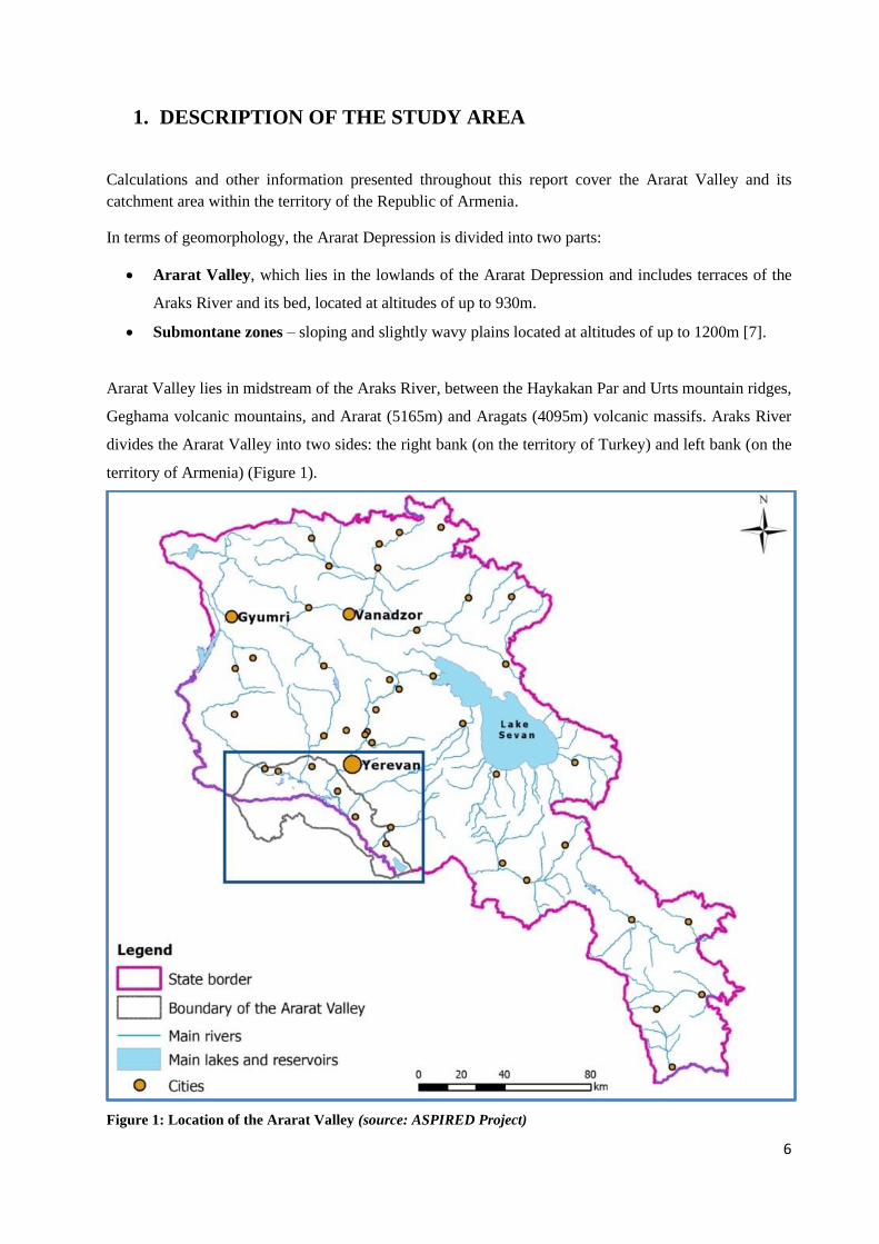
Ararat Valley lies in midstream of the Araks River, between the Haykakan Par and Urts mountain ridges,
Geghama volcanic mountains, and Ararat (5165m) and Aragats (4095m) volcanic massifs. Araks River
divides the Ararat Valley into two sides: the right bank (on the territory of Turkey) and left bank (on the
territory of Armenia) (Figure 1).
Figure 1: Location of the Ararat Valley (source: ASPIRED Project)
7
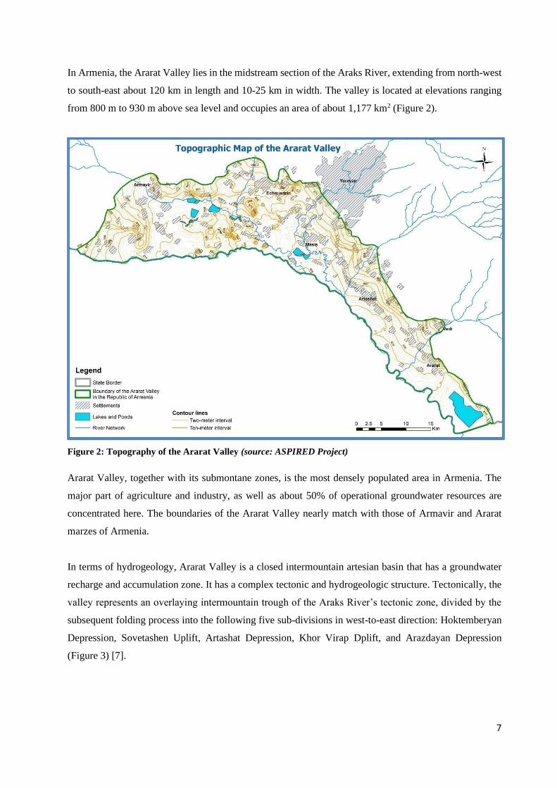
In Armenia, the Ararat Valley lies in the midstream section of the Araks River, extending from north-west
to south-east about 120 km in length and 10-25 km in width. The valley is located at elevations ranging
from 800 m to 930 m above sea level and occupies an area of about 1,177 km2 (Figure 2).
Figure 2: Topography of the Ararat Valley (source: ASPIRED Project)
Ararat Valley, together with its submontane zones, is the most densely populated area in Armenia. The
major part of agriculture and industry, as well as about 50% of operational groundwater resources are
concentrated here. The boundaries of the Ararat Valley nearly match with those of Armavir and Ararat
marzes of Armenia.
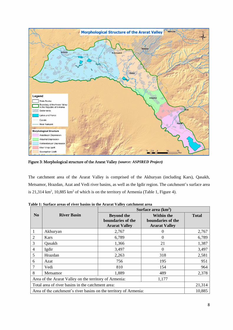
In terms of hydrogeology, Ararat Valley is a closed intermountain artesian basin that has a groundwater
recharge and accumulation zone. It has a complex tectonic and hydrogeologic structure. Tectonically, the
valley represents an overlaying intermountain trough of the Araks River’s tectonic zone, divided by the
subsequent folding process into the following five sub-divisions in west-to-east direction: Hoktemberyan
Depression, Sovetashen Uplift, Artashat Depression, Khor Virap Dplift, and Arazdayan Depression
(Figure 3) [7].
8
Figure 3: Morphological structure of the Ararat Valley (source: ASPIRED Project)
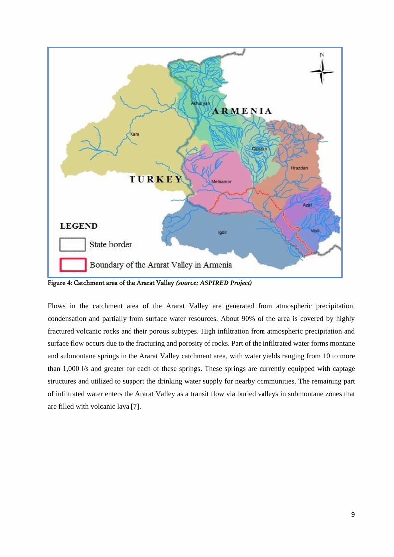
The catchment area of the Ararat Valley is comprised of the Akhuryan (including Kars), Qasakh,
Metsamor, Hrazdan, Azat and Vedi river basins, as well as the Igdir region. The catchment’s surface area
is 21,314 km2, 10,885 km2 of which is on the territory of Armenia (Table 1, Figure 4).
Table 1: Surface areas of river basins in the Ararat Valley catchment area
No
River Basin
Surface area (km2)
Beyond the
boundaries of the
Ararat Valley
Within the
boundaries of the
Ararat Valley
Total
1 Akhuryan 2,767 0 2,767
2 Kars 6,789 0 6,789
3 Qasakh 1,366 21 1,387
4 Igdir 3,497 0 3,497
5 Hrazdan 2,263 318 2,581
6 Azat 756 195 951
7 Vedi 810 154 964
8 Metsamor 1,889 489 2,378
Area of the Ararat Valley on the territory of Armenia: 1,177
Total area of river basins in the catchment area: 21,314
Area of the catchment’s river basins on the territory of Armenia: 10,885
9
Figure 4: Catchment area of the Ararat Valley (source: ASPIRED Project)
Flows in the catchment area of the Ararat Valley are generated from atmospheric precipitation,
condensation and partially from surface water resources. About 90% of the area is covered by highly
fractured volcanic rocks and their porous subtypes. High infiltration from atmospheric precipitation and
surface flow occurs due to the fracturing and porosity of rocks. Part of the infiltrated water forms montane
and submontane springs in the Ararat Valley catchment area, with water yields ranging from 10 to more
than 1,000 l/s and greater for each of these springs. These springs are currently equipped with captage
structures and utilized to support the drinking water supply for nearby communities. The remaining part
of infiltrated water enters the Ararat Valley as a transit flow via buried valleys in submontane zones that
are filled with volcanic lava [7].
10
2. METHODOLOGY
2.1 CALCULATION OF THE WATER BALANCES FOR THE ARARAT VALLEY
AND ITS CATCHMENT AREA
The Water Balance or Hydrologic Balance of any area, including the river basin, over any given time
period (multiannual, annual, seasonal) is the ratio of inflow, outflow, and storage (change in storage) of
the water resource within the given area [1]. To obtain the water balance for a given area, the values of
precipitation, evapotranspiration, and natural flow are calculated. The components of the water balance
are calculated using data series received from the meteorological and hydrologic observation posts located
within the area of interest.
The ASPIRED Project calculated the water balances for the Ararat Valley and its catchment area by river
basins by applying the following methods:
The water balance of the Ararat Valley catchment area by river basins is calculated based on average
annual values of precipitation, evapotranspiration, and natural surface and groundwater flows in the
sections of river basins of the catchment area that are outside the Ararat Valley. (Table 1). The water
balance of the Ararat Valley catchment area by river basins is calculated using the following equation [1,
2]:
P = ET + SW + GW, where:
P = annual precipitation occurred within the river basin for the given period (mm or mln. m3)
ET = annual average evapotranspiration occurred within the river basin for the given period (mm
or mln. m3)
SW = surface water flow in the river basin for the given period (mm or mln. m3)
GW = groundwater flow in the river basin for the given period (mm or mln. m3)
The water balance of the Ararat Valley is calculated based on the annual average values of precipitation,
evapotranspiration, natural surface inflow and outflow, as well as groundwater inflow and outflow. It is
the expression of the annual changes in the volume of water in the Ararat Valley in natural conditions, in
terms of water inflow and outflow, both surface water and groundwater resources.
The water balance of the Ararat Valley is calculated using the following equation [1, 2]:
P + SWin + GWin = ET + SWout + GWout + ∆, where
The inflow parameters (the left side of the equation) represent:
P = total annual precipitation occurred within the Ararat Valley for the given period, in mln. m3
SWin = surface water inflow into the Ararat Valley during the given period, in mln. m3
11
GWin= groundwater inflow to the Ararat Valley groundwater basin during the given period, in mln. m3
The outflow parameters (the right side of the equation) represent:
ET = annual average evapotranspiration occurred in the Ararat Valley for the given period, in mln. m3
SWout = surface water outflow from the Ararat Valley for the given period, in mln. m3
GWout= groundwater outflow from the Ararat Valley groundwater basin for the given period, in mln. m3
∆ = difference between water inflow and outflow in the Ararat Valley for the given period, in mln. m3
Each component of the water balance equation can be calculated both in millimeters (mm) and cubic
meters (m3). The values in millimeters are converted to the values in cubic meters by multiplying by the
total area of the Ararat Valley in the territory of the Republic of Armenia by 1,177 km2.
Volume of water discharge per second in cubic meters (m3/s) is converted to the annual water volume in
million cubic meters (mln. m3/year) by multiplying by the number of seconds within the year (that is
equal to 31,536,000) and dividing by 106.
2.2 DATA SOURCES
The ASPIRED Project used the following data sources used to calculate the water balances:
• Precipitation data from meteorological stations in river basins of the Ararat Valley catchment area,
obtained from the Service of the Hydrometeorology and Active Influence on Atmospheric
Phenomena (Hydromet Service) state non-commercial organization under the Ministry of
Emergency Situations (MES) of the RA.
• Data on precipitation, air temperature, atmospheric pressure, and wind velocity to determine the
values of evapotranspiration. This data was measured at meteorological stations and obtained from
Hydromet Service under the RA MES.
• Data on actual river flow measured at the hydrologic observation posts and obtained from
Hydromet Service of the MES.
• Data on the change of water resources in reservoirs (usage or storage) and water resources inter-
basin transfer, obtained from the Water Committee of the Ministry of Energy Infrastructures and
Natural Resources (MEINR) of Armenia.
• Data on water abstraction volumes, obtained from (1) the Hydrologic Yearbooks published by the
Hydromet Service of the MES; (2) the State Water Cadastre Data Warehouse of the Water
Resources Management Agency (WRMA) of the Ministry of Nature Protection (MNP); and (3)
Water Committee of the MEINR.
• Data on water return, obtained from the WRMA’s Water Use Permits Database. If the permits do
12
not indicate the volumes of return water, these values are calculated based on the results of the
research performed in the Institute of Water Problems and Hydro-Engineering Named After I.V.
Yeghiazarov. According to the research, the average volume of return water from irrigation
constitutes about 20% of water used, while the average volume of return water used for industry
and drinking-household purposes constitutes about 70% of the abstracted water.
• When calculating the water balance for the Ararat Valley catchment area by river basins, the
ASPIRED Project jointly calculated the water balance of Kars river basin together with that of the
Akhuryan river basin, as both basins are part of the Akhuryan catchment area on the territory of
Turkey. The groundwater flow from Kars river basin feeds into the groundwater basin of the
Ararat Valley and accounts for a considerable amount of groundwater inflow to the Ararat Valley.
The ASPIRED Project obtained the data from hydrological observation posts in Kars river basin
from the website of the General Directorate of State Hydraulic Works of Turkey [8], as well as
the meteorological data from the website of the Turkish State Meteorological Service [9].
2.3 STEP-BY-STEP CALCULATION OF WATER BALANCE
The following consecutive steps are implemented for calculation of the water balance of the Ararat Valley:
1. Determining the values of precipitation (P) and evapotranspiration (ET) for the following six river
basins of the Ararat Valley catchment area: Akhuryan; Metsamor; Qasakh; Hrazdan Aza; and Vedi.
The values of these components of the Ararat Valley catchment area serve as input data for
determining surface and groundwater inflow into the Ararat Valley.
2. Determining the values of precipitation (P) and evapotranspiration (ET) in the Ararat Valley. Those
values will be generated based on the outputs of Step 1, since the territory of the Ararat Valley is
comprised of downstream sections of the six river basins.
3. Converting the actual river flow measured at the all hydrologic observation posts located in the six
river basins of the Ararat Valley catchment area to the natural river flow.
4. Calculating the values of natural surface flow, including natural surface inflow (SWin) and natural
surface outflow (SWout) in the territory of Ararat Valley, using the outputs from Step 3.
5. Determining the values of natural surface flow generated within the territory of the Ararat Valley,
using the “precipitation-runoff” curve approach.
6. Determining the values of groundwater inflow (GWin) and groundwater outflow (GWout) in the Ararat
Valley.
7. Inserting all the calculated values in the water balance equation of the Ararat Valley and calculating
the difference between the inflow and outflow values.
8. Determining the difference between inflow and outflow values from the equation of water balance of
the Ararat Valley (∆), i.e. ∆ is determined based on the difference between inflow (precipitation
13
occurred in the Ararat Valley, surface and groundwater inflows into the valley) and outflow (surface
and groundwater outflows, as well as evapotranspiration from the valley).
The sections below describe the methodology applied for calculation of the water balances of the Ararat
Valley and its catchment area by river basins.
2.3.1 Calculation of the Precipitation Values
To calculate the annual average precipitation values in the river basins of the Ararat Valley catchment
area, the following steps are undertaken:
• Creating graphic correlation linkages between two values: 1) the values of annual precipitation
measured at the meteorological stations located in the river basins within the Ararat Valley catchment
area, which are provided by the Hydromet Service of the Ministry of Emergency Situations (MES);
and 2) absolute altitude values of the meteorological stations. These linkages allow calculation of the
precipitation values for each river basin separately, based on the altitude of the meteorological
stations located within that river basin.
• Extending the correlation curves between the precipitation values and values of absolute altitudes of
the meteorological stations to the highest point of the river basin, using extrapolation method.
Through this method, the ASPIRED Project can generate values of precipitation for the whole area
of the river basin, taking into account that the absolute altitudes of Armenia's river basins reach up to
3,700 m, and the altitudes of the meteorological stations of Armenia reach up to 2,400 m, except for
Aragats high mountain station (located at an altitude of 3,229 m).
• Distributing the calculated values of precipitation on the surface of the whole river basin based on
the topography of the basin (Digital Elevation Model (DEM)), as well as generating a raster image
of the spatial distribution of precipitation throughout the entire river basin1.
• Calculating the value of precipitation in the Ararat Valley, using the raster image for precipitation of
the Ararat Valley. The raster image for precipitation of the Ararat Valley is generated by cropping
the respective raster image for the Ararat Valley catchment area to the boundary of the Ararat Valley.
2.3.2 Calculation of the Evapotranspiration Values
Calculating the annual average evapotranspiration values in the river basins of the Ararat Valley catchment
area requires the following steps:
• Calculating the values of evapotranspiration at the meteorological stations of the river basins of the
1 The basic element of a raster image, as opposed to the photo, is the point called a pixel, which is characterized by
a digital value. Digital values enable arithmetic operations with raster images. Raster images can be subtracted one
from another in GIS interface, using spatial analysis tools and resulting in another raster image. Each pixel of this
raster image contains a value which is the difference between the relevant pixel values of two raster images
involved in subtraction.
14
Ararat Valley, using values of precipitation, air temperature, atmospheric pressure, and wind velocity
measured in the given meteorological station, using the following equation [1] (the measured values
were provided by the Hydromet Service of the MES):
ET = Eg* [(1+0.07 (Vi – Vave) * Have/ Hi, where:
ET = average monthly evapotranspiration, in millimeters
Eg = evapotranspiration obtained using the correlation curves between the average monthly values
of precipitation and temperature
Vi= average monthly wind velocity
Vave= average monthly wind velocity in the country (equals to 3.3 m/sec. for Armenia)
Have= the average value of atmospheric pressure in the country (equals to 605 mm for Armenia)
Hi = the average value of the atmospheric pressure of the given month
• Constructing graphic correlation linkages between the values of annual evapotranspiration and
absolute altitude values of the meteorological stations of the Ararat Valley catchment area.
• Calculating the evapotranspiration values for each river basin, using the correlation curves and based
on altitude values of meteorological stations.
• Distributing the calculated values of evapotranspiration on the surface of the whole river basin based
on the topography of the basin (DEM), and generating a raster image of the spatial distribution of
evapotranspiration throughout the entire river basin.
• Calculating the evapotranspiration value of the Ararat Valley, using the raster for evapotranspiration
of Ararat Valley. The raster image for evapotranspiration of the Ararat Valley is generated by
cropping the respective raster image for the Ararat Valley catchment area to the boundary of the
Ararat Valley.
2.3.3 Calculation of the Natural Flow Values
The value of water flow that occurs in a basin under natural conditions or natural flow is calculated to
estimate the water balance of the basin, assess dynamics of the flow changes, to perform hydrologic
calculations and analysis, such as defining the values of ecological flows and sustainable rates of water
use from a water resource, both surface and groundwater, etc.
The value of the natural flow is calculated by subtracting the value of evapotranspiration from the value
of precipitation, according to the following formula: Y = P – ET [1]. The raster images of the precipitation
and evapotranspiration generated for all six river basins of the Ararat Valley catchment area at the previous
stages are used to create the raster image of the natural flow for the Ararat Valley catchment area, using
the spatial analysis tools. The raster images for the Ararat Valley catchment area are cropped to the
boundary of the Ararat Valley to calculate the natural flow values for the valley.
15
The natural flow component of the Ararat Valley includes the natural surface flow and natural groundwater
flow.
2.3.4 Calculation of the Natural Surface Flow Values
The natural flow component of the Ararat Valley water balance equation includes two parameters: natural
surface inflow (SWin) and natural surface outflow (SWout). The consecutive steps for calculating the values
of SWin and SWout are described below.
Converting the actual river flow to the natural river flow:
The following steps are implemented for determining the natural surface inflow and outflow in the Ararat
Valley:
• Converting the values of the actual flow measured at the hydrologic observation posts in the
Akhuryan, Metsamor, Qasakh, Hrazdan, Azat and Vedi river basins of the Ararat Valley
catchment area to the natural flow values.
The following equation, which includes bed and water balance components, is used to convert the
measured values of actual flow to the
natural flow values [1]:
Y = Ym + Ya – Yb ± Vt + ΔΕ ± ΔS, where:
Y = the natural river flow, in mln. m3
Yq= the actual flow measured at hydrologic observation post, in mln. m3
Ya= water abstraction in the section of the river basin that is upstream from the hydrologic
observation post, in mln. m3
Yb- return flows from water use in the section of the river basin that is upstream from the hydrologic
observation post, in mln. m3
Vt = volume of the water transferred from/to the given river basin from/to another river basin, in
mln. m3
∆E = amount of evaporation from the surface of the reservoir, in mln. m3
∆S = the change of water volume in reservoirs (usage or storage) of the given basin, in mln. m3.
• Calculating the volume of evaporation from the mirror of the reservoir build on the rivers, for
determining the values of natural surface flow. On average, the value of evaporation is equal to 5-
10% of the annual flow in the given river section.
• Extending the time-series data of natural flow, using the analogy approach and the method of
correlation. These methods are implemented at the hydrologic observation posts where the
measurements were performed for a short period of time. Extension of time-series data is

16
performed for cases in which the correlation coefficient is larger than 0.75 [2].
• Creating graphic correlations between the recovered values of natural flows at the hydrologic
observation posts and average altitudes of their catchment areas, followed by calculating the
values of the natural flow in each river basin using the correlation curves.
• Distributing the calculated values on the surface of the whole river basin based on the DEM of the
basin, as well as generating a raster image of the natural surface flow throughout the entire
catchment area.
• Calculating the values of natural surface flow in the river basins of the Ararat Valley catchment
area.
Natural surface inflow, SWin.: The SWin is calculated using converted values of the natural flow at the
following three hydrologic observation posts, which are representative for boundary of the Ararat Valley:
• Sevjur-Taronik
• Hrazdan-Yerevan
• Azat-Lanjazat
To cover the areas of the Ararat Valley where there are no hydrological observation posts, natural surface
inflow is calculated at two representative sections of the rivers at the boundary of the Ararat Valley:
• Vedi-Vedi,
• Qasakh-River mouth.
The calculations are made using ArcGIS spatial analysis tools. As the first step, the surface of the
mentioned river sections’ catchment areas is determined. Afterwards, ASPIRED determines the annual
value of surface inflow for 2016 and multiannual average value of surface inflow for the period of 1961-
2016 for the river sections, using raster images of the Ararat Valley catchment area for the respective
periods.
Natural surface outflow, SWout. The SWout is calculated using converted values of the natural flow at the
following two hydrologic observation posts, which are representative for determining outflow from the
Ararat Valley:
• Sevjur-Ranchpar
• Hrazdan-Masis
To cover the areas of the Ararat Valley where there are no hydrological observation posts, natural surface
outflow is calculated at two representative sections of the rivers at the boundary of the Ararat Valley:
• Azat-River mouth,
• Vedi-River mouth.

17
The calculations are made using ArcGIS spatial analysis tools, following the steps described above to
determine the annual and multiannual average values of surface inflow.
The values of the surface flow in the areas located between the river basins of the Ararat Valley are
determined by using the values of the surface runoff in the mentioned areas generated by the precipitation-
runoff CN curve method. These values are obtained within the ArcGIS environment by cropping the CN
curve raster image by the boundaries of areas located between the river basins. The resulted total value of
surface runoff is added up to the annual surface outflow from the Ararat Valley.
2.3.5 Calculation of the Groundwater Flow Values
Groundwater flow is a part of the natural flow, which has infiltrated the deeper layers of the earth, and
moves through deep pathways. The groundwater flow value is not measured directly but rather determined
by the difference between the total natural flow (precipitation minus evapotranspiration) and the natural
surface flow.
Geomorphologically, Ararat Valley represents an intermountain depression associated with the valleys of
the Araks River and its six tributaries: the Akhuryan, Metsamor/Sevjur, Qasakh, Hrazdan, Azat, and Vedi.
The alluvial fans (cones) and buried valleys of these rivers, which are filled with volcanic lava, serve as a
source of recharge for the Ararat groundwater basin. From a hydrogeologic perspective, Ararat Valley is
a closed intermountain artesian basin - a groundwater discharge and recharge zone [7].
The value of groundwater flow for river basins of the Ararat Valley catchment area is calculated by
subtracting the value of natural surface flow from the value of total natural flow, using the following
formula [1, 2]:
GW = Y - SW
Two values for groundwater flow are calculated as a part of the Ararat Valley water balance equation:
groundwater inflow and groundwater outflow.
Groundwater inflow (recharge) to the Ararat Valley, GWin, is the amount of water entering the Ararat
Valley groundwater basin through underground pathways, which is the total groundwater flow for river
basins in the Ararat Valley catchment area.
To estimate the groundwater inflow to the Ararat Valley, values of groundwater flow for the river basins
of the Ararat Valley catchment area are calculated as a difference between the values of total natural flow
and natural surface flow [1, 2]:
18
GWin = Y - SWin
The ArcGIS spatial analysis tools in the ArcGIS environment are used for generating the value of
groundwater inflow to the Ararat Valley, in the following sequence:
(1) Subtracting the natural surface flow raster from the total natural flow raster for the Ararat
Valley catchment area, using the raster calculation function; and
(2) Calculating the value of groundwater inflow to the Ararat Valley by cropping the generated
raster image to the boundary of the Ararat Valley.
Groundwater outflow, GWout, is the amount of water leaving the Ararat Valley groundwater basin
through underground (deep) pathways. The value of groundwater outflow for the Ararat valley is
calculated using the Darcy’s equation [3, 4]:
Q =Kf* F * I, where
𝑄 = the volume of the groundwater flow, in m3/day,
Kf= the filtration coefficient of water-bearing rocks, in m/day,
I= the hydraulic gradient of groundwater movement,
F= the cross section of the groundwater flow,
F = 𝒎 ∗ 𝑳, where
𝑚= the thickness of the aquifer
L = the groundwater flow length
2.3.6 Calculation of the Values of Natural Surface Flow using the Precipitation-Runoff Curve
The “precipitation-runoff” curve approach is used to determine the annual values of the natural surface
flow generated within the Ararat Valley. This approach is based on the SCS Runoff Curve Number
method, which was developed by the United States Department of Agriculture (USDA) Soil Conservation
Service (SCS) to estimate rainfall excess from rainfall [5]. The main concept under this methodology is
related to estimation of the surface runoff based on the values of precipitation, land cover/land use
category, and the soil types within the river basin or its sub-basin.
The runoff Curve Number (CN) is an empirical parameter used in hydrology to predict direct runoff or
infiltration from rainfall excess. The method is widely used and accepted in numerous hydrologic
studies. Although it was originally developed for agricultural watersheds in the mid-western United
States, the CN curve method has been used throughout the world far beyond its original developers would
have imagined. Currently, the method is considered an efficient tool for determining the approximate
amount of direct runoff from a rainfall event in a particular area.
The general equation of the CN curve method is presented below [5]:
19
Wsnf. = (P – 0.2*S)2 / (P + 0.8*S), where
Wsnf= annual surface runoff generated within the given area, in mm
P= annual average precipitation for the given year occurred within the given area, in mm
S is calculated by the following formula
S=254,000/CN- 254, where
CN = the curve number corresponding to the potential runoff at the given area based on the land
cover/land use pattern and the soil type.
In general, the CN value can be viewed as the percentage of the potential surface runoff from the total
precipitation occurred at a specific area. A lower the curve number indicates a more permeable soil for
that area. The CN has a range from 30 to 100, with lower numbers indicating low runoff potential and
larger numbers indicating increasing runoff potential.
The “precipitation-runoff” curve method is customized for the use for the Ararat Valley. As a result, the
following equation is used to estimate the Ararat Valley surface runoff:
Wsnf. = [P – (5,080/CN - 50.8)]2 / [P + (254,000/CN - 50.8)]
In order to obtain more precise values of the CN curve within the Ararat Valley, a spatial analysis is
performed using ArcGIS software. Particularly, the CN curve raster is generated based on the raster images
of:
• Digital Elevation Model (DEM) of the Ararat Valley;
• Land cover/use classification performed through the analysis of high-resolution SENTINEL-2
satellite imagery for the Ararat Valley; and
• GIS layer on the soil types of the Ararat Valley, obtained from the Institute of Geology of the
National Academy of Sciences of Armenia.
The generated CN curve raster image (presented in the Section 2.3 of this report) is then used for
calculating the surface runoff, following the steps described below:
1. Add into the ArcMap package:
• The annual precipitation raster image of the Ararat Valley for the year 2016;
• The CN curve raster image generated based on the land cover/use classification in the
Ararat Valley for the year of 2016.
2. Perform the Raster Calculation operation using the following formula below:
Wsnf = [P – (5,080/CN - 50.8)]2 / [P + (254,000/CN - 50.8)].
As a result, the value of the Wsnf is calculated for each cell of the raster image.
3. Save the generated raster image as the surface runoff of the Ararat Valley for 2016.
20
2.4 LIMITATIONS FACED DURING CALCULATIONS
Throughout the data acquisition process, the ASPIRED team encountered the following limitations which
created restrictions for the calculation of water balance for Ararat Valley:
• Lack of access to data for entire Ararat Valley: The Araks River divides the Ararat Valley into
two sides: the right bank side belongs to Turkey and left bank side to the Republic of Armenia.
Although the ASPIRED team was able to calculate the water balance for the left side of the Ararat
Valley which is in the territory of the Republic of Armenia, the project team was unable to estimate
the water balance for the part of Ararat Valley located in Turkey due to limited data. Particularly,
the team did not include data on Igdir region in Turkey in calculation of the water balance for the
Ararat Valley, due to the lack of data on precipitation, evapotranspiration, and river flow. After
reaching out to academic institutions for data support, USAID and USGS were unable to receive
data on river flow, water abstraction, and evapotranspiration for Turkish area of the Ararat Valley.
• Another limitation is a lack of hydrological observation posts on the sections of the rivers at the
boundary of the Ararat Valley, which could be used for determining surface water inflow and
outflow at the Ararat Valley. To cover this gap, the ASPIRED team applied alternative calculation
techniques, as described in Section 1.1.4 of this report.
• Data limitations used for converting the values of the measured actual flows to the natural
discharge: Over the last two decades, due to the lack of reliable datasets on actual water
abstraction volumes, the natural surface flow estimation was performed using water use permits
data obtained from the WRMA State Water Cadastre Information System.
21
3. CALCULATED VALUES
This chapter presents:
• Water balance of the Ararat Valley catchment area by river basins for 2016, covering the sections
of river basins that are outside the Ararat Valley;
• Multiannual average water balance of the Ararat Valley catchment area for the period of
1961-2016, covering the sections of river basins that are outside of the Ararat Valley;
• Water balance of the Ararat Valley for 2016; and
• Multiannual average water balance of the Ararat Valley for the period of 1961-2016.
The ASPIRED team calculated these values using the methodology described in the previous chapter. The
Hydrologic Model of the DSS was used to generate the calculated values.
3.1 WATER BALANCE OF THE ARARAT VALLEY CATCHMENT AREA BY
RIVER BASINS FOR 2016
Precipitation data serve as inflow parameter for calculation of water balance of the Ararat Valley
catchment area by river basins for 2016. The outflow parameters are evapotranspiration, surface, and
groundwater flows.
Calculation of precipitation values: The raster image of precipitation for 2016 was generated in the
Hydrologic Model of the DSS, using precipitation data for 2016 from meteorological stations in Akhuryan
(including Kars), Qasakh, Metsamor, Hrazdan, Azat, and Vedi river basins of the Ararat Valley catchment area
(Figure 5).
Figure 5: Raster image of precipitation by river basins of the Ararat Valley catchment area for 2016 (source:
ASPIRED Project)
22
The average precipitation for 2016 was calculated for the Ararat Valley catchment area by river basins,
using the raster image of precipitation occurred in the Ararat Valley catchment area. The following are the
calculated values:
- Akhuryan river basin (including Kars) - 636.6 mm, which amounts to 6,076.9 mln.m3
- Qasakh river basin - 628.8 mm, which amounts to 858.9 mln.m3
- Metsamor river basin - 446.6 mm, which amounts to 841.9 mln.m3
- Hrazdan river basin - 626.7 mm, which amounts to 1,418.2 mln.m3
- Azat river basin - 546.3 mm, which amounts to 413.0 mln.m3
- Vedi river basin - 500.2 mm, which amounts to 405.1 mln.m3
Calculation of evapotranspiration values: The raster image of evapotranspiration was generated in
the Hydrologic Model of the DSS, using the evapotranspiration data for 2016 from meteorological stations
in Akhuryan (including Kars), Qasakh, Metsamor, Hrazdan, Azat, and Vedi river basins of the Ararat Valley
catchment area (Figure 6).
Figure 6: Raster image of evapotranspiration by river basins in the Ararat Valley catchment area for 2016
(source: ASPIRED Project)
The following are the calculated values of average evapotranspiration by river basins for 2016:
23
- Akhuryan river basin (including Kars) - 303․8 mm, which amounts to 2,901․5 mln.m3
- Qasakh river basin - 294.4 mm, which amounts to 402.1 mln.m3
- Metsamor river basin - 332.5 mm, which amounts to 626.8 mln.m3
- Hrazdan river basin - 307.4 mm, which amounts to 695.6 mln.m3
- Azat river basin - 306.8 mm, which amounts to 231.9 mln.m3
- Vedi river basin - 318.5 mm, which amounts to 258.0 mln.m3
Calculation of natural surface flow values: Natural surface flow in the Ararat Valley catchment area
for 2016 was calculated using the natural flow values of Akhuryan (including Kars), Qasakh, Metsamor,
Hrazdan, Azat, and Vedi river basins (Figure 7).
Figure 7: Raster image of surface flow by river basins in the Ararat Valley catchment area for 2016 (source:
ASPIRED Project)
The following are the calculated average values of surface flow by river basins for 2016:
- Akhuryan river basin (including Kars) -176․7 mm, which amounts to1,687․7 mln.m3
- Qasakh river basin - 212.5 mm, which amounts to 290.2 mln.m3
- Metsamor river basin -167․1 mm, which amounts to 315․0 mln.m3
- Hrazdan river basin - 257․1 mm, which amounts to 581․8 mln.m3
- Azat river basin - 204․8 mm, which amounts to 154․9 mln.m3
24
- Vedi river basin -168․7 mm, which amounts to 136․6 mln.m3
The total natural surface flow by river basins for 2016 was 3,166.2 mln.m3, including 1,478.5 mln.m3 of
total natural surface inflow to the Ararat Valley from Qasakh, Metsamor, Hrazdan, Azat, and Vedi river
basins.
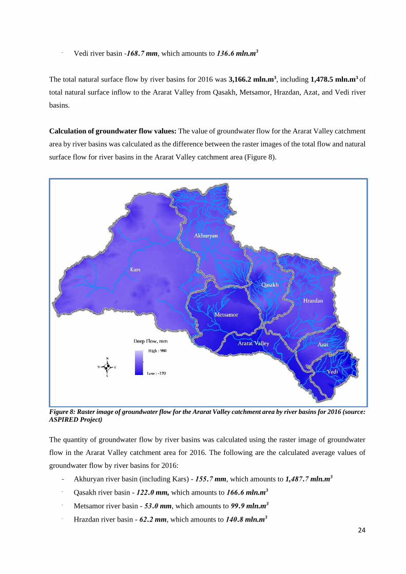
Calculation of groundwater flow values: The value of groundwater flow for the Ararat Valley catchment
area by river basins was calculated as the difference between the raster images of the total flow and natural
surface flow for river basins in the Ararat Valley catchment area (Figure 8).
Figure 8: Raster image of groundwater flow for the Ararat Valley catchment area by river basins for 2016 (source:
ASPIRED Project)
The quantity of groundwater flow by river basins was calculated using the raster image of groundwater
flow in the Ararat Valley catchment area for 2016. The following are the calculated average values of
groundwater flow by river basins for 2016:
- Akhuryan river basin (including Kars) - 155․7 mm, which amounts to 1,487․7 mln.m3
- Qasakh river basin - 122․0 mm, which amounts to 166․6 mln.m3
- Metsamor river basin - 53․0 mm, which amounts to 99․9 mln.m3
- Hrazdan river basin - 62․2 mm, which amounts to 140․8 mln.m3
25
- Azat river basin - 34․7 mm, which amounts to 26․2 mln.m3
- Vedi river basin - 13․0 mm, which amounts to 10․5 mln.m3
The value of groundwater flow by river basins for 2016 was estimated at 1,731.9 mln.m3. This value is
the quantity of groundwater flowing into the Ararat Valley (inflow).
The components of water balance of the Ararat Valley catchment area by river basins for 2016 (for the
sections of river basins that are outside the Ararat Valley) are summarized below.
Table 2: Components of water balance of the Ararat Valley catchment area by river basins for 2016, mln.m3
River basin
Input Output
Precipitation Evapotranspiration Surface
flow
Groundwater
flow
Akhuryan (including Kars) 6,076․9 2,901․5 1,687․7 1,487․7
Qasakh 858․9 402․1 290․2 166․6
Metsamor 841․9 626․8 315․0 -99․9
Hrazdan 1,418․2 695․6 581․8 140․8
Azat 413․0 231․9 154․9 26․2
Vedi 405․1 258․0 136․6 10․5
3.2 MULTIANNUAL AVERAGE WATER BALANCE OF THE ARARAT VALLEY
CATCHMENT AREA BY RIVER BASINS
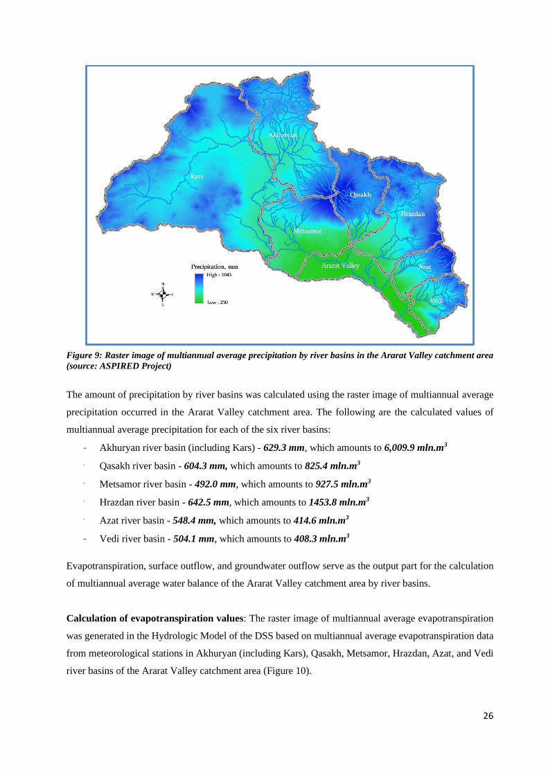
Calculation of precipitation values: The raster image of multiannual average precipitation was generated
in the Hydrologic Model of the DSS, based on multiannual average precipitation data from meteorological
stations in Akhuryan (including Kars), Qasakh, Metsamor, Hrazdan, Azat, and Vedi river basins of the
Ararat Valley catchment area (Figure 9).
26
Figure 9: Raster image of multiannual average precipitation by river basins in the Ararat Valley catchment area
(source: ASPIRED Project)
The amount of precipitation by river basins was calculated using the raster image of multiannual average
precipitation occurred in the Ararat Valley catchment area. The following are the calculated values of
multiannual average precipitation for each of the six river basins:
- Akhuryan river basin (including Kars) - 629.3 mm, which amounts to 6,009.9 mln.m3
- Qasakh river basin - 604.3 mm, which amounts to 825.4 mln.m3
- Metsamor river basin - 492.0 mm, which amounts to 927.5 mln.m3
- Hrazdan river basin - 642.5 mm, which amounts to 1453.8 mln.m3
- Azat river basin - 548.4 mm, which amounts to 414.6 mln.m3
- Vedi river basin - 504.1 mm, which amounts to 408.3 mln.m3
Evapotranspiration, surface outflow, and groundwater outflow serve as the output part for the calculation
of multiannual average water balance of the Ararat Valley catchment area by river basins.
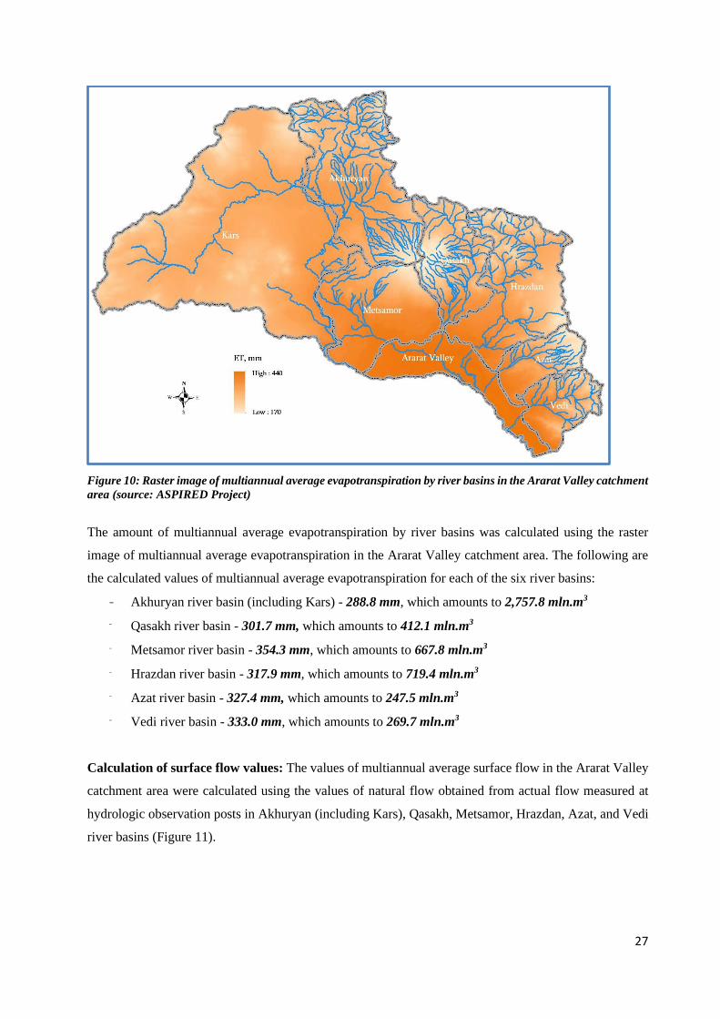
Calculation of evapotranspiration values: The raster image of multiannual average evapotranspiration
was generated in the Hydrologic Model of the DSS based on multiannual average evapotranspiration data
from meteorological stations in Akhuryan (including Kars), Qasakh, Metsamor, Hrazdan, Azat, and Vedi
river basins of the Ararat Valley catchment area (Figure 10).
27
Figure 10: Raster image of multiannual average evapotranspiration by river basins in the Ararat Valley catchment
area (source: ASPIRED Project)
The amount of multiannual average evapotranspiration by river basins was calculated using the raster
image of multiannual average evapotranspiration in the Ararat Valley catchment area. The following are
the calculated values of multiannual average evapotranspiration for each of the six river basins:
- Akhuryan river basin (including Kars) - 288.8 mm, which amounts to 2,757.8 mln.m3
- Qasakh river basin - 301.7 mm, which amounts to 412.1 mln.m3
- Metsamor river basin - 354.3 mm, which amounts to 667.8 mln.m3
- Hrazdan river basin - 317.9 mm, which amounts to 719.4 mln.m3
- Azat river basin - 327.4 mm, which amounts to 247.5 mln.m3
- Vedi river basin - 333.0 mm, which amounts to 269.7 mln.m3
Calculation of surface flow values: The values of multiannual average surface flow in the Ararat Valley
catchment area were calculated using the values of natural flow obtained from actual flow measured at
hydrologic observation posts in Akhuryan (including Kars), Qasakh, Metsamor, Hrazdan, Azat, and Vedi
river basins (Figure 11).

28
Figure 11: Raster image of multiannual average surface flow by river basins in the Ararat Valley catchment area
(source: ASPIRED Project)
The ASPIRED team used the raster image of multiannual average surface flow in the Ararat Valley
catchment area to calculate the following multiannual average surface flow by river basin:
- Akhuryan river basin (including Kars) - 171.8 mm, which amounts to 1,640.7 mln.m3
- Qasakh river basin - 195.3 mm, which amounts to 266.8 mln.m3
- Metsamor river basin - 309.2 mm, which amounts to 582.9 mln.m3
- Hrazdan river basin - 266.4 mm, which amounts to 602.8 mln.m3
- Azat river basin - 167.0 mm, which amounts to 126.2 mln.m3
- Vedi river basin - 130.4 mm, which amounts to 105.6 mln.m3
The multiannual average value of total natural surface flow by river basins (for the sections of river basins
that are outside the Ararat Valley) was calculated at 3,324.9 mln.m3.
Calculation of groundwater flow values: The value of groundwater flow in the Ararat Valley catchment
area by river basins was calculated by the difference between the raster images of total flow and natural
surface flow in river basins of the Ararat Valley catchment area (Figure 12).
29
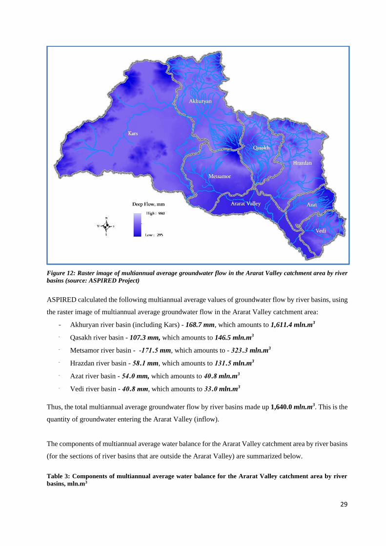
Figure 12: Raster image of multiannual average groundwater flow in the Ararat Valley catchment area by river
basins (source: ASPIRED Project)
ASPIRED calculated the following multiannual average values of groundwater flow by river basins, using
the raster image of multiannual average groundwater flow in the Ararat Valley catchment area:
- Akhuryan river basin (including Kars) - 168.7 mm, which amounts to 1,611.4 mln.m3
- Qasakh river basin - 107.3 mm, which amounts to 146.5 mln.m3
- Metsamor river basin - -171․5 mm, which amounts to - 323․3 mln.m3
- Hrazdan river basin - 58․1 mm, which amounts to 131․5 mln.m3
- Azat river basin - 54․0 mm, which amounts to 40․8 mln.m3
- Vedi river basin - 40․8 mm, which amounts to 33․0 mln.m3
Thus, the total multiannual average groundwater flow by river basins made up 1,640.0 mln.m3. This is the
quantity of groundwater entering the Ararat Valley (inflow).
The components of multiannual average water balance for the Ararat Valley catchment area by river basins
(for the sections of river basins that are outside the Ararat Valley) are summarized below.
Table 3: Components of multiannual average water balance for the Ararat Valley catchment area by river
basins, mln.m3
30
River basin
Input Output
Precipitation Evapotranspiration Surface
flow
Groundwater
flow
Akhuryan (including Kars) 6,009․9 2,757․8 1,640․7 1,611․4
Qasakh 825․4 412․1 266․8 146․5
Metsamor 927․5 667․1 582․9 -323․3
Hrazdan 1,453․8 719․4 602․2 131․5
Azat 414․6 247․5 126․2 40,8
Vedi 408․3 269․7 105․6 33
3.3 WATER BALANCE OF THE ARARAT VALLEY FOR 2016
Inflow parameters
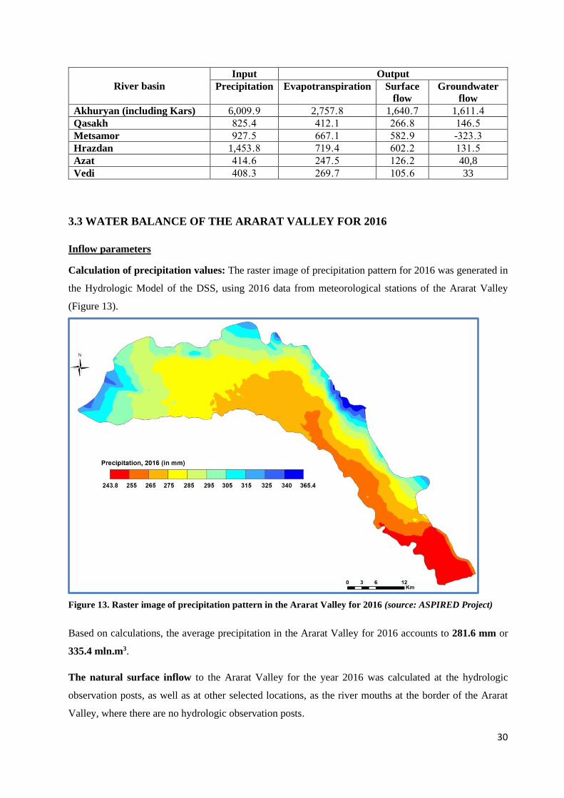
Calculation of precipitation values: The raster image of precipitation pattern for 2016 was generated in
the Hydrologic Model of the DSS, using 2016 data from meteorological stations of the Ararat Valley
(Figure 13).
Figure 13. Raster image of precipitation pattern in the Ararat Valley for 2016 (source: ASPIRED Project)
Based on calculations, the average precipitation in the Ararat Valley for 2016 accounts to 281.6 mm or
335.4 mln.m3.
The natural surface inflow to the Ararat Valley for the year 2016 was calculated at the hydrologic
observation posts, as well as at other selected locations, as the river mouths at the border of the Ararat
Valley, where there are no hydrologic observation posts.
31
The ASPIRED team obtained the following values:
• Sevjur-Taronik: 314.99 mln. m3,
• Kasakh-River mouth: 290.23 mln. m3,
• Hrazdan-Yerevan: 581.82 mln. m3,
• Azat-Lanjazat: 154.86 mln. m3
• Vedi-Vedi: 136.61 mln. m3
The total natural surface inflow to the Ararat Valley for 2016 was 1,478.5 mln m3.
Groundwater inflow. The value of the groundwater inflow to the Ararat Valley was calculated using the
raster image of the total natural flow of the Ararat Valley catchment area and the value of the natural
surface flow entering the territory of the Ararat Valley. The ASPIRED team used the ArcGIS spatial
analysis tools, including raster calculation function, for the calculations. As a result, the volume of
groundwater inflow to the Ararat Valley for 2016 constituted 1,731.9 mln. m3.
Outflow parameters (the right side of the water balance equation) represent:
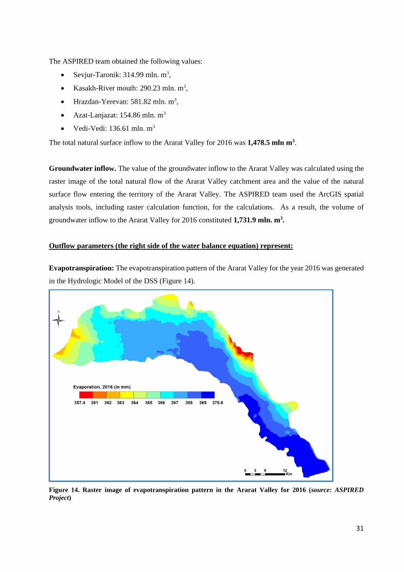
Evapotranspiration: The evapotranspiration pattern of the Ararat Valley for the year 2016 was generated
in the Hydrologic Model of the DSS (Figure 14).
Figure 14. Raster image of evapotranspiration pattern in the Ararat Valley for 2016 (source: ASPIRED
Project)
32
The average evapotranspiration in the Ararat Valley for 2016 comprised 367.1 mm, which amounts to
436.5mln. m3.
The natural surface outflow from the Ararat Valley for 2016 was calculated using the values measured
at the hydrologic observation posts, as well as at the selected river mouths at the border of the Ararat
Valley, where there are no hydrologic observation posts.
The following values were obtained:
• Sevjur-Ranchpar: 751.40 mln. m3,
• Hrazdan-Masis: 708.01 mln. m3,
• Azat-River mouth: 160.16 mln. m3,
• Vedi-River mouth: 138.72 mln. m3.
The total natural surface outflow in the Ararat Valley catchment area is 1,758.3 mln. m3. The values of
the surface runoff in the areas located between the river basins are also added up in the calculation of the
total surface outflow from the Ararat Valley, equaling 6.9 mln. m3. Thus, the total natural surface outflow
from the Ararat Valley was 1,765.2mln. m3.
Groundwater outflow. The groundwater outflow from the Ararat Valley occurs from the south-eastern
section of the left-bank part of the Valley. The flow occurs along the isopiestic line at an elevation of 810
m, in the section between Shahumyan and Yeraskh villages. The length (L) of the mentioned section is 38
km. According to the isopiestic map of the Ararat Valley, the hydraulic slope (I) varies from 0.002-0.005
and the average value is 0.003 in this section. Aquifers are represented by lacustrine-fluvial formations. In
the section from Shahumyan to Yeraskh, the average depth of the representative groundwater wells is
149.1 m. The value of filtration coefficient (Kf) varies between 13.2-48.1 m/day, with an average of 30.6
m/day [6].
The Darcy’s equation is used for calculating the groundwater outflow from the Ararat Valley:
𝑸 = 𝑲𝒇 ∗ 𝑭 ∗ 𝑰, where the following values are applied:
Kf: mean filtration coefficient of water-bearing rocks = 30.6 m/day
I: hydraulic gradient of groundwater movement = 0.003
F: groundwater flow section equaling to F = m ∗ L, where
M is the thickness of the aquifer and is equal to 149.1 m, and
L is the groundwater flow length at the hydroisopies on altitude of 810 m and equals to 38,000 m.
Thus, F = 38,000 m * 149.1 m = 5,665,800 m2
and Q=30.6 x 5,665,800 x 0.003 = 520,120.44 m3/day or 6.02 m3/sec
This is equivalent to the volume of 189.9 mln. m3 for the entire year.
Therefore, the annual groundwater outflow from the Ararat Valley in 2016 was equal to 189.9 mln. m3.
33
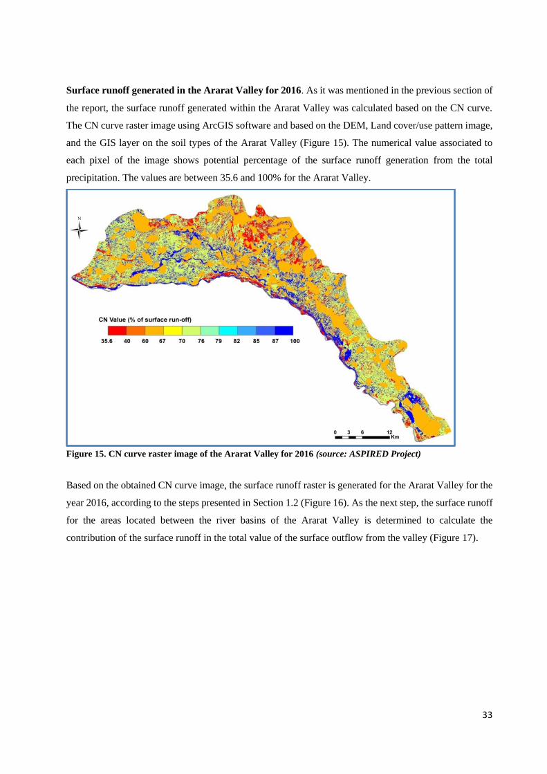
Surface runoff generated in the Ararat Valley for 2016. As it was mentioned in the previous section of
the report, the surface runoff generated within the Ararat Valley was calculated based on the CN curve.
The CN curve raster image using ArcGIS software and based on the DEM, Land cover/use pattern image,
and the GIS layer on the soil types of the Ararat Valley (Figure 15). The numerical value associated to
each pixel of the image shows potential percentage of the surface runoff generation from the total
precipitation. The values are between 35.6 and 100% for the Ararat Valley.
Figure 15. CN curve raster image of the Ararat Valley for 2016 (source: ASPIRED Project)
Based on the obtained CN curve image, the surface runoff raster is generated for the Ararat Valley for the
year 2016, according to the steps presented in Section 1.2 (Figure 16). As the next step, the surface runoff
for the areas located between the river basins of the Ararat Valley is determined to calculate the
contribution of the surface runoff in the total value of the surface outflow from the valley (Figure 17).
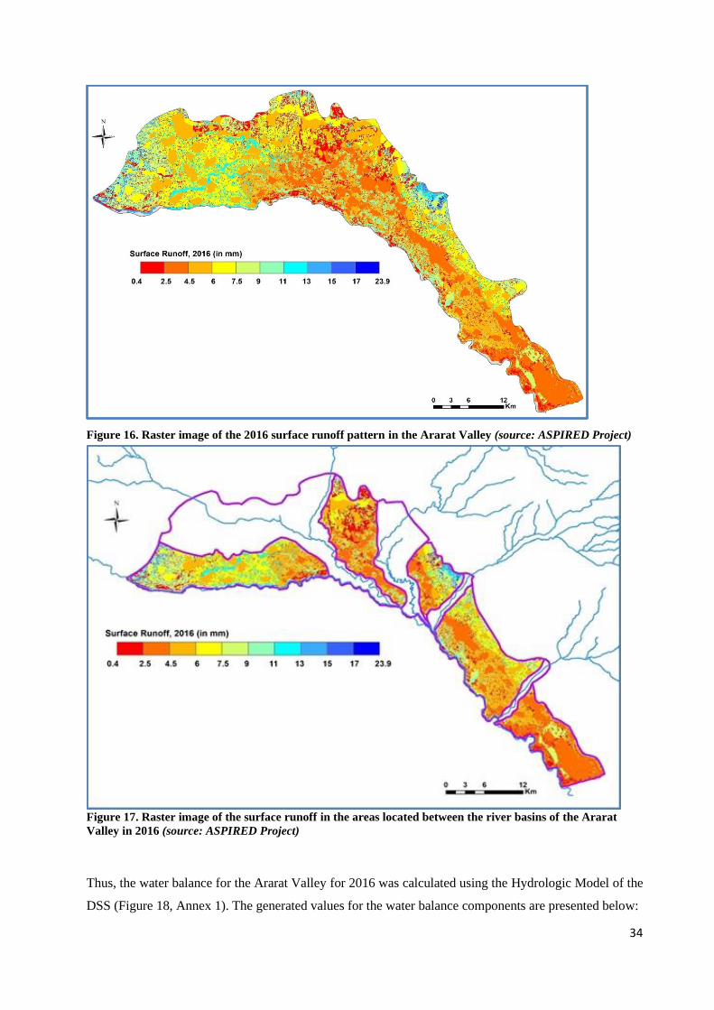
34
Figure 16. Raster image of the 2016 surface runoff pattern in the Ararat Valley (source: ASPIRED Project)
Figure 17. Raster image of the surface runoff in the areas located between the river basins of the Ararat
Valley in 2016 (source: ASPIRED Project)
Thus, the water balance for the Ararat Valley for 2016 was calculated using the Hydrologic Model of the
DSS (Figure 18, Annex 1). The generated values for the water balance components are presented below:
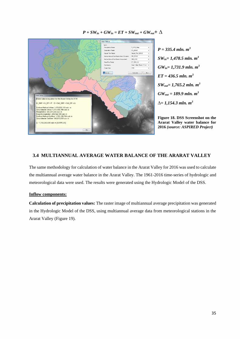
35
P + SWin + GWin = ET + SWout + GWout+ ∆
P = 335.4 mln. m3
SWin= 1,478.5 mln. m3
GWin= 1,731.9 mln. m3
ET = 436.5 mln. m3
SWout= 1,765.2 mln. m3
GWout = 189.9 mln. m3
∆= 1,154.3 mln. m3
Figure 18. DSS Screenshot on the
Ararat Valley water balance for
2016 (source: ASPIRED Project)
3.4 MULTIANNUAL AVERAGE WATER BALANCE OF THE ARARAT VALLEY
The same methodology for calculation of water balance in the Ararat Valley for 2016 was used to calculate
the multiannual average water balance in the Ararat Valley. The 1961-2016 time-series of hydrologic and
meteorological data were used. The results were generated using the Hydrologic Model of the DSS.
Inflow components:
Calculation of precipitation values: The raster image of multiannual average precipitation was generated
in the Hydrologic Model of the DSS, using multiannual average data from meteorological stations in the
Ararat Valley (Figure 19).
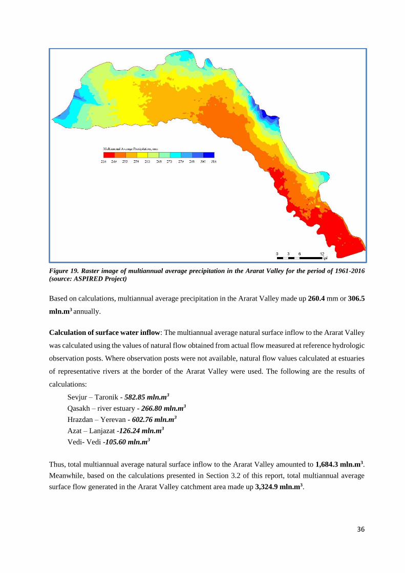
36
Figure 19. Raster image of multiannual average precipitation in the Ararat Valley for the period of 1961-2016
(source: ASPIRED Project)
Based on calculations, multiannual average precipitation in the Ararat Valley made up 260.4 mm or 306.5
mln.m3 annually.
Calculation of surface water inflow: The multiannual average natural surface inflow to the Ararat Valley
was calculated using the values of natural flow obtained from actual flow measured at reference hydrologic
observation posts. Where observation posts were not available, natural flow values calculated at estuaries
of representative rivers at the border of the Ararat Valley were used. The following are the results of
calculations:
Sevjur – Taronik - 582.85 mln.m3
Qasakh – river estuary - 266.80 mln.m3
Hrazdan – Yerevan - 602.76 mln.m3
Azat – Lanjazat -126.24 mln.m3
Vedi- Vedi -105.60 mln.m3
Thus, total multiannual average natural surface inflow to the Ararat Valley amounted to 1,684.3 mln.m3.
Meanwhile, based on the calculations presented in Section 3.2 of this report, total multiannual average
surface flow generated in the Ararat Valley catchment area made up 3,324.9 mln.m3.
37
Calculation of groundwater inflow values: The value of groundwater inflow to the Ararat Valley was
calculated by subtracting the value of natural surface inflow to the Ararat Valley from the raster image of
the total natural flow for the Ararat Valley catchment area, based on the formula GWin = Y - SWin. Spatial
analysis tools, particularly the raster calculation function within the ArcGIS interface were applied for
calculation. As a result, the total multiannual average groundwater inflow to the Ararat Valley amounted
to 1,640.0 mln.m3.
Outflow components
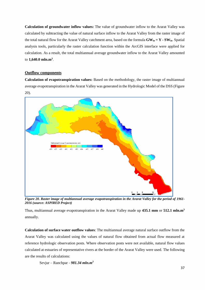
Calculation of evapotranspiration values: Based on the methodology, the raster image of multiannual
average evapotranspiration in the Ararat Valley was generated in the Hydrologic Model of the DSS (Figure
20).
Figure 20. Raster image of multiannual average evapotranspiration in the Ararat Valley for the period of 1961-
2016 (source: ASPIRED Project)
Thus, multiannual average evapotranspiration in the Ararat Valley made up 435.1 mm or 512.1 mln.m3
annually.
Calculation of surface water outflow values: The multiannual average natural surface outflow from the
Ararat Valley was calculated using the values of natural flow obtained from actual flow measured at
reference hydrologic observation posts. Where observation posts were not available, natural flow values
calculated at estuaries of representative rivers at the border of the Ararat Valley were used. The following
are the results of calculations:
Sevjur – Ranchpar - 981.34 mln.m3
38
Hrazdan – Masis - 712.15 mln.m3
Azat – river estuary - 134.22 mln.m3
Vedi – river estuary - 106.51 mln.m3
The cumulative natural outflow from the Ararat Valley amounted to 1,934.2 mln.m3. Surface runoff
generated between the river basins (approximately 4.0 mln.m3) was also added to the calculation of the
total surface outflow from the Ararat Valley. Thus, the total natural surface outflow from the Ararat Valley
was estimated at 1,938.2 mln.m3.
Groundwater outflow: Following the logic of calculation done for 2016, multiannual average annual
groundwater outflow from the Ararat Valley was estimated at 189.9 mln.m3.
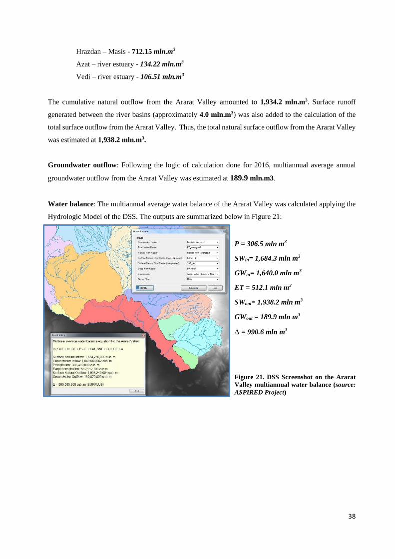
Water balance: The multiannual average water balance of the Ararat Valley was calculated applying the
Hydrologic Model of the DSS. The outputs are summarized below in Figure 21:
P = 306.5 mln m3
SWin= 1,684.3 mln m3
GWin= 1,640.0 mln m3
ET = 512.1 mln m3
SWout= 1,938.2 mln m3
GWout = 189.9 mln m3
∆ = 990.6 mln m3
Figure 21. DSS Screenshot on the Ararat
Valley multiannual water balance (source:
ASPIRED Project)
39
4. NEXT STEPS
The calculation of the water balance for the Ararat Valley is the initial step for completing comprehensive
hydrologic and hydrogeologic analyses for the Ararat Valley, implemented under the framework of
ASPIRED Project. The water balance that describes the hydrologic system of the Ararat Valley in natural
conditions is input data for the next stages of the analysis:
• Constructing a numeric groundwater flow model of the Ararat Valley groundwater basin;
• Determining Water Supply and Demand Balance for 2016.
The overall purpose of these comprehensive analyses is determining the values of groundwater reserve,
recharge rates and changes in groundwater reserve conditioned by groundwater use in the Ararat Valley,
and sustainable rate of groundwater use. In addition to this, the water supply and demand balance will
provide data on surface water resources of the Ararat Valley, including the surface water surplus or deficit,
in terms of use of surface water resources versus the resource availability.
Constructing the numeric groundwater flow model of the Ararat Valley groundwater basin
The ASPIRED team is currently implementing this activity using the ArcGIS AHGW extension, as well
as the GMS package with MODFLOW tools. The model construction process involves the following
consecutive steps:
• Construction of a three-dimensional (3-D) structure of the Ararat Valley groundwater basin,
using hydrogeologic data of wells located in the Ararat Valley.
• Determination of the total volumes of the main hydrogeologic units
Results of these two activities, including the hydrogeologic map of the Ararat Valley are presented in
the Project report.
• Determination of the potential volumes of water in the main hydrogeologic units
• Determination of deep flows entering the groundwater basin (recharge)
• Determination of groundwater flow directions
Determining Water Supply and Demand Balance for 2016
The water supply and demand balance of the Ararat Valley is expressed by the following equation:
P + SWin + GWin + Ya = ET + SWout + GWout + Yb + ΔS, where
P = precipitation
SWin = surface water inflow
GWin= groundwater inflow
Ya= water return according to the issued water use permits
ET = evapotranspiration
SWout = surface water outflow
GWout = groundwater outflow
Yb = water abstraction according to the issued water use permits
ΔS = changes in the volumes of groundwater and surface water in the Ararat Valley.
40
ANNEX 1. CALCULATION OF THE ARARAT VALLEY WATER BALANCE
USING DSS
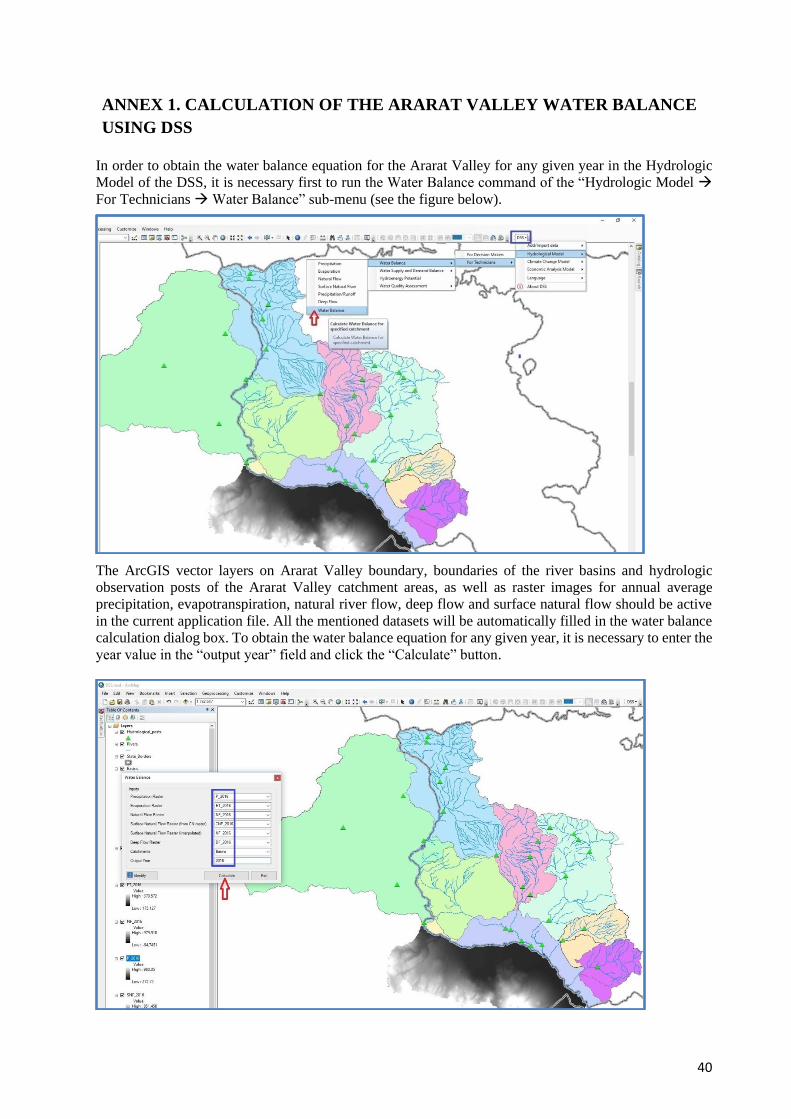
In order to obtain the water balance equation for the Ararat Valley for any given year in the Hydrologic
Model of the DSS, it is necessary first to run the Water Balance command of the “Hydrologic Model →
For Technicians → Water Balance” sub-menu (see the figure below).
The ArcGIS vector layers on Ararat Valley boundary, boundaries of the river basins and hydrologic
observation posts of the Ararat Valley catchment areas, as well as raster images for annual average
precipitation, evapotranspiration, natural river flow, deep flow and surface natural flow should be active
in the current application file. All the mentioned datasets will be automatically filled in the water balance
calculation dialog box. To obtain the water balance equation for any given year, it is necessary to enter the
year value in the “output year” field and click the “Calculate” button.
41
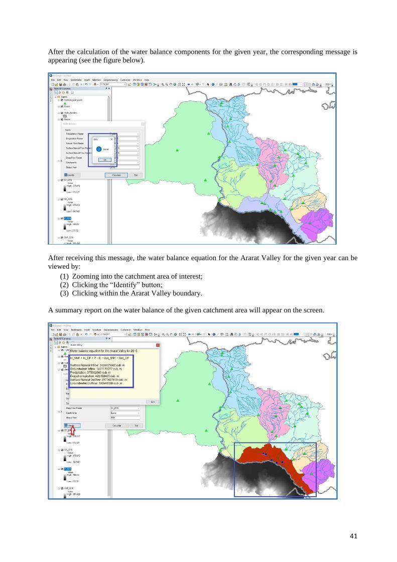
After the calculation of the water balance components for the given year, the corresponding message is
appearing (see the figure below).
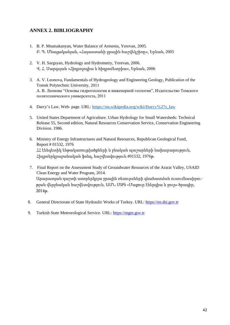
After receiving this message, the water balance equation for the Ararat Valley for the given year can be
viewed by:
(1) Zooming into the catchment area of interest;
(2) Clicking the “Identify” button;
(3) Clicking within the Ararat Valley boundary.
A summary report on the water balance of the given catchment area will appear on the screen.
42
ANNEX 2. BIBLIOGRAPHY
1. B. P. Mnatsakanyan, Water Balance of Armenia, Yerevan, 2005.
Բ. Պ. Մնացականյան, «Հայաստանի ջրային հաշվեկշիռը», Երևան, 2005
2. V. H. Sargsyan, Hydrology and Hydrometry, Yerevan, 2006.
Վ. Հ. Սարգսյան «Հիդրոլոգիա և հիդրոմետրիա», Երևան, 2006
3. A. V. Leonova, Fundamentals of Hydrogeology and Engineering Geology, Publication of the
Tomsk Polytechnic University, 2011
А. В. Леонова “Oсновы гидрогеологии и инженерной геологии”, Издательство Томского
политехнического университета, 2011
4. Darcy’s Law, Web- page. URL: https://en.wikipedia.org/wiki/Darcy%27s_law
5. United States Department of Agriculture. Urban Hydrology for Small Watersheds: Technical
Release 55, Second edition, Natural Resources Conservation Service, Conservation Engineering
Division. 1986.
6. Ministry of Energy Infrastructures and Natural Resources, Republican Geological Fund,
Report # 01532, 1976
ՀՀ էնեգետիկ ենթակառուցվածքների և բնական պաշարների նախարարություն,
Հիդրոերկրաբանական ֆոնդ, հաշվետվություն #01532, 1976թ.
7. Final Report on the Assessment Study of Groundwater Resources of the Ararat Valley, USAID
Clean Energy and Water Program, 2014.
Արարատյան դաշտի ստորերկրյա ջրային ռեսուրսների գնահատման ուսումնասիրու-
թյան վերջնական հաշվետվություն, ԱՄՆ ՄԶԳ «Մաքուր էներգիա և ջուր» ծրագիր,
2014թ.
8. General Directorate of State Hydraulic Works of Turkey. URL: https://en.dsi.gov.tr
9. Turkish State Meteorological Service. URL: https://mgm.gov.tr