Embed Size (px)
Citation preview
AVDLPPartIPartI
AYLESBURY VALEDISTRICT COUNCIL
Aylesbury Vale District Local PlanAylesbury Vale District Local Plan
Written Statement
Written Statement
JANUARY 2004JANUARY 2004
The Aylesbury Vale District Local Plan is published in two parts:
Part I - the Written Statement and Conservation Area map insets
- and Part II which comprises the Proposals Map.
The Written Statement and Proposals Map
should be read in conjunction with each other.
Part II contains 33 sheets to a scale of 1:20,000
covering the whole District
- where necessary insets to a larger scale
are included to show details clearly.
It includes insets for Aylesbury, Buckingham,
Haddenham, Wendover & Winslow on two loose sheets.
Norman Skedge
Director
Department of Environment and Planning
Friars Square Offices
4 Great Western Street
Aylesbury
Bucks HP20 2TW
J A N U A R Y 2 0 0 4
Tel: 01296 585439Fax: 01296 398665
Minicom: 01296 585055DX: 4130 Aylesbury
E-mail: [email protected]

AVDLPForeword
i
We live in times of constant change. This Development Plan, the mostimportant yet produced for our District, reflects - even anticipates - changein a way that earlier plans did not come close to doing. Yet the Council'scorporate mission - to make Aylesbury Vale the best possible place for peopleto live and work - remains a timeless guiding principle.
So comprehensive is this District Local Plan for Aylesbury Vale that it willaffect the lives of people over the next seven years to 2011. There are twomain themes: sustainability and accessibility.
Sustainability, in its purest sense, requires us to take no more from theenvironment than we put back. The Council has striven to minimiseconsumption of natural resources by looking carefully at the demandsdevelopment makes on land, air and water, and its impact on the naturaland historical environment. The Council has looked to development of'brownfield' land and the role of public transport as main priorities. It is amatter of regret that development of 'greenfield' land is inevitable. Regionaland county planning policies require Aylesbury Vale to accommodate growthgreater than that required by its existing population.
As regards accessibility, we have looked much further than just conventionaltransport considerations. Land use and development can disadvantagepeople already constrained by disability, remote location, or poverty. ThisPlan is one of a variety of measures the Council is using to redress theserious issue of social exclusion.
Indeed, we seek to facilitate access to the planning process itself. Throughextensive publicity and public consultation during the course of preparationof this Plan, the Council has sought to ensure that those who wished to doso had the opportunity, information and means to participate in shaping thepolicies and proposals.
To all those who have contributed their ideas and opinions to the making ofthis Plan, thank you for your help.
FOREWORD
Aylesbury Vale District Local Plan January 2004
Councillor Hedley Cadd
Chairman of Council
Councillor Mrs Carole Paternoster
Cabinet Member for Planned Development

AVDLP
iiAylesbury Vale District Local Plan January 2004

AVDLPContents
iii
i Foreword
iii Contents
xi List of Proposals
1 SUMMARY
2 INTRODUCTION3 AYLESBURY VALE DISTRICT
4 AYLESBURY VALE DISTRICT LOCAL PLAN
4 FORMAT AND STATUS
5 STRUCTURE OF AVDLP
5 SUPPLEMENTARY PLANNING GUIDANCE (SPG)
5 PUBLIC PARTICIPATION
6 THE WIDER CONTEXT
6 Global
6 European
6 National
8 Regional and County
9 AYLESBURY VALE DISTRICT COUNCIL’S MISSION STATEMENT AND KEY AIMS
3 STRATEGY11 AIMS AND OBJECTIVES
11 Mission Statement
11 Environmental Objective
11 Social Objective
11 Economic Objective
12 COUNTY STRUCTURE PLAN DEVELOPMENT REQUIREMENTS
13 INTEGRATED TRANSPORT STRATEGY
CONTENTS
Aylesbury Vale District Local Plan January 2004

AVDLPContents
ivAylesbury Vale District Local Plan January 2004
13 DEVELOPMENT STRATEGY
13 General Location of Development
14 AVDLP Housing Requirement
16 Aylesbury Development Strategy
17 Rural Areas Development Stategy
18 FUNDING AND IMPLEMENTATION
4 GENERAL POLICIES19 HOUSING
19 A Choice of Dwelling Types
20 Affordable Housing and Low Cost Market Housing
20 Affordable Housing
21 Low Cost Market Housing
22 Affordable Housing for Local Needs in Rural Areas
24 Existing Dwellings
24 Maintenance of Housing Stock
24 Conversion of Dwellings
25 Changes of Use of Residential Accommodation
25 Protection of Amenity of Residents
26 Extension of Dwellings and Annexes
27 Mobile Homes/Residential Caravans/Residential Moorings
28 Gypsies
29 Travelling Show People
30 EMPLOYMENT
30 Introduction
31 Employment Growth and Strategic Land Requirements
32 Existing Employment Sites
33 Employment Site Development Densities
34 Working from Home
34 TRANSPORT
34 Introduction
35 Traffic in Towns and the Rural Areas
35 New Development
37 Car Parking Guidelines
37 Public Transport
37 Buses
38 Rail
39 Taxi Services
39 Walking and Cycling
41 Roads
41 Motorways and Trunk Roads
i

AVDLPContents
v
41 County Roads
42 Other Road Schemes
42 Roadside Services
43 SHOPPING
45 DESIGN AND ACCESS FOR PEOPLE WITH DISABILITIES
46 CONSERVATION OF THE BUILT ENVIRONMENT
47 Design Principles for New Development
48 Siting and Layout
48 Scale
49 Materials and Design Details
49 Development Density
51 Landscape Design
51 Hard Landscape Features
52 Planting and Soft Landscaping
52 Existing Vegetation
53 Black Poplars
53 Lighting
54 Advertisements
55 Safe and Secure Development
56 Supplementary Planning Guidance
56 Listed Buildings and Other Structures
57 Changes of Use
57 Alterations and Extensions
58 Demolition
58 Setting and Long Distance Views
59 Conservation Areas
59 New Development
60 Demolition
61 Trees
61 Advertisements
62 Archaeology and Ancient Monuments
63 Historic Parks and Gardens
64 CONSERVATION OF THE NATURAL ENVIRONMENT
64 Sites of Acknowledged Nature Conservation Value
65 Amenity Potential of Safeguarded Sites
65 Wildlife and Habitats
66 The Protection of Rivers and Surface Water
66 Flooding and Surface Water Management
67 Source Control
68 Ground Water Protection
68 TOURISM
68 Introduction
Aylesbury Vale District Local Plan January 2004

AVDLPContents
viAylesbury Vale District Local Plan January 2004
69 Serviced Accommodation
69 Hotels and Motels
70 Bed and Breakfast/Guest Houses
71 Self-Catering Holiday Cottages
71 Camping and Caravaning
72 Existing Tourist Attractions
73 RECREATION AND LEISURE
73 Introduction
73 Water-Based Recreation
74 Horse-Related Development
75 Noisy Sport and Recreation
76 Canalside Development
77 Picnic Areas
77 Footpaths
78 Bridleways
79 Cycling
79 Open Space
80 Protection of Existing Open Space
81 Play Space Provision for New Residential Development
81 Outdoor Play Space
83 Funds Provided in Lieu of Outdoor Play Space
84 Access, Location and Design of Outdoor Playing Space
84 Provision of Indoor Facilities
85 Provision of Amenity Areas
86 Allotments
86 COMMUNITY FACILITIES AND SERVICES
87 OTHER MATTERS
87 Unneighbourly Uses
88 Noise-Sensitive Uses
89 Overhead Electricity Lines
89 In the Countryside
90 In Towns and Villages and Affecting New Development
90 New Development in Proximity to Existing Overhead Lines
91 Telecommunications
92 Hazardous Installations
93 Contaminated Sites
5 AYLESBURY95 INTRODUCTION
95 AYLESBURY LAND USE/TRANSPORT STRATEGY

AVDLPContents
vii
98 Implementation
101 Phasing
102 HOUSING
102 Brownfield/Reallocated Housing Sites
104 Mixed Use Schemes (Category A)
104 Tring Road (former BPCC factory)
105 Stoke Mandeville Hospital
106 Bearbrook House, Oxford Road
108 Territorial Army Centre, Oxford Road
109 Ardenham Lane
110 Car Showroom, Park Street
111 General Brownfield Policy (Category B)
112 Reallocated Sites
113 MAJOR DEVELOPMENT AREAS
113 Introduction
115 Berryfields
117 Weedon Hill
119 Aston Clinton Road
120 EMPLOYMENT
121 Other Employment Sites
121 TRANSPORT
121 Public Transport
122 Buses
123 Rail
125 Cycling
126 Walking
126 Parking
128 Park-and-Ride
129 Highway Network and Proposals
129 TOWN CENTRE
129 Introduction
130 A Place to Shop
131 New Floorspace Requirements
131 Town Centre Comparison Goods
133 Retail Warehousing
134 Food Retailing
135 Primary Shopping Frontages and Central Shopping Area
137 A Place to Live and Work
139 A Place of Leisure
140 TOWNSCAPE DESIGN AND ENVIRONMENT
140 Aylesbury Country Park
Aylesbury Vale District Local Plan January 2004

AVDLPContents
viiiAylesbury Vale District Local Plan January 2004
6 BUCKINGHAM141 INTRODUCTION
141 HOUSING
144 EMPLOYMENT
145 SHOPPING
146 TOWN CENTRE
150 CAR PARKING
150 TRANSPORT
152 TOWNSCAPE AND DESIGN
152 RIVERSIDE AMENITY FACILITIES
7 WENDOVER155 INTRODUCTION
155 HOUSING AND EMPLOYMENT
158 SHOPPING
159 CAR PARKING
159 TRANSPORT
160 TOWNSCAPE AND ENVIRONMENT
8 HADDENHAM161 INTRODUCTION
161 HOUSING
161 EMPLOYMENT
163 SHOPPING
163 TRANSPORT
9 WINSLOW165 INTRODUCTION
165 HOUSING
167 EMPLOYMENT
168 SHOPPING
168 CAR PARKING
169 TRANSPORT
169 TOWNSCAPE AND ENVIRONMENT
10 RURAL AREAS171 INTRODUCTION AND STRATEGY
171 THE COUNTRYSIDE
172 Coalescence of Settlements

AVDLPContents
ix
173 Curtilage Extensions
173 Countryside Recreation
174 Golf Courses
175 METROPOLITAN GREEN BELT
175 Control of Development Within the Metropolitan Green Belt
176 SPECIAL LANDSCAPE AREAS
176 The Chilterns Area of Outstanding Natural Beauty
177 Other Important Landscapes
178 AGRICULTURE AND FORESTRY
178 Agricultural Land
179 Agricultural Buildings
180 RE-USE OF BUILDINGS IN THE COUNTRYSIDE
182 HOUSING
183 At Settlements Outside the Metropolitan Green Belt
185 In the Countryside
185 In the Metropolitan Green Belt186 Replacement Dwellings in the Metropolitan Green
Belt and Special Landscape Areas186 Extensions to Dwellings in the Metropolitan Green
Belt and Special Landscape Areas187 Dwellings for Agricultural or Forestry Workers
187 Permanent Dwellings
188 Occupancy Conditions
189 Temporary Accommodation
189 Dwellings for Horse-Related Development
190 OTHER MAJOR DEVELOPMENT SITES
190 Calvert
192 Pitstone
194 EMPLOYMENT
194 Development in Settlements
194 Employment in the Countryside
196 Silverstone Motor Racing Circuit
197 Westcott
199 Newton Longville
200 TRANSPORT
Appendices
201 1 Environmental, Social and Economic Test Criteria
202 2 Summary of Minimum Children’s Playing Space Standard
203 3 Summary of NPFA Minimum Standards for Outdoor Playing Space
204 4 Settlements Where Proposals RA.13 - RA.14 Apply
205 5 Areas of Attractive Landscape and Local Landscape Areas
Aylesbury Vale District Local Plan January 2004
AVDLPContents
xAylesbury Vale District Local Plan January 2004
Conservation Area Maps
CA i Conservation Area Maps Index
ACKNOWLEDGEMENTS
Photographs on pages 155 and 161 are from the Charles Crisp Photography -Image Library.
Photograph on page 40 is from the Environmental Services Library atBuckinghamshire County Council.
This document has been printed by JWL Limited.
Produced by the Forward Plans Group
© Aylesbury Vale District Council

AVDLPList of Proposals
xi
3 STRATEGY
DEVELOPMENT STRATEGY14 ST.1 Distribution of new housing and employment development
4 GENERAL POLICIES
HOUSING
19 GP.1 Housing size mix
21 GP.2 Affordable housing
22 GP.3 Low cost market housing
24 GP.4 Affordable housing on small sites for local needs
24 GP.5 Maintenance of housing stock
25 GP.6 Conversion or subdivision of existing dwellings
25 GP.7 Changes of use of residential accommodation
26 GP.8 Protection of the amenity of residents
26 GP.9 Extensions of dwellings
27 GP.10 Annexes to dwellings in settlements
27 GP.11 Annexes to dwellings in the countryside
27 GP.12 Permanent residential caravans/mobile homes
27 GP.13 Temporary residential caravans/mobile homes
28 GP.14 Gypsy caravan sites
29 GP.15 Travelling show people
EMPLOYMENT
32 GP.16 Close correlation between homes and jobs
33 GP.17 Retention in use of existing employment sites
33 GP.18 New unneighbourly development proposals
34 GP.19 Employment site development densities
TRANSPORT
35 GP.20 Key transport considerations
36 GP.21 Transport considerations for all new development
36 GP.22 Contributions towards programmed transport proposals
36 GP.23 Parking courts for residential developments
37 GP.24 Car parking guidelines
39 GP.25 Re-opening of rail routes
LIST OF PROPOSALS
Aylesbury Vale District Local Plan January 2004

AVDLPList of Proposals
xiiAylesbury Vale District Local Plan January 2004
39 GP.26 Safeguarded station sites
40 GP.27 Improved provision for cyclists
40 GP.28 Pedestrian safety and mobility
42 GP.29 Standard, design and landscaping of new roads
42 GP.30 Safeguarded road schemes
SHOPPING
45 GP.31 Retail development considerations
45 GP.32 Retention of shops, public houses and post offices
DESIGN AND ACCESS FOR PEOPLE WITH DISABILITIES
46 GP.33 Access for people with disabilities
CONSERVATION OF THE BUILT ENVIRONMENT
48 GP.34 New development and local distinctiveness
49 GP.35 Design of new development proposals
51 GP.36 Efficient use of land
51 GP.37 Density of new development
52 GP.38 Landscaping of new development proposals
53 GP.39 Existing trees and hedgerows
53 GP.40 Retention of existing trees and hedgerows
54 GP.41 Minimising light pollution
55 GP.42 Design of advertisements
55 GP.43 Advertisements in Areas of Special Control
55 GP.44 Removal of unsafe or unattractive advertisements
56 GP.45 “Secured by Design” considerations
56 GP.46 Supplementary Planning Guidance
57 GP.47 Changes of Use to listed buildings
58 GP.48 Extensions and alterations to listed buildings
58 GP.49 Total demolition of listed buildings
58 GP.50 Partial demolition of listed buildings
58 GP.51 Setting of listed buildings
58 GP.52 Long distance views of churches and listed buildings
60 GP.53 New development in and adjacent to Conservation Areas
60 GP.54 Car parking and traffic generation in Conservation Areas
61 GP.55 Demolition in Conservation Areas
61 GP.56 Trees in Conservation Areas
62 GP.57 Advertisements in Conservation Areas
63 GP.58 Development and Scheduled Ancient Monuments
63 GP.59 Preservation of archaeological remains
63 GP.60 Development and Parks or Gardens of Special Historic Interest
CONSERVATION OF THE NATURAL ENVIRONMENT
65 GP.61 Development affecting sites of nature conservation importance
65 GP.62 Development affecting local nature conservation sites

AVDLPList of Proposals
xiii
65 GP.63 Proposed amenity use of nature conservation sites
66 GP.64 Safeguarding of protected wildlife and its habitats
66 GP.65 Development affecting the quantity and quality of water systems
66 GP.66 Access corridors and buffers adjacent to watercourses
67 GP.67 Development and the risk of flooding
68 GP.68 Risk to groundwater
TOURISM
70 GP.69 Hotel and motel development
70 GP.70 Changes of use of rural buildings andhistoric buildings to hotel use
70 GP.71 Bed and breakfast and guesthouse development
71 GP.72 Proposals for self-catering holiday accommodation and holiday homes
72 GP.73 Proposals for camping and touring caravan sites
RECREATION AND LEISURE
73 GP.74 Protection and provision of recreation and leisure facilities
74 GP.75 Loss of water-based recreational facilities
74 GP.76 Water recreation and wildlife protection
75 GP.77 Horse-related development
75 GP.78 Stables, loose boxes and other buildings for horses
76 GP.79 Proposals for noisy sports
76 GP.80 The Wendover Arm of the Grand Union Canal
77 GP.81 Development of canal-related facilities
77 GP.82 New picnic areas
77 GP.83 Facilities and buildings associated with picnic areas
78 GP.84 Public rights of way
80 GP.85 Safeguarding of existing open space
82 GP.86 Provision of outdoor playing space
83 GP.87 Application of open space policies
84 GP.88 Payment in lieu of providing sports and play areas
84 GP.89 Layout and landscaping of play space
85 GP.90 Provision of indoor sports facilities
86 GP.91 Provision of amenity areas
86 GP.92 Safeguarding of allotment land
COMMUNITY FACILITIES AND SERVICES
87 GP.93 Safeguarding of community buildings and facilities
87 GP.94 Provision of community facilities and services
OTHER MATTERS
88 GP.95 Unneighbourly uses
88 GP.96 Reduce/eliminate effects of unneighbourly uses
89 GP.97 Proposals for noisy development
Aylesbury Vale District Local Plan January 2004
AVDLPList of Proposals
xivAylesbury Vale District Local Plan January 2004
89 GP.98 Proposals for noise-sensitive development
90 GP.99 Development beneath overhead electricity lines
92 GP.100 Proposals for telecommunication development
92 GP.101 Hazardous installations/activities
93 GP.102 Development of contaminated sites
5 AYLESBURY
AYLESBURY LAND USE / TRANSPORT STRATEGY
98 AY.1 Considerations for traffic-generating proposals
101 AY.2 Additional financial contributions to the ALUT strategy
102 AY.3 Phasing of transport infrastructure
HOUSING
104 AY.4 Tring Road (former BPCC factory) site
106 AY.5 Stoke Mandeville Hospital site
107 AY.6 Bearbrook House site, Oxford Road
108 AY.7 TA Centre site, Oxford Road
109 AY.8 Ardenham Lane site
110 AY.9 Car showroom site, Park Street
111 AY.10 Development for housing on other brownfield sites
112 AY.11 Reallocated sites - Circus Fields
MAJOR DEVELOPMENT AREAS
114 AY.12 Requirement for planning briefs and public consultation regarding MDAs
115 AY.13 Berryfields MDA
117 AY.14 Weedon Hill MDA
119 AY.15 Aston Clinton Road MDA
EMPLOYMENT
121 AY.16 Other employment sites
TRANSPORT
123 AY.17 Public transport to serve new developments
124 AY.18 Safeguarded land for new rail stops
124 AY.19 Re-opening of railway line north of Aylesburyand Crossrail proposal
126 AY.20 Development of the cycle network
128 AY.21 Parking policy guidelines
129 AY.22 Western Link Road
TOWN CENTRE
130 AY.23 Extent of the town centre
132 AY.24 Mixed-use redevelopment, Exchange Street
132 AY.25 Infill retail developments
AVDLPList of Proposals
xv
133 AY.26 Extension of Cambridge Close retail warehouse park
135 AY.27 Provision of new foodstore retailing
136 AY.28 Development within the Primary Shopping Frontages
136 AY.29 Development within the Central Shopping Area outside the Primary Shopping Frontages
137 AY.30 Café and restaurant development
138 AY.31 Housing in the town centre
138 AY.32 Sites for urban uses in the town centre
139 AY.33 Vale Park
139 AY.34 Redevelopment of Exchange Street/Canal Basin
6 BUCKINGHAM
HOUSING
142 BU.1 Housing development at Moreton Road
143 BU.2 Housing development at Portfields
EMPLOYMENT
145 BU.3 Employment development at Buckingham
SHOPPING
146 BU.4 Retail development in Buckingham
TOWN CENTRE
147 BU.5 Development within the Central Shopping Area (CSA)
148 BU.6 Primary Shopping Frontages
148 BU.7 Development elsewhere in the CSA
149 BU.8 Sites at West Street/Moreton Road and Bridge Street
150 BU.9 Wharf Yard development site
TOWNSCAPE AND DESIGN
152 BU.10 Pedestrian priority area proposals
RIVERSIDE AMENITY FACILITIES
153 BU.11 Buckingham Riverside Walk
7 WENDOVER
HOUSING AND EMPLOYMENT
156 WE.1 Development at Princess Mary’s Hospital
SHOPPING
159 WE.2 The Central Shopping Area (CSA)
TOWNSCAPE AND ENVIRONMENT
160 WE.3 Development within the CSA
Aylesbury Vale District Local Plan January 2004
AVDLPList of Proposals
xviAylesbury Vale District Local Plan January 2004
8 HADDENHAM
EMPLOYMENT
162 HA.1 Employment development at Thame Road
SHOPPING
163 HA.2 Primary Shopping Frontage at Banks Parade
9 WINSLOW
HOUSING
166 WI.1 Housing development at Verney Road
EMPLOYMENT
167 WI.2 Employment development at Buckingham Road
SHOPPING
168 WI.3 The Central Shopping Area (CSA)
TRANSPORT
169 WI.4 Safeguarding of Winslow station site
TOWNSCAPE AND ENVIRONMENT
170 WI.5 Development within the CSA
10 RURAL AREAS
THE COUNTRYSIDE
172 RA.1 Development in the countryside
173 RA.2 Loss of open gaps and consolidation of settlements
173 RA.3 Extension of residential curtilages into open countryside
174 RA.4 Considerations for countryside recreation
174 RA.5 New golf courses
METROPOLITAN GREEN BELT
175 RA.6 Development in the Metropolitan Green Belt
SPECIAL LANDSCAPE AREAS
177 RA.7 Development in the Chilterns Area of Outstanding Natural Beauty
178 RA.8 Development in the Areas of Attractive Landscape and Local Landscape Areas
AGRICULTURE AND FORESTRY
178 RA.9 Development of the best and most versatile agricultural land
179 RA.10 Development of agricultural or forestry buildings
RE-USE OF BUILDINGS IN THE COUNTRYSIDE
182 RA.11 Conversion of buildings in the countryside

AVDLPList of Proposals
xvii
HOUSING
182 RA.12 Residential development in the countryside
184 RA.13 Development within settlements listed in Appendix 4
184 RA.14 Development at the edge of Appendix 4 settlements
185 RA.15 Dwellings beyond settlements listed in Appendix 4
185 RA.16 Infill development in the Metropolitan Green Belt
186 RA.17 Replacement dwellings in the Metropolitan Green Belt and special landscape areas
186 RA.18 Extensions to dwellings in the Metropolitan Green Belt and special landscape areas
188 RA.19 Permanent new dwellings for agriculture or forestry
189 RA.20 Occupancy conditions for agriculture/forestry dwellings
189 RA.21 Temporary accommodation to establish viability
190 RA.22 Dwellings for horse-related activities
190 RA.23 Location of new dwellings for horse-related activities
190 RA.24 Occupancy conditions for horse-related dwellings
OTHER MAJOR DEVELOPMENT SITES
191 RA.25 Calvert
192 RA.26 Pitstone
EMPLOYMENT
194 RA.27 Retention of existing employment in settlements
195 RA.28 Cottage industries
195 RA.29 Proposals for new employment uses in the countryside
196 RA.30 Employment at Silverstone Motor Racing Circuit
197 RA.31 Silverstone Employment Area
198 RA.32 Employment at the Royal Ordnance site, Westcott
199 RA.33 Westcott Sports and Social Club
199 RA.34 Development of Newton Longville Brickworks
200 RA.35 Safeguarded road corridor at Newton Longville Brickworks
TRANSPORT200 RA.36 Development causing traffic adversely affecting rural roads
200 RA.37 New accesses to inter-urban A-class or Trunk Roads
Aylesbury Vale District Local Plan January 2004

AVDLP
xviiiAylesbury Vale District Local Plan January 2004

1SUMMARY


AVDLP 1Summary
1
1.1. The Aylesbury Vale District Local Plan (AVDLP) applies to thewhole of the District and covers the period to 2011. The Planreplaces the Aylesbury and Aylesbury Vale (Rural Areas) LocalPlans, which were adopted in 1991 and 1995 respectively.
1.2. AVDLP has an important job to do. It proposes land fordevelopment and provides a framework of policies within whichother proposals will be considered. It also acts as the basis forco-ordinating this development with provision of essentialservices and programmes for improving and protecting the environment.
1.3. The proposals will be implemented mainly by private developersand also by a variety of public authorities. AVDLP establishesthe criteria by which essential infrastructure requirements willbe funded and implemented.
1.4. The main features of AVDLP are:
a pattern of sustainable development which achieves a closecorrelation between homes, jobs and community facilities, soreducing the need to travel;
provision for some 8,000 new homes with correspondingprovision for jobs and services phased with the provision of infrastructure;
priority given to the regeneration of sites within settlements;
concentration of most development at Aylesbury (at threemajor development areas) and some development atBuckingham, Wendover, Winslow and Haddenham;
a positive, integrated approach to transport planning,encouraging more use of public transport and improvingfacilities for walking and cycling;
creation of an accessible environment;
provision for affordable homes;
policies to protect and enhance the vitality and viability oftown and village centres;
1 SUMMARY
Aylesbury Vale District Local Plan January 2004

AVDLP1 Summary
2Aylesbury Vale District Local Plan January 2004
provision for new sport, recreation and tourism development;
restricted new housing in the villages;
encouragement for local jobs in Rural Areas;
tight controls on development in the countryside;
protection and enhancement of the countryside including theMetropolitan Green Belt, and the character of towns and villages;
protection for Areas of Outstanding Natural Beauty, otherspecial landscape areas, important biological and geologicalsites, and flood plains;
protection for Ancient Monuments, other importantarchaeological areas, Conservation Areas and listed buildings;
a requirement for development to enhance communitysafety; and
securing investment in infrastructure through a combinationof private and public funding.

2INTRODUCTION


AVDLP 2Introduction
3
AYLESBURY VALE DISTRICT
2.1. Aylesbury Vale is a large Shire District with a wealth ofattractive environment. It lies between a major regional growtharea to the north - the new city of Milton Keynes - and an areaof severe development restraint to the south - the ChilternsArea of Outstanding Natural Beauty (AONB) and theMetropolitan Green Belt around London.
2.2. The District covers some 900 sq km, well over half the Countyof Buckinghamshire. The Vale of Aylesbury has long been aflourishing agricultural area but, with the expansion ofAylesbury as a commercial, administrative and industrial town,it has now a much wider economic and social base.
2.3. The growing county town of Aylesbury is the administrativecentre for both the District and County Councils. Aylesbury hasa population of about 65,000, some 40% of that of the District.There are also well over 100 smaller settlements, including theimportant historic town of Buckingham, the attractive countrytowns of Wendover and Winslow, and many beautiful villages.These are set in a classically English landscape that variesmarkedly in character from the Chilterns woodlands andescarpment, across the low clay Vale of Aylesbury, to the lowerdip-slopes of the Cotswold Hills. This variation in landscape isreflected in the differing character of villages, and especially inthe materials used on traditional buildings.
2.4. The District comprises part of the Oxford Clay Vale. There arealso sections of chalk upland within the Chilterns AONB and, tothe north, sections of the Cotswold Limestone Series. There areseveral substantial and smaller Areas of Attractive Landscapecharacterised by ranges of low hills running east-west acrossthe District. These form the watershed between the Thamesand Great Ouse river catchments.
2 INTRODUCTION
Aylesbury Vale District Local Plan January 2004
The Chilterns Area ofOutstanding NaturalBeauty or AONB wasdesignated in 1965 underthe National Parks andAccess to the CountrysideAct 1949. The primarypurpose of designation isthe conservation andenhancement of thenatural beauty of the area.

AVDLP2 Introduction
4Aylesbury Vale District Local Plan January 2004
AYLESBURY VALE DISTRICT LOCAL PLAN
2.5. AVDLP forms part of the Statutory Development Plan forAylesbury Vale District. The other parts are theBuckinghamshire County Structure Plan (CSP), approved in1996, which provides the broad strategic framework for land-use planning, the Minerals Local Plan and the Waste LocalPlan. AVDLP must generally conform to the CSP.
2.6. The Plan will provide a framework for planning and otherinvestment decisions across the Vale up to 2011. Aylesbury Valeis identified in the CSP for continued growth in this period. Itis the task of AVDLP to plan for the best way to accommodatethis growth.
FORMAT AND STATUS
2.7. AVDLP applies to the whole of Aylesbury Vale District. Theboundary of the Plan area is shown on the Proposals Map. ThePlan consists of the Proposals Map, including its Insets, and thisWritten Statement which describes and justifies the Proposals.
2.8. There are two types of Proposals: those that make a specificproposal for change and those that embody development controlpolicies. Together they will be the basis upon which applicationsfor planning permission will be considered and determined.
2.9. In 1991 the status of development plans was considerablyincreased by an amendment to the Town and Country PlanningAct 1990. This amendment (Section 54A of the Act) requires alldevelopment control decisions to accord with the DevelopmentPlan unless material considerations indicate otherwise. Thepolicies in this Plan provide clear guidance as to therequirements that development proposals will normally need tocomply with in Aylesbury Vale.
2.10. In the Written Statement, Proposals are differentiated from theremainder of the text by shading; they are numbered separatelyin each chapter with a prefix denoting that chapter. Proposalnumbers are cross-referenced to the Proposals Map.
2.11. The Proposals should not be read in isolation from each other.Generally, a number of Proposals will be relevant to anyapplication for planning permission. The Written Statementmakes it clear where any Proposals override others and whereProposals are directly linked to one another.
The Town and CountyPlanning Act 1990, wasamended in 1991 by thepassing of the Planningand Compensation Act1991. Section 26 of thisAct inserts a newparagraph (Section 54A)into the parent legislationwhich requires alldevelopment controldecisions to accord withthe Development Planunless materialconsiderations indicateotherwise. Materialconsiderations must begenuine planningconsiderations i.e. theymust be related to thepurpose of the planninglegislation which is toregulate the developmentand use of land in thepublic interest. Theconsideration must fairlyand reasonably relate tothe developmentconcerned.
AVDLP 2Introduction
5
STRUCTURE OF AVDLP
2.12. The structure of this Written Statement is broadlygeographically based. Chapter 3 establishes a strategy foraccommodating the District’s development needs. Chapter 4contains those proposals that apply to the whole of the Planarea. The following five chapters relate to specific settlements.Chapter 10 contains those proposals that apply generally to theRural Areas.
2.13. In considering which Proposals will apply to any developmentproposal, it is important to look at both the general section(Chapter 4) and that section dealing with the location of the Proposal.
SUPPLEMENTARY PLANNING GUIDANCE (SPG)
2.14. AVDLP will be supplemented by guidance on matters that aretoo detailed for inclusion in this Plan. This will include adviceon design issues, developer contributions, and planning briefsthat deal with individual site characteristics and how thevarious Plan policies should be applied to a particular site. SPGwill be subject to public consultation before the Council adoptsit. Accordingly, it will have considerable weight in determiningplanning applications. SPG will be reviewed from time to time.
PUBLIC PARTICIPATION
2.15. The preparation of AVDLP is the culmination of a careful studyof Aylesbury Vale and public consultation at earlier stages of thePlan. This consultation included publication of the Pre-DepositIssues Paper in June 1996 and a further Issues Paper in March1997. Additional consultation took place in June 1997 to allowan opportunity for public comment on the Ministry of Defenceannouncement to release Princess Mary’s Hospital, Wendoverfor development. These consultations resulted in a verysubstantial number of representations being received and weretaken into account in publishing the Adoption Draft of theLocal Plan in October 1998.
2.16. The publication of the Adoption Draft provided the opportunityof objecting to or making representations on the Proposals.Again, there were a substantial number of representations, and,because there were unresolved objections, a Public LocalInquiry was held before an independent Inspector betweenJanuary 2000 and June 2001. Additional consultation inMarch/April 2000 allowed an opportunity for public comment
Aylesbury Vale District Local Plan January 2004
A number of backgroundpapers have beenprepared and are availableto help aid comprehensionof the proposals in this document.
AVDLP2 Introduction
6Aylesbury Vale District Local Plan January 2004
on the proposals to include further land for development at theformer Pitstone Cement Works. The Inspector recommendedhow the Plan should be changed prior to its adoption. TheCouncil accepted most of the recommendations and followingpublic consultation on Proposed Modifications amended thePlan accordingly before adopting it.
THE WIDER CONTEXT
2.17. The future of Aylesbury Vale will be influenced not only byevents and decisions within local control, but also by events in amuch wider arena. These influences have already had a hand inshaping AVDLP.
Global
2.18. Internationally, there is a growing awareness of environmentalissues and the need to tackle these at all levels from global tolocal level. This was evidenced by the Earth Summit in Rio deJaneiro in 1992 that drew up a plan, called Agenda 21, foraddressing the environmental, economic and social problemsfacing the world as it moves into the 21st Century. Mostcountries, including the UK, signed the Rio Declaration.
2.19. Agenda 21 stresses the role of local authorities in implementingthe Declaration’s aims. It advocates the preparation of a LocalAgenda 21 for each area in order to achieve development andother change that is sustainable. This process is under way inAylesbury Vale with the SAVE (Support Aylesbury Vale’sEnvironment) Campaign.
European
2.20. The European Union’s Fifth Action Programme complementsthe Rio Declaration. The European Union is exerting increasinginfluence over British planning through its policies oneconomic, social and environmental protection andenhancement. These are being translated into British law, forexample, on waste planning and protection for wildlife andwildlife habitats.
National
2.21. “This Common Inheritance” (a White Paper published in 1990)sets out the British commitment to sustainable development.Clearly emphasised is the role that local plans have to play.
AVDLP 2Introduction
7
2.22. The Government has endorsed the results of the Earth Summit,and has carried this commitment forward into its strategy onsustainable development and in more detailed advice. Thisadvice is contained in Planning Policy Guidance (PPG) Notes,some of which advise local authorities to:
integrate transport and land use planning policies (PPG13);
locate development in a sustainable manner byconcentrating most new development at existing urbancentres (PPG13);
reduce the need to travel (PPG13);
improve urban quality and vitality (PPG6);
achieve a healthy rural economy and viable ruralcommunities (PPG7);
take account of nature conservation interests whereverrelevant to local decisions (PPG9);
protect and enhance the vitality and viability of existingtown and neighbourhood centres (PPG6); and
effective protection for all aspects of the historicenvironment (PPGs 15 & 16).
Further to this, the Council acknowledges the detailed advicegiven in the following documents:
‘A New Deal for Transport: Better for Everyone’ (DETR, 1998)
‘Sustainable Development – Opportunities for Change’
‘Sustainable Communities: Building for the Future’(ODPM, 2003)
2.23. Commencing early during the l i fe of this Plan, theDisability Discrimination Act (1995) will require localauthorit ies to ensure that the bui l t environment isaccessible to disabled people.
2.24. Action in pursuit of one or more of these aims might appearto conflict with others; what is required in AVDLP is areasoned balance.
Aylesbury Vale District Local Plan January 2004
H.M. Government,Sustainable Development:The U.K. Strategy (1994)CM 2426, HMSO, London.
AVDLP2 Introduction
8Aylesbury Vale District Local Plan January 2004
Regional and County
2.25. The regional and sub-regional context is set out in the RegionalPlanning Guidance for the South East (RPG9) issued in March2001 and the County Structure Plan (CSP) approved in 1996.The Regional Guidance identifies North Buckinghamshire(specifically Milton Keynes and Aylesbury) as an area forcontinued growth. The emerging Milton Keynes and SouthMidlands Sub-Regional Strategy proposes alterations to thecurrent RPG9. The strategy identifies Aylesbury as havingpotential to accommodate significant further growth, the levelof which is still to be determined. This will be taken intoaccount in future reviews of the Local Plan.
2.26. The CSP confirms Aylesbury Vale District’s continuing growthrole in accommodating the District’s own development needs, aswell as some of those from other more constrained areas to2011. These development needs should be provided within abroad strategy, as set out in the CSP and Integrated TransportStrategy. These seek to:
establish a close correlation between homes, jobs, communityfacilities and supporting infrastructure, with most newdevelopment concentrated at Milton Keynes, Aylesbury andHigh Wycombe;
discourage high levels of commuting by balancing localemployment and population growth;
integrate new transport infrastructure with the national andregional transport system and, by concentrating most newdevelopment at existing urban centres and combining thatwith appropriate transport resources, improve the viabilityof more energy-efficient modes of transport than the privatecar; and
identify and achieve specific targets for less use of cars andincreased use of more sustainable modes of movement, thatis, cycling, walking and public transport.
The South East EnglandRegional Assembly(SEERA) is the RegionalPlanning Body for theSouth East and hasresponsibility forproposing strategicplanning and transportpolicies to government.SEERA prepares, monitorsand manages RegionalPlanning Guidance (RPG)for the South East.

AVDLP 2Introduction
9
AYLESBURY VALE DISTRICT COUNCIL'S MISSION STATEMENT AND KEY AIMS
2.27. The Council's Mission - its statement of what it is aiming toachieve overall, is:
"To make Aylesbury Vale the best possible place for people to liveand work."
The operation of the District Council is focused on three key aims:
Local communities - To achieve safe, active, healthycommunities and provide accessible services.
The local economy - To develop and promote the local economyand establish Aylesbury Vale as a vibrant economic centre.
The local environment - To manage the built and naturalenvironments of a growing district in a sustainable way.
2.28. The Aylesbury Vale District Local Plan has been prepared inaccordance with the Council's Mission Statement and the threekey aims.
Aylesbury Vale District Local Plan January 2004

AVDLP2 Introduction
10Aylesbury Vale District Local Plan January 2004

3STRATEGY


AVDLP 3Strategy
AIMS AND OBJECTIVES
3.1. This chapter sets out the AVDLP aims and objectives andestablishes a strategy for accommodating the District’sdevelopment needs. It takes as its starting point the context setout in the previous chapter. This has been developed throughdefining local environmental, social and economic criteria (seeAppendix 1) which provide a framework for defining the Planstrategy and the proposals that flow from it.
MISSION STATEMENT
3.2. The principal aim of AVDLP is represented in the followingmission statement:
To meet the needs and aspirations of present generations withoutcompromising the ability of future generations to meet theirneeds and aspirations.
3.3. Based on the above statement the following AVDLP objectiveshave been defined:
ENVIRONMENTAL OBJECTIVE
To protect and enhance the District’s environmental heritage.
SOCIAL OBJECTIVE
To make provision for an enhanced range and diversity ofhomes, jobs and other facilities for the existing and futureresident population of the District and redress the impact of “disadvantage”.
ECONOMIC OBJECTIVE
To facilitate the creation and maintenance of conditions whichprovide for a healthy, dynamic, diverse and robust economy.
3.4. In line with Government guidance, some 28 environmental,social and economic criteria (see Appendix 1) have been used totest how any proposal, whether at a strategic or local level,
3 STRATEGY
Aylesbury Vale District Local Plan January 2004
PPG12 “DevelopmentPlans and RegionalGuidance” underlines theneed for environmentalconcerns to be integratedinto development planpreparation which hasbeen further developed inthe Development PlansGood Practice Guide.PPG12 also requires localplanning authorities toconduct an environmentalappraisal of plans,policies and proposals asthey have been drawn up.
11

might satisfy these objectives. No attempt has been made toaward any weighting to the criteria tests, mainly because thiswill always be a subjective judgement. The purpose of theprocess is to provide a framework for identifying potentialpositive, negative or neutral impacts.
COUNTY STRUCTURE PLAN DEVELOPMENT REQUIREMENTS
3.5. The County Structure Plan describes and measures futuregrowth in terms of phased requirements for new housing from1991 to 2011. Whilst, generally, the County Structure Planenvisages a slowing down of Buckinghamshire’s growth rolethroughout the County Structure Plan period, for AylesburyVale District the reduction in growth only applies to the laterpart of that period. Housing development rates are expected toincrease in the 2001 to 2006 period, before falling back between2006 and 2011. The County Structure Plan justifies thisrequirement and phasing in terms of:
the District’s position in the northern part of the south-east region;
the decreasing reliance which could be placed upon Milton Keynes to accommodate externally generated housing demands;
the pent-up nature of demand in the District due to currentinfrastructure problems; and
Regional Guidance which identifies Aylesbury as having“growth potential”.
3.6. Table 1 describes the housing development requirements overthe two County Structure Plan periods.
1991-2001 2001-2006 2006-2011
Dwellings 7,000 5,000 3,600
TABLE 1 - County Structure Plan Requirements
3.7. An important point to make about the County Structure Plan isthat it allows some flexibility as to where the identified growthmay be accommodated. There is a general requirement thatdevelopment be concentrated at Aylesbury (a minimum of 3,000houses is specified for the period 2001 to 2011) and at otherlarge settlements well served by public transport. The split
AVDLP3 Strategy
12Aylesbury Vale District Local Plan January 2004
AVDLP 3Strategy
between Aylesbury and the Rural Areas (“Rural Areas” beingthe part of the District outside Aylesbury and its immediateenvirons) and the development locations within the Rural Areasare matters to be decided in AVDLP.
3.8. AVDLP must ensure that growth is accompanied byemployment and other development to ensure the closestlocational match between jobs, homes and other services. TheCounty Structure Plan indicates that provision should be madein the District for a projected growth of labour supply of 9,840people between 1991 and 2011.
INTEGRATED TRANSPORT STRATEGY
3.9. As well as the County Structure Plan, AVDLP needs to reflectCounty Council’s Integrated Transport Strategy (ITS). ThisStrategy has been prepared against the background of PPG13and sets out to achieve a more balanced approach to transportpolicy and proposals. It emphasises the role of local plans insecuring its objectives.
3.10. The ITS puts forward the following targets for Buckinghamshireby 2011:
a reduction in the proportion of residents travelling to workby car from 70% in 1991 to 60% in 2011;
an increase in the proportion of residents travelling to workby public transport from 9% in 1991 to 15% by 2011;
an increase in the proportion of residents travelling to workon foot from 9% in 1991 to 15% in 2011; and
a doubling of the 1991 proportion of residents travelling towork by cycle from 5% in 1991 to 10% in 2011.
DEVELOPMENT STRATEGY
GENERAL LOCATION OF DEVELOPMENT
3.11. A number of different strategies have been tested, ranging fromconcentrating development at main settlements to dispersingdevelopment about the District, and the creation of newsettlements. In drawing conclusions from the national andregional context and comparing the strategies with the definedLocal Plan aims and objectives, the most appropriate and
Aylesbury Vale District Local Plan January 2004
13

AVDLP3 Strategy
14Aylesbury Vale District Local Plan January 2004
sustainable policies are based around the following general principles:
1. giving priority to the redevelopment of urban “brownfield”sites, that is sites within existing built-up areas alreadydeveloped but suitable for re-use for housing;
2. accommodating a high proportion of development at Aylesbury;
3. accommodating a lesser proportion of development in theRural Areas concentrated at a limited number ofsettlements which offer the best prospect for limiting theneed to travel and, through offering a choice of transport,minimising the use of car; and
4. limited development elsewhere.
3.12. It is therefore proposed that 65% of housing and employmentrequirements should be provided at Aylesbury and 35% at a fewsettlements in the Rural Areas. It is not appropriate to locatemore than 65% at Aylesbury for two main reasons. Firstly, thereare both housing and employment needs to be met in the RuralAreas. Therefore, accommodating all or nearly all developmentat Aylesbury would be to provide for this need remote from itsorigin, encouraging people to live or work in locations removedfrom real requirements and not achieving a close correlationbetween jobs and homes.
3.13. Secondly, a greater concentration at Aylesbury would beunattainable and, therefore, such a Plan would be unrealistic.To propose more than the 65% requirement would entailconsistent construction rates only matched during theconstruction boom years of the mid-1980s. Assuming such ahigh construction rate over a lengthy period without justifiableconfidence would threaten the viability of the strategy.
ST.1 The broad division of new housing and employment provisionwill be 65% at Aylesbury and 35% in the Rural Areas.
AVDLP HOUSING REQUIREMENT
3.14. Table 2 sets out the requirement for some 4,800 (4,820) new housesin AVDLP. It is based on the County Structure Plan requirementsset out above and the current housing land availability position (March 2001).
Previously-developed(“brownfield”) land is thatwhich is or was occupiedby a permanent non-agricultural structure, itsassociated fixed surfaceinfrastructure and thecurtilage of the building.Where the footprint of thebuilding only occupies aproportion of the site(such as at an airfield,hospital or mineralsworking), the developablepart of the site willnormally only relate to thearea of that footprint.Property that has beenrestored to open land, hasnaturally reverted to openland, or is subject toprovision for restorationthrough planningconditions, is notconsidered to be“previously developed”.The definition does notinclude agricultural land,forest, woodland, parks,recreation grounds orallotments. (for a fulldefinition see PPG 3Annex C and associatedfootnotes).
Aylesbury is defined asthe existing built-up partof the town, including thethree Major DevelopmentAreas as allocated in theLocal Plan. The RuralAreas comprise theremainder of the Districtoutside of Aylesbury.
AVDLP 3Strategy
15
3.15. The requirement takes into account and relies upon:
the broad division for housing of 65% at Aylesbury and 35%in the Rural Areas;
estimates of dwelling completions on sites already withplanning permission;
estimates of dwelling completions on sites which, by way ofCouncil resolution, have been or are likely to be grantedplanning permission;
forecasts of dwelling completions on windfall sites;
sites already proposed for housing in existing Local Planswhich will be carried forward in AVDLP; and
an additional allowance of 5% non-completion of existing commitments.
Aylesbury Rural DistrictAreas
Structure Plan Requirement 1991-2001, 55%:45% division 3850 3150 7000
Total Completions 1991-2001 3712 3787 7499
Residual Requirement at 2001 +138 -637 -499
Structure Plan Requirement 2001-2011 8600
Residual Requirement 2001-2011 8101
Residual Requirement 2001-2011, 65%:35% division 5266 2835 8101
Expected completions 2001-2011 1087 849 1936
Expected windfall 2001-2011 380 965 1345
Total Completions and Windfalls 1467 1814 3281
Outstanding Requirement 2001-2011 3799 1021 4820
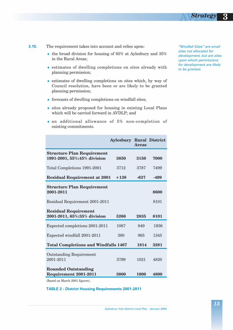
Rounded Outstanding Requirement 2001-2011 3800 1000 4800(Based on March 2001 figures).
TABLE 2 - District Housing Requirements 2001-2011
Aylesbury Vale District Local Plan January 2004
“Windfall Sites” are smallsites not allocated fordevelopment, but are sitesupon which permissionsfor development are likelyto be granted.
AVDLP3 Strategy
16Aylesbury Vale District Local Plan January 2004
AYLESBURY DEVELOPMENT STRATEGY
3.16. The District and County Councils have jointly devised theAylesbury Land Use/Transport Strategy (ALUT Strategy). Theobjective of this work has been to determine how best to combine new development with a new approach to transport infrastructure investment, taking into account the environmental, social and economic objectives mentioned earlier.
3.17. The development strategy at Aylesbury provides for some 3,800houses, together with all the employment, shopping, leisure andother facilities that go with it. The details of how thisrequirement is to be achieved are dealt with in Chapter 5; Table 3 opposite summarises how the 3,800 houses are to beaccommodated. The main features of the strategy are:
maximising the potential of “brownfield” sites for housing purposes;
concentrations of major development in areas to the north-west and north of the town;
improvements to public transport operation, including Park-and-Ride, concentrating on the Primary Public TransportCorridor from Bicester Road, via the town centre, to AstonClinton Road;
improvements to public transport operation on other radial roads;
the development of a comprehensive network of pedestrianand cycling links and facilities throughout the town;
the minimum amount of new road building, that is, a newroad linking the Berryfields and Weedon Hill majordevelopment areas (MDAs) with each other around thenorthern periphery of the town, from the A41(W) to theA413, the design and standard of such to be sufficient toserve local needs without attracting long distance throughtraffic nor generating undue levels of additional trips; and
the funding as a cost borne by development of significantelements of the local transport infrastructure package andother required facilities.

AVDLP 3Strategy
17
Outstanding requirement 3,800
Brownfield sites proposed 1,100
Reallocated sites 751
Outstanding new site requirement 2,700
New sites proposed
Berryfields 1,850
Weedon Hill 850
New site total 2,7001An additional 75 dwellings have been included due to the Circus Fields allocation.
TABLE 3 - Housing at Aylesbury 2001-2011
RURAL AREAS DEVELOPMENT STRATEGY
3.18. The strategy for the Rural Areas is based on the need toconcentrate development at the largest settlements that havethe greatest amount and range of employment and services, andwhich are best served by public transport. A sequential processis therefore established to accommodate the Rural Areasrequirement (some 1000 dwellings and associated development):
1. examine the capacity of “brownfield” sites withinsettlements which satisfy sustainability criteria in terms oftheir location having a reasonable amount and range ofemployment, services and public transport links; then
2. examine the capacity of the largest rural settlements whichhave the greatest amount and range of employment andservices and that are best served by public transport; then
3. consider other settlements which reasonably meet thesustainability criteria in terms of local jobs, services andpublic transport; then
4. consider the potential for the development of new settlement(s):
a) Firstly, on sites utilising major redundant areas in the countryside at the most sustainable locations, and
b) Secondly, “greenfield” sites at the most sustainable locations.
3.19. There are two sites in the Rural Areas, at Princess Mary’sHospital, Wendover, and the former nurses homes at Stone,which meet the criteria set out in the first category above.There are four settlements which meet the criteria set out inthe second category: Buckingham, Wendover, Haddenham andWinslow. At Wendover, however, because of the established
Aylesbury Vale District Local Plan January 2004
AVDLP3 Strategy
18Aylesbury Vale District Local Plan January 2004
constraints surrounding the settlement, there is no additionaldevelopment capacity apart from the land at Princess Mary’s Hospital.
3.20. There is sufficient capacity at the sites and settlementsidentified in the first and second categories as demonstratedand summarised in Table 4 below, to accommodate the RuralAreas development requirement. The details of the proposalsfor the development of specific sites, are dealt with in laterchapters (Chapters 6-9) under those settlement headings.
3.21. There is no need, and therefore it is not appropriate, to considerthe potential offered by the third and fourth categories.
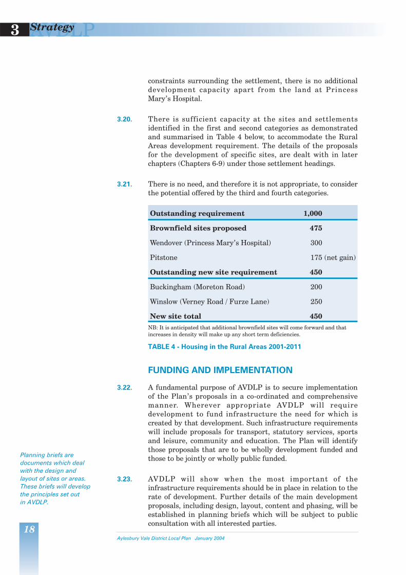
Outstanding requirement 1,000
Brownfield sites proposed 475
Wendover (Princess Mary’s Hospital) 300
Pitstone 175 (net gain)
Outstanding new site requirement 450
Buckingham (Moreton Road) 200
Winslow (Verney Road / Furze Lane) 250
New site total 450NB: It is anticipated that additional brownfield sites will come forward and thatincreases in density will make up any short term deficiencies.
TABLE 4 - Housing in the Rural Areas 2001-2011
FUNDING AND IMPLEMENTATION
3.22. A fundamental purpose of AVDLP is to secure implementationof the Plan’s proposals in a co-ordinated and comprehensivemanner. Wherever appropriate AVDLP will requiredevelopment to fund infrastructure the need for which iscreated by that development. Such infrastructure requirementswill include proposals for transport, statutory services, sportsand leisure, community and education. The Plan will identifythose proposals that are to be wholly development funded andthose to be jointly or wholly public funded.
3.23. AVDLP will show when the most important of theinfrastructure requirements should be in place in relation to therate of development. Further details of the main developmentproposals, including design, layout, content and phasing, will beestablished in planning briefs which will be subject to publicconsultation with all interested parties.
Planning briefs aredocuments which dealwith the design andlayout of sites or areas.These briefs will developthe principles set out in AVDLP.

4GENERAL POLICIES

AVDLP 4General Policies
19
HOUSING
A CHOICE OF DWELLING TYPES
4.1. National planning policy in “PPG3: Housing” requires that abetter mix of housing should be provided giving a wider choicein the size, type and location of dwellings. Nationally, theGovernment is seeking the provision of greater numbers ofsmaller dwellings to account for an increase in smaller, andparticularly single-person, households. Providing smallerdwellings also helps to use sites more efficiently. The Council’shousing needs study, undertaken in 1999, identified a shortfallin flats, apartments and maisonettes in the District, while theproportion of small houses, such as terraces, was similar to thenational average. This implies that there is a need in theDistrict, as in the country as a whole, to increase the proportionof smaller homes; this need is greater in some parts of theDistrict than others.
4.2. In villages, where development is generally more restricted, it isimportant to take every opportunity to seek to redress shortfallsin local housing choice in order to help to provide sustainablecommunities. Even the smallest developments in villages canhave a considerable impact on the overall choice of housingavailable to the community. In larger settlements, smalldevelopments will have less of an impact, and it would beappropriate to only apply a requirement to redress housing typeshortfalls to larger proposals.
4.3. To provide a cohesive design for developments and to meetsignificant local shortfalls it may often be appropriate,particularly on smaller sites, for only a limited range ofdifferent house sizes and types to be provided, including designscomprising houses of only one type.
GP.1 Proposals for sites comprising five or more dwellings inAylesbury, Buckingham, Wendover, Haddenham or Winslow,and all proposals for residential development elsewhere, shall contribute to redressing shortfalls in the range of dwellingsizes (in terms of bedroom numbers) in order to increasehousing choice.
4 GENERAL POLICIES
Aylesbury Vale District Local Plan January 2004

AVDLP4 General Policies
20Aylesbury Vale District Local Plan January 2004
AFFORDABLE HOUSING AND LOW COST MARKET HOUSING
4.4. The Housing Needs Study undertaken for the Council in 1999gave a strong indication that a considerable affordabilityproblem may arise in the District from the relationship betweenlocal income levels and the supply of average and below averagepriced properties. This was the case despite the fact that at thetime access to the housing market was at its lowest level in realterms for many years.
4.5. The Study also confirmed that low cost market housing wasrequired as well as affordable dwellings to meet identified needs and to address a shortage of units of that type in theexisting stock.
4.6. As part of their study of housing need, the consultantsundertook a large sample survey. The results indicated that there were many “concealed households”, that ispotentially independent households currently living as part ofan existing household.
4.7. For the purposes of this Plan, the following definitions shall beused: “Affordable housing” comprises dwellings provided withsubsidy for occupation by “qualifying persons”. “Qualifyingpersons” are those who are assessed by the Council and/or theregistered social landlord as being unable to resolve theirhousing needs in the private sector market because of therelationship between housing costs and incomes; these mayinclude “key workers”. “Low cost market housing” comprises 1-or 2-bedroom dwellings of a type approved by the Council asbeing appropriate to help satisfy the home-ownershipaspirations of people, including “key workers”, whose incomesare only just adequate to access the property market.
4.8. The Council will monitor the provision of affordable and lowcost housing and the need for such housing including the use offurther studies of housing need.
AFFORDABLE HOUSING
4.9. The 1999 Study demonstrated that there was a need for 2,000affordable units by 2006, even just to maintain the prioritywaiting list at its current level. This need for affordabledwellings is a material planning consideration.
PPG3: Housing andCircular 6/98 offerguidance on how theplanning system cancontribute to the overallsupply of affordablehousing.

AVDLP 4General Policies
21
4.10. Registered Social Landlords (RSLs) are the normal providers ofaffordable housing. However, if grant funding (via socialhousing grant or local authority social housing grant) is notsufficient to provide the number of affordable dwellings that arerequired, it will be necessary to explore and make use of otherways of achieving subsidised housing, such as by the use of landmade available at a reduced price. Where it is anticipated that aRSL will not be responsible for the management of affordabledwellings, the Council will use occupancy conditions orplanning obligations to ensure that the dwellings will beoccupied in perpetuity by ‘qualifying persons’ (as defined inpara.4.7 above).
GP.2 The Council will negotiate for the provision as affordabledwellings of a minimum of 20% and up to 30% of the totalnumber of dwellings on developments of 25 or more dwellings,or sites of 1 hectare or more (or which form part of a site ofsuch a size which is capable of development), regardless of thenumber of dwellings. The Council will assess the circumstancesof each proposed development individually. It will take intoaccount in particular the need locally for affordable dwellings(including evidence from the Council’s Housing Needs Survey),the economics of the development (including the cost of anycontributions towards the achievement of any other planningobjectives also being sought from the development of the site),Government guidance and sustainability considerations. TheCouncil will wish to ensure that the affordable dwellings areoccupied initially by ‘qualifying persons’ and are retained forsuccessive ‘qualifying persons’.
LOW COST MARKET HOUSING
4.11. A conclusion of the Housing Needs Study was that therelationship between local incomes and prices of dwellings inthe District is such that low cost market housing is notaffordable for the majority of “concealed” households. On thebasis of conservative assumptions and any realistic assessmentof the availability of properties, access to home ownership isbeyond the reach of more than three-quarters of the ‘concealed’households identified in the study. Nevertheless, the studyconfirmed that in the District there is still an important role forlow cost market housing, that is the smallest size of units. Thatrole is to meet the needs of households whose incomes are justsufficient to make a purchase on the open market. However, theconsultants found that those types of market units arecurrently in short supply in the District. Additional units of thistype are required to help redress that imbalance in the housingstock. A conclusion of the Housing Needs Study was that it
Aylesbury Vale District Local Plan January 2004
Registered SocialLandlords may becharities which arehousing associations,industrial and providentsocieties, and not forprofit companies.

AVDLP4 General Policies
22Aylesbury Vale District Local Plan January 2004
would be appropriate to seek 500 low cost market units by 2006. This need for low cost market dwellings is a materialplanning consideration.
GP.3 The Council will negotiate for the provision as low cost marketunits of a minimum of 10% of the total number of dwellings ondevelopments of 25 or more dwellings, or sites of 1 hectare ormore (or which form part of a site of such size which is capableof development), regardless of the number of dwellings. TheCouncil will assess the circumstances of each proposeddevelopment individually. It will take into account in particularthe need locally for low cost market dwellings (includingevidence from the Council’s Housing Needs Study),Government guidance and sustainability considerations.
4.12. The determination of what will be appropriate in any particularcase will be based upon information regarding housing need,including the findings of the Council’s Housing Needs Study,and the advice contained in DETR Circular 6/98 - Planning &Affordable housing.
AFFORDABLE HOUSING FOR LOCAL NEEDS IN RURAL AREAS
4.13. In accordance with Government advice, small sites which wouldnot normally be acceptable for housing development, mayexceptionally be developed for affordable schemes to meet aproven local need for such housing. “Exception schemes” aremore likely to be justified in the more remote parts of theDistrict distant from towns and larger villages. The number ofdwellings should be no greater than required to meet thecurrent need. Consideration of the number and types of unitsshould take into account the likely level of continuing need inthe community.
4.14. A number of schemes for local needs housing have been givenplanning permission as exceptions in the District. However, theCouncil expects that the stringent requirements will severelylimit the total number of such dwellings.
4.15. Local housing needs can best be identified by a survey ofhouseholds in the locality. The extent of the “locality” in anyparticular case should be agreed in consultation with theCouncil. It might be a single village or parish or an associatedgroup of settlements. Households which need affordablehousing will be those which need to be housed but which,having regard for the local market conditions and wage rates,
AVDLP 4General Policies
23
are genuinely unable to afford local accommodation. To qualify,households must also have a strong demonstrable localconnection. The following circumstances of households willgenerally count in assessing local need:
existing residents needing separate accommodation in thearea (newly married couples, people leaving tiedaccommodation on retirement);
people whose work provides important services and whoneed to live closer to the local community;
people who are not necessarily resident locally but havelongstanding links with the local community (e.g. elderlypeople who need to move back to a village to be nearrelatives); and
people with the offer of a job in the locality, who cannot takeup the offer because of the lack of affordable housing.
4.16. Proposals will need to be supported by the results of a survey orother information demonstrating to the Council’s satisfactionthat there is a special local need for affordable housing.
4.17. The development must be economically viable taking intoaccount the level of rent/purchase that enables the identifiedneed to be met.
4.18. In considering the suitability of a site for development,infrastructure requirements to serve it and accessibility toservices will be taken into account. The site should be located within or adjoining the existing built-up area of asettlement. The development should respect the character ofthe settlement and be in scale with it, and the developmentshould be integrated with the existing pattern of developmentand land uses.
4.19. The scheme will need to provide for housing for rent and/orshared equity and/or shared ownership as identified by theestablished need. It will be necessary to ensure the continuedavailability of the housing to meet a need. If the lessee of ashared ownership unit exercises a right to buy an additionalproportion of the equity, or if only the initial price is discounted,on resale the unit may be too expensive to meet the establishedneed. In accordance with Government advice, mixeddevelopment of affordable housing subsidised by open marketor higher priced housing on the same site will not be acceptableunder the exceptions policy.
Aylesbury Vale District Local Plan January 2004

AVDLP4 General Policies
24Aylesbury Vale District Local Plan January 2004
4.20. The Council will need to be satisfied that arrangements are inplace to ensure the dwelling(s) would meet the established localneed for affordable housing initially and will remain so in thefuture. This should preferably be with the management of thescheme by a Registered Social Landlord. Alternatively, it couldbe by planning obligation or planning condition.
GP.4 The Council will grant permission for affordable housing onsmall sites adjacent to the built-up areas of settlements to meetlocal needs that would not otherwise be met under the policiesof the plan.
Such sites will only be released as an exception to normalhousing restraint policies in the Rural Areas. Applicants will beexpected to demonstrate a local need for the number and styleof affordable dwellings by reference to an up-to-date survey andassessment of the relevant area.
Proposals for these rural exception sites must accord with thePlan’s design policies and reinforce the distinctive character ofthe villages in which they are located. Dwellings permitted inaccordance with this policy will be reserved in perpetuity foraffordable local needs by planning conditions or obligations.
EXISTING DWELLINGS
Maintenance of Housing Stock
4.21. A general presumption against development involving the lossof dwelling units is appropriate.
GP.5 In deciding planning applications the Council will resist anynumerical loss to the District’s housing stock.
Conversion of Dwellings
4.22. The conversion and subdivision of existing dwellings can makea useful contribution to housing provision by adapting theexisting housing stock to meet the needs of the increasingnumber of smaller households. It may also help to meet theneed for affordable and low-cost market housing.
4.23. The resultant residential units need to have an adequatestandard of accommodation, and the proposals need to haveregard for the character of the area in which the property islocated and for the amenity of nearby properties.

AVDLP 4General Policies
25
GP.6 Proposals for the subdivision or conversion of existing dwellingsinto two or more units of accommodation will be permitted,provided they make adequate provision in terms of access,parking, amenity space and noise attenuation and have regardto the amenity of adjoining or nearby properties and the effecton the character of the area and the balance of the community.
Changes of Use of Residential Accommodation
4.24. The Council recognises that residential properties may be usedin part for commercial purposes. However, amongst otherconsiderations, the effect on the amenity of occupants of otherproperties and the effect on the character of the locality are important.
GP.7 Proposals for changes of use of parts of dwellings for non-residential purposes or home-working will only be permittedwhere they:
a) would not have a detrimental impact on the amenity ofoccupiers of the retained residential accommodation or ofadjoining dwellings;
b) would not have an adverse effect on the character ofthe locality;
c) make appropriate provision for access, parking and noiseattenuation; and
d) accord with the other policies of the development plan.
Protection of the Amenity of Residents
4.25. It is a central theme of planning that good neighbourliness andfairness are among the most important factors against whichdevelopment proposals should be measured. While planningdecisions should always be made on balance in the publicinterest, this should not be at the expense of unreasonableharm to people’s peaceful enjoyment of their property. Mostdevelopment will have some impact on its neighbours, but it isimportant to ensure that this impact is reasonable in relation tothe benefits of the development.
4.26. Some of the policies of this Plan refer to the protection of theamenity or amenities of neighbours. Amenity can be harmed ina number of ways, for example by noise, fumes or odours,excessive or speeding traffic, loss of light, the overbearingnature of a new structure, disruptions to services, increasedrisk of injury, illness or damage to property. Aylesbury Vale is a
Aylesbury Vale District Local Plan January 2004

AVDLP4 General Policies
26Aylesbury Vale District Local Plan January 2004
valued place in which to live, and the Council aims to protectthis aspect of its residential environment, and improvesituations where amenity is currently reduced.
GP.8 Planning permission will not be granted where the proposeddevelopment would unreasonably harm any aspect of theamenity of nearby residents when considered against thebenefits arising from the proposal. Where planning permissionis granted, the Council will use conditions or planningobligations to ensure that any potential adverse impacts onneighbours are eliminated or appropriately controlled.
Extension of Dwellings and Annexes
4.27. When planning permission for extensions and annexes isrequired, applications will be judged on their merits havingregard to the effect on the original building, neighbouringproperties and the area in general.
4.28. The Council has adopted guidance on the detailed design ofextensions to dwellings - “Design Guide - Residential Extensions”).
GP.9 Proposals for extensions to dwellings will be permitted where they:
a) protect character of outlook, access to natural light andprivacy for people who live nearby;
b) respect the appearance of the dwelling and its setting andother buildings in the locality; and
c) accord with published Supplementary Planning Guidance onresidential extensions and the other policies of thedevelopment plan.
4.29. Extensions to houses are sometimes provided as “grannyannexes” to accommodate relatives. Within built-up areas oftowns and villages these are acceptable provided that thestandards that apply to independent dwellings are met. When,otherwise, they are built as extensions to dwellings, planningconditions will be imposed requiring their occupancy asancillary to the host dwelling. Where a detached building isproposed, the Council will ensure the new building remainsancillary to the existing building by the use of conditions or aplanning obligation.
A “granny annexe” is aself contained unit ofaccommodationassociated with the maindwelling either attachedor detached.

AVDLP 4General Policies
27
4.30. Detached annexe accommodation will not be permitted inlocations where the erection of new houses would not begranted. It should be constructed as an extension to the existingdwelling, which could be incorporated into the accommodationof the existing dwelling should the need for it cease.
GP.10 Proposals for residential annexes to dwellings within built-upareas of settlements, as either extensions or detachedbuildings, will be permitted provided that they meet standardsthat apply to independent dwellings. The Council will useplanning conditions or legal agreements to control the use ofsuch annexes.
GP.11 Residential annexes to dwellings outside the built-up areas ofsettlements will be permitted providing they are physicallyattached to the dwelling and capable of being incorporated withthe existing residential accommodation. The Council will useplanning conditions or legal agreements to control the use ofsuch annexes.
MOBILE HOMES/RESIDENTIAL CARAVANS/RESIDENTIAL MOORINGS
4.31. “Residential caravans” are caravans used for residentialpurposes as opposed to holiday homes. These caravans caneither form part of a large authorised site or be an individual orancillary unit. There is one such site in the District: apermanent site at Nicky Nook, Great Horwood.
GP.12 Proposals for new permanent residential caravan/mobile homesites will be considered against the same policies as wouldapplications for conventional residential development.
4.32. It is preferable that caravans be grouped on a well located,properly maintained site. However, in certain circumstances itis appropriate for a temporary planning permission to be givenwhere an identified need arises e.g. during the establishment ofan agricultural enterprise that requires a resident worker orwhere a new dwelling is being built or an existing habitabledwelling is being rebuilt.
GP.13 Temporary permission for an individual residential caravan willonly be given in exceptional circumstances to meet an acceptedneed arising from a site. The Council will seek to ensure thatthe caravan is sited to mitigate any visual intrusion, and willrequire that the caravan is removed and the site is returned to asatisfactory condition once the permission has expired.
Aylesbury Vale District Local Plan January 2004

AVDLP4 General Policies
28Aylesbury Vale District Local Plan January 2004
4.33. There is a demand for residential canal moorings. Residentialmoorings are normally only acceptable within urban areaswhere proper provision for access, car parking and otherfacilities can readily be made. In Aylesbury Vale, only atAylesbury is there operational canal within an urban area.Policies for residential moorings and for canal side developmentare set out at GP.80-81 and paragraphs 4.206-4.208.
GYPSIES
4.34. There is no longer a legal requirement on local authorities toprovide gypsy sites. Government advice presumes thatproposals for gypsy sites will come from the private sector. TheGovernment recognises that many gypsies would prefer to findand buy their own sites to develop and manage. Local Plansshould wherever possible identify locations suitable for gypsysites, whether local authority or private sites. Where this is notpossible, they should set out clear, realistic criteria for suitablelocations, as a basis for site provision policies.
4.35. There is no up-to-date information on gypsy accommodationneeds within Aylesbury Vale. In these circumstances, it isappropriate to establish a criteria-based policy against whichplanning applications for gypsy sites will be considered.
GP.14 Outside the Metropolitan Green Belt, Chilterns Area ofOutstanding Natural Beauty and other protected areasincluding Areas of Attractive Landscape, Local Landscape Areasand the best and most versatile agricultural land, the Councilmay permit small-scale gypsy caravan sites to meet clearlydemonstrated and particular local needs. In evaluating such proposals the Council will take into consideration thefollowing factors:
a) the accessibility of local services such as shops, schools, andpublic transport;
b) the suitability of the physical environment of the site and itssurroundings for habitation;
c) the likely impact on the amenity of local residents withregard to the potential from noise and other disturbance,from the movement of vehicles to and from the site, thestationing of vehicles on the site, and on-site business activities;
AVDLP 4General Policies
29
d) the adequacy of vehicular access from the public highway,provision for parking, turning and servicing on site, androad safety for occupants and visitors; and
e) the impact upon the appearance of the countryside and theenvironment generally and the landscaping proposed.
TRAVELLING SHOW PEOPLE
4.36. Government guidance states that Local Planning Authoritiesshould consider the needs of travelling show people whenpreparing local plans. A realistic assessment should be made ofthe amount of accommodation needed to provide a basis forrelevant and appropriate Plan policies.
4.37. There are a number of sites in the District used by show people.The Showmen’s Guild of Great Britain has not indicated a needto identify additional sites for show people in Aylesbury Vale.Nonetheless, such a need may arise in the future. It isimportant to have a criteria based policy against whichapplications for accommodating show people will be considered.
GP.15 Outside the Metropolitan Green Belt, Chilterns Area ofOutstanding Natural Beauty and other protected areasincluding Areas of Attractive Landscape, Local Landscape Areas and the best and most versatile agricultural land, theCouncil may permit small-scale show people’s quarters to meetclearly demonstrated and particular local needs. In evaluatingsuch proposals the Council will take into consideration thefollowing factors:
a) the accessibility of local services such as shops, schools, andpublic transport;
b) the suitability of the physical environment of the site and itssurroundings for habitation;
c) the likely impact on the amenity of local residents includingthe impact of vehicle movements to and from the site andthe maintenance and testing of equipment;
d) the adequacy of vehicular access from the public highway,provision for parking, turning and servicing on site, androad safety for occupants and visitors; and
e) the impact upon the appearance of the countryside and theenvironment generally and the landscaping proposed.
Aylesbury Vale District Local Plan January 2004
Government guidance iscontained in DETR circular22/91.
AVDLP4 General Policies
30Aylesbury Vale District Local Plan January 2004
EMPLOYMENT
INTRODUCTION
4.38. Employment in Aylesbury Vale is primarily focussed on thetown of Aylesbury where approximately half of all jobopportunities are located. Elsewhere in the District,employment patterns are influenced both by Aylesbury and thelarge number of other employment centres located in towns allaround the District’s periphery. These towns exert varyingdegrees of influence. London is less than an hour’s travellingtime by train on the lines from Aylesbury, and throughHaddenham, Cheddington, Stoke Mandeville and Wendover.The capital exerts a considerable influence, particularly in thesouthern part of the District.
4.39. Other towns that have significant influence on the travel towork patterns of the population include Milton Keynes,Bletchley, Banbury and Brackley to the north, Luton,Dunstable, Tring, Berkhamsted, Hemel Hempstead andLeighton Buzzard to the east, Oxford and Bicester to the westand High Wycombe, Amersham and Chesham to the south.
4.40. Within the expansive and largely rural parts of the District,employment was traditionally linked closely with agriculture.However, in line with trends nationally, the numbers employedlocally in this sector have declined dramatically. The greatmajority of job opportunities now in the District are in theservice sectors. This is particularly noticeable at Aylesbury,where a decline in its post-war manufacturing base has alsobeen marked, again in line with national trends.
4.41. Nevertheless, Aylesbury has grown significantly andconsistently over a long period and that growth has been largelyemployment led. Its success in attracting jobs is demonstratedby the fact that unemployment rates in the town, and District,have been consistently below national and regional averages.
4.42. In the Rural Areas, there is a range of employmentopportunities concentrated in the towns, larger villages and afew large industrial estates/business parks. In accordance withthe principle of maintaining a diverse rural economy andproviding local employment opportunities accessible to ruralcommunities and their workforce, the expansion of suchfacilities will generally be encouraged.
AVDLP 4General Policies
31
4.43. Firms that have established in converted barns or formeraerodrome buildings also provide a small but nonethelesssignificant proportion of rural employment. The expansionof these isolated businesses can have adverse effects onrural interests and such applications will need to be judgedagainst their conflict with other uses in the vicinity, alongwith local employment needs and the availability of moreappropriate locations.
4.44. The following sections deal with strategic employment issues.Specific employment development proposals at settlements andwithin the Rural Areas are contained in the subsequentrelevant Chapters.
EMPLOYMENT GROWTH AND STRATEGIC LAND REQUIREMENTS
4.45. The County Structure Plan envisages that employment in theDistrict will grow by 11,000 jobs over the Plan period.
4.46. Presently, approximately 20% of Aylesbury Vale’s totalemployment needs are accommodated outside the District, i.e.more of the District’s resident workforce commutes out of theDistrict to work than is replaced by those commuting in.Although AVDLP promotes a closer correlation of jobs andhomes, it is not expected that it will impact greatly on thisphenomenon over the Plan period. The levels of commuting towork will be closely monitored.
4.47. It is assumed, therefore, that 20% of the new job growth(2,200 jobs) will be located outside the District as a result ofnet out-commuting. Of the 8,800 remaining jobs, 2,800 will beprovided on existing employment sites leaving a residue of6,000 to be accommodated.
4.48. A third of these new jobs will be provided in education, health,retail, leisure and personnel services. The Plan proposes,therefore, that employment land for only about 4,000 office andindustrial jobs need to be provided.
4.49. Details as to the assumptions made and the rationale foraccommodating new employment needs is given in theEmployment Background Paper and Economic Background Paper.
Aylesbury Vale District Local Plan January 2004
AVDLP4 General Policies
32Aylesbury Vale District Local Plan January 2004
4.50. In order to ensure that employment opportunities match theneeds generated by its expanding population and its structurekeeps pace with modern employment needs, efforts to attractmodern industries are required.
4.51. The employment policies contained within AVDLP have beendeveloped in a manner consistent with the Plan’s overallstrategy and the policy objectives contained within the Districtand County Economic Development Action Plans and theBuckinghamshire Rural Strategy. Those Action Plans have inturn been developed consistently within the aims of the ThamesValley and the Milton Keynes and North Bucks EconomicPartnerships, in both of which Aylesbury Vale District is apartner. Other members include other County and District localauthorities, Learning and Skills Councils, Business Link, andthe Chambers of Commerce.
GP.16 In deciding applications for employment development theCouncil will aim to secure a close correlation between thelocation of homes, jobs and skills. The location of employmentuses must be consistent with the availability of services,including public transport and highway capacity. Employmentdevelopment proposals must be consistent with the need to safeguard the environment of towns, villages and the countryside.
EXISTING EMPLOYMENT SITES
4.52. In line with the objective of maintaining a healthy and diverseeconomy and balancing the number of jobs with the workforce,the Council will generally seek to retain existing employmentsites in employment use. However, where employment sites giverise to effects, such as noise or traffic, that may impact onneighbours, a flexible approach needs to be taken. Alternatively,some employment sites may not be suitable or attractive to newusers, and may appear to become redundant.
4.53. In many cases there will be opportunities to utilise parts, if notall, of such sites in employment uses, and the Council wouldsupport such redevelopments, where any existing adverseenvironmental impacts would be reduced. The social structureof settlements could be damaged and commuting levelsincreased if employment sites are lost where there is little or noalternative employment available nearby, or where the loss ofthe employment site would significantly reduce opportunities inthe locality; in such cases redevelopment for alternativeemployment uses would be appropriate. In larger settlements,

AVDLP 4General Policies
33
where there is greater access to a wider range of alternativeemployment opportunities, mixed-use proposals includingresidential development, could provide a more appropriate land-use balance.
GP.17 The Council will seek to retain existing employment sites anduses. Proposals for changes of use or redevelopment ofemployment sites will only be permitted where:
a) the existing use has an adverse impact on amenity ofneighbours and its proposed replacement would be an improvement;
b) there are appropriate alternative employment opportunitieseither on other sites in the locality or as part of the proposeddevelopment; and
c) there are opportunities in larger settlements of a moreadvantageous land-use arrangement through redevelopmentfor mixed use, including residential, purposes.
4.54. One of the main objectives of land use planning is to ensure theefficient use of land whilst minimising conflict betweenadjoining land uses. New developments, particularly for certainindustrial processes, which would have a detrimental impact onneighbouring uses will not be acceptable.
GP.18 Proposals for employment development will not be permitted where:
a) they would be incompatible with nearby uses and utilities; or
b) the effects of activities or processes undertaken orassociated traffic would be harmful to the amenity, health orsafety of occupants of nearby land uses.
EMPLOYMENT SITE DEVELOPMENT DENSITIES
4.55. Much of the District’s employment park development has beenbuilt at a ratio of about 40% coverage. This is typical ofdevelopments elsewhere. Where employment development isfound acceptable outside built-up areas it is often important toensure that it is accompanied by landscaping on and around thesite, and sometimes away from the site, to protect the visualand rural amenities of the locality. This may mean that in someinstances the proportion of the site covered by buildings and carparks could be lower than the historic figure for the District,and the site coverage ratio applying within settlements.
Aylesbury Vale District Local Plan January 2004

AVDLP4 General Policies
34Aylesbury Vale District Local Plan January 2004
GP.19 Employment development permitted in the countryside oradjacent to the built-up areas of settlements will be expected toprovide extensive landscaping to mitigate any adverse visualeffects. Planning conditions will be applied or obligationssought to secure those objectives.
WORKING FROM HOME
4.56. Advances in technology and changing work practices have madetele-working and working from home a more realistic option formany people. This can be environmentally beneficial byreducing the need for people to commute and socially beneficialby giving people more flexibility to combine working withcaring responsibilities. Usually, such practices do not require anapplication for planning permission as they can be carried outwithout material changes to the structure or function of thebuilding concerned. Where planning permission is required,proposals will be considered against policy GP.7.
TRANSPORT
INTRODUCTION
4.57. This section includes those general transport policies that willapply across the District, including Aylesbury. Policies specificonly to a certain settlement, including the major transportproposals for Aylesbury, or to the Rural Areas will be found inthe relevant section.
4.58. Transport has major implications for land use and theenvironment. Current Government forecasts suggest that cartraffic nationally will increase by around 30% by 2011. InAylesbury Vale this figure may be exceeded because of theamount of development proposed over the same period. Boththe District and County Councils consider that such overallrates of growth in road traffic can neither be accommodated norsustained in terms of compliance with Government policy.
4.59. This Plan therefore carries through the new approachemphasised in Government advice and in the County StructurePlan that recognises the need to control and manage land useand transport in an integrated manner.
The National Road TrafficForecasts 1997.

AVDLP 4General Policies
35
GP.20 The Council will take the following key factors into account inassessing the transport implications of development proposals:
a) the need to reduce car usage;
b) the need to promote the availability and use of convenientand safe public transport, cycling and walking opportunities;
c) the need to reduce car parking associated with newdevelopment, and in town centres;
d) the need for traffic management measures to improveenvironmental standards; and
e) the need to create better and and safer conditions for allroad users.
TRAFFIC IN TOWNS AND THE RURAL AREAS
4.60. AVDLP has been prepared against a background of increasingcar ownership and usage and a heightened awareness of theneed to protect the District from the environmental effects ofmotor vehicles. While it is recognised that some vehicle journeysare essential to maintain a healthy economy, many are not andcould be made by other less environmentally damaging modesof transport.
New Development
4.61. New development may generate increased levels of traffic. Thiscan affect local congestion levels, pollution levels and roadsafety. An integral element of the Plan is a concern to maintainand enhance the safety, amenity and accessibility of all thoseusing highways. It is important, therefore, that roads, footwaysand cycleways in new developments are designed andmaintained to a standard that provides a safe, convenient andaccessible environment.
4.62. Travel plans provide an opportunity for difficulties associatedwith increased traffic levels to be addressed prior todevelopment. The requirement for a travel plan will depend onthe scale and type of development but such a plan will beexpected in support of planning applications for all proposalswith significant transport implications or to tackle a particularlocal traffic problem.
Aylesbury Vale District Local Plan January 2004
AVDLP4 General Policies
36Aylesbury Vale District Local Plan January 2004
GP.21 In considering the highway aspects of planning applications theCouncil will have regard to:
a) the need to secure public transport links and improvementsrelated to the development;
b) the need for safe and convenient access for road users,including cyclists, pedestrians and disabled persons;
c) the adequacy of the highway network involved;
d) the requisite level of car parking;
e) the contents of any associated travel plan; and
f) the satisfactory design and layout of any proposed road system.
In appropriate cases the Council will secure the above benefitsby means of planning conditions or obligations. Theseconsiderations are elaborated in subsequent policies.
GP.22 In granting permission for development likely to impact uponthe transport system the Council will impose conditions or seekplanning obligations including, where appropriate, financialcontributions by developers, to secure the provision orimprovement of relevant public transport facilities, cycle andfootways, and other transport infrastructure.
4.63. In some instances, communal parking courts should be providedclose to the dwellings that they serve. Parking courts can be asource of nuisance to neighbouring residential properties andtheir location and design should take this into account. It isimportant also that their design includes as an integral elementlandscaping or other appropriate measures to minimise thevisual impact.
GP.23 Communal parking areas should be located conveniently for the dwellings they are intended to serve. Their design andlayout should:
a) respect the visual characteristics of the area;
b) protect the residential amenities of nearby occupiers; and
c) promote security and community safety.

AVDLP 4General Policies
37
CAR PARKING GUIDELINES
4.64. In line with PPG advice and general issues of sustainability, theCouncil is moving away from the rigid application of minimumcar parking standards. A key aim is to seek a reduction in theamount of non-residential parking available in the future, todiscourage non-essential car use, and encourage where possiblethe development and use of public transport, cycling andwalking as alternatives. In accordance with this principle, itmay be appropriate, in exceptional circumstances, for theparking requirement for certain developments to be zero.
4.65. In moving towards a more flexible but restrictive policy on carparking, the Council acknowledges that to do so unilaterally, ortoo quickly, may have a detrimental impact on the District bydeterring existing and potential investors. A strategy istherefore proposed that provides for a gradual change inapplication of the policy over the period to 2011 and beyond.
4.66. This principle is now enshrined in the Council’s ParkingGuidelines, published as Supplementary Planning Guidance.These will be amended as appropriate through the Plan periodto reflect the gradual tightening of application of policy.
GP.24 New development will be required to provide vehicular parkingin accordance with the Council’s operative guidelines publishedas Supplementary Planning Guidance.
These guidelines are intended to promote more sustainabletransport options and will establish maximum levels of parkingappropriate to the scale, type and location of development. Inapplying the guidelines the Council will have regard to therequirements of disabled people and those occupying specialisedaccommodation, and the need to maintain the vitality andviability of town centres.
During the period of the Plan the Council will review and mayrevise the parking guidelines in order to enhance the objectivesof reducing car usage and traffic growth, and easing congestion.
PUBLIC TRANSPORT
Buses
4.67. Bus services are operated by independent bus companies,although BCC has an obligation to secure such additionalservices as it deems are necessary which are not providedcommercially. It also has to obtain the best value for money inpublic and educational transport services when viewed together.
Aylesbury Vale District Local Plan January 2004

AVDLP4 General Policies
38Aylesbury Vale District Local Plan January 2004
Rail
4.68. There are a number of passenger rail lines through the District:
West Coast Main Line with a station at Cheddington (andnearby stations outside Aylesbury Vale at Bletchley, CentralMilton Keynes, Leighton Buzzard and Tring);
Aylesbury to London Marylebone, via Amersham, withstations in the District at Stoke Mandeville and Wendover;
Aylesbury to London Marylebone, via High Wycombe; and
London Marylebone to Birmingham with a station at Haddenham.
4.69. There is potential for rail to make a bigger contribution topublic transport provision. The existing rail stations typicallyact more as places from which to enter or leave the District,rather than facilitating travel within it. Improvements to andextension of the network would be needed to enable a greaterand more effective use of the system by residents and others inthe District. Those residents north of Aylesbury are particularlyisolated from the rail network.
4.70. In light of the much-reduced road-building programme there isa stronger case to consider rail alternatives, especially betweenAylesbury - Milton Keynes and Aylesbury - High Wycombe.While there has been significant improvements to the latterservice there is no northwards link from Aylesbury.
4.71. Over a number of years various studies have looked into thefeasibility of re-opening to passenger traffic the line betweenBicester and Bletchley (Milton Keynes). Aylesbury is linked tothis route at Claydon Junction via a little-used line to Calvert.The Council is a member of a consortium of local authoritiesand others, including BCC and Network Rail, looking atestablishing a new east west rail link (EWR) between EastAnglia and Central Southern England. The study includes theBicester - Bletchley and Aylesbury lines.
4.72. The latest report is very positive in its recommendations on thedesign, operation and financial feasibility of the establishmentof the EWR. The section of line between Bedford and Bicester,including the line running through the centre of the District,has the best potential for re-opening. The Council has expressedsupport for this project, including the Aylesbury link, and willsafeguard the line between Bicester and Bletchley and the line
East West Railway Phase II– Feasibility Study Report(Steer Davies Gleave).
AVDLP 4General Policies
39
running northwards from Aylesbury from development likely toprejudice its possible re-opening to passenger and freight services.
GP.25 The Council will resist development that might prejudice theuse of the rail route running through the District betweenBicester and Bletchley, and the northward link from Aylesbury,by passenger and freight services. In considering proposals forany associated rail development the Council will protect theamenities of occupiers close to the route.
4.73. In addition to safeguarding the route, it is important to ensurethat adequate station stops can be provided to serve localmovements in the District. A key site is at Winslow, both toserve the town and centre of the District. Similarly, a station atQuainton could serve the village and locality and a station atCalvert could also serve the new housing development on theold brickworks.
GP.26 Provision is made for railway stations on sites defined on theProposals Map at Winslow, Quainton and Calvert. The Councilwill resist development that would prejudice station schemes orrelated rail transport proposals for these sites.
Taxi Services
4.74. Taxis provide a valuable service within the urban areas and inlinking to the surrounding villages. Policies designed toencourage public transport are also likely to lead to increaseddemand for such service. Taxis should be available close to themajor public transport stops and interchanges.
Walking and Cycling
4.75. Cycling is an important means of transport for local trips and isa healthy and non-polluting form of transport that hasmarkedly increased in popularity. The town of Aylesbury andthe Rural Areas are ideally suited for cycling but many journeysare undoubtedly suppressed because of perceived or actualdangers to cyclists on the roads.
4.76. The District and County Councils are working with SUSTRANSto link, via dedicated cycleways, the main settlements in theDistrict to the National Cycle Network. A route is beingdeveloped between Milton Keynes and Oxford, via Winslow.Further linkages are proposed between Aylesbury and Winslow,Aylesbury to Leighton Buzzard and Aylesbury to Thame viaPrinces Risborough and Buckingham to Winslow. While totally
Aylesbury Vale District Local Plan January 2004
SUSTRANS, which standsfor Sustainable Transport,is a charity established tohelp put together theNational Cycling Network.It offers assistance toLocal Authorities andothers working towardsthis aim. SUSTRANS is aMillennium Project fundedby the National Lottery.

AVDLP4 General Policies
40Aylesbury Vale District Local Plan January 2004
separate cycleways are usually preferable, cyclists cansuccessfully share lightly trafficked roads and footpaths,provided the latter are properly designed and surfaced and ofadequate width. Such arrangements are being introducedbetween Stone and Aylesbury, along the A418, and have beenintroduced between Wendover and Aylesbury, along the A413.
4.77. The Council supports further measures to improve conditionsfor cyclists in the District in terms both of safety andconvenience, and of providing links within and betweensettlements, particularly between the main settlements andsurrounding villages.
GP.27 The Council will protect existing cycle routes from adverseeffects of new development. In dealing with planningapplications the Council will seek new or improved cycle accessand facilities, including cycle storage, and will use planningconditions or legal agreements to secure such arrangements.
4.78. As with cycling, walking is important as a means of travel aswell as recreation. There is an extensive footpath and footwaynetwork in the towns and villages, as well as in the countryside.It is imperative that the existing network is protected fromdevelopment likely to sever or extinguish definitive footpaths orother well used pedestrian routes.
4.79. New development proposals will be required to take intoaccount existing pedestrian movements and routes. It is alsoimportant to secure extensions of the existing pedestriannetwork and, wherever feasible, new development shouldinclude within the scheme links into the existing network.Footpaths should be suitable for use by disabled persons toallow them full access to the network.
GP.28 The Council will safeguard existing pedestrian routes fromadverse effects of new development. Development proposals willnot be permitted that do not provide for direct, convenient andsafe pedestrian movement and routes, connected whereappropriate to the existing pedestrian network. In decidingplanning applications the Council will use planning conditionsor legal agreements to secure the provision of new footpathsand the improvement of existing routes.

AVDLP 4General Policies
41
ROADS
4.80. The County Council defines a hierarchy of roads. This consistsof the primary and secondary road networks. The primarynetwork comprises all the strategic routes that include all the motorways, trunk roads and the main distributor roadsacross the County. These routes carry most of the throughtraffic across the County and provide links between the main settlements.
Motorways and Trunk Roads
4.81. A section of the M40 passes through the south-western part ofthe District. Most of the A41 which runs south-east to north-west, via Aylesbury, through the District has now been de-trunked. A proposal to construct an A41 bypass for AstonClinton was approved in 1991, and construction started in 2001.The bypass opened in October 2003 and forms the final part of amuch-improved link between Aylesbury and the M25 Motorway and provides much needed environmental relief toAston Clinton. There are no other proposals for the A41 through the District.
County Roads
4.82. BCC, as local highway authority, is responsible for all roadsother than motorways or trunk roads. Generally the Councilhas supported transport schemes, including bypasses, relatingto the Strategic Highway Network which bring aboutenvironmental improvements, make conditions safer forhighway users, or are in the interests of the local economy.Examples include bypasses for Buckingham, Wendover andTingewick. The Council is concerned that any local bypassscheme should be designed to a standard sufficient for localneeds, to achieve environmental improvement, withoutattracting long distance through traffic nor generating unduelevels of additional trips.
4.83. BCC’s proposed capital road programme has been cut backheavily over the last few years. This reflects the nationalscarcity of funding for major projects and the changingtransport philosophy. There remain a number of schemes thateither have planning permission or have safeguarded lines,which will improve conditions for traffic and effectenvironmental improvements to bypassed settlements. Theroutes for these schemes will be protected accordingly.
Aylesbury Vale District Local Plan January 2004

AVDLP4 General Policies
42Aylesbury Vale District Local Plan January 2004
4.84. These schemes will be funded from the County CapitalProgramme or other ways, such as public/private partnership,supported where appropriate by contributions from developers.
4.85. The Council supports proposals for construction of the A4146Stoke Hammond and Linslade Western Bypasses to anappropriate standard.
GP.29 The design of new road schemes should protect landscape,drainage, ecological and amenity interests. In considering suchapplications the Local Planning Authority will resist layoutsthat attract extraneous traffic unrelated to local needs, andencourage complementary measures intended to reduce speedand improve safety and environmental conditions.
GP.30 The Council will not permit development likely to prejudiceroutes safeguarded for the construction of the following roadschemes (as defined on the Proposals Map):
a) A4146 Stoke Hammond Bypass;
b) A4146 Linslade Western Bypass; and
c) Stocklake road improvement, Aylesbury.
4.86. Between 1996 and 2011 the 1997 National Road TrafficForecasts postulate a 46% increase in articulated HGVmovements nationwide. This emphasises the need to ensurethat those vehicles without a destination or origin withinthe District should be directed to the most appropriatethrough routes.
Other Road Schemes
4.87. In addition to major schemes, BCC has approved manyimprovement lines for existing highways. These include, forexample, works designed to improve forward visibility or reduceaccidents and provide footways/cycleways. BCC carries out aperiodic review of these highway improvement lines to rescindthose no longer considered necessary.
4.88. BCC safeguards these lines but they do not constitute proposalsin this Plan. Where appropriate, BCC draws attention to theselines when considering development proposals.
Roadside Services
4.89. Roadside services on primary routes contribute to an efficienttransport system by meeting the needs of motorists and

AVDLP 4General Policies
43
reducing the need for them to deviate from such routes.Government advice encourages meeting the need for newroadside services on these routes by the development of keysites with a range of facilities for travellers in cars and lorries.
4.90. In choosing a site for roadside services that are needed,particular account should be taken of the importance ofprotecting the countryside including, in particular,Metropolitan Green Belt and the separate identity ofsettlements from development.
4.91. The Government advises that road users on primary routesshould not need to travel more than 12 miles before reaching aroadside service area; a maximum of 25 miles is recommendedin the case of facilities on the same side of the road.
SHOPPING
4.92. This section deals with the general shopping strategy applyingto the whole of the District. Specific shopping policies for themain settlements and other areas are contained in theirrespective chapters.
4.93. Aylesbury town centre is defined in the County Structure Planas a sub-regional shopping centre. Aylesbury (along with HighWycombe) is second only in Buckinghamshire to Milton Keynesin the hierarchy of shopping centres. A key retail policy of theCounty Structure Plan is that the role of such centres, as thecentral focus of shopping activity within their catchments,should be maintained and enhanced.
4.94. Based on the broad indications for new retail development inthe County Structure Plan, and the Shopping BackgroundPaper prepared as part of this Plan, it is evident there will beconsiderable potential for new shopping floorspace of all typesover the Plan period.
4.95. Government guidance emphasises that priority should be givento town centres and accommodation of retail developmentwithin them. A sequential approach is required to be applied tothe selection of shopping development sites. The purpose of thisconcentration on town centres is to ensure that new retaildevelopment is accessible by a choice of transport modes andthat it facilitates multi-purpose trips.
Aylesbury Vale District Local Plan January 2004
Buckinghamshire CountyStructure Plan, policy S2,Retail Hierarchy.
The sequential approachis described in PPG6:Town Centres and RetailDevelopments.
AVDLP4 General Policies
44Aylesbury Vale District Local Plan January 2004
4.96. Accordingly, the majority of the District’s new retaildevelopment is to be concentrated at Aylesbury. Toaccommodate this, and accord with the sequential test, firstpreference will be given to town centre sites (where suitablesites or buildings suitable for conversion are available), followedby edge-of-centre sites, then neighbourhood and local centressites, and only thereafter, out-of-centre sites in locations thatare accessible by a choice of means of transport. Crucial to theselection of any sites not in or on the edge of the town centrewill be the relationship to the land use/transport strategy for Aylesbury.
4.97. Outside Aylesbury, a number of settlements have an importantbut more local shopping role, especially Buckingham,Haddenham, Wendover and Winslow. Through the applicationof the sequential test, the Plan will safeguard and enhance therole of these District and local centres. Similar considerations tothose at Aylesbury, in particular the application of PPG6considerations, will apply to new shopping developments atthese settlements. To consolidate and enhance these centres theCouncil will designate Central Shopping Areas and PrimaryShopping Frontages.
4.98. In the Rural Areas, it is important to protect shops, post officesand public houses, as these fulfil a local function providing localservices and reducing the need to travel. This protection isparticularly important where there are no alternatives availablelocally. Applicants will need to satisfy the Council that theexisting use is no longer viable and that a genuine attempt hasbeen made to market the enterprise as a going concern. Wheredevelopment is permitted, it would be regrettable if the buildingworks prevented the future resumption of the former, orsimilar, activity.
4.99. The general shopping aims of the Plan are:
to maintain and enhance the role of Aylesbury as a sub-regional shopping centre, of Buckingham, Wendover andWinslow as District centres and Haddenham as a local centre;
to undertake a programme of developments andimprovements in these centres to provide a safe, attractiveand convenient environment for shoppers;

AVDLP 4General Policies
45
to make provision for a range of shopping outlets tocomplement and enhance the centres’ respective shoppingroles in the District; and
to retain existing local public houses, shops and post officesin both rural and urban settlements.
GP.31 The retail strategy is to locate most shopping development inAylesbury. All applications for retail development will beconsidered having regard to:
a) a sequential approach to site selection;
b) the impact of the development on the trading strength ofAylesbury and other retail centres;
c) the effect on traffic growth, movement and parking;
d) the need to provide a safe and attractive shoppingenvironment accessible to pedestrians, cyclists and publictransport users.
GP.32 The Council will resist proposals for the change of use of shops,post offices and public houses for which there is a demonstrablelocal need.
In considering applications for alternative development or usesthe Council will have regard to the viability of the existing use,the presence of alternative local facilities and the communitybenefits of the proposed use. Where permission includesbuilding conversions, conditions will be imposed so as not toexclude later resumption of the existing use.
DESIGN AND ACCESS FOR PEOPLE WITH DISABILITIES
4.100. The Council is aware that the majority of people in thecommunity will at some time in their lives experience mobilitydifficulties or some other form of disability. The Council,through pursuance of planning policies and the implementationof Building Regulations, will seek to ensure that those withimpaired mobility or other disabilities are not prevented fromparticipating in or contributing to all community activities.
4.101. In the design and landscaping of the built environment,accessibility shall be a prime concern. There is often perceivedto be a conflict between aesthetics and access, but with sensitive
Aylesbury Vale District Local Plan January 2004

AVDLP4 General Policies
46Aylesbury Vale District Local Plan January 2004
and imaginative design, access can be improved for everyone inthe community. The Council will expect that buildings, openspaces and public areas are designed to ensure equal access forpeople with disabilities.
4.102. The Council has adopted and published a guide entitled“Designing for People with Disabilities.” The Council will haveregard to the guide in determining planning applications.
4.103. Local Planning Authorities have a duty to consider the needs ofdisabled people when determining proposals for a wide range ofbuildings to which the public have access.
GP.33 In considering planning applications the Council will pay specialattention to the needs of people with disabilities, includingphysical and sensory impairments. Development proposalsshould facilitate easy and safe movement and access to andfrom buildings and through outside public spaces and include,where appropriate, suitably located disabled parking provision.Regard will also be had for published and adopted guidance on“Designing for People with Disabilities”.
4.104. People with disabilities can experience severe difficulties innegotiating their way from their transport to the buildings theywish to use. Although it is a requirement of the BuildingRegulations to take account of access into and throughbuildings, there is no similar provision regarding parkingprovision. In determining planning applications, the Councilwill seek to ensure that adequate parking and adequate accessto and from the buildings is provided for disabled people.
CONSERVATION OF THE BUILT ENVIRONMENT
4.105. Design and landscaping of development are importantpriorities. An approach is required that respects the traditionalcharacter of towns and villages, and, where development in thecountryside is necessary or appropriate, the traditionalcharacter of rural landscape and buildings.
4.106. The character of the settlements differs across the District,especially in the materials used in traditional buildings,reflecting the changing geology and geography. It is vital thatnew development is of similar scale and character to itssurroundings and does not compromise environmental quality.

AVDLP 4General Policies
47
4.107. Half the District is designated as attractive landscape. Just 5%lies within the Chilterns Area of Outstanding Natural Beautybut 45% lies within other areas protected by Area of AttractiveLandscape (AAL) or Local Landscape Area (LLA) designations.
DESIGN PRINCIPLES FOR NEW DEVELOPMENT
4.108. The Council believes that it is important to encourage good anddiscourage poor design in the built environment. Developmentthat respects and enhances its surroundings will be supported.
4.109. The key to the Council’s approach towards the design of newdevelopment is “local distinctiveness”. This refers to thequalities of buildings, planting and topography in a locality thatdefine its character. Within the District there is a wide varietyof landscape character types, from the nationally recognisednatural beauty of the hills and woodlands of the Chilterns to thelocally important pattern of fields, hedgerows and streams inother, less hilly parts of the District. Similarly, there is a widerange of settlements with distinctive characteristics such as thenarrow roads and high walls of Haddenham and Chearsley, tothe wide main street and limestone houses of Thornborough.Designs or layouts that may be entirely acceptable in one partof the District may not be appropriate elsewhere.
4.110. The Council wishes to encourage these distinctions betweenareas of the District and neighbouring Districts and to reinforcea sense of place by requiring development to acknowledge itsimmediate surroundings. This will be especially important inareas recognised for their landscape or townscape quality, i.e.the designated special landscape areas and Conservation Areas.
4.111. Traditional or vernacular buildings naturally follow this localdistinctiveness through their siting, and the use of local materialsand building styles. The historic environment can be animportant component of local distinctiveness. Development thatrespects the historic characteristics of its surroundings will beencouraged. Modern developments should look towards the samequalities in order to be appropriate to their environment. That isnot to suggest that previous styles should be reproduced butrather to ensure that development respects traditional themes.The Council wishes to encourage development that has anindividual identity that either complements or forms anattractive contrast with its surroundings.
Aylesbury Vale District Local Plan January 2004

AVDLP4 General Policies
48Aylesbury Vale District Local Plan January 2004
GP.34 In determining planning applications the Council will seek toprotect or improve the traditional building characteristics oftowns, villages and the countryside. Development proposalsshould respect the local distinctiveness and environmentalqualities of their setting and surroundings. Permission will notbe granted for poor designs that harm these important visualand historic interests.
4.112. There are several aspects of a development’s design thatcontribute to its ability to reflect and reinforce localdistinctiveness: siting and layout, scale, density, design details,materials, and various aspects of landscaping.
Siting and Layout
4.113. A form of development that recognises local character, historiccontext and patterns of earlier building will be sought. Thehighest quality developments are those that reflectcharacteristic features of the locality in terms of the appearanceof buildings, their relationship to each other and the spacesbetween them. In addition, new buildings will almost alwaysintegrate with existing development more fully if they utilisethe existing features of the site such as levels and vegetation.
4.114. Closely spaced buildings or buildings placed close to flankboundaries can erode local character in a village or edge ofsettlement situation. This is also true in countryside locationswhere space about buildings is a fundamental requirement ofthe rural setting.
Scale
4.115. New development, whether urban or rural, should beappropriate in scale to its surroundings. Proposals will beassessed in terms of the impact of their size, massing andlocation upon skylines and public views.
4.116. The vast majority of buildings in the District are one or two-storey. The few modern high-rise buildings are often prominentand out of keeping with the character of their surroundings.Further high-rise building will generally be unacceptable.
4.117. Any development affecting a skyline can have a detrimentalimpact upon public views. When considering proposalsaffecting a skyline the Council will have regard to views of thesite from elsewhere and avoid unacceptable impacts on viewsand skylines.
AVDLP 4General Policies
49
Materials and Design Details
4.118. Development should use materials of similar quality, textureand colour to those predominantly used in the locality. Theyshould also reflect elements of design, such as roof and window types and decorative details utilised on traditionalbuildings locally. This is particularly important in or adjacent to Conservation Areas, listed buildings and the special landscape areas.
4.119. Where there is no predominant use of particular materials ordesign details, the Council will expect proposed materials anddesign details to respect development in the vicinity.
GP.35 The design of new development proposals should respect andcomplement:
a) the physical characteristics of the site and the surroundings;
b) the building tradition, ordering, form and materials ofthe locality;
c) the historic scale and context of the setting;
d) the natural qualities and features of the area; and
e) the effect on important public views and skylines.
Development Density
4.120. Increasing the net density of residential development,particularly where that development is accessible to publictransport, is a key aim of planning guidance and can assist bothwith reducing the demand to develop greenfield sites and withpromoting the viability of public transport and local services. Inoptimising the density of new development, a balance must bestruck between using land efficiently and avoidingovercrowding. It is normal to expect higher net densities ofdevelopment in towns, particularly in their centres, and lower,though not necessarily low, net densities in suburbs andvillages. This pattern should continue, but additionally, theCouncil now expects higher net densities of development inpublic transport corridors at principal nodes such as bus stopsand railway stations. The efficient use of land is as importantfor other uses, such as employment and retail, as it is forresidential development.
Aylesbury Vale District Local Plan January 2004
AVDLP4 General Policies
50Aylesbury Vale District Local Plan January 2004
4.121. New residential development should be provided at a netdensity that has regard for a number of factors including:
the character of the surrounding area;
accessibility to good public transport;
accessibility to employment and local services and facilities;
design considerations such as visual amenity, compatibilitywith the density of neighbouring development and impactupon the skyline;
highway capacity;
provision of adequate space around and between buildings;
provision of appropriate public open space and car parking; and
the need for privacy, safety and convenience.
4.122. The Council considers the following are appropriate netdensities for residential developments in the District:
in and immediately adjacent to Aylesbury town centre and inother town centres in the District that are well served bypublic transport: 50 dwellings per hectare net;
at locations that are well related to Primary PublicTransport Corridors, such as within the MDAs: 40 dwellingsper hectare net;
other locations within Aylesbury, Buckingham, Haddenhamor Winslow: 35 dwellings per hectare net;
Wendover and other village locations: 30 dwellings perhectare net.
It may be appropriate for the Council to seek higher netdensities on sites or a part of larger sites where any of thefollowing situations apply:
surrounding development is already at a higher density;
proposals are particularly close to or have good access toemployment or local services;
proposals have particularly good public transport access.

AVDLP 4General Policies
51
4.123. On large sites where the density of the whole site has beenagreed in accordance with the density guidelines by a planningbrief or outline planning permission, lower densities on parts ofthe site will be permitted provided that the average net densityof the whole site is not reduced. On those sites permitted forlocal needs (affordable) housing development, where dwellingsare likely to be smaller, densities may be higher.
GP.36 All development proposals should make best and most efficientuse of land. In considering applications the Council will seek theuse of previously developed sites or buildings in preference toundeveloped sites, consistent with the need to achieve apleasing arrangement of buildings and spaces, and neighbourlydevelopment standards.
GP.37 New housing schemes should be designed to as high a density asis reasonable having regard to the residential characteristics ofthe locality and the need to avoid wasting land. In and aroundthe centres of towns within the District and on sites with goodpublic transport accessibility the Council will accept moreintensive forms of residential development that correspond withthe overall development strategy and criteria of the Plan.
Landscape Design
4.124. The appearance and treatment of the spaces between andaround buildings is of equal importance to the design of thebuildings themselves. New development should have a spatialand planting structure that reflects and complements thesurrounding development. Landscape considerations shouldtherefore form an integral part of design and layout.Developments should ensure that existing site assets such asvegetation, topography, water and topsoil are used to bestadvantage, that the layout has a clearly recognisable structureof useable spaces and planted areas and that types of boundaryenclosure, paving and any street furniture are integrated intothe overall design.
4.125. Special attention will be required to landscape design fordevelopments at the periphery of settlements where they meetcountryside to soften the interface between the landscape andbuilt development.
Hard Landscape Features
4.126. Relatively small details of new development can have a markedeffect on the overall character of the development and whetherit integrates well with the surroundings. For example, fencing
Aylesbury Vale District Local Plan January 2004

AVDLP4 General Policies
52Aylesbury Vale District Local Plan January 2004
and surface treatment of access roads can alter the character ofa new dwelling from a rural appearance to an urban one. Thesedetails can reinforce local distinctiveness very effectively andthe Council will expect any such opportunities to be exploited.It is therefore vital that the proposed hard landscape details aredesigned to be in harmony with the overall setting and context.
Planting and Soft Landscaping
4.127. New development, particularly where there is little or noexisting vegetation can appear starkly at variance with itssetting for a substantial period of time. New planting helps tosoften the immediate impact of the development and helps toenhance the immediate surroundings in terms of its appearanceand nature conservation value. It is essential that plantingschemes are prepared as an integral part of development.
4.128. In most cases, the use of appropriate local native species will be preferred and a mix of young and more mature plants shouldbe used.
GP.38 Applications for new development schemes should includelandscaping proposals designed to help buildings fit in with andcomplement their surroundings, and conserve existing naturaland other features of value as far as possible.
Hard landscaping should incorporate materials appropriate tothe character of the locality. New planting should be withpredominantly native species. Conditions will be attached to relevant planning permissions to require the submission of landscaping schemes and implementation of the approved arrangements.
Existing Vegetation
4.129. Trees, hedgerows and other vegetation are an importantelement of both urban and rural environments in severalrespects. They often characterise a locality, provide wildlife orecological interest and screen development from view, softeningits impact and improving its appearance.
4.130. The Council will therefore expect proposals for developmentand redevelopment of land to include appropriate measures forretention of existing vegetation.
4.131. When the Council is notified of the intention to fell or carry outother works to a tree which is subject to a Tree PreservationOrder, regard will be had to the health and stability of the tree
The BuckinghamshireTree and WoodlandStrategy, produced bythe BuckinghamshireWoodland Forum,provides information onthe protection andmanagement of treesand woodlands.
BS5837 ‘Trees in Relationto Construction’ givesguidance on thesatisfactory positioning oftrees and constructions toensure successfulintegration of builtdevelopment with trees.
AVDLP 4General Policies
53
and its likely future life, and the existing and likely futurecontribution of the tree to public amenity. Where trees ofamenity, landscape or wildlife importance, whether protected ornot, are felled, it would be appropriate to secure replacementplanting, usually with locally appropriate species, in the nextplanting season.
GP.39 In considering applications for development affecting trees orhedges the Council will:
a) require a survey of the site and the trees and hedges concerned;
b) serve tree preservation orders to protect trees with publicamenity value; and
c) impose conditions on planning permissions to ensure theretention or replacement of trees and hedgerows of amenity,landscape or wildlife importance, and their protectionduring construction.
Black Poplars
4.132. Rare species of tree occur in the District, in particular the BlackPoplar, of which Aylesbury Vale has a high proportion of theBritish population. Black Poplars are important features in thelandscape in Aylesbury Vale. They also support a wide variety ofwildlife, such as birds and insects. They grow in wet areasalongside streams and rivers and in the floodplain. Sensitiveand appropriate management, which may include pollarding,and planting are vital to maintain the District’s population ofthis nationally rare tree. Particular weight will therefore begiven to the protection and the planting of this species. TreePreservation Orders will be served where appropriate, inaccordance with the above policies.
GP.40 In dealing with planning proposals the Council will oppose theloss of trees, particularly native Black Poplars, and hedgerowsof amenity, landscape or wildlife value.
Lighting
4.133. Control of lighting is currently exercised primarily throughenvironmental controls, though supplemented by listed buildingand advertisement controls. Excessive, poorly designed andbadly aimed lighting can have adverse effects. Glare from poorlyaimed or bright lights can cause dazzle, with safety implicationsfor drivers and pedestrians. Light spill may impinge directly onhomes, destroying privacy and interfering with people’s abilityto sleep. In rural areas, it can lead to “skyglow” that obscures
Aylesbury Vale District Local Plan January 2004
AVDLP4 General Policies
54Aylesbury Vale District Local Plan January 2004
views of the night sky and subtly alters the character of thearea giving a night time appearance more reminiscent of built-up areas. In open landscape areas, the lighting structuresthemselves may have an adverse daytime visual impact on the surroundings.
4.134. The Council will encourage BCC, as Highway Authority, tominimise the effects of light pollution arising from new/improved highway schemes.
4.135. The Council will consider the lighting aspects of planningapplications, in particular, illumination for sports facilities, carparks and advertisement signs, and require light pollution to beminimised. Appropriate conditions will be imposed restrictinghours of lighting, size and appearance of lighting structures,strength and direction of light beams etc.
GP.41 Where proposals include external lighting, the Council willrequire the submission of details of the lighting systemproposed. Proposals will not be permitted where glare or lightpollution from external lighting would have an adverse effect onthe character of rural areas, road safety and residentialproperties. Where external lighting is necessary, for example forsecurity or operational purposes, the Council will use planningconditions or legal agreements to reduce its detrimental impact.
Advertisements
4.136. The display of advertisements is subject to control only in theinterests of amenity and public safety. Most of the District isdesignated as an Area of Special Control for advertisementpurposes. This provides extra control in rural areas and otherareas requiring special protection on grounds of amenity suchas attractive landscape areas and Conservation Areas.
4.137. The Council has resolved to amend the boundaries of theexclusions from the Area of Special Control so that they reflectthe extent of the urban areas in the District and theconservation area boundaries within those urban areas. Theconcurrence of the Secretary of State has been sought for thosechanges. The boundaries of the areas now to be excluded areindicated on the Proposals Map. They are: the developed urbanareas of Aylesbury, Buckingham, Winslow and Wendover (notincluding their Conservation Areas).

AVDLP 4General Policies
55
GP.42 In considering applications for the display of advertisements theCouncil will protect:
a) the interests of amenity, including the appearance of thebuilding on which the advertisement is to be erected and thevisual characteristics of the surroundings;
b) the interests of public safety, particularly for road users,cyclists and pedestrians.
GP.43 In considering applications for advertisements in the Area ofSpecial Control for Advertisements the Council will seek toprotect the distinctive amenity interests concerned and willresist illuminated signs and those not reasonably required inconnection with the buildings or land on which they are located.
GP.44 The Council will seek to secure the removal of anyadvertisement displayed with deemed consent where it isnecessary to do so in the interests of public safety, or it isconsidered that such display is seriously detrimental to theappearance or character of the building on which, or area inwhich, it is located.
4.138. Within Conservation Areas GP.57 also applies to proposedadvertisements.
Safe and Secure Development
4.139. In association with the Police authorities, the Council is keen topromote good practice in applying “Secured by Design”principles. Crime prevention is a material consideration inplanning decisions. It is possible with careful layout and designof development to avoid obvious opportunities for crime. Thiscan be achieved by maximising natural surveillance,encouraging a mix of uses and allowing views to permeatedevelopment. “Threatening” designs should be avoided, such aspoorly lit subways and high walled footways. The objectiveshould be to create a safe environment. The Council hasproduced Supplementary Planning Guidance relating to“Secured by Design”.
4.140. The Council is especially keen to improve safety and security intown centres. In association with local businesses and the Policeauthorities, a number of initiatives have been introduced toreduce crime and improve safety in Aylesbury. These include atown centre closed-circuit television (CCTV) scheme, and aprogramme of security improvements to public car parks. Asimilar programme is being discussed for Buckingham.
Aylesbury Vale District Local Plan January 2004
“Secured by Design” is aPolice initiative which waslaunched in 1989. Theobjective of “Secured byDesign” is to encouragethe building industry toadopt recommendedcrime preventionguidelines, in both houseand estate design.

AVDLP4 General Policies
56Aylesbury Vale District Local Plan January 2004
4.141. Particularly in town centres, it may be appropriate to requiredevelopments, which include public access and publicmovement through the centre, such as retail and leisurefacilities and some employment uses, to contribute to theprogramme of security measures.
GP.45 The design and layout of all planning proposals shouldincorporate measures to assist crime prevention and helpreduce risks to personal safety. In considering applications forplanning permission the Council will have regard to the securityaspects of development including personal visibility, thearrangement of buildings, landscaping and walls, and lightingand closed circuit television surveillance.
In granting permission for buildings in town centres with publicaccess, the Council will use planning conditions or legalagreements, which may include financial contributions, tosecure reasonably-related measures that would improvecommunity safety.
SUPPLEMENTARY PLANNING GUIDANCE
4.142. More detailed interpretation of the Council’s design policies isavailable as adopted Supplementary Planning Guidance. Theseinclude Design Guides, Site Briefs and other publications thatwill be issued and adopted by the Council following publicconsultation. Design Guides have already been produced on theConversion of Traditional Farm Buildings, ResidentialExtensions, New Housing in Towns and Villages, BuildingMaterials and New Buildings in the Countryside. Guides onLandscape Design and the Countryside will soon be published.
GP.46 The Council has produced, and will continue to prepare,Supplementary Planning Guidance to provide a clearerunderstanding of the policies and proposals of the Plan.Applicants for planning permission should have regard torelevant published supplementary guidance, which the Councilwill take into account in coming to planning decisions.
LISTED BUILDINGS AND OTHER STRUCTURES
4.143. There are over 2,800 buildings, bridges, statues and otherstructures in the District contained in Lists of Buildings ofSpecial Architectural or Historic Interest. Of these listedbuildings over 200 are recorded as Grades I or II* and theremainder as Grade II. Buildings in Aylesbury were last
The Lists of Buildings ofSpecial Architectural orHistoric Interest are compiled by theSecretary of State forNational Heritage.
AVDLP 4General Policies
57
surveyed in 1973. Those in Buckingham were surveyed in 1994and lists for the remaining parishes were revised between 1981and 1985.
4.144. The objective of listing buildings is to ensure their protection.The Council has a statutory duty to have a special regard to thedesirability of preserving any listed building or its setting, orany features of special architectural or historic interest that itpossesses. Listed building consent is required for all works thatwould affect a building’s special interest including internal work.
Changes of Use
4.145. Generally, the best way of securing the upkeep of historicbuildings is to keep them in active use. Where it is no longerpracticable to maintain a historic building in the use to which ithas traditionally been put, it may be appropriate to consideralternative uses that would help to secure its protection. Theaim of protecting listed buildings can be of sufficientimportance to outweigh certain other planning considerations.For this reason, it may be appropriate to relax normal planningpolicies to enable alternative uses for listed buildings thatwould secure the building’s survival. It is important that theuse so proposed would not in itself harm the interests that thebuilding’s listing was intended to protect.
GP.47 In dealing with applications for changes of use involvingconversions of buildings of architectural or historic interest theCouncil will consider making exceptions to the ordinaryrequirements of the Plan in order to promote the preservationof and a beneficial future for the listed building, where theproposed use would be compatible with the structure, fabric andsetting of the building.
Alterations and Extensions
4.146. Many listed buildings can sustain some degree of sensitivealteration or extension without loss of their special interest.Cumulative changes reflecting the history of use and ownershipare themselves an aspect of the character of some buildings, butin some cases successive works of indifferent quality cancumulatively be very destructive of a building’s special interest.Alterations, even of a minor nature must respect the individualcharacteristics of the building and ensure the survival of asmuch historic fabric as is practical. Modern extensions shouldnot dominate the existing building in scale, material orsituation, and, in some cases, any extension would be damaging.
Aylesbury Vale District Local Plan January 2004
PPG15: Planning & theHistoric Environmentprovides detailedguidance for developmentwithin Conservation Areasand in relation to historic buildings.

AVDLP4 General Policies
58Aylesbury Vale District Local Plan January 2004
GP.48 Applications for planning permission that involve alterations orextensions to buildings of architectural or historic interestshould respect and protect the special interest and features ofthe listed building.
Demolition
4.147. The objective of listing buildings is to ensure their protectionand this is best achieved by retaining them in their originalform. However the demolition of inappropriate extensions to alisted building may be permitted, provided the retained sectionof the building is made good.
GP.49 There is a presumption against the total or substantialdemolition of any building of architectural or historic interest.
GP.50 Consent for partial demolition of a building of architectural orhistoric interest will only be granted where the Council issatisfied that the special interest and features of the buildingwould be preserved or enhanced.
Setting and Long Distance Views
4.148. The setting of a listed building is often an essential part of thebuilding’s character, especially if grounds were laid out tocomplement its function. Equally, the setting of an individualbuilding may owe its character to the surrounding buildingsand the spaces between them. It may therefore be difficult toascertain the extent of a building’s setting and any proposeddevelopment will need to be examined according to theproposals themselves and the particular character and extent ofthe setting of the listed building. Many listed buildings in theDistrict are visible from a considerable distance. The views ofsome of the finer buildings, for example Waddesdon Manor, thebuildings and temples at Stowe and prominent churches, makean important contribution to the character of the District.
GP.51 Development proposals or listed building alterations that affectthe location of a building of architectural or historic interestshould protect its setting. Works that do not respect the specialcharacteristics of the setting of a listed building will not be permitted.
GP.52 The Council will seek to ensure that new development does notdominate important long distance views of churches and otherlisted or historic buildings.
AVDLP 4General Policies
59
CONSERVATION AREAS
4.149. A Conservation Area is an area of special architectural orhistoric interest the character or appearance of which it isdesirable to preserve or enhance.
4.150. Seventy five Conservation Areas have been designated in theDistrict. The Council may make other designations asappropriate, and review existing Conservation Area boundaries.It is the Council’s practice, prior to the designation or variationof a Conservation Area, to publish draft proposals to enablelocal people to consider and comment on the proposals.
4.151. The special character of Conservation Areas is derived from oneor more of the following elements: the topography of the land; aunity of scale in the buildings; building densities; the nature ofbuilding materials; the shape and incidence of open andenclosed spaces; a historic street pattern or archaeologicalfeatures; the incidence of individual or groups of trees; the useof walls, fences, railings and hedgerows as a means of enclosure;and views into, within and out of the area.
New Development
4.152. In Conservation Areas, the Council will pay special attention topreserving or enhancing the character or appearance of thearea. Greater control can be exercised over new development,demolition or works to trees than elsewhere. Where newdevelopment is permitted, its design and the external materialsused will necessarily be of the highest standard and be requiredto complement its surroundings. Detailed drawings andinformation may be required to illustrate how the proposeddevelopment relates to its surroundings and outline planningapplications giving minimal information will not be accepted. Insuch cases, the Council will seek further details of the proposal,if necessary by requiring the submission of a full application.
4.153. The use and development of land adjacent to ConservationAreas can frequently have a material effect on the character ofthe area, for example by affecting views to or from theConservation Area. Therefore the need to respect the setting ofthe Conservation Area in terms of design of new buildings andalterations will also apply beyond the designated boundaries.
4.154. Surface treatments and street furniture, including signs,lighting and overhead cables, can detract from the character ofa Conservation Area. Development proposals in ConservationAreas will be expected to respect and complement the area’s
Aylesbury Vale District Local Plan January 2004
Conservation Areas aredesignated under Section69 of the Planning (Listed Buildings andConservation areas) Act 1990.
AVDLP4 General Policies
60Aylesbury Vale District Local Plan January 2004
character in the use and design of these features. The Councilwill encourage developers, including utilities, to replace surfacesand features disturbed by works in Conservation Areas on alike-for-like basis.
GP.53 In Conservation Areas the Council will seek to preserve orenhance the special characteristics that led to the designation ofthe area.
Proposals for development will not be permitted if they causeharm to the character or appearance of Conservation Areas,their settings or any associated views of or from theConservation Area.
Proposals for development or redevelopment must respect thehistoric layout, scale and form of buildings, street patterns,open spaces and natural features in the Conservation Area thatcontribute to its character and appearance.
Proposals for alterations, extensions and changes of use mustrespect and complement the character, materials and designdetails of the structure and site concerned and its neighbours.
4.155. In Conservation Areas, particularly those including town orvillage commercial centres, unrestricted vehicular accesscan lead to an intrusive number of movements and pressurefor a multiplicity of car parking requirements, both on- andoff-street. Compliance with the Council’s guidelines for off-street parking may, therefore, not be appropriate withinConservation Areas.
GP.54 In Conservation Areas where normal car parking standardscould adversely affect the special character of the area, theCouncil will be prepared to modify the ordinary requirements ofthe plan in relation to car parking standards.
Development proposals will not be permitted that would impactadversely upon the character or appearance of the ConservationArea, through increases in vehicular movements or new carparking arrangements.
Demolition
4.156. Conservation Area designation introduces control overdemolition of buildings within them. The general presumptionis in favour of retaining buildings that make a positivecontribution to the character or appearance of the area.
AVDLP 4General Policies
61
Account will be taken of the extent that the building for whichdemolition consent is sought contributes to the historic orarchitectural interest of the area and the wider effects of such ademolition on the building’s surroundings as a whole. Consentwill not be given unless there are acceptable detailed proposalsfor redevelopment of the site. A condition will be imposed onany such consent preventing demolition until planningpermission has been granted for the works of redevelopment.
GP.55 The demolition of any building of individual merit or groupvalue within a Conservation Area will not be permitted unlessthe Council is satisfied that the building cannot reasonably beretained. Before consent is granted for the demolition of anybuilding the Council will wish to be satisfied as to proposals forthe subsequent development or other use of the site.
Trees
4.157. Conservation Area designation introduces special provision fortrees that are not already protected by tree preservation orders.Anyone proposing to undertake works to trees must, withcertain limited exceptions, give written warning to the LocalPlanning Authority so that the Council can consider whether anorder should be made (under policy GP.39). There are penaltiesfor not giving appropriate notice. Trees are valued features ofConservation Areas that often contribute to the setting of openspaces and buildings in the area. These factors will be takeninto account when Conservation Area trees are affected byfelling or development proposals and if consent is given toremove a protected tree, replanting with a suitable replacementmay be required.
GP.56 When informed of works affecting trees, determining planningproposals or deciding whether to make tree preservation ordersin Conservation Areas the Council will take account of thetrees’ contribution to the amenity and character andappearance of the area, and will seek to protect trees whosecontribution is considered important to the Conservation Area.In granting planning permission that involves the removal oftrees in Conservation Areas the Council will impose conditionsto require suitable replacement planting.
Advertisements
4.158. A high quality of advertisements will be expected inConservation Areas. Signs will often be traditional in form andmaterials, and any projecting signs should be hung beneathbrackets rather than side mounted. Internally illuminated signswill generally not be accepted.
Aylesbury Vale District Local Plan January 2004

AVDLP4 General Policies
62Aylesbury Vale District Local Plan January 2004
GP.57 In, and where appropriate adjacent to, Conservation Areas,fascia and projecting signs should relate well in scale, character,position and materials to the building to which they are affixedand the street scene. Illumination of signs should be kept to theminimum and, where necessary, achieved by external lighting.
ARCHAEOLOGY AND ANCIENT MONUMENTS
4.159. There are sixty one sites in the District that are included in thestatutory schedule of Ancient Monuments. The consent of theSecretary of State is required for any proposals that may affectthem. Additionally, there are other identified sites ofarchaeological importance. The Council is committed to protectall these sites from development that would damage orendanger them and will afford protection to archaeologicalremains in accordance with their archaeological importance.Sites currently known to be of archaeological importance areshown on Archaeological Notification Maps held by the Counciland regularly updated.
4.160. Applications for development of sites containing or likely tocontain archaeological remains will be required to beaccompanied by an archaeological field evaluation. It isdesirable for developers to consult the Council at pre-application stage wherever possible. In certain cases, permissionwill be refused if the appropriate evaluation has not beencarried out.
4.161. The Council will expect proposals for sites containing importantarchaeological remains to be preserved in situ, i.e. preservationundisturbed in the monument’s existing location and setting,sometimes under a new building or structure. In dealing withproposals affecting archaeological remains of lesser importance,the desirability of preserving them will be weighed against othermaterial considerations, including the need for the development.
4.162. Where preservation in situ is not justified, the Council will seekpreservation by record. This involves digging the site, exposingand removing whatever archaeological remains are found andmaking a record of the findings. The developer will be requiredto make satisfactory arrangements for the excavation andrecording of the archaeological remains and the publication
AVDLP 4General Policies
63
of the results. This will be achieved by the imposition ofsuitable conditions and/or agreement between the Council andthe developer.
GP.58 The Council will resist development that affects sites ofScheduled Ancient Monuments and their settings.
GP.59 In dealing with development proposals affecting a site ofarchaeological importance the Council will protect, enhance andpreserve the historic interest and its setting.
Where research suggests that historic remains may be presenton a development site planning applications should besupported by details of an archaeological field evaluation. Insuch cases the Council will expect proposals to preserve thehistoric interest without substantial change.
Where permission is granted for development involving sitescontaining archaeological remains the Council will imposeconditions or seek planning obligations to secure the excavationand recording of the remains and publication of the results.
HISTORIC PARKS AND GARDENS
4.163. In Aylesbury Vale there are nine Parks and Gardens of SpecialHistoric Interest included in the national register of such. Theyare graded in a similar way to listed buildings. The inclusion ofa historic park or garden in the register carries obligations onthe Local Planning Authority to consult English Heritage on allapplications for development likely to affect the area of specialinterest. The Garden History Society must also be consultedbefore granting planning permission for such development. Inconsidering the impact of a proposal the Council will haveregard to the historical layout and landscaping of the Park orGarden and public views within, into or from it.
GP.60 Development proposals within or affecting a Park or Garden ofSpecial Historic Interest should take full account of the area’shistoric and landscape significance. The Council will resistproposals that do not protect the distinctive characteristics ofsuch Parks and Gardens.
Aylesbury Vale District Local Plan January 2004
The register of Parks and Gardens of SpecialHistoric Interest iscompiled by English Heritage.
AVDLP4 General Policies
64Aylesbury Vale District Local Plan January 2004
CONSERVATION OF THE NATURAL ENVIRONMENT
4.164. The District supports a rich variety of natural habitats.Numerous species of flora and fauna occur in the District,including many of regional importance and several which arenationally rare. The Council supports initiatives to protect andwhere possible enhance the natural environment of the Districtgenerally, and seeks to ensure by the application of developmentcontrol policies that sites of nature conservation value are notharmed by development proposals.
SITES OF ACKNOWLEDGED NATURE CONSERVATION VALUE
4.165. The District contains many sites of special nature conservationvalue. Their characteristics, degree of protection and theamount of information about them varies considerably. Part ofthe Chilterns Beechwoods candidate Special Area ofConservation lies within the District and this is of internationalimportance and is protected under the Conservation (NaturalHabitats, &c) Regulations 1994. Sites of Special ScientificInterest (SSSIs) are of national importance, have statutoryprotection and have been investigated and recorded thoroughly.The Council has designated two Local Nature Reserves inBuckingham and Haddenham because of their regional/localimportance. The non-statutory nature reserves managed byBerkshire, Buckinghamshire and Oxfordshire Wildlife Trust(BBOWT) are of regional importance and have beeninvestigated and recorded; 20 of these lie within the District.Many other sites of geological and biological interest within theDistrict have been identified by other bodies, and are generallyof county or local interest. They have no statutory protection anddetailed information on many is limited.
4.166. Buckinghamshire County Museum holds the BuckinghamshireBiological and Geological ALERT Maps showing sites of knownnature conservation interest. Following detailed surveys, someof these have been designated Sites of Importance for NatureConservation (SINCs). Additionally, there may be sites ofconsiderable importance which have not been brought to theattention of the Council but it may be highly desirable toprotect them.
4.167. The Council will pay full and proper regard to natureconservation considerations when determining any applicationsfor development.
ALERT Sites are thosewhich have beenidentified as havingpotential value from anatural history pointof view.
AVDLP 4General Policies
65
GP.61 In determining development proposals affecting sites ofinternational, national nature conservation importance anddesignated Local Nature Reserves the Council will ensure thattheir nature interest and ecological value is fully protected and,where possible, enhanced.
GP.62 When considering applications affecting sites of localimportance for nature conservation the Council will seek theconservation of their special nature features and ecologicalcharacteristics. In granting permission the Council will imposeconditions or seek planning obligations to promote themanagement and conservation of the nature interests involved.
Amenity Potential of Safeguarded Sites
4.168. Safeguarded or sensitive nature conservation sites will differ intheir capacity for accommodating formal or informal recreationor providing an amenity resource. Planning permission isrequired for any proposed development of land within an SSSI -there are no permitted development rights. Accordingly,consideration can be given as to how the site can be utilised forrecreation, for example on a limited or seasonal basis. Wherethey occur within settlements, the exploitation of such sites inan informal rather than a formal manner may be compatiblewith the desire to conserve such habitats. On the edge of townsand close to large residential areas sites of nature conservationinterest may be more susceptible to harm from recreational uses.
GP.63 In areas of nature conservation value, leisure, recreational andsporting uses will only be permitted where compatible with theecological and wildlife interests to be protected.
Wildlife and Habitats
4.169. The presence of a protected species is a material planningconsideration when considering proposals for development.There is legislation, such as the Wildlife and Countryside Act1981, which seeks to protect certain species of plants andanimals and makes it an offence to kill, injure, take or disturbthem. The Council will have regard to the BuckinghamshireBiodiversity Action Plan to ensure that development does notprejudice biodiversity in Aylesbury Vale. The Council willconsult English Nature on any development proposals whichmay affect protected species and, if permission is granted, willconsider attaching conditions and/or legal agreements underwhich the developer will be required to take steps to secure theprotection of the species.
Aylesbury Vale District Local Plan January 2004

AVDLP4 General Policies
66Aylesbury Vale District Local Plan January 2004
GP.64 The Council will expect building operations and new land usesto minimise interference with and avoid harm to any protectedspecies or its habitat, and will have regard to the effect of alldevelopment proposals on plant and animal species. TheCouncil will use planning conditions or legal agreements tosecure protection of wildlife interests affected by development.
THE PROTECTION OF RIVERS AND SURFACE WATERS
4.170. Preserving the quantity and quality of water is important to awide range of uses and users, including abstraction forresidential and industrial supply, fisheries, inland navigation,recreation and conservation. The Council will consult theEnvironment Agency and where appropriate British Waterwaysregarding proposals that may affect surface water quality.
GP.65 Planning proposals should protect the quantity and quality ofwatercourses and open water systems. Where relevant, theCouncil will impose conditions on planning permissions, or seekplanning obligations, to ensure the protection of water flowsand potability, and the leisure and amenity characteristics ofwater systems.
GP.66 In riverside or canalside development proposals, the Councilwill require access corridors and buffers adjacent to thewatercourse to:
a) conserve and enhance existing areas of landscape or wildlife value;
b) promote public access and provide recreationalopportunity; and
c) protect or enhance the environment and habitat of those watercourses.
FLOODING AND SURFACE WATER MANAGEMENT
4.171. It is the general objective of the Environment Agency tomaintain and where practical restore the capacity of the naturalfloodplains and washlands of the river system. It is important toensure that new development is not subject to flooding, andalso, in order to avoid flooding being caused elsewhere, that itdoes not impede the flow of flood water nor reduce the capacityof the floodplain itself. The general advice from the Agency,therefore, is that within the floodplain there should be apresumption against development.

AVDLP 4General Policies
67
4.172. There is no objection to recreational development in theseareas, provided that no buildings are erected, nor the groundlevels raised. However, development that might otherwise beprecluded could be acceptable by providing compensatory worksfor any loss of flood water storage and conveyance.
SOURCE CONTROL
4.173. Unless carefully sited and designed, new development canincrease the rate and volume of surface water run-off aspermeable surfaces are replaced by impermeable ones such asroofs, paving and roads. This can increase the risk of flooding inareas downstream and physical damage to river environments.
4.174. Source control is a method of water disposal that theEnvironment Agency has been promoting in recent years. Thetraditional practice for disposal of surface water is to pipe itaway to the nearest watercourse or an impounding reservoir toensure rapid run-off. This can lead to increased risk of flooding,aquifers not being recharged and reduced groundwater suppliesleading to increased use of treated water for horticulture andincreased transmission of pollutants.
4.175. Construction Industry Research and Information Association(CIRIA) guidelines on “Design of Flood Storage Reservoirs”(1993) and, particularly, the CIRIA technical report No.156 on“Source Control Techniques” (1998) offer detailed advice onhow best to achieve satisfactory drainage of new developments.
4.176. The Environment Agency advocates, wherever appropriate, theuse of sustainable urban drainage systems (SUDS), includingsource control techniques in the drainage of new developmentareas (in areas of contaminated land such techniques may notbe appropriate). A “Strategic Drainage Study for Aylesbury” iscurrently being prepared by the Environment Agency.
GP.67 In considering planning proposals the Council will pay specialattention to the need to manage and reduce any risk of flooding.Within areas of flood risk full account will be taken of thehazard of flooding to proposed development. In all cases regardwill be had to the effect of development on flood flows, floodstorage capacity and flood run-off and the consequences forproperty protection and personal safety.
New development should be designed to restrict and reducesurface water discharge and incorporate suitable measures forthe management and disposal of surface water to avoid the risk
Aylesbury Vale District Local Plan January 2004
Sustainable UrbanDrainage Systems (SUDS)are described in AppendixE to PPG25: Development& Flood Risk and also inthe Council’s DrainageTopic Paper.

AVDLP4 General Policies
68Aylesbury Vale District Local Plan January 2004
of flooding. Where permission is granted for development inareas at risk from flooding or that might increase flood risks,the Council may impose conditions or seek planning obligations,including financial contributions, to promote flood-riskmanagement and avoid or mitigate any adverse effects.
GROUND WATER PROTECTION
4.177. Ground water resources are an essential source of water forpublic supply, industry and agriculture. They also sustainthe base flow of many rivers. The Council aims to preventtheir pollution.
4.178. Guidance on development and groundwater protection iscontained in the “Policy and Practice for the Protection ofGroundwater” published by the Environment Agency.
GP.68 New development should not impair the supply or quality ofgroundwater and underground water reserves. In consideringapplications the Council aim to protect water resources andavoid their contamination.
TOURISM
INTRODUCTION
4.179. Tourism is a major growth industry in both volume and valueterms. Domestic tourism is particularly important with nearlytwo thirds of all tourism expenditure coming from domestictrips. Day trips make a major contribution with over half ofvisits made to museums, galleries or historic buildings.
4.180. There are several significant tourist attractions in the Districtand there is potential for new tourist developments. TheCouncil is involved in the promotion of tourism and hasdeveloped its first strategy for development of this business.The key objectives of the Tourism Strategy are:
to ensure a co-ordinated and planned approach to tourism;
to maximise strengths and capitalise on future opportunitiesto the benefit of the area; and
to increase the profile and economic strength of the Districtthrough the encouragement of appropriate forms of tourismwith due regard to the environmental impacts.
AVDLP 4General Policies
69
4.181. As a result of the Council’s involvement in tourism promotionthe District is well served by Tourist Information Centres atAylesbury, Buckingham and Wendover. The centres arerecognised to be vital to the promotion of tourism generally andthe Council will continue to support and promote these centres.
4.182. It is recognised that the development of a tourism base createssignificant new employment opportunities. In particulartourism may contribute towards the diversification of therural economy.
SERVICED ACCOMMODATION
4.183. Demand for hotels, motels, guest houses and bed and breakfastaccommodation is expected to increase in accordance with othertourism trends.
4.184. The number of establishments in Aylesbury Vale has increasedsteadily over the last few years. Although this increase is not asgreat as that experienced in neighbouring Districts, the trend islikely to continue.
4.185. The County Structure Plan policies recognise the need forfurther serviced accommodation, provided that proposals arelocated on suitable sites and guided by other policies for thecontrol of development.
Hotels and Motels
4.186. The development of hotel accommodation in built-up areas is tobe generally welcomed. A specific proposal for a new hotel atAylesbury is made elsewhere in this Plan, in AY.34. Acornerstone of planning policy is the protection of thecountryside for its own sake. In terms of tourism, thisprotection should be balanced with providing opportunities toenjoy the qualities of the countryside. New construction ofhotels and motels on greenfield sites outside settlements wouldbe contrary to this aim and would help to increase traffic in thecountryside. However, the sensitive redevelopment ofpreviously-developed sites (as defined in “PPG3: Housing”),including the re-use of existing buildings, could provideopportunities to both meet the need for hotel and moteldevelopment, and provide environmental improvements onbrownfield sites that, by their location, are not appropriate forresidential development.
Aylesbury Vale District Local Plan January 2004
BuckinghamshireCounty StructurePlan policy TM1.

AVDLP4 General Policies
70Aylesbury Vale District Local Plan January 2004
GP.69 Within the built-up areas of settlements, the Council willpermit proposals for the construction of new hotels and motelsand the conversion of buildings to such uses, subject to theother policies in this plan.
Proposals for new hotels and motels outside or on the edge ofthe built-up areas of settlements will only be permitted onpreviously-developed land, including the re-use of existingbuildings, where the redevelopment would be consistent withthe aims of protecting the character and appearance of thecountryside and reducing car-borne travel.
4.187. Historic buildings are a useful asset to the tourist industry inboth a cultural and an economic sense. Their sensitiveconversion to accommodation is acceptable, providing thecharacter and historic features of the building are not harmed.
GP.70 Proposals for the change of use of rural buildings to hotels ormotels will only be permitted where they are consistent withthe principle of protecting the character and appearance of thecountryside and the need to reduce car-borne travel.
A relaxation of normal restrictions on change of use of buildingsof historic or architectural importance will be considered wherethe proposals would help to secure the conservation of thebuildings and their settings.
Bed and Breakfast/Guest Houses
4.188. There is an acknowledged shortage of bed and breakfastaccommodation in the District. The limited use of a buildingfor bed and breakfast purposes may not require planningpermission. Where permission is required, the Councilrecognises that the use of a dwelling either for bed andbreakfast accommodation or as a guest house will have amore signif icant impact than when used simply forresidential purposes. When considering proposals for thistype of facility regard will be paid to the effect on theamenity of local residents.
GP.71 Proposals for the use of existing dwellings as guesthouses orbed and breakfast accommodation will only be permitted wherethe proposal would not have a significant adverse effect on thecharacter and appearance of the locality or the residentialamenities of people living nearby.

AVDLP 4General Policies
71
Self-Catering Holiday Cottages
4.189. A survey carried out for the Southern Tourist Board in 1997 hasestablished an unmet demand for self-catering accommodationand holiday cottages. There are many opportunities to increasethe supply of self-catering accommodation in the District.Redundant farm buildings may be appropriate for conversionand farmers are being encouraged to diversify their farm economy.
4.190. The use of a dwelling for self-catering accommodation does notnormally require planning permission unless subdivision of thedwelling occurs. Where proposals require planning permissionthe Council will seek to ensure sensitive conversions that do notharm the character and appearance of the building or the area.
GP.72 Proposals for the construction of self-catering holidayaccommodation and holiday homes will be assessed against thehousing and rural settlement policies of the plan.
Applications for the conversion or changes of use of existingdwellings and other buildings to self-catering holidayaccommodation outside the built-up areas of settlements will beconsidered against the background of the Council’s TourismStrategy, and the need to protect the character and appearanceof the countryside.
In granting permission the Council will impose conditions orseek planning obligations to control the use and occupation ofholiday accommodation.
Camping and Caravaning
4.191. There is little provision for either camping or caravaning withinAylesbury Vale. Small-scale demand has been establishedanecdotally through enquiries at the Tourist Information Centres.
4.192. Visitors walking long distance footpaths or cycling require campsites for overnight stays in the District. The development of the SUSTRANS cycling routes throughout the District may contribute towards the development of demand in thistourism sector.
Aylesbury Vale District Local Plan January 2004

AVDLP4 General Policies
72Aylesbury Vale District Local Plan January 2004
GP.73 For proposals involving the provision of camping and touringcaravan sites, as well as other considerations set out in thisplan, particular attention will be given to ensuring that:
a) the location, access and scale of facilities can besatisfactorily accommodated within the landscape characterof the area;
b) the site is well served by public transport or walking orcycling networks;
c) the proposal does not cause significant highway problems;
d) facilities and buildings associated with the proposal areconstructed of appropriate materials, are of a scaleappropriate to the locality and are landscaped effectively tominimise any visual impact; and
e) essential facilities such as toilets, showers and washfacilities are adequately provided for.
EXISTING TOURIST ATTRACTIONS
4.193. There are several important tourist attractions in AylesburyVale: Ascott House near Wing; Waddesdon Manor; StoweLandscape Gardens; Silverstone Motor Racing Circuit; theBuckinghamshire County Museum at Aylesbury; and theBuckinghamshire Railway Centre at Quainton to mention onlya few. The District has a wealth of historic towns and villagesthat also attract visitors.
4.194. In addition there are several other historic properties open tothe public, several of which are owned by the National Trust(NT). These include Boarstall Tower (NT), Boarstall DuckDecoy (NT), Brill Windmill, Claydon House (NT), DortonHouse, Ford End Watermill, Long Crendon Court House (NT),Mentmore Towers, Nether Winchendon House, PitstoneWindmill (NT), Quainton Windmill, Winslow Hall and Wotton House.
4.195. The Council recognises that these existing tourist attractionswill form an integral element in any strategy for increasingtourism in the District. Measures that improve or enhancethese facilities and increase access to the public are to beencouraged, providing there is no significant conflict with otherproposals in the Plan.

AVDLP 4General Policies
73
RECREATION AND LEISURE
INTRODUCTION
4.196. This section of the Plan deals with recreation and leisureproposals as they apply to the whole of the District. Specificpolicies and proposals for individual settlements and in thecountryside are dealt with elsewhere in the Plan.
4.197. Demand for leisure and recreation facilities in the District isincreasing as a result of changing interests, lifestyles,population structure and social groupings. Aylesbury Vale has arising population with the largest increase predicted in one ofthe most frequent countryside user groups, the 55-69 age group.In addition, the District has a high proportion of socio-economicgroups with large incomes and longer leisure hours.
4.198. In addition to these changing demand patterns, there has alsobeen a shift in supply over the last few years. Local authoritieshave traditionally been a major provider of leisure andrecreation facilities. Local authorities now are adopting anenabling role in leisure provision. Policies seek to exploit thisincreased commercial interest in recreation and the Council isgenerally sympathetic towards leisure and recreation proposals.
GP.74 The Council will protect the open recreational, sporting andamenity spaces, and leisure facilities of the District fromdevelopment that would result in the loss of a facility for whichthere is a local need or demand.
All planning proposals should make adequate provision foropen space and leisure needs associated with thedevelopment concerned.
WATER-BASED RECREATION
4.199. The Council recognises the importance of lakes and reservoirsin both catering for water recreation and supporting afreshwater ecosystem. As well as providing for a number ofwater sports, these areas also act as pleasant amenity areas forinformal activities. It is the Council’s view that both recreationand nature conservation should be integral elements in any newproposal since the enjoyment of the former is enhanced by thediversity of the latter.
Aylesbury Vale District Local Plan January 2004

AVDLP4 General Policies
74Aylesbury Vale District Local Plan January 2004
4.200. Activities such as water-skiing and other noisy sports aredetrimental to the enjoyment of some other users and shouldonly be allowed where there is an identified demand and wherethey can be located away from wildlife habitats and other majorareas of informal recreation (see also paragraph 4.205 and GP.79).
GP.75 Proposals affecting established water sports and water-basedrecreational facilities should safeguard the leisure interests. Indetermining applications the Council will require the provisionof alternative facilities for any eliminated by the development.
4.201. Water-based recreation can be an appropriate activity on lakes,reservoirs and water-courses, but activities need to take accountof the landscape, ecological and wildlife factors related to theassociated stretches of water. Recreational development that is compatible with these factors, or would lead to theirenhancement, is to be welcomed, subject to other policies of the Plan.
GP.76 Proposals for water sports and water-based recreationaldevelopment should avoid adverse impacts on the ecologicaland wildlife interest of the body of water affected. Indetermining such applications the Council will safeguard thesenatural assets and will require landscaping and otherappropriate measures, where appropriate, to protect andpromote nature conservation.
HORSE-RELATED DEVELOPMENT
4.202. Equestrian development is an acceptable use in principle,providing there are no detrimental effects on either thesurroundings or local residents. Although agricultural land maybe involved, providing the land is not built upon, it may stillrevert to its previous use if required. This diversification is alsobeneficial to the farm economy and may enable a farm holdingto remain viable.
4.203. Equestrian developments can have a particularly adverseimpact on the character and appearance of the countrysidewhere they result in the subdivision of previously large fieldsinto small paddocks with associated buildings and equipment.With intensive use and inadequate management the appearanceof the land can deteriorate to the extent that the landscape isharmed. It is acknowledged, therefore, that, whilst such usescan enhance disused or derelict land, restrictions may be neededelsewhere, particularly in or adjacent to special landscape areasand Conservation Areas.
AVDLP 4General Policies
75
GP.77 When considering proposals for horse-related development theCouncil will have particular regard to:
a) the effect on the character and appearance of thesurrounding area;
b) the maintenance of the open nature and rural character ofthe land;
c) the impact on land of high agricultural or ecological value,the fragmentation of farm units and the effect on theviability of farm units;
d) the suitability of the access and the adequacy of on-siteparking and turning facilities;
e) the environmental effects of the development in terms ofnoise, smell or other disturbances; and
f) the suitability of the location, bearing in mind, in particular,the desirability of location away from busy roads and closeto existing bridleways or lightly trafficked lanes.
GP.78 Stables, loose boxes and other related buildings requiringplanning permission should, where possible, be sited adjacent toexisting buildings or natural features such as trees orhedgerows, be of a design and constructed of such materials asare appropriate to the locality and proposed use, and belandscaped or screened so as to minimise any visual intrusion.
4.204. Applications for dwellings or temporary residentialaccommodation will be dealt with in the manner set out atRA.22-RA.24.
NOISY SPORT AND RECREATION
4.205. Certain sports and recreation, by their nature, give rise to noiseand visual disturbance. Some of these, such as motor sports,trial bike riding, clay pigeon shooting, flying activities and kartracing, create major problems of noise but require countrysidelocations. There is a growing demand for these types offacilities, so they need to be accommodated if demand is to besatisfied. The Council will seek to ensure that such facilities aremanaged by organised clubs or commercial operators, andlicensed and monitored where appropriate.
Aylesbury Vale District Local Plan January 2004

AVDLP4 General Policies
76Aylesbury Vale District Local Plan January 2004
GP.79 In dealing with applications for sporting and recreationalproposals likely to generate noise, the Council will protect fromunreasonable disturbance noise-sensitive uses and theiroccupiers, and avoid any effect on the public enjoyment of areasof landscape, wildlife and historic value.
Conditions will be imposed on planning permissions, orplanning obligations sought, in order to safeguard amenitiesand mitigate the impact of noisy activities.
CANALSIDE DEVELOPMENT
4.206. The Council recognises the amenity potential of the GrandUnion Canal, particularly in quiet places in the opencountryside. The Aylesbury Arm is open to canal users and itsenhancement creates a significant opportunity for furtherrecreation in the area. The Wendover Arm, although closed tonavigation along much of its length, constitutes an importantamenity resource, and considerable leisure and amenity benefitscan result from the restoration of this arm of the canal. TheCouncil supports the principle of the re-opening of theWendover Arm as a navigable waterway and the provision offacilities necessary for its use as such and appropriate to itslocation and setting. Opportunities exist for angling, boating,casual walking and nature conservation. There is also potentialfor tourism and canal-related activities, such as establishmentof launching facilities, car parking and boat-based businesses,provided that the essential open and quiet nature of the canal inthe countryside is protected.
GP.80 Development that would prejudice the future restoration of theWendover Arm of the Grand Union Canal to a navigablewaterway will not be permitted.
4.207. The Council will seek to take advantage of opportunities toenhance the environment along the Aylesbury Arm of the canal.
4.208. The Council recognises that there may be a need for somecanal-based development adjacent to the canal.
AVDLP 4General Policies
77
GP.81 Proposals for the development of canal-related facilities shouldrespect the character and appearance of the canal, its settingand the surroundings.
In dealing with applications for such development the Councilwill seek to avoid adverse impacts on:
a) landscape, ecological interests and the countryside;
b) townscape and the historic environment; and
c) residential amenities
PICNIC AREAS
4.209. Picnic sites can be provided on small areas of land in opencountryside or woods. Sites are often located at a viewpoint orrecreational facility and should also take advantage of therights of way network and cycle routes. In addition, sites canalso be formed to improve an eyesore or waste land close to amain road.
4.210. There is scope for more picnic areas in the District andthe Council will encourage appropriate further provisionwhere necessary.
GP.82 The Council supports the further provision of picnic areas,provided that they would not significantly detract from thecharacter or appearance of the countryside or harm sites ofecological, biological or historical importance.
GP.83 Facilities and buildings associated with picnic areas should beconstructed from materials and be of a scale appropriate to thelocality and should be landscaped effectively to minimise anyvisual impact.
FOOTPATHS
4.211. Walking in the countryside is one activity enjoyed by a widespectrum of the population. Footpaths are used not only by thecasual user but also by organised walking clubs. Surveys by theCountryside Agency confirm that this activity is still one of themost popular of all informal recreational activities. Thecountryside is particularly important around the main growthareas of Aylesbury and Buckingham. Footpaths provide publicaccess to some of the most attractive countryside, including theChilterns Area of Outstanding Natural Beauty, Areas ofAttractive Landscape and Local Landscape Areas.
Aylesbury Vale District Local Plan January 2004

AVDLP4 General Policies
78Aylesbury Vale District Local Plan January 2004
4.212. Walking is also an important means of travel especially withintowns and villages. It is imperative that the existing network isprotected from development likely to sever or extinguishdefinitive footpaths or other well used pedestrian routes.
4.213. The network of footpaths in the District has considerablepotential for walkers, and improvements by way ofmaintenance, waymarking and signposting facilitate access bythe public. Six major paths have sections in the District: theAylesbury Ring, the Thame Valley Walk, the North Bucks Way,the Ridgeway, the Cross Bucks Way and the Two Ridges Link.
GP.84 In considering applications for development affecting a publicright of way the Council will have regard to the convenience,amenity and public enjoyment of the route and the desirabilityof its retention or improvement for users, including people withdisabilities. Planning conditions will be imposed on planningpermissions, or planning obligations sought, to enhance publicrights of way retained within development schemes.
Where it is proposed to stop up or divert a public right of way toenable development to take place, permission will only begranted where there is an existing suitable alternative route, orprovision is so made.
BRIDLEWAYS
4.214. Provision for recreational horse-riding occurs on the bridlewaysections of the rights of way network, but bridleways requirehigher levels of maintenance to keep them in a satisfactorycondition. Footpaths are not normally suitable for use asbridleways. The network of bridleways is generally lessextensive and less complete than that of footpaths, although along-distance bridleway, the Swan’s Way, does cross the District.Also, horses are banned from using many open areas availableto walkers due to the operation of local bye-laws. In terms ofhorse trails laid out in country parks, the District is relativelypoorly provided for in an area of high demand. Therefore, aspart of its commitment to maintaining and improving rights ofway in general, the Council will encourage the provision of newbridleways, particularly where they would connect with orcomplement the existing bridleway network.

AVDLP 4General Policies
79
CYCLING
4.215. Cycling is an important recreational pursuit and much of theDistrict is ideally suited to it. In the future it is expected thatcycling will play a major part in contributing towards theachievement of the sustainable transport goals of AVDLP.
4.216. The general support for provision for cycling will includesupport for the creation and promotion of recreational networkswithin the District, such as the Circular Cycle Routes beingprovided by BCC.
OPEN SPACE
4.217. In its widest sense, the term “open space” includes all open landranging from formal sports fields and parks to planted areas inhousing estates and roads. Whatever form it takes, open spaceis an important element in the environment and character ofsettlements and is, from a functional point of view, one of themain uses of land within settlements.
4.218. Government advice stresses the importance of retaining openspaces in cities, towns and villages, and the need for new openspaces in conjunction with new housing development.
4.219. Open space is required to accommodate a variety of specialrecreational pursuits and also to serve a general need andcontribute to the visual amenity of the locality. Whilst someareas may be set aside for a particular purpose and others mayserve more than one function, open space is dealt with in thisPlan in terms of the following distinct categories:
playing space, which incorporates sports fields and formaland informal play areas;
amenity areas including footpaths, verges, shrub beds,woodland, parks etc.; and
allotments.
4.220. Specialised sports facilities and large areas dedicated to onefunction, such as golf courses, are dealt with in paragraph 10.10and RA.4-RA.5.
Aylesbury Vale District Local Plan January 2004
PPG3: Housing andPPG17: Sport andRecreation providedetailed guidance on thesubject of open space.

AVDLP4 General Policies
80Aylesbury Vale District Local Plan January 2004
Protection of Existing Open Space
4.221. Existing open spaces, whatever their function, contribute agreat deal to the character of the District and the quality of theenvironment. Difficulties in providing new open spaces withinthe existing built-up area serve to emphasise the importance ofretaining and making best use of those that already exist. Theneed to protect open space that contributes towards meetingcommunity needs for both formal and informal recreation isvital. The types of open space to which this policy appliesinclude the following, whether in public or private ownership:
formal and informal landscaped parks and gardens;
sports fields;
recreation grounds;
play areas;
areas of amenity space provided as part of the design orlandscaping of developments; and
other areas of open space such as churchyards and burial grounds.
4.222. The Council recognises the very significant contribution madeby privately owned and managed sports fields and school andother educational sports fields, and in particular the effect ofany reduction in their availability. Accordingly, any proposalsfor the development of school and other playing fields, whetherpublic or private, will be resisted except where redevelopment ofa small part of the site will enhance sports or recreationalprovision, or where alternative provision of at least theequivalent size, suitability and convenience can be made.
4.223. Similarly, open space that contributes to the visual amenity ofthe settlement by providing space between buildings and/or asetting within which buildings are viewed must not be lost tothe community. This includes preventing the enclosure ofsuch areas into private gardens where other residents cannotenjoy them.
GP.85 In dealing with applications for development involving the lossor reduction of public and private open space the Council willhave regard to its recreational, conservation, wildlife, historicaland amenity value and the desirability of protecting thoseaspects of its enjoyment.
AVDLP 4General Policies
81
Proposals for building on playing fields will only be permittedwhere there is sufficient existing community recreation andamenity land to meet local needs, or where appropriate new orenhancement of existing sport and recreation facilities would be provided.
In granting permission involving the loss of facilities for whichthere is a local need or demand, the Council will impose conditionsor seek planning obligations, including financial contributions, tosecure alternative relevant recreational arrangements.
PLAY SPACE PROVISION FOR NEW RESIDENTIAL DEVELOPMENT
Outdoor Play Space
4.224. The Council will maximise opportunities to provide additionalforms of sports and recreation facilities. To this end the Councilconsiders it appropriate to use an overall rate of provision at aminimum of 2.43 hectares of outdoor playing space perthousand population. This standard is derived fromrecommendations made by the National Playing FieldsAssociation (NPFA).
4.225. This standard relates to outdoor playing space only, that isoutdoor land set aside for sport and/or play; it does not includeamenity areas.
4.226. The Council will ensure that developers make provision, inaccordance with the above standard, to accommodate needsgenerated by new housing development. The existing provisionof sports fields is to be kept under review and the Council willseek to redress any shortfall and meet future needs arising fromincreasing population and demand in the District.
4.227. Arrangements for future maintenance should be agreedbetween the developer and the Council. Conditions will beimposed on any planning permission and/or a legal agreementwill be required before planning permission is granted to ensurethe permanent retention of the land for this function. Acommuted sum will be required to cover future maintenance costs.
4.228. As well as applying the general NPFA standard, the Council willhave regard to the existing sports and playing space provision inthe locality. In some housing developments, both sports fieldsand play areas can be provided since minimum levels can befulfilled. However, on smaller sites, the amount of land required
Aylesbury Vale District Local Plan January 2004
AVDLP4 General Policies
82Aylesbury Vale District Local Plan January 2004
will not provide sufficient space for sports fields as well as playareas. In all cases, the type and location of existing facilitiesmust be taken into account when considering the open playingspace requirement for new housing development.
4.229. The Council intends to produce Supplementary PlanningGuidance on the design, management and maintenance ofoutdoor playing space.
GP.86 New housing proposals should include sufficient outdoor playspace to meet requirements associated with the development.
In considering applications the Council will seek provision forthe needs of occupiers of the dwellings, based ordinarily on astandard of 2.43 hectares outdoor play space per 1000population, and the provision of and accessibility to existingopen space in the locality.
In granting permission the Council will use conditions orplanning obligations to regulate the scale, distribution andmanagement of outdoor play space and related facilities and equipment.
4.230. In applying the overall standard referred to, the Council willgenerally base the playing space requirement for eachdevelopment on the more detailed guidance given in “The SixAcre (2.43 hectares) Standard - Minimum Standards forOutdoor Playing Space” NPFA 1992 (see Appendices 2 and 3).
4.231. Developers may be required to devote the total playing spacerequirement to children’s play areas, particularly on smallerdevelopments. This reflects the priority to provide children’splay area provision. A range of types and sizes of play area isrequired (see Appendix 2) in order to cater for both youngchildren near to home which can be overseen by people innearby properties and the more boisterous play of olderchildren including ball games, which needs to be located so asnot to cause annoyance to nearby residents. Children’s playareas whether formal or informal, must be located close tohome, away from passing traffic and accessible to thoseintended to use them without having to cross busy roads.

AVDLP 4General Policies
83
4.232. Sports fields, sports facilities and play areas should be designedin accordance with the Council’s currently adopted standards.The minimum size for a sports field is 0.9 hectares although,where appropriate, a larger area would be required to justifythe provision and effective use of changing facilities. In somesituations, playing areas may incorporate existing trees andvegetation, or planting may be carried out to enhance theseareas. This must not interfere with the essential function ofthese areas which is to allow play or sport. Planted “bufferzones” and linear areas that do not lend themselves to informalplay do not form part of the requirement but are classed asamenity areas.
GP.87 Housing schemes designed for family occupation should makesuitable provision for equipped play areas for childrens’ use,located safely and with due regard for residential amenity.
Sports fields for organised play and games should be not lessthan 0.9 hectares in area and planned to enable full use to bemade of the playing surfaces.
In dealing with applications for residential development theCouncil will have regard to these considerations and itspublished standards for the size, layout and equipping ofoutdoor play spaces.
Funds Provided in Lieu of Providing Outdoor Play Space
4.233. In most cases the Council will require useable play space to beprovided on site. In exceptional circumstances, however, theCouncil may consider alternative methods of providing for theoutdoor playing space requirements.
4.234. Such circumstances include those where the land required forplay areas or sports fields may not comply with the acceptedminimum standards and the space is not realistically capable ofuse, or the topography of the site may not lend itself to useableplay areas or there may be existing facilities nearby which, ifenhanced, could better fulfil the playing space function. If therequirement for play space were to be waived without anycompensation, the outcome would be that an unacceptableoverall deficit would emerge in playing space provision.
Aylesbury Vale District Local Plan January 2004

AVDLP4 General Policies
84Aylesbury Vale District Local Plan January 2004
GP.88 Where planning agreements or undertakings are sealed in orderto secure outdoor play spaces or facilities associated withresidential development, but such provision either is notpracticable on site or is better made elsewhere, the Council willaccept monetary payments in lieu of their provision by partiesto the obligation.
The recreational benefits to be obtained or provided by theCouncil by virtue of the obligation will be directly relevant tothe development permitted and the needs of its occupiers, andfairly and reasonably related to its scale and kind.
Access, Location and Design of Outdoor Playing Space
4.235. It is vital that the potential users can easily access playingspaces of all sizes. Accordingly, the Council will require suitablefootpaths and cycleways to be provided to facilitate access toand through all new sports fields and play areas. In addition tothe sports or play function of new outdoor playing space, suchareas will also make a visual contribution to the developmentand its surroundings, and planted amenity areas around themmay enhance this contribution. Playing spaces should thereforebe properly integrated with the design of the development andthe scale and context of their surroundings.
4.236. It is an established aim of the Aylesbury Vale District LeisureStrategy to encourage better management of existing facilitiesand encourage the juxtaposition of facilities in order tomaximise the potential for access and use by the greatestpossible proportion of the community.
GP.89 Planning proposals that include outdoor playing areas shouldincorporate complementary landscaping and provide for theretention of trees and hedges, consistent with the recreationalfunction. In considering such development the Council willprotect and improve rights of way through and connected withthe open space.
PROVISION OF INDOOR FACILITIES
4.237. New residential development also creates a demand for indoorsports facilities. The Sports Council (“Planning Guidance forDevelopment: A Guide for Negotiation” 1992) advocates thatLocal Planning Authorities require new housing projects tofund a range of indoor sports facilities commensurate with thesize of development.
AVDLP 4General Policies
85
4.238. The facilities envisaged may include sports halls, swimmingpools, tennis courts and golf courses. The type of facilities thatshould be provided as part of a particular development will bedetermined by reference to the range and location of existingfacilities, the Council’s sports development strategy and adviceand guidance produced by Sport England.
4.239. In all housing proposals the Council will consider whether thereis a need for a development contribution towards indoor sportsprovision. In terms of which facilities should be provided,consideration will be given to the range and location of existingfacilities and to the Council’s sports development strategy.Conditions will be imposed on any planning permission and/or alegal agreement will be sought before planning permission isgranted, to ensure the appropriate phasing and provision of theappropriate level of indoor sports facilities.
GP.90 In considering applications for residential development theCouncil will have regard to the need for the provision of indoorsports facilities arising from the proposal. Conditions will beimposed on permissions, or planning obligations sought in orderto secure appropriate indoor recreation amenities, or financialcontributions thereto, reasonably related to the scale and kindof housing proposed.
PROVISION OF AMENITY AREAS
4.240. Amenity areas are not credited against the Council’s playingspace standard. They are highly valued by residents andvisitors. They may include land in private as well as publicownership and generally make a significant contribution tothe environment.
4.241. The Council will encourage the provision of new amenity areasin conjunction with new development. It is emphasised that thisdoes not replace the playing space requirement. There are nogenerally accepted standards for amenity areas, provision beingmore related to the nature and context of the development, thetopographical character of the land and other physicalconstraints. In particular, potential exists alongside streams andin other areas that may not be developed such as above theroutes of underground services. The Council will take positivesteps to exploit the amenity potential of such open spaces.Amenity spaces linked to other open land perform importantstrategic functions in providing ‘green corridors’ through built-up areas and linking to surrounding countryside.
Aylesbury Vale District Local Plan January 2004
In Buckingham theCouncil has taken positivesteps to develop theBuckingham RiversideWalk. The riversideenvironment has beenenhanced and benefitsboth recreation and nature conservation.

AVDLP4 General Policies
86Aylesbury Vale District Local Plan January 2004
GP.91 The design of new housing and other building proposals shouldinclude suitable informal amenity open spaces appropriate tothe character of occupation of the development, especially in thecase of sites adjoining open water or watercourses, or whereprotection may be given to or advantage taken of natureconservation interests.
In granting permission for proposals including informal openspace the Council will impose conditions, or seek obligations, tosecure the provision and management of the amenity.
ALLOTMENTS
4.242. Gardening is one of the most popular forms of outdoor recreationand allotments play an important role in providing a facility forthose without or with insufficient gardens. In addition to theirfunctional use, allotments can also be of amenity value andprovide a pleasant contrast to the built environment.
4.243. The demand for allotments is subject to fluctuation. There istherefore merit in locating new allotments adjacent to otherrecreational facilities. This allows for effective use andmanagement of the land since any surplus land at a particulartime can be incorporated into adjacent recreational open space.Although the location of allotments is related to the distributionof population, this factor is not as critical for this use as it is forother types of open space.
GP.92 The Council will protect working allotment gardens fromadverse development.
Exceptionally, permission will only be granted for the change ofuse from allotment purposes in cases:
a) where there is no demonstrable allotment demand; and
b) where suitable alternative provision can be made; and
c) where the allotment facility would be enhanced through the development.
COMMUNITY FACILITIES AND SERVICES
4.244. Community facilities and services include public halls, schools,places of worship, libraries, museums, crèches, day centres anddoctors surgeries. They make a vital contribution to the socialand economic life of the community, particularly in rural areas,and are especially important for elderly and disabled people and

AVDLP 4General Policies
87
for those who do not have easy access to private or publictransport. Shops, post offices and public houses can alsosupport a valuable community function that should not beignored (see also policy GP.32).
4.245. As such the Council will refuse proposals that would result inthe erosion of community facilities and services, unless it can beclearly demonstrated that there is no long-term requirement fortheir retention. In the case of a commercial venture, theapplicant will need to satisfy the Council that the existing use isno longer commercially viable and, where a business iscontinuing to trade, that a genuine attempt has been made tomarket the enterprise as a going concern.
4.246. Similarly, new development creates an additional need forcommunity facilities of a type that may be determined byreference to existing facilities in the locality and the type ofdevelopment proposed.
GP.93 The Council will resist proposals for the change of use ofcommunity buildings and facilities for which there is ademonstrable local need.
In considering applications for alternative development or usesthe Council will have regard to the viability of the existing use,the presence of alternative local facilities and the communitybenefits of the proposed use. Where permission includesbuilding conversions, conditions will be imposed so as not toexclude later resumption of a community use.
GP.94 In considering applications for residential development theCouncil will have regard to the need for the provision ofcommunity facilities arising from the proposal. Conditions willbe imposed on permissions, or planning obligations sought inorder to secure appropriate community facilities, or financialcontributions thereto, reasonably related to the scale and kindof housing proposed.
OTHER MATTERS
UNNEIGHBOURLY USES
4.247. One of the main objectives of this Plan is to ensure the efficientuse of land whilst minimising conflict between adjoining landuses. Certain existing uses are poorly located or have adetrimental effect on neighbouring land uses and theenvironment generally. Whilst under ideal conditions the
Aylesbury Vale District Local Plan January 2004

AVDLP4 General Policies
88Aylesbury Vale District Local Plan January 2004
Council would wish to take positive action to relocateunneighbourly uses, the economic climate will determinewhether such action can be taken. Nevertheless, the Councilwill seek to ensure such effects do not worsen and that newdevelopment does not cause similar problems. In appropriatecases, the Council will encourage the relocation of existingunneighbourly uses to more suitable sites and will permit theredevelopment of the site for some other suitable useappropriate to the character of the area. For the purposes ofthis Plan, unneighbourly uses are those that have a detrimentalimpact on neighbouring land uses, arising from factors such asnoise, vibration, dust, fumes, smell or excessive trafficgeneration or other adverse effects on health, safety or amenity.
GP.95 In dealing with all planning proposals the Council will haveregard to the protection of the amenities of existing occupiers.Development that exacerbates any adverse effects of existinguses will not be permitted.
GP.96 Development proposals that reduce or eliminate the adverseimpacts of an unneighbourly use on the amenities of the usersof nearby properties will be permitted subject to other policiesof this Plan. Such proposals may include mitigation works,relocation of the user or redevelopment of the site. Where arelocation is proposed, the Council will ensure that the proposalwould not result in adverse impacts on a new set ofneighbouring uses.
4.248. Some uses of land that are unneighbourly are neverthelessnecessary and provision may need to be made for them, forexample sewage treatment works, certain industrial processesand some agricultural uses. It is desirable to ensure that suchuses are located on sites where their effects are minimised.Proposals for such uses will be considered on their merits andin the light of their likely impact on the surrounding area.
NOISE-SENSITIVE USES
4.249. Noise can be as harmful to the quality of the environment asother more tangible forms of pollution, and positive steps can betaken to reduce the risk of noise intrusion in existing developedareas and ensure that new development will not be seriouslyaffected by an existing noise source. The most common localsources are traffic and industrial premises. A number ofmethods can be employed to reduce their effects. The Councilwill seek to ensure that appropriate measures are taken tominimise noise or to require sound insulation of buildings sothat noise levels are acceptable.
PPG24: Planning &Noise provides detailedguidance on the subjectof noise impact onvarious use types.
AVDLP 4General Policies
89
GP.97 Proposals for uses or operations that generate high levels ofnoise should be located away from noise-sensitive uses such ashouses, hospitals and schools and valued amenity areas.
In dealing with applications for development that involvesnoisy activities, the Council will seek the avoidance of anydisturbing effect on amenities and environmental qualities.Where permission is granted, conditions will be imposed, orplanning obligations sought, to regulate the noisecharacteristics of the proposal.
GP.98 Proposals for noise-sensitive development, such as houses,hospitals and schools, should be located away from uses andoperations likely to generate noise that could prove disturbingfor their occupation or operation.
In dealing with applications for noise-sensitive proposals theCouncil will have regard to the impact of noise from othersources. Where permission is granted the Council will imposeconditions, or seek planning obligations, to mitigate orattenuate the effect of noise.
OVERHEAD ELECTRICITY LINES
In the Countryside
4.250. Proposals for the erection of overhead electricity lines areconsidered under the Electricity Act 1989. Under this Act,electricity utility companies must apply for consent to therelevant Secretary of State and serve notice to the LocalPlanning Authority, who may make representations regardingthe proposal. While the Council does not make the decisions onsuch proposals, it does have the opportunity to inform theirconsideration. It is proper therefore to state here the Council’spolicy on overhead lines.
Some overhead lines benefit from permitted developmentrights, meaning that, in those instances, consultation with theCouncil is not required.
Overhead electricity lines, particularly the pylon supports canbe visually intrusive and harmful to amenity. The Council willtherefore seek to encourage electricity companies to adoptroutes where the lines can be more easily assimilated into therural landscape.
Aylesbury Vale District Local Plan January 2004

AVDLP4 General Policies
90Aylesbury Vale District Local Plan January 2004
In Towns and Villages and Affecting New Development
4.251. Electricity transmission lines and their pylon supports arevisually intrusive, the lines are often noisy and the electro-magnetic fields that surround them can cause radio interference.There is public concern about having to live, or play beneaththem and about their implications on property values.
New Development in Proximity to Existing Overhead Lines
4.252. For amenity reasons, the Council regards areas that lie belowand alongside overhead electricity transmission lines asunsuitable for residential accommodation and uses whichinvolve an element of outdoor activity where amenity could beaffected, such as community buildings, including their grounds,and formal play areas. Such areas may be exploited as informalamenity areas of the type allowed for by policy GP.91 but shouldnot be used to fulfil any part of the formal open space or sportsrequirement of policies GP.86-87.
4.253. Forms of land use where there would not be an impact uponresidential or recreational amenity can be acceptable belowoverhead lines. These would include, but are not restricted to,employment, utilities, infrastructure, recreation of a whollyindoor nature and car parking, provided requisite safetyclearances are met. In such circumstances the height of anybuildings or structures will be subject to limitations.
4.254. The Council will only apply the requirement for these amenityzones to overhead electricity lines that carry voltages of 132 kVor more.
GP.99 New residential development, formal open space and publicbuildings such as schools that are occupied for a substantialpart of the day should not be located beneath overheadelectricity conductors carrying voltages of 132kv or more.
In considering applications for development close to power linesthe Council will have regard to any adverse effect on amenitycaused by the cables and pylons. Where permission is granted,conditions will be imposed, or planning obligations sought, toregulate the proximity of buildings to the conductors, the height ofany new structures, and the use of land below the overhead lines.

AVDLP 4General Policies
91
TELECOMMUNICATIONS
4.255. The Government encourages the growth of telecommunicationsin order to improve business and domestic communications,which it regards as essential to the functioning of a moderneconomy. It nevertheless recognises the need to preserve thenational heritage and does not wish to see the appearance orcharacter of buildings, towns, villages and countryside sufferdamage as a consequence of such development.
4.256. Some small-scale telecommunications development is permittedunder the General Permitted Development Order. However, largestructures or groups of smaller structures may require permission.
4.257. The Independent Expert Group on Mobile Phones was set up in1999 at the request of the Government and in response topublic concern over possible health effects associated with theuse of mobile phones and with base stations. The Grouppublished their findings (The Stewart Report) on 11th May2000. In its response, the Government noted that it was mindedto require all new masts to be subject to applications for fullplanning permission. It would consult widely on this subject aspart of a review of PPG8, Telecommunications.
4.258. It is not for Local Planning Authorities to seek to replicatethrough the planning system controls under the health andsafety regime, which are the responsibility of the Health andSafety Executive. However, health considerations and publicconcern can in principle be material considerations indetermining applications for planning permission and priorapproval. The Government considers that if a proposeddevelopment meets the International Commission for Non-Ionizing Radiation Protection (ICNIRP) guidelines for publicexposure, as recommended by the Stewart Report on aprecautionary basis, it should not be necessary for a planningauthority to consider the health effects further. All new basestations should meet these guidelines, in particular those at orclose to sensitive sites (e.g. schools).
4.259. All applications for planning permission or prior approvalshould be accompanied by details of maximum emissions fromthe proposed transmitter at (i) any publicly accessible point (ii)directly in front of the antennae (iii) at ground floor level in thebeam of maximum intensity. Details of the location used foreach calculation should be specified.
Aylesbury Vale District Local Plan January 2004
AVDLP4 General Policies
92Aylesbury Vale District Local Plan January 2004
GP.100 Proposals for telecommunication development should avoidvisual intrusion. High masts and large telecommunicationstructures will not be permitted within the Green Belt,designated Areas of Outstanding Natural Beauty andConservation Areas unless there are no alternatives, includingthe shared use of existing equipment, that would enable thereasonable coverage of the area concerned.
In considering applications the Council will seek to avoidadverse effects of equipment on the visual characteristics of thesurroundings and the availability of less intrusive options,together with any technical considerations and limitations.
Proposals should, where necessary, be supported by anappropriate landscaping scheme. Where permission is grantedconditions will be imposed, or planning obligations sought, toensure the removal of equipment when it is no longer required.
HAZARDOUS INSTALLATIONS
4.260. The District contains a number of installations handlingnotifiable substances, including high-pressure natural gastransmission pipelines. Whilst there are stringent controlsunder existing health and safety legislation, it is necessary tocontrol the kinds of development permitted in the vicinity ofthese installations. The Council has been advised by theHealth and Safety Executive of consultation distances for eachof these installations.
4.261. There are also long-distance oil pipelines that cross theDistrict and other installations that may be hazardous. It isnecessary to control development in the vicinity ofinstallations such as these, which are not covered by theHealth and Safety Executive, and to liaise with the relevantoperators when determining planning applications in respectof such development.
GP.101 The Council will refuse planning permission for proposals forinstallations where hazardous substances or activities may beinvolved where they will be in close proximity to housing orplaces of work and in any other situation where the safety ofthe public or environment will be put at risk. When consideringproposals for development in the vicinity of installationsinvolving hazardous substances or activities the Council willtake account of consultation with the relevant operators.

AVDLP 4General Policies
93
CONTAMINATED SITES
4.262. Particular care is needed before land subject to potentiallyhazardous contamination by a previous use, or neighbouringland to which such contamination may have or may yet spread,is developed or re-used.
4.263. Government advice identifies that the following land uses aresome of those that, because of their nature, may have led to thecontamination of the site they occupied:
asbestos works; chemical works; docks and railway land,especially large sidings and depots; gasworks, other coalcarbonation plants and ancillary by-product works; metalmines, smelters, foundries, iron and steel works and metalfinishing plants; munitions production and testing sites; oilrefineries, petroleum storage and distribution; paper andprinting works; heavy engineering installations, e.g.shipbuilding and shipbreaking; radioactive processinginstallations; scrap works; sewage works and sewage farms;tanneries; and industries making or using wood preservatives.
This list is not exhaustive; other types of use may also lead tocontamination of land.
4.264. From 1st April 2000 a new regime for the identification,investigation and remediation of contaminated land wasintroduced in Part IIA of the Environmental Protection Act1990 under section 57 of the Environment Act 1995. The LocalAuthority is the lead regulator for this legislation, however inspecific cases this role will fall to the Environment Agency.
GP.102 Proposals for the development of land affected bycontamination should avoid risks to public health andenvironmental amenities.
The Council will require applications to be supported byinformation about the nature and extent of previouscontamination, and measures for its remediation. In grantingpermission on contaminated land, the Council will imposeconditions, or seek planning obligations, to secure remedialaction and ensure safe occupation of the site and nearby land,and to provide notice of the presence of unsuspected pollutantsdiscovered during development.
Aylesbury Vale District Local Plan January 2004

AVDLP4 General Policies
94Aylesbury Vale District Local Plan January 2004

5AYLESBURY


AVDLP 5Aylesbury
95
INTRODUCTION
5.1. Aylesbury is the county town of Buckinghamshire and theadministrative centre of both the County and District Councils.Over the last forty years it has grown into a thrivingcommercial town combining traditional character with moderndevelopment and progressive economic aspirations.
5.2. In 1997 the town had a population of approximately 58,000 andprovided employment for about 32,000 people. That representedwell over 40% of the population of the District and over 50% ofall jobs in the District.
5.3. This Plan proposes that some 65% of the District’sdevelopment be concentrated at Aylesbury in accordance withits role as a sub-regional growth centre. Taking into accountexpected completions and windfall sites, this entails buildingsome 3,800 houses between 2001 and 2011 (see Table 3 on page17). First priority is given to locating these houses onbrownfield sites, which it is estimated can accommodate some1,100 houses. This leaves some 2,700 houses to be built on newsites. The population of Aylesbury is envisaged to grow toabout 75,500 by 2011, representing an increase of 29% on the1996 population.
AYLESBURY LAND USE/TRANSPORT STRATEGY
5.4. Concentrating development at Aylesbury offers the bestopportunities for reducing reliance on the car and encouragingmore sustainable forms of transport. Since 1994, the Districtand County Councils have jointly worked on preparing a landuse/transport strategy (ALUT Strategy) for the town, thepurpose of which is to maximise these opportunities and takefullest advantage of them.
5.5. The formulation of the ALUT Strategy has been based ontraditional planning principles, including landscape quality,agricultural quality, avoiding settlement coalescence, surfacewater management, and site specific concerns, and on the
5 AYLESBURY
Aylesbury Vale District Local Plan January 2004

AVDLP5 Aylesbury
96Aylesbury Vale District Local Plan January 2004
principle of minimising the need to travel and facilitatingjourneys by means other than the private car. The latterprinciple is to be achieved by maximising opportunities toencourage the use of public transport and developing acomprehensive pedestrian and cycle network.
5.6. In this context the ALUT Strategy is in accordance with BCC’sIntegrated Transport Strategy (ITS) in looking to reduce theproportion of residents in the town who travel to work andother destinations by car, and invoke a consequent increase intravel to work by more sustainable means. The ITS targetssubscribed to are indicated in paragraph 3.10.
5.7. Key to the implementation of the strategy will be a requirementfor development to fund facilities and infrastructure where aneed is created by that development. The local highwaynetwork is already unacceptably congested at peak times interms of delay and effect on the environment. Where newdevelopment would add to the level of traffic, the District andCounty Councils will, in accordance with national and regionalguidance, refuse permission on the basis that theenvironmental and operational capacity of the highway networkhas been reached and further development would exacerbatethe current situation. Therefore, to accommodate the level ofgrowth proposed, development will be required to fund facilitiesand a package of transport (as well as other) proposals whichwill reduce the level and mitigate the effect of traffic whichwould otherwise have been created by that development.
5.8. Combining these factors with government advice on thebenefits of planning for major mixed-use developments, whichtend to reduce travel demand, the ALUT Strategy proposesdevelopment at a limited number of locations to the north-west,north and south east of the town. These locations best satisfynormal planning criteria and the more specific but crucialtransport objectives.
5.9. The Council proposes that the Land Use/Transport Strategy forAylesbury be based upon the following principles:
a) maximising the potential for housing on brownfield sites(those sites within the urban area which have or have hadbuilt development on them);
b) concentrating development at three major developmentareas (MDAs), including two mixed-use development areasat Berryfields and Weedon Hill, and an employment area atAston Clinton Road;

AVDLP 5Aylesbury
97
c) as a first priority, each MDA will be responsible for securingthe construction of a Primary Public Transport Corridor tothe town centre (along with cycling and walking measures)and equitable contributions made to the construction oftown centre measures linking the corridors together;
d) developing a comprehensive network of pedestrian and cyclelinks throughout the town, including to the MDAs, and toall the surrounding villages;
e) minimising the amount of new road building required, thatis, comprising (i) that required to directly serve the MDAsand to provide essential linkages between the MDAs and (ii)that required to serve the general needs of the town, suchroads being designed to a standard sufficient to meet localneeds without attracting long distance through traffic norgenerating undue levels of additional trips; and
f) requiring development to fund new or improved transportinfrastructure required in association with thatdevelopment, with public funding for other elements.
5.10. This strategy is divided into its component parts and detailed inlater sections of this Chapter.
5.11. The primary consideration in locating the MDAs has beenwhere developments of this scale can be accommodated, takinginto account all normal constraints and the extent to whichthey can be served by an enhanced public transport system. Thetransport advantages of locating the larger MDAs to the north-west, north and south east of the town are reinforced by:
the MDAs being directly linked to the existing majoremployment areas of Rabans Lane/Bicester Road, and thetown centre;
locating the main employment allocation at Aston ClintonRoad - this provides a balance to the existing employmentconcentration on Bicester Road;
maximising the use of Bicester Road, which has the capacityto accommodate public transport priority measures;
maximising the use of appropriate parts of the Inner ReliefRoad, which have the capacity to accommodate publictransport priority measures; and
the strategy allowing for, and being able to take advantageof, the possibility of the re-opening of the railway northwardfor passengers.
Aylesbury Vale District Local Plan January 2004

AVDLP5 Aylesbury
98Aylesbury Vale District Local Plan January 2004
5.12. As well as the MDAs, it is important to ensure that all decisionsrelating to developments at Aylesbury are consistent with andserve to enforce the principles set out in paragraph 5.9.
AY.1 All traffic-generating proposals will be considered against theprinciples of the ALUT Strategy as set out in paragraph 5.9. Aprimary consideration will be the effectiveness of developmentproposals in minimising the need to travel and facilitating orencouraging journeys by means other than the private car.
IMPLEMENTATION
5.13. To secure implementation of the ALUT Strategy a framework isproposed defining the nature and scale of developercontributions. The MDAs will generate trips that will use boththe new and existing transport infrastructure. Similarly,existing development will generate trips that will use new andexisting infrastructure. The location of the MDAs has to a largemeasure been defined by the ALUT Strategy. Without thisstrategy, particularly the creation of the Primary PublicTransport Corridors, development of the MDAs cannot proceed.In this situation, the Council’s approach is to require the MDAsto fund new or improved transport infrastructure identified asessential to them, and not to make a contribution to othertown-wide transport infrastructure measures. It is envisagedthese town-wide measures will be jointly funded by publicsources and contributions from other developments in the town.This is a broad-based approach to the developer fundingstrategy in which:
the MDAs fund the whole of the Primary Public TransportCorridor that connects them to the town and each other, andis an essential pre-requisite to their development;
the MDAs fund the revenue costs during the first three yearsof public transport bus improvements along the PrimaryPublic Transport Corridors;
each MDA makes an equitable proportional contribution tothe whole of the Primary Public Transport Corridordependant on the total vehicle trip movements likely to begenerated by that development. As a first priority, each MDAwill be responsible for securing the construction of a PrimaryPublic Transport Corridor to the town centre (along withidentified cycling and walking measures) and equitablecontributions made to the construction of town centremeasures linking the corridors together; and
AVDLP 5Aylesbury
99
all non-MDA development in the town makes acontribution, to be added to public funding, towards othertown-wide elements of the ALUT Strategy, this contributionto be based on the new vehicle trip movements they arelikely to generate.
5.14. The funding strategy for the various elements of the ALUTStrategy shall be based on the following categories:
Category 1 (wholly MDA funded)
a) Primary Public Transport Corridors linking Berryfields andWeedon Hill to Aston Clinton Road (via Bicester Road,Buckingham Road, the town centre and along the TringRoad corridor);
b) revenue costs during the first three years followingoccupation of the first dwellings/employment unit of publictransport bus improvements along the Primary PublicTransport Corridors;
c) cycle and pedestrian connections from each MDA to theexisting network and town centre; and
d) a new road (the Western Link Road) linking Berryfields toWeedon Hill (A41 to A413).
Category 2 (non-MDA developer and public funded)
a) town-wide transport measures, including:
i) public transport improvements to radials other than thePrimary Public Transport Corridors;
ii) enhancements to town-wide (outside MDAs) walking and cycling strategy; and
iii) other traffic management measures associated with developments.
Where necessary the relevant local authorities will useappropriate powers (e.g. Compulsory Purchase Orders) tofacilitate the acquisition of land necessary for successfulimplementation of the ALUT Strategy.
5.15. The specific requirements for each MDA to fund and/orcontribute to elements of the ALUT Strategy are given later inthis Chapter.
5.16. In addition to MDA funding, it is acknowledged that all newdevelopments in the town will place demands, by way ofpotential trip generation, on the local transport network.Because the network is currently at capacity at peak times,these demands, and therefore the development, would normally
Aylesbury Vale District Local Plan January 2004
AVDLP5 Aylesbury
100Aylesbury Vale District Local Plan January 2004
be unacceptable. To accommodate such development, in a waythat is acceptable in terms of impact on the network, all newdevelopment (except for the very smallest) which would addtravel demand onto the network will be required to make acontribution toward the implementation of the ALUT Strategy.
5.17. The ALUT Strategy takes into account the anticipated amountof brownfield development proposed in the Plan and sets out acomprehensive programme of transport measures toaccommodate the effects of that development on a town-widelevel. It is fully in accordance with government advice onplanning obligations (Circular 1/97) to require developers tocontribute to infrastructure required as a result of thatdevelopment. The level of contribution will be based on thenumber of vehicle trips the development is likely to generate,and on the principle that non-MDA development at Aylesburywill be required to jointly fund town-wide transport proposalsas defined in the ALUT Strategy, except those to be 100% MDAfunded. The public element of this funding will be securedthrough the Local Transport Plan.
5.18. The proportion of non-MDA development funding to publicfunding of the town-wide transport proposals (Category 2) is tobe based on the following. The total number of trips generatedby the existing population of Aylesbury will continue to grow to2011 due to natural growth whether additional developmenttakes place or not. The proportion of non-MDA developerfunding will be based, therefore, on the increase in tripsgenerated by these developments over that generated by thenatural growth in trips of the existing population between 1994(the base year of the ALUT Strategy model) and 2011.
5.19. Contributions will be related to programmed works along theappropriate radial route serving the development within thetown; or to provide essential transport links to other radialroutes; or works within and to the town centre. Programmedworks refer to those schemes included in the relevant LocalTransport Plan.
5.20. Full details of the calculation methodology and means ofimplementing these requirements will be given in separateSupplementary Planning Guidance.
The BuckinghamshireLocal Transport Plan(LTP) consists of a set ofactions and initiativesthat aim to improve thequality of life forBuckinghamshire’sresidents and visitors byproviding wider travelchoice, tackling theeffects of traffic andmaintaining thetransport network. Thebids for funding supportare submitted to thegovernment each yearby BuckinghamshireCounty Council.

AVDLP 5Aylesbury
101
AY.2 All non-MDA developments that could be expected to add morethan 50 vehicle movements to the network per day will berequired to make a financial contribution towards theimplementation of the ALUT Strategy. The methodology forcalculating this contribution, relevant thresholds and exemptions,and the arrangements for collecting and administering it ispublished in Supplementary Planning Guidance.
PHASING
5.21. Investment in the ALUT Strategy must keep pace with the levelof development achieved and accord with, in terms of timingand prioritisation, the objectives of the Strategy. Transportmodel testing has been undertaken to establish the amount ofdevelopment that, in the absence of the link road but withradial measures in place (including those related to publictransport, walking and cycling), would result in the network-wide congestion index exceeding the agreed threshold.
5.22. The principle of the phasing policy will be to ensure that thepublic transport, walking and cycling elements of the ALUTStrategy related to any development are available before firstoccupation of part of that development. The Berryfields MDAmust fund the Primary Public Transport Corridorimprovements along the A41 Bicester Road corridor. TheWeedon Hill MDA must fund the Primary Public TransportCorridor along the A413 Buckingham Road corridor. The AstonClinton Road MDA must contribute financially toward thePrimary Public Transport Corridor along the Tring Roadcorridor. All the MDAs must jointly fund linkages of thePrimary Public Transport Corridors around the town centre.The Primary Public Transport Corridor shown on the ProposalsMap running along the Western Link Road is not required to bein place in advance of the road. Also required at this stage is theminimum new road construction necessary to give access to thedevelopment and accommodate essential public transportlinkages. The development threshold at which completion of thelink road will be required has been set at when 33% of the MDAdevelopment is complete.
5.23. Before development of the Berryfields and Weedon Hill MDAsexceeds either jointly or individually 33% of their cumulativeproposed size, the Western Link Road must be constructed andopen to traffic.
5.24. Exceptional circumstances may justify a limited departure fromthe principle that no more than 33% of the MDAs can be builtbefore the Western Link Road is open to traffic. In such
Aylesbury Vale District Local Plan January 2004

AVDLP5 Aylesbury
102Aylesbury Vale District Local Plan January 2004
circumstances, a financial contribution will be required tosecure the later construction of the section of link road and anyappropriate temporary measures. Such arrangements are alsolikely only to permit development to a higher threshold of thetotal development of the MDA. The details of any suchexception shall be secured through legal agreement.
5.25. Other exceptional circumstances that are beyond the control ofdevelopers may apply that prevent the operation of PrimaryPublic Transport Corridor services upon first completion, eventhough all the physical highway works are in place. In suchcircumstances it would be inappropriate to delay occupation ofthe earliest phases of development, provided there was firmevidence that the Primary Public Transport Corridors willcommence operation in the near future.
AY.3 The Council will require that the off-site public transport, andcategory 1 walking and cycling elements of the ALUT strategyrelating to each MDA development corridor are implementedbefore occupation of the first dwelling or occupation of the firstemployment unit, whichever is the sooner. Before developmentof the Berryfields and Weedon Hill MDAs exceeds either jointlyor individually 33% of their cumulative proposed size, theWestern Link Road must be constructed and open to traffic.Exceptional circumstances may justify a limited departure fromthe 33% principle. In such circumstances, a financialcontribution will be required to secure the later construction ofthe section of link road and any appropriate temporarymeasures. The details of any such exceptions shall be securedthrough legal agreement. In exceptional circumstances that arebeyond the control of the developers and which delay theoperation of services along the Primary Public TransportCorridors initial occupations will be acceptable provided it isdemonstrated that the Primary Public Transport Corridors willcommence operation in the near future.
HOUSING
5.26. Sufficient land has been identified which, together with thatalready committed, will meet the housing needs of the town.Table 3 on page 17 shows that land is proposed for 1,100 houseson brownfield sites and 2,700 houses on new sites (MDAs).
BROWNFIELD / REALLOCATED HOUSING SITES
5.27. In accordance with national and regional policy, the Council iscommitted to maximising the amount of housing development

AVDLP 5Aylesbury
103
on previously developed vacant, derelict or under-used sites,(so-called “brownfield sites”) within Aylesbury. This will reducethe need to develop greenfield sites. A number of significantsites have recently been redeveloped for housing, for example,the former Coca-Cola Schweppes factory on Bierton Road andthe former Council offices on Oxford Road.
5.28. There are a number of very significant redevelopmentopportunities remaining that the Council wishes to encouragefor housing. These include:
identified sites that are expected to come forward with somehousing as part of a mixed-use scheme (Category A - 625houses); and
sites not identified in advance that are expected to comeforward from a general policy favouring brownfielddevelopment (Category B - 475 houses).
5.29. It is important that the development of brownfield sites isaccompanied by measures to improve public transport and thenetwork of pedestrian and cycle routes consistent with thetransport proposals of the Plan.
Site
Tring Road (AY.4) 100
Friarage Road (all complete) 25
Stoke Mandeville Hospital (AY.5) 275
Bearbrook House (AY.6) 50
TA Centre (AY.7) 50
Ardenham Lane (AY.8) 50
Park Street (AY.9) 25
Exchange Street (AY. 34) 25
Walton Street (AY. 32) 25
Total 625
General Brownfield Policy (AY.10) 475
Grand Total 1,100
TABLE 5 - Brownfield Housing at Aylesbury
Aylesbury Vale District Local Plan January 2004

AVDLP5 Aylesbury
104Aylesbury Vale District Local Plan January 2004
Mixed Use Schemes (Category A)
5.30. There are six brownfield sites where although housing is notappropriate for the entire site, the opportunity exists for somehousing within them. These are: Tring Road (former BPCCfactory), Stoke Mandeville Hospital, Bearbrook House(following public consultation and the adoption by the Councilof a Planning Brief for the site in July 2003 employment is nolonger considered appropriate for this site), the TA Centre,Ardenham Lane, and Park Street.
Tring Road (former BPCC factory)
5.31. This site is occupied by the former BPCC (Hazell’s) printingworks. It immediately adjoins the Tring Road Tesco foodsuperstore. It is adjacent to the Aylesbury Arm of the GrandUnion Canal. To the south it is bounded by existing housing.
5.32. In part the site could accommodate an expansion of thefoodstore, in accordance with the Plan’s food retail strategy (seePolicy AY.27).
5.33. Allowing for the expansion of the foodstore it is estimated thatthe site could accommodate approximately 100 houses. Shouldthe expansion of the foodstore not occur, the area allocated forthat purpose should instead be developed for housing.
5.34. There is the possibility that employment activity will continue inthe industrial unit on the east of the site (this is in separateownership). If this is the case the Council will need to be satisfiedthat a satisfactory residential environment can be achieved.
AY.4 The Council proposes that land at the former BPCC factory,Tring Road, Aylesbury (as defined on the Proposals Map) bedeveloped for housing and a food retail extension to the existingfood superstore subject to:
a) the development being in accordance with a comprehensiveplan to be prepared for the whole of the site (to include thehousing site and the site for the expanded foodstore);
b) an equitable contribution being made to the category 2transport infrastructure improvements to public transportand facilities for walking and cycling;
c) satisfactory vehicular access;
d) enhancement of the setting and environment of the canalto provide for direct pedestrian/cycle links from the siteand enhance the setting and environment of the towpathand canal;

AVDLP 5Aylesbury
105
e) protecting the amenity of the residents of the new housingfrom the foodstore to the east and the industrial area to thenorth of the canal and, if retained, the employment activityto the east;
f) providing for a mix of housing types and sizes, including inparticular at least 10% as low cost market housing, andproviding for a minimum of 20% and up to 30% as affordablehousing. The Council will assess the circumstances of the siteand of the particular proposed development, taking intoaccount the considerations set out in GP.2. The Council willalso wish to ensure that the affordable dwellings areoccupied initially by "qualifying persons" and are retained forsuccessive "qualifying persons";
g) protecting the amenity of residents of existing adjoininghouses; and
h) provision of public open space and associated equipment atthe equivalent of 2.43 hectares per thousand people.
Stoke Mandeville Hospital
5.35. Stoke Mandeville Hospital NHS Trust is redeveloping thehospital to improve patient facilities. Part of the hospital sitewill be available for redevelopment as a result. This will involveland controlled by the National Health Service Executive andcurrently leased to the Trust.
5.36. Because of its proximity to adjacent housing areas and itsimmediate access to public transport, the site is consideredappropriate for housing and local neighbourhood shopping,including a community hall at a scale appropriate to theoverall number of dwellings. The requirement to safeguardexisting trees within the site will be based upon an agreed orjoint tree survey.
5.37. The Council supports the creation of a new railway halt to servethe Hospital, the Guttmann Sports Centre and surroundinghousing. A site is reserved adjacent to the existing pedestrianunderpass for a railway halt (See Policy AY.18).
5.38. The site at Stoke Mandeville Hospital could accommodateapproximately 275 houses and a neighbourhood retail store.There are a number of existing houses and flats on the sitewhich accommodate hospital staff (approximately 80 units). It isexpected that these will be replaced within that part of the sitethat is retained as a hospital. If they are not, the net gain ofhouses from the identified site will be reduced.
Aylesbury Vale District Local Plan January 2004

AVDLP5 Aylesbury
106Aylesbury Vale District Local Plan January 2004
AY.5 The Council proposes that land at Stoke Mandeville Hospital,Aylesbury (as defined on the Proposals Map) be developed forcommunity uses and housing subject to:
a) the development being in accordance with a comprehensiveplan to be prepared for the whole of the existing hospitalsite (to include the housing site, the neighbourhood centresite and the site for the new hospital development);
b) an equitable contribution being made to the category 2transport infrastructure improvements to public transportand facilities for walking and cycling;
c) provision of segregated pedestrian and cycle links within thesite and to the existing and planned local network includingthe Stoke Mandeville Hospital to Aylesbury route, theunderpass to Elm Farm Park and onto Lower Road/Mandeville Road;
d) satisfactory vehicular accesses;
e) providing for a mix of housing types and sizes, including inparticular at least 10% as low cost market housing, and providing for a minimum of 20% and up to 30% as affordablehousing. The Council will assess the circumstances of the siteand of the particular proposed development, taking intoaccount the considerations set out in GP.2. The Council willalso wish to ensure that the affordable dwellings are occupiedinitially by "qualifying persons" and are retained forsuccessive "qualifying persons";
f) protecting the amenity of residents of adjoining houses;
g) protecting the amenity of the residents of the new housingfrom the new hospital buildings to be constructed to the south;
h) retaining existing suitable trees within the site;
i) provision of public open space at the equivalent of 2.43hectares per thousand people; and
j) provision of appropriate community facilities, including providing for local neighbourhood shopping (up to 1,000 sq mof net retail floorspace).
Bearbrook House, Oxford Road
5.39. The site is made up of the former District Council’s offices anda factory to the rear (both now demolished). Comprehensivedevelopment of the whole site could include an element ofhousing probably on the frontage of Oxford Road.

AVDLP 5Aylesbury
107
5.40. In terms of vehicular access to Oxford Road this site should beconsidered together with the TA Centre (see over) in order thatthe means of access to the two sites can be rationalised. As partof the redevelopment of the sites, the number of access pointsfrom Oxford Road should be reduced to two. Emergency accessfrom Gatehouse Close and to Oxford Road will be required. ATraffic Impact Assessment will be required in order to establishthe form of the junction.
5.41. It is estimated that the site could accommodate approximately50 houses.
AY.6 The Council proposes the development of Bearbrook House andsurrounding land at Oxford Road, Aylesbury (as defined on theProposals Map) for housing and employment subject to thefollowing:
a) the development being in accordance with a comprehensiveplan to be prepared for the whole of the site;
b) an equitable contribution being made to the category 2transport infrastructure improvements to public transportand facilities for walking and cycling;
c) improvements to the existing cycle and pedestriannetwork beyond the site including the provision of new orenhancement of existing crossing facilities across theOxford Road;
d) vehicular access being from Oxford Road serving this siteand the TA Centre site to allow rationalisation of existingaccess points;
e) providing for a mix of housing types and sizes and providingfor a minimum of 15% (or other appropriate figuredetermined by a housing needs survey) as affordable housingincluding in particular at least 10% as low cost markethousing, and providing for a minimum of 20% and up to 30%as affordable housing. The Council will assess thecircumstances of the site and of the particular proposeddevelopment, taking into account the considerations set outin GP.2. The Council will also wish to ensure that theaffordable dwellings are occupied initially by "qualifyingpersons" and are retained for successive "qualifying persons";
f) protecting the amenity of residents of existing adjoining houses;
g) retaining trees on the Oxford Road frontage and utilisingthe stream as a feature;
Aylesbury Vale District Local Plan January 2004
AVDLP5 Aylesbury
108Aylesbury Vale District Local Plan January 2004
h) provision of public open space at the equivalent of 2.43hectares per thousand people; and
i) an appropriate archaeological evaluation shall be made ofthe entire site prior to the submission of any proposalswhich should secure mitigation of the impact ofdevelopment on archaeological remains.
Territorial Army Centre, Oxford Road
5.42. The Territorial Army (TA) occupies and owns a large site offOxford Road. The TA site is also used by cadet units and theArmy Careers Office. An adjacent site owned by the TA isoccupied by the Red Cross. Development of this site for housingwould consolidate an existing residential area.
5.43. The TA may rationalise its Aylesbury site as a result of thedefence review to be completed in 1998. The Red Cross isconsidering options for improving their accommodation atAylesbury. The entire site has a capacity of approximately50 houses.
5.44. Access to the site should be provided from Oxford Road (seeAY.6 above). A Traffic Impact Assessment will be required toestablish the form of the junction.
AY.7 The Council proposes that land at the Territorial Army Centreon Oxford Road, Aylesbury (as defined on the Proposals Map)be developed for housing subject to the following:
a) the development should be in accordance with acomprehensive plan to be prepared for the site;
b) an equitable contribution to the category 2 transportinfrastructure improvements to public transport andfacilities for walking and cycling;
c) vehicular access from Oxford Road serving this site and theBearbrook House site to allow rationalisation of existingpoints of access;
d) providing for a mix of housing types and sizes, including inparticular at least 10% as low cost market housing, andproviding for a minimum of 20% and up to 30% as affordablehousing. The Council will assess the circumstances of the siteand of the particular proposed development, taking intoaccount the considerations set out in GP.2. The Council willalso wish to ensure that the affordable dwellings areoccupied initially by "qualifying persons" and are retainedfor successive "qualifying persons";
AVDLP 5Aylesbury
109
e) protecting the amenity of residents of existing adjoining houses;
f) provision of public open space and associated equipment atthe equivalent of 2.43 hectares per thousand people; and
g) an appropriate archaeological evaluation shall be made ofthe entire site prior to the submission of any proposalswhich should secure mitigation of the impact ofdevelopment on archaeological remains.
Ardenham Lane
5.45. The site includes Ardenham House previously occupied by theHealth Authority, allotments which are not fully utilised, anunused car park and a number of offices on Oxford Road someof which are substantially vacant. It is in a variety ofownerships. It is estimated that the site could accommodateapproximately 50 houses even though the main area withpotential on the site, Ardenham House, has been grantedplanning permission for sheltered accommodation. There maybe some opportunity for housing development on the unusedcar park or with the consolidation of the allotments (ifalternative provision can be provided elsewhere). There may beadditional scope for conversion of offices on the Oxford Roadfrontage (one of these has been granted planning permission forconversion to flats).
AY.8 The Council proposes the development of land and/or theconversion of existing offices at Ardenham Lane, Aylesbury (asdefined of the Proposals Map) for housing subject to:
a) the development being in accordance with a comprehensiveplan to be prepared for the whole of the site or, where part isthe subject of development, a plan which shall describe theproposals in the context of, and relate them to, other uses ofthe remainder of the site;
b) an equitable contribution being made to the category 2transport infrastructure improvements to public transportand facilities for walking and cycling;
c) vehicular access from Ardenham Lane;
d) providing for a mix of housing types and sizes, including inparticular at least 10% as low cost market housing, andproviding for a minimum of 20% and up to 30% as affordablehousing. The Council will assess the circumstances of the siteand of the particular proposed development, taking intoaccount the considerations set out in GP.2. The Council willalso wish to ensure that the affordable dwellings areoccupied initially by "qualifying persons" and are retained forsuccessive "qualifying persons";
Aylesbury Vale District Local Plan January 2004
AVDLP5 Aylesbury
110Aylesbury Vale District Local Plan January 2004
e) protecting the amenity of residents of existing adjoining houses;
f) provision of public open space at the equivalent of 2.43hectares per thousand people;
g) retention of trees on the site;
h) the retention and appropriate re-use of the listed buildingArdenham House;
i) an appropriate archaeological evaluation shall be made ofthe entire site prior to the submission of any proposalswhich should secure mitigation of the impact ofdevelopment on archaeological remains;
j) provide for the retention and upgrading to cycleway of thepedestrian route from the end of Mount Pleasant toWhitehill Surgery; and
k) development of the site should retain a minimum of 50% ofthe existing allotments and secure the enhancement of thatremaining allotment land.
Car Showroom, Park Street
5.46. This site includes a car showroom, garage and various openuses to the north. The site was included in the Aylesbury LocalPlan as a housing allocation, although land availabilityassessments have acknowledged that it would not come forwarduntil after 2001. It is estimated that the site could accommodateapproximately 25 houses together with business/office uses.
AY.9 The Council proposes the redevelopment of the site at ParkStreet, Aylesbury (as defined on the Proposals Map) forresidential and business/office use subject to:
a) an equitable contribution being made to the category 2transport infrastructure improvements to public transportand facilities for walking and cycling;
b) vehicular access from Park Street;
c) providing for a mix of housing types and sizes, including inparticular at least 10% as low cost market housing, andproviding for a minimum of 20% and up to 30% as affordablehousing. The Council will assess the circumstances of the siteand of the particular proposed development, taking intoaccount the considerations set out in GP.2 above. TheCouncil will also wish to ensure that the affordable dwellingsare occupied initially by "qualifying persons" and are retainedfor successive "qualifying persons";

AVDLP 5Aylesbury
111
d) protecting the amenity of residents of existing adjoininghouses and the residents of new houses from adjacent roadsand commercial uses;
e) provision of public open space at the equivalent of 2.4hectares per thousand people; and
f) the development shall be in accordance with acomprehensive plan to be prepared for the site.
General Brownfield Policy (Category B)
5.47. The Council considers that there are a number of sites withinAylesbury which offer potential for housing development butare not capable of specific identification in advance because ofuncertainties over ownership and/or redevelopment capability.These include outworn employment sites and vacant and under-used areas of land consistent with national and regional policy.It is important to maximise the housing potential of such sites,so minimising the need to develop greenfield sites.
5.48. In encouraging such redevelopment for housing it is alsoimportant not to lose viable employment sites which wouldundermine the objective of matching housing growth with jobgrowth at Aylesbury. It is only those outworn sites not readilycapable of re-use for employment, and/or sites that causeunacceptable impact on adjacent residential areas that arepotentially suitable. Other areas of land may perform animportant open space function and should not be developed forthat reason.
5.49. It will be important to ensure that a satisfactory environmentcan be achieved for the residents of the new houses on thesesites. This will be a particular issue with sites that border orcontain non-residential uses. Development of brownfield sitesshould contribute to the achievement of improved publictransport and facilities for walking and cycling at Aylesbury.
AY.10 Within the built-up area of Aylesbury consent for theredevelopment for housing of vacant, derelict or under-usedland will be subject to:
a) avoiding the loss of valuable open space;
b) avoiding the loss of viable employment sites;
c) an equitable contribution being made to the category 2transport infrastructure improvements to public transportand facilities for walking and cycling;
Aylesbury Vale District Local Plan January 2004

AVDLP5 Aylesbury
112Aylesbury Vale District Local Plan January 2004
d) achievement of a satisfactory residential environment;
e) compliance with other policies of the plan; and
f) provision of public open space at the equivalent of 2.4hectares per thousand people.
5.50. It is estimated that some 475 houses will be brought forwardthrough the application of this policy.
Reallocated Sites
5.51. The Council proposes to modify the allocation made in the 1991Aylesbury Local Plan on land east of Oakfield Road, known asCircus Fields, from development for general industrial and/orbusiness use, to a mixed-use development based around a newcanal-basin and associated uses, and which may includeresidential, leisure and/or commercial uses.
5.52. The provision of a new canal basin on the Aylesbury Arm of theGrand Union Canal is an essential element of the regenerationproposals for Aylesbury Town Centre set out in policy AY.34.The former Circus Fields employment allocation provides thebest available site as it is adjacent to the Canal and has goodroad and footpath connections to the town centre and todestinations outside the town, but does not visually intrude intothe countryside.
5.53. Surrounding fields and the Canal support some protectedanimal and plant species, and a full ecological survey will berequired to determine necessary on- and off-site mitigation. TheCouncil aspires to the provision of a country park aroundAylesbury and it is important, therefore, that pedestrian andcycle linkages are made into the countryside making use of thetowpath, canal bridges and rights of way network.
AY.11 The Council proposes the development of 2.98 hectares of landat Circus Fields, Aylesbury (as shown on the Proposals Map) formixed-use development including a canal-basin with associateduses. A comprehensive plan should be prepared for the sitewhich takes account of an ecological assessment and includesappropriate ecological mitigation measures.

AVDLP 5Aylesbury
113
MAJOR DEVELOPMENT AREAS
INTRODUCTION
5.54. The proposals for the MDAs at the mixed development sites atBerryfields and Weedon Hill, and the employment park at AstonClinton Road provide the opportunity for creating a sustainableand attractive form of development for Aylesbury. The scale ofthese developments at such concentrated locations isunprecedented for the town. Each MDA will involve creatingsubstantial new satellite communities in greenfields on the edgeof, but linked to, Aylesbury. When complete, the largest of these,at Berryfields, involves creating a community three-quartersthe size of Buckingham.
5.55. This scale of development provides important opportunitiesthat can be exploited to benefit the whole town. The Council iskeen to explore and apply with developers best practice inplanning for attractive, safe, sustainable communities.
5.56. A primary objective will be to create new vibrant communities(what are commonly known as ‘urban villages’) on the edge of,but with strong links to, the existing built-up area ofAylesbury. Each community should clearly be a different placewith its own identity.
5.57. The MDAs should create a human-scale environment, with arich and varying townscape complemented by a sensitive,imaginative relationship with the surrounding countryside, anda design that incorporates elements of the countryside andhistoric landscape within and through each development area.Within each MDA there should be a strong sense of differingbut related neighbourhoods that offer security, and close andeasy access on foot to shops, schools, jobs, open spaces andleisure facilities.
5.58. The important and wide ranging implications of developingthese sites will require comprehensive consideration of each siteas a whole.
5.59. A standard blueprint is not proposed for the MDAs. The Councilwill work with the developers involved to jointly prepareplanning briefs for each MDA. These planning briefs willdevelop the principles and details highlighted above. Each willbe separately consulted upon and the approved briefs will beadopted as Supplementary Planning Guidance.
Aylesbury Vale District Local Plan January 2004

AVDLP5 Aylesbury
114Aylesbury Vale District Local Plan January 2004
AY.12 Planning briefs are to be prepared for each of the MDAs. Thesewill be the subject of public consultation and adopted by theCouncil as Supplementary Planning Guidance. Applications forplanning permission for the development of all or part of anyMDA will be determined having regard to the provisions ofrelevant policies in this plan and adopted SupplementaryPlanning Guidance. Adherence to their principles shall besecured by means of planning conditions and/or planningobligation agreements made pursuant to section 106 of the Townand Country Planning Act, 1990.
5.60. The earliest sections of this chapter, detailing the ALUTStrategy, highlight the need for development funding for keyparts of the transport proposals. Additionally, all surface andfoul water drainage elements, all services, and necessarycommunity facilities such as schools, sports fields, play areas,other leisure facilities and landscaped amenity space will haveto be provided by the development. In seeking these servicesand facilities, the Council will apply the appropriate standards.
5.61. The local education authority calculates that three newcombined schools will be required to meet the needs generatedby the new development. Two will be required at Berryfieldsand one at Weedon Hill.
5.62. The education authority has also calculated that the scale ofnew development proposed at Aylesbury will be sufficient togenerate the equivalent of half of one new 1,500 place secondaryschool. As insufficient capacity is available to expand existingfacilities, a new secondary school is proposed at Berryfields (thelargest of the MDAs). The education authority have indicatedthe need to re-organise secondary school provision in thenorthern part of the town, re-locating the existing QuarrendonSchool to the new site at Berryfields. This will result in a full-sized 1,500 place secondary school being built at Berryfields.
5.63. On the basis that future playing field provision in the MDAsand those associated with the schools could be shared facilities,the education authority advises that a 6.5ha site would berequired to accommodate a secondary school and 1.65ha wouldbe required for a combined school.
5.64. The amount of housing on the Berryfields and, to a slightlylesser degree Weedon Hill, sites will generate a requirement toprovide indoor sports facilities (see GP.90). Indoor sportsfacilities, to a standard and design to be agreed with theCouncil, should be provided by way of an enhanced communityfacility. This should include a multi-sports/community uses hall,

AVDLP 5Aylesbury
115
changing rooms and an outdoors multi-purpose areaimmediately adjacent the hall.
5.65. The MDAs are required to fund the whole of the transportinfrastructure costs identified as category 1 works (seeparagraphs 5.13-5.14). Each MDA will be required to make anequitable and proportional contribution to this total cost basedon the total trip movements likely to be generated by thatdevelopment (the secondary school at Berryfields will beexcluded from this calculation).
BERRYFIELDS
5.66. The Berryfields site, which comprises almost 200 hectares, isproposed for a mixed development comprising housing,employment, and a full range of community facilities. Thedevelopment has the potential to accommodate 3,000 houses onsome 85 hectares of land. Of this 3,000, no more than 1,850 areto be built within the Plan period and the remainder proposedafter 2011. There is potential, therefore for this site to meetfuture County Structure Plan requirements with the likelihoodof further growth being promoted at Aylesbury beyond 2011.
5.67. The local education authority requires the provision of asecondary school within the Berryfields MDA. This requirementis explained in more detail in paragraphs 5.62-5.63.
AY.13 Proposals for development at Berryfields (as defined on theProposals Map) will only be permitted where that developmentcomprises a comprehensive scheme for the site in accordancewith AY.12. No development shall extend beyond the MDAboundary. The Council proposes that development of the siteshall include:
a) provision of a single carriageway distributor road (theWestern Link Road) from a junction on the A41 BicesterRoad near the Berryfields junction (that also provides accessto land on the southern side of the A41) to the eastern edgeof the development site and with further junctions on thedistributor road providing access into the development areanorth of Bicester Road;
b) provision of an additional junction onto the A41 BicesterRoad, near the existing Berryfields Farm access, servingland on both sides of the A41;
c) a 100% contribution to the A41 Bicester Road PrimaryPublic Transport Corridor and a proportional contributionto Primary Public Transport Corridor linkages around thetown centre (as described in paragraphs 5.13-5.17, 5.22-5.23
Aylesbury Vale District Local Plan January 2004
AVDLP5 Aylesbury
116Aylesbury Vale District Local Plan January 2004
and proposal AY.3) and the revenue costs, during the firstthree years after occupation of the first dwelling, of publictransport bus improvements along that corridor, and aproportional contribution towards the provision of thecategory 1 funded sections of the Western Link Roadbetween the Berryfields and Weedon Hill MDA boundaries;
d) the establishment and safeguarding of a suitable network ofsegregated cycleways, footpaths and bridleways within thesite and alongside the River Thame, with crossing(s) of theriver, the Western Link Road and A41 and with connectionsto the existing network and town centre;
a) provision of land (not more than 85ha) for 3,000 newhouses, of which not more than 1,850 houses shall be builtin the period to 2011;
f) prov i s ion o f l and (approx imate ly 10ha) f oremployment purposes;
g) provision of land, buildings and car parking sufficientfor two separate combined schools, (with associatedplaying field), the size to be determined by generatedpupil numbers;
h) provision of land for a new 1,500 place secondary school,inclusive of associated playing field, and a proportionalcontribution based on generated pupil numbers for thebuildings and ancillary facilities;
i) provision of land, buildings and car parking sufficient for aneighbourhood centre including community hall, indoorsports facilities, local shops including 1,400 sq m net foodretail floorspace, and other community facilities;
j) provision of land (1.7ha) for a Park-and-Ride facilityadjacent to the railway line and the A41 Bicester Road (landis additionally reserved for a rail halt - see AY.18);
k) provision of land in accordance with NPFA standards for thelaying out of and the maintenance of sports pitches andassociated changing rooms;
l) provision of land in accordance with NPFA standards forchildren's play areas and the provision of equipment,including their maintenance;
m) the provision and safeguarding of land within and aroundthe periphery of the developed area of the site (all within theextent of the MDA boundary) for open amenity land;
n) the safeguarding, as far as possible, of important naturalfeatures such as trees, hedges and streams, particularlythose that could form the basis of strong axis links throughthe site;

AVDLP 5Aylesbury
117
o) the provision of all necessary supporting infrastructure; anysurface water balancing shall be fully integrated into thelandscaping scheme;
p) providing for a mix of housing types and sizes, including inparticular at least 10% as low cost market housing, andproviding for a minimum of 20% and up to 30% asaffordable housing. The Council will assess thecircumstances of the site and of the particular proposeddevelopment, taking into account the considerations set outin GP.2 above and also the local need for low cost housing.The Council will also wish to ensure that the affordabledwellings are occupied initially by "qualifying persons" andare retained for successive "qualifying persons";
q) an appropriate archaeological evaluation shall be made ofthe site as part of the preparation of the planning brief inorder to assess potential archaeological importance orfeatures. The development shall take account of thisevaluation; and
r) the development shall take account of the importance of thescheduled ancient monument at Quarrendon, and theprotection of its setting.
5.68. The Council wishes to encourage the reopening of the railwayline to passenger traffic to meet as varied travel needs aspossible. Therefore, any development of this site should notprejudice this possibility and not miss opportunities foroperating an enhanced service along the line, in particularserving the site. The 1.7ha site safeguarded at Berryfields for aPark-and-Ride facility should be located to enable it to serveboth bus and rail services from any future rail halt.
WEEDON HILL
5.69. The Weedon Hill site extends to about 50 hectares. It isproposed for a mixed development comprising 850 houses and afull range of community facilities.
AY.14 Proposals for the development at Weedon Hill (as defined onthe Proposals Map) will only be permitted where it comprises acomprehensive scheme for the site in accordance with AY.12. No
development should extend beyond the MDA boundary. The Councilproposes that the development of the site shall include:a) provision of a section of single carriageway distributor road
from a new junction on the A413, to the northern edge ofthe development site and a junction on the link roadproviding access into the site;
Aylesbury Vale District Local Plan January 2004
AVDLP5 Aylesbury
118Aylesbury Vale District Local Plan January 2004
b) provision of a new junction connection to the site from theA413 Buckingham Road at the Watermead roundabout andthe signalisation of the whole of that junction;
c) a 100% contribution to the A413 Buckingham Road PrimaryPublic Transport Corridor and a proportional contribution toPrimary Public Transport Corridor linkages around thetown centre (as described in paragraphs 5.13-5.17, 5.22-5.23and proposal AY.3) and the revenue costs, during the firstthree years after occupation of the first dwelling, of publictransport bus improvements along that corridor, and aproportional contribution towards the provision of thecategory 1 funded sections of the Western Link Roadbetween the Berryfields and Weedon Hill MDA boundaries;
d) the establishment and safeguarding of a suitable network ofsegregated cycleways, footpaths and bridleways within thesite and alongside the River Thame, with crossing(s) of theriver, the A413 and with connections to the existing networkand town centre;
e) a proportional contribution based on generated pupil numberstoward providing a new secondary school at Berryfields;
f) provision of land (not more than 22ha) for housing development;
g) provision of land, buildings and ancillary facilities sufficientfor a combined school, (with associated playing field), thesize to be determined by generated pupil numbers;
h) provision of land, buildings and car parking sufficient for aneighbourhood centre including community hall, indoorsports facilities, local shops, and other community facilities;
i) provision of land (1.7ha) for a Park-and-Ride facilityadjacent the A413/Western Link Road junction;
j) provision of land for the laying out of and the maintenance ofsports pitches and associated changing rooms upon that land;
k) provision of land in accordance with NPFA standards forchildren's play areas and the provision of equipment,including their maintenance;
l) the provision and safeguarding of land within and aroundthe periphery of the developed area of the site (all within theextent of the MDA boundary) for open amenity land;
m) providing for a mix of housing types and sizes, including inparticular at least 10% as low cost market housing, andproviding for a minimum of 20% and up to 30% asaffordable housing. The Council will assess thecircumstances of the site and of the particular proposed

AVDLP 5Aylesbury
119
development, taking into account the considerations set outin GP.2 and also the local need for low cost housing. TheCouncil will also wish to ensure that the affordabledwellings are occupied initially by "qualifying persons" andare retained for successive "qualifying persons";
n) the safeguarding, as far as possible, of important naturalfeatures such as trees, hedges and streams, particularlythose that could form the basis of strong axis links throughthe site;
o) the provision of all necessary infrastructure; any surfacewater balancing shall be fully integrated into thelandscaping scheme;
p) an appropriate archaeological evaluation shall be made ofthe site as part of the preparation of the planning brief inorder to assess potential archaeological importance orfeatures. The development shall take account of thisevaluation; and
q) the development shall take account of the importance of thescheduled ancient monument at Quarrendon, and theprotection of its setting.
ASTON CLINTON ROAD
5.70. The Aston Clinton Road site, which comprises 26 hectares, isproposed for a business park set in amenity parkland and aPark-and-Ride site.
AY.15 Proposals for development at Aston Clinton Road (as defined onthe Proposals Map) will only be permitted where it conformswith a comprehensive scheme for the site as required in AY.12.No development should extend beyond the MDA boundary. TheCouncil proposes that the development of the site shall include:
a) any development being against the background of acomprehensive plan for the whole of the site;
b) a proportional contribution (see paragraphs 5.13-5.17, 5.22-5.23 and proposal AY.3) towards the Tring Road PrimaryPublic Transport Corridor and the revenue costs, during thefirst three years after occupation of the first employment user,of public transport bus improvements along those corridors;
c) the establishment and safeguarding of a suitable network ofsegregated cycleways, footpaths and bridleways within thesite and with crossings of the A41 Aston Clinton Road andBroughton Lane to the existing and proposed network andtown centre;
d) provision of land, buildings and car parking for a business park;
Aylesbury Vale District Local Plan January 2004
AVDLP5 Aylesbury
120Aylesbury Vale District Local Plan January 2004
e) provision of land (1.7ha) for a Park-and-Ride facilityadjacent the A41 Aston Clinton Road;
f) the provision and safeguarding of open amenity land withinthe comprehensive development site, the location of whichwill be determined in the planning brief;
g) the provision of all necessary infrastructure; any surfacewater balancing shall be fully integrated into thelandscaping scheme;
h) the protection of and addition to existing trees andhedgerows, particularly where they screen the site, (savewhere the retention of existing trees and hedgerows wouldprevent the most satisfactory comprehensive scheme beingachieved); and
i) an archaeological evaluation shall be made of the entire siteprior to the submission of any proposals which shouldsecure mitigation of the impact of development onarchaeological remains.
EMPLOYMENT
5.71. Aylesbury provides employment for about 32,000 people, abouthalf of whom live in the town; the remainder commute fromelsewhere in the District and beyond. Its location on the A41with easy access to London, the Midlands, Heathrow and theM1, M25 and M40 motorways makes it an attractiveemployment location.
5.72. Aylesbury is identified as a sub-regional growth centre in theadopted County Structure Plan. In order to meet its growthrequirement and continue to successfully attract newemployment investment and reinvestment, substantial newland allocations must be made to supplement that which existsalready. Accordingly, a further 25.0ha of land is proposed for(B1, B2 and B8) office, industrial and distribution uses aroundthe periphery of the town. Additionally, land is proposed forretail warehouse uses, hotel and conference accommodation anda number of sites in and around the town centre are proposedfor retail and leisure purposes. Provision is also made asnecessary to accommodate employment uses displaced frombrownfield sites within the existing urban area.
5.73. According to the Council’s own advisers, the local Chambers ofCommerce, other business support agencies and local businessrepresentatives, the main employment allocation should be
The Town and CountryPlanning (Use Classes)Order 1987 as amendedgives detailed guidance onuses which fall within eachclass of development,though in general:
B1 = BusinessB2 = General Industrial B8 = Storage or distribution.
AVDLP 5Aylesbury
121
made at Aston Clinton Road. That location is considered mostmarketable and most accessible to major markets, i.e. London,Heathrow and the Thames Valley.
5.74. A part of the Berryfields site, next to the A41 and proposedWestern Link Road, is expected to provide opportunities forexisting businesses in the town who wish to expand, much asBrunel Road and the new Coldharbour Farm/Fairford Leysdevelopments do at present. The employment needs of theWeedon Hill area are provided for at Berryfields and along theBicester Road employment area.
OTHER EMPLOYMENT SITES
5.75. Two sites at Stocklake with a cumulative area of 2.8 ha and 0.7 haoff Telford Close (originally proposed for employment purposes inthe Aylesbury Local Plan) remain available for development.
AY.16 The Council proposes that the three sites listed below bedeveloped for employment uses:
a) Stocklake (west) 2.0 ha;
b) Stocklake (east) 0.8 ha; and
c) Telford Close 0.7 ha.
TRANSPORT
5.76. Aylesbury is both a significant generator and attractor oftransport movements. In 1994 there were nearly 238,000person trips by all modes made on a typical weekday. Almost90% of these trips have an origin or destination, or both, in theAylesbury area. Only 11% of the daily trips are traffic passingthrough the town, and this figure is nearly halved for themorning peak period. With car ownership levels expected tocontinue to grow in line with increased wealth, a majorobjective of the Plan is to manage in a more sustainable mannerthe transport demands of the town.
5.77. The ALUT Strategy, which has been devised jointly with BCC,is contained at the beginning of this chapter. This strategy isdivided into its component parts and detailed over.
PUBLIC TRANSPORT
5.78. Improved public transport provision is a key requirement inproviding alternatives to journeys made by car. Public transport
Aylesbury Vale District Local Plan January 2004
Facts and figures ontransport in Aylesburycan be found in theAylesbury LandUse/Transport StrategyBackground Paper.
AVDLP5 Aylesbury
122Aylesbury Vale District Local Plan January 2004
has a number of social, economic and environmental advantagesover the car:
it is more cost effective;
it makes better use of road space;
it produces lower levels of pollution per passenger/mile;
it limits parking problems; and
it has a better safety record.
5.79. At present public transport in Aylesbury is relatively poorlyused. The 1991 Census identified that fewer than 4% of journeysto work in the town were made by bus. A study carried out in1997 indicated that patronage was rising but only very slowly.
5.80. Passenger rail services extend southwards on two routes toLondon. The line to the north has no passenger service. Rail atpresent caters more for longer distance journeys to and fromthe town, rather than for local travel.
5.81. Bus transport often has advantages over rail for local journeysespecially in that:
it has lower costs of provision;
it has lower costs of operation; and
it provides far greater flexibility and accessibility to moreclosely match the large number of diverse trip origins anddestinations prevalent in Aylesbury.
Buses
5.82. The key to the success of an enhanced bus network will be itsquality. It is vital that the quality of the whole public transportnetwork is improved. This will include introducing newer,cleaner, quieter buses that run frequently and reliably. Thesupporting network of bus stops, information on timetables, thebus station and general marketing will all need improvement.Much of this improvement will only be achieved through jointworking between the two Councils and the bus companies.
5.83. It is proposed to develop a range of preference measures alongthe main radial roads serving the town to assist bus access andservices. These include: bus lanes, bus priority measures,vehicle activated initiatives, improved bus stops, shelters and
AVDLP 5Aylesbury
123
information facilities, and ensuring that new developmentsmake appropriate provision for bus services and access.
5.84. The creation of Primary Public Transport Corridors linking theMDAs north-west, north and east of the town, via the towncentre, is the first priority for implementation in the overallstrategy for bus improvements. Bus priority improvements areproposed along Bicester Road linking the Berryfields MDA tothe town centre, in and around the town centre, along theBuckingham Road linking the Weedon Hill MDA to the towncentre and in the Tring Road Corridor linking Aston ClintonRoad MDA to the town centre.
5.85. Within the Primary Public Transport Corridors (as defined onthe Proposals Map) and other priority bus corridors, measuresto improve and enhance bus operation and access will bedeveloped. Measures will include, as appropriate:
a) bus lanes, bus operated traffic signals and other innovativepriority measures introduced on a comprehensive basisalong each corridor;
b) additional bus stops at appropriate locations, with bettershelters, improved information facilities and otheramenities; and
c) co-ordinated up-to-date timetable information at the mainbus station, the main shopping centres, and other majorpublic transport nodes.
5.86. Improvements to assist bus priority will be implemented onthe other main radials in the town: A418 Oxford Road, A41Tring Road, A413 Wendover Road and B4443 Lower Road/Mandeville Road.
AY.17 Proposals for residential and employment development on sitesin Aylesbury should make appropriate provision for integrationof the uses with the public transport system. In decidingapplications the Council will have regard to the need fordevelopment layouts to incorporate routes and accesses suitablefor buses.
Rail
5.87. Rail services in Aylesbury are important for travel to and fromLondon, but do little for more local travel. A study looking atthe possibilities of rail accommodating local journeys wascommissioned as part of the background work to the Local Plan.
Aylesbury Vale District Local Plan January 2004

AVDLP5 Aylesbury
124Aylesbury Vale District Local Plan January 2004
The study looked at the potential of both existing rail and lightrapid transit (LRT) proposals for Aylesbury.
5.88. The study showed that there is no viable case for an LRTsystem to serve Aylesbury. On existing rail, the study concludedthat while there is no firm case for new stations at the moment,there may be cause over the Plan period to review the situationwith regard to station stops at Stoke Mandeville Hospital and aspart of the Berryfields MDA, because of this, land for stationstops at both sites will be safeguarded in the Plan.
AY.18 The Proposals Map indicates the preferred position of new railstation stops at Berryfields and Stoke Mandeville.
Planning proposals that would prejudice the development ofsuch facilities will not be permitted.
5.89. For some time the Council has been concerned to exploit allopportunities to diversify and expand Aylesbury’s localeconomy. This includes improving the town’s overallaccessibility. A key element in this is to improve rail servicesand links both north and south of the town.
5.90. The District and County Councils are members of aconsortium looking to encourage the development of animproved East West rail link from the South Midlands to EastAnglia. The re-opening to passenger and freight services of theBicester to Bletchley line, including a link from Aylesbury toBletchley, is an integral part of the proposal. This has thesupport of both Councils.
5.91. In the late 1980s a rail proposal was put forward to link areaseast and west of London via new tunnels under the centre ofthe city. This is known as CrossRail, and involves the linking ofAylesbury and Reading in the west, via the City of London toStratford and Shenfield, Essex in the east.
5.92. Development likely to prejudice the implementation ofCrossrail or the re-opening of the line running northwardsfrom Aylesbury Station to passenger and freight services, willbe refused.
AY.19 The Council will resist proposals for development that wouldprejudice the re-opening of the railway line north of Aylesburyfor passenger and freight traffic or the Crossrail proposallinking Aylesbury to central London.

AVDLP 5Aylesbury
125
CYCLING
5.93. The benefits of cycling are well known. It is an efficient, cheapand healthy means of transport and has environmentalbenefits. The Government is actively promoting the potential ofthe bicycle. In 1991, some 4% of journeys to work in Aylesburywere by cycle. By 1994 a travel survey indicated that this haddropped to about 2.5%. BCC’s ITS looks to raise this to 5% by2011 Countywide.
5.94. The topography of Aylesbury and the surrounding Vale lendsitself to cycling. The ALUT Strategy includes a CycleNetwork (ALUT Strategy Background Papers), designed inconjunction with local user groups. Suitable routes have beenidentified using:
minor low trafficked roads;
modified road layouts giving advantages to cyclists;
special cycle facilities, including dedicated cycle lanes orroutes and advanced stop lines at appropriate junctions; and
where appropriate, shared use of footways or footpaths.
5.95. The Council in conjunction with the County Council intends toproduce Supplementary Planning Guidance to define the CycleNetwork. The Cycle Network has been designed to cater for themultiplicity of trip origins and destinations in Aylesbury, suchas journeys to work, shop, school, and leisure facilities. Anoverall aim is to provide a safe, continuous, convenient anddirect cycle network throughout the town along with adequatestorage and parking facilities.
5.96. The Cycle Network relates to the existing developed urban areabut is designed to link in to new routes within the approved andproposed development areas, and to surrounding villages. Workon developing the network has begun in various parts of thetown, including:
Wendover/Halton via the A413 to Aylesbury town centre;
A41 Bicester Road;
Stone via the A418 to Aylesbury town centre; and
within the Coldharbour Farm/Fairford Leys development.
Aylesbury Vale District Local Plan January 2004
AVDLP5 Aylesbury
126Aylesbury Vale District Local Plan January 2004
AY.20 The Aylesbury Cycle Network is defined in SupplementaryPlanning Guidance. The Council will resist development thatcompromises the convenience or safety of cyclists on thisnetwork. When considering development proposals the Councilwill seek, in conjunction with the proposed scheme, to extendthe Cycle Network with dedicated cycle lanes or sharedcycle/pedestrian routes, and to provide secure cycle parking forits users.
WALKING
5.97. In the travel survey conducted in 1994, walking, at 18% of alltrips, was second only to the car as a choice of transport modeduring the morning peak period. The development of a qualitycycle network will also provide benefits to pedestrians andwheelchair users in providing safe, attractive and direct routes,and safe and easy crossing points of main roads. A complementarypedestrian network has been drawn up with BCC.
PARKING
5.98. Car parking is a key factor that can influence transport demandand choice of transport for making journeys. In Aylesbury some60% of people travelling to work in the town centre have freeparking and at out of centre employment, leisure and shoppinglocations this is nearer 100%. Local authority control over thisparking is limited. This situation, common to much of thecountry, has arisen through attempts to accommodate massivegrowth in car traffic and a relatively unrestrained parkingpolicy operated over the last two to three decades. Free andreadily available parking, while currently the expected norm,generates traffic and contributes to congestion.
5.99. The ability or scope for an authority to promote speedy radicalchanges to the existing parking regimes is limited. Any highlyrestrictive policy arrived at unilaterally may have a detrimentalimpact on the town by deterring existing and potentialinvestors in the town, by driving them away to nearbysettlements with a more lax policy towards the car.
5.100. In the light of this, the Local Plan is looking to adopt a strategybased on the advice in PPG13 and PPG6, which recognises thatthis is the beginning of an incremental change in policy over theLocal Plan period to 2011. The principles of this approach areincluded in GP.24.
5.101. The parking strategy is to allow adequate short stay parkingclose to the town centre and limited long stay parking in and
AVDLP 5Aylesbury
127
around the town centre complemented by the introduction ofPark-and-Ride facilities at the edge of the town. The ParkingGuidelines will be subject to regular review to accommodatechanging circumstances and policy changes.
5.102. In looking to begin reducing town centre long stay private non-residential parking (PNR) it is proposed that an “operationalparking only” zone be designated in the town centre, within andadjacent the area bounded by the Inner Relief Road (IRR). Theonly developments for which more than operational parkingwould be allowed are residential and major food/bulky goodsretail warehousing development. This will lead to a reduction inunnecessary car access into the heart of the town, much ofwhich is a designated Conservation Area and subject topedestrian priority proposals.
5.103. “Operational need” is that parking required for cars and othervehicles that are regularly and necessarily involved in theoperation of the business or land use. This will includecollecting and delivering goods and the setting down ofpassengers. The storing or servicing of vehicles where this is anintegral part of the business or use is not precluded.
5.104. Restricting on-site car parking provision will provide greaterpotential for maximising development on a site and will lead toadditional demands being made on the transport network.Therefore, in addition to the developer contribution referred toin paragraphs 5.13-5.20, developments except for residentialand major food/bulky goods retail warehousing within the“operational parking only” zone, will be required to provideadditional contributions to the ALUT Strategy. These will bebased on a sum equivalent to the cost of providing surface levelcar parking which would otherwise have been required inaccordance with the Parking Guidelines. This sum will bepayable to the Council and used for the provision of alternativetransport choices as developed in the ALUT Strategy. This willinclude the provision of bus, cycle, walking facilities and publiccar parking provision, including Park-and-Ride sites, facilitiesand bus services.
5.105. There are and will be large areas which lie outside the IRR butwhich are well served by public transport, for example, sitesjust outside the IRR, the neighbourhood centres in the MDAsand sites adjacent to the public transport corridors. Proposalsfor development that can be shown to be well served by publictransport, including residential, should be considered as in theabove paragraph.
Aylesbury Vale District Local Plan January 2004
AVDLP5 Aylesbury
128Aylesbury Vale District Local Plan January 2004
AY.21 Within the urban area of Aylesbury special parking principleswill apply.
Inside the Inner Relief Road, on-site parking provisionassociated with all development proposals other than foodsuperstores (and bulky goods retail warehousing) will berestricted to that required for the operational needs of thebusiness or land use.
For other parts of the urban area well served by publictransport, planning proposals will not be required to providethe maximum parking levels set out in the Council's parkingguidelines. In considering these applications the Council willapply a reduced parking standard consistent with theaccessibility of the site to public transport options and theessential needs of the development.
5.106. There will remain a need to control the demand for car parkingto prevent it merely being displaced into surroundingresidential and other areas. Problems usually result where long-stay parking demand conflicts with residents and other users inthese areas. In conjunction with BCC it is therefore intended tointroduce a Special Parking Area (SPA) to cover the town centreand surrounding areas in order to control on-street parking andprevent the displacement of long-stay parking into unsuitableareas. To be effective charges will be required within the SPA tofund the necessary enforcement. Any proposals wouldaccommodate the needs of residents and other essential usersalthough charges may be levied for permits, to help cover thecost of enforcement and administration.
Park-and-Ride
5.107. Proposals for Park-and-Ride generally involve the relocation oflong-stay parking from the town centre into new car parkstowards the edge of the urban area and provide dedicatedpassenger transport services into the centre or to otheremployment areas.
5.108. The Council proposes to safeguard land for possible futurePark-and-Ride sites within the MDAs on the periphery of thetown. Some 2ha of land are required to provide sites forparking up to 600 cars and associated Park-and-Ride facilities.The locations of the safeguarded areas are shown on theProposals Map.

AVDLP 5Aylesbury
129
5.109. The safeguarded Park-and-Ride site at Berryfields is locatedto take advantage of either bus or rail initiatives if theybecome viable.
5.110. The Council will keep under review the need and requirementsfor Park-and-Ride sites to serve the radial corridors of OxfordRoad (A418) and Wendover Road (A413).
HIGHWAY NETWORK AND PROPOSALS
5.111. The ALUT Strategy provides for the minimum amount of newroad building. This is defined as:
that which is required to directly access the MDAs andprovide essential links between one another and the existingurban area; and
that which is required to serve the general needs of thetown and, accordingly, would be designed to a sufficientstandard to meet local travel needs without attracting longdistance through traffic nor generating undue levels ofadditional trips.
5.112. To directly access the MDAs a new road is proposed linkingBerryfields and Weedon Hill MDAs (as defined on theProposals Map).
AY.22 The following road is proposed (as defined on the ProposalsMap) - Western Link (connecting Berryfields and WeedonHill MDAs).
TOWN CENTRE
INTRODUCTION
5.113. Aylesbury is fortunate in having successfully retained itshistoric centre in recognisable form whilst accommodatingsignificant modern developments. A major part of its attractionis the proximity of the “Old Town”, centred around St. Mary’sChurch, to the main shopping area, and that within theshopping area there is a miscellany of attractive and interestingold buildings and frontages.
5.114. Recent years have seen significant investment in the town withthe major redevelopment of the Friars Square Centre andrefurbishment and redevelopment of other shopping areas. Thetown is well represented by the national multiples and has twodepartment stores.
Aylesbury Vale District Local Plan January 2004

AVDLP5 Aylesbury
130Aylesbury Vale District Local Plan January 2004
5.115. The success of the High Street and Market Squarepedestrianisation schemes is to be enhanced by further restrictionsof traffic in these areas and the extension of the pedestrian priorityzone to include Kingsbury and adjoining streets. These works wereprogrammed to commence early in 1999.
5.116. In seeking to enhance Aylesbury’s role as county town and sub-regional shopping centre, the Council has approved the VisionStatement for the Development of Aylesbury Town Centre (May1998), which includes the following principle:
To provide for all possible dimensions of town centre activitywhilst always seeking to make the centre of the County Townsafer, more prosperous, more vibrant and more attractive.
5.117. This statement highlights the fact that there are a number ofuses and activities that have to be accommodated in the towncentre including shopping, leisure, employment, housing,worship and tourism. It is one of the main purposes of this Planto accommodate these sometimes competing uses in a waywhich most benefits the whole of the town centre.
5.118. The Council has embarked on a programme of measures toimprove security and safety in the town centre. Thesemeasures, and the policy related to them, are included inparagraphs 4.139.-4.141. and GP.45.
A PLACE TO SHOP
5.119. In accordance with the general shopping strategy, outlinedearlier in Chapter 4, a main objective of the Plan is toconcentrate new shopping development at Aylesbury, and thatthis development should be concentrated within or on the edgeof Aylesbury’s town centre. Aylesbury’s town centre embraces amultitude of uses and activities including shops, homes, jobs,pubs and clubs, restaurants, leisure, sports and communityfacilities that are mainly concentrated within the Inner ReliefRoad. For the purpose of implementing PPG6, the town centreshould be defined so as to embrace this multiplicity of purpose.
AY.23 The town centre is defined as that area within the Inner ReliefRoad, as shown on the Proposals Map. Proposals fordevelopment within this area will be considered having regardto their town centre location.

AVDLP 5Aylesbury
131
New Floorspace Requirements
5.120. As the population grows with the expansion of the town, thereis a need for the town’s shopping facilities to expand andimprove in order to maintain Aylesbury’s role as the main retailfocus in Aylesbury Vale and as a sub-regional centre in theCounty. Substantial requirements for additional provision ofcomparison, food and retail warehouse floorspace during thePlan period have been identified (see Shopping BackgroundPaper). The scope for accommodating this on town centre andedge of centre sites has been examined (see Development SitesAppraisal Background Paper).
Town Centre Comparison Goods
5.121. To maintain Aylesbury’s existing share and role in thecomparison goods sector, about 19,000 sq m net sales area ofadditional floorspace will be required. This is not seen as aprescriptive target, rather as a reasonable guide. To accord withthe principles of sustainable development, and to seek enhancedprosperity for the town, additional development may be soughtto reduce outflow of expenditure from Aylesbury’s catchmentarea. The potential to increase Aylesbury’s market share,through development opportunities that arise in accordancewith the general shopping strategy, will be carefully considered.
5.122. It is essential to locate comparison shopping in such a way asextends range and choice, and allows shoppers to be able readily tocompare between competing traders. The first priority is thereforeto accommodate the additional floorspace within the retail core ofthe town centre in locations that best satisfy these criteria.
5.123. The availability of appropriate town centre sites that meet thestrict location criteria and which can accommodate the scale ofdevelopment required is severely limited. The Aylesbury LocalPlan (1991) identified the Upper Hundreds site for town centrecomparison goods. This site has been redeveloped for almost3,900 sq m net sales area (which contributes towards the 19,000sq m floorspace requirement). Another edge of centre site, theformer Cattle Market, has been redeveloped as a multiplexcinema and other leisure uses.
5.124. The only remaining significant available and appropriate site,which adjoins the Central Shopping Area is Exchange Street(N), currently occupied by the Civic Centre, former Maxwellpool, the Civic Centre car park, and the open space between thecar park and Exchange Street. The proposed relocation of theCivic Centre to the southern side of Exchange Street and the
Aylesbury Vale District Local Plan January 2004
The Shopping BackgroundPaper and DevelopmentSites AppraisalBackground Paper containrelevant information,identified floorspace andexamination of edge ofcentre sites.

AVDLP5 Aylesbury
132Aylesbury Vale District Local Plan January 2004
relocation of the former pool to an enhanced facility on ValePark provides an opportunity for re-developing this area. It iswell related to the existing shopping centre and provides theopportunity for strong linkages to the Hale Leys Centre and,potentially by including additional properties, through to theHigh Street.
5.125. The primary purpose of the Exchange Street (N) site would befor approximately 16,000 sq m net sales area of town centrecomparison goods shopping. The physical characteristics of thesite, and the scale and height of surrounding buildings, providethe opportunity of also accommodating other uses including apublic space, replacement car parking, offices and leisure uses.
AY.24 The Proposals Map defines a site north of Exchange Street forcomprehensive mixed-use redevelopment based principally onretail uses.
In considering proposals for the redevelopment of this area theCouncil will have regard to the results of public consultation onany preferred schemes.
5.126. Two smaller sites, previously identified in the Aylesbury LocalPlan (1991), at Exchange Street/Canal Basin and immediatelynorth of Marks & Spencer remain available for developmentappropriate to a town centre setting (including retail uses).The Exchange Street/Canal Basin site is considered suitablefor a mixture of uses including retail, but also including artsand leisure, residential, hotel and café/restaurant uses (seeAY.34). The land north of Marks & Spencer was identified inthe Aylesbury Local Plan as a part of the Upper Hundredsredevelopment site. It remains available for retaildevelopment purposes.
5.127. Other proposals for town centre comparison goods shopping willbe judged against policies AY.25 and AY.28-AY.30. In particular,the development or redevelopment of smaller sites can lead toqualitative improvements in shopping facilities and can readilybe accommodated within and enhance the town centre.
AY.25 Within the Central Shopping Area proposals for infill retaildevelopments that enhance the shopping environment willbe permitted.

AVDLP 5Aylesbury
133
Retail Warehousing
5.128. The Shopping Background Paper (1996) identified a need forfurther bulky goods retail warehouse floorspace emergingtowards the year 2000. Beyond that, the potential for a furthersubstantial retail warehouse park was identified by about themiddle of the Plan period. Recent work undertaken for theCouncil has revealed that the timing of capacity for furtherfloorspace has receded and will not now be required until theend of the Plan period. Any such requirements will beconsidered in a review of the Local Plan.
5.129. Sites for new retail warehousing in or on the edge of the towncentre are severely limited. Current edge-of-centre provision isconcentrated at Cambridge Close, which suffers compared tomodern retail parks because of its poor layout and ageingstructures. The Council has long recognised the importantcontribution retail warehousing plays in supporting the towncentre, and has sought to strengthen this role by encouragingthe redevelopment and modernisation of Cambridge Close.
5.130. It is therefore proposed to redevelop and extend CambridgeClose Retail Park to include the sites of the existing fire stationand former Council depot. This would allow for the floorspaceto be redeveloped and extended to meet modern requirements,and bring the site closer to the town centre so strengthening itssupportive role bolstering the town centre.
5.131. Cambridge Close is restricted to the sale of retail bulky goodsonly (with Argos trading on a personal permission to their name).It remains appropriate to restrict the sale of goods to preventinappropriate competition with the town centre and to maximisedevelopment prospects of the Exchange Street (N) site.
5.132. At Cambridge Close the Council may exceptionally approveproposals for non-bulky goods outlets, which require largepremises that cannot readily be accommodated on town centresites, provided such proposals would not harm the vitality andviability of the town centre. Under no circumstances will suchexceptions be made for outlets normally found in town centres,such as those selling fashion goods, clothes or shoes.
AY.26 The Proposals Map defines a site adjacent to the CambridgeClose retail park for mixed-use development, based principallyon the retail sales of bulky goods. Such development shouldrespect the residential amenities of nearby households.
Aylesbury Vale District Local Plan January 2004
AVDLP5 Aylesbury
134Aylesbury Vale District Local Plan January 2004
In granting permission for retail warehousing the Council willimpose conditions, or seek planning obligations, intended torestrict the range and type of goods sold and regulate the size ofthe retail outlets. Proposals for changes of use to comparison orconvenience shops will be resisted.
Food Retailing
5.133. Aylesbury is well served by food superstores at Broadfields,Tring Road, and within and on the edge of the town centre.Growth of the town and consumer spending will generate aneed for approximately 6,000 sq m - 8,000 sq m of additionalfloorspace during the Plan period.
5.134. Application of the shopping strategy (set out in GP.31) directsthat to accommodate the new floorspace requirement firstpreference should be for town centre sites, followed by edge-of-centre sites, district and local centres and, only then, by out-of-centre sites in locations that are, or can be, accessible by achoice of means of transport.
5.135. Given the restricted nature and number of available sites (seeRetail Background Paper and Aylesbury Development SitesBackground Paper) and the need to accommodate otherappropriate town centre uses, the only appropriate opportunityfor major food floorspace is on land adjoining the BuckinghamStreet store (Sainsbury’s) occupied by the former Odeon cinema.
5.136. The former Odeon site, adjoining Sainsbury’s car park, becameavailable with the development of a multiplex cinema on theCattle Market. This provides the opportunity for a majorextension to the Sainsbury store increasing its sales area from1,500 sq m to approximately 2,400 sq m, so providing anenlarged food store on this side of the town centre.
5.137. Planning permission has been granted on the edge of the towncentre for a modest extension to the Safeway store in FriarageRoad. In the absence of any other town centre or edge of centresites, and applying the sequential approach to the selection ofsites elsewhere, the major influencing factors are the need toprovide a balanced distribution of food-store floorspace acrossthe town (including the MDAs) and the need to locate thisfloorspace on sites accessible by a choice of means of transport.This entails in the first instance being well related to thePrimary Public Transport Corridor.

AVDLP 5Aylesbury
135
5.138. To meet the recognised floorspace deficiency in the south-east ofthe town, there is an opportunity to extend the Tesco TringRoad store with the closure of the adjoining printing works.This is likely to provide approximately 1400 sq m of additionalfood-sales floorspace. The redevelopment of Stoke MandevilleHospital releases land that is proposed for housingdevelopment. A local centre-sized food store of some 900 sq mshould be provided as part of this redevelopment, which wouldalso serve local food shopping needs in this part of the town.
5.139. Finally, development of the Berryfields MDA will include asignificant local centre. This will act as a focus for the newcommunity. The site will be well served by public transport andfootpath/cycle links. Taking into account the proximity of theTesco store at Broadfields, the local centre at Berryfields shouldinclude a food store of between 1000-1400 sq m. The final sizeof the store will be dependent on the design and facilities to beaccommodated at the local centre, and on any revisions agreedto the total floorspace requirements.
5.140. Taking into account the development of these sites, and themost recent retail advice (G L Hearn Aylesbury ValeConvenience Capacity Update 2002), it is likely there willremain a food retailing deficit of 1,600 - 2,000 sq m emergingpost-2006. This issue should be addressed in a review of thePlan. However, in the meantime, other opportunities may arisein appropriate locations which accord with the food retailstrategy and may meet some or all of this deficit.
AY.27 The Proposals Map defines the following sites for food retailing:
a) Buckingham Street/Odeon;
b) High Street; and
c) Tring Road (shown on the Proposals Map - see policy AY.4).
The Council will resist development that prejudices the use ofthese sites for that purpose.
Primary Shopping Frontages and Central Shopping Area
5.141. The part of the town centre devoted mainly to shopping isdefined on the Proposals Map as the Central Shopping Area.There are primary frontages within the Central Shopping Areawhere premises are wholly or mainly used for retail purposesthat the Council wishes to maintain in that use. To ensure thevarious parts of the centre form a cohesive whole, it is essentialto maintain important shopping frontages on primary
Aylesbury Vale District Local Plan January 2004

AVDLP5 Aylesbury
136Aylesbury Vale District Local Plan January 2004
pedestrian routes and key sites along those routes inpredominantly shopping use.
5.142. The Primary Shopping Frontages, where the Council wishes tomaintain and strengthen the shopping function and character,are shown on the Proposals Map.
AY.28 The Proposals Map defines Primary Shopping Frontages withinthe Central Shopping Area.
Within these primary frontages the Council will not permitchanges of use to non-retail uses that weaken the shoppingstrength and interest of the area.
Redevelopment that incorporates ground floor shopping usesand enhances the trading characteristics and liveliness of thecentral area will be permitted.
5.143. During the last ten years, a considerable number of premisesoutside the Primary Shopping Frontages have been convertedto non-shop uses, particularly for financial and personalservices (A2 use). The diversity of small independent retailers, acharacteristic of Aylesbury town centre, has been diluted.Therefore, the further conversion of shops outside the PrimaryShopping Frontages and within the Central Shopping Area tonon-shop uses will be permitted only exceptionally.
AY.29 Outside the Primary Shopping Frontages of the CentralShopping Area preference will be given to retail uses. Non-shopuses that complement the diversity of uses in these parts of thetown centre may be permitted between retail premises wherethe attractiveness and interest of the street scene is maintained,but adjacent non-shop uses will be resisted.
5.144. Throughout the town centre and on some of the radialapproaches to it, there are a great many food take-away uses.However, the town is relatively poorly served bycafé/restaurants. Such uses add significantly to theattractiveness of the centre. They help add vitality during boththe daytime and the evening and thus contribute to a safer andgenerally more pleasant environment.
5.145. The Council will actively favour the development of newcafé/restaurants and the conversion of premises outside thePrimary Shopping Frontages to café/restaurant use. Areas
AVDLP 5Aylesbury
137
particularly well suited for such development will be thesquares and streets immediately adjacent the PrimaryShopping Frontages, especially Kingsbury, Temple Square,Temple Street, Bourbon Street, Buckingham Street,Cambridge Street and the lower part of High Street betweenBritannia Street and Railway Street.
5.146. The Town and Country Planning (Use Classes) Order 1987, asamended, permits conversion from café or restaurant to take-away without the need for planning consent, since all aredefined as Class A3. The Council is anxious to ensure that newcafé and restaurant facilities are provided but does not wish toencourage takeaway uses which are already well provided for.
AY.30 Within the Central Shopping Area proposals for cafés andrestaurants that harmonise with the character and appearanceof the town centre without adversely affecting its shoppingfunction or relevant residential interests will be permitted.where permission is granted conditions will be imposed toregulate the operation of the business and subsequent changesof use.
A PLACE TO LIVE AND WORK
5.147. Residential uses in Aylesbury town centre are mainlyconcentrated in the ‘Old Town’ area around St. Mary’s Church,extending along Church Street and Parsons Fee to Castle Streetand Rickfords Hill and north from the church along NelsonTerrace, Granville Street and Ripon Street.
5.148. It is important to ensure that the residential role of the towncentre is not lost in the pressure to reinforce Aylesbury’s retail,leisure and employment roles. Existing residential propertieswill therefore be protected (see GP.5).
5.149. Providing more housing within and close to the town centre is aprime objective of the Plan. More housing in the town centre issustainable; it will provide greater choice, a better balance ofuses, accommodation for those who wish to be less reliant onthe motor car, and increased activity outside peak periods. Itwill help provide a more attractive and safer town centreenvironment and add positively to the quality of the centre’surban fabric. The redevelopment of the Exchange Street/CanalBasin site will include residential uses (see AY.34).
5.150. Considerable scope exists, not only for the re-use of vacantoffice and retail premises, but also older office buildings and the
Aylesbury Vale District Local Plan January 2004

AVDLP5 Aylesbury
138Aylesbury Vale District Local Plan January 2004
upper floors above shops, the latter being particularly suitablefor conversion to flats.
AY.31 The Council will seek provision of additional housing withinAylesbury town centre as follows:
a) upper floors above shops;
b) conversion of older offices; or
c) as subsidiary parts of (re)development and largerdevelopment subject to compliance with other policies inthis Plan.
5.151. Aylesbury town centre is not only a place to shop and live it isalso a place of work. Many major employment uses areconcentrated on the approaches to the town centre.
5.152. The town centre provides a convenient and largely attractiveworking environment with a wide choice of officeaccommodation. The range of support services for employers andemployees within the centre plays an important part in this.
5.153. Maintaining and improving the centre’s attractiveness andambience and the range of facilities it has to offer are keyfactors in securing the vitality and viability of the centre.
AY.32 The Proposals Map identifies land reserved for urban uses,including residential, employment or leisure purposes, at OldBrewery Close/Walton St, and the former Council offices andadjoining car park at Walton Street.
Development likely to prejudice such uses will not be permitted.in considering proposals for these sites the Council will haveregard to the need to include public car parking and mayimpose conditions on planning permissions, or seek obligations,for that purpose.
The Council endorses the redevelopment of employment sites inthe town centre and its environs for urban uses that do nototherwise conflict with policies of the Local Plan.

AVDLP 5Aylesbury
139
A PLACE OF LEISURE
5.154. Aylesbury town centre and the adjoining areas of Vale Park andthe Canal Basin provides the focus for much of the town’s and asignificant proportion of the District’s leisure needs. The towncentre already provides such facilities as the Civic Centre, abowling alley, swimming pools, gymnasia, a cinema, a park,restaurants, bars and nightclubs.
5.155. However, existing facilities fail to provide the range or quality ofentertainment offered by other towns within easy reach ofAylesbury and the District. Consequently, people travel somedistance out of the District for many of their leisure andrecreation pursuits.
5.156. A major leisure development on the Cattle Market car park hasbeen completed, comprising a 6-screen cinema, tworestaurant/bars, a nightclub and a new shop unit.
5.157. The former Vale Park open-air swimming pool has beenredeveloped for a new, much larger, swimming and gymnasiumcomplex comprising three separate pools, and the Council hasplans to enhance the remainder of the Park.
AY.33 The Council will retain and enhance the balance of Vale Park asa formally landscaped recreational area following thedevelopment of the swimming pool complex.
5.158. A 2.5ha site in Exchange Street, beside the Canal Basin andopposite the Cattle Market site, is proposed for a mixeddevelopment comprising residential, arts and leisure uses,including a hotel/conference centre and café/bar/restaurant(s).The intention of this redevelopment is to provide an arts/leisureaxis extending from the town centre, through the Cattle Marketsite and on to Vale Park.
AY.34 The Proposals Map identifies a site between Exchange Streetand the Canal Basin reserved for mixed-use redevelopmentbased principally on residential and leisure uses. Developmentthat jeopardises these objectives will not be permitted.
The range of uses planned should include an hotel andconference centre, café-bars and restaurants and othercompatible uses taking advantage of the waterside setting, andfacilities for the arts.
Aylesbury Vale District Local Plan January 2004

AVDLP5 Aylesbury
140Aylesbury Vale District Local Plan January 2004
The Council will have regard to the results of publicconsultation on any preferred schemes.
TOWNSCAPE DESIGN AND ENVIRONMENT
5.159. In order to improve the environmental quality of the towncentre and, in so doing, make it more attractive to thoseliving, working, shopping or otherwise enjoying its facilities,the Council has embarked upon a programme ofenvironmental enhancement.
5.160. The first phases of creating pedestrian priority areas werebased on the upper part of High Street and Market Squareareas. Together with a revision of the traffic managementregime, the pedestrian priority areas are to be extended intoKingsbury and adjoining streets. This work was programmed tocommence in early 1999. An initial phase of work was carriedout in 2000. Subsequent phases, including introduction of newtraffic orders for Kingsbury, will be implemented in accordancewith the recommendations of the Inspector’s Report followingthe Public Inquiry held in November 1997.
5.161. No further pedestrian priority areas are proposed for the towncentre. The Council does propose, however, to continue theprogramme of enhancement schemes within the Inner ReliefRoad. This will take the form of general traffic calming outsidepedestrian priority areas and other enhancement schemesbased on improving the environment generally and giving lessspace to vehicles and more space to pedestrians, particularly inthe Old Town part of the town centre. Any such schemes willtake into account local access and local residents parkingrequirements and will be subject to public consultation with allinterested parties.
AYLESBURY COUNTRY PARK
5.162. The large scale development of the MDAs around Aylesbury,with their associated areas of amenity open space and parkland,provide the opportunity to create a comprehensive series oflinked informal country parkland areas around the town. TheCouncil will seek to exploit this potential and will negotiatewith other landowners to provide additional areas of land andfootpath links to enhance this facility.

6BUCKINGHAM

AVDLP 6Buckingham
141
INTRODUCTION
6.1. The historic town of Buckingham is the second largestsettlement in the District, having grown significantly in thelast 20 years. Buckingham has a strong employment baseand a wide range of other facilities serving the town andsurrounding villages.
HOUSING
6.2. For housing proposals involving infill, rounding-off and otherschemes within the built-up area of Buckingham, policiesRA.13 - RA.14 apply.
6.3. With a need to identify land for housing development, as set outearlier, the search for suitable sites has included land aroundthe entire periphery of Buckingham. The following criteria wereconsidered in identifying the necessary housing allocations atBuckingham: the impact on the town’s rural setting; the qualityof agricultural land; the impact of additional road traffic on thenetwork and the town centre; the need for additional servicesand facilities; and maintaining the character and identity ofMaids Moreton.
6.4. In this context the Plan proposes the allocation of a site west ofMoreton Road. The site extends to some 11 ha and is thereforecapable of accommodating substantially more than the 200houses required at Buckingham. It is therefore appropriate toonly allocate that part of the site that lays to the south ofManor Farm for 200 houses, with a requirement that thisdevelopment should not prejudice development beyond 2011 onthe remainder of the site if required.
6.5. The site is situated on the northern edge of Buckingham, iswithin walking and cycling distance of Buckingham town centreand is in close proximity to First and Middle Schools and thelocal Maids Moreton post office and shop. Any development ofthe site will require careful landscaping along northern edgesand need to respect existing housing to the south and east. The
6 BUCKINGHAM
Aylesbury Vale District Local Plan January 2004

AVDLP6 Buckingham
142Aylesbury Vale District Local Plan January 2004
sensitive development of the site, including the juxtaposition ofdevelopment and open space together with suitable landscapingwill not threaten the separate character of Maids Moreton.
6.6. It is acknowledged that traffic generated by the developmentwould be likely to increase the pressure on the town centre -particularly on the Old Gaol junction - and the potential for rat-running on unsuitable routes. Similarly, while located close tothe town centre, there is no easy prospect of significantlyimproving existing cycling and walking facilities into the towncentre. A regular ‘round town’ loop bus service is currentlyrouted along Moreton Road, linking all the outlying estates andMaids Moreton with the town centre and the other side of townincluding Tesco’s. This service also provides the potential forinterchange with other services and if necessary could beextended into the site. A comprehensive transport assessmentwill be required to address all of these issues as part of theplanning brief for this development.
BU.1 The Council proposes that land at Moreton Road, Buckingham(as defined on the Proposals Map) be developed for housingsubject to the following:
a) any development shall be based on a planning brief thatshall be the subject of public consultation and subsequentapproval as Supplementary Planning Guidance;
b) built development shall be restricted to a part of the site tobe determined through the brief, to the south of ManorFarm capable of accommodating 200 dwellings;
c) the proposals shall not prejudice possible developmentbeyond 2011 on the remainder of the site;
d) an equitable contribution will be sought towards therevenue costs during the first three years after occupationof the first dwelling for public transport bus improvementsin Buckingham;
e) an equitable contribution will be sought towardsimprovements to local education facilities based ongenerated pupil numbers;
f) the development shall take account of a comprehensivelandscaping scheme based on a tree and hedgerow survey,and safeguard significant natural features, including treesand hedgerows;
g) the provision of improved pedestrian and cycle linkages andfacilities, where reasonable and practicable, within the site,between the site and the town centre, and elsewhere;

AVDLP 6Buckingham
143
h) provision of land in accordance with NPFA standards for thelaying out of and the maintenance of sports pitches andassociated changing rooms;
i) provision of land in accordance with NPFA standards forchildren's play areas and the provision of equipment,including their maintenance;
j) the provision and safeguarding of land within and aroundthe periphery of the developed area of the site for openamenity land;
k) providing for a mix of housing types and sizes, including inparticular at least 10% as low cost market housing, andproviding for a minimum of 20% and up to 30% asaffordable housing. The Council will assess thecircumstances of the site and of the particular proposeddevelopment, taking into account the considerations set outin GP.2 above and also the local need for low cost housing.The Council will also wish to ensure that the affordabledwellings are occupied initially by "qualifying persons" andare retained for successive "qualifying persons";
l) the provision of a satisfactory means of access, adequatesewerage and land drainage, and other physicalinfrastructure necessary to serve the site; and
m) the provision of any other social or community facility thatmay reasonably be required.
6.7. The land at Portfields was a land allocation for housingdevelopment in the Rural Areas Local Plan (1995). Much ofthe site has been developed or has planning permission.Some 1.85 ha remain undeveloped.
BU.2 The Council proposes that land at Portfields be developed forhousing in accordance with the following principles:
a) any built development should extend no further westbeyond the line defined as the Portfields built-up limit;
b) vehicular access to the site comprising as a minimum roadlinks from Bridge Street and Bourton Road;
c) provision of public open space, where appropriate, tocontribute to the provision of a riverside park and walk;
d) provision of pedestrian/cycle links tied into the network inadjoining housing areas;
e) providing for a mix of housing types and sizes, including inparticular at least 10% as low cost market housing, andproviding for a minimum of 20% and up to 30% as
Aylesbury Vale District Local Plan January 2004
AVDLP6 Buckingham
144Aylesbury Vale District Local Plan January 2004
affordable housing. The Council will assess thecircumstances of the site and of the particular proposeddevelopment, taking into account the considerations set outin GP.2 above and also the local need for low cost housingand the character of the site and its surroundings. TheCouncil will also wish to ensure that the affordabledwellings are occupied initially by "qualifying persons" andare retained for successive "qualifying persons";
f) take into account the proximity of the conservation area topart of the site;
g) take into account views into the site from CornwallsMeadow; and
h) the development principles described above shall be securedby means of agreement(s) made pursuant to section 106 ofthe Town & Country Planning Act 1990.
EMPLOYMENT
6.8. Buckingham is the major employment area within the north-western part of the Plan area. It is a significant workplace forresidents of both the town and many of the surroundingvillages. Significant new employment has occurred in the townfollowing housing growth over the last three decades.
6.9. Buckingham has a population of about 10,500 and providesemployment for about 4,400 people. It is the only employmentcentre in the north of the District of any significant size andwith any reasonable potential for attracting further economicinvestment. The town is located at the junction of the A421,A422 and A413 roads, with easy access to Milton Keynes,Aylesbury, Brackley, the Silverstone Grand Prix Motor RacingCircuit (see paragraphs 10.74-10.79 and RA.30) and the M1 andM40 motorways.
6.10. Given the local competition that Buckingham faces from othercentres, notably Milton Keynes and Aylesbury, it is concludedthat the town would be unlikely to attract significant amountsof B1 type development. Nevertheless, it is well placed to attractdistribution uses. Such uses are identified as a significantgrowth sector in the regional economic forecasts and wasidentified in the 1996 Milton Keynes and North Bucks AnnualEconomic Review as one having strong local growth potential.
6.11. It is part of the Plan’s strategy to provide for employmentdevelopment in association with residential allocations. There
The Town and Country(Use Classes) Order 1987as amended, classifiesclass B1 as a businessuse. See the Order fordetailed guidance on alluse classes mentioned inthis document.

AVDLP 6Buckingham
145
are significant housing commitments and proposed allocationsfor Buckingham to 2011. It is appropriate, therefore, tomaintain existing Rural Areas Local Plan (RALP) allocationsfor employment and also to allow for some employmentexpansion for the Plan period.
6.12. The unimplemented commitment and allocations of land foremployment development in RALP, on the BuckinghamIndustrial Park, to the west of Lenborough Road, and betweenTesco and Wipac, will be retained in this Plan.
6.13. Taking into account the existing commitments and retainedallocations there is a residual need for about 150 jobs to beprovided in the Plan period to 2011. Assuming that newemployment development would be met, in the most part, inoffice, light industrial and distribution uses, a further allocationof some 2.1 ha of land is proposed.
6.14. In accordance with this requirement a further small, westwardextension of the Buckingham Industrial Park is proposed. Whilebeyond the existing built-up area, it is well related to thebypass, the existing employment allocations and close to thenew housing site at Mount Pleasant.
BU.3 The Proposals Map allocates land for employment developmentwithin and adjacent to the Buckingham Industrial Park, and tothe south of the Buckingham bypass.
Employment proposals on these sites should relatesatisfactorily to the layout and design of adjacent developmentand include appropriate pedestrian, cycle and public transportlinks and provision for suitable drainage infrastructure andwater supply. Permission will not be granted for directvehicular access to the bypass.
In considering applications the Council will have regard to theconservation of natural features and will impose conditions, ormay seek planning obligations, to secure substantiallandscaping for the sites and their settings.
SHOPPING
6.15. Buckingham is located within a mature retail hierarchy. Interms of retail floorspace Milton Keynes, Aylesbury and to alesser extent Oxford are the dominant retail centres servingthis area. In Aylesbury Vale, Buckingham is the most significant
Aylesbury Vale District Local Plan January 2004
AVDLP6 Buckingham
146Aylesbury Vale District Local Plan January 2004
shopping centre outside of Aylesbury and the main shoppingcentre serving the north of the District.
6.16. Buckingham’s catchment comprises the town and outlyingpredominantly rural areas. The Aylesbury Vale Shopping Studyupdated in Spring 1996 identified Buckingham’s catchmentpopulation rising to some 23,250 by 2001. Further growth inthe catchment area to 2011 will primarily comprisedevelopment at Buckingham itself.
6.17. The principal attractions for visitors to the town are foodshopping and service facilities. Although the town does notfigure highly as an attraction for comparison goods, bearing inmind the surrounding competing centres, it is important tomaintain and enhance Buckingham’s role as a shopping centre.This is to cater for local needs and demands and so reduces theneed to travel longer distances to alternative centres. Toprovide the basis for maintaining the vitality and viability, partof the town centre is designated as the Central Shopping Areaand is defined on the Proposals Map.
BU.4 Proposals for retail development in Buckingham should notadversely affect the shopping function and character of thetown centre. Neighbourhood shops serving the needs of localareas are acceptable in principle.
TOWN CENTRE
6.18. All of Buckingham’s Central Shopping Area (see ProposalsMap) is within the designated conservation area. The historicfabric lends a great deal to its character and environmentalquality; it constitutes one of the principal assets. There is aneed to exploit this and other opportunities to enhance theenvironment of the town centre and so increase itsattractiveness as a place in which to shop. Shop premises mayneed to be refurbished but this should not be at the expense ofmaintaining the integrity of the historic buildings.
6.19. Providing more housing within town centres is an importantobjective. More housing will provide more choice, a betterbalance of uses in the centre, increased activity outside peaktimes and provide a choice for those who want to be lessdependent on the motor car.

AVDLP 6Buckingham
147
6.20. The Council is considering a programme of measures toimprove safety and security in the town centre. These arereferred to in paragraphs 4.132 - 4.134 and GP.67.
BU.5 The Proposals Map defines the Buckingham CentralShopping Area.
Development that enhances the shopping function andcharacteristics of the Central Shopping Area will be permitted,subject to other policies of the Plan. Proposals where shopping-related development is secondary to residential and other non-retail uses are not likely to be considered appropriate in theCentral Shopping Area.
Proposals for new buildings or alterations to existing buildings,and for shop fronts and advertisements, should be designed toharmonise with the traditional appearance of the town centreand should, where possible, include or facilitate rear servicing.
Development giving rise to excessive traffic that is incompatiblewith the historic environment or retail efficiency of the centrewill not be permitted.
6.21. It is recognised that the diversity of uses in town centres, andtheir accessibility to people living and working in the area,makes an important contribution to their vitality and viability.Government advice encourages the diversification of uses in thetown centre as a whole but recognises the importance ofsupporting the shopping function of the primary shopping area.
6.22. In recognition of the role of Buckingham as a district retailcentre and to enhance the shopping function and character ofthe town centre, Primary Shopping Frontages have beendefined. These are shown on the Proposals Map. In these mostimportant shopping frontages, the loss of retail premises to non-retail uses will generally be resisted. The frontages are locatedin central positions and have existing concentrations of retailshops. They contain the main stores and convenience goodsoutlets are well represented. These are the most popularfrontages in the centre where the numbers of people passing byare the greatest. The Council seeks to strengthen and maintainthe predominantly retail character and attraction of thesefrontages for the benefit of the town centre as a whole.
6.23. It is acknowledged that non-shop uses can contribute to acentre’s vitality and viability by providing services that are now
Aylesbury Vale District Local Plan January 2004
AVDLP6 Buckingham
148Aylesbury Vale District Local Plan January 2004
widely regarded as complementary to traditional shoppingfacilities. Nevertheless, it is most important that a carefulbalance of uses is maintained. Uses in Class A2 (Financial andProfessional Services) and in Class A3 (Food and Drink) will beacceptable in principle outside Primary Shopping Frontages andwithin the Central Shopping Area. They should be welldispersed and a concentration of such uses should be avoided.
6.24. Generally, larger premises occupy more prominent locations inthe town centre and major retailers, who tend to attract moreshoppers, normally occupy them. Premises with service accessto the rear are particularly suitable for shopping use. Suchpremises will normally be expected to remain in Class A1shopping use.
6.25. While non-shop uses may be acceptable within the CentralShopping Area outside the Primary Shopping Frontages, theCouncil wishes to guard against the creation of long unbrokenstretches of non-shopping activity which may detract from theretail attractiveness and vitality of the area as a whole. Non-shop uses will not be permitted adjoining each other.
BU.6 The Proposals Map defines Primary Shopping Frontages withinthe Central Shopping Area.
Within these primary frontages the Council will not permitchanges of use to non-retail uses that weaken the shoppingstrength and interest of the area.
Redevelopment that incorporates ground floor shopping usesand enhances the trading characteristics and liveliness of thecentral area will be permitted.
BU.7 Outside the Primary Shopping Frontages of the CentralShopping Area preference will be given to retail uses. Non-shopuses that complement the diversity of uses in these parts of thetown centre may be permitted between retail premises wherethe attractiveness and interest of the street scene is maintained,but adjacent non-shop uses will be resisted.
6.26. While noting the high degree of competition from surrounding,much larger, town centres, there is scope in Buckingham forimproving its provision of everyday comparison goods,enhancing its small specialist shops and providing for modernretail requirements and premises. The amount of land required
AVDLP 6Buckingham
149
for additional town centre shopping is based upon forecasts thatreflect its district centre function.
6.27. There are two areas, shown on the Proposals Map, which areconsidered the best sites for new shopping in the Plan period.Both are under-utilised or vacant. The frontage properties,many of which are listed, should be retained but the backlandoffers opportunities for development that is supportive of andcomplementary to the town centre.
6.28. In line with the parking policy in the Plan, parking provisionwill be provided as a maximum figure. The parking providedshould serve the town centre as a whole and not just thedevelopment - it should therefore be publicly available forshoppers and other short-term users.
BU.8 The Proposals Map identifies two sites where the Council willgive priority to schemes for the regeneration of under-used orvacant land.
a) for the site between West Street and Moreton Road,proposals should be based on the retention of frontageshopping, and mixed uses including other retail, housing,offices or leisure uses.
b) proposals for the site bounded by Market Square, BridgeStreet and the Great Ouse should avoid broaching thefloodplain and retain existing frontage shops, with theprovision of other mixed uses.
In each case development should reflect planning briefspublished by the Council as Supplementary Planning Guidancethat will include requirements for shared car parking and apublic walkway adjacent to the river.
6.29. The important role retail warehousing can play in catering forlocal shopping needs has long been recognised by the Council.Buckingham could support up to 2,800 sq m of retailwarehouse development - probably addressing the DIY marketand a site is proposed for this use at the north-eastern end ofthe town centre.
6.30. This site has its own constraints, in terms of size, access, andneighbouring uses. These issues should be addressed in aplanning brief which will set out how this site can be developedin a comprehensive manner and what alternative edge of centreuses will be appropriate should retail warehousing not proveachievable in the long term here.
Aylesbury Vale District Local Plan January 2004

AVDLP6 Buckingham
150Aylesbury Vale District Local Plan January 2004
BU.9 The Proposals Map identifies a site at Wharf Yard betweenStratford Road and the Great Ouse for a retail warehouse orother town centre uses. Any development shall be subject to theagreement of a comprehensive plan for the site, which willinclude requirements for shared car parking and a publicwalkway adjacent to the river. In granting permission for anyscheme the Council may impose conditions to regulate therange of goods that may be sold from the retail warehouse.
6.31. To avoid undue impact on the vitality and viability of the towncentre as a whole planning conditions will be used to control andlimit the range of goods to be sold in any retail warehouse proposal.
CAR PARKING
6.32. Complementary to new shopping developments andenvironmental improvements in the town centre is the need foradequate short-stay car parking spaces. The main town centreoff-street public car park is at Cornwalls Meadow providingsome 340 spaces, with others at Western Avenue public car park(peripheral to the town centre) and a private car park off BridgeStreet for which public use is permitted by the owners.Cornwalls Meadow car park is currently divided into separateareas for long- and short-stay parking
6.33. As the town’s population grows further public short-termparking is likely to be required through the Plan period. Inaddition, the Town Centre Development sites, all well located tothe town centre, will be required to make any parking provisionpublicly available. All new major housing sites will provide forimproved pedestrian, cycle and public transport linkages to thetown centre in an attempt to reduce unnecessary car travel.
6.34. The provision of publicly available parking spaces inconjunction with the development areas will be sufficient tomeet the future needs of the town centre.
TRANSPORT
6.35. An overall assessment of the town and the developmentproposals concluded that inherent traffic problems in thetown centre and on the bypass would be exacerbated in theperiod to 2011. The detailed transport measures associatedwith the particular developments will be identified in theplanning briefs to be drawn up for the sites and shall be in

AVDLP 6Buckingham
151
accordance with the Transport Strategy for Buckinghambased on the following principles:
a) improving the operating conditions for public transport toenhance it as a transport choice;
b) restraining traffic in the town centre by a continuedprogramme of pedestrian priority proposals;
c) the development of a comprehensive and interlinked cycleand pedestrian network, designed to a standard that takesaccount of those with impaired mobility;
d) the management of off-street car parking to ensure the bestand most accessible spaces are available to shoppers andother essential short-stay users;
e) the reduction of traffic speeds to a level commensurate withthe type of road, safety requirements of other road usersand the local environment by appropriate traffic calmingmeasures; and
f) essential junction and highway improvement schemes toeffect safety and environmental improvements.
6.36. While it will be the responsibility of those developments tointroduce the necessary transport measures that will alleviatetheir expected impacts, the need will remain for theintroduction of further measures to bolster the aims of the Planin promoting sustainable transport. There is a particular needto improve opportunities for public transport operation andmeasures to facilitate cycling and walking across the town andlinking in to nearby villages.
6.37. Public transport improvements will include better stops andmore information along with investigations of how to developbetter and more frequent local services.
6.38. The compact size of Buckingham offers potential for a highlevel of trips to be made by bicycle or walking. A network ofroutes will be developed extending onto the existing facilities.
6.39. As part of the Transport Strategy for Buckingham the Councilwill require funding contributions where appropriate fromdevelopment proposals. These will be used to fund plannedtransport improvements in the town as identified in the LocalTransport Plan (LTP) or other schemes in the town whichcomply with LTP objectives.
Aylesbury Vale District Local Plan January 2004

AVDLP6 Buckingham
152Aylesbury Vale District Local Plan January 2004
TOWNSCAPE AND DESIGN
6.40. The layout of the centre of Buckingham is based on itshistorical pattern. While this is an integral part of the characterof the town, it has led to environmental problems andvehicle/pedestrian conflict. In order to improve the environmentof the town centre, the Council has sought the implementationof a programme of environmental enhancement, includingvarious forms of traffic restraint, pedestrianisation, repaving,landscaping, creating attractive spaces and the provision ofcomplementary street furniture and lighting.
6.41. The Council has already carried out a number of schemes eastof the Old Gaol, in particular, on the Old Cattle Market Islandand the Bus Station. This programme is being continued withproposals to improve the Bull Ring/Market Hill area in 1999.Final phases will be implemented through the Plan period.
6.42. The Council, in conjunction with the County and TownCouncils, proposes to continue to bring forward thedevelopment of the pedestrian priority area at Buckingham, toimprove the environment of the town centre for residents andvisitors alike.
BU.10 The Proposals Map identifies streets to be improved aspedestrian priority areas.
Proposals for the development of sites adjacent to these areasshould have regard to the need to avoid interfering withpedestrian access and movement by providing rear access andoff-street servicing, consistent with the conservation of thehistoric environment.
RIVERSIDE AMENITY FACILITIES
6.43. Extensive areas of public open space have been providedalongside the Great Ouse and a public riverside walk has beencreated adjacent to the river. More informal recreational spacehas been provided with the initial stages of the Portfieldsdevelopment, together with a river bridge that connects largehousing areas directly to the town centre. Additional informalopen space will be provided in connection with the latter stagesof the Portfields development. Further sections of the riversidewalk joining and extending the existing footpath system areplanned to create pedestrian links across the town. The Council

AVDLP 6Buckingham
153
intends to prepare detailed guidance, on which public views willbe sought, for this riverside walk and related amenity areas.
BU.11 The Proposals Map indicates diagrammatic additions to theBuckingham Riverside Walk. Details of this route andassociated amenity areas will be explained in SupplementaryPlanning Guidance to be published by the Council.
Development schemes adjacent to the river, including thosesubmitted in accordance with policies BU.8 and BU.9, shouldhave regard to the guidance and avoid interrupting thecontinuity of the footpath route. Proposals that areincompatible with its alignment and associated plannedamenity areas may be refused.
In granting permission for the development of land adjacent tothe river the Council may impose conditions or seek obligationsintended to secure public accessibility alongside the river.
Aylesbury Vale District Local Plan January 2004

AVDLP6 Buckingham
154Aylesbury Vale District Local Plan January 2004

7WENDOVER

AVDLP 7Wendover
155
INTRODUCTION
7.1. Wendover has a population of about 6,800 and is situated on thenorthern edge of the Chilterns Area of Outstanding NaturalBeauty and London’s Metropolitan Green Belt. It adjoins RAFHalton in the neighbouring Halton parish, which has apopulation in excess of 1,800. The combined population of thetwo parishes makes it the third largest settlement in theDistrict. As such it acts as a local service centre for a number ofsmaller villages in the area as well as a tourist base for visitorsto the Chilterns.
7.2. As the strategy chapter sets out, Wendover is a sustainablelocation for some housing and local employment.
HOUSING AND EMPLOYMENT
7.3. For housing proposals involving infill, rounding-off andother schemes within the built-up area of Wendover, policiesRA.13 - RA.14 apply.
7.4. Princess Mary’s Hospital at RAF Halton has been declaredsurplus to the Ministry of Defence’s requirements. Governmentadvice and Buckinghamshire County Structure Plan policygives clear support to the re-use of “brownfield” sites withinurban areas close to public transport links. Princess Mary’sHospital falls within this category. It is within reasonablewalking and cycling distance of the facilities of Wendover andHalton. As such, it is appropriate that it be redeveloped forhousing and associated uses.
7.5. The hospital site occupies an area of approximately 19.9 ha ofwhich approximately 11 ha has been defined as developable.This comprises the building footprint and hard standing, andexcludes landscape buffers, tree groups and ecologicallysensitive sites.
7.6. The hospital occupies a very sensitive site in landscape terms. Itis located on the lower slopes of the Chilterns escarpment. It
7 WENDOVER
Aylesbury Vale District Local Plan January 2004
AVDLP7 Wendover
156Aylesbury Vale District Local Plan January 2004
immediately abuts the Chilterns Area of OutstandingNatural Beauty. It is visible from the Chilterns and from thecentre of Wendover.
7.7. Existing vehicular access to the site is inadequate to serve aredeveloped site and substantial changes will therefore need tobe made.
7.8. An essential part of any development of the site will be goodfootpath and cycle links both within and through the site itselfto link with the facilities of Wendover and Halton. There is alsoscope to increase the bus services in the locality to serve thenew development.
7.9. The site has a large number of trees both within and beyond thedevelopable area. Trees that are of significant landscape/amenity value should not be lost.
7.10. It is appropriate to provide for the opportunity for a shop, asmall convenience store/newsagent or similar, within thedevelopment with the benefit of reducing reliance upon car-borne journeys and helping to create a focal centre for thehousing. The need to provide local employment at Wendovermust also be considered.
WE.1 The Council proposes that land at the former Princess Mary'sHospital at Wendover (as defined on the Proposals Map) bedeveloped for a minimum of 300 dwellings, and community andemployment uses, in accordance with the following principles:
a) any development shall be based on a planning brief for thesite that shall be subject to public consultation andsubsequent approval as Supplementary Planning Guidance.This brief shall determine the maximum number ofdwellings to be provided on the site;
b) a vehicular access shall be provided from the B4009 by wayof a roundabout located at the Upper Icknield Way/TringRoad junction and designed to serve also the housingdevelopment on land to the south and east;
c) segregated pedestrian and cycle access shall be provided tothe site and linked to the existing network;
d) providing for a mix of housing types and sizes, including inparticular at least 10% as low cost market housing, andproviding for a minimum of 20% and up to 30% asaffordable housing. The Council will assess thecircumstances of the site and of the particular proposed

AVDLP 7Wendover
157
development, taking into account the considerations set outin GP.2 above and also the local need for low cost housingand the character of the site and its surroundings. TheCouncil will also wish to ensure that the affordabledwellings are occupied initially by 'qualifying persons' andare retained for successive 'qualifying persons';
e) provision shall be made for community facilities, including ashop (small convenience store/newsagent or similar) and B1business premises on the site;
f) open space shall be provided at a rate equivalent to 2.4hectares per 1,000 people and shall include play areas andassociated equipment;
g) provision shall be made for local bus services and an equitablecontribution will be sought towards the revenue costs duringthe first three years after occupation of the first dwelling forpublic transport bus improvements in Wendover;
h) the development shall safeguard important natural features,including the trees, hedges and ecologically sensitivegrassland, and landscaping proposals shall be based on atree and hedgerow survey;
i) the visual impact of the development when seen from thesurrounding countryside, the adjoining housingdevelopment and Upper Icknield Way shall be minimised bytaking account of the topography of the site and by means ofsubstantial landscape belts around the southern, northernand eastern boundaries;
j) adequate provision shall be made for foul and surface waterdrainage; any surface water balancing facilities shall be fullyintegrated into the landscaping scheme;
k) the design of the development shall have regard for andshall incorporate local characteristics;
l) an appropriate archaeological evaluation of the site shall beundertaken as part of the preparation of the planning briefin order to assess potential archaeological importance orfeatures. The development shall take account of thisevaluation; and
m) appropriate contributions towards classroom extensions andother infrastructure at primary schools in the area (HaltonCombined, John Hampden, Wendover Junior) and at theJohn Colet Secondary School to meet the needs arising fromthe development.
Aylesbury Vale District Local Plan January 2004

AVDLP7 Wendover
158Aylesbury Vale District Local Plan January 2004
SHOPPING
7.11. Located just to the north of the Chilterns, Wendover providesan attractive environment for both local and visitor shopping.Wendover has a good range of shops, together with publichouses, restaurants, banks, estate agents and other usesnormally associated with shopping centres. They are largelyconcentrated in the old centre of Wendover, along the HighStreet and around the corner of Aylesbury Road and TringRoad, producing a well defined shopping centre. Some morescattered shops are found along Aylesbury Road, Tring Roadand South Street. All of the Central Shopping Area is within theConservation Area and many buildings are listed.
7.12. The Wendover bypass has resulted in substantial reductions inthrough traffic and a consequent improvement in theshopping environment.
7.13. Wendover’s centre is unlikely to expand significantly over thePlan period, despite the proposals for the redevelopment of thePrincess Mary’s Hospital site for a significant amount of newhousing. Nevertheless, the busy and attractive shopping centreserves a large local population and the Council is concerned tosupport its important role in the District.
7.14. A Central Shopping Area (see Proposals Map) has beendesignated to maintain a cohesive town centre.
7.15. Non-shop uses can contribute to a centre’s vitality and viabilityby providing services that are now widely regarded ascomplementary to traditional shopping facilities. Nevertheless, itis most important that a careful balance of uses is maintained.Non-shop uses will be acceptable in principle within the CentralShopping Area. They should be well dispersed and aconcentration of such uses should be avoided. Non-shop uses willtherefore not be permitted adjoining each other.
7.16. Generally, larger premises occupy the more prominent locationsin the Central Shopping Area and are normally occupied bymajor retailers, which tend to attract more shoppers. Premiseswith service access to the rear are particularly suitable forshopping use. Such premises will normally be expected toremain in shopping use.

AVDLP 7Wendover
159
WE.2 The Proposals Map defines the Central Shopping Area.
Permission will not be given in the Central Shopping Area foruses that weaken its shopping strength and attractiveness. Newdevelopment should enhance the trading vitality and interest ofWendover's shopping centre. Redevelopment proposals shouldnormally incorporate ground floor retail accommodation. Non-retail or mixed-use schemes should avoid a bunching of, oradjacent, non-shop uses.
CAR PARKING
7.17. The public car park at Wendover is to the rear of the southernside of High Street. It is heavily used throughout the day byshoppers, people using the library and commuters. A short stayonly management regime has now been introduced in the carpark to address these issues. Previously the Council sought toextend the car park on land to the south-west of the existing carpark. It has not proved possible to progress this proposal andthis is no longer considered feasible.
7.18. There is also a large car park at Wendover Station, which hasrecently been extended.
7.19. The advent of the by-pass and the traffic-calming scheme willprovide potential for some additional on-street car parking. TheCouncil will investigate with others the potential for additionalpublic car parking in the centre of Wendover and, in the eventof identifying a suitable site, will consider the use of compulsorypurchase powers for its acquisition.
TRANSPORT
7.20. An important means of reducing reliance on the private car isthe creation of pedestrian/cycle links in Wendover which aresafe and convenient linking where people live to where theyshop, work, go to school etc.
7.21. The traffic calming works carried out following the opening ofthe bypass included some improvements of the cycle network.The development of the Princess Mary’s Hospital site will beassociated with improvements to the pedestrian and cycle linksin that part of the village (WE.1).
Aylesbury Vale District Local Plan January 2004

AVDLP7 Wendover
160Aylesbury Vale District Local Plan January 2004
7.22. The Council will seek to encourage the continued improvementof facilities for walking and cycling in Wendover both throughthe granting of planning applications and other mechanisms inconjunction with BCC.
TOWNSCAPE AND ENVIRONMENT
7.23. All of Wendover’s Central Shopping Area is within theConservation Area. The historic fabric lends a great deal toits character and environmental quality; it constitutes one ofthe principal assets. There is a need to exploit this and otheropportunities to enhance the environment of Wendover’scentre and so increase its attractiveness as a place to shop.Shop premises may need to be refurbished but this shouldnot be at the expense of maintaining the integrity of thehistoric buildings.
7.24. Providing more housing within town centres is an importantobjective. More housing will provide more choice, a betterbalance of uses in the centre, increased activity outside peaktimes and provide a choice for those who want to be lessdependent on the motor car.
WE.3 The Proposals Map defines the Wendover Central Shopping area.
Development that enhances the shopping function andcharacteristics of the Central Shopping Area will be permitted,subject to other policies of the Plan. Proposals where shopping-related development is secondary to residential and other non-retail uses are not likely to be considered appropriate in theCentral Shopping Area.
Proposals for new buildings or alterations to existing buildings,and for shop fronts and advertisements, should be designed toharmonise with the traditional appearance of the town centreand should, where possible, include or facilitate rear servicing.
Development giving rise to excessive traffic that is incompatiblewith the historic environment or retail efficiency of the centrewill not be permitted.
7.25. The Council has recently undertaken in co-operation with theParish Council a number of small environmental improvementschemes in central Wendover. BCC has carried out traffic calmingproposals that include some environmental works. There is scopeto extend this sort of work to other parts of Wendover.

8HADDENHAM

AVDLP 8Haddenham
161
INTRODUCTION
8.1. Haddenham is a large village in the south-west of AylesburyVale. It has a good range of small shops, public houses and otherservices. It has a large number of jobs on the HaddenhamBusiness Park. It has relatively good bus services to largerurban areas, including Aylesbury, and a railway station withtrain services to London and Birmingham.
HOUSING
8.2. Although it has a good range of services, Haddenham is notconsidered an appropriate location for significant housingdevelopment at this time, because there are more suitablelocations for such development elsewhere in the District.Housing proposals within or on the edge of the built-up area ofHaddenham will be considered under policies RA.13 - RA.14.
EMPLOYMENT
8.3. Although Haddenham only has a population of 4,800 it is,nevertheless, one of the largest rural settlements with a broadrange of facilities. It acts as a local centre for many smallvillages in the area.
8.4. The Haddenham Business Park has successfully attractedemployment, including effectively replacing firms that havemoved. The estate has the best access to the motorway networkof any of the District’s rural employment sites, being close tothe M40 and the lucrative market west of London, althoughtraffic, both heavy and light, does cause environmentalproblems through the centre of Haddenham, part of which isdesignated a Conservation Area.
8.5. The Council’s advisors have recommended that the village couldbuild upon its attractiveness to investors as an employmentlocation. This would help meet some of the District’s strategicemployment needs and provide jobs in a key rural location thatcan help reduce commuting to major towns from rural areas.
8 HADDENHAM
Aylesbury Vale District Local Plan January 2004

AVDLP8 Haddenham
162Aylesbury Vale District Local Plan January 2004
8.6. Accordingly, the Council will seek to exploit the potential ofland adjacent to the existing Haddenham Business Park site tomeet strategic employment needs. An allocation of 5.85 ha isproposed for office, industrial and distribution uses west andeast of Haddenham Business Park and north of Thame Road.
8.7. The allocation of this amount of employment land will alsofacilitate the construction of a new road from the HaddenhamBusiness Park direct to the A418. This will afford significantenvironmental benefit to Haddenham.
8.8. It will be important to secure pedestrian and cycle links to/fromthe station and to/from the village centre.
HA.1 The Council proposes that a 5.85 ha site west and east ofHaddenham Business Park and north of Thame Road (asdefined on the Proposals Map) be developed for employmentuses in accordance with the following principles:
a) any development shall be against the background of aplanning brief which shall be subject to public consultationand approval as Supplementary Planning Guidance;
b) vehicular access shall be provided northward direct to andinclude a junction with the A418. The alignment will followthat shown on the Proposals Map. The vehicular access shallbe constructed and made available for use prior to theoccupation of no more than 2 ha of the land hereby allocatedfor development. Within three months of the new accessbeing brought into use, the existing access to Dollicott shallbe permanently closed to all but emergency traffic, cyclistsand pedestrians;
c) the main estate road within the development shall bealigned, designed and constructed to provide a direct link tothe Haddenham Business Park;
d) an equitable contribution will be sought towards therevenue costs during the first three years after theoccupation of the first unit for public transport bus servicesin Haddenham;
e) segregated cycle/footpath links shall be provided to link thesite to the station and the village;
f) the visual impact of the development when seen from thecountryside, the A418 and Thame Road shall be minimisedby taking account of the topography of the site; alandscaping scheme shall safeguard, as far as possible,important natural features, including trees and hedges on
An appraisal ofemployment needs iscontained in the EconomicBackground Paper.

AVDLP 8Haddenham
163
the Thame Road frontage, and shall provide a substantiallandscaping belt on the northern boundary of the site; and
g) adequate provision shall be made for foul and surface waterdrainage; any surface water balancing shall be fullyintegrated into the landscaping scheme.
SHOPPING
8.9. The maintenance and enhancement of Haddenham as a localshopping centre is important in terms of minimising the need totravel. With the exception of shops at Banks Parade, othershopping facilities in Haddenham are spread over a large area.Banks Parade, in particular, acts as an important local centrefor Haddenham and surrounding villages. The loss of any of theshops would be likely to affect the viability of the remainder.The Council therefore proposes to designate Banks Parade as aPrimary Shopping Frontage to prevent shops being lost to non-shop uses.
HA.2 The Proposals Map defines the Primary Shopping Frontage atBanks Parade Haddenham.
Within this primary frontage the Council will not permitchanges of use to non-retail uses that weaken the shoppingstrength and interest of the local centre.
Redevelopment that incorporates ground floor shopping usesand enhances the trading characteristics of the local centre willbe permitted.
TRANSPORT
8.10. An important means of reducing reliance on the private car isthe creation of good pedestrian/cycle links in the village that aresafe and convenient linking where people live to where theyshop, work, go to school etc. The Council will encourage thecontinued improvement of facilities for walking and cycling inthe village.
8.11. In order to provide an enhanced service, the line has beenrestored to double track on the section of the London toBirmingham railway line which skirts Haddenham.Haddenham and Thame Parkway station has been rebuilt andthe car park extended.
Aylesbury Vale District Local Plan January 2004

AVDLP8 Haddenham
164Aylesbury Vale District Local Plan January 2004

9WINSLOW


AVDLP 9Winslow
165
INTRODUCTION
9.1. Winslow is a small historic market town serving surroundingrural areas in the central part of the District. It has apopulation of about 4,400. It has a wide range of shopsincluding a number of specialist shops serving a widercatchment area. It has some employment on the Station RoadIndustrial Estate and in the town centre.
HOUSING
9.2. For housing proposals involving infill, rounding-off andother schemes within the built-up area of Winslow, policiesRA.13 - RA.14 apply.
9.3. With a need to identify land for housing development, as set outearlier and to be consistent with the Inspector’srecommendations, the search for suitable sites for 250 houseshas included land around the entire periphery of Winslow. Thefollowing criteria were considered in identifying the necessaryhousing allocation at Winslow: the impact on the town’s ruralsetting; the quality of agricultural land; the impact of additionalroad traffic on the network and the town centre; and the needfor additional services and facilities.
9.4. In this context the Plan proposes the allocation of a siteimmediately to the west of the existing built-up area of thetown. The site extends to some 14 ha and is therefore capable ofaccommodating substantially more than the 250 housesrequired at Winslow. It is therefore appropriate to only allocatethe southern part of the site for 250 houses, with a requirementthat this development should not prejudice development beyond2011 on the remainder of the site if required.
9.5. The site is situated on the western edge of Winslow and isbounded to the south and west by development fronting VerneyRoad, and Furze Lane. It is well located in terms of itsproximity to local services, particularly the BCC WinslowCentre, town centre shops and the Market Square, all of which
9 WINSLOW
Aylesbury Vale District Local Plan January 2004

AVDLP9 Winslow
166Aylesbury Vale District Local Plan January 2004
are within easy walking distance. Likewise, the Winslow C of ECombined School, local employment areas and recreationfacilities are readily accessible on foot or by cycle.
9.6. It is acknowledged that traffic generated by the developmentwould be likely to increase the pressure on the town centre.The amount of requisite provision for related infrastructure andfacilities will be determined as part of the preparation of aplanning brief for the site.
WI.1 The Council proposes that land at Verney Road, Winslow (asdefined on the Proposals Map) be developed for housing subjectto the following:
a) any development shall be based on a planning brief thatshall be the subject of public consultation and subsequentapproval as Supplementary Planning Guidance;
b) an equitable contribution will be sought towards therevenue costs during the first three years after occupationof the first dwelling for public transport bus improvementsin Winslow;
c) an equitable contribution will be sought towardsimprovements to local education facilities based ongenerated pupil numbers;
d) the development shall take account of a comprehensivelandscaping scheme based on a tree and hedgerow survey,and safeguard significant natural features, including treesand hedgerows;
e) the provision of improved pedestrian and cycle linkages andfacilities, where reasonable and practicable, within the site,between the site and the town centre, and elsewhere;
f) provision of land in accordance with NPFA standards for thelaying out of and the maintenance of sports pitches andassociated changing rooms;
g) provision of land in accordance with NPFA standards forchildren's play areas and the provision of equipment,including their maintenance;
h) the provision and safeguarding of land within and aroundthe periphery of the developed area of the site for openamenity land;
i) providing for a mix of housing types and sizes, including inparticular at least 10% as low cost market housing, andproviding for a minimum of 20% and up to 30% asaffordable housing. The Council will assess thecircumstances of the site and of the particular proposed

AVDLP 9Winslow
167
development, taking into account the considerations set outin GP.2 above and also the local need for low cost housing.The Council will also wish to ensure that the affordabledwellings are occupied initially by "qualifying persons" andare retained for successive "qualifying persons";
j) the provision of satisfactory means of access, adequatesewerage and land drainage, and other physicalinfrastructure necessary to serve the site; and
k) the provision of any other social or community facility thatmay reasonably be required.
EMPLOYMENT
9.7. In recent years, despite significant housing growth, employmentopportunities have declined. The Council is anxious toencourage employment development to meet local employmentneeds. The Council has concluded that a small workshopemployment park would be appropriate for Winslow.
9.8. It is proposed that 4.72 ha of land is allocated at Winslow foremployment use, at a site north of the railway line, adjacent tothe Buckingham Road/Furze Lane junction. It is envisaged thatsuch a site would be sufficient to provide some 150 jobs.
WI.2 The Proposals Map allocates a site at the junction ofBuckingham Road and Furze Lane for employmentdevelopment based on small-scale industrial and commercialuses, including a landscaped buffer zone to protect the auraland visual amenity of the adjoining cemetery, and that a site besafeguarded for a new railway station (as defined on theProposals Map).
Proposals for this site should follow the principles of an agreedoverall layout plan for the area that makes satisfactoryprovision for vehicular access to the A413, and pedestrian andcycle links.
The layout plan should include landscaping proposals to screenthe development along the northern and western sides of thesite, and to separate employment uses and buildings from theadjoining burial ground.
Development will not be permitted in advance of satisfactorydrainage provision or an archaeological evaluation of the site.
Aylesbury Vale District Local Plan January 2004
AVDLP9 Winslow
168Aylesbury Vale District Local Plan January 2004
SHOPPING
9.9. The maintenance and enhancement of Winslow as a localshopping centre is important to minimise the need to travel.The central area incorporates a diversity of local shopping uses,a number of specialist shops and a range of other commercialuses. They are mainly concentrated in Market Square andnorthwards along High Street. Much of this is in theConservation Area.
9.10. Given its relationship to larger shopping centres and thelimited further housing growth, Winslow is unlikely toexpand significantly as a shopping centre. The priority willbe to maintain the level of shopping it currently offers as alocal centre.
9.11. A Central Shopping Area (see Proposals Map) has beendesignated to maintain a cohesive town centre and prevent thehaphazard spread of commercial uses into the surroundingresidential areas.
9.12. Non-shop uses can contribute to a centre’s vitality and viabilityby providing services that are now widely regarded ascomplementary to traditional shopping facilities. Nevertheless,it is most important that a careful balance of uses ismaintained. Non-shop uses will be acceptable in principlewithin the Central Shopping Area, however, they should be welldispersed and a concentration of such uses should be avoided,therefore they will not be permitted adjoining each other.
WI.3 The Proposals Map defines the Central Shopping Area.
Permission will not be given in the Central Shopping Area foruses that weaken its shopping strength and attractiveness. Newdevelopment should enhance the trading vitality and interest ofthe town centre.
Redevelopment proposals should normally incorporate groundfloor retail accommodation. Non-retail or mixed-use schemesshould avoid a bunching of, or adjacent, non-shop uses.
CAR PARKING
9.13. A limited amount of parking is available within the MarketSquare, but on one day a week an open market occupies part ofthis area. Further parking is located on the east of High Street,

AVDLP 9Winslow
169
in Greyhound Lane and to the north of Elmfields Gate. Theremaining parking available within the town centre is on-street.Market Square would be very much more attractive both interms of appearance and use by shoppers if fewer cars wereparked there.
TRANSPORT
9.14. The Council supports the re-opening of the railway throughWinslow to passenger traffic.
WI.4 The Proposals Map identifies a site reserved for a railwaystation stop.
Development proposals that prejudice the effective use of thesite for its designated purpose will not be permitted.
Proposals for a railway station on the reserved site at Winslowshould have regard to:
a) the protection of nearby residential amenity;
b) the provision of related car and cycle parking, and buswaiting facilities; and
c) the conservation and protection of any affected trees orother landscape feature.
9.15. In the event that the railway line is re-opened to passengertraffic the Council will support proposals for a station havingparticular regard to the impact on adjacent residents andprovision for walking and cycling.
9.16. The National Cycle Network (SUSTRANS) includes a routethrough Winslow and a link to Aylesbury.
TOWNSCAPE AND ENVIRONMENT
9.17. A large part of Winslow’s Central Shopping Area is within theConservation Area. The historic fabric lends a great deal toits character and environmental quality; it constitutes one ofthe principal assets. There is a need to exploit this and otheropportunities to enhance the environment of the town centreand so increase their attractiveness as places in which toshop. Shop premises may need to be refurbished but thisshould not be at the expense of maintaining the integrity ofthe historic buildings.
Aylesbury Vale District Local Plan January 2004
AVDLP9 Winslow
170Aylesbury Vale District Local Plan January 2004
9.18. Providing more housing within town centres is an importantobjective. More housing will provide more choice, a betterbalance of uses in the centre, increased activity outside peaktimes and provide a choice for those who want to be lessdependent on the motor car.
WI.5 The Proposals Map defines the Winslow Central Shopping Area.
Development that enhances the shopping function andcharacteristics of the Central Shopping Area will be permitted,subject to other policies of the Plan.
Proposals where shopping-related development is secondary toresidential and other non-retail uses are not likely to beconsidered appropriate in the Central Shopping Area.
Proposals for new buildings or alterations to existing buildings,and for shop fronts and advertisements, should be designed toharmonise with the traditional appearance of the town centreand should, where possible, include or facilitate rear servicing.
Development giving rise to excessive traffic that is incompatiblewith the historic environment or retail efficiency of the centrewill not be permitted.

10RURAL AREAS

AVDLP 10Rural Areas
171
INTRODUCTION AND STRATEGY
10.1. Aylesbury Vale is a large rural district. Outside Aylesbury, thecharacter of the District is one of countryside with a few smalltowns and many villages. Extensive tracts of the countrysidehave been identified as having special landscape and ecologicalqualities with national, county and local designations. All of thecountryside is valuable for its natural beauty, its peace andquiet, its historical and cultural associations as well as the landuse it supports. Agriculture is the main land use in the Districtand it makes a fundamental contribution to the area’scountryside and landscape. For these reasons the protection ofagricultural land and the maintenance of agricultural uses areimportant elements of this Plan.
10.2. The strategy of the Plan as a whole is to concentrate mostdevelopment at Aylesbury and then at the largest ruralsettlements of Buckingham, Wendover, Winslow andHaddenham. The general strategy for the Rural Areas is toapply more restrictive policies controlling housing developmentthan has been the case in the past. This is to ensure that mostdevelopment is in the most sustainable locations. Therefore, insmaller settlements, development will be severely restricted,and in the countryside, development will only be permitted inexceptional circumstances.
10.3. Conversely, it is proposed to apply more flexible policies foremployment in the Rural Areas at the most sustainablelocations. This is to provide a wider employment base andreduce the overall need for travel within the Rural Areas.
THE COUNTRYSIDE
10.4. There are many competing demands for development or newuses of land in the countryside which often conflict with themaintenance of the countryside’s fundamental characterand value. There is a continuing need to protect thecountryside for its own sake, as well as safeguarding thebest productive farming land and the quality of life ofresidents of the countryside.
10 RURAL AREAS
Aylesbury Vale District Local Plan January 2004

AVDLP10 Rural Areas
172Aylesbury Vale District Local Plan January 2004
10.5. The countryside around settlements can be particularlyvaluable as a setting to a built-up area, or as a transitionbetween urban and rural areas or separating adjacentsettlements. Where an area of countryside is particularlyvaluable, for example, because of intrinsic landscape quality,special historic or natural interest, or because it performs aspecific land use function such as Green Belt additional controlswill apply.
RA.1 In dealing with proposals for development in Rural Areas theCouncil will give priority to the need to protect the countrysidefor its own sake.
Development will not be permitted in the countryside unless itis necessary for the purposes of agriculture or forestry, or forenterprise, diversification or recreation that benefits the ruraleconomy without harming countryside interests.
COALESCENCE OF SETTLEMENTS
10.6. The Council seeks to preserve the separate identities ofneighbouring settlements or communities. The Council willresist development that would compromise the open characterof the countryside between settlements, especially where thegaps between them are already small. It is acknowledged that insome cases, whilst neighbouring communities may still haveseparate characters or identities, the built-up areas of thosesettlements are already linked. The Council will resist furtherdevelopment that would result in consolidation of such linkageand threaten what remains of the separate character or identityof the communities.
10.7. In addition to the general control of coalescence, there is a needfor more specific protection in locations that are or will beexperiencing the strongest pressures for development. Thesepressures are evident in certain locations around Aylesbury,where there are proposals for major development areas toinclude several thousand new homes, and in the MiltonKeynes/Newton Longville area. The Council has identified andallocated sufficient land in this Local Plan at Aylesbury (andelsewhere) to accommodate the requirements stipulated by theCounty Structure Plan. Nonetheless, it is anticipated that landnot so allocated will come under particular pressure to bedeveloped during the Plan period.
AVDLP 10Rural Areas
173
RA.2 Other than for specific proposals and land allocations in theLocal Plan, new development in the countryside should avoidreducing open land that contributes to the form and characterof rural settlements.
In considering applications for building in Rural Areas theCouncil will have regard to maintaining the individual identityof villages and avoiding extensions to built-up areas that mightlead to coalescence between settlements.
CURTILAGE EXTENSIONS
10.8. The encroachment of non-agricultural uses into the countrysideby the extension of curtilages both on the edge of settlementsand in the open countryside, especially those associated withresidential property and open storage, can have a particularlysignificant impact, especially in terms of the potential forassociated development.
10.9. Where changing the use of the land in question fromagricultural is considered acceptable in principle, the Councilwill require submission of details of proposed boundarytreatment and any planting proposals, and permitteddevelopment rights for additional structures or hard surfacesmay be withdrawn by condition.
RA.3 Proposals for the extension of residential and other developedcurtilages beyond the built-up area of settlements that wouldadversely affect the character and appearance of Rural Areaswill be resisted. Where such proposals are permitted, planningconditions may be imposed to regulate the use of the land andany associated building development.
COUNTRYSIDE RECREATION
10.10. The District contains extensive tracts of countryside. Some ofthe countryside has special protection such as the ChilternsArea of Outstanding Natural Beauty, Areas of AttractiveLandscape and Local Landscape Areas. In the countryside thereis an increasing demand for a diverse range of recreationalactivities, which can provide an important source of income andemployment for the rural economy.
10.11. There are forms of recreation that can take place in thecountryside without harming the character and appearance, itsecological, archaeological or historic interest and itsenvironmental amenity. These include walking and sightseeing.
Aylesbury Vale District Local Plan January 2004
AVDLP10 Rural Areas
174Aylesbury Vale District Local Plan January 2004
There are also those uses or sports that by their nature are notappropriate within or adjacent to settlements because the userequires a large amount of land or a countryside setting, orwould be unneighbourly if located close to dwellings.
10.12. The Council supports the former and aims to provide for thelatter on appropriate sites. Any associated buildings shouldhave regard to the natural features of the site, any effect onneighbouring land uses and the likely long-term impact of theuse. Recreational uses that require substantial buildings willnot be acceptable in the countryside.
RA.4 In considering proposals for the recreational use of land outsidethe built-up areas of settlements the Council will haveparticular regard to:
a) the visual effect of car parking and access roads;
b) the siting and design of any associated buildings;
c) the accessibility of the site, including public transport linksand walking or cycling networks; and
d) agricultural land quality and the effect on land drainage.
GOLF COURSES
10.13. Advice from the Sports Council, based on their standard for golfcourses (one nine-hole course per 12-15,000 population) showsthat numerically the District is substantially over-provided withgolf courses. The Sports Council, nevertheless, suggest thatwithin the District there are still geographical deficiencies,particularly in the Western part. Although providing animportant leisure resource, golf courses can have a detrimentaleffect on the countryside and on nearby settlements. It istherefore proposed to permit golf courses only exceptionally,and to ensure that where they are permitted they comply with astrict range of criteria.
RA.5 In considering proposals for new golf courses the Council willhave particular regard to:
a) the effect on the landscape, the natural environmentand wildlife;
b) the accessibility of the site and the suitability of the ruralroad network;
c) public rights of way affected by the development;
d) the effect on farming processes and the need to adopt asequential approach to agricultural land-take;

AVDLP 10Rural Areas
175
e) the desirability of restricting new building development andusing existing buildings for purposes directly related to thegolfing project; and
f) the availability of other golfing facilities.
Planning permissions may be subject to conditions, orobligations may be sought, to regulate the use and timing ofconstruction of any buildings permitted in association with thegolf course.
METROPOLITAN GREEN BELT
10.14. The purpose of the Metropolitan Green Belt, a relatively smallpart of which falls within the District as shown on theProposals Map, is to restrain the outward sprawl of London, toprevent communities within it from merging into one another,to assist in safeguarding the countryside from encroachment, topreserve the special character of towns within the Green Beltand to assist in urban regeneration by encouraging therecycling of derelict and other urban land. This Plan is notproposing to alter the Green Belt boundary.
CONTROL OF DEVELOPMENT WITHIN THE METROPOLITAN GREEN BELT
10.15. Policies controlling development in the open countryside applywith equal force within the Metropolitan Green Belt, but inaddition there is a general presumption against inappropriatedevelopment within it.
10.16. Specific policies relating to new dwellings, replacementdwellings and extensions and alterations to dwellings in theMetropolitan Green Belt can be found in the section onhousing below.
RA.6 Within the Metropolitan Green Belt there is a presumptionagainst new building development except for the purposes ofagriculture or forestry, essential facilities for outdoor sport andoutdoor recreation, cemeteries and other uses of land whichpreserve the openness of the Green Belt.
The re-use of buildings of permanent and substantialconstruction may be permitted where there is no greater impacton the openness of the Green Belt and the form, bulk anddesign of any conversion is in keeping with the surroundingsand does not involve major or complete reconstruction.
Aylesbury Vale District Local Plan January 2004
PPG2: Green Belts setsout Government advice.

AVDLP10 Rural Areas
176Aylesbury Vale District Local Plan January 2004
Permission for the re-use of such buildings may includeconditions regulating further building extensions, and the useof land associated with the building.
SPECIAL LANDSCAPE AREAS
10.17. Parts of Aylesbury Vale have been identified as areas of speciallandscape: Areas of Outstanding Natural Beauty (AONB)designated by the Government; Areas of Attractive Landscape(AAL) identified by the County Structure Plan and the preciseboundaries defined in the Local Plan; and Local LandscapeAreas (LLA) designated in the Local Plan.
10.18. The approach adopted in this Local Plan to the designation ofspecial landscape areas (SLAs) is consistent with the requirementsof the County Structure Plan and the other Districts in theCounty and Milton Keynes. However, this approach may differfrom that adopted in the neighbouring areas of Hertfordshire,Bedfordshire, Oxfordshire and Northamptonshire.
10.19. These SLAs all comprise landscape of distinctive quality. TheCouncil will seek to protect the special character, appearanceand enjoyment of these areas. Proposals for development withinthem will be judged against this objective. So, too, willdevelopment proposed beyond the boundaries but having asignificant impact upon views to or from the SLAs.
10.20. The Council is concerned to protect the rural landscape outsidethe SLAs. In the longer term the Council intends to adoptSupplementary Planning Guidance for the protection of alllandscapes in Aylesbury Vale.
10.21. Specific policies relating to replacement dwellings andextensions and alterations to dwellings in the SLAs are includedin the Housing section below.
THE CHILTERNS AREA OF OUTSTANDING NATURAL BEAUTY
10.22. Part of the Chilterns Area of Outstanding Natural Beauty(AONB) falls within Aylesbury Vale District. Alterations weremade in 1990, and the current boundary is shown on theProposals Map.
10.23. It is an extensive area of distinctive landscape of nationalimportance that crosses several county boundaries. The mainpurpose of designation is to conserve and enhance natural

AVDLP 10Rural Areas
177
beauty, which includes protecting flora, fauna and geologicalfeatures as well as the overall landscape.
10.24. The Council, as a member of the shadow ChilternsConservation Board, endorses the Management Plan for theChilterns AONB - The Framework for Action (2002 - 2007). ThePlan lays out a vision for the AONB and provides a policyframework for achieving it. Specific policies and guidelinesproduced by the shadow Chilterns Conservation Board may, ifappropriate, be adopted by the Council as SupplementaryPlanning Guidance.
RA.7 In the Chilterns Area of Outstanding Natural Beautypriority will be given to the conservation of the naturalbeauty of the designated area. In considering proposalswithin the AONB the Council will pay special attention tothe amenity value of its scenic beauty and natural features.Development that adversely affects these characteristics willbe resisted and major industrial or commercial developmentis unlikely to be permitted.
OTHER IMPORTANT LANDSCAPES
10.25. Areas of Attractive Landscape (AALs) have been identified inthe County Structure Plan. The Structure Plan requires thatthe precise boundaries are identified in the Local Plan. Theseimportant landscape areas demand a high level of protection,but not quite so rigorous as in the nationally important Area ofOutstanding Natural Beauty. These areas are described inAppendix 5.
10.26. Six of the AALs identified fall entirely or partly within theDistrict. They are: - Stowe; Quainton-Wing Hills; Brill-Winchendon Hills; the Brickhills; Ivinghoe/Edlesborough; andHalton/Wendover. The Brill-Winchendon Hills AAL has beenextended at Aylesbury to take account of the ColdharbourFarm/Fairford Leys development (see Proposals Map).
10.27. Local Landscape Areas (LLAs) are areas of distinctive quality atthe District rather than the County level. They are areas thatmake a special contribution to the appearance and thecharacter of the landscape within Aylesbury Vale. Six areas areidentified on the Proposals Map and briefly described inAppendix 5:
Westend Hill/Southend Hill, Cheddington; Great Ouse Valley(East); Great Ouse Valley (West); the Whaddon-Nash Valley;Poundon Hill; and Halton.
Aylesbury Vale District Local Plan January 2004
AVDLP10 Rural Areas
178Aylesbury Vale District Local Plan January 2004
RA.8 The Proposals Map defines Areas of Attractive Landscape,identified in the County Structure Plan, and Local LandscapeAreas, defined by the District Council, which have particularlandscape features and qualities that are considered appropriatefor particular protection.
Development proposals in these areas should respect theirlandscape character. Development that adversely affects thischaracter will not be permitted, unless appropriate mitigationmeasures can be secured.
Where permission is granted the Council will impose conditionsor seek planning obligations to ensure the mitigation of anyharm caused to the landscape interest.
AGRICULTURE AND FORESTRY
AGRICULTURAL LAND
10.28. Agriculture constitutes the main land use in the countryside ofthe District and it is expected that it will continue to do so. Theagricultural industry has been and will continue to undergoprofound change linked to the efficiency of food production, thediversification of agricultural units and an increased emphasison environmental objectives.
10.29. The Government’s guiding principle in the countryside is thatdevelopment should both benefit economic activity andmaintain or enhance the environment. Within the principles ofsustainability, the best and most versatile agricultural landshould be protected as a resource for future generations. This island classified as Grades 1, 2 and 3a (agricultural land is gradedfrom 1[excellent] to 5[very poor quality]) according to thedegree to which permanent characteristics impose long termlimits on it for food production. If agricultural land isdeveloped, it is seldom practicable to return it to best qualityagricultural land even if the proposals are for “soft”development such as golf courses. If agricultural landunavoidably has to be developed subject to the policy below, andthere is a choice of sites, development should be directedtowards the area of the lowest grade.
RA.9 In considering planning applications the Council will haveregard to the need to conserve the best and most versatilefarmland, where permission will not be granted without anassessment of alternative sites on previously developed land andland in urban areas. Development proposals should avoid using

AVDLP 10Rural Areas
179
good farmland as far as possible and will be expected to observea sequential approach using lower grades of agricultural land inpreference to better grades.
AGRICULTURAL BUILDINGS
10.30. New agricultural buildings can have a considerable effect on theappearance of the countryside. This is due to siting and designbeing guided by functional and economic criteria rather thanaesthetic ones. Many new agricultural and forestry buildings,excluding dwellings and intensive livestock units, do not need tobe the subject of a planning application as they are permitteddevelopment under the provisions of the Town and CountryPlanning (General Permitted Development) Order 1995. Insome circumstances, however, these rights cannot be exerciseduntil the developer has applied to the Council for adetermination as to whether prior approval is required forcertain details. In these cases, the principle of the erection of abuilding for agricultural or forestry purposes may not bequestioned, but the Council may have the opportunity toregulate siting, design and external appearance of thedevelopment. Some agricultural activities involve large-scalebuildings that can be intrusive in the countryside and createdifficulties for residential occupiers because of noise and smells.Such buildings are not usually appropriate in the most sensitiverural landscapes, or close to built-up areas or dwellings.
RA.10 Any farm or forestry building or structure that requiresplanning permission or for which details require approval,should be sited to minimise the visual impact on the appearanceof the surrounding landscape. The design and materials usedshould fit sympathetically with the rural setting and whereappropriate, landscape schemes will be required to be submittedas part of the application. Any potential impact on the amenityof nearby residential properties should be minimised.
Permission will not be granted for large-scale farm buildings,unconnected with the agricultural use of a substantial area ofadjoining open land, that adversely affect the natural beauty ofthe Area of Outstanding Natural Beauty.
Permission will not be granted for large farm buildings in Areaof Attractive Landscapes and Local Landscape Areas where thespecial landscape characteristics of the setting are notrespected, or in locations close to built-up areas where properconsideration is not shown for the residential amenities ofnearby occupiers.
Aylesbury Vale District Local Plan January 2004

AVDLP10 Rural Areas
180Aylesbury Vale District Local Plan January 2004
10.31. Where permission is required, the objective is to assimilatebuildings into the landscape without compromising thefunctions they are intended to serve. The Council has producedSupplementary Planning Guidance, Design Guide entitled“New Buildings in the Countryside”, which includes advice onrelating buildings to their setting.
RE-USE OF BUILDINGS IN THE COUNTRYSIDE
10.32. Opportunities occur for the re-use or adaptation of ruralbuildings for new commercial, residential or recreational use. Ingeneral, the Council will encourage such re-use where thebuilding contributes to the character and appearance of thecountryside. Re-use can help reduce demand for new buildingsin the countryside, encourage new enterprises, and provide jobsand homes needed in Rural Areas, but this should not be to thedetriment of the countryside.
10.33. The Council will need to be satisfied that the building orbuildings are capable of being converted without majorrebuilding at the outset. A structural survey will be required tobe submitted at the application stage together with detaileddrawings clearly showing any repair or replacement work.Replacement of the majority or all of the structure of thebuilding is unacceptable, although it is recognised that the roofcovering may have to be replaced.
10.34. A primary consideration is whether the nature and extent of theproposed use for the building is acceptable in planning terms.Whilst a commercial use for a building may make an importantcontribution to the rural economy, the scale and nature of theenterprise should not result in a large number of employeesneeding to drive to work nor excessive traffic generation on therural road network.
10.35. Traditional buildings often make a valuable contribution to thecharacter of the countryside and it is important to safeguardthe District’s rural heritage by re-using them whereverpossible. However, conversion schemes should not alter theessentially simple character of the building and its relationshipwith the surrounding landscape with the addition of numerouswindows and doors, large areas of open parking, urban styleboundary treatment, etc. Commercial uses may give rise to lessintrusive conversions - residential conversions may require theinsertion of more additional windows, more internal alterationsto the original structure and the creation of a domestic curtilageand associated trappings such as washing lines etc.

AVDLP 10Rural Areas
181
10.36. Modern buildings frequently make a lesser contribution to theappearance of the countryside, but where a commercial use isproposed this should be weighed against the valuablecontribution to the economy in Rural Areas such a conversionmay make. Concern for the form, bulk and general design of thebuilding will be the greatest within special landscape areas. Ifthe existing building detracts from the landscape significantly,refusal of permission for re-use or conversion may be justified.Even if the building is unused and derelict, the short term effecton the landscape before it is taken down or falls down is moreacceptable than the extended existence of a building that hasbeen judged not to be in keeping with the rural surroundings.
10.37. Accordingly, in determining the appropriateness of anyproposals the Council will have particular regard to the originalbuilding and the effect of any proposed use or building works onit and on its setting. Any conversion scheme must be compatiblewith the essential character of the building concerned,particularly traditional types, and capable of being achievedwith minimal impact on the landscape. The Council has adoptedSupplementary Planning Guidance, Design Guide “TheConversion of Traditional Farm Buildings”. Specialconsiderations also apply in the case of buildings that have beenlisted for their architectural or historic importance.
10.38. The Council favours employment rather than residential re-useof rural buildings. There is less potential for harmful effect onthe countryside and the strategy of the Plan is to have strictcontrol on new housing in the countryside and to encouragerural employment. Residential conversion will not be allowedunless the applicant has made every reasonable attempt tosecure suitable business re-use and the application is supportedby a statement of the efforts that have been made or residentialconversion is a subordinate part of a scheme for business re-use.
10.39. The Council is concerned to prevent the abuse of agriculturalpermitted development rights. If permission is sought toconvert a recently erected building, or to convert a buildingwhich has become available for an alternative use by reason ofthe recent erection of another building as permitteddevelopment, permission will not be granted.
10.40. Conversions that would give rise to specific planning objectionssuch as noise, smell or excessive traffic generation will not beacceptable. Changes of use which result in the establishment ofa new access or intensified use of an existing access onto an Aclass road will be resisted as will proposals that lead tointensified use of an access with substandard visibility.
Aylesbury Vale District Local Plan January 2004
AVDLP10 Rural Areas
182Aylesbury Vale District Local Plan January 2004
10.41. The Council will not permit the subsequent redevelopment of abuilding converted to an alternative use. The purpose ofallowing conversion is to bring into positive use a building thatwould otherwise be unused. Conversion is not acceptable ifsubstantial rebuilding is required. New buildings in thecountryside are strictly controlled. Redevelopment would beinconsistent with this.
RA.11 Outside the built-up area of settlements, the Council endorsesthe conservation and re-use of buildings that are of permanentand substantial construction and generally in keeping with therural surroundings, for non-residential purposes that fortify therural economy.
The scale of such schemes should not conflict with the strategyof concentrating development in the main settlements.
Conversion works should not involve major reconstruction orsignificant extensions and should respect the character of thebuilding and its setting.
Proposals should not give rise to other planning objections.
Permission for residential re-use is unlikely but may be grantedexceptionally as part of an acceptable business conversionscheme, or where genuine attempts to secure business re-usehave been unsuccessful. Any subsequent redevelopmentproposals will be judged by other relevant policies in the Local Plan.
HOUSING
10.42. In the interests of preserving the rural character of thecountryside, house building needs to be strictly and carefullycontrolled. When it is necessary for a dwelling to be providedoutside an existing settlement, notably to meet an essentialneed arising from the land concerned, it should be designed andsited in such a way as minimises the effect on the character ofthe area.
RA.12 Planning permission will only be granted in exceptionalcircumstances for residential development in the countrysideoutside existing settlements. Any new dwelling required toserve the essential needs of agriculture, forestry or some otherspecial need shall be sited within or immediately adjacent to an

AVDLP 10Rural Areas
183
existing group of dwellings suitably located to serve thepurpose, unless it can be shown that there are overridingreasons why it must be built elsewhere.
AT SETTLEMENTS OUTSIDE THE METROPOLITAN GREEN BELT
10.43. In the Rural Areas, in addition to the planned development atBuckingham, Wendover and Winslow, it is appropriate to allowlimited small-scale development at settlements that have somecommunity facilities like shops, pubs and post offices, arereasonably accessible and may provide some employmentopportunities. These settlements are listed in Appendix 4.
10.44. In Appendix 4 settlements priority will be given to proposals forthe re-use of small parcels of derelict or under-used land, andpreviously developed land, that consolidate the settlement form.These development or redevelopment schemes should notgenerally exceed five dwellings, although in Buckingham,Wendover, Haddenham and Winslow the principle of largerdevelopments that conform to other policies may beappropriate. These projects should not detract from anydistinctive characteristics of the settlement or prejudiceimportant areas of open space or employment uses.
10.45. Within Appendix 4 settlements infilling development willnormally be permitted. For this purpose, infilling is regarded asone or two dwellings in a small gap of a built-up frontage of thesettlement. Such development should be consistent with thescale and spacing of residential development in the vicinity ofthe site and the character of the area. There may be incidenceswhere the number of infilling dwellings could be varied, in theinterests of making a better use of land or to enhance theappearance of the surroundings. There may be other caseswhere the space involved is an important visual feature thatshould not be developed.
10.46. At the edge of Appendix 4 settlements there may also be scope forsmall-scale development between the built-up area and thecountryside. These opportunities will be very limited - a typicalexample might be a farmyard - and they should avoid intrusioninto the rural setting of the settlement and, where possible,strengthen the interface between the village and the countryside.
10.47. In all cases of development in Appendix 4 settlements anefficient use should be made of land and wasteful buildingdensities avoided.
Aylesbury Vale District Local Plan January 2004
AVDLP10 Rural Areas
184Aylesbury Vale District Local Plan January 2004
10.48. The ‘built-up area’ to which policies RA.13 and RA.14 applyrefers to land within the settlement framework principallyoccupied by permanent buildings. This would not normallyinclude recreation or amenity land, playing fields, allotmentsor similar open or wooded areas that contribute to thesettlement form, or large grounds and gardens on the ruralmargins of settlements.
RA.13 Within the built-up areas of settlements listed in Appendix 4 ofthe Plan residential development will be restricted to small-scale areas of land. Subject to other policies of the Plan,permission will only be granted for residential or mixed-usedevelopment comprising:
(a) infilling of small gaps in developed frontages with one ortwo dwellings in keeping with the scale and spacing ofnearby dwellings and the character of the surroundings.
(b) up to five dwellings on a site not exceeding 0.2 ha thatconsolidates existing settlement patterns without harmingimportant settlement characteristics, and does not comprisethe partial development of a larger site.
Such development should use land efficiently and safeguardexisting employment uses and significant open spaces andbuildings. In Buckingham, Wendover, Haddenham and Winslowlarger schemes may be permitted.
RA.14 On the edge of the built-up areas of settlements listed inAppendix 4 of the Plan permission may be granted forresidential or mixed-use development of up to 5 dwellings on asite not exceeding 0.2 ha where:
a) the site is substantially enclosed by existing development
b) the proposal would satisfactorily complete the settlementpattern without intruding into the countryside; and
c) the proposal does not comprise the partial development of alarger site.
Proposals should use land efficiently and create a well-definedboundary between the settlement and the countryside.Permission will not be granted for development that impairsthe character or identity of the settlement or the adjoiningrural area.

AVDLP 10Rural Areas
185
IN THE COUNTRYSIDE
10.49. In the countryside outside the Green Belt, that is outsidesettlements, and in settlements not listed in Appendix 4, newhousing development will be very strictly controlled. Thereplacement of existing dwellings and the infilling of one or twodwellings in an otherwise built-up frontage will generally beacceptable. Government guidance states that the minorextension of small groups of housing in the countryside may beacceptable. However, because of the importance in this Plan ofrestricting the location of new housing to achieve thesustainability objectives, such development will not be allowed.
RA.15 In the Rural Areas beyond the Green Belt and outside the built-up areas of settlements listed in Appendix 4 permission for theconstruction of new dwellings, other than for those for whichspecific provision is made in the Local Plan, will be granted onlyin the exceptional circumstances of providing affordablehousing to meet a local need, or housing necessary for thepurposes of agriculture or forestry.
Subject to other policies of the Plan, permission will only begranted for infilling of small gaps in developed frontages withone or two dwellings in keeping with the scale and spacing ofnearby dwellings, and for the replacement of existingdwellings in their original curtilage, where there would be noadverse effect on the character of the countryside or otherplanning interests.
IN THE METROPOLITAN GREEN BELT
10.50. The County Structure Plan allows for infilling in settlementscovered by the Metropolitan Green Belt designation,replacement of habitable dwellings and limited extension oralteration of existing dwellings.
RA.16 Within the existing built-up area of settlements within theMetropolitan Green Belt, residential infilling of small gaps indeveloped frontages with one or two dwellings in keeping withthe scale and spacing of nearby dwellings and the character ofthe surroundings will be permitted.
Aylesbury Vale District Local Plan January 2004

AVDLP10 Rural Areas
186Aylesbury Vale District Local Plan January 2004
REPLACEMENT DWELLINGS IN THE METROPOLITANGREEN BELT AND SPECIAL LANDSCAPE AREAS
10.51. Whilst accepting the principle of the erection of replacementdwellings in the Metropolitan Green Belt and special landscapeareas, it is important to take account of the overall effect theproposed replacement would have. A comparison should bemade between the effect of the proposed replacement againstthe impact of the existing dwelling. If the dwelling allowedexceeds the original size, the Council may impose a conditionwithdrawing future permitted development rights. For thepurpose of the comparison the term “dwelling” will not includeany detached garaging or domestic outbuildings.
RA.17 The replacement of existing dwellings in the Green Belt by newdwellings that are not significantly larger in area or volume,and which do not have a greater effect on the openness of theGreen Belt, may be permitted subject to other relevant policiesof the Plan.
Within the special landscape areas, similar replacementdwellings that do not harm the natural beauty of the Area ofOutstanding Natural Beauty or the individual landscapefeatures and characteristics of the Area of AttractiveLandscapes and Local Landscape Areas may also be permitted.
EXTENSIONS TO DWELLINGS IN THE METROPOLITANGREEN BELT AND SPECIAL LANDSCAPE AREAS
10.52. Extensions to dwellings within the Metropolitan Green Belt andspecial landscape areas are subject to particular considerations.It is important to resist extensions to existing dwellings outsidethe built-up area of settlements that are likely to adversely affectthe open and undeveloped character of these areas. In principle,provided that they do not result in disproportionate additionsover and above the size of the original building, extensions andalterations to dwellings are appropriate development. In the caseof very small dwellings it may be necessary exceptionally topermit a relatively larger extension to allow the provision ofbasic modern amenities. The cumulative effect of a series ofsmall extensions to a dwelling can be equally detrimental tocharacter and appearance; therefore any proposed extensionshould be assessed against the original building.
RA.18 Extensions and alterations to dwellings in the Green Belt thatare not out of proportion or character with the original buildingand which do not materially reduce the openness of the GreenBelt may be permitted.
AVDLP 10Rural Areas
187
Within the special landscape areas the scale, form and locationof proposed dwelling extensions should have regard, as will theCouncil, to the conservation of the natural beauty of the Area ofOutstanding Natural Beauty and to the protection of importantlandscape features and characteristics of the Area of AttractiveLandscapes and Local Landscape Areas.
DWELLINGS FOR AGRICULTURAL OR FORESTRY WORKERS
Permanent Dwellings
10.53. The Council will in all cases need to be satisfied that a new housein the countryside is necessary because of the demands of thefarming or forestry work which requires it. One or more peoplemust have to live on the site and they could not perform theirduties if they lived in a nearby settlement or existing house. Thepersonal circumstances and preferences of the individualsinvolved are not relevant - it is the needs of the enterprise underconsideration. There is no justification for the provision of newdwellings as retirement homes for farmers. Whilst the need forsecurity may contribute to the requirement for an agriculturaldwelling, this reason by itself does not justify one.
10.54. Accordingly, in considering a proposal for a new farm or forestryworker’s dwelling, the following will be relevant factors:
a) the existing functional need of the enterprise, includingessential care at short notice and dealing quickly withemergencies in the interests of the business;
b) the number of full time permanent workers who need to liveat or close to the site of their work;
c) the unit and activity concerned have been established for atleast three years, have been profitable for at least one ofthem, are currently financially sound and have a clearprospect of remaining so;
d) the amount and suitability of existing accommodation orexisting buildings suitable for conversion, on or in thevicinity of the land holding;
e) other factors relating to access, siting etc.; and
f) whether any existing houses or buildings suitable forconversion to housing on the unit have been sold off withinthe last five years.
10.55. Where a need is proven for a new dwelling in the countryside,the Council will be concerned that the impact of the proposeddwelling on the countryside will be acceptable. The size of the
Aylesbury Vale District Local Plan January 2004

AVDLP10 Rural Areas
188Aylesbury Vale District Local Plan January 2004
proposed dwelling should be appropriate to the functional needof the enterprise. In the future, the dwelling may not berequired to meet the original need, or the enterprise as a wholemay be sold, and the dwelling should not be too large to affectthe continued viability of maintaining it for its intendedpurpose. Specific permitted development rights may bewithdrawn by condition to prevent the property being extendedbeyond its original size.
10.56. The site should be well related to existing farm buildings orother dwellings, and designed so as to harmonise with therural setting. The Council will apply all relevant designpolicies and Design Guide advice to any new farm or forestryworker’s dwelling.
RA.19 Planning permission will be granted for dwellings in thecountryside for agricultural or forestry workers who aregenuinely obliged to live close to their occupations in theinterests of the proper working of a viable farm or forestryenterprise. Permission will not be granted if theaccommodation could be equally well provided in a settlementor by building conversion.
The scale and location of the dwelling should be related tothe functional need of the unit, and other buildings, and itssit ing and appearance should respect the ruralcharacteristics of the surroundings. Where permission isgranted conditions may be imposed to regulate subsequentincreases in the size of the dwelling.
Occupancy Conditions
10.57. Where the need for a new agricultural/forestry worker’s housein the open countryside is justified, it is necessary to ensurethat the dwelling is kept available for this need and a standardoccupancy condition will be imposed on the permission toensure this. In some cases, the Council may wish to imposeoccupancy conditions not only on the new dwelling, but alsoon any other unrestricted dwellings over which the applicanthas control and need at the time to be used in connection withthe farm.
10.58. The Council will consider applications for substituting themodern occupancy condition for a non-standard conditionimposed on dwellings for which planning permission wasgranted prior to the current guidance.

AVDLP 10Rural Areas
189
10.59. Changes in the scale and character of farming and forestry overthe years may affect the long-term requirement for dwellingssubject to an occupancy restriction. Applications for theremoval of agricultural/forestry occupancy conditions will onlybe allowed if the Council is satisfied that the need advanced atthe time of the original permission is no longer valid and alsothat there is no need for such a dwelling to meet the needs ofthe local agricultural community.
10.60. Applicants will be required to submit evidence that the dwellinghas been properly marketed continuously and unsuccessfullyfor sale at a price that reflects the restriction over a reasonableperiod of time.
RA.20 The occupation of all permitted agricultural or forestry workers'dwellings will be restricted by condition to ensure that thedwelling remains available to meet the essential needs offarming or forestry in the locality.
In granting permission conditions may also be imposed, orobligations sought, to regulate the occupation of other dwellingson the relevant holding.
Temporary Accomodation
10.61. In considering proposals for temporary accommodation, theCouncil will have to be satisfied that there is a functional needfor a full time worker to be present at all times on the site,there are no other dwellings available, the proposed enterprisehas been planned on a sound financial basis, there is clearevidence of a firm intention and ability to develop theenterprise concerned, and other normal planning requirementsare satisfied. Temporary permission will not be granted inlocations where a permanent dwelling would be unacceptableand successive extensions to any temporary permission areunlikely to be considered acceptable.
RA.21 In appropriate cases, permission for a mobile home or othertemporary dwelling may be given for the period during whichviability for the enterprise is to be proved and established.
DWELLINGS FOR HORSE-RELATED DEVELOPMENT
10.62. Applications for dwellings or temporary residentialaccommodation for horse-related activities will be dealt with inthe same way as for agricultural or forestry operations. Thefollowing specific policies will apply.
Aylesbury Vale District Local Plan January 2004
AVDLP10 Rural Areas
190Aylesbury Vale District Local Plan January 2004
RA.22 Planning permission for a permanent new dwelling in thecountryside for a worker associated with horse-related activitieswill only be granted where:
a) it is essential for the proper functioning of an existing horse-related enterprise which has an assured future;
b) there is no other suitable alternative accommodationavailable or capable of being provided by conversion of anexisting building; and
c) suitable accommodation, including that which might havebeen converted, has not been sold separately from the landwithin the last five years.
RA.23 Permanent new dwellings for workers associated with horse-related activities shall be located to meet the identifiedfunctional need and be well related to existing farm buildings orother dwellings. They will be expected to be of a good standardof design and of a size appropriate to their rural location.
RA.24 In all cases, permission for permanent dwellings for workersassociated with horse-related activities will be subject to acondition and/or legal agreement that the occupation of thedwelling shall be limited to a person solely or mainly working, orlast working, in the locality in horse-related activities, or a widowor widower of such a person, and to any resident dependants.
OTHER MAJOR REDEVELOPMENT SITES
CALVERT
10.63. The Aylesbury Vale (Rural Areas) Local Plan (RALP) set out (inPolicy RMS.8) a policy for the redevelopment of the site of theformer Calvert brickworks. The whole area of the Calvertbrickworks site totals 55ha of which 25ha comprises that partdescribed in the RALP as the ‘footprint of Calvert brickworks’and which is shown on the Proposals Map as a ‘mixedhousing/employment commitment’.
10.64. In August 2000 the Council granted outline planningpermission on the footprint site for mixed developmentcomprising 300 dwellings on 22 ha of the footprint and 3 ha ofemployment on the remainder.
10.65. The Local Planning Authority has sought to accommodatehousing needs in the most sustainable locations. This is aremote site and there is no justification for increasing thedensity of development above that already committed by a validplanning permission.
AVDLP 10Rural Areas
191
RA.25 The Council will require that any proposal for any alternativedevelopment to that permitted or other use of the formerCalvert brickworks site accords with the following requirements:
a) a comprehensive plan for the whole of the footprint site ofthe redundant Calvert brickworks, in accordance with theprinciples established in the masterplan approved underreference 00/0250/ADP (reference number A1420/2.1/03),shall describe the proposals in the context of and relatethem to any intended development or other use ofneighbouring land;
b) restriction of replacement built development to the footprintof the former Calvert brickworks (shown on the ProposalsMap as a mixed housing/employment commitment), and theapproved masterplan referred to in a) above;
c) provision of appropriate landscaping works to enhance thepermitted site, to protect and enhance the amenities of localresidents and to relate the site to its countryside location -existing trees and hedgerows, particularly where they screenthe site, shall normally be retained and supplemented;
d) provision within the footprint of the former Calvertbrickworks of a minimum of 3 ha of land for employmentuses to replace that lost from the site on closure and land forresidential development to provide a maximum of 300dwellings in accordance with the principles established inthe approved masterplan referred to in a) above;
e) that the remainder of the site of redundant brickworksshown on the Proposals Map as the Calvert policy area isdevoted to uses appropriate to the site's countrysidelocation; and
f) satisfactory highway access, including any necessary localroad and/or junction improvements;
and will seek:
i) any appropriate local vehicle routing arrangements;
ii) to establish and safeguard a suitable network of footpathsand bridleways within the site;
iii) appropriate utilisation of the railway for access andservicing (see also GP.26); and
iv) to secure, by means of a legal agreement with the landownerand/or developer, that the necessary improvements to thephysical and social infrastructure of the site are provided atthe appropriate time.
Aylesbury Vale District Local Plan January 2004
AVDLP10 Rural Areas
192Aylesbury Vale District Local Plan January 2004
PITSTONE
10.66. The Aylesbury Vale (Rural Areas) Local Plan (RALP) set out (inPolicy RMS.3) a policy for the redevelopment of the site of theformer Pitstone cement works. Planning permissions havesubsequently been granted for the development of 275 houseson the site. Since 1998, when the deposit draft District LocalPlan was published, the District Council has been consulting onmodifications to the Plan that would provide for a greateramount of development on the former cement works site and onadjacent land (as defined on the Proposals Map as PitstoneDevelopment Area). The additional area comprised landalongside the main West Coast Rail Line that had originallybeen reserved for a waste transfer facility and land between themain part of the village and the development site. The formerarea was part of the original developed site that was nowredundant and the latter part would, once developed, allow forgreater connectivity to be made between the existing andproposed new parts of the village. It is envisaged that theexpanded development site will enable some 450 dwellings (thetotal number of dwellings to be determined by means of acomprehensive plan/development brief described inrequirement a) below) to be accommodated, together withreplacement employment on 21.44 ha of the former cementworks, a new spine road between the B488 and B489 andcommensurate community uses.
RA.26 The Council supports the redevelopment of the former Pitstonecement works site and adjacent land as defined on theProposals Map as the 'Pitstone Development Area' for a mixedemployment and housing scheme including appropriate localservices, facilities and open space. In any development proposalsfor the re-use and redevelopment of the Pitstone Policy Area,the District Council will require:
a) that any proposals for the development of land outsidethat already granted planning permission, or proposalsto alter existing planning permissions shall be againstthe background of a comprehensive plan/developmentbrief for the whole of the Pitstone Development Areaprepared in association with the Council and subject topublic consultation;
b) provision of housing, employment, open uses andcommunity uses on the land defined as PitstoneDevelopment Area;
c) provision of a mix of housing types and sizes, including inparticular at least 10% as low cost market housing, andproviding for a minimum of 20% and up to 30% as

AVDLP 10Rural Areas
193
affordable housing. The Council will assess thecircumstances of the site and of the particular proposeddevelopment, taking into account the considerations set outin GP.2 above and also the local needs for low cost housing.The Council will also wish to ensure that the affordabledwellings are occupied initially by "qualifying persons" andare retained for successive "qualifying persons";
d) replacement built development to be restricted to the landdefined on the Proposals Map as the Pitstone DevelopmentArea with the precise extent of the land to be developed tobe determined in accordance with the comprehensiveplan/planning brief described in requirement a) above;
e) the reduction of the visual impact of the formerly built-uparea of the works and associated quarries and the visualenhancement of the Pitstone Policy Area in accordance withrequirements f)-i) below;
f) restoration of Quarry no. 1 to an open use appropriate to thecountryside and its countryside setting pursuant to the IDOconsents ref: 92/461/AMI and 0975-93;
g) use(s) for Quarry no. 2 consistent with its location withinthe Area of Outstanding Natural Beauty and MetropolitanGreen Belt following the extraction of chalk from andrestoration of Quarry no. 2 pursuant to the IDO consentsref: 92/461/AMI and 0975-93;
h) arrangements for the long-term maintenance andfurtherance of the nature reserve in Quarry no. 3;
i) that existing trees and hedgerows, particularly where theyscreen the Pitstone Policy Area and/or are prominent in thesurrounding landscape, are retained and supplemented, savewhere the retention of existing trees and hedgerows wouldprevent the most satisfactory comprehensive scheme for thePitstone Development Area from being achieved or wheresuch trees/hedgerows are dead or dying and/or diseased andneed to be removed;
j) equitable contributions towards the provision of bus servicesbetween the development and Tring station;
k) maximum utilisation of the railway for access and servicing;
l) the protection and enhancement of the amenity of theneighbouring residents and those in nearby settlements;
m) additional pedestrian and cycle links through the adjoiningrestored quarry land to neighbouring settlements and/orsurrounding footpaths;
n) integration between the existing village and the formercement works site fully exploiting opportunities to do so
Aylesbury Vale District Local Plan January 2004

AVDLP10 Rural Areas
194Aylesbury Vale District Local Plan January 2004
provided by all the land enclosed within the PitstoneDevelopment Area, in particular the Hawkins/ParishCouncil land, in accordance with the provisions agreed inthe comprehensive plan/planning brief described inrequirement a) above; and
o) an equitable contribution towards improvements toBrookmead School , Iv inghoe based on generatedpupil numbers.
EMPLOYMENT
DEVELOPMENT IN SETTLEMENTS
10.67. There are many employment sites in settlements throughoutthe Rural Areas. Some are isolated employment sites but thereare also aggregations like the industrial areas at Aston Clintonand Westbury.
10.68. The continued use of these sites for employment purposes and,in appropriate instances, the extension and/or intensification ofsome of these sites accords with the aims of the adoptedBuckinghamshire Rural Strategy. They are commensurate withthe aims of maintaining a healthy and diverse rural economyand providing local employment.
RA.27 Within the built-up areas of rural settlements the Council willresist proposals which lead to the loss of viable employmentuses that do not cause significant environmental harm.
EMPLOYMENT IN THE COUNTRYSIDE
10.69. There are a considerable number of isolated employment sitesscattered throughout the District’s countryside. There are alsoa number of businesses located on small parts of formerwartime aerodromes near Turweston, Tingewick, GreatHorwood, Wing, Marsworth and Worminghall.
10.70. It is necessary to strike a proper balance between the objective ofmaintaining a healthy and diverse rural economy in which thenumber of jobs broadly matches the workforce, with that ofprotecting the open character and appearance of the countryside.
10.71. The Buckinghamshire Rural Strategy, developed in accordancewith the guidance given by the Rural Development Commissionand the rural strategies adopted by all local economicdevelopment agencies, promotes a proactive approach tomeeting rural area employment needs locally. Small-scale

AVDLP 10Rural Areas
195
‘cottage industries’ within existing dwellings can make apositive contribution to the rural economy and employment.Where an application for planning permission is required toestablish such activities, these will normally be acceptablewhere they do not have an adverse impact on the amenity of theoccupiers of neighbouring properties and accord with otherpolicies of the Plan.
RA.28 The Council is in favour of small-scale commercial activitiesundertaken in conjunction with the residential use of dwellingsin Rural Areas.
In considering applications for such uses the Council will haveregard to their employment and social benefits along with anyeffect of the business on other planning interests, especiallyneighbourly amenity. Where permission is granted conditionsmay be imposed, or planning obligations sought, to regulate thenature and extent of the approved use.
10.72. Whilst existing uses should be permitted to continue, given theopen character and appearance of the former aerodrome sitesand their relative remoteness from populated areas they areconsidered inappropriate locations for expansion orredevelopment. Such development would inevitably impact onthe wider rural environment and attract increased commutertraffic on unsuitable rural roads.
10.73. The Council considers that there should normally be apresumption against the establishment of new employment usesin the countryside.
RA.29 Except where otherwise allowed for in the Local Plan, outsidethe built-up areas of settlements and identified employmentareas, the Council will resist proposals for new employmentbuildings and for the expansion of established employment sitesinto the countryside.
With the exception of Silverstone Motor Racing Circuit,Westcott, and Newton Longville Brickworks, existingemployment sites in the countryside are not defined on theProposals Map. When considering applications for planningpermission made in respect of these non-defined sites, theCouncil will have regard to any extant planning permission orlawful use or development in order to define the extent of theexisting employment site. At these sites permission may begranted for limited building extensions or redevelopment that isnot out of keeping with the characteristics of the locality anddoes not lead to excessive traffic generation.
Aylesbury Vale District Local Plan January 2004

AVDLP10 Rural Areas
196Aylesbury Vale District Local Plan January 2004
SILVERSTONE MOTOR RACING CIRCUIT
10.74. Silverstone Motor Racing Circuit is a motor sports venue ofinternational importance. It is important both to theinternational motor racing industry and to the local economy.
10.75. Because the Circuit straddles the boundary between AylesburyVale and South Northamptonshire Districts, it is essential toachieve consistency and continuity across the administrativeboundary and to consider the site comprehensively.
10.76. A balance must be struck to enable both the futuredevelopment of the Circuit and its related facilities, and theneed to protect the environment of the surrounding area. Thesouthern part of the Circuit overlaps the Stowe Area ofAttractive Landscape. All of the Circuit within Aylesbury Valeis in a rural setting. It is important to ensure that developmentin the Circuit does not displace existing uses to thesurrounding countryside.
10.77. Expansion of employment at Silverstone accords with theadvice given by consultants who prepared the Buckingham andNorth Bucks Rural Strategy Studies, which this Council jointlycommissioned. Both these reports identify Silverstone asoffering tremendous potential to stimulate the rural economy innorth Buckinghamshire.
10.78. Although substantial new employment is planned in SouthNorthamptonshire, it is appropriate to maintain thisdesignation as this employment area performs a complementaryand different role to an Advanced Technology Park.
10.79. The employment area within Aylesbury Vale is primarily smallworkshop units, providing “nursery” accommodation for motorracing related industry. This is an important and complementarypart of the employment activity at Silverstone.
RA.30 The Council endorses the improvement of motor sport andspectator facilities within the defined area of Silverstone MotorRacing Circuit.
Proposals for new development, including leisure andrecreational activities complementary to the main motor sportuse, should have particular regard to:
a) the need to avoid serious additional disturbance to thosewho live in the area;
AVDLP 10Rural Areas
197
b) the need to protect the rural and visual character of thecountryside adjacent to the circuit;
c) the need to avoid traffic increases and traffic routingunsuited to rural roads in the locality; and
d) the archaeological significance of Luffield Priory.
RA.31 Within the defined area of Silverstone Employment Area,subject to other relevant policies of the Local Plan, permissionwill only be granted for the redevelopment and extension ofexisting premises and the construction of new premises, forpurposes directly connected with the motor sport industry,including related research and development.
WESTCOTT
10.80. When the Aylesbury Vale (Rural Areas) Local Plan (RALP)policy was devised for Westcott a large part of the site wasredundant from Royal Ordnance use. Since then buildings onthe site have been granted planning permission for generalemployment use. The buildings are primarily concentrated inone area with a number of more widely scattered buildings.There are a significant number of derelict structures/buildingsthat have little prospect of re-use. There are also extensiveareas of hard standing in the site.
10.81. The Council recognises that the employment use of the site isnow well established. It is reasonable to allow for theredevelopment and limited expansion of employment floor-space. To do so it is appropriate to identify a boundary for the“Westcott Employment Area”. However, redevelopment andexpansion must be on the basis of achieving comprehensiveimprovement of the visual impact of the entire site. This is bothin respect of the consolidation of employment floor-space intothe main employment area and the removal of redundantbuildings and structures or, where removal is not feasible, otherworks to reduce their visual impact. There would also need tobe measures to address traffic impact locally and introducefurther landscaping and retain existing tree groups. The “SolidsArea”, which is immediately adjacent the Westcott EmploymentArea could also be developed as part of the WestcottEmployment Area provided the explosives licence that currentlyprevents development on the site has first been removed. Oncethe constraint has been removed, any development within thatarea should accord with RA.32.
10.82. The remainder of the site outside the Employment Area is anarea where open countryside policies apply. However the
Aylesbury Vale District Local Plan January 2004

AVDLP10 Rural Areas
198Aylesbury Vale District Local Plan January 2004
Council recognises that the extensive areas of hardstandingmay be used for a variety of purposes without adding to theimpact on the countryside. Uses of the hardstanding which donot add to the permanent impact of the site on the countrysidewill be permitted provided that they are acceptable in relationto other matters in particular traffic and impact on residentialamenity. This does not include open storage. No new buildingswill be permitted in this area.
10.83. The former Royal Ordnance Sports & Social Club is now run asa separate organisation and made available to local people. TheCouncil will encourage the retention and improvement of thesefacilities in line with normal policies for sport and recreation.
10.84. The policies below define the “Westcott Policy Area”, thenfurther define within the site a “Westcott Employment Area”and “Westcott Sports and Social Club Area”. The general thrustof the policies is to concentrate development within theEmployment Area and to achieve environmental benefits, byway of removal of buildings and structures, outside theEmployment and Sports Club areas.
10.85. The site is not presently served by bus services, althoughpreviously it was when the site was used to a greater extent byRoyal Ordnance. Any expansion of the employment facilities onthe site should be accompanied by a reinstatement of improvedbus services.
RA.32 Within the defined Westcott Employment Area there is noobjection in principle to the redevelopment of existingemployment buildings with appropriate structures ofcomparable floor area.
Additional employment floor space may be permitted subject tothe removal of other buildings of similar floor area in thedesignated Westcott Policy Area and suitable after-treatment oftheir sites.
Permission will not be granted in the Solids Area of theEmployment Area during the currency of the explosivesafeguarding envelope.
Planning permission granted for all development may includeconditions to control outside commercial activities and storage,ensure satisfactory road access and require tree protection andlandscaping. Planning obligations may also be sought to obtain

AVDLP 10Rural Areas
199
relevant improvements to the transport system, including publictransport bus services, and footpath and bridleway networks.
RA.33 The Council will resist development proposals that involve aloss or reduction in the social facilities and communityamenities of the Westcott Sports and Social Club. Proposals foradditional buildings will be subject to other relevant policies ofthe Local Plan and may be dependent on the removal of otherbuildings in the designated Sports and Social Area and suitableafter-treatment of their sites.
NEWTON LONGVILLE
10.86. Newton Longville Brickworks closed in 1991. Since then,Aylesbury Vale District Council has been working with MiltonKeynes Council and Bucks County Council on acomprehensive approach to the redevelopment of the area,which straddles the District boundaries. The area includes thefootprint of former works buildings, landfill operations, andfarmland with consent for mineral workings. In 1995, thethree Councils jointly approved a Planning Brief guiding theredevelopment of the area.
10.87. The Brief stipulates that the majority of development, includinghousing, employment, local shopping, recreation andcommunity uses, takes place within the area covered by MiltonKeynes Council. In Aylesbury Vale, only that part of the builtfootprint of the former brickworks extending into the district issuitable for development, and that is identified for employmentuse. In addition, the site as a whole requires access throughAylesbury Vale to link with the A4146 Fenny Stratford bypass.
10.88. The Council continues to support the redevelopment of the areain general accordance with the approved Brief.
RA.34 Proposals for the redevelopment of that part of the NewtonLongville Brickworks Site will be considered against thefollowing principles:
a) that proposals form part of the comprehensiveredevelopment of the site generally as described in theapproved Planning Brief, including provision of the linkroad to the A4146, and limited to the areas defined therein;
b) appropriate measures are undertaken to discourage and sominimise the impact of traffic generated by the developmentusing rural roads and travelling through villages, inparticular Newton Longville;
Aylesbury Vale District Local Plan January 2004
Newton LongvilleBrickworks Planning Brief,approved 1995.
AVDLP10 Rural Areas
200Aylesbury Vale District Local Plan January 2004
c) the revocation of all outstanding mineral planning consentsand the granting of a new planning permission and wastedisposal licence for a revised landfill programme; and
d) provision for the maintenance of the openness of landbetween the new development and Newton Longville village.
RA.35 The Council will protect the safeguarded corridor, NewtonLongville Brickworks, for a road between the proposeddevelopment in Milton Keynes and the A4146 Fenny Stratfordbypass. The Council will also seek to ensure that theopportunity for construction of a link between the proposeddevelopment in Milton Keynes and the Buckingham Road(A421) is not prejudiced by development.
TRANSPORT
10.89. The Strategic Highway Network has been identified to providesafe and convenient access through the Rural Areas to majorcentres of population and employment, with the least damage tothe environment. Other inter-urban roads have been identifiedto serve predominantly local traffic and the use of minor roadswill be discouraged or resisted.
10.90. The quiet lanes and rural road network throughout the RuralAreas form an integral part of the attractive character andappearance of the countryside. An important element of theoverall strategy of this Plan is to protect and enhance thecharacter and appearance of the Rural Areas and preventdevelopments that are likely directly or indirectly to harm it. Itis also concerned to prevent development likely to generateadditional traffic on inadequate roads or that would causeenvironmental damage to settlements, individual properties orthe countryside generally.
RA.36 In considering proposals for development in the Rural Areas theCouncil will have regard to the desirability of protecting thecharacteristics of the countryside from excessive trafficgeneration, including the need to avoid traffic increases androuting unsuited to rural roads.
RA.37 New accesses to inter-urban A-class or Trunk Roads will not bepermitted, unless they are required as part of any otherproposal in this Plan or for specific agricultural or forestryoperations. Any new access will be considered with respect tosafety and to the strategic status of the road.

APPENDICES


AVDLPAppendix 1
201Aylesbury Vale District Local Plan January 2004
ENVIRONMENTAL, SOCIAL AND ECONOMIC TEST CRITERIA Environmental Test Criteria
• Propensity to conserve or enhance natural habitats. • Propensity to maximise use of renewable energy sources. • Propensity to conserve finite energy resources. • Propensity to minimise development pressure on Green Belt land. • Propensity to minimise development pressure on woodland / tree areas. • Propensity to re-use derelict land and/or clean contaminated land. • Propensity to avoid Grades 1, 2 and 3a agricultural land. • Propensity to avoid floodplains / prevent flooding. • Propensity to maintain water supply / safeguard
water from contamination. • Propensity to enhance / safeguard landscape and townscape character. • Propensity to safeguard listed buildings and sites of
archaeological / geological importance. • Propensity to safeguard designated high quality landscape areas. • Propensity to avoid adverse impact on rural landscape views. • Propensity to conserve or enhance public open space provision.
Social and Economic Test Criteria
• Propensity to enhance the local business economy.
• Propensity to maximise inward investment – new company start-ups.
• Propensity to diversify local economic base.
• Propensity to replace lost employment.
• Propensity to sustain / enhance the vitality and viability of town centres.
• Propensity to provide enhanced infrastructure provision in locality and wider area.
• Propensity to assist public transport operation.
• Propensity to minimise traffic congestion.
• Propensity to sustain facilities in urban or rural service centres.
• Propensity to meet local needs / affordable housing.
• Propensity to maximise proximity to existing and new employment opportunities.
• Propensity to maximise safe and equal access to facilities.
• Propensity to minimise the need to travel.
• Propensity to maximise access to public transport / cycle networks / quality of pedestrian links.
AVDLPAppendix 2
202Aylesbury Vale District Local Plan January 2004
SUMMARY OF MINIMUM CHILDREN’S PLAYING SPACE STANDARD
It should be emphasised that the deciding factor in locating the facilities is time. When using radii as straight line distances, the design of the estate footpath network and busy crossing points needs to be taken into account.
For example, a group of houses outside the radial straight-line distance may well be within the walking distance because of the provision of a pelican crossing.
MINIMUM SIZE NEAREST HOUSE
FACILITY TIME WALKING DISTANCE
STRAIGHT LINE DISTANCE Activity
Zone Total (inc. buffer)
Property Boundary
CHARACT-ERISTICS
LAP 400 sq m
(Local Area for Play)
1 min
100 m
60 m
100 sq m
(0.04 ha)
5 m from Activity Zone
Small, low-key games area (may include ‘demonstrative’ play features)
LEAP 3,600 sq m
(Local Equipped Area for Play)
5 min
400 m
240 m
400 sq m
(0.36 ha)
20 m from Activity Zone
About five types of equipment Small games area
NEAP 8,500 sq m
(Neighbourhood Equipped Area for Play)
15 min
1,000 m
600 m
1,000 sq m
(0.85 ha)
30 m from Activity Zone
About eight types of equipment Kickabout and cycle play opportunity
Source: The National Playing Fields Association

AVDLPAppendix 3
203Aylesbury Vale District Local Plan January 2004
SUMMARY OF NPFA MINIMUM STANDARDS FOR OUTDOOR PLAYING SPACE Category Definition Hectares per
1,000 population
A. Youth and Adult Use
Facilities such as pitches, greens, courts and miscellaneous items such as athletics tracks, putting greens and training areas in the ownership of local government, whether at county, district or parish level; facilities as described above within the educational sector which are as a matter of practice and policy available for public use; facilities as described above within the voluntary, private, industrial and commercial sectors which serve the leisure time needs for outdoor recreation of their members or the public
1.6 - 1.8 ha (4 - 4.5 acres)
B1.
Outdoor equipped playgrounds for children of whatever age; other play facilities for children which offer specific opportunity for outdoor play, such as adventure playgrounds
0.2 - 0.3 ha (0.5 - 0.75 acres)
B. Children’s Use (see Appendix 2 for a detailed summary of children’s playing space standards)
B2.
Casual or informal play place within housing areas
0.4 – 0.5 ha (1 - 1.25 acres)
Source: The NPFA “Six Acre Standard” (1989)
AVDLPAppendix 4
204Aylesbury Vale District Local Plan January 2004
SETTLEMENTS WHERE PROPOSALS RA.13-RA.14 APPLY
Adstock Great Brickhill Shabbington
Akeley Great Horwood Slapton
Aston Abbotts Grendon Underwood Soulbury
Aston Clinton Haddenham Steeple Claydon
Beachampton Hardwick Stewkley
Bierton / Burcott Ickford Stoke Hammond
Bishopstone Ivinghoe Stoke Mandeville
Brill Little Horwood Stone
Buckingham Long Crendon Swanbourne
Buckland Ludgershall Thornborough
Chackmore Maids Moreton Tingewick
Charndon Marsh Gibbon Turweston
Chilton Marsworth Twyford
Chearsley Mentmore Waddesdon
Cheddington Mursley Weedon
Cublington Nash Wendover
Cuddington Newton Longville Westcott
Dinton and Westlington Northall Westbury
Drayton Parslow North Marston Weston Turville
East Claydon Oakley Whaddon
Edgcott Oving Whitchurch
Edlesborough Padbury Wing
Gawcott Pitstone Wingrave
Granborough Preston Bissett Winslow
Quainton Worminghall

AVDLPAppendix 5
205Aylesbury Vale District Local Plan January 2004
AREAS OF ATTRACTIVE LANDSCAPE AND LOCAL LANDSCAPE AREAS
BACKGROUND
Parts of Aylesbury Vale have been identified as areas of special landscape: anArea of Outstanding Natural Beauty (AONB), Areas of Attractive Landscapeand Local Landscape Areas. These designations highlight particularlyimportant features of the countryside. The remaining countryside, althoughpossessing less distinguishable features, has a soft and subtle charm which it isnonetheless important to protect.
The special landscape areas all comprise landscape of distinctive quality. Areasof Outstanding Natural Beauty are designated by the Secretary of State for theEnvironment; Areas of Attractive Landscape are identified by the CountyStructure Plan, and they and Local Landscape Areas are designated in thisLocal Plan.
PPG7 “The Countryside – Environmental Quality and Economic and SocialDevelopment” notes in paragraph 4.1 that, “where special statutorydesignations apply, planning policies and development control decisions shouldtake full account of the specific features or qualities which justified designationof the area, and sustain or further the purposes of that designation.”
Further advice on non-statutory local countryside designations is given inparagraph 4.16 of PPG7. This notes that local designations carry less weightthan national designations, and development plans should not apply the samepolicies to them. Local authorities should only maintain or extend localcountryside designations where there is good reason to believe that normalplanning policies cannot provide the necessary protection. They should ensurethat they are soundly based on a formal assessment of the qualities of thecountryside and state what it is that requires extra protection and why.
Areas of Attractive Landscape (AALs) have been identified in the CountyStructure Plan 1991 - 2011 adopted in March 1996 - Policy LS3 and paragraph309. They are areas of distinctive quality landscape extensive enough withinthe County to justify the application of the same planning considerations asapply to the Chilterns AONB. The Structure Plan requires that the preciseboundaries of AALs be defined in local plans.
The County Council in identifying AALs recognised that other areas ofparticular local significance could be defined at a later stage by District Councilsin local plans – paragraph 310 in the adopted County Structure Plan. Theseareas have been designated as Local Landscape Areas (LLAs) in this Plan.
LLAs are areas of distinctive quality identified at the District level. They areareas that make a special contribution to the appearance and character ofAylesbury Vale.
The approach adopted to the designation of special landscape areas in this Planis consistent with the approach adopted in the County Structure Plan and theother Districts in Buckinghamshire.
AVDLPAppendix 5
206Aylesbury Vale District Local Plan January 2004
AREAS OF ATTRACTIVE LANDSCAPE
Stowe
The area north of Buckingham comprises a limestone plateau with scatteredwoodlands and open spaces set against a wooded back-cloth which stretchesacross the county boundary with Northamptonshire. Over time some of thewoodland has been lost and it is important both to protect the existing woodsand to encourage more tree-planting. The area includes the internationallyrenowned historic man-made parkland landscape of Stowe plus several otherattractive areas of parkland. The remaining landscape of gently rolling fieldsand woodland is sparsely populated, with few small villages and scatteredfarmhouses, many of the older properties being stone-built. The network ofquiet lanes and minor rural roads is frequented by horse riders, walkers,cyclists, slow-moving farm vehicles and farmers moving their livestock on foot.The area is broadly defined to the north by a woodland belt coincident with theCounty boundary and to the south by the A422 and the southern boundary ofthe scattered woods which determine its character.
Quainton-Wing Hills and Brill-Winchendon Hills
Between the foot of the Chilterns escarpment and the dip slope of the Cotswoldsrise a series of low, generally open limestone hills, often with hilltop settlementssuch as Oving and Brill. These upland areas are divided into two distinct groupscomprising the Quainton-Wing Hills and the Brill-Winchendon Hills.
The southern boundary of the Quainton-Wing Hills is broadly coincident withthe foot of the slopes. The northern boundary follows the foot of the hills to thenorth of Dunton where, in recognition of the changing quality of the landscapeto the north, a necessarily arbitrary line is taken across the ridge to the southof the former Wing aerodrome.
The southern boundary of the Brill-Winchendon Hills generally follows the footof the hills, although extending southwards between Long Crendon andAylesbury to include the valley of the River Thame, which, in this area, formsan integral part of the hill landscape. The northern boundary generally followsthe foot of the hills, although also including the grounds of Wotton House.
Brickhills
The Brickhills in Buckinghamshire represent the western end of the lowgreensand hills located mostly in Bedfordshire. They straddle the boundarybetween Milton Keynes Borough and Aylesbury Vale District. The character ofthe defined area is based on woodland with interspersed agricultural areas andsome heathland. It also includes the floor of the Ouzel Valley east of the GrandUnion Canal which forms the immediate foreground to the Brickhills. In thearea immediately bordering Bedfordshire an area west of the canal is included.This prominent and steeply sloping high ground is bordered in Bedfordshire byan Area of Great Landscape Value.

AVDLPAppendix 5
207Aylesbury Vale District Local Plan January 2004
Ivinghoe
This area comprises relatively prominent areas of open and undulating landwhich comprise the lower escarpment of the Chilterns. The open rollinglandscape serves to accentuate the steep scarp slope of the Chilterns AONB. Itprovides an attractive and distinctive foreground as the land rises from the Valeto the heights of Pitstone Hill and Ivinghoe Beacon.
Halton/Wendover
This area includes landscape at RAF Halton and south of Witchell at Wendoverwhich is important in the context of its proximity to the Chilterns escarpmentand probably would have been included in the AONB but for man’s significantinfluence on the appearance of the lower slopes.
LOCAL LANDSCAPE AREAS
Westend Hill-Southend Hill, Cheddington
South-west of Cheddington within the generally flat landscape rise two isolatedhills. These hills form an interesting and pleasant feature prominent from thehigher ground of the Chilterns and Quainton-Wing Hills and constitute asignificant local landscape feature.
Great Ouse Valley (West)
The Great Ouse valley west of Buckingham comprises a relatively enclosed andnarrow valley. In part it straddles the administrative boundary between theDistricts of Aylesbury Vale and Cherwell in Oxfordshire. Within Aylesbury Valethe northern boundary is defined by the A422 Buckingham to Brackley Road.The villages of Radclive, Water Stratford and Westbury lie within the LLA.Within Cherwell the valley has been included in an Area of High LandscapeValue. Part of the northern boundary of the defined area abuts the Stowe AAL;whilst the AAL and LLA are closely related, they nonetheless have separatelyidentifiable characters.
Great Ouse Valley (East)
East of Buckingham the Great Ouse retains its charm as an enclosed rivervalley with gently rolling sides. The A422 forms the northern boundary of thedesignation and the southern boundary is equally well defined by the A421 toThornborough; and then the minor road that runs via Thornton andBeachampton to the County boundary. From Thornton the County boundaryruns along the river.
Whaddon - Nash Valley
Between Whaddon and Nash, north of the A421, in part of the area known asWhaddon Chase, the north-facing slope from the higher ground in the southtowards the River Great Ouse is cut by tributaries of the river. The result is a

AVDLPAppendix 5
208Aylesbury Vale District Local Plan January 2004
varied and secluded landscape. The high quality landscape provides anattractive setting for the villages of Whaddon and Nash and is prominent whenviewed from the north.
Poundon Hill
Poundon Hill, located immediately to the west of the village of the same nameand straddling the County boundary, is the highest and largest of the series oflow hills that extend from the Oxfordshire boundary towards Edgcott.Although the site of a wireless station with its associated aerials and buildings,it remains a relatively prominent and distinctive landscape feature.
Halton
This area of the RAF Halton complex south of the B4009, forms part of thelower slope of the Chilterns escarpment which to the east is designated as anAONB or an AAL. There are parts of this area where built developmentpredominates and the natural slope has been disrupted by recontouring.However, large parts of the site are open, undeveloped and retain the naturaltopography. There are substantial areas of woodland, on the western boundaryand on the frontage to the B4009 in particular. The overall character is that ofthe Chilterns escarpment, affected but not overwhelmed by built development,and remains special and distinct.

AVDLPConservation Area Maps
CA i
CA 1 Adstock
CA 2 Ashendon
CA 3 Aston Abbotts
CA 3 Aston Sandford
CA 4 Aylesbury Town
CA 5 Beachampton
CA 6 Bierton (West)
CA 7 Bierton (East)
CA 8 Bishopstone
CA 9 Botolph Claydon
CA 10 Brill
CA 11 Buckingham
CA 12 Buckland
CA 13 Chackmore
CA 14 Chearsley
CA 15 Chetwode
CA 16 Chilton
CA 17 Cublington (West)
CA 17 Cublington (East)
CA 18 Cuddington
CA 19 Dinton and Westlington
CA 20 Drayton Beauchamp
CA 21 Gawcott
CA 21 Gibraltar
CA 22 Great Brickhill (North)
CA 23 Great Brickhill (South)
CA 24 Great Horwood
CA 25 Grendon Underwood (North)
CA 25 Grendon Underwood (South)
CA 26 Haddenham (North)
CA 27 Haddenham (South)
CA 28 Halton
CA 29 Hardwick
CA 30 Hartwell
CA 31 Hillesden (Church End)
CA 32 Hillesden (Hamlet)
CONSERVATION AREA MAPS
Aylesbury Vale District Local Plan January 2004
CA 32 Hulcott
CA 33 Ickford
CA 34 Ivinghoe
CA 34 Lillingstone Lovell
CA 35 Little Horwood
CA 36 Long Crendon (West)
CA 37 Long Crendon (East)
CA 38 Ludgershall
CA 39 Marsh Gibbon (West)
CA 39 Marsh Gibbon (East)
CA 40 Marsworth
CA 41 Mentmore
CA 42 Middle Claydon
CA 43 Mursley
CA 44 Nash
CA 45 Nether Winchendon
CA 46 Newton Longville
CA 46 North Marston
CA 47 Oving
CA 48 Padbury
CA 49 Preston Bissett
CA 50 Quainton
CA 51 Radclive
CA 51 Sedrup
CA 52 Shalstone
CA 53 Shipton (Winslow)
CA 53 Singleborough
CA 54 Soulbury
CA 55 Stewkley (North)
CA 56 Stewkley (South)
CA 57 Stoke Hammond
CA 58 Stowe
CA 59 Swanbourne (North)
CA 59 Swanbourne (South)
CA 60 Thornborough
CA 61 Tingewick

AVDLPConservation Area Maps
CA iiAylesbury Vale District Local Plan January 2004
CA 62 Turweston
CA 63 Waddesdon (North East)
CA 63 Waddesdon (South West)
CA 64 Walton (Aylesbury)
CA 64 Water Stratford
CA 65 Weedon (West)
CA 65 Weedon (East)
CA 66 Wendover
CA 67 Westbury
CA 68 Weston Turville (West)
CA 69 Weston Turville (East)
CA 70 Whaddon
CA 71 Whitchurch (North)
CA 71 Whitchurch (South)
CA 72 Wing
CA 73 Wingrave
CA 74 Winslow
CA 75 Wotton Underwood
i
Conservation Area
Based upon the Ordnance Survey (OS) 1:1,250and 1:2,500 maps with the permission of theController of Her Majesty’s Stationery Office.© Crown copyrightLicence number 100019797 2004Unauthorised reproduction infringes crown copyright and may lead to prosecution or civil proceedings
The Plans were compiled using OS Land Line2003+ data. However, the maps should notbe taken as a definitive indicator of the current extent of development.
Reproduced here at 1:5,000 except where noted.
The grid on these maps is taken from theNational Grid with the permission of theController of Her Majesty’s Stationery Office.
The Aylesbury Vale District Local PlanConservation Area Maps were produced in ESRI ArcMap 8.3
NOTATION
Scale 1:5,000 Except where noted
N

AVDLPForward Plans GroupAYLESBURY VALE DISTRICT COUNCIL 66 High Street Aylesbury Bucks HP20 1SD
Tel: (01296) 585439 Fax: (01296) 398665 Minicom: (01296) 585055DX: 4130 Aylesbury E-mail: [email protected]
www.aylesburyvaledc.gov.uk
If you would like a copy of this
document in large print or on tape,
please telephone (01296) 585439