Embed Size (px)
Citation preview
1
Adaptive Surveying and Early Treatment of Cropswith a Team of Autonomous Vehicles
Wajahat Kazmi∗ Morten Bisgaard‡ Francisco Garcia-Ruiz† Karl D. Hansen‡ Anders la Cour-Harbo‡∗Department of Architecture, Design and Media Technology, Aalborg University, Aalborg-9220, Denmark
†Department of Agriculture and Ecology, University of Copenhagen, Taastrup-2630, Denmark‡Department of Electronics Systems, Aalborg University, Aalborg-9220, Denmark
Abstract— The ASETA project (acronym for Adaptive Survey-ing and Early treatment of crops with a Team of Autonomousvehicles) is a multi-disciplinary project combining cooperatingairborne and ground-based vehicles with advanced sensors andautomated analysis to implement a smart treatment of weedsin agricultural fields. The purpose is to control and reduce theamount of herbicides, consumed energy and vehicle emissionsin the weed detection and treatment process, thus reducingthe environmental impact. The project addresses this issuethrough a closed loop cooperation among a team of unmannedaircraft system (UAS) and unmanned ground vehicles (UGV) withadvanced vision sensors for 3D and multispectral imaging. Thispaper presents the scientific and technological challenges in theproject, which include multivehicle estimation and guidance, het-erogeneous multi-agent systems, task generation and allocation,remote sensing and 3D computer vision.
Index Terms— multivehicle cooperation, multispectral imaging,precision farming, 3D computer vision.
I. INTRODUCTION
Weeds have always remained a major concern to farmersbecause they compete with crops for sunlight, water andnutrients. If not controlled, they can cause a potential lossto the monetary production value exceeding a global averageof 34% [1].
Classical methods for weed removal are manual or mechani-cal which are time consuming and expensive. Over the last fewdecades, herbicide application has been a dominant practice.Indiscriminate use of chemicals, on the other hand, is alsodetrimental to both environment and the crop itself.
Reduction in the use of pesticides in farming to an econom-ically and ecologically acceptable level is one of the majorchallenges of not just developed countries but also the devel-oping countries of the world. Introducing an upper thresholdto the amount of pesticides used does not necessarily serve thepurpose. It must be accompanied with the knowledge of whenand where to apply them. This is known as Site-Specific WeedManagement (SSWM). For SSWM, the concept of precisionfarming scales down to field spots or patches [2] or even toplant scale [3]. This requires real-time intelligence on cropparameters which significantly increases the complexity ofmodern production systems and therefore imply the use ofautomation through information technologies, smart sensorsand decision support systems.
Over the last five decades, the concept of agricultural au-tomation has evolved from mechanization of manual labor intointelligent sensor based fully autonomous precision farming
systems. It started with automation of ground vehicles [4] andover time, air vehicles also found their way in. Furthermore,advanced perception technologies such as machine visionhave become an important part of agricultural automation and2D/3D image analysis and multispectral imaging have beenvery well researched in agriculture.
Today, with advanced sensor technologies and both airand ground, manned and unmanned vehicles available in themarket, each one with its own pros and cons, the choice hasbecome broad. The technology is at par with most of the indus-trial demands but the need is of an optimal subset of technicalattributes since the practice, particularly in agriculture, hasusually been limited to the use of one type of vehicle with alimited sensor suite. The drawback of this scheme is that onetype of vehicle is unable to satisfy all operational requirements.For example an unmanned aircraft (UA) to detect and applyspray to the aquatic weeds compromises on spray volume,precision and duration of flight due to weight-size constraints[5], while a ground vehicle alone can significantly slow downthe operation along with producing substantial soil impact [6],not to mention the problem of emissions.
These constraints imply the use of a team of both air andground vehicles for a holistic solution. Unmanned (ground)vehicles being considerably smaller in size than mannedvehicles have lesser soil impact and fuel consumption (thushave reduced emissions) and may also be battery operated.Therefore, for economy of time and energy and for higherprecision, a network of unmanned air and ground vehicles isinevitable and is destined to outperform conventional systems.Research has also been conducted in cooperative unmannedmixed robotic systems both for civil and military purposes, forexample, [7] proposes hierarchial framework for a mixed teamof UAS and UGV for wildfire fighting and GRASP laboratory[8] used such systems in urban environments as a part ofMARS2020 project. But apparently, no such strategy has beenadopted in agriculture. To the best of authors’ knowledge,ASETA is the first project of its kind to use a team of both UASand UGV in agriculture which has opened a new chapter inprecision farming and researchers especially in the EuropeanUnion are taking increased interest in such approaches (forexample, RHEA project [9]).
This paper describes the scope of ASETA’s scientific re-search, its heterogeneous robotic fleet and sensor suite forSSWM. The paper is organized as follows: the project isdescribed in section II, followed by equipment summary in

2
section III. Main research areas of this project in the contextof the related work are presented in section IV. Section Vconcludes the paper.
II. ASETA
ASETA (Adaptive Surveying and Early treatment of cropswith a Team of Autonomous vehicles) is funded through agrant of 2 million EUR by the Danish Council of StrategicResearch. It aims at developing new methods for automatingthe process of acquiring and using information about weedinfestation for an early and targeted treatment. The project isbased on the following four hypotheses:
Fig. 1. ASETA Strategy
1) Localized detection and treatment for weeds will sig-nificantly decrease the need for herbicides and fuel andthereby reduce environmental impact.
2) Such early detection can be accomplished by multi-scalesensing of the crop fields by having UAS surveying thefield and then performing closer inspection of detectedanomalies.
3) A team of UAS and UGV can be guided to make close-to-crop measurements and to apply targeted treatmenton infested areas.
4) A team of relatively few vehicles can be made toperform high level tasks through close cooperation andthereby achieve what no one vehicle can accomplishalone.
The strategy adopted in ASETA (Fig. 1) is to survey cropfields using UAS in order to obtain and localize hotspots(infested areas) through multispectral imaging followed bycooperative team action among a team of air and groundvehicles for a closer 3D visual inspection, leading to thetreatment. Survey may be iterated depending on the team sizeand field dimensions.
Obviously, ASETA’s industrial gains come at the cost ofcertain technical and scientific challenges. A heterogeneousteam of several unmanned vehicles is chosen to distributeheavy payloads on ground vehicles (sensing, perception andtreatment) and relatively lighter payload (sensing and per-ception only) on the air vehicles which potentially is a wellbalanced approach but puts high demands on team cooperationand task management keeping in view the constraints of each
team member. A further complexity to the proposed systemarises from the fact that although computer vision is verypopular and successful in plant inspection, however, changingweather and sunlight conditions has so far limited in-fieldagricultural vision systems [10]. These challenges must beaddressed in order to produce an optimal combination ofmore than one type of unmanned vehicles to outperform theconventional systems in the scope. Therefore, in order toachieve its goals, ASETA will carry forward scientific researchin four directions, namely, multispectral imaging, 3D computervision, task management and multivehicle cooperation.
The project started in January 2010. Major research workwill be carried out from 2011 to 2013. Scientific research is be-ing conducted by four post graduates and several faculty staffinvolved at two Danish universities, University of Copenhagenand Aalborg University. This collaborative work is a mixtureof theory, simulations, and actual fields tests. The latter isdone in cooperation with the university farms at Universityof Copenhagen, which will maintain a field of sugar beetsthroughout the growth seasons in 2011 to 2014. Since sugarbeet is the crop-of-choice for the demonstrative part, NordicBeet Research is also involved in the project.
III. EQUIPMENT
Some of the specialized equipment used in this project isdescribed below:
A. Robotic Platforms
ASETA has three unmanned mobile robots available for theproject. They are briefly described below:
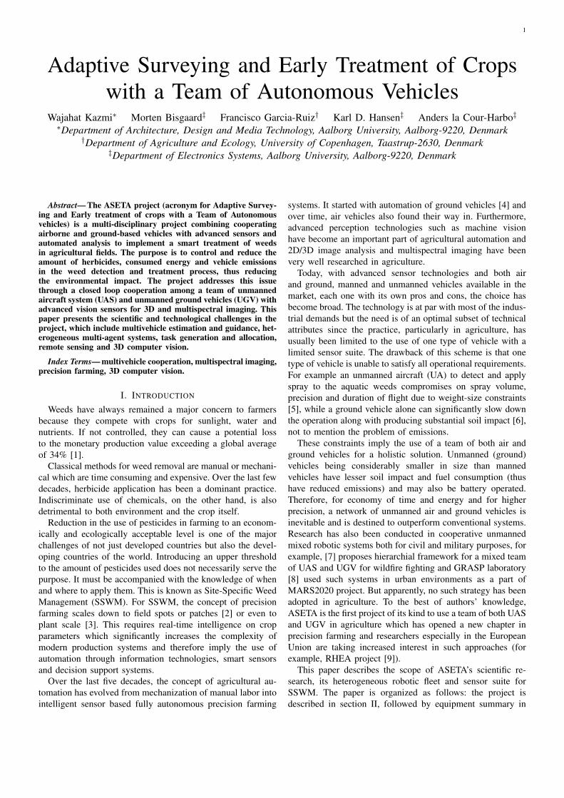
1) UAS: The UAS is comprised of two rotary wing aircraft.The first UA is a modified Vario XLC helicopter with aJetCat SPTH-5 turbine engine (Fig. 2). The helicopter weighs26 kg when fully equipped for autonomous flight and canfly for 30 minutes with 6 kg of fuel and 7 kg of payload.For autonomous flight, a NAV440 Inertial Navigation System(INS) from Crossbow is used together with altitude sonar.Onboard computer is a Mini-ITX with dual-core 1.6 GHzIntel Atom processor and runs a Debian Linux operatingsystem. The flight time in this configuration is approximately30 minutes.
The second UA is a modified Maxi Joker-3 helicopter fromMiniCopter. It is electrically powered and weighs 11 kg whenequipped for autonomous flight (Fig. 2). The helicopter can flyfor 15 minutes with a payload of 3 kg. It has a Xsens MTiGINS and sonar altimeters for autonomous flight and Nano-ITXsize 1.3 GHz onboard computer with Debian Linux operatingsystem.
Each UA can be configured to carry the multispectralcamera (see Section III-B) or a color camera. The sensorsare mounted in a modified OTUS L205 gimbal from DSTControl. The low level guidance, navigation, and control(GNC) system for the UAS is the baseline GNC software fromAalborg University’s UAV lab1. It features gain scheduledoptimal controller, unscented Kalman filter for navigation andan advanced trajectory generator.
1www.uavlab.org
3
Fig. 2. Autonomous vehicles in ASETA, (from left): Vario XLC, Maxi Joker-3 and robuROC-4
2) UGV: The ground vehicle is a robuROC-4 from Ro-bosoft (Fig. 2). Running on electric power this vehicle isdesigned for in-field use and will carry the TOF (see SectionIII-B) and color cameras for close-to-crop inspection. The totalweight is 140 kg (without vision system) and it is controlled bya standard laptop residing under the top lid running the cross-platform robot device interface Player/Stage. This vehicle isequipped with RTK GPS to allow it to traverse the crop rowswith sufficient accuracy.
B. Vision Systems
As described in section II, two different imaging systemswill be used: one for remote sensing and another for theground based close-to-crop imaging. For remote sensing, amultispectral camera will be employed and for ground basedimaging a fusion of Time-of-Flight and color images will beexplored.
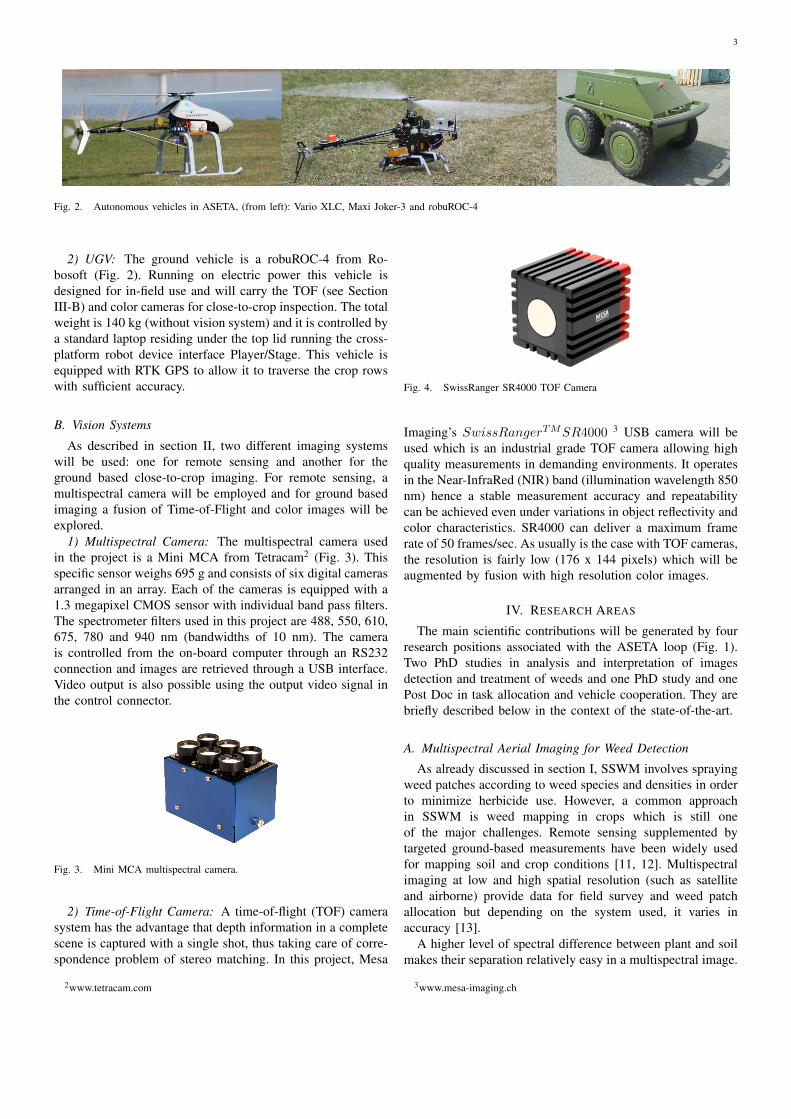
1) Multispectral Camera: The multispectral camera usedin the project is a Mini MCA from Tetracam2 (Fig. 3). Thisspecific sensor weighs 695 g and consists of six digital camerasarranged in an array. Each of the cameras is equipped with a1.3 megapixel CMOS sensor with individual band pass filters.The spectrometer filters used in this project are 488, 550, 610,675, 780 and 940 nm (bandwidths of 10 nm). The camerais controlled from the on-board computer through an RS232connection and images are retrieved through a USB interface.Video output is also possible using the output video signal inthe control connector.
Fig. 3. Mini MCA multispectral camera.
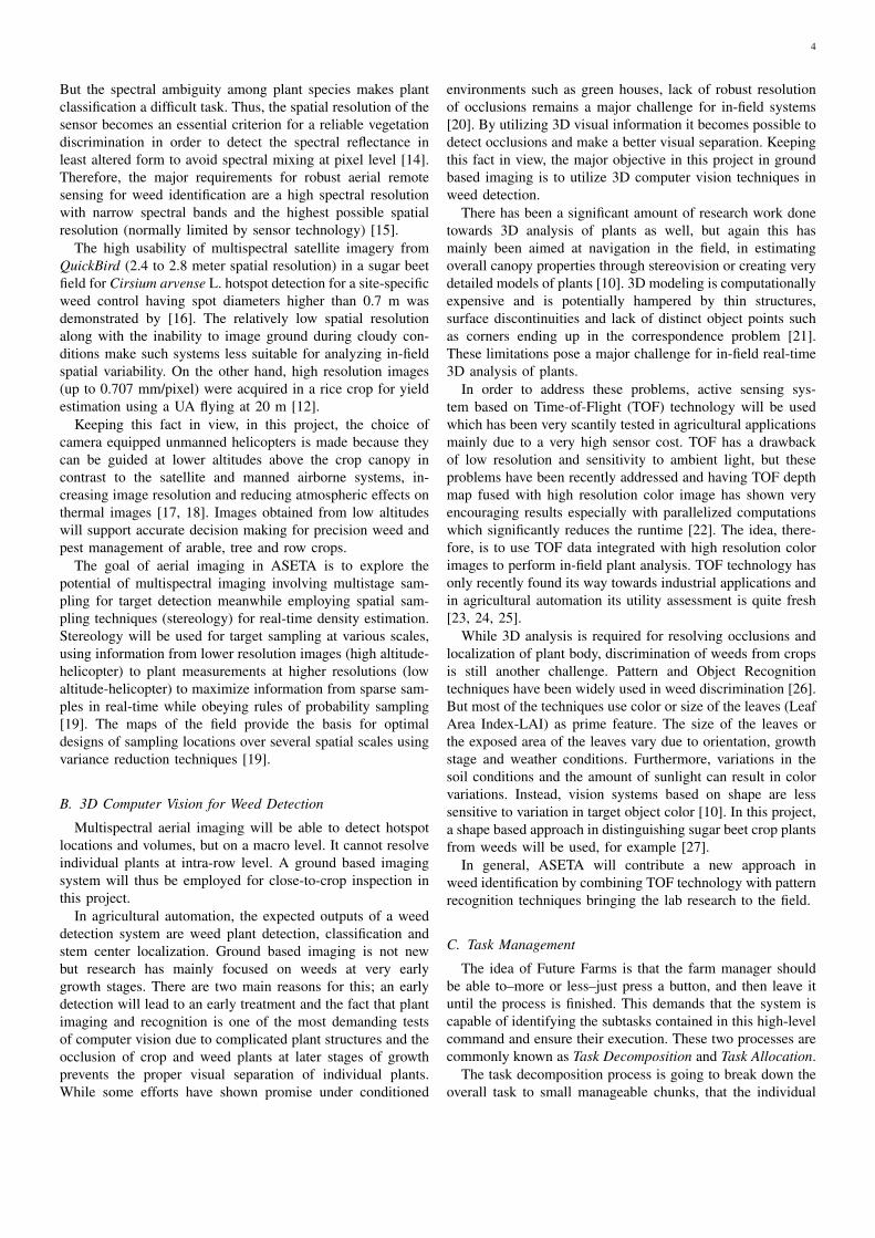
2) Time-of-Flight Camera: A time-of-flight (TOF) camerasystem has the advantage that depth information in a completescene is captured with a single shot, thus taking care of corre-spondence problem of stereo matching. In this project, Mesa
2www.tetracam.com
Fig. 4. SwissRanger SR4000 TOF Camera
Imaging’s SwissRangerTMSR4000 3 USB camera will beused which is an industrial grade TOF camera allowing highquality measurements in demanding environments. It operatesin the Near-InfraRed (NIR) band (illumination wavelength 850nm) hence a stable measurement accuracy and repeatabilitycan be achieved even under variations in object reflectivity andcolor characteristics. SR4000 can deliver a maximum framerate of 50 frames/sec. As usually is the case with TOF cameras,the resolution is fairly low (176 x 144 pixels) which will beaugmented by fusion with high resolution color images.
IV. RESEARCH AREAS
The main scientific contributions will be generated by fourresearch positions associated with the ASETA loop (Fig. 1).Two PhD studies in analysis and interpretation of imagesdetection and treatment of weeds and one PhD study and onePost Doc in task allocation and vehicle cooperation. They arebriefly described below in the context of the state-of-the-art.
A. Multispectral Aerial Imaging for Weed Detection
As already discussed in section I, SSWM involves sprayingweed patches according to weed species and densities in orderto minimize herbicide use. However, a common approachin SSWM is weed mapping in crops which is still oneof the major challenges. Remote sensing supplemented bytargeted ground-based measurements have been widely usedfor mapping soil and crop conditions [11, 12]. Multispectralimaging at low and high spatial resolution (such as satelliteand airborne) provide data for field survey and weed patchallocation but depending on the system used, it varies inaccuracy [13].
A higher level of spectral difference between plant and soilmakes their separation relatively easy in a multispectral image.
3www.mesa-imaging.ch
4
But the spectral ambiguity among plant species makes plantclassification a difficult task. Thus, the spatial resolution of thesensor becomes an essential criterion for a reliable vegetationdiscrimination in order to detect the spectral reflectance inleast altered form to avoid spectral mixing at pixel level [14].Therefore, the major requirements for robust aerial remotesensing for weed identification are a high spectral resolutionwith narrow spectral bands and the highest possible spatialresolution (normally limited by sensor technology) [15].
The high usability of multispectral satellite imagery fromQuickBird (2.4 to 2.8 meter spatial resolution) in a sugar beetfield for Cirsium arvense L. hotspot detection for a site-specificweed control having spot diameters higher than 0.7 m wasdemonstrated by [16]. The relatively low spatial resolutionalong with the inability to image ground during cloudy con-ditions make such systems less suitable for analyzing in-fieldspatial variability. On the other hand, high resolution images(up to 0.707 mm/pixel) were acquired in a rice crop for yieldestimation using a UA flying at 20 m [12].
Keeping this fact in view, in this project, the choice ofcamera equipped unmanned helicopters is made because theycan be guided at lower altitudes above the crop canopy incontrast to the satellite and manned airborne systems, in-creasing image resolution and reducing atmospheric effects onthermal images [17, 18]. Images obtained from low altitudeswill support accurate decision making for precision weed andpest management of arable, tree and row crops.
The goal of aerial imaging in ASETA is to explore thepotential of multispectral imaging involving multistage sam-pling for target detection meanwhile employing spatial sam-pling techniques (stereology) for real-time density estimation.Stereology will be used for target sampling at various scales,using information from lower resolution images (high altitude-helicopter) to plant measurements at higher resolutions (lowaltitude-helicopter) to maximize information from sparse sam-ples in real-time while obeying rules of probability sampling[19]. The maps of the field provide the basis for optimaldesigns of sampling locations over several spatial scales usingvariance reduction techniques [19].
B. 3D Computer Vision for Weed Detection
Multispectral aerial imaging will be able to detect hotspotlocations and volumes, but on a macro level. It cannot resolveindividual plants at intra-row level. A ground based imagingsystem will thus be employed for close-to-crop inspection inthis project.
In agricultural automation, the expected outputs of a weeddetection system are weed plant detection, classification andstem center localization. Ground based imaging is not newbut research has mainly focused on weeds at very earlygrowth stages. There are two main reasons for this; an earlydetection will lead to an early treatment and the fact that plantimaging and recognition is one of the most demanding testsof computer vision due to complicated plant structures and theocclusion of crop and weed plants at later stages of growthprevents the proper visual separation of individual plants.While some efforts have shown promise under conditioned
environments such as green houses, lack of robust resolutionof occlusions remains a major challenge for in-field systems[20]. By utilizing 3D visual information it becomes possible todetect occlusions and make a better visual separation. Keepingthis fact in view, the major objective in this project in groundbased imaging is to utilize 3D computer vision techniques inweed detection.
There has been a significant amount of research work donetowards 3D analysis of plants as well, but again this hasmainly been aimed at navigation in the field, in estimatingoverall canopy properties through stereovision or creating verydetailed models of plants [10]. 3D modeling is computationallyexpensive and is potentially hampered by thin structures,surface discontinuities and lack of distinct object points suchas corners ending up in the correspondence problem [21].These limitations pose a major challenge for in-field real-time3D analysis of plants.
In order to address these problems, active sensing sys-tem based on Time-of-Flight (TOF) technology will be usedwhich has been very scantily tested in agricultural applicationsmainly due to a very high sensor cost. TOF has a drawbackof low resolution and sensitivity to ambient light, but theseproblems have been recently addressed and having TOF depthmap fused with high resolution color image has shown veryencouraging results especially with parallelized computationswhich significantly reduces the runtime [22]. The idea, there-fore, is to use TOF data integrated with high resolution colorimages to perform in-field plant analysis. TOF technology hasonly recently found its way towards industrial applications andin agricultural automation its utility assessment is quite fresh[23, 24, 25].
While 3D analysis is required for resolving occlusions andlocalization of plant body, discrimination of weeds from cropsis still another challenge. Pattern and Object Recognitiontechniques have been widely used in weed discrimination [26].But most of the techniques use color or size of the leaves (LeafArea Index-LAI) as prime feature. The size of the leaves orthe exposed area of the leaves vary due to orientation, growthstage and weather conditions. Furthermore, variations in thesoil conditions and the amount of sunlight can result in colorvariations. Instead, vision systems based on shape are lesssensitive to variation in target object color [10]. In this project,a shape based approach in distinguishing sugar beet crop plantsfrom weeds will be used, for example [27].
In general, ASETA will contribute a new approach inweed identification by combining TOF technology with patternrecognition techniques bringing the lab research to the field.
C. Task Management
The idea of Future Farms is that the farm manager shouldbe able to–more or less–just press a button, and then leave ituntil the process is finished. This demands that the system iscapable of identifying the subtasks contained in this high-levelcommand and ensure their execution. These two processes arecommonly known as Task Decomposition and Task Allocation.
The task decomposition process is going to break down theoverall task to small manageable chunks, that the individual
5
members (robots) of the system are able to execute. Thedecomposition depends on the combined set of capabilitiesof the members. For example, if a member has the capabilityto take very high resolution images, the initial images mightbe taken from high altitude and only a few overview imagesmay be sufficient for mapping the the entire field. Whereas,if only low resolution cameras are available, several overviewimages may be required.
When the overall task has been decomposed into suitablesubtasks, they must be distributed to each of the membersin the system. This is known as Task Allocation. Severaldifferent approaches to this have been investigated. Two broadcategories can be identified as centralized and distributedallocation. The centralized approach is essentially a matterof solving a multiple travelling salesman problem (m-TSP).The distributed approach will divide the task of solving theTSP between each member. In this case the members mustcommunicate with each other to make sure that two membersare not planning to visit the same point (see section IV-D).
The TSP solution has historically received a great deal ofattention and has shown to be NP-hard [28], thus simplebrute-force algorithms will not be practically usable in thesystem. The Lin-Kernighan heuristic [29] of 1971 is still one ofthe most preferred algorithms for solving TSPs, and maintainsthe world record of solving the largest TSP [30]. A strategy tosolve the TSP with timing constraints (TCTSP) is devised in[31]. Helicopters conducting a closer examination of the weedinfestations in the ASETA scheme will experience a TCTSPas the high altitude images will be taken over time and thusthe close-up tasks are time constrained. Walshaw proposed amulti-level approach for solving the TSP [32]. This is relevantas the high altitude-helicopter process coarsens the TSP for thelow altitude-helicopter, and thus gives a coarse representationof the low-level TSP free of charge.
The decentralized approach relies on the members to dis-tribute the tasks among themselves, without intervention of agoverning system. The MURDOCH allocation system uses anauctioning approach where each robot bids on the differenttasks depending on their own perceived fitness for the taskat hand [33]. The fitness assessment of the ALLIANCEarchitecture [34] is based on a impatience behavioral pattern.These approaches will not guarantee the optimal solution,but provide some robustness that might be missing in thecentralized approach.
The aim of the ASETA task management is to utilize exist-ing TSP solving methods such as Lin-Kernighan or Walshawapproach and adapt them to the situation at hand, with themembers gradually revealing more and more information asthey move closer to the crops, from the high altitude- over tothe low altitude-helicopter down to the ground vehicle.
D. Multivehicle Cooperation
The close cooperation among team members (robots) is animportant part of ASETA in order to ensure a safe and efficientexecution of the tasks provided by the Task Management. Thecooperation layer will determine which robot will tackle whichtask and to some extent in what order. In a situation where
a team of heterogeneous robots must cooperate in order tocomplete a task in an open-ended environment, it is crucialthat each member has a clear understanding of its own aswell as the other members’ capabilities because they are notequally qualified to handle a given task. In this project, Thehelicopters are equipped with several different types of sensorsincluding cameras (as described in section III) well suitedfor observation only and the ground vehicle has an altogetherdifferent sensor suite and is meant for closer inspection andtreatment. This information is to be used by every member todecide which part of the overall task it should handle and howto do it.
To ensure a timely and efficient execution of the tasksit is equally important for a robot to know what its teammembers are doing – i.e. their behavior – and thereby ensuringthat two members do not unnecessarily work on the samesubtask. However, it is not always trivial to acquire suchknowledge. The distances involved in field operations canpotentially become very large and thus can only allow limitedcommunication. Furthermore, when reducing necessary com-munication among members, backwards compatibility is madeeasier and this is preferable in a industrial product. Therefore,the members must be able to deduce this knowledge from verylimited information such as the state (position, orientation, andvelocity) of the other members. This will put lesser constraintson the robots that are allowed to participate in the cooperation.In fact even robots without any cooperative capabilities can bea part of the system, as long as they can share their state withthe rest of the team.
Current research in cooperative control of multivehicle sys-tems focuses mainly on the control element such as formationcontrol or distributed optimization. A comprehensive reviewof recent research in cooperative control can be found in[35]. Only few projects have taken the limited communicationbetween robots into account (for example: [36] or [37]).
In this project, the actual cooperation layer is created as adecentralized two-level approach:
1) Level 1: Acquiring team behavioral information: Thechallenges of this level are seen primarily as a model basedestimation problem which will be solved using particle fil-tering. This is done through the formulation of a behavioralmodeling framework which in turn describes the differentpossible behaviors of the members. When used in a particlefilter, it is capable of determining the maximum likelihoodhypothesis, i.e. best fitting behavior of the observed teammembers.
2) Level 2: Task execution: Each member is assumed to becontaining a low level navigation and control system as well assimple trajectory planning. As a high level control, a recedinghorizon is used in the form of a decentralized Model PredictiveController (MPC). The MPC on each member will attempt tofind an optimal behavioral action to take, given informationabout the current behavior of the rest of the team.
In short, the ASETA cooperation scheme will use particlefiltering and model predictive control to implement coopera-tion between loosely coupled robots.
6
V. CONCLUSION
ASETA will not only produce high quality research inmultispectral imaging, computer vision and multivehicle sys-tems, but it also aims at developing an actual demonstrator.Working within the price range of other farming machineryand the use of off-the-shelf hardware throughout enhances thelikelihood of tools developed in this project being adopted bythe industry. The long term objective of ASETA is a com-mercially available autonomous multi-scale surveying systemfor site specific weed management to reduce the cost andenvironmental impact of farming chemicals, fuel consumptionand emissions. It therefore holds the potential for significantimpact on the future of precision farming worldwide.
Given the rising levels of atmospheric CO2 and tempera-tures under climate change, weed species are expected to showa higher growth pattern than crops due to their greater geneticdiversity [38]. On the other hand, governments mandate con-siderable reductions on the use of pesticides. This fact hasadded more importance and promise to such projects.
Although dealing with a system of heterogeneous vehiclesincreases the complexity of the system, however, it also servesas a flexibility on the user end in the choice of vehicles andsensors from a wide range, producing a more customizedsolution to the application at hand. ASETA, therefore, hasfuture beyond agriculture towards several other applicationssuch as fire fighting, search & rescue and geological surveying,in the long run.
REFERENCES
[1] E. Oerke, “Crop losses to pests,” The Journal of Agricultural Science,vol. 144, no. 01, pp. 31–43, 2006.
[2] S. Christensen, T. Heisel, A. M. Walter, and E. Graglia, “A decisionalgorithm for patch spraying,” Weed Research, vol. 43, no. 4, pp. 276–284, 2003.
[3] M. Ehsani, S. Upadhyaya, and M. Mattson, “Seed location mappingusing RTK GPS,” Trans.-American Society of Agricultural Engineers,vol. 47, no. 3, pp. 909–914, 2004.
[4] K. Morgan, “A step towards an automatic tractor,” Farm mech, vol. 13,no. 10, pp. 440–441, 1958.
[5] A. H. Goktogan, S. Sukkarieh, M. Bryson, J. Randle, T. Lupton,and C. Hung, “A rotary-wing unmanned air vehicle for aquatic weedsurveillance and management,” J. Intell. Robotics Syst., vol. 57, pp. 467–484, January 2010.
[6] V. Rusanov, “Effects of wheel and track traffic on the soil and on cropgrowth and yield,” Soil and Tillage Research, vol. 19, no. 2-3, pp. 131– 143, 1991.
[7] C. Phan and H. H. Liu, “A cooperative UAV/UGV platform for wildfiredetection and fighting,” in 2008 Asia Simulation Conference - 7th In-ternational Conference on System Simulation and Scientific Computing,(Beijing), pp. 494–498, Ieee, Oct. 2008.
[8] L. Chaimowicz, A. Cowley, D. Gomez-Ibanez, B. Grocholsky, M. Hsieh,H. Hsu, J. Keller, V. Kumar, R. Swaminathan, and C. Taylor, Deployingair-ground multi-robot teams in urban environments, vol. III, pp. 223–234. Springer, 2005.
[9] “RHEA: Robot Fleets for Highly Effective Agriculture and ForestryManagement,” http://www.rhea-project.eu/, accessed 08-Apr-2011.
[10] C. L. McCarthy, N. H. Hancock, and S. R. Raine, “Applied machinevision of plants: a review with implications for field deployment inautomated farming operations,” Intelligent Service Robotics, vol. 3,pp. 209–217, Aug. 2010.
[11] K. R. Thorp and L. F. Tian, “A review on remote sensing of weeds inagriculture,” Precision Agriculture, vol. 5, no. 5, pp. 477–508, 2004.
[12] K. C. Swain, S. J. Thomson, and H. P. W. Jayasuriya, “Adoption of anunmanned helicopter for low-altitude remote sensing to estimate yieldand total biomass of a rice crop,” Trans. of the ASABE, vol. 53, pp. 21–27, Jan-Feb 2010.
[13] M. S. Moran, Y. Inoue, and E. M. Barnes, “Opportunities and limitationsfor image-based remote sensing in precision crop management,” RemoteSensing of Environment, vol. 61, pp. 319–346, Sep 1997.
[14] D. W. Lamb and R. B. Brown, “Remote-sensing and mapping ofweeds in crops,” Journal of Agricultural Engineering Research, vol. 78,pp. 117–125, Feb 2001.
[15] R. B. Brown and S. D. Noble, “Site-specific weed management: sensingrequirements - what do we need to see?,” Weed Science, vol. 53, pp. 252–258, Mar-Apr 2005.
[16] M. Beckes and J. Jacobi, “Classification of weed patches in quickbirdimages: Verification by ground truth data,” EARSeL eProceedings,vol. 5(2), pp. 173–179, 2006.
[17] J. A. J. Berni, P. J. Zarco-Tejada, L. Suarez, and E. Fereres, “Thermaland narrowband multispectral remote sensing for vegetation monitoringfrom an unmanned aerial vehicle,” IEEE Transactions on Geoscienceand Remote Sensing, vol. 47, pp. 722–738, Mar 2009.
[18] R. Sugiura, N. Noguchi, and K. Ishii, “Remote-sensing technologyfor vegetation monitoring using an unmanned helicopter,” BiosystemsEngineering, vol. 90, pp. 369–379, Apr 2005.
[19] D. Wulfsohn, “Sampling techniques for plants and soil: In. advanced en-gineering systems for specialty crops: A review of precision agriculturefor water, chemical, and nutrient application, and yield monitoring.,”Landbauforschung Volkenrode, vol. Special Issue 340, pp. 3–30, 2010.
[20] D. Slaughter, D. Giles, and D. Downey, “Autonomous robotic weedcontrol systems: A review,” Computers and Electronics in Agriculture,vol. 61, pp. 63–78, Apr. 2008.
[21] a. Piron, F. Van Der Heijden, and M. Destain, “Weed detection in 3Dimages,” Precision Agriculture, pp. 1–16, Nov. 2010.
[22] B. Huhle, T. Schairer, P. Jenke, and W. Straßer, “Fusion of range andcolor images for denoising and resolution enhancement with a non-localfilter,” Comp. Vision and Image Understanding, vol. 114, pp. 1336–1345,Dec. 2010.
[23] G. Alenya, B. Dellen, and C. Torras, “3D modelling of leaves from colorand ToF data for robotized plant measuring,” in Proc. of the InternationalConference on Robotics and Automation, (accepted), 2011.
[24] M. Kraft, N. Regina, S. a. D. Freitas, and A. Munack, “Test of a 3DTime of Flight Camera for Shape Measurements of Plants,” in CIGRWorkshop on Image Analysis in Agriculture, no. August, (Budapest),2010.
[25] A. Nakarmi and L. Tang, “Inter-plant Spacing Sensing at Early GrowthStages Using a Time-of-Flight of Light Based 3D Vision Sensor,” inASABE Meeting Presentation, no. 1009216, 2010.
[26] M. Weis and M. Sokefeld, Detection and Identification of Weeds, ch. 8,pp. 119–134. Dordrecht: Springer Netherlands, 2010.
[27] M. Persson and B. Astrand, “Classification of crops and weeds extractedby active shape models,” Biosys. Eng., vol. 100, pp. 484–497, Aug. 2008.
[28] M. R. Garey and D. S. Johnson, Computers and Intractability. W. H.Freeman and Co., 1979.
[29] S. Lin and B. Kernighan, “An effective heuristic algorithm for thetraveling-salesman problem,” Operations research, vol. 21, no. 2,pp. 498–516, 1973.
[30] K. Helsgaun, “General k-opt submoves for the Lin-Kernighan TSPheuristic,” Mathematical Programming Computation, vol. 1, pp. 119–163, July 2009.
[31] E. K. Baker, “An exact algorithm for the time-constrained travelingsalesman problem,” Operations Res., vol. 31, pp. 938–945, Apr. 1983.
[32] C. Walshaw, “A multilevel approach to the travelling salesman problem,”Operations Research, vol. 50, pp. 862–877, Sept. 2002.
[33] B. P. Gerkey and M. J. Mataric, “Sold!: auction methods for multirobotcoordination,” IEEE Transactions on Robotics and Automation, vol. 18,pp. 758–768, Oct. 2002.
[34] L. E. Parker, “Alliance: An architecture for fault tolerant, cooperativecontrol of heterogeneous mobile robots,” in Proc. IROS, pp. 776–783,1994.
[35] R. M. Murray, “Recent Research in Cooperative Control of MultivehicleSystems,” Journal of Dynamic Systems, Measurement, and Control,vol. 129, no. 5, pp. 571–583, 2007.
[36] G. M. Hoffmann, S. L. Wasl, and C. J. Tomlin, “Distributed cooperativesearch using information-theoretic costs for particle filters with quadro-tor applications,” in Proceedings of the AIAA Guidance, Navigation, andControl Conference, pp. 21–24, 2006.
[37] K. S. Alessandro Arsie and E. Frazzoli, “Efficient Routing Algorithmsfor Multiple Vehicles With no Explicit Communications,” IEEE Trans-actions on Automatic Control, vol. 54, no. 10, pp. 2302–2317, 2009.
[38] L. Ziska and G. Runion, Future weed, pest and disease problems forplants, pp. 261–287. Boca Raton FL: CRC Press, 2007.