Embed Size (px)
Citation preview

Action Research in Landscape Mosaics: Approaches and Methods
A Report of and Reflections on a Workshop held at Senggigi Beach Hotel, Lombok, Indonesia,
3-6 December 2007
Peter G.H. Frost
87, Ikitara Road Wanganui 4500 New Zealand
March 2008
Supported by funds from the European Union


Contents
Acknowledgements........................................................................................ ii
1. INTRODUCTION ......................................................................................... 1
2. THE LANDSCAPE MOSAICS PROJECT ................................................................. 2
3. LANDSCAPE MOSAIC PROJECT SITES ................................................................. 2
3.1 Muara Bungo, Jambi Province, Sumatra, Indonesia ............................................. 3
3.2 Luang Phrabang, Viengkham District, Lao People’s Democratic Republic................... 4
3.3 Takamanda-Mone, Cameroon....................................................................... 6
3.4 Tanga Region, East Usambara Mountains, Tanzania ............................................ 8
3.5. Manompana, Toamasina, Madagascar ...........................................................10
4. COMMON RESEARCH ACTIVITIES.....................................................................12
5. IMPACT PATHWAYS AND EXPECTED CHANGES ....................................................18
5.1 Muara Bungo, Jambi Province, Sumatra, Indonesia ............................................18
5.2 Luang Phrabang, Viengkham District, Lao People’s Democratic Republic..................19
5.3 Takamanda-Mone, Cameroon......................................................................19
5.5 Manompana, Toamasina, Madagascar ............................................................21
6. REFLECTIONS AND CONCLUDING THOUGHTS ON THE WAY AHEAD ............................21
6.1 Action research ......................................................................................22
6.2 The role of researchers .............................................................................22
6.3 Guidelines for landscape management...........................................................23
6.4 Minimal data set for cross-site comparisons ....................................................25
6.5 Timing and duration.................................................................................26
Annex 1 ....................................................................................................27
Annex 2 ....................................................................................................28
Annex 3 ....................................................................................................30
Annex 4 ....................................................................................................31
Annex 5 ....................................................................................................33
i

Acknowledgements
I am grateful to Jean-Laurent Pfund for inviting me to the workshop, and for stimulating discussions before, during, and after it; John Watts for providing notes on the proceedings and for collating the various presentations and reports given to the workshop; and Indah Susilanasari for logistical and other assistance. Thanks also to Yves Laumonier, Jean-Marc Boffa, and Terry Sunderland for useful discussions on various issues, and to all workshop participants for their inputs. I am grateful to Wageningen University (Plant Production Systems Group) for the opportunity to finish this report, using its excellent library facilities in the process. The workshop was held with funds from the European Union. Disclaimer The views expressed in this document can in no way be taken to reflect the official opinion of the European Union.
ii

Action Research in Landscape Mosaics: Approaches and Methods
1. INTRODUCTION Landscapes are relatively large, spatially defined, geographic areas that normally comprise a mosaic of geological units, soils, landforms and drainage, on which are superimposed a variety of biotic communities, land covers, human land uses, cultures, and values. Landscapes are usually perceived and defined at human scales, as they correspond broadly to the scale at which human rural communities function. The elements making up a landscape are not isolated, but interact across boundaries and ecotones, along corridors, and across patches. The movement of water, material, and organisms is not uniform, but is variously impeded by barriers, sifted through filters, or channelled along conduits and corridors. Even the matrix in which some of the more contrasted and discrete elements are embedded, such as forest patches in a grassland matrix, may be selectively permeable to such flows. People do not all view a given landscape in the same way. Their perspective and values are shaped by their needs, interests, experience, training, and what they seek to gain from, or contribute to, the site. They manage the landscape accordingly. This selectivity of vision complicates attempts to manage landscapes in an integrated way because each interested party—“stakeholders” in contemporary jargon—has different objectives and these often diverge widely. Some stakeholders have the power to influence the form and function of a landscape, others are affected by such changes and often can less easily influence the outcome. Further complications arise from interactions between people and a landscape; among landscapes and landscape elements themselves, across a range of spatial and temporal scales; and within and among stakeholders themselves, outside the landscapes. Historical and geographic contexts are also important in shaping the outcomes of these interactions, making it difficult to arrive at generalities. Particular problems arise when attempting to integrate ‘top-down’ and ‘bottom-up’ perspectives. Top-down perspectives tend to have a macro-economic viewpoint, emphasising the contribution of agricultural production, forestry, mining, and other land uses to gross domestic product, or the capacity to meet global demand through trade, enhancing profits and foreign exchange earnings. Management and use are conceived in terms of standards, regulations, and enforcement. The multiple and fluctuating interests of local people are largely ignored, if only because they are too variable to take into account in national policies. Conversely, local people take a fine-grained view of their environment, dominated by micro-economic decisions and actions around issues of wellbeing and livelihoods, centred on subsistence or small-scale commercial production. To local people, the landscape is more than simply a production unit, but one that represents home, a place of spirits and culture. Their horizons are generally narrow; governments and others operating at a large scale are considered too remote and unresponsive to their needs. The real challenge for land-use planning is to integrate these contrasting viewpoints. All this complexity poses two key questions:
• How best can the perceptions and values of different stakeholders be integrated in the context of poverty alleviation (implying some degree of landscape modification/transformation) and biodiversity conservation (requiring the retention of as much natural cover as possible)?
• What constitutes enhanced landscape performance in relation to these two ends, and how best can this be operationalized?
These and other issues were discussed at a planning workshop for the Landscape Mosaics Project held at Senggigi Beach Hotel, Lombok, Indonesia, from 3-6 December 2007. This document presents a synthesis of the main points of the presentations, discussions, and decisions taken at the workshop.
1
Action Research in Landscape Mosaics: Approaches and Methods 2. THE LANDSCAPE MOSAICS PROJECT One inevitable consequence of the increasing transformation and modification of natural landscapes by human activities is the fragmentation of wildlife habitat. This is most obvious and arguably most pronounced in forested regions, where the converted natural systems are substantially different from that which was there before. The principal response of conservationists to this has been to set up protected areas from which local people are excluded and, in some cases, actively displaced. This has usually resulted in tension between local people and those wanting to conserve the protected areas. Pressures on resources outside the protected areas increase, followed in turn by encroachment of the protected areas and unsanctioned use of resources in them. People living in these biodiversity-rich forested landscapes are also often materially poor and depend largely on extracting and processing low-value forest products (or they lack the technology, skills, and connections to realize the full worth of the more valuable resources). Their access to educational, medical, social, and financial services is limited, prompting the need for development. At the same time, despite protection, biodiversity has declined, either because the protected areas are too small to support viable populations of certain species—usually those with naturally small populations or requiring large home ranges—or because the changes in land cover cut important seasonal migration or dispersal routes. Some species or biotic groups are also threatened directly through exploitation (e.g. through logging, hunting, fishing, or some other extractive activity). Consequently, conserving biodiversity has to go beyond defending protected areas. Provisions need to be made to maintain connectivity of some sort among these areas, as well as safeguarding essential components and processes, while also ensuring that people in the surrounding areas benefit socially and economically from these areas and the biodiversity that they support. To address these issues, the Center for International Forestry Research (CIFOR) and the World Agroforestry Center (ICRAF), working under the auspices of the Joint Biodiversity Platform and with support from the Swiss Development Corporation, have initiated the Landscape Mosaics Project with an overall objective to promote the integration of livelihoods and multiple biodiversity values in mosaic landscapes. This is being done through the following activities at five sites globally:
• identifying local needs and multiple biodiversity values and integrating them in the land-use planning processes of selected tropical landscape mosaics;
• developing and promoting the use of participatory landscape planning and monitoring approaches that integrate development and conservation objectives in land-use planning; and,
• disseminating the lessons learned to relevant international agencies, and promoting their uptake and application in research-and-development best practices.
3. LANDSCAPE MOSAIC PROJECT SITES Research in this project is being undertaken at five sites, two in South-East Asia (Bungo, Jambi Province, Sumatra, Indonesia, and Luang Phrabang, Viengkham District, Laos), two in Africa (Takamanda-Mone, Cameroon, and Tanga Region, Eastern Usambara Mountains, Tanzania), and one in Madagascar (Manompana, Soavinerana-Ivongo District, Toamasina Province). These sites all fall within one or other of the top 25 global biodiversity hotspots identified by Myers et al. (2000). Brief descriptions of these sites, the key conservation issues, site-specific objectives, and a summary of the actions planned at each one, follow.
2

Action Research in Landscape Mosaics: Approaches and Methods
3.1 Muara Bungo, Jambi Province, Sumatra, Indonesia This is the first project to be established under the CIFOR-ICRAF Biodiversity Platform. It is situated within the Sundaland biodiversity hotspot, ranked third among the top eight global hotspots, as categorised by the number and density of endemic plants and vertebrates, and the percent of primary vegetation remaining intact (Myers et al. 2000). The project is focused on rubber agroforests (RAF) and their potential to support substantial natural diversity and connect the wildlife populations in the protected forests of three national parks: Kerinci Seblat, Bukit Duabelas, and Bukit Tigapuluh. Plant diversity is high, not only within the natural forest but also within RAF systems. Three-quarters of these species are dispersed by animals. Bird and mammal diversity is high. People in Bungo depend on the forests for a variety of goods and services (fruit, water, timber), but the landscapes are changing rapidly through the expansion of rubber and oil palm plantations, and with increases in mining for coal and gold. Between 1990 and 2000, the area of indigenous forest declined by about 12%. Although forest transformation results in a considerable loss of biodiversity, the RAF systems successfully conserve much of this, relative to monoculture plantations of rubber or oil palm. About 78% of the bird species and 44% of mammal species found in surrounding natural forest also occur in mature RAF, with diversity of species increasing markedly in older RAF. A number of these species are protected both in Indonesia and internationally under the Convention on International Trade in Endangered Species (CITES). Researchers from ICRAF have a long standing connection with the local Dinas. Prior work in Bungo has focused on creating greater awareness of the importance of biodiversity and environmental services, strengthening and empowering local institutions, setting up farmers’ groups around activities such as establishing rubber nurseries and micro-hydro systems, participatory mapping of natural resources, and exploring possible reward systems for conserving biodiversity and environmental services. This project seeks to build on these achievements, to integrate concerns for biodiversity conservation alongside those of economic development in local land-use planning processes. In Jambi, especially Bungo, planning is carried out at a district level. In 2005, the local government agency responsible for regional development and planning (BAPPEDA) invited NGOs and researchers to contribute to the planning initiative. This followed the establishment in 2004 of a multi-stakeholder forum, comprising representatives from communities, local government (forestry and environment), academia, and NGOs, to discuss district development issues. Whereas government in the past has used such meetings to emphasise and encourage compliance with existing laws, there is now increasing willingness to listen to people’s concerns and opinions. These meetings provide an opportunity to discuss land-use planning with local people, and foster their interest in the process. In late October 2007, representatives of local district services, the regional planning agency, the forestry department, CIFOR, ICRAF and Komunitas Konservasi Indonesia WARSI participated in a local inception meeting for the Landscapes Mosaic Project. Discussions focused on identifying the research sites and establishing what information is available that could be used to integrate biodiversity conservation and economic development during land-use planning at a local level. Three villages were selected along a transect from low density to high forest cover: Desa Lubuk Beringin and adjacent hamlets; Desa Tebing Tinggi; and Desa Danao. These sites were chosen because of they have been the focus for earlier studies, so a considerable amount of biophysical and socioeconomic information is already available (see Annex 1). Overall, work by ICRAF and its partners in Jambi have generated a substantial amount of data on which the project can build. This includes spatial analyses of land cover, land use, topography, drainage, settlements, and infrastructure. More recent satellite imagery, with a finer 10-m resolution (SPOT), has been ordered. Considerable information on
3

Action Research in Landscape Mosaics: Approaches and Methods the biodiversity of the area has been collected by various organisations but, along with population data, needs to be brought up to date. Apart from collating the existing information and assessing its value for land-use planning, it is also necessary to review existing land-use plans and the planning process in the area. Biodiversity conservation is not the main concern of most stakeholders, especially the communities and local government, so the initial challenge is to consider the balance between biodiversity and economic development with the communities and how to improve the situation. This could include using economic incentives to protect biodiversity, though any such compensation scheme would need to be well founded. If people develop excessive expectations of the level of compensation, it could jeopardise this process, so establishing an appropriate incentive level, taking into account people’s opportunity and transaction costs, is essential. Even if the project does not manage to alter substantially the present trajectory of land-use change, the lessons learned will provide valuable knowledge about the limits to reconciling conservation and development. Immediate challenges for the project include allocating roles and responsibilities among the parties involved and drawing up a specific schedule of activities and timelines. Because of resource limitations much of the work will have to be done in partnership with others, especially KKI-WARSI, or by subcontracting specific elements of the project to others. In either case, decisions are required on what measures of progress need to be monitored, and how best to do this. 3.2 Luang Phrabang, Viengkham District, Lao People’s Democratic Republic Lao PDR is situated within the Indo-Burma biodiversity hotspot, and is ranked sixth among the top eight global hotspots identified by Myers et al. (2000). It falls within one of Vavilov’s centres of origin of domesticated plants and animals. The country has an exceptionally rich flora and many bird, mammal, reptile and amphibian species. Many of these are linked to the country’s forests and are currently conserved within 20 National Biodiversity Conservation Areas, which cover 14% of the country. Land ownership outside reserve areas is invested in local communities. Within these areas, considerable biodiversity is believed to exist within remnant forest patches making up the landscape mosaic. Given the dependence of the Laotian economy and its people on natural resources, biodiversity conservation and management needs to be extended to other areas, to improve food security and ensure poverty reduction, particularly among the rural poor. The United Nations classes Lao PDR one of the world’s fifty Least Developed Countries (see http://www.un.org/special-rep/ohrlls/ldc/LDCs-List/profiles/laoDemRep.htm?id=418). Per capita GDP in 2005 is estimated to have been US$485 (US$ 2, 039 at purchasing power parity), half of which is contributed by subsistence agriculture (which also accounts for 85% of total employment: UN World Development Report 2007-2008, see http://hdr.undp.org/en/media/hdr_20072008_en_complete.pdf). Infrastructure is greatly underdeveloped, with only a few basic roads, no railways, little electricity, and limited telecommunications. The government is under considerable pressure, internally and externally, to facilitate the exploitation and export of natural resources, particularly to neighbouring China, where demand for resources is soaring. Deforestation and forest degradation resulting from unsustainable land-use practices, principally land conversion, logging, and shifting cultivation, constitute the major threats to this biodiversity. Between 1992 and 2002, forest cover declined by over 5%, no doubt with an associated loss of some biodiversity, though how much is unknown. In response to these threats, the government has introduced a number of measures, including:
• Changing the policy and improving legal frameworks related to forest protection and use;
4

Action Research in Landscape Mosaics: Approaches and Methods
• Acceding to the Convention on Biological Diversity, leading to the development and endorsement of a national biodiversity strategy;
• Implementing a National Land Use Planning and Land Allocation Scheme; • Implementing a Shifting Cultivation Programme, aimed at introducing sustainable
livelihood alternatives; • Introducing restrictions on logging, together with the establishment of a system of
production forests and community-based sustainable forest management; • Halting, at least temporarily, the allocation of concessions for rubber plantations; • Encouraging the establishment of forest plantations to reduce pressure on the natural
forest; • Linking forest conservation to rural development and ecotourism through integrated
conservation and development schemes; • Enhancing research capacity for better information; and • Building and empowering local capacity.
Challenges remain, however. Shifting cultivation is still widespread. Human resources (skills and knowledge), information, and funds to promote conservation and sustainable management of natural resources are all limited. The demand for natural resources from neighbouring countries is high and growing, and there is an upsurge in monoculture cash crops, leading to increased demand for land concessions. Along with this is the ongoing development of infrastructure such as roads and dams, but with little thought given to their impacts on biodiversity. Overall, information on biodiversity and its values is limited. The current project, situated in Luang Phrabang, Viengkham District, adjacent to the Phou Loey National Biodiversity Conservation Area, is focused on implementing and testing a participatory land-use based biodiversity assessment and monitoring programme in various communities in the district. The region borders China and Vietnam, and is crossed by a national road to Vietnam, a road that is due to be upgraded with Asian Development Bank funding. This road will improve access to and through the region, but this improved access to markets could also increase the rate of extraction of natural resources. Formalized land-use planning in Laos started only about 10 years ago and is still evolving. To date, implementation has not been particularly successful. One aim of the project therefore is to monitor the local impacts of land-use planning on people and biodiversity, both locally and at district level, so as to identify any adverse impacts of the process and allow recommendations for improving it to be made. Another aim is to encourage the development of a more equitable and balanced land-use planning process both in its outcomes for people, and in its impacts on livelihoods and biodiversity. Because difficulties with land-use planning can arise both from the policies underpinning the process and with how the process is implemented, both facets will be considered in the project. Implementing the Landscape Mosaics Project in Laos is not just a considerable challenge; it offers significant opportunities to integrate concerns about biodiversity conservation with those of economic and social development at an early stage in the process of rural transformation. If successful, the methods and approaches can be incorporated in, or adapted to, the formal land-use planning process. If unsuccessful, useful lessons can still be learned about the constraints on integrating divergent interests, and may lead to the development and testing of others models for reconciling these. Unlike the other sites in the Landscape Mosaic Project, research in Laos has to start from the beginning, as there is little existing information about the area. Some GIS data will be available at the end of 2007. A preliminary analysis of stakeholders and their interests are available in a report of the Upland Research and Capacity Development Research Programme (URDP) research agenda and program planning workshop held in Luang Prabang in August 2007 (see http://lad.nafri.org.la/FullText/LAD010320071337.pdf particularly Annex 4). Priorities in
5

Action Research in Landscape Mosaics: Approaches and Methods 2008 include analysing perceptions of landscapes, policies, and development options by the different stakeholder groups, and assessing the similarities and differences in these among the sites. Information on policies and institutions is available from other projects and from government ministries but these need critical analysis of their intended, actual, and inadvertent effects. Specific studies that should be done early in the project include field surveys of biodiversity across the landscape mosaic, surveys of households and livelihoods, and a preliminary evaluation of the potential for using economic incentives to secure conservation goals. Given the constraints of funding and personnel, the scope of these surveys must be clearly established beforehand, so that the data collected serves the needs of negotiators and decision makers (at all levels). Just who will do all this work in the time available is currently uncertain, and will have to be negotiated between CIFOR, NAFRI, NLMA, URDP, the Ministry of Forestry, various university groups, other international NGOs, and district and village authorities responsible for local-level land-use planning. A preliminary listing of activities and broad timeframes, as presented at the workshop, is given in Annex 2. The overall paucity of information suggests the need for a more limited objective than at the other LMP sites, one that focuses primarily on building synergies among the various stakeholders involved in the maintenance and management of landscape mosaics and in monitoring the outcomes of current land-use planning initiatives. Addressing the various needs of local people in these contexts is crucial. The National Agriculture and Forestry Research Institute (NAFRI) has already identified these needs in general terms (see above). NAFRI, which was established in 1999 through the amalgamation of all existing agriculture and forestry research centres to undertake research in support of development, is working with the National Land Management Agency (NLMA) to implement, monitor, and refine land-use planning initiatives. A key opportunity for the Landscape Mosaics Project is to work with NAFRI, NLMA, and other stakeholders, including local communities, to help identify and reconcile, where possible, their various divergent interests. In so doing, the LMP could also help build capacity at various levels to address multi-faceted, multi-scale problems of integrating livelihood improvement and biodiversity conservation. Getting clarity on roles, responsibilities, and reporting is a priority. 3.3 Takamanda-Mone, Cameroon The Takamanda-Mone area of Cameroon is situated within the Guinean Forests of West Africa biodiversity hotspot (Myers et al. 2000). The level of endemism within the flora and among the main faunal groups in this hotspot is extremely high (plants, 25%; amphibians, 77%; reptiles, 33%; birds, 18%; mammals, 8%). Takamanda-Mone region supports six (85-125 individuals) of the 11 remaining groups (250-300 individuals) of the critically endangered Cross River Gorilla, Gorilla gorilla diehli, a distinct subspecies of gorilla that until recently was thought to be extinct. The region also supports populations of chimpanzee, drills, elephants, forest buffalo, a number of threatened bird and reptile species, as well as economically important plant species such as the bush mango Irvingia gabonensis, chewing sticks Garcinia spp., and a variety of timber trees. Households in areas closer to roads and markets depend primarily on cultivated cash crops (palm oil, cocoa, and cassava), whereas those in more remote areas derive their livelihoods mainly from exploiting land and forest resources; these communities derive ~90% of their income from forest products. In addition to income, both for local people and for the government in the form of timber and mining concession fees and royalties, the landscapes of the region provide a range of environmental services: drinking water for the local population; food and medicines for households; cultural values; land for agriculture; global carbon sequestration; and research opportunities and materials. The beneficiaries range from households and communities, through the local council, traders, small-scale businesses depending on natural resources, and logging companies, to the Cameroon government, university and other researchers, and the global community. Most settlements are clustered
6

Action Research in Landscape Mosaics: Approaches and Methods
around the edges of the Takamanda and Mone Forest Reserves, though there are four settlement clusters within Takamanda, an issue that will be contentious if plans to create a national park out of the forest reserve come about. Both forest reserves are exploited unofficially for timber, bushmeat, and other forest products. Management of, and decision-making on, natural resource use and conservation currently are largely top-down. Communities have no option other than to accept government decisions on land and resource use (e.g. exploiting forests for timber). Tenure rights over land in settlement areas have not been fully transferred to communities. Despite the Cameroon government’s policy of devolution, the transfer of funds below district-council level is limited, which could become a problem for any benefit-sharing schemes. Changes to the protected area system are altering former traditional local forest management systems, and make it difficult for communities to manage resources in traditional ways. Planning and management is further complicated by the large numbers and diversity of interests of stakeholders, including communities, local councils, private land managers, logging companies (TRC, WIJMA), traders and small businesses, common interest groups, state agencies (e.g. MINFOR), German Development Bank (KfW), and various national and international NGOs, including the Wildlife Conservation Society. The last of these also operates a Landscape Project, albeit focused primarily on the region’s protected areas (see http://www.wcs.org/international/Africa/Cameroon/TakamandaMone). Working effectively with these different groups will be a significant challenge. The core of the LMP in Takamanda-Mone is to influence the process of integrated management being undertaken by the Technical Cooperation Unit for South-West Province (TCU-SWP) in Takamanda-Mone to reconcile livelihood and conservation objectives. This involves bringing local people into the planning process. A secondary objective is to encourage management of any logging concessions for the broader benefit of the community. Considerable biophysical, spatial, and socio-economic data are already available for Takamande-Mone and these need to be linked to discussions and negotiation about the future land uses and the conservation and development zones of the region. A summary of these data sets, with the dates when the surveys were carried out, is given below. Biophysical
Distribution and abundance of large mammals (1997-2003, 2007); Multi-taxa survey of Takamanda—birds, lepidoptera, fisheries, amphibians, reptiles
(2001-2003); Distribution, ecology, habitat, feeding behaviour, and genetics of the Cross River
Gorilla population (1997 to present); Plant-based NTFPs and assessments of their distribution, importance to livelihoods,
and sustainability of use (2003, 2007); and Vegetation assessments, including the establishment of permanent sample plots
(various dates). Spatial data
Topography (2003); Vegetation classification, land cover change (Takamanda) (2003); Distribution of primates and plant species of conservation importance (2003); Village sites and population data (2007); All roads, rivers, access paths (2003); Reserve boundaries and agricultural extent mapped (2007); and Forest Management Unit boundary (2006).
Socio-economic Household surveys (four years recall data) for three representative communities (2000-
2004); Land use planning/Plan de zonage (2002); Socio-economic surveys (Mone) (2004); Village development plans (Takamanda) (2004 on-going);
7

Action Research in Landscape Mosaics: Approaches and Methods
Participatory mapping (2000 on-going); Hunter perception surveys (2001); and Local institution studies (2002).
Additional information on livelihoods is available from Forests, Resources and People (FOREP), a local NGO in Cameroon. To evaluate the usefulness of this information, and to identify any gaps, means becoming involved in discussions and negotiations at various levels as soon as possible. This requires gaining legitimacy with all parties as a facilitator and mediator. In particular, initiating discussions with local communities, to canvas their opinions, concerns, and expectations, will help to clarify the issues and establish what information local people need to enhance their decision making. A perspective is also needed on existing and proposed plans for the region. This will involve discussions with key government agencies and advisors, as well as with international conservation and development NGOs. Some initial steps in this direction, undertaken so far, include:
1. Documenting what work has been done in the region, and what is now known (see above);
2. Carrying out a reconnaissance site visit; establishing contacts with Government of Cameroon (GoC), potential implementing partners (e.g. FOREP), and village chiefs; and setting up a field team in conjunction with GoC (September-October 2007);
3. Holding introductory workshops with stakeholders at both landscape and local levels (November 2007);
4. Analysing stakeholder positions through workshops and focus group interviews (November 2007);
5. Reviewing the available satellite imagery and selecting images for purchase or acquisition by other means (November 2007); and
6. Preparing the basis for an analytical study of policies affecting the region (November 2007; study to be done in January 2008).
The preliminary sequencing and timetabling of follow-up activities, as presented at the workshop, is given in Annex 3. Potential partners and contributors to this process have been identified. The Cameroon Ministry of Forestry and Fauna (MINFOF) is central to the process, primarily through the TCU-SWP. Representatives attend monthly meetings and engage in discussion on conservation management issues, along with partners from KfW, WCS, GTZ, and DED. Stella Asaha will coordinate local NGOs in respect of socio-economic research. Natalie van Vliet (Autopromotion des Pygmés dans leur Environnement, APE, and CIFOR) is due to study local governance issues. Dan Slayback (GSFC NASA) will assist with various spatial analyses of the region. Students from the universities of Dschang and Buea will carry out short-term specialist studies, with further botanical research being undertaken by specialists from the Limbe Botanic Garden. Environmental economics issues, particularly those relating to payments for the provision of environmental services, and the impacts of different policies on the region are also scheduled, though specific personnel have still to be identified. Given the considerable amount of biophysical and other data already available for the region, the focus of the project will be more on using that information during periodic visioning exercises designed to clarify and develop preferred options. For that reason, the budget for research has not been wholly allocated at this stage. Provision is being made instead for research into specific questions that emerge from the visioning process. 3.4 Tanga Region, East Usambara Mountains, Tanzania The Eastern Arc Mountains of Tanzania (including the Taita Hills in Kenya), and the coastal forests of Tanzania and Kenya, form one of the eight top biodiversity ‘hotspots’ globally
8
Action Research in Landscape Mosaics: Approaches and Methods
(Myers et al. 2000). The region contains about 1,500 endemic plant species in a total area of only 2,000 km2 (less than 7% of the presumed original 30,000 km2 extent of these forests), 38% of all the plant species recorded from the area. Endemism is also high among vertebrates (amphibians, 52% of 63 species; reptiles, 27% of 188 species; mammals, 9% of 183 species; and birds, 4% of 585 species). These forests have the highest concentration globally of endemic plant and vertebrate species per unit area (75 endemic plant species and 6 endemic vertebrate species per 100 km2: Myers et al. 2000). Although the remaining primary forests are all officially protected, there are continued pressures on them from illegal logging, encroachment, fire, gold mining, and the spread of invasive plants. Within the East Usambara mountains, agroforestry and tree planting are being promoted as a means of regenerating forest cover, ideally providing corridors and patches for the movement and dispersal of species among the remaining forest patches. Conservation of the Eastern Arc Mountains overall is being promoted by a number of groups. A Tanzanian non-governmental organisation established in 1985, the Tanzania Forest Conservation Group ( http://www.tfcg.org/docs/project_usambara_e.htm), is working with communities living close to the forests to raise awareness about forest conservation, develop conservation strategies, and improve livelihoods. The group comprises representatives from other NGOs, donors, the private sector, and government. It is supported by the African Rainforest Conservancy, a non-profit-making organisation that raises money for conservation in Tanzania, along with several other donors: NORAD (through CARE-Norway); the JJ Charitable Trust; IUCN-Netherlands; MA Dobie; and the Critical Ecosystem Partnership Fund (http://cepf.tfcg.org/). A second group, the Eastern Arc Mountains Conservation Endowment Fund (http://www.easternarc.or.tz/fund) is also active, working with the Government of Tanzania and supported by the World Bank and GEF/UNDP to implement the Conservation and Management of the Eastern Arc Mountain Forests Project. As with other LMP sites, a key challenge will be to find ways of working effectively with these and other groups, and with local communities. To improve both livelihoods and the conservation of biodiversity in the East Usambaras requires reconciling the diverse interests of these different stakeholders; finding ways to combat threats to the integrity of the forests, without diminishing local people’s livelihood opportunities; and developing mechanisms for sharing benefits and costs associated with biodiversity conservation. Current problems in the governance of forest landscapes in the Eastern Usambaras include delays in signing a joint forest management agreement, corruption, and the limited capacity of the government to enforce its laws on forest and biodiversity conservation and use. Other significant problems are lack of clarity on the total area of protected forest (the boundaries of such areas are not well defined); inadequate mapping of different land uses; and an absence of village-level landuse plans. Monitoring of land cover, land use, biodiversity, and the nature and location of threats to that diversity, is essential. This requires testing and adapting different monitoring methods. How the results of monitoring can best be communicated to decision makers also has to be considered. Mechanisms for promoting biodiversity conservation by local people need to be developed, including rewarding them in some or other way. This could involve a system of direct payments for achieving specific conservation outcomes. Currently, there is no policy or mechanism for doing this. There is also little awareness on the part of either the potential providers of such services (local communities and individuals), or possible buyers (which includes the Tanzania government). The process and procedures of setting up a system are also not clear, in particular just who is willing to pay for such services and the legal status of any arrangements that might arise. Water production and carbon sequestration are two obvious possibilities. Monitoring the progress and outcomes of any payments system is also essential and needs to be developed, at least initially as a way of capturing lessons to be learned about the complexities of implementing such a system.
9

Action Research in Landscape Mosaics: Approaches and Methods Much is known about biology and socio-economics of the Eastern Usambaras (see http://www.easternarc.or.tz/eusam) but it needs to be synthesised and integrated into a management framework. Whereas much more undoubtedly still needs to be investigated, the immediate tasks are to evaluate and synthesise the existing information, and bring it into processes of decision making on land and resource use. In this respect, the LMP can be seen as a layer on top of existing projects. Clarity is required on just what policy and other processes the LMP seeks to influence, as this will determine what data will be needed and how much of this is already available (and therefore what new data need to be collected). An appropriate balance must be struck between work on the remaining forests and forest patches, and on the matrix of transformed landscapes in which they are embedded, where most people live. Many of the existing outside groups are focused on conserving the forest and forest patches, so the main opportunity appears to be to work with communities in the matrix, from where pressures on the forests continue to come, to integrate conservation and development. A partial listing and sequencing of activities to be carried out within the LMP is given in Annex 4. Some elements have already been completed—defining the landscape, establishing partnerships, scoping information, and drawing up a list of available spatial data—but others have yet to be completed or initiated. These include identifying those policy processes that need to be targeted (almost complete), developing guidelines for identifying local territories in which to work, and then applying them. Being able to recruit the necessary staff for the project, given the available budget, is a limiting factor. Most of the ICRAF and CIFOR researchers involved in the project have other responsibilities, and so will not be available full-time. Their time inputs, relative to what are needed, will have to be assessed. So far, the project has only been able to recruit one full-time staff member for the project, with a second one planned. The potential for and benefits of engaging university students or a consultant ecologist or policy analyst, or both, need to be evaluated. Specific skills and assistance will be required for running the negotiation, visioning, and facilitation of participatory landscape planning processes. 3.5. Manompana, Toamasina, Madagascar In an overall ranking of biodiversity, based on the numbers of endemics, endemic species, area ratios for plants and vertebrates, and habitat loss, Madagascar is the prime biodiversity hotspot globally, though in it only ranks third in terms of endemic species alone. Whereas much of the unique diversity is concentrated in the dry forests of the south, many endemic and other species also occur in the moist tropical forests along the east and northern coasts. Many of these forests have been wholly or partial cleared for agriculture, initially through shifting cultivation. Legal and illegal logging is also a significant cause of forest loss and degradation. Most of the remaining forest patches are embedded in a matrix of degraded forest, fallow fields, and agricultural land. Conserving these forests and providing for ongoing movement and dispersal of the biota among the various remnants is an important conservation goal. The Kolo Ala Manompana Project is a pilot landscape mosaics project on decentralised and adaptive management being carried out in the Manompana forest corridor, Soavinerana-Ivongo District, Toamasina Province, Madagascar. (The term Kolo Ala is used nationally to refer to forests outside conservation areas that can be managed for production.) The overall goal of this project is to contribute to reducing poverty through the sustainable use and management of multifunctional coastal forest landscapes in Madagascar. The specific objective is to develop and apply adaptive methods of sustainable resource management to create income and maintain environmental services for rural communities and the communes of Manompana.
10

Action Research in Landscape Mosaics: Approaches and Methods
The target groups for this research are the inter-communal forest management organisation and its village forestry agents, local authorities at both village (fokontany) and commune (firaisana) level, village communities and village forest management committees, and communal forest operators’ associations. Partners with CIFOR’s Landscape Mosaics Project in Madagascar currently include four rural communes within the Manompana forest corridor, the Ministry of Environment, Water and Forest (MINENVEF), participants in the REDD-FORECA pilot project (Reducing Emissions from Deforestation and Forest Degradation through Committing Forests as Carbon Pools and Sinks: see http://www.bfn.de/fileadmin/MDB/documents/ina/vortraege/20_Dutschke_REDD-FORECA-MD.pdf), and Intercooperation, Switzerland, through l’Association Intercooperation Madagascar (AIM). Where possible, researchers in the Kolo Ala project will need to collaborate and integrate their activities with those of other projects in the district. There is considerable potential for synergy, but also for competition. The principal thrust of the project is to integrate forest management and land-use planning. The main activities required to produce the expected outcomes are:
1. Strengthening skills: setting up an effective, transparent and viable system of forests local governance, based on enhancing the skills of relevant stakeholders.
2. Adaptive planning: developing effective planning tools, which can then be used collaboratively and adaptively by the relevant stakeholders to negotiate the zoning and management of forests.
3. Conservation methods: investigating and negotiating methods for conserving landscape elements that promote connectivity among forest patches, and the financial and other resources needed to sustain them.
4. Transferred management approaches: setting up multifunctional management approaches for village forests, which can be legally transferred to local communities and which have the potential to contribute to the communities’ sustainable development.
5. Communal working methods: setting up sustainable forestry business methods through communal operators associations who are involved in a formal network, thereby contributing to the local and communal economy.
6. Monitoring, adaptation and capitalization: designing and implementing a simple but effective monitoring system for tracking the outputs of planning and management that will allow lessons to be synthesised and learned, and the tools to be adapted.
7. Extension and policy dialogue: developing an inter-communal extension strategy, based on lessons learned, and encouraging the experiences and recommendations arising from the project to be integrated into the higher-level decision making by the authorities.
A preliminary listing of the main project elements and activities planned for this site is given in Annex 5. A detailed timeline has still to be developed. To date, a corridor linking the main forest blocks has been identified. A general map of the area exists, as does a forest inventory, though it is somewhat limited in scope and detail. A preliminary map of land use is planned. Some satellite imagery has been obtained; additional images will be organised where needed for spatial analysis. The project was presented in May 2007 to local people and officials representing the regional and district governments, and partners have been selected. Identifying specific territories and villages has still to be done. Four people have been recruited to assist with research in the area. (Capacity building is part of the Kolo Ala project.) The recruitment of one or two PhD students to undertake specialist studies is also planned. Once the initial surveys have been completed, the conservation values of the various components of the area will be undertaken. Specific attention will be paid to identifying the most important environmental services used by people locally, so that measures can be planned to conserve these. This includes the possibility of instituting an incentive scheme whereby people are rewarded for conserving the forest and the carbon stored in it. This would be an important adjunct to increasing local incomes, and an opportunity to promote more equitable sharing of environmental benefits.
11

Action Research in Landscape Mosaics: Approaches and Methods The project expects to build on and improve existing experiences in transferring responsibilities for forest management to local communities. Some conflicts of interest need to be resolved, principally between forestry and mining, as there are some outstanding mining claims in the proposed corridor zone. This will also require building consensus with the Forestry Department over the future status and uses of the forests in this area. The Forestry Department itself is not particularly strong in relation to outside commercial pressures, and will need support to resist them in favour of local people. At present, visioning is planned for later in the project. It needs to be advanced up the agenda, not only because it must be an iterative and incremental process, but also because there may be issues that require more data and information to resolve them. Early identification of such issues is essential. 4. COMMON RESEARCH ACTIVITIES The following tables (Table 1-5) summarise the principle objectives, and related key questions and data requirements, for the five main clusters of activities expected to be undertaken in the Landscape Mosaic Project, as identified and discussed at the workshop. They are presented here only marginally modified from how they were developed by the working groups. They represent a substantial research agenda, the implications of which, in terms of time, personnel, skills, and resources, need careful consideration. Table 1. Objectives, key questions, and data needs from field surveys
Objectives 1) To understand how landscape configuration and history influences: local perceptions of values, costs and benefits of different land
cover types; tree diversity; the presence of useful species and those of conservation concern;
and threats of landscape change.
2) To provide information on: landscape configuration, specifically the effects of distance and type
of accessibility to forests (ecology) and villages (harvesting); edge effects associated with forests and forest patches, and the
nature of the transition between forest patches and the surrounding matrix;
the histories of clearance and preservation, and their rationales; potential threats and environmental changes associated with
particular social, cultural or ecological processes; basic ecological attributes of key species; and ecosystem services provided within the main landscape units.
Key questions 1. How does the spatial configuration of tree cover contribute to the maintenance of tree diversity, and of useful and endangered species?
2. What is the effect of accessibility (both physical and institutional) on patterns of exploitation and the availability of selected resources?
3. How are habitat quality, dispersal ability, and the exposure to threat of key groups of organisms affected by landscape patterns?
4. Where in the landscape is biodiversity most vulnerable, and why? 5. Which aspects of the landscape are critical for maintaining particular
ecological services? 6. How do customary controls affect the pattern of resource use? 7. For what cultural or other reasons are some forest patches retained? 8. Is it possible to determine the age of forest fragments through
interviews or the use of remote sensing?
12

Action Research in Landscape Mosaics: Approaches and Methods
Data needs • For each survey site, information on topography, soils, vegetation, land uses, land-use history, customary ownership and control, accessibility, and distance to (least) disturbed forest;
• Identity of species and ecological processes of local importance; • Measurements of tree diversity in different landscape units, together
with associated soil properties, measures or indices of animal and human use, and indicators of regeneration;
• Targeted surveys of species of conservation value and priority (if not already available);
• Assessment of edge effects (but need to decide first which effects to assess and which methods to use);
• Key aspects of landscape variation influencing woody cover; and • Reconnaissance surveys of adjacent areas.
Table 2. Objectives, key questions, and data needs for research on livelihoods
Objectives To understand the local socio-ecological processes that influence the conservation of biodiversity-rich land uses and local livelihoods, using the Sustainable Livelihoods framework and focusing on local perceptions of biodiversity and its contributions to livelihoods, both for subsistence and income-generating purposes.
Key questions 1. How are livelihoods linked to the maintenance and changes of the biodiversity observed in the selected landscapes?
2. What kind of socio-economic or environmental changes have occurred, and what opportunities or threats, or both, did these impose? a) Did any of these changes cross a threshold? b) Given these changes, what are the impacts on species that are
important for livelihoods and under threat? Complementary questions 3. How, and under what circumstances, can local knowledge and practices
contribute to livelihoods security and biodiversity conservation? 4. How can changing local knowledge base, complemented with scientific
and market information, promote resilience and reduce vulnerability? Questions linked to governance 5. How can political processes, institutions and markets more effectively
incorporate local priorities? 6. To what extent is local knowledge reflected or incorporated into
customary and/or state regulatory frameworks? Data needs Livelihood variables
• Livelihood profiles: livelihood strategies and income sources (cash, subsistence) from agriculture and off-farm activities; their relative importance/ranking; evolution over time (past 10-20 years, recent changes); seasonality of income sources;
• Distribution of income and assets throughout the community and intra-household distribution of income (by gender, age, ethnicity, caste, religion etc.);
• Investment and consumption preferences at household level; • Livelihood response to shocks and trends; • Local perceptions of values associated with wealth; • Demographic trends: population growth; in- and out-migration; village
history; ethnic composition; decisions on family planning; and • Health indicators: child mortality, nutrition levels etc. Vulnerability context • Seasonality; response to shocks/trends.
13
Action Research in Landscape Mosaics: Approaches and Methods
Governance variables • Access and user rights, tenure, management regimes, local rules,
responsibilities, monitoring and sanctioning mechanisms (by gender, age, ethnicity, caste, religion etc.).
Institutions and stakeholders • Spheres of influence, overlap and conflict. Biodiversity variables • Priority species (flora or fauna), long and short list by habitat; relative
significance for subsistence and income; • 3-5 key species of local use value: occurrence and status, quantity, time
of harvesting, habitat preference (using local typologies), and intensity of management; and
• Number of collectors, number of intermediaries, prices along the market chain (link to market appraisal), processing.
Local perceptions of biodiversity • Perceptions of land cover changes and threats to natural resources,
cultural significance, access rules, management regimes, local documentation, monitoring and sanctioning mechanisms.
Table 3. Objectives, key questions, and data needs from research on governance issues
Objectives To test the hypothesis that overall landscape sustainability is enhanced if public policies are informed by, allow, and support customary or local rules and practices. In other words, strengthening mutual support among levels of governance will result in better forest management and improved human well being.
Key questions 1. What are current governance arrangements at local and district levels and how do they influence ability to reconcile diverse stakeholder interests as well as livelihoods and biodiversity conservation? c) Is overall landscape sustainability enhanced if public policies are
informed by, and allow and support, customary or local rules and practices?
d) Power and authority of which categories of stakeholders contribute most to effective landscape management in the field?
e) What is the perceived legitimacy of customary norms and formal policies on resource access and management by different local interest groups?
f) What rules exist in the study communities pertaining to natural resources or forests and how effectively are they enforced?
g) What contextual factors (e.g. social capital, wealth, security of tenure, gender relations) affect the efficacy of these rules?
h) Which types of rules (e.g. bundle of tenure rights, seasonal access, related to age or type of plant or the type, sex or age of animal) are most effective and should be encouraged?
i) What are the governance-related constraints to sustainable management of species and ecological processes of importance to households, local communities, and external stakeholders?
j) Who owns or manages the forest and other natural resources in the patches of the landscape?
k) Are there identifiable community groups that are exempt from the rules that apply generally?
l) Is there an elite group that determines the rules that the rest of the group must follow?
m) Are there groups, such as women, that are disadvantaged in local
14

Action Research in Landscape Mosaics: Approaches and Methods
governance? If so, what are the implications of such internal differentiation for governance and for biodiversity conservation?
n) What kinds of interaction (frequency, quality, and issues) exist between various social categories within communities and government or other personnel involved in biodiversity-related activities?
2. Which governance innovations (process and outcome) are most effective in reconciling diverse stakeholder interests as well as livelihoods and biodiversity conservation? Possible innovations include:
Improving collaboration and social learning at the landscape level; Ensuring local rules adequately reflect diverse local interests; Strengthening adherence to agreements and rules; Harmonizing local informal and district-level formal regulations; Strengthening communication between communities and local
government; Enhancing the land-use planning processes; Bridging gap between policy and practice; Empowering the community in its dealings with government; and Reducing the economic cost of compliance.
3. What opportunities exist to strengthen mutual support between local and external actors?
4. At each site, what government (or other) programmes exist that are designed to improve natural resource management, specifically of forests and trees?
Data needs Current community governance • Types of regulations by species and landscape unit (i.e. kinds of
resources, management actions, distribution of costs and benefits, compliance and enforcement, and sanctions, applied by and to whom?
• Cultural and spiritual belief systems and traditional values on land use; • Decision-making processes and participation in formulation of local
rules and formal policies; • Equity (distribution of rights to different areas and resources; tenure
security); • Perceived legitimacy of local rules and policies; • Mechanisms for managing conflicts; • Levels of social capital; • Levels of empowerment of women and the poor and other marginalized
groups; and • Species and ecological processes of local importance and governance-
related constraints to their sustainable management. Higher-level governance and drivers • Crucial policies and drivers affecting behaviour of landscape users; • Priority policy issues and interests for various government sectors
concerned with land use; • Market forces influencing priority biodiversity and livelihood values; • Influence of services on land use (extension, credit, inputs); • Enforcement and enforcement mechanisms; and • Important species and ecological processes, and governance-related
constraints to their sustainable management. Linkages between local and higher levels of governance • Commonalities and contradictions in policy; • Power and authority vested in which categories of stakeholders; • Types of interactions (frequency, quality, and issues); • Conflict management mechanisms; and
15

Action Research in Landscape Mosaics: Approaches and Methods
• Level of bridging capital. Governance reform processes • Governance priorities (bottlenecks and opportunities) selected for
intervention by communities and other stakeholders; • Characteristics of effective and ineffective governance processes and
the reasons for this; • Changes in baseline in indicators for items 1 to 3; • Changes in local indicators over time (defined in participatory M&E); • Ownership and initiative of local communities; • Resolutions reached from negotiations; • Changes in local resource management and governance capacity; and • Area-based assessment of relations between tenure, land use and
institutions. Cross-site analysis of current status of biodiversity and livelihoods • Level of education; • Assets by wealth category; • Dependence on biodiversity by wealth category; • Sources of on- and off-farm income; • Access to micro-credit; and • Availability of infrastructure, etc.
Table 4. Objectives, key questions, and data need related to the analysis of spatial relationships among key factors at the research sites
Objectives 1. To identify and categorize areas, by patch type and configuration, that are under threat of biodiversity loss.
2. To determine the reasons for the threats. 3. To locate and rank ‘hotspot’ under threat as critical areas for
maintaining biodiversity. 4. To identify characteristics that are critical for sustaining specific
ecological interactions (such as dispersal, facilitated by the connectivity of a landscape, as influenced by habitat corridors, “stepping stone” patches, or porous, “soft matrix”, areas).
5. To derive relationships between the biophysical landscape and the values attached to those landscapes by different interest groups.
Key questions 1. What relevant patches in the landscape have been and are under threat of biodiversity loss?
2. What are the reasons for these threats? 3. Which land types, and the composition and configuration of patches
within landscapes, are critical for maintaining biodiversity and sustaining specific ecological interactions (e.g. connectivity)?
4. How have recent changes in the arrangement and integrity of landscape patches influenced local and external values of the landscape?
Data needs • Analysis of changes in landuse, land-cover, and landscape organization; • Measures of the level of threat posed by habitat loss; • Identify proximate and ultimate (underlying) drivers of change, both
past and present, at local-, meso-, and national level; • Identify priority conservation areas, both as wildlife habitat (especially
that having a low contrast with natural vegetation cover—a “soft matrix”—and as habitat corridors or stepping stones for dispersing organisms;
• Establish the current status of protection; • Determine those landscape features (connectivity, size and integrity of
core habitat areas) specific to tree diversity and to ‘useful species’;
16
Action Research in Landscape Mosaics: Approaches and Methods
• Identify any marked bio-geographical patterns (e.g., altitudinal transitions); and
• Determine local and external landscape values and those features of the landscape with which these are associated.
Table 5. Objectives, key questions, and data needs from research on incentives for conservation
Objectives What is the potential role for conditional incentives to conserve biodiversity and resolve competing claims across forestry, agroforestry and agricultural land uses?
Key questions 1. Which specific environmental services related to biodiversity do we want to reward or compensate?
2. What criteria should be used to set priorities? a) What kinds of environmental resources need protecting? b) Where are they located? c) What is the level of threat to each of them? d) What options are available for minimizing or halting the threats? e) What indicators can be used to measure progress towards improving
the status of these threatened resources? 3. Who are the key stakeholders involved?
a) What are their relationships to each other? b) How do they impact on the resource (e.g. through specific
activities, uses, kinds and levels of exploitation, or through their assessments of economic, cultural, or other values)?
c) What are their interests in or concerns about the conservation of the resource?
d) Who are the ecosystem stewards? e) Who are the environmental beneficiaries, and what are they
prepared to do to protect the resource? f) How committed are these beneficiaries to any undertakings they
might give? 4. What are the effective local rules?
a) How effective can local regulations be in negotiating commitments to conservation?
b) What are the prevailing government rules, how are they applied (e.g. through sanctions or incentives), and how well are they enforced?
c) What role, if any, do current research or development projects play in controlling access to or use of these resources?
d) What is the nature of any local monitoring of natural resources, and does that information affect the application of the rules?
5. Are there any existing reward schemes at the site? a) How effective are these? b) What are the reasons for their success or failure?
6. How best can we estimate the value of specific natural resources? a) What the returns to land of the different land uses? b) Are there products that have commercial potential? c) Are there existing markets for the resources (e.g. NTFPs)?
7. What kinds of rewards schemes could be provided? 8. What are the options to compensate for avoided deforestation?
Data needs Map with location of environmental resources (forest, trees, fauna, flora, water, soils, etc.) and associated stakeholders’ priorities. For each resource: • Initial status of environmental resource (quantitative and qualitative
description, level of endanger);
17

Action Research in Landscape Mosaics: Approaches and Methods
• Indicators of biodiversity level; • Geographic extent (ownership, administrative boundaries, ecological
boundaries); • Stakeholders profile and map; • Perceptions and interests in the conservation of stakeholders; and • Information on local management of natural resources (rules, means of
control, sanctions). For each site: • List of rules and regulations; • List of past, present and planned research and development activities
at each site; • List of existing reward schemes; and • List of marketable products and prices (at farm gate, international
market), together with information on the exploitation costs, labour requirements, and marketing margins.
5. IMPACT PATHWAYS AND EXPECTED CHANGES 5.1 Muara Bungo, Jambi Province, Sumatra, Indonesia One possible approach to achieving both a measure of biodiversity conservation and some degree of economic development is to provide economic incentives for conservation. Among the obstacles that have to be overcome in doing this are ensuring a) that the requirements of biodiversity conservation are congruent with local needs and capacities, and b) that those who stand to benefit from the transaction do not have unrealistic expectations of the level of compensation to be paid. To ensure congruence between the needs of local development and those of biodiversity conservation requires a getting a clear idea of local community and government needs and capacities. Biodiversity conservation by itself is certainly not a local priority, so some link between conservation and development has to be established. This could be through identifying ways in which components of biodiversity contribute to meeting livelihood needs and furthering economic development, or by providing specific economic incentives for conservation. In both cases, stakeholders need to be convinced of the importance of conserving biodiversity and of the necessity to integrate this with provisions for enhancing livelihoods and economic development in district land-use plans. One immediate action for the LMP in Jambi is therefore to review the existing spatial (land-use) planning document, giving special attention to the selected site to see what opportunities exist to integrate biodiversity conservation and economics development objective locally, as a basis for later discussion and negotiation with and among the various stakeholders involved. Where payments for conservation actions are identified as the best way forward, the question of the appropriate level of compensation arises. People are always likely to have unrealistically high expectations in this regard, whereas those making payments will want to limit these as much as possible. Any negotiations over price must therefore be based solidly on all sides knowing the various costs and benefits involved. An initial step in the process for the LMP in Jambi is to acquire and disseminate such knowledge, and to ensure that the principles of compensation schemes and how they function are well understood. This would help to produce more realistic expectations in communities of possible payment scales and a better appreciation of what they have to do to be compensated. At a district level, provision needs to be made in the land-use plan for such compensated land uses.
18

Action Research in Landscape Mosaics: Approaches and Methods
5.2 Luang Phrabang, Viengkham District, Lao People’s Democratic Republic The LMP in Laos also aims to achieve better integration of conservation and livelihood aspects in land-use planning. For local livelihoods, more focus is needed on identifying and catering for activities that will improve and sustain them. This requires a land-use planning process that is better informed about local livelihood concerns and priorities, as well as those related to conservation, and to take better account of these in decision making and management. From a conservation perspective, provision needs to be made in land-use plans to maintain connectivity among areas set aside for conservation, and to minimize to the extent possible negative impacts on these and surrounding areas. The LMP also aims to promote setting up a practical monitoring system that combines district and local level tools and methods for monitoring the implementation and outcomes of the district and village-cluster level land-use plans. This includes monitoring the effects of planning and development on, and threats to, forest resources, habitats, and key biodiversity species. To be effective, such monitoring needs to be participatory, with the people or groups affected by the anticipated impacts negotiating among themselves what to monitor, who will do it and how, who will assess the results, and how they will respond to any changes. The LMP will encourage local authorities, communities, and others to develop a direct interest and shared purpose in monitoring the impacts of the land-use plan, local resource management, and biodiversity conservation in a fragmented landscape, in an integrated way. This requires a common understanding of the objectives and expected impacts of the plans and actions—which would be helped by having inputs when the plans are being prepared—as well as the aims of monitoring and how the results can be fed back to improve both planning and implementation. Apart from better planning and management, other benefits may also arise: heightened visibility and outreach; civic pride; external help; and possible payments for environmental services. Nevertheless, because of the transaction and operational costs involved in monitoring, the LMP aims to target simple monitoring activities, building on existing district and local monitoring wherever possible. The project faces a number of threats in this regard. These include: • inherent limitations of the project, principally shortages of time, money and human
resources to acquire the necessary information and effect change; • limited capacity within the LMP to intervene, especially in gaining access to decision
makers; and • potential conflicts between different stakeholders, if unresolved or ineffectively
managed, could affect project outcomes. Some threats lie outside control of the project. The larger land-use planning process itself may fail, leaving no process for the LMP to target. Economic imperatives beyond the control of the project, especially those driven by international financial institutions such as Asian Development Bank support for upgrading the road linking Laos and Vietnam, could have potentially negative effects on the region (as well as some positive ones), if these are not identified early and the necessary counter-measures taken. Moreover, the project’s achievements may be overtaken by the rate of uncontrolled resource depletion. 5.3 Takamanda-Mone, Cameroon The major change anticipated at this site as a result of the project is to reconcile livelihood and conservation objectives within the integrated management planning processes of the Takamanda-Mone Technical Operation Unit. This requires being considered as a relevant and legitimate partner in the process; empowering the weaker stakeholders by, for example, carrying out visioning exercises at the village level; contributing to and enhancing the existing negotiation platforms at the landscape level; and helping to develop mechanisms for
19

Action Research in Landscape Mosaics: Approaches and Methods monitoring changes in the functioning of the Technical Operation Unit and other partners. These steps should be geared specifically to transforming land-use planning from the current top-down approach to one that is more participatory, and to ensuring that some of the benefits from production forests and other productive parts of the landscape are directed to improving local livelihoods and conservation. They should also support the development of a management plan for wildlife. Achieving these changes faces a number of challenges. First, different stakeholders may have vested interests in specific parts of the landscape, and are likely to focus on these rather than take an integrated view of the region as a whole. Second, within communities, there may be diverging inter-generational interests that will require resolution. Third, there is the wider problem of corruption and institutional weaknesses about which the project can do little, other than to try to diminish their impacts locally. Finally, conservative land-use practices in the region can be threatened by sudden increases in commodity prices for agricultural products such as cocoa or oil palm, or for timber. To counter this requires ensuring that communities benefit to the maximum possible extent from conservation activities. 5.4 Tanga Region, East Usambara Mountains, Tanzania
Conserving the biodiversity of the East Usambaras is an essential component of a broader strategy to ensure the preservation of the remaining forests and other natural areas in the Eastern Arc Mountains overall. Three policy process need to be influenced. First, to improve the level of protection given to existing protected areas and, where possible, increase the area under protection. This requires a strategic, spatially-explicit, analysis of the threats facing the forests, identifying causes and trends, and how these might be countered. It also requires an assessment of existing resources devoted to protection, especially where these are currently deployed, relative to the threats, and their adequacy and effectiveness. Such an analysis is probably better done by government officials and other conservation agencies, with the stimulus and support of LMP personnel, skills, and resources (e.g. spatial mapping). Second, to enhance land management in the areas surrounding the forests so that these remain permeable to the movement of plants and animals between protected areas. This means encouraging land use and land-management practices that will maintain suitable habitat corridors or patches in the agricultural matrix through which species can move, or even modifying the matrix itself in ways than make it less of a barrier to dispersal, the so-called “soft matrix” approach. Such enhancements and changes need to catered for within village and district-level land-use plans. This needs to be informed by research on current land use, livelihoods, and governance of resources and areas in both the agricultural matrix and adjacent forests. Initiating discussions with selected communities on these issues, and obtaining the necessary data, are priorities. Third, to identify opportunities for possible incentive schemes based on the principles of payments for environmental services (PES), through which local communities could be rewarded for appropriately conservative land-management practices. Maintaining the quality and volumes of water flowing from forested catchments, or preserving and expanding forest cover, thereby enhancing carbon storage, are two obvious options for PES schemes. Both would also help to conserve biodiversity, though this could form the basis for payments on its own if a buyer for such a service could be found. The immediate steps that need to be taken are a) to engage local communities in discussion about PES, to build understanding of the concept; b) to identify potential buyers of such services, and ensure that they too understand the concept; and c) to lobby local and national government officials to support such initiatives and ensure the necessary legal provisions for such payments.
20

Action Research in Landscape Mosaics: Approaches and Methods
5.5 Manompana, Toamasina, Madagascar Four major problems need to be countered at this site. First, without a formal statute specifying the status of the forest, there is a risk from mining interests. A statute needs to be drawn up and enacted that will ensure that the forest corridor at Manompana is reserved for sustainable production. This requires a number of actions, including getting agreement with Direction Generale de l’Environnement et des Eaux et Forets (DGEEF) and building consensus with Circonscription de l'Environnement et des Eaux et Forêts (CIREEF). Discussion platforms also need to be build with and between local communities, communes, regional and state agencies, and l'Association Nationale pour la Gestion des Aires Protégées (ANGAP), so as to identify shared interests and local and regional economic opportunities (e.g. wood). Other activities include building national alliances with GTZ, WWF, and DGEEF (the Ministry responsible for climate change), and carrying out the necessary lobbying and advocacy in support of the proposed changes, particularly forest zoning and statutory protection. The second problem is the absence or non implementation of a consultative process that would clearly reflect the contribution of the project to the changes made. This is a difficult issue because often the most effective change is one that appears originate internally, rather than being driven externally by project personnel. Project activities and outcomes will need to be well documented to ensure that the changes can be attributed to the project, at least in part. Regular consultation of the community by the authorities over the award and operation of concessions is one specific change needed. This means bringing people together to formulate a realistic and relevant process for achieving this. A third issue is that of deforestation associated with the expansion of rice cultivation, and the need to identify and provide alternative benefits for land users. Changes to the current system should not only increase incomes for local communities (or improved access to products and services from the forest that will enhance people’s livelihoods), but also a more equitable distribution of these benefits. Possible areas for action research in this regard include: facilitating access to carbon markets; analysing market chains and the potential for accessing niche markets through producing certified forest products; developing partnerships with local timber extractors and merchants, helping them to be more professional their activities with a view to certification; and working with the communities to ensure more equitable sharing of benefits from all these opportunities. The fourth issue that needs to be addressed is the weakness of the State forest service. Tackling this problem overall is beyond the scope of the project, but steps can be taken locally to support forest officers in their tasks and, perhaps, to reduce outside political influence (though the project itself constitutes a form of external political influence). These steps include integrating foresters into the processes initiated by the project, lobbying for more support for the forest service, and exploring the potential for various reward mechanism, to counter possible corrupting influences. 6. REFLECTIONS AND CONCLUDING THOUGHTS ON THE WAY AHEAD What was developed at the workshop clearly represents a considerable but interesting research agenda, one that, if it is to be conducted its entirety through in-depth research, may prove to be beyond the scope of the project in its present form. Nevertheless, there is sufficient indication from almost all of the sites that substantial progress towards the project’s goals is possible. In some cases, the required information may already be available in published papers and reports, and can be obtained through collation and synthesis. Provision needs to be made for this. In other cases, the information could come from ongoing research, especially that being carried out by others working at the sites. Access to this information will need to be negotiated, and its quality assessed (see Annex 6 and Briassoulis 2001, for some guidelines). Information collected for one purpose may not always be
21
Action Research in Landscape Mosaics: Approaches and Methods completely suitable for other purposes, however. In many cases, therefore, information will need to be collected from the beginning. Given the limitations on personnel and funds, careful consideration will have to be given to just how to adapt this research agenda in the time and with the resources currently available. One approach would be to assign priorities among the proposed activities, and set out to achieve those that are essential to demonstrating substantial progress towards the project’s eventual goal. Government land-use planners and their scientific advisors have tended to view land capability, land use, and planning largely from a technical perspective. Considerable emphasis was placed in the past on analysing the properties of soils, slopes, and species, the assumption being that assessing the land in bio-physical terms was usually sufficient to discern its productive capacity for various purposes. Many agencies are still locked into such land-capability analyses. One unfortunate effect of this process was that land set aside for conservation was generally that for which no other more productive use could be identified, given its biophysical constraints. An alternative perspective sees the land principally as stage and scenery, with the significant features being the people and their ideas about what they might do with land, given the constraints of existing technology and imperfect knowledge about both the resources they use and the changing rules that govern their actions (Raup, 1966). If people are the key element in how land is used, then land-use planning has to become more focused on people and their ambitions, abilities, actions and outcomes. This principle is at the core of the Landscape Mosaics Project. The most effective way of putting this principle into practice is through action research. 6.1 Action research Action research is an approach that seeks to link research more closely with development. It is focused on understanding local people’s problems, perceptions, and priorities, so as to produce relevant site-specific solutions. Researchers collaborate with the land users and others to define the research agenda; share information, knowledge, and resources; and undertake joint activities, including studies to resolve problems. It involves dealing with the interests and positions of different stakeholders; identifying possible synergies and tradeoffs among these; promoting institutional change, where necessary; acting on the best available knowledge; learning from the outcomes; and adapting accordingly. By encouraging local people to do their own studies and to collaborate more effectively with outsiders, it is intended to foster more local orientation and control of development. For communities that, historically, have been instructed, cajoled, and coerced into doing what outsiders have considered to be appropriate, becoming part of an action research programme requires some adjustment, principally in developing trust in the researchers’ motives and methods. Thus undertaking facilitation and initiating action research will depend on the facilitator’s skills and on the political goodwill of the stakeholders. 6.2 The role of researchers Researchers need to be clear about their own roles. They have to serve as facilitators of dialogue and discussion among the stakeholders, and therefore ideally should be reasonably neutral, to gain the trust of all different groups. Where dialogue and discussion are already taking place, independently of the project, project researchers will need to negotiate entry to these, if they are not already involved. Where such discussions are not underway, or are taking place among only a subset of the stakeholders, then researchers have to consider how they can initiate or broaden the discussions without imposing their own perceptions and ideals on the process.
22
Action Research in Landscape Mosaics: Approaches and Methods
The problem is that the Landscape Mosaic Project is not simply one in which the project personnel are neutral observers. The rationale for the project is clearly interventionist, with particular interests in promoting land-use practices that sustain some natural biodiversity while also helping to improve livelihoods. Thus the researchers’ agenda is distinctly pro-conservation and pro-poor, two goals that are not always compatible, and for which some researchers will be predisposed more to one side than the other. Researchers need to reconcile or rationalise the contradictions, to avoid being considered duplicitous. Although the outcomes should reflect the interests of local stakeholders rather than those of the researchers, it will require unusual skill and commitment to do this, and yet achieve some measure of benefit for both conservation and local livelihoods. One possible way to do this is to think about what features of the selected landscapes need to be maintained for conservation purposes, and how these can best be integrated into current land use practices, if at all. The reciprocal thought is to consider the implications of not maintaining these features, and what the consequences would be for both livelihoods and biodiversity conservation. These could become points for dialogue and discussion with the other stakeholders, to gauge reactions and to seek areas of agreement and for action.
6.3 Guidelines for landscape management
A number of principles and guidelines for land use and landscape management have been proposed in recent years (Dale et al. 2000, Fischer, Lindenmayer, and Manning, 2006, Lindenmayer, Franklin, and Fischer 2006, Lindenmayer et al. 2008). These have been formulated in response to growing concerns about the nature, magnitude, and impacts of human-induced land transformation, and the need to find ways of maintaining essential environmental services in modified landscapes by conserving critical elements and processes. These principles and guidelines reflect a broad emerging scientific consensus, founded on extensive research. They should be central to any initiative aiming to reconcile conservation and development. Dale et al. (2000) propose five ecological principles and eight associated guidelines to help land managers consider the implications of their decisions on land use (Box 1). These guidelines have to be applied in the appropriate spatial and temporal context to the land-use decisions being made. More detail and justifications for these principles and guidelines can be found in the original paper. Where conservation is the particular management goal, Lindenmayer et al. (2008) draw on six broad, interrelated themes within the fields of landscape ecology, conservation biology, and restoration ecology to formulate a series of management guidelines. These themes are: landscape classification; habitat amount, amount of land cover, patch sizes and mosaics (i.e. the spatial organization of a landscape); vegetation structure and condition; connectivity (comprising corridors, “stepping stones” or habitat patches connected through the movement and dispersal of organisms, and a “soft matrix”, areas between patches which are sufficiently habitable and safe from threat for individuals to move through); the significance of edges (acting as barriers, filters, or leading lines); and disturbance, resilience and recovery. Within these, Lindenmayer et al. (2008) set out 13 guidelines, grouped as follows:
Setting goals
1. Develop long-term shared visions and quantifiable objectives
Spatial issues
2. Manage the entire mosaic, not just the pieces
3. Consider both the amount and configuration of habitat and land-cover types
23

Action Research in Landscape Mosaics: Approaches and Methods
Box 1 Ecological Principles and Guidelines for the Use of Land (Dale et al. 2000)
Time principle: Ecological processes function at many time scales, some long, some short; and ecosystem processes change through time
Guideline 1a: Examine the impacts of local decisions in a regional context Guideline 1b: Plan for long-term change and unexpected events
Species principle: Particular species and networks of interacting species have key, broad-scale, ecosystem-level effects
Guideline 2: Preserve rare landscape elements, critical habitats, and associated species
Place principle: Local climatic, hydrologic, edaphic, and geomorphic factors, as well as biotic interactions, strongly affect ecological processes and the abundance and distribution of species at any one place
Guideline 3a: Avoid land uses that deplete natural resources over a large area
Disturbance principle: The type, intensity, and duration of disturbance shape the characteristics of populations, communities, and ecosystems
Guideline 4a: Retain large contiguous or connected areas that contain critical habitats Guideline 4b: Minimise the introduction and spread of non-native species Guideline 4c: Avoid or compensate for the effects of development on ecological processes
Landscape principle: The size, shape, and spatial relationships of land-cover types influence the dynamics of populations, communities, and ecosystems
Guideline 5: Implement land-use and land-management practices that are compatible with the natural potential of the area
4. Identify disproportionately important species, processes and landscape elements (e.g. “keystone” species; ecological engineers; filters, conduits, and barriers; resource “hotspots”, etc.)
5. Integrate aquatic and terrestrial environments
6. Use a landscape classification and conceptual models appropriate to objectives
Temporal issues
7. Maintain the capability of landscapes to recover from disturbance
8. Manage for change
9. Time lags between events and consequences are inevitable
Management approaches
10. Manage in an experimental framework
11. Manage both species and ecosystems
12. Manage at multiple scales
13. Allow for contingency
Many of these are already incorporated in the LMP, some of explicitly (e.g. 1, 2, 3, 4, 11, and 12). Others are implicit but should be considered more deliberately. In all cases, plans need to be drawn up to translate them into appropriate action at each site. For conserving forest biodiversity specifically, Lindenmayer et al. (2006) proposed five principles and a range of strategies for implementing each, with the goal of preventing
24

Action Research in Landscape Mosaics: Approaches and Methods
habitat loss across the full range of spatial scales. Four of the principles relate to maintaining certain features of forested landscapes: connectivity; the integrity of aquatic systems (through sustaining hydrological and geomorphic processes); the structural complexity of forest stands; and landscape heterogeneity. The fifth principle refers to using knowledge of natural disturbance regimes in indigenous forests to guide forest management outside reserve areas. Most importantly, the authors conclude by emphasizing the need for multiple and multi-scaled conservation measures to ensure that risks are spread, cumulative negative impacts are avoided, and opportunities for synergy in managing different components and processes of forested landscapes are realised. Although these principles were developed primarily in the context of forestry and land use in northern developed countries, their applicability undoubtedly extends further than that. For commodity production landscapes, which could include those producing palm oil and rice, Fischer et al. (2006) suggest 10 principles within two groups of management strategies: those linked to pattern; and those related to process. These are as follows (see the original paper for rationale and details).
Pattern oriented management strategies
1. Maintain and create large, structurally complex patches of vegetation
2. Maintain structural complexity throughout the landscape
3. Create buffers around sensitive areas
4. Maintain or create corridors and stepping stones
5. Maintain landscape heterogeneity and capture environmental gradients
Process-oriented management strategies
6. Maintain key species interactions and functional diversity
7. Apply appropriate disturbance regimes
8. Control aggressive, over-abundant, and invasive species
9. Minimize threatening ecosystem-specific processes
10. Maintain species of particular concern
Whereas there is some overlap among all these guidelines, they form a coherent set that should be at the heart of any serious effort to manage landscape mosaics. Of course, what is lacking among them are the principles and guidelines that underpin local people’s perspectives on, and use of, the land. The LMP could make a major contribution to the debate on landscape management by identifying and reporting these principles, and determining which ones are compatible with those given above, and which are not. In the latter case, negotiations, trade-offs, and compromises will be needed to find the optimal outcome under the constraint of these competing claims on how best to use of land. 6.4 Minimal data set for cross-site comparisons
The data needs identified at the workshop and reported in Tables 1-5 are still much more than a minimal data set. Further discussion is needed within and across sites as to what should be the minimum data needed to make valid cross-site comparisons. A minimum data set is important if a common set of interventions are being made at each site. The presence of other external actors at most of these sites, however, each with a particular history of involvement and an agenda for future engagement, could mean that the dynamics of change at a site may be driven more by uncontrolled external forces than by its intrinsic features. It may be more profitable to consider each site as a separate non-replicated experiment, and to focus instead on describing the outcomes in terms of site-
25

Action Research in Landscape Mosaics: Approaches and Methods specific features and processes. In this case, collecting a comparable dataset could be limited solely to those data needed to characterize these features and processes. Cross-site comparisons are still possible, for example, by looking at which features of each site local stakeholders consider to be important, contrasting these with those identified by the researchers, and seeing if there is any consistency in the patterns. 6.5 Timing and duration
The timeframe for this project is short and the timing and duration of the different activities is therefore crucial. Many of the activities will need to be carried out in parallel, or at least in close sequence. Existing data sets will need to be collated, assessed, and used if suitable. New data should be collected only where its application is clear or where collecting it does not compromise other activities, resources, or the time of research personnel. Because much of the project centres on working with other stakeholders to achieve mutually acceptable outcomes to land-use planning and activities, engaging these stakeholders in developing a common vision for the future and negotiating how to achieve it, has to start early. Trust is an important ingredient in this, so building trust must go hand-in-hand with this early engagement. That in turn required establishing some common ground with each of the main stakeholder groups, and having something positive to contribute to resolving the issues that concern them. Conservation may be the least of these, so the challenge is raise its profile without overlooking people’s principal interests. References
Briassoulis, H. 2001. Policy-oriented integrated analysis of land-use change: an analysis of data needs. Environmental Management 27:1-11.
Dale, V.H., Brown, S., Haeuber, R.A., Hobbs, N.T., Huntly, N., Naiman, R.J. Riebsame, W.E., Turner, M.G., and Valone, T.J. 2000. Ecological principles and guidelines for managing the use of land. Ecological Applications 10:639-670.
Fischer, J., Lindenmayer, D.B., and Manning, A.D. 2006. Biodiversity, ecosystem function, and resilience: ten guiding principles for commodity production landscapes. Frontiers in Ecology and Environment 4:80-86.
Lindenmayer, D.B., Franklin, J.F., and Fischer, J. 2006. General management principles and a checklist of strategies to guide forest biodiversity conservation. Biological Conservation 131:433-445
Lindenmayer, D., Hobbs, R.J., Montague-Drake, R., and 34 others. 2008. A checklist for ecological management of landscapes for conservation. Ecology Letters 11:78-91.
Raup. H. 1966. The view from John Sanderson’s farm. A perspective for the use of the land. Forest History 10:1-10 (reprinted in Forest History Today, 1997, 2-11; online URL: http://www.foresthistory.org/Publications/FHT/FHT1997/SandersonsFarm.pdf).
26
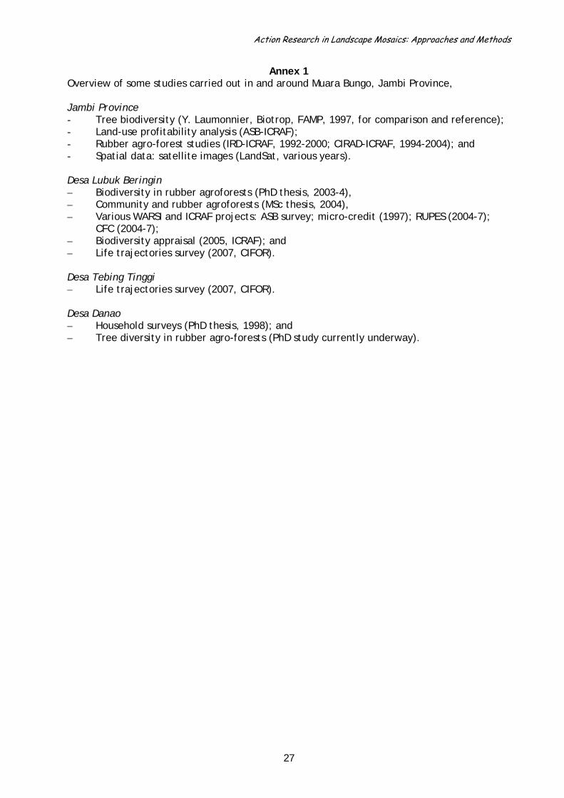
Action Research in Landscape Mosaics: Approaches and Methods
Annex 1
Overview of some studies carried out in and around Muara Bungo, Jambi Province, Jambi Province - Tree biodiversity (Y. Laumonnier, Biotrop, FAMP, 1997, for comparison and reference); - Land-use profitability analysis (ASB-ICRAF); - Rubber agro-forest studies (IRD-ICRAF, 1992-2000; CIRAD-ICRAF, 1994-2004); and - Spatial data: satellite images (LandSat, various years). Desa Lubuk Beringin – Biodiversity in rubber agroforests (PhD thesis, 2003-4), – Community and rubber agroforests (MSc thesis, 2004), – Various WARSI and ICRAF projects: ASB survey; micro-credit (1997); RUPES (2004-7);
CFC (2004-7); – Biodiversity appraisal (2005, ICRAF); and – Life trajectories survey (2007, CIFOR).
Desa Tebing Tinggi – Life trajectories survey (2007, CIFOR).
Desa Danao – Household surveys (PhD thesis, 1998); and – Tree diversity in rubber agro-forests (PhD study currently underway).
27

Action Research in Landscape Mosaics: Approaches and Methods
Annex 2 Preliminary listing of activities and timeframes for work within the LMP in Viengkham District, Luang Phrabang Province, Lao PDR. Who will undertake each of these activities, and precisely what resources are required, have still to be decided. Stage Time Who Resource 1. Institutional and policy framework: -MOU between CIFOR-NAFRI -Partners – MoF, NLMA, Universities, District/village authorities for LUP -Policies; framework for LUP, project for district-LUP (URDP), NGPES (National Growth and Poverty Eradication Strategy), PM decree for decentralization, and laws for Forestry, Agriculture, Environment, Mining, national Roads, Property 1.a. Source of Information: -URDP (Upland Research and Capacity Development Program); household survey, market analyses. NCCR – SDC; satellite images
2007
2. Remote sensing data collection: -Pre-spatial analyses; including roads?
End 2007
3. Stakeholder analyses: -Preliminary results based on workshop -preliminarily identified in SDC documents
Sept. 2007
4. Perception of landscape, policy, development, etc. 2008 5. Synthesis of contrasts and similarities between study sites
2008
6. Specific studies: -Field survey, -Household survey, -Reward for Environmental Services, etc.
Before June 2008
7. 2nd synthesis based on stage 6 8. Negotiation and planning: -Intermediaries? -a year period
2009?
9. Dissemination on national level 2010? Step1: use of resources and of local knowledge on their management as a base of participatory monitoring Collecting information on existing use and possible local monitoring of key resources and habitats to determine what influences the state of the resource:
• Informing, gaining support, database: community meetings; • Capture different opinions of groups of villagers: focus Group Discussions; • Informing issues on LUP, NTFP management: semi-structured interviews; • Important NTFP in different gradients, land types: inventories; and • Assessing local control, resources and habitats: joint patrol/BD assessment.
Step 2: Analysis of the threats to resources and habitats Identifying existing and potential threats against important biodiversity components + strategies locally developed to anticipate them:
• Identify the threats and discuss about the way people anticipate them (district and village clusters): focus group discussions + interviews; and
• Direct field observations.
28

Action Research in Landscape Mosaics: Approaches and Methods
Step3: Monitoring and accessibility to resources Studying the effects of accessibility of the resources (related to land management, tenure, and access to infrastructures, markets):
• Information on existing and planned access (road, tracks, distance to market): GIS analysis;
• Looking at how LUP affects land rights, resource, livelihoods (district and village): interviews; and
• Information on household role in resource collection, land rights, relocation issues: household survey.
Step4: Participatory development of collaborative monitoring mechanisms Improving LUP procedures and methods related to monitoring: learning process: • Look for appropriate monitoring related to actual LUP & monitoring: meetings between
all stakeholders; and • Guidelines for collaborative monitoring of LUP: participatory and multilevel development
of guidelines.
29
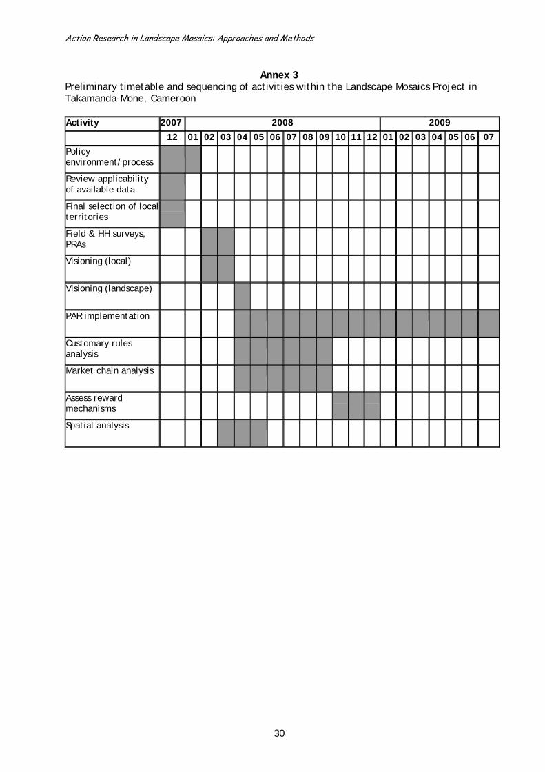
Action Research in Landscape Mosaics: Approaches and Methods
30
Annex 3
Preliminary timetable and sequencing of activities within the Landscape Mosaics Project in Takamanda-Mone, Cameroon Activity 2007 2008 2009
12 01 02 03 04 05 06 07 08 09 10 11 12 01 02 03 04 05 06 07
Policy environment/process
Review applicability of available data
Final selection of local territories
Field & HH surveys, PRAs
Visioning (local)
Visioning (landscape)
PAR implementation
Customary rules analysis
Market chain analysis
Assess reward mechanisms
Spatial analysis

Action Research in Landscape Mosaics: Approaches and Methods
Annex 4 Preliminary scheduling of Landscape Mosaic Project activities in the East Usambara mountains, Tanzania Project Local Landscape/Meso Timing Comments on data availability Landscape/gradient: East Usambara Partners: ICRAF, TFCG, WWF TZ Approach/indicators:
Definition of the policy process that we want to influence: 1) efforts to increase area under protection/upgrade status of existing ones (IUCN categories); 2) corridor management, land use planning outside protected areas; 3) development of PES mechanisms (water, carbon)
Spatial analysis (clustering the landscapes)
Analysis of the landscape for selection of the local territories
December 2007 Have: satellite images and other spatial data Spatial data EU_Dec2007.xls
Scoping for context information
Consultations of local stakeholders for the identification of the local territories, key issues, etc.
January 2008
Selection of local territories according to defined criteria:
January 2008
Monitoring Introductory workshop, Stakeholder analysis
February 2008
Perceptions of landscapes Important species, etc. “Pre-Vision” (internal groups)
Perceptions of landscapes and policy terrain Development & Conservation priorities, etc. “Pre-Vision” (different external stakeholders)
PhD theses (mid-1990s, unfinished work)
1st synthesis on contrasts and similarities of perceptions Land use maps
Specific studies PRA HH survey (LIV, GOV) BD surveys
Economic analyses Rewards Maps (time series)
A number of studies exist – need to evaluate relevance, suitability (in terms of location of local territories etc.) of information for our purposes. In most cases, these are reports, theses etc., not the raw data. Biodiversity data: for forest
31
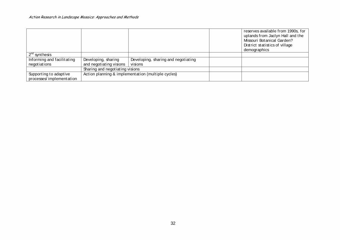
Action Research in Landscape Mosaics: Approaches and Methods
reserves available from 1990s, for uplands from Jaclyn Hall and the Missouri Botanical Garden? District statistics of village demographics
2nd synthesis Informing and facilitating negotiations
Developing, sharing and negotiating visions
Developing, sharing and negotiating visions
Sharing and negotiating visions Supporting to adaptive processes/implementation
Action planning & implementation (multiple cycles)
32

Action Research in Landscape Mosaics: Approaches and Methods
Annex 5 Preliminary listing of different LMP project elements and activities planned for Manompana, Toamasina Province, Madagascar Project element and personnel
Local-level activities Landscape/Meso activities Comments on data availability
Landscape/gradient Partners (DGEF-Jariala, ANGAP, AIM, EPFZ, ESSA-F, consultant) Approach/indicators
Definition of the policy process: forest management, land use planning
MAP-KoloAla concept, Forest inventories (punctual)
Spatial analysis (clustering the landscapes) Not yet identified
Many satellite images, including maps, deforestation from time series
Project presentation to representatives at regional, district, and commune levels
Recruitment of the local team (4 people)
Capacity building 1 Preparing project monitoring Introduction, reconnaissance
and first surveys: Perceptions of landscapes (MLA) Important species, etc. Stakeholder analysis 1 (“pre-vision”)
Development & Conservation threats and priorities, etc. “Pre-Vision” of different external stakeholder groups
PCD
Capacity building 2 Stakeholder analysis 2 (poverty,
vulnerability, gender)
Policy terrain, external conservation interests
ANGAP, Mananara/Biosphere (ToR, consultants)
Preliminary land use maps (with patches)
1st synthesis on contrasts and similarities of perceptions
Selection of local territories Recruitment of village facilitators, capacity building
Launching the PhD studies Zora, Mihaja Specific studies HH surveys (LIV, GOV)
Forest inventories, BD surveys PCD: household census; transfer of
forest mgt rights: existing monitoring
33

Action Research in Landscape Mosaics: Approaches and Methods
tools and procedure, REDD: partner project
Analysis of causes of deforestation
REDD, Mihaja (PhD student)
Preparation of the monitoring of forest management
Economic analyses of reward options
REDD, students
2nd synthesis Building the negotiation Platform
Representatives of villages OPCI: Association of Communes, Forest Service, Authorities
Informing and facilitating negotiations
Syntheses validation, developing, sharing and negotiating a common vision (zoning)
Syntheses and validation; developing, sharing and negotiating visions (zoning)
Schema regional d’Amgt Terr. (?)
Elaborating scenarios, sharing and negotiating a common vision Supporting to adaptive processes/implementation
Action planning and implementation (multiple cycles)
Evaluation Evaluation Evaluation Dissemination
34

Action Research in Landscape Mosaics: Approaches and Methods
Annex 6
CRITERIA FOR EVALUATING DATA QUALITY AND NEEDS (courtesy of Helen Briassoulis, Department of Geography, University of the Aegean, Greece: see also Briassoulis 2001)
DIMENSIONS OF A DATA SET A. INHERENT QUALITIES OF THE DATA Spatial scale Temporal scale Definitions Data collection procedures
Compatibility
• Social, economic, and environmental data frequently lack compatibility in spatial resolution, coverage and spatial definition
• Administrative and physical boundaries usually do not coincide
• Data collected at one level of spatial resolution cannot be disaggregated to finer levels of resolution
• Spatial frames of reference change over time
• Similar problems to those of spatial scale: disciplinary, scientific and practical reasons tend to dictate the frequency and timing of observations
• Temporal frames of reference change over time
• Data collected at one level of temporal resolution cannot be disaggregated to finer levels of resolution
• Many data sets lack spatio-temporal compatibility
• Definitions tend to change over time, often without this being indicated
• Different operational definitions can be used in different regions at the same time
• Aggregate definitions also cause a problem, particularly when there is a need for disaggregated data
• Data collection procedures differ from one agency to another, and among countries
• Procedures also change in response to changes in technology, organisation, and understanding, affecting the quality of available data
Consistency
• If the same system of spatial reference is not used over time for the same variable, this may affect both relationships with other variables and the capacity to disaggregate the available data
• Similar problems to those of spatial scale: if data have not been collected for the same dates, assumptions have to be made that data from nearby dates reasonably approximate the real values
Consistency is adversely affected by: • changes in definition of a variable
over time • lack of explicit definition (vague
definitions) • aggregate definitions that make it
almost impossible to disaggregate data for local-level analyses
• use of indices, where the composition of the variables and the method of calculation are not clear
• Changes in organisation, technology, and socio-economic conditions affect data collection and result in inconsistencies unless there are rules governing the transition from one system to another (e.g. comparison of LCLUC derived from aerial photos and satellite imagery)
Reliability
• Some data collected without an explicit spatial frame of reference; acute at the local level - produces spatially unreliable data
• Problem when combining data sets for integrated analysis
• Unreliable time-series data produced when there are problems of compatibility and consistency
• Lack of explicit definition of concepts and/or variables can lead to inaccurate and hence unreliable data; the available data may not refer to the same entity
• Lack of systematic and strictly applied data collection procedures affect the precision of the measurements and hence the reliability of the data
• intentional and unintentional omission of data
• use of untrained personnel • degree of unreliability not the
same for all variables • data for finer spatial scales tends
to be fuzzier and less reliable than data for larger areas
35

Action Research in Landscape Mosaics: Approaches and Methods
CRITERIA FOR EVALUATING DATA QUALITY AND NEEDS (cont.)
DIMENSIONS OF A DATA SET B. CONTINGENT QUALITIES OF THE DATA Spatial scale Temporal scale Definitions Data collection procedures
Availability
• Data do not exist at the required level of spatial resolution
• Data not available for the whole study area
• Historical data generally not geo-referenced
• Incomplete historical data sets make it difficult (impossible) to do integrated analyses
• Lack of longitudinal (time-series) data , especially spatio-temporal data, with the desirable properties
• Possible causes include: ⇒ poor interagency co-
ordination ⇒ little demand for data ⇒ lack of continuity in
agencies ⇒ shortage of funds ⇒ no feedback from users ⇒ no systematic data
collection procedures and rules
⇒ lack of integrated planning
• Availability of data depends on the level of detail one is interested in
• Coarse, aggregate data may exist even at lower levels but many analyses require disaggregated data
• Aggregate data from different areas may not encompass exactly the same things because of slightly differing definitions
• Some types of data require specialised studies
• Quantitative data often do not exist for all variables of interest in an integrated assessment
• Qualitative data can provide information about the nature of the missing data
• Qualitative data can also be used to help interpret the available quantitative data, and help in disaggregating aggregated data
Ease of data acquisition • Data on most common variables easier to find at higher levels (national, international) than at lower levels, a function not only of data availability but also of agency preparedness and management system
• Many environmental data sets are not yet systematically tabulated; although they exist they are difficult to extract
• Long time-series data, or data collected at frequent intervals, often less easy to find and retrieve
• Much time and effort is needed to extract historical data from many different sources of information with their attendant problems of lack of compatibility, consistency and reliability
• Data on aggregate categories of variables and at aggregate spatial and temporal scales of resolution are easiest to find
• Disaggregated data at finer levels of resolution are harder to find and may need special studies (but are constrained by shortage of expertise, funds, time, and often a need for confidentiality)
• Data collected systematically by means of censuses or surveys are easier to find
• Specialised surveys and studies may offer more detailed data but are often not readily accessible
• Government departments tend to treat data as confidential, thus limiting its use (this creates a negative feedback - little use, no reason to continue to collect it)
Cost of data acquisition • Coarser level data are generally less costly to obtain because they are already published or more readily available
• Fine-scale spatial data are more costly not only because of the increased cost of data collection but also of storage and analysis
• Disaggregation of coarse time-series data, where possible, is costly
• Where simplifying assumptions have to be made, they can affect the consistency of the data sets
• The end points of different data series may not coincide, limiting their value for integrated analysis
• Data for aggregate categories are generally less expensive than for finer levels of detail
• Detailed data are costly in terms of both money and time
• Public agencies usually provide data free of charge or only at a nominal cost; private and semi-public agencies usually charge fees at commercial rates
• Data that are collected regularly and in a standardised way are less costly than other kinds of data
Transferability
• Coarse data are difficult to disaggregate
• Disaggregated data may not be congruent, affecting consistency
• Disaggregated data may not refer to the same spatial unit
• Fine-scale data easier to
• Simplifying assumptions may have to be made about the temporal disaggregation of coarse data; this can threaten their consistency
• The end points of different data series may not coincide, making
• Changes in or aggregations of definition is a serious problem
• Disaggregated data may not correspond to the definition of the variable(s) involved
• Transferability of data between scales and among categories is seriously affected by the data collection procedures
• Trend towards standardisation and uniformity of procedures but not yet far enough advanced
36

Action Research in Landscape Mosaics: Approaches and Methods
aggregate disaggregation more difficult
37