Embed Size (px)
Citation preview
Accurate Localization in Combination with Wireless Sensor Networks and Laser Localization*
Lingfei Wu1, 2, 4, Max Q.-H. Meng1, 3, Huawei Liang1, 2, 4, Wen Gao1, 2 1Center for Biomimetic Sensing and Control Research, Institute of Intelligent Machines,
Chinese Academy of Sciences, Hefei, Anhui Province, China 2Department of Automation, University of Science and Technology of China
Hefei, Anhui Province, China 3Department of Electronic Engineering, Chinese University of Hong Kong, Sha tian, Hong Kong
4The Key Laboratory of Biomimetic Sensing and Advanced Robot Technology,Anhui [email protected]
* This work is supported by Key Program of the National Natural Science Foundation of China Grant #60535010 to Max Q.-H. Meng
Abstract - In order to explore the moon more effectively, it is very important to enhance the ability of navigation and localization of the lunar rover for exploration achievement of scientific goals. In this paper, an Accurate Localization in Combination with Wireless Sensor Networks and Laser localization scheme is proposed. First, the lunar rover position system consisted of the Lander, the lunar rover and a wireless sensor network is introduced. Then, we compare and analyse the advantages and disadvantages of TOA, TDOA, AOA, and RSSI. In the proposed scheme, the wireless sensor networks first localize themselves with the help of the Lander. For increasing the localization accuracy of the sensor nodes, a novel localization algorithm based on APS algorithm is presented. Next, we detail the lunar rover localization especially in that case where the lunar rover is not in the sight of the Lander. In initial experiment, we validate the proposed method using the test platform designed by us. Index Terms - Lunar rover; Wireless sensor networks; Localization; RSSI
I. INTRODUCTION
An unmanned lunar rover will be part of the essential equipment for moon exploration in the second phase of the Chinese “Chang’e” mission [1] [2]. Since we have to know where the information is collected, and to begin with, the rovers have to reach destination, the rovers must know their position on the surface.
There are several methods to navigate and control lunar rover such as remote control, automation and half automation. In each method rover’s position and attitude should be measures so that rover can drive in a planned path and assure its safety. Currently, various kinds of navigation methodologies such as inertial navigation localization [3] [4], visual navigation localization [5], celestial navigation localization [6] and satellite navigation localization have already been proposed to solve mobile robots navigation and localization problems. All of these navigation methods have their own characteristic and have been applied in different application areas.
The merit of INS is able to provide the complete independency and adequacy navigation information (such as position, speed, posture and so on). INS renews date quickly
and the precision of short term is good. The drawback is that INS does not have infinite precision and the output values of are prone to drift away.
Visual navigation localization has the merit of achieving high accuracy localization. The draw of traditional visual navigation methods are that they have mostly depended on local visual information and because the date size of the image information general big, they have high request for processor and memory and the robustness of visual navigation methods are relative worse.
Celestial navigation localization takes use of a series of stars surround in the Moon to determine the location, or relative locations. This process if often referred to as getting a fix. However, it is not good enough method to obtain accuracy localization because a small angle measurement error can cause a large localization error.
A navigation system development plan based on Radio determination Satellite Service (RDSS)has been proposed. They use two geosynchronous satellites to achieve navigation localization [7].
Today, the famous satellite navigation system is GPS. It provides two services for people to use to locate outdoor objects. However, unlike Earth, on the Moon there is no GPS-like satellite system that can be used to pinpointing location on the surface.
In robot, Lidar and laser sensors have been widely applied into the robot’s navigation and localization such as robot position in indoor environments [8] and unmanned vehicles navigation in outdoor environments [9]. The robot equipped with laser sensor can significantly improve its abilities such as local localization and obstacle avoidance. In fact, Lidar system can detect the objects with the distance about 10Km to 50Km while relative accuracy and errors are rather small, usually only a few centimeters.
Recently, there are many researches focusing on mobile robot navigation and localization using wireless sensor networks [10] as reference nodes. In the paper [11], the author proposed a method that sensor nodes act as signposts for the robot to follow, thus obviating the need for map or localization on the part of the robot. Rex, et al [12] also presents that
146
Proceedings of the IEEE
International Conference on Automation and Logistics Shenyang, China August 2009
978-1-4244-4795-4/09/$25.00 © 2009 IEEE
wireless sensor networks, if deployed in well-organized formation, can serve as signposts that will help mobile robots for navigation and localization. In [13], the author presents an environment map free navigation for robot based on wireless sensor networks.
In this paper, we present a novel method to unite wireless sensor networks and laser localization for the localization of lunar rover. There are two steps in lunar rover localization: first of all, wireless sensor networks nodes, deployed with random placement, obtain their location coordinate using RSSI. In order to obtain better localization accuracy for sensor nodes, we proposed a new localization algorithm based on DV-distance algorithm [14]. Second, the robot can do accuracy localization using both the position information gained from sensor nodes and laser ranging information that is measured by Lander equipped with Lidar system. We focus on investigating the robot’s localization in the situations where the Lidar system can not work well when the lunar rover is blocked by the large rocks or travels into the craters. Our initial experiments and simulation prove the validity of the proposed method.
The rest of this paper is organized as follows: Section II discusses lunar rover position system. Section III introduces the proposed localization algorithm for both the sensor networks and the lunar rover. Our experiment and simulation results are described in Section IV. Section V draws the conclusion.
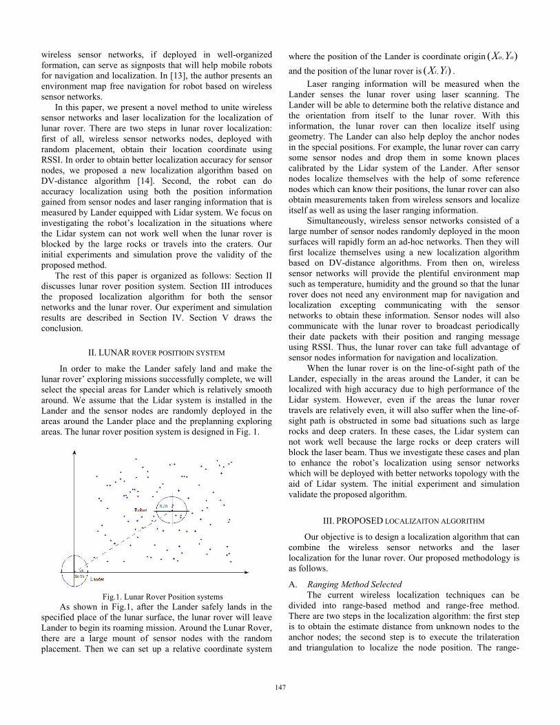
II. LUNAR ROVER POSITIOIN SYSTEM
In order to make the Lander safely land and make the lunar rover’ exploring missions successfully complete, we will select the special areas for Lander which is relatively smooth around. We assume that the Lidar system is installed in the Lander and the sensor nodes are randomly deployed in the areas around the Lander place and the preplanning exploring areas. The lunar rover position system is designed in Fig. 1.
Fig.1. Lunar Rover Position systems
As shown in Fig.1, after the Lander safely lands in the specified place of the lunar surface, the lunar rover will leave Lander to begin its roaming mission. Around the Lunar Rover, there are a large mount of sensor nodes with the random placement. Then we can set up a relative coordinate system
where the position of the Lander is coordinate origin ,( )o oX Y and the position of the lunar rover is ,( )i iX Y .
Laser ranging information will be measured when the Lander senses the lunar rover using laser scanning. The Lander will be able to determine both the relative distance and the orientation from itself to the lunar rover. With this information, the lunar rover can then localize itself using geometry. The Lander can also help deploy the anchor nodes in the special positions. For example, the lunar rover can carry some sensor nodes and drop them in some known places calibrated by the Lidar system of the Lander. After sensor nodes localize themselves with the help of some reference nodes which can know their positions, the lunar rover can also obtain measurements taken from wireless sensors and localize itself as well as using the laser ranging information.
Simultaneously, wireless sensor networks consisted of a large number of sensor nodes randomly deployed in the moon surfaces will rapidly form an ad-hoc networks. Then they will first localize themselves using a new localization algorithm based on DV-distance algorithms. From then on, wireless sensor networks will provide the plentiful environment map such as temperature, humidity and the ground so that the lunar rover does not need any environment map for navigation and localization excepting communicating with the sensor networks to obtain these information. Sensor nodes will also communicate with the lunar rover to broadcast periodically their date packets with their position and ranging message using RSSI. Thus, the lunar rover can take full advantage of sensor nodes information for navigation and localization.
When the lunar rover is on the line-of-sight path of the Lander, especially in the areas around the Lander, it can be localized with high accuracy due to high performance of the Lidar system. However, even if the areas the lunar rover travels are relatively even, it will also suffer when the line-of-sight path is obstructed in some bad situations such as large rocks and deep craters. In these cases, the Lidar system can not work well because the large rocks or deep craters will block the laser beam. Thus we investigate these cases and plan to enhance the robot’s localization using sensor networks which will be deployed with better networks topology with the aid of Lidar system. The initial experiment and simulation validate the proposed algorithm.
III. PROPOSED LOCALIZAITON ALGORITHM
Our objective is to design a localization algorithm that can combine the wireless sensor networks and the laser localization for the lunar rover. Our proposed methodology is as follows.
A. Ranging Method Selected The current wireless localization techniques can be
divided into range-based method and range-free method. There are two steps in the localization algorithm: the first step is to obtain the estimate distance from unknown nodes to the anchor nodes; the second step is to execute the trilateration and triangulation to localize the node position. The range-
147
based method uses all kinds of ranging techniques to obtain estimation distance with relative high localization accuracy while the range-free method takes advantage of the connectivity information to get with more coarse localization accuracy. A localization algorithm is valuable only for lunar rover when the localization error is relative low, but most of current rough wireless localization techniques such as range-free localization can not meet such a requirement. So, we choose the range-based algorithm such as DV-distance for node localization.
The traditional range measurements can be divided into RSSI, TOA, TDOA, and AOA. Since there is no aerosphere and no GPS in the moon, TDOA and TOA can not work well in the moon. In addition, AOA need expensive extra-hardware such as an antenna array in the sensor nodes so that they are not a good choice for sensor nodes due to limit battery power and small size of sensor nodes. RSSI method has the advantages of being low cost, low power consumption, and easy to network and incorporate with other equipments, thus it is a rather good choice for moon exploration.
B. Sensor Node localization Sensor nodes will first localize themselves based on the
proposed localization algorithm with the aid of the anchor nodes which already know their position. The positions of anchor nodes are calibrated by the Lidar system in the Lander. It should be noted that when the lunar rover is on the line-of-sight of the Lander, it could gain laser ranging information. Then lunar rover can localize itself accurately using laser ranging information such as relative distance and the orientation. If there are some bad situations where the LOS path is blocked by some obstacles such as large rocks and deep craters, the lunar rover will roughly localize itself only using ranging information from the sensor networks. Thus, we present a novel node localization algorithm that can significantly improve the localization accuracy so that it can meet the requirement of the localization of lunar rover in non-line-of-sight conditions.
In order to fully consider both the topology relationship among anchor nodes and the topology relationship between anchor nodes and unknown nodes, we introduce the concept of collinearity and apply it into the localization of the multihop networks. The proposed algorithm is similar with DV-distance algorithm but have better localization accuracy due to the introduction of collinearity parameter. The algorithm can dynamically adjust the unknown nodes to collect the neighbour anchor nodes information, and then select the good anchor nodes terns through the collinearity parameter to realize the position estimate, and at last the final position is estimated by the weighted estimation mechanism.
Our collinearity is very simple definition. Collinearity is the maximum of the three Cosine of interior angle of the triangle composed by a set of anchors. Thus, the process of calculation is also very simple. We can be convenient to use triangular law of cosines to obtain:
2 2 2, , ,
, ,2C A A B B C
AC A A B
b c aC
b c+ −
= (3-1)
2 2 2, , ,
, ,2B C A B C A
BB C A B
a c bC
a c+ −
= (3-2)
2 2 2, , ,
, ,2B C C A A B
CB C C A
a b cC
a b+ −
= (3-3)
And A, B, C represents the angles that are composed by the anchor node A, B, C. ,B Ca , ,C Ab , ,A Bc represents the sides
responding to angle A, B, C. So, we can at once get the collinearity of anchor nodes tern:
{ }max , ,A B CNC C C C= (3-4)
Due to the collinearity represents the cosine of minimum angle of the triangle its scope is 0.5 to 1.0 (corresponding angle is from 0° to 60°). If NC equals to 0.5, the triangle is equilateral triangle and in this case the localization will be best theoretically. If NC equals to 1, the anchor tern is totally aligned and results in the worst localization.
The sensor node localization algorithm is as follows: 1) Implement the first two stages of the DV-distance, each of
the unknown nodes collects all the anchor nodes location and distance information they can.
2) Calculate the NC of each tern, and then select the good terns with NC smaller or equal to special NC threshold.
3) Get a set of locations through using trilateration with selected anchor node terns, and record the NC of each tern.
4) Calculate the reciprocal of each NC and record them, and then compute corresponding weight iW of each tern.
1
1i
i
i i
NCW
NC
=∑
(3-5)
5) Obtain the final position estimate by multiplying a set of locations by their corresponding weight.
'X
Position WY⎡ ⎤
= ⎢ ⎥⎣ ⎦
(3-6)
C. Lunar Rover Localization After the sensor nodes have localized themselves, lunar
rover will use different types of information available to locate its position as it moves. The types of information available to the lunar rover include: 1) RSSI values of various sensor nodes’ transmission that
the lunar rover can measure when it comes into range. As the sensor nodes constantly broadcast their estimated positions, the lunar rover will both know the estimated position of the sensor nodes and the RSSI value from them. The information that the lunar rover got can be used
148
to execute trilateration to update its own estimate position.
2) When the Lander senses the lunar rover using laser scanning, the laser ranging information can be measured. The Lander will broadcast its position and ranging information to sensor nodes around and this information will be forwarding to the lunar rover by the sensor networks. The Lander can also communicate with lunar rover directly and send ranging information to it. Thus, the lunar rover can make full use of useful information to do some localization. In most of cases, the lunar rover can localize itself using the laser ranging information containing the distance information and the orientation information by communicating with the Lander and sensor networks.
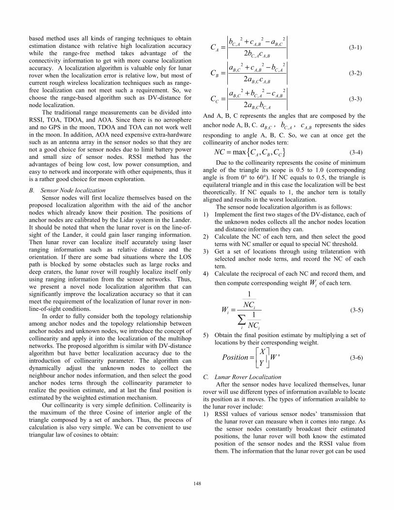
3) When lunar rover can not use the laser ranging information due to the non-line-of-sight conditions, we will adopt another good method that usually can be used to improve its localization performance using sensor networks. We will deploy more anchor nodes along with the projective edge of the obstacles so that the lunar rover can use the proposed algorithm to realize the relative high localization accuracy. As shown in Fig. 2, if the lunar robot walks into the place that is not at the sight of the Lander, the lunar rover will carry and drop some anchor nodes in the known places by the help of Lidar system in the edge of narrow region.
Fig. 2 Lunar Rover’ Localization in NLOS
IV. EXPERIMENT RUSLTS
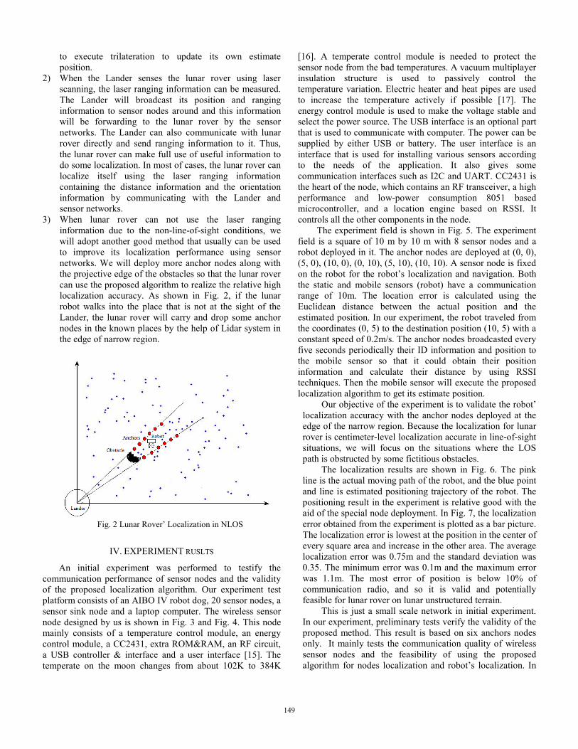
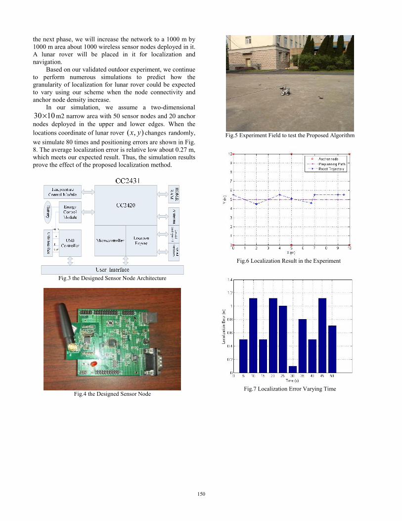
An initial experiment was performed to testify the communication performance of sensor nodes and the validity of the proposed localization algorithm. Our experiment test platform consists of an AIBO IV robot dog, 20 sensor nodes, a sensor sink node and a laptop computer. The wireless sensor node designed by us is shown in Fig. 3 and Fig. 4. This node mainly consists of a temperature control module, an energy control module, a CC2431, extra ROM&RAM, an RF circuit, a USB controller & interface and a user interface [15]. The temperate on the moon changes from about 102K to 384K
[16]. A temperate control module is needed to protect the sensor node from the bad temperatures. A vacuum multiplayer insulation structure is used to passively control the temperature variation. Electric heater and heat pipes are used to increase the temperature actively if possible [17]. The energy control module is used to make the voltage stable and select the power source. The USB interface is an optional part that is used to communicate with computer. The power can be supplied by either USB or battery. The user interface is an interface that is used for installing various sensors according to the needs of the application. It also gives some communication interfaces such as I2C and UART. CC2431 is the heart of the node, which contains an RF transceiver, a high performance and low-power consumption 8051 based microcontroller, and a location engine based on RSSI. It controls all the other components in the node. The experiment field is shown in Fig. 5. The experiment field is a square of 10 m by 10 m with 8 sensor nodes and a robot deployed in it. The anchor nodes are deployed at (0, 0), (5, 0), (10, 0), (0, 10), (5, 10), (10, 10). A sensor node is fixed on the robot for the robot’s localization and navigation. Both the static and mobile sensors (robot) have a communication range of 10m. The location error is calculated using the Euclidean distance between the actual position and the estimated position. In our experiment, the robot traveled from the coordinates (0, 5) to the destination position (10, 5) with a constant speed of 0.2m/s. The anchor nodes broadcasted every five seconds periodically their ID information and position to the mobile sensor so that it could obtain their position information and calculate their distance by using RSSI techniques. Then the mobile sensor will execute the proposed localization algorithm to get its estimate position.
Our objective of the experiment is to validate the robot’ localization accuracy with the anchor nodes deployed at the edge of the narrow region. Because the localization for lunar rover is centimeter-level localization accurate in line-of-sight situations, we will focus on the situations where the LOS path is obstructed by some fictitious obstacles.
The localization results are shown in Fig. 6. The pink line is the actual moving path of the robot, and the blue point and line is estimated positioning trajectory of the robot. The positioning result in the experiment is relative good with the aid of the special node deployment. In Fig. 7, the localization error obtained from the experiment is plotted as a bar picture. The localization error is lowest at the position in the center of every square area and increase in the other area. The average localization error was 0.75m and the standard deviation was 0.35. The minimum error was 0.1m and the maximum error was 1.1m. The most error of position is below 10% of communication radio, and so it is valid and potentially feasible for lunar rover on lunar unstructured terrain.
This is just a small scale network in initial experiment. In our experiment, preliminary tests verify the validity of the proposed method. This result is based on six anchors nodes only. It mainly tests the communication quality of wireless sensor nodes and the feasibility of using the proposed algorithm for nodes localization and robot’s localization. In
149
the next phase, we will increase the network to a 1000 m by 1000 m area about 1000 wireless sensor nodes deployed in it. A lunar rover will be placed in it for localization and navigation.
Based on our validated outdoor experiment, we continue to perform numerous simulations to predict how the granularity of localization for lunar rover could be expected to vary using our scheme when the node connectivity and anchor node density increase.
In our simulation, we assume a two-dimensional 30 10× m2 narrow area with 50 sensor nodes and 20 anchor nodes deployed in the upper and lower edges. When the locations coordinate of lunar rover ( , )x y changes randomly,
we simulate 80 times and positioning errors are shown in Fig. 8. The average localization error is relative low about 0.27 m, which meets our expected result. Thus, the simulation results prove the effect of the proposed localization method.
Fig.3 the Designed Sensor Node Architecture
Fig.4 the Designed Sensor Node
Fig.5 Experiment Field to test the Proposed Algorithm
Fig.6 Localization Result in the Experiment
Fig.7 Localization Error Varying Time
150
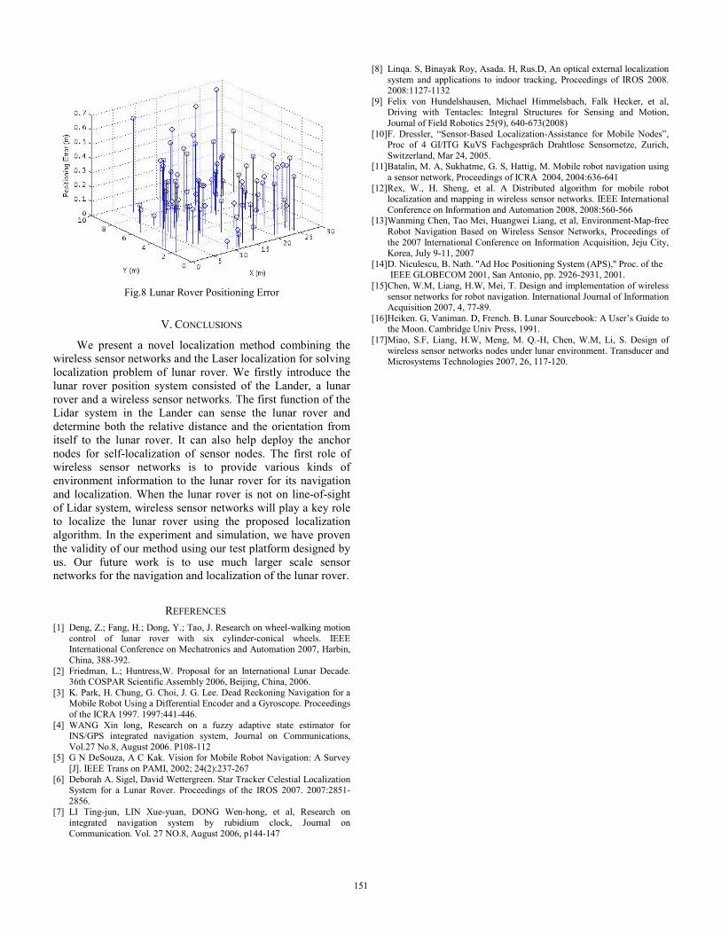
Fig.8 Lunar Rover Positioning Error
V. CONCLUSIONS
We present a novel localization method combining the wireless sensor networks and the Laser localization for solving localization problem of lunar rover. We firstly introduce the lunar rover position system consisted of the Lander, a lunar rover and a wireless sensor networks. The first function of the Lidar system in the Lander can sense the lunar rover and determine both the relative distance and the orientation from itself to the lunar rover. It can also help deploy the anchor nodes for self-localization of sensor nodes. The first role of wireless sensor networks is to provide various kinds of environment information to the lunar rover for its navigation and localization. When the lunar rover is not on line-of-sight of Lidar system, wireless sensor networks will play a key role to localize the lunar rover using the proposed localization algorithm. In the experiment and simulation, we have proven the validity of our method using our test platform designed by us. Our future work is to use much larger scale sensor networks for the navigation and localization of the lunar rover.
REFERENCES [1] Deng, Z.; Fang, H.; Dong, Y.; Tao, J. Research on wheel-walking motion
control of lunar rover with six cylinder-conical wheels. IEEE International Conference on Mechatronics and Automation 2007, Harbin, China, 388-392.
[2] Friedman, L.; Huntress,W. Proposal for an International Lunar Decade. 36th COSPAR Scientific Assembly 2006, Beijing, China, 2006.
[3] K. Park, H. Chung, G. Choi, J. G. Lee. Dead Reckoning Navigation for a Mobile Robot Using a Differential Encoder and a Gyroscope. Proceedings of the ICRA 1997. 1997:441-446.
[4] WANG Xin long, Research on a fuzzy adaptive state estimator for INS/GPS integrated navigation system, Journal on Communications, Vol.27 No.8, August 2006. P108-112
[5] G N DeSouza, A C Kak. Vision for Mobile Robot Navigation: A Survey [J]. IEEE Trans on PAMI, 2002; 24(2):237-267
[6] Deborah A. Sigel, David Wettergreen. Star Tracker Celestial Localization System for a Lunar Rover. Proceedings of the IROS 2007. 2007:2851-2856.
[7] LI Ting-jun, LIN Xue-yuan, DONG Wen-hong, et al, Research on integrated navigation system by rubidium clock, Journal on Communication. Vol. 27 NO.8, August 2006, p144-147
[8] Linqa. S, Binayak Roy, Asada. H, Rus.D, An optical external localization system and applications to indoor tracking, Proceedings of IROS 2008. 2008:1127-1132
[9] Felix von Hundelshausen, Michael Himmelsbach, Falk Hecker, et al, Driving with Tentacles: Integral Structures for Sensing and Motion, Journal of Field Robotics 25(9), 640-673(2008)
[10] F. Dressler, “Sensor-Based Localization-Assistance for Mobile Nodes”, Proc of 4 GI/ITG KuVS Fachgespräch Drahtlose Sensornetze, Zurich, Switzerland, Mar 24, 2005.
[11] Batalin, M. A, Sukhatme, G. S, Hattig, M. Mobile robot navigation using a sensor network, Proceedings of ICRA 2004, 2004:636-641
[12] Rex, W., H. Sheng, et al. A Distributed algorithm for mobile robot localization and mapping in wireless sensor networks. IEEE International Conference on Information and Automation 2008, 2008:560-566
[13] Wanming Chen, Tao Mei, Huangwei Liang, et al, Environment-Map-free Robot Navigation Based on Wireless Sensor Networks, Proceedings of the 2007 International Conference on Information Acquisition, Jeju City, Korea, July 9-11, 2007
[14] D. Niculescu, B. Nath. "Ad Hoc Positioning System (APS),'' Proc. of the IEEE GLOBECOM 2001, San Antonio, pp. 2926-2931, 2001.
[15] Chen, W.M, Liang, H.W, Mei, T. Design and implementation of wireless sensor networks for robot navigation. International Journal of Information Acquisition 2007, 4, 77-89.
[16] Heiken. G, Vaniman. D, French. B. Lunar Sourcebook: A User’s Guide to the Moon. Cambridge Univ Press, 1991.
[17] Miao, S.F, Liang, H.W, Meng, M. Q.-H, Chen, W.M, Li, S. Design of wireless sensor networks nodes under lunar environment. Transducer and Microsystems Technologies 2007, 26, 117-120.
151